The Kinglake Ranges, Flowerdale and Toolangi · Murrindindi Shire Council in partnership with the...
31
The Kinglake Ranges, Flowerdale and Toolangi Plan and Design Framework February 2014 The Kinglake, Flowerdale and Toolangi Plan and Design Framework has been developed by the Murrindindi Shire Council in partnership with the Kinglake Ranges, Flowerdale and Toolangi Community Recovery Committees and the State Government of Victoria.
-
Upload
duongtuong -
Category
Documents
-
view
217 -
download
0
Transcript of The Kinglake Ranges, Flowerdale and Toolangi · Murrindindi Shire Council in partnership with the...

Future Directions
The Kinglake Ranges, Flowerdale and Toolangi
Plan and Design FrameworkFebruary 2014
The Kinglake, Flowerdale and Toolangi Plan and Design Framework has been developed by the Murrindindi Shire Council in partnership with the Kinglake Ranges, Flowerdale and Toolangi Community Recovery Committees and the State Government of Victoria.

2
Prepared for
Murrindindi Shire Council in partnership with the Kinglake Ranges, Flowerdale and Toolangi Community Recovery Committees, Regional Development Victoria and the Department of Transport, Planning and Local Infrastructure
We wish to acknowledge the contribution of the Project Coordination Group:
• Kerry O’Neill, VBRRA (CHAIR)• Jane Keedle, VBRRA • Frank Maas, VBRRA •Markus Terjung, VBRRA • Paul Mayer, VBRRA • Bill Gale, Kinglake Ranges CRC • John Burgess, Flowerdale CRC•Michael Nardella, Toolangi CRC• Stuart Craven, Office of Water, DSE • Alan McPherson, Office of Water, DSE• Andrew Shannon, Parks Victoria • Angela Verde, RDV• Andrew Manning, RDV• Bruce Standish, RDV • Leah Smith, DTPLI• Andrew Ganey, CFA•Michael Chesworth, MSC •Matt Parsons, MSC• Karen Girvan, MSC • Noel Matthews, AECOM•Michael Dunn, AECOM
Prepared by
AECOM Australia Pty Ltd
Level 45, 80 Collins Street, Melbourne VIC 3000, AustraliaT +61 3 9653 8222 F +61 3 9653 8299 www.aecom.comABN 20 093 846 925z
February 2014Issue H Final
The report is printed on recycled paper© AECOM Australia Pty Ltd 2014
This document has been prepared solely for the benefit of the Murrindindi Shire Council and is issued in confidence for the purposes only for which it is supplied. Unauthorised use of this document in any form whatsoever is prohibit-ed. No liability is accepted by AECOM Australia Pty Ltd or any employee, contractor, or sub-consultant of this com-pany with respect to its use by any other person. This disclaimer shall apply notwithstanding that the document may be made available to other persons for an application for permission or approval to fulfil a legal obligation.

3
Contents
Introduction 4
Community Engagement 6
Regional Context 8
Strategic Context 10
Bushfire Safety 18
Future Directions 26
Potential Development Framework 30
Local Area Design Frameworks 32 1. Kinglake 34
2. Kinglake Central 38
3. Kinglake West/Pheasant Creek 40
4. Flowerdale 44
5. Hazeldene 46
6. Castella 48
7. Toolangi 50
More Information 52
Figures Figure A. Study AreaFigure B. Plan ProcessFigure C. Regional Context - Key InfluencesFigure D. Settlement Figure E. EnvironmentFigure F. Social and EconomicFigure G. Bushfire Safety FrameworkFigure H. Future Development FrameworkFigure I. Settlement Structure
Design FrameworksFigure 1.1 Kinglake Design FrameworkFigure 1.2 Kinglake Town Centre Design FrameworkFigure 2 Kinglake Central Design FrameworkFigure 3 Kinglake West/Pheasant Creek Design Framework Figure 4 Flowerdale Design Framework Figure 5 Hazeldene Design FrameworkFigure 6 Castella Design FrameworkFigure 7 Toolangi Design Framework

4
The Kinglake Ranges, Flowerdale and Toolangi Plan and Design Framework (the KFT Plan) is a vision for a sustainable future for the local communities of Kinglake, Kinglake Central, Kinglake West/Pheasant Creek, Flowerdale (including Hazeldene1), Castella and Toolangi. Figure A shows the Study Area. All these communities are in the municipality of Murrindindi Shire. The KFT Plan is founded on the values that these local communities have identified as important to their future.
The KFT Plan will guide future population growth, land use and development, infrastructure and service provision, community safety and the character and identity of local communities.
The need for a long term strategic plan was identified as important before the 2009 bushfires and was re-emphasised as a community priority in the community recovery planning process after the fires. The development of the KFT Plan and Design Framework received funding in the Rebuilding Together: A State-wide Plan for Reconstruction and Recovery, October 2009.
The delivery of the final KFT Plan has been delayed as various elements of the Victorian Bushfires Royal Commission (VBRC) final report into the causes and circumstances of the fires that devastated Victoria in 2008 and 2009 were reconciled. Many of the 67 recommendations made by VBRC have and continue to be implemented by all levels of government.
The KFT Plan presents a development framework to strengthen the sustainability of existing towns and preserve the environmental values of the region in a way that promotes economic development and enhances community resilience and safety for the future. The KFT Plan identifies potential locations for limited population growth contained within existing zoning boundaries within Kinglake and Kinglake West to create opportunities for safer living (and possible resettlement from less safe areas). The identification of these locations also seeks to underpin the future viability of existing and planned services and infrastructure. Future development should be undertaken in a way that improves the overall sustainability of the towns.
1 At the time of finalising this Plan work was well advanced on the amalgamation of the localities of Flowerdale and Hazeldene under the one name of Flowerdale. This amalgamation has had the strong support of the local communities affected, the Council and the State Government and is likely to be completed by the Registrar of Geographic Names in early 2014. For the purpose of consistency over the life of this study, Flowerdale and Hazeldene remain referenced as separate settlements in this Plan.
Opportunities for innovation to improve safety in towns and settlements exist in subdivision patterns; green landscape buffers created through waste water management; more permeable road networks and designated Neighbourhood Safer Places.
The KFT Plan recognises that the sustainability of towns within the study area is affected by the need to travel long distances on a daily basis for employment and services. Close to 80 per cent of workers in the Kinglake West and Kinglake area travel to work outside the municipality, with most travelling to metropolitan Melbourne. A stronger local economy, along with improved access to services, will help to reduce the high social and economic costs of travel for local households. Local communities will also benefit from a greater capacity to meet daily needs and work locally, recognising that proximity to Melbourne will continue to be important to access employment, services and entertainment.
The major opportunities for local economic development are tourism related activities and niche agribusinesses that take advantage of high value agricultural land and proximity to Melbourne markets.
The Kinglake National Park is the largest national park close to Melbourne and before the bushfires, received approximately 200,000 visitors a year. The park, along with other environmental assets and features in the region, provides opportunities for tourism that can bring more people to the area, supporting existing local businesses and creating opportunities for new enterprise.
The KFT Plan provides a strategic framework to guide how local towns and settlements in the Kinglake Ranges, Flowerdale and Toolangi district can evolve into the future. Design frameworks for each main settlement identify interventions that could be implemented to strengthen town centres and community hubs, improve attractiveness and connections.
The KFT Plan is partnered by an Implementation Strategy identifying the projects and priorities that will help to drive the KFT Plan forward. The strategies in the KFT Plan will also be implemented with the support of the Commonwealth, State and Local Government, the private sector and industry groups. Implementation measures will also include changes to the Murrindindi Planning Scheme.
Introduction

5
Mel
ba
H
wy
Melba
Hwy
Mel
ba
Break
Rd
Rd
Heidelberg Kinglake
Rd
Hw
y
Oday
Rd
Yea
Yea
Yea
Rd
Rd
Rd
esea
esea
esea
Whittl
Whittl
Whittl
sville
sville
King
Kinglake
Heale
Heale
lake
KinglakeNational Park
4km(5 mins)
CITY OF WHITTLESEA
SHIRE OFYARRA RANGES
SHIRE OFNILLUMBIK
SHIRE OFMITCHELL
17km(16 mins)
4km(5 mins)
3.5km(3 mins)
5.2km(5 mins)
9.5km(10 mins)
28km(24 mins)
9km(8 mins)
34km(31 mins)
KinglakeNational Park
SHIRE OFMURRINDINDI
3.5km(3 mins)
CentralKinglake
Kinglake
Hazeldene
Flowerdale
KinglakeWest
YeaBroadford
PheasantCreek
Toolangi
Castella
13km(14 mins)
St Andrews
13.5km(13 mins)
Whittlesea
17km(13 mins)
Yarra Glen15km
(15 mins)
Healesville
Figure A. Study AreaPrepared by Planisphere

6
Introduction
The 2009 Victorian Bushfires had a devastating impact on the communities of Kinglake Ranges, Flowerdale and Toolangi, with 55 lives lost and 716 properties destroyed and many more damaged. Significant community assets and businesses were also destroyed.
There has been extensive Commonwealth and Victorian Government support and investment in rebuilding of these communities. Almost $20 million has been invested in the rebuilding of community infrastructure by government, the Victorian Bushfire Appeal Fund and donors. New community facilities include the Flowerdale Early Learning Centre, Flowerdale Community House, Middle Kinglake Community and Education Precinct, the Kinglake National Park Visitor Centre, Kinglake Wilderness Camp, and Kinglake Ranges Men’s Shed. In addition, $84 million has been provided to support individual households in the rebuilding process.
Economic recovery in these communities is vital for job creation and attracting business investment. Initial grants of $4.4 million were provided to 280 small businesses to assist with fire restoration works. The Commonwealth and State Government also sought to stimulate economic recovery through the Victorian Bushfire Business Investment Fund. Grants of $1.9 million from the fund were provided to local businesses in Kinglake Ranges, leveraging $11 million of private investment. Businesses assisted include tourism facilities, hospitality, agribusinesses and retail outlets, which support local employment into the future.
In more recent times, the private sector has also reinvested in the Kinglake Ranges, with a proposed petrol station and commercial/retail development proposed for Kinglake.
Mitchell Community Health also manages the recently established Kinglake Ranges Medical Centre located in Kinglake.
Government investment in the Kinglake Ranges, Flowerdale and Toolangi, with a population of more than 3,730, has been critical in generating confidence in the future social and economic role of these communities.
In July 2010, the Victorian Bushfires Royal Commission (VBRC) released its final report into the causes and circumstances of the fires that devastated parts of
Victoria in January and February 2009.
The State government is committed and continues to implement all 67 final recommendations, including the establishment of the Bushfires Royal Commission Implementation Monitor (until September 2014).
The State Government committed to undertake a range of implementation actions in response to each recommendation outlined in the State’s Bushfire Implementation Plan. The Implementation Monitor’s primary functions are to monitor, review and report on the progress of agencies in carrying out the government’s response to the VBRC’s Final Report recommendations.
In July 2013 the Minister for Planning advised Murrindindi Shire Council that in light of the significant impact of the fires and various other actions undertaken responding to the bushfire risk, it would be untenable to support significant housing expansion into areas of high bushfire risk.. The Minister also noted that there is significant potential for additional development within existing development areas, particularly in Alexandra and Yea as areas that are also of a lower bushfire risk.
The 2009 Victorian Bushfires

7
Local communities and stakeholders have been kept informed and have participated in the development of the KFT Plan through a wide range of forums. These have included information mail outs to all ratepayers, a project website and blog, community and stakeholder interviews, community forums, roundtables and briefings and a Community Visioning Planning Day. Figure B provides a summary of the KFT Plan process and consultation activities.
At the Community Visioning Planning Day, there was high level agreement about the elements around which a shared vision should be built. These include:
• achieving a balance between the needs of people, the environment and the economy that sustains living in the Kinglake Ranges, Flowerdale and Toolangi areas for a sustainable future,
• ensuring that future development and economic opportunities are aligned with the high value placed on the environment,
• reinforcing and strengthening the distinctive character, scale and identity of local towns,
• addressing issues associated with wellbeing and lifestyle choices through innovative models of service delivery to improve access to local services,
• improving transport, telecommunications and connectivity within communities and beyond,
• growing the local economy and jobs to reflect environmental and community values such as tourism linked to the Kinglake National Park and niche agricultural production, and minimising land uses that detract from these values, and
• responding to capacity issues in relation to infrastructure, especially associated with access to water and the management of waste effluent.
Further details regarding the community consultation program can be found in the Consultation Summary Report which can be viewed at the Murrindindi Shire offices and at the website www.murrindindi.vic.gov.au
Tim
elin
eC
onsu
ltatio
n
June 2010 - September 2010
Sta
ge
Community Forums
Discuss key issues and priorities
Community Issues and Priorities
Technical Issue Papers
Agency and Community RoundtablesFire, Water, Economy and Jobs, Health and Wellbeing, Settlement and Environment
Community Visioning Day
Discussing the vision for the region
Neighbourhood Workshops
Discussing Future development scenarios and local area design workshops
Formal Public Consultation
Formal Public Consultation
Public Exhibition of Draft Plan and Design Framework
Interim Consultation Report
Final Consultation Report
Future Directions Paper
(Consultation Report)
Future Scenarios and Our Local Places
Draft Plan and Design Framework
Final Plan and Design Framework
October 2010 Feb/Aug 2011 Sep/Dec 2013
Figure B. Plan Process
Community Engagement

8
Regional Context
Overview The Kinglake Ranges, Flowerdale and Toolangi area is located within Melbourne’s peri-urban area.
Peri-urban literally means the area around a settlement. Melbourne’s peri-urban area is diverse, containing a mix of people, places and experiences. This predominately rural area includes key urban settlements and townships which face particular pressures for growth and change. Melbourne’s peri-urban influence extends into the southern part of the Hume Region to include most of the Lower Hume sub region. The proximity of the peri-urban area to Melbourne and high standard road and rail infrastructure reinforces strong two way connections between these areas, providing access to jobs, markets, customers and tourists.
Melbourne’s peri-urban area includes a number of state significant land assets important to the functioning of Melbourne and Victoria as a whole. These include resources, infrastructure, environmental assets and cultural heritage assets which provide some of the most basic needs which over 5 million Victorians rely on everyday such as quality air and water, food, fibre, and building materials for homes and roads.
The unique natural, cultural, and recreational assets of Melbourne’s peri-urban areas provide great economic opportunities. This is a significant strength for the State, providing opportunities to maximise the competitive advantage over other cities and regions within Australia and the Asia-Pacific region. The economic opportunities provided by the assets and appropriate growth will contribute to the economy, quality of life and environmental strengths. This approach will help ensure the continued enjoyment of the benefits that this area provides.
At the 2011 Census, approximately 3,730 people were living in the study area. In the 2008-09 period following the bushfires, Murrindindi Shire experienced a decline in population levels of approximately 1,000 people overall. However, in the following year for the period 2009-10, the population increased by 120 people which is reflective of rebuilding in the area. Over time, it is anticipated that the population in the area will return to pre-bushfire levels, with any further population growth limited by the extent of zoned land available.
People are drawn to the area seeking a lifestyle change and more affordable housing choices. In the period before the bushfires, Kinglake had experienced average annual population growth of around 8 per
cent and an average increase in dwellings of 7 per cent. Kinglake West experienced slightly less growth, with the Flowerdale-Hazeldene and Toolangi areas remaining fairly stable. The majority of residents travel to the metropolitan area and the larger townships of Whittlesea, Healesville, Yarra Glen and Yea for shopping, secondary and tertiary education, higher order services and employment.
For the purposes of Victorian Government planning and administration, the study area is part of the Hume Region which is administered from larger centres a considerable distance to the north including Seymour, Shepparton and Wangaratta. This contrasts with the considerably stronger relationship of residents and businesses in the study area to the Melbourne metropolitan area. This regional context has long presented challenges for servicing and planning agencies.
Key Influences The final report of the 2009 Victorian Bushfires Royal Commission (VBRC) and the subsequent State Government response have a fundamental influence on future planning for this area. A reshaping of planning policy for bushfire prone areas was developed by the Victorian Government and Murrindindi Shire Council during 2011, with the changes introduced aiming to strengthen the consideration of bushfires at different stages of the planning process and better integrate the planning and building systems. Other changes include new State Planning Policy, the introduction of the Bushfire Management Overlay and planning provisions for managing vegetation to create defendable spaces and changes to building regulations within bushfire prone areas.
The impacts of climate change also need to be considered when planning for the future of the study area. Climatic changes projected for the peri-urban region of Melbourne, (CSIRO, 2008) indicate that the northern parts of the peri-urban region are likely to experience the most significant changes in climate, including; temperature increases, reduced average rainfall, increased rainfall intensity leading to flash flooding and increased storm intensity.
The absence of reticulated sewer limits the density of development that can be achieved in the study area due to the requirement to contain all wastewater on-site. Studies have confirmed that it is not economically feasible to provide a conventional sewer to the study area, however opportunities exist for precinct level waste water management utilising new technologies.

9
The local economy faces many of the issues typical of peri-urban towns, including the difficulty of trying to compete with the retail offer of larger neighbouring towns and with the metropolitan area. Tourism is seen as a possible engine of economic growth in the future, drawing on nature based tourism in the Kinglake National Park. In 2011, Parks Victoria prepared the Kinglake National Park Master Plan (2011) to guide the future of the Park. It identifies ways in which the Park’s contribution to regional visitation and economic growth can be supported.
Figure C outlines the key influences on the study area, namely:
1 Whittlesea Growth Area – extending as far north as Doreen, the population of the growth area is forecast to grow by at least 118,000 by 2031 with 44,000 new homes. Improved public transport to the growth area includes the extension of the railway to South Morang which was completed in April 2012. New communities are also planned at Lockerbie and Lockerbie North which fall partly within the Whittlesea Growth Area and will provide new homes for 42,500 new residents collectively.
2. Northern Growth Area - including the Cooper Street Employment Node – a major employment node targeted to generate over 30,000 jobs is currently under development to the west of Epping. This is the closest metropolitan employment node to the study area. The relocated Melbourne Wholesale Market is set to open in Epping in 2014, and the Beveridge area has been identified as a potential location for an interstate freight terminal in the longer term.
3. Yea - a town of approximately 1,600 people with local services, community facilities and sufficient zoned land to accommodate long term growth. The communities of Flowerdale and Hazeldene have some connection to Yea.
4. Whittlesea – a small amount of incremental growth is provided for in the Whittlesea Planning Scheme to consolidate the role of the township as a rural service centre. The communities of Kinglake West/Pheasant Creek have a strong connection to Whittlesea.
5. Healesville and Yarra Glen – residents of Toolangi and Castella have strong connections with both Healesville and Yarra Glen.
6. Hume Growth Area – an industrial and employment
!!!!
!!!!
!!
!!
!!
!!
!!
!!
!!!!
!!!!
!!
!!
!!
!!
!!!
!
0 4 82 6 km1:250,000
N
!!
YeaBroadford
Castella
Glenburn
Toolangi
Healesville
Yarra Glen
St Andrews
Kinglake
Kinglake Central
Whittlesea
MerndaDoreen
Epping
Diamond Creek
HurstbridgeSouth Morang
Eltham
Kinglake West/Pheasant Creek
FlowerdaleHazeldene
1
4
8
55
3
Figure C. Regional Context - Key Influences
N
Not to Scale
2
7
6
region of State significance to provide up to 95,000 jobs and residential development to accommodate up to 35,000 people.
7. The Shires of Murrindindi and Mitchell have grown at a rate of 1.3% over the last 10 years due to the high amenity of the area and peri-urban development pressures, however most of this has been focussed on the growth corridor along the Hume Freeway.
8 A key focus of the Lower Hume Sub-Regional Plan (Hume Strategy) is the need to properly resource recovery efforts following the 2009 Black Saturday fires, with considerable resources directed to recovery including ecological restoration and community strengthening activities that build community leadership and resilience.
2
3
4
5
6
7
8

10
Strategic Context
Victorian Government PolicyThe Victorian Government has recently undertaken to significantly reform the planning system, updating the Planning and Environment Act, State, regional and metropolitan policy and introducing a suite of new policy documents and zones in 2013 to guide future development in the State. This includes a planning framework comprising a metropolitan planning strategy and eight regional growth plans encompassing the remainder of the State.
The study area for the Kinglake, Flowerdale and Toolangi Plan and Design Framework is identified as part of Melbourne’s peri-urban area, falling within the Hume region.
The recent Government reforms have also included a review of land use zones, and incorporated changes to the rural zones (August 2013), residential zones and commercial zones (July 2013) which are of relevance to the study area. Revisions to the State Planning Policy Framework are scheduled for implementation in 2014.
Plan Melbourne (2013) Plan Melbourne has recently been released by the Victorian Government as the government’s strategy for Melbourne. It is a metropolitan planning strategy that seeks to guide the future growth of the metropolitan area. Plan Melbourne seeks to establish a permanent urban growth boundary, and is expected to stimulate higher growth in peri-urban towns. The plan considers growth beyond Melbourne boundaries and highlights the importance of regional growth to help ensure that future population growth is not concentrated in Melbourne alone.
Plan Melbourne envisages greater integration of regional and peri-urban areas into the city, with some sities and towns becoming places for large scale population growth over time. The State of Cities concept promoted in Plan Melbourne seeks to maximise Victoria’s growth potential by consolidating regional cities and towns, and strengthening transport and communications links between them and Melbourne. Wallan, in the Hume region has been included in the Urban Growth Boundary. Plan Melbourne identifies towns in the peri urban area, including Seymour, Kilmore and Broadford for future growth, however no townships which are the subject of this report are nominated for growth. The plan identifies the short term need for the preparation of a peri-urban area policy statement.
Plan Melbourne also recognises the need for growth in peri-urban areas to respond to natural hazards, and the need to protect high-value agricultural land.
Hume Strategy for Sustainable Communities (2010)The Hume Strategy for Sustainable Communities (2010) has been adopted to guide investment and decision-making in the Hume Region of Victoria to 2020. The Strategy outlines plans to strengthen local communities and economic development, improve transport systems and guide future land use.
Key land use directions are:
• directing future population growth to settlements with the greatest capacity to accommodate it,
• maximising the use of existing infrastructure and services and facilitating strategic investment in future infrastructure and services,
• retaining productive rural land for agriculture and other compatible rural uses, and
• Ensuring efficient use of land use planning resources in the region.
The Strategy recognises that managing the aftermath of the 2009 Victorian bushfires is a significant challenge for the Hume Region with the need for extensive rebuilding and support for recovery into the future. Lower Hume Sub Regional Plan (2010) The Lower Hume Sub Regional Plan forms one of the five volumes that create the Hume Strategy for Sustainable Communities, and provides detail specific to the Lower Hume Region.
The Sub Regional Plan acknowledges that the location and rate of population growth in Lower Hume has implications for the provision of social services and infrastructure, and specifies that residential development in Kinglake and surrounding areas should be limited until infrastructure and servicing issues are resolved.
The Sub Regional Plan outlines actions to improve transport linkages within the region including increasing the frequency of the Kinglake to Whittlesea bus service connecting to metropolitan buses at Whittlesea, and evaluating the potential for a Toolangi to Healesville bus service.
Other local actions of note within the plan include

11
• The provision of on-going advice and strategic input to fire affected communities in Lower Hume, and
• Exploring opportunities in established settlements to pursue urban renewal with a focus on local assets, landscape and streetscape amenity and diversification of existing housing stock.
Hume Regional Growth Plan 2013 The eight regional growth plans prepared by the Victorian Government in partnership with Local Government, provide broad direction for land use and development across regional Victoria and complement Plan Melbourne, the new metropolitan planning strategy.
The Hume Regional Growth Plan responds to directions established in the Hume Strategy for Sustainable Communities (2010), and provides a regional scale and common approach to land use issues affecting the Hume Region.
The Hume Regional Growth Plan identifies preferred growth and change locations and associated land supply for the next 30 years to accommodate a population of 360,000. This represents an additional 80,000 people.
The Plan seeks to focus growth and change in the regional cities of Shepparton, Wodonga and Wangaratta as well as in the regional centres of Benalla and Seymour. These five urban locations form the foundation of the urban settlement network and employment in the region.
Other growth opportunities within the existing settlement network are identified, including important sub-regional settlement networks, settlements extending across state borders and towns in Melbourne’s peri-urban area such as Kilmore, Broadford, Alexandra and Yea. No townships which are the subject of this report are nominated for growth.
The Plan recognises the strategic location of Seymour and related opportunities and identifies the need for further strategic planning for potential employment growth areas in and around Seymour including consideration of Mangalore Airport.
Support is provided for a more diverse regional economy focussing on the further development of key existing economic sectors such as manufacturing and
agriculture, while encouraging the attraction of new investment and industries such as renewable energy generation and extractive industries.
The Plan encourages protecting, maintaining and developing key regional tourism assets such as national parks, water bodies, Alpine areas, scenic landscapes and tracks and trails, as important for the region’s economy. It seeks to protect and manage natural and cultural heritage assets such as water, landscapes and vegetation for their environmental, cultural and economic values.
The Plan supports the improvement of connectivity by optimising the use of existing transport links and providing new transport infrastructure. It recognises the three regional cities of Shepparton, Wodonga and Wangaratta as major focal points in the Hume and Goulburn Valley transport corridors for both freight and passenger transport.
The Plan highlights the importance of identifying and providing key infrastructure to facilitate growth, deliver improved environmental outcomes and enhance liveability.
Land Use Zoning Reforms The commercial, residential and rural zone (July and August 2013) reforms introduced by the State government are also of particular relevance to the KFT Plan.
The new commercial and rural zones and changes to Township and Low Density Residential zones were introduced automatically on 1 July 2013, whilst councils have until 30 June 2014 to implement the new residential zones. The key impacts of the new zones on the KFT Plan are:
Commercial zones The Commercial zone has replaced the Business 1 Zone in Kinglake, Flowerdale and Hazeldine. It promotes vibrant mixed use commercial centres for retail, office, business, entertainment and community uses, as well as residential uses at densities complementary to the role and scale of the commercial centre. With regard to the KFT Plan, it differs from the Business 1 zone by allowing greater opportunity for accommodation and retail uses, and allowing limitations to be placed by councils in rural and regional Victoria on the combined leasable floor area for office and shop in a schedule to the zone.

12
Strategic Context
Victorian Government Policy cont.Rural zones The reformed rural zones modify the Farming, Rural Living and Rural Activity Zones, allowing more opportunity and flexibility in the zone provisions. The changes include making most agricultural uses ‘as of right’ in most zones instead of needing a planning permit as well as the following more specific opportunities:
Farming Zone
• allowing for the sale of farm produce without the need for a planning permit and removing restrictions on the sale of processed produce.
• supporting business by removing the prohibitions on complementary business uses in some zones.
• Encouraging tourism by reducing or removing permit limitations relating to tourism uses, enabling applications to be considered on their merits.
• including a purpose statement to the Farming Zone to encourage retention of employment as well as population to support rural communities.
Rural Living Zone
• allowing for the sale of farm produce without the need for a planning permit and removing restrictions on the sale of processed produce.
Rural Activity Zone
• removing the prohibition on backpacker’s lodge, camping and caravan park, group accommodation, hotel, host farm, landscape gardening supplies, manufacturing sales, restaurant, residential hotel, trade supplies and tavern uses.
• removing permit requirements for uses such as rural industry and rural store.
Residential Zones:
The two residential zones present in the Kinglake Ranges are the Township Zone and the Low Density Residential Zone. The proposed changes include:
Township Zone:
• allowing local application requirements and decision guidelines to be specified.
• retaining a discretionary height limit of nine metres (unless a maximum building height is specified in a schedule to the zone).
• allowing a local maximum building height to be specified that cannot be exceeded.
• allowing key residential siting and design requirements to be varied for different neighbourhoods.
• retaining the planning permit threshold to construct or extend one dwelling on a lot at 300 square metres (or to 500 square metres where specified in a schedule), and
• removing or reducing restrictions on non-residential land uses such as place of worship and medical centre.
Low Density Residential Zone:
• allowing lots to be subdivided to a minimum of 0.2 hectares where reticulated sewerage is connected.
• allowing lots to be subdivided to a minimum of 0.4 hectares where not connected to reticulated sewerage.

13
The KFT Plan’s ResponseThe KFT Plan plays an important role in building on the directions outlined in existing and emerging policy, and in particular new State and regional planning policy contained in Plan Melbourne and the Hume Regional Growth Plan. The KFT Plan seeks to strengthen the role and identity of the local townships so that they:
• are more resilient and safer places,
• provide for the daily needs of people who live there;
• realise the economic opportunities provided by high value agricultural land and
• promote local towns as gateways to Kinglake National Park for visitors to the region.
Within this context the KFT Plan will:
• protect the significant agricultural resources and the landscape and environmental values of the area.
• respond to the risk of bushfire and minimise risks.
• promote recreation options close to Melbourne and integrate with Parks Victoria’s Kinglake National Park Master Plan to foster economic development.
• manage the potential development pressures on the study area as population grows in the Hume corridor.
• focus future residential growth within existing townships to protect environmental values and improve safety.
• seek to provide viable settlements that meet the daily needs of communities and reduce the need to travel.
• enhance the character and identity of settlements, and
• identify desirable connections between facilities, townships and the surrounding region.
Catalyst projects and strategies are identified that seek to improve the economic sustainability of the area and build on the emerging opportunities for tourism associated with the Kinglake National Park, State forests and niche agricultural production, all of which potentially benefit from close proximity to Melbourne markets.
These strategies and initiatives are set within a framework that values the natural environment and seeks to enhance the rich tapestry of mountains and hills, bushland, creeks and rivers, gently rolling farming land and settlements.
Figures D, E and F identify the influences on the study area and future opportunities under the themes of settlement, environment and social and economic.

14
Strategic Context
SettlementInfluences
1
2
3
4
5
6
1
2
D
D
33
3
3
3
2
5
7 4
D
5
5
5
A
B
B
A
A
C Kinglake
Kinglake Central
Kinglake West/Pheasant Creek
Flowerdale
Hazeldene
Castella
Toolangi
Yea
Glenburn
Yea
Broadford
St Andrews
Whittlesea
Healesville
Figure D. Settlement
Fire risk is a key consideration in settlement location and structure
Townships in Melbourne’s peri-urban with some development pressures
Strengthen landscape values and features as transitions between urban and rural land uses
Numerous small rural lots outside of recognised settlements
Lack of reticulated waste management in settlements and hence only low density development is possible
Potential for land use conflict between adjoining residential and industrial land uses in Kinglake West/Pheasant Creek.
Opportunities
A
B
C
D
Re-cast townships as gateways to the natural assets of the area including the Kinglake National Park
Optimise high quality agricultural land surrounding settlements in the Kinglake Ranges and Toolangi areas
Provide greater housing diversity in established settlements
Direct housing growth into existing zoned land at Kinglake and Kinglake West
N
Not to Scale
15
Strategic Context
Toolangi
Yea
Healesville
EnvironmentInfluences
Opportunities
1
2
3
4
5
6
7
A
B
C
D
E
F
G
1
1
2
2
2
2
2
3
4
4
5
5
6
7
7
7
7
7
7
A
A
G
B
BC
FC
D
D
D
D
E
EKinglake
Kinglake Central
Kinglake West/Pheasant Creek
Flowerdale
Hazeldene
Castella
Yea
Glenburn
Yea
Broadford
St Andrews
Whittlesea
Healesville
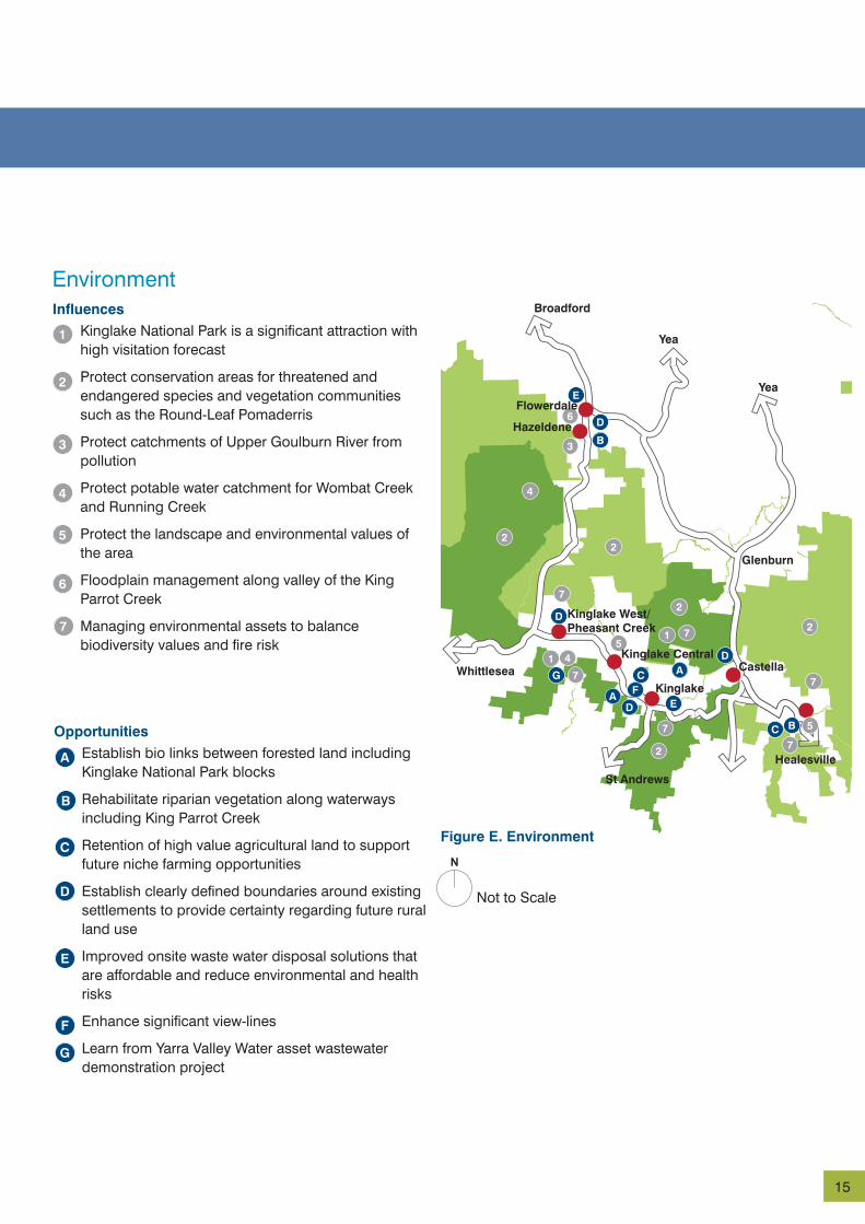
Figure E. Environment
Kinglake National Park is a significant attraction with high visitation forecast
Protect conservation areas for threatened and endangered species and vegetation communities such as the Round-Leaf Pomaderris
Protect catchments of Upper Goulburn River from pollution
Protect potable water catchment for Wombat Creek and Running Creek
Protect the landscape and environmental values of the area
Floodplain management along valley of the King Parrot Creek
Managing environmental assets to balance biodiversity values and fire risk
Establish bio links between forested land including Kinglake National Park blocks
Rehabilitate riparian vegetation along waterways including King Parrot Creek
Retention of high value agricultural land to support future niche farming opportunities
Establish clearly defined boundaries around existing settlements to provide certainty regarding future rural land use
Improved onsite waste water disposal solutions that are affordable and reduce environmental and health risks
Enhance significant view-lines
Learn from Yarra Valley Water asset wastewater demonstration project
N
Not to Scale

16
Social and EconomicInfluences
Opportunities
1
2
3
4
5
6
A
B
C
D
E
F
G
H
I
Kinglake
Kinglake Central
Kinglake West/Pheasant Creek
Flowerdale
Hazeldene
Castella
Toolangi
Yea
Glenburn
Yea
Broadford
St Andrews
Whittlesea
Healesville
Figure F. Social and Economic
Better understand constraints posed by Dieldrin contamination on former potato farms.
Need for improved way finding.
Access to existing well-located base-line community infrastructure in each settlement.
Need to identify innovative and sustainable approaches to the provision of primary health care in the study area.
Need for improved infrastructure, including high speed internet to businesses.
Need for improved youth services.
Improve the attractiveness and functionality of settlements.
Strengthen the role and identity of the local townships.
Connections between Kinglake National Park and Kinglake Ranges settlements both physically and potentially economically.
Improve housing affordability by increasing choice in housing type within existing townships to meet the needs of households as they move through life cycle changes and to support diverse communities.
New or re-establishment of businesses within commercial centres of Kinglake and Kinglake West/Pheasant Creek.
Home-based and farm gate businesses.
Tourist facilities, including host farms, bed and breakfast and retail.
Improve walking and cycling access between and within townships.
Continue to explore for a sustainable model for post-Primary education
1
2
2
3
3
3
34
5
5
6
6
A
B
B
B C
D E
F
H
GG
HH
I
H
H
H
F
A
F
E
C
CB
B
A
N
Not to Scale
Strategic Context

17
Toolangi
Yea
Healesville
Strategic Context Bushfire Safety
Safer CommunitiesFollowing the experience of the devastating 2009 Victorian bushfires, the KFT Plan has a primary focus on ways in which the safety and resilience of communities within the Kinglake Ranges, Flowerdale and Toolangi area can be optimised.
The final report of the 2009 Victorian Bushfires Royal Commission (VBRC) identifies the elements of a comprehensive and integrated approach to enhancing the safety and resilience of bushfire prone areas (see Figure G).
This framework, along with the subsequent response of the Victorian Government, which committed and continues to implement all 67 final recommendations, informs the approach to bushfire safety and community resilience outlined in this KFT Plan.
Of critical importance to this Plan, the VBRC recommended that:
‘The State develop and implement a retreat and resettlement strategy for existing developments in areas of unacceptably high bushfire risk, including a scheme for non-compulsory acquisition by the State of land in these areas.’
The final report of the VBRC also specifically mentions Pine Ridge Road in Kinglake West as an example of where a retreat and resettlement strategy should be applied. It would be reasonable to expect there are other locations within the study area and throughout Victoria to which such a recommendation would be equally applicable.
The VBRC identified the importance of planning and building controls and on-going property maintenance in the following statement:
‘where people live, the standards of the buildings in which they live, how those standards are maintained and therefore, planning and buildings controls are crucial factors affecting safety in a bushfire.’
Many of the recommendations of the VBRC relate to state and region wide measures that are the responsibility of the Victorian Government and relevant emergency services agencies and are beyond the scope of the KFT Plan. However, a number of the recommendations relate to Local Government and to specific measures that need to be applied within the study area. Table A – Safer Communities, provides a summary of the measures
currently being implemented to improve the safety and resilience of communities, along with the progress that has been made on their implementation.
The approach taken in the KFT Plan is to limit further residential growth to existing zoned land.
Hume Regional Growth Plan Many of the landscapes in the Hume region most attractive to residents and visitors are also in locations containing large areas of bushfire hazard, and future climate predictions indicate bushfire risk is likely to increase.
The Hume Regional Growth Plan considers planning in areas of high bushfire risk, noting that planning needs to review and address exposure of communities to risk including bushfire and floods and the potential impacts of climate change, as well as heritage, settlements, agricultural land and infrastructure.
Key land use planning drivers in the Hume region also include minimising risk to life and property from bushfire hazard and designing settlements to maximise resilience to natural hazards and climate change and take advantage of the opportunities from climate change.
When addressing bushfire risk, community resilience to bushfire will be strengthened by:
• prioritising the protection of human life over other policy considerations when planning to create or expand a settlement at risk from bushfire,
• applying a precautionary approach to planning and decision-making when assessing the risk to life, property and community infrastructure from bushfire, and
• taking advantage of existing settlement patterns where new development will not expose the community to increased risk from bushfire.
Regional and localised planning will take bushfire hazard into account in detail with the assistance of planning tools such as the Bushfire Management Overlay, Regional Bushfire Planning Assessments and Bushfire Prone Areas, as well as input from the Country Fire Authority.
Bushfire Management Overlay State bushfire planning policy seeks to strengthen

18
Bushfire Safety
community resilience to bushfire through sound planning decisions. Bushfire planning provisions are included in planning schemes at clauses 13.05-1 (Bushfire Planning Strategies & Principles), 44.06 (Bushfire Management Overlay), 52.47 (Bushfire Protection: Planning Requirements) and 52.48 (Bushfire Protection: Exemptions).
The Bushfire Management Overlay (Clause 44.06) is one tool within the planning system that helps to implement bushfire policy. This overlay (and relevant schedules) helps guide the development of land that may otherwise be significantly affected by a bushfire.
The purpose of the Bushfire Management Overlay is to:
• identify areas where the bushfire hazard requires specified bushfire protection measures for subdivision and buildings and works to be implemented.
• ensure that the location, design and construction of development considers the need to implement bushfire protection measures.
• ensure development does not proceed unless the risk to life and property from bushfire can be reduced to an acceptable level.
The Bushfire Management Overlay triggers the need for a planning permit for certain developments and requires that new development implements appropriate bushfire protection measures. It requires consideration of the location, design and construction of development and the implementation of bushfire protection measures.
The Bushfire Management Overlay in itself does not prohibit development in areas covered by the overlay, but it:
• triggers the need for a planning permit for certain developments
• requires that new development implements appropriate bushfire protection measures
• requires referral of planning permit application to the relevant fire authority.
The relevant fire authority and the council will assess the application from a bushfire perspective and advise the responsible planning authority if any specific planning permit conditions are needed or if it objects to the granting of a planning permit. The fire authority can also
ask for more information from the permit applicant.
The Bushfire Management Overlay may be supported by an associated schedule to apply to specific local circumstances. A schedule can vary specified requirements of the overlay and modify the relevant standards. Due to the local conditions that influence bushfire behaviour a schedule may apply to a particular neighbourhood, township or rural settlement and must be informed by a bushfire analysis.
The Bushfire Management Overlay and other key bushfire policy measures set out in state planning policy has particular relevance to planning for the KFT area.

19
Safer More Resilient Communities
Land Use Planning• Greater emphasis in Murrindindi
Planning Scheme on fire risk and protection of life
• Local Planning Policy specific to wildfire management
Building Regulations• Retrofitting of existing buildings to
improve resilience• Improved construction standards
for new buildings
Fuel Management• Manage fuel on public land
through Fire Management Planning Process
• Manage fuel on private land - landholders responsibility
Fire Management Planning• Integrated Fire Management
Planning Process• Victorian Fire Risk Register• Community Information Guides -
Bushfire• Neighbourhood Safer Places
Communications• Improved Telecommunications• Removal of radio black spots
Mapping Bushfire Risk• Bushfire Management Overlay
Readily implemented personal response plans
Fire Awareness through Education
Fire Information and Warnings
Figure G. Bushfire Safety Framework Greater InfluenceWhere the KFT Plan has:
Lesser Influence

20
Focus Area Specific Measure Implementation in the Study Area Relevant Royal Commission Recommendation
Integrated Municipal Fire Management Plan Framework
Municipal Fire Management Plan
Council has developed a new integrated Municipal Fire Management Plan in light of the recommendations of the Royal Commission.
3, 31
Victorian Fire Risk Register A fire risk register has been prepared for the southern parts of the Shire of Murrindindi, including all of the study area.
3
Township Protection Plan ‘Community Information Guides - Bushfire’ for Kinglake West - Pheasant Creek, Kinglake, Flowerdale-Hazeldene, and Toolangi - Castella have been prepared by the Country Fire Authority.
3
Neighbourhood Safer Places The Flowerdale Hall and the Kinglake West recreation reserve have been endorsed as Neighbourhood Safer Places.
Further sites are being investigated in the study area for declaration.
3
Mapping Bushfire Risk Bushfire Management Overlay (BMO) mapping
Updated mapping for the Bushfire Management Overlay will be progressed in 2014. This will include landowner notification. DTPLI will advise further on final timing and arrangements for the planning scheme amendment.
37
Land Use Planning Local Planning Policy The Plan recommends that Council prepare a local planning policy to guide decision making for new land use and development in areas of high bushfire risk, which includes most of the study area. A policy has been prepared by Council to integrate the assessment of bushfire risk and building development while prioritising the protection of human life. This policy has been submitted to the Minister for Planning for approval.
This policy should provide direction for Council planners in determining the suitability of new development, including dwellings on small rural lots within high fire risk areas.
45
Management of growth The Murrindindi Planning Scheme currently provides for new urban development in Kinglake West/Pheasant Creek and Castella. These provisions will require amendment for consistency with the KFT Plan.
The Plan also recommends removing subdivision potential from the low density residential estate located in Castella given fire risk considerations.
39
Fuel Management Application of Code of Practice for Fire Management on Public Land
Many residents of the study area live in close proximity to forested public land managed by the Department of Environment (DEPI) State Forests and Parks Victoria (Kinglake National Park).
Fire Management Planning is currently underway to apply fire management zones to this land to reflect the need for asset protection and biodiversity conservation objectives.
Public land management agencies are to improve communications with local communities regarding fuel management activities undertaken within the study area to ensure that local communities are better informed.
56, 57, 59
Bushfire Safety

21
Focus Area Specific Measure Implementation in the Study Area Relevant Royal Commission Recommendation
Fuel Management along major roads
In March 2013 VicRoads released Road Bushfire Fire Risk Assessment Guidelines, prepared in partnership with the CFA, DEPI and the MAV. The guidelines are aimed at ensuring that there is a systematic program of bushfire risk assessment on the arterial road network. The guidelines will form part of the Integrated Fire Management Planning Process undertaken across the State. The guidelines provide:
• an outline of the key objectives with respect to road bushfire management.
• a processes for assessing risk relating to each objective.
• guidance for determining what treatment is to be employed based on the risk of bushfire.
• an outline of the bushfire management planning process.
• work sheets to assist with risk assessment and treatment selection.
62
Communications Improve fire ground communications
Additional command channels are being installed at Kinglake West and Reedy Creek.
23
Table A. Safer Communities

22
Fire Management PlanningThe KFT Plan identifies the need to better integrate the various components of the community safety work currently being undertaken by Murrindindi Shire Council (Municipal Public Health Plan, Municipal Emergency Management Plan, Municipal Fire Management Plan and Township Protection Plans) and by other authorities including public land managers (Parks Victoria and the Department of Sustainability and Environment) and the Country Fire Authority, with the strategic and spatial planning processes for the area through the Murrindindi Planning Scheme.
Land Use PlanningThe VBRC identified improvements that can be made to the Murrindindi Planning Scheme including the need for a local planning policy to provide specific guidance on bushfire risk mitigation. A local policy addressing bushfire risk has been drafted and has been forwarded to the Minister for Planning for approval. The KFT Plan recommends the adoption of a local planning policy and also that the subdivision potential currently provided for in the Castella Low Density Residential area is removed due to fire risk.
Fuel Management Many residents within the study area live in close proximity to heavily forested public land under the management of either Parks Victoria (Kinglake National Park) or the Department of Environment and Primary Industries (State Forests). The need for these public land managers to more clearly articulate how fuel is to be managed in close proximity to private landholdings was recognised by the VBRC. The Fire Management Planning review process that is currently underway for public land is the first step in improving fire management planning on public land within the study area.
Communications Awareness and Personal ResponsibilityResidents and visitors to the study area need to be well-informed about the inherent risks of living or visiting the area during high fire risk days. This is of critical importance for ensuring that communities are well-prepared for any fire event. Strategies that have been identified in the KFT Plan to improve community
awareness of fire risk include:
• ensuring community and civic hubs and other logical points (i.e. bus stops, Council offices, libraries) provide information about responding to an immediate emergency situation, improved design standards and vegetation management
• encouraging the community’s participation in raising fire risk awareness, and the development of personal and family individual emergency management and response plans
Fire ground communications within the study area will be improved through the addition of command channels at Kinglake West and at Reedy Creek (with coverage that extends into the study area). These command channels will make it easier to manage a fire incident in the study area.
Building RegulationsShortly after the bushfires, the Victorian Government announced that it supported the rebuilding of homes and infrastructure within bushfire affected communities. New buildings are now required to meet a higher standard of bushfire protection. Following amendments to the Building Code of Australia, new and replacement dwellings and public buildings are required to be built to a Bushfire Attack Level (BAL) standard to improve resilience to fire. Building standards are only one means of improving safety and do not mitigate the need for people to be well prepared in advance of fire events and able to readily implement fire plans.
Managing GrowthMany areas affected by this KFT Plan are surrounded by forest and steep terrain, presenting a high degree of fire risk. Accordingly, growth is confined to existing zoned areas.
Within this framework, there are opportunities to provide for a greater diversity of land use opportunities, be they different forms of housing in Kinglake, tourism or other economic opportunities allowed under the provisions of existing zones.
Bushfire Safety

23
THIS PAGE INTENTIONALLY
LEFT BLANK

24
Future Directions
Kinglake Ranges, Flowerdale and Toolangi regions will be: :
Places where the natural environment and rural landscape continue to be highly valued, defining the character of local towns and community lifestyles; and that seek to balance the environmental, economic and social aspects of everyday living.
Safer, more resilient communities serviced by distinctive small towns that are welcoming and attractive to locals and visitors alike, are able to meet daily needs and are well connected to each other and to surrounding employment and services.
The Vision The ValuesThe vision and values that underpin a sustainable future for the communities of Kinglake, Kinglake Central, Kinglake West/ Pheasant Creek, Flowerdale and Hazeldene, Toolangi and Castella have been identified to capture the essence of community aspirations, they include:
Our tranquil lifestyles within a picturesque rural environment.
Viable, distinctive, small towns with a welcoming, village atmosphere and a mix of housing and business opportunities.
Our natural assets and the environment including the Kinglake National Park, the State Forest, agricultural land and the landscapes that add character to our roads and towns.
Resilience and adaptability with the capacity to live more safely with nature and its risks; and to respond to the challenges of climate change.
The opportunity to meet our daily needs locally while maintaining our rural lifestyles and staying connected to the world.
Local jobs in the new green economy including opportunities for sustainable agribusiness and tourism, and for creativity and innovation.
The wellbeing of our people, with access to the housing, services and facilities they need at different times in their lives.
Our guardianship of the environment and our communities for future generations.

25
DirectionsThe KFT Plan proposes that the vision and values be realised through pursuing seven directions. The directions and strategies implement them are outlined below:
1.0 Maintain Tranquil Lifestyles
1.1 Safeguard and enhance environmental and rural landscape character by preserving and improving existing views and landscapes, and ensuring new development reinforces these qualities.
1.2 Support viable and sustainable agriculture by encouraging innovation and best practice farming, protecting areas of agricultural value from urban encroachment and resolving the limitations on agriculture posed by previous agricultural activities and access to water.
1.3 Preserve the rural landscape character by consolidating new development and community infrastructure within existing towns.
1.4 Protect rural lifestyles and expand the diversity of housing choice available through developing more sustainable solutions to manage waste water and energy to allow for a broad range of lots sizes in townships.
2.0 Foster a Viable Local Economy
2.1 Develop a unifying brand identity, building on the environmental and cultural assets of the area, to attract investment and visitors to the area.
2.2 Encourage small, creative enterprises in tourism, creative arts, home-based businesses, overnight visitor accommodation and farm enterprises/markets that showcase local produce.
2.3 Encourage sustainable agri-business including innovative horticulture, niche and organic farming, and farm-gate and tourism-oriented businesses.
2.4 Develop a tourism and recreational offer based on the Kinglake National Park and other natural assets that encourages tourists to visit townships, provides local employment, and protects and enhances the natural assets.
2.5 Grow local jobs and businesses by making towns more attractive, improving the retail and hospitality offer, and encouraging local residents to shop locally and tourists to visit.
3.0 Protect and Enhance the Environment
3.1 Identify, manage and enhance significant environmental assets such as the Kinglake National Park, biodiversity corridors and watercourses.
3.2 Manage water resources more sustainably through innovative local and precinct-level waste water solutions, community education programs and monitoring the use of groundwater.
3.3 Support more sustainable energy generation and conservation in residential, agricultural and business sectors.
3.4 Promote the region as an exemplar of sustainable environmental management.
3.5 Provide for recreational and educational activities, aligned with the environmental values of the Kinglake National Park and other natural assets.
26
4.0 Create Attractive, Distinctive, Vibrant Towns4.1 Provide compact and distinct town centres and
community hubs that reinforce township identity.
4.2 Enhance the landscape character of towns and local settlements through better integration of landscape and built form and streetscape improvements in town centres.
4.3 Consolidate population growth within existing towns and settlements to strengthen their viability and support the renewal of communities.
4.4 Create boundaries around towns and settlements with environmental buffers that help to define the character of townships, improve safety and avoid dispersed development that detracts from the rural character of the area.
5.0 Support the Wellbeing of Local Communities5.1 Support local towns to be safe, welcoming and
inclusive places to live, work and visit by providing a baseline of core services and facilities in each town, improving public spaces and enhancing the attractiveness of town centres and neighbourhood nodes.
5.2 Respond to the diversity of community needs by seeking to achieve sufficient levels of service to provide for day-to-day needs and reduce the need to travel; and through flexible models of service delivery to improve access to health and education services, where there is not the population to sustain full service levels.
5.3 Support life choices and opportunities particularly through improved access to local employment, access to learning (especially for young people), and housing and services that support older people in their communities.
5.4 Create opportunities for people to connect, celebrate and participate in community life by supporting
cultural activities, providing access to information and decision-making and safe walking and cycling connections.
6.0 Support Community Resilience, Safety and Adaptability
6.1 Improve community safety by implementing an integrated response to bush fire management and settlement planning.
6.2 Promote awareness of natural risks so that communities and visitors are well-informed and well-prepared about the risks of living or visiting the area.
7.0 Improve Community Connectivity 7.1 Provide safe, accessible and reliable roads,
pathways and trails and improve access to public transport for employment, recreation and services.
7.2 Address telecommunications infrastructure gaps to underpin stronger social and economic outcomes and community safety.
7.3 Create opportunities for social connectedness through improved signage and public spaces, access to information and broadband.
Future Directions

27

28
Development Framework
The KFT Plan presents a development framework to strengthen the sustainability of existing towns and preserve the environmental values of the region in a way that enhances community safety for the future.
The key features of the development framework are:
1. a) Promote consolidated commercial and residential growth within existing zoned land at Kinglake, b) Promote limited commercial and residential growth within existing zoned land in Kinglake West/Pheasant Creek, c) Support sustainable growth consistent with relevant planning provisions in existing zoned land in Kinglake Central, Toolangi, Flowerdale and Hazeldene, d) Limit residential growth by removing the existing provision for subdivision in Castella. The key features of the development framework are This will create opportunities for safer living (and possible resettlement from less safe areas) and will help to underpin the future viability of existing and planned services and infrastructure.
2. Future development being undertaken in a way that contributes to improving the overall safety of the towns through more innovative approaches to subdivision patterns; green landscape buffers created through waste water management; more permeable road networks and designated neighbourhood safer places.
3. Strengthening the identity and character of local towns and activity nodes through improved signage, landscape buffers, urban design and town containment.
4. Promoting local towns as gateways to the Kinglake National Park and other environmental assets and features in the region and providing opportunities for tourism to bring more people to the area.
5. Strengthening the local economy and improving access to jobs at the local level – the major opportunities for local economic development are in tourism-related activities and in niche agribusinesses that take advantage of the Kinglake National Park, high value agricultural land and proximity to Melbourne markets. This includes supporting
existing local businesses and creating opportunities for new enterprise in creative and cottage industries; accommodation, food and hospitality, outlets for small producers such as farmers markets and farm-gates and festivals and events.
6. Improving access to services at the local level through developing local activity and community nodes that provide a base line of core services in each town; helping to reduce the high social and economic costs of travel for local households and strengthening local community viability and wellbeing.
7. Enhancing the attractiveness of local towns as places that provide for the daily needs of local communities and are appealing to visitors.
8. Strengthening connections between and within towns by improving cycle and walking paths.

29
Flowerdale
Hazeldene
Kinglake
Castella
The Gums
Wombelano Falls Island Creek
Jehosaphat Gully
Mount Sugarloaf
Masons Falls
Frank Thomson Reserve
Toolangi
Promote consolidated growth within existing zoned land
Visitor Node (Kinglake National Park)
Environmental Buffer
Recommendations for potential rezoning and buffers environmental
Landscape Buffer
Support sustainable growth within existing zoned land
Limit growth - remove potential for further subdivision
Promote limited growth within existing zoned land
Figure H. Development Framework
Yea
Yea
Glenburn
Broadford
St Andrews
Whittlesea
Healesville
Kinglake West/Pheasant Creek
N
Not to Scale
Kinglake Central

30
Kinglake West/Pheasant Creek Existing zoned land provides for some growth in Kinglake West/Pheasant Creek (approximately 90 lots at minimum 2 hectares). Township identity would be strengthened and community activity nodes emphasised at intersection of Kinglake-Whittlesea Road and Whittlesea-Yea Road; Kinglake West Primary School/Mechanics Institute Hall and at Pheasant Creek/National Park Road. No further rezoning to support residential growth is proposed.
Kinglake Central Kinglake Central provides a hub for community infrastructure (e.g. new school and early learning centre, recreation facilities). No further rezoning to support residential , commercial/retail growth is proposed.
Core Retail
Community Facilities
Consolidation of Residential
Low Density Residential
Forest
Farming
Hazeldene Hazeldene is highly constrained by steep forested terrain with most private landholdings already developed. Hazeldene is proposed to remain a rural settlement and community nodes being strengthened at Flowerdale Community House in Silver Creek Road and Hazeldene General Store. No further rezoning to support residential growth is proposed.
Flowerdale Flowerdale is proposed to remain a small rural settlement, given its distance from larger towns and the environmental constraints that apply to the locality, particularly at its southern end. Community nodes would be emphasised at the Flowerdale Hall/school/hotel, and the Spring Valley Recreation Reserve. No further rezoning to support residential growth is proposed.
Settlement Structure

31
Kinglake Kinglake is more isolated from Melbourne than other settlements and currently provides a range of commercial services to local residents. There is an opportunity to consolidate the town centre through utilising reformed commercial or residential zones in the vicinity of the commercial centre to provide increased dwelling diversity and to support the local business and community services sectors, providing for both locals and visitors to the region. Community activity nodes would be located in the town centre and at the primary school-neighbourhood house location. No further rezoning to support residential growth is proposed.
Castella Castella is a low density residential estate in an isolated area that is subject to high fire risk. The Murrindindi Planning Scheme currently allows for significant further subdivision in Castella. It is proposed that this subdivision potential be removed by increasing the minimum lot size for the zone in this area.
Toolangi Toolangi is proposed to remain a small rural settlement located within a highly valued landscape setting with highly productive agricultural areas surrounding the settlement. Community activity nodes would be strengthened in the vicinity of the CJ Dennis Hall and at the Toolangi Tavern. No further rezoning to support residential growth is proposed.
Rural areasRural areas located between settlements provide landscape and ecological buffers and should remain as rural areas. It is proposed to maintain these highly valued landscape and ecological values.
Figure I. Settlement Structure