The Importance of Land-Cover Change in Simulating Future ...

1
The Importance of Malaysian Land Administration Domain Model Country Profile in Land Policy
Nur Amalina Zulkifli1*, Alias Abdul Rahman1, Peter van Oosterom2, Tan Liat Choon1, Hasan Jamil3, Teng Chee Hua3, Looi Kam Seng3, Chan Keat Lim3
1Department of Geoinformation, Faculty of Geoinformation and Real Estate, Universiti Teknologi Malaysia, UTM Skudai 81310, Johor, Malaysia.
2Delft University of Technology, Section GIS-technology, Department OTB, Faculty of Architecture and the Built Environment, P.O. Box
5030, 2600 GA Delft, The Netherlands.
3Department of Survey and Mapping Malaysia, Jalan Semarak, 50578, Kuala Lumpur, Malaysia.
Keywords: LADM, country profile, land policy
A B S T R A C T
Every country has land policy and land planning systems to improve social, physical, spatial and economic imbalance. Land policies provide the framework, direction and continuity of decisions made for the function of land in the implementation of national development plans which involve local, state and regional plans. In Malaysia, land policies are implemented within a broader framework, which is supervised by the government. Some land policies were implemented based on the National Land Code (NLC). The National Land Code 1965 came into force on 1st January 1966 to administer all land matters in Peninsular Malaysia and the Federal Territory of Labuan while Sabah and Sarawak continued to use the Sabah Land Ordinance 1930 and Sarawak Land Code 1958 respectively. The purpose of the NLC is to ensure the uniformity of land policy and land law with respect to land tenure, registration, transfer, charges, leases, easements and other interests and rights to land. Rapid development and various needs for securing proprietors’ interests have put a lot of demands on land administration. A new three-dimensional (3D) cadastral system was proposed to cater for above and below surface cadastral objects and to enable the registration of real properties that are not limited to the land surface. The 3D approach for cadastral and land registration systems can provide a better means to manage modern cadastral objects. There are two organisations within Peninsular Malaysia responsible for managing and maintaining the land administration system, namely, the Department of Survey and Mapping Malaysia (DSMM) and the District Land Offices which are responsible for the cadastral survey and ownership rights respectively. Both organisations have their own information systems called eLand in District Land Offices and eCadastre in DSMM. There are three arguments to further improve the land administration system towards e-Government services – government guarantee of indefeasibility of title to private land; information integration for good governance of land administration; systematic and accurate recording for land taxation purposes as a source of important state revenue. Those arguments clearly demonstrated the need for the Land Administration Domain Model (LADM). The LADM is an international standard for land administration purposes. Malaysia does not have a standard model for land administration. Standardisation of land administration within a country should meet the international standard, this will hasten land transactions between international entities. This paper attempts to outline Malaysian land policy in relation to the framework of the National Land Policy and LADM standard as a reference model for Malaysian land administration.
1. Introduction
Law and legislation are a complex set of rules that have been developed gradually and naturally within a society to ensure the peaceful behaviour of its members. The land administration organisational structure in Malaysia demarcates the power to manage land to the state authority since land is a state matter pursuant to the Federal Constitution of

2
Malaysia. The state authority may alienate land in perpetuity or for a term of years, in consideration of payment or rent. There has been a tendency towards rural/urban residential and occupational specialisation by ethnicity. Thus, there are policies such as the New Economic Policy (NEP), the National Development Policy (NDP) and the New Economic Model (NEM) to reduce imbalance by restructuring society. These policies are important to solve land-related issues in Malaysia. The first issue relates to public power over land which involves planning, development control, compulsory purchase, public development and land taxation. Secondly, the land market includes legal and fiscal frameworks for commercial transactions such as buying, selling, leasing and mortgaging. The last issue is the institutional structures that exist to control the use of land and this includes local and central public authorities and the general regulatory framework for decision making in the field of urban land. A substantial part of the national development will inevitably be in the form of physical development on land. The success of the national development policies and strategies in Malaysia depends on complementary land legislation, supporting land policy and the physical planning framework (Ganason and Ismail, 2011).
The current Malaysian land administration system does not include 3D objects registration rights. The 2D-based system has been practised in Malaysia for a period of one hundred years and it provides essential information about land and property such as ownership of the lots and land parcels for the country. In addition, the eCadastre (in DSMM) and eLand (in District Land Offices) systems work unconnectedly Consequently, there are no 3D property rights as well as 3D cadastral rights. However, these systems can be extended for 3D and can be integrated using the LADM standard. In this way Malaysian land policies could be better supported in the future.
The LADM is an important model to create standardised information services in an international context, where land administration domain semantics have to be shared between regions or countries in order to enable necessary translations. Literature reviews show that many countries have proposed their own profiles based on LADM such as Poland (Bydlosz, 2013), the Republic of Korea (Kim et al., 2013), the Netherlands (Lemmen, 2012) and Croatia (Vucic et al., 2013). Malaysia is one of the potential candidates moving towards a LADM-based country profile. As listed in ISO 19152 (ISO, 2012), two important goals of this model are:
i. to give a foundation for the refinement and development of an effective land administration system, using Model Driven Architecture (MDA),
ii. to involve parties, within one country and between different countries, to communicate based on the same terminologies used by the model.
As background, Section 2 provides an overview of the Malaysian land policy framework. Then, land administration is elaborated in Section 3. Section 4 describes the Malaysian land administration systems. Section 5 discusses the development of the Malaysian LADM country profile. Finally the paper concludes in Section 6 with a reflection on the findings and implications for good governance.
2. Framework of Malaysian Land Policy
Malaysia is a federation of states. In Peninsular Malaysia, states are responsible for their own land matters. These states operate a Torrens system, administered by the State

3
District Land Office and coordinated by the State’s Land and Mines Office. On the other hand, cadastral surveys are controlled by the Department of Survey and Mapping Malaysia (DSMM), which is a federal department. The DSMM is responsible for cadastral survey work within Peninsular Malaysia and is supported by licensed land surveyors, who are in charge of subdivision surveys. In Sabah and Sarawak, cadastral survey and land registration is administered by a single organisation, namely the Department of Land and Surveys.
2.1 National Land Policy
The Constitution of Malaysia provides for the doctrine of private ownership of property including land. The National Land Code (NLC) supports this through the creation of a comprehensive and organised system of land ownership, registration and dealing which ensures the indefeasibility of title to land. The right of land being a state matter is provided in the Constitution. This means that there are as many land policies as there are states. Where the third tier of government exists i.e. local authorities, further ‘localised’ land policies exist which are in turn controlled by state land policies.
Article 91 of the Malaysian Constitution provides for the establishment of a National Land Council comprising state representatives. It is mandatory for federal and state governments to follow the National Land Policy. The council has in the past formulated broad-based policies on squatters, land speculation and use of land for industries. These policies however, have been kept confidential and there is no known assessment of their effectiveness. As land is a state matter, it can be expected that each state will want to decide what it can do with its land first rather than be subjected to a national policy. Thus, the National Land Policy Framework, illustrated in Figure 1 will be further explained.
Fig. 1. Framework for the National Land Policy (Ismail, 2011a)
NATIONAL LAND POLICY
FRAMEWORK
Land Development Land use conversion Subdivision of land Partitioning of land Amalgamation of land Surrender of land Re-alienation of land Abandoned title
Land Tenure Disposal of land rights Indefeasibility of titles Registration of dealings/non-
dealings
Social Context Facilitating Sustainable development Economic, social,
environmental, governance Quality of life
Country Context (Federal-State Levels) Institutional arrangements Capacity building Education & research Services to business and citizens Coordinated land information &
management systems
Land Value & Taxation Quit rent Premium Assessment
Land Use Agriculture Building Industry

4
The vision of the National Land Policy is ‘towards sustainable development through excellent land resource management’. This will ensure that land resources are utilised on a sustainable basis for the continued progress of the nation’s socio-economic development. There are eight policy principles, as stated below (Ismail, 2011a):
Principle 1: Access to land for all citizens
This principle needs to be stated in the face of ever-increasing pressures on land resources and their administration. This principle assures land access, clearly defined property rights and secures tenure.
Principle 2: Integration of this National Land Policy with the vision and goals of the National Vision 2020
Vision 2020 is the long-term guide to Malaysia’s development. Therefore, one principle of this national land policy is to ensure optimum utilisation of land resource to assist in achieving its socio-economic development vision and related goals of Vision 2020.
Principle 3: Institutional coherence or alignment of land-related agencies
This deserves its status as a principle rather than simply a strategy because of its fundamental importance in achieving the NLP’s vision. That is, it is a fundamental principle of this policy that institutional coherence and efficiency is a necessary precondition for the achievement of the goal.
Principle 4: A process of capacity building upon Malaysian culture and institutions
This principle recognises that, historically, lasting progress is built incrementally, one step at a time. Practices and institutions that encourage such growth are to be recognised and modified if need be.
Principle 5: Community participation, accountability and transparency in land administration and management
This principle follows the human resource development principles of Vision 2020. This policy principle is directed towards local communities taking the future into their own hands, with the government making themselves available to service their requirements. The principles of transparency and accountability are to apply to all levels of this process – from the communities themselves to the highest echelons of land administration and management.
Principle 6: Gender equity
Obstructions to the human resources development of any individual should not be imposed on the basis of gender, race or marital status. Land-related legal impediments to gender equity are to be removed. The growth towards gender equity in customary tenure is to be encouraged.
Principle 7: A process of stimulating land and property markets
National Vision 2020 recognises the private sector as holding the key to economic growth. The effective operation of the private sector is dependent upon the establishment of clearly

5
defined property rights including land-related property rights by a legal framework and their efficient administration through an institutional framework.
Principle 8: Optimal sustainable use of the land resource
Natural resource management and development are the basic strategies towards improving sustainable food security.
2.2 Land Tenure and the Cadastral System
The Torrens system is a system of title registration where the law guarantees that the person shown on the title displayed in a land register is the registered proprietor. The register is conclusive evidence that the person named therein, as the proprietor of an interest in the land, is the legal owner of that interest. Interests in land can only be created, varied or changed by registration. These standards are summarised as two fundamental principles of the Torrens system in Peninsular Malaysia namely the Mirror Principle and the Curtain Principle. The Mirror Principle ensures that the register reflects legal interests in the land. The Curtain Principle means that once a registration occurs, unregistered interests affecting the land are not enforceable against the registered owner. It is not necessary to look behind the title to investigate previous interests (Ismail, 2011b).
There are three components in a Torrens title. The parcel section of the land identifies the boundary, giving it a unique identifier and describing the metes and bounds (usually graphically by reference to a plan of survey). The proprietorship section identifies the owner and the encumbrance section identifies any other interests in the parcel such as a charge, caveats, an easement or a restriction as to use. In the paper-based system, the registered proprietor holds an Issue Document of Title of the Register Document of Title held by the land registry. The paper-based titles are being phased out as the administrations convert to computer-based systems (i.e. eLand and eCadastre). Using the eCadastre system, the state will permit cadastral plans to be part of the the land registry in the digital cadastral mapping system.
The cadastral systems in Peninsular Malaysia are based on registering transactions with land generated by a land market. The role of the cadastral system is to support the registration of land for legal ownership, registering the rights, restrictions and responsibilities pertaining to land through precise surveying methods. The integrity of each cadastral system is consistent allowing the core spatial data set in spatial data infrastructures to play a fundamental role in broader land administration activities. Cadastral systems are basically created by surveying land parcels in the field and recording the corresponding land ownership titles in the land registry.
2.3 Land Taxation System
All land in Peninsular Malaysia is subject to an annual tax known as ‘Quit Rent’ which is collected by the state government. This tax structure is based on state land rules and is determined by the size, location and use of land. This form of tax does not encourage the development of vacant land as tax on vacant land is low. Property tax or ‘Assessment Tax’ is another form of tax levied on property within a local authority which is collected by the local authority. The tax levied is determined under the provisions of the Local Government Act and varies from one local authority to another. The more built-up the area of a property, the higher the assessment tax. Assessment tax is a form of revenue to the local authority to provide for public services and facilities. The Real Property Gain Tax Act 1976 ensures that
6
profits made from the sale of land are taxed. This is to prevent property speculation; it is not designed to tax unearned increment in land values or to increase the supply of land for development (Ismail, 2011b).
2.4 Land Use Control and Land Development Systems
The planning scheme controls land use and development within a local municipality. It contains state and local planning policies, zones, overlays and other provisions that affect how land can be used and developed. The planning scheme will indicate if a planning permit is required to change the use of the land or to construct a building or make other changes to the land. Every municipality has its own planning scheme. The local government councils must take into account both the state and local planning policies when making a planning decision. It makes most of the planning decisions that affect its municipality. For example, it decides whether or not to grant a planning permit for a new use or development and what permit conditions are appropriate (Ismail, 2011b).
Today in Peninsular Malaysia, all municipalities are covered by land-use planning controls, which are administered by state and local government authorities. Legislation governs such controls through the Town and Country Planning Act 1976 and Local Government Act 1976. Those who do not obey the laws about land and development can be prosecuted. At state level, the government’s strategic land-use planning is based on a sound analysis of issues and trends that can be regularly monitored and reviewed, with an integration of the transport, environmental and social aspects of development. Such strategies are reflective of the broader community and based on extensive community consultation. The state government’s approach relies on creative and effective partnerships with local government, local communities, business, industry and other organisations and interest groups.
3. Land Administration in Malaysia
Land administration is an integral part of a nation’s development. Land administration is governed by the NLC 1965 which was created to provide consolidated legislation in the aspects of land tenure, registration of titles relating to land, transfer of land, leases and charges in respect of land, easement and other rights in the alienation and development of land.
Rapid development and various requirements for securing proprietors’ interests have put a lot of demands on land administration. The lack of speed in services delivery has made doing business with land administration a nightmare because of the bureaucracy and long approval periods which dampen the prospect of attracting large investments into the country. A brief identification of some related issues pertaining to land development within the framework of the NLC will be discussed.
3.1 Qualified Titles and Final Titles
Qualified Title (QT) is a concept implemented in Malaysia where land titles are issued in advance of a proper cadastral survey. The QTs were introduced to accelerate administration involved with subdivision development. Although the process of issuing QTs was successful in speeding up the development process, as well as assisting in the establishment of an active land market, many QTs are still pending Final Titles (FTs). This creates survey issues, as not all ownership units have necessarily been surveyed or registered

7
as FTs. Qualified Titles have been successfully traded and used as security in the land market in the same way that FTs are treated in the land market. Banks and financial institutions also treat QTs and FTs in the same way regarding loan security. Because of these factors, there is little motivation from land owners to convert their QTs to FTs (Ganason and Ismail, 2011).
The original configuration of the QT concept meant that many QTs were created by non-surveyors, with the central survey and mapping organisation having no control over the form of these cadastral plans. Although it was intended for these plans to eventually be converted to FTs, QTs that have not been converted are therefore not recorded in the national cadastral map series. These factors will generate difficulties when attempting to convert the national cadastral maps series into a digital cadastral database.
3.2 Coordination between different levels of institution
Land administration should ideally be under the supervision of a single authority that acts as the lead agency (Nordin, 2001). Such an arrangement will guarantee the best possible coordination between the various parts of the whole process and provide the necessary framework for establishing a unified land information system and service. However, this ideal principle does not exist in Malaysia. In practice, Malaysia has a tradition of separate governmental institutions with the cadastre recording property boundaries under the jurisdiction of the Federal Ministry. The State authorities are responsible for taxation and land-use rights for a separate legal registration system. The Federal Ministry often makes its own rules, while co-operation between State authorities frequently depends more on personalities than on policies. This results in separate inquiries having to be made about rights of ownership and rights of use before any transfer can take place, leading to overlapping efforts and inconsistencies. As a result, inaccuracies in the data may arise, coupled with additional costs being incurred. Therefore, it is important to propose information integration of all these data from various agencies.
With vast advancements in Information and Communication Technologies (ICT), databases could be integrated electronically. In order to achieve the goal of a comprehensive Land Information System from district level up to State, and eventually at national level, the integration of the spatial eCadastre database with the textual eLand database is a prerequisite. Coordination beween the State Land & Mines Offices, the District Land Offices and the Department of Survey & Mapping Malaysia could be provided by the installation of a centralised server or distribution server at each of their offices, which would act as the transporters and bridges in exchanging data between eLand and eCadastre. Although there are a lot of benefits from an integrated textual title registration database, and better graphics as well as spatial cadastral database, there are still many hurdles to overcome at this stage.
Based on what has been discussed previously, there could be extensive benefits if these two systems, namely the eLand and eCadastre, were linked. Therefore, with the integration of attribute data from eLand and spatial data from eCadastre and through identified applications, the efficiency of land administration could be greatly increased. Although conceptually tenable, the eventual implementation would need substantial negotiations and compromise between these government authorities.
3.3 Automatic renewal of land leases
Section 40 of NLC 1965 states that all state land belongs to the state authority. When state land is disposed of by the state authority to an individual in perpetuity for an indefinite period, this land is now granted as a freehold title. When the state land is disposed of by the

8
state authority to an individual for a term of years, not exceeding 99 years, this land is now granted as a leasehold title. Upon expiry of the period of the lease, the land will revert to the state authority. The owner will then have to either apply for a renewal of the lease before its expiry or apply for a fresh alienation if the lease has expired. These will involve the payment of a hefty premium which would be similar to buying the land, or the state authority, using its powers of discretion, may offer some discount to the landowner. When the lease has been obtained by the leaseholder from the state authority and the property is part of a residential area it is unlikely that the state authority will refuse to renew the lease or grant a further term (Ganason and Ismail, 2011).
There is no guarantee that the renewal will be for a duration which is equal to the period of the earlier lease. Nor would the new premium to be paid likely to be the same as when the lease was previously obtained. There could be instances where there is no renewal of the lease at all. This could happen if the area is required by the state to meet a pressing and urgent need of national interest, in which case the houses in the area concerned may have to be demolished. The uncertainties surrounding leasehold land can lead to problems in land development and any other dealings by the proprietor. In order to overcome this problem, the devising of a mechanism for automatic renewal of a lease is proposed.
3.4 Redevelopment of land by ‘en bloc sale’ concept
The concept of redevelopment of land by ‘en bloc’ basically means all the owners of separate units in an apartment, condominium or even an office building, coming together to collectively sell their properties to a developer for comprehensive redevelopment. Thus, this term generally refers to en bloc sale or collective sale. There are some requirements for unanimous consent among property owners within the development before they would be able to collectively put their properties up for sale. Therefore, in those developments where one person or a minority refused to give their consent to sell their unit, the collective sale could not materialise. As a result, there will be multiple situations where a majority of the owners lose the opportunity to realise the capital gains from such a type of sale. In response to complaints and appeals from frustrated owners whose efforts to complete such sales had been thwarted by a very small minority, a proposal has to be made to amend the Strata Title Act to facilitate collective sales or en bloc sales (Ganason and Ismail, 2011).
The latest updates – the Strata Titles (Amendment) Act 2013 (STAA 2013) brings a significant change to the landscape of strata developments and common property management. The amendments under STAA 2013 include the introduction of the Electronic Land Administration System of Strata Titles, the designation of limited common property and the creation of one or more subsidiary management corporations to represent the different interests of parcel proprietors. Figure 2 illustrates the various types of cadastral objects related to strata titles within a lot.

9
Fig. 2. Various cadastral objects related to strata titles within a lot
A parcel in relation to a subdivided building means one of the individual units comprised therein (apartment or condominium), which is held under a separate strata title. An accessory unit means a unit shown in a strata plan, which is used or intended to be used in conjunction with a parcel. A common property means that such development area in strata scheme is not comprised in as well as used or capable of being use or enjoyed by occupiers of two or more parcels or proposed parcels. A limited common property means common property designated for the exclusive use of the specific owners. A land parcel means a unit delineated within the lot (in which is comprised a building of not more than four storeys) which is held under a strata title and which may have a shared basement, accessory unit and common property.
There are at least three reasons why owners of strata-type properties usually go for an en bloc sale:
i. it allows parcel owners to sell their properties for a lot more than the properties would fetch by selling them individually in the open market,
ii. it allows parcel owners to convert the unused land or development potential in their property development into cash,
iii. it also allows parcel owners to cash out of their property investment for other newer and larger properties or re-invest in other forms of higher yield investments.
In addition, en bloc sale is normally feasible when some positive change occurs in land development. For example, an increase in the plot ratio of land, re-zoning of the land for a higher use or when the land is not fully built-up or utilised.
3.5 Customary rights
The National Land Code 1965 is only valid within Peninsular Malaysia and its federal territories. Both Sabah and Sarawak states have implemented their own Land Ordinance. Malaysian customary rights are not governed by the Federal Constitution of Malaysia but governed by the state authority as customary rights are regarded as state land matters. Prior to the Malaysian Customary Rights, the states that still implemented these rights were Melaka, Negeri Sembilan, Sabah and Sarawak, which are Malacca Customary Land, Tanah Adat Negeri Sembilan, Native Lands and Native Customary Land for Sabah and Sarawak

10
respectively. Customary rights are acquired by custom and owned by the natives. Each of these customary rights differs from one another in terms of land administration systems and land management systems due to their historical differences.
The majority of the indigenous peoples of Malaysia still live in remote areas, although some of them now live on the periphery of the urban areas. Many survive by hunting and gathering, fishing, farming, arboriculture and by trading forest products. There are 28 indigenous groups making up 71.2% of the population of Sarawak state: 13 native groups of people in Peninsular Malaysia numbering around 200,000 people (2010 estimate) or constituting 0.8% of the population of Peninsular Malaysia. In Sabah, the 39 ethnic groups apparently make up 61.22% of the state’s total population.
Various complaints have been made by land owner ranging from allegations of encroachment and dispossession of land, land incorporated into forest or park reserves, overlapping claims and inefficient processing of requests for the issuing of native titles or community reserves. A large part of the problem arises from a lack of recognition by the authorities of the concept of customary land of the indigenous people, or what constitutes customary land, when much of this land has not been, or is pending registration as customary land with the relevant government departments due to ignorance or misunderstanding, on the part of the community, of the processes involved.
4. Malaysian Land Administration System
The origins of the land administration systems in Peninsular Malaysia that are in operation today lie in the 19th century or earlier. Only the technology to deliver them has significantly changed. If full advantage is to be taken of the technology and a truly ‘joined-up’ service is to be delivered in tandem with the Malaysian Government Transformation Programme, then some radical reforms are called for. The first of these is to adopt a better holistic view of land and to create a multi-disciplinary forum in which land issues can be seen in perspective. The second necessary reform is to ensure that all institutional arrangements for an information based society are in place. Some of these arrangements require new laws or clarification of existing laws relating to ownership, copyright, privacy, liability and exploitation of land-related data. In particular there may need to be new legislation on the sharing of data between the public and private sectors.
The present fragmentation between federal agencies and state government
departments and between different professional organisations must cease. The treatment of land rights, land usage, land taxations and land values as entirely separate entities handled by entirely separate organisations leads to a misuse of resources. To achieve sustainable development one must consider all aspects of the land and how they inter-relate. Land registers in land registries need to reflect the way that property is used in order that appropriate services can be provided and citizens can be aware of their full rights. The integrated electronic land administration system is a model for change as a preliminary step in the right direction. Information needs to be readily available with regard to the disposal of land and the existence of potentially contaminated land in consequence of development activities.
From a technological perspective, there are five stages in the evolution of land administration systems in Peninsular Malaysia (Ismail, 2011b). The first stage recognises that historically, land title registration was manually conducted and cadastral systems were
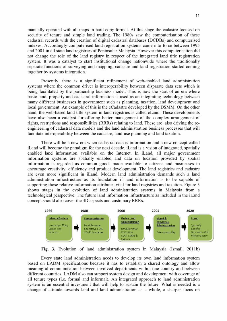
11
manually operated with all maps in hard copy format. At this stage the cadastre focused on security of tenure and simple land trading. The 1980s saw the computerisation of these cadastral records with the creation of digital cadastral databases (DCDBs) and computerised indexes. Accordingly computerised land registration systems came into force between 1995 and 2001 in all state land registries of Peninsular Malaysia. However this computerisation did not change the role of the land registry in respect of the integrated land title registration system. It was a catalyst to start institutional change nationwide where the traditionally separate functions of surveying and mapping, cadastre and land registration started coming together by systems integration.
Presently, there is a significant refinement of web-enabled land administration systems where the common driver is interoperability between disparate data sets which is being facilitated by the partnership business model. This is now the start of an era where basic land, property and cadastral information is used as an integrating technology between many different businesses in government such as planning, taxation, land development and local government. An example of this is the eCadastre developed by the DSMM. On the other hand, the web-based land title system in land registries is called eLand. These developments have also been a catalyst for offering better management of the complex arrangement of rights, restrictions and responsibilities (RRRs) relating to land. These are also driving the re-engineering of cadastral data models and the land administration business processes that will facilitate interoperability between the cadastre, land-use planning and land taxation.
There will be a new era when cadastral data is information and a new concept called iLand will become the paradigm for the next decade. iLand is a vision of integrated, spatially enabled land information available on the Internet. In iLand, all major government information systems are spatially enabled and data on location provided by spatial information is regarded as common goods made available to citizens and businesses to encourage creativity, efficiency and product development. The land registries and cadastre are even more significant in iLand. Modern land administration demands such a land administration infrastructure as its foundation if land information is to be capable of supporting those relative information attributes vital for land registries and taxation. Figure 3 shows stages in the evolution of land administration systems in Malaysia from a technological perspective. The future land information infrastructure as included in the iLand concept should also cover the 3D aspects and customary RRRs.
Fig. 3. Evolution of land administration system in Malaysia (Ismail, 2011b)
Every state land administration needs to develop its own land information system based on LADM specifications because it has to establish a shared ontology and allow meaningful communication between involved departments within one country and between different countries. LADM also can support system design and development with coverage of all tenure types (i.e. formal and informal). An integrated approach to land administration system is an essential investment that will help to sustain the future. What is needed is a change of attitude towards land and land administration as a whole, a sharper focus on

12
information as a commodity and binding commitment to keep that information up to date. Land administration systems must evolve to provide a modern framework within which the demands of sustainable development can be met.
5. Malaysian LADM Country Profile
After introducing the Malaysian land policy (Section 2), issues in Malaysian land administration (Section 3) and Malaysian land administration system (Section 4), the next question is what approach is required to support the land policies in the future. Because the Land Administration Domain Model, LADM (ISO 19152, 2012) integrates both spatial and non-spatial information, supports 3D Cadastres and both formal and informal RRRs are included, it was decided to develop a Malaysian country profile and assess its value. The Malaysian LADM country profile can be used to combine meaningful information from DSMM and the District Land Offices (in SDI setting) since the current systems are not fully integrated. Even if responsibilities and systems remain distributed in the future, their use can be integrated to better support the various land policies and related applications. Therefore an agreement on data content is needed in order for distributed systems to become interoperable.
With increasing urban population, and urban space being limited, the urban exploitation and utilization is carried out considering a careful plan for the urban area. A land lot can have multi-level constructions such as condominiums belonging to different owners. Most traditional cadastral systems are based on two-dimensional (2D) registration which deals with geometry and semantics of land lots on the land surface. These systems have some difficulties in dealing with today’s 3D reality, especially in complex situations. Although the traditional 2D cadastre still plays a dominant role in land administration in Malaysia, specific needs for the registration related to 3D cadastre based on Land Administration Domain Model (LADM) specifications need further investigation.
The LADM is an important conceptual reference model to create standardised information services in an international context, where land administration domain semantics have to be shared between different organisations and authorities, and also between regions or countries, in order to enable necessary translations to understand each other's data. Domain specific standardisation is needed to capture the semantics of the land administration domain on top of the agreed foundation of basic standards for geometry, temporal aspects, metadata and also observations and measurements from the field. A standard is required for communication between professionals, for system design, system development, and data exchange. This will enable land registry and cadastral organisations to use the components of the standard to develop, implement and maintain systems in an efficient way. Standardisation is supportive and helpful in design and further development of land administration systems. The LADM is designed in such a way that transparency can be supported via the inclusion of source documents and the names of persons with roles and responsibilities for the maintenance processes of the data model.
There are many different reasons to adopt the ISO standard 19152, LADM (Zulkifli et al, 2014a). The LADM:
i. contains the collective experience of experts from many countries (within ISO TC211 and FIG);
ii. took a long time to develop in the FIG/ISO project team, but LADM is based on consensus and now adopted by ISO (and CEN);

13
iii. allows meaningful exchange of data (within country, SDI-setting, but also between countries);
iv. covers the complete land administration spectrum: survey, cadastral maps, rights, restrictions, responsibilities, mortgages, persons (individuals of groups), etc.;
v. allows integrated 2D and 3D representation of spatial units;
vi. supports both formal and informal RRRs; and
vii. links essential land information data to source documents, both spatial (survey) and legal (title, deed).
The development of the Malaysian LADM country profile is based on data sources from the District Land Offices and the Department Survey and Mapping Malaysia (DSMM). Administrative data contains ownership of lots and strata titles for building. The spatial data for this research contains a National Digital Cadastral Database (NDCDB) model for lots and a Strata Extensible Markup Language (XML) model for building. Based on the earlier works of Abdul Rahman et al. 2011, Tan and Looi 2013 and Zulkifli et al. 2013, with regard to initial steps towards the Malaysian LADM country profile, the proposed model could be assessed via the development of a prototype (Zulkifli et al., 2014b). ‘MY_’ is the prefix for the Malaysian country profile, covering both the spatial and administrative (legal) data modelling. The Malaysian country profile is based on an inheritance from the LADM classes. To illustrate the inheritance from the LADM parent classes, the MY_classes have either the corresponding LA_class name in italics in the upper right corner or have the explicit inheritance arrow shown in the diagram. In the next two subsections the administrative and spatial parts of the model will be described, while Annex A contains the Malaysian code list.
5.1 Administrative (legal) Part
The legal part of the Malaysian LADM country profile contains the party and administrative package. The main class of the party package is MY_Party class with its specialisation MY_GroupParty. There is an optional association class called MY_PartyMember. Basically, a party is a person or organisation that plays a role in a rights transaction. The organisation can be a company, a municipality or the state. A group party is any number of parties forming together a distinct entity. A party member is a party registered and identified as a constituent of a group party. This allows documentation of information on membership (holding shares in right). The administrative package concerns the abstract class MY_RRR (with its three concrete subclasses MY_Right, MY_Restriction and MY_Responsibility), MY_Mortgage, MY_BAUnit (Basic Administrative Unit) and MY_AdministrativeSource. A right is an action or activity that a system participant may perform or using an associated resource such as ownership, customary, easement and tenancy rights. The rights may be overlapping or may be in disagreement. A restriction is a formal or informal entitlement to refrain from doing something. For example, not being permitted to build a house on a piece of land or not being allowed to transfer the title to other parties within a certain period time. A responsibility is a formal or informal obligation to do something such as the responsibility to maintain a monument or a building. The instance of the class MY_Mortgage is a mortgage. MY_Mortgage is a subclass of MY_Restriction. MY_Mortgage also is associated with the class MY_Right. A mortgage can be associated with zero or more rights. A BAUnit is an administrative entity consisting of zero or more spatial units (parcels) against which one or more unique and homogeneous rights, responsibilities or restrictions are associated with the whole entity as included in the Land

14
Administration System. An example of a BAUnit is a basic property unit with two spatial units (e.g. the Federal Land Development Authority (FELDA). A BAUnit may play the role of a ‘party’ because it may hold a right of easement over another, usually neighbouring, spatial unit.
One of the important foundations of the LADM is the fact that all information in the system should originate from source documents and that the association to the source document is explicitly included. In the case of administrative source documents (usually titles) there are associations with rights, restrictions (including mortgage) and responsibilities (RRR) and basic administrative unit. MY_AdministrativeSource associates with MY_RRR and MY_BAUnit. The LADM Malaysian country profile uses sID as an administrative source identifier. Basically, sID is the title number for an administrative source. Apart from source documents, all classes in the LADM (and therefore also all derived classes in the Malaysian country profile), are a subclass of VersionedObject and inherit all the VersionedObject attributes (refer to Figure 4). The class VersionedObject is introduced in the LADM to manage and maintain historical data. As source documents cannot change, only new source documents can arrive, they are not versioned. The current land administration system in Malaysia does not support full history management, so this is a significant change. It is an important change not only for the land administration system itself, but is also crucial for the future Malaysian information infrastructure, as others might need the functionality to refer to historic versions of land administration objects.
Fig. 4. Overview of administrative (legal) part of the Malaysian LADM country profile
5.2 Spatial Part
In the Malaysian country profile, the spatial unit can be 2D or 3D. Traditionally, lots are 2D, but subsurface lots already exist with 3D volumetric descriptions, however without 3D topology. Note that there are several abstract classes in the Malaysian country profile indicated in Italics: MY_SpatialUnit, MY_Shared3DInfo, MY_GenericLot, see Figure 5. These classes are only supporting the modelling process, representing shared attributes and structures, and will not get any instances (and therefore no corresponding table in the database implementation). Some MY classes have an LA class name in the upper right corner

15
with an italics font and others not because those classes are inherited from the LA standard. For example, MY_SpatialUnit is an inherited class from LA_SpatialUnit (from the standard – use LA as prefix). The classes which do not have an LA class name in the upper right corner are not inherited classes from the LA standard.
MY_GenericLot holds the attributes of a lot and it has two specialisations, MY_Lot2D and MY_Lot3D, with their own attributes and structure. Currently MY_Lot2D is based on 2D topology with reference to shared boundaries (MY_BoundaryFaceString). In 3D, topology is not available for lots (MY_Lot3D) and strata objects. In the model, one strata object type remains represented in 2D, that is MY_LandParcel (with buildings no more than four storeys). The other strata objects are all proposed to be 3D and therefore inherit from an abstract class MY_Shared3DInfo, with strata specialisations (and mutual aggregation relationships): MY_BuildingUnit, MY_ParcelUnit, MY_AccessoryUnit, MY_CommonPropertyUnit and MY_LimitedCommonPropertyUnit. The LimitedCommonProperty is modeled as a part-of relationship to MY_CommonProperty (the aggregation class). In the class diagram, (Figure 5), the blue classes refer to strata objects (for better readability of the model). For MY_Shared3DInfo, there is a geometric attribute (of type GM_Solid). Normally the 3D geometry in the LADM is represented in LA_BoundaryFace. However, given the fact that 3D topology is not available, there is a 1:1 association with the spatial unit (one of the specialisations of MY_Shared3DInfo). Thus, it could be argued that the proposed country profile is ISO conforming, despite the absence of the LA_BoundaryFace class.
Fig. 5. Overview of the spatial part of the Malaysian LADM country profile

16
To make the model comprehensive and future proofed, a wide range of spatial units are supported including legal spaces for utilities (3D), customary areas and reserved land (forest, wildlife areas). It should be noted that reserved land (forest, wildlife), are associated with their own RRRs. The spatial descriptions of customary areas are by texts or sketches, but they may also be measured (or a combination of the above). MY_Level class is used to organise the various types of spatial units. There is a type attribute in MY_Level class which describes the level type of the spatial unit such as customary, lots (mixed land and road), building (strata objects) and utilities. The codelist for this attribute can be referred to MY_LevelContentType. Basically, MY_Level is a collection of spatial units with a geometric or thematic coherence. The conceptual model proposes: level 0 for customary, level 1 for reserved land, level 2 for a 2D lot, level 3 for a 3D lot, level 4 for strata and level 5 for utility. A constraint has been added to make this more explicit, for example, MY_Customary has the constraint: MY_Level.name = ‘level 0’.
In the case of spatial source documents (such as certified plans) there are links with spatial units and point tables: MY_SpatialSource has an association with MY_SpatialUnit and MY_Point. The LADM Malaysian country profile uses suID for its spatial unit identifier and sID for its spatial source identifier. Basically, suID in the Malaysian country profile is based on the Unique Parcel Identifier (UPI). The certified plan number for spatial source is sID. A note has been added in the country profile to indicate this. In Malaysia, there is a 1:1 relationship between BAUnit and spatial unit. However, currently there are some cases where one BAUnit (with the same RRRs attached) has multiple spatial units, e.g. a combination of farmland with a residential house (Group Settlement Act). Also, some status values of MY_Lot do not yet have RRRs attached. Thus, the multiplicity of the association between the spatial unit and the BAUnit is 0. .1 (optional) at the BAUnit side. In the future, the Malaysian land administration system could consider more groupings of spatial units with the same RRRs attached via a single BAUnit.
5.3 The LADM as a Reference Model for Better Land Administration
The development of a Malaysian LADM country profile (spatial and administrative model) requires the contribution of many different departments to execute the fundamental components of the system. Both governmental and private institutions have to be involved concurrently to integrate all items of the new system. The implementation of each component is carried out by specific institutions at national, state and local level. This profile provides not only land ownership and property information but also a variety of land information such as land use, land zoning, infrastructure information, buildings and properties. This profile also enables systematic registration progressively and will overcome the weaknesses of the old system such as the delays in updating registers, high registration costs, and the absence of an exhaustive overview of existing parcels and properties within an area.
The new proposed Malaysian LADM country profile could aim to support land planning, land administration, land taxation and cadastre. For dissemination purposes, even hyperlinks from the cadastre or its spatial indexes to the data files of land-use planning authorities may be sufficient. However, the multiplicity of organisational and legal relations stresses the importance of structural information and in making information more widely accessible. Efficient data exchange must be focussed on data modelling, standardisation and an appropriate use of the common spatial reference framework.
By having a Malaysian LADM country profile, there could be wide-ranging benefits from the information (i.e. cadastral survey, title registration, taxation and land use) from

17
different organisations linked together. Furthermore, the integration of the spatial database with the textual database is a prerequisite for the creation of an inclusive land information system, ranging from the local level to the national level. Therefore, with the integration of the information from various departments and agencies responsible for the cadastral survey, title registration, taxation and land use, and through the unique parcel identifier that is assigned, the effectiveness of land administration systems can be significantly improved.
This profile should be designed to record, store and provide not only land tenure and land valuation information but also a wide variety of land-related facts. It not only receives information and data from many sources, but also provides services and products for many purposes and to many users. Therefore, in many ways, the profile is designed to address the inherent problems in the industry by providing comprehensive records of land-related information and presenting this information at the parcel level. Also, the profile should contain essential elements that would enable continuing progress and efficiency. These elements include the data contained in the certified plan, the document of title, taxation and land use and planning.
6. Conclusion
The current Malaysian land policies, land administration issues and land administration systems (i.e. eLand and eCadastre) have been discussed. This provides the background and motivation for the Malaysian land administration to develop a country profile based on the LADM. During the development of the conceptual model, many design decisions have been taken and documented (refer to Section 5), resulting in the Malaysian country profile. This conceptual model contains several novel aspects: 3D representations (including legal spaces around utilities), full version management, linking of database information and source documents, and basic property units (grouping of spatial units in one basic administrative unit with same rights attached). From the technical point of view the Malaysian LADM country profile could be assessed via the development of a prototype. The anticipated prototype could serve the integration of the system based on the LADM including 3D cadastral objects, and also to support customary rights. The environment for the implementation of land policy and land-use planning strategies is controlled by regulations. It should be affordable and open to everyone, meeting the needs of all its users and must be sustainable. The LADM plays an important role in sharing spatial and administrative information amongst land-related agencies. It can be concluded that the LADM is a basic step toward well-organised land-related service delivery. An integrated cadastral and land registration database in a single portal is possible if a Malaysian LADM country profile is realised.
References
Abdul Rahman, A., Teng, C.H., Van Oosterom, P.J.M., 2011. Embedding 3D Into Mutipurpose Cadastre. In: FIG Working Week 2011 – Bridging the Gap between Cultures. 18-22 May 2011. Marrakech, Morocco.
Bydlosz, J., 2013. Towards LADM Country Cadastral Profile – Case Poland. In: Proceedings of the 5th FIG Land Administration Domain Model Workshop, 24-25 September 2013, Kuala Lumpur, Malaysia, 247-260.

18
Chong, S.C., 2006. Towards a 3D cadastre in Malaysia implementation evaluation. MSc. Thesis. Delft University of Technology, Delft, the Netherlands.
Federal Constitution 1957, 2005. Federal Constitution. As at 10 October 2005.
Ganason, A., Ismail, M.S., 2011. Land Development Issues and Latest Initiatives undertaken by JKPTG to Improve Service Delivery System of Land Administration. In: Jurnal Pentadbiran Tanah.
Ismail, M.S., 2011a. Malaysia’s Land Policy Framework. In: Jurnal Pentadbiran Tanah.
Ismail, M.S., 2011b. Land Administration in Peninsular Malaysia: A General Overview. In: Jurnal Pentadbiran Tanah
ISO 19152, 2012. Geographic Information – Land Administration Domain Model (LADM). Version 1 December 2012.
Kim, T.J., Lee, B.M., Lee, Y.H., 2013. A Strategy for Developing the Cadastral System of Cadastral Resurvey: Project based on International Standard (LADM) in South Korea. In: Proceedings of the 5th FIG Land Administration Domain Model Workshop, 24-25 September 2013, Kuala Lumpur, Malaysia, 261-273.
Lemmen, C.H.J., 2012. A domain model for land administration. PhD Thesis. Delft University of Technology, Delft, the Netherland.
Licensed Land Survey Act. 1958, 2005. Licensed Land Surveyor Act 1958 (Act 458) and Regulations. As at 25 October 2005.
National Land Code. 1965, 2010. National Land Code (Act 56 of 1965) & Regulation. As at 20 January 2010.
Nordin, A.F., 2001. Institutional issues in the implementation of a coordinated cadastral system for Peninsular Malaysia: A study on the legal and organisational aspect. MSc. Thesis. Universiti Teknologi Malaysia, Skudai, Johor, Malaysia.
Strata Titles Act. 1985, 2010. Strata Title Act 1985 (Act 318) & Rules and Order. As at 1 February 2010.
Tan, L.C., Looi, K.S., 2013. Towards a Malaysian Multipurpose 3D Cadastre based on the Land Administration Domain Model (LADM) – An Empirical Study. In: Proceedings of the 5th FIG Land Administration Domain Model Workshop, 24-25 September 2013, Kuala Lumpur, Malaysia, 109-132.
Vucic, N., Markovinovic, D., Micevic, B., 2013. LADM in the Republic of Croatia – Making and Testing Country Profile. In: Proceedings of the 5th FIG Land Administration Domain Model Workshop, 24-25 September 2013, Kuala Lumpur, Malaysia, 329-344.
Zulkifli, N.A., Abdul Rahman, A., van Oosterom, P., 2013. Developing 2D and 3D Cadastral Registration System based on LADM: Illustrated with Malaysian Cases. In: Proceedings of the 5th FIG Land Administration Domain Model Workshop, 24-25 September 2013, Kuala Lumpur, Malaysia, 447-464.

19
Zulkifli, N.A., Abdul Rahman, A., Jamil, H., Teng C.H., Tan L.C., Looi K.S., Chan K.L., van Oosterom, P., 2014a. Towards Malaysian LADM Country Profile for 2D and 3D Cadastral Registration System. In: Proceedings of FIG Congress 2014, Kuala Lumpur, Malaysia, 16-21 June 2014.
Zulkifli, N.A., Abdul Rahman, A., Jamil, H., Teng C.H., Tan, L.C., Looi, K.S., Chan K.L., and van Oosterom, P., 2014b. Development of a prototype for the assessment of the Malaysian LADM Country Profile. In: Proceedings of FIG Congress 2014, Malaysia.

20
Annex A: Codelists
Based on spatial and administrative data modelling above, several classes have a code list. In Malaysia, we have standard codes for features and attribute codes (MS 1759: 2004). Malaysian standard codes basically cover the spatial part and rarely cover the administrative part such as Right, Restriction, and Responsibility type. Figure 6 and Figure 7 show the administrative and spatial codes. Newly proposed code lists for an administrative package not captured in the current Malaysia standard are presented in Figure 5 and are mainly based on the example code list values in ISO 19152, LADM informative Annex J. In most cases, Malaysian values are proposed for the well-known LADM code lists. In future there may be a global (ISO or FIG or OGC) organisation, maintaining code lists and their values. In addition some new Malaysian specific code lists are proposed, e.g. MY_LotType, also with proposed code list values.
Fig. 6. Code list with Malaysian values for the administrative package

21
Fig. 7. Code list with Malaysian values for the spatial package