The importance of land cover planning on climatic events ...
24
Pico island, Azores 9 th and 10 th of May 2019 Organizing: HYDROLOGICAL RISKS 2 nd International Workshop on Natural Hazards The importance of land cover planning on climatic events: evaluation of peatlands’ buffer impact on Terceira and Flores islands (Azores, Portugal) Dinis Pereira, Universidade dos Açores – CBA, [email protected] Cândida Mendes, Universidade dos Açores – CBA, [email protected] Eduardo Dias, Universidade dos Açores – CBA, [email protected]
Transcript of The importance of land cover planning on climatic events ...

Pico island, Azores
9th and 10th of May 2019
Organizing:
HYDROLOGICAL RISKS
2nd International Workshop on Natural Hazards
The importance of land cover planning on climatic events: evaluation of peatlands’ buffer impact on
Terceira and Flores islands (Azores, Portugal)
Dinis Pereira, Universidade dos Açores – CBA, [email protected]
Cândida Mendes, Universidade dos Açores – CBA, [email protected]
Eduardo Dias, Universidade dos Açores – CBA, [email protected]

Hydrological Risks
Pico island, 9th and 10th of May 2019
2nd International Workshop on Natural Hazards
NatHaz19|2
INTRODUCTION
- There are several natural types of peatlands in the Azores, being the
most extended type forest dominated, but a considerable area is now
occupied by Sphagnum-dominated types.
- The main threat faced by the peatlands in the Azores is their use as
pasture for livestock.
Peatlands in Protected areas of Terceira and Pico Islands (Mendes, 2010)

Hydrological Risks
Pico island, 9th and 10th of May 2019
2nd International Workshop on Natural Hazards
NatHaz19|3
INTRODUCTION
The peatlands are extremely important in the regulation of the water
cycle:
- releasing water gradually, acting as buffers
- minimizing the effects of climate events
- promoting landscape equilibrium
- minimizing the impact of extreme events, such as landslides or
floods
- supporting biodiversity.
However, owing to peatland depletion and degradation, their natural
functions have become narrowed.
Hydrological Risks
Pico island, 9th and 10th of May 2019
2nd International Workshop on Natural Hazards
NatHaz19|4
INTRODUCTION
The goal of this study:
- Calculate hydrological services from the current distribution of
peatlands in Flores and Terceira Landscape.
- Compare with equal parameters estimation, considering the potential
distribution of peatland in those islands.

Hydrological Risks
Pico island, 9th and 10th of May 2019
2nd International Workshop on Natural Hazards
NatHaz19|5
METHODS – STUDY AREA
The Azores are located at about 1 400 km W from Europe in the middle
of Atlantic Ocean. The islands selected for this study are Flores and
Terceira, as these have the largest areas of peatlands.

Hydrological Risks
Pico island, 9th and 10th of May 2019
2nd International Workshop on Natural Hazards
NatHaz19|6
METHODS – STUDY AREA
Examples of Peatlands in Terceira island © Dinis Pereira
Hydrological Risks
Pico island, 9th and 10th of May 2019
2nd International Workshop on Natural Hazards
NatHaz19|7
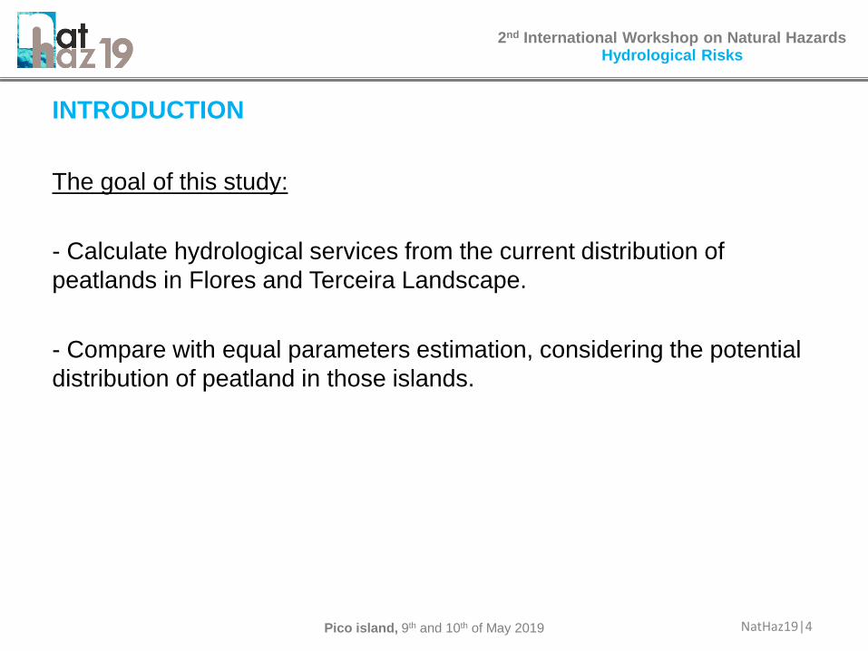
METHODS – STUDY AREA
Examples of Peatlands in Flores island © Cândida Mendes

Hydrological Risks
Pico island, 9th and 10th of May 2019
2nd International Workshop on Natural Hazards
NatHaz19|8
METHODS - DATA COLLECTION AND ANALYSIS
Actual distribution of peatlands
For the Sphagnum distribution was used:
- The modulation was done in ArcGIS with a supervised classification
with maximum likelihood using 25% and 50% Reject Fraction (RF).
- For ground truth, ecological field work was done (classification of
peatlands, inventories for flora characterization and communities’
description).
- For peatland and forested peatland, data from the
ATLANTIDA©GEVA database, cartographic distribution data from
Mendes (2010) and Dias et al. (2017) and photointerpretation of
Planet Scope Images.
- Sentinel-2, and Rapideye images with 2 800 Terceira and 7 500
Flores Ground Truths.

Hydrological Risks
Pico island, 9th and 10th of May 2019
2nd International Workshop on Natural Hazards
NatHaz19|9
METHODS - DATA COLLECTION AND ANALYSIS
Field and Drone surveys Satellite imagery
ATLANTIDA©GEVA

Hydrological Risks
Pico island, 9th and 10th of May 2019
2nd International Workshop on Natural Hazards
NatHaz19|10
METHODS - DATA COLLECTION AND ANALYSIS
Model of Potential distribution of peatlands parameters:
- Rasters (100x100 m) of Aspect E and W orientation, slope (>9º),
curvature (<-0.55), TOPEX (Wilson, 1984);
- Endorheic basins;
- Geomorphology (recent lavas as a excluded areas of the model in
Terceira).
Sphagnum and forested peatland water services values, from Dias et
al. (2016) and Pereira (2015) were applied to the peatlands.
Aspect Slope Curvature
TOPEX Endorheic basins Geomorphology
Hydrological Risks
Pico island, 9th and 10th of May 2019
2nd International Workshop on Natural Hazards
NatHaz19|11
Two types of Sphagnum peatlands were assumed:
(1) Mixed Sphagnum peatlands that include basin, raised and transition
types;
(2) Hillside Sphagnum peatlands that include hillside and blanket types,
and one type of forested and shrubland peatland.
Considering naturalness, (1) and (2) were separated into:
- natural (no disturbance),
- degraded (frequent use as pasture, Sphagnum present),
- peat soil pasture (corresponding to wet implanted pastures, no
Sphagnum);
- forested peatlands were separated in natural and peat soil forested
areas (corresponding to forest production).
METHODS - DATA COLLECTION AND ANALYSIS

Hydrological Risks
Pico island, 9th and 10th of May 2019
2nd International Workshop on Natural Hazards
NatHaz19|12
Hydrological services evaluation:
- Peatlands surveyed with Ground Penetrating Radar for the tri-
dimensional modelling of peatlands’ internal deep and layer
structures.
- Field coring was done with peat collected by layer for bulk density,
water retention capacity and water efflux determination.
METHODS - DATA COLLECTION AND ANALYSIS
Peatlands studied in Terceira islandGeoradar and Coring

Hydrological Risks
Pico island, 9th and 10th of May 2019
2nd International Workshop on Natural Hazards
NatHaz19|13
Hydrological services evaluation:
- The obtained reference values were estimated for water retention
capacity as well as time efflux, by Pereira (2015), for peatlands’
various internal layers and various peatland tipologies.
- Applied to the different typologies defined in actual and potential
peatlands.
METHODS - DATA COLLECTION AND ANALYSIS
3D of internal layers
Laboratory analysis
Hydrological Risks
Pico island, 9th and 10th of May 2019
2nd International Workshop on Natural Hazards
NatHaz19|14
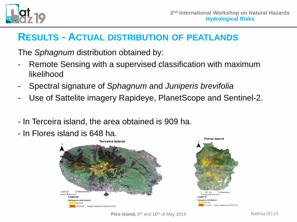
The Sphagnum distribution obtained by:
- Remote Sensing with a supervised classification with maximum
likelihood
- Spectral signature of Sphagnum and Juniperis brevifolia
- Use of Sattelite imagery Rapideye, PlanetScope and Sentinel-2.
- In Terceira island, the area obtained is 909 ha.
- In Flores island is 648 ha.
RESULTS - ACTUAL DISTRIBUTION OF PEATLANDS

Hydrological Risks
Pico island, 9th and 10th of May 2019
2nd International Workshop on Natural Hazards
NatHaz19|15
- There is a big area of Sphagnum peatland.
- Indeed, a considerable actual area of Sphagnum peatlands resulted
from the progressive degradation of forested types of peatlands.
- However, in potential terms, it would be the forested formations that
have become the commonest form of Azorean peatlands.
RESULTS - ACTUAL DISTRIBUTION OF PEATLANDS

Hydrological Risks
Pico island, 9th and 10th of May 2019
2nd International Workshop on Natural Hazards
NatHaz19|16
Both in Flores and Terceira, the dominant potential types of peatlands
are forested and shrubland. Basin Sphagnum types prevail in
endorheic valleys, and Sphagnum hillside types monopolise extreme
wind sloping areas.
RESULTS - POTENTIAL DISTRIBUTION OF PEATLANDS

Hydrological Risks
Pico island, 9th and 10th of May 2019
2nd International Workshop on Natural Hazards
NatHaz19|17
Considering the study of the eight reference peatlands, the results
showed that hydrologic services, such as water retention as well as
water efflux, varied with peatland type. However, we found a more
relevant relation of these services associated with peat depth.
RESULTS - HYDROLOGICAL SERVICES
Relation between Sphagnum peatland’s
depth and water retention capacity
(Pereira, 2015).
Relation between Sphagnum peatland’s
depth and water efflux (Pereira, 2015).

Hydrological Risks
Pico island, 9th and 10th of May 2019
2nd International Workshop on Natural Hazards
NatHaz19|18
- More degraded peatlands tend to have lower peat depth, diminishing
peatland water services provided.
- Peatlands with lower naturalness degree reveal different water
retention curves along the depth profile of the peat, compared to the
natural ones.
RESULTS - HYDROLOGICAL SERVICES
Gravitational Volume (ml) Interstitial
Dep
th (
m)
Peatland I - degraded Peatland II - natural
Trends of gravitational and interstitial water
retention at the midpoint of each layer,
considering the maximum depth of each
Sphagnum peatlands (I-degraded, II - natural).
Interstitial water associated with retention
capacity, gravitational water is associated to
efflux delay.

Hydrological Risks
Pico island, 9th and 10th of May 2019
2nd International Workshop on Natural Hazards
NatHaz19|19
- Mixed peatlands show a greater capacity to retain water by area
(m3/m2), working as accumulation structures. Hillside peatlands show
a greater capacity of volumetric water retention (m3/m3)
- Mixed Sphagnum reveals the greatest capacity for the temporal
restraint of water (efflux), being more important for buffering torrential
regimes after large rainfall events.
RESULTS - HYDROLOGICAL SERVICES

Hydrological Risks
Pico island, 9th and 10th of May 2019
2nd International Workshop on Natural Hazards
NatHaz19|20
- The results show an actual distribution of natural peatlands of 2 766
ha and 2 414 ha, for Terceira and Flores, respectively, which is even so
quite lower than the potential area estimated as 8 079 ha and 5 268 ha,
correspondingly.
- These peatlands currently have the ability to retain 72 438 317 m3 of
water. Theoretically, if all peatlands were in a natural state, this capacity
would increase to 300% of the retained water.
RESULTS - HYDROLOGICAL SERVICES
TERCEIRA FLORES
Area (ha) Water storage (m3) Area (ha) Water storage (m3)
Actual Potential Actual Potential Actual Potential Actual Potential
Nat. Mixed Sphag. 71 763 1300615 13841653 123 799 2240017 14505886
Nat. Hillside Sphag. 197 2166 3037997 47404912 769 1327 11875007 29031787
Nat. For./shrub. 2497 5150 5775013 11844863 1523 3142 3526759 7226076
Deg. Mixed Sphag. 379 5137043 148 2002912
Deg. Hillside Sphag. 825 1990130 463 1119573
For. in production forest
soil 1864 843477 376 170264
Peat soil pastures 1050 738909 684 482185
Hillside peat soil pastures 1151 520931 1146 519303
Total 8035 8079 19344115 73091429 5231 5268 21936020 50763749

Hydrological Risks
Pico island, 9th and 10th of May 2019
2nd International Workshop on Natural Hazards
NatHaz19|21
DISCUSSION
The Regional Programme for Climate Change in the Azores (PRAC in
Costa et al. 2017) presented for the Azores climate:
- Slight upward trend of precipitation in winter (10%) and a decrease in
summer.
- Extreme wind and storm events can occur with higher frequency and
intensity.
Nowadays, floods accompanied by landslides are quite frequent in the
Azores.
In these scenarios peatlands are extremely important landscape
regulators due to their water retention capacity, which are far below
their potential capacity, due to high disturbance.

Hydrological Risks
Pico island, 9th and 10th of May 2019
2nd International Workshop on Natural Hazards
NatHaz19|22
DISCUSSION
Environmental imbalances:
1) Differences between natural and potential hydrological services
varies within the territory:
Terceira
- Large natural areas as Santa
Barbara Mountain and Pico
Alto Mountain with a potential
increase of 285% and 237%.
- Pasture-dominated mosaic
with a potential increase of
1418% in water retention.
Flores
- Large natural areas (north central
plateau) with a potential increase
of 132%
- Pasture-dominated mosaic with a
potential increase of 432%.
2) Irregularity of Azorean streams flow:
The application of the differences between actual and potential water
services to Ribeira Grande waterline catchment area (in Flores) showed
a potential increase of 313% in retained water.
Hydrological Risks
Pico island, 9th and 10th of May 2019
2nd International Workshop on Natural Hazards
NatHaz19|23
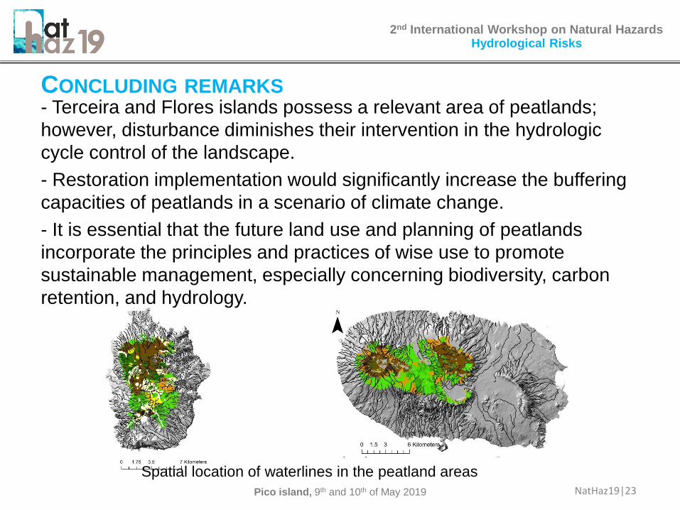
CONCLUDING REMARKS- Terceira and Flores islands possess a relevant area of peatlands;
however, disturbance diminishes their intervention in the hydrologic
cycle control of the landscape.
- Restoration implementation would significantly increase the buffering
capacities of peatlands in a scenario of climate change.
- It is essential that the future land use and planning of peatlands
incorporate the principles and practices of wise use to promote
sustainable management, especially concerning biodiversity, carbon
retention, and hydrology.
Spatial location of waterlines in the peatland areas
Hydrological Risks
Pico island, 9th and 10th of May 2019
2nd International Workshop on Natural Hazards
NatHaz19|24
ACKNOWLEDGEMENTS
We would like to thank PlanetLabs, for allowing the use of Planet and
Rapideye images. Also ESA for use of Sentinel-2 images. This study
was integrated into the CONNECT.GENE project (Ref. Acores-01-0145-
FEDER000061) financed by FEDER and regional funds through the
Azores 2020 Operational Program.