The Geohazards Exploitation Platform (GEP) - ESA...
17
The Geohazards Exploitation Platform (GEP) Philippe Bally 1 & Salvatore Pinto 2 1: European Space Agency, 2: Rhea c/ ESRIN
Transcript of The Geohazards Exploitation Platform (GEP) - ESA...

The Geohazards Exploitation Platform (GEP)
Philippe Bally1 & Salvatore Pinto2 1: European Space Agency, 2: Rhea c/ ESRIN
2
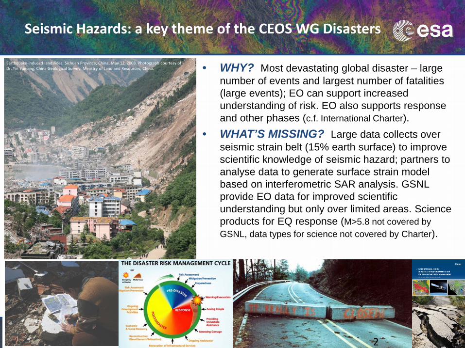
• WHY? Most devastating global disaster – large number of events and largest number of fatalities (large events); EO can support increased understanding of risk. EO also supports response and other phases (c.f. International Charter).
• WHAT’S MISSING? Large data collects over seismic strain belt (15% earth surface) to improve scientific knowledge of seismic hazard; partners to analyse data to generate surface strain model based on interferometric SAR analysis. GSNL provide EO data for improved scientific understanding but only over limited areas. Science products for EQ response (M>5.8 not covered by GSNL, data types for science not covered by Charter).
Seismic Hazards: a key theme of the CEOS WG Disasters
Earthquake-induced landslides, Sichuan Province, China, May 12, 2008. Photograph courtesy of Dr. Yin Yueping, China Geological Survey, Ministry of Land and Resources, China.

A. Support the generation of globally self-consistent strain rate estimates and the mapping of active faults at the global scale by providing EO InSAR and optical data and processing capacities to existing initiatives, such as the iGSRM
[role of EO: wide extent satellite observations] B. Support and continue the GSNL for seismic hazards and volcanoes [role of EO: multiple observations focused on supersites] C. Develop and demonstrate advanced science products for rapid earthquake response. [role of EO: observation of earthquakes with M>5.8]
Objectives of the CEOS Seismic Pilot led by ESA & DLR:
The CEOS WG Disasters also has a Pilot on Volcanoes

3
Science objectives & user manifesto
The “Santorini Conference” organised by ESA and GEO: • 140+ participants from 20 countries including European countries, the US,
Canada, Japan and China. • 70+ organisations: international organisations, public institutes, space
agencies, universities & private sector.
The Thematic Exploitation Platforms (TEP)
ESA has started Thematic Exploitation Platforms initiative covering six thematic areas: hydrology, polar, coastal, forestry, urban & geohazards.
The Thematic Exploitation Platforms goals are:
Facilitate use & processing of large datasets (including non-space data) by a large number of users (science and non-science)
Processing services, software (e.g. toolboxes, etc.) and computing resources
Provide an environment for services development, integration and exploitation
Federate user communities around common scientific & thematic objectives
Promote shared science objectives & better use of satellite EO
Collaboration tools (e.g. knowledge base, open publications, social networking)

EO Data Exploitation which allows a user to discover/select data and pre-existing processing service and process data; and visualize/analyse or select and apply data manipulation tools to the result New EO Service Development which allows a user to discover/select a data sample and software components; engineer (or upload) & validate an application (e.g. a processor) and deploy it on the platform for use also by other users. New EO Product Development, which allows a user to Authenticate; alternatively upload and deploy a new processor; discover/select data; process data and eventually publish the resulting product.
Benefits to users

The Geohazards Exploitation Platform
• As part of the Thematic Exploitation Platform initiative, ESA is developing the Geohazards Exploitation Platform (GEP) to bring the User closer to the data for new services and products generation
• An ESA funded activity on technological innovation to demonstrate the benefits of an exploitation platform for large scale hazard mapping.
• An enhancement and harmonization of the precursor SuperSite Exploitation Platform (SSEP) and the ESA EO Virtual Archive designed to support the Geohazards Supersites and National Laboratories (GSNL).
• The GEP takes into account the broader needs of users engaged in the CEOS WGDisasters Pilots on seismic hazards and volcanoes and other user groups.

8
An Exploitation Platform under development and validation that is sourced with data and processing relevant to the GeoHazards theme:
• Data storage concerning wide extent tectonic analysis for which large data stacks are needed (typically 1000+ and 5000+ scenes and larger)
• Access to advanced processing tools (e.g. InSAR) • A collaborative work environment and scientific animation • Current developer: Terradue (IT); partnership with CNR-IREA (IT)
The Geohazards Exploitation Platform

9
Sentinel-1 made available starting with CEOS Pilot targets and with the goal to gradually cover large community targets within 2016. ERS & Envisat SAR data: • Current ENVISAT ASAR IM Level-0 Data : > 60200 products (~30TB) • Current ERS SAR IM Level-0 Data : > 56500 products (~28TB)
Available ERS, Envisat & Sentinel-1A SAR data
ERS & ENVISAT Level-0 data available as of September 2014 ERS & ENVISAT Level-0 data available as of March 2015

Sentinel-1 data (same coverage as SciHub) is directly available in GEP for launching EO processing services (no dissemination) Contact: https://geohazards-tep.eo.esa.int, contact: [email protected]
Available Sentinel-1 data
11
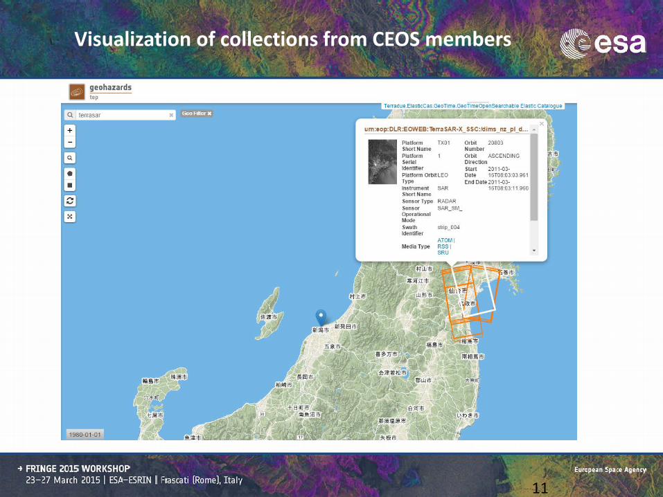
Visualization of collections from CEOS members
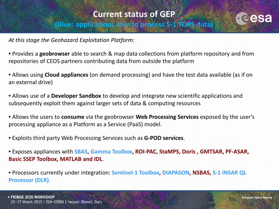
At this stage the Geohazard Exploitation Platform:
• Provides a geobrowser able to search & map data collections from platform repository and from repositories of CEOS partners contributing data from outside the platform
• Allows using Cloud appliances (on demand processing) and have the test data available (as if on an external drive)
• Allows use of a Developer Sandbox to develop and integrate new scientific applications and subsequently exploit them against larger sets of data & computing resources
• Allows the users to consume via the geobrowser Web Processing Services exposed by the user’s processing appliance as a Platform as a Service (PaaS) model.
• Exploits third party Web Processing Services such as G-POD services.
• Exposes appliances with SBAS, Gamma Toolbox, ROI-PAC, StaMPS, Doris , GMTSAR, PF-ASAR, Basic SSEP Toolbox, MATLAB and IDL.
• Processors currently under integration: Sentinel-1 Toolbox, DIAPASON, NSBAS, S-1 INSAR QL Processor (DLR).
Current status of GEP (Blue: applications able to process S-1 TOPS data)

January 2015 September 2015 January 2016
Validation with early adopters
GEP new contract (ITT)
Limited to early adopters (under invitation), evolution of the service on-going Available: • (evolving) EO Data Exploitation • (evolving) New EO Service
Development
Open under approval, consolidation and limited evolution of the service Available: • EO Data Exploitation • New EO Service
Development • (limited) New EO Product
Development
Open, consolidated and stable service Available: • EO Data Exploitation • New EO Service
Development • New EO Product
Development
Aim of validation phase: i) to test the first version of GEP (QW) ii) get user feedback & further tune the solution to user's needs
GEP Roadmap:

GEP Validation started March 3rd:
Sentinel-1A based change image of Villarrica eruption (Chile) using pre-event (20/02/2015) and post-event (04/03/2015) acquisitions. International Charter Space & Major Dissaters activated on 3 April by ONEMI (Chile). Blue: increase of the radar backscatter (melting of snow and ice) Cyan: surface roughness increase (melting of snow and the accumulation of volcanic material (volcanic ash, lava flows and tephra) Work performed by DLR on 5 March in the framework of the ASAPTERRA project originated by ESA (R&D action).

Processors
TBD
S-1 INSAR QL
DIAPASON
NSBAS
SBAS
GAMMA
SBAS
SBAS
ROI_pac, DORIS, Stamps, SBAS
DORIS , ADORE, StaMPS
DIAPASON
StaMPS, GAMMA, SBAS
SBAS
Areas
Etna, Italy and Corinth Rift, Greece
European tectonic mask
Test sites on landslides and earthquakes
Subduction zones of Latin America, the NAFZ and Tibet.
Alto Tiberina Fault and Fogo Cape Verde
Marmara, East sector of NAFS
Haiti and West Java
Muliple sites volcanoes, earthquakes, landslides
Geohazard sites in Greece
Silesia & Warsaw (Poland) Piton de la Fournaise in La Réunion, Cordon del Azufre / Lastarria in Chile–Argentina
Etna & Campi Flegrei / Vesuvius
urban areas of Great Britain
User organisation
Ecole Normale Supérieure de Paris
DLR IMF
Altamira Information ISTerre / Institut de Physique du Globe de Paris
INGV Roma
INGV Roma
INGV Roma
CNR IRPI Torino
NOA (Greece)
SATIM Obs. Physique du Globe de Clermont-Ferrand
INGV Catania
British Geological Survey
Platform Early Adopters, Validation Phase started in March 2015
Want to apply for the early adopters phase (limited slots)? [email protected]

ESA missions data
Copernicus missions data
Meteo missions data
National missions data
Commercial missions data
Airborne & in-situ data
European EO data asset
EO stimulating
element =
Remote sensing
expertise
EO outreach element
= Thematic expertise
Exploitation platforms within EO Innovation Europe linked with large science networks and ecosystems
Heritage missions data
EO enabling element
= Technical
& economical interoperability
EO Innovation Europe
Science network #2

Thank you