the “feng shui of facility...
3
Producing Results Geomancy produces options and optimal locations for facilities. Use of Geomancy in the planning process provides results that reduce environmental impact, construction costs, and time to develop a field. Planning and Modeling Capabilities The decision engine is used in a number of commercial and proprietary products and has a wide range of capabilities across multiple disciplines, such as Environmental, Engineering, Geosciences, and more. Geomancy consumes a variety of input datasets and provides a unique methodology for associated weightings and rankings with each input. Rules that define the dataset interactions are completely customizable and are used to address interactions between inputs. Geomancy has been designed to allow for ease of extensibility to handle new modeling approaches and new modeling concepts. The system provides a unique blend of capabilities that allow for full-field planning with optimizations on each asset type or across multiple assets simultaneously to achieve an overall optimal plan across the full field. integrated geomancy Geomancy Decision Engine The Geomancy Decision Engine provides a comprehensive and holistic methodology allowing for full integration and interaction between environmental, economic, construction, and reclamation factors involved in field development. This system supports optimum design through balancing all of these factors in conjunction with overarching goals and constraints and is used for the planning and siting of Pipeline Gathering Systems, Transmission Pipelines, Access Roads, Well Pads, and Central Processing Facilities. Designed for Your Workflow Geomancy is designed around a core suite of capabilities, configurable based on modeling requirements and client-specific settings, and available to be embedded in client proprietary processes or products. Geomancy is built with the professional in mind. Designed to work alongside your corporate GIS and built on the ArcGIS platform, the engine is able to slipstream nicely into the planning workflow and provide results within hours or days after implementation. The system provides the necessary project and scenario definition tools, data management and analysis tools, and reporting and visualization tools. www.integrated-informatics.com | [email protected] the “feng shui of facility siting”
Transcript of the “feng shui of facility...

Producing Results
Geomancy produces options and optimal locations for
facilities. Use of Geomancy in the planning process provides
results that reduce environmental impact, construction costs, and
time to develop a field.
Planning and Modeling Capabilities
The decision engine is used in a number of commercial and
proprietary products and has a wide range of capabilities
across multiple disciplines, such as Environmental,
Engineering, Geosciences, and more.
Geomancy consumes a variety
of input datasets and provides
a unique methodology for
associated weightings and
rankings with each input. Rules
that define the dataset interactions
are completely customizable and
are used to address interactions
between inputs.
Geomancy has been
designed to allow for ease of
extensibility to handle new modeling
approaches and new modeling concepts.
The system provides a unique blend of capabilities
that allow for full-field planning with optimizations on each
asset type or across multiple assets simultaneously to achieve an
overall optimal plan across the full field.
integrated geomancy
Geomancy Decision Engine
The Geomancy Decision Engine provides a comprehensive
and holistic methodology allowing for full integration and interaction
between environmental, economic, construction, and reclamation
factors involved in field development. This system supports
optimum design through balancing all of these factors in conjunction
with overarching goals and constraints and is used for the planning
and siting of Pipeline Gathering Systems, Transmission Pipelines,
Access Roads, Well Pads, and Central Processing Facilities.
Designed for Your Workflow
Geomancy is designed around
a core suite of capabilities,
configurable based on modeling
requirements and client-specific
settings, and available to be
embedded in client proprietary
processes or products.
Geomancy is built with the
professional in mind. Designed
to work alongside your corporate
GIS and built on the ArcGIS
platform, the engine is able to
slipstream nicely into the planning
workflow and provide results within hours or days after
implementation. The system provides the necessary
project and scenario definition tools, data management
and analysis tools, and reporting and visualization tools.
www.integrated-informatics.com | [email protected]
the “feng shui of facility siting”
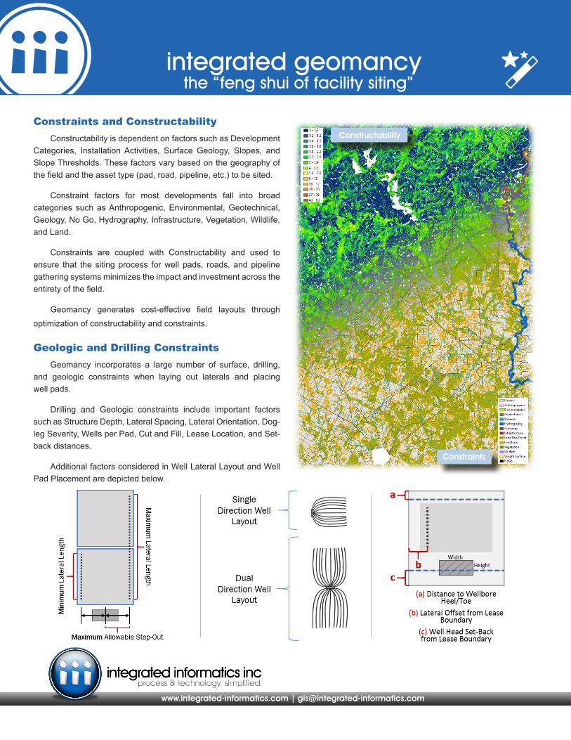
Constraints and Constructability Constructability is dependent on factors such as Development
Categories, Installation Activities, Surface Geology, Slopes, and Slope Thresholds. These factors vary based on the geography of the field and the asset type (pad, road, pipeline, etc.) to be sited.
Constraint factors for most developments fall into broad categories such as Anthropogenic, Environmental, Geotechnical, Geology, No Go, Hydrography, Infrastructure, Vegetation, Wildlife, and Land.
Constraints are coupled with Constructability and used to ensure that the siting process for well pads, roads, and pipeline gathering systems minimizes the impact and investment across the entirety of the field.
Geomancy generates cost-effective field layouts through
optimization of constructability and constraints.
Geologic and Drilling Constraints Geomancy incorporates a large number of surface, drilling,
and geologic constraints when laying out laterals and placing well pads.
Drilling and Geologic constraints include important factors such as Structure Depth, Lateral Spacing, Lateral Orientation, Dog-leg Severity, Wells per Pad, Cut and Fill, Lease Location, and Set-back distances.
Additional factors considered in Well Lateral Layout and Well Pad Placement are depicted below.
www.integrated-informatics.com | [email protected]
integrated geomancythe “feng shui of facility siting”
Constraints
Constructability

Geomancy allows the orientation of well laterals to be specified based on cardinal directions, economic factors, or geologic inputs (maximum stress direction, up-dip, etc.) which are evaluated on continuous and per lease basis.
Location of pads can be constrained to On and/or Off Lease and Cut-and-Fill calculations are utilized to keep on-pad material movement costs to a minimum.
Pad locations are utilized by Geomancy for siting of Access Roads and Pipeline Gathering Systems. Access Roads and Pipeline Gathering Systems are able to connect to existing infrastructure and connect from site to site without specifying visit order.
integrated geomancy
Well Laterals, Well Pads, Access Roads, and Pipeline Gathering Systems
www.integrated-informatics.com | [email protected]
the “feng shui of facility siting”
Our diverse suite of solutions is focused on establishing and enhancing the true value of GIS and applied data management in your organization.
put our team to work for you
Leases & Constructability
Pipeline Gathering System Access Roads
Laterals & Pads
The system automatically locates Access Roads and Pipeline Gathering Systems and establishes connectivity of each transportation network while concurrently balancing the trade-offs between constraints and constructability.
Scenarios allow for settings and constraints for all as-set types to be varied. This provides a means for performing what-if analyses and to determine multiple options for full field development.