The Development of Columbia County 1792
105
'I THE DEVELOPMEI\T OF COLTJMBIA COI.]NTY 7792-7930 HISTORTC CONTEXT STATEMENT ANN FI-ILTON, Ph.D. CULTURAL RESOURCES MANAGEMENT
Transcript of The Development of Columbia County 1792
'I
THE DEVELOPMEI\T OFCOLTJMBIA COI.]NTY
7792-7930
HISTORTC CONTEXT STATEMENT
ANN FI-ILTON, Ph.D.
CULTURAL RESOURCES MANAGEMENT

THE DEVELOPMENT OF COLUMBIAcouNTYo OREGON, 1792-1930
HISTORIC CONTEXT STATEMENT
BYANI{ FULTON, Ph.D.
REPORT TOCOLUMBIA COUNTY FORESTS, PARKS &RECREATION DEPARTMENT
CULTURAL RESOURCES MAI{AGEMENT1540 S\M DAVENPORT STREETPORTLAND, OREGON 97 201-2230
DECEMBER 15, 1998

Page z
PREFACE AND ACKNOWLEDGMENTS
This document is an Historic Context Statement for Columbia County that will be used as
a tool in preservation planning. The study was funded by an Historic Preservation FundGrant offered through the State Historic Preservation Ofüce of Oregon and the NationalPark Service, U.S. Department of the Interior, under the provisions of the NationalHistoric Preservation Act o11966. The study was co-administered by the Director of theColumbia County Forest, Parks & Recreation Department and the Executive Director ofthe Columbia-Pacific Economic Development District.
The research and writing of this report was carried out under the terms of a ProfessionalServices Contract between Columbia County and Cultural Resources Management. AnnFulton, President of Cultural Resources Management, was the principal researcher. Manyindividuals also provided historical information and attended meetings: Chuck Ashcroft,Inþ Aulenbacher, Beth Bailey, Blanche Bangsund, Edith Bartel, Bob Brown, VirginiaBurgh, Larry Cole, Lee Day, Vern Ferguson, Carol Hales, Richard Hunter, Don Johnson,Lillian Jones, JeffKing, Matt Laird, Karen Macfarlane, Sam McKinney, Geraldine Meyers,Tamie Maygra, Clara Neelands, Luanna Nelson, William Oester, Becky Partlow, LarryRea, Evelyn Sanders, Mike Schmit, Sheila Sullilvan, Vivian Ure and Robb V/ilson. Thesepeople had much historical information and were happy to share it. Their knowledge andassistance is very much appreciated.
The work of Bob Brown, JeffKing and Matt Laird in managing the project is especiallyappreciated. A very special thank you to Blanche Bangsund, Bob Brown, Larry Cole,Tamie Maygra, Geraldine Meyers, Vivian Ure and Robb V/ilson for spending many hoursdriving around the county telling great stories and finding historic resources, Without thehours of driving and knowledge shared, many resources would not have been identified.Also, the guidance of State Historic Preservation Office staffmembers Kimberly Dunnand David Skilton has been very much appreciated. Without them, this work could nothave gone forward. They spent time in the field advising on historic resources and manyhours providing expert advice.
Thank you to all the other individuals who helped whose names are not listed here; theyalso offered historical information and assistance as the work proceeded, The dedicationof everyone to preserving Columbia County's history is a gift that future generations willenjoy.

Page +
TABLE OF CONTENTS
P refa ce and Acknowledgments
Section I
Section II
Section III
Section IV
HISTORIC CONTEXT DEFINITIONA. Historic Context Theme: Historical Developnrent
B. Spatial Boundary/Place: Columbia County
C. Temporal Boundary: 1792-1930
HISTORIC CONTEXT DESCRIPTIONA. Historic Overview of Colurnbia County
B. Historic Properties Likely to be Foundl. Resource T1'pes
2. Distribution3. Quantity
C. Criteria for Evaluating Historic Properties1. Significance2. Integrity3. Condition
GOALS AND PRIORITIESA. Identifoing Other Considerations
B. Goals and Objectives
C. Strategies
D. Priorities
INTEGRATIONA. Comections with Other Plaus
lrl
5
5
6
7
8
I
464649
5l
52
53
53
53
54
54
58
60
6l
Connections with Other ConteÉs
Fuflire Related Studies
Sources Cited and Bibliography
Historic Resources Inventory-Draft, 1 998List of Cemeteries, Genealogical Forum of OregonBLM Cultural Resource Inventory and EvaluationOregon Department of Forestry Managenrent Goals and MapColumbia County Historic Overlay District
63
63
65
65
67
Appendices

I
I
I
t_)
)
)+t::I
I
)-I
t.fil,'I
l_I
I
l{ItI
I
t-I
I
?7
Map of Columbia CountY
'Í/\-f
l-.¡z)oo
ìP
Þ
o
0_
o(t)
F
JU
C¡TY
-t
WASHINGTON COUNTY
l2
MLTNOMAH COUNTYlto
ñ.î.Axo
R.5 rV.

Page s
SECTION I
HISTORIC CONTEXT DEFINITION
This Historic Context Statement was prepared for Columbia County to help fulfill the goal
of preservation planning, An Historic Context Statement lays the groundwork foridentifuing, evaluating and preserving historic resources. The information on historic
resources in this document will assist in preservation planning as Columbia County grows.
A companion document to this Historic Context Statement is 60 intensive site surveys and
an inventory of the county's historic resources.
HISTORIC CONTEXT THEME
The main theme of this report is the historical development of Columbia County from1792 to 1930. The report identifies historic resources, including buildings, sites,
structures, objects and districts existing in Columbia County. Columbia County was
carved out of Washington County on January 16, 1854, Chinook and Clatskanie Indians
developed rich cultures and trading networks here for hundreds of years before the countylines were drawn. Trappers and traders also traveled the land before the first whitesettlers arrived in the 1840s. Some of these settlers were town builders who tried toestablish port cities to attract the trade along the Columbia River, The towns these early
settlers started did not outrace Portland in the fight to dominate the river trade,
The most important source of the county's early development was logging and lumbering.
Columbia County was the location of some of the state's earliest logging ventures and
sawmills, The first sawmill probably was built in 1843 and by the 1880s Columbia Countyestablished itself as a leader in the timber industry. This industry was the mainstay of theeconomy until 1930.
Although some areas of Columbia County experienced short-lived spurts of growthbetween 1792 and 1930, overall the county's commercial, industrial and agriculturalgrowth developed at a moderate rate. This pattern of medium-paced development helped
to preserve some of the county's historic resources. There are few surviving historicresources associated with early settlement or the river trade, but more remain that are
associated with the timber industry, agriculture and commercial growth.
The main theme of the historical development of Columbia County is subdivided intosmaller ones. These themes are established by the State Historic Preservation Office(SHPO) and the National Park Service. The broad themes characterizing ColumbiaCounty's development and architectural and historical features include: Exploration & FurTrade, Native American & Euro-American Relations, Settlement, Agriculture,Transportation & Communication, Commerce & Urban Development, Industry &Manufacturing, Government and Culture, SI{PO and the National Park Service also
establish chronological periods. An effort has been made to minimize changes, but some

Page 6
thematic and temporal changes have been made to better reflect the specific history ofColumbia County,
The first chronological period in Columbia County's Historic Overview is Indians and
Exploration (1792-1806) This period highlights the important role Indian tribes played in
the era of exploration by white people. The dates were changed to reflect the actual dates
of significance. Lieutenant William Broughton explored the shoreline that became part ofColumbia County in 1792 and 1806 marks the Lewis and Clark expedition's return trip up
the Columbia River. The second chronological period is Fur Trade and the Hudson's Bay
Company (1807-1846). Because the Hudson's Bay Company's influence over the area
was much more significant than missionary efforts, the title of the period was changed to
reflect this. The dates were changed because the fur trade developed after the Lewis &Clark expedition ended.
The closing date for the era of Settlement, Statehood, and Steampower was changed
because initial settlement of the county's interior continued through the early 1880s rather
than ending in the mid-1860s. Following the Settlement, Statehood, and Steampower era,
the county entered the era of Railroads and Industrial Growth (1884-1913). The opening
date of this era was changed because mainline railroads first began operating here in 1884,
The end date of the Motor Age was changed because the chronological period under
study in this Historic Context Statement concludes in 1930.
SPATIAL BOUNDARY/PLACE
Columbia County, located in northwestern Oregon, comprises 687 square miles. It isbounded on the west by Clatsop County, on the south by Washington and Multnomahcounties, on the east by Multnomah County and on the north by the Columbia River. St,
Helens, the county seat, is approximately 35 miles from Portland and approximately 70
miles from Astoria. The county's Columbia Rive¡ frontage of 62 miles is the longest ofany of Oregon's counties. Columbia County's population in 1998 is 44,723 (PSU Center
for Population Research and Census, 1998).
Columbia County is west of the northward extension of the Willamette Valley and withinthe Coast Range belt. The range is less defined than it is farther south; in ColumbiaCounty it consists of two hilly ridges. Except for a narrow strip at the foot of the
Columbia River watershed and the narrow valley in the Nehalem River watershed, all the
land of the county is hilly or mountainous,
The county's topography separates it into two main areas. The section that is more
industrially and commercially developed and that has a greater population lies along the
Columbia River watershed. From sea level at the river, the land slopes upward south and
west to an elevation of approximately 1,200 feet that forms the divide between the
Columbia and Nehalem river watersheds (Harper and Torgerson 1929: 1). Historically,the interior of the county was the location of a great logging industry founded on a dense

Page 7
forest of Douglas firs. Towns such as Vernonia and small communities such as Mistdeveloped along or near the Nehalem River. The lumber and shipping industries have
dominated the area along the Columbia River; here larger towns such as Scappoose,
St. Helens and Rainier grew.
TEMPORAL BOUNDARY: 1792-1930
The temporal boundary for the Columbia County historic context starts with the first well-documented exploration of the areaby English explorers in 7792. The study ends in 1930
when the boom in the railroad logging era faded and the county felt the first effects of theGreat Depression The time frame of this study correlates with many of the historicalevents that were significant to Columbia County's development.

Page s
SECTION II
TIISTORTC CONTEXT DESCRIPTION
The historic context for Columbia County is described through an Historic Overview that
focuses on the people, places and events that contributed to the county's development
within the temporal scope of this study, The historic context provides an opportunity topredict the type of historic properties likely to be found. The historic properties are
categorized by resource types or generic classes of related historic properties. The
distribution of resource types is assessed and their amount estimated. An inventory and
intensive site survey of 60 sites, conducted as a companion study, confirms the presence
of specific resource types. Following the historic context description, criteria forevaluating historic properties is presented
HISTORIC OVERVIEW OF COLUMBIA COUNTY:
THE DEVELOPMENT OF COLUMBIA COUNTY, 1792-1930
INDIANS AND EXPLORATION, 1792-1806
Chínookans and ClatskaniesWith the Columbia River as a border and trees as an abundant natural resource, the land
that became Columbia County drew many people to it. Its first inhabitants wereChinookan and Clatskanie (Tlatskanai) Indians with their rich cultures. Later the landattracted explorers from many countries, fur traders, colonizers and American settlers.
The county took its name from the Columbia River, "the Great River of the West" (Carey1922'.910). The Pacific Ocean, a maritime highway for international trade, was only 70
miles from the county seat. The region also was west of the northward extension of theWillamette Valley, a place that by 1843 was a mecca for migrating American farmers.
With its river transportation, stands of magnificent trees and proximity to the WillametteValley and Pacific Ocean, the land had great potential.
The fïrst people to live here came long before explorers from Europe, England or theUnited States. They descended from ancestors who crossed the land bridge from easternAsia to North America 12,000 to 15,000 years ago. Tribes in this area tended to beoriented to one or more of the rivers (Dicken 1979,42). The two main groups were theChinookans who lived along the lower Columbia River and the Clatskanies who lived inthe Upper Nehalem Valley and the headwaters of the Klaskanine and Clatskanie rivers,The Clatskanies probably came to the area between 900 and 1200 A.D (Hajda 1987: 1).
They and other groups intermarried and traded goods, traveling by way of the Columbia,Nehalem and Wilson rivers and probably Scappoose Creek (Hajda 1987: l).

FLATTENED HE¡\DS OF ISL,,\ND INDI¡\N.S,
Replodrrcecl froln f.ervis alìcl Clark .for-rluals

Page 9
Americans sometimes called the Chinookans on the lower Columbia River "Canoe
Indians" due to their proficiency in making cedar dug-out canoes. White men also noted
the names of many of the bands in the region; some of the bands they called the Skilluts,
Kee-ass-sin-nos, and Cath-la-na-min-ims (Thwaites 1904-1905 IV: 218). The Chinookans
shared a culture similar to the Northwest Coast Indians and those of the Columbia Plateau
(Ruby and Brown 1986'.23). Members of the Lewis and Clark expedition reported seeing
Indians on the lower Columbia with flattened heads.
The Chinookans on the lower Columbia built winter villages consisting of largepermanent houses and smaller bark lodges; while hunting and gathering they made
temporary camps. The Indians ate the deer, elk and wild fowl that roamed the forests and
the salmon, sturgeon and other fish that swam the waters.
Chinookans on the lower Columbia were traders, They controlled the trade along theriver until the arrival of white maritime traders ended their dominance. Because theirlanguage was a difficult one, the Chinookans adopted words to make themselves
understood. This habit produced "Chinook Jargon," a trading language with borrowingsfrom many sources.
The Indians plied the trading highway of the Columbia River and went to the autumnrendezvous at the great falls of the river. The Chinookans also held a trading fair at
Scappoose Plains (near the present city of Scappoose). Hudson's Bay Companyemployees later told of seeing many Indians near Scappoose Creek and at the north end ofthe Plains. Here tribes gathered to feast, gamble, play games and trade (Watts 1984: 8).
The Indians also traveled extensively over two major trails. The most important one was agreat highway (now called Logie Trail, located in Multnomah County) between theColumbia River and the Willamette Valley that had its beginning south of what is now thecity of Scappoose; a second trail (later called the Territorial Road) traveled between thefuture cities of St, Helens and Hillsboro. Another Indian trail from St. Helens to a placeclose to Rocþ Point ran between the low and high water mark next to the timber (Watts1984: 8). Indians used these trails to hunt, trade and raid for ten thousand years. Laterthe Hudson's Bay Company used the Logie Trail to get agricultural products from theWillamette Valley. Settlers traveled them extensively too.
The Clatskanies belonged to the Athapascan family and spoke an Athapascan dialect.Other Athapascan speakers in Oregon included Indians of the inland valleys such as theUpper Umpqua, Upper Coquille and Shasta Costa bands. According to oral tradition, theClatskanies originally lived on the Skookumchuck River in what is now southwesternWashington. They were closely related to the Washington Kwalhioqua tribe and may havemoved across the Columbia River because the hunting was better there (Hajda 1987: l).
"Clatskanie" may have developed from a Chinookan word meaning "those of the region ofsmall oaks;" possibly the name derived from a village the tribe occupied just below OakPoint. Or the word may have meant "away to some place" and the place was in the

Possible Location of Clatskanie Indian Sites and Trails
tôalo-
Þoi.nt
I w."tpo"¿ç
.(v\..t
vÛ
'r. .'J,bc.rs1l *' tn'.À\ &l rrj/\\ r'
Clo-ts"tanie-
@\u
VQ-nça.¡.,'¡...'v'!l\
st.C,c-l¿ns .
Cof crrr,t bc'a- 6 .
s-.tx
o,

Page l0
Nehalem Valley, reached by ascending either the Klaskanine or the Clatskanie rivers(Hajda 1987: 3). Although the Clatskanies' main territory was the upland valley forests,
seasonally they occupied the shore of the Columbia around the mouth of the ClatskanieRiver and visited the Portland Basin at Scappoose Creek (Hajda 1987: 1). The
Clatskanies had many trails from the Nehalem River to the Columbia that the settlers later
used. One trail led from Clatskanie to Mist, another from Marshland to Banzer's farm,
and one from V/estport up Plympton Creek to the headwaters of Northrup Creek (Hajda
1987'.4; CCH 1976: 30).
Theirs was a hunting and gathering culture, centered on game, berries, roots and seasonal
salmon fishing. The Clatskanies built lodges of split cedar poles covered with bark. They
clashed frequently with other tribes and with early explorers. The builders of Fort Astoriaalso fought with them. The Wilkes expedition, led by Lieutenant Charles Wilkes and
commissioned by the federal govenìment to make a report on the Oregon Country,observed the Clatskanies' fierceness, Mr. Hale, a member of the expedition, reported in1841 that the Clatskanies were "somewhat more bold and hardy than the tribes on theriver and coast, and at the same time, more wild and savage" (Wilkes 1845 204)
Bruno de Heceta, Captaín Robert Gray and the Vancouver ExpedítíonBruno de Heceta, a Spaniard, was one of the first Europeans to see this land. Hediscovered the mouth of the Columbia River on August 14, 1775 but did not enter theriver (Clarke 1905: 22). Contact with explorers such as Heceta probably caused the
epidemic of smallpox in the late eighteenth century that killed the Indians by the thousands
(Clark 1927 60).
Almost two decades later Captain George Vancouver and his expedition passed the mouthof the Columbia but did not see it. On their way north they met the American traderRobert Gray and his ship the Columbia Rediva. Gray told Captain Vancouver that he
thought there was a mighty river to the south but Vancouver doubted it. Gray decided toexplore further. When the Columbia Rediva entered the river on May lI,1792 it was thefirst documented trip by an English vessel. Gray named it for his vessel but did not takeformal possession of the river for the United States.
Captain Vancouver decided to search for the river on his trip south. The Discovery, thelarger of the two ships in the expedition, could not cross the bar when Vancouver foundthe river's mouth. The smaller Chatham, captained by Lieutenant William Broughton,managed the task. Broughton and his crew were the first English explorers to see futureColumbia County (Carey l97 l'. 97 -98).
They traveled upriver for a week, meeting Indians and naming many natural features,
including Mt. Hood, for expedition members, friends and naval superiors. The Broughtonparty spent the night at a place Broughton named Point Sheriff(later called Green Point,
near Mayger) on October 26,1792. The Indians, following the Broughton party to watchits activities, stopped too, Broughton permitted one Indian to camp with them. Reverend
J. Neilson Barry, an Episcopal minister interested in Columbia County history, studied

Early Chart of the Columbia Rrver by Lt William Broughton
Dat6 lqtad or thc EÞ ind¡eacl@a¡oß ol Eroughaù's enqmpllHts
!+¿.q!ÉdÊ
" (gq-,
Go Þ bp llFTof pagc
- f-11 ç:-=
Tbc Charhu ùchoRd insidcCapc Disappornmnr on tG2ù1772. NOTE: This mp of ahc Columb¡r Rivcr Ís d¡údcd inao tro parts
. Upgq Rivcr = top of p¡gc
. Lord Rivcr = bottoE of p¡gc

Page tt
accounts of Broughton's trip. Barry reported stories that the Indian allowed to join the
party was an Indian chief. According to an oral tradition, he was the son of a sailor that
õame ashore after the wreck of a Spanish vessel on Clatsop beach. The Indians made him
a chief because he was a goldsmith or metal worker who used the wreckage to make metal
goods. This man traveled 100 miles to meet the Broughton expedition (CCH 1963-64.
50)
More Indians followed the Broughton party on October 27, 1192. The English sailors
stopped to dine near Rainier, then traveled past what is now Cottonwood Island. The
Indians again camped a short distance away when the sailors spent the night near a small
rocþ islet. Passing the islet on October 28, Broughton saw canoes with dead bodies in
them on platforms and named the place Coffin Rock (Carey l97l: 98).
After traveling past what is now called Sandy Island, Broughton and his crew arrived at a
point at the end of an island (Sauvie Island) where twenty-three canoes carrying Indians
dressed in war garments surrounded them. Impressed by this event, Broughton called the
place Point Warrior (now called Warrior Point). When the threatening newcomers talked
with the Indians accompanying the Broughton party, the warriors "took offtheir war
dresses, and with great civility disposed of their arms, but would not part with either their
copper swords, nor a kind of battle ax made of iron" (Becker 1974'.3). According to J.
Neilson Barry, it was the Spanish sailor's son who stopped an attack. The Broughtonparty may have spent the night at Willow Point on Sauvie Island (CCH 1963-64. 50).
Broughton and his men reached what is now called Multnomah Channel near the northern
mouth of the Willamette River at the future site of St. Helens on October 28, 1792.
Broughton named the channel Call's River but did not explore it. Broughton also was the
first white explorer to find the Willamette River, Broughton claimed the Columbia River
for Great Britain on October 30,1792 (Carey 1971.97-98).
The Corps of DiscoveryEven before the Louisiana Purchase of 1803, Thomas Jefferson supported an expedition
into the trans-Mississippi West. After the Louisiana Purchase, President Jefferson chose
Meriwether Lewis and William Clark to lead the 1804-1806 trip into the wilderness of the
West. The official name for the group was the Corps of Discovery, The Corps ofDiscovery's mission was to find a route over the Rockies and down the Columbia River tothe Pacific Ocean, It was to collect information about the flora, fauna and inhabitants
along the way for scientific, economic and political use. The Corps also was to make
commercial treaties with the Indians so that they would trade furs with Americans rather
than the British or French. Jefferson hoped to use the expedition to give the United States
a claim based on the right of discovery of the Columbia River watershed.
After wintering over at Fort Mandan in what is now North Dakota, the Corps ofDiscovery moved west on April 7, 1805 The explorers reached the meeting of the Snake
and Columbia rivers October 16, 1805. Later they traveled past the shores that bordered
future Columbia County. The expedition dined on the island it would later name'Wapato

William Clark's Map ofthe Oregon Country
The western portion of Captain l\'illi¿m Cl¡rk's map of thc Oregon Cot¡ntn,,lEl0. In ¿ddition to thc cxplorltions of f-cnis ¿nd CI¿rk, t¡sc w¿s madc oI Inc.li¿n
maps lnd thc :trrvcvs t'f \'¡ncou','cr

Page 12
Island (now Sauvie Island) on November 4, 1805. Here they met Indians who frequently
traded with white men. They wore sailors' clothing and all of them had "war-axes, spears,
and bows and arrows, or muskets and pistols, with tin powder-flasks" (Coues 1965. 692).
The expedition camped that night at what was later called Knapp's Landing on the northside ofthe river (Coues 1965: 695).
The Corps of Discovery saw Warrior Rock on November 5th and a slough (MultnomahChannel). The men commented on the low rock cliffs located between the future site ofSt. Helens and Columbia City and stopped to dine at the island they later named DeerIsland. Camped on November 5, 1805 near what was later named Owl Creek (near
Prescott), the expedition saw that it had reached the western edge of a "great plain orvalley" (Coues 7965: 697), Lewis and Clark noted that this valley began above what theycalled the Quicksand River (the Sandy River) and ended at the ridge of the low mountains(the Coast Range) where they now camped. Struck by the beauty and resources of thisarea that included the eastern edge of future Columbia County, Lewis and Clark named itthe Wapato or Columbian Valley, A journal entry noted:
It is a fertile and delightfirl country, shaded by thick groves of tall timber, watered bysmall ponds, and running on both sides of the river. The soil is rich and capable of anyspecies of culture; but in the present condition of the Indians. its chief production is thewappatoo-root. . . Sheltered as it is on both sides, the temperature is much milder than thatof the surrounding country...During its whole extent it is inhabited þ numerous tribes ofIndians, who either reside in it permanently, or visit its waters in quest of fish and wappatoo-roots (Coues 1965: 698).
As they continued westward, they commented on many features along the way, includingGreen's Point, Grim's Island and Gull Island. After camping November 6 and November7th on the river's north shore, they traveled past Puget's Island and went on to the PacificOcean. Here they spent the winter gathering information and preparing for the trip back.
The Corps of Discovery started its return trip on March 23,1806. It made its first campin what would become Columbia County on March 25,1806, near the future town ofMarshland opposite Cape Horn. A journal entry noted, "Here the coast formed acontinued swamp for several miles back, so that it was late in the evening before we wereable to reach a spot fit for our camp" (Coues 1965: 908). They met a party of CathlamahIndians who gave them seal meat that they gratefully ate.
Passing by bottom land and an island, they decided to name it Fanny's Bottom andFanny's Island (now Grim's Island) after Captain Clark's youngest sister, Frances; theyalso commented on the beauty of the oak grove at the bottom's northern edge, later calledOak Point. The expedition camped on what is now called Fisher's Island in Washingtonon March 26,1806.
The next day they passed fishing camps on both sides of the river and happily bought fishand roots from the Indians for pleasing prices. They camped at the beginning of thebottom land near Deer Island on March 27, 1806 and on March 28, 1806 reached an old

Page t3
Indian village on the island's north side. Here the hunting party they sent out the day
before met them with seven deer to dress and tales of seeing one hundred more. They
stayed on Deer Island to put pitch on their boats, dry their baggage and spend the night.
A journal entry described the island:
This island, which has received from the Indians the appropriate name of Elalah [Elallah],or Deer Island, is surrounded on the water-side þ an abundant growth of cottonwood, ash,
and willow, while the interior consists chiefly of prairies interspersed with ponds (Coues 1965:
9r2).
The Corps of Discovery stopped for breakfast on March 29, 1806 at the upper end ofDeer Island which expedition members called "the commencement of the great Columbian
Valley" (Coues 1965: 913). As they passed through the last section of the river that
bordered future Columbia County on March 30, 1806, a party of Indians that the explorers
called Claxsta¡s, and another band that they called Cathlacumups, passed them in canoes.
Indians from Wapato Island visited the expedition when it camped on the north side of the
river that night (Coues 1965. 916).
The Corps of Discovery's trip through the land produced names for natural features and
gathered a wealth of information about the geography, birds and beasts. It also learned
about the different bands of Indians and their cultures. For the most part, the Corps
established good trading relationships. The Lewis and Clark expedition accomplished the
far-reaching goal of strengthening the American claim to the Oregon Country. Itconfirmed that agriculture could flourish in the region and proved that the Columbia-
Snake river watershed provided a way to get furs out of the interior.
THE FUR TRADE AND THE HUDSON'S BAY COMPAI{Y, 1807-1846
The PaciJic Fur CompønyReports of the Lewis and Clark expedition excited British and American fur tradingcompanies and encouraged a transition from maritime trading to a land-based fur trade.
Eager to enter the lucrative fur business and other trading ventures, Massachusetts
merchants sent Captain Nathan Winship to the area in 1809. Entering the Columbia River
on May 26,1810, Winship attempted to establish the first trading colony. After travelingforty miles upriver, Winship decided on a spot where oak trees flourished on the bank. He
named it Oak Point because it was the first place where he saw oaks near the river (Clarke
1905: 39).
The Winship party started to build a two-story log house that it could use for a fort as wellas a warehouse, but the annual Columbia River spring freshet flooded the effort. When
the party began to rebuild on higher ground the Indians protested. According to one
account, the colonizers captured some members of the Whill-wetz band and a battle
seemed imminent (Tolleshaug 1973. 4). A second account reported that the Indians were
angry because the new location interfered with their trading routes (Clark 1927'. 129).

Page 14
The first colony failed, The Winship party abandoned its plan and traded along the coast
for a year before leaving.
The first American to successfully build a trading post near the future Columbia Countywas John Jacob Astor. Astor organized the American Fur Company in 1808. To expand
his lucrative business, he established the Pacific Fur Company to trap and trade from the
Pacific Ocean to the Rockies and he built a fort at Astoria in l81l (Dodds 1986: 35-38).
Alexander McKay, a former member of the Montreal-based North V/est Fur Company,
was one of Astor's partners. Thomas McKay, Alexander McKay's son, later was a chieftrader for the Hudson's Bay Company and one of the first settlers in the what later became
Columbia County,
Eager to compete with the North West Fur Company that was exploring the area, the
Pacific Fur Company sent out a small expedition from Astoria on July 22, lSll to fïnd
good locations for more trading posts. The expedition included David Stuart, one ofAstor's partners, and Alexander Ross, then a clerk of a company who wrote eloquently
about his adventures.
Ross documented his trip up the Columbia River in great detail. He observed what may
have been a Clatskanie village, "the great Whill Wetz village", situated on Oak Point.Ross wrote that the size of the trees surprised him because "both sides of the riverpresented a thick forest down to the water's edge--the timber being large, particularly the
cedars" (Ross 1986: 117), His party camped near Oak Point on July 22,1811. CoffinRock attracted the party's grim attention. Ross remembered, "This sepulchral rock has a
ghastly appearance, in the middle of the stream, and we rowed by it in silence" (Ross
1986: 1 17). Ross noted in his journal that after "passing Deer's Island, we encamped at
the mouth of the Wallamitte" on July 23,7811 (Ross 1986: 118). The extent of theflooding struck him and he recognized how diffficult it would be to live there:
The waters of the Columbia are exceedingly high this year--all the low banks and ordinaryu,ater-marks are overflowed and the island [Deer Island] inundated. At the mouth of theWallamitte [near Scappoose], commences the great Columbian valley of Leu'is and Clark;but in the present state of flood, surrounded on all sides b-v woods almost impervious, theprospect is not fascinating (Ross 1986: 118).
Although the epidemic of the late eighteenth century killed many, the Indian populationwas still large. Alexander Ross commented that "the Indians appeared very numerous inseveral villages" as he passed near the future site of Scappoose (Ross 1986: 1 18). Whenthe fur traders and trappers traveled, they stopped in these villages to talk and trade.
The Indians served as guides to the traders and trappers who were the first white men toexplore the area thoroughly. Searching for valuable beaver pelts, the Indians introducedthem to trails and waterways (Dicken 1979'. 4). Gabriel Franchere, a Frenchman who was
one of Astor's clerks, carefully wrote down all the information the Indian guide providedwhen he went on a fur trading expedition up the Columbia. The scenery of the ColumbiaRiver Valley near Scappoose captivated Franchere, as it had the Corps of Discovery. He

Page 15
wrote, "Here the banks of the river are charming, enhanced by meadows and oak and
poplar groves, with distant mountains, thus creating avery pleasant prospect. It was on
the edge of a beautiful meadow that we camped for the night" (Franchere 1969'.82).
The Indians and the fur traders developed relationships helpful to both groups. When
three men deserted Fort Astoria, Gabriel Franchere found them captured by the chief in
the Cath-la-na-min-im village near the future city of Scappoose. Franchere got the men
back and the chief received blankets, a kettle, a hatchet, a broken pistol and a powder horn
(Barry 1934.3).
The Pacific Fur Company had a short life in Oregon Country. The War of 1812 and fierce
competition from other trading companies prompted Astor to sell out to the North West
Fur Company in 1813. This company merged with the Hudson's Bay Company in 1821.
Hudson's Bay CompanyThe giant Hudson's Bay Company established its dominance over the Pacific Northwest
by 1825. As S. A. Clarke, an historian of early Oregon, observed, "The dominion of the
Hudson's Bay Company extended across the continent...over a great portion of this
immense territory there was no other ruIe..." (Clarke 1905: 202), The merger of the
North West Fur Company and the Hudson's Bay Company produced the decision tocreate a new Oregon headquarters.
Possibly this new headquarters was first planned for the site where Columbia City later
grew. According to one historical account, Joseph Caples saw squared timbers at the
location where he helped to establish the future town. Caples asked Dr. John
Mcloughlin, Chief Factor of the Hudson's Bay Company, about them. Mcloughlin said
that the place had been chosen as the new location for the company's trading post and
construction had begun. The hostility of the Indians supposedly drove the white men
away. The fort's final location \ryas eighty-eight miles from the Columbia's mouth. Near
the Columbia's head of navigation and its confluence with the Willamette, the new Fort
Vancouver had a good port and enough land for farming. Dr. John Mcloughlin, ChiefFactor, governed with a strong hand.
Fort Vancouver was only a short boat ride away from the future Columbia County. The
life and livelihood of the surrounding region was closely tied to the fort through furtrapping and trading, other commercial activities, farming, settlement and relationships
with Indian tribes. Each year the company sent out a brigade to collect furs in the fall and
to bring them back in early summer. Many trappers who worked in the lower Columbia
River Valley were members of the company's California brigade; its territory was the
Willamette Valley, the coast and additional parts of Oregon and California.
The Hudson's Bay Company was the center for many other commercial activities,
including lumber and salmon exporting and shipbuilding (Clarke 1905:2Ol-204). Many of

Fort Vancouver, 1854
tr
Ê!¡ilüilD -1 f,.¡ r: :.i
';:;;!*-t
IIUDSON BAY CO]TP.\\T FORT, AND YILLA(.JFJ OF \-A\COU\-ER-1854

Page t6
the people that lived near the fort logged or caught fish to sell to the Hudson's Bay
Company. The company also encouraged farming (Galbraith 1957" 192).
Amerícøn TrødersLike the Hudson's Bay Company, other trading interests came in the 1820s. Two trading
ships, Íhe Owyhee and the Convoy, owned by the American trader Joseph Marshall,
entered the Columbia and traded for furs in 1829. The Owyhee stayed near Deer Island in
the summer of 1829, then passed the winter near Scappoose and returned to Deer Island.
Fur trading with the Indians was profitable. The crew also put up approximately 50
hogsheads of salmon that were taken to the Boston market. The Owyhee carried a cargo
valued at $96,000 (Carey 1922: 410).
The trading sltrp Owyhee, piloted by a Captain Dominis, possibly brought the great
epidemic that killed many of the Indians. The Indians believed that Captain Dominis was
responsible for the horrible disease that started during 1829 and continued through 1832.
Years ago Duncan McDougal, apartner of the Pacific Fur Company, told them that whites
could start a small-pox epidemic by opening a bottle of bad medicine; now they believed
that Dominis uncorked one to kill them (Carey 1922. 410).
The epidemic, called the "cold sick," was probably influenza. With little resistance to it,approximately 30,000 Indians died (Clark 1927'. 63). John Ball, a member of the later
Wyeth expedition, wrote "so many and so sudden were the deaths that occurred that the
shores were strewed with the unburied dead" (Clark 1927. 64). Dr. John Mcloughlinestimated that nine-tenths of the Indians in the area died from the epidemic, includingfamily members of Chief Concomely, the head of the Chinook nation. The chief s
daughter, who also was the wife of Thomas McKay, succumbed to the disease (Vawser
1970: 16). Later Thomas McKay was buried next to her on his farm.
Following the Winship party, Nathaniel Wyeth established the second colony. Accordingto some accounts, Captain Dominis' return to Boston with salted salmon whetted Wyeth'sinterest (Barry 1934'.3). Hall J. Kelley may also have influenced Wyeth. Kelleypetitioned Congress in 1828 to support a colonizing company in the Northwest because ofits economic potential, Kelley found no political backers for his plan but Nathaniel Wyethdecided to put it in action.
Wyeth took an expedition to the lower Columbia in 1832, hoping to start a colony thatwould be the base for his Columbia River Fishing and Trading Company. With salmon as
the most important product, Wyeth wanted to establish an international trading networkfor fish, lumber, furs and agricultural goods. Because the Wyeth expedition may have
pondered starting a colony at the future site of St. Helens, people called the area "Wyeth'sRock" for many years (Lockley 1928: 316),
Wyeth built a temporary camp at V/arrior Point on Wapato Island in 1832, but a wrecked
supply ship prevented him from proceeding. Wyeth described the island as:

Page tz
woodlands and praine and on it there is considerable deer and those who could spare time
to hunt might live well but a mortality has carried offmany of its inhabitants and there is
nothing to attest that they ever existed except their decaying houses, their graves and their
unburied bones. . , (Carey 1922" 302) ,
After a trip east \Myeth came back in 1834 to establish a permanent trading fort on the
island. A second supply ship met V/yeth at Warrior Point and he chose the former site ofthe Cathla-nal-quia village to establish Fort William, his trading post (in Multnomah
County). The epidemic killed most of the residents of that Indian village. Wyeth may
have chosen the former village because it was near the end of the Logie Trail, the "great
highway into the Willamette Valley" (Barry 1934'. 6). Unable to successfully compete
against the Hudson's Bay Company, Wyeth quit the trading business by the end of 1834
and sold Fort William to the Hudson's Bay Company. The company established a dairy
there and named it after Laurent Sauve, one of the dairy's managers (Spencer 1950: 8).
Later, under the land laws of the United States, Nathaniel Wyeth unsuccessfully attempted
to claim ownership of Sauvie Island on the basis of establishing Fort William there (Carey
r97r 280).
The MíssíonaríesThe American Board of Commissioners for Foreign Missions, originally a Congregational
group that became interdenominational, was the first missionary organization interested in
the Oregon Country. The Board sent Reverend Jonathan S. Green, a Congregational
minister, to explore the possibility of a mission in 1829. Although bad weather prevented
Green's ship from entering the Columbia River, Thomas McKay gave Green a list of 34
tribes that might be inclined to convert. Green recommended a mission on the Columbia
River (Carey 197L 282-285,304).
The American Board of Commissioners for Foreign Missions sent out commissioners tomake a final decision on a location. One of them was the Presb¡erian minister Samuel
Parker and another was Dr, Marcus Whitman. Whitman temporarily returned East after
reaching the Nez Perce country, but Parker continued into the lower Columbia River
Valley and reached Fort Vancouver in 1835. He made a trip down the river on Nathaniel
Wyeth's brig and considered mission sites along the way. Reverend Parker visited Deer
Island and thought it might be a good place to establish a mission. He saw the bounteous
game there but noted that the 1829-1832 epidemic killed most of the Indians. Ultimatelyhe decided against Deer Island and left to preach near the future site of the Walla WallaMission, established in 1836 (Carey 1971: 305).
The Methodist Mission Board was the first to establish an outpost in the Oregon Country.
It sent ordained ministers Jason Lee and his nephew, Daniel, with the 1834 Wyethexpedition for safety's sake. Their task was to convert the Indians and bring them into
Christianity's fold, The missionaries, who arrived at Fort Vancouver on September 15,
1834, originally hoped to establish a mission among the Nez Perces. Mcloughlin, wishing
to keep them south of the Columbia River, suggested the Willamette Valley. Before
setting offon the trail into the valley (the Logie Trail), Jason Lee and his party stopped at

Page ls
Thomas McKay's farm at Scappoose Creek where McKay supplied the party with stringsof horses (Carey 1971.678).
Former French-Canadian Hudson's Bay Company employees who began farming in the1830s in French Prairie in the Willamette Valley started another missionary effort. Theyasked for a Catholic mission but the company would not support their request. It worriedthat the British title to the area was uncertain south of the Columbia; company agents whowere Protestants also wanted to keep the Catholics out of the Willamette Valley (Clark1927.245). Support for a Catholic mission came when the Hudson's Bay Companyformed the Puget's Sound Agricultural Company and asked former employees in theWillamette Valley to move near the Cowlitz and Nisqually rivers. To entice them therethe company subsidized the arrival of two Catholic priests.
Fathers Francis Norbert Blanchet and Modeste Demers accompanied the annual MontrealBrigade in 1838. Their first mission on the Cowlitz River was across the Columbia Riverfrom future Columbia County. Initially, Catholics who lived on the south side of the riverhad to seek the services of the priests on the north side, Both Thomas McKay and Dr.Mcloughlin converted to Catholicism and Father Blanchet ministered to them.
The Hudson's Bay Company Influences SettlementThe rise and fall of the fur trade and the Hudson's Bay Company were sources of earlysettlement. The growth of the fur trade and the proximity of Fort Vancouver broughttrappers and traders into the entire region, but by the 1830s the area was trapped out.These people needed to find a new occupation. Coupled with a declining industry, theHudson's Bay Company's growing interest in selling agricultural products promotedsettlement. That interest increased even more after the company established the Puget'sSound Agricultural Company in 1838 to expand its profits by producing butter and raisingcrops and livestock (Dodds 1986' 47),
Thomas McKay, the Hudson Bay Company's chief trader for the Columbia Department,was one of the first employees to settle and to sell crops to the company. Sometimebefore 1833 Dr. Mcloughlin gave McKay permission to farm on Scappoose Plains.McKay's farm provided a good place to pasture horses and to raise the hay and livestockthat the Hudson's Bay Company needed; it also served as a place to gather supplies andhorses before taking the trail over the Scappoose Mountains. Charles Carey, an historianof early Oregon, wrote, "A favorite route for going from Vancouver to the west side ofthe Willamette valley and Tuality plains was by way of McKay's place, and a trail led fromthe farm through a pass in the hills" (Carey 1971. 678)
The end of the most profitable era in the fur trade and the Indian mission movementarrived in 1846. When the United States and Great Britain signed the 1846 treaty dividingthe Oregon Country at the forty-ninth parallel, the area was trapped out and the Hudson'sBay Company lost its control south of the Columbia. Both the Methodist and the Catholicefforts proved less than fruitful. Jason Lee closed the Willamette Valley mission in 1844,The Catholic missions to the north also were not very successful in gaining new converts

Page 19
among the Indians. By 1855 the priests devoted most of their time to ministering to the
already faithtul (Clark 1927', 245).
SETTLEMENT, STATEHOOD AND STEAMPO\ilER, 1847-1883
SaíIors and Sea CaptaínsBecause it bordered on the Columbia River and was so close to the sea, the area was one
of the earliest parts of Oregon to be settled. Sailors and sea captains were some of the
first to come. The first permanent settler was James M. Bates, an American sailor who
deserted from the Owyhee or the Convoy while these trading ships sat in Scappoose Bay in
1829. Bates preferred to farm in Scappoose Plains than to return to sea (Bancroft 1888:
T2;Barry 1934:3). Ida Seggel, whose grandparents settled in Columbia County, reflected
on why later settlers chose Scappoose Plains too, "The vast resources of the river, untold
timber in the virgin forests and the natural deep soil with native hay seemed to be the
answer to their fondest hopes" (Seggel 1969'. 6).
River frontage attracted sea captains who saw the potential to develop port towns.
Captain Henry M Knighton strived to see his own town surpass Portland as the head ofnavigation. He came to the future site of Saint Helens in 1847 and took up the land claim
of a man named Bartholomew White, who built a grist mill and sawmill. V/hite may have
operated the first sawmill in future Columbia County (Wilson 1996'.7).
Knighton hoped to be one of Oregon's leaders. He was elected marshall ofthe territoriallegislature in 1849 and had big plans for his land claim (Carey l97l: 358). He originally
called the town he platted in 1849 Knighton, but by 1850 its name was Saint Helen (now
St. Helens; Wilson 1996:7). Knighton hoped to capitalize on the price increase of wheat
from $l to $6 per bushel that the California Gold Rush brought. He wanted to build a
railroad through Cornelius Pass into the Tualatin and Willamette valleys to take out thegrain and ship it to California. Knighton arranged with the Pacific Mail Steamship
Company to make St. Helens its terminus in 1852. This company, already carrying the
mail between San Francisco and Portland after monthly service started, built docks and
warehouses.
St. Helens was a serious contender for the head of navigation in 1850. The railroad was
to go through Cornelius Pass to Lafayette, then the most important town in the WillametteValley. Knighton believed that the line would cost $500,000 and advertised 1000 shares
for $500 in the Oregon Spectator. He highlighted the line's river connection by notingthat "the terminus of this road should be at a point that can be reached with safety by large
class vessels...as the people of Oregon have already expressed their wishes upon this
subject" (Carey 1922'. 73 4-73 5).
The lack of laws for limited liability corporations, the size of the sum needed in proportionto the wealth of the area and Portland developers dashed Knighton's dreams of St.
Helens' dominance. Portland founders such as Captain John Couch persisted in sailing

Page zo
steamships past St. Helens to Portland. Developers completed the Canyon Toll Road into
Tualatin Valley before St, Helens had an all-weather road over the Scappoose Mountains,
St. Helens' potential boom busted. Knighton, burdened with debts, moved away. The
mysterious burning of the docks made the Pacific Mail Steamship Company take its
business to Portland and ended St, Helens' bid for power in 1852.
Seth Pope was another sea captain who saw a great future for St. Helens and chose it as a
place to develop his shipping business. He also was one of the founders of Milton(Lockley 1928'.312). Captain Pope sailed his ship, the Nonpareil, and its cargo offinished lumber from San Francisco up the Columbia in 1850. He built St. Helens' firsthouse made of finished lumber and used it as the ofüce for his mercantile and shipping
business until 1854 (CCH 1968: 3). Francis LeMont was another sea captain who stayed.
LeMont was a ship's apprentice on the Owyhee in 1829 when he first visited the area. He
later sailed into St. Helens in 1850 bringing his own ship, the John Davis, filled withlumber from Bath, Maine, his home town and also the major East Coast export center offinished lumber.
Sea captains Nathaniel Crosby and Drew, Pope, Menzies and Williams also hoped toestablish a port city that dominated river traffic (Perry 1969:32). Dissatisfied withPortland and the shipping business he started there in 1845, Crosby led this seafaring
group. Before leaving Portland, Crosby built Portland's first frame house on the corner ofFront and Washington streets, The captain shipped the fïnished lumber from Maine on his
schooner the Toulon (Carey 1922.776).
Crosby and his partners founded Milton in 1850 and supported Knighton's plans for arailroad. Crosby enticed settlers by ofFering two city lots free to married men and one lotto single men if they would build houses. Crosby bought an existing sawmill and entered
into the shipping trade at Milton. He sent lumber to San Francisco on the Toulon and
took the first shipload of locally cut spars from St. Helens to China (Becker 1966 4-5).
According to Fred Lockley, a newspaper reporter who wrote about early Oregon, Captain
Crosby "planned to make Milton the terminus of a line of ships to China, and the Far East.
He made several trading voyages to China and knew something of the profits to be made
in Oriental trade" (Lockley 1928'.314) Milton washed away in a flood in the early 1850s
because the founders built on the bottomland. Failing to take into account the severity ofthe annual spring freshets, they made the same mistake that the V/inship expedition and
some later settlers did.
The earþ sea captains competed in an era of intense town rivalry along the Columbia and
Willamette rivers. The founders of St. Helens, Milton and Columbia City made bids fordominance based on thei¡ river locations, proximity to the wheat-producing valleys and
the potential of shipping wood products. These sea captains entered the race with dreams
centered on developing a shipping trade based on sailing ships; they envisioned the
continuation of high-masted schooners dominating the waterways.

ITRST IIRA}fItr HOUStr Iì{ PORTI,,AIID,FROM MAII{tr, VIA CA.PD
SHIPPED,I.IORN, IN
I(NOCI(ED DOWì(,1 8+7

Page zI
The dreams of the seafaring founders of St. Helens and Milton were not unreasonable.
They knew the shipping trade and they thought they could overcome their distance from
the granaries beyond the Scappoose Mountains. Portland surpassed them because it was
closér to the most productive areas and because its developers outraced them in building
transportation networks.
The sea captains were typical of one main group of early settlers who came to the region.
These werè settlers who had lived in towns and had commercial interests. They were
usually single young men from New England or the Middle Atlantic states looking for
opportunities in commerce and industry. They settled along the shoreline because the
river provided transportation and it was close to the magnificent forests.
These men wanted to build towns and to get rich in business ventures. Those who knew
nothing about boats often pursued their commercial interests by building sawmills. The
architecture of their buildings reflected their urban background too. Accustomed to the
architectural traditions of the East Coast, they quickly imported finished lumber to
construct replicas of the buildings with which they were familiar.
Early ChurchesThe first church in Columbia County looked like it should have been in a New England
village. A beautiful church with a gable roof and tall gothic windows, Henry Knighton
built it in 1852 on Nob Hill in St. Helens. Knowing how important a church was to the
people of a town, Knighton wanted a community church for everyone's use. Dr. Thomas
Condon, who later became a nationally known geologist, was the fìrst minister. When the
church burned down, the Methodists built another church on the same site sometime
before 1875 (CCH 1967'.6-7).
Episcopalians, Methodists, Catholics and other denominations all used St. Helens as their
base. From there they sent out circuit riders to preaching points. Initially the circuit riders
preached in the homes of the faithful or in the community school. When enough church
members gathered, the congregations raised funds to build a church. The 1880s and the
1890s were years of county church building, Clatskanie Methodist Episcopal Church, for
example, built its church in 1889 after Reverend S. Lee included Clatskanie in his circuit in
1886. Church members built the Evangelical Church in Vernonia in 1890. Like St.
Helens' first church, it was a community church that gave everyone a place to worship.
The Amertcan InfluenceThe Hudson's Bay Company brought some settlement to the area but other factors played
more important roles: the 1841 Distribution-Pre-emption Act, the opening of the Oregon
Trail, the treaty of 1846, the Donation Land Act of 1850 and the Homestead Act of 1862.
The 1841 Distribution-Pre-emption Act acknowledged the legal claim of squatters. Itallowed settlers to stake claims on most surveyed lands and to purchase up to 160 acres at
the minimum price of $1.25 per acre. Bartholomew'White, Henry Knighton and many
other settlers established pre-emption claims.

Population by Counties
POPULATION BY COUNTIES(1850)
each dot = 100 persons
Population by counties in 1850 (each dot represents 100 persons). The figures give
the total population for each county, (a) Clatsop; (b) t{ashin¡;tonr (c) Yamhill;(d) Polk. (Data from the U.S. Bureau of the Census, 1850)

Page 22
The opening of the Oregon Trail in 1843 fueled the future county's later settlement.
Although the vast majority first headed for the Willamette Valley's best land, the arrival ofthese settlers ultimately swelled the numbers of those who later sought opportunity here.
When the 1846 treaty forced the Hudson's Bay Company to relinquish its control over theriver's inviting south shore, many settlers took notice.
The Donation Land Act of 1850 (extended to 1855) provided another invitation. Between1850 and 1855 settlers took up 61 donation land claims in future Columbia County. All ofthem bordered on the river because it was the best source of transportation. The settlers'claims clustered around five future communities: Scappoose, St. Helens, Deer Island,Rainier and Clatskanie (the earliest claims on Sauvie Island were in Multnomah County).The Homestead Act of 1862 offered additional encouragement. It gave any citizen orintended citizen over 2l and the head of a household 160 acres of surveyed public domainafter five years of continuous residence and payment of a registration fee.
The rate of population increase by decade suggested the impact of the factors thatpromoted settlement. There were roughly 300 settlers living in the area in 1850. Because
the population only rose to 532by 1860 and to 863 by 1870, the Donation Land Act wasnot the main source of settlement (Spencer 1961: 44). Settlers claimed most ofthe landunder the Distribution-Pre-emption Act, the Homestead Act and the later Timber and
Stone Act of 1878. The arrival of the railroad and the opening of the interior in the 1870s
and 1880s spurred gowth even more dramatically.
The steps toward expanding settlement and establishing a government began before theUnited States acquired possession of the areain 1846. Those who lived here wanted toresolve Indians' and settlers' land claims as well as other questions of law and order, Theslowly growing population took great interest in organizing a government. England'sclaim to the area was tentative so the Hudson's Bay Company's rule was temporary.
Most of the early settlers in the area were American citizens eager to join the Union. Ahandful of these people gathered to organize a provisional government in 1843. GeorgeAbernethy became the first governor. Columbia Lancaster, who later supported building a
Scappoose blockhouse and lived in the county, was a member of the provisionalgovernment's legislature and its first Supreme Judge (Becker 1966'. 47), The provisionalgovernment divided Oregon into four districts in 1843 and future Columbia Countybecame part of Twality District, Following the government's designation of districts as
counties in 1844, Twality County's name was changed to Washington County in 1849(Dicken 1979.78).
The provisional government provided temporary answers to the problem of governance.
It was not able to resolve the conflicts between Indians and white settlers that was a majorsource of trouble. The government declared war on the Cayr.rse Indians after theirparticipation in the Whitman Massacre o11847 and Governor Abernethy recruitedvolunteer regiments for the Cayuse War. He appointed Thomas McKay captain of the

DISTRIBUTION OF DONATION CLAIMS
[Ïl AREA DENSELY coVERED BY DoNATION CLAIMSr'i'¡'i¡ TNDTvTDUAL cLATMS NoT sHowN
AREA SPARSELY COVERED BY DONATION CLAIMSINDIVI DUAL CLAIMS SHOWN
020Mila¡
The Donation Land Claims of western Oregon. (From Harlow Head, 'The
Oregon Donation Land Claims and Their Patterns," 1971)

Page 23
company of French Canadians who served in the war. McKay demonstrated his support
for the provisional government by insisting that his French Canadian regiment show its
allegiance to the American flag. He told his company, "This is the flag that you are
expected to defend, and defend it you must" (Carey 1971, 547), Louis Le Bonte, a
French Canadian who became the manager of McKay's farm in 1834, also wanted the
United States to control the land south of the Columbia River (Carey 197 7 . 251 , 268) .
Because the provisional government needed the help of the Hudson's Bay Company toend the Cayuse War, the settlers' desire for the power territorial organization would bringintensified, Nothing could be done to settle land claims until Oregon became a territoryon August 14, 1848. Territorial status opened the door to the government's distributionof the public domain that people clamored for, but that required dismissal of the Indians'title to the land,
The years of territorial status were years of conflict between Indians and white settlers.
The treaties and the reservations angered the Indians. So few Clatskanies remained that
only twelve or thirteen of them participated in an 1851 treaty that was never ratified(Hajda 1987: 3). Battles erupted between 1850 and 1856 in many parts of the Northwest,including the Yakima, Rogue and Umpqua River valleys, These conflicts touched the lives
of white settlers in future Columbia County. Fearing for their safety during the YakimaWar, they built blockhouses in Rainier and Scappoose (Abraham 1966 27;Yawser 7970'.
16). Columbia County historian Pearl Becker wrote that St. Helens residents built:
a blockhouse on the Strand, well equipped with provisions. This was for the protection
of settlers in case of Indran at[ack, and the Lewis River refugees crossed the river andmoved into the blockhouse. One account says that two families were massacred [duringan attack near the Lewis Riverl but all others were saved (Becker 1966: 47).
A treaty ratified in 1855 sent the remaining Clatskanies and Chinookans to the GrandRonde Reservation, established that year at the headwaters of the Yamhill River. By thistime almost all the Clatskanies were gone. Many may have abandoned their homes in theinterior, intermarried with the Chinookans and lived along the Columbia River. When thefederal government forced the Indians on to the reservation, there were approximately1,000 Chinookans and only a few Clatskanies left to uproot (Clark 1922'. 68, Hajda 1987:
3)
Besides treaties and reservations, the years of territorial government produced furtherchange. Prior to 1848, settlers in the area received their mail at Fort Vancouver.Congress established the first postal route to the Northwest in 1847, but schedules wereirregular. After 1848 mail came by boat and often went first to Portland; it then returneddownriver. A congressional act of 1850 established nine post roads in Oregon. One ofthe post roads traveled from Astoria to the mouth of the Umpqua River and Plymouth(later St. Helens) was the first stop after Astoria. Knighton, who applied for the first post
office at Plymouth in 1850, became the first postmaster. Residents established the second
post office in 1851 at Eminence (now Rainier). Regular delivery came only with thesteamboats in the winter of 1850 or spring of 1851 (Carey 1922'. 682).

. f't
' ,- l'',ì. .'¡'l:...
. ' .. )..'¡ '<r¡. '
fig.5.11 An early log cabin. (OHS)

Page 24
The Estsblishment of Columhìø CountyThe territorial legislature established Columbia and other counties as a response to the
great population growth following the opening of the Oregon Trail. Prior to Columbia
Óounty's creation, residents petitioned the territorial legislature to give it different
boundaries. An 1854 petition called for a "new county from the western part of the
present county of Washington and the eastern part of Clatsop county, to be called Nehalim
ðounty, with Rainier for its county seat,,." (George l97l'. 42). The boundaries established
on January 16, 1854 by an act of the territorial legislature remained unchanged. Milton,
about a mile south of St. Helens, was the original county seat. The first courthouse may
have been in the home of Thomas H. Smith, who was the county clerk for several years
(ccH te64"4).
The county seat moved to St. Helens when flooding in the 1850s destroyed Milton. The
courthouse, located in the large wood-frame structure facing the river that Captain Seth
Pope built, was at the site of the current courthouse (Becker 1966: 5). The county did
.toi hu,r" a judge or sheriff until Oregon became a state in 1859; the first judge was Seth
Pope and the first sheriffwas James C. Gilbreath. An elected board of county
commissioners formed the government and Phillip Laffer became the first chairman.
Taxes assessed in 1854 included a $1.00 poll tax and very low property taxes, but many
people were delinquent (CCH 1962'.24). Residents of the county quickly put their new
government to work to support their interests. At the first board of county
commissioners' meeting in December 1854 they ordered a road opened between St.
Helens and Clatskanie.
AgricultureBefore the land became part of the United States, the Hudson's Bay Company extended
its dominion over early agriculture. For twenty years Chief Factor John Mcloughlincontrolled the farming that took place by limiting settlement. The only independent farmer
who was not an employee of the company was the former sailor, James Bates, whojumped ship in 1829;Bates was the first American farmer (Barry 1934'.3). The twocolonizers also made brief attempts at farming. The Winship expedition established a
vegetable garden at Oak Point in 1810 and Nathaniel Wyeth briefly farmed, raised
livestock and planted an orchard in 1834. Another American who later \À/as a founder ofSt. Helens, Francis LeMont, brought the first peach trees on the Owyhee and gave them toDr Mcloughlin to plant in 1829 (Carey l97l: 679-681).
Although most of the land was better suited to growing trees than crops, later settlers not
interested in the timber or shipping industries wanted to farm. Attracted to Oregon by
liberal land laws, most were rural people from the Ohio, Missouri and Mississippi valleys.
The first wave of farmers naturally took up the best land and established their donation
land claims along the lowlands by 1855. Few people, however, farmed exclusively; most
also logged and worked in early sawmills. Trees, the land's primary resource, always
dominated the economy.

Page 25
Small in number, the acres good for farming were in the Nehalem and Columbia river
valleys. Cool summers and rainy winters provided ideal conditions for hay and forage
crops. Farmers tended to follow in the footsteps of Thomas McKay who raised hay on the
first large farm in the area. George Nelson, an early county extension agent, remembered
that "on some of the river bottom lands there were the wild grasses that were used forpasture and hay. Where land was cleared, timothy hay was grown" (Nelson 196I'.32).
As agriculture developed, hay emerged as a leader. Hay was Columbia County farmers'
largest crop in 1879 (Harper and Torgerson 1929: 4).
Forage crops perfectly supported the dairy farming that the valley land favored. Some ofthe most successful early products in the county came from dairy farms. As soon as
farmers cleared their land many established small dairies. They sold their milk, butter and
cream to the local creameries that developed and to the logging camps. They also shipped
it to the Portland market by steamboat. Samuel Gosa, who settled in Scappoose Plains in
1852, established Gosa's Landing (later known as Scappoose Landing and Johnson's
Landing) and operated one of the first dairies and stock farms in the area (CCH 1963-64'.
17).
Following the long-standing Midwestern tradition, farmers tried to raise corn but found itdid not get enough sun. Potatoes grew very well and they became one of the most
successful early cash crops; Columbia County farmers grew 21,200 bushels of potatoes in
1879 (Harper and Torgerson 1929, 4). Rutabagas were a staple when potatoes failed.
These vegetables with yellow roots, along with dog salmon and blackberries, were one ofthe local foods that lingered in settlers' memories.
Farmers also raised livestock for food and for work, The first cattle were the Spanish
Longhorns that Ewing Young drove in from California in 1837. To improve these cattle,
farmers crossed them with Durham or Shorthorn cattle. Farmers' preference for raising
oxen revealed the nature of the land. As late as 1890 there were 3,353 head of oxen and
orly 924 horses in Columbia County. Farmers needed the sturdy oxen to perform the hard
work of logging and clearing (Nelson 1961: 30).
The Steambost EraThe county was organized just after the beginning of the steamboat era in 1850.
Steamboats, including sternwheelers and boats using steam and propellers, provided a
safer, more convenient and faster form of travel than the wagons and sleds that people
used on land or the canoes, rowboats and ships that they used on water.
Chinookan canoes were the first mode of travel on the waterways and canoes retained
their usefulness for many years. They were easy to portage and perfect for streams and
small rivers. The explorers used canoes extensively, every Indian village had an available
canoe and guide. The colonizers and settlers copied the Indians' great art ofcanoebuilding. Nathaniel Wyeth, for example, built a sixty-foot canoe for his trading business
(Spencer 1950. 42). Even at the end of the nineteenth century, settlers relied on canoes in
some areas. Maud Graham, who came with her family to The Burn in the Nehalem

Page 26
Valley in 1883, remembered that "we crossed the Nehalem river in a log canoe" (Graham
1962'.30). Canoes required time and skill to produce so settlers also buìlt rowboats.
Sailing ships only provided transportation on the Columbia. The steamboat was most
successful at negotiating the Columbia River in bad weather (Dicken 1979'.77).
The Hudson's Bay Company, the greatest commercial power in the region, owned the
Beaver, the first steamboat on the Columbia River. The company wanted to connect all
its posts in the Oregon Country by steamboat. Samuel Parker, the Presbyterian missionary
who scouted for an outpost, took a trip on the Beaver shortly after it arrived in 1836.
Parker realized his voyage's significance, "The novelty of a steamboat on the Columbia,
awakened atrain of prospective reflections upon the probable changes which would take
place in these remote regions, in a few years" (Clark 1927'. 462).
During the 1850s, steamship navigation created a pattern of settlement and commerce in
which towns and landings formed a string of development along the Columbia and smaller
waterways. Steamboats were a quickening force for economic progress because these
towns and landings vied for business. They provided the chief form of transportation untilthe railroads were built.
Steamboats played a key role in the region's early growth because of its location on an
inland waterway with an ocean connection The principal traffic was between San
Francisco and Portland. Local traffic was between Astoria and Portland, with some boats
stopping at many landings along the way. Steamboats were essential to the county'strading network. They brought in manufactured goods and mail and took out cordwood,lumber, dairy products, meat, potatoes and other cash crops. The Minnie Hall, ownedbyM. Saxon and Henry Larson of Warren, was a floating country store that was a greatconvenience for rural people far from local markets (CCH 1970' 34).
Oregon's steamboat era began in 1850 when the Columbia, the first steamboat built in thestate, began a regular route between Portland and Astoria. Soon many steamboats joinedher, That same year St. Helens and Milton began to vie with Portland and other cities tobecome the main port on the inland waterways, Portland's success permanently limitedSt. Helens' and other Columbia County cities' ability to develop as ports, From the 1850s
onward Portland siphoned away the river trade (Brugo 1975'.2-10).
Many smaller settlements became steamboat landings. Landings developed on almostevery waterway deep enough for a steamboat. Gosa's Landing was one of the early ones,
The road that ran from Gosa's Landing to the high ground was the first public road in thearea (now Johnson Road; CCH 1963: 17). Freeman's Landing, which was five miles
down the Clatskanie River at its junction with the head of the Westport Slough, was one
of those that developed on rivers and sloughs with deep channels (Burris 1963-64', 19).
These smaller landings typically started as family businesses and often offered more thanjust a dock. Many had stores and shipped the products that they raised. Jennie Shatto, a
Scappoose resident, recalled the importance of the steamboats to all the landings:

Water Taxi on the Columbia' 1910
Page 27
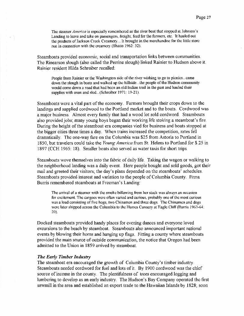
The steamer,4merica is especially remembered as the river boat that stopped at Johnson's
Landrng to leave and take on passengers, freight, feed for the farmers, etc. It hauled outthe products of Jackson Creek Creamery.,. It brought in the merchandise for the liffle store
run in connection with the creamery (Shatto 1962:32).
Steamboats provided economic, social and transportation links between communities.The Rinearson slough (also called the Perrine slough) linked Rainier to Hudson above it.
Rainier resident Hilda Schreiber recalled:
People from Rainier or the Washington side of the river wishing to go to picnics...came
down the slough in boats and walked up the hillside...the people of the Hudson communitywould come down a road that had been an old Indian trail in the past and hauled theirsupplies with oxen and sled...(Schreiber I97l: l9-2I).
Steamboats were a vital part of the economy. Farmers brought their crops down to thelandings and supplied cordwood to the Portland market and to the boats. Cordwood was
a major business. Almost every family that had a wood lot sold cordword. Steamboats
also provided jobs; many young boys began their working life stoking a steamboat's fire.During the height of the steamboat era companies vied for business and boats stopped at
the bigger cities three times a day. When trains increased the competition, rates felldramatically. The one-way fare on the Columbia was $25 from Astoria to Portland in1850, but travelers could take the Young America from St. Helens to Portland for $.25 in1897 (CCH 1965: l8), Smaller boats also served as water taxis for short trips.
Steamboats wove themselves into the fabric of daily life. Taking the wagon or walking tothe neighborhood landing was a daily event. Here people bought and sold goods, got theirmail and greeted their visitors; the day's plans depended on the steamboats' schedules.
Steamboats provided interest and variation to the people of Columbia County. ErmaBurris remembered steamboats at Freeman's Landing:
The arrival of a steamer with the smoke billowing from her stack was always an occasionfor excitement. The cargoes were often varied and curious, probably one of the most curiouswas a load consisting of five hogs, two Chinamen and three dogs. The Chinamen and dogswere later shipped across the Columbia to the Humes Cannery atE,agle Cliff @unis 1963-64:20).
Docked steamboats provided handy places for evening dances and everyone lovedexcursions to the beach by steamboat. Steamboats also announced important nationalevents by blowing their horns and hanging up flags. Fitting a county where steamboatsprovided the main source of outside communication, the notice that Oregon had beenadmitted to the Union in 1859 arrived by steamboat.
The Early Tímber IndustryThe steamboat era encouraged the growth of Columbia County's timber industry.Steamboats needed cordword for fuel and lots of it. By 1900 cordwood was the chiefsource of income in the county. The plentifulness of trees encouraged logging andlumbering to develop as an early industry, The Hudson's Bay Company operated the firstsawmill in the area and established an export trade to the Hawaiian Islands by 1828; soon

Page 28
it added a mill on Sauvie Island. After the fur trade ended, logs and lumber replaced fursas the area's chiefproduct.
Many settlers that came to farm did not think that the region's main source of wealth grewin the trees that surrounded them. They were as eager to burn a tree down as to look at it.They wanted to clear the land to farm and proceeded to burn and blast the big trees awayas fast as they could. Only some settlers saw the need for a sawmill to sell lumber to theirneighbors. Bartholomew White, who may have built the first sawmill in 1843 in St.
Helens, was one who saw that a local market might grow.
People needed lumber for the houses that replaced log cabins, for shipbuilding, forfurniture and for packing boxes. Shingles for buildings and roofs were in high demand andsoon combination saw and shingle mills dotted the area. J.R. and F.H. Watts establishedthe first planing mill in the 1860s (CCH 1970', 40). Sawmill operators on the ColumbiaRiver began to develop a national and international trade too. Captain Williams tooklumber to San Francisco on Captain Crosby's Toulon and Captain Nathaniel Crosby soldspars to China in the 1850s. Roy Perry described the business that Francis Perry, hisgrandfather, operated on the west bank of Milton Creek in the 1850s, Perry recalled thathis grandfather "hired Sam Miles to haul the lumber by ox team down to Scappoose Bayor the Multnomah channel, where it was sold to ship captains for $150 per thousand, Itwas loaded aboard and taken to far away markets" (Perry 1969. 32).
Mills were hand-powered at first, then water-powered and steam-powered. By 1870 therewere 173 sawmills in Oregon, but only 41 were steam-operated (Dicken 1979' 94),Before steam engines arrived, mills had to be on waterways for power; later operators stillused water to help solve the big problem of moving logs and lumber, Men built dams andflumes to move the logs over the creeks and rivers. Often they found their business heldhostage by the weather. Too little rain made the water flow too slow to flush out the logs;too much rain made it hard for the animals to pull the logs down the skid roads. Beforethe era of railroad logging, skid roads traveled the distance from the forested hills to therivers and streams all over Columbia County. Oxen pulled the logs down three skid roadsbetween Warren and St, Helens (CCH 1963-64',29),
Before 1900 the timber industry was small in scale, mostly unmechanized and family-owned and operated. It was the main source of income for Columbia County residents.Almost every man logged or worked in a sawmill for part of the year; women often keptthe accounts and cooked and laundered for the crews of family-owned operations.It was a seasonal industry so no one worked steadily, but no one stayed idle for too long,
Typically a man set up a mill and then logged his own property. Like Dean Blanchardwho started a sawmill in Rainier in 1869, mill operators relied on family members and
neighbors to supply labor (CCH 1967', 11), Attracted to the county's new jobs in thetimber industry, they left behind declining opportunities in states and countries wherelogging already exhausted the timber supply Columbia County attracted men and familiesfrom places where logging was a way of life. Many came from Maine, Wisconsin,Michigan, Minnesota, Sweden, Norway and Finland.

Deer Island School, 1910
$iFt'1'.1',.
titllil!
;-'; -\ær*EÈ?

Page z9
Family and ethnic ties affected the pattern of settlement, creating communities of peoplefrom the same state or country, Yankton in the Milton Creek Valley started from thenucleus of Herb Howard's sawmill. Howard, born in Maine, came to the valley in 1879.
Soon he needed a boarding house for his workers, many of whom were Maine friends andrelatives, By the early 1890s people called the community "Yankeetown" or'Maineville."The United States Post Ofüce would not approve'Maineville" so the settlement wascalled "Yankton" (CCH 1980:13). Alice Tarbell Brown, who came from Maine'sAroostook County, described it: "There are no wild beasts, no troublesome insects, noforeigners, and no thunder and lighting. Everything is as quiet and safe here as in any N.E.community; in fact, these are nearly all N.E. people" (Oliver 1980: l3), The first publicbuilding in these communities \¡/as usually a school.
Settlements of Finns, Norwegians, Swedes and other nationalities blossomed too.Swedetown, for example, grew southwest of Clatskanie. Here Swedes continued tospeak their own language and keep their cultural traditions for some time. The SwedeLine was the first telephone line in Vernonia in 1903; Swedish families who wanted to talkto each other installed it.
The development of the timber industry fueled the early shipbuilding industry.Shipbuilders at Fort Vancouver were the tìrst in the area to produce small schooners in1826. Intended specifically for the lumber trade, the schooners needed to be easy to loadso efficient single-decked schooners developed. Later, steam schooners and four-mastedbarkentines for ocean travel and steamboats sent wood products out of Columbia County(Bancroft 1888'. 726-729).
The Fishing IndustryThe Indians introduced the salmon fìshing and preserving industry to the white settlers ofColumbia County. The explorers and settlers observed how expertly the Indians fishedwith spears, nets, traps and weirs and smoked and dried their catch, The Hudson's BayCompany started the export trade by taking salmon to the London market in the late1820s. Captain Dominis sparked American development of the salmon fishing andpacking industry when he brought his 50 hogsheads of salmon back to Boston in 1829.
The settlers relied on fish as part of their diet when they arrived, At first they fishedprimarily for thçmselves and bought from or traded for tlsh with the Indians. Soon theybegan to develop the early export industry. William Green, for example, established a
barrel shop in 1863 at Green Point near Mayger, Fishermen salted and packed their fish inhis barrels before shipping them out (Sliper 1970: 35).
The commercial industry developed when William Hume and a man named Hapwoodstarted the first salmon canning factory in 1866, They were the first to use tin cans in theirfactory at Eagle Clifi which was approximately two miles below another communitycalled Oak Point on the north side of the river (CCH 1973: 52-53) Hume broughtChinese workers to pack the fish and Columbia County helped provide the Humecanneries with salmon. A few Chinese people, such as Ku Num and his son Sam Sing,
Seining for Salmon, ca.19l0

Page 30
settled in Rainier in the 1880s. Ku Num and his son operated a laundry near the river inthe early 1890s (CCH 1968: 28),
The packing industry expanded quickly. Workers packed 10,000 cases in 1869 and450,000 cases in 1878. The number of factories near Eagle Clifl Washington expanded
and Columbia County fishermen caught 23 tons of fìsh in one week in 1897 (CCC IV: 18).
Columbia County butchers bought the fish and delivered them to the Washingtoncanneries. The industry grew rapidly until approximately 1910.
Most fishe¡men fìshed with gill nets. Erma Burris remembered the fishing ground thatWill Graham and James \üallace operated on the Columbia River in the 1890s. They usedgill nets and took their catch in sail boats across the river to the Hume Cannery (Burris1963-64',20). Others used set nets, traps, purse seines and drag seines pulled by horses.Thomas Hodgkins and L,W. Ball established H & B Seining Ground, the first and biggestseining ground in the county on Hodgkins' donation land claim one mile below Oak Point.They borrowed money from William Hume for their seining equipment and sold theircatch to him in 1890 (Wood 1966: 40). Many of the fishermen at Clatskanie were Finnsor Norwegians (Cole 1998: 1)
MiníngBeginning in the 1870s reports appeared that rich deposits of iron ore, coal and even goldand diamonds were hidden like buried treasure in the county, Sidney Dell wrote an articlein the Oregonian in 1893 to spread the word that there were large deposits of iron andcoal in the Nehalem Valley. Dell wrote enthusiastically:
In my opinion, the entire region herein described, from a few miles west of St, Helensto wrthin a few miles of Greenville, and from the summit of the Coast range east to thesouth fork of Scappoose creek, an area ofover 50 miles square, is one vast and continuousdeposit of the best grades of iron and coal @ell 1893: n,p.).
Some settlers took up mining claims hoping to get rich quick, but to no avail. The ironore near Scappoose was some of the best in the state, but its phosphorous content was toohigh to be worth mining; later, paint and chemical industries mined the available limonite,The coal in the foothills was of a low grade and although some prospectors found goldand even some diamonds, nobody made a fortune (Wilson 1997: 18-19).
Settlíng the InteriorColumbia County's interior was still a frontier in the 1870s. Because no easily navigablerivers or roads traveled very far inland, the interior remained unsettled thirty years afterthe shoreline developed. One of the largest stands of old-growth forest in the PacificNorthwest and the meandering Nehalem River dominated this beautiful hill land. J.
Neilson Barry described the Nehalem as "an extremely peculiar river which flows in almosta complete circle, flowing toward every direction of the compass. Starting near its latercourse, it,..enters the ocean not far from where it rose" (CCH 1976'. I3). Offering a watersource and good land along its bed, the Nehalem River shaped the interior's pattern ofsettlement as communities grew along its banks.

Page 3l
Those who came to the interior were the county's second wave of settlers. Unlike thefirst, they often traveled to the county by more sophisticated means. Many took theimmigrant trains that offered cheap rates from the Midwest to California and thentransfered to sternwheelers. Walter Carl, an early Nehalem Valley resident, recalled thathis parents left Minnesota on an immigrant train. They "came to San Francisco where therailroad ended" and from there took the steamer Ajax to Oregon (Carl 1976. 3l).
Some of the pioneers traveled Indian trails to get to the interior. They entered from boththe northwest and the southeast. From the northwest they traveled the trail from Wood'sLanding that the Clatskanies made to get from the Columbia to the Nehalem. Walter Carlremembered that settlers arrived in 1873 to live at the mouth of Fishhawk Creek and thefuture settlements of Birkenfeld and Mist. Pioneers entered the southeast through a littlecommunity called Meacham's Corner near Mountaindale in V/ashington County. Anaccount from an 1889 Nehalem Journal called their route "an Indian trail over the Pebble
creek pass, now known as the Green Mountain road" (Fulton 1997. 12). Clark Parker and
Joseph Van Blaricom settled what would become the future city of Vernonia by 1874.
The settlers thought that railroads soon would be built and this encouraged theirsettlement (CarI 197 6: 3 0). Pre-emption claims, the I 862 Homestead Act and the 1 864
Civil War veterans' homestead bonus also sparked interest. Rather than proving up aclaim through five years of continuous residence, veterans with two years of service couldprove up a claim with one year's residence, So many of those who came to the NehalemValley staked claims under the veterans' bonus that the Grand Army of the Republic(G,A.R.) became an important social institution. A fraternal organrzalion for Unionsoldiers established in 1866, the G.A.R, held parades and social events for many years thatdrew residents throughout the Nehalem Valley.
Some came to log, others to farm and both started small communities. Pittsburg, one ofthe earlier communities, was typical of the interior towns that grew from the nucleus of asawmill. The Brous family, the Kenkle family and Isaiah Detrick were neighbors andfarmers from Nebraska. They came to the Nehalem River in 1878 to build a saw andplaner mill and operate a buhr-stone grist mill. Peter Brous named the new communityPittsburg and it became a bustling center (Perry 1969',36), Birkenfeld grew after JohnLane built a sawmill in 1898 on property owned by the Birkenfeld family. The Birkenfeldsimmigrated from Germany to Pennsylvania in 1881 and then moved to Oregon in 1885.
They took the trail from Wood's Landing into the valley and homesteaded on Deep Creek.At first they farmed and then logged (CCH 1968: 50).
While citizens in larger Oregon towns enjoyed the benefits of trains and a few good roadsin the 1870s, the settlers of the Nehalem Valley endured the difficulties of those who camein the 1840s. They built log cabins and schools in the future communities of Mist,Birkenfeld, Vernonia and Pittsburg and struggled to get their goods to market in the1870s and 1880s. Walter Carl remembered the transportation problem:

Early Photograph of Vemonia, ca'1880s

Page 32
It was 12 miles from our place to wood's Landing...they would drive the team
to Wood's Landing, get a skifffrom Wood, row 4 miles to Westport and do their
trading, row back to Wood's Landrng that evening to get an early start for home
the next morning (Carl 1976: 30).
Market roads were essential to the development of the interior. Settlers \^/ere very proud
of the hard work they performed to get these roads built. They volunteered their time toconstruct the roads and all good citizens had to help. Built in 1877, one of the earliest
roads the settlers finished was the Clatskanie sled road from Clatskanie to Mist. The
Bunker Hill road connecting Pittsburg to St. Helens over Bunker Hill, was built in 1879
and in 1880 Vernonia residents cut a wagon road over the trail across Green Mountain
and down Pebble Creek that they used to enter the valley. The calamitous windstorm of1880 demolished this road so they replaced it with the Cape Horn road (Becker 1972'.28).
The many rivers and creeks also demanded that the settlers build bridges. Long
suspension bridges for foot travel across the Nehalem River were cofllmon in the county'sinterior. Residents of Vernonia, Natal and other communities built these graceful bridges
(CCH 1965'.7). They also constructed vehicular wood bridges that were sometimes
covered. More than bridges or roads, valley residents wanted trains.
RAILROADS AND INDUSTRIAL GRO\üTH, 1884-1913
Railrosd BuildingThe dream of railroads in Columbia County began with a survey. Congress passed an act
on May 4,1870 that allowed the donation of land for a railroad and telegraph line fromPortland to Astoria. Portland railroad tycoon Ben Holladay completed a survey in the
early 1870s that traced a route from Portland to Astoria by way of Forest Grove throughthe Nehalem Valley. This was the survey that enticed settlers into Columbia County'sinterior but they waited many years for trains.
Railroad construction in Columbia County started in the early 1880s, The large railroadcorporations' main motivation was the vast amount of money they could make shipping
timber. The Northern Pacific Railroad Company built the first railroad into Columbia
County. Chinese laborers laid most of the track for the water level route along the river.
They lived in camps along the right-oÊway, such as the one in the Chimes Crest
neighborhood of Rainier (CCH 1976 9),
Building the railroad was difücult in some locations because the spurs of the Coast Range
required tunnels. The Northern Pacific Railroad completed its line from Portland toHunter's Landing two miles south of Goble in 1883, The railroad company's goal was toconnect northwest Oregon to Tacoma, to transport Oregon's rich natural resources tonational and international markets and to expand its export trade. The railroad throughColumbia County was part of the company's mainline between Portland and Seattle; the
county now was the location of a major railroad link.

Page 33
The completion of this 4O-mile water level route signaled Oregon's future connection witha transcontinental line. The line did not open immediately because the Northern Pacific-
owned ferry, the Tacoma, was not finished. Shipped in pieces aboard a sailing vessel and
reassembled at Kalama, the Tacoma began regular service on October 9, 1884. The
Tacoma transported trains over the Columbia River at Hunter's Landing and connected
them to the Northern Pacific's Kalama-Tacoma line. The company extended the line toGoble in 1890 and the Tacoma ferried the trains across the river from Goble until the
railroad bridge was built in 1908.
Just like the steamboats, the tracks that were owned by the nation's biggest railroad
tycoons changed Columbia County settlements. Often one mile inland, the railroad
bypassed the oldest towns and landings that were products of the steamboat era. Cut offfrom the fastest means of transportation, these communities saw their growth patterns
change, growth moved away from the edge of the river to be near the edge of the tracks.
The railroad era created new communities and increased the rate of development of the
towns it passed through. Ultimately, the steamboats could not compete with the faster
transportation the railroads offered and trains replaced steamboats.
When the railroad bypassed Johnson's Landing (formerly Gosa's Landing), the communitymoved to get on the line. W.W. West donated several acres of land in 1886 and the stores
and post ofüce picked up stakes and became part of Scappoose (Becker 1965: 37)Scappoose resident Jennie Shatto remembered the importance of the railroad:
It is hard for us to rcalize, who have seen the importance of the Railroad through thisarea dwrndling in recent years, but at that time this was the main line between Portland
and Seattle. Trains were passing though Scappoose area every hour (Shatto 1962:32).
The railroad also bypassed St. Helens and traveled through Milton Creek. After theoriginal Milton flooded in the 1850s, a new town sprouted a mile away. The railroadbrought growth to this community that served as St. Helens' depot. Unable to keep thename Milton because of the Milton in eastern Oregon, the town became Houlton when itapplied for a post office in 1890 (Becker 1966: 5). The railroad came through ColumbiaCity and made it grow too. Columbia City residents welcomed the railroad. Twenty years
earlier the city founders tried to get the Columbia City & Hillsboro Railroad built toconnect their town to the Tualatin Valley.
The Astoria and Columbia River Railroad, completed April 3, 1898, connected Goble toAstoria. Vacationers eagerly traveled from Portland to stay in the grand seaside hotelsbuilt for this new tourist trade. Ten thousand travelers per weekend sometimes crossedColumbia County and trains often made three round trips per day in the summer season,
The Spokane, Portland, & Seattle (SP&S) Railroad, owned by the Northern Pacific and
Great Northern railroads, bought the line in 1907. Railroad magnate James J. Hill built theSP&S along the north bank of the Columbia River in 1909 and later built a branch line toVernonia.

Vemonia Train Depot, ca.1928

Page 34
Trains greatly expanded the county's economic development. They increased the supplyof manufactured goods from outside the region, including consumer goods, farmmachinery and construction materials. They opened up the interior to development and
intensified growth along the shore line. The railroads also played a key role inmodernizing the county's greatest source of economic growth at the turn of the century--logging and lumbering.
Railroads helped to increase the number of people in Columbia County. The largestpopulation increase between 1860 and 1890 occurred between 1880 and 1890. The huge
waves of immigrants coming to America and the expansion of the logging industry werethe main causes of the county's growth, but railroads made it easier for them to get there.
Railroad companies' publicity offices advertised vigorously and offered low fares to places
where they had lines.
Trains and population expansion affected the cities of Columbia County. With Portlandserving as the region's main commercial center, the county's towns did not turn intometropolises, but they grew, The period from 1884 to 1913 brought the county's firstwave of incorporation. Rainier was the first to incorporate in 1885. Founded by CharlesE. Fox in 1851, its first name was Eminence; later it became Fox's Landing and finally,Rainier. St. Helens incorporated in 1889 and Vernonia and Clatskanie both incorporatedin 1891. St. Helens did not grow rapidly until the arrival of the McCormick plants and
Vernonia waited until the 1920s, Clatskanie gained population after the Benson LoggingCompany became successful and employed 300 people at its peak. There were only 146
people in Clatskanie in 1880 but by 1900 it had a population of 1,200.
The Timber InclustryUntil the steamboats and the growing city of Portland required cordwood, the timberindustry did not expand rapidly. Much of the cordwood came from the land settlers
wanted to clear for farming. Residents used timber for houses, barns and other structurestoo. Shingle making was an important industry. Mill owners sold shingles locally and
shipped them to Portland (Nelson 1961: 33). During the next half-century ColumbiaCounty's timber industry reached its peak.
The timber industry changed dramatically in the last decades of the nineteenth century.Reshaped by the diminishing forests in the Great Lake states, mechatization, the influx ofbig companies and the growing diversity of wood products, the timber industry entered anew phase of expansion that lasted through the 1920s. Distant markets developed; morelogs and lumber found buyers in Southern California, the East Coast, England, Europe and
South Africa (Dodds 1986: 144).
The growth in the industry included a change from small, family-owned businesses to largecorporate-owned enterprises. By 1900 the largest landowners and taxpayers in ColumbiaCounty were timber and railroad companies. The Pennsylvania-based Dubois LumberCompany, for example, purchased 29,000 acres and Michigan lumberman V/illiam Reidbought 7,000 acres along the Goble, Nehalem and Pacific Railway Company's tracks; the

Minnie Nickerson wrth Rolling Prn at Camp Benson, ca 1906

Page 35
Chapman Logging Company and the Nehalem Timber Company owned more than 11,000
acres neff Vernonia and the Clark and Wilson Lumber Company held 10,000 acres near
Goble (Fulton 1997'. 54).
The decision of the rffestern Cooperage Company to build a plant in Houlton, now part ofSt. Helens, demonstrated the growing diversity of the wood products industry and the
increase in corporate ownership. The lffestern Cooperage Company, with its head office
in Portland, located its plant next to the railroad in 1904 The plant was the largest barrel
factory on the West Coast and employed 17 5 people in 1905. Water diverted from h4ilton
Creek carried the stave bolts to the factory and the company bought timber land toprovide its own wood (Becker 1973. 47-48) This switch to corporate ownership oftimber land and mills escalated in later years Columbia County was unique because so
much of its forested land vras privately owned.
The introduction of railroad logging increased accessibility to the trees and expanded the
market for railroad ties. \{ashington Territory had the first logging railroad in 1881;
Coiumbia County's first logging railroad came in the 1890s These railroads, built by
logging companies for their o\.vn use, were short lines running from the Columbia River to
the forested hills
By i900 many companies were railroad logging The Kerry Logging Company built the
Columbia and Nehalem Railroad, the first logging railroad into the Upper Nehalem Valley
in i913 This railroad took eighteen months to construct. It traveled from Wood'sLanding on the Columbia River to Mist, connected with a railroad at Wood's Landing,
and extended into the lower Nehalem Valley (Peterson et al 197 |. 31) There were 2,000
miles of track for logging railroads in Oregon by 1922 (Carey 1922'. 861)
Eecause railroad logging greatly increased productivity and expanded the number ofworkers needed, it encouraged the growth of large logging camps and milis Betr.veen
1900 and 1930 logging camps mushroomed in the county's forests Some rvere eomplete
communities with turn-arounds for the trains, machine shops and sawmills They had
bunkhouses for single men and houses for families; grade schools and company stores
were provided too. The loggers and their families also used the logging railroads to get totowns that provided the high schools, stores and other services that they needed. When
the loggers cut all the trees down, the camps moved to a new location. The Chapman
Logging Company camp, established in approximately 190ó six miles from Scappoose on
the north fork of Scappoose Creek, r.l'as typical of the county's larger camps. During itspeak it housed 400 people (Becker 1971.32),
The increase in logging productivity sped the transition from small, family-operated mi1ls
to large operations. The sale of the Muckle family mill in St. Helens to Charles and
Hamlin McCormick was characteristic of this change The Muckle brothers were
Wisconsin loggers before they came to St Helens in 1874, They bouglit the LaddCompany Mill, employed eight to ten men, and saw their business grow until a 1904 fireburned the mill Attracted to St Helens because of its r.vaterfront location and railroad

Page :e
access, the McCormick brothers bought the Muckle mill site and built alarge new mill.
The St. Helens Lumber Company, established in 1911, produced 725,000 feet of lumber in
a 1g-hour shift by 1912. Like the other large companies that began to grow in Cclumbia
County after the railroads arrived" the St Helens Lumber Company helped towns todevelop. The company was largely responsible for St. Helens' growth in population from400 in 1909 to 1,500 in1912 (Becker 1965 33)
The era and the industry were ripe for innovation. People r,vith endurance and ingenuity
could make money logging in Columbia County, Those who quickly adopted the ner,v
technologies of donkey engines, cross-cut saws and double-bitted axes prospered most
Simon Benson was one of the successful ones. Benson came from Nonvay with his family
in 1867. His first home in Oregon was a log cabin near Tide Creek that he built in 1879.
By 1890 he started his own small logging outfit with a four-man crew. Benson introdueed
donkey engines to his operations and in 190ó developed ocean-going cigar-shaped lografts. These rafts, stacked high and riding deep in the r,vater, successfully survived theirocean trip to San Diego. The rafts moved much of the lumber that fueled the boomingSouthern California construction industry. When Benson sold his business in 1909, the
Benson Logging Conipany was one of the largest and most profitable in Columbia
County It employed 300 people and was valued at $6 million (Hyskell 1924).
Expansion of the Shìpbuilding IndustryJust as the early timber industry spurred shipbuilding in Columbia County in the 1850s, sc
did the expansion of the timber industry after the 1880s. Many of the ships were stillmade of wood but lvere steam-powered; their manufactured engines came from the East
Coast The difficulties of navigating Oregon's bars and currents also increased the
shrpbuilding business because wrecks were so common.
The success of the lvlcCormick Mill in St Helens produced the county"s first majorshipyaid Hamlin McCormick started the St Helens Shipbuilding Company in 1912 Thecompany built steam-powered ships to transport the company's lumber more efficientiythan wind-powered schooners could The business expanded quickly and the Þ{cCorr¡iekcbuilt another shipyard on the north end of Sauvie Island in 1912.
The Multnomah,Ihe first ship built in the county for the federal government, also \.vas thefirst to come out of the new Sauvie Island shipyard in 1912 Construction of thelvfultnomah signaled the beginning of the St. Helens Shipbuilding Company as the best
shipbuilding firm on the West Coast. The lVlcCormick mill provided the lumber and a boattowed the huge ship to San Francisco to have its boilers and engine installed. The St
Helens Shipbuilding Company also built the steam schooners h'lerced, Celilo,l{ømpamaand Everetr and the motor ships Clly of Portland, S.A. Allard and City of Sf. Helens(Becker 1965: 33)

City of Portland, ca.l9l4

Page 37
St. Helens' Rock IndustryThe crushed rock and Belgian block business were sources of St. Helens' prosperity and
some of the biggest industries in the county between I 890 and 1 9 I 5 . Stonemasons easily
split the rock into the shapes known as Belgian blocks from the cliffs along the ColumbiaRiver. The rock companies employed many men at high wages at the new quarries,
Master stonecutters immigrated from England, Scotland, Italy and other countries to workin St. Helens,
Workers used small Belgian blocks, shipped to the big city by barge and rail, to pave
Portland streets such as Front Avenue and First and Second streets. Workers in St,
Helens built the courthouse, city hall and fine residences with large Belgian blocksConstruction was slow and dangerous with each wheelbarrow of stone cautiously raisedto the necessary height with block and tackle. The peak of the industry occured between1908 and 1909', a local newspaper reported that the quarries employed approximately 300men in 1909.
St. Helens' city fathers were glad to see the industry grow. The City Council granted theColumbia Contract Company the right to quarry rock from the east end of Walla Walla,Summit and Spring streets and also on River Street in 1909. St Helens' Belgian blockindustry provided jobs and income to the city until the 1920s when asphalt paving reduceddemand (Lain1979: 35, CCH 1963-64.43-44)
Agrículture DevelopsColumbia County participated in the expansion of agriculture into new te¡ritory thatoccurred throughout Oregon between 1870 and 1900. The second wave of settlers tookup the less desirable hill land and worked hard to make their homesteads productive. Theyslashed and burned their acreage and planted around stumps because there were too manyto remove.
Farming became more comme¡cial during these years. The arrival of trains to ColumbiaCounty made markets more accessible; farmers shipped more orops to other states andcountries. The main source of development for the county's agriculture, however,remained the growth of Portland, and, to a lesser extent, local county markets.
Farmers further adjusted their crops to the climate and to local demands (Harper and
Torgerson 1929. 4). Between 7879 and 1889 the acreage planted to all crops exceptwheat, corn and barley increased; wheat and corn did not grow well. Adjustmentsincluded more specialized and intensive farming, especially dairying and cattle raising,
Scappoose Plains \ryas a perfect place for dairy farms and ranches. John C. Johnsonoperated Jackson Creek Creamery, one of the first of many creameries in the county in1890. Dean Blanchard and John Dibblee started another creamery in Rainier in 1896;John Schunesen later bought them out and developed the business. Farmers from Rainierbrought in cream and farmers from the Goble and the Mayger-Quincy district shipped theircream to Schunesen by train (Tolleshaug 1962 37) Yankton, approximately four miles
Page 38
west of St. Helens, developed first as a logging community and then as a farming
community, The Tarbell family was one of the first to raise poultry, sheep and fruitsuccessfully there.
Creameries encouraged the farmers to improve their herds. Scappoose Plains and
Clatskanie, to a lesser extent, became dairy centers. Three breeders in Scappoose Plains
were Harry'West, who imported purebred Jerseys from the Jersey Isles, and P.A. Frakes
and Albert Johnson, who bred Holsteins, Harry V/est started Sunny Bank Farm southwest
of Scappoose in 1884, To house his growing herd he built a large barn for 80 head ofcattle. When he died in 1933, a reporter in the Jersey Bulletin wrote:
Mr. West \vas a successful irnporter, sholvman and breeder...It is not too rnuch to sa,v
that no other one man has accomplished arything like the results attained þ him ingiving to the Jersey cow the commanding position she holds in the three states of Oregon.
Wasllngton and Idaho (CCH 1973: 9).
Farmers also raised livestock on the land that was too hilly to farm. Many settlers in
Columbia County called their homesteads ranches because their main occupation was
raising cattle, Farmers continued to improve the breeds by crossing Longhorns withDurham and Shorthorn Cattle (Nelson 1961'.32).
The Granger movement flourished in the first two decades of the century. Granges came
to Columbia County shortly after this farmers' organization was founded in 1867. Twogranges on Sauvie Island and one in Scappoose organized in 1874, followed by the
addition of granges in Columbia City, Clatskanie and Beaver Valley. Pearl Becker, the
ofücial Grange historian, reporled that these early granges "did not last generally, for there
was little supervision in those days of slow travel and great distances between settlements"(Becker 1965 42). The leaders lent a hand to those who followed and flurries of grange
organizationoccurredbetn'een 1901 and 1903,1914 and 1915 andinthe 1920s
Becker called Yankton Grange the county's oldest grange because it was the firstchartered in 1901 (Becker 1965'2). Grange members organized the ColumbiaDistrictPomona (that included Clatsop County), later renamed Columbia County Pomona Grange,
on September 11, 1902. The Pomona Grange was the umbrella organization for all the
county granges and it supported all the members' projects. For many granges building a
hall was one of the first major endeavors.
The Yankton Grange led the way. It requested the state's agricultural extension service tohelp farmers fight pests and to teach them improved methods of farming in 1915, MrFlippin became the first county agricultural agent in l9l7 (Becker 1965: 17). The
Yankton Grange also played a leading role in starting the county fair. Shortly after the
1902 organization of Pomona Grange, farmers discussed having a county fair to display
what they raised. When the Yankton Grange decided to hold a fair in 1908, residents
called it the first county fair (Becker 1965 . 3 8) The site of the fair moved to lffashinglon
Square (later the site of the high school built in 7925) in St Helens in 1913 The Pomona
Grange initiated a petition for a one mill tax to enable the county to buy a permanent fair

Fage 39
site in 1923. The county bought the Appleton farm in Deer Island and construction of fairbuildings began in 1924.
The granges supported many community improvement projects Pushing the county toimprove roads, requesting widows' pensions, building a creamery in the Nehalem Valleyand helping needy families were only a few of them Farm families bettered their own lives
and improved their communities through the granges.
THE MOTOR AGE, 1914-1930
World lVar I's ImpøctWorld Vy'ar I, the expansion of the timber industry and agriculture and the increase in cars
and trucks produced a national economic boom. The period of prosperity that lasted
through most of the 1920s helped to modernize the county The e population also
doubled during this affluent era, Columbia County had 10,580 people in 1910 and20,047in 1930
The Allies' clamor for more manufactured and agricultural products expanded foreignmarkets in 1974 while America's entry into the war in l9l7 added dornestic demand.
Shipbuilding was an early requirement because Germany so successfully destroyed ocean
commerce with its submarines. The need for ships created a boom throughout theNorthwest in merchant shipbuilding, This became the first modern manufacturing industryin the county (Dodds 1986: 201).
Twenty-eight shipyards in the Pacific Northwest built wood schooners and nine built steel
ships during the war. Between America's entry and the war's end in 1918, the Oregondistrict led the way in producing the greatest number of vessels. Oregon shipyards built a
total of 1 16 wood ships and 96 steel ships. The desire for wood ships remained strongeven though steel ships were more durable Historian Cha¡les Carey observed, "The need
of ship tonnage of every description revived interest in the building of ships of wocd, theprime material for marine construction of an earlier time" (Carey 1922', 886). With itsestablished shipbuilding industry and the necessary natural resources, Columbia County\.vas prepffed to build ships.
The St Helens Shipbuilding Company made a significant contribution to the war effort bybuilding two Ferris-type vessels for the federal government The shipyard built sailingships for other firms and barges, launches and two ferries for the Long Bell Compafly, a.
timber firm, The McCormicks' Sauvie Island shipyard, employing 160 workers, was a
beehive of activity. When steel ships replaced wood ships after World War I, the SauvieIsland shipyard concentrated on repair work and small boats; by the 1930s it closed(Becker 1965'.33-34) The Sommarstrom Shipyard in Columbia City was anotherimportant company. This shipyard built large troop carrier ships for the governmentduring World War I (Wilson 1997.22)

Shipbuildrng at St. Helens, ca,I972
@'",æ¿'--

Page.l0
Columbia County farmers' success in livestock raising also contributed to the war effort
and brought prosperity to many farmers. Prices for beef sheep and hogs rose throughoutWorld War I. Apple growing, a relatively new industry in the county, experienced gains in
the domestic market, The fishing and fish canning industries benefited from the war
because the federal government bought most of the canned fish (Dodds 1986,202).
World War I increased the amount of land logged and the number of sawmills. The warexpanded the need for all types of lumber and prices for it rose. The conflict created a
special need for Sitka Spruce as well as fir and cedar for airplane construction. AlthoughSitka Spruce, valued for its strength and lightness, was most accessible on the western
slope of the Coast Range, loggers also cut this tree in the county, The Spruce ProductionDivision, under the direction of the federal government, established 234 camps to produce
lumber during the war. Oregon's production of lumber for airplane construction expanded
from less than three million board feet to more than 19 million board feet per month
between 7917 and 1918 (Carey 1922.886).
rù/hen World IVar I ended in 1918, the county's economy readjusted as prices fell and the
international market diminished. Industries changed to meet the new postwarcircumstances. Those, like shipbuilding, whose market \ilas very dependent on war,
suffered the most, others found new markets.
The Ríse and Fall of the Tìmber IndustryAn economic boom continued in the timber industry until the end of the 1920s. Industrychanges that began in the 1880s produced further expansion. Most important was thegrowth in railroad logging that increased accessibility. Prior to 1900, loggers cut downthe forests near the county's shorelines and only second-growth trees were available there.
The interior, however, hardly had been touched in 1900. Southern Pacific RailroadCompany magnate James J. Hill's decision to build a branch line to get to those trees
brought a huge timber boom to the interior after'World War L Small logging companies
built their own lines too. Expansion of the use of new logging technology pushed
production levels higher.
The exhaustion of the timber supply in southern states and the Upper Midwest continuedto pull big timber interests west. Large companies such as Southern Pacific owned 22 4%
of the standing timber in Oregon by 1913 (Dicken 1979, 154) Columbia County was amagnet for companies such as the Kansas City-based Central Coal & Coke Company withmining and timber interests in many states (Fulton 1996. 54-55).
Corporate bargaining between two industry giants produced one of the biggest and mostmodern electric mills in the United States in Vernonia, The Southern Pacific RailroadCompany agreed to build a branch line into the interior if Central Coal & Coke Companywould build a giant mill. Workers completed the branch line that connected to the SP&Srn 1922; this line, part of the United Railways track (owned by Southern Pacific), traveledfrom Wilkesboro, near Banks, via Buxton to Vernonia.

Clark and'Wilson Lumber Company's Camp 8, ca.l9l7
!É l.

Page +t
The Oregon-American Lumber Company, a subsidiary of Central Coal & Coke Company,
started building one part of its big operation by constructing a logging camp 16 miles up
Rock Creek. Camp McGregor provided the mill's first logs and employed as many as 175
people by 1922. The company bought 210 acres east of Vernonia's city limits for the mill;
when completed the mill and storage area occupied 110 acres. The company built
Millview, its own 3O-acre housing complex, next to the mill. A Kansas City landscape
a¡chitect carefully planned this neighborhood of company houses. Millview contained 62
well-designed bungalows ranging from grand to simple, all perfectly suited to their forest
environment of Douglas firs and maples (Fulton 1996" 63-65).
'When completed in 7924, construction of the Oregon-American mill was a landmark event
not only for Columbia County but for the entire Pacific Northwest timber industry, It was
the first electric sawmill in the region built of concrete and steel rather than wood and one
of the first to kiln-dry common lumber to make it lighter for shipping The largest modern
electric sawmill in the country, it generated millions of dollars of income to out-of-state
owners and cut down thousands of old-growth trees.
Just as the arrival of railroads changed the county, the arrival of big timber interests
changed its landscapes and towns. Timber companies removed the original forests, built
camps and made towns bigger Mills changed the face of established downtowns by
adding businesses and they created new neighborhoods, some with more expensive and
sophisticated housing.
The timber industry transformed Vernonia and St Helens into "Payroll Cities" in which
one company's payroll supported the entire town. When A¡thur Sullivan, the editor of the
Automobile section of the Oregonian, took a scenic drive through Vernonia\n 7927,he
reported: "Throngs of mill workers and their families crowd the main street of the pretty
little town on a Sunday afternoon., Vernonia, with its great mill running, is one of the
busiest and most prosperous towns of Oregon" (Sullivan 1927.6). Construction of the
big mill in Vernonia changed the nature and appearance of this Upper Nehalem Valley
hamlet. From a little town in the county's interior with a population of approximately 350
in 1920, it became a bustling city with a population of approximately 1,500 in 1926
The growth of the McCormick timber interests also developed St. Helens, They created
St. Helens Timber Company after buying the C,C. Masten Logging Company and its
timber. When Hamlin McCormick learned that the government wanted to modernize the
railroads before turning them back to private ownership after World War I, he decided tomake and creosote railroad ties, the St. Helens Creosoting Company was Oregon's largest
creosoting business. Eager not to waste any wood, Harnlin McCormick established St.
Helens Wood Products in 1923. This plant produced broom and mop handles and lath
from wood wastes (Becker 1965, 34-35). The addition of these plants produced St.
Helens' growth spurt, new businesses and neighborhoods.
While the arrival of large new mills and wood products plants brought modemization and
income, they destroyed the county's magnificent forests, Between 1900 and 1930 loggers

Logging Railroads ur the Nehalem Valley and Columbia River Watershed
MAP OF
Nehalem Vallê! ønil
o Columbia Watershed
\(.l' -,OI
'.1J1,:l

Page 42
cut down the vast majority of old-growth trees. Some companies advertised their stumpland as good land for farms and ranches; others just abandoned the land after it waslogged, Columbia County historian Pearl Becker observed: "It seems to have been thepolicy of the logging companies to 'cut out and get out,' leaving the county in poorfinancial condition and the farmers and city dwellers to foot the bills of organizedgovernment" (Becker 197 I'. 40).
Columbia County, like all other Oregon counties, acquired a larger amount of tax-foreclosed land between 1920 and 1940 than it had in any previous decades, The countyregained many hilly acres, really only suitable for raising trees. Later the county sold thisland to people who thought they might be able to run productive farms there, but usuallythey had little success. Many families, often with no experience farming or ranching, cameinto the county in the late 1920s and especially the 1930s to try to eke out a living onstump land. Most of them gave up and moved away.
The combination of efficient railroad logging and high prices for timber brought hugescars to the land. While Arthur Sullivan of the Oregonian waxed poetic over ColumbiaCounty's beauty, he did not hesitate to give his opinion of the logged-offland. Sullivanreflected, "For miles and miles the road courses through these ruined forests, barren areas
of stumps and scrub brush. Here and there are to be seen abandoned logging roads,.,"(Sullivan 1927', l). For many years some residents regretted that loggers cut so manytrees and destroyed so much beauty, Pearl Becker thought in 1962 that the countyrealized too late what had happened. She lamented, "Columbia County profited least ofall, having as a result many thousand acres of stumps and waste land" (CCH 1962. 2I).Reforestation \À/as still a plan in the future.
After 1928 the cutting of all the big trees and falling timber prices drove loggingcompanies and mills out of the county. Little communities once bustling because of a
local mill now quieted. Kathleen Jolma, a resident of Quincy, remembered:
After the timber companies had logged off the timber it left our area preth' much lnthoutu'ork, and u'e settled down to a l'ery slow and resourceless time, farming the small farrns,The women and children sta-ved at home rvhile the men sought vr'ork farther arvay. onlygetting home on rveekends (CCH 1969: 24).
After the logging boom was over, Columbia County also had some ghost towns that onceflourished as centers of logging. They remained in the woods, often with few signs of thebusy activity that had taken place there,
More Specíalízed snd Intensffied AgricultureAgriculture continued to develop between 1914 and 1930, but it never produced the greatincome that the timber industry did. There were 813 farms in the county whose averagesize in 1910 was 112 acres; in 1930 there were 7,667 fa¡ms whose average size was 71.1
acres. 2L6% of county land was farmed in 1 9 1 0 and 28o/o was farmed in 1 93 0 (Harderand Torgerson 1929: 9) World War I produced rapid but temporary agricultural growth

Page.l3
because of increased demand and higher prices; after the war growth returned to its
gradual rate. Development of specialized and intensive farming, well adapted to market
and climatic conditions, characterized the years following World War I. Dairying,
livestock raising and hay and forage crops continued as dominant agricultural enterprises.
Horticulture, production of small fruits and poultry raising were growing activities.
As was true throughout Oregon between 1900 and 1930, dairying produced a greater total
income than any other branch of farming. Dairy farms continued to grow along the
Columbia River because of the fine pasture land there. Farms near Scappoose became
important producers in the county's dairy industry and dairying flourished from Vernonia
to Birkenfeld.
Many farmers kept small herds and continued to improve their stock. Dairy farming
naturally increased the number of large commercial creameries in the county; farmers
began exporting butter and cheese to Caiifornia and other out-of-states markets in 1921
(Harper and Torgerson i929. 5;Dicken 1979. 156). Because of the limited amount ofland suitable for dairying, however, the county was not one of the top ten milk producers
in the state.
Sheep and goat raising also increased, with the number of sheep far exceeding goats. The
expansion of this type of livestock reflected the increased amount of logged offhill land.
The number of sheep and goats doubled in 1929 alone as people searched for productiveways to use the cutover acres. The county's climate, conducive to producing high-qualityeggs, helped the poultry and egg industry to grow (Harper and Torgerson 1929: 6).
Throughout the county's listory, regular flooding affected farming just as it did many
other aspects of life. Before residents made any effort to control them, two types offloods plagued the land. Winter brought intense rainfalls that produced the sharp-crested,
short-lived flooding of interior rivers. Snow melts du¡ing the spring and early summer
brought an annual spring freshet to the Columbia in May or June; this flooding of longer
duration immersed the land along the Columbia River. Before flood controls, the spring
freshets caused the most damage, Erma Burris vividly described how flooding changed
life at Freeman's Landing, located on a piece of land the residents called the Island:
the dock and lr.arehouse as well as the home and other buildings ¡,1sre built upon pilings. . .
even the rvooden rvalks connecting all the buildlngs hadto be on pilings,,. The tidelandsfloodsd...All the livestock had to srvim frorn the Island to pastures on the Graham farmuntil the water receded, then the fanrill' and livestock would return (CCH i963-64: 19).
Before diking, floods swept away whole towns. The great flood of 1894 forced Finns tomove their community out of the tidelands near Clatskanie where they first settled,
Clatskanie residents warned them against building houses there. Each year they raised up
the houses they built on stilts, but the 1894 flood was so severe that many Finns
abandoned their homes (CCH 1970.24). The 1894 flood also prevented Northern Pacific
trains from reaching Goble or Kalama; instead they went to Kelso and the Tacoma taokthem to Portland.

Flooding at Milton, 1894

Page +.1
By the second decade ofthe 20th century residents organized to fight the floods
Following the example of Warrenton residents who built the first levee on the lowerColumbia in 1899, Richard Magruder organized the Columbia Agricultural Company in1904 to develop a drainage district (CCH 1963-64,21) The Magruder district,approximately 2 ll2 miles west of Clatskanie, was constructed in 1911 and included a
levee, pumping station, tideboxes and interior drains to prevent damage from the annual
spring freshets. Between 1911 and 1940 residents established 12 drainage districts; 10
were entirely in Columbia County and two spanned Columbia and Multnomah counties.
Residents established ten districts between lgll and 1922. Started by local interests, thedrainage districts were non-profit public entities established by the state government,Ranging in size from small to large, their purpose was to control flooding and drain theland for productive use. Scappoose had alarge district and drainage districts clusterednorth of Clatskanie because of the bottom land there. The districts turned land that onlycould be used intermittently for pasture into prime land perfect for intensified and
specialized farming. The drainage districts also increased the number of farmers, Thecreation of these districts was one of the important steps towards modernizationthatColumbia County took during the first two decades of the century.
Cars, Trucks and HighwuysN. A. Perry registered the county's first automobile on August 12, 7909. The county had
70 registered cars by 1914 and even more unregistered ones (Fulton 1997',50). Thepopularity of cars increased the long-standing public interest in building roads. Roadconstruction always was difficult. Wet, hilly and forested terrain in the interior made roadbuilding extremely arduous while the Coast Range created a barrie¡ for east-west
construction,
The Lower Columbia River Highway was the most important addition to the road systembetween I9l4 and 1930 Prior to its construction, the Portland Road (now called the OldPortland Road), built before 1905, went from Portland to St Helens. Scappoose residentJennie Shatto remembered it as'Just a dirt road and very dusty" (CCH 1962.32).Steamboats and trains were much more important forms of transportation than thelvagons, buggies and early cars that traveled over the winding, bumpy Portland Road
The State Highway Department started planning and surveying for the Lower ColumbiaRiver Highway in 1914. Construction began in t9I7 and the road was near completion in1922 It straightened out the path of the Portland Road and followed the rail¡oad tracks.The 1929 completion of the Lewis and Clark Bridge that connected the Oregon andWashington sides of the Columbia Riverwas a key addition to the highway system.
The Lower Columbia River Highway sped up business and communication lt quickly putsteamboats out of work and took away the railroads' passenger business while it moregradually eroded their freight business. L C Hall established one of the early truckinglines. Hall bought out an earlier wagon-haul business in 7920. At first Hall's line coveredSt. Helens, Deer Island and Goble, but soon it expanded to include transfer service to lines

Page 45
throughout the nation. Farny Truck Service started in Scappoose in 1917 when Mr. Farny
purchãsed a local milk haul. Farny Truck Service was one of the early trucking companies
that edged railroads out of the log hauling business. The company started to cover
northwest Oregon and southwest Washinglon and hauled logs for the Nehalem Timber
and Logging Company (CCH 1968: 15-16), By the end of the 1920s companies
abandoned many of the logging railroads and truck logging began to dominate the timber
industry.
Completion of the Lower Columbia River Highway also brought new businesses to the
side of the road. Farmers lined the highway with produce stands where they sold apples,
grapes, pumpkins, potatoes, cider and flowers; auto courts flourished and so did
restaurants Gas stations were another form of business that grew rapidly; at a busy
crossroads one or two gas stations always sprouted.
Like the rest of Oregon, Columbia County experienced its first major growth spurt in its
tourism and recreation industry during the 1920s (Dicken 1979'. I44). The land's beauty
and abundance of fîsh and wildlife always had attracted Indians, trappers, settlers and
recreationists. Freeman's Landing, for example, was a favorite place for Portland hunters
in the 1890s and Sauvie Island was another (CCH 1963-64.20) During the 1880s and
1890s families often pitched tents for a week in scenic spots such as Bunker Hill Here
they picked blackberries, hiked and appreciated nature during long summer days.
The tremendous ieap in car ownership and the completion of the new highway in the
1920s greatly increased the growth of tourism and recreation, Arthur Sullivan advised
readers of the Oregonian that the Vernonia Loop, which started in Portland and traveled
through Vernonia, Timber and Forest Grove, 'ùias the perfect Sunday drive: "For the
Portland motorist, a more pleasant Sunday trip of four or five hours' duration could
scarcely be imagined" (Sullivan 1927. 1),
The Pomona Grange also played a role in developing tourism and recreation. A Mr.Schoonover requested a resolution to ask the County Court to provide public parks and
campgrounds along the public highways in 1903, Later, J. B. Godfrey, an early member
of Pomona Grange, sold for a nominal sum a parcel of land in St, Helens to be used as a
city park (Becker 1965 34). Grangers traveling by car to thei¡ meetings saw the
destruction left by clear-cutting and wanted to preserve some of the county's forested
beauty. Pearl Becker remembered:
When first lve drove to the Nehalem r.alle-v over the rvinding road from St. Helens
though Yankton, Happy Hollow and other scenic spots, it rvas in 1923, and the road
\l,as so shaded þ the dense timber that the sun $'as hidden from v-ieu'...A.vear later,
much of the timber hadbeen cut. with nothing scenic remaining (Becker 1967'.47)
Pomona Grange secretary Maud Mills suggested in 1924 thzl the members try to buy apark on the Nehalem River. She wanted to save some of the magnifìcent forests so out-oÊtown automobile tourists and local people could enjoy their grandeur. Fomona Grange
bargained with the Fir Tree Lumber Company for a 1O-acre park site at Big Eddy on the

Page 16
Nehalem River and a five-acre parcel next to the Natal Grange. T'he grange purchased thel0-acre site in 1927 and later the rnerged Fir Tree and Clark and Wilson companiesdonated the five-acre parcel after logging it. Pomona Grange provided tourists artd
recreatronists with a wonderful park in the heart of the Nehalern Valley and began holdingannual picnics at Big Eddy park in 1931 (Becker 1967 . 47).
Between l9L4 and 1930 population growth, Worlci War I, a boom in the timber industryand a dramatic increase in the number of cars changed the appearance and nature ofColumbia County. Loggers cut down old-growth forests and towns such as Vernonia and
St. Helens grew from small communities to sizable cities. T'he county experienced itsbiggest economic boom at the beginning of the period only to enter the Great Depressionat the end of it. Through it all the county modernized and looked fbrward to furtherchange
HIST'ORTC TROTERI'TES LIKELY 'TO ËE FOUNTI
Prior to the 1998 survey and inventory that accompanies this Historic Context Statement,no historìc resources survey and inventory work had been conducted in theunincorporated areas of Colunibia County. Sites identitied as historically important in1969 by the State Park Historian rvere: 'fhornas McKay's Grave site, Warrior Rock,Caples House, Cofhn Rock, Deer lsland, Winship Settlernent and the Knighton HouseThese sites are inciuded in the Statewide Inventory of Historic Properties.
The Columbia County Comprehensive Pian, acknowledged in 1984, included the historicresources on the Statewide Inventory and added seven historic resources: Naial Grange,Natal School, Mist General Store, Mist flommunity Church, Nehalem Drvide RailroadTunnel, Wilark Site and Neverstill Roundhouse.
As part of a 1998 Periodic Review tbr the Columbia County Compreliensive I'lan, theseven incorporated cities of Columbia County were asked to list identifieci and
undetermined historic resources (See Appendix A)
Columbia County has seven iistings on the National Register for Historic Places: theFlippin House, Moeck House, Cox-Wiliiams House, \ilatts House, St. Helens DowntorvnHistoric District, Longview Rridge and the Portland & Southwest Railroad Tunnel.
Archaeological sites have been found in Colunibia County and it is extreniely likely thatmore will be found,
Resource TypesThe main themes in the historical development of Columbia County are:
Prehistory/Archaeology (outside the scope of this study), Exploration & Fur T'rade, NativeAmerican & Euro-American Relations, Settlement, Agriculture, fransport atton &.
Communication, Conrmerce & Urban Development, lnclustry & Manufacturing and

Page +t
Culture Only sites remain that are related to the themes of Exploration & Fur Trade andNative American & European-American Relations. Buildings, sites, structures, objectsand districts are related to the remaining themes
The Historic Context Themes presented in this study are characterized by the followingspecific resource types:
Airport Industrial/mining/quarriesAgricultural outbuilding Natural feature/point, rock, etc.Agricultural outbuilding/barn Rail related/right-oÊwayAgricultural outbuilding/barn/cow Rail related/bridgeArms storage Rail related/tunnelBank Rail related/trestleBridge Rail related/passenger stationCamp meeting sites (religious site) RoadCemetery Rock wallChurch SaloonChurch/residence School/elementaryCourthouse School/high schoolDitch/drainage Service StationFair site Site/archaeologicalFarmhouse Multiple/single grave siteFarm site Store/general merchandiseFerry/landing Telephone exchangeFofiblockhouse Trail sites/Indian and PioneerHighr,vayHomesteadHudson's Bay Company/farm sitelndustrialifood processing/canning siteLewis and Clark expedition/campsiteLighthouseMeeting halVGrangeMill/flourMilVlumberMill/paperMill related/wigwam burnerMill related/flumeMill related/logging camp
The many late nineteenth century and early twentieth century fa¡mhouses, houses, andcommercial and public buildings that comprise the majority of remaining historic buildingsreflect the county's building trends. The main architectural styles are Queen Anne,Bungalow, Commercial and Vernacular. Wood-frame construction predominates Asmall number of buildings in the vicinity of St Helens are constructed of stones quarried inthat area

Page'18
Resource types are discussed as they relate to the historic themes identilìed during
research and development of the Historic Overvierv. Resources often are related to more
than one historic theme but here only the theme that they most directly reflect is discussed.
Resourc.es related to the theme of Prehistory and Archaeology are outside the scope ofthis study but very imporlant. These resources include archaeological sites associated
with Indian t¡ibes Prior to the arrival of permanent white settlers in the l8'{0s, future
Columbia County was an area with a long and rich history of Indian use; it was the
location of early trading and cultural exchanges between Indian tribes and non-Indian
explorers, fur traders and trappers
Resources related to the theme of Exploration & Fur Trade include the many natural
features that were named by explorers, such as Warrior Point and Coffin Rock, the Lewis
& Clark expedition campsites and stopping places, the Hudson's Bay Cornpany farm site
of Thomas McKay and the grave sites of Thomas McKay and his fïrst wife, Tomee The
theme of Exploration & Fur Trade also was important to the development of the futu¡e
oounty because it laid the groundwork for later settlement. The fur trade brought traders
and trappers; the Hudson's Bay Company, with its need to sustain itself by developing
agriculture and industry, fueled later settlement. Further research into the exact location
of the lvÍcKay farm site and the history of that site also would provide information
regarding the role of the Hudson's Bay Company in the development of the area.
Resou'oerrelateúto thstheme oÊNativeårneriean &'€tre-{meriean Relations are the
sites of the blockhouses in St. Flelens and R.ainier. This theme is a rich one that needs
more research, there may be additional sites that w-ould reveal the history of the many
cultural and economic relationships that developed between Indians and non-Indians
follorving the Exploration & Fur Trade era,
Columbia County has many historic resources related to the theme of Settiement.
Resources include homesteads, residences, cemeteries and grave sites There are few
remaining resources related to the earliest r.vhite settlement in the newly minted towns
along the river, More research and examination of land near the shoreline in Columbia
City, St. Helens and the Milton town site might reveal more historic resources The fer.v
historic buildings that remain are examples of domestic architecture popular in the mid-
nineteenth century, Dornestic architecture related to later settlement represents
architectural styles such as Queen Anne, Craftsman, Bungalow and Vernacular.
Resources related to Agriculture include agricultural outbuildings, farmhouses, farm sites,
granges, the county fair grounds site and drainage districts. These resources are typically
outside city limits and are easily identifiable. The development of agriculture in Columbia
County produced the construction of many rernaining farmhouses designed in the
vernacular tradition. The county also is rich in the number of historic barns that remain
Of wood-frame construction, these barns are typically two-story buildings

Page +l
Resources associated with the theme of Transportation & Communication include the sites
of Indian and pioneer trails, wagon roads, ferry landings and a lighthouse. Resources
related to mainline railroads are right-of-ways, passenger stations, bridges, tunnels and
trestles. Resources related to automobile transportation include highways, roads and
service stations. Buildings and residences that housed the first telephone exchanges and
airports are additional resources.
The resources associated with Transportation & Communication played a major role incounty development. Resources such as trails, steamboat landings and the mainlinerailroad created, moved and developed communities. Steamboats, for example, brought a
string of settlements along the Columbia River in the mid-nineteenth century. Resources
related to Commerce & Urban Development are stores, saloons and banks. The earliest
commercial and urban development was concentrated along the shore of the ColumbiaRiver. Commercial buildings in the nineteenth and early twentieth century werepredominately wood-frame building; some buildings were made of poured concrete,hollow-tile masonry or stone.
Resources related to Industry & Manufacturing include flour, lumbet, and paper mills,wigwams burners, flumes, logging railroads (and their bridges, tunnels and tresties),logging camps, quarries, rock walls and food processing and canning plants. Logging r.vas
the industry that brought the greatest amount of economic prosperity to the county.Because of the development of railroad logging, communities such as Vernonia changed
from small towns to growing cities with expanded commercial districts. R.esources relatedto Culture include schools, churches and church residences
Historic Resource DistributionThe location of additional historic resources can be predicted using the Historic OverviewField testing of the location of resources was accomplished by the 1998 sun'ey andinventory work. The archaeological, burial and ceremonial sites ¡elated to the theme ofPrehistory and Archaeology will be found near or in the Columbia River for the ChinooksVillages tended to be near the Columbia River. One likely location for sites is theScappoose area. I. Neilson Barry noted in 1934 that "there would be villages in thatvicinity...where there was agreat trading malt" (Barry 1934: 1). Sites forthe Clatskanies
will be found in the Nehalem Valley and at places along the Cclumbia River, such as OakPoint
Resources related to Exploration & Fur Trade and Native Ame¡ican & Euro-AmericanRelations will be found primarily along the shoreline of the Columbia River. The Lewis &Clark expedition campsites and stopping places also are located on islands in or along theriver. Likely sites of the Indian trails also used later by fur trappers and settlers are thehilly ridges and interior waterways The farm site of Thomas McKay and the grave sites
of McKay and his first wife are located in Scappoose.
Resources related to Settlement will be found throughout the county Homesteads and
residences related to early settlement (ca.1844-1865) are located near the Columbia River;

Page 50
those related to later settlement (ca.1866-1883) also will be found in the interior near
water sources. Some indicators of homestead sites, if no structures ¡emain, ate open
grassy clearings often near creeks or springs, domesticated plants, fruit trees, household
discards and wagon trails or roads Grave sites and family cemeteries are often near
homesteads; many of their locations have been recorded ( See Appendix B; Genealogical
Forum of Oregon 1996: iv-v). Houses of some of the county's earliest settlers are found
in St Helens and Columbia City.
Resources related to Agriculture such as farm sites, farmhouses, agricultural buildings and
granges are distributed throughout the county. The site of the county fair grounds,
developed in the 1920s, is in Deer Island and the drainage districts that increased the
amount of productive farm land are located along or near the Columbia River Resources
related to "Transportation & Communication" also are distributed throughout the county
They include the Indian and pìoneer trails and wagon roads that typically traveled along
ridges and waterways into the interior; further research will provide more information on
their location. The pilings of a covered wood bridge over the Nehalem River near
Vernonia remain. Ferry landings were located all along the Columbia River sho¡eline and
on smaller rivers and sloughs.
R.esources related to the mainline railroad, completed in 1883, are located near the
shoreline of the Columbia River; they include the right-of-way, railroad bridges, passenger
stations and tunnels. Historic resources related to the Portland Road and the originalLower Columbia River Highway (Highway 30) include sections of the road, highway and
bridges The Portland R.oad traveled from Portland to St. Helens and sections of itsroadbed are marked with signs. The Lower Columbia River Highway traveled fromPortland to Astoria; sections of the old road remain The location of the first telephoneexchange is known in Scappoose; further research r'vill establish the location of otherexchanges, The original Scappoose and Vernonia airports are important historicresources.
Resources related to "Commerce & Urban Development" are located in small
communities and incorporated cities. Almost every small settlement had a general store;
the original stores in some communities such as Mist and Birkenfeld, are still in operation.Some cities contain many structures built during their boom eras, Vernonia is an example
of a city whose I920s commercial district has many historic structures. Saloon sites
remain; further research is needed to document them
Resources related to Industry & Manufacturing are spread throughout the county. Thesite of the first flour mill in the interior of the county is in Pittsburg; further research is
needed to determine the exact location. The county has many resources related to thetimber industry. Logging camp sites are located in the hilly ridge near the Columbia Riverand in the interior; sawmills existed on many waterways The sites of tracks, bridges and
trestles related to railroad logging can be found in the same locations; with furtherresearch, remnants of flumes may be found on hills above waterways. A wigwam burneris located near Clatskanie. Sites of large lumber and paper mills are located in Vernonia

Page st
and St Helens The stone quarries and the rock walls made from the stones are located inand near St. Helens. Sites of some large food processing plants are located near therailroad in larger cities
The schools, churches and church residences associated with the theme of Culture are
spread throughout the county in both the small settlements and bigger towns. There are
many one-room country schools, two that retain much of their integrity are Delena Schooland Bachelor Flat School. Many of the churches were built between 1885 and 1930 and
retain their integrity Camp meeting sites are another resource related to culture. These
typically are located in tree groves near the rivers and streams that were used for baptisms.
There is a camp meeting site along R.ock Creek in Vernonia and further research willestablish the location of sites near Clatskanie and other communities
Quantity of flistoric ResourcesThe quantity of historic resources and their coÍìmonness in historic periods providesinformation regarding their rate of disappearance. This information helps establish
preservation priorities. Historic resources related to the theme of Exploration & FurTrade that were rare in the past are the natural features named by explorers, the campsites
and stopping places of the Lewis & Clark expedition, and the Thomas McKay farm site
and grave site. These resources, of course, remain rare. Resources related to NativeAmerican & Euro-American Relations are the blockhouses; these rare resources w-ere
destroyed many years ago.
Resources related to Settlement that were common but no\ry are Íare aÍe homesteads,
residences built before 1900 and grave sites. Cemeteries were common and they continueto be preserved. Resources related to Agriculture that were common include agricuituralbuildings, farmhouses and farm sites. Columbia County is particularly rich in the numberof barns, other agricultural buildings, farmhouses and farm sites that remain. These
resources are diminishing in suburbanizing areas Granges, county fair grounds and
drainage districts continue to be rare. The Deer Island county fair grounds is currentlyunder consideration as a site for industrial development. The drainage districts are not
threatened
Pioneer trails and'\¡/agon roads were common but now are rare. Ferry landings werecornmon but now only pilings remain. Airports and the first telephone exchanges continueto be rare Historic resources associated with the mainline railroad such as the right-of-way, bridges, passenger stations and tunnels continue to be rare; some of the passenger
stations have been demolished and remaining stations need preservation strategies.
Historic highways such as the Lower Columbia River Highway continue to be rare
The commercial buildings associated with the theme of "Commerce & UrbanDevelopment" were common, Most of the buildings built before 1920 are rare; many ofthe buildings built after 1920 remain. Flour mills were rare and none remain. Lumbermills, shingle mills, paper mills, flumes, wigwam burners and logging camps \À'ere commonbut now are rare, Schools built before 1920 were common but now are raÍe, remaining

Page 52
schools need preservation strategies. Churches built between 1885 and 1930 continue to
be a rare resource, Columbia County is fortunate in having these churches. Although
many of the churches in larger communities have been preserved and maintained through
the activities of local people, some of the churches in smaller communities, such as NIist
and Birkenfeld, need immediate support for preservation.
In general, many of the historic resource types are rare. Those that are common are
agricultural outbuildings, farm houses, residences and commercial buildings built after
1920.
Columbia County has many types of historic resources that need preservation as economic
development progresses. The county now has a population of 44,723 Projections
prepared by Portland State University Center for Population Research and Census and the
Oregon Office of Economic Analysis estimate that the county will have a population of45,000 to 50,000 by 2010. Although this growth rate does not indicate intense
development pressure, it is critical that the county plans now for preservation. The
immediate focus for historic preservation efforts should be on resources in or near
growing cities and their suburbs, but more long-range planning for resources outside
developing areas also is needed now.
CRITERIA FOR EVALUATING HISTORIC PROPERTTES
Evaluation is the process of determining the significance of historic resources This
section of the Context Description sets the standards for evaiuating the resources
associated with the historic context. The evaluation criteria in this study follows the
c¡iteria used by the National Park Service for the National Register of Historic Flaces and
endorsed by the State Historic Preservation Ofüce. Resources are evaluated according totheir significance, integrity, condition, and association with the historic context ofColumbia County.
SignificanceHistorical significance is the primary consideration in determining which resources topreserve The National Register criteria finds historic resources significant if they have
one or more of the following characteristics:
are associated with events that have made a significant contribution to the broadpatterns ofour history
are associated with the lives of persons significant in our past
embody the distinctive characteristics of a type, period, or method ofconstruction) or represent the work of a master, or possess high artistic values, orrepresent a significant and distinguishable entity whose components may lackindividual distinction
A)
B)
c)

D)
Page 53
have yielded, or may be likely to yield, information important in prehistory orhistory
R.esources are not given a numerical rating on their significance They are eithersignificant under one or more of the four categories or not significant.
IntegrityThe criteria assesses historic resources' integrity. Integrity is defined as a state ofunaltered completeness. The National Register criteria examines integrity of "design,setting, materials, workmanship, feeling, and association." An appropriate degree ofintegrity is required for a resource to be evaluated as historically significant. Resourceswith a high percentage of original elements and materials receive a high rating. Alteredresources are evaluated according to the compatibility of alterations with the resource'soriginal state. Historic aiterations often are compatible because similar or the same
materìals are used; contemporary alterations may not be because dissimilar materiais are
used.
Resources are given a numerical rating on their integrity A resource with good integrityreceives ã"3," a resource with fair integrity receives a"2" and a resource with poorintegrity receives a " 1."
CouditionThe condition or state of repair of an historic resource is another criteria Resources indeteriorated condition may receive a lorver evaluation for practical reasons. Preservationefforts and funding might not be weli spent on resources in extremely poor condition.
Resources are given a numerical rating on their condition. A resource in good conditionreceives ã"3," a resource in fair condition receives a"2'" and a resource in poor conditionreceives a"1."
Resources also are evaluated on the basis of their clear association with the themes ofhistorical development outlined in this Historic Overvier"u-. This criteria overiaps thecriteria of significance. A resource that is associated with an important local event thatmade a significant contribution to broad patterns of our history also would have a clearassociation with the themes of historical developrnent in the Historic Overview.Together, significance, integrity, condition and association with the themes of historicaldevelopment determine the ranking of resources. The process of surveying andinventorying is continual and resources' ranking may change over time. As resourcesreach 50 years of age they should be surveyed, ranked and added to the Columbia CountyInventory of Historic Resources and SFIPO's Statewide Inventory of Historic Properties.

Page 54
SECTIOI\ III
GOALS AND PRIORITIES
Historic significance should be the primary consideration in determining which historicresources to preserve, but other considerations also play a role. By setting goals and
priorities and developing preservation strategies, context-based planning tries to balance
the importance of resources with the other factors affecting them, such as public supportfor preservation, availability of funds and staffand threats to preservation.
IDENTIFYIN G OTHER CONSIDBRÀTIONS
A key reason for preparing an Historic Context Statement is to create a plan forpreserving the signiticant resources that are documented. This part of the HistoricContext Statement identifies the positive and negative factors afiFecting preservation inColumbia County and offers plans for directing them.
An initial step is to develop a list of stakeholders. Through public meetings, residents ofColumbia County have identified the following groups that play a role in preservation:
Columbia County Board of CommissionersColumbia County CourthouseSt. Helens, OR 97051503-397-4322
Columbia-Pacific Economic Development DistrictP.O Box 598
St. Helens, OR 97051503-397-2888
Columbia County Department of Forest, Parks & RecreationColumbia County CourthouseSt. Helens, OR 97051503-397-2353
Columbia County Department of Land Development ServicesColumbia County CourthouseSt. Helens, OR 97051s03-397-1 501
Confederated Tribes of Warm Springs9615 Grand Ronde Rd.Grand Ronde, OR 97347503-87e-52t1

Page 55
Columbia County Historical SocietyP,O, Box 837St Helens, OR 970515Q3-397-9780
Mist-Birkenfeld Historical S ocietyMelis Ranch, Hwy.202Mist, OR 97016503-7s5-9628
Scappoose Historical Soci etyP O. Box 294Scappoose, OR 97056503-543-2173
Daughters of the American RevolutionP O Box 1033
Scappoose, OR 97056503-543-7476
Nehaiem Valley Pioneer AssociationMelis Ranch, Hwy.202Mist, OR 97016503-755-9628
Columbia County Historical Museum511 E Bridge St.
Vernonia, OR 97064s03-429-3713
School AdministratorsNorthwest Regional Columbia Service Center800 Port Ave.St. Helens, OR 97051
503-397-0028
Clatskanie Library DistrictP.O Box 577
Clatskanie, OR 97016s03-728-3732
Scappoose Library DistrictP.O. Box 400Scappoose. OR 97056503-543-7123

Fage 56
St. Helens Public Library375 S 18th St
St. Helens, OR 97051
503-397-4544
Rainier City LibraryP.O. Box 100
Rainier, OR 97048503-556-7301
Vernonia Public Library919 Bridge St
Vernonia, OR 97064503-439-1818
St, Helens-Scappoose Chamber of CommerceP O. Box 1036
St Helens, OR 97051503-391-0685
Vernonia Pride1410 Roseview Heights Ave.Vernonia, OR 97064503-429-1204
Columbia County Senior Citizens32946 Bell Crest RdScappoose, OR 97056503-543-6853
Scappoose Senior Center53723 Ringering Rd.
Scappoose, OR 97056503-543-2944
St. Helens Senior Center354 N. 5thSt. Helens, OR 97051503-391-3720
Rainier Senior Center544 5th St. EastRainier, OR 97048503-5 56-3 5 88

Clatskanie Senior Center75515 Price Rd.Rainier, OR 97048503-556-3734
Vernonia Senior Center340 Bridge St.
Vernonia, OR 97064503-429-2581
Washington County Historical Society & Museum17677 NW Springville Rd.
Portland, OF.972295A3-645-5353
Historic Preservation League of OregonP O, Box 40053Portland, AR97240503-243-ï923
Oregon History Center1200 S\ry Park AvePortland, OR 97205503-222-1741
State Historic Preservation Office1115 Commercial St., NESalem, OR 97310s03-378-5001
Residents
Property Owners
Business Owners
Bankers
Realtors
Land Developers
Tourists, Visitors, Recreationists

Page 58
Church Administrators
Cemetery Overseers
Civic Clubs (Lions Club, Kiwanis, etc.)
Local Newspapers
Columbia County is fortunate in having many groups that support historic preservation.Key leaders are the historical societies, local museums and the Daughters of the AmericanRevolution Many of these groups have already accomplished some of their goais ofpresen'ing barns, houses, objects and documents. Their dedicated members have been and
will continue to be the nucleus of preservation activities. They can be counted on to start
programs and to get others involved.
Columbia-Pacific Economic Development District has been instrumental in supportinghistoric preservation. It can play an important role in fostering projects that further theinterests of preseruation and economic development. Columbia County Department ofForests, Farks & Recreation played a very important role in initiating the project ofpreparing an Historic Context Statement and a Survey and Inventory. Columbia CountyDepartment of Land Development Services also has been supportive and has gathered
information on historical resources to be included in its cotnprehensive planning. All ofthe groups listed may provide support for historic preservation With local politicalbacking and public and private funds, Columbia County's past can be presen'ed.
The greatest potential support base for preservation is the residents of Columbia CountyMany of the residents have deep family roots in the county. Ner.vcomers too express a
strong interest in the county's history and pride of place. lt is residents' interest and pride
in the county's history that is the greatest preservation resource.
To make that support base grow, it is critical that community education programs are
offered throughout the county. These programs must focus on the benefits ofpreservation. N{ost people are not aware of the positive aspects of preservation, such as
the Special Assessment Frogram, increased property values, greater tourism and business
opportunities. Community education programs presented by people knowledgeable about
these benefits should be a first priority and they should be held in many locations
GOA.LS AND OBJECTI\,'-ES
The following goals and objectives are designed to aceomplish the rnission of protectingand preserving significant historic resources. These goals and objectives rvere developedduring public meetings held in St, Helens in 1998, The goals describe a desired futurecondition and the objectives are the steps needed to achieve those goals,

Page 59
Goal: Use the Columbia County Preservation Committee as a county-wideresource center for information on preservation. This committee was
established by the group of Columbia County residents that attended
the 1998 public meetings associated with the preparation of the
Historic Context Statement and the Survey and Inventory.
Objective'. Notifu groups and individuals interested in preservation of the
biannual meeting of the Columbia County Preservation Committee.
The Columbia County llistorical Society will publish meeting
notices in its newsletter.
Objective'. Provide current information on historic preservation resources and
history and preservation projects in the county. The Columbia
County Historical Society will provide this information
Ohjecti't'e', Keep the inventory of Columbia County's historic resources
updated
Goal: Hold community education programs on historic preservation and preserving
community history
Ohjective', The Columbia County Freservation Committee or an historical
society could arrange a preservation and contact local groups such
as granges, churches and schools and ask them if they would host a
program on preservation or community history. This wouldallow other groups to learn more about preservation
Goal: Nominate selected resources to the National Register of Historic Places.
Objective'. At meetings of the Columbia County Preservation Committee,historical society meetings, or other rneetings, decide on
resources to nominate and prepare the nominations.
Goal: Find funding for county preservation and local history activities.
Objective: Find granting agencies and private foundations that fundpreservation and history programs and write the grant applications
Objective: Request funding from the list of stakeholders
Goal: Establish more school programs on community history.

Page 60
Objective: Build on established school programs that bring localhistory into K-12 classrooms. Find individuals willing tooffer local history programs in the schools and help
them gather and organize historical material.
STRATEGIES
The State Historic Preservation Ofüce has recognized particular strategies that have been
successful in realizing a community's goals in historic preservation. The State HistoricPreservation Office's list of strategies can be used and adapted to best serve the county'sinterests:
Networking: A community member attends preservation and local history conferences toshare, to learn and to meet indil'iduals with similar interests This
strategy is highly recommended because it r.vould help people outside the
county learn about the county's historie resources and it would bringinformation back into the county. Individuals would frnd much to offer and
to learn by attending the annual Governor's Conference on HistoricPreservation, the annual National Trust for Historic Preservation
conference, or the Oregon History Center's workshops on oral history,
Partnerships: Groups or individuals such as civic groups, business owners and
historical societies work together to identify and to nominate propedies tothe National Register of Historic Places Partnerships should be created
whenever possible because it shor,vs different interest groups how everyone
can benefit from preservation
Piggybacking, An organization distributes or requests information through ânother
organization's publications. The newsletters of the county's local
historical societies and libraries can provide information an how to get
historic preservation and local history publications from the State
Historic Preservation Ofüce, the National Trust for HistoricPreservation and the Historic Preservation League of Oregon. The new
Columbia County Preservation Committee will use this strategy bypublicizing information in the Columbia County Historical Society'snewsletter
Volunteers/Interns: Preservation and community history projects are conducted by volunteers
and interns. This strategy has been successfully used for some time in the
county. Expansion of the strategy could include using more volunteers towork on collecting historical documents and to be involved in specificprojects. Interns who are history and historic preservation students
from the University of Oregon and Oregon State University also might be
used on specifìc projects

Page 6l
Grants: Finding potential grants, writing grant applications and using county
clerical and stafftime to fulfill"match" requirements. Members of the
Columbia County Preservation Committee should form a grant-writing
committee and focus on securing grants as soon as possible.
Repackaging: Republishing the Historic Overview from the Historic Context Statement
as a fundraising tool.
Coaiitions: Preservation groups combine their effiorts with wildlife habitat advocates topreserve an historic rural landscape.
Leveraging: Local businesses and citizens lend time and/or money to support the
preservation activities of others Leveraging also can be accomplished
by using matching grants. Emphasis should be placed on this strategy.
There are many businesses and citizens in Columbia County that would
be willing to support preservation if shown how to help, The people that
have been successful in gathering preservation support e an r'vork withothers to find more interested businesses and people.
lV{entoring. Presen'ation groups and historical societies connect owners of historic
homes with individuals who have already rehabilitated or restored
homes. Emphasis should be placed on this strategy, Owners of historic
homes can present atalk or slide show at a community education program
lvlodeling: Placing key historic properties on tlte National Register, rehabilitating
them and using them as models in a neighborhood. Emphasis also shoulcl
be placed on this strategy, The county needs more examples of the benefits
that placement on the National Register can bring
PRIORITIES
The following preservation activities should be given priority in Columbia County:
1. Select historic resources to nominate to the National Register of Historic Places
and complete the nomination process A beginning list of properties to nominate
includes: A¡licker Homestead, Oregon-American Lumber Company Office (now
the Columbia County Historical Museum), Thomas McKay Grave site, P.A.
Frakes Barn and Goble (historic district)
Find potential grants, rvrite grant applications and solicit local donations forpreservation.
Focus time and energy on informing officials, groups and individuals about the
benefits of preservation. Conduct community education programs on the
2
3

4
5
Page tz
positive aspects of preservation, including placement on the National Register, the
Special Assessment Program and the attraction of historic areas to businesses and
visitors.
Develop the newly created Columbia County Preservation Committee so that itgathers many representatives from all areas of the county. This committee should
be a place to share ideas and to gather support and information for preservation
activities. Establish regular biannual meetings for this group and have all groups
call their members and explain the importance of participation.
Build the local history school program in grades K-12 Continue the grade school
programs that have been successful in cities such as Scappoose and Vernonia and
expand them, Find high school teachers that support studying local history and
develop programs rvith them

Page e:
SBCTION IV
I1\TEGRATION
CONNECTIONS TO OTHER PLANS
This section of the Historic Context Statement discusses planning efforts established by
other government agencies and community organizations. Knowledge of other planning
activities avoids duplication of effìort and encourages support for preservation.
In Colurnbia County, the Army Corps of Engineers, the Bureau of Land Management, the
Oregon Department of Forestry, the Oregon Department of Transportation and Columbia
County Department of Land Development Services are the government agencies and
departments that supervise sizabie amounts of land and historic resources.
The Army Corps of Engineers has oversight over the twelve drainage districts in Columbia
County These drainage dìstricts are non-profit entities incorporated with the State ofOregon The Army Corps of Engineers can contract work to be done in these districts,
Prior to any work, the Army Corps of Engineers conducts a cultural resources study todetermine if any historic resources will be affected, It contacts the State HistoricPreservation Office to veriff the existence of historic resources in the work area and todiscuss possible impact on them
The Bureau of Land Management (BLM) supervises land in its Columbia Flanning Unit,located primarily in the hill region bet\ ieen Vernonia and St, Helens on the north and the
Tualatin Plains to the south. The BLM has conducted a survey and prepared a culturalresource inventory and evaluation of historic resources. The purpose of evaluation is toclassify cultural resources in terms of potential alternative use. Evaluation is the starting
point for planning and decision making. Cultural resource specialists suggest appropriate
classifications for each resource. The classifrcations are to conform with any applicable
land use plan and to be oonsistent with the State Historic Preservation Ofüce plan (see
Appendix C).
The Oregon Department of Forestry (ODF) has oversight over approximately 5,021 aores
in Columbia County. These iands are part of the Clatsop State Forest and are owned by
the Board of Forestry and managed out of the Forest Grove District. The Oregon
Department of Forestry has established management goals and preservation strategies fcrthe lands it supervises,
ODF management goals are to preserve and protect archaeological sites or objects inaccordance with state law, to conserve historic artifacts and real property of historicsignificance in accordance with state law and in consultation with the Secretary of State
and the State Historic Freservation Office, to protect additional cultural resource sites that

Page 64
are determined by the Department of Forestry to have special educational or interpretive
value, and to maintain compatibility with Oregon's Statewide Land-Use Planning Goal 5.
ODF management strategies include completing an inventory and assessment of culturai
resource sites and conducting a prehistoric and historic cultu¡al resource review
developing a cultural resource database for tracking and planning purposes, and
developing a procedure for integrating site protection into forest activity plans by
providing practical guidelines for recognizing, assessing, recording and protecting sites
(See Appendix D)
The Oregon Department of Transportation (ODOT) has conducted a survey and inventoryof historic resources. Resources include original sections of the Lower Columbia RiverHighway, such as the section from Alston to Rainier (10 miles) and the Beaver Falls Road
(13 miles) and historic bridges, If work is needed that would affect an historicallysignifìcant resourÇe, ODOT consults with the State Historic Preservation Office before
beginning the project.
Columbia County Department of Land Development Services has begun the process ofpreserv'ation planning. This Historic Context Statement, the Inventory of HistoricResources and 60 Intensive Site Surveys will help inform Columbia County'sComprehensive Plan Cultural resources are treated under Statewide Land-Use Planning
Goal 5. Revisions to the Administrative Rule Governing Goal 5 (OAR 660-023)
encourage communities to plan for cultural resources using the historic context-.based
model created by the National Park Service.
State law (ORS 358i653) requires that state agencies and political subdivisions such as
counties create programs to preserve significant historic resources that they own or forwhich they are responsible. Columbia County Department of Land Development Services
has included Section 1130, the Historic Overlay District, in the Columbia County ZoningOrdinance. The Historic Overlay District is designed to protect historic values bymitigating conflicting uses.
Section 1 130 of the Columbia County Zonng Ordinance has three parts: Sections 1 131,
1132 and 1133. Section 1 13 1 requires a public hearing before any change ofuse orexternal modification of an historic structure or site takes place This allows the county tonotif,/ the State Historic Preservation Office and local historical societies of the proposed
change and to request their comments The Planning Commission then determines if theproposed change of use or external modification destroys the historic value of thestructure or site.
Section 1132 allows the Planning Commission to attach conditions on a proposed requestto change or alter an historic structure or site. Section 1 132 protects the historic valuewhile meeting the applicant's needs, Section 1133 installs a 90-day waiting period beforethe demolition of an historic structure or site. This allows the County to send notice tointerested parties and to investigate methods of saving the structure or site. This typically

Page o5
involves purchasing the structure or site or moving the structure. If a plan to save the
structure or site is not developed, the demolition permit is issued (See Appendix E)
Some of the other important groups that should be included in preservation planning are
school districts, churches and granges
CONNECTIONS \YITH OTTIER CONTEXTS
This Historic Context Statement is the first that has been prepared for Columbia County,
Lou Ann Speulda's Oregon's Agriailtural Developtnent: A Historic Context I8I l-1910(l9Sq) identified survey and research needs, preservation activities, and goals and
priorities for the statewide treatment of agricultural historic resources; this document
contains helpful information Historic Context Statements for similar counties will provide
useful information too.
FITTTÍRE RELATED STUÐIES
The Historic Overview in this Historic Context Statement is a general overuiew of the
history of Columbia County that identifies significant eras, events and historic resources.
To fully describe their significance, more intensive research in specific areas is needed
Recommended subjects are:
The history of the Indian tribes beginning with their first settlement through the early 20th
century. Research topics include identification of the tribes, their relationships with each
other, the development of cultu¡al and economic relationships with white explorers, furtrappers and traders and settlers, the Indian Wars of the mid-nineteenth century, theimpact of removal to reservations and the related historic resources. This study is needed
because Indian tribes made a major contribution to the history of the county Informationregarding many historic resources is available through archaeological digs and historicaldocuments
The passage of the Lervis & Clark expedition through the area. Research topics includefurther identification of the expedition's campsites and stopping places, study of theexpedition's obsen ation of and relationships with the Indian tribes and descriptions of thewildlife, land and waterways This study rvould contribute to Columbia County'spreparation for the Bicentennial of the Leu'is and Ciark expedition
The history of settlement by sailors and sea captains, their ideas about town planning and
their architectural and building traditions. Some of the early town founders built houses
and stores that were made of finished lumber shipped to the area in the mid-nineteenthcentury. Research topics include: the nature of town planning principles and the buildingmaterials and the styles used, the development of the eastern market for finished lumberand the involvement of Columbia County torvn founders in that market. This study ra'ould

Page 66
contribute to an understanding of early town planning and building and architecturaltraditions
The study of early church organization and the historic resources related to it Churchorgaruzatton began with meetings held in members' homes and schoolhouses; latermembers built churches and parsonages. Circuit riders established preaching points insmall settlements, new members were baptized in streams and rivers and camp meetings
were held for many years at established camp grounds. The study of the growth of churchorganization and the many historic sites and structures that reflect that growth is necessary
because it played a central role in the social history of the county.
Mapping of pioneer trails Pioneer accounts of early settlement typically discuss theimportance of early trails and the difüculty of building and tra'reling them Examples are
the trail from Wood's Landing and the trail into Vernonia Documentation of the exactlocation of the trails and their history is necessary because it rvould contribute to theunderstanding of settlement and transp ortation p atterns.
A study of the Thomas lv{cKay farm site (which was a Hudson's Bay Companyfarm site). Research topics include McKay's significance as an historical figure, thelocation of the McKay farm site and its relationship to the Hudson's Bay Company Thisstudy would reveal the importance of the Hudson's Bay Company to the laterdevelopment of the county.
A study of the steamboat landings and the communities that grerv up around them. The
steamboat era created a string of communities lvith associated historic sites and structuresalong or near the Columbia River. Visual remains are not easily identiliable so theexistence of these landings and the historic resources related to them could tre forgotten.
A study of the growth of the tirnber industry and the historic resources related to it fromthe mid-nineteenth century to 1930 For many years the county's eoonomy revolvedaround the timber industry and the logging camps, sar,vmills and loads of logs made thiseconomic reality very visible The historic resources related to the timber industry arerapidly diminishing This study is needed to document the importance of the industry and
the location and appearance of the many camps and mills that dotted the county
A study of the Scandinavian (including Finnish) immigrants and the historic resourcesrelated to their settlement, Because of economic opportunities associated with the timberand fishing industries, Columbia County attracted many immigrants from Scandinavia. Astudy of the houses, stores and industries associated with them is needed because theseimmigrants played such an important role in county development. A special case studyshould focus on Simon Benson, whose logging operations were very important in thecounty,
A study of dairy farming and its historic resources. This study could foeus on theScappoose area, where dairy farming thrived for many years. Research topics include

Page e7
mapping the location of dairy farms and creameries and the connections to steamboat
landings and the railroad. This study is needed because it would provide historic context
for the many remaining related resources (barns and farmhouses) that exist.
A study of the shipbuilding industry and the historic sites associated with it. Columbia
County made an important contribution to this industry in the early twentieth century by
building commercial and government ships. This study is needed to document that
contribution and the sites where ships were built.
A study of the local rock industry. Research topics include documenting the location ofthe quarries, the workers and craftsmen involved and the style of construction of the
buildings and walls, This study is needed to provide historic context for the many stone
buildings and walls located in or near St. Helens.
SOURCES CITED AND BIBI-IOGRAPHY
Sources cited as "CCH" in the Historic Overview are articles and information in thejournal Colurnbia County History that have no author of record. They are listed below by
date and title under Columbia Cotntty Hislory.
Abraham, Mrs, Ervin1966 Hudson Community. Columbict County History V'. 27-29.
Anderson, Harvard1998 Intervierv by Ann Fulton, Scappoose, Oregon
Bancroft, Hubert H.188ó-1888 History of Oregon. 2 Vols Historical Company, San Francisco.
Barry, J Neilson1934 The History of Scappoo,re. Unpublished article, Portland, Oregon
Becker, Pearl1965 H,F. N{cCormick. Columbia County History IY: 34-36.
1966 Indian War of i 855-56. Colum!¡is County History Y: 45-48.
Milton, Early Dream City. (-olunthia County History Y. 4-6.
1967 The Acquiring of Big Eddy Park. Colttmhia Counry History W. 47 .
l97I Camp Wilkerson. Coltmbia C.otttty History X: 39-40,
The Chapman Commuruty. (lolumbia CounlT' HìstoryX. 32-33,

Page 6s
1972 Nehalem Valley Roads. Columbia CowÍy History XI: 28-30
1973 Western Cooperage Company, Columbia Llounty History XII. 47-49.
7974 182 Year Report: Coffin Rock to Trojan Nuclear Plant. Columbia Cot*ttyHistory KII: 3-6.
Becker, Pearl, ed.
1965 Scappoose History From Several Sources. Columbis (lotutfy HistoryIV: 36-39
Brugo, Mary L.1975 The Distribution, Utility and Demand of Riverfront Land on the Oregon
Shore of the Lower Columbia River. Ph.D. Dissertation, Oregon State
University.
Burris, Erma G.
1963-1964 Life at Freeman's Landing. Llolumhiq County History III: 19-21.
Carey, Charles H.1922 History of Oregon. Vol. L Pioneer Historical Publishing Company,
Chicago.
197 | General History of Orcgon; 'fhrough Early Statehood. Binfords and Mort,Portland, Oregon.
Carl, Walter Merritt1976 History of the Nehalem Valley. Columbict {)ounty HistoryXy.29-36.
Clark, Robert C.
1927 Hi.story of the LV-illamette ['alley, Oregon. Vol. I. S J. Clarke, Chicago.
Clarke, S.A,1905 Pioneer Days of Oregon HisÍory. Yal. L J K. Gill and Company,
Portland, Oregon.
Cole, Larry1998 ClatskanieHistoryInformation Unpublisheddocument,Clatskanie,
Oregon.
Columhia County Grange History1965 Columbia County Grange History, Collis Enterprises, St. Helens.
C.ohrmb ia Cowúy History1962 Sherifß of Columbia County Columbia C.ounÍy History IL 24-25.

Page 69
1963-1964 History of 'Warren and Vicinity. Cohtmbia County Hi'story III: 28-30.
Samuel Thomas Gosa, Oregon Pioneer. (-.olumbia Cowtty Hislory III' I'7-
18.
The Shipwrecked Spanish Sailor. Columbia County History III: 49-50.
St, Helens Rock Quarries. Columbia Couttty HistoryIIL 43-44.
1965 Early Newspaper--L9g7 . Columhia County History IV: 18.
1967 The Ðibblee Family. Columbia Cotutty History VI: 10-13
St. Helens Area Churches. Cohrttbia C'ounly History YI: 6-7 .
1968 Birkenfeld Family. Colunthia Cowtty History VII: 50
100 Years of County Judges. C'olumhia Llottnty History WI: 3-8.
Items ftom Rainier Reviev,Centennial Number. Cohmbia Counly Hisforyvrr.28-29,
[Pioneer Bridge over the Nehalem I Oolumhia ()outty History VII. 46
1970 First Planing Mill Came around the "Horn" ìn 1860s, Coltiffibia Coun4t
History IX: 40
1973 William Hume Columbia Cowty History XII: 50-53.
William W. West Family of Scappoose, (lolumbia County History X'II'. 7-
10
1976 Dell M. Caples Houghton. Cofumhia (ounty Hi'story XV: 9.
Coues, Elliott, ed
1965 History of the Expedition, under the conmond of Lewis and Clark. Vol. IIand III. Dover, New York
Dell, Sidney1893 The Nehalem Basin. Oregonian, 17 September 1893,
Dicken, Samuel N. and Emily F.
1979 The tr'laking of Oregon: A Stady irt Historical Geography. OregonHistorical Society, Portland, Oregon.
Page ltt
Dodds, Gordon B.l986 The Anterican Nortltwest: A History of Oregon and Washinglon. Forum
Press, Arlington Heights, Illinois,
Franchere, Gabriel,1969 Journal of Gabriel Frønchere. Champlain Society, Toronto.
Frank, Margaret1998 Interview by Ann Fulton, Scappoose, Oregon
Fulton, Ann1997 vernonia, A Pocket in the woods. Ann Fulton, Fortland, oregon.
Galbraith, John S.
1957 The Huclsort',s Bay C,ompany ãs afl Intperial Factor, l82I-1869. University
of California Fress, Berkeley
Genealogical Forum of Oregon1996 Columbia County, Oregon, Cemetery Records, Genealogical Forum of
Oregon, Portland, Oregon
George, Della1971 John Lousignont, Pioneer of 1843. (-olunthia County HistoryX. 40-42.
Graham, Maud1962 Anson J. Orwig and the Burn. Columhia C.ounly HistoryIL 29-30
Harper, W G and Torgerson, E F.
1929 Bureau of Chemistry and Soils. ,1oll Sun'ey of Cr¡luntbiø Couttty, Oregon.
United States Department of Agriculture, Vy'ashingfon, D.C
Hyskell, C.M.1924 Simon Benson Oregonian, S March 7924.
Lain, Mildred1979 Quarries Irnportant Early Indusfry. Colurnhia County History XVIII: 35.
Lockley, Fredlg28 History of the Oolumbia River trhlley front the Dslles to the Sø4. Chicago,
1928.Martin, AlbroIg76 James J. Hill and the Opening of the Nortlu,est. Oxford University Press,
New York.

Page 7l
Nelson, George A.l96l Brief History of Farming and Cutting of Timber in Columbia County.
Columbia CountY HistorY I: 30-36.
Oliver, Egbert S.
1980 The Columbia County Tarbells. Columbia County History XIX: I -58.
tö7ô""t 4' Frun.i, C. perry--Oregon pioneer of 1845. Colttmhia County HistoryYrÚ..
28-35.
Peter Brous. Coluntbia Couttty HistoryVIII' 36-37
Peterson, Elsie et al
lg7l The Kerry Logging Company. Cofumbia ()ounty History X: 34-35
Portland State University Research Team
1998 The Center for Population Research & Census.
Ross, Alexander1986 Advenfires of the F;irst Settlers on the Oregort or Colwnhia Rit'er, I8I0-
l8I3.IJniversity of Nebraska Press, Lincoln, Nebraska
Ruby, Robert H. and Btown, John A.
1986 A (]uitle to the Indian T'ribes of the Paci/'ic Northvt,est. Llniversity ofOklahoma Press, Notman, Oklahoma
Schreiber, Hilda1971 Rinearson Slough' c'olumbia (\ot*tfii History X: 18-21'
Soott, Harvey W.lg24 Hì,story o.f tloe Oregon Counîry. Riverside Press, New York'
Seggel, Ida1969 My Columbia County Ancestors Colwmbia County History VIII. 4-8.
Shatto, Jennie1962 South Scappoose . (lolumbia County History II' 32-33.
Sliper, Katerine J.
1970 Early Mayger History. Coluntbia Counfy History IX: 35-37

Page72
Spencer, OmariqSO A History of Sautie Island, Binfords and Mort, Portland, Oregon
196l One Hundredth Birthday of Columbia County. Llolumbia County
HistorYI'. 44-48'
Sullivan, Arthur D.lg27 The Vemonia Loop: Logged in A Chevrolet Sedan, Oregoniart 6
November 1927, Section Six, P 1.
Thwaites, Reuben Goldlg5g Origtnal Journals of the Le,¡vis and Clark Expeditiort, 1801-1806. I vols.
Antiquarian Press, New York.
Tolleshaug, Katherinelg73 Notes on Early Rainier History. Columbia Couttty History )ilI: 3-7.
1962 John Andrew Schunesen and the Rainier Creamery. Coltffiibia Counly
HistorYII: 35-39
Vawser, Delores1g7O The History of Scappoo se. columbia (-or¡tty History IX 15-21.
Watts, James Loringlg3l The History of Scappoose, Oregrn BeÍv'een the Years' 1852-1930. James
Loring Watts, ScaPPoose, Oregon.
Wilkes, CharleslB45 U.S. Exploratory Expedition l)uring the Years 1838, 1839. 1810. l8"lI,
t812. Vol. 6: Ethnology and Philology c sherman, Philadelphia.
'Wilson, Robb
1996 History of Columbia County Unpublished document, Vernonia, Gregon.
1998 Personal communication to Ann Fulton, September 21,1998.
Wood, William C., ed
1966 H&B Seining Grounds. Columhìa Counly Hislory V'. 39-40 '
Zucker, Jeff, Hummel, Kay and Hogfoss, Bob1983 Oregon Indians; Culture, History, and Ctttent Affairs. Oregon
Historical Society, Portland, Oregon,
I.
Appendix A
Columbia Countv Listings in the National Historic Register
1. Thomas J. Flippin House (Ciry of Clatskanie)620 TichenorClatskanie, Oregon 970t6(l e00)
2. George F. Moeck House (Ciry of Rainier)713 B St. W.Rainier, Oregon 97048(l 888)
Cox-Williams House (City of St. Helens)280 S. First St.
St. Helens, Oregon 97051(l 8e0)
James Grant Watts House (City of Scappoose)
206 SE First St.
Scappoose, Oregon 97056(1 e02)
St. Helens Downtown Historic District (City of St. Helens)Courthouse,Plaza, and City HallSt. Helens. Oregon 97051(18s1 - 1e34)
Longvierv Bridge (County)Columbia RiverRainier(1929 - re30)
Portland & Southwest Railroad Tunnel (County)
Scappoose Vicinity, Oregon 97056(1910 -1e20)
J.
7.
4.
5.
6.

il. Columbia Countv Comprehensive Plan
l. Thomas McKay's Gravesite near Scappoose (lC)2. Warrior Rock on Sauvie island (lC)3. Caples house at Columbia City (City)4. Coffin Rock near Prescott (lC)5. Deer Island (lB)6. Winshop Settlement near Clatskanie (lB)7. Knighton house in St. Helens (City)8. Natal Grange (lC)9. Natal School (lC)
10. Mist General Store (lC)11. Mist Community Church (lC)12. Nehalem Divide Railroad Tunnel (1C)13. The Wilark Site (lA)14. The Neverstill Roundhouse in Birkenfeld. 1917 (lA)
rrr. oAR 660-16-000Statelvide Goal 5
A : Do Nor Include on Inventory: Based on information that is available on location,quality and quantity.
B : Delay Goal 5 Process: Pending fuither information regarding the existence of aResource site. Current information is not adequate
C : Include on Plan Inventory: Site determined to be significant or important as a resultof the analysis process.
IV. Oreeon Parks and Recreation DeparrmentState Historic Preservation Offìce
Sites accepted by Park Historia in 1969:
l. Thomas McKa,vs' Gravesite near Scappoose2. Warrior Rock on Sauvie Island3. Caple's House at Columbia City4. Coffin Rock near Prescott5. Deer Island6. Winshop Settlement near Clatskanie7. Knighton House in St. Helens

V. Citv of Columbia City
ldentifi ed Historic Structures :
1. The Caples House2- The McVey House
Recognized Area:
3. The Lewis and Clark Trail
VL City of Clatskanie
Identifed Historic Site:
I . ( 1890) The Flippin House
VIL City of Rainier
Identifi ed Historic Structure :
l. The Moeck House
Undetermined Histori c Sites
2. The Blancha¡d House3. The Dibblee House4. The Clark House
VIII. Cit) of Vemonia
Undetermined Historic Site
l. Columbia County Historir¡çal Museum
IX. City of Scappoose
Prima{v Historical Sisnificance:
1. (1908) The Peterson School Bell2. (1881) Fairview Cemetery
' 3. (1902) The Watts House4. (1910) The Scappoose Bank Building

5. (1930) The Frakes Building6. (1905) The Schultz House
7. (Late 1800's) The E-G. Wickstrom House
8. (1890) The Jobin House
9. (1919) The Jorgenson Home
10. @arly 1900's) The Kessi Home
I 1. (Early 1900's) The Uhlman Dairy Farm House
Citv of Scappoose
Secondary Historical Signifi cance
12. Watts Family Gravesite
13. West Lane Road
14. 729 SE 6th, First structure in the entire scappoose area
15. State Historic Marker on Hwy. 30
16. Possible Pioneer Cabins
17 . House at corner of SW I st and J.P' V/est Road
18. (Early 1900's) Congregational Church Parsonage
19. Three houses near SV/ Maple and 4th
20. Farm House near J.P. West Road and Scappoose Creek
21. House at Columbia and W lst22. House at NE lst and rVilliams
23. Two houses near NE 2nd and Prarie
24. House at NE 2nd and Laurel25. House at NE 2nd and Williams26. House at 3rd and Watts
27. House at 3rd and Laurel28. House on west side of NE 3rd between Lawel and Williams
29. House on NE 3rd north of Williams30. Four houses on West lst betrveen Laurel and J.P. West Road
31 . Thomas McKaY Gravesite
32. Lamberson Gravesite
X. Citv of St. Helens
Primary Historical Signifi cance :
l. (1850) The Knighton House
2. (1912) The Amy George House
3. (1891) The Williams House
4. (1906) The Columbia County Courthouse
5. The Courthouse Plaza
6. (1908) The City Hall BuildingI . (1S97) The Episcopal Church on the Courthouse Plaza
8. (190S) The Morgus Building
9. (191l) The "Captain House"10. (Early 1900's) A row of significant house on South First and the Hawkins House
on South Second.
Ll. (1905) The Hopkins House12. (1926) The Stucco House at I l5 South First13. (1905) The Carver House
14. (1886) The Building at 175 South First15. (1919) John Gumm School
Citv of St. Helens
Primarv Historical Sisnificance Continued:
16. (1910) The Methodist Church on Columbia Blvd. and Sixth17. The stone wall along Columbia Blvd.1 8. ( I 930's) Basalt rock house at 255 North l4th19. ( 1930's) Basait rock house at 205 Dubois Lane20. (1923) The Burlington-Northern office21. (1932) The Piano Home22. (1906) TheWhite House23. (Mid 1880's) The Wikstrom House24. (1900-1910) The Von Smith Bam

8. Columbia County Courthouse, St. Helens
9. Columbia County Historical Museum, Vernonia
10. Diblee House, Rainier e? Þl@LÐiI l. St. Helens City hall, St. Helens
12. Wilark Site near Trenholm13. George F. Moeck House, 713 B. St. W. , Rainier
Other notential sites include:
14. Paul and Roberta Ki¡kland House, Clatskanie
15. Dr. Lemont's House
Other Sites of historic interest include the followinq:
l. The Lewis and Clark Trail. the route traveled by Lewis and Clark along 52 milesof the Columbia River.
2. Sauvie Island, once the center of a great Indian Culture.3. The City of Vernonia, an old logging town.4. The Columbia River Estuary as a whole, knor*m for its early exploration and its
Indian artifacts.5. Benson Log Boom near Clatskanie, one of the first commercial logging
operations.6. Mayger, a historic old commercial fishing center.7. The Columbia River Railroad Ferry Crossing at Goble. an old railroad ferry
between Goble, Oregon and Kalama, Washington.8. The Kerry Log Dump Site. the beginning point of the old Kerry Railroad Line.
running from the Columbia River to the Nehalem Valley.9. Seining Grounds - the drift lvhere the seining grounds worked north of
Clat/ikanie and still offers one of the best gillnening drifts along the ColumbiaI
River.10. Prescott is a pioneer lumber mill town.I l. The Nehalem Divide railroad Tunnel 1,700 feet in length located between
Chapman and Pittsburg.
Fossil Sites:
l. Two East Fork Nehalem Sites
2. Mist Fossil Site
3. Pittsburg Bluff Fossil Site
Appendix B
Birk¿nfctd Area Ceoeteries IFi¡trhawk .....J
Whiaig . -..... iGhapman Araa Cemeterier
i
Hr¡wick Gravc .
Pisgah HomcCla¡sk¡nie Área Ceme¡crics I
Br¡anrM¡plcwood ,...,....,i
Ilvfe¡shland .......,... ìMurray Hill . .
Petrr ...... iDccr lsland Area Cemeterier
Ratnrer Area Ceme(rncs lcorttrnued¡pon¿t'3 Fidd . .Schoolm¡stcC¡ Grave . ....Shiloh B¡¡inSt wan Creck .WcltcrWoodbine
Scappoosc Arce G¿mrtcri¿¡Colunbi¡ M¡morial Gardcn¡ .
Fai¡vicw .....i...Hall GnveLacey GnvcLambcrsonMcKay GravcMcPhenon Grave .
Merriman Gravc & Watt¡ GrerS¿ Wcncc¡lau¡ Carholic .,..
St Helcns Arca C¿rnctcricsMasoniclvtcNulry
Trenholm Arca CcmetcriesSchicve Gr¡vc . .SL Jos€ph Poli¡h Catholic . . .
Vernonia Area C¿octeriesHall-TipronKcascyNonhOwen GravcSrldcrs GravcVcrnoni¡ Mcmori¡lVcrnonia Pionecr .
Warren Arca C¿mctcriesBayvicw (IOOF) .
Bethany (Lutheran)fndian Burial Sire .... .....
Yankton Arca Cemctcries
GoreKinderMsriil
M¡stMist Area Cemcteries
UnitedEretlr¡cn.... ...,,.,...iRainier Area Cemeteries !
Apiary .. . -.. iBcaver Valley Obin¡ari.e¡Dibblce House .
Gilbreath-Moeck ....GirgensonGrccn Mounrain. NonhGrcen Mountain . SouthHudson (1964) .
lndia¡ Buriai Sites . .
KcnruckyFlar...Knigha of PyúriasKobelMayger-Downing ,,..Mounrain ViewNecr Ciry - LowcrNccr Ciry - Upper
Hi.l!cre¡tUnion

Appendix C
8111 - CIILTURAL RESOURCE I}T'¡EINORY AND EVAIUAÎION
.2 EvaIuat,ion.
-> ,2L Cultural Resource IIse Categgglgg. The purpose of evalu¿tiou isto classify cultural resources in cems of pocential alrerÉaÈive use(s).This final step of the ideotificaÈiotr process is Ehe starting point forplaoaing aad decisio'¡-okiag. Properly qualified culÈural resou¡cespecialiscs (see .5 belo¡¡) aaalyze inveaÈory records, apply professioualjudgnent t,o assess eharacteristics Ehat couÈribuEe Èo possible uses forrecorded cultural reEources (cousidered iodividually or iu collecÈivegroupings of similar resources), aod suggesÈ eppropriaee use(g) for eachresource or grouping. Classificatioos should be in cooforuance with anyapplícable laud use plaa aud should be consisÈent with the State hisroricpreservat,ion plan prepared by the SEPO. All public land culturalresources knor¡o or auEicipaÈed Èo occur r¡itbin a BIJ.Í administrative uuitare classified according to che followiug categories. Classificat,ionsuay chaoge as nen data become available.
A. Scieotific Use. This categor]r applies to aûy culÈural propertydeÈenaiaed Eo be suitable for consideratioo 8s the subject of scientifÍcor bistorical study uÈiliziag currencly available researeh techniques,iucluding study ubat sould result in its physieal alÈeracion. Inclusionin chis caÈegory signifies EheE the property need uoÈ be couserved in theface of aû apptop.riaÈe research or data recovery (nitigation) proposal.
B. Conservation for FuÈure Use. This cacegory is reserved for anyunueual cultural resource which, bGuse of scarcity, a researchPotentiel ÈtrsÈ surpa8ses lhe curreût state of the arÈ, singular historicimportaace, culÈural iuportance, or arcbiÈectu¡al ioÈerest, or couparablereasoûs, is oot curreotly appropriate for consideration as Ehe subjecc ofscientific or historical study Èhat r¡ouId result, io ius pbysicalalteratioa. A culÈural property or locatioo iscluded in Ehis cacegory isconsidered worÈhy of segregaÈioo fron all oÈher land or resource uses,including culEural reaource uses, that would threateû the meintenance ofits presenc condiËiou or setÈiug, as perÈinent, and it will remain inthis use cacegory until specified provisioos are Eet in Ehe future;
C. Hanagement Use. This caÈegory may be applied to any culÈuralproperty cousidered uosÈ useful for cooÈrolled experinental study thatr¡ould result iu ita physical alÈeration, co be conducted by the BLI{ orother enti¿íee coocerm,ed r¡ith the mauagenetrÈ of cultural properties.Expeadicure of cult,ural properÈies or data may be justified for purposesof obtainiag specific iaforua!ioo ÈhaE would ultio¿¡ely aid in themrnage¡¡reût of other cultural properties. Experimental study may be ainedÈo¡rard a beÈÈer undersÈaoding of kinde and rates of naÈural or human-caused deterioraÈion, effectiveaess of proÈectio[ u¡easures, and similarlines of inquiry.
BLM MANUALSupetædcr RcL B-40
+-
Rel. 8-53L2/ 6/ 8e

Appendix D
Agriculture and Grazing
1. Permit agriculture and grazing, to the exlent that they zìre compatible with otherresource goals. '¡.¿
Air Quality
1. Contribute to meeting National Ambient Air Qualiry Su¡dards (NAAQS) andPrevention of Significaat Deterioration standa¡ds (PSDs) established under the federalClean Ai¡ Act (42 USC 74Ol et seq).
2. Manage prescribed fire to comply with the Oregon Smoke Management Plan"
3. Maintain compatibilAy with Oregon's St¿tewide Pl¡¡ning Goal 6 (Air, Water, a¡dT ¡nd Resourc€s Quality) direction to maintain ¿¡d imFrove the air resource of thestate.
Cultural Resources
1. Preserve and protect a¡chaeological sites or a¡chaeological objects in accordance withstate law (oRS 97.740 to 97.760;358.905 to 358.955; and 390.235).
Conserve historic a¡tif. acts and real properry of historic significance in accordance withstate law, in consult¿tion with the Secretary of Staæ and the State HistoricPreservation Office (ORS 358.640 and 358.653). /
Protect additional cultural resouræ sites that a¡e determined by the Deparment ofForestry to have special educationai or interpretive value.
Maintain compatibility s¡ith Oregon's Statewide plnnning Goal 5 (Open Spaces,Scenic and Historic Areas, and Natu¡al Resources).
3.
4.
. O Iv-2 DRAFT April 1998 Management Goals

Forest Grove D¡strict
ODF Olnership:f I Board of Forestry
f Connrcn School Lands
YAMHILL
50
WASHINGTOI.I
10 Mles
CT.ATSOPtrf*"
:ra.\l+

Appendix E
Section 1 130 HISTORIC OVERI-AY DISTRICT
1 131
HO
HO
The Historic designation is a district
which is intended to allow opportunities to preserve sites of historical signifìcance within the
County. This district is an ovàday district and may be used in any land use designation listed
in the Columbia County Comprehensive Plan. Any use which is established in this
designation will continue as it is. Any change of use or ucture
,"y-b" permitted by the Design Revìew Board or Plan public
heãring. The Design Review Board or Planning Commi use or
modifìcation of a structure when:
The change in use will not alter the structure or site in such a way as to destroy the
historic value of the structure or the site.
lnput may be requested from the state agency which administers the Historic Sites
Program.
1132
.j The Design Review Board or Planning Commission may attach conditions to any
change oiu.. in the Historic District, such as setbacks, screening, off-street parking
and gnloading, construction standards and maintenance, and landscaping, which may
r þe deemed necessary to protect the historic character of the structure or site, the
public health, safety, and welfare of the adjoining property owners, and the public
interest.
1 133 Demolition of a Historic structure: lf a permit to demolish a historic structure is requested,
there will be a g0 day waiting period before the demolition permit can be issued. During this
time, the County añd/or any interested civic groups will investigate possible methods to
purchase and save the historic site or structure. lf some appropriate plan to save the site is
developed, the demolition permit will not be issued until this plan has been perused by all the
parties involved. ln no case will a permit be withheld for more than one year.
.1 lf no program to save the structure is developed within 90 days, the demolition permit
will be issued.
.1
.2