The Commons in South Asia Conference Proceedings
304
The Commons in South Asia: Societal Pressures and Environmental Integrity in the Sundarbans of Bangladesh John Seidensticker, Richard Kurin, Amy K. Townsend, editors Proceedings from a workshop held November 20-21, 1987 in Washington, DC The International Center Smithsonian Institution Washington, D.C. 1991
-
Upload
amarjyoti-mitra -
Category
Documents
-
view
251 -
download
41
Transcript of The Commons in South Asia Conference Proceedings
The Commons in South Asia: Societal Pressures and Environmental Integrity in the Sundarbans of
Bangladesh
John Seidensticker, Richard Kurin, Amy K. Townsend, editors
Proceedings from a workshop held November 20-21, 1987 in Washington, DC
The International Center Smithsonian Institution
Washington, D.C. 1991
i
Proceedings of a Workshop Sponsored by the Social Science Research Council/American Council of Learned Societies Joint Committee on South Asia and the Smithsonian Institution on "The Commons in South Asia: Societal Pressures and Environmental Integrity in the Sundarbans of Bangladesh" Held at the S. Dillon Ripley Center, Smithsonian Institution, November 20-21, 1987.

ii
Table of Contents
WORKSHOP SCHEDULE ............................................................................................................VI
PART I: SUNDARBANS AS AN INTELLECTUAL PROBLEM .......................................... 1
THE COMMONS AND ITS "TRAGEDY" AS ANALYTICAL FRAMEWORK ................................. 2 CONCEPTUALIZING THE COMMONS ............................................................................................. 3 SOCIAL ECOLOGY VS. "DEEP" ECOLOGY: THE INSTRUMENTALIST VIEW OF NATURE ..... 10 THE SUNDARBANS OF BENGAL: TRAGEDY AVERTED?............................................................ 12 THE BROADER RESEARCH AGENDA: PHENOMENOLOGY AND POLITICAL ECONOMY OF THE COMMONS ................................................................................................................................ 15 THE COMMONS AS A PROBLEMATIC............................................................................................ 19 REFERENCES .................................................................................................................................... 21 NOTES ................................................................................................................................................ 24
HUNTER'S DROWNED LAND: WONDERLAND SCIENCE IN THE VICTORIAN SUNDARBANS 26 HUNTER'S PROJECT ........................................................................................................................ 27 COLOSSAL FORCES ......................................................................................................................... 30 ENIGMATIC VISTAS.......................................................................................................................... 33 ANOMALOUS OCCUPATIONS......................................................................................................... 37 SUMMARY AND CONCLUSION ....................................................................................................... 42 NOTES ................................................................................................................................................ 43
PART II: VALUE – NATURAL, ECONOMIC, AND SOCIAL ........................................... 50
NOTES ON THE SUNDARBANS WITH EMPHASIS ON GEOLOGY, HYDROLOGY, AND FORESTRY ................................................................................................................................ 51
BACKGROUND AND CHARACTERIZATION .................................................................................. 51 PAST HISTORY .................................................................................................................................. 51
GEOLOGY AND HYDROLOGY.................................................................................................................. 51 LAND USE HISTORY................................................................................................................................... 53
PRESENT STATUS OF THE SUNDARBANS..................................................................................... 53 SOILS.................................................................................................................................................. 53 FOREST VEGETATION ..................................................................................................................... 54 THE DOMINANT FOREST SPECIES................................................................................................ 55 THE GANGES WATER DISPUTE...................................................................................................... 56 FUTURE CONCERNS........................................................................................................................ 57 REFERENCES .................................................................................................................................... 58 NOTES ................................................................................................................................................ 60
SUNDARBANS - GOODS, MARKETS, AND VALUE .................................................................... 62 POLICY............................................................................................................................................... 62 THE PROBLEM.................................................................................................................................. 63 THE VALUE OF THE SUNDARBANS: PUBLIC AND PRIVATE GOODS...................................... 65 FOREST PRODUCTS......................................................................................................................... 65 INVENTORY ....................................................................................................................................... 66 POTENTIALS TO INCREASE PRODUCTION .................................................................................. 67 NON-LUMBER PRODUCTS AND THEIR POTENTIAL ................................................................... 67 THE PUBLIC GOOD ......................................................................................................................... 68 ONE SOLUTION ................................................................................................................................ 68 MARKETS........................................................................................................................................... 68 NOTES ................................................................................................................................................ 69
NOTES TOWARDS AN ETHNOSOCIOLOGY OF THE BENGAL SUNDARBANS ........................... 70 INTRODUCTION: DELIMITATION OF REGION OF STUDY......................................................... 70 THE SUNDARBANS REGION: GENERAL ETHNOGRAPHIC CHARACTERISTICS...................... 71 THE SOCIAL ORGANIZATION OF THE SETTLED AREA .............................................................. 78 THE ETHNOGRAPHY OF FOREST USE.......................................................................................... 81
iii
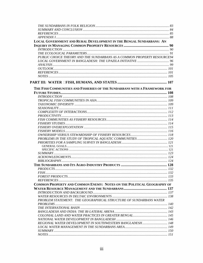
THE SUNDARBANS IN FOLK RELIGION........................................................................................ 83 SUMMARY AND CONCLUSION ....................................................................................................... 84 REFERENCES .................................................................................................................................... 85 APPENDIX I ....................................................................................................................................... 88
LOCAL GOVERNMENT AND RURAL DEVELOPMENT IN THE BENGAL SUNDARBANS: AN INQUIRY IN MANAGING COMMON PROPERTY RESOURCES ................................................. 90
INTRODUCTION ............................................................................................................................... 90 THE ECOLOGICAL PARAMETERS.................................................................................................. 91 PUBLIC CHOICE THEORY AND THE SUNDARBANS AS A COMMON PROPERTY RESOURCE94 LOCAL GOVERNMENT IN BANGLADESH: THE UPAZILA INITIATIVE ...................................... 96 ANALYSIS ........................................................................................................................................... 99 OUTLOOK........................................................................................................................................ 101 REFERENCES .................................................................................................................................. 101 NOTES .............................................................................................................................................. 105
PART III: WATER – FISH, HUMANS, AND STATES ...................................................... 107
THE FISH COMMUNITIES AND FISHERIES OF THE SUNDARBANS WITH A FRAMEWORK FOR FUTURE STUDIES.................................................................................................................... 108
INTRODUCTION ............................................................................................................................. 108 TROPICAL FISH COMMUNITIES IN ASIA .................................................................................... 109 TAXONOMIC DIVERSITY ............................................................................................................... 109 SEASONALITY.................................................................................................................................. 111 COMPLEXITY OF INTERACTIONS................................................................................................ 112 PRODUCTIVITY............................................................................................................................... 113 FISH COMMUNITIES AS FISHERY RESOURCES......................................................................... 114 FISHERY STUDIES.......................................................................................................................... 114 FISHERY OVEREXPLOITATION .................................................................................................... 115 FISHERY MODELS .......................................................................................................................... 116 OWNERSHIP VERSUS STEWARDSHIP OF FISHERY RESOURCES............................................ 118 PROBLEMS IN THE STUDY OF TROPICAL AQUATIC COMMUNITIES .................................... 120 PRIORITIES FOR A SAMPLING SURVEY IN BANGLADESH....................................................... 121
GENERAL GOALS...................................................................................................................................... 121 SPECIFIC ACTIONS ................................................................................................................................... 121
SUMMARY........................................................................................................................................ 123 ACKNOWLEDGMENTS................................................................................................................... 124 BIBLIOGRAPHY............................................................................................................................... 124
THE SUNDARBANS AND ITS AGRO-INDUSTRY PRODUCTS .................................................. 128 PRODUCTS ...................................................................................................................................... 132 FISH.................................................................................................................................................. 132 FOREST PRODUCTS....................................................................................................................... 133 REFERENCES .................................................................................................................................. 135
COMMON PROPERTY AND COMMON ENEMY: NOTES ON THE POLITICAL GEOGRAPHY OF WATER RESOURCE MANAGEMENT AND THE SUNDARBANS ............................................... 137
INTRODUCTION AND BACKGROUND......................................................................................... 137 WATER RESOURCES IN DELTAIC ENVIRONMENTS .................................................................. 138 PROBLEM STATEMENT: THE GEOGRAPHICAL STRUCTURE OF SUNDARBANS WATER PROBLEMS ...................................................................................................................................... 140 THE INTERNATIONAL BASIN ........................................................................................................ 142 BANGLADESH AND INDIA: THE BI-LATERAL ARENA ............................................................... 143 COLONIAL LAND AND WATER PRACTICES IN GREATER BENGAL......................................... 145 NATIONAL WATER DEVELOPMENT IN BANGLADESH ............................................................. 146 REGIONAL WATER DEVELOPMENT IN SOUTHWESTERN BANGLADESH.............................. 148 LOCAL WATER MANAGEMENT IN THE SUNDARBANS AREA................................................... 149 SUMMARY........................................................................................................................................ 150 NOTES .............................................................................................................................................. 151
iv
REFERENCES .................................................................................................................................. 151
PART IV: LIVING OFF THE FOREST – WILDLIFE, MANAGERS, AND BUSINESSES..................................................................................................................................................... 158
FOREST MANAGEMENT IN THE SUNDARBANS, 1875-1952 .................................................. 159 INTRODUCTION ............................................................................................................................. 159 GENERAL PRINCIPLES OF SCIENTIFIC FORESTRY.................................................................. 160
STATE COMPETENCE............................................................................................................................... 162 STATE OWNERSHIP .................................................................................................................................. 163 RIGHTS AND PRIVILEGES....................................................................................................................... 165 FOREST ECONOMY................................................................................................................................... 165
WORKING PLANS FOR THE SUNDARBANS................................................................................. 170 SCHLICH'S PLAN ....................................................................................................................................... 170 HEINIG'S PLAN .......................................................................................................................................... 171 LLOYD'S PLAN........................................................................................................................................... 173 TRAFFORD'S PLAN ................................................................................................................................... 174 CURTIS' PLAN ............................................................................................................................................ 175
CONCLUSION.................................................................................................................................. 177 REFERENCES .................................................................................................................................. 177 NOTES .............................................................................................................................................. 178
THE BANGLADESH SUNDARBANS AS WILDLIFE HABITAT: A LOOK AHEAD.................... 180 SUMMARY........................................................................................................................................ 180 THE SETTING: LANDSCAPE AND FOREST MANAGEMENT...................................................... 181 CHANGING LANDSCAPES AND QUESTIONS FOR THE FUTURE ............................................ 182 WILDLIFE CONSERVATION IN THE SUNDARBANS: INDIA AND BANGLADESH .................. 184 WILDLIFE RESEARCH AND THE MAINTENANCE OF BIOLOGICAL DIVERSITY ................... 186
A HISTORY OF WILDLIFE INVESTIGATIONS IN THE SUNDARBANS ............................................ 186 WILDLIFE DIVERSITY IN THE SUNDARBANS LANDSCAPE............................................................ 187
SOCIAL OBJECTIVES FOR FOREST MANAGEMENT AND WILDLIFE CONSERVATION IN THE SUNDARBANS.................................................................................................................................. 188 NOTES .............................................................................................................................................. 189 LITERATURE CITED....................................................................................................................... 190
Appendix 1. Checklist of mammals in the Sundarbans and adjacent areas. E = Extinct in the area.................. 1 Appendix 2. Checklist of birds the Sundarbans and adjacent areas................................................................... 4 Appendix 3. Checklist of reptiles and amphibians in the Sundarbans and adjacent areas. .............................. 12
THE ROLE OF FOREIGN ASSISTANCE AND COMMERCIAL INTEREST IN THE EXPLOITATION OF THE SUNDARBANS ............................................................................................................... 16
INTRODUCTION ............................................................................................................................... 16 HISTORICAL FACTORS SHAPING SCIENTIFIC FOREST MANAGEMENT.................................. 16 FOREIGN ASSISTANCE AND COMMERCIAL INTERESTS ............................................................ 18 THE IMPACT OF FOREIGN ASSISTANCE ...................................................................................... 20 CURRENT DEVELOPMENT STRATEGIES AND CONSEQUENCES FOR FORESTRY ................. 21 CONCLUSION.................................................................................................................................... 26 REFERENCES .................................................................................................................................... 26 NOTE .................................................................................................................................................. 27
PART V: CONTROL – REAL (ESTATE), MATERIAL, AND IDEATIONAL ................. 29
LONG-TERM TRANSFORMATIONS IN THE SUNDARBANS WETLANDS FORESTS OF BENGAL................................................................................................................................................... 30
RECLAMATION AND THE COLONIAL STATE................................................................................ 30 FOREST RESERVES .......................................................................................................................... 39 SOCIAL FORCES: STATE, MARKET, AND POPULATION GROWTH ........................................... 42 CONCLUSION.................................................................................................................................... 46 NOTES ................................................................................................................................................ 47
HOUSEHOLD CRAFT AND RURAL INDUSTRY IN THE SUNDARBANS: EXTRAPOLATIONS FROM EXISTING BANGLADESH DATA..................................................................................... 55

v
INTRODUCTION ............................................................................................................................... 55 THE BANGLADESH SUNDARBANS ................................................................................................. 57 REGIONAL AND HOUSEHOLD DEMOGRAPHIC PROFILE......................................................... 58 THE HOUSEHOLD ECONOMY ........................................................................................................ 60 HOUSEHOLD CRAFT AND COTTAGE INDUSTRY ........................................................................ 63 CONCLUSION.................................................................................................................................... 65 REFERENCES .................................................................................................................................... 67
HUMAN SETTLEMENT AND COLONIZATION IN THE SUNDARBANS, 1200-1750.................... 79 THE SUNDARBANS UNDER THE BENGAL SULTANS ................................................................... 79 THE SUNDARBANS IN THE MUGHAL PERIOD............................................................................. 84 CONCLUSION.................................................................................................................................... 91 NOTES ................................................................................................................................................ 92

vi
Workshop Schedule
THE COMMONS IN SOUTH ASIA: SOCIETAL PRESSURES AND ENVIRONMENTAL INTEGRITY IN THE SUNDARBANS OF BANGLADESH
A Workshop Sponsored by the
SSRC/ACLS Joint Committee on South Asia and Smithsonian Institution
S. Dillon Ripley Center 1100 Jefferson Drive, SW
Room 3112
Friday, November 20 – Saturday, November 21, 1987
Friday
9:00 – 9:30 Introduction
Dr. Toby Volkman, South Asia Joint Committee, Social Science Research Council
Gretchen Ellsworth, International Activities, Smithsonian Institution
Francine Berkowitz, International Activities, Smithsonian
Dr. Richard Kurin, Folklife Programs, Smithsonian/SAIS, Johns Hopkins University
9:30 – 10:45 I. Sundarbans as Intellectual Problem
Rethinking “The Commons” and the Tragedy Therof Dr. Ronald Herring, Political Science, Northwestern University
Hunter’s Drowned Land: Notes toward the Intellectual History of the Sundarbans
Dr. Paul Greenough, History, University of Iowa
Discussant – Dr. John Richards, History, Duke University
vii
Break
11:00 – 12:30 II. Ecological, Socio-political and Cultural Dimensions
The Sundarban Wildlife Management Plan: Conservation in the Bangladesh Coastal Zone
Dr. John Seidensticker, National Zoological Park, Smithsonian
Local Government and Rural Development in the Bengal Sundarbans: An Inquiry in Managing Common Property Resources
Dr. Harry Blair, Rural Sociology, Cornell University /
Political Science, Bucknell University
The Settlement of a Forested Area on the Western Sea Face of the Bengal Delta
Dr. Ralph Nicholas, Anthropology, University of Chicago
Discussant – Dr. Hugh S. Plunkett, Rural and Institutional Development, U.S. Agency for International Development
Lunch
2:00 – 3:30 III. Value: Natural, Economic and Social
Notes on the Sundarbans with Emphasis on Geology, Hydrology, and Forestry
Dr. Samuel Snedaker, Biology & Living Resources, University of Miami
Sundarbans – Goods, Markets, and Values
Dr. Thomas Timberg, Nathan Associations, Inc.
Notes toward an Ethnosociology of the Bengal Sundarbans
Dr. Peter Bertocci, Sociology & Anthropology, Oakland University
viii
Discussant – Dr. Richard Tucker, History, Oakland University
Break
3:45 – 5:15 IV. Water: Fish, Humans and States
The Sundarbans, An Unparalleled Source of Knowledge about Tropical Estuarine Fish Communities of Asia
Dr. Water Rainboth, Biology, University of California, Los Angeles
Notes on Agro-Industry in the Sundarbans
Dr. Jnan Bhattacharyya, Community Development, Southern Illinois University
Common Property and Common Enemy: Notes on the Political Geography of Water Resources Management and the Sundarbans
Dr. James Wescoat, Geographical Studies, University of Chicago
Discussant – Dr. Ronald Herring, Political Science, Northwester University
7:30 Dinner at home of Richard and Allyn Kurin
3326 Wilkins Drive
Falls Church, Virginia
Saturday
9:00 – 10:30 V. Living off the Forest: Wildlife, managers, Businesses
The Bangladesh Sundarbans as Wildlife Habitat: A Look Ahead

ix
Dr. John Seidensticker, National Zoological Park, Smithsonian
Forest Management in the Sundarbans, 1875-1952
Dr. Frank Presler, Political Science, Kalamazoo College
The Role of Foreign Assistance and Commercial Interests in the Exploitation of the Sundarbans
Dr. Florence McCarthy, Field and International Study Program, Cornell University
Discussant – Dr. Samuel Snedaker, Biology, University of Miami
Break
10:45 – 12:30 VI. Control: Real (Estate), Material, Ideational
The Expanding Frontier of Cultivation in the Sundarbans
Dr. John Richards, History, Duke University
Household Craft and Rural Industry in the Sundarbans: Extrapolations from Existing Bangladesh Data
Dr. Shelly Feldman, Rural Sociology, Cornell University
Human Settlement and Colonization in the Sundarbans, 1200-1750
Dr. Richard Eaton, History, University of Arizona
Discussant – Dr. Ralph Nicholas, Anthropology, University of Chicago
Lunch
2:00 – 3:30 VII. General Discussion: The Intellectual Present
x
Discussant – Dr. Paul Greenough, History, Iowa
Break
3:45 – 5:00 VIII. Where do we go from here?
Discussant – Dr. Richard Kurin, Folklife Programs, Smithsonian
Adjourn

1
Part I: Sundarbans As an Intellectual Problem

2
The Commons and Its "Tragedy" As Analytical Framework
Ronald Herring
The "tragedy of the commons" has become a metaphor for a persistent and severe contradiction in the interaction of natural systems and social systems. Maximization of individual interests in the use of "open access" common natural resources eventually degrades the commons to the detriment of all individuals. The classic formulation was based on the destruction of grazing resources on the village commons because of a local societal failure to control individual access (Hardin, 1968). But the problematic of the commons is broader and richer than the well-worn tragedy metaphor. Preservation or regeneration of the commons--whether at the local, nation-state, or global level-- raises complex, enduring questions of institutional political economy and social values that transcend traditional political-administrative and disciplinary boundaries.
Scientific knowledge about the degradation of the natural world is increasing exponentially. But the complex relationships between particular social systems and their natural environments lags behind. For both natural and social scientists concerned with preservation of biological diversity and the material base on which societies depend, understanding these relationships in South Asia constitutes an exciting and pressing agenda. The purpose of this collaboration between the SSRC and the Smithsonian is to begin elaboration of that agenda.
For the social scientist, the most challenging proposition from the very notion of "ecology" is the existence of unalterable linkage-dependencies within systems. Social scientific discourse tends to focus on discrete entities at the expense of interconnections: the social system of a village, the politics of a state or ethnic group, the administration of a particular policy. The unit-of-analysis problem has exercised social scientists largely within the boundaries set by social-political definitions of units: the village, district, state, nation. The challenge for social scientists is to consider conceptualizing alternative units of analysis in terms of systems defined by ecological dynamics rather than by administrative or social arenas of behavior. This conceptual enlightenment is more subtle, and probably more important, than our overt dependence on the technical knowledge output of scientific investigations.
An ecological system confronts human populations as both a given and a variable; societies adapt to ecological pressures, in either planned or unplanned ways, and struggle to alter others. These social dynamics take place within limits: in the classic formulation, "nature bats last." It is a source of "tragedy" that societies--large and small--frequently do not collectively recognize these limits until catastrophes occur, and frequently fail to alter behavior even after the emergence of clear evidence of natural limits and constraints. If natural scientists
3
can clarify the limits, the contributions of social scientists lie in specifying the social, political, and economic dynamics that generate pressures on those limits and constrain or block responses. As area scholars, we believe these dynamics must be situated in terms of specific history, culture, social and political institutions, and indigenous meaning systems. At a pragmatic level, accurate mapping of social-natural interactions should provide a base for better policy or at least a means of minimizing unintended consequences. But social scientists do not exercise power, delusions and temptations of policy analysts notwithstanding. Fortunately, the problem of the commons presents intellectual questions that are not dependent on the instrumental utility of the answers.
The essay will proceed as follows. First, conceptualization of "commons situations" and "commons dilemmas" will be distinguished in order to expand conventional usage and locate the problematic in the specific context of South Asia. This section will argue that traditional solutions in the tragedy paradigm offer their own problems and underestimate solutions based on cooperation (compare Ostrom, 1986). Nevertheless, solutions even in theory apply more to conservation of common resources in use; the preservation of relatively "useless" systems presents the tragedy dilemma in pure form. The tension between conceptualizations of nature as valuable to the extent that its elements can be (or are) commoditized and exchanged and conceptualizations of the value of natural systems rooted in "deep ecology" replicates the tension between the market-driven notion of values and their antitheses. Second, the case of the Sundarbans coastal mangrove forest bordering Bangladesh and India will be utilized for the type of commons dilemma most serious in terms of ecological consequences. The final two sections will turn to implications of empirical cases in the region to situate problems in a broader research agenda.
CONCEPTUALIZING THE COMMONS
Conceptualizing a boundary between private property and unincorporated terrain, creating an analytical space defined by collective use rights as a "commons," has certain attractive theoretical features. A powerful paradigm for explaining decay in the natural properties of such a bounded terrain has emerged in the notion of "the tragedy of the commons" (e.g., Hardin, 1968; cf. Ostrom, 1986; Shiva, 1986). The "tragedy" of the commons is only a part of the puzzle surrounding the commons. In particular, it is important to distinguish between commons situations and commons dilemmas. In Robert Wade's formulation (1988:184):
The exploitation of a common-pool resource is always a commons situation, in the sense that any resource characterized by joint use and subtractive benefits is potentially subject to crowding, depletion and degradation. But only some commons situations become commons dilemmas: those where joint use and subtractive benefits are combined with scarcity, and where in consequence joint users start to interfere with each other's use.

4
The original tragedy paradigm pictured not a failure of common property institutions but rather a failure to preserve common pool resources precisely because no common property arrangements to limit use evolved. There are really three types of commons situations relevant to the discussion of intersecting social and natural dynamics. First, there are situations in which benefits of cooperation are foregone despite the existence of some common good that could be obtained through collective action. These benefits, such as rationalization of irrigation and grazing, are the subject of Wade's (1988) important investigation in South India. A second situation analytically is one in which failures of collective action result not simply in foregoing benefits of optimal use of resources but absolute degradation of the resource in question--Hardin's "tragedy." Finally, there is the situation, typically not analyzed as a commons dilemma, of failure of collective action to preserve nature itself. This final notion of commons introduces a second-order conflict: collective solutions to either of the first two types, when successful, may actually run counter to solution of the commons dilemma represented by potential conflict between human use of nature and ecological imperatives. To take the simplest example, suppose Hardin's shepherds were able to act collectively not only to preserve grazing grounds but to pool labor to extend grazing into the surrounding forest or wetlands through tree-cutting and/or water diversion or drainage. A common objective interest in preserving the surrounding ecosystem, whether or not subjectively perceived, would be forfeited through success in coping with more classic commons dilemmas.
Reactions to an earlier formulation of "the commons" as an analytical framework for understanding environmental degradation in South Asia (Herring, et al., 1986) raised three potential problems. First, is the concept not ethnocentric, loaded with inappropriate connotations derived from its long association with European thought and history? Second, is the concept not politically biased toward methodological individualism (and specifically "rational actor" models) and thus conservative political solutions (e.g., authoritarian political practice and privatization)? Third, is the "commons" not already a historical curiosity, not a current reality, in contemporary South Asia?
The first objection on grounds of Eurocentrism fails to appreciate the complexity of the concept of property, particularly in the Indic context. Indeed, much of the conflict over "the commons" is ideologically a conflict between alternative meanings of property. An appropriate appreciation of indigenous conceptualizations of property entails recognition of a socially defined (and disputed) "bundle of rights" (Baden-Powell, 1892:V.I, p216, passim; Herring, 1983) to patches of the physical surface of the planet. Such rights are hierarchically ordered. The making of market society entails the long historical process of collapsing differential use rights into a system of ownership in which individual private property rights are generally bounded only by the prior claims of the state. Karl Polanyi termed the commoditization of nature a central element in the "great transformation" to market society: "What we call land is an element of nature inextricably interwoven with man's (sic) institutions. To isolate it and form a market out of it was perhaps the weirdest of all undertakings of our ancestors (Polanyi: 1944/57:178)." In Polanyi's formulation, pre-market economic relations,
5
norms, and outcomes were "embedded" or "submerged" in social relations generally. As Polanyi correctly noted, the extraction and elevation of market-driven dynamics from their social mooring produces significant social conflicts and centrally involves the state (compare Neale, 1988). There is nothing "natural" about market society.
There is to my mind no historical question about the reality of stratified use rights in common lands in South Asia. The structure of these rights was an adjunct of broader social institutions such as caste, service obligations, temple maintenance, kinship systems, and the like. In his classic work, Baden-Powell (1892: I, 219) approvingly cites Campbell's Essay on Indian Land Tenures:
In the greater part of the world the right of cultivating particular portions of the earth is rather a privilege than a property--a privilege first of the whole people, then of a particular tribe or a particular village community, and finally of particular individuals of the community. In this last stage land is partitioned off to those individuals as a matter of mutual convenience, but not as unconditional property; it remains subject to certain conditions and to reversionary interests of the community, which prevent its uncontrolled alienation, and attach to it certain common rights and common burdens. In the subcontinent, the existence of superior over-arching rights such as zamindari did not preclude the simultaneous operation of subordinate, often collective, claims to use rights underneath the top layer. Indeed, the complex institutional structure of land tenure systems stands as evidence for the multiplicity of overlapping rights to the same physical patch of soil. The European feudal ideal of nulle terre sans seigneurs was never fully achieved in South Asia; where it was approached, seigneurial rights were encumbered by subordinate rights and claims.
More important for ecologists, vast tracts of forest and uncultivated land remained outside the net of property relations until the late 19th Century. Chatrapati Singh (1986:2) estimates that until the end of the last century "at least 80 percent of India's natural resources were common property" and speculates that "even a ratio of 90:10 for common versus private property" is plausible. Analytically more important than any numerical ratio is the historical reality of the struggles set in motion by attempts of the state to claim and manage a commons previously defined by local usage (e.g., Guha, 1985; K.S. Singh, 1986; Omvedt, 1987). The colonial state's marriage of revenue/ developmental imperatives (plantations, logging) with an emerging scientific discourse of forest management and conservation established both an internal dialectic of colonial policy debates on land use and a continuing confrontation with local societies' definitions of the commons.
Institutionalized village commons date at least from the Laws of Manu (200 B.C. or thereabouts). Manu specified the precise area for indivisible common pasture lands for both villages and towns (Ayyar, 1976:83). Moreover, the ancient concept of private property (swamya, swatwa) presupposes an open-access commons in the sense of res nullius (that which belongs to no one); for Manu, the most fundamental ideas of property were contained in the axiom: the field belongs to whoever clears it from jungle (Baden-Powell, 1892:I, 127; Ayyar,
6
1976:76). This Lockean notion (pre-Locke, of course), together with Manu's strictures on grants of unutilized lands by the King, implies a view of nature as potential resource, where labor expenditure permits the transformation of a common res nullius into individual use rights subject to general approval by royal authority. Once claimed, property became subject to conditions of use and alienation enforced by a village community. Only in cases of dispute between or within villages did Manu posit the need for intervention by central authority (Ayyar, 1976:82). Lest the "commons" become a vehicle for a second romanticization of village republics, it must be stressed that the village commons implied, as far back historically as can be traced, locally variable rules for inclusion and exclusion, related to a strict division of labor and rights by caste (jati) membership.
Colonial law was meant to simplify, collapse, and locate concretely the bundle of rights in land with the objective of creating property rights approximating fee-simple ownership in a British sense (e.g., Logan, 1887:I, 670-696; Neale, 1988). Simultaneously, vast tracts were "reserved" for the state on the claim that unused "waste" land had traditionally been "the property of the state" (Baden-Powell, 1892: I, 236). In this transformation, the use rights of subordinate strata depended more on the capacity to exert local power than on legal tradition or inertia of custom. The extent to which common property rights survived the great transformation, or were established de novo in its teeth, is an empirical question with regionally differentiated answers.
Village common lands and claims of common use rights to forests persist despite the transition to market property systems throughout the region. Terms such as shamilat and khas1 continue to connote village commons. N. S. Jodha, in a path-breaking empirical analysis, has documented the importance of "common property resources" to the village poor in India (Jodha, 1986). His survey found that the economic benefits of using the commons were greater for the village poor than were the benefits of government programs targeted for their welfare. Moreover, as one would expect, these common resources were under intense pressure from powerful people in the village who were attempting to privatize the land, often successfully. Philip Oldenburg (1986) has demonstrated the use of village common lands in the process of land consolidation (chakbundi) in contemporary Uttar Pradesh. Gadgil and Iyer (1988) stress the effectiveness of local institutions in Karnataka in protecting sacred groves and small forests even in the face of state opposition. The near universality of village commons, and pressures for their privatization, is documented by Schenk-Sandbergen (1988:1.2), based on her own research and secondary analysis of classic anthropological studies.
The increasing scarcity of village common land is of course a major source of pressure on undeveloped land as desperate villagers attempt to challenge the state's claim on reserved areas. The positing of claims to use rights in both the village commons and in unincorporated forests, however fragile those claims may prove to be, is thus rooted in tradition and practice in India.
7
In the classic formulation of "the tragedy of the commons" (Hardin, 1968), the tragedy was the failure of collective social institutions to prevent the externalities of private maximizing behavior from ruining a common resource to the detriment of all individuals in the local social system. In this sense, the "tragedy of the commons" is simply another, though one of the most dramatic, of examples of what Sartre calls "counter-finality": the unintended negative consequences at the collective level of individually "rational" decisions (cf. Elster, 1985:24). The problem of the commons is nothing more than a particularly poignant illustration of the necessity of coming to terms with a fundamental dilemma of social life: certain collective goods can be achieved only through interference with a Hobbesian (or Kautilyan)2 world of individual maximizing behavior. There must be rules. It is in the theoretical elaboration of the sources, nature, and enforcement of those rules that the tragedy paradigm generates the most contentious issues. Those issues remain important whether or not one shares the values embedded in the original tragedy problematic and its extensions.
The association of the tragedy of the commons with conservative values lies in a) the person of its promulgator, Garrett Hardin; b) the individual maximizing assumption about human nature, which denies community; c) popular extension in applications such as "triage" and "lifeboat ethics" applied to the "third world" (cf. Moss, 1977, and Barnet, 1978); and d) the two traditional solutions to the "tragedy": Leviathan and vigorous creation of exclusive private property rights in land. None of these associations fatally contaminates the concept.
The ad hominen argument seems unworthy of discussion. The usefulness of "rational actor" assumptions regarding human behavior is too complex to address here (cf. Herring, 1980), but some preliminary comments are appropriate regarding the communitarian solution to the tragedy problem. On the capacity of communities of "traditional" or "ecosystem people" (Klee, 1980:1) to regulate use in conserving ways, there is considerable debate. While hunting, gathering, and fishing communities may indeed impose limits to conserve their commons, slash-and-burn agriculturalists and frontier-expanding peasants with "ax and plow" are more problematic (e.g. Mohanty, 1987). In all cases, the capacities of small communities to conserve their local ecosystems for "sustainable yield" are bounded by limitations imposed by a very modern force: population increases (cf. Jodha, 1985). Unless the commons can expand to create a constant opportunity/person ratio, pressure on local norms of conservation will increase. As we move from conservation of usable resources to preservation of an ecosystem, the boundary conditions become more stringent and the examples more rare. Thus the tragedy-of-the-commons perspective becomes increasingly relevant even in situations in which local institutions have evolved to protect elements of the environmental resource base; claims by the state and population pressures may destroy the conditions under which traditional conservation norms could be enforced (for examples, Murton, 1980: 87, 91, 93; Jodha, 1985; Gadgil and Iyer, 1988). Whatever the validity of models based on individual maximization as a characterization of human nature, community as a normative construct presupposes certain minimal material and political conditions rooted in the local and national political economy. It is not accidental that individual

8
maximization models of human behavior coincided with the establishment of market capitalism; the individuating pressures of the "great transformation" may not be inexorable but are certainly powerful.
The traditional theoretical solutions to the tragedy dilemma are likewise insufficient to disqualify the model; there are alternatives within the framework of the tragedy paradigm. The original tragedy model assumed that no cooperative strategies would emerge among shepherds maximizing their individual gains from a common pasture. As a consequence, one solution is that of Thomas Hobbes (and Kautilya): a powerful state that could enforce its will on subjects for their own good. This solution is of course not unknown in environmental preservation: protection of the "Silent Valley" rainforest in South India was the act of an elitist and authoritarian government acting contrary to the clearly expressed democratic voice of inhabitants of the region (cf. Herring, et al, 1986:3-4 and infra). The problem with the Leviathan solution in political theory is the absence of a guarantee, or even a likelihood, that the state will not behave in the same self-seeking, social-disregarding manner as individuals. The environmental profligacy of modern nation states of authoritarian bent certainly confirms the possibility. States in the real world are influenced, often captured, by interests that run counter to environmental values. But even with relative autonomy, Leviathan must be fed. Pressures for taxation revenue and hard currency earnings have abetted environmental degradation throughout the subcontinent (e.g., Agarwal, 1985: 363-366; McCarthy, 1987).
That strong states may err, or run amok, is the argument for democracy as a protector of society's environment. Under democratic conditions, at least a cybernetic corrective possibility exists. Positing strong individual private property rights as a bulwark of democracy, and simultaneously as a corrective to the tragedy of the commons, the property-rights school comes down heavily on the side of harnessing individuated property interests to environmental protection. In the original "tragedy" paradigm, no rational shepherd would degrade his/her own land by overgrazing, and therefore the division of common pasture into individually owned plots would avert the destruction of a common resource (cf. Ostrom, 1986:8).
There are two internal and one external problems with the property-rights solution. Internally, property rights are useful only for insuring that the level of exploitation does not measurably degrade the resource any further than the value of the short-term benefits of exploitation. Conservation will, even in the best-case scenario, be limited to the very loose constraint that degradation does not interfere with market rationality. Market rationality, in turn, will only incidentally coincide with ecological "rationality" (compare Singh, 1976; Desai, 1987; Nadkarni, 1987). Ecosystems are large and complex; individually rational behaviors (diversion of surface water, draining of wet lands, clearing of forests, etc.) still offer the likelihood of counter-finality in a broader context. The property-rights solution may work fairly well in closed, bounded systems in which conservation and exploitation interests coincide (e.g., fishing, tree-harvesting), but still requires some broader collective political authority to define and maintain
9
boundaries, prevent externalities, and mediate disputes. As important, human lives are short in terms of the evolution of ecosystems; it is difficult to imagine a fit between short-term interests and intergenerational "rationality," or justice, being generated by the market (Nadkarni, 1987: 360-61 et passim). The external critique is, of course, that in modern South Asia, as in much of the world, individuated property rights exclude whole classes of society, with unacceptable human costs and political dynamics that challenge the solution itself. De facto privatization of village commons in India has simply constricted further the survival options of the poorest villagers (Jodha, 1986).
There is a third possible solution to the tragedy problem: cooperation and social learning. Because of the rational choice base of the tragedy paradigm, much work has proceeded in the game-theoretic vein of prisoner dilemma situations in which cooperation, though desirable to everyone, is ruled out by pursuit of interests (e.g., Gadgil et al., 1984, Ostrom, 1986). In the real world, prisoner dilemma situations are rare, however powerful the original logic. As Axelrod (1984) and others have argued, in repeated games, cooperation becomes a live possibility, even within the game-theoretic paradigm that offends many social scientists on other grounds. Evolution of social institutions can be thought of as a series of repeated games in which conflict, or recognition of the benefits of cooperation, produces self-correcting change. More concretely, there is no a priori reason, even in theory, to expect that shepherds would not recognize impending disaster and evolve rules and enforcement mechanisms to preserve their common livelihood base. There are clear empirical examples in India (Murton, 1980; Gadgil and Iyer, 1988). Elinor Ostrom (1986) likewise provides examples of small-scale social systems that have overcome the tragedy of the commons in exactly this manner. Robert Wade's important work on India (1988) persuasively argues that the presumed collective action problem has been overcome in villages in which the collective benefits of managing irrigation and grazing exceed some threshold level (which itself is a function of the local ecology). But Wade's work does not suggest great optimism about the prospects for collective action beyond that motivated by material self-interest in managing resources. In a section of Village Republics termed "the moral basis," Wade writes:
It is striking how little people in these [successful] villages are steered by a sense of devotion or obligation to a non-self-regarding 'cause,' such as 'the welfare of the village' or 'cooperative ways of doing things'.
As discussed briefly above, even such collectively organized conserving rules as have evolved may succumb to pressures arising from inside or outside the local system. Moreover, social learning in the real world is subject to blockages of concentrated power and stratified interests, just as Habermas (1973) notes for social rationality in general. Cooperative institutions are for the same reasons difficult to create and sustain (Herring, 1983:263-64). Nevertheless, the social learning solution disarms theoretically the ideological-partisan critique of the tragedy paradigm, and opens an important problematic: under what conditions do ecologically friendly social learning and institutional change occur?

10
The argument to this point is that the "commons" framework is not hopelessly contaminated by Eurocentrism or sectarian political-ideological ramifications but is an exemplar of the problem of counter-finality that inevitably confronts society. Well-meaning and rational individual behavior may aggregate to produce unintended and catastrophic consequences. Such consequences can occur as classic "market failures" (in the specific sense of externalities) or as social institutional failures. Social learning through political processes may mitigate the inexorable quality of the tragedy, but two caveats are necessary. First, concentrations of power can block the process. Second, the interest-driven model even under optimal conditions offers little protection for nature per se, but rather for conservation of nature already employed as economic resource, opening the question of what has been termed the "deep ecology" perspective.
SOCIAL ECOLOGY VS. "DEEP" ECOLOGY: THE INSTRUMENTALIST VIEW OF NATURE The logic in the tragedy-of-the-commons literature has depended heavily on a conceptualization of the "commons" as used as resources of nature; the value of the commons is instrumental. This notion carries over in the dominant policy language of "common property resources"; the natural is valuable insofar as it constitutes a resource, something to be exploited. Grazing lands in the original paradigm have value because they form the foundation for livelihoods; concrete material interests are identifiable. This instrumental view of nature in market economics is shared by the Marxian tradition (e.g., Marx's Grundrisse, "Chapter on Capital"). Conservation of the instrumental value of natural systems certainly constitutes a critical agenda for analysis of the commons problem in concert with developmental policy issues. But these questions presuppose a nature already appropriated and altered for human use.
For the ecologist, a deeper set of questions concerns the conditions under which some parts of the natural environment not be used at all, not simply used in conserving ways. This is a second order notion of commons, the common bio-physical world that supports a full complement of species and not merely our own. Even the most "rational," conserving use of pastures for sheep would be ruinous to the global commons if all forests were converted to pastures. The critical role of forests in the global biological system is well understood; the more challenging political proposition for deep ecologists is to demonstrate the value of even small components of larger ecosystems. The only material-interest argument that ecologists can bring relies on the specter of uncalculated risk; in destroying systems that are poorly understood, potential use values may be sacrificed unknowingly.
In the case of the Sundarbans mangrove wetlands in Bengal, for example, estuaries provide breeding grounds for some 400 species of fish, some of which are of commercial importance in an international commons--the ocean (Rainboth, 1987). At our present level of knowledge, it is difficult to calculate the risk of environmental perturbation in terms of depleting an international common
11
property resource. How much risk is justifiable? Would the answer change if the only risk were to the functional equivalents of the snaildarter--i.e., commercially useless species? Certainly, the politics of preservation would change. What is the justification for preservation of evidently "useless" species when the material gains from limited exploitation are demonstrably large? How many people really believe that the next wonder drug may come from some yet-undiscovered fungus inhabiting a tropical rainforest, as was argued by proponents of saving Silent Valley? The political argument for conservation depends on the commercial value of that which is to be conserved; the politics of preservation must be rooted in more tenuous values of aesthetics, ethics, or risk.
The tension between an instrumentalist view of nature and an idealist argument for the value of nature per se shadows the tension between the commoditization of market society and pre-market or extra-market sources of values. When value is measured by use, priced in markets, nature depends for its preservation on extra-market valuation in the "moral economy" tradition.3 In the absence of market power, preservationist values can become actualized only through a political process that bounds and limits markets. The insights of Polanyi's The Great Transformation (1944) remind us that the transition to a market-dominated world is incomplete and inevitably so. Societies of various ideological tendencies continue to constrain, bound, and contravene particular market-driven outcomes. Much of contemporary politics, inside and outside the environmental sphere, concerns boundary demarcations between what markets can decide and what they cannot, or should not.
If we expand the notion of commons to include the biological systems that support a full complement of species (and not merely our own), the usefulness of the "tragedy-of-the-commons" formulation lies in its explicit confrontation with the contradictions outlined above. First, whereas there may be small-scale solutions to the tragedy problem with regard to instrumental uses of nature, preservation of nature in a "useless" (primordial, or at least steady, state) requires the identification and mobilization of interests to compete with those of individual gain and survival. Given the level of human destitution in South Asia, this dilemma is difficult to resolve even in normative theory; practical politics raises even more severe dilemmas. Though the poor are often seen as the greatest threat to fragile ecosystems, they are more importantly the first victims of environmental degradation (Agarwal, 1985; C. Singh, 1986). More problematic than the poor are the powerful. Their social connections and access to bureaucracy are major obstacles to the preservation of economically attractive zones. It is here that the Leviathan solution arises but manifests its problematic character.
Leviathan as a metaphor conveniently links will and implementation in one (resolute) actor. States of the subcontinental region are indeed "soft" (in Gunnar Mryrdal's memorable formulation), but selectively so. Even under non-democratic regimes (e.g., contemporary Bangladesh), a strong state is hard to come by. The permeability of (especially) the local state to powerful interests bent on exploitation is a pervasive phenomenon in South Asia and the source of significant environmental degradation. States demonstrate both vertical and
12
horizontal incoherence; as lower levels of the state ramify into society, they become less and less distinguishable from society, much as blood vessels ramify into capillaries and finally disappear into tissue. Neither political will nor capacity can be assumed in assessing solutions to the tragedy dilemma.
In sum, the tragedy of the commons in South Asia is a more serious case of "counter-finality" than even the original theoretical model implied. This is true because the potential solutions present severe difficulties in the concrete social settings of the region --extraordinary levels of destitution, state incapacity-- and because one must distinguish common property resources from the environment generally as a commons. In the case of natural resources already employed, there are opportunities for the linkage of environmental preservation/ regeneration with strategies for economic development focused on secure livelihood for the most desperate citizens (cf. The World Commission on Environment and Development, 1987). As a concrete example, some pressure for drowning Silent Valley was released by promising jobs in the construction and maintenance of a research institute in the area. Likewise, genuine land reform can relieve land hunger, which drives invasion of fringe areas of reserve4, and simultaneously reduce some blockages to cooperation and institutional change. Food for Work programs can be targeted for relieving pressure immediately surrounding fragile areas. Technological change of the most simple sort--improved village stoves, alternative cooking fuel sources--can marginally relieve deforestation pressures. Nevertheless, contradiction between livelihoods and preservation remains as a function of market dynamics in the existing context of skewed distribution of assets and extreme pauperization. Though some environmentally progressive change is possible within that configuration, assuming significant alteration of political dynamics, substantial progress would require quite fundamental rethinking of the relative values of growth per se, social justice, and political democracy in the context of environmental crisis.
THE SUNDARBANS OF BENGAL: TRAGEDY AVERTED? The fate of the mangrove coastal wetlands bridging Bangladesh and India's West Bengal has been intertwined with a central dynamic of human history: the pressure to carve new livelihoods and habitats from nature. In the Sundarbans (etymologically either "beautiful forest" or, more likely, forest of sundri trees--Heritiera minor), this transformation has been going on for centuries (Eaton, 1987; Richards and Flint, 1987), progressively reducing the forest's extent. As in much of the subcontinent, increased pressures on agricultural land and available jobs threaten encroachment on a natural system that state authority seeks, however ambiguously, to preserve. Unlike the forests inhabited by tribals in the region, where the conflict is between utilization of an existing habitat-cum-common-property resource and historically novel statist claims to conservation and management, the remaining (and shrinking) mangrove forests have become an object of conflict between social forces seeking an extension of livelihoods on the one hand and a state that seeks to limit that process on the other.
13
The ecological and economic functions of the Sundarbans have been described as follows (Seidesticker and Hai, 1983)
The vegetated tidelands of the Sunderbans are the only source of timber, firewood and other forest products in the region, but they also function as an essential habitat, nutrient producer, water purifier, nutrient and sediment trap, storm barrier, shore stabilizer, aesthetic attraction and energy storage unit. The drainage ways and estuaries serve as a transportation net, major fishing area, and nursery area for many coastal and ocean fisheries.
Although ecological systems are often thought of as producing (even if poorly perceived) "public goods," it is crucial to note their role in preventing "public bads" (though protection is of course a public good in theory and, indeed, the archetypal one). The function of the Sundarbans as a "storm barrier" is critical given the colossal devastation of cyclonic storms in coastal Bengal. Complete destruction of the coastal forest wetlands would have rendered rural Bengalis even more insecure than is presently the case.
The preservationist strain in official policy is of relatively recent origin. Before the 1870s, the colonial state operated on a commercializing and revenue logic that recognized the value of controlled reclamation of "wasteland" by agricultural entrepreneurs. That logic gave way incrementally to protection of a diminished core of forest, managed for sustained yield and state revenues (Presler, 1987; Bhattacharyya, 1987). The Sunderbans is now managed as a limited access commons, for what American environmental managers would call "multiple use." Limited access proves difficult to maintain in practice because of the limited capacity of the local state. Conservation has not been completely effective, even in the diminished core, but the full tragedy implications of unlimited destruction by "ax and plow" have been averted by an ecologically benevolent but porous state.
The danger to the Sundarbans as an ecosystem arises from proximate sources that are quite familiar but difficult to assess empirically; the ecologist's notion of a critical threshold is plausible but hard to identify. The easiest conflict to monitor and control, though not to reverse, is the bunding (embanking) imperative that historically allowed farmers to exclude salt water from paddies, with a resulting decrease in salinity and soil quality that threatens the Sundarbans' flora (Cowan, 1928: 203). Gathering of timber, forest products, and fish may pose a threat to the carrying capacity of the system, but there are limitations to our understanding because of gaps in the social scientific and natural scientific literature. Much of the exploitation of the forests is illegal (McCarthy, 1987) and therefore cannot be precisely measured. More important, we do not have a precise notion of the regenerative capacity of the forest, especially in the face of deteriorating hydrological conditions. Thus, even the problematic concept of "sustainable yield" of timber or fish is difficult to employ empirically. In addition to these historic threats, shrimp culture for export poses a new threat to the Sundarbans.
Distal pressures on the forest emerge from the incapacity of the international political system to resolve conflicts over fresh water as a common resource. The Farraka barrage in India has certainly altered the downstream hydrology of
14
Bangladesh in a negative fashion, but the precise effects on coastal forest ecology remain unknown. In addition, major internal alterations of the nation's hydrology, driven in part by external advice and aid, are occurring through massive embankment schemes (for flood control and drainage) that privilege rice over fish and rest on an uncertain empirical base in terms of ecological effects (Herring, 1985; Rainboth, 1987). The Government of Bangladesh is engaged in baseline data collection for a major simulation of the hydrological system, but the results will be a long time coming. Even more distal geological processes may threaten the existence of the coastal wetlands through dynamics beyond the control of any human institution (Snedaker, 1987). Pressures for import-substituting development of timber and pulp resources or export earnings from shrimp and timber are difficult to ignore at the regime level, given the chronic hard currency shortage, debt-servicing difficulties, and position of Bangladesh in the international economy (Sobhan, 1982; McCarthy, 1977).
The Sundarbans is a local commons in the sense that it is an arena for conflict between private interests (some very powerful, some quite humble) and the state. The national state's proprietary claims entail restriction of use rights at odds with the interests of the local rentier state: the gaining of material rewards for granting selective expansion of use rights. The Sundarbans is an important part of a global commons not only as the well-publicized home of the endangered Bengal tiger, but also because of the importance of its estuaries as breeding grounds for fish that inhabit the Bay of Bengal, the presence of unique flora and fauna, and the importance of mangrove wetlands as an endangered ecological system worldwide. In this sense, the deterioration of the forest is an illustration of the perverse ecological consequences of sovereignty claims by nation states that inhabit a global commons. In a somewhat ironic twist, the same dependency relations that produce so supine a state vis-B-vis international actors and put pressure on environmental integrity in general have helped preserve the Sundarbans precisely because of its importance in conceptualizations of a global commons by powerful international actors.
At another level, the social process of restricting access to exploitation of the Sundarbans entails a conflict between deep ecology and social ecology. Adherents to the values of deep ecology resist any human interference with the functioning of natural systems. Biological diversity takes precedence over conceptualizing, and managing, nature as a "resource," whether common or private. Social ecologists are concerned with establishing a fine line between interests of preservation of nature per se and the legitimate interests of human populations in exploiting their environment for livelihoods and habitats. Official policy in the region leans toward the social ecology perspective, though there are undercurrents of deep ecology in pressure for human population control. Whether that line can be maintained depends on the capability of the local state on the one hand and the carrying capacity of the natural system on the other. On both matters, a great deal more needs to be learned. Nevertheless, it seems clear that economic pressures emanating from above the national state because of its position in the global economy and social pressures emanating from below
15
(through both pauperization and greed) threaten further deterioration in the ecological integrity of the Sundarbans.
The conclusions from the Sundarbans case concern both the state as solution to ecologically defined commons dilemmas and the centrality of cognitive and evaluative framings of natural systems. To the extent the Sundarbans has been preserved, it is because of a perceptual transition from "waste," and later exploitable resource, to endangered ecological zone worthy of protection -- from open access commons to privatized property at the margins to a limited access commons at the shrinking core -- largely through the internal dialogue of state managers (Presler, 1987). The state in this process must be conceptualized as both disarticulated and embedded. It is disarticulated by both horizontal and vertical divisions (ministries concerned with fish, agriculture, forests, tourism, planning and export promotion, for example, have different interests in environmental preservation, just as the local rentier state has material interests contrary to proclaimed central state policy). The national state is embedded in an international system that exhibits anarchy with regard to global commons dilemmas and exerts contradictory pressures for both hard currency earnings and environmentally sensitive policies. Both local and national states are embedded in society, from which come pressures for (mainly) relaxing environmental protections.
THE BROADER RESEARCH AGENDA: PHENOMENOLOGY AND POLITICAL ECONOMY OF THE COMMONS The Sundarbans illustrates the importance of ideational shifts in the framing of "nature" and "natural resources." The area could be (and has intermittently been) conceptualized as a dangerous and useless swamp, a source of potential revenue and rice, a natural resource to be conserved, or a rich and precarious wetland ecological system worthy of preservation (e.g., Seidensticker and Hai, 1983; Bhattacharyya, 1987; Presler, 1987).
In general, the complex relationships between the meaning systems and natural environments of South Asia remain obscure. The substantial literature on economic development and policy-oriented issues is only beginning (with the exception of the long-standing forestry management discourse) to deal with questions of how commercial, agricultural, or industrial demands can be balanced with conservationist concerns (e.g., Nadkarni, 1987). Typically lacking in this perspective is systematic attention to cultural variation in conceptualizations of the value of nature per se. The dominant instrumentalist discourse has enjoyed a privileged status due to its patronage by governments and agencies promoting a particular kind of growth-centered economic development. Central to this world view is a conceptualization of nature as a bundle of "natural resources"; its value is measured by prices of products in markets.

16
Despite the seemingly pragmatic and scientific language of policy studies, ineffective or counter-productive policy is often rooted in miscalculation of prevailing attitudes and interests. We know very little of a systematic nature about the sources of preservationist or commons-regarding values in the operative cultural traditions of South Asia. What do indigenous meaning systems make of nature (prakriti)?5 "Wild" animals may have one value in myth, song, and religious practice and quite another when confronted as "pests" threatening agriculture.6 Where do environmental values rank in the face of competing values -- "development," individual opportunity, employment, hard currency earnings? Reciprocally, how do natural processes provide a language and metaphors for understanding social relations -- as in Kautilya's "law of the fishes" or the term for an exploitative big man in the village in Bangladesh -- freshwater shark (raghab buwal)?
A second problematic is what we might call the moral economy (see ftn. 3) of the commons: what are the prevailing notions of the rights, limits, and responsibilities entailed in private and common property? What is held to be the public interest in the commons? How do people conceptualize inter-generational justice with regard to a natural heritage? How are the short-term and particular interests of an existing generation desperate for jobs and material welfare balanced against the interests and rights of future generations? What moral logic governs the distribution of costs in environmental externalities?
Chatrapati Singh (1986: 1) has argued that in the traditional Hindu conceptualization of nature as "a living organic force, like man, violence against nature constitutes adharma" ("injustice," or unrighteous action). But as in the case of all values, the behaviorally relevant meaning is situational, not given or primordial. Despite celebration in the great tradition of dharma and ahimsa (nonviolence), Singh goes on to document systematic adharma vis-B-vis nature, in which the benefits accrue to the state and powerful groups, the costs to "the rural poor, the tribals, and the flora and fauna of India (ibid)." Perceptions of value, like the consequences of action, are interest-mediated, and thus class-differentiated; the need for integration of phenomenological and political-economy perspectives is clear. As Lukacs noted (1923:234):
Nature is a societal category...whatever is held to be natural at any given stage of social development, however this nature is related to man and whatever form his involvement with it takes, i.e., nature's form, its content, its range and its objectivity, are all socially conditioned.
Political economic analysis is about the dynamics of interests within structures. Environmental degradation is driven by a complex interaction of individuals with structurally generated interests and powers mediated by incentives and constraints of a state. Public incentives and programs--social forestry, flood control, chemical-intensive agriculture, manure-methane plants, import-substituting pulp and lumber programs, etc.--all affect the dynamics of ecological damage, preservation, and regeneration. Public policy toward alleviation of rural poverty directly affects encroachment on the commons driven by subsistence pressures affecting marginal classes (e.g., Desai, 1987). Simultaneously,
17
disappearance of the local commons of the village constricts survival strategies of the rural poor. Pressures on the state have to date come primarily from mobilization of defensive reactions by those affected materially in conjunction with a relatively elite stratum of environmentalists rooted in the evaluative framework of social ecology.
The configuration of interests in environmental protection does not, in theory, predict effective political action to head off catastrophes or continuous degradation. Political-administrative units, both international and sub-national, do not necessarily conform to the boundaries of ecological systems. Risks to a large ecosystem are difficult for the individual to perceive, and are typically indirect, uncertain, distant, and diffuse. Just as individuals systematically underinsure themselves against catastrophe, believing for understandable reasons that tragedies will befall people other than themselves, it is psychologically easier to underestimate the long-term consequences of multitudes of small acts against nature. The presence of threshold effects, or tipping points, in ecological damage reinforce this dynamic. On the other hand, the benefits of small acts against the environment are immediate and directly appropriated. Whatever the validity of the hierarchy-of-needs conceptualization, or the "post-material" values approach (Ingelhart, 1977), it does seem that environmental activism other than defensive reactions to protect immediate individual material benefits is concentrated in classes not engaged in a daily struggle for security and survival. For these reasons, the impressive environmentalist movements of India have been more effective in mobilizing defensive reactions for conservation than in preservationist causes. But in both cases, significant obstacles are frequently encountered in state and commerical interests committed to the instrumentalist view of the natural sphere. Real world Leviathans are cross-pressured; despite structural pressures for growth-generating policy, which dominate, in specific instances states in the subcontinent have pressed environmentalist concerns over the objections of well-organized local interests.
By way of illustration, we may consider two major environmental movements in recent Indian experience that anchor ends of the continuum. In the Chipko (tree-hugging) movement, local pressure was generated to prevent despoliation of a collective economic resource--the forest. Local democratic expression of interest-driven local values coincided with environmental preservation. In the Silent Valley movement in Kerala, the opposite dynamic occurred. Local mobilization was for development of a hydroelectric project that various elite preservationist groups, national and international, saw as a threat to a supposedly pristine and unique rainforest.
In the Chipko movement of North India, rural people, especially women, have banded themselves around trees to protect them from destruction by government and commercial agencies. An explicit concern of the forest protesters was that "protection" of the forest by the state was a cruel hoax: "They have swept the jungle clean" (Omvedt, 1987:29-30). The movement highlighted the growing conflict between competing political interests, and behind them, competing world views. One position reflects those interests associated with an aggressive cash
18
economy; the other, those associated with a rural subsistence economy. While the former emphasizes commercially valuable trees such as pine, teak, and eucalyptus, the rural economy is dependent upon an older, indigenous forest whose biomass products have supplied rural society with most of its household needs -- fuel, fodder, fertilizer, building materials, herbs, and clothing (Agarwal, 1985; Eaton, in Herring, et al., 1986).
In the Silent Valley controversy of South India, a similar antinomy of perceptions and values was manifest. The plan for damming the Kantipuzha river and flooding the valley represented to local organized interests only jobs, irrigation water, hydroelectric power, and lucrative contracts. Preservationists evoked the aura of a primeval rainforest, one of the last remaining in the Western Ghats; they cited cytological evidence of rapid speciation underway in the area and called for preservation of the habitat of its known endangered species (principally the lion-tailed macaque) and potentially numerous undocumented species (cf. Nayar, 1980; Vijayachandran, 1980). Wellorganized proponents of the dam won the definitional struggle; the state legislature debated an issue of "man versus monkey" and essentially voted against the monkeys. The narrow escape of Silent Valley from inundation resulted from a peculiar niche in India's federal political system that allowed a central government adopting the environmentalists' meaning and value system to override local democracy.
These two polar cases make several points about the political economy of environmental protection. First, there is no institutional guarantee of substantive outcomes friendly to the environment. Local democracy and decentralization have become totems of development literature and clearly can be legitimized on other grounds. But when livelihood competes with preservationist values, as in the Silent Valley case, local democracy may exacerbate pressures for despoliation. Malabar is a neglected area within a neglected state. Even after significant land reforms, underdevelopment and destitution characterize a high percentage of the population. Moreover, Kerala is a state of unusually high literacy and advanced politicization; popular interests are typically mobilized, often in a militant fashion. The second point is that local democracy is more likely to be a force for conservation in the social ecology sense rather than preservation in the deep ecology sense. The Chipko participants were protecting their own livelihoods; the Silent Valley project threatened no existing livelihoods and promised to generate 15,000 new ones. Recent moves toward decentralization and popular control of local administration in Bangladesh (Herring, 1985; Blair, 1987) can be expected to put more rather than less stress on the Sundarbans. In the absence of a profound ideational shift in the conceptualization of nature, the contradiction between democratic and preservationist values poses one of the most serious dilemmas for environmentalists.
Interests and norms come together in effective environmental protection, typically through a two-stage movement in moral economy and public law. First, the commons must be recognized as a collective good. Clearly there is a great deal yet to be learned about the sources and extent of that conceptualization in
19
traditional and contemporary thought in the subcontinent, as elsewhere. Protection of the commons must often proceed in conflict with immediate interests and thus depends on an argument for higher-order values that are poorly received, whether because of ordinary interest politics or for lack of understanding of the science of ecology.7 Changes in public law and the ceaseless struggle for implementation must likewise be understood as a dynamic intersection of interests, power, and values. The issues of "political will" and popular understanding are thus dialectically related; changes in environmental consciousness must incorporate popular meanings even as effective protection must often transcend them. The (admittedly improbable) best-case scenario for South Asia's environment is a state strong enough to resist despoliation pressures rooted in greed and short-term horizons and yet responsive enough to find creative solutions to pressures emanating from destitution. The implication is a development strategy far more egalitarian in politics and economics than those currently in place. Amelioration of the pressures of destitution and simultaneous curbing of the privileged access of interests motivated by greed would provide the necessary, but certainly not sufficient, conditions for a shift in operative values in the direction of environmental protection.
THE COMMONS AS A PROBLEMATIC
In common usage, the "commons" connotes a physical space of open or collectively controlled access, either as res nullius or as community-defined property. This essay has argued that the concept must be broadened significantly to capture the wide range of phenomena important to analysis of the intersection of social and natural systems. These meanings can be disaggregated as follows:
a) The Commons as Physical Space: Whether as the residual from claims of private property or from common practice, spaces have been defined historically as legitimate use objects of bounded communities. The commons in this sense has been the object of pressure for privatization. Privatization of the commons has produced results that are dubious in terms of environmental preservation and social justice. Institutional rules for conservation (less likely, preservation) may or may not emerge from the relatively small communities that claim this type of commons. Such rules as exist will hold only within boundary conditions; both destitution and greed put almost inexorable pressure on rules regulating the commons. Crucial to analysis in this vein is the understanding that social delineation of a commons inevitably involves rules of inclusion and exclusion from opportunities, presenting the basis for conflict within and between social groupings. In modern political systems, maintenance of local commons depends on nodes of public authority at higher levels.
b) The Commons as Arena: The creation of "public" property resolves nothing, but introduces a subsidiary set of conflicts around the issue of defining the public and determining its collective "interests." Reserved forest lands are a commons in not being private property, but the legal definition of reservation for a public

20
purpose merely introduces a conflict between the state's historically contingent claims and those of inhabitants and users of forests. Delineation of a common purpose, institutionalization of management for a common good, and treatment of claims akin to common-law use rights define antagonists in the political space in which the commons is both the object and arena of contest.
c) The Commons as Ideological Force: From the perspective of privatization ideology, the tragedy of the commons constitutes evidence for the superiority of private-property systems for the conservation of "natural resources." For what we might term "traditionalists" (e.g., Klee, 1980), common interests in conservation of the environment in pre-market communities provide a store of techniques and an ideology of non-market rationality in which social appeals for preservation or regeneration of the commons can be grounded. The radical content of the commons ideological framework is the direct confrontation with the inevitability or desirability of markets as arbiters of the future of natural and social systems. Grounded in pre-market or non-market conceptualizations of nature and society, the commons perspective asserts the legitimacy of extra-market claims on the dispensation of the surface of the planet.
d) The Commons as Global Interest: The argument that environmental concerns are literally global in scope implies standing for those far removed from particular environments. The argument for preservation of biological diversity is rooted in a notion of interest that is planetary and species-wide. It is only by this enlargement of the legitimate social arena by appeal to a global commons that North Americans can presume to have a stake in the fate of tigers in Bengal (or the Amazon basin).8 Reciprocally, recognition of the global commons legitimates interests of inhabitants of poor countries in the policies and practices of rich countries. Rights and obligations in the use and preservation of a global commons raise genuinely new issues in international politics.
e) The Commons as Tragedy: The tragedy paradigm formalizes the popular caution: that which is everyone's concern is no one's concern. While not inexorable, the logic of uncoordinated pursuit of interests threatens that which is a common interest. Recognition of the potential tragedy inherent in this logic is the grounds for institutional innovation and new political practice from the local to international levels. As neither of the traditional solutions -- Leviathan and privatization -- guarantees conservation, much less preservation, the well-worn tragedy metaphor is a vehicle for energizing a broader discussion of institutional and evaluative alternatives.
Economics and ecology derive from a common etymological root; oikos is both home and household.9 Aristotle's household was in effect a firm; the laws (nomos) of household management, could constitute the subject for a science of economics. But oikos is also home, and the home of each species is dependent on others in a natural pattern; this pattern, discernible by reason (logos), is likewise the subject of a science of ecology. That one species attained that capacity for subjugation of others through technological change and enhanced reproductive capacity made the home of all species dependent on the management techniques of individual and collective households of humans. In
21
both the dominant and Marxian traditions of economics, nature attains value insofar as it can be transformed into commodities for use and exchange. Through some reconceptualization of nature as an exhaustible, hence scarce, stock, and expanded conceptualization of "externalities," social ecological values can be used to refine the market logic of value residing only in factors of production and products (e.g. Desai, 1987). Integration of market logic with a deep ecological perspective remains problematic, dependent on a reevaluation of the concept of value itself. Since natural laws of ecology are not mutable, the socially and historically contingent "laws" of economics must be recognized as such.
REFERENCES Agarwal, Anil 1985 "Politics of Environment-II," in The State of India's Environment, 1984-85. New Delhi: Centre for Science and Environment. Axelrod, R 1984 The Evolution of Cooperation. New York: Basic Books. Ayyar, R.S. Vadyanatha 1976 Manu's Land and Trade Laws. Delhi: Oriental. Baden-Powell, B.H. 1892 The Land Systems of British India. 3 Volumes. Oxford: The Clarendon Press. Barnet, Richard 1978 "No Room in the Lifeboats," New York Times Magazine, April 16, 1978. Bhattacharyya, Jnanabrata 1987 "Notes on Agro-Industry in the Sundarbans," Smithsonian Institution Workshop: The Commons in South Asia, Washington, D.C. Blair, Harry W. 1987 "Local Government and Rural Development in the Bengal Sunderbans," Smithsonian Institution Workshop: The Commons in South Asia, Washington, D.C. Cowan, J.M. 1928 "The Flora of the Chakaria Sunderbans," in Records of the Botanical Survey in India, Volume XI, No. 2, Calcutta: Government of India. Eaton, Richard 1987 "Human Settlement and Colonization in the Sunderbans," Smithsonian Institution Workshop: The Commons in South Asia, Washington, D.C.
22
Gadgil, Madhav and Prema Iyer 1988 "On the Diversification of the Common Property Resource Use by the Indian Society." Bangalore: Center for Ecological Sciences of Indian Institute of Sciences. Gadgil, Madhav, S.N. Prasad, and K.M. Hegde 1984 "Whither Environmental Activism?" Lokayan Bulletin, November 1984, pp. 27-37. Guha, Ramachandra "Forestry and Social Protest in British Kumaun, c. 1893-1921," Subaltern Studies, IV, pp. 54-100. Habermas, Jurgen 1973 Legitimation Crisis. Trans. Thomas McCarthy, Boston: Beacon Press. Hardin, Garrett 1968 "The Tragedy of the Commons," Science, 1968, pp. 1243-1248. Herring, Ronald J. 1983 Land to the Tiller. New Haven: Yale University Press. 1985 "Field Report on Local Participation in Water Management in Bangladesh," World Bank Appraisal Mission, Dhaka. Herring, Ronald J., Richard Eaton, and Franklin Presler 1986 "Understanding the Commons in South Asia: Values and Interests," Working Paper, SSRC/Smithsonian Commons Project, October 1986. Jodha, N.S. 1985 "Population Growth and the Decline of Common Property Resources in Rajasthan, India," Population and Development Review, 11:2, June 1985. 1986 "Common Property Resources and Rural Poor in Dry Regions of India," Economic and Political Weekly, XXI:27, July 1986. Klee, Gary A., Editor 1980 World Systems of Traditional Resource Management. London: Edward Arnold. Lukacs, Georg 1971 History and Class Consciousness. London: Merlin, (orig.1923). McCarthy, Florence E. 1987 "The Role of Foreign Assistance and Commerical Interests in the Exploitation of the Sunderbans," Smithsonian Institution Workshop: The Commons in South Asia, Washington, D.C.

23
Mohanty, Gopinath 1987 Paraja. Trans. from the Oriya by Bikram K. Das. Delhi: Oxford University Press, (orig. 1945). Moss, Robert 1977 "Let's Look Out for Number 1," New York Times Magazine, May 1977. Murton, Brian J. 1980 "South Asia," in Klee, Gary A., Editor, World Systems of Resource Management, London: Edward Arnold. Nadkarni, M.V. 1987 "Agricultural Development and Ecology: An Economist's View," Indian Journal of Agricultural Economics, 42:3, July 1987, pp. 359-375. Nayar, B.K. 1980 An Ecological Hyperbole (Trivandrum: Parisara Asoothrana Samrakshana Samithy. Oldenberg, Philip 1987 "Land Consolidation as Land Reform," Paper for the Annual Meetings of the Association for Asian Studies, Boston, March 1987. Omvedt, Gail 1987 "India's Green Movements," Race and Class, XXVIII:4 pp. 29-38. Ostrom, Elinor 1986 "How Inexorable is the 'Tragedy of the Commons'?" Distinguished Faculty Research Lecture, Indiana University, Bloomington, April 1986. Polanyi, Karl 1957 The Great Transformation. New York: Holt and Rinehart, (orig. 1944. Rainboth, Walter J. 1987 "The Sunderbans: An Unparalleled Source of Knowledge About Tropical Estuarine Fish Communities of Asia," Smithsonian Institution Workshop: The Commons in South Asia, Washington, D.C. Richards, John F. and Elizabeth Flint 1987 "The Expanding Cultivation Frontier in the Sunderbans," Smithsonian Institution Workshop: The Commons in South Asia, Washington, D.C. Robinson, Marguerite S. 1988 Local Politics: The Law of the Fishes. Delhi: Oxford University Press.
24
Shiva, Vandana 1986 "Coming Tragedy of the Commons," Economic and Political Weekly, Volume 21, No. 15, April 12, 1986. pp. 613-615. Singh, Narindar 1976 Economics and the Crisis of Ecology (Delhi: Oxford University Press. Singh, Chatrapati 1986 Common Property and Common Poverty: India's Forests, Forest Dwellers and the Law. Delhi: Oxford University Press. Singh, K.S. 1986 "Agrarian Dimension of Tribal Movements," in A.R. Desai, Editor, Agrarian Struggles in India After Independence, Delhi: Oxford University Press. Schenk-Sandbergen, Loes 1988 "People, Trees and Forest in India," Annex 2, Report of the Mission of the Netherlands on the Identification of the Scope for Forestry Development Corporation in India, Amsterdam. Snedaker, Samuel C. 1987 "Notes on the Sunderbans with Emphases on Geology, Hydrology and Forestry," Smithsonian Institution Workshop: The Commons in South Asia, Washington, D.C. Vijayachandran, K. 1980 Silent Valley: Myth and Reality. Trivandrum: Parisara Assothrana Samrakshana Samithy. The World Commission on Environment and Development 1987 Our Common Future. New Delhi: Oxford University Press.
NOTES
1. In Bangladesh, "khas" (reserved) lands and ponds can still be identified legally and are one source of compensation to farmers who lose land through bunding (embanking) operations (Herring, 1985). As is common throughout the subcontinent, village commons" are frequently under the de facto control of locally-powerful people but present a legal and ideological basis for reassertion of collective control.
2. In the Artha Sastra, Kautilya notes: "The means of ensuring the pursuit of philosophy, the three Vedas, and economics is the Rod [wielded by the king]; its administration constitutes the science of politics....On it is dependent the orderly maintenance of worldly life....If not used...it gives rise to the law of the fishes. For the stronger swallows the weak in the absence of the wielder of the rod." From Marguerite S. Robinson (1988: frontispiece). The doctrine of matsya-nyaya,
25
which Robinson calls the "law of the fishes," implies that in the state of nature, anarchy prevails, providing justification for a strong state. So strongly is the state associated with "the rod" (danda) that Kautilya calls the science of kingship dandaniti.
3. In the debates surrounding the Silent Valley protection bill in the Kerala Assembly, the word "ecology" was used and then challenged as to its meaning. No one could give a coherent account, but it was finally decided that it must have to do with pollution. Since the hyrdroelectric scheme threatened no pollution, the deep ecology position of the Kerala Sastra Sahitya Parishad was effectively delegitimized in the dominant view of the legislators. Working in Palghat district at the time of the controversy, I can affirm that ecological valueswere even more weakly perceived and appreciated by local organizations.
4. Even the Reagan administration, which took a privatizing and national sovereignty position on numerous international issues which posit a "global interest," argued that there are indeed global interests in the environment. In the most recent statement of principles of U.S. foreign policy, there is reference to "the world's heritage of living natural resources--its tropical forests, its reserves of biological diversity, its wild plants and animals," threatened by "the products of our industrial civilization." Recognizing "new frontiers of international responsibility and cooperation," the State Department explicitly champions a "leadership role" for the United States. Fundamentals of U.S. Foreign Policy (Washington, D.C.: United States Department of State), March 1988, pp. 42 ff.)
5. This point has almost certainly been made by someone previously, but I know of no source. Aristotle's dependence on nature as a model for human relations and societal organization is developed in the Nichomachaean Ethics.

26
Hunter's Drowned Land: Wonderland Science in the Victorian Sundarbans
Paul Greenough
This essay is intended as a modest contribution to the intellectual history of the Sundarbans of Bengal.1 It may appear doubtful or ironic to assert that the Sundarbans have an intellectual history, but everything highlighted from a background of brute phenomena and written about has a place in the history of thought and expression. Given that some parts of the earth's surface are seen to be more sublime than others, the Sundarbans have hitherto been seen as particularly lowly and obscure, and one question to be considered here is how this mean view was established. A purely historicist method would begin by tracking Sundarbans references in classical authors, both Indian and European.2 I reject that approach in favor of one that scrutinizes a single British "statistical account" dating from 1875. This influential essay (or "gazetteer"), although reasoned on the surface, exhibits deeper themes of fantasy and foreboding. The playfulness of some of its themes does not erase the fact that it and every similar account was an appropriation as well as appreciation of the differences between Victorian Britain and India and, thus, was itself one more net thrown over a subject land and people.
The most obvious fact to begin with is that the low mangrove forests in the Sundarbans sub-region of the Ganges-Brahmaputra delta have been more often passed by or passed through than directly focused upon. Spread over thousands of square kilometers (and clearly visible to earth-scanning satellites), they have rarely been sought out as a destination or considered scenic by the kinds of scribbling travelers who savor their experiences and record their impressions.3 From the mid-nineteenth century, numerous steamers and country-boats plied the torturous routes between Calcutta and Dhaka and beyond, and thousands upon thousands of passengers passed through the Sundarbans at a leisurely pace during daylight hours.4 Yet, from the scant written record, it is easy to conclude that most who looked did not see. Observant passengers peeled their eyes for tigers and crocodiles, but most retired to their cabins or smoked or played carroms or cards on the deck. Cognitively, the Sundarbans did not yet register; they presented no landscape, at least not in the aesthetic sense of offering a striking impression of a scene in nature taken in at a glance.5
In 1875, William W. (later Sir William) Hunter published a lengthy essay on the Sundarbans in the first volume of his Statistical Account of Bengal.6 This became the official and "imperial" account of the area, finding its way into every district library in India by 1880, presumably into good libraries everywhere a decade later.7 Hunter's essay captured the essential features of the Sundarbans at a time when human settlement was still so sparse and the native flora and fauna still so abundant that anxious questions about the future of both were

27
unimaginable.8 Even though the clues protrude from his own text, he failed to emphasize the risks to cultivators and woodsmen along the typhoon-prone Bay of Bengal, just as he failed to caution against over-exploiting the area's natural resources; such themes did not enter the thinking of even the best-informed Europeans. To be sure, one cannot perceive risks and exploitation directly, and, to an even greater extent then than now, the Sundarbans presented such feral abundance that they might have been taken for the Garden of Eden. But Hunter did not find them Edenic. His first words represent the Sundarbans in a fearful light as "a sort of drowned land, covered with jungle, smitten by malaria, and infested by wild beasts."9 One wonders why he troubled to write about so dismal a place. Professionally, of course, he was bound to do so in order to make his Statistical Account complete. But it is evident that the Sundarbans exercised on him a disquieting fascination. Evidence for this claim is found in a series of disturbing and fanciful images permeating his account. Yet, Hunter cannot be said to have been a fantasist. He had a scrupulous regard for facts--or for what he understood to be facts--that took the form of including detailed lists, tables of data, and lengthy quotations from other authors. The result is a realistic account with an underlying surrealism, a scientific text laced with apprehension; his rhetorical strategy is best summarized by the phrase "everything is not what it seems."
HUNTER'S PROJECT
The complete work will contain the results of my Statistical Survey of the whole fifty-nine Districts of Bengal and Assam. Each volume proceeds upon a uniform plan, dealing with the same subjects, in the same words. In adjoining districts which possess many features in common, this system involves frequent repetitions.10
The last four decades of the nineteenth century in India were a time of large-scale socio-economic surveys and systematic collections of scientific information and cultural artifacts. While marine and topographical mapping of the coasts, rivers, and landmasses had been initiated in the eighteenth century, and revenue surveys were begun in British territories in the first quarter of the nineteenth, it was only after the 1857 rebellion and the great change in supreme government that comprehensive censuses and the linguistic, anthropological, and archaeological surveys of India were planned and executed.11 The success of these descriptive projects, which recalled but far surpassed the imperial geographies of Tacitus and Strabo, depended on steady support from the highest political levels.12
Hunter's twenty-volume Statistical Account of Bengal (1875-77), clearly modeled on Sir James Sinclair's Statistical Account of Scotland (1791-98), was the forerunner of a series of local and regional handbooks that culminated in 1881 in the Imperial Gazetteer of India.13 Unlike local censuses and partial surveys from earlier in the century, the compilations of the seventies, eighties, and nineties were coextensive with British authority and served as grids of surveillance and

28
inquiry that pressed down upon the entire subcontinental population. But what was the specific value of the gazetteers and surveys, and why did the Indian government underwrite them? As Hunter tells us in his preface to the first Bengal volume, the Court of Directors had written their servants in Calcutta as early as 1809, saying "we are of the opinion that a statistical survey of the country [Bengal] would be attended with much utility.14 This encouragement reflected the ambitions not only of the Court but also of Lord Wellesley, the Governor General, who already in 1807 had sent off Francis Hamilton, a Company physician and learned amateur botanist, to survey northern and eastern Bengal. What Wellesley and his employers had in mind was a district-by-district "statistical account" that not only would describe local conditions in great detail but that could also be put into the hands of revenue officials, who were frequently rotated between districts.15 Equipped with such a handbook, a departing administrator need not prepare ethnographic sketches, capsule histories, lists of localisms essential in revenue work, and institutional profiles for his successor; the latter, by perusing the "statistical account," would be sufficiently informed of local conditions. This shows a curious faith in compilation: how could a mere reference work come to be so potent? Clearly, the Court of Directors believed that local knowledge was power. As Marika Vicziany has shown, the term "statistical account" (or "statistical survey") had a special meaning in early nineteenth-century administrative circles:
it had become standard practice when reporting on a country's affairs to give a full report. In addition to topography, natural history and antiquities, taxation, local customs, diet and general living conditions were all regarded as important subjects for investigation. Reports which encompassed all these topics were described as 'statistical accounts,' the word 'statistics' then having an entirely different meaning from its current sense.16
Similarly, the "utility" the Court of Directors claimed for a statistical survey in 1809 had a special denotation. During the Napoleonic wars (1797-1815), Britain's rulers had been under domestic pressure to adopt liberal reforms, including more democratic institutions, public education, and duty-free trade. The clique of intellectuals and officials who pressed these reforms, led by the philosopher Jeremy Bentham, was dubbed "utilitarian" because of its argument that institutional and economic arrangements could only be justified if they produced socially useful (utile) effects. But, in alluding to the utility of a statistical survey, the Court in their 1809 dispatch hardly had in mind the extension of more liberal governance to East India, nor were they particularly eager to see the principle of "the greatest good for the greatest number" applied to their eastern cash-cow, Bengal. On the contrary, "utility" in India stood for an authoritarian managerial policy that emphasized a more efficient despoliation of human and natural resources.17 Thus, Francis Buchanan's early survey, which had moved slowly over northern Bengal and eastern Bihar in 1807-14, suggested where to insert the revenue augers, where to drill the marketplace taps. Buchanan never completed his Bengal survey, covering only seven out of thirty-five districts, and his reports were not published in his lifetime. The government of Bengal had,

29
therefore, to wait another sixty years for the prodigiously energetic Hunter to finish what Buchanan had begun.18
Hunter leaves no doubt that the purpose of the Statistical Account is to give the prop of exact local knowledge to the administration of Bengal; his accounts exemplify the genre in which a lowly, handmaiden orientalism climbs eagerly into bed with gouty imperialism. To prepare his gazetteers, Hunter solicited, selected, and then compressed masses of detailed information into district essays arranged under six headings-- Geography and General Aspect; The People; Agriculture; Natural Calamities; Means of Communication, Commerce and Manufactures; Administration.19 He personally wrote or edited most of the Bengal, Bihar, and Orissa volumes, and the preparation of the other provincial series proceeded under his supervision.20 Relying overwhelmingly on district officials, he first circulated among them a questionnaire and then drew them out in conversation when he was on tour or when they reported to Calcutta. It was his vanity that the heterogeneous and often obscure materials he collected could be made interesting, even lively, and to that end he alternated between, on the one hand, skillfully quoting choice passages from raw memos and technical studies, and, on the other hand, giving long lists of native technical terms--exotic land tenures, varieties of deshi seeds, and local weights and measures--terms that, if mastered, would give the impression to the natives of profound local knowledge.21 Hunter was thorough but worked at top speed,22 and he relied on statements whose accuracy he could not possibly verify. His encyclopedic accounts make good reading, although, as noted, there is considerable repetition in volumes pertaining to adjacent districts.
In the very first volume of the Statistical Account, something odd occurred: Hunter made his mold and then broke it. Holding that a statistical account must adopt the district as the unit of description, he started off smartly with a thorough review of "the great metropolitan District of the 24-Parganas" that surrounds Calcutta.23 So far so good. But in the second account, when he turned to the Sundarbans, he abandoned the district in favor of the geographic zone. The low, tide-washed archipelago crossing the sea-face of 24-Parganas, Jessore, and Bakarganj refused to be shoe-horned into a schema designed for the 225 districts of British India.24
Why Hunter chose to treat the Sundarbans as a single unit instead of incorporating them piecemeal into the adjacent district accounts is not obvious. It is possible he thought the area so distinctly different that it merited a separate treatment, although he certainly had conceptual fallbacks to cope with the many marked differences in what was obviously a highly varied country. For example, he could accommodate Bengal's great contrasts of ethnicity, economy, and population by invoking the familiar analogy (familiar, that is, to Europeans) of European diversity: "The Provinces of Bengal and Assam have a population more varied in character and more numerous than that of England, Scotland, Ireland, Norway, Holland, Switzerland, and Italy put together."25 Setting aside the vertiginous thought that only by inverting the map of Europe to superimpose it on India would deltaic Bengal find its correspondent in the fjords and forests of
30
Norway, this analogy clearly fails in the case of the Sundarbans. For, if it was Bengal's ethnic diversity that suggested the European analogy, then the analogy did not apply to the Sundarbans, where there were no indigenes: all the human denizens were immigrants, the only true aboriginals being tigers and crocodiles. On the other hand, if it was the populousness of Bengal that suggested the European analogy, then the deserted islands of the Sundarbans could hardly have figured at all: "The southern portion of the Sundarbans...is entirely uninhabited, with the exception of a few wandering gangs of woodcutters and fishermen. The whole population is insignificant."26
Let me suggest the obvious. Hunter's intention to compile an account of administrative utility was undercut in the case of the Sundarbans by the fact that administration had limited significance in a setting lightly trod by humans. There was a great abundance of deer, tigers, sundri trees, myna birds, and other wildlife, there was some paddy being grown in untenanted fields, and there was even a little jute. But there were no towns, no handicrafts, no law courts, no banks, no schools, no mustard oil mills, no medical practitioners, no Court of Wards estates, no moneylenders, and so forth, descriptions of which made up the bulk of the district gazetteers for the rest of Bengal. But Hunter was not put off, for it was his intention to write a readable account as well as an administrative manual. He succeeded in his secondary purpose because of instinctive skills in manipulating the materials at hand, producing a disturbing vision of a still-wild environment. Beneath the overt statistical account with its fixed topical format, there lurks another, intuitively assembled version of the Sundarbans. The elements of this version included colossal processes, enigmatic vistas, and anomalous occupations. I propose now to re-read Hunter to display these elements, and, rather than pause to indicate when he quotes this or that source, I attribute all statements to him.27
COLOSSAL FORCES
In dimensions, the 'Swatch of No Ground' extends nearly north by east from 21 degrees to 21 degrees and 22 minutes north latitude, five leagues in breadth, with its northern extremity about five leagues from the land, and its western edge about 11 or 12 miles eastward of Sagar Island.28
The colossal forces in Hunter's Sundarbans are not at all what modern experience would predict. For example, little attention is paid to the natural disasters that nowadays harry the region:
Natural calamitites, such as blights, floods, and droughts, occasionally occur in the Sundarbans, but not often; nor have they, within the experience of the present generation, happened on a scale to seriously affect the harvest of the entire Sundarbans. The cyclones of 1864, 1867, and 1869, although they inflicted great damage in certain particular localities, were only partial in their effects, and did not extend over the whole Sundarbans. What was felt severely in one tract hardly affected another; and even in the parts most severely visited, the

31
destruction was confined to a more or less limited area. Excepting such partial inundations caused by cyclones and storm-waves, floods are unknown. Excessive rainfall does not cause inundation....As storm-waves and cyclones, however, are not of frequent occurrence, and do not affect the entire Sundarbans, the Commissioner thinks there is no necessity for larger protective embankments than those which already exist.29
The implicit criterion here for a "serious" natural calamity is one that causes widespread loss of crops. However, the Sundarbans are represented as nearly impervious to major crop failures from any cause. In short, cyclones, floods, famines, and tidal surges--the mass killers in the Bengal delta in the present--are regarded complacently by Hunter and his informants.
What, then, are the colossal forces active in the Sundarbans? First, there is the evil fertility of the soil, which has a malign power of resistance against would-be cultivators:
Supposing, however, that the Sundarban [sic] cultivator has got over these obstacles [i.e., wild animals], and the equally formidable although less prominent difficulties entailed by a residence far from the haunts of men, his dangers are not yet past. Unless the greatest care is taken of the land so cleared, it will spring back into jungle and become as bad as ever. So great is the evil fertility of the soil, that reclaimed land neglected for a single year will present to next year's cultivator a forest of reeds (nal). He may cut it and burn it down, but it will spring up again almost as thick as ever; and it takes about three eradications to expel this reed when once it has grown. The soil, too, must be cultivated for ten or twelve years before it loses this tendency to at once cover itself with jungle weed.30
In such soil, vegetal matter grows incomparably thick, especially the large trees, which become so enmeshed with each other that woodcutters do not so much chop them down as mine them:
The trees intertwine with each other to such an extent, that each supports and upholds the others. Some of the trees, too, are of immense size--one sort, the jin tree, spreading and sending down new stems, till it covers perhaps an acre of ground. Trees like these cannot be cut down and removed in bulk; they must be piecemeal, and the tree must be cut up into little pieces. But the trees are not the only difficulty, for there is a low and almost impenetrable brushwood, which covers the whole surface. This has simply to be hacked away bit by bit by anyone who attempts to penetrate the forest.31
If the Sundarbans vegetation seems to woodcutters like an ore to be mined, it offers itself to cultivators as a stony shield:
Along the sea face the timber is large, but generally with an undergrowth of low brushwood. This belt of forest serves as an admirable breakwater against the ocean; and in the recent cyclones of 1869, which were accompanied by storm-waves, it broke the force of the tidal wave before the inundation reached the cultivated tracts, and thus prevented a great destruction of life and property. On

32
the outer islands, and on parts of Rabnabad Island, where the forest once ran down without a single clearing to the water's edge, a belt of trees has been carefully preserved by the cultivators as a breakwater, varying in depth according to the exposure of the situation.32
Second, there is the steady construction of new landforms whose origins lie in the heaving of the sea rather than in the deposits of the rivers; that is, colossal marine forces actively push submerged silt back up onto the land to create new surfaces, contradicting the assumption that delta growth results only from gravity dragging river-borne sediment:
Approaching the sea, the general level of the surface of the soil rises very gradually, until, reaching the outer islands, it is above ordinary high-tide level. This is caused by the silt, which during the south-west monsoon, and especially during the months of May and October, is deposited over these islands by the heavy swell, which at that season, coming in from the Bay charged with earthy matter stirred up from the flats outside, flows for several miles inland, and floods the most exposed islands....[In the extreme east of the delta in Bakarganj] nature has raised a line of sand-hills, varying from 20 to 60 feet in height, which present an impassable breakwater to the waves. During the great cyclone of 1864, a similar line of sand-hills on the Midnapur and Hijli coast protected that portion of the country from the effect of the storm-wave.33
This benevolent building process, by which the sea boosts up and extends the land, is counter-intuitive for all whose ideas on the relations of land and sea have been formed by recent Bangladesh cyclones.
Third, Hunter turns his reader's attention to an immense churning of the sea, which produces a spectacular submarine void called the "Swatch of No Ground...a natural depression or hole in the Bay of Bengal."34
The sides of this remarkable depression or hole are so steep and well defined, that it affords mariners the best possible sea-mark; the lead suddenly dropping, especially on its western face, from five to ten, to two and even three-hundred fathoms, with no ground. It seems impossible to ascribe this sinking to volcanic action, inasmuch as we know that no violent convulsion has taken place in Lower Bengal during the last 200 years, such as could have caused the chasm; and it is not conceivable that so large and so sharply defined a depression could have existed in so muddy a sea for even a fraction of that time, without being obliterated or smoothed over, unless there was some tidal or fluviatile [sic] action always at work tending to keep it open.35
It is not difficult for Hunter where this "tidal or fluviatile" action originates:
The flood tide, coming up the contracting Bay from the southward, is accelerated on the shelving shore on either hand; and reaching the face of the delta at its eastern and western extremities, before it touches the centre, a rotary motion ensues. The consequence seems to be, that the two circular tides, meeting somewhere in the center of the Bay, must do one of two things--either they must throw up a bar or spit between them, or they must scoop out a depression....The
33
latter seems the probable action of two tides, whose motion is continuous and uniform. It is quite reasonable to assume that the action of these tides might not have sufficient force to scoop out such a canal as this, if they found the delta perfectly formed and uniform across the whole head of the Bay; but as the tides certainly existed before the delta had been formed...there is not reason for doubting that their daily action is quite sufficient to sweep out and keep clear any channel which may be necessary for the efflex of these waters.36
This account is illustrated by a map in Hunter's volume in which the Swatch of No Ground points like a finger from the Bay of Bengal into lower Jessore (see map).
May I point out the anomaly of including an account of the Swatch of No Ground as a "utilitarian" account of the Sundarbans? Of what possible administrative value is knowledge of a bottomless marine depression more than ten miles from shore that poses no risk to cultivators, navigators, or fishermen? In this instance, Hunter shows his hand: He finds the Swatch irresistible, a literally unfathomable, invisible, yet violently agitated center toward which he (and his readers) is drawn.37
These, then, are Hunter's colossal forces: a self-knotting jungle braided by "evil fertility"; a gravity-defying situation from below that creates dry land from the sea; an invisible vortex that scours a giant hole in the bottom of the Bay of Bengal. Phrased so baldly, they seem the grotesque chart marginalia of the pre-Columbian Ocean Sea or the phenomena of a primeval world in science fiction. Yet, Hunter is no Jules Verne. Confining himself largely to quoting other authorities, most of whom are as sober of purpose as he, the impact of these unusual images is muted. Yet, at least part of the readability of Hunter's account comes from allusions to these awesome forms of natural power. We see a similar effect in his disjointed descriptions of enigmatic vistas.
ENIGMATIC VISTAS
The great fertility of the land renders it easy for a husbandman to keep large areas under cultivation; and thus, what with resident large-cultivating husbandmen, the population in the Sunderban tracts is not at all equal to what the amount of land under cultivation would lead one to expect.38
Hunter notes that older maps of the Sundarbans are soon superceded, and even up-to-date maps have difficulty representing the actual state of affairs:
There are few or no villages, properly speaking [in Jessore]; that which is marked on a map as a village is perhaps only an expanse of rich rice land, with a few houses, those of cultivators, scattered here and there.39
Maps are only figurative: one has to see the Sundarbans in person and, even then, not all is what it seems. Judgments made on the basis of appearances alone are dangerous--beware the false mouths of the Ganges, the misleading beauty of the tidal bore, the tenuous security of fenced-off bathing spots in the natural habitat of the crocodile.40 In a constantly shifting terrain, exact

34
knowledge is at a premium: paddy-farmers need to know where sweet water turns salt for the sake of their cultivation;41 sailors have to distinguish deep soft-bottomed channels from shallow hard ones in order to navigate the twisting rivers;42 woodcutters pay premia to fakirs who tell them which islands are free from tigers.43
All is not as it seems. Are the Sundarbans inhabited or uninhabited? Even where strenuous human labor has cleared the jungle for cultivation, the result is an uncanny desolation:
It is difficult to give an idea of the wealth of rice-fields that one sees at harvest time, in passing along the rivers which intersect the Sundarban [sic] reclamations. In other parts of the country [Bengal] the view is always restricted by trees or by villages, but in the Sundarbans it is different. In the tract which has been cleared, you look over one vast plain, stretching for miles on either side, laden with grain. A homestead is dotted about here and there, and the course of the rivers is traced by the fringes of low brushwood that grow upon their banks; but with these exceptions one sees in many places one unbroken sea of waving rice up to the point where the distant forest bounds the horizon.44
This vast prospect is spiritual cousin to those Chinese paintings in which empty distance seems emptier when a few huts or a temple are brushed onto a remote pinnacle.
To counter this desolation, Hunter injects human activity into his text, for example, by narrating the history of organized European settlements or by describing the frenzy of riverside markets. On close inspection, however, European settlements in the Sundarbans turn out largely to be failures, leaving ghost-towns like Port Canning behind,45 and the sub-region's most active market (Chandkhali hat on Mondays) is invariably followed by a week of desert silence.46 The scarcity of humans in Hunter's Sundarbans is occasionally an embarrassment. When he offers a catalog of human groups resident in the reclaimed areas, he inserts it directly after similar but longer lists of snakes, birds, and fish,47 suggesting the Gastarbeiter status of human beings. Indeed, some forms of Sundarbans wildlife--like the otters tied to the side of fishing boats that are "trained to plunge about on the sides of the net, so as to frighten fish into it"48--are recruited by settlers to take the place of human labor. Hunter's long description of the wood trade and the thirty species of forest trees in commerce corresponds to the space filled in other district accounts by descriptions of castes and sects.49
Perhaps because human activity in the Sundarbans is scarce, Hunter succumbs to the temptation to fill the blanks with a lost civilization. He introduces the notion smoothly--
It has long been a disputed point whether the Sundarbans were anciently populated. According to tradition, cultivation once extended down the eastern bank of the Kabadak river far below the now solitary village of Gobra, in Sundarban lot No. 212.50

35
Gobra village (in lower Jessore) is then draped with significance in a historical fantasy of ancient settlements:
Long before Rennell's day other streams had interfered with and cut off the Kabadak from the Ganges, and left it what it now is, a mere tidal creek, with no headway of fresh water. Fresh deposit on its banks must then have ceased to a great extent; the rains would have gradually washed away the upper stratum of soil, and lowered the general level; the place would soon have become sickly, and finally forsaken by all but those whom dire necessity kept chained to the spot. Of all the villages that once have existed over this portion of Jessore, the miserable village of Gobra alone remains. The area of this village has also decreased, and the cultivation of rice does not extend to within two miles of where it once did. The soil is gradually becoming more and more impregnated with salt and unfit for crops; and were it not for embankments, and the fresh water that drains and passes down the Kabadak in the rains helping to wash out the salt of the soil near the banks, Gobra would soon be deserted also.51
The pathos of Gobra is that of an orphan, the sole survivor of an alliance between salinity and silt. Gobra, lone remnant from another era, is a pathetic image that discourages the reader from asking about the village's actual origins and career. But, having told this tale, Hunter draws back from its premise--that there once were widespread settlements in the Sundarbans--concluding:
There can be no doubt that settlers did occasionally appear in the Sundarbans in olden times, but there is nothing to show that there was ever a general population in the Sundarbans lower than the present limits of cultivation.52
Having conjured and then dismissed this vision of a lost civilization, Hunter is fully prepared to raise another spectre, in this case a parallel world that, at no great remove in time, subsided beneath the sea. Of course, subsidence is a common feature of deltaic surfaces, but evidence of subsidence in the Sundarbans is peculiarly striking:
At the village of Khulna, in the Jessor [sic] District, about 12 miles north of the nearest Sundarbans lot, at a depth of 18 feet below the present surface of the ground, and, parallel to it, the remains of an old forest was found, consisting entirely of sundri trees of various sizes, with their roots, and lower portion of their trunks, exactly as they must have existed in former days, when all was fresh and green above them; whilst alongside them lay the upper portion of the trunks, broken off and embedded in a thick stratum of half-decomposed vegetable mould 19 inches in depth, from which, when first exposed, leaves, grasses, and ferns could readily be separated and detached.53
This sunken jungle is not confined to isolated spots in the Sundarbans but is general:
We must not be surprised to find that the liquid mass [of the deltaic foundation], unable to support the superincumbent weight, has repeatedly bulged out seaward, reducing the level of the delta, submerging whole forests, together with their fauna and flora. That forests now lie under the Sundarbans we have seen

36
with our own eyes. In excavating a tank [pond] at the new town of Canning, at the head of the Matla, large sundri trees were found standing as they grew, no portion of their stems appearing above ground: their numbers may be imagined when we state, that in a small tank only 30 yards across, about 40 trees were exhumed 10 feet below the surface of country, their timber undecayed, showing that no very great period of time has passed over their submergence. If the present level of their roots could suddenly become the level of the country, the whole Sundarbans would be under water.54
If the reader of this passage happens to be sitting in Calcutta, Hunter is ready with the disturbing news that the sunken lands in question extend beneath his feet:
That this subsidence of the surface of the ground is not confined to the Sundarbans, seems to be confirmed by the fact that stumps of sundri trees were found at Sialdah [Sealdah], Calcutta, at various levels down to a depth of 30 feet, or 10 feet below the peat....If at Fort William, Calcutta, the wood found above and below the peat bed be in situ, as I think most probable, there must have been a depression at this spot of not less than 46 to 48 feet....From these facts I infer an average depression of the Gangetic delta of 18 to 20 feet since the land surface existed, which is marked by the sundri trees in situ.55
In other words, the drowned world of a former Sundarbans is vastly larger than the visible Sundarbans of the present (i.e., 1875). And, if the site of an earlier Calcutta had slid beneath 30 feet of silt and saltwater, who can say it will not happen again? Isn't the "second city of the Empire" at risk from the "liquid mass" of a delta that is wont to "repeatedly bulge" into the sea? Hunter elaborates on the scenario:
The general depression may have been caused partially by the continually increasing weight of the superincumbent earth and forest; but the argument in favour of its not being wholly so, put forth by the Meteorological Reporter, appears to me incontrovertible. It is more probable that it was caused suddenly, during some great earthquakes; and the fact of all the trees being, as a rule, broken off short, and none being found standing at Khulna or Sialdah, might in that case be accounted for by the enormous wave that such a subsidence would have rolled in from the Bay over the Sundarbans, destroying all in its path.56
The imaginative reader is led to consider--briefly, before psychic numbing begins--the effects of a tidal wave that would roll (like a "Juggernaut"?) over Calcutta and over most of lower Bengal. Once again, however, having waved this enigmatic vista before us, Hunter sweeps it away: "All is pure conjecture, however, and the causes [of subsidence] may have been very different."57
These teasing narratives have a pattern; they sound like science but turn out to be mostly romances. Did Hunter know what he was talking about? Undoubtedly, a brilliant documentary historian, his background in local revenue administration did not prepare him to write with authority in a technical idiom about complex matters of tides and bores, subsidence and deltation.58 Pressed for time and lacking scientific interests, he was at the mercy of his sources; he tended to
37
organize his materials intuitively, which sometimes meant crediting a colorful or pleasingly symmetrical speculation over a more cautious and complex one. Poetic descriptions are paraded as causal principles ("So great is the evil fertility of the soil, that reclaimed land...will present to next year's cultivator a forest of reeds");59 solemnly phrased opinions are offered as inductions from data ("As storm-waves and cyclones, however, are not of frequent occurrence, and do not affect the entire Sundarbans, the Commissioner thinks there is no necessity for larger protective embankments than those which already exist");60 hypotheses are subjected to mental experiments only ("The centre of the Bay, must do one of two things--either they must throw up a bar or spit between them, or they must scoop out a depression").61 In short, Hunter often pleased himself, and the reader must doubt that he applied or was capable of applying the restrained methods of induction. When we turn to a third area of his concern, we find that he had his limitations also as economist and sociologist.
ANOMALOUS OCCUPATIONS
Should it be found necessary to close certain [forest] allotments, in order to allow the timber to come to maturity and to regulate a future supply, I do not apprehend any great difficulty will arise from opposition on the part of the woodcutters, when they become aware that the forests are worked by the Government.62
Granted that official interest in the dispersed Sundarbans population was slight,63 Hunter devotes considerable space to the sub-region's woodcutters, cultivators, and fishermen. Other occupational groups--deer hunters, lime-preparers, fakirs, and ship scavengers--are also briefly portrayed. All of these were migrants into the Sundarbans, but Hunter is silent about the motives that led them there. In general, he is content to give surface accounts of their work. While the occupational hazards are great, he goes out of his way to deny that the Sunderbans are a risky environment, and in several passages he seems to regard the loss of human life as inevitable.64 When describing markets, he is inclined to emphasize their color rather than their importance in local exchange, and although we know that Sundarbans products such as timber, reeds, and thatching are sold in Calcutta in vast quantities, he denies that the extent of the wood trade is known or knowable. In a word, Hunter treats the world of work and of exchanges in an offhand manner, unconstrained as it were by human effort and economic logic.
There is a marked contrast between the source of Hunter's knowledge about the physical and biological environment of the Sundarbans and the source of his knowledge about the sub-region's economic life. We have seen that he nods in the direction of systematic data when discussing hydrology, biota, archaeological remains, etc., often reproducing lists, tables, and technical arguments verbatim in his account. But, when he comes to explain how men and women labor and strive, he abandons empirical methods and turns, instead, to the views of a handful of officials. The arbitrariness of this is apparent, for there is no reason to

38
distinguish in practice the realm of nature from the realm of labor, or the data of science from the facts of foreign rule.
Consider, for example, his account of the Swatch of No Ground.65 The Swatch is invisible from the surface of the Bay of Bengal. How was it detected? Hunter tells us: by sailors who paid out lead and line, marking sudden falls on their charts. Why did they do this? Because in coastal waters ships founder when they run onto hidden shoals. On whose charts were these hazards recorded? European ones. It was a case of sailors wresting precise depth data from a hazardous environment in the course of their daily labors. Does knowledge of these natural facts of the deep pertain to sailing or science or imperialism? Is it necessary or even possible to distinguish? Would it not be better to admit the mundane relationship that obtains in the Sundarbans among marine hazards, exact measurements, and political authority? We could ask similar questions about Hunter's account of deltaic subsidence, the knowledge of which was revealed in the course of laborious excavations by coolies for utilitarian purposes.66 Yet, he regularly pulls apart these complex relationships.
Relying on official opinion, Hunter downplays, as we have seen, the hazards to life and property from cyclones, tidal surging, and famines.67 His European informants see and hear no evil. Sometimes, recourse to officials leads to contradictory observations, such as the following:
The Commissioner reports to me that he has no means of ascertaining the annual loss of life in the Sundarbans from drowning. He thinks that, notwithstanding the innumerable large and dangerous rivers, few such cases occur, as every one knows how to swim, and the people seldom venture out when the weather threatens a storm.68
The Commissioner admits here that he has no evidence; he then asserts that there must be few drownings. Epistemologically considered, this approach to positive knowledge has its drawbacks. Where Hunter does admit an undeniable danger--from tigers--his admission moves rapidly to incorporate an anecdote whose point is the courage of the Englishman, not of the native:
Tigers are very numerous, and their ravages form one of the obstacles to the extension of cultivation. They often commit terrible havoc among the cattle, sometimes on the husbandmen or his family. The depredations of a single fierce tiger have frequently forced an advanced colony of clearers to abandon their land and allow it to relapse to jungle. Mr. Westland relates that there was one great man-eater, whom the whole district was perpetually hearing about, in 1868. Hardly a week passed without one or two people being carried off by him, and his face and appearance were perfectly well known. He had apparently a charmed life. One day he came on board an Englishman's boat, and cooly walked off with one or two of his oarsman. The Englishman fired a blunderbuss at him, but it burst, and injured the shooter, while the tiger got off unscathed. On another occasion the tiger passed within a few yards of a gentleman who fired at him, but again the beast escaped. This pest was finally killed by Mr. Morrell of Morrellganj.69
39
The construction of this paragraph is remarkable. It begins with a sober statement of the danger, shifts attention to a particular beast whose man-eating habits made him notorious, and concludes with this tiger's extermination at the hands of a wealthy English settler. The charm of the anecdote is undeniable--note the feudal code by which the tiger's prowess is saluted in the course of narrating its destruction--but the subtext is clear: only Englishmen have the courage to stand up to man-eaters. Of course, only Englishmen in Bengal have guns; all others have been dismarmed. Yet, here and elsewhere, Hunter implies that European bravery and native fear constitute a matched set of attitudes.70
Despite Hunter's animadversions, it is evident that the unarmed inhabitants of the Sundarbans have adaptive strategies for coping with tigers, and when coexistence is not possible, they retreat, picking up and moving their villages. Here is as clear a statement as can be found:
Crocodiles are seldom met with, except on the immediate banks of rivers; but tigers are not unfrequent, and occasionally break out upon the defenceless forest-clearers, if the latter approach their lair too closely. Sometimes a tiger takes possession of a tract of land, and commits such fearful havoc, that he is left at peace in his domain. The depredations of some unusually fierce tiger, or of more than one such tiger, have often caused the retirement of some advanced colony of clearers, who have, through their fear, been compelled to abandon land which only the labour of years has reclaimed from the jungle.71
This strategy of abandonment is adopted only by resident settlers. For those whose work takes them on short trips into the tiger-infested parts of the Sundarbans, avoidance is practiced as modified by the advice of ritualists, whose livelihood depends on the ability to distinguish tigers' haunts from the safer parts of the jungle. Characteristically, Hunter denigrates the practical knowledge involved:
All woodcutters are very superstitious, and believe in the existence of numbers of forest spirits. None of them will go into the forest to cut wood unless accompanied by a fakir, who is supposed to receive power from the presiding deity--whom he propitiates with offerings--over the tigers and other animals. Occasionally a large number of boats proceed together in a party, taking a fakir with them, and sometimes the fakirs take up their posts on certain lots, and the woodcutters go out to them. Before commencing work in any allotment, the fakir assembles all the woodcutters of his party, clears a space at the edge of the forest, and erects a number of small tent-like huts, in which he places images of forest deities, to which offerings and sacrifices are made. When this has been done the allotment is considered free from tigers; and each woodcutter, before commencing work, makes an offering to the jungle deities, by which act he is supposed to have gained a right to their protection. In the event of any of the party being carried off by a tiger, the fakir decamps, and the woodcutters place flags at the most prominent corners of the allotment to warn off all others. Each fakir receives a share of all produce removed from the lot he patronizes, which is generally commuted for cash.72
40
The aim of the fakirs' ritual procedures is to demarcate territory suitable for woodcutters from territory suitable for tigers. This is done symbolically by petitioning the tiger deity to remain at the edge of the forest into which the woodcutters must go; it is done literally by flagging a tiger's known territory if an error is found in the ritual petition. In either case, the fakir's methods are practical attempts to manage the risk by carefully studying the habits of tigers.
Hunter's account, focused on the tiger-deity pujas, makes colorful reading for Europeans. But to emphasize the color of the ritual is to ignore its productive meaning. We are plainly told that woodcutters will not enter the Sundarbans unless accompanied by a fakir. The fakir was as surely the linchpin of the wood trade as was the contemporary shop foremen in a British factory, and the flow of posts, planks, and firewood to the rest of Bengal turned upon his competence.
In fact, the collection and export of wood from the Sundarbans in Hunter's time is a substantial industry; it links woodcutters, wood-transporters, wood-marketers, and wood-capitalists to the ultimate consumers in a wide network of exchange.73 Further, the wood trade has species-specific requirements for fuel, hut-posts, boats, furniture, and so forth, and its complexity is demeaned by treating it on a par with the trade in forest products such as honey, beeswax, and venison. Hunter's account lacks good data on the number of woodcutters or the magnitude of the trade, but he observes that "all the firewood used in the 24-Parganas [including Calcutta], with most of that consumed in Jessor [sic] and Bakarganj, is supplied from the Sundarban forests."74 A simple calculation shows this to be at least 225 pounds per person in 1872.75
Hunter fails to point out that the firewood and timber demand on the Sundarbans was increasing rapidly in the last third of the nineteenth century, principally because of the appearance of jute mills along the Hugli River, which were a major stimulus to urban growth. It is, therefore, of considerable interest to know what he made of the major administrative issue looming over the Sundarbans forest after about 1865: Were they in need of resource management? Here, again, Hunter cites the opinion of an official, in this case the Deputy Conservator of Forests, as follows:
From various conversations I have had with woodcutters and fakirs as to the supply of timber and firewood becoming exhausted, and from personal inspection of the forests, I am under the impression that, up to the present at least, no material difficulty in obtaining firewood, posts, etc., has been caused by the indiscriminate felling now allowed....The general appearance of the forests themselves shows that there can be no present difficulty in obtaining posts and firewood to an almost unlimited amount; and, taking into consideration the consumption of this material that has continued for numbers of years past, unless the demand should increase very largely (and I am not aware that there is reason to suppose that it will so increase), I do not believe that any special measures are necessary to ensure a full and regular supply for the future.76
Notice that the Deputy Conservator gives as his source of information the views of "woodcutters and fakirs." This is a refreshing change, but, in this case, there is

41
every reason to think that the native informants lied through their teeth. Woodcutters and fakirs were perfectly aware that if officials were to decide the forests were being over-exploited, they would institute fees and coercive management measures that would injure or even destroy their livelihoods. These men of 1875 have already had a taste of what was in store:
The woodcutters of the Sunderbans appear to have all along a prescriptive right to fell the forest timber, and no Government revenue is realized from the forests. In 1866, the Government leased the forest rights in the unappropriated lands to the Port Canning Company. The lease, however, was resumed after due notice, on the ground that the monopoly was contrary to the general interests of the public, and that oppression was practiced by the Company's agents in the collection of the fees....A deputy-conservator of forests was specially sent to the Sundarbans early in 1873, and the officer's propositions for establishing toll stations and issuing licenses are given further on.77
Tolls and forest leases can be defended as rational administrative controls over a diminishing natural resource; from the vantage point of customary users, such novelties were hated intrusions of authority. In fact, there are passages in Hunter's account to suggest that stealth and secrecy were part of a sub-regional ethos of resisting official controls. For example,
The Commissioner of the Sunderbans states that many years ago, in the early days of Magh immigration, it was the custom of the immigrants to seek out some little creek leading into the heart of the forest, where they would form a location, clear the jungle and cultivate the lands. The reason for their thus secluding themselves is said to have been to secure immunity from payment of revenue. This practice is now abandoned, only, however, because very little jungle land now remains in the Bakarganj Sunderbans for them to hide in.78
A comparable desire to evade official knowledge and punishment is evident in a very different kind of employment:
Mr. Westland mentions another trade of the Sundarbans--the collection of timber, etc., from wrecks. He states that the boats that make expeditions to the sea-shore of the Sundarbans are pretty sure to come across teak beams, the spoil of some wrecked vessel. Other articles are occasionally found, and sometimes chains and other parts of ship-furniture. Such flotsam and jetsam were collected in secret until some few years ago, when a case occurred in which the authorities refused to interfere. Since then, the trade is openly carried on; and large teak beams may be seen at Khulna and other places, the product of such expeditions. Most of the spoil which the sea throws up is, however, taken straight to Calcutta, where it finds ready sale.79
My criticism of Hunter's approach to economic affairs in the Sundarbans has now come full circle. The initial complaint was that he had recourse to British official opinion only, neglecting Indian views and failing to collect empirical data. Now, however, I find myself arguing that had he, in fact, questioned Indian informants about deforestation, the answers to be obtained would almost surely have been misleading: woodcutters, fakirs, and others economically dependent on
42
untrammeled access to Sundarbans forests had every reason to lie, for they could not bear the heavy-handed methods of Victorian forest administration. Experience had shown them that the government's responses to poaching, ship-scavenging, and tax-evasion were unpredictable, while the recent (1866) experiment of letting the Port Canning Company sell forest leases and the emplacement of toll-houses in the forest itself were disturbing signs of what the government was capable of. Managing the tiger threat was simple compared to managing the Raj; dissimilation necessarily found its place in the Bengali response to the fiercest predator.
SUMMARY AND CONCLUSION
The Sundarbans were surveyed between 1812 and 1818 by two young brothers, Lieutenants Hugh and W.E. Morrieson. They were much annoyed by tigers and alligators, and they relate how a tiger sprang from a branch just over their theodolites while in the act of observing, and how the shaking of the ground near them made the instruments vibrate, owing to the tread of huge monsters in the jungle.80
As this excerpt from Markham indicates, it was not unusual for scientific work to be set at risk by special dangers in the Sundarbans, especially by predation of tigers and crocodiles. In a larger perspective, however, it was the science of the surveyors that was predatory; theodolites and chains symbolized perfectly the resource-hunger of the colonial state, and white men in boots eventually menaced all the jungle's denizens, including people, trees, fish, saurians, and big cats.
W.W. Hunter, India's first Director-General of Statistics, was charged in the early 1870s with preparing a "statistical account" for each of the districts of Bengal, Bihar, and Orissa. Intended principally to acquaint newly assigned officials with the essential features of their districts, these accounts, like other large compendia such as the censuses and anthropological and the archaeological surveys, are best understood as orientalist props to nineteenth-century administration. The utilitarian aims and fixed format of the statistical accounts are notable, but these did not prevent Hunter from inserting his erratic literary and personal psychological values into otherwise rather dry material. Hunter intended to be read, not just referred to, and to this end he smuggled colorful elements of native practice and striking elements of the flora, fauna, and environment into a new Indian genre, the "gazetteer."
The Sundarbans essay in Hunter's first volume is exceptional in that his expository structure according to fixed categories broke down. The Sundarbans were not amenable to precise administrative methods, nor had they ever formed a traditional social arena in Bengali life; they were virtually empty of population when compared to regular districts, and the human immigrants from varied ethnic and occupational backgrounds entered in unknown numbers, often by stealth. Their occupations were highly unusual and very risky when compared to the
43
sedentary paddy farmers, field laborers, and artisans of the rest of Bengal. The Sundarbans functioned geographically more like a vast frontier than as an administrative unit, a frontier that contained an anomalous and highly dispersed human population working cheek by jowl with densely concentrated wildlife populations. There was no comparable environment in eastern India.
Faced with an unusual descriptive problem, but confident that he possessed as much information about the Sundarbans as anyone, Hunter's ambition to be interesting was unleashed and almost took over his exposition. His essay is unsystematic and impressionistic, some portions war with others, and there is a general failure to go beneath the surface of important matters. On the other hand, the essay is rich with information about official attitudes toward the sub-region, attitudes that were just beginning to shift away from laissez-faire in the direction of tighter controls on settlement and the management of natural resources.
Hunter is regularly credulous when he should be wary, and there are threads of surreal imagery and racial arrogance running through his account. The opinions of British officials are regularly privilaged above other sources of knowledge, and empirical data are deemed irrelevant when the discussion turns to the economy. There is an unspoken assumption that human labor and productive resources in the Sundarbans are in thrall to the state. Yet, the glimpse we get of the actual producers in this economy is one of smooth operators--natives wise to the ways of officials and tigers, gliding in and out of the nearly empty landscape, practicing discretion that is the better part of colonial valor. It is apparent that Hunter, caught up in describing a somber, drowned Wonderland, could not focus on the dynamic panorama the Sundarbans spread out before him.
NOTES
1. I am grateful to fellow participants at the November 1987 Washington, D.C., conference on the Sundarbans, sponsored by the Joint Committee of the Social Science Research Council and the American Council of Learned Societies and by the Smithsonian Institution, for constructive criticism of this paper. The helpful pug marks (Hindi pag, from the Sanskrit padakah, foot) of Shelly Pollock will be found here and there on this essay.
2. As does, for example, Kanangopal Bagchi, The Ganges Delta, "Early Accounts of Population," (Calcutta: University of Calcutta, 1944).
3. Values have changed: the authors of the World Wildlife Fund's Sundarbans Wildlife Management Plan (Gland, Switzerland: 1983) observe that "The Sundarbans is one of the World's great wild places. The opportunity to have visited [there] is a long remembered privilege" (p.105).
4. An "inner passage" ran to the north and was used by country-boats in the rainy season, while an "outer passage" ran to the south during the cold season; the steamer route ran farther south still. See map folded into W.W. Hunter, A
44
Statistical Account of Bengal, Vol. 1, Districts of the 24-Parganas and Sundarbans (London: Truebner and Co., 1875) and the description on p. 300. Quotations cited are taken from the 1973 reprint by D.K. Publishing House, Delhi, which preserves the pagination in the original and is thus cited here as Hunter 1875.
5. James Paradise, "Darwin and Landscape," in James Paradise and Thomas Postlewait, eds., Victorian Science and Victorian Values: Literary Perspectives (New Brunswick, NJ: Rutgers University Press, 1985), p. 86.
6. The Sundarbans portion of the volume fills Hunter 1875, pp. 285-346, to which is appended "Remarks by Local Officers," pp. 349-51, and "Geographical and Historical Notes on the Bardwan and Presidency Divisions of Lower Bengal Compiled for Dr. W.W. Hunter's Statistical Account of Bengal," by H. Blochmann, pp.353-89.
7. My approach to Hunter involves examining in detail what he, an English official and salaried intellectual with no obvious personal, property, or other ties to the Sundarbans, had to say about the region. I have never been in the Sundarbans myself and I do not pose as an authority, only a library scout. Many things about the region continue to puzzle me, and even at the level of nomenclature there are confusions that I share with the text I discuss. For example, are the Sundarbans singular or plural? I choose the plural only because the map before me shows a multiplicity of islands and rivers.
8. According to Hunter, the area of the Sundarbans in the period 1871-73 was approximately 7,500 square miles, of which about 2,000 square miles had been reclaimed for cultivation or a ratio of 1:3.7. Ibid., p. 286; elsewhere, the total "area under cultivation" in 1873 is estimated at only 1,087 square miles; ibid., p. 327. The pace of reclamation appears to have been very slow in the nineteenth century: only 771 square miles were cleared between 1830 and 1872. Ibid., p. 327.
9. Hunter 1875, Preface, p. xiii.
10. Ibid., p.xii.
11. Clements R. Markham, A Memoir of the Indian Surveys, second ed. (London, 1878; Amsterdam: Meridian, 1968).
12. Ibid., p.889. It had been the Viceroy, Lord Mayo, who, in 1871, named Hunter India's first Director-General of Statistics.
13. Hunter's Bengal volumes were intended as a model for other Indian provinces; eventually, 128 such volumes appeared, which were compacted by Hunter into the nine-volume Imperial Gazetteer. This series of local, provincial, and imperial gazetteers was called by a contemporary, with some exaggeration, "The most gigantic literary enterprise that has ever been taken by any government." Leslie Stephen and Sidney Lee, eds., Dictionary of National Biography (DNB), vol. 22, Supplement (Oxford: Oxford University Press, 1967), s.v. "Hunter, Sir William Wilson," p. 889. An account of Sinclair's opus and
45
methods is given, as Vicziany has noted, in M.J. Cullen, The Statistical Movement in Early Victorian England (New York: Harvester Press, 1975).
14. Hunter 1875, Preface, p. vii. My emphasis.
15. The post-Indpendence name for such texts, District Handbooks, compiled in association with the decennial census volumes, expresses nicely their broad introductory purposes.
16. Marika Vicziany, "Imperialism, Botany, and Statistics in Early Nineteenth-Century India: The Surveys of Francis Buchanan (1762-1829)," Modern Asian Studies 20, 4 (1986), p. 648. NB: "Apparently any information of a precise character could qualify as 'statistical.' The term was often used in a way later researcher might assert that a work was 'scientific.'" (p. 650).
17. Eric Stokes, The English Utilitarians and India (Oxford: Clarendon Press, 1959).
18. Buchanan's travels through seven Bengal and Bihar districts were clearly the forerunner of Hunter's project, but his methods were very different and depended mainly on personal observations made in a wide, slow, and idiosyncratic itinerary. Hunter, as explained below, turned to a diverse official group in the districts to supply him with information collected on a common scheme. Hunter's manuscript reports gradually lost their administrative utility, but their scientific value has been emphasized in recent reviews. Vicziany, "Imperialism, Botany, and Statistics," pp. 658-59. His manuscripts still lie in the India Office Records and the Scottish Record Office, having been published erratically and only in part to this date.
19. This topical arrangement does not quite match his formal definition of a statistical account as one that illustrates the "topographical, ethnical, agricultural, industrial, administrative, medical and other aspects of an Indian district," Hunter 1875, Preface, p. ix.
20. He referred to the Bengal and Orissa volumes as "statistical accounts," although in other provinces the preferred term was "gazetteer." In any case, Hunter's statistical accounts contained much more prose than numerical data. The term "statistical" in the 1870s seems to have been a voguish catchword, much like "data-base" in the present.
21. Hunter's drive to be interesting can easily be seen in his famous study of late eighteenth century local administration in Burdwan division, Annals of Rural Bengal; in its many purple passages this work reads more like a Persian than a European history. His model may have been, however, T.B. Macaulay's five-volume History of England (1849-61), of which 13,000 copies of the first two volumes were sold in four months.
22. He completed twenty volumes covering the forty-five districts of Bengal, Bihar, Orissa, and their tributary states in less than three years with the help of five assistants.
23. Hunter 1875, p.11.

46
24. Administration of the Sundarbans in the 1870s was divided among officers from 24-Parganas, Khulna, and Bakarganj, who collected the revenue, adjudicated suits, and policed their respective districts independently of each other. The Chief Commissioner of the Sundarbans, nominal administrator for the entire area, had sharply limited functions confined mostly to granting leases for reclamation of forest lands. Ibid., p.286.
25. Ibid., Preface, p. xi. Bengal's regional diversity was in turn only one element in the more florid diversity of the subcontinent as a whole: "The materials now amassed [for all India] form a Statistical Survey of a continent with a population exceeding that of all Europe, Russia excepted." Ibid., p. x.
26. Ibid., p. 317. No population estimate is given for 1872, because the Sundarbans population was partitioned and assigned to the districts of 24-Parganas, Jessore, and Bakarganj.
27. This departs from scholarly practice, but as it is my intention to show that the effects of Hunter's account derive from his skillful assembly of a variety of sources, it is the continuity of his editorial vision and not the specificity of his sources that I emphasize. Hunter makes,on the first page of his essay, the following statement: "The following Statistical Account is chiefly compiled from the following sources: (1) Four series of returns specially prepared for me by the Commissioner of the Sundarbans, dated 10th April 1873. (2) Mr. J. Westland's Report on the District of Jessore. (3) Colonel Gastrell's Revenue Survey Report on the Districts of Jessore, Faridpur and Bakarganj. (4) Horsburgh's Sailing Directions, edition 1852 [reproduced verbatim where practicable]. (5) Official Papers supplied by the Bengal Government."
28. Hunter 1875, p. 297.
29. Ibid., p. 342. In another passage, quoting Mr. Westland, Collector of Jessore, a more realistic assessment of the cyclone hazard is given: "These colonies suffer most severely from cyclones....The grain in their fields is spoiled, their houses are torn away, and all their stores are lost; their cattle are carried away and drowned; and they themselves are reduced to the extremist shifts to save their lives." Ibid., p. 335.
30. My emphasis, ibid., p. 332, quoting J. Westland's "Report on the District of Jessor [sic]."
31. Ibid., p. 331, quoting Westland's "Report."
32. Ibid., p. 289.
33. Ibid., pp. 289-90, quoting Col. J.E. Gastrell, the Revenue Surveyor.
34. Ibid., p. 295.
35. Ibid., p. 295-96. Quoting J. Fergusson, "Recent Changes in the Delta of the Ganges," Quarterly Journal of the Geographical Society (August 1863).
36. Ibid., pp. 296-7. Quoting J. Fergusson, "Recent Changes."

47
37. The term swatch, meaning a watery depression between sandbanks or between a bank and the shore, appears in the oldest form as a seventeenth-century East India usage. Oxford English Dictionary, s.v. "swatch," sb.3.
38. Ibid., p. 333.
39. Ibid., p. 286, quoting J. Westland.
40. "Col. Gastrell states that, after the beginning of March, it is not safe to bathe in or take water from the streams, except at places specially protected by palisades of bamboos or wooden stakes. Even this precaution sometimes fails. Instances have been known of crocodiles entering within the palisades from the land side at night. In the morning, the first notice of the hidden danger is the struggles and shrieks of some unfortunate woman, seized and dragged under water by the reptile." Ibid., p. 316.
41. Ibid., p. 287.
42. Ibid., pp. 298-99.
43. Ibid., p. 312.
44. Ibid., p. 335.
45. "After a few years, the attempt to form a port and town failed; the Government moorings, etc., were taken up, and the port officially declared closed....At present it is nearly deserted; and the Sundarbans Commissioner...states that 'with the exception of the Agent and others employed by Port Canning Company, and a dak munshi or Deputy Postmaster, no one lives at Canning.' "Ibid., p.320. See also the account of Magistrate Henckell's eighteenth-century settlement in Jessore, ibid., pp. 327-31.
46. "If one were to see Chandkhali on an ordinary day, one would see a few sleepy huts on the river bank, and pass it by as some insignificant village...there are no purchasers to be seen, and the square is deserted." Ibid., pp. 300-01.
47. Ibid., pp. 315-18.
48. Ibid., p. 302.
49. Ibid., pp. 304-13.
50. Ibid., p. 320. The "lots" of the Sundarbans were tracts of standard dimensions derived from a grid laid over the map of the sub-region and used to assign grants to wealthy developers who agreed to reclaim the land.
51. Ibid., p. 321. Quoting Col. J.E. Gastrell. The allusion in the first line is to Major James Rennell, who carried out an intensive survey of the river system of Bengal between 1765 and 1773, for which he prepared a series of maps.
52. Ibid., p. 321. In this judgment, he follows the views of H. Blochmann, in an appendix entitled "Geographical and Historical Notes on the Bardwan and Presidency Divisions of Lower Bengal," ibid., pp. 380-83. Hunter, unlike Blochmann, is indifferent to dates--hence the vagueness of phrases like
48
"anciently" and "in olden times" employed freely in this and the previous quotation.
53. Ibid., quoting Col. J.E. Gastrell.
54. Ibid., quoting Col. J.E. Gastrell.
55. Ibid., p. 291, quoting Col. J.E. Gastrell.
56. Ibid., pp. 292-93, quoting Col. J.E. Gastrell.
57. Ibid., p. 293, quoting Col. J.E. Gastrell.
58. Hunter received a B.A. at Glasgow in 1860, which was followed by "some months of study in Paris and Bonn acquiring (among other things) a useful knowledge of Sanskrit." He stood first in the 1861 Indian Civil Service examination list, and his initial appointment was as an assistant magistrate and collector in Birbhum in 1862. DNB, s.v. "W.W. Hunter," pp. 888-89.
59. Ibid., p. 332, quoting J. Westland.
60. Ibid.
61. Ibid., p. 296. My emphasis.
62. Ibid., pp. 311-12.
63. "The whole population is insignificant," ibid., p. 317.
64. I do not charge this lightly. See the remarks quoted on drowning deaths. Another cool statement is the following: "Although generally four or five days' voyage from their villages, some of them [woodcutters] from time to time go home to bring news of how the party are progressing, or to report that one of them has been caught by tiger or alligator." Ibid., p.309.
65. Ibid., pp. 295-97. Reproduced above, pages 11-12.
66. Ibid., pp. 290-93.
67. Above, pages 8-9, citing the Commissioner of the Sundarbans. 68. Ibid., p. 299.
69. Hunter 1875, p. 315. See the related passage concerning the depopulation of tiger-infested areas, ibid., pp. 331-32.
70. "When that place was being cleared, [Mr. Henckell's] native agent was much troubled by the depredations of tigers; so he called the place after Mr. Henckell, expecting that the tigers, out of respect and dread of the Judge's name, would no more molest him. The name adhered to the place ever after, until at last the survey authorities, picking up the local pronunciation, wrote it down 'Hingulgunge' on their maps, and blotted out the history it contained." Ibid., p. 327.
71. My emphasis. Ibid., pp. 331-32.
72. Ibid., p. 312. Note Hunter's suggestions that the fakirs are frauds: when embarrassed, they "decamp"--that is, depart secretly.

49
73. The wood trade is discussed. Ibid., pp. 309-15. A table of prices for several species of wood in their log, post, and plank forms between 1870 and 1873 is given on p. 313.
74. Ibid., p. 311. The forest products, woodcutters, and wood trade are discussed, Ibid., pp. 304-15.
75. The volume of firewood carried into Calcutta and 24-Parganas by railways and canals in one year (1872-73) came to 303,000 tons, Ibid. The population of 24-Parganas district, including Calcutta, was given in the 1872 census as 2.66 million, Ibid., p. 43. 303,000 English tons are 606 million pounds. Dividing the latter by 2.66 million gives a quotient of 228 pounds per person.
76. Hunter, 1875, pp. 311-12. Quoting A.L. Home. Home was particularly concerned about the supply of "sundri timber of good girth"; he had determined from the same sources that large sundri trees had already been harvested in the northern Jessore Sundarbans, although they were "still plentiful in the lower lots to the east." Ibid., p. 311.
77. Ibid., p. 304.
78. Ibid., p. 319. My emphasis.
79. Ibid., pp. 314-15. My emphasis.
80. Clements Markham, The Indian Surveys (London: 1878), pp. 81-82.
50
Part II: Value – Natural, Economic, and Social

51
Notes on the Sundarbans with Emphasis on Geology, Hydrology, and Forestry
Samuel Snedaker
BACKGROUND AND CHARACTERIZATION
The mangrove-dominated Ganges delta is one of the three largest single tracts1 of mangrove forest in the world (Blasco 1975). It encompasses an area of some 407,300 ha within the southwest portion of Bangladesh in the civil district of Khulna. In contrast to the other large mangrove forest tracts, the Sundarbans is extraordinarily diverse in wildlife and produces significant quantities of food, fiber, and fuel for the local human population. In present-day Bangladesh, the Sundarbans represents the most economically important production forest and "natural" wildlife habitat in the country, notwithstanding the teak forests of the Hill Tracts to the east of Chittagong. The Sundarbans also has two other important distinctions: (1) it has no permanent human population in one of the world's most densely populated countries, and (2) it is one of the first managed mangrove forests in the world, one beneficial result of British colonialism.
The Sundarbans forest of Bangladesh is situated between 20 deg. 30' and 21 deg. 30' N latitude and 89 deg. and 90 deg. E longitude, south of the Tropic of Cancer and at the northern terminus of the Bay of Bengal. The mean annual temperature is in excess of 24 degrees Celsius and the annual rainfall is approximately 1,600 mm. This defines the climatic life zone as a Tropical Moist Forest (Holdridge et al., 1971). Temperature and rainfall are both sharply seasonal and characteristic of the monsoon climate of the Indian subcontinent. However, the microclimate within the Sundarbans is highly modified by the extensive area of open water surface. The coolest temperatures occur toward the end of the wet season, ending in the period December to January, and the warmest temperatures occur at the end of the dry season in May to June. Destructive cyclones also tend to occur most frequently during the latter, period when low barometric pressure gradients form in the Bengal basin. Monthly rainfall varies from dry season lows of a few millimeters in December to wet season maximums of around 600mm in July.
PAST HISTORY
GEOLOGY AND HYDROLOGY
Prior to the 16th century, the Ganges River flowed past Calcutta through the watercourses known as the Bhagirathi2 and the Hooghly, which together are considered to be the Ganges' "true" mouth by orthodox Hindus. At that time, the major delta-building spill rivers (except the Jalangi, Matabhanga, and Gorai)

52
issued from the left bank of the Ganges and not from the right bank as they do now; Williams (1919) suggested that the Bhairab was the principal delta-building distributary. In the 16th century, the Ganges changed course, combined with the Brahmaputra and flowed down what is referred to as the Madaripur course. Some 150 years ago, the combined Ganges-Brahmaputra, called the Padma, changed again to its present course, which empties into the Meghna estuary in Bangladesh.
Williams (1919) observed that in the 80-year period prior to 1918 and beginning when the Padma switched to its present course, a complete change had taken place in the western Sundarbans (i.e., that portion is present-day India and the western boundary of Bangladesh). The once-active delta-building process had ceased, and the distributary rivers had become silted. In the more poorly flushed inland areas, the land, in his terms, became "water logged." Williams further attributed the causes to the change in the course of the Padma to "...the construction of railways, roads and private embankments [that caused] the death of many streams." He further felt that the system was "...threatened with extinction," an observation that has some basis. For example, the Kobadak River is essentially a saline moribund channel, and the Hooghly receives significantly reduced freshwater flow down the Bhagirathi, which has resulted in salinity intrusion and shoaling (Cole and Vaidyaraman, 1966).
Whereas rivers constantly meander and switch courses in flat coastal plains, the principal contributing cause of the progressive eastward shift of the Ganges and the Padma is attributable to the tectonic instabilities of the Himalayan region. Deb (1956) observed that the western part of the Gangetic delta is in full orogenic phase that is resulting in geologic tilting with the western Sundarbans being uplifted in elevation (relative to mean sea level). It is presumably these tectonic processes that led to Ganges River course changes, the death and silting of distributaries in the western Sundarbans, and an increase in freshwater discharge down the distributary rivers in the east. It should be noted that the Padma can probably not significantly change course any farther toward the east due to abrupt changes in the topography relative to mean sea level.
Although delta building has effectively stopped in the western portions of the Sundarbans, the process has accelerated in the eastern areas associated with the Meghna estuary. In fact, the combined Ganges-Brahmaputra-Meghna River drainage carries the world's large load of sediments (Coleman, 1969), both suspended (approximately 1 billion tons annually) and as bedload transport. As a result, large island accretions known as char lands have been formed over the past century, which are opportunistically viewed as new land to be consolidated for human occupation. However, from a geologic perspective, the massive weight on the continental shelf contributes to subsidence, which may or may not be offset by the continuing accretional processes, particularly under a rising sea level. It should be noted, however, that much of the sediment is transported off the shallow shelf into the deeper Bay of Bengal through a canyon known as the "Swatch of No Ground."
53
LAND USE HISTORY
Prior to the 18th century, when progressive land clearing was taking place along the northern boundary of the forest, the Sundarbans forest occupied a land area of approximately 1,281,000 ha, about twice its present area (Curtis 1933). Land clearing toward the south continued until 1828, when the British Government assumed proprietary rights to the forest. Notwithstanding, large-scale forest destruction continued for another 40 years (Choudhury 1962). The first restriction on the leasing of forest areas for clearing and bunding were started in 1875 in the Khulna District, and, over the next few years, the majority of the remaining forested lands were declared reserved. From then until 1904, destructive leasing lead to deforestation only on some 7,109 ha, at which time it stopped (Choudhury 1962).
One of the first forest conservation measures implemented in the Sundarbans was a minimum girth limit for felling of 114 cm (stated as 3 feet, 9 inches), followed by the preparation of the first forest-wide Working Plan in 1893-94. During the following years, other Working Plans were prepared by Curtis (1933) and Choudhury (1962) for the period from 1960-61 to 1979-80. Officially, the Choudhury management plan remains in force although a variety of recommended changes have been put forth (Blower 1985, Chaffey et al. 1985).
PRESENT STATUS OF THE SUNDARBANS The present boundaries of the Sundarbans forest in Bangladesh are fixed and define a total area of 577,285 ha, which includes rivers and open tidal channels. Forested land area constitutes 407,312 ha, of which 1,227 ha are classified as unexploitable immature stands (Choudhury 1962), the latter being a temporary classification. These areas do not, of course, include that portion of the Sundarbans that lies across the border in India. The forest is uninhabited except for resident Forest Department staff and seasonal workers, estimated at 300,000, who enter the forest annually for work. Taxes, or royalties, on timber, thatch, and other forest products contribute approximately 80 percent of the revenues for the operations of the office of the Conservator of Forests. The absence of human settlements within the boundaries of the Sundarbans forest is the result of prohibition by the government and, to a lesser extent, by the presence of tigers, which kill several hundred persons per year. Hendrichs (1975) has observed, however, that the "man-eating" behavior is more prevalent among tigers in the more saline western parts of the forests, presumably due to what he deduced was physiological stress.
SOILS The soils of the Sundarbans are derived allochthonously from deltaic floodplain alluviums and authochthonously from tidal-marsh materials consisting mainly of organic matter (i.e., peat deposits), and, to a lesser extent, from biocarbonates
54
from shell-forming marine-estuarine organisms. The soils are deep, poorly drained, and have mineral compositions that are traceable to the bedrock parent material of the gneissic mountains of the Himalaya. The top soil horizon is a silty, clay loam overlying alternating horizons of clay and sand (Choudhury 1962), the pattern of which is indicative of a meandering river in an active delta. Surface soils are dominantly clay overlain with thin layers of fresh silt delivered annually by monsoon floods. In the more eastern Sundarbans, where the annual silting process provides fertile nutrients, the delta forests are more highly productive. In the western portions of the Sundarbans, however, flow velocities in the moribund distributary rivers are frequently so low that any suspended silts settle out in the stream beds, which further restricts their drainage ability. This encourages a build-up of soil salinity and the creation of a hard, compacted soil that does support a productive forest. Furthermore, compacted, de-watered clays tend to selectively concentrate chlorides (Scholl 1965, Lindberg and Harris 1973), which, at high levels, can affect forest growth, even that of the salt-tolerant mangroves. In general, soil fertility (including a suitable water balance) decreases from east to west and from north to south (Curtis 1933, Choudhury 1962).
FOREST VEGETATION The forested lands within the Sundarbans are classified according to their production potential into one of three Site Quality Classes, based on the mean height of the mature trees. The Site Quality Classes are defined below, along with the acreages assigned to each:
Site Quality Class I--50 feet and over--253,440 acres Site Quality Class II--36 to 49 feet--231,740 acres Site Quality Class III--25 to 35 feet--451,610 acres
These quoted acreages from the records of the Office of the Forest Conservator differ significantly from those of Curtis (1933). Curtis uses empirical measurements of absolute maximum height, whereas the Directorate used data generated by photogrametric techniques, which can only determine maximum mean height. The portion of the Sundarbans within India consists of forests less than 25 feet tall and constitutes Site Quality Class IV, no longer applicable to Bangladesh. The areas designated in each Quality Class correspond to site conditions, with Class I being best and Class III the worst in terms of forest growth and production and habitat value (Hendrichs 1975). In all regards, the Quality Classes also reflect the perceived economic value. However, for inventory, fiscal accounting, and management purposes, other categories are used, such as working circle, range, coupe, compartment, felling series, and cutting section.
The forest vegetation of the Sundarbans is described in great detail in the Working Plans of Curtis (1933) and Choudhury (1962) and, also, in the early scientific literature (e.g., Hooker 1878; Prain 1903). A summary of the working plans is presented here with emphases on the dominant characteristics of the

55
three Site Quality Classes and the principal plant species of ecological and commercial significance: sundri (Heritiera fomes, Buch, Syn., H. minor, Roxb.), gewa (Excoecaria agallocha), and golpatta palm (Nupa fruticans).
As stated above, the Site Quality Classes are categories that reflect differences in the productive potential of forested land areas. The productive potential is an integrated measure of the long-term manifestation of all environmental factors that act to promote forest growth as well as those that restrict forest growth. Growth promotion factors include, but are not limited to, abundant nutrients, good soil structure, a suitable seasonal pattern of salinity, a good regime of precipitation and tidal flushing, optimum rainfall, humidity and temperature, and high levels of oxygen in the root zone. Restrictive growth factors are simply the negative aspects of those factors that, at some other level, behave as growth promoters. Troup (1921) and Curtis (1933) are largely credited with the concept and use of the Site Quality classification scheme, and it has been assumed since that time that inadequate fresh water and its inverse correlate, salinity, were the agents controlling the productive potential of the Sundarbans, particularly in the spatial dimension. This has since proved to be a useful concept because of its high predictive value. Within a Quality Class, local differences in species dominance and mature tree heights are considered to reflect significant differences in land elevation relative to mean water level. The broad spatial relationship between the Quality Classes and the major spillways of the Ganges are easily observed. The general relationship is consistent with the geological history of the Gangetic Delta, as discussed above.
THE DOMINANT FOREST SPECIES The dominant forest species in the Sundarbans and the species of highest economic value is the sundri, even though it is insignificant in Quality Class III (Choudhury 1962). Sundri is a moderately large tree capable of reaching 90 feet in height. It grows best in the northeastern part of the Sundarbans (Site Class I), where it reaches 50 to 70 feet in height. Sundri decreases in height to 15 to 20 feet in the southeastern and western parts of the forest. The average tree height throughout the forest is 35 to 45 feet, with a corresponding average dbh of 6 to 7 inches. Mature trees have buttresses that support the main stem. These buttresses may reach as high as 9 feet above ground. The sundri also produces dense pneumatophores, which make the pure sundri stands difficult to walk through, especially in areas where the pneumatophores may reach over a foot in height.
SUNDRI: Sundri stands are normally found on the higher ground in the forest, although the species will not survive on dry soil. It produces abundant, regular crops of large buoyant seeds that are widely dispersed throughout the forest by the tides. The wood of sundri is hard, durable, and reddish in color and is used extensively for timber, poles, house posts, rafters, masts, oar handles, and planking. It is the principal source of the highest quality timber in southwestern Bangladesh.
56
Although sundri dominates what is widely accepted as a mangrove forest, certain authors (cf. Macnae 1974) believe it is not a valid member of that grouping of woody halophytes known as mangroves, mainly because of its low tolerance for salt. For example, Heritiera fomes is known from as far north as Sylhet in Bangladesh (Hooker 1878) and other members of the genus live in mountainous habitats in Africa. Curtis (1933) attempted to deal with the ecological confusion by recognizing "freshwater and saltwater sundri" for management purposes.3 Irrespective of its ecological classification, the low salinity tolerance of sundri is of principal concern relative to the salinization of the Sundarbans.
GEWA: The second dominant forest species in the Sundarbans is the gewa, which is a medium-sized tree that occasionally grows to 60 to 70 feet in height in the northeastern parts of the forest. Normally, it is 30 to 35 feet high, depending upon the site and location within the forest. Although it dominates in Site Class III, it occurs as a small stunted tree along the western boundary with India. Gewa is more tolerant to dry site conditions and salinity than is sundri, although it is less tolerant to shade. It regenerates reasonably well under a closed forest canopy but becomes established and grows much faster on open, cleared areas and is frequently one of the pioneer tree species on newly formed land. It produces abundant, regular crops of small seed, which float and, like sundri, are dispersed throughout the forest by the tides. Gewa produces a toxic milky sap and, as a result, is sometimes called the "blinding tree."
This species does not have buttresses and the pneumatophores arise from surface roots in the form of a knee or knuckle. The wood of gewa is soft and whitish in color and floats in water.4 Because of its buoyancy, it can be rafted to points of utilization. The wood is used for cheap box planking, matches, and matchboxes but, most important in Bangladesh, for pulpwood in the production of paper and paper products. The pulp mill in Khulna is the only production mill in Bangladesh that produces newsprint.
GOLPATTA PALM: The golpatta, or nipa, palm occurs in low- salinity estuaries and tidal channels throughout the Indo-Pacific (Fong 1986). In the Sundarbans, it is a common associate of sundri. This trunkless palm forms dense stands over large areas and is the major source of thatching in southern Bangladesh. The palm can be commercially tapped for its sap, which, when fermented, is called "toddy" and, when distilled, produces commercial methanol, which, elsewhere in the Pacific region, is used as fuel, manufacturing feedstock, and as a gasoline extender (fermentation of golpatta sap is not condoned in Moslem Bangladesh). Because of its economic importance for thatch, the Forest Conservator closely controls the harvesting for the purpose of maintaining a sustained yield.
THE GANGES WATER DISPUTE In the early 1970s, India constructed and put into full operation (in 1975) the 2,745-m Farakka barrage across the Ganges some 19 km from the Bangladesh border. The purpose of the barrage was to divert fresh water from the Ganges

57
through a canal to the moribund Bhagirathi and Hooghly rivers, primarily to reverse the siltation process at the Port of Calcutta and its access channels.5 The justification for the diversion is evident in the fact that Calcutta is one of India's major ports, accounting for about one-half of its exports. The restriction or outright closure6 of the Port of Calcutta would necessarily have severe economic consequences for India as well as Nepal and Bhutan, which are also served by the Port. No one ever really questioned the justification because India's argued need for the barrage was intuitively obvious. However, the need for both freshwater and high-velocity discharges occurs during the dry season, when almost, by definition, the Ganges is at its lowest volume.
In the 1975-76 dry season, the flow of the Ganges was unusually low, and India captured and diverted the maximum quantity of water. Consequently, there was a severe crop failure in southwestern Bangladesh, and salinity intrusion reached several hundred kilometers upstream, probably assisted by the thousands of tubewells that provide irrigation and domestic water during the dry season.7 The potential for a Ganges water-rights war between Bangladesh and India was averted largely through diplomacy and a succession of treaties and agreements. The last agreement in 1982, which guaranteed a minimum release of water into Bangladesh, was bitterly condemned in Bangladesh. However, irrespective of any arguments, treaties, agreements, or proposed hydrological solutions,8 the reduced dry season freshwater delivery to the Sundarbans has created a different salinity regime that, at the present time, is affecting primarily sundri but could, if conditions continue to worsen, also affect golpatta and the other species of commercial importance and ecological value.
Top dying in sundri has been observed and variously reported in the northeastern portions of the Sundarbans (Site Quality Class I); the effect is most dramatically noted here because this site class is the least saline part of the Sundarbans, and the trees grow to the tallest height. Because the ability of trees to grow to, and maintain, a specific height is largely a function of fresh water, reductions in heights of living trees are correlated with decreased freshwater availability, even for "mangroves."9 In this regard, the extensive freshwater flooding during the monsoon period is largely irrelevant due to the fact that it is the salinity rise during the dry season that is presumed to be the controlling influence. Thus, sundri is an indicator species of the environmental changes that are occuring in the Sundarbans.
FUTURE CONCERNS For the reasons stated in this collection of notes, and for a variety of other reasons,10 massive ecological changes are expected to take place in the Sundarbans. The "Farakka issue," that is, the reduction in dry season freshwater inflow, is significant in the short term as accelerating the process of change, but, in the longer term, it may have lessened relevance. Some of the principal concerns arising from the perspective of future change are outlined as follows:
58
(1) If and when controlling salinity levels rise above the tolerance limits for dominant economic species, particularly sundri and golpatta, Bangladesh will lose its principal source of quality timber and thatching material. With few or no substitutes available, considerable hardships might be envisioned. The Forest Conservator's office has been reluctant over the years to conduct provenance trials of the more salt-tolerant Heritiera littoralis (from the Andaman-Nicobar Islands or Australia) as an ecological substitute for the existing species. It appears that most of the budgetary resources are focused on consolidating11 the new char lands for settlement and agriculture.
(2) The particular mix of plant species and plant communities, unique to the Sundarbans, provides the habitat for the still relatively abundant and diverse wildlife associated with the Sundarbans. To the extent that the various low-salinity-tolerant tree species are replaced by high-salinity-tolerant species, the supporting habitat will be lost along with many of the principal wildlife species.
(3) Sundarbans Site Quality Class III (and, to a lesser extent, II) represent areas that are constantly eyed by agriculturalists (e.g., for rice farming) and persons interested in mariculture (e.g., for shrimp export), mainly because they presently have the least economic importance. The Chokaria Sundarbans, once covering in excess of 40,000 ha, has already been completely converted to shrimp farms by wealthy absentee entrepreneurs. The loss of this relatively small "Sundarbans Commons" could be a prescient example of what could happen to the Sundarbans as environmental conditions continue to worsen.
(4) There is also concern that as the sundri (and gewa) forest crop continues to deteriorate, the pre-determined level of annual harvesting may exceed, significantly, the level that assures a perpetual sustained yield. Together with the salinization processes that restrict forest growth and timber production, the forest resource base is in a highly tenuous situation. Heretofore, the Sundarbans has been "protected" primarily because of its significant economic importance to Bangladesh and, to a lesser extent, because of the diverse wildlife.
A perception of diminished economic importance would likely be translated into a policy that permitted the Sundarbans to be used for other purposes, as outlined above. A contributing element, unfortunately, is that economic value is measured by the government in terms of extraction of tax revenues and not on the basis of market economics. From the perspective of natural resource economics, the true economic value of the Sundarbans to Bangladesh could be one or two orders of magnitude greater than the tax revenue estimate, in which case the highest and best use of the Sundarbans is to perpetuate its existence as a production forest and wildlife habitat.
REFERENCES Blasco, F. 1975. The Mangroves of India. Institut Francis de Pondichery, Travaux de las Section Scientifique et Technique, Tome XIV, Facicule 1. Pondichery, India.
59
Blower, J.H. 1985. Sundarbans Forest Inventory Project, Bangladesh: Wildlife Conservation in the Sundarbans. ODA Project Report 151, Land Resources Development Centre, Surbiton, Surrey, U.K.
Chaffey, D.R., F.R. Miller, and J.H. Sandom. 1985. A Forest Inventory of the Sundarbans, Bangladesh. Main Report, 5 vol. ODA Project Report 140, Land Resources Center, Surbiton, Surrey, U.K.
Choudhury, A.M. 1962. Working Plan for the Sundarbans Forest Division of the Period 1960-61 to 1979-80, 3 vol. Printed 1968. East Pakistan Government Press. Tajgaon, Dacca.
Cole, C.V. and P.P. Vaidyaraman. 1966. Salinity Distribution and Effect of Fresh Water Flows in the Hooghly River, pp. 1, 412-1,434 (Chap. 79). In Proc. Tenth Conf. Coast. Engr., Tokyo, Japan. Publ. Amer. Soc.-Civil Engr., New York.
Coleman, J.M. 1969. Brahmaputra River: Channel Processes and Sedimentation. Sed. Geol. 3:129-239.
Curtis, S.J. 1933. Working Plan for the Forest of the Sundarbans Division for the Period 1931-57, 2 vol. and appendix. Bengal Government Press, Calcutta.
Deb, S.C. 1956. Paleoclimatology and Geophysics of the Gangetic Delta. Geogr. Rev. India XVIII:11-18.
Fong, F.W. 1986. Studies on the Population Structure, Growth Dynamics and Resource Importance of Nipa Palm (Nipa fruticans Wurmb). Ph.D. Thesis, University of Malaya, Kuala Lumpur. 428 p.
Hendrichs, H. 1975. The Status of the Tiger Panthera Tigris (Linne 1758) in the Sundarbans Mangrove Forest (Bay of Bengal). Saugetierkum Iliche Mitteilugen 23(3):161-199.
Hoffman, J.S., J. Wells, and J.G. Titus. 1986. Projecting Future Sea-level Rise. U.S. Gov. Printing Office, Washington, D.C.
Holdridge, L.R., W.C. Grenke, W.H. Hatheway, T. Liang, and J.A. Tosi, Jr. 1971. Forest Environments in Tropical Life Zones. Pergamon Press, New York. 747 p.
Hooker, D.J. 1878. Flora of British India, vol. II. Reeve, London. 435 p. (In V.J. Chapman, 1976, Mangrove Vegetation. Strauss and Cramer, Germany. 447 p.).
Lindberg, S.E. and R.C. Harriss. 1973. Mechanisms Controlling Pore Water Salinities in a Salt Marsh. Limn. Oceanog. 18(5):788-791.
Macnae, W. 1974. Mangrove Forests and Fisheries. IOFC/DEV/74/73. Indian Ocean Fisheries Commission. UNDP-FAO, Rome. 35 p.
Prain, D. 1903. Flora of the Sundarbans. Rec. Bot. Surv. India 2:231-390.
Scholl, D.W. 1965. High Interstitial Water Chlorinity in Estuarine Mangrove Swamps, Florida. Nature 207(4994):284-285.
Troup, R.S. 1921. The Silviculture of Indian Trees. Clarendon Press, Oxford.

60
West, R.C. 1956. Mangrove Swamps of the Pacific Coast of Colombia. Ann. Assoc. Am. Geogr. 46:98-121.
Williams, C. Addams. 1919. History of the Rivers in the Gangetic Delta 1750-1918. NEDECO--Netherlands Engineering Consultants, The Hague, Holland. Bengal Secretariat Press: Calcutta. Reprinted 1966, East Pakistan Inland Water Transport Authority. 96 p.
NOTES 1. The other two large areas are the Orinoco River delta forest (495,200 ha) in Venezuela and the Niger River delta forest (1,133,300 ha) in Nigeria (Snedaker, S.C., and M.S. Brown, research notes).
2. The Bhagirathi, or Bhagirati, River takes its name from the mythical King Bhagirat, who created the Mata Ganga "Mother Ganges" for mankind.
3. In general, mangroves are woody species that dominate the coastal zone, not because they require salinity but rather because the potential competitors are less tolerant to salt (West 1956).
4. Gewa is the only species of some 53 mangrove species worldwide that has a buoyant wood. In Bangladesh, logs of gewa are strapped to the sides of country-boats above the gunwale to increase the freeboard.
5. In addition to the control of siltation, a secondary but very major objective was to provide fresh water for and domestic uses in West Bengal.
6. The other means of maintaining deep-water access would have been through maintenance dredging on a regular basis. However, the sheer magnitude and cost of the dredging effort made it impractical.
7. Even shallow tubewells in large numbers can effectively lower the freshwater table, which, under normal conditions, could otherwise help to prevent the inland movement of saline water.
8. For example, India has proposed the so-called "Brahmaputra Link," a 320-km canal that would bring water from China and Assam to the Ganges upstream from Farakka, and Bangladesh has proposed the construction of new reservoirs in India and Nepal to store excess water following monsoon floods for dry-season delivery to the Ganges.
9. Although mangroves grow in saline environments, they require fresh water for transpiration and metabolic purposes like all other plants. They differ mainly in their ability to take up fresh water without the associated salt. Sundri simply lacks the ability to extract fresh water from salt water with even relatively low salt concentrations.
10. In addition to these current problems, two other major problems appear on the horizon. These are: (1) the accelerating deforestation of Himalayan watersheds, particularly in Nepal, and (2) the projected rise in global sea level,
61
which is estimated to range from 56 to 345 cm (or more) over the next century (Hoffman et al. 1986). The consequent or potential effects are a hydrologist's nightmare because either both processes (increased creation of char lands or increased surface flooding) could dominate, or either could interact in some unknown manner with the other.
11. New char land consists of soft, unconsolidated sediments, usually saline, that cannot be used for agricultural purposes. Bunding and salinity reduction by leaching, followed by planting tree crops, stabilizes the soil, eventually rendering it suitable for agriculture. Most of the provenance trials and forest research are focused on the char lands.

62
Sundarbans - Goods, Markets, and Value
Thomas A. Timberg
The Sundarbans refers to three things in this seminar. Historically, it refers to the declining area of mangrove forest and jungle in the west of the Ganges-Brahmaputra delta that has been chipped away by clearances for settlement over the last centuries. This process, as will undoubtedly be noted by others, has created the "frontier" of Bengali society and has been connected with the role of such missionaries, rulers, and extenders of Bengali culture as Khan Jahan Ali of Bagerhat.
There is reason to suppose that clearance for cultivation has, in fact, reached the level below which it will not fall. Because of the salinity of the soil in the remaining Sundarbans, "it is no accident of history that the last extensive area of lowland woodland left uncleared by man (in Bangladesh) is in the Khulna Sundarbans, a region of mangroves and swamp forest--the home of the tiger, chital deer, and swamp crocodiles. The acid sulphate soils here tend to be toxic when drained, rendering further reclamation of the Sundarbans for agriculture problematic and certainly expensive."1 The problem that remains is the management of the residual forest.
Administratively, the Sundarbans referred to a region defined by the British for revenue purposes that included part of old Barisal (Bakerganj), Khulna, and Jessore districts of Bangladesh, as well as the 24-Parganas area of West Bengal. Finally, there is the current definition in Bangladesh that I will use in this paper, the Protected Forest Area in the extreme south of Khulna District--over 2,000 square miles with no more than 20,000 settled population recorded.
This Sundarbans is one of the last great tropical forests in one of the most heavily populated sectors of the globe. From an ecological point of view, these tropical forests are critical as the last refuge for thousands of rare species for which they are the only habitats; species that are valuable for their contribution to biodiversity, the pool of variants from which useful crossbreeds may be developed. The forests play a lesser role, apparently, in supporting the overall physical ecology of the region. But they are critical as its source of forest products. Of how much value the "global" ecological importance is to those who live on the margin of these forests is very much a question, but the forests certainly have value to them as the producer of forest produce.
POLICY
For several decades, the government wavered in its priorities for the area, but, by the early twentieth century, it had absorbed the whole into the reserved forest category in which new construction and cultivation were prohibited, and rights to exploit forest produce were sold on a limited basis by auction. This legal regime
63
has largely been continued by the two successor governments--those of the erstwhile Pakistan and independent Bangladesh.
It is a matter of some interest that the Indian and Bangladesh version of the forest regime differs. Bangladesh has pursued a strategy of maximal exploitation consistent with conservation of the forest--whether successfully or not we will see later. India has kept one-third of its section of the Sundarbans as a pristine wilderness and permitted extensive exploitation of the remainder.
The protected forest regime, in general, has been subjected to considerable criticism, both in India and elsewhere, because it succeeded it pitting the forest guards against the denizens and neighbors of the forest area, as far as exploiting its resources were concerned. The state of conflict was only mitigated by widespread corruption and evasion of forest rules. Only now has there been an effort to introduce to the subcontinent a more collaborative "social forestry approach" in which the forest is exploited for the long-term benefits of these residents. But the appropriateness of this "social forestry" approach to a large forest tract like the Sundarbans--in contrast to small village woodlots--is certainly questionable. The immediate interest of denizens and neighbors in important goods ("products") like biodiversity is likely to be limited, and no one has seriously suggested such a social forestry regime for the Sundarbans.
In one or two areas of Bangladesh, village communities and cooperatives of the poor have contracted to protect segments of forest--somewhat as in India they have undertaken the guardianship of wastelands--and perhaps this will prove a means to involve them.
For the near term, the Sundarbans is a "Reserved Forest," protected by armed guards, into which those who are permitted, usually on the basis of licenses sold at annual auctions, may come to gather strictly limited amounts of products. The only effective limits are those the forest authorities can enforce. The forest authorities can be corrupted but, more seriously, hardly have the resources to patrol the entire expanse of the forest.
In contrast to the situation elsewhere in South Asia, such as the Himalayan regions where the Chipko movement is active, there is not much local interest expressed in the immediate vicinity of the forest in preserving it.2 Perhaps, as in the Silent Valley case treated by Herring, Eaton, et al,3 the focus on the preservation of arcane wildlife--the Bengal tigers, for example, is hard to make appealing to a local constituency.
THE PROBLEM The Sundarbans constitutes a rich resource located in one of the poorest parts of the world. The resource is the land and water, and the richness consists of the products--timber, fish, crops, and so forth--that might be extracted from the forest. But equally important are what are called "public goods"--the role the
64
Sundarbans plays in sustaining the ecosystem on which the world and Bangladesh depend.
The poor region in which the Sundarbans is located is the east of the Indian subcontinent. Bangladesh, which accounts for the larger part of the Sundarbans, has the second lowest per capita income in the world, according to recent World Bank estimates, and per capita incomes in adjoining West Bengal are probably not much higher. One might quibble about whether the situation of those in Sahelian Africa, civil-war-ravaged Chad, or Ethiopia is worse, but, in any case, the region is poor and levels of living correspondingly low.
The residents of the region naturally look to the opportunities that the Sundarbans provides them to improve their living levels. In fact, for hundreds of years they have been gnawing away at the Sundarbans, clearing it and subjecting it to cultivation. The remaining areas have escaped, at least according to B.L.C. Johnson, cited above, because they tend to be toxic when drained. But the timber and fish resources are heavily exploited. The sundri and gewa wood, for example, are used for fuel and paper pulp. Smaller amounts are used to make other wood products, matches, furniture, and river boats. Larger industrial units manufacturing paper and matches are dependent on the forest production. The forest provides a good habitat for bees and fish. Honey and fish and a number of other "minor forest products" are produced.
A great deal of economic activity in areas of Khulna, Jessore, and Barisal adjoining the Sundarbans, and even as far away as Dhaka, is dependent on raw materials from the Sundarbans. The total number of those employed at some time during the year in the Sundarbans itself is estimated to be 300,000; the numbers in activities dependent on Sundarbans produce may be another 50,000 to 100,000--perhaps 2 to 3 percent of Bangladesh's labor force.
There are three large-scale categories of users of the Sundarbans products: the Khulna Newsprint Mill, the Khulna Hardboard Mill, and three match factories (two in Khulna and one in Dhaka). The Newsprint Mill is now producing 37,000 tons of newsprint a year but is planning to increase its production to close to its rated capacity of 52,000 tons. This would imply slightly more logging than is permitted at present. The Khulna Hardboard Mill has a target of 1.4 million square feet a year. Both plants meet the entire domestic demand and export some of their output. The three match factories use 320 tons of wood a day to produce five million match boxes. Because of wood shortage, some of the boxes are made of imported cardboard.
The small river ports adjoining the Sundarbans are the base for a considerable volume of small-scale wood processing and fishing operations. Large settlements of fishermen also live in the forest. The waterfront in Swarupkhati, a river port near the Sundarbans, is lined by small sawmills--the bulk of sawmills are located there and in immediately adjoining areas. In 1985, boatmen in Bhandaria, one river port near Swarupkhati, indicated that one of the high-return operations was the construction of larger boats, still not power-driven, that could haul lumber in from the Sundarbans, and smaller boat-owners were thinking of ways they could
65
combine to finance these boats. A smaller amount of activity is connected with collecting and processing minor forest products. In addition, there has been some canvassing in recent years of other possibilities including tourism, wildlife-based enterprises, etc.
THE VALUE OF THE SUNDARBANS: PUBLIC AND PRIVATE GOODS The Sundarbans produces, in economic terms, two separate sets of goods: private goods, such as lumber for fuel, pulp, and wood products, fish, honey, and tourism, which are ultimately bought and consumed by individuals; and public goods, support for the Bangladesh ecosystem, biodiversity, etc., which are consumed by all of us but in a diffuse way. The two are connected. The biodiversity is one motivation for tourism. We have developed better systems for managing private goods, generally through markets, than public. J.K. Galbraith's indictment of the United States economy for producing "private wealth and public squalor" is a situation not limited to western and even capitalist countries. As Herring, et al., write, "Maximization of individual interest in the use of common natural resources eventually degrades the commons to the detriment of all individuals."
The ultimate value of the Sundarbans, in economic terms, is the sum of the value of all these public and private goods, and our purpose is to maximize the value of those goods, net of the costs to society, for producing them on a sustainable basis. I am consciously abstracting from the question of how these goods are distributed, not because it is trivial, but because it is largely determined by society at large, whereas, the ways to exploit the forest are, to some extent, subject to management by sub-bureaucracies with a specialized interest in the Sundarbans. The question of how the goods are to be distributed over time is also difficult. And, it is certainly logical for present generations of those who work in the Sundarbans to have a shorter time horizon than those who look at it from outside.
FOREST PRODUCTS According to the District Forest Office, the forest products of Khulna district, largely from the Sundarbans (1982-83), included 88,000 cubic meters of round timber, excluding gewa, (the total is a low one, and the more normal figure seems to be between 150,000 to 200,000); 113,000 meters of industrial round wood (gewa); and 317,000 metric tons of firewood (sundri, etc.); 62,000 tons of golpata; 4,500 tons of grass; 9.1 thousand tons of fish (7.3 thousand tons of this fresh); 232 tons of honey; 58 tons of beeswax; and 154,000 hantal leaves.4 The gewa is all cut by the Khulna Newsprint Mill for its own purposes. Golpatta is used as thatching by villagers, and hantal leaves for making the walls of local houses. Shells are used for making lime, to be used with betel nuts for chewing.

66
It is certainly reasonable to question these figures, which are collected in circumstances where it is recognized that much forest exploitation occurs surreptiously, without forest or other authorities' permission. Since licenses are given on the basis of boat capacity, illegal exploitation must normally be connected with illegal entry. If one could determine what percentage of vessels at the primary markets were unlicensed, one could estimate the illegal exploitation.
We can run a crosscheck on the figures reported by comparing them to those available elsewhere. The reserved forest area in Khulna is 2,248 square miles, about half the district's area, or 4 percent of the land area of Bangladesh. Bangladesh, as a whole, is officially reported as having 7,689 square miles of forest (most of it in the Chittagong Hills), though much of it is not heavily wooded. The Sundarbans accounts for a third of Bangladesh's forest. Firewood accounts, according to the 1981-82 Household Expenditure Survey, for 34 percent of the average household's monthly expenditure of 75.87 taka for fuel and lighting or 25 taka a month, 300 taka a year.5 There were 14.1 million households, according to the 1981 census, so total firewood expenditure is about 4.2 billion taka a year.6 The Chaffey Inventory report gives a wholesale/retail price for fuelwood of 860 to 914 taka a ton.7 The recorded 317,000 tons produced by the Sundarbans would be worth roughly 300 million taka, or about 10 percent of the total Bangladesh supply. Of course, much fuel-wood may come from village woodlots not counted in the "forest" figures. Still, it would seem that the official figures are low.
Comparing the figures for the other Sundarbans products will be more difficult. The 9,100 tons of fish recorded from the Sundarbans compare to a national total of 724,000 tons. Some very old figures show that 42,745 boats and 95,240 fishermen worked in the Sundarbans in 1963-63 (as compared to more than one million fishermen for Bangladesh as a whole today).8 If there are, indeed, roughly 90,000 fishermen today, this would imply a catch of 100 kg. per person per year, which seems low.
INVENTORY We, fortunately, have accurate recent data on timber, based on a careful inventory of the state of the forest, indicating that it is progressively being destroyed (The Chaffey Report). The survey used aerial/satellite photography, combined with careful cutting and surveys, as did its predecessors, to arrive at some highly accurate stock figures.
Salable standing timber has gone down by 40 percent for sundri and 45 percent for gewa since the last such inventory survey in 1959. This was despite a planned annual cutting under a plan made following that inventory, which was intended to sustain the stock.9 It is not clear to me to what extent the problem is one of overestimating trees' actual growth (as implied by the report), or to what extent it is a problem of illegal and unreported cutting in excess of that allowed. The Chaffey Report assumes the forest authorities' estimates of annual offtake

67
are accurate. Others in this seminar have pointed to increased salinization as a result of flow derangements caused by the indirect effects of the Farakka barrage, such as diminishing tree growth.
The inventory report recommends a decrease in the rate of cutting. To the extent such a policy of decreased cutting is adopted, it is not clear that formal decreases in permissible cutting will have the desired effect. If the problem is, in any case, unauthorized cutting, it will have no effect at all, unless enforcement is enhanced. On the other hand, it seems unlikely that the present pace of exploitation can be sustained for long --and as the shortage of timber manifests itself--the social costs will be high, probably in higher fuel costs and the undercutting of the economic viability of the Khulna paper plant.
POTENTIALS TO INCREASE PRODUCTION There is some potential for increasing the efficiency of the lumbering operation, and, thus, the amount of usable lumber that comes out of a given timber cut, especially that part not used for fuel. According to Mellhuish, sawyers used 226,000 cubic feet of round timber in the saw mills in the areas adjoining the Sundarbans--80 percent of the 1981-82 cut.10 Small power-saw loggers in Ecuador were estimated to waste 85 percent of the wood they cut as compared to the best available technology. One would think the same might be the case in Bangladesh. Perhaps FAO or some other donor has funded a study on this matter--which is not available to me--but it would seem worthy of some attention.
NON-LUMBER PRODUCTS AND THEIR POTENTIAL Though the inventory treats non-lumber forest products, its data on these cannot be as accurate as those on lumber. In any case, these products appear relatively small in value, as compared to lumber. But these non-lumber products are also ones where there may be possibilities of increasing production or, more typically, recovery, by technological improvement. Preservation facilities in the forest area itself would radically increase the proportion of the fish catch that could be marketed, as noted in the Chaffey Report. Wildlife could also be systematically harvested, and can be a sustainable and profitable resource. At present, all killing is banned in the Sundarbans.
There exists one good--tourism--that is not covered in the inventory. Despite a series of efforts by the government Parjatan Corporation and private parties, relatively little tourism has been generated to the area. The adjoining state of West Bengal has apparently done somewhat better in its section of the Sundarbans forest area, though figures are not available to me. In both cases, there are clearly imposing obstacles--the infrastructure that would permit tourism, either in groups or individual, is largely absent or relatively primitive. The most accessible tourist populations--the Bangladesh middle class and that of neighboring India--have limited interest or income, and, in any case,

68
governments have been reluctant to encourage them. The area is relatively inaccessible from other tourist sites and attractions, but there is no question that tourist development within the ranges likely to be feasible would both generate income and, perhaps, be functional in supporting the conservation of the forest resource.
THE PUBLIC GOOD It is the public good aspect that is, obviously, of greatest importance to the outside world but the hardest to pursue. The ecological costs to Bangladesh of the ecological degradation of the Sundarbans are considerable though not nearly as great as those connected with the gradual drying up of the country's western deltaic areas. The difficulties are the usual ones with public goods--getting the beneficiaries to pay for them and getting them delivered when the beneficiaries do pay.
ONE SOLUTION Some recent efforts in Costa Rica and Bolivia, where external conservation groups have paid Bolivia to preserve its tropical forests, would seem to offer some promise, but this is contingent on the always cash-poor Bangladesh state being able to deliver the protection required.
Bangladesh, and most of the other states in South Asia, are in Gunnar Myrdal's terms "soft states"--they find it difficult to extract resources and compliance when their citizens are unwilling. One might point out that the United States is "soft" relative to many European states. Still, capacity is a function both of political will and of resources, and, if some of the resources provided could be channeled into increasing the protective capacity of the Bangladesh state, that capacity would be increased. However, resources involved would have to be very large, indeed, to inspire the state to give a policy priority to preserving the Sundarbans. In ideological terms, of course, the commitment of the state might be strengthened by identifying the preservation task with a broader role of Bangladesh as the conserver of a valued ecological treasure--analogous to Panama and Egypt's involvement with their famous canals.
MARKETS As an addendum, since my assigned topic included reference to markets, I conclude with a summary of what I have been able to find. The various private goods from the Sundarbans are each sold in separate markets: wood as fuel, lumber, matches, pulp, hardboard, etc.; fish; golpatta, hantal, beeswax, lime, and honey.

69
These markets for private goods are divided into two categories. Primary markets are either those provided by Forest Department auctions, or by whatever "black" markets illegal plunderers can arrange. Secondary markets are those where forest products are sold to final users and processors by purchasers in primary markets. The legal primary markets are exhaustively described in the Chaffey Report and the "black" illegal ones not at all. The main secondary markets are roughly covered in the Chaffey Report. As would be expected, they have very active demand and lively competition, but a considerable premium usually exists between the license auction price and that in the secondary markets, suggesting some general deficiency. The major users are accounted for in the Chaffey Report, but we have no figures for the overall volume of timber and fuelwood--including illegal cuttings sold in the secondary markets. Any more intensive treatment of this subject requires either further empirical work or finding sources I have not been able to locate.
NOTES
1. B.L.C. Johnson, Bangladesh, second edition, London: Heineman, 1982, p. 24.
2. F.D. Ascoli, A Revenue History of the Sunderbans from 1870 to 1920, Calcutta: Bengal Secretariat Book Depot, 1921, pp. 55 and 62.
3. Richard P. Tucker, "The Historical Context of Social Forestry in the Kumaon Himalayas," Journal of Developing Areas IV, April 1984, pp. 341-353.
4. D.R. Chaffey, F.R. Miller, and J.H. Sandam, A Forestry Inventory of the Sunderbans, Bangladesh. Overseas Development Administration, Land Resources Development Centre, Surbiton, Surrey, U.K. Project Report 140, Tables 12-14.
5. Report of the Bangladesh Household Expenditure Survey, 1981-82. Dhaka: Bangladesh Bureau of Statistics, March 1986, p. 83.
6. The 1986 Statistical Yearbook of Bangladesh (1986 SYB). Dhaka: Bangladesh Bureau of Statistics, 1987, p. 173.
7. Chaffey, op. cit., p. 61.
8. Chaffey, 1986 SYB, p. 388.
9. D.R. Chaffey, F.R. Miller, and J.H. Sandam, A Forestry Inventory of the Sunderbans, Bangladesh. Overseas Development Administration, Land Resources Development Centre, Surbiton, Surrey, U.K. Project Report 140, p. 187.
10. A.D. Mellhuish, "Supply and Demand of Forest Products and Future Development Strategies: An Assessment of the Private Sawmilling Sector with Notes on other Mechanical Wood Industries in Bangladesh." Field Document, UNDP/FAO Planning Commission, BGD/78/010 No.
70
Notes towards an Ethnosociology of the Bengal Sundarbans
Peter Bertocci
INTRODUCTION: DELIMITATION OF REGION OF STUDY
What shall we mean by the Sundarbans region of Bangladesh? To give an account of the ethnographic and social structural features of the Sundarbans region, we need to focus on the activities of people in relationship to an area in which permanent human habitation is officially limited and otherwise inhibited by the naturally forbidding character of the forest itself. How are the Sundarbans forests utilized and by whom? Who controls access to the region, either by ownership or other, including governmental, forms of land control? If few people actually dwell in the forests, from where do those who rely on them for some kind of livelihood come, how long do they stay, who and what governs their activities, and what, indeed, do they actually do? Much of the sylvan terrain historically associated with the Sundarbans has been subdued to the demands for cultivation land. Do we, then, wish to devote any study to the settled agricultural communities that have sprung up over the past century and a half? Or, shall we center attention solely on activities that have impact on what remains of forest land? There are, clearly, a number of diverse potential foci for ethnographic and social structural analysis, each implying a different strategy for research.
In this paper, then, I attempt to delimit, in preliminary and inevitably arbitrary fashion, a reasonable area for focus and then to describe its general ethnographic and likely social structural features from the paucity of available data I have discovered so far. I shall also suggest strategies for research.
Geographically, it seems generally agreed that we are focusing on a forest-cum-riverine area of southern Khulna District about 5,800 square kilometers in area (or around 2,200 square miles, 407,000 hectares or 1.4 million acres--see estimates given in the conference papers by Snedaker and Seidensticker). That said, it still remains to delimit a specific area of ethnographic and sociological reference--that is, to locate in space actual human communities of forest users whose activities become the focus of data-gathering and analysis. Therefore, it has seemed to me that I ought to begin by casting a broad net over the area I shall call the Sundarbans region. This includes the six southernmost thanas of Khulna District, wherein lies most of the Sundarbans region, and the five most southerly thanas of Patuakhali District, where, mostly in Amtali thana, I gather, some 40 kilometers (25 square miles) of Sundarbans forest still may be found (Ahmad 1968:199-215; Latif 1982:82-83).
These thanas contain the settled human communities most adjacent to the Sundarban forests. From the point of view of research strategy, then, one kind of

71
ethnographic and sociological inquiry ought, surely, to focus on the rural villages in this region. Although the people living in them are undoubtedly not the sole users of the forest, it seems highly probable that they do exploit it, and, thus, an understanding of their activities ought to give us a good general picture of how the ordinary rural people of Bangladesh--as opposed to large-scale commercial or governmental operations--relate to the Sundarbans as a resource area. Moreover, these thanas are in the most recently reclaimed area of what were not so long ago much larger forest tracts. Their present-day inhabitants are likely to offer great potential for ethnohistorical inquiry, which might yield valuable insight into the ways in which the forest was brought under human domination. Moreover, their local culture might present significant variations from that obtaining in Bangladesh more generally; examination of these variations contribute to an understanding of what has happened in the Sundarbans. These considerations, then, underlie selection of the "Sundarbans region" for purposes of this study and serve as a possible, useful starting point for others who might be interested in taking up field research.
THE SUNDARBANS REGION: GENERAL ETHNOGRAPHIC CHARACTERISTICS The Sundarbans region so designated above displays several obviously distinctive characteristics (see Tables 1 and 2, appended to this text). The part of the area lying in Khulna District encompasses a goodly portion of the forest area, not only of that district, but of Bangladesh overall. Thus, not surprisingly, its population densities have consistently registered magnitudes far smaller than those of the district in general and the country as a whole. However, while the average density of the district increased by 75 percent between 1961 and 1981--the increase, no doubt, largely due to the growth of Khulna town--that of the Sundarbans region grew by only 50 percent over the same period (GPRB 1984b: Table 6.4; Koyra thana omitted from calculation).
The Patuakhali portion of the Sundarbans region defined herein is certainly more densely populated than that of Khulna. Nonetheless, it also exhibits population densities somewhat lower than those registered over the past two decades for the district as a whole, and the district itself has been legal considerably behind Bangladesh, overall, in the concentration of its inhabitants over the 1961-1981 period. However, whereas the densities of both the district and the nation, as a whole, have grown by around 63 percent over the past two decades, it is perhaps noteworthy that two of the thanas in the Patuakhali Sundarbans region--Amtali and Patharghata--have increased in densities by 77 percent and 100 percent, respectively, while Galachipa--the district's largest and most riverine of thanas in the area--has increased its density by only 40 percent.
In addition to displaying smaller concentrations of population than the country writ large, the Sundarbans region is also distinctive with respect to the composition of its population according to religious community. Khulna District, as a whole, has the largest number of Hindus of all districts in Bangladesh, its

72
borders containing 11 percent of the total Hindu population in 1981 (GPRB 1984a: Table 5); whereas only 12 percent of Bangladesh's population are Hindus, 27 percent of Khulna's people belong to that religious community (GPRB 1984a: Table 4). The Sundarbans region of Khulna is home to an even greater proportion of Hindus, who are found there in ratios of roughly one to every two of the Muslim-majority population (see Table 1).
At least twenty years ago, slightly more than half of the total Hindu population of the then East Pakistan was classified by census as belonging to "scheduled" castes (see GOP 1964a: Table 5). By contrast, about 70 percent of Khulna's Hindu population was so designated, and a tally of the data for our selected Sundarbans thanas suggests that the scheduled castes constituted about 80 percent of the Hindu community there at that time and probably do so today.
While censuses taken in eastern Bengal since the Partition have not recorded the Hindu population's caste distribution in great detail, we can, of course, fall back on the more richly enumerated censuses of days of yore, as well as on reports based on them, to extrapolate what the Hindu caste composition of various regions of Bangladesh might look like today. O'Malley (1908:65-68), writing of Khulna early in this century, tells us that "[by] far the most numerous Hindu castes are the Pods and the Chandals, or as they now call themselves, Namas or Namasudras." Numbering around 190,000 and 105,000, respectively, at that time, they accounted for over a third of the district's entire population.
Concerning the Pods, Risley (1891, II:176-177) asserted that the "great majority of the caste are engaged in agriculture," a few having "risen to be zamindars, and some at the other end of the scale work as nomadic cultivators on freshly-cleared land in the Sundarbans, changing their location every two or three years according to the fortune of their crops." Many others, he claimed, were involved in trade or else specialized as goldsmiths, blacksmiths, tinsmiths, carpenters, thatchers, and the like. The Pods, like the other major Bengali cultivating castes, have long engaged in a sanskritizing upward status mobility effort, claiming the title Poundra Kshatriya, which associates them mythically with the legendary Pundra of the Mahabharata. O'Malley's census report (1913: Table XIII, p. 181) of the period shows clearly that the vast majority of Pods were to be found in the Sundarbans area of Bengal as a whole, both in Khulna and 24-Parganas (where they form the largest single cultivating caste today--see Das et al. 1981).
"Chandal" is the traditional, but highly derogatory, name of the other great cultivating caste of eastern Bengal, whose members have long insisted on the sanskritized title, Namasudra (i.e., "respectable" Sudras). According to Risley (1891, I:183-189), although they are "subdivided according to trades, Chandals actually work at anything...they form a large proportion of the peasantry; and they are shopkeepers, goldsmiths, carpenters, oilmen, as well as successful traders" (p. 188). At the beginning of this century, nearly 30 percent of all Namasudras were found in Khulna and Bakarganj districts, with other major concentrations of the caste located in Dacca [Dhaka] and Faridpur (O'Malley 1913: Table XIII, p. 180).

73
The Namasudras and Poundra Kshatriyas have long been considered the "original settlers" of Khulna District (O'Malley 1908:65), and it is entirely likely that they were indeed prominent among the reclaimers of the Sundarbans forests there, as were the Poundra Kshatriyas in 24-Parganas. This probability accounts for the preeminence of these castes in the Sundarbans region at the turn of this century and, no doubt, today. Huq (1957:81) confirms the likelihood that the scheduled castes reported in recent censuses allude, in fact, to these two communities: according to him, in 1951, Poundra Kshatriyas preponderated in Dacope and Shyamnagar as well as Paikgacha (which formerly incorporated Koyra), while Namasudras were the majority in Sarankhola and Rampal/Mongla.
Only three other caste communities in Khulna in the early 1900s numbered more than 25,000: the Kaibarttas, Kayasthas, and Brahmins. A third major agriculturalist caste of Bengal, the Kaibarttas, may, perhaps, have been as prominently associated with the Sundarbans as the former two; it is difficult to say at this juncture. Most members of this caste are known today by its sanskritized appelation, Mahishya, long in use by the haliya ("ploughing") division of the Kaibarttas (see Risley 1891, II:375-382). The other division, the jaliya ("net-using," thus, "fishing") Kaibarttas, still employs the traditional name.
The East Pakistan censuses of 1951 and 1961 report that the "caste Hindu" population was far less numerous than that of the scheduled caste groups noted above. Brahmins, clearly, constituted the largest number historically and, perhaps, do so today. According to O'Malley (1908:67-68), most Khulna Brahmins were of the highest ranked Rahri community (for discussion, see Risley 1891:141-152; Inden 1976:11-48). The district's Kayasthas, most of them of the Dakshin Rahri subcaste, numbered 39,000 at the turn of the century (O'Malley 1908:67; Inden, 1976:34-45 discuss the divisions of the Brahmin and Kayastha castes; on the Kayasthas, see also Risley 1891, I:438-443).
The Sundarbans thanas of Patuakhali display a somewhat different ethnographic picture (see Table 2). Clearly, Muslims are in evidence far more consonant with their proportions in Bangladesh as a whole, whereas Hindus are somewhat less so, save in Patharghata. O'Malley's 1911 census indicates that among the Hindus of the then Bakarganj District, Namasudras clearly formed the vast majority, with Pods in little evidence. Kaibarttas of both varieties were also present, and, among the higher castes, Kayasthas far exceeded Brahmins. According to Latif (1982:51-52), the Kayasthas of Patuakhali "were in fact men of lower castes who took advantage of the opportunity offered by the Census [operations of the early 1900s] to claim an improvement in their status." They "crowded into the professions, owned many tenures, and were numerous...in the management of estates," some becoming zamindars, as in the case of the Rajas of Chandradwip Island.
Historical accounts of the Sundarbans are laden with reference to the Maghs (Mogs, Mugs, etc.), whose name evokes remembrance of piratical and plundering activities for which they are rightly or wrongly infamous. These people are, however, more properly known as the Marma, by which they call themselves, and, after the Chakma, they are the second largest ethnic group in

74
the Chittagong Hill Tracts. Their presence in the Bakarganj-Patuakhali Sundarbans dates initially from their migration from Burma's Arakan province, their land of origin, into the Hill Tracts, partly as refugees from the warfare surrounding the Burmese conquest of Arakan in the late eighteenth century. From the Hill Tracts, many were later dispersed into the plains of Chittagong District and, in the early 1800s, from there to the Bakarganj Sundarbans (Beveridge 1876:163-164; Bernot 1967, I:61-65).
Retaining their Arakanese language, the Marma are the Buddhists who, as Table 2 indicates, constitute 2.2 percent of the population of the Patuakhali Sundarbans area and, who, in 1981, numbered nearly 3,700 in the district as a whole (GPRB 1984c: Table 6.6); all but a few are found in Amtali and Kalapara thanas.
"Mag coolies from the eastern frontier" were among the "woodcutters and labourers" recruited for reclamation work in the Bakarganj Sundarbans in the 1830s and 1840s, Pargiter (1885:57) mentions in passing. Elsewhere (1889:300), he complained of the "Maghs," that they carried with them their inveterate practice of "jhooming," that is, they settle on a spot of forest, cut down the trees and cultivate the soil for a few years; and they move off to a new spot and repeat the process....Their unsettled habits render the Maghs excellent pioneers, but most troublesome raiyats. If lands cleared by the Maghs can be peopled with Hindu or Mohammedan raiyats, they may be considered as well settled as possible; but these classes strongly dislike what they consider the filthy habits of the Maghs, who build their houses on piles from 3 to 5 feet high, and keep their dogs, poultry and refuse in the space beneath.
"They are unfortunately addicted to the use of opium," Jack (1918:164) asserted, further echoing Pargiter's reservations regarding the Marma. "They are excellent reclaimers of forest, but are somewhat indifferent as permanent raiyats, partly because they have a rooted objection to paying rent." (What distinguishes the Marma uniquely in this latter respect from other peoples of eastern Bengal is something of a mystery.)
Their allegedly "troublesome" traits notwithstanding, the Marmas' more admired abilities as "excellent pioneers" seem to have qualified them for inclusion among the settlers recruited for the colonization scheme of the first two decades of the 1900s by which the Bakarganj Sundarbans forests were systematically subdued (for an account, see Ascoli 1921:36, 112, who considered the Bakarganj colonization scheme highly successful and a model for the reclamation of the rest of the Sundarbans; this justified his enthusiasm in part on the success of the Marma colonies. "The Maghs," he proclaimed, "have been converted from a poverty-stricken community to a body of prosperous cultivators").
Over the past hundred years, the Marma population showed remarkable growth, followed by decline. In 1872, there were some 4,000 Marma in Bakarganj; men slightly outnumbered women (Beveridge 1876:164). By 1911, they numbered 8,600 (Jack 1918:164), and their population had grown to ten or twelve thousand by mid-century, according to the relevant census figures cited by Latif (1982:54). It seems entirely likely that Marma numbers grew most rapidly during the period
75
of forest reclamation in the Bakarganj Sundarbans alluded to above. But the present population of 3,700 represents a precipitous decline, indeed, and well may be attributed to significant changes in the reclaimed Sundarbans areas since 1947, among other factors.
A.M. Khan (1984), who did fieldwork among the Patuakhani Buddhists from 1979-80, provides some useful clues. He first notes that numerous cyclones ravaged the coastal belt of the Bay of Bengal between 1960 and 1970, including the area where many Marma villages were found, causing widespread death and destruction in these communities. Drought and the salinization of the paddy lands in the Buddhist areas between 1955 and 1965 brought economic hardship to the Marma settlements, as well, from which they had difficulty recovering.
But, administrative changes in the area seem also to have had significant impact on the Marma. It should be noted that the British recognized the Marmas' needs for special protection as a minority people in the whole Sundarbans colonization scheme. Thus, for example, in 1916, the raiyatwari rules, under which the scheme was being pursued, were altered in 1916 "to safeguard the position of the successful new Magh colonies...the main alteration being that transfers by Maghs were restricted to Magh transferees...." (Ascoli 1921:38). The suggestion here is that the Marma had been subject to the land alienation pressures from non-Marma settlers, and, thus, rules prohibiting the transfer of Marma land to the latter were deemed necessary for their protection. But, the special protections afforded the Marma under the colonization scheme were changed after 1947. Khan (1984:122-123) notes that in 1958 the post of Colonization Officer, dating from the days of the Bakarganj colonization scheme, with its headquarters at Khepupara, was abolished and replaced by that of a Resident Magistrate. Prior to this change, Marma legal and other concerns had been directly attended to by the colonization officer. With the change, the Marma were thrown into the hurly-burly of procedures for revenue and land litigation to which Bengalis have long been accustomed but to which the Marma were rank strangers. Thus, decidedly disadvantaged to begin with in dealing with court proceedings, the Marma now also had to travel up to Patuakhali town where, Khan was told by Buddhist informants, they faced discrimination in finding hotel and restaurant accommodations. Their disadvantages in the legal arena, Khan further suggests, made the Marma increasingly subject to unscrupulous crop-stealing and land-grabbing, which they had "neither enough money nor men to face...." (p. 123).
The Marma have inevitable educational and linguistic problems as non-speakers of Bengali, Khan points out. Moreover, he suggests, being in the non-Muslim minority, the Marma were increasingly alarmed by communal outbreaks in the 1960s, even though these disturbances occurred elsewhere in what was then East Pakistan and were directed at Hindus. He cites a confidential government report that 230 families emigrated to Burma in 1966 alone. A variety of quite plausible factors would appear to have contributed to "a large-scale Buddhist [Marma] exodus to Burma" (Khan 1984:123), thus accounting for the notable decline in their population recorded between 1961 and 1981.
76
Muslims, of course, constitute the vast majority of the population in our Sundarbans region, albeit less so in Khulna than in Bakarganj-Patuakhali. Despite the inevitable presumption in the historical literature that the Muslims, who, either by conversion or colonization, came to preponderate in the region and belonged to inferior (ajlaf or atraph) status groups, it is probably safe to say that, today, the Muslims can be thought of as "cultivating Sekhs," i.e., in addition to the Hindu castes discussed earlier, the largest of the cultivating communities of eastern Bengal. (For a discussion of traditional Bengali Muslim categories of social rank and a hypothesis of their collapse into a widespread homogenization via claim to Sekh status, see Bertocci 1970:73-84.) Although the presence of a Muslim majority is not surprising, one of the tasks of an ethnohistory of the Sundarbans ought to be the teasing-out not only of why so large a Hindu minority came to persist in the Khulna region but also of how the Muslims arrived there in such large numbers.
With respect to Bakarganj, Beveridge (1876:253), after reviewing the perennial argument among British observers regarding Muslim conversion from the lower strata of Hindu society, concluded that "the excessive preponderance of Mahomedans in the southern part of Bakarganj is not so much due to conversion as to colonization." He continues:
It is the pressure of population in other districts, and also the protection against robbers afforded by the British government, which have led to the colonization of Southern Bakarganj; and when the process began, Mahomedans easily outstripped the Hindus in the race for taking possession of the new country.
Beveridge (1876:254) attributed Muslim "victory" in this curiously metaphorical "race" to a variety of comparative communal traits that we would view today as wrong-headed stereotypes. The Mahomedans are not nearly such 'stay-at-homes' as Hindus. They have fewer local superstitions, and no local gods, while the principle of the family is less strong among them. The joint-family system is unknown to them, and the practice of polygamy is unfavourable to fixity of residence. There is no doubt that Mahomedans are more enterprising than Hindus; and that their more generous diet fits them better to endure an unhealthy climate, and especially the salt air of the eastern districts. Where, as in Manpura, there is a Hindu settlement, it is of people of inferior caste, who eat meat, and have otherwise broken with Hindu practices.
One wonders how, had he been writing of Khulna, Beveridge would have accounted for the continuous presence of large numbers of Hindus in similarly "unhealthy" terrain. Indeed, it is interesting, not to say amusing, to compare Beveridge's notions of comparative ethnology with O'Malley's (1908:59) observations some years later. Attempting to explain the large Hindu presence in Khulna, where, at the time of his writing, "the proportion of Muhammedans in the population [was] gradually decreasing, while that of Hindus is steadily increasing," O'Malley asserted this was due to the fact that a large proportion of Hindus consists of castes of aboriginal descent, such as Chandals and Pods, who are extremely hardy, industrious and thrifty, while their habits, which are almost amphibious, specially qualify them for living in the fen country which forms
77
so large a part of the district. It is true that a large proportion of the Musalmans also are descendants of converted Chandals and Pods, but their conversion is said to have brought about changes which have rendered them unfit to compete with their unconverted congeners. In the first place, many have ceased to be fishermen and, consequently have given up the amphibious life which is of such great service to the Chandals and Pods; and in the next place, the consciousness that their religion is one of conquerors and rulers, the polygamous habits which they have adopted, and the seclusion of their females, have combined to impair their habits of hardihood, thrift and industry, and to render them pleasure-loving and indolent.
What are we to make of such competitively prejudicial statements, save to say that British observers were obviously divided into "pro-Hindu" and "pro-Muslim" camps, with each side prepared to trot out all manner of pseudo-ethnological nonsense when tallying up the comparative virtues of their favorite group? Well, such statements may tell us something about the preferences the British had when recruiting personnel for the colonization of the Sundarbans. They seem to have perceived that reclamation of the Sundarbans required both an ethic of "industriousness" and "habits of life" that were preadaptive to living and working in difficult, dangerous, and watery terrain. And, in a manner consistent with their penchant for stereotyping the "races" of India, they may have sought out for colonization of the Sundarbans precisely those groups deemed to possess these traits. For some, it was the Poundra Kshatriya and Namasudra castes, while, for others, Muslims were more desirable. Recall further, from the above discussion of the Marma, that the latter, with their heritage of slash-and-burn agriculture, were deemed to be "excellent pioneers." This may have made them also attractive candidates for colonization schemes, although, as noted earlier, the Marma were thought by the same token to be recalcitrant when it came to permanence of settlement and payment of rent--in which case, as Pargiter seemed to argue, once the "Maghs" had cleared the land, then Hindus or Muslims were far to be preferred as "permanent raiyats."
Thus far in this research, however, evidence of the manner in which the British may have recruited colonists for the Sundarbans has been maddeningly elusive. We are far more likely to understand the whole process of Sundarbans colonization by proceeding imaginately along lines charted by Eaton's paper for this workshop. Clearly, a long-term process combining immigration and "incorporation of indigenous fishing and horticulturalist peoples already inhabiting the region" (Eaton, concluding paragraph), which had begun long before the British took over Bengal, seems the most fruitful hypothesis, with population increase and agricultural intensification, as Eaton further suggests, playing the final and perhaps most decisive role. The comparative distribution of Hindu and Muslim populations in the Sundarbans awaits further explanation as our historical understanding progresses.
78
THE SOCIAL ORGANIZATION OF THE SETTLED AREA Regarding the social character of the settled agricultural communities wrested from the forests of the Sundarbans region, we have no truly recent account. Despite the proliferation of rural field studies in Bangladesh over the past two decades, I know of none save that of Khan (1984) that has focused on villages in the Sundarbans area. In the absence, then, of concrete empirical information on the area in question, one can merely draw upon what we know from the existing studies, on the presumption that what they describe is likely to be present in some approximation in the Sundarban regions, as well.
Throughout Bengal, the nucleated, territorially distinct Indian "village republic," so lionized in days of yore, has probably never existed. The region's low-lying deltaic character, placing a premium on high ground as optimal for homestead construction, precludes easy nucleation of communities, as it also does a facile demarcation of territorial boundaries. All the more so, one suspects for the Sundarbans, even today. According to O'Malley (1908:58), turn-of-the-century residential communities in the Khulna Sundarbans were "even fewer and smaller" in number and size than elsewhere,
for the settlers there do not tend, as in other places, to group themselves into villges, this being probably one result of their having holdings so large that it is most convenient to live on them. But whatever the cause, many of the village names on the map represent no sites of villages as we understand a village, but wide stretches of waving paddy, with homesteads scattered about them, where cultivators' families live apparently in perfect seclusion.
As southern Bakarganj no doubt increasingly took on the appearance of much of the rest of the Bengal delta, it seems reasonable to suppose that village forms not unlike those described for Bangladesh since 1970 came to prevail. Still, as Beveridge (1876:216-217) described rural Bakarganj in the late 1800s:
The houses there are...scattered, and there is little of collective village life. Each house stands by itself on its mound, surrounded by a thicket of fruit trees, and there is often no other house in sight or nearer than 100 yards.
Everywhere in rural Bengal, such nucleation of settlement as comes to exist begins with the clustering of homesteads in what are called para, little hamlets, if you like, or "neighborhoods." These build up as kin groups begin to grow and subdivide, and newcomers arrive. Where the ties of religion, caste, kinship, and marital alliance reinforce the social links born of propinquity, creating some sense of solidarity between para, one may begin to speak of a village (gram)--although the term can be applied to a single hamlet as well. Socially recognized villages admit of no obvious or inevitable coincidence with mauza (i.e., officially listed) village boundaries, although that may be the case as often as not. The term gram, however, may be applied to any residentially based social group, regardless of the basis of its cohesion.
Throughout much of rural Bangladesh, in fact, [the] residents of several contiguous hamlets...commonly come to see themselves as constituting a
79
socially distinct community...and within such loosely adherent groupings the comparatively wealthy families come to exercise predominant social influence. The unity of such constellations is nearly always expressed with reference to [what they call] samaj [samaj, "society, association," which is in fact] a religious corporate group, symbolically constructed as a vehicle for the expression of Muslim community, concretely organized for the expression of Islamic worship and ritual observance, and solidly fortified by watchful efforts to enforce Koranic norms. With respect to its religious and ritual functions, one may speak of a minimal samaj, a concrete worshipping congregation, at least with respect to observance of several important Islamic holy days, even though the group itself may not have its own mosque. Within the samaj, too, rituals surrounding life-cycle rites of passage are carried out; marriage ceremonies and their arrangements are functions of samaj organization, as are funerals, and...nearly all ritual occasions are ones in which food is shared, an important symbolic feature of samaj activities. As noted above, samaj groups have general social control functions, beginning with the regulation of disputes within the group membership itself. But in this connection one may also speak of a maximal samaj, for the reason that, if the nature of a dispute requires it, the leaders of discrete but adjoining samaj units may come together to collectively preside over or adjudicate a case. This may occur, say, as among samaj groups within the boundaries of a single mauza, or an effective maximal samaj unit may encompass several smaller ones over a much wider area (Bertocci 1980:107).
As suggested above, samaj groups are the "power domains" of individuals who come from the wealthier sections of the Muslim peasantry. Such persons supply samaj leadership (and when they do so they are often entitled sardars) with respect to the group functions described above, and samaj memberships may constitute a source of recruitment for the political factions in which these men are so often involved, not merely locally, but in the wider, micro-regional political arena.
I should be quite surprised if samaj organization as I have summarized it here were not found in the settled Muslim-majority communities of the Sundarbans region. Indeed, this likelihood is suggested by a mere snippet of information provided by Motaharlul Huq (1857:57), who conducted the last settlement operations in the Bakarganj and the Khulna Sundarbans. His report alludes--with tantalizing brevity from the point of view of this inquiry--to "headmen" of one or more villages who control ceremonial hospitality in a manner that evokes the samaj (or sardari) system of organization noted above.
Discussion of Hindu social organization is a more problematic undertaking. For one thing, other than Bessaignet (1963) in a disappointingly uninformative article, few students of today's Bangladesh seem to have taken much interest in the country's Hindu community. For another, the matter turns on the likelihood that Hindus in rural Bangladesh most commonly live as minorities in Muslim-majority communities, in diaspora-like manner, if I may strain an analogy. This has been true in the field sites I have investigated, although I know of pockets of Hindu concentration where a semblance of residential community apparently obtains,
80
especially in larger rural market centers where caste specializations find ready outlets for the wares associated with Hindu occupation. They maintain ties to their confreres through their own caste samaj, which regulates marital alliance.
Yet, the great concentrations of Hindus in the Khulna Sundarbans suggest that a number of Hindu-majority villages may be found in the Sundarbans area. If so, one would probably find Hindu communities organized like those, described by Nicholas (1968:247-255), in West Bengal. These communities are lightly stratified and dominated by a single agriculturalist caste--either Namasudras or Poundra Kshatriyas in the case of the Bangladesh Sundarbans--that is prominent in organizing local activities. Political organization is likely to reflect factionalism along lines of para residence, kinship alliance, and economic (i.e., land-ownership) cleavage, rather than inter-caste oppositions.
What can we say about land ownership and its relationship to social organization in the Sundarbans region's settled communities? To begin with, it should be recalled that the Bakarganj region was historically one of the most complexly subinfeudated in all of Bengal; indeed, while reviewing documents for this paper, I came across a most lucid description of the historical hierarchy of tenures, reproduced in Appendix I, which clearly indicates this hierarchy in the Sundarbans region with a vengeance from very early on (see also Beveridge 1876; Raychaudhuri 1969). Recent historical studies of the zamindari system in Bengal have emphasized the importance of local-level participants and their ability to gain prominence in local affairs through manipulation of the land revenue collection process (Ray 1979). With the formal abolition of the zamindari system after 1947, the men--or their recent descendants--who had held local-level positions of power in or had otherwise benefited from the former zamindari arrangements generally came to exercise the predominating influence in the peasant villages of Bangladesh. (It is not for nothing, after all, that patronymic surnames associated with positions and roles in the infamous zamindari system, such as Majumdar, Chaudhuri, Talukdar, and Haldar [Haoladar] are common among self-styled rural Bangladeshi elites, Hindu and Muslim alike.)
Discussions of socio-political structure in rural Bangladesh thus begin, as do such discussions with respect to other regions of South Asia, with the question of local-level land control. Nicholas's (1968:262-280, and elsewhere) well-known distinction between "vertical" and "horizontal" lines of political cleavage, which has often served as a guideline for the analysis of factional politics in Bangladesh villages as well as those of West Bengal, might well also apply to the communities of the Sundarbans area. "Horizontal" cleavages occur most frequently in Bengali rural communities in which a fairly large number and variety of castes are found, the key element of social structure, and, thus, political organization, being the division between higher and lower castes. But, throughout Bangladesh, such multi-caste villages rarely obtain, and this seems clearly again the case in the Sundarbans area, at least from the statistical data we have managed to compile here. Thus, one would expect to find "vertical" cleavages most prominent here--that is, a social structure in which political conflict takes place primarily between the relatively more wealthy members (as
81
measured by land control) of the dominant caste group, who form factions on the basis of patron-client linkages established through ties of locality, kinship, and economic dependence of the less wealthy upon the more affluent. It does not matter whether we are talking about Hindu-majority villages--as, say, in the case of Namasudra- or Poundra Kshatriya-dominated villages found in the Sundarbans region--or Muslim-majority villages, which in "caste" terms may be seen as dominated by "cultivating Sekhs." The key point is that caste, per se, is not the organizing basis for local politics; rather, politics is the affair of local "big men" who predominate in land control and compete with one another for power and influence, both locally and in wider arenas.
This likelihood is supported by data on land ownership supplied by Harry Blair's paper for this workshop. Blair notes that in the Khulna Sundarbans thanas--which correspond to those included in this paper--there appear to be greater concentrations of land ownership and higher rates of landlessness and dependency on agricultural labor as a source of income. Add to that certain economic date provided in Tables 3 and 4, herein, which suggest greater rates of poverty overall, such as the fact that thatched roof (or kacca) houses are much more in evidence in the Sundarbans thanas of both Khulna and Patuakhali than in the districts or in Bangladesh as a whole.
At this point, then, we can hypothesize that the kinds of socio-political community structures found elsewhere in rural Bengal are likely to be found in the settled areas of the Sundarbans region as well, and much of the above discussion is merely a recapitulation of these general findings with suggestions as to how they might be needed to substantiate the validity of these observations.
THE ETHNOGRAPHY OF FOREST USE In addition to seeking an understanding of the character of the settled communities in the Sundarbans region, we also need to determine an ethnosociology of forest use. As Huq noted in 1957 (p. 62), "the Sundarbans Forest Reserve directly or indirectly offers employment of a good number of people," and this is, no doubt, still true. As Timberg reports in his workshop paper:
A great deal of economic activity in the areas of Khulna Jessore, and Barisal adjoining the Sundarbans, and even as far away as Dhaka, is dependent on raw materials from the Sundarbans. The total number of those employed at some time during the year in the Sundarbans itself is estimated To be 300,000; the numbers in activities dependent on Sundarbans produce may be another 50,000 to 100,000--perhaps 2 to 3 percent of Bangladesh's labor force.
Timberg goes on to discuss the large-scale commercial uses of the products of the Sundarbans. In addition, however, we should be mindful of the role that forest products play in the local, traditional peasant economy. There are some two dozen kinds of trees commonly listed in the Sundarbans forests, of which the sundri and gewa are the best known (for a good historical list, with their
82
respective uses, see Stenhouse [1868:112]; a more recent useful summary is that of Ahmad and Khan [1958:20-21]). The use of sundri for house-pots, rafters, and beams is well known, but other diverse species have historically contributed handles for bill-hooks and spades, furniture, platforms, and sluices, as well as drums and even water-pipe (hookah) stems. Moreover, the sap from some species is used as anti-decay unguents for boats, as is the bark from others for the tanning of hides. At least half a dozen species, of course, are used for firewood as well.
All of these are the sorts of items that feed directly into the local economy but are extracted from the forest by people who do not live there. Thus, in order to understand the processes of extraction, another research strategy required is that of occupationally focused ethnography, in which one would follow into the forest those who carry on the work of providing such items, noting their activities in detail. Some examples might suffice, to illustrate this point.
According to Ahmad and Khan (1958), most of what I take to be the commercial timber-cutting labor in the reserved forests is imported from the Bakarganj-Patuakhali area with Khulna and even more distant districts such as Jessore, Faridpur, and Chittagong also providing a fair share in this respect. Workers in this state-supervised industry are paid a monthly wage and provided with food and lodging.
Fuelwood extraction, however, is carried on everywhere in the Sundarbans by traditional woodcutters, known, irrespective of caste or religious community, as bawalis (sometimes spelled "baolis," or "bouleys," etc., the name perhaps derived from the Bengali expression nouka baoya, "to ply, row a boat"). These woodcutters contract privately with the purchasers of their products and may enter the forests to load their boats only after obtaining permits that allot to them specific areas from which they may cull fuelwood from such species as the goran and golpatta (Ahmad and Khan 1958:23-24; for historical accounts, see Pargiter 1889:298-299; Mukhopadhyay 1976:26-30).
There is also a group of specialists in honey-gathering, the moulis (perhaps from the colloquial Bengali word for "honey," mou), again an occupation-specific appellation denoting or connoting no specific caste or communal identification. According to Mukhopadhyay (1976:27), the work of the moulis is seasonal, carried on during the spring and early summer months, when forest flowers are in full bloom, during which time these men, "[by] tracking the course of bees and by measuring the velocity of the wind...calculate the exact location of the beehives...."
Fishing is also an important local activity, largely carried out by Chittagonians, one reads, who come in organized activities of fifty or more. These parties divide their collective labor into groups of fish catchers and shore workers, the former undertaking the actual perils of open-sea fishing, the latter sorting and drying the catch as it is brought in. According to Mountfort (1970:197-198), a naturalist who visited the Sundarbans in the late 1960s, "some 5,000 fishermen congregate from November to April in the region of Dubla Island to harvest [fish and other

83
marine organisms] along the shores of the Bay of Bengal." Their work, he reports, is financed by mahajans, to whom the fishermen are commonly in constant debt and who expropriate fishing products at far below the market value.
These examples suggest that ethnographic accounts of human activities are carried out by people who exploit the Sundarbans forests as "commons" in a variety of ways. A comprehensive understanding of the Sundarbans region requires our appreciation of how such activities link the forests to nearby settled communities as well as to commercial exploitation on a larger scale. Needless to say, an ethnography of the Forest Department bureaucracy itself might prove instructive in this regard.
THE SUNDARBANS IN FOLK RELIGION One topic of ethnographic inquiry that appears to have fascinated early Sundarbans observers is that of popular religion. So vast and terrifying a region has, indeed, evoked its own unique ideational representations.
Among the folk deities particularly associated with the Sundarbans forests is the Bon Bibi, the Lady of the Forests, a sylvan manifestation of the devi propitiated by woodcutter, honey-gatherer, fisherman, and hunter, alike. According to Das et al. 1981:75-78), she is often represented by a stone slab, clay pot, or a full two-headed image seated on a tiger, and has her own special festival in the winter months of the year. In some Sundarbans villages, she is the object of daily worship as well. There is also a Bon Durga, perhaps and alter ego of the Bon Bibi, again a forest version of one of Bengal's most important Hindu goddesses, differing from her image elsewhere by the fact that her hands hold implements closely associated with forest-related activities--the axe and the bow and arrow, for example.
The Bon Bibi is thought to share dominion over the forest with Dakhshin Rai, the Lord of the South, who may be represented in two forms. In one manifestation, he appears as a sallow-skinned soldier, replete with crown or turban, a ferocious mustache, large eyes, and tila-annointed forehead, and armed variously with bow and arrow, sword, or even a gun (Mukhopadhyay 1976:73; Das et al. 1981:79-89). Alternatively, he is made manifest in the form of a trunkless, but always helmeted, human head (called a bara). In this latter form, some have suggested, Dakhshin Rai evokes the origin myth of Ganesh and is thus linked genealogically with the Lord Siva (Mukhopadhyay 1976:74).
As the principal deities of the forest, both Bon Bibi and Dakhshin Rai are appealed to in the propitiation and exorcism of animals deemed threatening to human endeavor in the Sundarbans (see e.g., Sunder, cited in O'Malley 1908:61-63; Mukhopadhyay 1976:28-30). The tiger has always been the nemesis of woodcutters and honey-gatherers, so much so that the powers of a ritual specialist thought to be effective against the animal have always been sought by exploiters of forest resources. The bawalis, for instance, are said always to enter
84
the forest invariably accompanied by a fakeer or geanee who is believed to possess a charm, or by certain cabalistic words to have power over tigers; the powers being conferred on him by the presiding forest deity whom he propitiates by offerings, sacrifices, etc. It is strange that all castes of Hindoos and Mahammedans believe in these spirits, and have firm faith in the geanees. The fakeers are easily distinguished in the Soonderbans; they are invariably quick and intelligent men, with sharp eyes, and a wild look about the face. They have great influence; not a man will step out of his boat and enter the jungle unless preceded by a geanee or fakeer, not a follower or a beater will attend a sportsman in the forest, unless he engages the services of these men to secure the tigers away or to shut their mouths (Smyth, quoted in Mukhopadhyay 1976:28).
By calling out to the Mother (devi) upon entering the forest, for instance, the exorcist establishes a tiger-free area that extends over all the territory covered by the sound of his voice. Various mantras ensue, some of which restrain tigers from entering the protected zone, others lock the tigers' jaws, while still others inflict a burning sensation on the great cats, causing them to flee (Mukhopadhyay 1976:28-29). The exorcist fakirs would appear to exorcise considerable shamanistic powers over the men who regularly risk their own lives to extract forest products. In this sense, they are surely central to the indigenous social organization of the bawalis and moulis as the latter carry on their trades. Their activities would be important to investigate as part of an overall ethnographic study of the Sundarbans region.
As a final note here, it is worth mentioning a gradual transformation of tiger propitiation as human cultivation overtook the region. As noted, Dakshin Rai is a folk god long important to exploiters of the forest; not only is he worshipped by low-caste Hindus in particular, but Muslims also may acknowledge him as a kind of pir. Although proclaimed as a deity who can save humans from tiger predation, Dakshin Rai is also propitiated as protector of agriculture as well--a provider of rain, a protector against crop and cattle disease, and a guard against crop-destroying pests. It is tempting to conjecture that awe of the tiger as denizen of the forbidding forests gave way to the more subtle enemies of the farmer alluded to above, once the forest itself had been subdued. The power of the gods who once defended humans from the ravages of beasts in "Hunter's Drowned Land"--to allude to Greenough's workshop paper--came to be harnessed, instead, to the sponsorship of successful cultivation therein.
SUMMARY AND CONCLUSION This paper has attempted to piece together fragments of information that suggest at least some of the elements present in the socio-cultural life of the Sundarbans region. It would seem that the Sundarbans may be ethnographically more complex than other regions of Bangladesh, with greater interactive mixtures of Muslim, Hindu, and remnant "tribal" populations. While populations densities in the region are predictably less great than in the country as a whole, land holdings
85
may be more concentrated in the settled areas, as a function both of the settlement process and of the high degree of subinfeudation historically associated with this part of southern Bengal. I have only been able to hint at the ways in which settled communities are likely to be linked to exploitation of the remaining forest area, suggesting that ethnographic study is needed not only of the latter but also of the specialized occupational groups with long traditions of extracting forest produce. It would appear, as well, that the region has a unique and richly fascinating local tradition of folk religion associated with human adaptation to the forest area over time. I am no less frustrated than the reader, no doubt, by the incompleteness of the information contained herein, pleading only that the sources of data on the Sundarbans region and its people are few and far between. I hope, nonetheless, that at least some of this description is useful as a guide to field research, and that some of the directions I suggest for empirical study seem as apt to others as they do to me.
REFERENCES
Ahmad, Nafis 1968 An Economic Geography of East Pakistan (2nd Ed.). London: Oxford University Press.
Ahmad, Nafis and Fazle Karim Khan 1958 The Sundarbans Forests of East Pakistan: A Resource Appraisal. Oriental Geographer 3(2):13-32.
Ascoli, F.D. 1921 A Revenue History of the Sundarbans from 1870 to 1920. Calcutta: Bengal Secretariat Book Depot.
Bernot, Lucien 1967 Les Paysans Arakanais du Pakistan Oriental: l'Histoire, Le Monde Vegetal, and l'Organisation Sociale des Refugies Marma (Mog). 2 volumes, Paris and The Hague: Mouton and Co.
Bertocci, Peter J. 1970 Elusive Villages: Social Structure and Community Organization in Rural East Pakistan. Ph.D. Thesis. Department of Anthropology. East Lansing, MI: Michigan State University.
1980 "Models of Solidarity, Structures of Power: The Politics of Community in Rural Bangladesh. In Myron J. Arnoff, ed. Ideology and Interest: The Dialectics of Politics. Political Anthropology Yearbook I. pp. 97-125. New Brunswick, NJ: Transaction Books.

86
Beveridge, H. 1876 The District of Bakarganj: Its History and Statistics. London: Trubner and Company.
Das, Amal Kumar, Sankarananda Mukherji and Manas Kamal Chowdhuri 1981 A Focus on Sundarban. Calcutta: Editions Indian.
GOP (Government of Pakistan) 1964a Population Census of Pakistan 1961. Volume 2: East Pakistan. Dhaka: Division of Home Affairs, Ministry of Home and Kashmir Affairs.
1964b Population Census of Pakistan 1961. District Census Report: Khulna, Parts I-V. Karachi: Division of Home Affairs, Ministry of Home and Kashmir Affairs.
GPRB (Government of the People's Republic of Bangladesh) 1984a Bangladesh Population Census 1981: Analytical Findings and National Tables. Dhaka: Bangladesh Bureau of Statistics, Statistics Division, Ministry of Planning.
1984b Bangladesh Population Census 1981. District: Khulna. Dhaka: Bangladesh Bureau of Statistics, Statistics Division, Ministry of Planning.
1984c Bangladesh Population Census 1981. District: Patuakhali. Dhaka: Bangladesh Bureau of Statistics, Statistics Division, Ministry of Planning.
Huq, Motaharlul 1957 Final Report on the Revisional Survey and Settlement Operations in the District Bakarganj 1940-42 & 1945-52 and Khulna Sundarbans 1947-50. Dacca (Dhaka): Directorate of Land Records and Surveys, Government of East Pakistan (Bangladesh).
Inden, Ronald B. 1976 Marriage and Rank in Bengali Culture. Berkeley: University of California Press.
Jack, J.C. 1918 Bengal District Gazetteers: Bakarganj. Calcutta: Bengal Secretariat Book Depot.
87
Khan, Abdul Mabud 1977 The Buddhists in Bangladesh: A Socio-Cultural Study. Unpublished M. Phil. Thesis. Dhaka Jahangirnagar University.
1984 "The Buddhists of Patuakhali: Problems of Identity and Existence in a Marginal Culture." In Mahmud Shah Qureshi, ed. Tribal Cultures in Bangladesh. pp. 112-126. Rajshahi: Institute of Bangladesh Studies, Rajshahi University.
Latif, M.A. 1982 Bangladesh District Gasetteers: Patuakhali. Dhaka: Bangladesh Government Press.
Mountfort, Guy 1970 The Vanishing Jungle: Two Wildlife Expeditions to Pakistan. Boston: Houghton-Mifflin.
Nicholas, Ralph W. 1968 "Structures of Politics in the Villages of Southern Asia. In Milton Singer and Bernard S. Cohn, eds., Structure and Change in Indian Society. pp. 243-284. Chicago: Aldine Publishing Company.
O'Malley, L.S.S. 1908 Bengal District Gazetteers: Khulna. Calcutta: Bengal Secretariat Book Depot.
1913 Census of India, 1911. Volume V. Bengal. Part II. Tables. Calcutta: Bengal Secretariat Book Depot.
Pargiter, F.E. 1885 A Revenue History of the Sundarbans from 1765 to 1870. Alipore: Bengal Government Press. [1934 reprint cited].
1889 Cameos of the Indian Districts III: The Sundarbans. Calcutta Review 89(172):280-301.
Ray, Ratnalekha 1979 Change in Bengal Agrarian Society, c1760-1850. New Delhi: Manohar.
Raychaudhuri, Tapan 1969 "Permanent Settlement in Operation: Bakarganj District, East Bengal." In Robert Eric Frykenberg, ed. Land Control and Social Structure Indian History. pp. 163-174. Madison: University of Wisconsin Press.

88
Risley, H.H. 1891 The Tribes and Castes of Bengal. 2 Volumes. Calcutta: Bengal Secretariat Press. [1981 reprint, Calcutta: Firma K.L. Mukhopadhyay.]
Stenhouse, William 1868 Progress Report of Forest Administration in Bengal for the Year 1868-1869. Calcutta: Bengal Secretariat Press.
APPENDIX I The Hierarchy of Land Tenures in Bakarganj District, 1831-1835 and @1850 with Special Reference to the Sundarbans
Between 1831 and 1835, the hierarchy of land tenures forming the basis of revenue settlement were as follows:
1. zamindars: who granted leases to
2. talukdars; or to
3. ausat talukdars ("class of talukdars whose status was 'intermediate' between full talukdars and lower tenants"), who, in turn, "portioned out their lands to"
4. haoladars--"men who received charge--hawala--of land for the purpose of reclamation" [Bengali: haoyala, haola, "change, custody or care"]
5. nim (or 'half') haoladars. These latter were, at first, genuine cultivators, but the improvement of the country and the rise in the value of the land enabled them, in turn, to sublet their lands, for each class of undertenants in an estate had its own general rate, which was firmly established and free from fear of enhancement. The class to whom they sublet was called
6. karshas (i.e. ploughmen) [Bengali: karsak, "tiller of the soil"], who were mere labourers destitute of all rights.
In most of the eastern mahalls in the Bakarganj Sundarbans at this time the nim-haoladars were the lowest class of cultivators; but the karshas had come into existence and were to be found in Baliyatali, Dhankhali, and apparently in the northern group of resumed estates." In making the new measurements for settlement, Dampier, then Special Commissioner for the Sundarbans, carried them out down to the nim-haola level, but the nim-haoladars were not admitted to the jamabandi [Bengali: jamabandi, "the calculated rate of rent" or "settled amount of revenue" for an estate, village, district, or farm], for Mr. Dampier considered their position and pronounced them to ghair mourashi (non-hereditary) [Bengali: mourasi], inasmuch as they were unable to transfer their land and were wholly dependent on the haoladars. The karshas being a lower

89
grade still received no recognition unless they held directly from the haoladars, in which case their lands were transferable tenures and were the only substantial and responsible occupants. Mr. Dampier pronounced them to be 'marusi' [Bengali: maurusi, "hereditary"] raiyats' and made them the basis of his jamabandi, leaving the rights of all below them to the cognizance of the civil courts.
In the resumed lands reclamation, in every instance but one, had been the work of middlemen....The zamindars therefore having done nothing for the lands were put aside, and the settlements were concluded...with the talukdars or ausat talukdars who had undertaken the risk of reclamation. The principle used was "that the superior landholder, by whose encouragement the jungle had been reclaimed, was entitled, not of right, but of equity, to be admitted to the engagement. By around 1850, when the settlements were being revised, the situation had become much more complicated. "Soon after Mr. Dampier's settlements [as above], ausat ("intermediate") haulas were created between the haolas and nim-haolas, and a little later on ausat nim-haolas were interposed between the nim-haolas and the karshas. Nim ausat taluks were created between the ausat taluks and the haolas....By about 1850 all the tenants below the haoladars seems [sic] to have made good their claims to the rights of alienation, subdivision and succession, which were at first acknowledged in the haolas alone, and the resettlements made about that time were extended to and included the nim-haolas in many cases, and the ausat nim-haolas in a few; but in subsequent resettlements there has been no uniformity in the method, so that the jamabandis in some instances have dealt with everyone down to the karshas, and in others discarded all except the haoladars. From Bakarganj this system of tenures spread westward into the present Bagerhat sub-division [i.e., later, after 1881, in Khulna Dt.], but it did not attain the same development there.
Thus, the hierarchy circa 1850:
1. Zamindars
2. Talukdars
3. Ausat Talukdars
4. Nim Ausat Talukdars
5. Haoladars
6. Ausat Haoladars
7. Nim-Haoladars
8. Ausat Haoladars
9. Karshas
TABLES 1-4
90
Local Government and Rural Development in the Bengal Sundarbans: An Inquiry in Managing
Common Property Resources
Harry W. Blair
INTRODUCTION There are essentially three strategies to forestall over- exploitation of an immensely valuable common property resource (CPR) like the Sundarbans, two in the public sector and one in the private sphere. The most obvious and time-tested path is to strengthen the police function of the Forestry Department, or, in other words, to further centralize the authority and control of the government over the resource. Such an approach, of course, has great difficulties, as the furor over the proposed 1980 Indian Forest Act has abundantly shown. The second method is to encourage local authorities to manage the resource in their own (and the national) long-term interest by treating it as a CPR for sustained yield. This approach has been notably successful in some instances though much less so in others.
The third way is to privatize the resource on the theory that its new owners will safeguard it for the sake of their own long-term interest. Historically, privatization, as a policy for land tenure and revenue in the Indian subcontinent, has had a very mixed and contentious record, but it continues to resurface as a possibility for afforestation programs in India (e.g., promising the usufruct of government land in trees in return for providing security for strip plantations).
Other participants in the workshop have dealt with various aspects of the centralization strategy (Pressler, Seidensticker). While privatization has its adherents in the international donor community (e.g., Hageboeck and Allen, 1982 for the United States Agency for International Development or Roth, 1987 for the World Bank), even to the extent of pushing such a strategy for activities like fertilizer and tubewell distribution in Bangladesh (Blair, 1986), little interest appears to have been shown thus far in implementing similar strategies for natural resources there (though see McCarthy's essay).
This paper will focus on the remaining strategy, namely the management of the Sundarbans resource by local authorities, which in the Bangladesh sector of the region means popularly elected upazila and union parishads. In the last several years, the Bangladesh government has embarked on a decentralization initiative that has given considerable autonomy to the upazila level and, accordingly, a consideration of local government's role in the Sundarbans offers a good opportunity to focus on CPR management at local level. It would make sense here to include the West Bengal sector of the Sundarbans area as well, especially in view of the efforts of the current state government in Calcutta to decentralize various development sectors to the panchayat structure, but the

91
immediate concern of the Smithsonian/Joint Committee project centers on the Bangladesh Sundarbans, and so I will confine myself to that part of Bengal in this paper. Much of the literature on the Sundarbans derives from West Bengal, however, so I will draw on the overall experience in both Bengals, where appropriate.
The paper begins with a brief consideration of the ecological parameters, both in terms of the resource base and population growth patterns. The next section will focus on public choice theory in the context of common property resources, with some attention to examples of local management of such resources elsewhere. The discussion then moves on to local government in Bangladesh and its potential for local resource management, along with a look at how successful this local government initiative has been. Last, will come an analysis of the CPR issue in the specific context of the Bengal Sundarbans, concluding with an assessment of the outlook for CPR there in the future.
THE ECOLOGICAL PARAMETERS Accounts of the size of the Sundarbans vary, but 800,000 hectares seems a reasonable estimate--roughly 200,000 hectares in the 24-Parganas District of West Bengal and 600,000 in the "greater" Khulna District1 of Bangladesh (Blasco, 1977:24l; Bari, 1978:4). Most of the West Bengal Sundarbans falls in two thanas (Kultali and Gosaba), while in Bangladesh there are five upazilas2 involved (Shyamnagar in new Satkhira District, Koyra and Dacop in new Khulna District, and Mongla and Sarankhola in new Bagerhat District, as shown in Figure 1).
The area of the Sundarbans appears to have been both expanding and contracting over the years. Alluvial silt washed down from the Himalaya by the Gangetic river system has built up land in the Bay of Bengal over the millenia, more so in the eastern Sundarbans than in the west during recent centuries, it appears, due to the eastward shift of the Ganges (Blasco, 1977). This process of land formation has probably been aided materially by various mangrove species that, through natural succession, have facilitated progradation of the shoreline (Naskar and Bakshi, 1982; though the role of mangroves in building land seems to be somewhat controversial, Thom, 1984).
But while, on the one hand, the Sundarbans has been expanding slowly to the south, it has been shrinking more rapidly from the north, as people have cleared the forests and cultivated crops. This has occurred partly through design of government, as in the East India Company's efforts to colonize the area in the late 18th century (Bari, 1978:51-52 and 300ff.; more generally, see essays by Eaton; Richards and Flint). It has occurred partly through natural migration over time and is owing partly, no doubt, to the inability of the Forestry Department to keep people out of its reserved areas, though, in this century, it has done remarkably well in preventing people from settling permanently in the forest tracts. Blasco (1977:249) cites estimates that the forest area of the entire

92
Sundarbans has been reduced by half in the last two or three centuries and by 150,000 hectares in the last 100 years.
The entire Sundarbans tract in Bangladesh is managed by the Forestry Department, which has operated a yearly auction for cutting rights for many decades. Most of the abuses found in professional forestry management elsewhere have been observed here as well, such as excessive thinnings in the auctioned area and connivance between purchasers and forestry staff to cut wider areas than sanctioned, etc.(Bari, 1978;141-142 et passim).3 The major usable forest species include a wide variety of mangroves, and government auction of trees such as the gewa, sundri, and nipa palm raise substantial revenues each year (Bari, 1978: 132-155). Gewa is the principal feedstock for the Khulna Newsprint Mills, a 48,000-ton facility built in 1959, and a significant (if heavily subsidized--BO, 1987a) export earner.4 The other major commercial species is sundri, which is used for saw- and fuelwood. As is the case with forests elsewhere, there is also a host of products with significant commercial value as well (Feldman's essay), some of which are collected legally and some extralegally.
Historically, most of the land cleared of forest has been turned into paddy for growing rice, but the rigid prohibition on settlement appears to have effectively stopped this practice. A greater threat today probably comes from mariculture, for prawns and shrimp can be grown successfully in the brackish water characteristic of the area, though doing so appears to require removing mangroves and reclaiming land.5 Crustaceans have a good export market, and, in recent years, their cultivation and processing for export has grown quite remarkably, to the point that by the mid-1980s, they ranked second among all Bangladesh exports in value, ahead of tea and leather, even if still a very long way behind jute (BBS, 1986a:559). Much, if not most, of this industry is situated to the east of the Sundarbans, but there appears to be considerable interest in increasing crustacean culture in the reserved forest (e.g., BO, 1988), an interest doubtless spurred by the government's target of a 136- percent increase in shrimp exports during the 1985-90 Five Year Plan (GRPB, 1985:199).
Population growth in the Sundarbans area has been substantial, though it is difficult to tell from official statistics just how great it has been. Table 1 presents the census data for the 1951-1981 period for the relevant thanas and upazilas as well as for the rural population of the two districts and of Bangladesh and West Bengal as a whole. It might be thought that growth rates in the less densely settled Sundarbans region would have been greater than elsewhere, particularly in more recent years. As is clear from the table, however, increases in the Sundarbans region, while impressive, are really not much different from Bengal as a whole, for either East or West. Generally, growth is higher in the West than in the East, most likely because of Hindus fleeing East Pakistan in the first decade or so after the partition in 1947.6 After 1961, rates of population increase were more or less balanced in the two Bengals.
There are some problems in estimating population growth, though, for it is not clear from the data just what portions of Sundarbans thanas and upazilas are
93
being counted in the census each year. For two census years, separate figures (i.e., in addition to those reported by union parishads and upazilas) were returned for the Sundarbans forest area in Bangladesh. In 1961, some 6,721 persons were reported, while, in 1981, the figure was 20,682 (GOP, n.d.; BBS, 1983:4-5). The fact that 97 percent of this population was male in 1961 and 99 percent in 1981 would lead to the conclusion that it consisted, for the most part, of forestry staff and, perhaps, commercial cutters who were in the reserve forest area on the "reference day" of the census (e.g., 5 March for the 1981 census; GPRB 1984:xiii). Quite likely, a good many others were in the Sundarbans area as well but were not counted by census enumerators, who did not "officially" know of their presence (especially since the Forestry Department is charged with restricting non-official settlement in the reserved forest area). Chaffey et al. (1985:58), refer to "large numbers of fishermen who either inhabit floating accommodation boats in the inland waterways or camp at one or [the] other of the two fishing islands in the southeastern Sundarbans," also observing that the total number employed over the course of a year in the forest "is thought to be 300,000," though this must be a guess. In sum, it can be stated that population in the Sundarbans area is probably growing at least as rapidly as elsewhere in rural Bengal.
A landholding perspective is given in Table 2, which presents a summary of the landholding data by household for the Sundarbans area in 1983-84, as well as for the three "new districts" that make up the new "region" (i.e., "old district") of Khulna, and for Bangladesh as a whole, thereby making possible some comparisons between the Sundarbans and outside areas. The first six columns give the customary agricultural census figures for number of holdings and area held in three size classes. Here, it is immediately apparent that landholding inequalities were more pronounced in the Sundarbans area than elsewhere; there were fewer small holdings in the Sundarbans upazilas and, correspondingly, a greater proportion of larger holdings. For Shyamnagar, Dacope, and Mongla upazilas, roughly 45 percent of all operated area was in "large" holdings of 7.5 acres and more, while, for the Khulna region, as a whole, the figure was under 35 percent, and, for Bangladesh, overall, it came to about 26 percent.
Agricultural censuses, generally, do not give data for landless families, but, fortunately, this one collected information for all rural households. Accordingly, columns six through ten offer percentage figures for all families, not just for those with land. Thus, for Bangladesh overall, whereas 70.3 percent of farm-owning households owned between 0.05 and 2.50 acres (column 1), only 51.1 percent of all rural households owned land in that range (column 7). This meant that 27.3 percent of all families were de facto landless (i.e., 100.0 percent- (51.1+18.0+3.6)=27.3 percent).
Clearly, many of the landed families worked mainly as agricultural laborers, then, for households in this category amounted to 39.8 percent of the total (column 10).7 For the Sundarbans upazilas, agricultural labor households are a substantially higher proportion of the total than for the three new districts in

94
general, or for the Khulna region or the country as a whole. (The only exception is Sarankhola upazila, where agricultural labor households are less common than for the district or the Khulna region). In some of the Sundarbans upazilas, agricultural labor households amount to more than half the total, as against less than two-fifths for the nation as a whole.
The existence of a large and sparsely populated resource like the Sundarbans should be expected to generate a considerable urge on the part of such a large landless population to exploit that resource; and, indeed, it is probably not too far-fetched to suggest that a good portion of that landless population is already exploiting the Sundarbans forest, most likely as part of those 300,000 persons reported earlier to be employed there over the course of a year. Altogether, between the population growth in recent years, the existence of a large proportion of landless laborers in the population, the demands made on the forest from the newsprint industry and other commercial interests (combined with the excessive cutting that has been the hallmark of the Forestry Department's management), and a new concern for shrimp farming in the Sundarbans, the resource base would appear to be under considerable threat. A "tragedy of the commons" would not be out of the question, a possibility that has caused at least some anxiety to the Bangladesh government at high levels in the recent past.8
PUBLIC CHOICE THEORY AND THE SUNDARBANS AS A COMMON PROPERTY RESOURCE Public choice theory, as it has developed in the last couple of decades, offers an excellent model for understanding the range of possibilities of managing (and mismanaging) the Sundarbans as a common property resource. The theory itself, insofar as it relates to the present discussion, is quite simple and straightforward.9 Goods and services, generally, can be thought of as characterized by two dimensions: exclusion and subtractibility. A good (or service) is exclusive when its use or consumption can be restricted to those who meet some specified condition, usually a payment in return for it. This principle, of course, is the keystone of the market's operation. On the other hand, consumption of non-exclusive goods cannot be restricted in this way. Thus, an item purchased in the marketplace is an exclusive good, while air is non-exclusive. Common property resources are more or less synonymous with the latter category.
The use of a good (as opposed to the good itself) is subtractible when its consumption prevents others from consuming it, as with an item of food. Perfectly non-subtractible goods are rare, but sunlight or gravity are examples; here, use by one or any number of people does not preclude use by others. More frequently encountered are partly non-subtractible goods, where use by one or a few people does not affect use by others, but increasing use will constrain consumption by other people. Examples would be public roads, or, obviously, the environment. Another way to distinguish these categories would be to say that

95
subtractible goods are characterized by alternative use, while partly non-subtractible goods can be called subject to joint use.
These two measures can be combined into a contingency table, as is done in Fig. 1. The distinctions in the figure should be reasonably clear, with the possible exception of that between common pool resources and public goods. The latter are available to all, and people using them do not preclude others from doing so, as well, without detriment to the resource itself. The television sets owned by village panchayats in rural India, for example, would be public goods to the extent that everyone can watch (excluding some groups, such as women or Harijans, however, would render the TV set a "toll good" in the context of Fig. 1). Common pool resources, such as fish in a public pond, are also available to all, but their use does diminish them. In particular, they are susceptible to overuse and even elimination.
Common property (as opposed to common pool--the distinction should be kept in mind) resources can move from one cell of the table's bottom row to another, as their use and abuse changes over time. Thus, a ground water aquifer with few people tapping into it constitutes a public good that continually recharges itself. But, if more and more people take water from it, the aquifer bcomes a common pool resource, subject to depletion, which is manifested in a sinking water table. And, if too many use it for too long, the water table can sink to the point where tapping into it is no longer feasible. Hardin's "tragedy of the commons" is then an extreme case of a public good turning into an abused common pool resource that finally vanishes altogether.
But, turning a public good into a common pool resource is not the only option available for dealing with a resource subject to more demand than it can sustain. One obvious move is to privatize it, as mentioned back in the introduction to this essay. A variant commonly practiced in forestry is to ration the resource, say through an auction, and then privatize it, so that the winning bidders can then cut the block of trees they have purchased.
Different groups of people in an area may have different views about public policy for dealing with resources or, in other words, may have different ideas concerning the appropriate cell of Fig. 1 for a given local resource. The Chipko Movement in the Garhwal hills of Uttar Pradesh is a good example (see Bahuguna, 1986 or Uphoff, 1987:275-276 for a brief account of the circumstances). Here, forestry officials, in connivance with timber cutters, saw the forest as a private good, but the local inhabitants, who had secured their living from the forest for generations, saw it as a common pool resource to be safeguarded from depradation. Fortunately, they were able to act on their beliefs to save a good portion of the trees that would have otherwise been lost.
In the Silent Valley controversy (cf. Herring's workshop paper), on the other hand, local people apparently thought of the resource as something for them to exploit for their livelihood (though I am not sure whether it would be a "common pool resource" or a "private good" in terms of Fig. 1), while outsiders (who ultimately prevailed) considered the area a public good. Sea tenure for fishing
96
rights on the Bahia coast of eastern Brazil offers a different case (Cordell and McKean, 1986). Here, the outsider view would be that increasing population and a virtually unchanging fishing technology would lead to rapidly-escalating demands on the resource and its inevitable depletion: in short, a common pool resource in severe danger. But, in fact, local fishing communities see the fishing grounds as a "toll good," which can be apportioned to community members who can and do then use social pressure to maintain the grounds as an exclusive resource from which "unauthorized" fishers can be excluded.
In one final example, the Andhra Pradesh villages studied by Wade (1986, 1987) provide a case where different aspects of a given resource are managed differently by the villagers concerned. Here, the two major common resources are cropland and water for irrigation. Land is treated as a private good for cropping purposes, but, after the harvest, the stubble is managed as a common pool resource by the village. Water is treated as a common property good to be allocated by village authority in some villages but as a private good in others.
In various ways, the Sundarbans fits into each of the cells of Fig. 1. An environmentalist view would call the Sundarbans a public good and categorize it similarly to the Silent Valley, as a public treasure from which predatory outsiders should be excluded. Forestry professionals would think (officially, that is) of the Sundarbans as a toll good, to be allocated on a "sustained yield" basis to authorized commercial interests to exploit. People like ourselves would probably want to consider the area a common pool resource to be used by its inhabitants in a rational manner, along the lines of the ideology of the Chipko Movement, though we would doubtless concede that the forestry bureaucracy and outside commercial interests would have to be given some role as well. Local inhabitants most likely think of the Sundarbans as a resource there for the taking, to be exploited as the need arises, and, accordingly, they resent efforts to keep them from doing so, in a manner perhaps reminiscent (though on a smaller scale) of the "sagebrush rebellion" in the American West a few years back. This assertion will be developed further in the Analysis section.
LOCAL GOVERNMENT IN BANGLADESH: THE UPAZILA INITIATIVE Centralized "command politics" are not any better for managing political systems than command economies are for promoting economic growth over anything more than the very short run. It is primarily for this reason that governments sooner or later turn to decentralization schemes; those in the capital city simply do not know what to do at the local level, for, even in a relatively homogeneous country like Bangladesh, there is just too much local variation for everything to be efficiently decided at the center.
Thus, each successive regime in Imperial Bengal/East Pakistan/Bangladesh has felt compelled to decentralize authority to some extent, and, in fact, that extent has increased markedly over the years, almost in direct proportion to the equal
97
growth of a combination of the government's simultaneous desire to promote rural development and failure to achieve much notable success in doing so. As the need to develop the countryside has become more pressing, the urge to decentralize has also become stronger. So it is, then, that the Ershad government has embarked upon what is, on paper, by far the boldest scheme yet to emerge for decentralizing government authority to local level.10
The essence of the Ershad reform was to place a directly elected head of each upazila (a unit of roughly 250,000 people) in charge of a newly constituted upazila parishad. Other voting members of the upazila parishad were to be the elected chairmen of the constituent union parishads (the next level down--there are on average 8 to 10 unions in each upazila)11 and three or four nominated (primarily female) members. Under the chairmen's supervision was to be another new official, the upazila nirbahi officer, a generalist administrator in the tradition of the old subdivision officer. Then, under the nirbahi officer's charge were to come the various technical officers at upazila level (the upazila engineer, agricultural officer, etc.). The mechanism for replacing the traditional line ministry control of these field officers (i.e., their department superiors, whom they reported to, received their pay from, and were promoted or transferred by) was to be the "Annual Confidential Report," or ACR, which was, henceforth, to be written by the nirbahi officer and "endorsed" (seconded) by the elected upazila chairman.
The second aspect of the reform lay in budget allocation. Whereas, previously, each line department had decided upon and implemented its own field program at local level, now, the upazila parishad would be given a lump sum development block grant from Dhaka (about Tk. 5 million to start, later reduced to roughly Tk. 4 million) to allocate as it wished for development activities. The technical officers would continue to draw their pay, for that continued to come directly from Dhaka, but their activities were now to be determined by their new local bosses.
The scheme was bound to be somewhat precarious from the beginning, for its two driving forces were quite contradictory, just as had been the case with the decentralization efforts mounted by previous regimes in Dhaka. On the one hand, the government saw that real decentralization was needed to promote any genuine rural development,12 while, on the other, it also saw that its rather tenuous hold on legitimacy needed some major bolstering in the countryside. The upazila parishad initiative could meet either objective but not both at the same time, for to realize either one was, in effect, to jeopardize the other.
Serious development in the countryside would mean including other groups and classes beyond traditional elites, thereby alienating the latter, which had customarily been the main bulwark of rural support for the government. Alternatively, regime support in the rural areas would be most easily realized through a patronage operation that would funnel resources down to local elites in return for their allegiance, but that allegiance would then come at the cost of any improvement in the position of other classes, for local elites would tend to follow their past practice of sequestering outside resources to themselves.
98
The patronage/support goal is generally the more prominent one in the developing world, and Bangladesh has been no exception here, both before and after the secession from Pakistan in 1971. The upazila initiative, in other words, might sound like a recipe for confirming dominant elites in the rural areas, both by allowing them more resources and by giving them programmatic control over rural development policies previously decided in Dhaka. The picture is rather more complex than this, however, and I would argue that there might be good reason to hope that the new structure in the course of time could deliver some tangible benefits to the poor even while, in the shorter run, serving the interests of the local gentry. Similar representative structures at local level in large parts (though admittedly by no means all) of India have been able to accommodate a gradually widening spectrum of groups and classes beyond the traditional elites over the last 25 years or so, and the same could happen in Bangladesh.13
As things have turned out, the basic scheme has been implemented, though it has been weakened and, perhaps, even fatally vitiated, by a number of compromises along the way. First, the opposition parties, sensing the "non-partisan" elections as a means to put Ershad men into power locally, vigorously attacked the upazila poll. The government backed down and postponed the poll, finally conducting it a year later, in the spring of 1985.
Equally opposed to the whole idea were the technical field officers in the line ministries, who resisted being placed under the upazila nirbahi officer, even to the extent of undertaking a strike later on in 1985. As a result, the government retreated, the nirbahi officer was removed from his ACR duties, and the chairman became responsible for writing the ACR. Shortly after that came another reduction in upazila level supervision, when it was announced that the chairman's ACR would become a "performance report," counting a technical field officer's personnel evaluation as about 20 percent of the total, while a "technical report" to be written through the old departmental channels would constitute the remaining 80 percent.
Then, the chairmen themselves came under increasing pressure to join the ruling Jatiyo Party. Many succumbed to these pressures, so that while somewhat less than half of the 460 chairmen were (despite the "non-partisan" cover) reported to be with the ruling party just after the election, by early 1987 it was estimated that more than 80 percent had joined it. Finally, in the summer of 1987, the Secretary General of the ruling Jatiyo Party was made the Minister of Local Government, thereby taking charge of the upazila system itself. Clearly, the government is interested in using the upazilas to strengthen its support base in the rural areas. Still, the upazilas have retained a fair amount of autonomy in their discretion over rural development programs, and, at least, some (though certainly not all) of the upazila chairmen appear to have established a satisfactory supervisory relationship with their technical officers. The upazila budgets were cut back somewhat for 1986-87, but they still had budgets of roughly Tk. 4 million each, exclusive of recurrent (i.e., salary) costs, which they could spend more or less as they chose, plus a similarly sized grant in the form of food-for-work allotments.
99
What they have chosen to do, essentially, is to build physical infrastructure: roads, bridges, field drains, school buildings, etc. Services like health, extension, education, animal husbandry, and the like have assumed a very low profile. Nor has planning received much interest. Each upazila is mandated to draw up a Five Year Plan for its developmental activity, which is supposed to include both infrastructure and services, but there is no evidence that many (any?) upazilas have put together the required planbook or even seriously thought about the business of planning for future needs of their areas.14
ANALYSIS What are the prospects that the upazila parishad structure could manage the Sundarbans area as a common property resource? At present, the Forestry Department has complete control over the Sundarbans reserved forest region, but it is certainly not inconceivable that those upazilas that have some area lying within the forest preserve will, in future, be given some degree of authority or influence over that area. Local representative structures, whether "official" elective bodies, informal leadership groups, or traditional leaders, certainly can be effective at protecting and managing common property resources, as illustrated in the cases mentioned in the Public Choice section of this paper. There are many other examples as well (e.g., those analyzed in the PCPRM study, 1986). But, at this point, I am not so sure that the upazila parishad system could become a good CPR management structure.
There are several relevant considerations. For one thing, clearly a crucial factor in the success of local management of CPRs is that the resource has been in long-term use by local people and is, thus, something that they think of as a fundamental part of their immediate social and cultural as well as economic environment. The Chipko women or the Bahia fishermen thought of the Garhwal trees or the coastal fish runs as their resources, to preserve for long-term use. Similarly, in Wade's South Indian villages, people had lived with their land and water resources for many generations. As Elinor Ostrom (1985) puts it, there must be a sense of user proprietorship in the resource if people are to develop and implement rules for sustained exploitation.
In the Sundarbans case, however, the ethos would seem to be more nearly one of a frontier. People from outside the Sundarbans have for centuries seen it as an uninhabited region, there to be moved into, cleared for crop cultivation (or more recently for mariculture), settled and exploited, as illustrated in the essays by Eaton, Richards and Flint. The appropriate analogy is likely to be nineteenth century North America or the present-day Amazon basin rather than the Garhwal hills of Uttar Pradesh: Resources are to be used, not managed. Thus, an upazila parishad, to the extent that it represents the interests of its constituents, could probably not be counted upon to show much interest in long-term management.
Certainly, the track record in drawing up plans of any kind, with upazilas, generally, does not so far encourage one to think that they would do very well at
100
CPR management. Perhaps worse, the presence of such a tempting resource as the Sundarbans would offer an upazila parishad a concrete opportunity to provide a boost to the rural poor without hurting those better off by letting as many people as possible exploit the forest. As elsewhere, those doing the most exploiting can be safely assumed to be those in the least need, but the proximity of a usable CPR would allow the poor a chance for income in addition to the customary "trickle down" that has been their lot.
The issue is nicely illustrated in the last two columns of Table 2, which show population density in the area, both when the reserved forest area is excluded (as it now is, since no non-government employees are permitted to reside there permanently) and when it is included. A similar picture emerges from Fig. 2 when the reserved and unreserved portion of each of the forested upazilas is compared. Given the pressure on land resources that now exists, generally (column 11), the greater-than-normal (for Bangladesh) bias toward larger landholdings (columns 8 and 9), and the relatively large proportion of households dependent on agricultural labor for a living (column 10), the pressure on local government to do whatever it could to allow access to an apparently "free" good would be intense. And, for an upazila government that was accountable to its citizenry, that pressure might well prove irresistible. To put it another way, the more the upazila system is able to change from being a patronage/support structure for the government into a representative structure promoting and implementing rural development activities, the more the Sundarbans could be in danger.
On the other hand, the Forestry Department has done reasonably well at protecting specific species of biota. As Pressler shows in his essay, it was, in a sense, too successful in conserving the forest resource in some of its early management plans. More recently, it has been able to control quite effectively the cutting of passur (Chaffey et al., 1985:187), even while it has allowed serious overcutting of gewa and sundri. And, as Seidensticker has pointed out in his essay (also Seidensticker and Hai, 1983), Bangladesh has acquitted itself rather well thus far in protecting tigers and other large fauna.15 But how long can large wild animals be protected while trees are cut to excess? Choudhury's (1968) management plan for the Sundarbans16 is apparently now due for replacement; can this conflict be resolved? In sum, can the state exercise the coercive Hobbesian role that Hardin asserts is required to protect its CPRs (see Herring's essay on this)?
What role, if any, should local government have in this process? A topic that should be explored in this connection is the relationship between the Forestry Department and the upazila and union parishads. Whatever may have been their relations in the past, it is probably safe to say that things could be greatly improved. Indeed, it would be most unusual if there were not a long history here of hostility between the guardians of the forest and the local inhabitants who wanted to use it, as has been abundantly the case elsewhere in the Indian subcontinent. There should have been some useful experience accumulated in this sphere by this time, in the donor-assisted social forestry project that has
101
been in place for several years now in Bangladesh, as well as in the World Bank-assisted coastal afforestation project. Perhaps, the Smithsonian/Joint Committee enterprise could tap what has been learned here.
OUTLOOK The Sundarbans forest is a common property resource in need of long-term management at both national and local levels. The forest has come under increasing threat as population pressure, on one side, and economic pressure to earn foreign exchange on the other combine to force produce gatherers, timber cutters, and shellfish cultivators into the mangrove area. Clearly, there is a role for local government to play here, and the new decentralization initiative embarked upon by President Ershad opens the way for considerable local involvement in CPR issues.
Experience elsewhere indicates that local bodies can be instrumental in good CPR management. At the moment, however, the ability of Bangladesh's new local government units to plan much of anything is very rudimentary. And, given what seems to be the perception of the Sundarbans as an exploitable frontier, the outlook for wise resource management by the upazila parishads should not be considered great.
On the other hand, should things be left altogether to the Forestry Department? Their track record in such matters has also been substantially less than ideal, though arguably better than that of official forestry management elsewhere in the Indian subcontinent (or the Third World generally, for that matter). Even so, it could be argued that their management of the Sundarbans in recent decades has contributed more to the destruction of the resource than to its preservation. The Smithsonian/Joint Committee has made a good start examining and analyzing these issues of common property resources management, but there is much more that can and should be done.
REFERENCES
Bahuguna, Sundarlal. "Chipko--The People's Movement to Protect Forests," Cultural Survival Quarterly, 10:3, (1986: pp. 27-30).
Bari, K.G.M. Latiful. Bangladesh District Gazetteers: Khulna. (Dhaka: Bangladesh Government Press, 1978).
BBS (Bangladesh Bureau of Statistics), Statistical Division, Ministry of Finance and Planning, Government of the People's Republic of Bangladesh.
1983 Khulna District Statistics: 1983. Dhaka: BBS, Reproduction and Documentation Branch, R.D.P. Wing.
1986a Statistical Yearbook of Bangladesh. Dhaka: BBS, Reproduction and Documentation Branch, R.D.P. Wing.

102
1986b The Bangladesh Agricultural Census of Agriculture and Livestock: 1984-85. Volume I. Structure of Agricultural Holdings and Livestock Population. Dhaka: BBS, Reproduction and Documentation Branch, R.D.P. Wing.
Blair, Harry W.
1985 "Participation, Public Policy, Political Economy and Development in Rural Bangladesh, 1958-85," World Development, 13:12, (December 1985), pp. 1,231-1,247.
1986 "Ideology, Foreign Aid and Rural Poverty in Bangladesh: Emergence of the Like-Minded Group," Journal of Social Sciences, 34, (October, 1986), 1-27.
1987 "Decentralization and Development in Bangladesh: trip report on a visit to USAID mission, Dacca, in January 1987." mimeo. Dhaka: USAID, 1987a.
Blasco, F. "Outlines of Ecology, Botany and Forestry of the Mangals of the Indian Subcontinent," Chapman. (1977: pp.241-260). BO (Bangladesh Observer).
1987a "Newsprint Price Rises by 153 percent in 10 Years," 14 October.
1987b "550 Royal Tigers in Bangladesh," 14 November.
1988 "Shrimp Culture Not Making Headway," 1 April.
Chaffey, D.R., F.R. Miller and J.H. Sandom. A Forest Inventory of the Sundarbans, Bangladesh. Overseas Development Administration, Project Report 140. (Surrey, England: Land Resources Development Centre, 1985).
Chapman, V.J., Ed. Wet Coastal Ecosystems, Ecosystems of the World, 1. (Amsterdam: Elsevier Scientific Publishing, 1977).
Choudhury, A.M. Working Plan of the Sundarbans Forest Division for the Period 1960-61 to 1979-80. Dhaka: East Pakistan Government Press. Cited in Chaffey, 1985; Seidensticker and Hai, 1983.
Conyers, Diana. "Decentralization and Development: A Review of the Literature," Public Administration and Development, 4, 2 (April-June, 1984), 187-197.
Conyers, Diana. "Future Directions in Development: The Case of Decentralization," World Development, 14, 5 (May 1986), 593-603.
Cordell, John C. and Margaret A. McKean. "Sea Tenure in Bahia, Brazil," in PCPRM (1986: 85-113).
ET (Economic Times, Bombay), "STC (State Trading Corporation of India) to Buy 25,000 tons Bangla Newsprint," 2 July 1987.
GOP (Government of Pakistan). Population Census of Pakistan 1961, District Census Report, Khulna, by A. Rashid (Karachi: Manager of Publications, n.d.).
103
GOWB (Government of West Bengal). Census 1951, West Bengal, District Handbook, 24-Parganas, by A. Mitra (Alipore: West Bengal Government Press, 1954).
GOWB (Government of West Bengal). Census 1971, Series 22, West Bengal, District Census Handbook, Twenty four Parganas District, by Bhasker Ghose (Calcutta: Government Printing, West Bengal, 1975).
GOWB Census 1961, West Bengal, District Census Handbook, 24-Parganas, by B. Ray (Calcutta: Government Printing, West Bengal, n.d.(a)).
GOWB Census of India 1981, Series 23, West Bengal, Paper 1 of 1981, Supplement, Provisional Population Totals, by S.N. Ghosh (Calcutta: n.p., n.d.(b)).
GPRB (Government of the People's Republic of Bangladesh). Census Commission, Ministry of Home Affairs, Bangladesh Census of Population--1974, Bulletin--2, Census Publication No. 26 (Dhaka: Bangladesh Government Press, 1975).
GPRB. Report of the Committee for Administrative Reorganization/Reform. (Dhaka: n.p., 1982).
GPRB. Bangladesh Population Census 1981, Analytical Findings and National Tables, by A.K.M. Ghulman Rabbani (Dhaka: Bangladesh Bureau of Statistics, 1984).
GPRB. Planning Commission, Ministry of Planning. The Third Five Year Plan, 1985-90. (Dhaka: Bangladesh Government Press, 1985).
Hageboeck, Molly, and Mary Beth Allen. "Private Sector: Ideas and Opportunities, a Review of Basic Concepts and Selected Experiences," AID Program Evaluation Discussion Paper No. 14 (Washington: Agency for International Development, Bureau for Program and Policy Coordination, Office of Evaluation, 1982).
Hardin, Garrett. "The Tragedy of the Commons," Science 162, 1968, 1,243-1,248.
Librero, Aida R. "Mangrove Management in the Philippines," in Teas (1984: 79-87).
Naskar, Kumudranjan, and D.N. Guha Bakshi. "Sundarbans -- the World Famous Mangrove Forest of the District 24-Parganas in West Bengal (India)," Journal of Economic and Taxonomic Botany, 3, 3 (December, 1982), 883-918.
Oakerson, Ronald J. "A Model for the Analysis of Common Property Problems," in PCPRM (1986: 13-30).
Ostrom, Elinor. "The Rudiments of a Revised Theory of the Origins, Survival and Performance of Institutions for Collective Action." mimeo. Paper W85-32. (Bloomington, Indiana: Workshop in Political Theory and Policy Analysis, 1985).

104
Ostrom, Vincent, and Elinor Ostrom. "Public Goods and Public Choices," in Savas (1977: 7-49).
PCPRM (Panel on Common Property Resource Management). Board of Science and Technology for International Development, Office of International Affairs, National Research Council, Proceedings of the Conference on Common Property Resource Management, April 21-26, 1985 (Washington: National Academy Press, 1986).
Pillay, T.V.R. "Land Reclamation and Fish Culture in the Deltaic Areas of West Bengal, India," Progressive Fish-Culturist 20, 3 (July 1958), 99-102.
Roth, Gabriel. The Private Provision of Public Services in Developing Countries. (New York: Oxford University Press, 1987). Savas, E.E. Ed. Alternatives for Delivering Public Services: Toward Improved Performance (Boulder, Co: Westview, 1977).
Seidensticker, John, and Md. Abdul Hai. The Sundarbans Wildlife Management Plan: Conservation in the Bangladesh Coastal Zone. (Gland, Switzerland: International Union for Conservation in Nature and Natural Resources, 1983).
Smith, B.C. Decentralization: The Territorial Dimension of the State (London: George Allen & Unwin, 1985).
Snedakar, Samuel C. and Jane G. Snedakar. Eds. The Mangrove Ecosystem: Research Methods (Paris: United Nations Educational and Scientific Organisation, 1984).
Soegiarto, Aprilani. "The Mangrove System in Indonesia, Its Problems and Management," in Teas (1984: 69-78).
Teas, H.J. Ed. Physiology and Management of Mangroves. Tasks for Vegetation Science 9 (The Hague: Dr. W. Junk, 1984).
Thom, Bruce G. "Coastal Landforms and Geomorphic Processes," in Snedakar and Snedakar (1984: 3-17).
UNESCO. The Mangrove Ecosystem: Human Uses and Management Implications, Report of a UNESCO Regional Seminar Held in Dhaka, Bangladesh, December 1978. Unesco Reports in Marine Science 8 (n.p.: UNESCO, 1979).
Uphoff, Norman. Local Institutional Development: An Analytical Sourcebook with Cases (West Hartford, Conn.: Kumarian Press, 1987).
Wade, Robert.
1986 "Common Property Resource Management in South Indian Villages," in PCPRM. pp. 231-257.
1987 "The Management of Common Property Resources: Finding a Cooperative Solution," World Bank Research Observer, 2, 2 (July, 1987), 219-234.

105
In addition to the sources cited above, workshop essays by the following were referred to in this paper: Eaton, Feldman, Herring (both essays), McCarthy, Pressler, Richards and Flint, Seidensticker, Timberg.
NOTES
1. Khulna District was divided into three districts in the reorganization of 1984, each conforming to one of its previous subdivisions: Satkhira, Khulna and Bagerhat. Today "old Khulna" or "greater Khulna" or "Khulna Region" is used to refer to the larger district of the pre-1984 arrangement.
2. Also in the early 1980s, the old thanas were "upgraded" to become upazilas; the territory is the same as for the erstwhile thanas (though a few new upazilas have been created), but the administration, as well as the representation and autonomy of the governing body were considerably enhanced. For more detail, see the Local Government section.
3. The comprehensive inventory done in the early 1980s (Chaffey et al., 1985:172, 187) more diplomatically notes merely that there has been substantial "over-exploitation," such that for the main species, "Recorded removals of round timber alone also amount to overcutting" (187).
4. Most of the export appears to go to India. See, for instance, ET (1987). Interestingly, the current (1985-90) Five Year Plan calls for no expansion in newsprint production (GPRB, 1985; though see also Timberg's essay), perhaps an indication that the government has become well aware of the overcutting of recent years.
5. This is what I gather from Pillay (1958), Librero (1984) and Soegiarto (1984). In the Philippines, mangrove clearing for mariculture has become quite widescale; Librero (1984:82) reports that in 1978 alone, there were applications to clear some 50,000 ha. of mangrove area, which would amount to roughly one-sixth of the total Bangladesh Sundarbans region.
6. Hindu population in Khulna District increased by only 3 percent during 1951 to 61, while the overall urban + rural growth was 18 percent. In Paikgacha thana, where Hindus actually outnumbered Muslims in 1951, they had decreased in absolute numbers by 18 percent at the time of the 1961 census (data from GOP, n.d.:IV-40 & 41).
7. That is, at least 12.5 percent of the agricultural labor households (39.8-27.3=12.5) must have owned land. In fact, the percentage was undoubtedly somewhat greater than 12.5, since a good number of landless families do not depend on agricultural labor for the greater part of their livelihood (e.g., traders, government workers, artisans, etc.).
106
8. See the text of Vice President Abdus Sattar's speech to the UNESCO seminar on mangrove ecosystems, held in Dhaka in 1978 (UNESCO, 1979:15-16). The "commons" reference is, of course, to Hardin (1968).
9. The discussion here more or less follows the presentation in Ostrom and Ostrom (1977). For a more recent account, see Oakerson (1985). Needless to say, there is considerably more to the public choice approach than is being presented here. Two aspects that might be of interest to the workshop are: (1) the issue of individual vs. group basis of action (in particular, that the assumption of "methodological individualism" that is part of most public choice theory may not apply in the South Asian context); and (2) the allied question of "rational" (i.e., invariably cost/benefit- calculated) behavior.
10. The argument here and the outline of the upazila scheme are based largely on Blair (1985). On decentralization more generally, see Conyers (1984 and 1986) and Smith (1987). The analysis of the Ershad initiative to date is based mainly on Blair (1987a and 1987b).
11. The union parishads (roughly analogous to gram panchayats in India, though they usually have larger populations to serve) have been in place more or less since 1973, with interruptions as regimes have changed. They have had some discretionary power, with rather small budgetary allocations. Consensus at present in Bangladesh is that the upazila system has diminished the role and power of the union parishads to some extent.
12. This concern came out quite clearly in the major government report that led to the setting-up of the upazila system. See GPRB (1982).
13. For an elaboration of this case, see Blair (1985). Such an optimistic scenario presumes that a representative rural structure would stay in place for at least a couple of decades, a feat that has proven impossible thus far in East Pakistan/Bangladesh, where regime changes at the top have meant that local government systems have never remained in operation for very long.
14. These were the impressions I gathered on field trips in January and July-August 1987 to analyze decentralization in Bangladesh. Another trip in March 1988 did nothing to change these conclusions.
15. A 1987 survey showed 550 tigers in the Sundarbans (BO, 1987b).
16. Choudhury (1968), cited in Chaffey (1985:193) and in Seidensticker and Hai (1983:113). Choudhury's plan was to end in 1979-80, but delays occasioned by the liberation war caused it to be extended into the 1980s (Seidensticker and Hai, 1983: 76).

107
Part III: Water – Fish, Humans, and States

108
The Fish Communities and Fisheries of the Sundarbans with a Framework for Future Studies
Walter Rainboth
INTRODUCTION
The great river floodplains of continental Asia have been inhabited and modified by agrarian societies for centuries. Human alterations of the habitat to promote irrigation, drainage, and flood protection have caused the disappearance of many of the original features. Extensive stands of pristine mangrove forest are almost nonexistent in continental Asia due to the accelerating clearance of coastal deltas for rice production. The Sundarbans, an extensive series of coastal mangrove forests shared by India and Bangladesh, represent a rare exception. The effects of human encroachment on the terrestrial biota of these coastal forests are readily seen and will be discussed by others in this volume. Human-induced changes affecting the aquatic biota are not as easily visible; nevertheless, they are just as real and important. The fishery resources are a primary concern in this region and the subject of this presentation. Fishery resources are treated as common property everywhere except in private ponds, although fishing at certain particularly productive grounds is proprietary through informal or possibly hereditary rights. However, in general, fishery resources are common property and may fit the "tragedy of the commons" paradigm.
In a total-utilization fishery, the exploited resources are equivalent to the fish communities that inhabit the harvested areas. An important aspect of this paper is the importance of understanding the fish communities that still inhabit unmodified habitats. By logical extension, this also refers to other organisms of the same aquatic ecosystem. The lower trophic levels that supply nutrients to the fish stocks should not be overlooked. Human exploitation of fish stocks, or habitat modification affecting fish stocks, will also cause changes in the rest of the aquatic community. If we are able to thoroughly understand the system that produces the fishes, it will be possible to determine causes of stress on that system. Then, it will be the responsibility of governing agencies to develop policies that can relieve the stress in time to avert collapse of the system. However, in order to accomplish these goals, it is necessary to have a more complete understanding of these aquatic ecosystems than we do at present. The presence of the Sundarbans offers biologists a unique opportunity to gain the basic knowledge necessary to assist in making informed decisions about various development schemes in Bangladesh as well as in other parts of tropical Asia.
This paper will present several topics of importance relating to tropical aquatic fish communities in general, and to those of Asia and the Sundarbans in particular. It will cover faunal diversity, productivity, and the complexity of tropical fish communities, and then demonstrate the diversity of the Sundarbans by the

109
introduction of a list of estuarine-tidal zone fishes known from the northern Bay of Bengal. Seasonality and its effect on the variability of the habitats in the Sundarbans will be mentioned, along with comments on the demonstrated susceptibility of Asian fish communities to overexploitation. Modifications of aquatic habitat that have recently occurred or are in progress in Bangladesh will be presented, with a discussion of their effects on the aquatic fauna. To demonstrate how such effects can be predicted, a macrosystem model developed for another tropical ecosystem in Asia will be used. Next, the discussion will cover some of the difficulties encountered in the study of tropical aquatic communities. Finally, a general outline of goals for a sampling survey for the Sundarbans of Bangladesh will be proposed. Such a survey would produce the baseline data necessary to begin modeling the dynamics of the fish communities.
TROPICAL FISH COMMUNITIES IN ASIA Knowledge of fish communities has grown extensively in the last two decades, largely due to the rapid rise in information processing by computer. Greater objectivity through the use of statistics and simulation studies has become the norm, particularly with temperate aquatic ecosystems. Although there has been an increase in knowledge of temperate fish communities and their ecosystems, much of the information is still fragmentary. Some attempts have been made to synthesize a unified overview of river ecology for the temperate zone (Vannote et al., 1980), but much still remains to be learned about tropical systems. Several aspects of the ecology of tropical fish communities are pertinent to a discussion of the Sundarbans, including diversity, seasonality, complexity of interactions, and productivity. Besides giving a general introduction to each of these topics, specific information about the fish communities of the estuary and tidal zone of Bangladesh will be included.
TAXONOMIC DIVERSITY
Tropical fish communities are notable for their high diversity, as is the case with other tropical assemblages. Not only is there a high level of endemism, but also a greater diversity of fishes simultaneously sharing the same habitat (Lowe-McConnell, 1975). Numerous possible explanations for such diversity exist, and many contributing factors may have been at work. These explanations are interesting, but until we begin to understand more about the way that tropical ecosystems function, causative factors for species diversity at lower latitudes will remain little more than "educated guesses." In counterpoint to this observed trend in greater diversity at low latitudes, Lewis (1987) has argued that no statistical test has proved such an effect. However, the acceptance of a non-diversity null hypothesis can be caused in several ways, most of them related to the lack of taxonomic knowledge of low- latitude faunas.
110
Estimates of fish diversity in the Sundarbans vary greatly. Pillay's (1967) statement that "over 120 species are commonly caught by commercial fishermen" is true but is hardly an estimate of the actual diversity. Jhingran (1977) recorded a total of 172 species from a variety of sources and also mentioned that the diversity of the Hooghly-Matlah estuary increases along an increasing salinity gradient. However, many of the papers used in compilation of these species lists were based on limited sampling and fairly scant material. Consequently, cryptic species and gradual replacement of species with close relatives were rarely noted. Also, much of the literature has a fishery orientation, in which gear specificity (sampling bias) and taxonomic imprecision are more or less expected. Given modern knowledge of fish taxonomy in the region, a more realistic listing of species known or expected from the estuaries of Bangladesh includes nearly 400 species (Appendix I). The list was compiled from numerous sources, including primary taxonomic literature. The major literature sources were used to obtain more than single species or generic records and include Hamilton (1822), Day (1875-1878), Fischer and Whitehead (1974), Menon (1974), Rahman (1975), Rainboth and Kibria (1978), Rainboth (1978a,b,c,d), Kibria et al. (1979), Jayaram (1981), Talwar and Kacker (1984), Fischer and Bianchi (1984), as well as the additional sources listed in Jhingran (1977).
The list includes species known from non-saline tidal areas, because of temporary occurrence of this type of habitat during periods of peak runoff. The list also includes species that may not enter the rivers of the Sundarbans but, instead, remain in immediate offshore waters of the Bay of Bengal within sight and influence of the coastal mangrove forests. Many of the species listed, and probably many not listed, use the mangrove forests as nursery areas, and would not be found there as adults. Numerous species (estimated to be 400) are known to use mangrove swamps as nursery grounds (Gundermann and Popper, 1984; Lowe-McConnell, 1987). An intensive survey of the area would be expected to record even greater variety than is now known. Greater diversity would certainly be demonstrated if enough time and care were taken to do year-round sampling on all possible microhabitats under a variety of environmental conditions and then to correctly identify all specimens.
During 1977-78, I participated in extensive fish sampling for the assessment of naturally occurring fish stocks with a development project funded by the IDA (World Bank). In that year-long environmental study of the effects of various human habitat modifications in southern Bangladesh (Chowdhury and Lagler, 1978), 25 species of fishes new to the fauna were added to the most recent compilations (Rainboth, 1978a). That listing was made on field identifications and was conservative due to constraints of time and available literature. Of the more than 400,000 specimens taken in over 500 collections during seven months of field work, I returned to the University of Michigan with some 14,000 specimens (ca. 3 percent of the project specimens). The fishes were taken as a series of intact field collections, rather than as an assortment of interesting specimens. When the specimens were identified with a greater source of literature, some 25 additional species new to Bangladesh were found, making a total of 50 species new to Bangladesh. Most of the 300+ known species from Bangladesh taken

111
during that project were collected by myself and co-workers from local fishermen as catch subsamples. Of these, more than 100 species are strictly freshwater, giving well over 500 species from Bangladesh waters. Thus, in a country the size of the state of Wisconsin, more species have been found than are known to inhabit the entire Mississippi basin (approximately 250 species), or all of Europe (192). Further, these fishes were collected mostly from highly modified areas, and probably represent only part of the true diversity. More species would have been found if a concerted effort had been made to study the relatively pristine habitats in the forests of the Sundarbans, Mymensingh and Tangail provinces, Sylhet, the northern and southern Chittagong Hill Tracts, or the streams in the very restricted forest areas of Dinajpur, Rangpur, and Rajshahi.
Although it is possible to produce a list of species from the Sundarbans based on information available from modified habitats in coastal areas of Bangladesh and India, coupled with identified material listing the most recent taxonomic revisions, the result remains somewhat problematic. Most of the data collected were obtained from fishery surveys. With fishery work, it is expected that the species identifications will be fairly crude and the specimens will usually not be saved. Further, gear specificity (type of gear, mesh sizes, trawling speeds, segment sampled in water column, etc.) is such that a wide variety of fishes will not be collected, although they may be present in great numbers. For surveys such as ours, in which a variety of collection methods were used, the fact that collections were made in modified habitats means that many species with low reproductive capacity and narrow niche width may already have been extirpated from the study areas. At this point, we can only estimate the original diversity of the areas studied. However, in the Sundarbans, there is still the possibility of doing a thorough baseline study.
SEASONALITY The maze of rivers that drain the Sundarbans are subject to large tidal fluctuations. The resulting enlargement from tidal scour has created channels with depths of 80 to 100 feet. Tidal current-borne sediment has been transported and deposited to form a plain at the high-tide level. Wind-borne sand and silt from the shore then increase the height of the land. Variation in the salinity levels from that found in the immediately adjacent Bay of Bengal, particularly at the upper levels of the water column, is dependent on the precipitation during the annual monsoon cycle. Certain rivers under influence of the Ganges at peak discharge can be expected to have a freshwater lens that will remain reasonably intact for some distance into the Sundarbans. Given the possibility of sheet-flooding during the peak of the rains, with the subsequent enhanced discharge from the Ganges, it would not be surprising to find fishes typically considered to be tidal freshwater species occurring well within the boundaries of the Sundarbans.
Three distinct seasons in the tidal regime of the estuary were first discussed by Oag (1939). One season occurs during the southwest monsoon, when the effect
112
of the flood tides is countered and almost completely nullified by freshwater inflow, and the ebb tides predominate strongly. Another season lasts from November to February, when the strength of the flood tide over the ebb tide reaches minimum. The third season occurs during the hot and dry months (May and June, just prior to the southwest monsoon), when the effect of the flood tides is much stronger than the ebb tides, and the estuary reaches maximum salinity. Seasonal changes in the ichthyofauna at selected locations due to cyclical seasonal changes in salinity have been found along the banks of the Meghna River (Chowdhury and Lagler, 1978). It is typical of floodplain ecosystems of the tropics that the fish stocks of an area can experience marked changes during the annual seasonal cycle, as large segments of riverine fish communities migrate laterally from the river habitat out into newly inundated riparian forests and floodplains. These locally migratory stocks reside within the banks of flowing rivers during the dry season, and then move out into newly available adjacent waters for the duration of the wet season. This is a typical pattern for most of Bangladesh, which has widespread and long-lasting floods, and the same pattern should also be expected for the Sundarbans.
COMPLEXITY OF INTERACTIONS There is no doubt that diversity is high in many tropical fish communities. Learning how the members of this diverse fauna manage to coexist forms the basis of any community ecology study. Resource-sharing and limits to numbers of species and individuals in communities, as well as the role played by multiple levels of predation on fishes and invertebrates, affect the ultimate species composition of the community. Mangrove swamps of South and Southeast Asia are ideally suited for intensive study because of their rich faunas.
When sampling various microhabitats, the potentially dazzling array of species would never be encountered in a single collection because of the high degree of habitat specificity for these fishes. The presence of many fishes is localized and in some species extremely so. For instance, the fish list includes only two species of blennies, even though the Sundarbans is within the coastal range of over a hundred blenny species. The two species listed are known to nest in holes in mangrove stems (Springer and Gomon, 1975), and therefore are almost certain to be found in the Sundarbans. It is also possible that an intensive effort to determine their diversity in the Sundarbans might uncover many more species. Other species of fishes are also to be expected from well-defined habitats, but much of this has never been documented in detail for such a large and complex area as the Sundarbans.
An initial study of the diversity of the Sundarbans would aim to determine the number of species in the community, as a precursor to establishing their ecological relationships. However, the diversity for a sample locality at any time is merely a passing glance at the system. The community will demonstrate changes in species composition that occur along numerous physical gradients of the environment, over relatively short distances, and within brief periods of time.

113
Only by knowing the entire range of aquatic habitats and their biota can the extent and integrity of similar, but modified, habitats be determined. Without looking at the diversity and complexity of the original, there is little chance that we can accurately describe the changes that have already taken place over most of the region. This fact alone demonstrates the outstanding and unique information possible from the Sundarbans.
One of the most interesting aspects of the diversity of the Sundarbans is that this diversity is maintained in a habitat that is anything but uniform. Extreme daily variation in temperature, salinity, depth, direction, and strength of water flow give mangrove swamps a variability that, at first, might be equated with instability, which can decrease the diversity (May, 1974). Yet, the particular type of daily and seasonal variation found in mangrove swamps forms a predictable and stable pattern of wide variation. This permits species in the ecosystem to evolve the narrow niche width that allows close species-packing necessary for utilizing nutrients in a greater array of intermediate and upper trophic levels.
The species of upper trophic levels, besides the economic value of their fisheries, are important to the maintenance of stability and diversity of the entire system. Predators serve several related and important functions in aquatic ecosystems (Kerfoot and Sih, 1987). The most important indirect effect of predators is in the benefit to inferior competitors of the next- lower trophic level. By reducing populations of superior competitors, predators maintain diversity, as has been demonstrated for rocky intertidal communities (Paine, 1966, 1974; Dungan, 1987). Further, predators can also benefit prey that are two links lower in the trophic chain by reducing an intermediate consumer (Abrams, 1984). There are several other indirect benefits to the ecosystem due to the presence of predators (Kerfoot and Sih, 1987). These effects would be expected to be important in the Sundarbans because of the limits to human harvest of fish (predator) stocks, although these problems have not been studied in detail for mangrove habitats. Again, the Sundarbans offer us the chance to develop an excellent baseline to compare with altered habitats throughout the region.
PRODUCTIVITY Tropical aquatic ecosystems have long been assumed to have higher productivity than is found in temperate ecosystems, ostensibly because year-round warm temperatures should provide continuous growing seasons (Bishop, 1973; Ryder, 1982). However, fishes from the tropics demonstrate periods of seasonal growth and growth pauses, and, within an optimal temperature range, the metabolisms of temperate and tropical fishes are similar (Beamish, 1964). Therefore, the expectation of higher productivity may not be true, and controlling factors in productivity are likely to be found elsewhere (Watson and Balon, 1984). In practice, the expected higher productivity in the tropics has not been found to be generally true, and, in some instances, high productivity may not even be desirable (Lowe-McConnell, 1975). High productivity has long been associated with species-poor communities (Margalef, 1969). A comparison of the

114
productivities of various types of tropical ecosystems demonstrated that estuaries have among the highest productivities found in diverse communities (Lowe-McConnell, 1987). Another aspect of productivity in the tropics is that riverine communities exhibit an extreme dependency on annual inundation of floodplains in both mainstreams and tributaries (Welcomme, 1979). Within these areas there can be extensive migrations and large seasonal changes in community composition.
Recent studies on tropical fish communities of Asia (Watson, 1982; Watson and Balon, 1984) have indicated that production in tropical rivers may be controlled by nutrient limitations. With such controlling factors, close species-packing maximizes production within diverse faunas by allowing them to use the limited available resources efficiently. In diverse communities, fishes may develop specialized reproductive strategies that result in fewer offspring and reduced surplus production (Balon, 1975, 1983; Watson and Balon, 1984). As a result, populations of these fishes are less resilient to environmental perturbation and to overfishing than those of less diverse communities (Regier and Henderson, 1973; Balon, 1974).
FISH COMMUNITIES AS FISHERY RESOURCES In Bangladesh, as in most developing countries, fishes are viewed entirely within the framework of their meaning to the human society with which they share living space. The meaning of the fish communities to most Bangladeshis is in terms of their value as food. A man-made catastrophe that destroys major parts of a fish community will have importance relative to the fact that a large part of the human population of an area has had its protein source eliminated or reduced. Primary research will have importance based on the applicability of the study to human populations. Pure research without practical human benefit would receive minimal support. However, a well-planned fishery study may yield much information of pure biological interest on the fish communities. Therefore a discussion of the fish communities from the perspective of their fisheries is in order.
FISHERY STUDIES In recent years, there has been a trend toward the use of environmental indices to predict potential fish harvest based on studies conducted primarily in temperate latitudes (Ryder, 1965; Jenkins, 1967; Ryder et al., 1974). Such models overlook the importance of differences in structure of fish communities, life histories, and reproductive capacities of fishes in the different regions. The use of models that make predictions of fish productivity based on temperature can lead to poor advice on the regulation of fisheries and result in overfishing. Tropical fish communities are vulnerable in this regard (Goulding, 1981; Watson, 1982). Research on tropical fish faunas is still in its infancy, and much more
115
information will be needed before the tropical fish stocks can be intelligently exploited.
Fisheries in developing countries of the tropics are so different from fisheries in developed countries of the temperate zones that the expectations of the temperate zone simply do not apply. Some of the biological differences in fish communities of temperate and tropical zones have been mentioned, but differences in human interactions with the fish communities are also important. In developing countries of the tropics there is generally an extremely low level of management input to protect aquatic resources or assure sustained productivity. There is a vast deficiency of reliable catch, effort, and economic data to complement the dearth of biological information. All fishes that are caught are used, with nothing wasted intentionally. Unrestricted fishing is the norm, and anyone can take as much as is possible, with little or no enforcement of any existing fishing regulations (Lagler, 1982). The tendency for individual maximizing behavior in human societies of a Hobbesian world is similar to scramble competition of the biological world and characterizes much of the fishery exploitation of Bangladesh. However, fishing with highly productive and expensive methods (such as behundi-jal = large tidal set-nets) requires usage rights. These rights may be informal or traditional in ways that are not precisely stated and may vary from location to location. From my own observations (Rainboth, 1978b), when highly capitalized fishermen such as these are displaced by a habitat alteration, they may be forced to travel great distances to stake their nets because all the appropriate grounds nearby are already being exploited. This has already occurred with the fishermen from the impounded Little Feni River (Noakhali Prov.) and is likely occurring now with the fishermen from the Feni River, which has recently had its mouth sealed off by a cross-dam and regulator.
FISHERY OVEREXPLOITATION The susceptibility of tropical fisheries to overexploitation has been aptly demonstrated with the collapse of the estuarine- marine fisheries in the Gulf of Thailand in the last two decades. The area is comparable to the northern Bay of Bengal, especially with respect to the fish fauna. During the mid-1960s, a rapid development of the Thai trawl-fishing industry caused a great increase in fishing pressure. The standing crop fell nearly 50 percent between 1964 and 1966 (Tiews et al., 1967) and fishes used for human consumption fell to less than 20 percent of the 1964 level by 1978 (Lowe-McConnell, 1987). Overfishing may be of three types (Pauly, 1983), of which "ecosystem overfishing" seems to have occurred in the Gulf of Thailand. In the mixed fishery of the Gulf of Thailand, there was no compensation for the catch decline in the originally abundant stock by any subsequent increase of other exploited animals. Such a change would have transformed the diverse and efficient community into a less diverse and less efficient (stressed) community, where a few fish species with high reproductive capacities would have become dominant. In the Gulf of Thailand, a

116
high biomass system with great fish diversity has not remained a high biomass system dominated by a few species but, instead, has been turned into a low biomass system in which invertebrates have proliferated.
FISHERY MODELS Although overfishing is a human activity with direct effects on the fishes, numerous changes to the fish communities occur as indirect effects of other human activities (Fig. 1). The diagram models the effect of the sphere of human activities on the fishery of a region. The circles represent a measurable accumulation of a physical component, or a commodity. The rectangles represent system processes. The ovals represent factors that may affect and alter commodity-process relationships. Material flows are represented by solid lines and arrows, and influences on flows are shown by dotted lines and arrows. The model is actually a compartmental submodel of the macrosystem model of a fishery in the Mekong River (Lagler, 1976). By modeling the extensive relationships of human activities to the biological systems, we may arrive at a greater understanding of the system than has typically been possible for many biological models. A common shortcoming for many biological models has been the tendency of their authors to overlook or minimize the human effects on their systems.
In practice, quantification of this model would be difficult given that the categories are not homogeneous and, therefore, would require subdivision into more numerous compartments. A general and more pervasive problem for this and other attempts at modeling tropical ecosystems is the lack of precise information about mathematical relationships between compartments. However, an important aspect of the Mekong model is that it can serve to identify the empirical analyses needed to quantify various relationships. It also clarifies the potential ramifications of any choice of land-use that allows policymakers to be cognizant of the ecological scope of their decisions. More recently, numerical implementations of simpler models of development have been employed in the Mekong basin of Thailand with some success, even within areas that include the realm of administrative reform (Mekong Committee, 1982). The Mekong program was successful even though the modelers lacked a great deal of information that appeared to be necessary for more sophisticated models. In this respect, the approach of the Mekong Committee stands in positive contrast to the development schemes promoted by most organizations.
Planners of basin development and water management projects in developing countries rarely consider the effects of development on the fishes and fisheries. Yet, those who have are so handicapped by the lack of baseline data that it is very difficult to make realistic projections of the ultimate results of development. It is not surprising that fishes and fisheries rarely enter into the decision-making process at all. To determine the possible effects on fish communities and the fisheries they may support, the basic requirements of these communities must be kept in mind (Fig. 2). Habitat modifications that negatively affect fish populations
117
may be performed after authorities have regarded the value of the fishes and fisheries as either unimportant or simply indeterminable, if the fishes (and those who must rely on them for sustenance) have been considered at all. In contrast to the strikingly impressive multinational planning that has characterized the development of the lower basin of the Mekong River, planning of water development projects in Bangladesh has never taken the fisheries into account. This may be due to the fact that the Directorate of Fisheries has relatively little influence in government decision-making, particularly when concerns for the fisheries might conflict with highly visible foreign aid projects.
In Bangladesh, side effects of the movement toward economic development have caused damage to fish communities. Pollution of waterways by pulp and paper mills, as well as by other industrial projects, produces effects that are easily visible. However, other human activities can have serious negative impact on fish communities without producing massive fish-kills. Direct modification of waterways can cause drastic changes in the fish populations that inhabit, or formerly inhabited them. Modification of waterways can be something as simple, as widespread, and as seemingly innocuous as the practice of sifting out stream-bed stones, which are used in road building. For the stream, this practice results in an unstable sand substrate that cannot support the diverse array of plants or benthic organisms necessary as a food source for a complex fish community.
Another type of waterway modification that produces drastic results on the fish communities is the construction of large irrigation and flood-control projects. Although floods may be a serious problem in developed regions of the temperate zone where they can be a source of great destruction and relatively rapid retreat, the same negative effects cannot be said to apply for tropical floodplain ecosystems (Welcomme, 1979). Yet, irrigation and flood-control projects have been funded by high-profile foreign aid grants to the Bangladesh Water Development Board by foreign development agencies based in western temperate regions whose view of floods is limited by experiences in their own part of the world. Consequently, types of crops and farming practices promoted by development agencies reflect our own temperate zone practices and require disruption of the annual flooding cycle. The need for fisheries has been perceived after their collapse, at which point the solution has been to obtain more foreign assistance to construct highly-capitalized fish-breeding facilities. These fish-culture centers produce fry for restocking the ponds that would have been re-stocked naturally by the annual flooding prior to the completion of the flood-control project.
The promotion of aquaculture for the purpose of generating food supplies to compensate for the short-fall of the negatively impacted fisheries overlooks some serious problems and may create even more. The ecological result of flood-control projects has been to disrupt a system in which the biota possess highly evolved adaptations to exploit the flooding cycles. In tropical floodplain ecosystems such as Bangladesh, fish populations rely on annual flooding for habitat expansion, influx of nutrients, and development of an aquatic foodchain utilizing formerly terrestrial organic matter (Fig. 3). Although flooding can bring
118
additional nutrients into aquatic food chains in non-floodplain ecosystems that are typical of our own country, the importance of flooding is critical in the great tropical floodplain ecosystems where the fishes immediately move out into flooded habitat and begin spawning activities. Other species, particularly major carps, spawn in river channels during high tides at the onset of the rainy season. The major carps and other river channel spawners usually have migratory habits and require unobstructed passage as well as consistent, even if tidally changing, current flow. Irrigation projects that reduce flooding and block off river channels have serious negative effects on a wide array of fishes and cause great changes in the fish communities that inhabit an area (Fig. 4). If all that remain are small fishes of negligible commercial value and low food quality, these irrigation projects will have adverse economic effects on fishermen also.
The Chandpur Irrigation and Flood Control Project will be used as an example of fishery disruptions caused by irrigation projects (Fig. 5). The south branch of the Dakatia River was closed off in April 1977. The species composition of the fish community changed and the fishery declined, yielding a total fish production was 3,482 metric tons, in an area inhabited by 474,100 people from June 1977 to June 1978. This means that the project area supplied each person with 7.3 kg/annum or about 20 gm/day. About two-thirds of the fish caught by fishermen living in the project area were caught outside the irrigation project and brought into the project area for consumption. The first visible problem was that a habitat alteration caused precipitous decrease of fish production in a restricted part of this great floodplain. The immediate result was that the area could no longer support its human population without importation of two-thirds of the human consumption requirements from areas outside the project. Although these problems were obvious, the ultimate problem has not yet been reached. If the abundance of natural stocks in "outside areas" must be the repeated solution, then at what point in the continued construction of these projects do the fish stocks of the Meghna River lose the last of their spawning sites and disappear from the main stream also? If the standard procedure is to destroy the habitat and then construct a fish farm after the local fishery destruction has been discovered, then the knowledge that aquaculture can solve the food production problems actually may foster a disregard for the environment. The effects of this disregard may not become obvious until important species disappear from non-altered areas. Further, if the plan is to culture exotic species, then the problem is compounded with the possible negative effects of introducing superior competitors into ecosystems where there are no natural controls to their proliferation.
OWNERSHIP VERSUS STEWARDSHIP OF FISHERY RESOURCES To those who are aware of the vast gaps in knowledge of the natural communities of the tropics, this heavily foreign-aid-subsidized rush to develop aquaculture seems to perpetuate attitudes toward the environment that have only

119
recently been overcome by some people in our own society. As a solution, I think our best hope is education of those who must make the choices. The approach of applying simple and general models can be successful if they are used in limited ways. It is possible to use programs that implement fairly simple models to instruct influential people about types of activities that are most destructive to the environment. At this point, we must hope that they feel it is within their interest to make a choice for the greater good. For a bureaucrat whose influence is directly related to the the size of his development projects, there may be a problem with self-interest. Whether it would be possible to restructure bureaucratic heirarchies is another matter altogether, although some success might be possible if the attempt is modest and has particular environmental importance. A much more ambitious and perhaps quixotic plan would be to take a solid foundation of basic ecological information and demonstrate the fiscal superiority of defining our relationship with the environment as one of stewardship rather than one of ownership. As paradoxical as it may seem, even this broadly justifiable approach may have limited appeal, depending on the extent of individual maximizing behavior among those in responsible positions.
Although it may appear that our approach to utilization of common resources may be either one of exploitation or one of management, the choice is rarely that clear. As a preliminary step, let us begin by discussing whether or not the Sundarbans constitute a common resource, with reference to the fishes and fisheries in particular. Fishes in their natural habitat come the closest to being a common resource of any potentially common resources. Fishes know no boundaries other than those imposed by their habitats. For an individual fish, its known habitat is defined by its home range, or the area where it habitually pursues its daily activities. For reproduction, it may travel a considerable distance beyond its normal home range to reach appropriate waters. A population may inhabit a great expanse of territory suitable to the needs of any individual of the population. The group of populations that constitute the species may inhabit a series of regional patches, each of which is suitable for daily living activities. However, their breeding region may be restricted to a few or none of their typical living regions. Numerous species that live in marine waters breed in the sheltered coastal estuaries, which have enhanced organic nutrient availability originating from terrestrial sources. Species that spawn in the Sundarbans or just off its coast may range into other parts of Bangladesh as well as into India, Burma, or, possibly, even farther. Such fishes may make up parts of the annual harvest in nearby countries or provinces, finding their way to fish markets in cities as distant as Bangkok. The fish populations will be affected by fishery management practices in the Sundarbans as well as in the surrounding areas. More important though, the fish will be affected predictably by practices of land and water management. The change of water flow by the Farakka dam or the loss of habitat due to irrigation projects will yield predictable results if enough basic information is available. The effects of changing patterns of fishery exploitation may also have predictable results, particularly if efforts become focused on valuable but vulnerable species.
120
Among the many ways in which people may seek to harvest the excess natural production of food organisms, the practice of fishing may come the closest to being exploitation of a common resource. As mentioned earlier, management of fishery resources is rarely achieved in developing countries. Intent to manage fishery resources is often present, but physical facilities are lacking. Concrete goals, planning, monitoring, and enforcement are almost impossible to implement because fishery officers are faced with the lack of historical precedent, enforcement authority, and a critical shortage of basic information. At the present time, it is doubtful that Bangladesh, which is not a leviathan state, could implement a uniform procedure that would yield success for its predetermined goals, whatever they may be.
Numerous development projects in Bangladesh have caused decreases in fisheries and these decreases were predictable. However, the problem resided in the Directorate of Fisheries' lack of influence with the Water Development Board. As detrimental consequences of development projects became obvious, other projects were initiated to increase fish production. Although attempts have been made to increase fish production through intensive aquaculture programs, these do not address the ecological consequences of development and habitat degradation. In fact, success in these efforts serves to distract us from the hard reality of our ignorance about the natural ecosystem.
Our relationship with the environment is complex, and our actions produce a variety of effects, which ultimately affect us in return. It is no surprise that our actions may have unforeseen and negative side effects. It is important that we make every effort to avoid this "counter finality," and this can only begin when we understand the biology of our environment. The more complete our knowledge becomes, the easier it will be to predict the effects of human alterations of the ecological zero-state. Thus, we can comprehend the events that have already occurred and those that are likely to occur from any of our actions.
PROBLEMS IN THE STUDY OF TROPICAL AQUATIC COMMUNITIES For complex tropical fish communities, the problem of understanding the system in detail is much more difficult than it is for temperate communities, for a variety of reasons. The complexity of the system (in terms of species interactions) is only one of the problems. Another problem is that much less is known about the natural history of tropical areas than is known about temperate areas. It is often not possible to identify the aquatic fauna of an area with complete certainty. Most field studies place great reliance on field identifications. However, these field identifications must be solidified by supplementary examination of specimens after the field phase of the studies has been completed. Changes in field personnel, or gradual development of species' discriminatory capabilities by project members during the course of study, may cause early and late results to be non-comparable. The taxonomic situation is improving for the tropics, but the pace of improvement may not be equal to the rate at which important

121
ecosystems are disappearing. A third problem is that seasonal aquatic ecosystems may have extremely different physical and biological characteristics over the course of a year. These characteristics depend greatly on climatic cycles, which are variable themselves and may cause fish communities to approach different equilibria in different years. Therefore, a single year-long study barely scratches the surface and cannot produce genuine understanding of such a system. Although most biologists are willing to make a start, the results of one-year projects are rarely substantial. In a single-year project, a full year is almost never dedicated completely to the pursuit of field studies, and multi-year programs funded by "foreign aid" and devoted to producing a detailed baseline study are virtually non-existant.
The lack of a realistic time frame to produce and analyze baseline data for environmental impact studies is common for studies in developed countries as well for studies in developing countries (Rosenberg et al., 1981). However, in the developed countries of the temperate zones, a great deal more general information about the biota exists. Regardless of the locality, inadequate baseline studies can be deadly to the scientific accuracy of any environmental impact study. Further, having noted the differences between tropical fish communities and temperate communities, one should not be surprised if abbreviated baseline studies were to lead to disastrous policy decisions more easily when tropical systems are involved. Thus, our difficulties with understanding tropical ecosystems in Asia are due, in part, to the complexities of the systems themselves, as well as to limitations in our approach to solving these problems.
PRIORITIES FOR A SAMPLING SURVEY IN BANGLADESH
GENERAL GOALS
Keeping in mind the complexities of tropical aquatic systems as well as the types of knowledge generally sought in fishery research, let us define some goals of an aquatic study of the Sundarbans and/or any other relatively unmodified habitat of Bangladesh. When the area is pristine, and no, or at least few, environmental impacts of human activities have occurred, then the appropriate type of study is a baseline or monitoring study. In the study regions, localized changes (impacts) can be detected as departures from the pristine (unimpacted) state. For instance, local tree removal in areas of regulated logging operations may may cause the logged area to differ from unmodified areas. The duration and complexity of any baseline study depends on the extent of natural trends and fluctuations in the unmodified state of the area (Green, 1979). The Sundarbans, as mentioned earlier, have diverse and variable habitats.
SPECIFIC ACTIONS
In any sampling survey, there are a number of factors that must be weighed in cost/benefit terms. If enough money is invested in a project to do field sampling, one must decide how much additional effort is required to produce information of
122
various levels of increasing usefulness. With field studies on fishes, if the physical data are taken properly and completely, and the collections are preserved, a great deal can be done by a fairly limited number of scientific personnel. The main interests of a survey can be listed in order of pursuit: 1) survey of taxa; 2) relative abundances of co-occurring species; 3) species occurrence with respect to physical parameters; 4) biomass or standing crop; 5) trophic structure of the community; 6) productivity.
Each of the desired results requires the information from the results listed earlier, which must be augmented with certain types of additional data. To produce each of these results, the additional information must be taken during field sampling, or during the laboratory analysis of the collections. The first three involve identification of all collected specimens and statistical analysis of species composition and physical paramaters (Pielou, 1977; Green, 1979). Biomass or standing crop can be calculated in terms of weight or number of individuals per species per area of habitat. To determine trophic structure of the fish community, the gut contents of the preserved fishes must be analyzed. To assess the productivity, individual specimens must be weighed and measured to determine the growth of individuals in an age class. Fecundity estimates can be made by counting ova. With bi-weekly or monthly sampling of areas, determining productivity can be time-consuming if samples are large. In terms of biotic breadth of sampling, besides the fishes, the plankton (including ichthyoplankton) and benthos must be sampled and worked up by specialists prior to doing gut-content analysis of the fishes that form the upper trophic levels. Ideally, the gut contents would be studied quantitatively by the same plankton and benthos specialists who analyzed the field samples, although that is not necessary if they prepare illustrated keys to species and genera as part of their contracts with the project. These analyses have been greatly simplified but have been listed to give a general idea of what needs to be done.
In practice, it is probably possible to accomplish the first four objectives in the field, although biomass estimates will require back-calculating as gear specificity for sub-communities is determined. Problems with gear specificity (which are considerable) must be dealt with by using a variety of sampling techniques and are well beyond the scope of this paper. It will be necessary to complete the first four objectives in the field because statistical tests must be run in situ to decide whether sampling intensity with respect to various physical parameters has been sufficient, or whether more samples are required. The final two objectives will require extensive laboratory work-up, which could be done most efficiently back in the USA. Of course, any serious study will include field work extending over several years. If each of the five important types of ecological information is developed for the area, then the study will have gone a long way toward furnishing baseline data necessary for environmental impact analyses of nearby regions as well as continued monitoring of unmodified areas. Further, the study will have produced a great deal of information that is crucial to the management of fisheries of the region.
123
This paper discusses some of the reasons for a baseline study in the Sundarbans, although such a study would also be important for other localized areas of pristine habitat in Bangladesh. Some of these areas (forests of Tangail and Mymensingh) represent the last vestiges of freshwater lowland forest floodplain in the entire Gangetic system. As such, they represent our last chance to view the communities and ecological processes as they formerly occurred in this region. Further, they represent our last chance to determine the amount of habitat required to perpetuate self-sustaining natural areas.
SUMMARY In this paper, a wide variety of subjects has been discussed, all of them relating to the need for modern ecological study of the aquatic habitat of the Sundarbans. Although knowledge of tropical aquatic ecosystems has been growing in recent years, much of the recently published information has contradicted many long-held assumptions. Sound management of natural resources requires correct basic knowledge about ecosystems. Management practices based on the assumption that high biomass means high productivity have failed in the past, and will fail again in the future if policy formulation is forced to remain as a guessing game. Any serious attempt to build knowledge must come from a strong foundation of basic research. Merely renting a trawler and producing kg/ha biomass estimates for the Sundarbans is a waste of money because what is really needed is knowledge of how the ecosystem functions. Such trawling can produce information that can aid in modeling the system, and with the model completed, it could serve as a real-world check on our perceptions of the system. Simple standing crop estimates of biomass are not only useless when used in the absence of other information, but they are, in fact, dangerous to the very ecosystems that well-intentioned governments may be trying to protect.
The Sundarbans are an important aquatic resource in many ways. For fishes, the Sundarbans function as nursery grounds for important commercial species of the continental shelf that are harvested in Bangladesh and neighboring countries. Further, many commercial estuarine fishes grow to maturity there and make up a large part of the near-shore fishery of the northern Bay of Bengal. Other fishes and prawns that spend most of their lives in freshwater descend annually to the estuary for spawning. The estuary is a major food source and will be seen by many strictly from this narrow viewpoint. However, it is much more than that. The Sundarbans are a source of knowledge about how tropical deltaic coastal ecosystems function when left in near-natural state. The kinds of knowledge that can be gained there can benefit far more people than gain immediate benefit from its fisheries. The purpose of this paper is to direct the pursuit of knowledge about the tropical aquatic fish community that forms part of the ecosystem to its logical starting point. From this base we can begin to understand the modifications in progress and those already completed within the Sundarbans and in nearby areas. This knowledge must be present before this area and others like it can be managed wisely.

124
ACKNOWLEDGMENTS I would like to dedicate this work to the memory of the late Professor Karl F. Lagler, who introduced me to Asiatic fishery work in the Mekong River during the middle 1970s and in Bangladesh during the late 1970s. Much of what I saw and learned in those projects has aided me in more recent studies and will serve as a source for ideas for years to come. Preparation of this paper was supported by National Science Foundation grant BSR-85-16738 of the Systematic Biology Program to Walter J. Rainboth and Donald G. Buth. I thank Professor Don Buth for reading and commenting on the manuscript.
BIBLIOGRAPHY ABRAMS, P.A. 1984. Foraging time optimization and interactions in food webs. Amer. Naturalist. 124:80-96.
BALON, E.K. 1974. Fish production of a tropical ecosystem. In: BALON, E.K. and A.G. COCHE, eds.
Lake Kariba, a man-made tropical ecosystem in Central Africa. Monogr. Biol. 24(2):253-676. 1975. Reproductive guilds of fishes: a proposal and definition. J. Fish. Res. Board Canada. 32:821-864.
1983. Patterns of evolution of reproductive styles in fishes. In: POTTS, C.W. and R.J. WOOTTON, eds. Fish reproduction: strategies and tactics, p.35-53. Academic Press, London.
BEAMISH, F.W.H. 1964. Respiration of fishes with special emphasis on standard oxygen consumption. II. Influence of weight and temperature on respiration of several species. Can. J. Zool. 42:177-188.
BISHOP, J.E. 1973. Limnology of a small Malayan river, Sungai Gombak. Monogr. Biol. 22:1-485.
CHOWDHURY, A.Q. and K.F. LAGLER. eds. 1978. Fishery development in irrigation and flood control systems. First Annual Report for: Irrigation-Fishery Development Project for Chandpur, Muhuri, and Karnafuli, People's Republic of Bangladesh.
DAY. F.E. 1875-1878. The fishes of India; being a natural history of the fishes known to inhabit the seas and fresh waters of India, Burma and Ceylon. xx+778. London.
DUNGAN, M.L. 1987. Indirect mutualism: complementary effects of grazing and predation in a rocky intertidal community. In: KERFOOT W.C. and A. SIH. eds. Predation: direct and indirect impacts on aquatic communities. p.188-200. University Press of New England, Hanover.

125
FISCHER, W. and G. BIANCHI. eds. 1984. FAO species identification sheets for fishery purposes. Western Indian Ocean (fishing area 51). in 5 vols. FAO, Rome.
FISCHER, W. and P.J.P. WHITEHEAD. eds. 1974. FAO species identification sheets for fishery purposes. Eastern Indian Ocean (fishing area 57) and Western Central Pacific (fishing area 71). in 4 vols. FAO, Rome.
GOULDING, M. 1981. Man and fisheries on an Amazon frontier. Developments in Hydrobiology 4. Dr. W. Junk, The Hague.
GREEN, R.H. 1979. Sampling design and statistical methods for environmental biologists. xi+257. John Wiley & Sons, New York.
GUNDERMANN, N. and D.M. POPPER, 1984. Notes on the Indo-Pacific mangal fishes and on mangrove related fisheries. In: POR, D. and I. DOR. eds., Hydrobiology of the Mangal. p.201-206. Dr. W. Junk, The Hague.
HAMILTON F. (formerly BUCHANAN) 1822. An account of the fishes found in the river Ganges and its branches. viii+405. Edinburgh.
JAYARAM, K.C. 1981. The freshwater fishes of India, Pakistan, Bangladesh, Burma and Sri Lanka--A handbook. viii+475. Zoological Survey of India, Calcutta.
JENKINS, R.M. 1967. The influence of some environmental factors on standing crop and the harvest of fishes in U.S. reservoirs. In: Reservoir Fisheries Symposium, Southern Division, American Fisheries Society. p 298-321.
JHINGRAN, V.G. 1977. Fish and Fisheries of India. xv+954. Hindustan Publ., Delhi.
KERFOOT, W.C. and A. SIH. 1987. Predation: direct and indirect impacts on aquatic communities. viii+386. University Press of New England, Hanover.
KIBRIA, G., KHALEQUE, M.A. and W.J. RAINBOTH. 1979. Abundance and distribution of finfish and prawn at five trawling stations in the Meghna River, Bangladesh. Bangladesh J. Zool. 7(2):87-94.
LAGLER, K.F.
1976 Fisheries and integrated Mekong River Basin development. Terminal report of the Mekong Basinwide Fishery Studies. Committee for Coordination of Investigations of the Lower Mekong Basin UN/ESCAP, University of Michigan School of Natural Resources. 3 vols. variously paged.
1982 Integrating fishery resource allocation into tropical river basin development and water management schemes. In, GROVER, J.G. ed. Allocation of Fishery Resources. Proceedings of the technical consultation on allocation of fishery resources held in Vichy, France, 20-23 April 1980. Published by The Food and Agriculture Organization of the United Nations and the American Fisheries Society. p. 180-190.
LEWIS, W.H. 1987. Tropical limnology. Ann. Rev. Ecol. Syst. 18:159-184.
LOWE-McCONNELL, R.H.

126
1975 Fish communities in tropical freshwaters, their distribution, ecology and evolution. xvii+337. Longman, London.
1987 Ecological studies in tropical fish communities. xiii+382. University Press, Cambridge.
MARGALEF, R. 1969. Diversity, stability, and productivity. In: WOODWELL, G.M. and
H.H. SMITH eds. Diversity and stability in ecological systems. Brookhaven Symp. Biol. 22:25-27.
MAY, R.M. 1974. Stability and complexity in model ecosystems. vii+265. Princeton University Press, Princeton, NJ.
MEKONG COMMITTEE. 1982. Nam Pong Environmental Management Research Project. Final report for phase III. Part I. An integrated simulation model for resource management. xiii+311. Bangkok.
MENON, A.G.K. 1974. A check-list of fishes of the Himalayan and the Indo-Gangetic plains. Inland Fish. Soc. India, spec. publ. 1:1-136.
OAG, T.M. 1939. Report on the River Hooghly and its headwaters. Commissioner for the port of Calcutta. Calcutta, India.
PAINE, R.T.
1966 Food web complexity and species diversity. Amer. Naturalist. 100:65-75.
1974 Intertidal community structure: experimental studies on the relationship between a dominant competitor and its principal predator. Oecologia 15:93-120.
PAULY, D. 1983. Some simple methods for the assessment of tropical fish stocks. FAO Fisheries Technical Papers 234:1-52.
PIELOU, E.C. 1977. Mathematical ecology. x+385. John Wiley & Sons, New York.
PILLAY, T.V.R. 1967. Estuarine fisheries of the Indian Ocean Coastal Zone. In: LAUFF, G.H. ed. Estuaries. Publ. Amer. Assoc. Adv. Science 83:647-657.
RAHMAN, A.K.A. 1975. A checklist of the freshwater bony fishes of Bangladesh. Bull. Freshw. Fish. Res. Sta. Chandpur. 1:1-18.
RAINBOTH, W.J.
1978a The fish and prawn stocks of the Chandpur region and the impact of the Chandpur Irrigation Project on these stocks and their fisheries. Government of Bangladesh Irrigation Fishery Development Project Working Document 16:1-65.
1978b The fish and prawn stocks of the Muhuri Irrigation Project and the surrounding region, with special reference to the potential impacts of the Feni River cross-dam and regulator on the fish and fisheries. Government of Bangladesh/Irrigation Fishery Development Project Working Document 17:1-58.
1978c The fishes and prawns of the Halda and Ichamati Units of the Karnafuli Flood Control and Irrigation Project, with reference to potential impacts of the

127
development scheme. Government of Bangledesh/Irrigation Fishery Development Project Working Document 18:1-60.
1978d Fish stocks-Chandpur. In: CHOWDHURY, A.Q. and K.F. LAGLER eds. Fishery development in irrigation and flood control systems. Irrigation Fishery Development Project First Annual Report. Chapter 4.
Rainboth, W.J. and G. KIBRIA. 1978. Trawling survey of the Meghna River tidal zone, Bangladesh, using the R.V. MACHHRANGA. Government of Bangladesh/Irrigation Fishery Development Project Working Document 9:1-23.
REGIER, H.A. and H.F. HENDERSON. 1973. Towards a broad ecological model of fish communities and fisheries. Trans. Amer. Fish. Soc. 102:56-72.
ROSENBERG, D.M. and V.H. RESH et al., 1981. Recent trends in environmental impact assessment. Can. J. Fish. Aquat. Sci. 38:591-624.
RYDER, R.A.
1965 A method for estimating the potential fish production of north-temperate lakes. Trans. Amer. Fish. Soc. 94:214-218.
1982 The morphoedaphic index--use, abuse, and fundamental concepts. Trans. Amer. Fish. Soc. 111:154-164.
RYDER, R.A., S.R. KERR, K.H. LOFTUS, and H.A. REGIER. 1974. The morphoedaphic index, a fish yield estimator--review and evaluation. J. Fish. Res. Board Canada 31:663-688.
SPRINGER, V.G. and M.F. GOMON. 1975. Revision of the blenniid fish genus Omobranchus with descriptions of three new species and notes on other species of the tribe Omobranchini. Smithsonian cont. zool. 177:1-135.
TALWAR, P.K. and R.K. KACKER. 1984. Commercial sea fishes of India. lii+997. Zoological Survey of India, Calcutta.
TIEWS, K., P. SUCONDHAMARN, and A. ISARANKURA. 1967. On the changes in the abundance of demersal fish stocks in the Gulf of Thailand from 1963/1964 to 1966 as consequence of the trawl fisheries development. Marine Fish. Lab., Bangkok. 8:1-39.
VANNOTE, R.L., G.W. MINSHALL, K.W. CUMMINS, J.R. SEDELL, AND C.E. CUSHING, 1980. The river continuum concept. Can. J. Fish. Aquatic Sci. 37(1):130-137.
WATSON, D.J. 1982. Subsistence fish exploitation and implications for management in the Baram River system, Sarawak, Malaysia. Fish. Res. 1:299-310.
WATSON, D.J. AND E.K. BALON, 1984. Structure and production of fish communities in tropical rain forest streams of northern Borneo. Can. J. Zool. 62:927-940.
WELCOMME, R.L. 1979. Fisheries ecology and floodplain rivers. viii+317. Longman Group, New York.
128
The Sundarbans and Its Agro-Industry Products
Jnan Bhattacharyya
Between Bangladesh and India, the Sundarbans forest is currently estimated to cover some 10,000 square kilometers, an area half of what it was just a hundred years ago. Expansion of human settlement, of tillage, of fisheries, and of forest exploitation has not only reduced the forest to its current size but has also greatly reduced its biotic diversity. Large numbers of species of fauna and flora have vanished from the forest, and some have become extinct (Richards and Flint, this volume; Seidensticker, this volume; Seidensticker and Hai, 1983; Gupta, 1966:236). The result has been forest degradation. By the 1970s, the tiger population in the Sundarbans had fallen to an alarmingly low level, a measure of a forest's degradation since tiger habitats are ipso facto high-grade forests (Seidensticker and Hai, 1983). The tiger has been saved by an international effort, Project Tiger. Its numbers have increased, but it has been forced into a much smaller territory that, in the West Bengal Sundarbans, must be periodically stocked with pigs because the natural supply of pigs and deer, the habitual prey of the tiger, has dwindled (Ghosh, 1988:354). It is likely that expansion of tillage into the forest has reached its limit (Timberg, this volume); farther into the forest, the soil is too acidic or otherwise unsuitable for cultivation. Other forms of disturbance persist and are bound to intensify with increases in population density and in demand for forest resources, especially for fuel and industrial wood, fish, and prawns. The Sundarbans, like other tidal forests, is tolerant of natural disturbances such as the cyclones and tidal waves of the Bay of Bengal, but it is highly vulnerable to human disturbances (Seidensticker, this volume). The delicate web of interdependencies amongst the fauna and flora can be upset with a long chain of adverse consequences, not only for the ecology but also for the economy. At the extreme, the forest may die and, with it, the economy that depends on it. Between Bangladesh and India, several hundred thousand people depend directly for their livelihood on the Sundarbans (Feldman, this volume; Palit, 1966). The number would be many times greater if those who live on the reclaimed land under tillage and whose productivity depends upon the health of the forest were included. The full ecological impact of the forest's destruction--on climate, soil, and air and water regimes--is incalculable. In the hundred years between 1880 and 1980, in the three districts where the Sundarbans is located--the 24-Parganas in West Bengal, India, and Khulna and Bakarganj in Bangladesh--arable land increased by 37 percent (504,000 ha); settled and built-up area by 292 percent (225,000 ha) and grass-shrub
129
complexes by 122 percent (98,000 ha). By contrast, wetlands decreased by 53 percent (798,000 ha); forest-woodland by 43 percent (7,000 ha); and interrupted woods also by 43 percent (22,000 ha). The total population of the three districts increased 353 percent, from a little over 5.5 million to more than 25 million (Richards and Flint, this volume: Table 1). By the mid-1980s, per capita forest area in India (0.11 ha) was about one-tenth of the world average (1.08 ha). The proportion of forest area to total geographic area in India was 22.75 percent compared to the world proportion of 29.50 percent. In the state of West Bengal, per capita forest area was 0.02 ha, the second lowest proportion in the country (after Haryana and Punjab, both with 0.01 ha). Per capita forest area in West Bengal is one-fifth of the Indian average and one-fiftieth of the world average. The proportion of forest area to total geographic area in West Bengal is 13.47 percent, the fifth lowest in the country (above Haryana, 3.30 percent; Punjab, 4.09 percent; Gujarat, 10 percent; and Rajasthan, 10.11 percent)--(Swarup and Chand, 1987:3.5). This denudation process has often been attributed to the struggle between human needs and nature. It would be better conceptualized as a contradiction between human needs in the short-term and human needs in the long-term. The Sundarbans has received very little appreciation for what it is. From the beginning of the British administration in Bengal, the area was considered more a nuisance than an advantage --an area of "evil fertility" and "pestilential exhalations from the rotten jungle and muck" (Mitra, 1954:cv), to be drained, dyked, and reclaimed for tillage. In this respect, British and Bengali thinking were congruent--both regarded reclamation of forest for the spread of cultivation and human settlement (jana basati) as good. To the Bengali, jangal or aranya (the natural forest), as distinguished from bana or upabana (garden forest), is an extra-societal space--foreboding, shvapadashankul (infested by ferocious animals), the abode of spirits and wild people. People went there in exile, in terminal retirement, or to hide. Spread of tillage meant the spread of civilization and prosperity, an attitude formed, no doubt, in the days when population was sparse but jungles abounded. As regards the British attitude toward forests, Manning (1988:9) notes: Until well into the early-modern period, many Englishmen assumed that the clearing of forests represented the triumph of civilization over savagery. When contemporary observers gazed upon the summer landscape of sixteenth-century England and saw a predominance of green, they were not struck by its beauty, as would be the case with a present-day traveller. The preponderance of woodland and pasture was especially offensive to the eye of the Tudor surveyor--that harbinger of agricultural improvement; it reminded him that the indolent denizen of sylvan and pastoral areas could get an easy living by stock-rearing and dairying. Gold was the colour that he longed to see in the rural landscape
130
because an increase in corn growing was taken to be the sign of agricultural progress. It was axiomatic that uncultivated heaths, moorlands and forests were nurseries of beggars, thieves and sectaries, but the husbandman who followed the plough had little time to get into trouble. It was not just a need to increase corn production to feed a growing population that prompted the efforts to extend the amount of land under cultivation; it was also a determination to bend the idle to labour. The state policy toward the Sundarbans was always driven by the primary purpose of increasing state revenue. From the 1770s to 1878, this was to be accomplished by rapid land reclamation and extension of cultivation. From 1878, the idea gained ground that the forest itself could be an additional source of revenue. A secondary purpose, applicable specifically to what is now the Indian Sundarbans, was to improve the climate and drainage of Calcutta by removing the swampy hideouts of "smugglers, pirates and ferocious animals" from the southern edges of the city (Mitra, 1954:xxxii). Reclamation of the Sundarbans began in the 1770s. In 1785, Tilman Henckell, the judge-magistrate of Jessore, gave out 150 leases and established three market towns in the area. The Sundarbans always belonged to the state and did not come under the purview of the Permanent Settlement Act of 1793; that is, zamindars were not to collect revenues or taxes from the Sundarbans. That the Sundarbans was truly a frontier region (Blair, this volume) with a weak state presence was evident from the fact that zamindars continued collecting "large sums" as ban kar (salt tax) well into the first quarter of the nineteenth century (Banerjee, 1966:167), taxes that should normally have proceeded to the state. In 1830, the state asserted itself. The whole area was opened up for leases, and a large number of applications were sanctioned between 1830 and 1836 (Banerjee, 1966:167). In 1862, Dr. Brandis, the Conservator of Forests in Burma, put up a convincing argument in favor of preserving the Sundarbans (Banerjee, 1966:167). Additional reclamation grants were stopped, but the forest was leased to the Port Canning Company. This was a company newly formed to build the Port of Canning at the mouth of the Matla River to replace the Port of Calcutta, which was considered to be dying because of the silting up of the Hooghly River. But the lease was cancelled in 1868 because of the Company's oppressive behavior toward the traditional users of the forest (Banerjee, 1966:167). On December 7, 1878, Dr. Brandis' intercession became effective, and portions of the Sundarbans were declared "reserved" and "protected." But encroachment and deforestation continued as the result of administrative ambivalence and weak enforcement. Although arguments for preservation were becoming persuasive, there was a lingering incredulity about preservation, which was reinforced by the demand for revenue, including the call for the Forestry Division to be self-supporting and, moreover, to manage to contribute to the
131
general revenue of the state (Palit, 1966:213). Much of the protected land was leased out by the Government itself, and the encroachment was, as a rule, accepted as a fait accompli. Four hundred sixty-six square miles of the protected forest were encroached upon and deforested over a ten-year period ending in 1903-04 ("Account of Land Management" in Mitra, 1959:177). The boundary of the protected zone had, thus, to be several times redrawn around the shrinking forest (Mitra, 1954:xiii). With the benefit of hindsight, we can appreciate that extension of tillage was bad enough for the forest; what made matters worse was the rapacity unleashed by the terms of the leases. These terms underwent several revisions, but the ones formulated in 1879 remained in force until 1950 (Mitra, 1954:xxxiii). Large capitalists would lease 200 acres or more, and small capitalists up to 200 acres. Under the standard terms, a quarter of the leased land was forever exempted from revenue assessment, and the remaining three quarters enjoyed a revenue holiday for ten years. However, one-eighth of the land had to be cleared and made arable by the end of the fifth year. "And this stipulation was enforced either by forfeiture of the grant or by the issue of a fresh lease at exorbitant rates" (Mitra, 1954:xxiii). However, it took two years after clearance to make a plot arable and often three to finally eradicate the nal grass that had a tendency to recapture a plot soon after it had been cleared. Subinfeudation proliferated as the initial lease-holder, the Lotdar, shifted the economic risk to sublease holders, who rented out to bhag chashis (sharecroppers). Population increased as sharecroppers and workers were brought in from the surrounding areas. So did tillage. But the method of reclamation--felling and eradication of the understory and the bunding--unregulated as it was to start with, became rapacious under this sytem. Some tree species were overcut, and some of these became extinct (Mitra, 1954:xiii). Among large mammals that vanished from the Sundarbans were the rhinoceros and the wild buffalo. Much of the reclamation was premature (Mukherjee, 1969:1-2). In the natural process, land is formed by the silting up of the interlocking creeks, forming islands. Eventually, the islands are connected by the filling up of the intervening channels and raised permanently above the high-water level. But, in the nineteenth century and thereafter, land was reclaimed at the limit of the low-water level, by building embankments. The silt that would have been deposited on the islands, thus raising their levels, was now deposited in the creeks, raising their levels instead. Over the course of time, the creek beds rose higher than the low-lying reclaimed areas, "turning those areas into vast stretches of permanent marshes" (Mukherjee, 1969:1-20. Soil fertility declined, and many rivers became dead or moribund (Mitra, 1954:xxiii).

132
PRODUCTS It is obvious from historical records that the Sundarbans was regarded as an exceedingly fertile area, capable of producing a great variety of goods. Until the time of the Partition, the Indian Sundarbans was valued for two major products, aman (winter) rice and fish, and a host of minor products, such as jute, timber, fuelwood, fruits, vegetables, honey, beeswax, salt, reeds, bamboo, and thatch. In the Indian Sundarbans (24-Parganas District), the total cultured area in 1950 was 975 square miles (624,000 acres). Ninety-six percent of this area was under aman rice. Other crops were pulses, jute, tobacco, and vegetables. The normal yield of paddy per acre was 18 to 20 maunds, which was better than almost anywhere else in Bengal. In 1947, the Indian Sundarbans produced 331,000 tons of paddy. Between 1914 and 1944, Calcutta's rice needs were met largely from supplies from the Sundarbans (Mitra, 1954:lv). The rice was produced abundantly and, it would seem, quite easily, with lower labor and input costs than elsewhere. Rice land is often situated below the high-water level; it is sown on higher land and then transplanted into these lower lands. Sowing and transplanting are completed from July through September, and then, the fields are left alone, with no further tending until harvest, in January-February (Mitra, 1954:liv).
FISH The indigenous techniques of fishing in the Sundarbans were, perhaps, the least ecologically intrusive economic activities. The recent introduction of brackish water prawn farming on a commercial scale is, however, a different matter, requiring, as it does, the clearing of the mangrove forests for preparing the fish bed. Some seventy species of fish were commonly available in the Sundarbans, and fishing was the most important "hand industry" in the area (Mitra, 1954:lxxvi). Traditionally, fish were harvested from the estuaries, rivers, khals (creeks), and bils (marshlands) at no cost except for the cost of harvesting. There are three additional kinds of fisheries that demand special attention: the bheri, the sewage-fish ponds, and the paddy-cum-fish farm. (A) The Bheri: This is an embanked area with a regulated opening; it lets in tidal water carrying fish larvae. The opening is closed after the water level rises to about five feet; the captured larvae thus mature in the protected area. This is a widely practiced method of fish farming in the swamps, very productive and relatively inexpensive. (B) The Sewage-Fish Pond: With this method, sewage water is channeled into waterlogged swamps; fish do not feed on the sewage directly but on its derivatives. It is estimated that sewage from 10 to 12 persons is sufficient for an acre of fish pond to produce 10 maunds of "healthy and tasty" carp annually. Excellent results have been reported on a variation of this method of farming: poultry coops are hung over the pond, the droppings serving the same function as the sewage. (C) Paddy-cum-Fish Farm: This is fish farming practiced in paddy

133
fields that retain a water level of one to three feet for a period of six months. The fish feed on, among other things, paddy insects and, thus, act as natural pestivores. If the fish are of the ground-feeding species, they also help in tillage and in oxygenation of the soil; fish excrement provides an excellent organic manure. This symbiotic system can increase paddy production by 5 to 15 percent and the growth of the fish by as much as 30 percent. Sundarbans fish are marketed in various forms. Spawns and fingerlings are sold to other fish farmers, and fresh fish go to the inexhaustible market of Calcutta. In commercial orchards, as well as in homestead gardens, the Sundarbans produces a wide variety of fruits and vegetables. The principal fruits are coconut, banana, plantain, mango, papaya, jack, guava, custard apple, plum, wooden apple, pineapple, and tamarind. These fruits and trees also produce marketable by-products. The area also produces gur (molasses) from sugarcane, palm and date and biri, chori, mats, brooms, and fuel wood.
FOREST PRODUCTS "The only forest products of importance," wrote Mitra in reference to the Indian Sundarbans (1954:lviii), "were the goran timber, honey and beeswax." Writing in the mid-1960s, Banerjee (1966:168-69) noted that, of the available tree species, only passur, keora, gengwa, and sundri had the potential to grow to "sawable" size, but only the passur did so, attaining a girth of 6 feet, while the other species barely attained a girth of 3 feet. Thus, the Indian Sundarbans was not a major source of high-quality timber, but the passur, the gengwa, and the goran had industrial uses: the passur for beams, rafters, and posts and the gengwa for packing boxes and dunnage timber in ships, while the goran bark was used for tanning and the trunk for posts. The Indian Sundarbans is a forest of small timber. Other than firewood and the uses mentioned above, this timber can be utilized only by pulping for paper mills or by crushing to manufacture particle board (Banerjee, 1966:169). Twenty years ago, a major miff of the West Bengal foresters was about the insufficient exploitation of the Sundarbans. Benerjee, the Deputy Conservator of Forests, came to the following estimates: Table 1: Firewood Timber
Estimated Mean Annual Increment 7ft3/acre 12ft3/acre
Annual Increment 4,032,000 ft3 6,912,000ft3
Average Annual Exploitation of Last Four Years: 122,660 ft3
But the situation today may be quite different. The pressure on the remaining forest in the Sundarbans may--if it has not already--come from several directions:
134
from the rising demand for fuelwood, for diverse forest products for industrial use, and for fish and prawns. India has been experiencing a fuelwood famine. In India in the mid-1970s, fuelwood, cow dung, and crop residues provided 98 percent of the total energy need; fuelwood, alone, accounted for 65 percent of the need (Government of India, 1976, cited in Swarup and Chand, 1987:45). The fuelwood requirement in India is estimated to rise from 150 million cubic meters in 1970 to 225 million cubic meters in 2000 A.D., while its supply has been dwindling (Swarup and Chand, 1987:7). The annual deficit, calculated in 1983, was 84 million tons (Saldanha, 1983:54). Whatever the supply position in West Bengal, a national scarcity of such magnitude is bound to make itself felt through normal commercial channels, even in the Sundarbans. The scarcity of, and industrial demand for, forest products have been accelerating. The paper mills, the plywood factories, and the tea-chest manufacturers of West Bengal long ago became dependent upon raw materials from Assam, Orissa, and Tripura. Since these states have begun manufacturing finished products, alternative supply sources are bound to include the Sundarbans and to intensify the pressure to over-exploit the natural forest and displace it with "economic forests," i.e., plantations of commercially more useful species. Parts of the Sundarbans have already been planted with eucalyptus, casuarina, and sissoo. Given the high and accelerating people-to-forest ratio, and the concomitant demand for forest products, particularly fuelwood and industrial raw materials, the possibility of a reverse reclamation, i.e., of returning the cultured areas to the forest, can be written off. To barricade the forest against illicit exploitation by traditional as well as commercial users would be an absurdly difficult administrative task. Even if it were ethical, neither Bangladesh nor West Bengal has the will or the capability to implement it. The principle of forest management pursued in both states has been administrative, which sets the state against all private interests, including those of traditional users. This policy has been successful in preserving the Sundarbans from complete eradication by market-driven private aggrandizement. However, this principle, never wholly successful, is proving to be untenable in the face of the accelerating demand for forest resources (Feldman, this volume; McCarthy, this volume; Ghosh, 1988). The alternative strategy of social forestry seeks to relieve the pressure on the forests by increasing wood supply from non-forest lands, as well as by involving the traditional user communities in the guarding and protecting of the forests. India has approximately 20 million ha of wastelands, degraded forests, roadsides, canal sides, and lands along railroads that may be available for fuelwood cultivation (Saldanha, 1983:54). If implemented, such a scheme should go a long way toward reducing the annual fuelwood deficit, estimated in 1983 at 84 million tons (Saldanha, 1983:54). Village commons and homesteads can be brought under such a scheme. A successful start has been made in Gujarat and Himachal Pradesh (Swarup and Chand, 1987). Orissa and West Bengal's social

135
forestry projects have run into difficulties (Ghosh, 1988:SIDA, 1987). It would appear that the idea of social forestry has not been adequately conceptualized; neither the forestry officials nor the villagers have been trained for it (SIDA, 1987; Ghosh, 1988). It has become clear that a top-down forest management system is no longer viable (Prasad, 1985; Fernandes, 1983). Suggestions have been made that optimal utilization thresholds be established at the intersection of ecological and economic rationality (SIDA, 1987), which would provide guidelines for forest utilization, to be widely distributed amongst forestry officials and among both traditional and commercial users of forest resources.
REFERENCES Banerjee, A.K. 1966 "Forests of Sundarbans," West Bengal Forest Directorate, West Bengal Forests. Centenary Commemoration Volume, Calcutta: Divisional Forest Officer, Planning and Statistical Cell, (orig. 1964), pp. 167-72. Fernandes, Walter, Editor. 1983 Forests, Environment and People: Ecological Values and Social Costs. New Delhi: Indian Social Institute. Ghosh, Arun 1988 "West Bengal Landscape I: The Sundarbans," The Economic and Political Weekly, February 20, 1988, pp. 352-56. Government of India, Ministry of Agriculture and Irrigation 1976 Report of the National Commission on Agriculture. New Delhi: Manager of Publications. Gupta, A.C. 1966 "Wildlife of Lower Bengal with Particular Reference to the Sundarbans," West Bengal Forest Directorate, West Bengal Forests. Centenary Commemoration Volume, Calcutta: Divisional Forest Officer, Planning and Statistical Cell, (orig. 1964), pp. 233-38. Manning, Roger B. 1988 Village Revolts: Social Protest and Popular Disturbances in England, 1509-1640. Oxford: Clarendon Press. Mitra, Asok 1951 "Census 1951: West Bengal," District Handbooks: 24-Parganas, Alipore: West Bengal Government Press.

136
Mukherjee, K.N. 1969 "Nature and Problem of Neo-Reclamation in the Sundarbans," Geographical Review of India, Vol. XXXI, No. 4. Palit, Sasanka B. 1966 "Hundred Years of Forestry: Impact on the State Economy," in West Bengal Forest Directorate, West Bengal Forests. Centenary Commemoration Volume, Calcutta: Divisional Forest Officer, Planning and Statistical Cell, (orig. 1964), pp. 207-21. Prasad, V.N. 1985 Principles and Practices of Social-cum-Community Forestry. Dehradun: International Book Distributors. Saldanha, Cecil J. 1983 "Forests in the New Forest Policy," Fernandes, Walter. Editor, Forests, Environment and People: Ecological Values and Social Costs. New Delhi: Indian Social Institute, pp. 45-55. Seidensticker, John and Abdul Hai 1983 The Sundarbans Wildlife Management Plan: Conservation in the Bangladesh Coastal Zone. Gland, Switzerland: International Union for the Conservation of Nature and Natural Resources. SIDA (Swedish International Development Authority) 1987 "Evaluation of the SIDA Supported Social Forestry Project in Orissa, India," (Typescript). Swarup, R. and K.P. Chand, Editors. 1987 Management of Social Forestry in India. New Delhi: Agricole Publishing Academy.
137
Common Property and Common Enemy: Notes on the Political Geography of Water Resource
Management and the Sundarbans
James L. Westcoat, Jr.
INTRODUCTION AND BACKGROUND
"...it is merely the fact that revenue is more concerned with land than with water that has tended in this book to hide the importance of rivers." Alcoli, A Revenue History of the Sundarbans from 1870 to 1920 (1921), p. 156.
Alcoli's 1921 revenue history offers an explanation for the neglict of water resources in the colonial administration of mangrove forests in the Sundarbans area of the Bengal delta (fig. 1). Because revenues were based on "land," i.e., spatially delimited areas of economic access and control, water was regarded as just one of many resources attached to the land. Revenues were actually derived from commodities that laborers produced: timber, food, fish, and fiber. But revenue collection was organized through systems of entitlement to land.
From the 18th century onwards, the Sundarbans have been regarded as a certain type of land--wasteland or forest land--managed by government. Although there have been gaps between government policy and actual practice, government has been officially responsible for developing, disposing of, and protecting Sundarbans resources. On the one hand, government control limited the extension of "private" land tenure systems into the Sundarbans forests and created greater scope for both state-based and community-based common property resource management.1 On the other hand, government land policies reinforced the view of the Sundarbans as a discrete area, disconnected from other regions. This point of view has led many to think of the environmental threats to the area as "boundary" problems: squatting, poaching, population pressure, and so on.
But if we think of the Sundarbans as a hydrologic region, or as one hydrologic region within a hierarchy of larger hydrologic regions, our understanding of the area and its problems is substantially altered. Waterways link the Sundarbans with regional, national, and international arenas of resource development--arenas that institutionally encompass and physically impact the coastal ecosystem. Thus, we can think of the Sundarbans as part of an elaborate network of hydrologic, institutional, cultural, and bureaucratic systems. This "hydraulic" perspective reminds us that Sundarbans resources cannot be managed or conserved independently of larger realms of water resource management.
138
This paper outlines the water resource issues related to conservation of the Sundarbans, giving particular attention to the political, institutional, and property relations that link the coastal ecosystem with larger regions. Water may not have been a primary revenue variable in the Sundarbans in 1921, but during the past hundred years, it has become one of the most important sectors of economic development. Dams, flood control works, and irrigation systems represent the largest sector of public works expenditure in Bangladesh today, heavily promoted and financed by foreign governments and banks. In physical terms, these waterworks have potentially serious impacts on the Sundarbans. Section one provides an overview of the hydrologic processes and human activities that affect the Sundarbans environment. The second section of the paper examines specific issues in six water development arenas: from the international river basin issues to local water development activities.
The water sector has special relevance for proposals to manage the Sundarbans as a common property resource, for water is already managed to a limited degree as a common property resource, both in the Sundarbans and in larger regions. It is also managed as private property, a public good, a state-controlled resource, an open access resource, and a natural hazard. And to a large degree, it is not managed at all. At the local level, water continues to be undermanaged in the Sundarbans area (being treated as an adjunct to land resources, as res nullius, or as a hodge-podge of common law practices, traditional usage, and Government projects). But in the meantime, large-scale water development sponsored by national and international agencies quickens, accelerating natural processes of deltaic deterioration. Thus, by focussing on water, we gain an understanding of the linkages between common property resource systems and the broader array of institutional, political, and property relations in the region; as well as between the Sundarbans area and its surroundings. It is useful to begin by asking how water development physically supports, threatens, and constrains the Sundarbans environment.
WATER RESOURCES IN DELTAIC ENVIRONMENTS Freshwater delta inflows provide domestic, agricultural, and industrial water supplies to districts surrounding the Sundarbans. They also convey sediments and nutrients which create a foundation for vegetation growth and estuarine species. Tidal processes contribute to the navigability of coastal channels and to forest and fisheries production. They also maintain the dynamic ecologicl processes of estuarine sedimentation, nutrient mixing, flooding, salinity gradients, and mangrove forest growth. In a very real sense, rivers and tides created the lands on which revenue systems and government policies have been based.
Deltaic environments are so dynamic that natural processes of growth, ecological succession, and decline can be observed within an historical time frame. Progradation and aggradation in one area are accompanied by recession and subsidence in others. Changes in surface drainage, salinity gradients, and landforms trigger continuous ecosystemic adjustments, which feedback in turn
139
upon physical processes. Stream channel patterns, coastal landforms, and vegetation complexes are all continuously changing, often rendering the administrative delimitation of land areas or management areas a formal exercise.
Today, active delta building is occurring in the southeastern districts of Noakhali and Patuakhali, Bangladesh. Several centuries ago, the primary delta lobe was in the present area of the Bangladesh Sundarbans. The river shifted, initially west toward the modern Bhagirathi-Hooghly channel, and subsequently east to its present course. The eastward shift of the Ganges channel also created a new confluence with the Brahmaputra River near Faridpur.
When the river assumed its present course, flooding in southwestern Bangladesh declined, leaving that area in what, at best, can be viewed as a "near steady state" condition, where sedimentation, erosion, and salinity regimes remain relatively stable over the near term. Dense mangrove vegetation, shallow nearshore slopes, and coastal sediment deposition help to limit erosional processes. Even so, southwestern Bangladesh must be regarded as a former deltaic distributary where erosion will naturally outstrip sedimentation. Natural subsidence from sediment compression and tectonic downwarping will lower land surfaces. Major cyclones will flood these depressions, radically reworking coastal landforms; and salinity gradients will naturally push inland. These processes may be aggravated by slow rates of delta progradation near the main channel and possible loss of sediments into an offshore structural trough called the "Swatch of No Ground" (Moran and McIntire, 1959). They may also be aggravated by sea level rise induced by climate change.
But the physical deterioration of the southwestern delta may be greatly accelerated by human activity, and more specifically by water development. The litany of water engineering activities transforming the Bengal delta are similar to those in many other parts of the world. They include:
1. Channelization for flood control and navigation.
2. Impoundment of upstream main stem and tributary flows, modifying the amount and timing of freshwater, sediment, nutrient inflows.
3. Increased river diversions and groundwater withdrawals.
4. Increased consumptive water use in resevoirs and irrigation.
5. Levee construction and diking for navigation and flood control.
6. Extrabasin transfers, again for navigation and water supply.
7. Obstruction of natural hydrologic drainage in the delta (e.g., by roads, pipelines, canals, railroads, and bridges).
8. Diking and polder construction for agricultural land reclamation and settlement. Reclamation and flood protection encourage increased settlement densities in many areas of the delta increasing vulnerability to coastal storm hazards (Islam, 1971) as well as subsidence.

140
10. Modification of wildlife populations and habitats that affect vegetative stabilization of coastal lands.
11. Dredging and harbor protection works that impede littoral redistribution of sediments.
These activities have been actively underway in both the delta and the upper reaches of the Ganges and Brahmaputra rivers for centuries, with the most rapid period of development occurring during the past three decades.
Ecological and human ecological problems arise when populations in the affected area have difficulties adjusting to the combination of natural and anthropogenic change. Changes in salinity, soil moisture, and erosion rates can rapidly alter vegetation communities. Populations must then change their patterns of movement, migrate, or adjust their diets and habitat requirements. Such population changes also affect the rate and pattern of delta recession. Although human groups have perhaps the broadest range of choice, "choice" is severely constrained in this densely populated and economically impoverished region. Death, migration, resettlement, disease, marginalization, and landlessness are the major categories of "choice" for poor populations in the Bengal delta.
PROBLEM STATEMENT: THE GEOGRAPHICAL STRUCTURE OF SUNDARBANS WATER PROBLEMS Interestingly, most of these delta development problems were prophetically envisioned in Radhakamal Mukherji's 1938 study, The Changing Face of Bengal: A Study in Riverine Economy. Inspired by geographer Vidal de la Blache, Mukherji argued that the "shifting balance between man and nature" was cause for concern in the delta. Mukherji called for a Ganges River Commission, modelled after the Mississippi River Commission, and for experimentation with Dutch reclamation approaches. Both recommendations were eventually tried, but they had the unanticipated consequences of aggravating the processes of deltaic decline. It is, therefore, useful to consider comparisons and interactions between the Ganges-Brahmaputra river system and other river basins.
Bangladeshi authors like to argue that their upstream-downstream problem in the Bengal delta can be compared with that of Pakistan in the Indus basin. In that case, India was induced by the World Bank and "friendly nations" to enter into a treaty with Pakistan that apportioned the rivers of the upper Indus Basin (Michel, 1967).
Frequent comparisons have also been made with the lower Mississippi River valley. In the lower Mississippi, estuarine water is treated not as property but as an unowned resource, and in flood conditions as a "common enemy." The dual role of State agencies (e.g., the U.S. Army Corps of Engineers) as delta developers and delta protectors has parallels with national water development agencies in India and Bangladesh. Efforts to manage the Sundarbans also bear
141
comparison with belated wetlands protection efforts in the Mississippi delta. But the Mississippi has served more as a model for river engineering in the Bengal delta than for agricultural intensification.
The model used for land reclamation and intensive cultivation in Bangladesh has been Dutch technology. Dutch consultants (NEDECO) have designed extensive polder schemes to control salt water intrusion, improve soil drainage, and reduce high frequency/low-magnitude flood losses. Criticism that polder construction encourages high density occupance of areas subject to severe cyclone hazards has not slowed the pace of "polderization" (Burton, Kates and White, 1978; Islam, 1971. Cf. van Duivendijk, 1984; and Burger and Smith, 1985).
I would like to suggest that Colorado River (USA) offers a useful analogy for understanding the water resources dimension of the Sundarbans, for the lesson of the Colorado is that downstream interests, particularly deltaic ones, must attend to the "law of the river"; that is, to the changing body of laws, policies, and projects that affect freshwater, sediment, and nutrient inflows, and that, thereby, determine the long-term vulnerability of coastal areas to accelerated subsidence, salt water intrusion, and marine erosion.
The expression "law of the river" comes from the Colorado River, which, after 100 years of competition, conflict, and construction, is regarded by some as the most litigated, developed, and overappropriated river in the world. Its upper basin lies in a wealthy powerful upstream country; its delta in a less powerful and poorer downstream country. Despite the treaties and compacts negotiated to protect downstream interests (and in some cases because of these agreements), the Colorado River delta receives dwindling inflows with increasing salinity and attendant ecological damage.
These examples illustrate the international models that have had a material impact on the Bengal delta through modern development planning. Despite their importance, we have little detailed knowledge about the impacts of international water development in the Bengal delta (a recent volume titled Water Development in Asia brought together chapters by American and Bangladeshi authors, none of which compared the experience or interactions between the two countries).
Before the process of international comparison can be at all useful, however, the specific character of water management problems in the Sundarbans must be examined within its own context. This brings us to the main theme of this paper, which concerns of the "law of the river," as it affects the Sundarbans area. The basic assumption is that actions in one area or institutional arena produce problems in others. Administrative arenas of water management are hierarchically structured, so attention must be given to the interactions between levels of water development (i.e., between locales, regions, and states). In the case of Bangladesh, the relevant scales of analysis are many, including:
1. Tenants farms [raiyatwari]

142
2. Estates [talukdari; zamindari; government]
3. Individual chars and interdistributaries
4. Villages
5. Local administrative organizations (thana, upazila)
6. Sub-districts of Khulna district
7. Major administrative districts, esp. Khulna, Patuakhali,and 24-Parganas and India
8. Forest Working Circles
9. Regional river basin planning units, up to the level of the entire Ganges distributary system in southwestern Bangladesh
10. National water sector planning (and outside support)
11. Bengal-wide land and water management practices (derived from pre-Independence periods)
12. Bi-lateral negotiations with India over international basins
13. The full international basin [incl. India, Nepal, Bangladesh, Bhutan, and China]
Sub-divisions and intermediate arenas are, no doubt, also important. The main point is that management of the Sundarbans ecosystem cannot be regarded as solely a local or even a regional land use problem.
For this paper, six spatial levels of water management will be briefly assessed: 1) the international river basin; 2) the bi-lateral arena; 3) Bengal land and water practices; 4) national water sector planning; 5) regional district-level shifts in water use; and 6) local thana-level patterns of water usage and modification. International aid programs will be dealt with at the national and regional levels (i.e., the levels at which they are negotiated and executed). Three specific water management issues will be considered at each scale: 1) water supply; 2) flood hazards; and 3) water quality. This approach builds upon previous geographical research on integrated water development (White, 1957, 1977; Day et al., 1986; Wescoat, 1984, 1986).
THE INTERNATIONAL BASIN The international basin extends into six countries: Bangladesh, India, Nepal, Bhutan, China, and very small areas of Burma. India, Nepal and Bangladesh are the most important actors affecting Ganges inflows to the western delta. Bangladesh has sought to include Nepal in international negotiations on the Ganges, but India insists on bi-lateral discussion of water issues on all its boundaries. Bangladesh has advocated construction of upstream reservoirs in

143
Nepal to store summer meltwaters and floodflows and to augment flows during the dry months of March through May. But India has consistently countered with proposals to construct a link canal between the Brahmaputra River and Ganges River in India, just upstream of the Farakka Barrage (Abbas, 1982) [fig. 2].
In bi-lateral negotiations, a strong upstream party has great leverage over negotiations. It need only acquiesce on those points about which it cares least and to the extent that it seeks comity with its downstream neighbor. Once additional parties are included, however, the potential for coercion of the strong upstream riparian becomes more likely. In the case of India, Bangladesh, and Nepal, a plausible negotiating strategy for the latter two states would be to combine Nepal's interest in reservoir storage with Bangladesh's interest in secure and timely regulation of Ganges releases. As the principal market for power production in Nepal and the principal beneficiary of flood control reservoirs (as well as the principal party at risk from dam failure), India would be expected to assume the bulk of the coasts of water development; while benefits would be wheeled downstream to Bangladesh.
But there is no international Ganges-Brahmaputra river basin organization, no basin-wide management plan, and no established forum in which to develop one. Nor is there a comprehensive perspective on the river system. Before the disastrous 1986-88 floods in Bangladesh, allocation of Ganges waters was foremost on the international agenda. Pollution, flood control, and environmental protection received considerably less attention. The linkages between water problems are subjects of heated speculation. The widespread argument that deforestation, erosion, and runoff in Nepal generate massive floods in the lower basin, for example, has come under harsh scrutiny (Ives, 1987; and Hamilton, 1987). Conflicting national attitudes toward international environmental research have impeded the development of scientific and political institutions at the international level.
BANGLADESH AND INDIA: THE BI-LATERAL ARENA The largest literature on international water management in the Bengal delta deals with bi-lateral negotiations between India and Bangladesh, centered around the Farakka Barrage controversy (Khan, 1976; Crow, 1985; Bangladesh, 1976ab; Abbas, 1982; and Rahman, 1984). Problems of natural and artificial river diversions were recognized as early as the 1930s (Willcocks, 1938; and Mukherjee, 1938). Willcocks proposed a barrage structure for overflow irrigation just upstream of the confluence of the Baral and Ganges to rejuvenate the central and western delta. Some of these flows were to be diverted into the channel of the Bhagirathi River and from there into the Hoogly. Just over a decade later, in the radically different context of India and Pakistan, a comparable scheme was announced by India for the Farakka site.
International conflict arose immediately after the 1951 announcement of the Farakka diversion. Farakka was to serve the multiple purposes of navigation for
144
the port of Calcutta, sediment flushing, and water supply. Freshwater inflows into Bangladesh during the dry season would be substantially reduced, while floods would be passed along as usual during the monsoon season.
The partitioning of Bengal in 1947 affected the design of the diversion, the distribution of regional environmental impacts, and the forums for conflict and negotiation. Indeed, no forum existed in 1951. Meetings of technical experts did not occur until 1960. Meetings at the secretarial level began in 1968, at the ministerial in 1973, and between prime ministers in 1974--just before the Farakka Barrage was commissioned in 1975. It should be noted that the early part of this process coincided with the Indus Basin negotiations between 1947 and 1960; and that at no time does it appear to have been broached that the two river conflicts be considered together.
Not until after the independence of Bangladesh in 1972 was a standing international organization created to address water concerns of the two countries. The Indo-Bangladesh Joint Rivers Commission disseminated studies of water use forecasting, hydrologic data, and river operations in the two countries. It became the primary vehicle for talks between 1972 and the commissioning of the barrage in 1975. Prior to the diversion of water, a pilot agreement was adopted by the two prime ministers regarding diversion rates during a trial period in 1975. Diversions continued through the dry years of 1975-76 contributing to significant modifications of river stage, discharge, and salinity regimes--with Bangladeshi authors reporting impacts on Sundarbans vegetation, agriculture, and navigation (Abbas, 1982; and Rahman, 1984). Bangladesh took the controversy to a United Nations forum, but on November 5, 1977, a five-year bi-lateral agreement was signed.
The 1977 agreement apportioned reservoir releases at Farakka between the two countries. Reservoir inflows were based upon the 25-year record between 1948 and 1973. Releases were based upon 75% availability of these inflows and varied over ten-day intervals throughout the regulated period. As in most basin apportionments, the logic behind these negotiated rates was not revealed. Surplus and deficit would be shared proportionately, with the stipulation that Bangladesh's share would never fall below 80% of the agreement schedule. India would not withdraw more than 200 cusecs between Farakka and the border. Finally, a new Joint Committee was established to implement the agreement, conduct long range studies, and exchange data.
When the bi-lateral agreement expired in 1982, a new memorandum of understanding (MOU) was reached to retain most of the original provisions and the Joint Committee (Bangladesh in International Affairs, 1985). The 1982 MOU lapsed in 1984 when talks reached a low point. Bangladesh asserted that India had exceeded its share of dry season water causing downstream areas to suffer lowered water tables. The MOU was renegotiated in 1985, once again along the lines laid out in the original 1977 agreement. But by 1985, the negotiated rates of release were referred to only as "recommendations" (Bangladesh in International Affairs, 1985b).

145
India has relaxed its initial stance in which the upstream state makes few guarantees to the quality or quantity of water delivered to the downstream riparian. This represented a shift from absolute ownership to a form of common ownership. Downstream riparians such as Bangladesh generally point to the Helsinki Conventions, which recognize the inherent right of downstream riparians to an equitable apportionment of international river waters (International Law Association, 1966).
There is a cruel irony in the absolute ownership doctrine when it is coupled with the "common enemy" doctrine that applies during flooding. The common enemy doctrine holds that riparians have an unqualified right to fend off surface floodwaters as they sees fit without regard for the consequences to other landowners, who also have a right to protect themselves as best they can (Black's Law Dictionary, 5th ed., p. 250). As might be expected, the downslope and downstream parties are invariably the losers under these doctrines.
It is noteworthy that bi-lateral agreements have concentrated primarily on low flow releases and water supply augmentation. Flood control, sedimentation, instream flows, and water quality remain in the wings, a pattern quite typical of early stages of international basin management. As is common in international river disputes, India and Bangladesh have concentrated on engineering solutions that augment water storage rather than on apportionment of existing supplies or adjustment of water use practices.
COLONIAL LAND AND WATER PRACTICES IN GREATER BENGAL Prior to the 1905 and 1947 partitions, the Sundarbans were part of a greater political, cultural, and ecological region that spanned from the Hoogly River to the current channel of the Brahmaputra. What is now a territorial problem between two sovereign nations was formerly a fabric of local territorial problems dealt with by the colonial state. Colonial land and water institutions continue to affect the Sundarbans area.
Regional land laws gave shape to extensive yet highly localized patterns of coastal reclamation. Building on the foundations of medieval land revenue administration, the British undertook elaborate experiments in land and water development. Of particular concern here is how land laws affected water management. Flooding, drainage, erosion, and access were primarily addressed through colonial land law, in which water was an incident of land ownership and control. The British adapted regional land use systems to suit their own purposes, but they also introduced English common law (including the riparian doctrine) to handle some of the land and water problems that arose. Common law ownership of riparian lands and waters is particularly relevant to the Sundarbans and its surroundings.
The colonial land settlement system in Bengal was distinguished by a permanent settlement of land revenue rates and the role of zamindars in revenue
146
administration beginning in 1793. All of what were called "permanently settled lands" were privately owned. Some riverbanks constituted a special class of "temporarily settled land" that were also privately owned.
The colonial government did not recognize common property as such, but it did allow for several types of land and water ownership that verge on "commons situations." The first were "government estates," which were owned by the government and often leased out. They included "waste lands" such as the Sundarbans, which were subject to special leasing and sale provisions, and also islands or chars in navigable non-fordable rivers on Crown owned beds. Once again, there were special (diara) settlement rules and temporary leasing provisions for river flats, islands, and government alluvial lands.
Government estates played an important role in the Sundarbans. Whereas land ownership north of the Sundarbans consisted largely of privately owned permanently settled lands, the government estates retained government ownership of both land and water. Riyatwari estates represent a special case in wastelands areas, where the government dealt directly with cultivating leaseholders, and where there was a large scale institutional basis for something akin to common property management. One of the major activities in land revenue proceedings in such areas was governmnet resumption of wastelands falsely claimed by zamindars, talukdars, and others.
The evolution of colonial land policies for flood contro embankments followed a similar progression. Prior to 1765, embankments were the responsibility of zamindars. Government began to make repairs in 1785 and then assigned responsibility for them to the Salt Agents. Finally, in 1803, an Embankment Commission was established to coordinate private and collective actions.
In contrast with the present international picture, riparian rights to fiver flows were not an issue during the colonial period. Uner the common law, riparian land owners were entitled to flows undiminished in quantity or quality, subject to unlimited domestic use in upstream reaches. It is not clear whether the riparian land ownership legacy within Bangladesh would today provide a basis for environmental protection, or whether it would be completely subordinate to national programs of water management and development. Important changes have occured in laws related to alluvial processes. In 1951, for example, the (East Bengal) State Acquisition and Tenancy Act (sec. 87) made all new lateral accretions the property of the State and not of the riparian land owners (Khan, 1983).
NATIONAL WATER DEVELOPMENT IN BANGLADESH Whereas in the colonial period water was an adjunct of the land, today it has become a separate vehicle for national economic development. National water planning has expanded from an initial focus on reclamation to incorporate irrigation, flood control, and water quality programs over the years. But national
147
water management has also ushered in massive projects which have had serious consequences for environment and society in the Bengal delta.
Water sector planning in Bangladesh remains securely lodged within the Irrigation and Drainage bureaucracies. Despite increased concern for fisheries and environmental impacts, conventional irrigation and flood control projects remain the dominant mode of national water management (e.g., see United Nations, 1959; Farouk, 1968; Chaudury and Siddiqui, 1987; A. Khan, 1987; H. Khan, 1987; Khan and Khan, 1987; T. Khan, 1987). Bangladesh's interests in maximizing freshwater inflows from the Ganges revolve around the following objectives: 1) increasing agricultural production through new irrigation projects; 2) agricultural salinity control; and 3) environmental protection (to the extent that it advances the first two objectives).
State water development can be appraised from three published sources: five-year plans, reports of the Water Development Board, and irrigation statistics (fig. 3). Each five-year plan devotes a chapter to water resources within the agriculture sector of the plan. Irrigation and flood control have become the primary water management objectives for the State. Although the areal coverage of flood control projects is far greater than that for irrigation, irrigation investments exceed those for flood control.
The second five-year plan (Bangladesh SFYP, 1980-85) puts forward two objectives with special relevance for the Sundarbans area:
(i) to protect coastal areas from saline water innundation and to control and regulate floods in affected areas; and
(ii) to develop water resources in all parts of the country so that a balanced development in all areas takes place. It is not clear whether salinity control will continue to mean polderization or a more comprehensive approach to freshwater distribution in the delta. Similarly, the second objective could mean further depletions of water for agricultural use in southwestern Bangladesh, or it could mean allocation of water for resource management in marginal areas such as the Sundarbans.
The second five-year plan promotes the intensification of high-yielding rice varieties through key inputs such as water, fertilizer, and pesticides. Bangladesh has notably low agricultural input rates for Asia. State sponsored irrigation was a small proportion of total irrigated acreage at the start of the first five-year plan. Because the State garners most foreign assistance for agriculture and water development, its prominence in the irrigation sector is increasing. From an early emphasis on large-scale water diversion schemes, the State has moved more toward small-scale shallow pumping programs.
Multiple-purpose approaches to river basin and coastal zone management face a number of bureaucratic and political obstacles. Management of the Sundarbans is covered in the Forestry sector of the Second Five-Year Plan. Coordination of the Forestry, Agriculture, and Water sectors in Bangladesh, as elsewhere, is

148
minimal. There has been some progress, however, in the water sector. A 1979 summary report by the Bangladesh Water Development Board describes the types of projects undertaken by the State and the regional patterns of water development expenditures (fig. 4). Eighty percent of the water projects completed before 1979 were single-purpose. The heaviest investment relevant to the southwest had been phase one of the Ganges-Kobadak project in Kushtia district. The smallest governmnet expenditures were in Khulna district near the Sundarbans. The pattern of expenditure was heavy in three regional district headquarters of the Bangladesh Water Development Board (Rangpur, Faridpur, Comilla).
But projects underway in 1979 displayed a different picture (fig. 5). The proportion of multiple-purpose projects increased to nearly 40%. Much greater emphasis was placed on coastal projects (drainage and flood control) and on a barrage to divert Ganges water into the southwestern districts. Coastal development featured a massive polderization scheme, which promised short-term protection of agriculture and settlements but long-term difficulties with maintenance and extreme events. Also in progress were a set of national and basinwide appraisals that may lead to more spatially and functionally integrated projects.
REGIONAL WATER DEVELOPMENT IN SOUTHWESTERN BANGLADESH The Water Development Board is organized into four administrative regions. The southwestern zone, headquartered at Faridpur, has jurisdiction over the Sundarbans and includes Faridpur, Barisal, Patuakhali, Khulna, Jessore, and Kushtia districts.
District statistics indicate major changes in the spatial structure of agricultural water use in southwestern Bangladesh between 1972 and 1985 (Bangladesh, Monthly Statistical Bulletin). Between 1972 and 1974, the percentage of irrigated cropped area ranged from 2% to 14% with the highest levels in districts near the active mouth of the delta (Noakhali, Bakerganj, Comilla, and Dhaka districts) [fig. 6]. Ten years later, the percentage of irrigated districts ranged from 2% to 30%, with major increases on the upper right bank of the Ganges River [fig. 7]. This increase is attributable in large part to Phase One of the Ganges-Kobadak project in Kushtia district. Jessore district irrigation also increased markedly. A map of the percentage increase between 1972 and 1985 indicates that Kushtia, Jessore and Pabna districts all increased by over 200 percent [fig. 8]. Faridpur and Khulna districts, which remained low in terms of acreage irrigated nevertheless increased by over 40 percent.
Escalating water demands along the Ganges main stem affect the Sundarbans in several ways. To the extent that irrigation consumes water through evapotranspiration, freshwater inflows into the estuary will decline. Some water withdrawals would drain back into the tidal channels of Khulna district as
149
agricultural return flows. But those agricultural returns would bear an increasing load of agricultural chemicals, particularly in view of the push to increase rates of agricultural inputs in Bangladesh.
Finally, and more ominously, the map of shifts in irrigated acreage indicates acreage reductions of over 50% in the coastal district Patuakhali and to a lesser extent Barisal. It is not clear what lies behind these data. Major decreases occurred in most regions in the dry year of 1976, when Farakka barrage was operating and irrigated acreage nearly doubled in Kushtia district. These three factors suggest salinity problems on the delta fringe in Patuakhali district and perhaps in the Sundarbans area as well. The implication is that deltaic deterioration stems from national and regional water development in Bangladesh, as well as from upstream actions in India.
LOCAL WATER MANAGEMENT IN THE SUNDARBANS AREA The preceding analysis sets the stage for more fine-grained investigation of water use patterns and practices in Khulna district. Thana agricultural statistics for 1974 through 1979 and more recent thana level data in the 1983 Khulna District Statistics shed light on recent changes in irrigated acreage, methods of irrigation, and use of agricultural chemicals (fig. 9). These data indicate where the most serious problems of freshwater depletion and pollution can be expected.
Most measures of irrigated acreage indicate an established core of relatively intensive agricultural water use in the northeastern part of Khulna District, especially in Therokhada, Khulna, Mollahat, Bagherat, and Kachua thanas (fig. 10). Interestingly, high water use also occurs in Sarankhola thana along the Baleswar River extending into the Sundarbans. Moderately high levels of irrigated acreage are found on the western margins of Khulna District in Syamnagar thana. Agricultural water demand is thus like a girdle constricting the eastern and western boundaries of the forest but not the northern edges.
These initial observations on agricultural water demand are accentuated by data on the percent change in irrigated acreage (fig. 11). The old center of irrigation in the northeastern portion of Khulna District has given way to growth on the eastern and western borders of the District, with the most rapid growth occuring in Debhata and contiguous thanas and once again in Sarankhola thana within the forest itself. Thus, at the local level, the eastern and the western margins of the Sundarbans deserve the closest attention.
Agricultural water quality was neglected in the 1979 Water Development Board report and in the Second Five-Year Plan. But Green Revolution technologies have required higher chemical inputs, which are likely to increase substantially over the near term. Data for fertilizer and spraying practices in Khulna District are mapped on figures 12 and 13. Fertilizer application rates are closely correlated with the scale of irrigated acreage. Spraying rates are less clear. Dacope thana has high spraying but a low irrigated acreage. Within the Sundarbans, Sarankhola thana once again shows signs of agricultural intensification through

150
spraying. This underlines the importance of monitoring land use, water use, and pollution problems in Sarankhola and Syamnagar thanas.
SUMMARY This paper has shown that any policy for conservation in the Sundarbans cannot hope to succeed without taking international, national, and regional water factors into account. The "law of the river" may not yet be contorted as on the Colorado River, but it promises to be so. How much fresh water does the Sundarbans ecosystem require, at what times, through what channels, with what pollutant loadings, and with what types and levels of human activity? These are the material questions which now need to be answered. On the political side, we need to know how a reasonably secure supply of reasonably high quality freshwater can be obtained to meet these ecological requirements: i.e., through what international agreements, multilateral development programs, national water policies, and local water administrative arrangements?
This paper has shown that both water resources and the Sundarbans forest have been officially managed by the State. This represents a type of property system where rights are held by the state in trust for the people (res publicae). At the local level, public resources are utilized by communities that hold more or less well-defined usufructory rights to enter the Sundarbans and manage resources in the areas specified by their permits.
On the one hand, these local usufructory regimes bear comparison with common property systems of resource management. At the state level, national management of water and forest resources can be regarded as large-scale institutionalized versions of common property resource management. If so, the Sundarbans area can be regarded as one of the few places where several systems of common and public resource management intersect and take precedence over private resource ownership.
On the other hand, this paper has shown that the various levels, regions, and sectors of public resource management in Bangladesh do not conform well with the ecological linkages and processes in the delta. There are major coordination problems. The international basin is not jointly managed. The colonial bias toward a land revenue system of resource management dominates community-based resource management. National water planning is not integrated with national forest or environmental planning. And, as is common around the world, the water sector agencies are not functionally integrated. Irrigation and drainage proceed at the expense of water management for estuarine fisheries, forestry, and land uses. Ecologically viable approaches to flood hazard reduction are in the earliest stages of consideration (Rogers, 1989). And estuarine water quality will decline as local agricultural intensification advances throughout the delta, especially in Khulna District.
Further, geographical inquiry may help to show how these political and environmental issues are related to one another in space and how constructive
151
regional alternatives might be generated to meet the challenges of conservation in the Sundarbans. Futher water resources inquiry may also shed light on the ways and extent to which the Sundarbans can be managed as a jointly public and common property resource.
NOTES 1. The terms "commons" and "common property" will refer here to what Wade and Herring call commons situations and commons dilemmas, where resources are held or used in common, and where management problems are generated and dealt with by social groups. Although sometimes associated with resource degradation or vulnerability, the term commons situation is more general than the culturally contingent behavioral and political-economic arguments of the so-called tragedy of the commons.
REFERENCES Abbas, B.M.
1959 "Control of Floods in East Pakistan." Oriental Geographer.
1982 The Ganges Water Dispute. Dacca: University Press Limited.
"Agreement on the Ganges." In Water Resources Policy for Asia, pp. 517-40. Mohammed
Ali, George E. Radosevich, and Akbar Ali Khan, eds. Boston: A.A. Balkema, 1987.
Ahmad, Nafiz. A New Economic Geography of Bangladesh. New Delhi: Vikas Publishing, 1976.
Ahmad, Nafiz and Fazle Karim Khan. "The Sundarbans Forests of East Pakistan." The Oriental Geographer [Dacca] 3(1959): 13-32.
Ahmad, T. "Waging War on the Rice Pests in Bangladesh." Ambio 16 (1987):287-92.
Alcoli, F.A. A Revenue History of the Sundarbans from 1870 to 1920.
Ali, A.M.M. Shawkut. "Ground Water Policies: Options in Bangladesh." In Water Resources Policy for Asia, pp. 313-34. Mohammed Ali, George E. Radosevich, and Akbar Ali Khan. Boston: A.A. Balkema, 1987.
Baden-Powell, B.H. Land Systems of British India. Oxford: Clarendon Press, 1892.
Bangladesh. Deadlock on the Ganges. 1976a.
Bangladesh. White Paper on the Ganges Water Dispute. 1976b.
152
Bangladesh. Bureau of Statistics. Report on the Bangladesh Pilot Agricultural Census, 1982. Dhaka, 1983.
Bangladesh. Planning Commission. The Second Five Year Plan, 1980-85. Dhaka, 1983.
Bangladesh. Statistical Yearbook of Bangladesh. Dhaka, 1975, 1979, 1980, 1981, 1982.
Bangladesh. District Census Reports. Dhaka, 1974. [esp. Khulna District].
Bangladesh. Bureau of Statistics. Khulna District Statistics, 1983. Dhaka.
Bangladesh. Bureau of Statistics. Thana Statistics. Vol. 1: "Basic Information, Land Utilization, and Irrigation (1974-75 to 1978-79)." Dhaka, 1981.
Bangladesh. Monthly Statistical Bulletin of Bangladesh. Dhaka, 1973-1986.
Bangladesh. Water Development Board. Water Resources Development in Bangladesh. Dhaka, 1979.
Bangladesh in International Affairs. "The 24th River Joint Commission Meeting." 6:(1983):39-40.
Bangladesh in International Affairs. "28th Meeting of JRC." 8:6(1985):7-8.
Bangladesh in International Affairs. "New Arrangement on the Ganges." 8:10/II(1985b):20-25.
Bhatt, S. Environmental Laws and Water Resources Management. New Delhi: Radiant Publishers, 1986.
Bhattacharya, Amitabha. Historical Geography of Ancient and Early Medieval Bengal. Calcutta: Sanskrit Pustak Bhandar, 1977.
Boyce, James K. Agrarian Impasse in Bengal: Institutional Constraints to Technological Change. Oxford University Press, 1987. Ch. 6, "Water Control: The Leading Point." pp. 62-200.
Burger, J.W. and E.C. Smith. "Closure of Tidal Channels in Bangladesh (IV). Land and Water International 55(1985): 29-36.
Burton, Ian, Rober W. Kates and Gilbert F. White. The Environment as Hazard. New York: Oxford University Press, 1978.
Caponera, Dante
1973 Water Laws in Moslem Countries. 2nd ed. 2 vols. Irrigation and Drainage Paper no. 20. Rome: Food and Agriculture Organization, 1973, [unfortunately, no separate chapter on Bangladesh].
1985 "Patterns of Cooperation in International Water Law: Principles and Institutions." Natural Resources Journal 25:583.
Center for Study of Man and Environment [Calcutta]. Comprehensive Pollution Survey and Studies of Ganga River in West Bengal. New Delhi: Central Board for the Prevention and Control of Water Pollution, 1981.
153
Chaphekar, S.B. and G.N. Mhatre. Human Impact on Ganga River Ecosystem. New Delhi: Concept Publishing Co., 1986.
Chaudury, M. and M.H. Siddiqi. "Toward a National Water Plan in Bangladesh." In Water Resources Policy for Asia, pp.549-80. Mohammed Ali, George E. Radosevich, and Akbar Ali Khan, eds. Boston: A.A. Balkema, 1987.
Choudhury, M. and A.K.M. Kamaluddin. "Land Use in Bangladesh." In Water Resources Policy for Asia, pp. 203-17. Mohammed Ali, George E. Radosevich, and Akbar Ali Khan, eds. Boston: A.A. Balkema, 1987.
Crow, B. "The Making and Breaking of Agreement on the Ganges." In Strategies for River Basin Management. J. Lundquist et al., ed. Dordrecht: D. Reidel Publishing Co., 1985.
Cruz, Ma. Concepcion, Nicomedes D. Briones and M.M. Hufschmidt. Water Resources Management in Asia: A Selective Bibliography with Introductory Essays. Honolulu: East-West Center, 1984; and "Supplementary References," 1986.
Day, J.C., et al. "River Basin Development." In Geography, Resources and Environment. v.2, pp. 116-52. Robert W. Kates and Ian Burton, eds. Chicago: University of Chicago Press, 1986.
Dayal, P. "River Valley Development," pp. 134-44. In A Survey of Research in Geography. Bombay: Popular Prakashan, 1971.
East Pakistan. Statistical Abstract of East Pakistan, 1947-1953. 5 vols. Dacca.
East Pakistan. Statistical Digest of East Pakistan, 1974-71. [Name changes to Statistical Digest of Bangladesh in 1972-74].
Farouk, A. Irrigation in a Monsoon Land: Economics of Farming in the Ganges-Kobadak. Dacca: Bureau of Economic Research, University of Dacca, 1968.
Gasser, William R. Survey of Irrigation in Eight Asian Nations: India, Pakistan, Indonesia, Thailand, Bangladesh, South Korea, Philippines, and Sri Lanka. 1977.
Gupta, R.M.N. Land System of Bengal. Calcutta: University of Calcutta, 1940.
Hamilton, Lawrence S. "What Are the Impacts of Himalayan Deforestation on the Ganges-Brahmaputra Lowlands and Delta? Assumptions and Facts." In Mountain Research and Development 7(1987):256-63.
Herring, Ron. "Rethinking the Commons." Paper presented to the Smithsonian Conference on the Sundarbans as a Common Property Resource. 1987.
Hossain, Mahabub. "Agro-socio-economic Conditions in Bangladesh." In Water Resources Policy for Asia. pp. 183-202. Mohammed Ali, George E. Radosevich and Akbar Ali Khan. Boston: A.A. Balkema, 1987.
Huq, Mazharul. The East India Company's Land Policy and Commerce in Bengal, 1698-1784. Publication no. 14. Dacca: Asiatic Society of Pakistan, 1964. India. Central Board of Irrigation and Power. Irrigation Map of India, 1984.
India. Irrigation Commission. Irrigation Atlas of India. New Delhi, 1972.

154
India. Central Board of Irrigation and Power. Water Resources Research in India. Publication no. 78. New Delhi, 1979.
International Law Association. Helsinki Rules on the Use of the Waters of International Rivers. London: 1966.
Islam, M. Aminul. "Human Adjustment to Cyclone Hazards: A Case Study of Char Jabbar." Natural Hazards Research Working Paper, no. 18, University of Toronto, 1971.
Ives, Jack and Bruno Messerli. The Himalayan Dilemma: Reconciling Development and Conservation. London: Routledge, 1989.
Khan, A.A. Land Laws of Bangladesh. Dhaka: Khoshroz Kitab Maha, 1983. Sections on "The State Acquisition and Tenancy Act of 1951," and "The Tenancy Rules, 1954."
Khan, Akbar Ali. "Economic Considerations and Alternatives in Water Policy Formulation for Bangladesh." In Water Resources Policy for Asia, pp. 459-84. Mohammed Ali, George E. Radosevich and Akbar Ali Khan. Boston: A.A. Balkema, 1987.
Khan, Hamidur Rahman. "Water Resource Development in Bangladesh: Problems and Prospects." In Water Resources Policy for Asia, pp. 165-82. Mohammed Ali, George E. Radosevich and Akbar Ali Khan. Boston: A.A. Balkema, 1987.
Khan, M. Amjad and Akbar Ali Khan. "Surface Water Strategy: Policies and Laws in Bangladesh." In Water Resources Policy for Asia, pp. 267-84. Mohammed Ali, George E. Radosevich and Akbar Ali Khan, eds. Boston: A.A. Balkema, 1987.
Khan Tauhidul Anwar. "The Water Resources Situation in Bangladesh." In Water Resources Policy for Asia, pp. 139-65. Mohammed Ali, George E. Radosevich and Akbar Ali Khan, eds. Boston: A.A. Balkema, 1987.
Khan, Humayan. "The Sundarbans." In Bangladesh Quarterly 4(1983):36-45.
Khan, Z.A. Basic Documents on Farakka Conspiracy from 1951 to 1976. Dacca: Khoshroz Kitab Mahal, 1976.
Michel, Aloys. The Indus Rivers: A Study of the Effects of Partition. New Haven: Yale University Press, 1967.
Morgan, J.P. and W.G. McIntire
1957 "Geological Studies in the Bengal Delta." In Research Reviews. Office of Naval Research, pp. 1-7.
1959 "Quaternary Geology of the Gengal Basin, East Pakistan and India." In Bull Geol. Soc. Amer. 70:319-42.
Morrison, Barrie M. Political Centers and Culture Regions in Early Bengal. Association for Asian Studies Monographs and Papers. Tuscon: University of Arizona Press, 1970.
155
Mukherjee, Rahdakamal. The Changing Face of Bengal: A Study in Riverine Economy. Calcutta, 1938.
National Research Coucil. Common Property Resource Management. Washington, D.C.: 1986.
Nishat, Ainun and Shahjahan Kabir Chowdury. "Water Quality: Problems and Needs for Integrated Control." In Water Resources Policy for Asia, pp. 349-63. Mohammed Ali, George E. Radosevich and Akbar Ali Khan, eds. Boston: A.A. Balkema, 1987.
Pakistan, District Census Reports. Dhaka, 1961. [esp. Khulna District].
Pargiter, Frederick E. A Revenue History of the Sundarbans from 1765 to 1870. Alipore: Bengal Government Press, 1934.
Rahman, Mohammad Gaziur. "Reducing the Flow of the Ganges: The Consequences for Agriculture in Bangladesh." In Environmental and Social Effects of Large Dams, vol. 2. pp. 267-75. 1984.
Rao, K.L. India's Water Wealth. New Delhi: Orient Longman Ltd., 1975.
Rashid, Haroun Er. Geography of Bangladesh. Boulder: Westview Press, 1977.
Robinson, Nicholas A. "Marshalling Environmental Law to Resolve the Himalaya-Ganges Problem." In Mountain Research and Development 7(1987):305-15.
Rogers, Peter. "Models to Analyze Conflicts Arising from Water Resource Development: The Case of Bengal." In Prelude to Crisis: Bengal and Bengal Studies in 1970, pp. 33-64 [incl. comment by Mohiuddin Alamgir]. Peter Bertocci, ed. East Lansing: Michigan State University, Asian Studies Center, 1972.
Rogers, Peter, Peter Lydon and David Seckler. Eastern Waters Study: Strategies to Manage Flood and Drought in the Ganges-Brahmaputra Basin. ISPAN. Washington, D.C.: USAID, 1989.
Roy, Nirmal Kumar. The Land Laws of Bengal. Calcutta: Eastern Law House Private Ltd., 1961.
Samad, M.A. A Cyclone of 1970 and Agricultural Rehabilitation. Dacca: Agriculture Information Service, 1972.
Seidensticker, John and Md Abdul Hai. The Sundarbans Wildlife Management Plan: Conservation in the Bangladesh Coastal Zone. Gland, Switzerland: IUCN, 1983.
Sharma, Chandra K. Water and Energy Resources of the Himalayan Block: Nepal, Bhutan, Bangladesh, Pakistan and India. Kathmandu: Sangeeta Sharma, 1983.
Shibusawa, A.H. "Cooperation in Water Resources Development in the Ganges-Brahmaputra Basins." In Mountain Research and Development 7(1987):319-22.
Siddiqui, M.F.A. "Management of River Systems in the Ganges and Brahmaputra Basin for Development of Water Resources." In River Basin Development. Munir Zamen, ed. 1981.

156
Singh, Jasbir. An Agricultural Atlas of India: A Geographical Analysis. Kurukshetra: Vishal Publications, 1974. ch. 2. "Water Supply."
Sinha, Upendra Kumar. Ganga Pollution and Health Hazard. New Delhi: Inter-India Publications, 1985.
Stoddart, David and John S. Pethick. "Environmental Hazard and Coastal Reclamation: Problems and Prospects in Bangladesh." pp. 339-61. In Understanding Green Revolutions. Tim Bayliss-Smith and Sudhir Wanmali, eds. Cambridge: Cambridge University Press, 1984.
United Nations. Economic and Social Commission for Asia and the Pacific. Proceedings of the Third Regional Symposium of the Development of Deltaic Areas. New York: United Nations, 1978. [Articles on Bangladesh, pp. 155-68].
United Nations. Water Control Mission to Pakistan. Water and Power Development in East Pakistan. New York, 1959.
United Nations Development Programme and World Health Organization. Survey of Water Supply Resources of Greater Calcutta. Geneva, 1969.
United States Agency for International Development. Country Development Strategy Statement, FY 1986: Bangladesh. Washington, D.C., 1984.
Van Duivendijk, J. "Bangladesh: Polders in a Flood Plain." In Land & Water International 53(1984):20-26.
Wade, R. "Common Property Resource Management in South Indian Villages," pp. 231-58. National Research Coucil. Common Property Resource Management. Washington, D.C.: 1986.
Wescoat, James L., Jr.
1984 Integrated Water Development: Water Use and Conservation Practice in Western Colorado. Research paper no. 210. Chicago: University of Chicago, Dept. of Geography.
1986 "Expanding the Range of Choice in Water Management: An Evaluation of Policy Approaches." U.N. Natural Resource Forum 10:239-54.
White, Gilbert F.
1957 "A Perspective of River Basin Development." In Law and Contemporary Problems 22:157-84.
1977 Environmental Effects of Complex River Development. Boulder: Westview Press.
Willcocks, Sir William. Ancient System of Irrigation in Bengal and Its Applications to Modern Problems. Calcutta: University of Calcutta, 1930.
Williamson, A.V. "Irrigation in the Indo-Gangetic Plains." In Geographical Journal 65(1925):141-53.

157
Whitcombe, Elizabeth. "Irrigation." In The Cambridge Economic History of India, vol. 2, pp. 677-737. Dharma Kumar, ed. Cambridge: Cambridge University Press, 1983.
158
Part IV: Living off the Forest – Wildlife, Managers, and Businesses
159
Forest Management in the Sundarbans, 1875-1952
Franklin Presler
INTRODUCTION
In 1875, Wilhelm Schlich inaugurated with B. H. Baden-Powell the Indian Forester, a journal which has been in continuous publication ever since. The first article, written by Schlich, was entitled "Remarks on the Sundarbans," and gives a fair representation of the concerns over conservation which underlay much of the period's scientific forestry. The Sundarbans, Schlich observed, supply Calcutta, the 24-Parganas, Jessore, and Bakarganj with fuel, timber, and thatching grass. Because of the peculiar ecology of the region, regeneration is uncertain, especially where the forest has been extensively cleared.
It is our duty to see that the supply is not exhausted. Moreover, the demand is certain to increase, and we must therefore make sure that the increase also is provided for. It has been said that the supply is inexhaustible, but such is not the case. It appears, on the contrary, that the western part of the Sundarbans, which is that nearest Calcutta, is already exhausted to a large extent, and that fuel-cutters proceed more to the east year after year.
Schlich's prescription was characteristic: the state should take over control and restrict access:
In short, if the Sundarbans remain open to all comers, and if certain restrictions are not introduced, it seems no doubt that the supply will fall short of the demand. This must be avoided, as no other sources are available, and therefore the Sundarbans should be taken under forest management without delay, instead of extending cultivation towards the south without considering to what extent the permanent yield of forest produce may be curtailed by it.1
This prescription, which Schlich had already placed before the government, grew out of the framework of nineteenth century scientific forestry. Schlich, like most of his contemporaries, assumed at the outset that there was what today is known as the "problem of the commons." But he also assumed a general set of strategies to address the problem, strategies that enabled foresters, at once, to promote conservation and to meet society's demands for forest use and forest products. These strategies drew on four principles: state competence, state ownership, forest economy, and limited-user access. Although these principles were general and non-contextual, foresters knew that their application could not be mechanical. They would inevitably be shaped by local ecologies, traditions of forest use, and regional economies, as well as by the shifting and often conflicting currents of government policy. Put another way, in scientific forestry, there was a good deal of "slippage" between broad theory and its application.

160
Schlich's argument on the Sundarbans forest was accepted, and the Khulna and Bagherhat sections were reserved the same year. This paper describes some of the complexities in the management of these forest blocks since then. I will first elaborate how the four basic principles just mentioned were and still are envisioned by India's professional foresters. I will then trace schematically how these principles were (or were not) applied in the Sundarbans. The focus is on the perspective of the Indian Forest Service, as seen through its working plans, since I have not had at my disposal records which would have enabled me to assess directly how forest users and others were affected. Also, I was not able to locate working plans for the period subsequent to 1952; I suspect, however, that, although administration may differ today in matters of detail, continuity exists at the level of overall organization and approach.
GENERAL PRINCIPLES OF SCIENTIFIC FORESTRY Dietrich Brandis became the first Inspector-General of Forests in India in 1865 with the mentality of a pioneer. He was convinced that most Indian forest users were ignorant of how to manage, protect and utilize a forest efficiently. This was true of the whole range of forest users, big and small: individual farmers, village communities, timber merchants, professional graziers, native rulers, railway builders, the British Government. Indian forests were either ignored, with many fine and valuable stands permitted to age and deteriorate, or were recklessly misused. Since the early nineteenth century, forest tracts had been completely cleared and rooted out in many districts, the land denuded and either left as waste or put to the plow. For Brandis, the task was clear and urgent: to step in vigorously "to arrest the denudation of the country."
Brandis placed a large share of the blame for the crisis facing Indian forests squarely at the feet of the British government. There had been no large forests in Britain for centuries, and so the British did not understand the climatic, agricultural and economic necessity of the forests. The third Inspector General of Forests, Mr. Ribbentrop, writing in 1900, also argued that Britain's limited historical experience had crucial effects during the early years of the nineteenth century:
(N)o apprehension was felt that the supply of forest produce would ever fall short of the demand, and forests were considered as an obstruction to agriculture rather than otherwise, and consequently a bar to the prosperity of the Empire. It was the watchword of the time to bring everywhere more extensive forest area under cultivation, and the whole policy tended in that direction.1
Brandis, thus, viewed his task as an uphill battle requiring energy, imagination and organization. "Forestry" would go against the grain both of established Indian custom, on the one hand, and the British predisposition to limit government regulation as much as possible, on the other. Fortunately, however, India did not have to start from scratch. A well-developed system of forestry existed in Europe

161
which could be adapted with little effort to the Indian scene. Forestry was a single science, applicable anywhere and everywhere:
...the principles upon which scientific forestry is based, are the same in all countries, and the aim in future must be, as it has been in the past, to build the system of forestry in India, not upon the ideas and theories of individual men, but upon the results which long experience has furnished in those countries of Europe where scientific forestry is oldest and best understood.2
Throughout his long Indian career Brandis would emphasize that Europe's "scientific forestry" provided the only sure basis for India's forests over the long-term. Brandis was not alone in this conviction. The most influential names of the first generation of foresters shared his conviction. All were men of unusual intelligence, zeal and energy, with a capacity for keen analysis. In the group besides Brandis and Ribbentrop were: Sir William Temple, Governor of Bombay, who was often a prominent spokesman; B.H. Baden-Powell, formally untrained in forestry but profoundly influential in the area of forest law and tenure; Wilhelm Schlich, Brandis' immediate successor as Inspector-General of Forests, whose six-volume Manual of Forestry went through many editions and shaped the minds of generations of foresters well into the middle of the twentieth century; Colonel Pearson, for a dozen years attached to the Forest School in Nancy, France, where most early Indian foresters were trained; and Dr. Cleghorn, who was appointed Conservator of Forests in Madras Presidency in 1856 and who later worked under special duty with the Government of India with Brandis in organizing forest administration in other provinces.
To mention these men together is not to say that they agreed on all details: their careers took them to different regions and their varied experiences inevitably led to debate and disagreement. The columns of the Indian Forester, minutes of annual forest conferences, and the government records make rewarding reading, partly because of the lively no-holds barred manner in which each writer struggled to chart the course of Indian forestry to conform to his own perceptions and convictions. Yet, with time, the disagreements narrowed and became less pronounced; after two decades, by the 1880s, most Indian foresters shared a common perspective. Though never stated explicitly, a basic framework, a theory, a "talk", had emerged, which has formed the context for all subsequent forest policy and administration, down to the present. Among the elements in this framework four will be discussed here: state competence, state ownership, forest economy, and rights and privileges. Providing a backdrop to these elements was an idealized image of the European landscape, with a set of ordered silvicultural practices designed to give concrete effect to that image.
162
STATE COMPETENCE
The starting principle, from which, in a sense, everything else followed, was that state action was essential for any meaningful progress towards forest protection. From the Indian Forester in 1878:
(It) is a universal and fundamental principle of all forestry, properly so called, that private owners can only, in the rarest and most exceptional circumstances, manage forests; such must be managed by Government or Communal bodies who never die, and who are removed as far as possible from the temptation of abusive working.3
The state lacked handicaps inherent in individual persons: shortness of life, limited vision and selfishness.
State action was especially appropriate where speed was not a factor and where long term investment was necessary.
Private individuals can originate and carry out schemes at once, as the demand arises; they can quickly alter their plan of operation, transport at once their products to the places where they are in demand for the moment with no hindrance or check. Government operations must proceed with a certain slowness and obedience to rules.4
The point was often elaborated by contrasting forestry and agriculture, especially the fact that they differ with respect to the amount of labor and money expended in proportion to the time and area involved. Where agriculture is relatively intensive in cultivation, forestry is more extensive, demanding less labor and unfolding slowly.
The more intense the cultivation the less is it suited to be conducted by the State....It follows that while private individuals best occupy those spheres of production which demand rapid and unchecked action, the State best occupies those which demand the slow action of time, and which depend not on the momentary consideration of considerations which often reach into the distant future, or extend to the indirect results of present action.5
And these features apply especially to forestry:
Forests, quite unlike agriculture property, are much better preserved by the State than by private owners. They demand comparatively a small amount of labor, and the operations are uniform in character, so that the management of the State is not unsuited to their wants.6
It was quite easy for the early foresters to explain why Indian forests had deteriorated during the first half of the nineteenth century: the British had failed to grasp the necessity of state supervision.7 They had been deluded by a misplaced concern for people's "sacred rights," little realizing that it was precisely the exercise of these "rights," which all around the world had so often "mutilated" and "burned" forests and ultimately hurt the very people exercising those rights.8

163
Foresters felt themselves to be up against what Schlich in 1890 called "the constitutional aversion of Englishmen to State interference":
Whenever the forest question turned up, whether in India or in the Colonies, the usual cry was that the matter might be safely left to private enterprise.9
Opponents of the first Forest Act (VII of 1878), for example, argued that state action would be costly, fruitless and damaging to the villagers' themselves:
...The acquisition and management under Government of increased areas means increased establishment and increased cost, without adequate return, increased apathy, increased ignorance among the people on the very points on which energy and the extensive knowledge acquired only be experience, is essential.10
For supporters of the Forest Act, these were "mischievous" ideas:
Under any system of laissez faire you are only fiddling while Rome, or your forest, is burning. The effects of such a system under Native Governments, and during the earlier years of your own rule, are written in broad letters upon a thousand hills....11
The state's role was not something about which foresters believed there could be responsible compromise: weak state management was worse than private management. As Schlich put it:
Nominal interference on the part of the State is the most disastrous form of all. In that case the forests are looked at as common property and everybody tries to get the most out of them, and into their own pocket, the result being that they disappear faster than ever.12
STATE OWNERSHIP
To state the managerial competence of the state was relatively easy: to establish that the state actually possessed forests to manage was far more complicated and controversial. Did the state actually own forests?
The work of Baden-Powell was especially influential in providing forestry's answer. His Forest Law, first published in 1882, became a basic text for forest trainees and was the handbook on which foresters in the field relied. Originally, a set of lectures at the Royal College of Engineers in England, where foresters were being trained, it was published in 1882 in the first of several editions. Baden-Powell stated his basic perspective emphatically:
....the right of Government to all uncultivated, unappropriated land is the basis on which the Indian Forest Law proceeds.13
The government's right, he continued, was founded on and inherited from the earlier claims of Indian rulers "to be absolute owners of every acre of the land in their domains."14
164
Baden-Powell acknowledged that the claim to absolute ownership was in fact of relatively recent historical origin. Ancient Hindu kings did not appear to have made such a claim, nor had it been made even at the height of Mughul rule. But, he argued, later Indian rulers--such as "Hindu or Rajput sovereigns, chiefs, princes the Muhammadan princes like Nawab of Bengal, Nawabs of Oudh, Nawabs of Hyderabad, Sultan of Mysore"--had claimed "to be absolute owners of every acre of the land in their domains." This was the important point. However arbitrary originally, the claim had been made:
[And] the British government legally, i.e., by the usual principle of civilized international law, succeeded to the de facto rights of all conquered or ceded States - as they existed at the end of the last century and in the beginning of this....15
Baden-Powell also acknowledged that the British did not always choose to insist on its right, especially over "occupied" land. But this liberality was because the right was "comparatively recent," and to assert it would alienate important sections of the population.16 Nonetheless, the right was there and was the underlying reason, Baden-Powell wrote, that the British government was able "to regulate, confirm or confer" various titles and proprietary rights on those it found through investigation were entitled to them.17 The whole "land settlement" process, in other words, assumed the state's prior right.
In any case, liberality was appropriate only for "occupied" land. There could be no doubt of the status of "unoccupied land," and, here, the state's right should be vigorously exercised. The government
...retained the ancient (and never doubted) right of the State to all land not definitely occupied by permanent land-holders.18
The principle that "land unowned and unoccupied...or being still waste belongs to the State" was one that Baden-Powell believed absolutely essential for Indian forestry and forest law (Baden-Powell:213).
At a conference of foresters held at Allahabad in January 1874, Baden-Powell acknowledged that it was at best "in theory" that most forests are the "absolute property of the state" (Report:4). Since governments had not exercised their rights in full, forests were often left open to anyone who wanted to use them. The result was that people had developed the "habit of doing what they pleased, no one caring to stop them," which was why the state's right did not always appear "intact." The fact that practices such as grazing, woodcutting and cultivation had developed in or near forests surely complicated the government's work when once it decided to take its forest responsibilities seriously (Baden-Powell:218). But Baden-Powell insisted that this did not change the essential nature of the case: "the right was there."
Every native ruler closed, when he chose, whole areas of forests to preserve the game, and as in the well known instance of the Amirs of Sindh, and in other parts, punished with the utmost cruelty the slightest trespass within the forest limits (Reports:4).

165
Baden-Powell knew as well as anyone that the uses of the forest, and the titles surrounding those uses, were enormously complex. But this complexity, he insisted, was secondary and derivative. The primary and fundamental point to be established was the state's paramount right. Precisely because this argument was so controversial and difficult to prove, he felt obliged to drive it home repeatedly and forcefully whenever occasion arose.
RIGHTS AND PRIVILEGES
In this context, the claims made by villagers that they were the real forest owners or that they had rights to privileged use became the "chief difficulty" of Indian forestry. The terminology used by foresters when discussing the problem of village rights and privileges are revealing: "adverse," "injurious," "pernicious," "foul cancers," "obnoxious," "abuse."
And what made the situation especially difficult was the fact that these claims were usually undefined and vague. It was thus incumbant on the governmnent, foresters believed, to define clearly what rights and privileges the state were willing to maintain, and which it was necessary, in the interests of the forests themselves, and of society, to abolish. In any case, the whole situation needed to be defined and settled.
Foresters should not let the fact that their work is unpopular among villagers raise doubts in their minds. It is no surprise that forest settlement raises hostility:
You never did invent, or ever will invent, any system of conservancy, worth the name, which was popular, or which everybody liked. Forest conservancy is as much hated in Europe after three centuries, as it ever was; and if so, how can you expect it to be liked in India? Whatever you do, you affect some one [sic]; you limit the freedom of some people in their grazing, burning and cutting, and they hate it accordingly. To suppose, therefore, that you can carry with you the people in the effort to conserve is a vain hope. Our general principle is very plain; forest conservancy cannot go on without our, in some cases, taking something.
FOREST ECONOMY
A central concept in Indian scientific forestry was "forest economy," with the associated principle that maximizing "forest revenue," over the long term, was a central criterion of success. This approach has in recent years been sharply criticized as demonstrating that the Indian foresters historically have viewed forests in narrow economic terms, as primary sources of state revenue, rather than as natural resources which must be preserved over the long term. But the issue is more complex. Scientific forestry in India was initiated both to preserve the forest estate and to utilize it for various public purposes. "Forest economy" was designed to ensure both goals. Conservation and revenue were not seen as contradictory, but as complementary.

166
The framework for "forest economy" was laid out in two major works published in the 1880s. One was J.L.L. MacGreggor's The Organization and Valuation of Forests on the Continental System, in Theory and Practice, published in 1880. MacGreggor was with the Bombay Forest Service and, since he dealt especially with concrete matters of application, his book became one of the essential handbooks for forest officers in the field. The other volume was a work by a French forester, M. Puton, known to all early forest probationers from his teaching in Nancy. In 1882 the Indian Forester began a serial translation of his Amenagement des Forets. Both these publications were highly technical volumes, full of mathematical equations and formulae. Yet, the underlying conception is fairly straightforward and designed for practical application. As Puton put it,
This is a matter of practical administration, and it is important to carry into the working of forests those ideas of accounting for everything, and showing the effect in profit and loss, in yield, which are just as necessary in the case of public estate as they are in the management of private property (Puton:217).
In the theory of "forest economy," forests are analyzed in terms of "capital" and the "interest" returned on capital. The object is to manage the forest in a way that maximizes the interest or revenue, while husbanding the resource on a continuing basis over the long term. MacGreggor's first chapter, entitled "The Model Forest," laid the theory out clearly. "Imagine a uniformly productive tract," he wrote,
divided into any number (n) divisions, or compartments, of equal area; the first stocked with trees one year old, the second with trees two years old, and so on in an ascending series up to the nth compartment stocked with trees n years old. And let the revolution, or age at which the trees are to be cut, be n years, the land will then be parcelled out into a number of compartments equal to the number of years in the revolution, and each one will be stocked with trees one year older than those of a compartment immediately preceding it in age, so that there will be a complete series of groups of all ages from 1 to n years old. If, now, all trees n years old, that is those in the nth compartment, be cut, and the land immediately re-stocked with young growth, it is evident that, at the end of twelve months, the group of trees next in order of age, or n-1 years at the time of the first cutting, will have advanced to maturity, while the plants in the first coupe will have taken the place of the youngest group in the series, and the plants of all intermediate compartments have advanced one year in age. At the expiration of twelve months from the time of the first cutting, we may, therefore, again cut a group n years old, and so on for ever, cutting a group n years old once a year without diminishing the stock. The yearly produce thus obtained is, in fact, the annual growth, or interest, of the material standing on n compartments, and is called the sustained yield, and a forest so organized is called a model or ideal forest, because it
167
represents a state of things which is theoretically perfect, if never quite attainable in practice.
If, in the case just considered, we were to cut more than the sustained yield in any year, we would be trenching on the capital stock and unable to maintain an unvarying yield. If, on the other hand, we were to cut less, we would not be working up to the full capability of the forest and have a certain amount of capital, in the form of trees, lying idle, and, for the time being, unremunerative (MacGreggor:1-2).
From this basic framework of "forest economics" stems the other branches of forestry: forest utilization, forest mensuration, and working plans. A forest is "capital" or "material for exploitation" (Puton:218), which produces an annual "interest" or "income"; it produces "a certain interest in wood, just as a sum of money which is lent out produces interest; and,
in estimating the growth of a forest viewed as a productive money-capital, the rate is calculated in precisely the same way as in ordinary money transactions (MacGreggor:3).
The forester's task is to make the forest as "remunerative" as possible.
The procedures for a forester are thus clear. He needs first to know the objects to which a given forest or species is to be put, such as heavy timber, fuel or poles, or protection against erosion, or preservation for climate; this is an aspect of "forest utilization." He must then measure the wood in the forest, calculate its annual growth, usually designated as cubic meters per acre. Since the annual growth varies not only according to species and locale, but also with age, starting out slowly in younger trees, growing faster with youth until maturity, after which growth declines and practically stops, the forester must also identify the revolution (or "rotation") at which the average growth (i.e., "interest") borne is at the maximum. This is an extremely complicated task, technically as well as mathematically, and forms the major branch of forestry known as "forest mensuration."
After the purposes of forest utilization are known and the forest has been measured, a "working plan" is drawn up to ensure each forest's long-term mangement production. This is the highest accomplishment, the summit of forestry science. Drawing plans for working the forest is an art as well as a science, Puton wrote, as are the mechanics of carrying the plans out (Puton:217). Working plans, mensuration and utilization form one of the two great branches of forestry, the other being silviculture, the actual cultivation of the species of which the forest is composed. And silviculture could itself be integrated into the basic economic framework, as when Col. G.F. Pearson, the charge late in the 19th century for training English foresters in France wrote:
silviculture, or the culture of forests, as it is understood and applied in the countries of Europe, where it has been studied as a science, is the application to woodland property of certain economical principles....(Pearson:309).

168
In summary, the original concept of "forest economy" was intended to convey the ongoing, extended process of forest regeneration, growth, and utilization. A forestry which ignores preservation invites disaster over the long term. But a forestry which focuses on preservation alone is too narrow. The "Arbor Day" movement in the U.S. was criticized in the Indian Forester in 1882 on these grounds. The Arbor Day focussed on tree-planting alone, and this was not forestry, properly speaking:
...forestry must have in America, as it has in India, a far wider meaning. It is for this reason we have wished to see disseminated in America, works dealing with the Political Economy of forestry, and explaining the possibilities of managing large national forest estates, as a great "business," in which furnishes the capital and the interest on the capital, which is the yearly national revenue or produce (Indian Forestry 9:372).
"Forest economy" provided yet another rationale for placing forests in state hands. From standard mensuration practices we know that, for most species, the highest annual growth (or "yield") occurs somewhere between 40 and 120 years, which is thus the optimal "rotation cycle," or period between planting and harvesting. But private proprietors are rarely willing to adopt such lengthy rotations, and instead tend to treat the forest as coppice. Why? "The reason," M. Puton wrote, "is very simple."
The private proprietor works only for his own immediate advantage: he does not look to the production of a class of wood required by the country at large....He only produces wood because he finds forest a safe and playing investment.
Only the state (or very great public institutions or communal bodies), Puton argued, are wealthy enough to wait for the full rotation, or are able to resist making inroads on the capital itself. Individuals do not typically calculate their finances beyond their own lifetime. French history, Puton noted, demonstrates tragically these realities:
It has followed in France, that the timber forests formerly possessed by the feudal nobility and the Church, which were confiscated at the Revolution, and all the State forests which have since been (from time to time) alienated, have with rare exceptions been diverted from their original treatment, and converted into forests worked "a petit capital," or coppice forests,--the only ones which the means of private owners will permit them to follow (Puton:223).
CLASSIFICATIONS OF A EUROPEAN LANDSCAPE
In no way is the essentially European inspiration of his forestry better illustrated than in those occasional passages where Brandis looked far into the future and pictured the new India to which scientific forestry would lead:
...the distribution of forests will be similar to what exists in France and Germany; they will be surrounded by rich fields and flourishing towns and
169
villages, and their produce will stimulate the agriculture and industry of the country (Brandis 1878:275).
The remade landscape would be overwhelmingly productive; no land would be left as "waste," unappropriated and without use. Man and forest would draw closer, the forests supplying the ever increasing and more varied needs of industrial society, and man--in the form of the Forest Service--supplying the knowledge and organization to make the forests ever more healthy and productive.
Europe illustrated the distinctions among the "three great classes" of forests: state forests, communal forests, and private forests. It provided the distinctions between "reserved," "unreserved," and "protection" forests. It had legal models for dealing with, perhaps extinguishing, alleged private rights, of whatever kind, that inhibit the most efficient management (Indian Forester 3:303). And Europe provided the systematic methods of silviculture:
A. Permanent Systems
1. High or Seedling forest system
i. method of clear fellings
a. by compartments
b. by strips
c. by patches
d. with reserves
ii. method of successive regeneration fellings
iii. group method
iv. Selection method
v. Storeyed-forest method
2. Coppice forest system\
i. Simple coppic method
ii. Coppic selection method
3. Combination of seedling and coppice forest system
i. Coppice with standards method
B. Provisional systems
1. Improvement fellings
2. Conversions
3. Transformations
In summary, according to scientific forestry's framework and theory, the ideal forest grows without major external distrubance until it reaches its model rotation

170
cycle. The best forest is one which is kept separate from its surroundings and from society. The Forest Department is the forest's protector. It follows the systematic principles of silviculture, and mediates the forest's relations with the surrounding world. Any use not prescribed by forestry science and its instrument, the Indian Forest Service, is likely to be damaging.
WORKING PLANS FOR THE SUNDARBANS These principles of scientific forestry were straight-forward, but their implementation, at least in the Sundarbans, could not be mechanical. Bengal foresters operated within a unique set of constraints deriving partly from the special ecology and geography of the Sundarbans, partly from the relations which historically had evolved between the forests and human society, and partly from the conditions imposed by changing government policy. Forest "working plans" illustrate these aspects clearly.
In his Revenue History of the Sundarbans 1870-1920, F.D. Ascoli observed that "the history of the Sundarbans development does not furnish an example of continuity of purpose"; sharp turns in policy were more typical than regularity and agreement over the long term. Though Ascoli was referring primarily to rules for reclamation and settlement under the revenue department, his remark applies equally to the Reserved and Protected forests of the Sundarbans. At least seven different working plans were successively put into operation during the period from 1876 to 1952. Each one, on first reading, seems to have been reasonably and "scientifically" thought out: goals are well-defined; ecological, sylvicultural, market, and other conditions are described; forest produce "outturns" are closely measured and reported in complicated statistical tables, and the applications of the general principles of "scientific forestry" to local contexts seem reasonable. It is striking, therefore, to find that in almost each case earlier working plans were found by the authors of subsequent plans to have been wrong-headed and critically flawed.
SCHLICH'S PLAN
The first plan (not an officially designated "working plan") was drawn up by Schlich in 1876. In reserving the Bagerhat (500 sq. mi.), Khulna (699 sq. mi.), and Satkhira (382 sq. mi.) block, the Government stated that the object of forming the reserves
has not been so much the realisation of profit as the preservation for the public benefit of a valuable property which was being recklessly destroyed and which ministered to needs which could not well be supplied from any other market (Ascoli:56-57).
Schlich's approach to countering "reckless destruction," however, can only be described as "minimalist." The essential mechanism was fiscal: royalties were
171
charged for timber or firewood, generally ranging from 3 to 6 pies per cubic foot except for sundri for which the rate was 1 anna (Ascoli:57). There was no limit on what or how much could be cut except in the case of sundri in the Bagherat block, where trees could not be less than 3'6" in girth at breast height.
Administration of these rules was through 22 forest "stations" set up at the principal points of ingress into the forest (Dansey:4), where permits were issued to cut, collect, and remove forest produce, and fees were levied on permit-holders as their boats left. The administrative staff included a Deputy Conservator (earning Rs. 550 a month), 2 Extra-Assistant Conservators (Rs. 200-250), 8 Forest Rangers (Rs. 50-60), 35 Foresters (Rs. 15-40), and 21 Forest Guards (Rs. 8). The staff was supported by 3 steam launchers, 6 patrol boats, 16 station boats, and 29 dinghies.
The system thus essentially amounted to restricting use through collecting a tax. As was to be expected, the surplus rose from Rs. 16,644 in 1875-76 to Rs. 346,480 in 1891-92. Yet, the system apparently did not achieve the main purpose of forest preservation. In 1891, the Bengal Conservator of Forests, Mr. Dansey, reported a good deal of "illicit traffic" in forest produce. His analysis was that the executive forest staff, i.e., rangers and foresters, just above guards in rank, were probably in league with the wood-cutters, and that this could not be prevented without greater vigilence by the controlling staff, i.e., Deputy and Extra-Assistant Conservators, who, it seemed to Dansey, were too often headquarters and did not spend enough time "constantly cruising the waters" to intercept and check boats. In short, Dansey believed, Schlich's royalty system had severe limitations and was unlikely to protect the valuable forest species. He viewed the long-term prognosis as possibly even dimmer than before reservation (Dansey:4-5). The readily accessible fringes of the forest were "grievousely overworked" and, according to one report, "denuded" (Heinig:22) of mature timber. The sundri growth was imbalanced: there was little mature growth left, there were many open spaces in the forest where regeneration was unlikely, and the trees that remained were mainly of moderate size (around 3 to 3 1/2 feet in girth).
HEINIG'S PLAN
Dansey's findings led to the first formal "working plan," prepared by Mr. Heinig, the Deputy Conservator. The stated goals of the plan to conserve more strictly all valuable timber, i.e., pussur, amur, and keora, in addition to sundri, and to do so not only in Bagherhat but also in the major Khulna block. The primary method was a system of rotation. The Khulna and Bagherhat forests were designated as felling series, and each divieded into 10 annual coupes. Felling was to be restricted to annual coupe, and to a minimum felling girth of 3 feet. No chnages were made in the Satkhira and 24-Parganas, where felling remained "unregulated," that is, subject only to royalties.
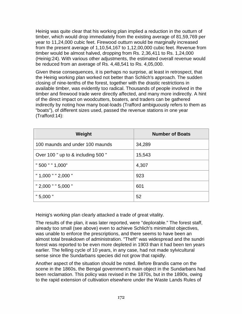
172
Heinig was quite clear that his working plan implied a reduction in the outturn of timber, which would drop immediately from the existing average of 81,59,769 per year to 11,24,000 cubic feet. Firewood outturn would be marginally increased from the present average of 1,10,54,167 to 1,12,00,000 cubic feet. Revenue from timber would be almost halved, dropping from Rs. 2,36,411 to Rs. 1,24,000 (Heinig:24). With various other adjustments, the estimated overall revenue would be reduced from an average of Rs. 4,48,541 to Rs. 4,05,000.
Given these consequences, it is perhaps no surprise, at least in retrospect, that the Heinig working plan worked not better than Schlich's approach. The sudden closing of nine-tenths of the forest, together with the drastic restrictions in available timber, was evidently too radical. Thousands of people involved in the timber and firewood trade were directly affected, and many more indirectly. A hint of the direct impact on woodcutters, boaters, and traders can be gathered indirectly by noting how many boat-loads (Trafford ambiguously refers to them as "boats"), of different sizes used, passed the revenue stations in one year (Trafford:14):
Weight Number of Boats
100 maunds and under 100 maunds 34,289
Over 100 " up to & including 500 " 15,543
" 500 " " 1,000" 4,307
" 1,000 " " 2,000 " 923
" 2,000 " " 5,000 " 601
" 5,000 " 52
Heinig's working plan clearly attacked a trade of great vitality.
The results of the plan, it was later reported, were "deplorable." The forest staff, already too small (see above) even to achieve Schlich's minimalist objectives, was unable to enforce the prescriptions, and there seems to have been an almost total breakdown of administration. "Theft" was widespread and the sundri forest was reported to be even more depleted in 1903 than it had been ten years earlier. The felling cycle of 10 years, in any case, had not made sylvicultural sense since the Sundarbans species did not grow that rapidly.
Another aspect of the situation should be noted. Before Brandis came on the scene in the 1860s, the Bengal government's main object in the Sundarbans had been reclamation. This policy was revised in the 1870s, but in the 1890s, owing to the rapid extension of cultivation elsewhere under the Waste Lands Rules of

173
1879, the Commissioner of the Sundarbans made drastic proposals for disafforestation in the reserved areas. In 1895, for example, he proposed that 200 square miles of the Khulna sundri forest be made available for cultivation. He did not achieve his object but did manage to get some smaller portions to be released during the decade. These developments continued into the 20th century. In 1909, a conservation plan for a portion of the Backarganj Sundarbans was approved on condition that forest protection should not stand in the way of reclamation. These developments suggest that the very concept of forest reservation was still not entirely secure, which made even more serious the fact that the Forest Department's working plans seemed ineffective (Ascoli:59-60).
LLOYD'S PLAN
An effort was made to improve forest administration through an interim working plan drawn up for the five year period 1903-04 to 1907-08. (This plan, sometimes known as the Lloyd Plan, was subsequently revised and used until 1913). The plan kept the two basic felling series in Khulna and Bagherhat, but the 10 annual coupes were cut into a quarter their size to increase the rotation cycle to 40 years. Felling of sundri, keora, and passur was completely prohibited in the western forests of Satkhira and 24-Parganas. A major change was introduced in overall management: permits were issued only at the coupe by a gazetted officer; the idea was to avoid the services of "dishonest subordinates" (Curtis:48). The plan also introduced monopoly sales: coupes were auctioned off in 1/4 square mile sections, so that the auction price was added to the regular royalties on exports. The plan also tightened water transit rules by prohibiting the transportation of sundri without hammar marks and permits. The cumulative effect of these changes was to reduce significantly the average yield of sundri timber and fuel:
Timber (cubic feet) Fuel (cubic feet)
Average 1893-94 to 1902-03
2,257,500 1,811,118
Average 1903-04 to 1905-06
1,304,754 642,925
In part, this downturn was accentuated by the boat-building trade's refusal to take the material available under the new regime (Trafford:12).
174
TRAFFORD'S PLAN
Mr. Trafford's working plan was drawn up in 1911 and was in effect for two decades 1912-13 to 1931-32. The whole of the Sundarbans were now divided into two working circles, the sundri or eastern working circle, and the western working circle. The former consisted of the coupes in the Bagherhat and Khulna areas which were put under a more elaborate and differentiated sylvicultural treatment. Basically, the two blocks were combined into a single felling series on a cycle of 40 years, although provision was made to fell on a 20 year cycle faster-growing, more-fresh water trees when they reached the minimum exploitable girth of 3'6". Provision was also made for subsidiary thinnings of young sundri saplings under 1'6" if the Divisional Officer approved. Exploitable girths were prescribed also for keora, amur, kankra, and passur, and their fellings kept to the same sundri coupes. The control of other species was mostly through royalties, although the plan was responsive to unexpected changes as when, for example, it was felt in 1925 that gengwa needed to be more tightly controlled against overcutting.
In the western working circle (Satkhira and 24-Parganas), felling of the five main timber species (sundri, passur, amur, and keora) was limited to the same minimum girth as in the east. But the primary effort in the west was to bring some control, absent until now, over firewood cutting for the Calcutta market. The main target was purchasers in large boats of over 500 maunds capacity, who now found their movements limited successively to each of 5 blocks, open on a rotation basis. Purchasers using smaller boats could continue to roam over the whole circle, cutting and collecting fuel as they chose. There was also an (unsuccessful) effort to manage the cutting of golpatta through the division of the western forests two annual blocks which were to be open in alternate years to purchasers with large boats.
Surveying the Sundarbans in 1931, Mr. S.J. Curtis, Deputy Conservator of Forests, saw little in the previous working plans that he liked. After a half-century of scientific forestry, the forest was hardly "ideal" in the technical sense (see definition above). For the first quarter-century after reservation sundri and passur, the species to which most attention had been given, had been overcut through "wasteful," unregulated fellings. Although this was "corrected" over the next 25 years by a near ban on fellings in some regions, the result was that age gradations of these species were not "normal." Some strands were over-mature, while some ages and sizes were in deficit. Distortions had been exacerbated by the Lloyd and Trafford plans. For example, before reservation, cuttings by local people of sundri and passur had effectively amounted to sylviculturally sound "thinnings" of dense younger saplings; this stopped after 1903 when in an effort to end the "waste" of "unregulated fellings, the local population was made subject to heavy penalties if found with unmarked timber. The unexpected result of the change was under-felling, and a preponderance now of middle-aged poles. Also, after the Khulna and Bagherhat felling series were combined under the Trafford plan, the one coupe open each year turned out usually to be in the Bagherhat block. This distorted the market: woodcutters from Barisal to the east obtained a
175
monopoly, other markets dried up, which in turn caused fellings to fall behind their assigned targets.
More generally, Curtis reported, the system of permits from revenue stations had not effectively controlled fellings, which had remained essentially unregulated, with "maximum damage and depletion" (Curtis:50). Restrictions, such as those imposed on large boats, had merely concentrated overfellings in different portions of the forest at different times, or had led to subterfuge, as when large boat owners simply substituted several smaller boats to export the same amount. The overall state of the forest, as Curtis saw it, remained extremely gloomy:
Everywhere within the forests may be seen the results of this wasteful method of management. Large baen trees have been felled merely fore the utilisation of the best log, and the rest left to rot in the forest; in other cases, a branch has been cut off for fuel, permitting the entrance of rot which, in a few years, has destroyed the timber of the whole tree; most of the dhundal trees left are unsound; blanks are left in the goran jungle, because the woodcutters clear-fell the root clusters....;golpatta is not nearly so plentiful as in former years owning to the fact that numberous rhizomes have succumbed to continual cutting, without a sufficient and regular period of rest (Curtis:50-51).
CURTIS' PLAN
Curtis' solution was to draw up yet another working plan, to cover the period from 1931 to 1951. In it he called for an "absolute revolution" in the system of management (Curtis:ii). His plan began by repeating, as had all previous plans, the goals of Sundarban forest administration. The main object was the production of timber, fuel, and thatching material, and their perpetual supply at reasonable rates to south-eastern Bengal; it was also important to grow large-sized sundri and gengwa for boat-building and box-planking, respectively. Another interest was to stimulate utilization of species so far not much used, although the plan did not speak to this possibility directly. The Sundarban forests were ecologically important because of the protection they provided to the interior from devastating floods. Revenue was also an object, insofar as it was consistent with these underlying purposes.
For Curtis, the road to achieving these goals was through "intensive management." Rather than respond to heavy demand negatively as in the past, by closing off the forest or raising the royalty prices, Curtis proposed a set of silvicultural prescriptions finely tuned to the characteristics of each species in different locales. The felling of all important forest produce, not just the five species traditionally regarded as important, would be concentrated in coupes. Unregulated felling would stop, as would the revenue station and the permit system. Waste would be minimized and, it was hoped, output would be regulated "according to the possibility of the forests" (Curtis:73). In order to encourage local demand (reversing a 30-year policy aiming at restricting demand), the coupes would be distributed throughout the forest. One result would be to lessen the
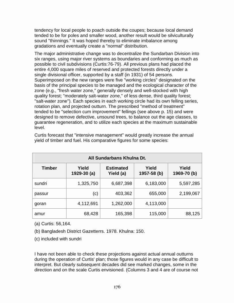
176
tendency for local people to poach outside the coupes; because local demand tended to be for poles and smaller wood, another result would be silviculturally sound "thinnings." It was hoped thereby to eliminate imbalance among gradations and eventually create a "normal" distribution.
The major administrative change was to decentralize the Sundarban Division into six ranges, using major river systems as boundaries and conforming as much as possible to civil subdivisions (Curtis:76-79). All previous plans had placed the entire 4,000 square miles of reserved and protected forests directly under a single divisional officer, supported by a staff (in 1931) of 54 persons. Superimposed on the new ranges were five "working circles" designated on the basis of the principal species to be managed and the ecological character of the zone (e.g., "fresh water zone," generally densely and well-stocked with high quality forest; "moderately salt-water zone," of less dense, third quality forest; "salt-water zone"). Each species in each working circle had its own felling series, rotation plan, and projected outturn. The prescribed "method of treatment" tended to be "selection cum improvement" fellings (see above p. 15) and were designed to remove defective, unsound trees, to balance out the age classes, to guarantee regeneration, and to utilize each species at the maximum sustainable level.
Curtis forecast that "intensive management" would greatly increase the annual yield of timber and fuel. His comparative figures for some species:
All Sundarbans Khulna Dt.
Timber Yield 1929-30 (a)
Estimated Yield (a)
Yield 1957-58 (b)
Yield 1969-70 (b)
sundri 1,325,750 6,687,398 6,183,000 5,597,285
passur (c) 403,362 655,000 2,199,067
goran 4,112,691 1,262,000 4,113,000
amur 68,428 165,398 115,000 88,125
(a) Curtis: 56,164.
(b) Bangladesh District Gazetterrs. 1978. Khulna: 150.
(c) included with sundri
I have not been able to check these projections against actual annual outturns during the operation of Curtis' plan; those figures would in any case be difficult to interpret. But clearly subsequent decades did see marked changes, some in the direction and on the scale Curtis envisioned. (Columns 3 and 4 are of course not

177
strictly comparable to columns 1 and 2 but are included here because much of the outturn for identified species came from the Khulna and Bagherhat blocks). Whether or not these changes occurred under the conditions of controlled but intensive management Curtis prescribed is not at this point known.
CONCLUSION For most of the period examined here, the department's management appears to have focused consistently on long-term preservation of the Sundarban forests. I have found no indication, for example, that silvicultural goals were undermined, as was the case elsewhere, by heavy extractions during the first world war. The basic goals throughout were left essentially unchallenged: to provide on a sustained basis for fuel, timber, thathching and building needs in the regional economy; to protect the upland cultivated regions from severe storms; and, consistent with these ends, to contribute to state revenue.
But it is also clear that foresters took quite some time to settle on how these objectives could be concretely achieved. The forests were reserved formally in 1876, but administration for at least the first half century was unsteady. Supervision initially was minimal and worked primarily through a price mechanism, to which later was added largely unsuccessful efforts to prescribe targets and to prohibit customary uses by local populations. Surely other factors, external to the forest service, such as civil disobedience movements, economic depression, and changing political pressures, must additionally have dislocated adminstration, but what has been of interest in this paper has been the more or less independent evolution of the department's internal understanding of it might best achieve its goals. Only with the Curtis plan did the full range of scientific forestry, such as silviculture, mensuration, forest economics, and yield calculations, come into play. And even under the Curtis plan the forest department was not itself actually "working" the forest; the tasks of felling, thinning, extraction, and sometimes even marking were left to professional woodcutters and the local population. The overall size of the forest staff remained inadequate to the task, even taking into account the expansion from 54 to 165 persons envisioned by the Curtis working plan.
The general point this suggests is that it is a vast oversimplification to depict the regime of scientific forestry, at least in the Sundarbans, as a Leviathan-like presence, strongly set on a consistent path. It was only gradually that the overall pattern of Sundarbans management approached the essential underlying principles of scientific forestry outlined in the first part of this paper, and even then did not do so completely.
REFERENCES Ascoli, F.D. 1921. A Revenue History of the Sundarbans from 1870 to 1920. Calcutta: The Bengal Secretariat Book Depot.

178
Baden-Powell, B.H. 1893. Forest Law: A Course on Lectures on the Principles of Civil and Criminal Law and on the Law of the Forest. London: Bradbury, Agnew, and Co., Ltd.
Brandis, D.
1878 Review of Forest Administration During 1876-77. Indian Forester.
1885 Progress of Forestry in India. Indian Forester 10.
Curtis, S.J. 1931. Working Plan for the Forests of the Sundarbans Division. 2 volumes. Calcutta: Bengal Government Press.
Fragment. 1876. A Fragment from a German writer on the reasons why the State should manage forests. Indian Forester 2: 83-84.
Heinig, R.L. 1893. Working Plan of the Sundarban Government Forests, Bengal.
Hope, T.C. 1877. Speech by T.C. Hope, 6th March, moving acceptance of report of the Select Committee. Indian Forester 3.
MacGreggor, J.L.L. 1883. The Organization and valuation of Forests, on the continental system in theory and practice. London.
Pargiter, F.E. 1934. A Revenue History of the Sundarbans from 1765 to 1870. Alipore: Superintendant of Government Printing.
Pearson, G.F. 1884. Teaching of Forestry. Indian Forester.
Puton, M. 1881. Translation of M. Puton's Amenagement des Forets. Indian Forester.
Report. 1874. Report of the Proceedings of the Forest Conference, 1873-74. Edited by B.H. Baden-Powell and J. Sykes Gamble. Calcutta: Office of Superintendent of Government Printing.
Ribbentrop, B. 1900. Forestry in British India. Calcutta: Superintendent of Government Printing.
Schlich, W.
1875 Remarks on the Sundarbans. Indian Forester 1:9-11.
1890 Forestry in the Colonies and in India. Indian Forester 15.
Trafford, F. 1911. Working Plan for the Forests of the Sundarbans Division. Calcutta: Bengal Secretariat Press.
NOTES 1. Wilhelm Schlich, "Remarks on the Sundarbans," Indian Forester 1:9-10.
2. B. Ribbentrop, Forestry in British India (Calcutta: Superintendent of Government Printing, 1900).
3. D. Brandis, "Progress of Forestry in India," Indian Forester 10:461-462.
179
4. Indian Forester 4 (1878):393.
5. "A Fragment From a German Writer on the Reasons Why the State Should Manage Forests," Indian Forester 2 (1876): 83-84.
6. Ibid.
7. Ibid.
8. Ibid.
9. Indian Forester 2:297.
10. Wilhelm Schlich, "Forestry in the Colonies and in India," Paper read at Royal Colonial Institute, by Schlich, Principle Professor of Forestry, Royal Engineering College, Cooper's Hill. In Indian Forester 15 (1890):281.
11. "Speech by T.C. Hope, 6 March, Moving Acceptance of Report of the Select Committee," in Indian Forester 3 (1877):332.
12. Ibid., p.333.
13. Dr. W. Schlich, "Forestry in the Colonies and in India," Indian Forester 16 (1890): 281-282.
14. B.H. Baden-Powell, 1893. Forest Law: A Course of Lectures on the Principles of Civil and Criminal Law and on the Law of the Forest. London: Bradbury, Agnew and Co., Ltd., 1893. Emphasis in original.
15. Ibid., p. 211.
16. Ibid., p. 212.
17. Ibid., p. 212.
18. Ibid., p. 212.
180
The Bangladesh Sundarbans as Wildlife Habitat: A Look Ahead
John Seidensticker
SUMMARY 1) The Sundarbans, the 10,000 km2 mangrove forest on the southern edge of the Ganges-Brahmaputra-Menhga delta in India and Bangladesh, is an open, dynamic, heterogeneous ecological system that is resilient to disturbance from within the forest and waterways, but sensitive to disturbance from the outside, particularly to changes in the flow of fresh water.
2) The century-old forest management system in the Sundarbans has focused attention on the sustained production of forest products. There has been no concurrent development of management mechanisms to maintain best achievable ecosystem function. For example, the forest departments of Bangladesh and India have not developed the power to ensure minimum fresh water deliveries or to maintain minimum salinity standards in the Sundarbans.
3) The Sundarbans is an essential and high-quality wildlife conservation area of regional and international importance. A comparison of today's conditions with those of the early part of this century shows that a number of wildlife species have been lost and populations of others greatly reduced.
4) The Sundarbans has functioned as an essential wildlife habitat while providing goods and services needed in the local and national economies of Bangladesh. The role of the Sundarbans in the local and national economies of India is much less important. This has vital implications for the wildlife management system that can be realized for the Sundarbans.
5) Management of the Indian Sundarbans as a wildlife habitat has focused on the Sundarbans Tiger Reserve, which has a totally protected core area comprising about one-third of the forest remaining in the Indian Sundarbans, surrounded by a buffer zone where exploitation is allowed. The Bangladesh Sundarbans is managed as a refuge where wildlife is protected and small sanctuaries nestled in the larger forest tract protect resource "hot-spots" essential to the maintenance of wildlife populations. Almost all the Bangladesh Sundarbans is on a rotational cutting cycle and is exploited. The economic bases and the long-term consequences of these wildlife conservation strategies, which are based on different ecological scales in the landscape mosaic, are discussed.
6) The diversity of birds and mammals found living in the Sundarbans is examined. We know little about wildlife diversity in relation to the geomorphic and specific disturbances (the sum of the frequencies, intensities, and types of individual disturbances) on the Southern Delta. This preliminary assessment indicates there is a high turnover rate among the habitats concerned and that
181
high B-diversity is reflected in the fauna lists because of high species habitat specificity.
7) Strategies to forestall over-exploitation of the forest are presented. To date, centralized authority has resulted in the preservation of this essential wildlife habitat. It is concluded that future management strategies for the Sundarbans must recognize and match the ecological scales within which they operate.
THE SETTING: LANDSCAPE AND FOREST MANAGEMENT The Ganges, Brahmaputra, and Menhga rivers join in Bangladesh and form a 65,000-km2 delta, one of the largest in the world. Few areas in the world could have matched the standing crop biomass of the assemblage of ungulates that lived in those forests, reed beds, and grasslands two centuries ago (Eisenberg and Seidensticker 1976). Today, the only remaining large block of forest lies at the delta's edge (Rashid 1977, Green 1978, Gittins and Akonda 1982).
At the edge of the delta is one of the world's largest mangrove forests1, the Sundarbans (Fig. 1). This is an open, dynamic, resilient, heterogeneous ecological system. The 6,000 km2 of waterways and forest that form the Sundarbans Forest Division (Table 1) is at the interface and is the sum of happenings in two huge ecological systems -- the Ganges/ Brahmaputra watersheds and the Bay of Bengal. The tides, floods, and frequent, intense cyclonic storms make it a dynamic, pulse-stable system (Odum 1971), which is constantly changing and renewing itself. As such, it is resilient to disturbances from within the forest and waterways, but sensitive to those from the outside, particularly to changes in the flow of fresh water. Variations in the flow of fresh water and tides are compartmentalized by the distributaries of the Ganges and tidal rivers, and the terrestrial productivity of the system is thus also compartmentalized (Choudhury 1968, Fig. 1; Snedaker, this workshop).
The forest today is about half the size it was two centuries ago (Curtis 1933, Choudhury 1968) and has been under the control of the Forest Department for the last century. My reading of the management paradigm that has developed during that time is that the Forest Department sought ways to increase forest outturn within the constraints of sustained-yield philosophy (Curtis 1933, Choudhury 1968, Pressler, this workshop -- for a careful analysis of the history of this Development). The process has been a series of incremental acts designed to bring more food, fiber, and material into production. It appears to have been done with care and control. A substantial increase in the production of these goods resulted without apparent damage to the Sundarbans ecosystem. This, however, should be confirmed to the extent possible.
With the forest management system focused on production, there was no concurrent development of a management mechanism to maintain best achievable ecosystem function (Clark 1974). In its most basic form, this means that the Forest Department did not develop the power to ensure minimum freshwater deliveries to the forested waterways or to maintain minimum salinity
182
standards for that water (Westcoat, this workshop). Indeed, until recently the conventional wisdom concerning water management in Bangladesh was that there was too much water rather than too little (A. Quandt, person. comm.).
A major strength of the forest management system has been that an entire coastal region was under the control of one government unit over a long period of time. While there are seasonal fishing villages set up on some of the seaface char lands (Fig. 2), there have been no permanent settlements established in the Sundarbans Forest Division other than those needed for administrative purposes, as far as I am aware. Permanent settlement has been carefully controlled by the ForestDepartment. I believe that the reason the Forest Department has been so successful in discouraging permanent settlement, while forest departments have been less successful farther inland in much of South and Southeast Asia, is because of the enormous aid the Forest Department received from the raw living conditions in the Sundarbans. As a settler in the Sundarbans, it would be very difficult to live and plan your future in a mangrove forest influenced by very high tides (av. 3 m), where there is virtually no fresh water -- not even rainwater -- for months at a time, where the entire area is regularly worked over by intense cyclonic storms, and where numerous and very real man-eating tigers (Panthera tigris tigris)2 live just outside your door and sometimes inside your house and boat.
CHANGING LANDSCAPES AND QUESTIONS FOR THE FUTURE On the "Soonderbans" Tiger: "...The sole distinctive characteristic of this tiger, so far as is known, is its utter fearlessness of man, and its inveterate propensity to kill and devour him on all and every opportunity." E. B. Baker (1887:80)
"The Sundarbans region has always been known as a notorious abode of man-eaters, which become exceedingly bold and have been known to swim at night to a boat anchored in the stream and carry away a man." R. G. Burton (1933:95)
"The survival in the wild of the powerful metaphysical symbol of Bangladesh, the Royal Bengal Tiger, hinges upon the capability and the will of man....In the Sundarbans, tigers, deer, forest, and men are linked inseparably and so must be their management. Any attempt to separate the tiger from its prey, the deer from the forest, or people from their needs will surely fail. The tiger must be managed with all wildlife as an integral part of forest management that ensures the sustainable production of forest products and maintains this coastal zone at the level of best achievable ecosystem function to provide for the needs of the people of Bangladesh." J. Seidensticker and M. A. Hai (1983:9)
Aligning the words of contemporary wildlife managers with those of the shikar literature from the British Raj in India characterizes one of many changes that has occurred in the Sundarbans over the last century. A comparison of written and oral shikar descriptions of the Sundarbans as wildlife habitat made fifty to a hundred years ago with conditions I observed a decade ago reveals a decline in
183
the quality of the Sundarbans as wildlife habitat as reflected in the reduced population levels of some megafauna.
This landscape will continue to change, directly and indirectly, at the hands of man. What can we expect from the Sundarbans as wildlife habitat in the future? This is a priority question in conservation planning because the Sundarbans is such an important wildlife habitat at the regional and international levels.
Consider tigers. Anywhere tigers live today is high-quality wildlife habitat. Our view of the Sundarbans and tigers living there has come full circle. A century ago, even three decades ago, clearing a region of tigers was a sign of progress. Those days are gone. There is literally nothing left to clear. There is little room left for tigers. I see the Sundarbans as one of the world's last great wild places. On these storm-lashed tidelands, the feared, respected, awesome, largest of all cats, the tiger, has been pushed to the final edge of existence. I have argued elsewhere (Seidensticker 1986, 1987) that the Sundarbans is the most important area left for the long-term survival of the tiger because the area is large enough to support a large effective population size Ne. This view is affirmed in the "Global Tiger Survival Plan" (Tilson and Seal 1987).
The Sundarbans is an essential wildlife habitat. Also, because the Sundarbans Forest Division contains all the forest left in the lower Bengal Basin of Bangladesh (Green 1978), it is the only source of timber, and a major source of firewood and other forest products, for the southern region of Bangladesh (Timberg, this workshop). These vegetated tidelands also function as a nutrient producer, water purifier, nutrient and sediment trap, storm barrier, shore stabilizer, esthetic attraction, and energy storage unit (Snedaker, this workshop). The drainage ways and estuaries serve as a transportation network, a major fishery, and as a nursery for many coastal and ocean fisheries (Rainboth, this workshop). The real value of the goods and services provided by this area is not calculable, or at least has not been calculated. The goods and services from a healthy Sundarbans diffuse into the local, regional, and national fabric of Bangladesh (McCarthy, this workshop). For the most part, there are no substitutes for these goods and services. Where substitutes are available elsewhere, Bangladesh cannot afford to buy them.
If the Sundarbans has functioned as an essential wildlife habitat while providing the goods and services needed in the local and national economy of Bangladesh, why be concerned? Is this not a case we can celebrate where public needs have been met while maintaining a charismatic megafauna and biological diversity in an enormous wildland? The first red flag of concern for future productivity of the Sundarbans Forest and the future of the Sundarbans as prime wildlife habitat area went up with Farakka and the significant upstream diversion of Ganges water (BWDB 1977).
Reflect on what has happened in the lower delta during the last two centuries. Two hundred years ago, a primary consumable resource of the region was undeveloped land. Forest clearing was encouraged. It was during this developmental phase that we saw a decline in the diversity of large mammals as

184
their habitat went under the ax and plow (Table 2). Clearing and cultivation went on until about 1875, when the remaining unleased forests were declared reserved under the Forest Act of 1879. At this point the curves of supply and demand crossed, and there was a switch from land transformation to forest utilization as the principal land use in the lower delta. This switch occurred when the population of Bangladesh was under 25 million people. By 1960, the start of the Forest Working Plan that was recently completed, the population was 55 million people. Today there are 100 million people and by the turn of the century it is projected there will be 134 million people (World Bank 1979:74). These additional people will have needs that must be met with additional goods and services from the Sundarbans. Can we quantify what the increasing need for goods and services from the Sundarbans over the next decades will be? In the process of providing for these needs, what will happen to the Sundarbans as a premier wildlife habitat?
One option is that a substantial portion of the Sundarbans forest could and should be cleared, bunded, and transformed into agricultural and fisheries production areas. If this is the future of the Sundarbans forest, the Sundarbans as quality wildlife habitat has no future and a majority of the other values and public goods that the Sundarbans now provides will be lost. We have only limited knowledge of the Sundarbans ecosystem's inherent resilience. We have limited knowledge of functional relationships within this ecosystem. I don't think we have a clear understanding of the social objectives of the future management of the Sundarbans ecosystem. We know that the Sundarbans, as an open system, is subject to the "fickle fortune of fate," or more to the point, subject to the needs and political will of India and the people living in the upper Ganges and Brahmaputra watersheds (Westcoat, this workshop). We have only limited knowledge of how upstream conditions result in changes in the Sundarbans. We have limited knowledge of what the needs and political will of people living in the upper Ganges and Brahmaputra watersheds are, and what they will demand in terms of upstream diversion of water in the future.
The future of the Sundarbans as the wildlife habitat we now know, and the long-term maintenance of wildlife populations living there, revolve around finding quantitative answers to these questions. I believe that the future development of the management system for the Sundarbans must be directed toward obtaining best achievable ecosystem function if the full complement of values now available from the Sundarbans is to be maintained.
WILDLIFE CONSERVATION IN THE SUNDARBANS: INDIA AND BANGLADESH Preservation, conservation, and management of wildlife in Bangladesh are regulated under the provisions of Presidential Order No. 23 of 1973 (the Order): Bangladesh Wildlife (Preservation) Order, 1973. Subsequent notices in the Bangladesh Gazette authorize various forest and police officers to discharge functions prescribed in the Order. The Sundarbans Forest Division is part of the

185
National Wealth in accord with the Forest Act of 1927. In accordance with Article 46 of the Order, the Government can declare, through notification in the official Gazette, the complete protection of all species of mammals, birds, reptiles, and amphibians that occur in the Sundarbans Forest Division.
Three areas in the Sundarbans Forest Division have been declared Wildlife Sanctuaries under the provisions of Article 23(1) of the Order. The total area of these Wildlife Sanctuaries is less than 140 km2 (Fig. 3). These areas are each too small to stand alone to provide long-term protection for large mammals or birds. They function to protect "hot-spots" of wildlife habitat nested in the larger forest tract. Under this arrangement, the Sundarbans Forest Division has been one of the largest "effective wildlife refuges" in South Asia.
Management of the Indian Sundarbans as a wildlife habitat has focused on the Sundarbans Tiger Reserve, which was established in 1973 under "Project Tiger." Of the 4,262 km2 of Sundarbans in Indian territory, the tiger reserve covers 2,585 km2, with a core area of 1,330 km2 legally protected as a national park (Sanyal 1983). No exploitation is allowed in the core area. "The remaining area acts as a buffer zone and caters to the needs of the local people by allowing systematic, limited exploitation (Sanyal 1987:429)."
I have referred to these two contrasting wildlife management systems as "refuge" (Bangladesh) and "reserve" (India) management (Seidensticker 1987). The latter, the reserve-buffer system, is a conventional approach to wildlife conservation. It has worked and is an essential tool for wildlife conservation in many areas of the world, including South Asia. This approach rests on the assumption that inviolate core areas surrounded by restricted-use buffer zones can ensure the survival of species and animal assemblages; it assumes that within these reserves, the life-
cycle needs of species and communities will go on in a "natural way" if the animals are safe from man-induced mortality and perturbations. Recent studies in conservation biology, however, have demonstrated that simple elimination of man-induced perturbations must be coupled with concepts of minimum viable population size, minimum area, and habitat diversity if areas are to be effective in maintaining biological diversity over the long-term (Soule 1986).
The Bangladesh Sundarbans has been managed as what I have termed a wildlife refuge, an area where the support of wildlife is provided through protection and management but not to the exclusion of resource extraction activities. I believe that long-term tiger conservation in the Sundarbans can be achieved through strict protection of the tiger and by careful management of critical habitats and vital areas where essential ecological and life-history processes occur or originate. Vital areas include hot-spots of high local resource production. The seaface meadows are resource hot-spots for deer and their predator, the tiger. Water birds serve as another example. With their dependency on patchy food supplies, they must integrate resources over large areas; their nesting and roosting sites are vital areas that require protection (Kushlan 1979). It must be recognized that these hot-spots constitute only a small fraction of the area needed to ensure that vital population processes for deer and tiger and

186
water birds are not confounded, a recognition that must be integrated into the overall system of forest management as a management standard. Rather than attempting a strategy for wildlife conservation management that involves setting aside areas where the entire life-cycle needs of a wildlife community can be met, the ecological needs of wildlife can be linked into the overall management of the system for the Sundarbans. In so doing, the ecological processes upon which wildlife depend become integral values in the management matrix.
In drawing the distinction between refuges and reserves, I am recognizing strategies of wildlife conservation on different ecological scales in the landscape mosaic. I find it fascinating that these two fundamentally different wildlife management systems have developed side-by-side in the same forest. I suggest that the reason for this is that India can afford to set aside a large portion of the Sundarbans forest as a national park because it has alternative sources for the forest products of the Sundarbans or can afford to buy them. Bangladesh, much more restricted in area and limited in alternative sources of the forest products provided by the Sundarbans, cannot afford to restrict access to those resources over a large area. The irony of this is that, while the Indian, or reserve-buffer approach, is the conventional model and is supported by such international systems as the World Heritage Trust, I believe that the difference of ecological scale is what is of vital importance to the long-term survival of the Sundarbans megafauna; the Bangladesh approach, or the refuge model, may be the more appropriate for the long-term survival of the tiger (Seidensticker 1987).
WILDLIFE RESEARCH AND THE MAINTENANCE OF BIOLOGICAL DIVERSITY
A HISTORY OF WILDLIFE INVESTIGATIONS IN THE SUNDARBANS
Much of our knowledge of local fauna assemblages in South Asia came from curious naturalists, who recorded observations from their tireless avocational pursuits in the journals of local natural history societies and in their own books. The extensive, harsh environment of the Sundarbans, however, has thwarted extensive investigation by amateur naturalists. The professional forest officers who have long enjoyed regular and efficient access to the forests and waterways have focused their attention on the megafauna -- the deer, tiger, and crocodilians. Their qualitative observations are recorded in the "forest working plans" (cf. Curtis 1933, Choudhury 1968). The foresters and their field staffs are excellent naturalists; if over the years a systematic record of their observations had been kept, our knowledge of Sundarbans wildlife would be superlative. In 1944, traveling as a guest of the Forest Department and, in 1946, traveling by ferry through the edge of the forest, C. L. Law made observations for a comprehensive and still very useful annotated list of Sundarbans birds (Law 1953, 1954, 1956, 1959). In 1967, Anjit Kumar Mukherjee completed his dissertation on the food habits of the water birds of 24-Parganas District. His very important 1975 paper on the Sundarbans biota addressed the impact of habitat
187
change on wildlife living in the lower delta. Also in 1967, Guy Mountfort (1969) undertook the first World Wildlife Fund expedition to the Sundarbans. Mountfort's enthusiasm for the conservation possibilities of this remarkable forest led to World Wildlife Fund support for Hubert Hendrichs' field studies of the tiger conducted in late 1970 and early 1971. His 1975 account includes his observations of the tiger, the abundance and distribution of deer, and annotated checklists of mammals, birds, and reptiles. The Mukherjee (1975) and Hendrichs (1975) accounts, together with the more recent observation by Sanyal (1983, 1987), provide our portrait of the wildlife assemblage living in the Sundarbans. This has been combined and presented in Seidensticker and Hai (1983) and included here with revised nomenclature in the Appendix (1-3).
Considerable resources have been invested in recent years by the Bangladesh Water Development Board to improve our information base on the ecology of the lower delta. The resulting wildlife lists (BWDB 1977), like those of Khan (1982b), are useful but are not precise enough to assess the impact of environmental change on the wildlife assemblage living in the forest.
Countrywide wildlife assessments place the extreme value of the Sundarbans as an essential wildlife habitat in perspective (Olivier 1979, Gittins and Akonda 1982, Khan 1982b). This has also been emphasized in the surveys of primates conducted by Green (1978) and Gittins and Akonda (1982) and of the cats conducted by M. A. Raza Khan (1986, 1987). The international importance of the Sundarbans as an essential wildlife habitat for the long-term survival of the tiger is described in Seidensticker and Hai (1983) and Seidensticker (1986, 1987).
WILDLIFE DIVERSITY IN THE SUNDARBANS LANDSCAPE
In tables 3 and 4, I made comparisons between the birds and mammals found in the Sundarbans and adjacent areas and those found living in mainland Southeast and South Asia. I had wanted to compare diversity of species living in similar large mangrove habitats in different zoogeographic areas (u-diversity) but species lists from comparable habitats (other large mangrove forests) have not been compiled. I have compared the birds and mammals of the Sundarbans with other regional faunas in South and Southeast Asia. I used Thai mammals as a basis for this comparison with mammals because that assemblage has been the subject of a recent monographic study (Lekagul and McNeely 1977). I used the Flemming et al. (1979) handbook as the basis for bird comparisons because of Nepal's importance as a migratory route for South Asian birds.
As can be seen in the tables, the Sundarbans is without endemics; this is to be expected in this formation. The mammals and birds that "shake out" of this analysis have wide distributions in the Indian subcontinent.
The diversity of species for the area as reflected in these checklists is quite high. This is because the lists do not reflect an a-diversity (an inventory or species packing level) for the Sundarbans forest. These lists also include species found living in adjacent deforested lands.
188
In compiling the lists of mammals, birds, and herps included in the Appendix (1-3), I was impressed with how little we know about the wildlife diversity in relation to the geomorphic and specific disturbance regimes (the sum of the frequencies, intensities, and types of individual disturbances) in the southern delta. Mukherjee (1975) provided an initial assessment of the distribution of birds and mammals in relation to forest and "reclaimed" lands. He was the first to point out that species from the "reclaimed" lands were invading the forest; only a few forest species could live in the "reclaimed" lands (Fig 4). This preliminary assessment indicates there is a high turnover rate (B-diversity) among the habitats concerned.
Initially I wanted to categorize these lists to reflect "forest living" and "reclaimed-land living" species. For some obvious species this was possible (Table 2). For most species, I found that it was not possible to do the categorization with confidence.
This points to a wildlife research need for the Sundarbans. If my assumption that high B-diversity is reflected in these lists is correct, it is because of high habitat specificity for many species. I believe that studies of diversity patterns, such as those Cody (1986) has conducted in Mediterranean-climate regions, should be a priority topic for wildlife research in the Sundarbans. Such an investigation would help produce conservation guidelines to maintain the full suite of species.
SOCIAL OBJECTIVES FOR FOREST MANAGEMENT AND WILDLIFE CONSERVATION IN THE SUNDARBANS I do not know what the future social objectives are for forest management on the Indian and the Bangladesh sides of the Sundarbans. Harry Blair (this workshop) has outlined three strategies to forestall over-exploitation: 1) centralize authority and control by the government over the resource; 2) encourage local authorities to manage the resource in their own and the national long-term interest by treating it as a common property resource for sustained yield; or 3) privatize the resource on the theory that its new owners will safeguard it for the sake of their own long-term interest. To date, centralized authority has resulted in the preservation of this essential wildlife habitat and the tiger has survived.
I am troubled about the future of the Sundarbans as wildlife habitat under a privatization option because the outcome for privatization or local control of common property resources is predictable. Clark (1973:434) demonstrated "...that overexploitation in the physical sense of reduced productivity may result from not one but two social conditions: 1) common- property competitive exploitation on the one hand and 2) private-
property maximization of profits on the other. For [biological] populations that are economically valuable but have low reproductive capabilities, either condition may lead to extinction. In view of the likelihood of private firms adopting high rates of discount, the conservation of renewable resources would appear to require public surveillance and control of the physical yield and conditions of the stocks." I argue that the environmental conditions and social history of the
189
Sundarbans will encourage the adoption of high-discount rates if exploitation of the biological resources is privatized or placed in the hands of local authority.
When land is converted from forest in the Sundarbans it loses most of its value as wildlife habitat (Mukherjee 1975). I do not know what the social objectives are for the forest areas outside the Sundarbans Tiger Reserve in India. How much of this will be turned into shrimp fisheries in private hands? Will attempts be made to turn some of this into agricultural production areas? Will forest products be made available to local economies and will production be managed by local political units? How much forest will continue to be managed as a national forest as part of the national wealth?
Which of these options will be utilized in the Bangladesh Sundarbans? I can not envision how the Sundarbans Forest Division of Bangladesh can be managed through local or private mechanisms and retain the range of values we see there today. I do not know how to design a locally controlled public system of surveillance and control of the physical yield and conditions of the stocks for an ecosystem the size of the Sundarbans.
The tiger will survive only where it is protected and optimal ecosystem function is maintained. Is this the future Sundarbans?
NOTES 1 Diamond (1986:487) informs us that "...New Guinea's plant communities include the world's largest expanses of mangroves..."Myers (1980:64) informs us that "At the mouth of the river Ganges is a 6,000 km2 block of mangrove tidal forest, the largest such tract in the world, known as the Sundarbans." Snedaker (this workshop) reports that the largest is the Niger River delta forest (112,223 km2); the Orinoco River delta forest is also very large (4,952 km2).
2 Khan (1987:94) reports "...The earliest known record of man-killing by Sundarbans tigers is that of Bernier, who toured this part of the Mughul Empire during 1665-1666...an estimated 814 people have been killed by tigers in the Bangladesh Sundarbans from 1948 to 1986. This is an average of 21 people a year killed by tigers. Sanyal (1987) reports that between 1975 and 1981 an average of 45.5 people were killed by tigers annualy in the Sundarbans Tiger Reserve in India. This problem was tackled in an imaginative fashion by the Project Tiger authorities, and human fatalities declined from and average of 45.5 to an average of only 22 per annum between 1983 and 1985. Rishi (1988) describes experiments using human face masks as a protective device against tiger attacks with promising results. In 1974 with the help of the Forest Department of West Bengal, I captured a man-killing tiger in a reclaimed area of the Indian Sundarbans near Jharkhali (Seidensticker et al. 1976). I have a healthy respect for man-killing tigers and the problem of man-killing tigers in the management and conservation of the Sundarbans.
190
LITERATURE CITED Ali, S., and S. D. Ripley. 1983. Handbook of the birds of India and Pakistan together with those of Bangladesh, Nepal, Bhutan and Sri Lanka, compact edition. Oxford University Press, Delhi.
Baker, E. B. 1887. Sport in Bengal: how, when, and where to seek it. Ledger, Smith and Co., London.
Bangladesh Water Development Board (BWDB). 1977. Special studies. Volumes A, B, C, and D. Peoples Republic of Bangladesh, Water Development Board, Dacca.
Bingaman, L. 1987. The ISIS (International Species Inventory System) list of reptiles. National Zoological Park, Smithsonian Institution, Washington, D.C.
Burton, R. G. 1933. The book of the tiger. Hutchinson and Co., London.
Choudhury, A. M. 1968. Working plan of the Sundarbans Forest Division for the period 1960-61 to 1979-80. Vol. I. Government of Bangladesh, Forest Department, Government Press, Dacca.
Clark, C. W. 1973. The economics of overexploitation. Science 181:630-634.
Clark, J. 1974. Coastal ecosystems. The Conservation Foundation, Washington, D.C.
Cody, M. L. 1986. Diversity, rarity, and conservation in Mediterranean-climate regions. Pages 122-152 in Soule, M. E., ed. Conservation biology: the science of scarcity and diversity. Sinauer Associates, Sunderland, MA.
Curtis, S. J. 1933. Working plan for the Sundarbans Forest Division. Bengal Government Press, Calcutta.
Diamond, J. 1986. The design of a nature reserve system for Indonesian New Guinea. Pages 485-503 in M. E. Soule, ed. Conservation biology: the science of scarcity and diversity. Sinauer Associates, Sunderland, MA.
Eisenberg, J. F. and J. Seidensticker. 1976. Ungulates in southern Asia: a consideration of biomass estimates for selected habitats. Biological Conservation 10: 293-308.
Flemming, R. L., Jr., R. L. Flemming Sr., and L. S. Bangdel. 1979. Birds of Nepal with reference to Kashmir and Sikkim. P. P. Banks, Avalok Publishers, Kathmandu.
Frost, D. R., eds. 1985. Amphibian species of the world: a taxonomic and geographic reference. Allen Press and Association of Systematic Collections, Lawrence, KA.
Gittins, S. P., and A. W. Akonda. 1982. What survives in Bangladesh? Oryx 16:275-281.
Green, K. M. 1978. Primates of Bangladesh: a preliminary survey of population and habitat. Biological Conservation 13:141-159.

191
Groves, C. P., and S. Chakraborty. 1983. The Calcutta collection of Asian rhinoceros. Record of the Zoological Survey of India 80: 251-263.
Hendrichs, H. 1975. The status of the tiger Panthera tigris (Linne,1758) in the Sundarbans mangrove forest (Bay of Bengal). Saugertierkundliche Mitteilungen 23:161-199.
Honacki, J. H., K. E. Kinman, and J. W. Koeppl, eds. 1982. Mammal species of the world: a taxonomic and geographic reference. Allen Press and Association of Systematic Collections, Lawrence, KA.
International Union for the Conservation of Nature and Natural Resources (IUCN). 1987. World Heritage nomination -- IUCN Summary 452: Sundarbans (India). IUCN, Gland. (Draft)
Khan, M. A. R. 1982a. Chelonians of Bangladesh and their conservation. Journal of the Bombay Natural History Society 79:26-27.
Khan, M. A. R. 1982b. Wildlife of Bangladesh, a checklist. University of Dhaka, Dhaka.
Khan, M. A. R. 1986. Status and distribution of cats in Bangladesh. Pages 43-49 in S. D. Miller and D. D. Everett, eds. Cats of the world: biology, conservation, and management. National Wildlife Federation, Washington, D.C.
Khan, M. A. R. 1987. The problem tiger of Bangladesh. Pages 92-96 in R. L. Tilson and U. S. Seal, eds. Tigers of the world: the biology, biopolitics, management, and conservation of an endangered species. Noyes Publications, Park Ridge NJ.
Kushlan, J. A. 1979. Design and management of continental wildlife reserves: lessons from the Everglades. Biological Conservation 15:281-290.
Law, S. C. 1953, 1954, 1956, 1959. A contribution to the ornithology of the Sunderbans. Journal of the Bengal Natural History Society. 26: 85-90, 142-140; 27:59-65, 28:149-152; 30:155-160.
Lekagul, B., and J. McNeely. 1977. Mammals of Thailand. Association for the Conservation of Wildlife and Kurupha Ladprao Press, Bangkok.
Mountfort, G. 1969. The vanishing jungle. Collins, London.
Mukherjee, A. K. 1967. Food habits of waterbirds of the Sundarbans, 24-Parganas District, West Bengal, India, with notes of their ecology. Ph.D. Dissertation, University of Calcutta, Calcutta.
Mukherjee, A. K. 1975. The Sundarbans of India and its biota. Journal of the Bombay Natural History Society 72:1-20.
Myers, N. 1980. Conversion of tropical moist forests. National Academy of Sciences, Washington, D.C.
Odum, E. P. 1971. Fundamentals of ecology. W. B. Saunders Co., Philadelphia, PA.

192
Olivier, R. C. D. 1979. Wildlife conservation and management in Bangladesh. Food and Agriculture Organization of the United Nations, Rome.
Rahman, N., M. M. Billah, and M. U. Chaudhury. 1979. Preparation of an up to date map of Sundarbans Forests and estimation of forest areas of the same by using Landsat imageries. Second Bangladesh National Seminar on Remote Sensing, Dacca, December 9-15.
Rashid, H. E. 1977. Geography of Bangladesh. University Press Ltd. Dacca.
Rishi, V. 1988. Man, mask and maneater. Tigerpaper 15(3):9-14.
Sanyal, P. 1983. Mangrove tiger land: the Sundarbans of India. Tigerpaper 10(3):1-4.
Sanyal, P. 1987. Managing the man-eaters in the Sundarbans Tiger Reserve of India - a case study. Pages 427-434 in R. L. Tilson and U. S. Seal, eds. Tigers of the world: the biology, biopolitics, management, and conservation of an endangered species. Noyes Publications, Park Ridge, NJ.
Seidensticker, J. 1986. Large carnivores and the consequences of habitat insularization: ecology and conservation of tigers in Indonesia and Bangladesh. Pages 1-41 in S. D. Miller and D. D. Everett, eds. Cats of the world: biology, conservation, and management. National Wildlife Federation, Washington, D.C.
Seidensticker, J. 1987. Managing tigers in the Sundarbans: experience and opportunity. Pages 416-426 in R. L. Tilson and U. S. Seal, eds. Tigers of the world: the biology, biopolitics, management, and conservation of an endangered species. Noyes Publications, Park Ridge, NJ.
Seidensticker, J., R. K. Lahiri, K. C. Dass, and A. Wright. 1976. Problem tiger in the Sundarbans. Oryx 13:267-273.
Seidensticker J. and M. A. Hai. 1983. The Sundarbans wildlife management plan: conservation in the Bangladesh coastal zone. International Union for the Conservation of Nature and Natural Resources, Gland. 120 pp.
Soule, M. E., ed. 1986. Conservation biology: the science of scarcity and diversity. Sinauer Associates, Sunderland, MA.
Tilson, R. L. and U. S. Seal. 1987. Preface. Pages vii-viii in R. L. Tilson and U. S. Seal, eds. Tigers of the world: the biology, biopolitics, management, and conservation of an endangered species. Noyes Publications, Park Ridge, NJ.
World Bank. 1979. Bangladesh: current trends and development issues. The World Bank, Washington DC.
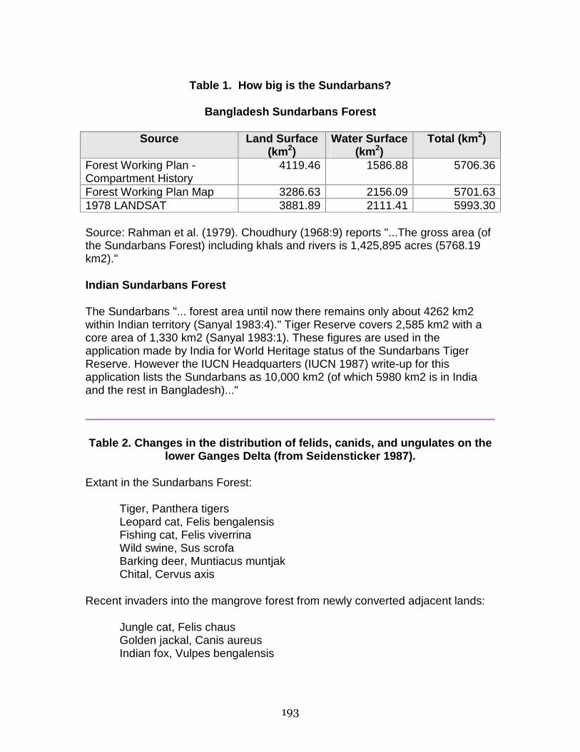
193
Table 1. How big is the Sundarbans?
Bangladesh Sundarbans Forest
Source Land Surface (km2)
Water Surface (km2)
Total (km2)
Forest Working Plan - Compartment History
4119.46 1586.88 5706.36
Forest Working Plan Map 3286.63 2156.09 5701.63 1978 LANDSAT 3881.89 2111.41 5993.30
Source: Rahman et al. (1979). Choudhury (1968:9) reports "...The gross area (of the Sundarbans Forest) including khals and rivers is 1,425,895 acres (5768.19 km2)."
Indian Sundarbans Forest
The Sundarbans "... forest area until now there remains only about 4262 km2 within Indian territory (Sanyal 1983:4)." Tiger Reserve covers 2,585 km2 with a core area of 1,330 km2 (Sanyal 1983:1). These figures are used in the application made by India for World Heritage status of the Sundarbans Tiger Reserve. However the IUCN Headquarters (IUCN 1987) write-up for this application lists the Sundarbans as 10,000 km2 (of which 5980 km2 is in India and the rest in Bangladesh)..."
Table 2. Changes in the distribution of felids, canids, and ungulates on the lower Ganges Delta (from Seidensticker 1987).
Extant in the Sundarbans Forest:
Tiger, Panthera tigers Leopard cat, Felis bengalensis Fishing cat, Felis viverrina Wild swine, Sus scrofa Barking deer, Muntiacus muntjak Chital, Cervus axis
Recent invaders into the mangrove forest from newly converted adjacent lands:
Jungle cat, Felis chaus Golden jackal, Canis aureus Indian fox, Vulpes bengalensis

194
Recently extinct from the lower Ganges Delta:
Leopard, Panthera pardus Javan rhinoceros, Rhinoceros sondaicus Hog deer, Cervus porcinus Swamp deer, Cervus duvauceli Wild water buffalo, Bubalus bubalis
___________________________
Notes: Based on Hendrichs (1975), Mukherjee (1975), and Sanyal (1983). Sanyal noted the recent extinction of the barking deer from the Sundarbans Tiger Reserve and Holliday Island in India. Hendrichs found this deer living in the northeastern areas of the Sundarbans at densities of 1 to 10/km2. Baker (1887) killed three Javan rhinos in the Sundarbans in 1881. There are three specimens of this rhino from the Sundarbans in the collections of the Indian Museum, Calcutta (Groves and Chakraborty 1983). Two of the specimens have recorded collecting sites: Chillichang Creek and Mathabhanga River (Barisal District). Curtis (1933) lists the leopard living at the edge of the Sundarbans forest. Khan (1986) reports that it is no longer found in the region and that a viable population of leopards may no longer exist in Bangladesh. Sanyal (1983) dates the extinction of the swamp deer and wild water buffalo from the Sundarbans and adjacent lands as around the turn of the century. Hog deer were noted as uncommon in the northern areas of the forest by Curtis (1933); they were not found by Hendrichs (1975).
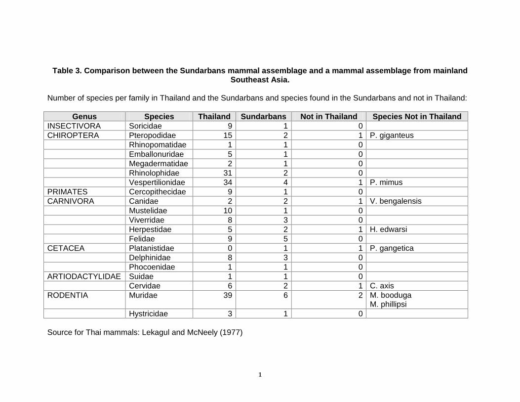
1
Table 3. Comparison between the Sundarbans mammal assemblage and a mammal assemblage from mainland Southeast Asia.
Number of species per family in Thailand and the Sundarbans and species found in the Sundarbans and not in Thailand:
Genus Species Thailand Sundarbans Not in Thailand Species Not in Thailand INSECTIVORA Soricidae 9 1 0 CHIROPTERA Pteropodidae 15 2 1 P. giganteus Rhinopomatidae 1 1 0 Emballonuridae 5 1 0 Megadermatidae 2 1 0 Rhinolophidae 31 2 0 Vespertilionidae 34 4 1 P. mimus PRIMATES Cercopithecidae 9 1 0 CARNIVORA Canidae 2 2 1 V. bengalensis Mustelidae 10 1 0 Viverridae 8 3 0 Herpestidae 5 2 1 H. edwarsi Felidae 9 5 0 CETACEA Platanistidae 0 1 1 P. gangetica Delphinidae 8 3 0 Phocoenidae 1 1 0 ARTIODACTYLIDAE Suidae 1 1 0 Cervidae 6 2 1 C. axis RODENTIA Muridae 39 6 2 M. booduga
M. phillipsi Hystricidae 3 1 0
Source for Thai mammals: Lekagul and McNeely (1977)
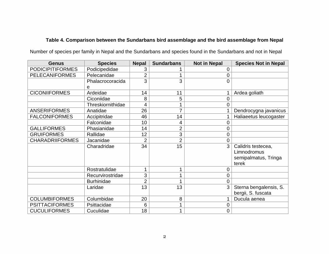
2
Table 4. Comparison between the Sundarbans bird assemblage and the bird assemblage from Nepal
Number of species per family in Nepal and the Sundarbans and species found in the Sundarbans and not in Nepal
Genus Species Nepal Sundarbans Not in Nepal Species Not in Nepal PODICIPITIFORMES Podicipedidae 3 1 0 PELECANIFORMES Pelecanidae 2 1 0 Phalacrocoracida
e 3 3 0
CICONIIFORMES Ardeidae 14 11 1 Ardea goliath Ciconiidae 8 5 0 Threskiornithidae 4 1 0 ANSERIFORMES Anatidae 26 7 1 Dendrocygna javanicus FALCONIFORMES Accipitridae 46 14 1 Haliaeetus leucogaster Falconidae 10 4 0 GALLIFORMES Phasianidae 14 2 0 GRUIFORMES Rallidae 12 3 0 CHARADRIIFORMES Jacanidae 2 2 0 Charadridae 34 15 3 Calidris testecea,
Limnodromus semipalmatus, Tringa terek
Rostratulidae 1 1 0 Recurvirostridae 3 1 0 Burhinidae 2 1 0 Laridae 13 13 3 Sterna bengalensis, S.
bergii, S. fuscata COLUMBIFORMES Columbidae 20 8 1 Ducula aenea PSITTACIFORMES Psittacidae 6 1 0 CUCULIFORMES Cuculidae 18 1 0

3
STRIGIFORMES Strigidae 20 5 0 CAPRIMULGIFORMES Caprimulgidae 4 3 0 CORACIIFORMES Alcedinidae 9 8 2 Halcyon chloris,
Pelargopsis capensis Meropidae 4 1 0 Upupidae 1 1 0 PICIFORMES Picidae 25 6 0 PASSERIFORMES Hirundinidae 8 4 0 Laniidae 5 3 0 Oriolidae 4 2 0 Dicruridae 8 7 0 Artamidae 1 1 0 Sturnidae 10 7 2 Aplonis panayensis,
Sturnus contra Corvidae 15 3 0 Campephagidae 12 7 0 Irenidae 4 1 0 Pycnonotidae 9 2 0 Muscicapidae 222 48 6 Muscicapa thalassina,
Chaetornis striatus, Phragamaticola aedon, Prinia inornatus, Sylvia hortensis
Motacillidae 14 8 1 Motacilla indica Nectariniidae 9 1 0 Ploceidae 15 10 0 Fringillidae 30 1 0 Embeizidae 11 2 1 Emberiza schoeniclus
Source for Nepali birds: Flemming et al. (1979)
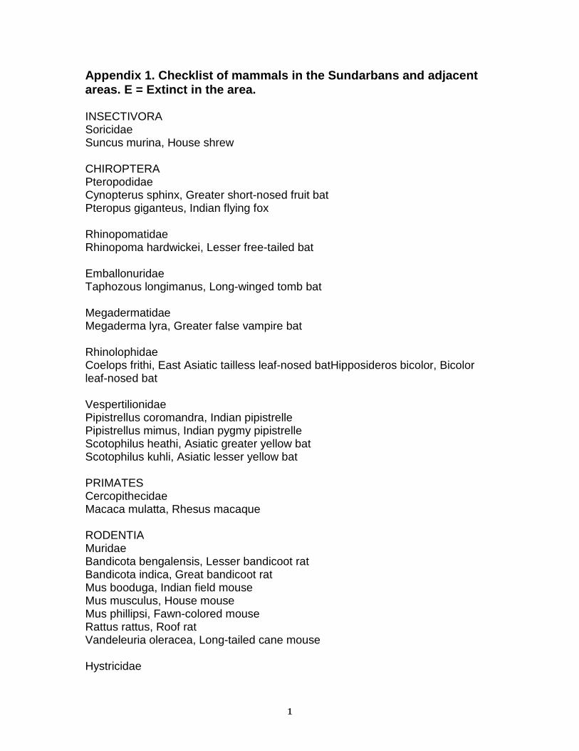
1
Appendix 1. Checklist of mammals in the Sundarbans and adjacent areas. E = Extinct in the area.
INSECTIVORA Soricidae Suncus murina, House shrew CHIROPTERA Pteropodidae Cynopterus sphinx, Greater short-nosed fruit bat Pteropus giganteus, Indian flying fox Rhinopomatidae Rhinopoma hardwickei, Lesser free-tailed bat Emballonuridae Taphozous longimanus, Long-winged tomb bat Megadermatidae Megaderma lyra, Greater false vampire bat Rhinolophidae Coelops frithi, East Asiatic tailless leaf-nosed batHipposideros bicolor, Bicolor leaf-nosed bat Vespertilionidae Pipistrellus coromandra, Indian pipistrelle Pipistrellus mimus, Indian pygmy pipistrelle Scotophilus heathi, Asiatic greater yellow bat Scotophilus kuhli, Asiatic lesser yellow bat PRIMATES Cercopithecidae Macaca mulatta, Rhesus macaque RODENTIA Muridae Bandicota bengalensis, Lesser bandicoot rat Bandicota indica, Great bandicoot rat Mus booduga, Indian field mouse Mus musculus, House mouse Mus phillipsi, Fawn-colored mouse Rattus rattus, Roof rat Vandeleuria oleracea, Long-tailed cane mouse Hystricidae

2
Hystrix brachyura, Crestless Malay porcupine CARNIVORA Canidae Canis aureus, Golden jackal Vulpes bengalensis, Indian fox Mustelidae Lutra perspicillata, Indian smooth-coated otter Viverridae Paradoxurus hermaphroditus, Common palm civet Viverricula indica, Small Indian civet Viverra zibetha, Large Indian civet Herpestidae Herpestes edwardsi, Indian gray mongoose Herpestes javanicus, Small Indian mongoose Felidae Felis bengalensis, Leopard cat Felis chaus, Jungle cat Felis viverrina, Fishing cat (E) Panthera pardus, Leopard Panthera tigris, Tiger CETACEA Platanistidae Platanista gangetica, Gangetic dolphin Delphinidae Delphinus delphis, Common dolphin - Orcaella brevirostris, Irrawaddy dolphin - Sousa chinensis, Indo-pacific humpbacked dolphin - Phocoenidae Neophocaena phocaenoides, Black finless porpoise PERISSODACTYLA Rhinocerotidae (E) Rhinoceros sondaicus, Javan rhinoceros ARTIODACTYLA Suidae Sus scrofa, Wild swine Cervidae Cervus axis, Chital (E) Cervus duvauceli, Swamp deer (E) Cervus porcinus, Hog deer

3
Muntiacus muntjak, Indian muntjac Bovidae (E) Bubalus bubalis, Wild water buffalo ____________________________________ Sources: Mukherjee (1975); Hendrichs (1975) Nomenclature: Honacki et al. (1982) Compiled with the assistance of J'Amy Allen
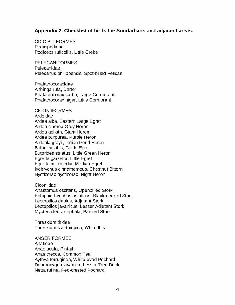
4
Appendix 2. Checklist of birds the Sundarbans and adjacent areas.
ODICIPITIFORMES Podicipedidae Podiceps ruficollis, Little Grebe PELECANIFORMES Pelecanidae Pelecanus philippensis, Spot-billed Pelican Phalacrocoracidae Anhinga rufa, Darter Phalacrocorax carbo, Large Cormorant Phalacrocorax niger, Little Cormorant CICONIIFORMES Ardeidae Ardea alba, Eastern Large Egret Ardea cinerea Grey Heron Ardea goliath, Giant Heron Ardea purpurea, Purple Heron Ardeola grayii, Indian Pond Heron Bulbulcus ibis, Cattle Egret Butorides striatus, Little Green Heron Egretta garzetta, Little Egret Egretta intermedia, Median Egret Ixobrychus cinnamomeus, Chestnut Bittern Nycticorax nycticorax, Night Heron Ciconiidae Anastomus oscitans, Openbilled Stork Ephippiorhynchus asiaticus, Black-necked Stork Leptoptilos dubius, Adjutant Stork Leptoptilos javanicus, Lesser Adjutant Stork Mycteria leucocephala, Painted Stork Threskiornithidae Threskiornis aethiopica, White Ibis ANSERIFORMES Anatidae Anas acuta, Pintail Anas crecca, Common Teal Aythya ferruginea, White-eyed Pochard Dendrocygna javanica, Lesser Tree Duck Netta rufina, Red-crested Pochard
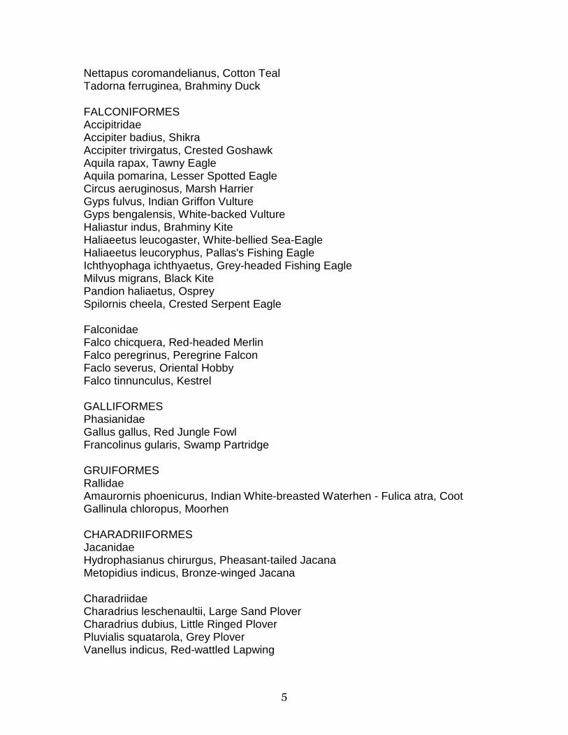
5
Nettapus coromandelianus, Cotton Teal Tadorna ferruginea, Brahminy Duck
FALCONIFORMES Accipitridae Accipiter badius, Shikra Accipiter trivirgatus, Crested Goshawk Aquila rapax, Tawny Eagle Aquila pomarina, Lesser Spotted Eagle Circus aeruginosus, Marsh Harrier Gyps fulvus, Indian Griffon Vulture Gyps bengalensis, White-backed Vulture Haliastur indus, Brahminy Kite Haliaeetus leucogaster, White-bellied Sea-Eagle Haliaeetus leucoryphus, Pallas's Fishing Eagle Ichthyophaga ichthyaetus, Grey-headed Fishing Eagle Milvus migrans, Black Kite Pandion haliaetus, Osprey Spilornis cheela, Crested Serpent Eagle Falconidae Falco chicquera, Red-headed Merlin Falco peregrinus, Peregrine Falcon Faclo severus, Oriental Hobby Falco tinnunculus, Kestrel GALLIFORMES Phasianidae Gallus gallus, Red Jungle Fowl Francolinus gularis, Swamp Partridge GRUIFORMES Rallidae Amaurornis phoenicurus, Indian White-breasted Waterhen - Fulica atra, Coot Gallinula chloropus, Moorhen CHARADRIIFORMES Jacanidae Hydrophasianus chirurgus, Pheasant-tailed Jacana Metopidius indicus, Bronze-winged Jacana Charadriidae Charadrius leschenaultii, Large Sand Plover Charadrius dubius, Little Ringed Plover Pluvialis squatarola, Grey Plover Vanellus indicus, Red-wattled Lapwing
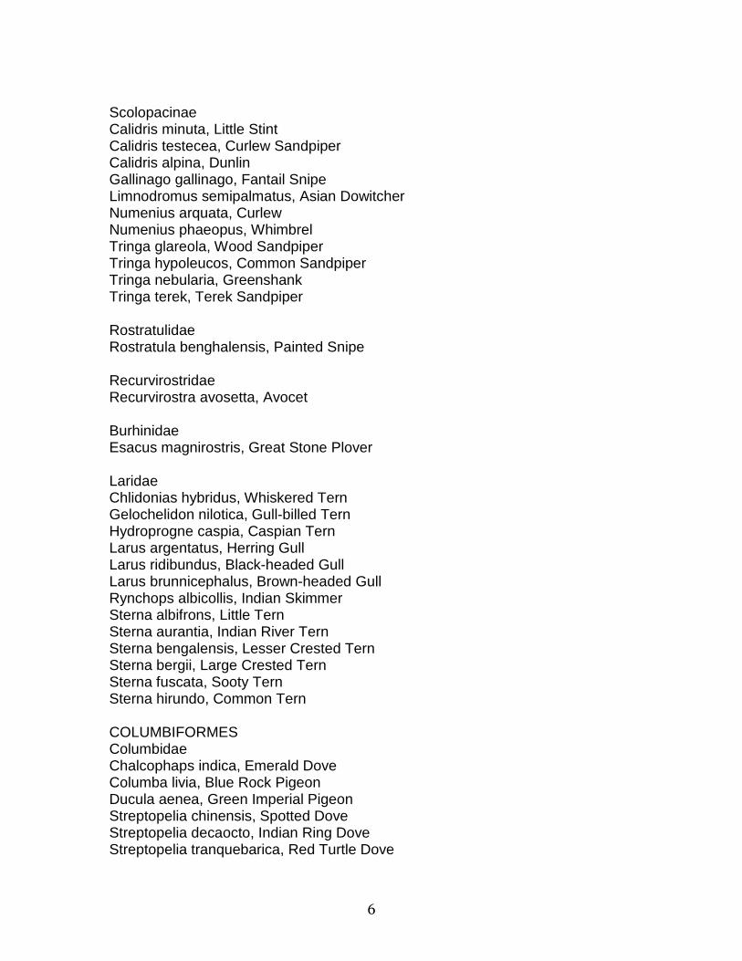
6
Scolopacinae Calidris minuta, Little Stint Calidris testecea, Curlew Sandpiper Calidris alpina, Dunlin Gallinago gallinago, Fantail Snipe Limnodromus semipalmatus, Asian Dowitcher Numenius arquata, Curlew Numenius phaeopus, Whimbrel Tringa glareola, Wood Sandpiper Tringa hypoleucos, Common Sandpiper Tringa nebularia, Greenshank Tringa terek, Terek Sandpiper Rostratulidae Rostratula benghalensis, Painted Snipe Recurvirostridae Recurvirostra avosetta, Avocet Burhinidae Esacus magnirostris, Great Stone Plover Laridae Chlidonias hybridus, Whiskered Tern Gelochelidon nilotica, Gull-billed Tern Hydroprogne caspia, Caspian Tern Larus argentatus, Herring Gull Larus ridibundus, Black-headed Gull Larus brunnicephalus, Brown-headed Gull Rynchops albicollis, Indian Skimmer Sterna albifrons, Little Tern Sterna aurantia, Indian River Tern Sterna bengalensis, Lesser Crested Tern Sterna bergii, Large Crested Tern Sterna fuscata, Sooty Tern Sterna hirundo, Common Tern COLUMBIFORMES Columbidae Chalcophaps indica, Emerald Dove Columba livia, Blue Rock Pigeon Ducula aenea, Green Imperial Pigeon Streptopelia chinensis, Spotted Dove Streptopelia decaocto, Indian Ring Dove Streptopelia tranquebarica, Red Turtle Dove
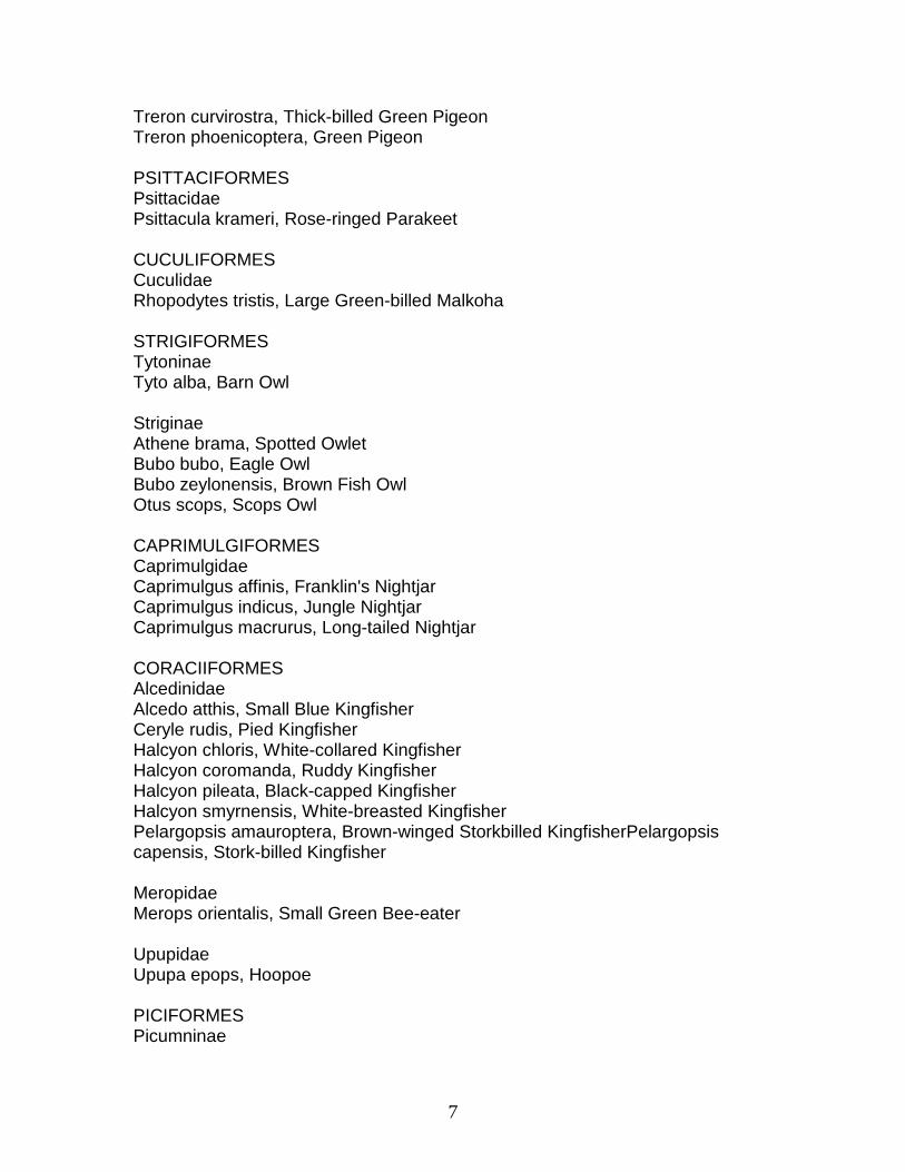
7
Treron curvirostra, Thick-billed Green Pigeon Treron phoenicoptera, Green Pigeon PSITTACIFORMES Psittacidae Psittacula krameri, Rose-ringed Parakeet CUCULIFORMES Cuculidae Rhopodytes tristis, Large Green-billed Malkoha STRIGIFORMES Tytoninae Tyto alba, Barn Owl Striginae Athene brama, Spotted Owlet Bubo bubo, Eagle Owl Bubo zeylonensis, Brown Fish Owl Otus scops, Scops Owl CAPRIMULGIFORMES Caprimulgidae Caprimulgus affinis, Franklin's Nightjar Caprimulgus indicus, Jungle Nightjar Caprimulgus macrurus, Long-tailed Nightjar CORACIIFORMES Alcedinidae Alcedo atthis, Small Blue Kingfisher Ceryle rudis, Pied Kingfisher Halcyon chloris, White-collared Kingfisher Halcyon coromanda, Ruddy Kingfisher Halcyon pileata, Black-capped Kingfisher Halcyon smyrnensis, White-breasted Kingfisher Pelargopsis amauroptera, Brown-winged Storkbilled KingfisherPelargopsis capensis, Stork-billed Kingfisher Meropidae Merops orientalis, Small Green Bee-eater Upupidae Upupa epops, Hoopoe PICIFORMES Picumninae

8
Picumnus innominatus, Specled Piculet* Picinae Chrysocolaptes lucidus, Larger Golden-backed WoodpeckerPicoides canicapillus, Brown-crowned Pygmy WoodpeckerPicoides macei, Pied Woodpecker* Picoides mahrattensis, Yellow-fronted Pied WoodpeckerPicus flavinucha, Yellow-naped Woodpecker PASSERIFORMES Hirundinidae Hirundo daurica, Red-rumped Swallow* Hirundo rustica, Swallow* Hirundo smithii, Wire-tailed Swallow* Riparia paludicola,Indian Grey-throated Sand Martin* Laniidae Lanius cristatus, Brown Shrike* Lanius schach, Black-headed Shrike* Lanius tephronotus, Grey-backed Shrike* Oriolidae Oriolus oriolus, Golden Oriole* Oriolus xanthornus, Black-headed Oriole* Dicruridae Dicrurus aeneus, Bronzed Drongo* Dicrurus adsimilis, Black Drongo* Dicrurus caerulescens, White-bellied Drongo* Dicrurus hottentottus, Hair-crested Drongo* Dicrurus leucophaeus, Indian Grey Drongo* Dicrurus paradiseus, Large Racket-tailed Drongo* Dicrurus remifer, Lesser Racket-tailed Drongo* Artamidae Artamus fuscus, Ashy Swallow Shrike Sturnidae Acrodotheres fuscus, Jungle Myna Acridotheres ginginianus, Black Myna Acridotheres tristis, Myna Aplonis panayensis, Glossy Starling Gracula religiosa, Hill Myna* Sturnus contra, Pied Myna Sturnus malabaricus, Chestnut-tailed Starling* Corvidae

9
Corvus macrorhynchos, Jungle Crow Corvus splendens, House Crow Dendrocitta vagabunda, Tree Pie Campephagidae Coracina melanoptera sykesi, Black-headed Cuckoo Shrike*Coracina melaschista, Dark Grey Cuckoo Shrike* Coracina novaehollandiae, Large Cuckoo Shrike* Pericrocotus cinnamomeus, Northern Small Minivet* Pericrocotus flammeus, Scarlet Minivet* Pericrocotus roseus, Rosy Minivet* Tephrodornis pondiceriana, Wood Shrike* Irenidae Aegethina tiphia, Common Iora* Pycnonotidae Pycnonotus cafer, Redvented Bulbul* Pycnonotus jocosus, Red-whiskered Bulbul Muscicapidae Timaliinae Macronous gularis, Yellow-breasted Babbler* Timalia pileata, Red-capped Babbler* Trichastoma abbotti, Abbott's Babbler* Turdoides striatus, Jungle Babbler* Muscicapinae Muscicapa latirostris, Brown Flycatcher* Muscicapa parva, Red-breasted Flycatcher* Muscicapa rubecoides, Blue-throated Flycatcher* Muscicapa sibirica, Sooty Flycatcher* Muscicapa thalassina, Verditer Flycatcher* Muscicapa westermanni,Little Flycatcher* Rhiphidura albicollis, White Spotted Fan-tail Flycatcher*Terpsiphone paradisi, Paradise Flycatcher* Monarchinae Monarcha azurea, Monarch Flycatcher* Sylviinae Acrocephalus agricola, Paddy-field Warbler* Acrocephalus dumetorum, Blyth's Reed Warbler* Acrocephalus stentoreus, Indian Great Reed Warbler* Chaetornis striatus, Bristled Grass-Warbler* Cisticola juncidis, Streaked Fantail-Warbler*
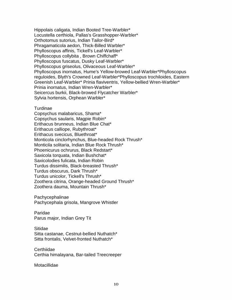
10
Hippolais caligata, Indian Booted Tree-Warbler* Locustella certhiola, Pallas's Grasshopper-Warbler* Orthotomus sutorius, Indian Tailor-Bird* Phragamaticola aedon, Thick-Billed Warbler* Phylloscopus affinis, Tickell's Leaf-Warbler* Phylloscopus collybita , Brown Chiffchaff* Phylloscopus fuscatus, Dusky Leaf-Warbler* Phylloscopus griseolus, Olivaceous Leaf-Warbler* Phylloscopus inornatus, Hume's Yellow-browed Leaf-Warbler*Phylloscopus reguloides, Blyth's Crowned Leaf-Warbler*Phylloscopus trochiloides, Eastern Greenish Leaf-Warbler* Prinia flaviventris, Yellow-bellied Wren-Warbler* Prinia inornatus, Indian Wren-Warbler* Seicercus burkii, Black-browed Flycatcher Warbler* Sylvia hortensis, Orphean Warbler* Turdinae Copsychus malabaricus, Shama* Copsychus saularis, Magpie Robin* Erithacus brunneus, Indian Blue Chat* Erithacus calliope, Rubythroat* Erithacus svecicus, Bluethroat* Monticola cinclorhynchus, Blue-headed Rock Thrush* Monticila solitaria, Indian Blue Rock Thrush* Phoenicurus ochrurus, Black Redstart* Saxicola torquata, Indian Bushchat* Saxicolodies fulicata, Indian Robin Turdus dissimilis, Black-breasted Thrush* Turdus obscurus, Dark Thrush* Turdus unicolor, Tickell's Thrush* Zoothera citrina, Orange-headed Ground Thrush* Zoothera dauma, Mountain Thrush* Pachycephalinae Pachycephala grisola, Mangrove Whistler Paridae Parus major, Indian Grey Tit Sitidae Sitta castanae, Cestnut-bellied Nuthatch* Sitta frontalis, Velvet-fronted Nuthatch* Certhiidae Certhia himalayana, Bar-tailed Treecreeper Motacillidae

11
Anthus hodgsoni, Indian Tree-Pipit* Anthus novaeseelandiae, Indian Pipit* Motacilla alba, White Wagtail* Motacilla caspica, Grey Wagtail* Motacilla citreola, Yellow-headed Wagtail* Motacilla flava, Yellow Wagtail* Motacilla indica, Forest Wagtail* Motacilla maderaspatensis, Large Pied Wagtail* Nectariniidae Nectarina asiatica, Purple Sunbird Ploceidae Passer domesticus, House Sparrow* Passer rutilans, Tree Sparrow Ploceus benghalensis, Black-throated Weaver-Bird* Ploceus manyar, Streaked Weaver-Bird* Ploceus philippinus, Baya Weaver* Estrilda amandava, Red Avadavat* Lonchura malabarica, White-throated Munia* Lonchura malacca, Black-headed Munia* Lonchura punctulata, Indian Spotted Munia* Fringillidae Carpodacus erythrinus, Common Rose-Finch* Emberizidae Emberiza fucata, Grey-headed Bunting* Emberiza schoeniclus, Reed-Bunting* ________________________________ Source: *Law (1953, 1954, 1956, 1959); Mukherjee (1975); Hendrichs (1975); Personal observations: April 1978 and March 1980. Nomenclature: Ali and Ripley (1983) Compiled with the assistance of J'Amy Allen

12
Appendix 3. Checklist of reptiles and amphibians in the Sundarbans and adjacent areas.
AMPHIBIA Bufonidae Bufo melanostictus, The common Indian toad Microhylidae Microhyla ornata, Narrow-mouthed frog Rhacophoridae Polypedates maculatus, Tree frog Ranidae Rana cyanophlyctis, Skipper frog Rana limnocharis, Indian cricket frog Rana tigerina, Asian bullfrog REPTILIA CROCODILIA Crocodilidae Crocodylus palustris, Mugger Crocodylus porosus, Salt water crocodile Gavialidae (E) Gavialis gangeticus, Gharial TESTUDINATA Chelidae Chelonia mydas, Atlantic green tutle Cheloniidae Eretmochelys imbricata, Hawksbill turtle Lepidochelys olivacea, Pacific Ridley turtle Emydidae Batagur baska, River terrapin Geoclemys hamiltoni, Black pond turtle Kachuga kachuga, Red-crowned roofed turtle Kachuga smithi, Brown roofed turtle Kachuga tentoria, Median roofed turtle Morenia petersi, Bengal terrapin Trionychidae
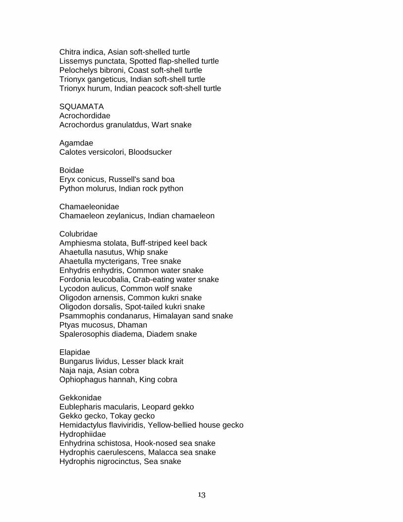
13
Chitra indica, Asian soft-shelled turtle Lissemys punctata, Spotted flap-shelled turtle Pelochelys bibroni, Coast soft-shell turtle Trionyx gangeticus, Indian soft-shell turtle Trionyx hurum, Indian peacock soft-shell turtle SQUAMATA Acrochordidae Acrochordus granulatdus, Wart snake Agamdae Calotes versicolori, Bloodsucker Boidae Eryx conicus, Russell's sand boa Python molurus, Indian rock python Chamaeleonidae Chamaeleon zeylanicus, Indian chamaeleon Colubridae Amphiesma stolata, Buff-striped keel back Ahaetulla nasutus, Whip snake Ahaetulla mycterigans, Tree snake Enhydris enhydris, Common water snake Fordonia leucobalia, Crab-eating water snake Lycodon aulicus, Common wolf snake Oligodon arnensis, Common kukri snake Oligodon dorsalis, Spot-tailed kukri snake Psammophis condanarus, Himalayan sand snake Ptyas mucosus, Dhaman Spalerosophis diadema, Diadem snake Elapidae Bungarus lividus, Lesser black krait Naja naja, Asian cobra Ophiophagus hannah, King cobra Gekkonidae Eublepharis macularis, Leopard gekko Gekko gecko, Tokay gecko Hemidactylus flaviviridis, Yellow-bellied house gecko Hydrophiidae Enhydrina schistosa, Hook-nosed sea snake Hydrophis caerulescens, Malacca sea snake Hydrophis nigrocinctus, Sea snake
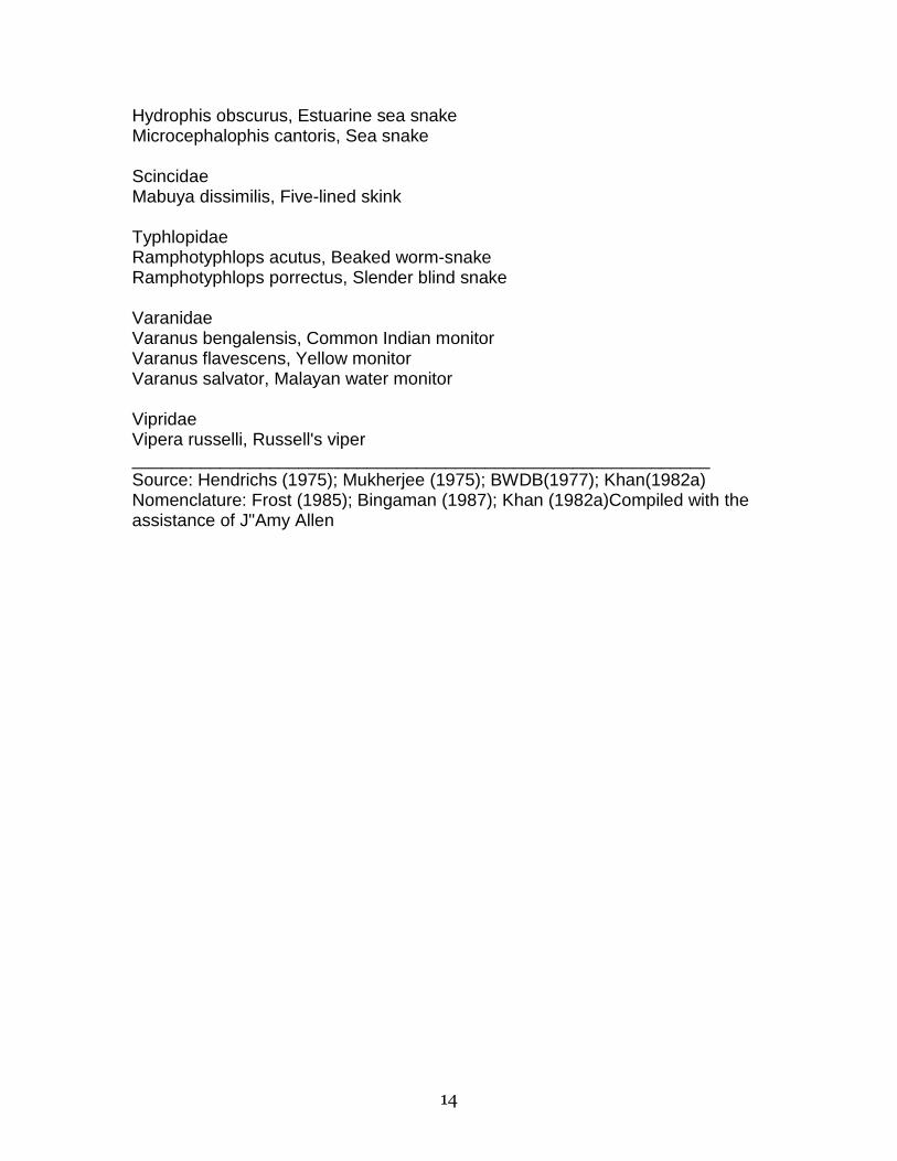
14
Hydrophis obscurus, Estuarine sea snake Microcephalophis cantoris, Sea snake Scincidae Mabuya dissimilis, Five-lined skink Typhlopidae Ramphotyphlops acutus, Beaked worm-snake Ramphotyphlops porrectus, Slender blind snake Varanidae Varanus bengalensis, Common Indian monitor Varanus flavescens, Yellow monitor Varanus salvator, Malayan water monitor Vipridae Vipera russelli, Russell's viper ___________________________________________________________ Source: Hendrichs (1975); Mukherjee (1975); BWDB(1977); Khan(1982a) Nomenclature: Frost (1985); Bingaman (1987); Khan (1982a)Compiled with the assistance of J"Amy Allen
15
Captions for Figures
Figure 1. Sundarban forest quality classes and land development units in the Southern Region of Bangladesh (from BWDB 1977). Figure 2. Some sand banks in the Sundarbans are used seasonnaly as bases for fishing in the Bay of Bengal and at the mouths of the big tidal rivers (Seidensticker: March, 1980). Figure 3. The Sundarbans Forest Division, Bangladesh. The stippled areas are designated sanctuaries. Figure 4. The northern edge of the Sundarbans Forest Division, Bangladesh (Seidensticker: March 1980).
16
The Role of Foreign Assistance and Commercial Interest in the Exploitation of the Sundarbans
Florence McCarthy
INTRODUCTION Commercial interests and foreign assistance constitute a significant set of parameters structuring resource use in Third World countries. These interests have both historical and present manifestations and operate to constrain the degree of freedom of Third World states in the delineation and implementation of development agendas. The confluence of external and internal interests results in contradictory pressures on the state and shapes and influences national priorities and objectives. Clearly, state interests often operate in opposition to those of the majority of its population, which has important consequences for forest policy, management, and use.
The purpose of this paper is to examine the contradictions posed by those sets of interests in the context of Bangladesh and in relation to the exploitation of the resources of the Sundarbans. Discussion will focus on the historical legacy delineating commercial and state interests in the utilization of natural resources and its consequences for user groups. Attention will also focus on the post-dependence period and an analysis of the contradictory effects of foreign assistance in establishing policies and programs for effective resource utilization and management. Particular consideration will be given to the dependency of Bangladesh on foreign assistance, the need to meet debt service liabilities, and the demand for local resource mobilization. A brief description of the current economic situation is included to provide a context for understanding the effects of foreign assistance on resource utilization and management.
HISTORICAL FACTORS SHAPING SCIENTIFIC FOREST MANAGEMENT Bangladesh shares with the majority of the subcontinent the colonial legacy of a particular framework for resource management and control regarding forests and forest products. This legacy involved the gradual development of a colonial policy that appropriated the pre-existing rights and access of local groups, dismantling what could be considered a system of common property arrangements for the utilization and management of natural resources.
As Guha (1985) notes, indigenous user groups had specific, well-defined rules, customs, and norms regulating the use of local forests, including rigorous sanctions for those violating established practices. Traditionally, the forest and its

17
products were used to supplement subsistence cultivation, to provide food, grazing land, fodder, medicines, wood and other resources to its inhabitants, and were often protected as holy places (Guha, 1985; Pandian, 1987).
The inducement of the British colonial administration to organize a forest department and generate proactive policies regarding forest use occurred in the late nineteenth century, when imperial interest in building railroads and increasing revenue sources became increasingly important. Subsequent policy explicitly embodied support for the development of commercial agricultural and forest-related enterprises. These policies embodied mutually exclusive approaches to forest resource management. On the one hand, policies were introduced that fostered commercial interests, including the systematic extraction of timber, the promotion of the propagation of commercially valuable trees, the leasing of deforested land to plantation growers--who cultivated tea and coffee in addition to trees--and the encouragement of the introduction of agricultural cultivators onto forest lands.
On the other hand, specific policies were promoted that curtailed traditional forms of peasant and tribal access and use, by prohibiting grazing of animals and requiring permits for cutting firewood or gathering forest products. Reforestation policies focused on a limited number of species and ignored broad-leaf plants or other tree species important to peasant or tribal subsistence. In general, "scientific forest management" juxtaposed a commercially oriented, monopurpose approach to forests, against the more varied and multipurpose use of forests by traditional users.
The consequences of these policies include ecological damage and the transformation of resource utilization patterns by both the Forest Department and traditional users. Two points are worth mentioning. First, the practice of scientific forest management is strongly influenced by the social and ecological setting in which it operates (Runge, 1986). As indicated, forest management came to embody the interest of the colonial administration in enhancing revenue and commercial enterprises.
What is also interesting is that Guha, Pandian, and others indicate that, in different parts of India, forest management strategies were modified in response to multiple forms of opposition to Forest Department policies from traditional users. As suggested by Guha (1985), Bromley (1986), and Sivanandan et al. (1986), traditional user groups did not passively acquiesce to changes in their access to and use of forest resources but were quite active in resisting, or responding to, such changes. Over time, the inability of the Forest Department to fully enforce its policy of curtailment of indigenous use caused it to accept and condone once-prohibited practices, such as encroachment, burning, lopping branches off trees, and grazing of animals. What this suggests is that scientific forest management, particularly as articulated in technical management strategies, is not an objective, value-free science but is shaped by and responsive to recurrent interaction with local conditions and users, as well as with macro-level commercial and state policies.
18
Second, changing practices and attitudes of local people to forest use must be understood in the context of their changing relationship to the forest as dictated by forest management policies. That is, curtailed access and limited utilization rights signified the alienation of indigenous users from traditional forms of forest utilization. The transformation of common property traditions, which included access to and use by right of birth or invitation, to state control or domination of resource rights significantly altered peasant and tribal perceptions of and use of forest resources. Paramount among these changes was the shift from communal to individualized forms of use, as encouraged by the permit system and by leasing rights and employment practices introduced by the Forest Department (Sivanandan et al., 1986).
Additionally, the appropriation of control over and disposition of forest land and resources by the state caused local people to fear state appropriation of any forest resources they tended or preserved. The loss of control and efficacy of local resource management further alienated traditional users and encouraged a destructive and individualized approach to the utilization of forest resources. In terms of Bangladesh and its forest policies, both points bear exploration in the determination of current user and state approaches to forest management and the utilization of forest resources.1
FOREIGN ASSISTANCE AND COMMERCIAL INTERESTS The exploitation of the resources in the Sundarbans is shaped by a current state requirement to meet foreign assistance needs and major donor demands and by the related need to increase local resource mobilization to meet foreign debt liabilities. Also relevant in understanding the exploitation of forest products are the policies regarding commercial resource extraction, which are critical in the generation of foreign exchange and the provision of forest products for the national economy.
It is important to note that the majority of commercial interests are likely to be Bangladeshi firms, many of which may be non-indigenous to the Sundarbans area. Their interest in forest products primarily concerns lumber for export and a wide range of commercial uses such as the harvesting of low-value trees for paper-manufacturing. The over-extraction of resources from forests and the role of local contractors in this process has long been noted and more recently has been described as reaching crisis proportions (Bari, 1978; Khan, 1987).
While the attempt has been made to control the commercial extraction of resources by licensing and permits, policy-making and implementing authority is divided between two separate ministries (Forestry and Finance), which often have different and conflicting policy objectives regarding forest resource use. For example, the Ministry of Agriculture and Forests may be encouraging reforestation and social forestry policies while the Ministry of Finance may advance policies that maximize resource mobilization and respond to pressures to create foreign exchange.

19
The policies of the state with regard to resource management and utilization are based upon the integration of need, conflict, and external pressures. In assessing the critical nature of these factors, it is important to note basic conditions of the Bangladesh political economy.
Bangladesh depends primarily on natural and agricultural resources such as jute, tea, fish, and shrimp for its export earnings, and depends on agriculture for the support of domestic production. Agriculture contributes approximately 51 percent to the national Gross Domestic Product (GDP), industries contribute about 9 percent, and other sectors account for approximately 40 percent (Third Five Year Plan, 1985).
Of the total contribution made by agriculture to the GDP, forest products accounted for about 5 percent at constant 1979 prices in 1981-82 (Statistical Yearbook, 1983). This percentage masks the wide variation in district-level contributions made from forest products. For example, forest products from the districts of Chittagong Hill Tracts and of Khulna contributed 68 percent, and 26 percent, respectively, to the total GDP of these districts in 1981-82 (Statistical Yearbook, 1983). Other districts that contain forest areas, Chittagong, Mymensingh, and Tangail, report contributions of forest products to district GDP of 7, 1, and 3 percent, respectively.
In terms of other national economic indicators that reflect conditions in the country and indicate policy constraints to government interests, the wholesale price index rose by 11 percent per year during the period 1980-85, while the consumer price index (CPI) rose disproportionately for rural versus urban populations (13 percent and 11 percent respectively per year). It also rose disproportionately for various socio-economic groups: 11.8 percent annually for Dhaka low-income families, 11.6 percent for the middle class, and only 8 percent for high-income groups (Third Five Year Plan, 1985).
Indicators of change in the CPI are the rising costs of essential commodities and their differential effect on various social classes. Ration rice rose in price some 564 percent between 1973 and 1985 (an increase in local prices from Tk 1.07 per kilo in 1973 to Tk 7.10 in 1985). The ration system operates under a controlled price system and mainly supplies the professional, military, and governmental sectors of the population. Kerosene prices rose from Tk 1.70 per gallon to Tk 32.78 during the same period, an increase of 1,828 percent. Costs of railway transportation rose from Tk 0.04 to Tk 0.18 per kilometer, which represents an increase of 350 percent (Third Five Year Plan, 1985).
These prices do not reflect proportionate amounts that the vast majority of the population pay for commodities. Kerosene, for instance, is generally used as fuel by the urban poor or low-income people, or used in peripheral towns. In contrast, natural gas (which only increased by 784 percent per metric cft.) is more likely to be utilized by the urban middle and upper classes. The increase in railway transportation charges, while apparently minimal, represents a higher proportionate cost for low-income as compared with high-income groups: the increase in roads and automobile transportation, and the extension of air service,

20
draws the patronage of higher income groups, leaving the railways to cater to lower income groups.
Unemployment in the rural areas is estimated at 25 percent, and landless households, including the functionally landless (holdings below 1.5 acres), are estimated to comprise two-thirds of all rural households. Food for Work programs generated approximately 1,149 million person-days of rural employment during the last plan period of 1980-85 (Third Five Year Plan, 1985). The implications of the above data suggest that disparities in resource access and control, income, and quality of life continue to increase and that little has been done to successfully ameliorate the conditions of poverty that affect so much of the country.
In terms of trade and debt service liability, the position of Bangladesh continues to worsen. The general world recession, falling prices, and increasing protectionism resulted in a situation--in 1979 to 1985--in which, despite lower imports, Bangladesh experienced a 34-percent decline in terms of trade, a loss of approximately one billion dollars (Third Five Year Plan, 1985). Lower world prices for agricultural commodities and natural fibers disrupted domestic markets and accounted for a significant fall in the value of export earnings. For example, in response to falling prices and crop failure, jute exports declined and, while reduced production increased domestic prices, depressed world prices limited export earnings and prevented jute manufacturers from passing along increased costs to external buyers. As a result, the jute industry lost an estimated $5.5 million dollars during this period (Third Five Year Plan, 1985).
The percent of total export earnings earmarked for debt liability rose from 13 percent in 1979-80 to 21 percent in 1984-85. This represented an increase from approximately $94 million to $196 million out of a total of $939 million in export earnings. Meeting debt service liabilities obviously limits the use of excess resources for other policy needs.
THE IMPACT OF FOREIGN ASSISTANCE Bangladesh receives approximately $1.2 billion dollars annually in foreign assistance. This assistance finances approximately 80 percent of the development budget, as well as supplementing the revenue budget (Sobhan, 1982). As an aid-dependent country, Bangladesh has little maneuverability or back-up resources upon which to rely if assistance levels are cut back or decline. This occurred in the early 1980s, when total aid allocations from major donors were reduced by 28 percent. While overall funds have increased, the amount of assistance in actual dollars remains at 1979-80 levels (Sobhan, 1982).
The composition of aid also affects the structure and direction of national development policies. During the plan period, for example, food aid declined from 31 to 19 percent and commodity aid registered only a modest increase of from 31 to 32 percent, while project assistance increased from 38 to 49 percent. The increase in project assistance indicates the penetration of donor interests into

21
grass-roots development activity, and this, along with the total volume of assistance, enables major donors such as the World Bank, USAID, and the IMF to "buy" or use assistance to leverage development policy or implementation strategies.
Examples of such influence are embodied in the privatization of agricultural and rural industrial technologies, inputs, and services, the promotion of domestic resource mobilization in the private sector, and the encouragement of local entrepreneurship. The privatization of agricultural inputs began in 1978 with the transfer of fertilizer and pesticide sales and distribution to private traders. In the new plan period, such activity will continue, and will be a critically important factor in technology transfer, and in increasing the productivity of agriculture (Third Five Year Plan, 1985).
The New Industrial Policy (NIP) declared in 1982 indicates the direction industrial development will take in Bangladesh, including forms of support for foreign export production, the private sector, and private domestic and foreign investment. Essentially, the NIP denationalized public-sector industries, created credit and tax incentives for industrial investment, established an Export Processing Enclave to attract foreign investment, and encouraged the development of private financial and banking facilities (Feldman, 1987).
During the Second Plan period, credit allocations to the private sector increased by 384 percent, while loan recovery rates by the two primary financial institutions servicing private investment (the Bangladesh Shilpa Bank and the Bangladesh Shilpa Rhin Sangstha) dropped to 5 percent and 10 percent respectively. The distribution of private investment found agriculture absorbing 36 percent of the total between 1980-85, physical planning and housing 18 percent, manufacturing, trade and other services receiving 16 percent, and transport absorbing 14 percent (Third Five Year Plan, 1985).
Other organizations involved in stimulating entrepreneurship and resource mobilization have been domestic- and foreign- sponsored non-governmental organizations (NGOs), such as the Grameen Bank, the Bangladesh Rural Development Committee (BRDC), and others, which have become increasingly involved in generating rural private entrepreneurship among program members. The Grameen Bank in particular has taken the lead in mobilizing rural resources by establishing widespread credit facilities for rural dwellers. In a move away from collective activity, many other NGOs are also emphasizing individualized credit, and various degrees of skills-training, marketing, and other services to qualified members (Feldman and McCarthy, 1984).
CURRENT DEVELOPMENT STRATEGIES AND CONSEQUENCES FOR FORESTRY What becomes clear from the above discussion is that potential areas of conflict exist between current development policies and resource management and utilization policies. Briefly, these are: 1) privatization of production and resource
22
exploitation in contrast to common property resource use; 2) the need to meet foreign exchange requirements versus resource conservation; and 3) commercial versus local user interests.
1) Privatization versus Common Property Resource Use At issue in the conflict between a focus on private resources versus one on common property are different resource management regimes and the effects of their implementation on different resource oases. Bromley (1986), for example, contends that a common property regime is a user management scheme where group interests transcend individual interests. In this context, access to and utilization of a common resource is framed within established rules and regulations developed by a primary decision-making group as constituted from the total pool of users. Growing out of the deliberations of such groups are definitions of membership, sanctions, and individual rights and responsibilities. The utilization of resources is premised on long-term access to such resources, and hence includes preservation and conservation as well as use in defining parameters of appropriate activity. The range of decisions to be made about resource utilization also includes the option of planned exhaustion or transformation of resources.
Alternatively, private property regimes assume that the regulation of users is not a collective interest. Rather, it is assumed that the activities of atomistic entrepreneurs constitutes the public good (Bromley, 1986). Privatized production, as it is being promoted in Bangladesh, encourages individualized decision-making and atomistic productive activity. Rules and regulations limiting activity are embedded in generally weak administrative and legal institutions, and hence the opportunity to over-exploit resources is fairly easy and goes largely unchecked. With weak regulatory systems, it is also possible for Forest Department officials to become involved in the systematic misuse of forest resources. All indications are that this is a serious problem.
Efforts to create alternatives to individualized production have been largely unsuccessful, and cooperative systems that have operated have been thwarted in their operations by individuals who join cooperative groups as a means of gaining access to scarce resources such as credit, training, or production inputs. An original objective of the cooperatives was to serve as a conduit through which production resources would be channeled to rural producers. Cooperatives have been significantly weakened with the privatization of input delivery systems.
Additionally, the impact of national strategies to increase overall production encourages an emphasis on yield, price, over-production, the misuse of inputs, and a short-term assessment of advantage that, in the long term, may be detrimental to the viability of a diverse set of resources. Estimates of annual deforestation rates, for instance, are 8,000 hectares, or 2,667 acres, which represents 0.86 percent of the total area under tree formations (Khan, 1987). While these rates are not abnormally high, they are not paralleled by similar rates of reforestation or generation of new forest resources.
2) The Demand for Foreign Exchange versus an Emphasis on Sustainable Resources Much of the driving force behind current development policy arises

23
from the need to generate foreign exchange. This is crucial to maintaining a good credit rating with international monetary sources, garnering foreign investment and assistance, and combatting the ever-present stereotype of Bangladesh as a "basket case." The effect of these pressures is an increasingly competitive economic environment, which the government encourages but only minimally regulates and controls.
In terms of the government's approach to the exploitation of forest resources such as those of the Sundarbans, the pressure to generate exports together with the knowledge of the value of timber and other forest resources, encourages their over-exploitation. Additionally, the colonial legacy ever-present in the Forest Department inseparably combines commercial concerns with scientific silviculture. Hence, at the level of policy formation and implementation, commercial interests are promoted and protected.
Another consideration regarding the conflict between foreign exchange demands and sustainable forest resources is the heterogeneity represented in forest policy. This is seen particularly in the different approach being taken to the exploitation of the Chittagong Hill Tracts (CHT) vis-a-vis the Sundarbans and other state-owned forests. These latter are consistently referred to as over-exploited, while the Hill Tracts are generally referred to as under-exploited. Policies of afforestation and reforestation are developed for the former areas, while the solution to the situation in the Hill Tracts is seen to be the introduction and expansion of mechanical extraction and processing (Third Five Year Plan, IX-61, 1985).
The policy with respect to the Chittagong Hill Tracts reflects the government's ongoing interest in wresting control of the area from the tribal people who have traditionally dominated it. The attempt to incorporate the CHT into general development policies and to open it to settlement and exploitation began with Zia Rahman in the late 1970s. In response to government incursions, tribal people have defended themselves with armed force, and a general state of open conflict exists. Therefore, one must interpret the government's interest in mechanizing the extractive processes in the CHT in the light of its immediate interest in dominating the area.
Also implied in the government's policy is that the CHT has been selected as a test case for the introduction of mechanical processing techniques that, if successful, could be applied to other places. Even if not explicitly the design of the government, one can envision the pressure that will develop among commercial interests to use a successful extractive technique in other sites if it is proven to be commercially viable in the CHT. The question as to the ecological consequences of using such techniques, and that of the probable over-exploitation of the CHT, is nowhere addressed.
The competitive interest in maximizing returns, and limitations in the regulation and supervision by the Forest Department of extractive operations, contribute to systematic violation of extractive contracts and agreements. A critical question to be explored is the extent to which such practices have become institutionalized.
24
Such information is important in ascertaining actual use rates and in predicting accurate estimates of forest resources. Both are essential in creating forest policy grounded in fact rather than in estimates.
Additionally problematic is the fact that inherent in government policy are mutually contradictory interests within the forestry sector and among other sectors as well. Within the forestry sector, for instance, one objective of the Third Five Year Plan is to meet the commercial demand for pulp- and paper- manufacturing as well as the people's fuel requirements without upsetting the forest ecology. This policy objective ignores the contradictions posed by an emphasis on both commercially valuable species and on those that meet the subsistence and productive needs of local users.
Among sectors, the framework for policy is the stated aim of government to generate employment by increasing the productivity and output of the rural-industries sector. Technology transfer and mechanization are projected as the means by which this is to occur. This may contradict the interests of the forestry sector, since little mention is made of the effects of increased energy use on available energy resources. The Third Five Year Plan refers to the need for increased electrification to meet this demand, but rising costs of electricity and its current limited availability generate skepticism as to the realistic nature of the assumption that electric power will provide for increased energy use, should rural-based industries expand.
Warranting some consideration as well are rural producers in cottage- and home-based industries, and their response to efforts to increase production. To the extent the Bangladesh Small and Cottage Industries Corporation (BSCIC), as well as NGOs, provide credit and assistance to this segment of the rural-industries sector, demands for local energy resources will increase and will most likely be met by natural fuel sources. The consequences of increased energy demand may be a ripple effect increasing pressure on local resources as well as on commercial enterprises to meet demand by increased extraction from forest areas.
3) Commercial Interests versus Local User Interests A third area of conflict is posed by commercial versus local user interests in relation to the government's approach to developing sustainable forest resources in state-owned forests. The approach followed since Independence has been the introduction predominantly of timber plantations of long- and short-term species. The Third Plan period proposes the planting of 85,000 acres of plantations in exploited forests, including areas where past plantations have failed--estimated to be about 60 percent of the roughly 165,000 acres that have already been planted (Third Five Year Plan, 1985). An additional 261,000 acres of plantations are expected to be established in unclassified forest areas, including newly accreted lands in the coastal areas. Some 70,000 acres of established plantations in the coastal afforestation program will also be maintained.
Non-timber plantations of rubber, bamboo, oil palm, and cane will also be increased. Rubber, for example, will be increased from 23,000 to 60,000 acres,

25
with approximately one-third private, two-thirds public, ownership. Plantations in other crops will be expanded only if feasible (oil palm), and as propagation techniques are developed (cane and bamboo)--Third Five Year Plan, IX-63, 1985.
In the plantation system the government/Forest Department act as landlords, controlling production decisions, determining who has access to the plantations, and hiring local people as wage labor to cultivate and care for the trees. At one level, the question of who the laborers are is important. Are they recent settlers or cultivators, who may not be conversant with the care and tending of forest products? Are they traditional users, who in the present system sell their skills and remain excluded from control of the productive process? Either answer is likely to present problems of supervision and control: the former because migrant wage laborers may be ignorant of tree cultivation, and of the care and tending of forest products; the latter because their new situation reinforces rather than mitigates their alienation from traditional use of the forests.
The larger and more significant problem facing forest management resides in the nature of plantation agriculture itself. As Murti (1986) and Sivanandan et al. (1986) argue for India, the creation of plantations has considerable consequences for local ecosystems as well as social systems. Plantation systems often promote large-scale, monocrop commercial enterprises under the control of absentee landlords or government supervisors, rather than the leasing of manageable tracts of exploited forest area to be controlled in a long-term arrangement with traditional users. In areas close to crop cultivation, small-scale farmers could be encouraged to develop or integrate diversified crop production with horticulture, homestead forestry, and livestock-rearing.
Plantation cultivation causes changes in local ecosystems, as exemplified in the demands made for water, and in the clearing and leveling of land, the application of fertilizers and pesticides, and the possible increase of pests and disease. Plantation cultivation also transforms small producers into wage laborers, and generally only provides employment at minimal wages. For this group of laborers security from exploitation is not ensured, nor are benefits such as health care and job security provided.
For traditional forest users, employment on plantations and limited access and extractive rights do not resolve their alienation from or loss of productive control over forest areas. It has been noted that gaining widespread support for government programs from local people depends on granting them long-term tenure on the land and control of the products involved (Khan, 1987). This is indicative of the overwhelming interest of people in controlling their own productive activity, and indicates as well that the transfer of resource control to users must be incorporated in any resource policy that is likely to succeed.
26
CONCLUSION This paper has provided a context for understanding the nature and extent of pressures generated by foreign assistance and the need to meet debt service liabilities on government policies regarding the exploitation of natural resources, such as those of the Sundarbans. Internal pressures from commercial interests and the need to mobilize and promote domestic resource mobilization also encourage forms of economic development that generate contradictory policies toward resource management and control. The limited funds for afforestation and reforestation efforts, as well as a reluctance to provide local users with secure rights and productive control of forest resources, also hinder the development of viable forest policy for the Sundarbans.
Areas requiring investigation of the issues raised above are:
(1) The consequences of contradictory governmental and ministerial policies on forest resource extraction and use, including increased emphasis on rural-based industries, homestead and cottage production, and non-agricultural income-earning activities among rural dwellers;
(2) The nature and extent of institutionalized patterns of resource abuse by commercial and private interests in the Sundarbans, including the effects of weak administrative and enforcement operations;
(3) An evaluation and assessment of the expansion and success of government and NGO reforestation and afforestation projects; and
(4) An assessment of economic needs and interests of forest users, including their perceptions of rights and entitlements to forest products, and suggestions for equitable access to and use of the forests.
REFERENCES Bari, K.G.M. Latiful, ed. Bangladesh District Gazetteer, Khulna. Dacca: Establishment Division, Government of the People's Republic of Bangladesh, 1978.
Bromley, Daniel W.. "Closing Comments at the Conference on Common Property Resource Management," in Proceedings of the Conference on Common Property Resource Management, National Research Council, Washington, D. C.: National Academy Press, 1986, pp. 591-596.
Feldman, Shelley. "Human Rights and the New Industrial Working Class in Bangladesh," conference paper, Human Rights in the Indian Subcontinent, SUNY, Buffalo, March, 1987.
Feldman, Shelley and Florence E. McCarthy. Rural Women and Development in Bangladesh: Selected Issues, Oslo: Norwegian Agency for International Assistance, 1984.
27
Guha, Ramchandra. "How Social is Social Forestry?", Economic and Political Weekly, Vol. XX, No. 14, April 6, 1985a, pp. 587-88.
Guha, Ramchandra. "Scientific Forestry and Social Change in Uttarakhand," Economic and Political Weekly, Vol. XX, Nos. 45, 46 & 47, Special Number, 1985b, pp. 1939-49.
Khan, Asmeen, M. Personal interview: An Assessment of Forest Policy and Practices in Bangladesh, Dhaka: The Ford Foundation, 1987.
Murti, B. V. Krishna. "Supplanting Peasant Agriculture with Plantation Economy," Economic and Political Weekly, Vol. XXI, No. 13, March, 1986, pp. 525-28.
Noorani, A.G. "Rights of Forest Dwellers," Economic and Political Weekly, Vol. XXII, No. 7, February, 1987, pp. 260-61.
Ostrom, Elinor. "Issues of Definition and Theory: Some Conclusions and Hypotheses," in Proceedings of the Conference on Common Property Resource Management, National Research Council, Washington, D. C.: National Academy Press, 1986, pp. 599-616.
Pandian, M.S.S. "Peasant, Natural Resource Use and State Intervention in Nanchalnadu, 1850-1940," Economic and Political Weekly, Vol. XXII, No. 26, June 27, 1987, pp. 1032-1036.
Runge, C. Ford. "Common Property and Collective Action in Economic Development," in Proceedings of the Conference on Common Property Resource Management, National Research Council, Washington, D. C.: National Academy Press, 1986, pp. 31-60.
Salem, B. Ben and Tran van Nao. Paper, UN Conference on New and Renewable Sources of Energy, Nairobi, August, 1981.
Shingi, Prakash M., M. S. Patel, and Sanjay Wadwalkar. Development of Social Forestry in India, New Delhi: Oxford & IBH Publishing Co., 1986.
Sivanandan, P. D. Narayana and K. Narayanan Nair. "Land Hunger and Deforestation: Case Study of Cardamon Hills in Kerala," Economic and Political Weekly, Vol. XXI, No. 13, March 29, 1986, pp. 546-550.
Sobhan, Rehman. The Crisis of External Dependence: The Political Economy of Foreign Aid to Bangladesh, Dhaka: University Press Limited, 1982. Statistical Yearbook, 1982, Government of the People's Republic of Bangladesh, Bangladesh Bureau of Statistics, Dhaka, Bangladesh, 1983. Third Five Year Plan, 1985-1990, Government of the People's Republic of Bangladesh, Planning Commission, Ministry of Planning, Dhaka, Bangladesh, 1985.
NOTE
1. Changing production demands, demographic pressure, and the differentiation and development of rural-based industries also significantly shape and influence the beliefs and practices of peasants regarding forest resources. These issues

28
have been addressed in companion articles in this volume (see Feldman and Bhattacharayya).
29
Part V: Control – Real (Estate), Material, and Ideational

30
Long-Term Transformations in the Sundarbans Wetlands Forests of Bengal
John F. Richards and Elizabeth P. Flint
The tidal forest and nature reserve known as the Sundarbans constitutes one of the principal forest areas for both Bangladesh and the State of West Bengal in India. These wetlands forests are protected in each country by national forestry legislation and by the active management of foresters and wildlife specialists. The Sundarbans today comprise approximately 10,000 sq km of mangrove forest and intricate water channels fringing the river deltas at the head of the Bay of Bengal. Remaining wetlands left untransformed are probably less than half of the area intact in the late eighteenth century.1
Since the 1790s, the state, landlord, and cultivator, acting in concert, have pushed the clearing and settlement frontier deeper into the watery reaches of the Sundarbans. Colonial and post-independence economic policies reinforced the urge of the land-hungry to wrest their own agricultural holdings from what was perceived as a hostile wilderness. In their view, a land "covered over with impenetrable forests, the hideous den of all descriptions of beasts and reptiles"2 could only be improved by deforestation.
Contrary to stereotypes of the "traditional" Bengali peasantry mired in lassitude, scarcity, and poverty, settlers in the Sundarbans did not hesitate to seize the opportunities presented by the opening of this frontier. Two hundred years of human labor were expended to clear forests, construct river embankments, and polder wetlands. Great tracts of tidal forest were converted to a landscape dominated by wet rice fields, with a network of linear settlements running along levees and elevated river banks. Nevertheless, a significant remnant of tidal forest survived the surge of settlers and entrepreneurs engaged in land clearance, water control, and commodity production. It was the institutionalization of a countervailing trend toward preservation and conservation of forest resources that prevented complete obliteration of the Sundarbans wetlands. Today's landscape, society, and economy are the end product of a massive transformation in the land--not an age-old, unchanging artifact.3
RECLAMATION AND THE COLONIAL STATE
Frontier expansion into the Delta's wetlands accelerated under British colonial rule in the second half of the eighteenth century. After its coup at Plassey in 1757 and decisive military victory at Buxar in 1764, the East India Company acquired unchallenged domination over Mughal Bengal. Peace, new internal and external markets, and government policies encouraged steady, long-term economic

31
expansion in northeastern India. In Bengal, rising production of cash crops rested upon intensive exploitation of the soil, forests and wildlife of the Delta.
The new East India Company regime granted tenures for reclaiming waste land to Bengali applicants as early as 1770.4 Tilman Henckell, the judge Magistrate of Jessore district, started a systematic reclamation program rewarding peasant settlement with land ownership eleven years later.5 These settlers, mostly migrants from other Bengal districts,6 deforested the land, constructed embankments, and then planted rice in the alluvial soils when monsoon rains reduced their salinity.7 Settlers grew limited quantities of vegetables for personal use and planted fruits such as coconut, arecanut, date, mango, and jackfruit on raised plots or the bunds protecting their homesteads. But their dominant crop was aman rice (sown in May or June, transplanted between mid-July and mid-September, and harvested in December or January).8 Ancillary to the embanking and bunding required for wet rice cultivation, settlers refined techniques for highly-productive aquaculture. Several species of fish and several types of prawns could be grown in flooded rice fields. Other bunded areas, still brackish, could be used for annual trapping and harvesting of numerous species of river fish.9 Accessible tidal forest considered unsuitable for conversion to wet rice fields was systematically stripped of building timber, fuelwood, and thatching grass to meet the demands of a growing population.
After nearly four decades of public debate and administrative experimentation, the East India Company administration of Governor-General Cornwallis promulgated legislation to stabilize governmental revenues and land ownership in Bengal. Under the Permanent Settlement of 1793, the East India Company stipulated the taxes to be paid in perpetuity on landed property by a small group of large land-holders (known as zamindars). So long as these landlords paid their taxes promptly they held complete ownership rights of alienation, mortgage, lease and inheritance over their estates. If they did not pay the land revenue their lands would be sold by the state to another purchaser. The tax burden on those estates, fixed at a total of 26.8 million silver rupees, would never be altered. By this means the East India Company hoped to create a stable, conservative class of improving Bengali landlords in the countryside. The Permanent Settlement did succeed in creating the property rights and tax policy desirable for expansion of production--especially by bringing new lands under cultivation for cash crops.10
The Permanent Settlement did not resolve the status of those extensive "waste" lands or jungles which, in eighteenth century Bengal, were not as yet cleared or cultivated. Thus, the estates recognized in that settlement bordered, but did not extend into, the interior of the great Sundarbans deltaic forests of Bengal. As the administrative chronicler Frederick Pargiter summarized the early history of this frontier:11
The zamindaris that bordered on the Sundarban forest had no constant boundaries on that side, but cultivation advanced and receded according to the general circumstances of the country and the capabilities of the landowners. The forest was the property of the State and was not included in the Permanent Settlement; but its extent could not be defined during the early period, while the
32
southern boundaries of the zamindaris were undetermined, and it was not until the year [1828] that the claims which the zamindars asserted to the forest were decided and the confusion dissipated. In these early years salt-makers on the coastal Islands co-existed with bandits, pirates, and smugglers who made effective use of the intricate waterways of the region. The Bengal government wished to suppress these illegal activities and to assert the State's ownership claim for the Sundarbans.
Landlords were encouraged by rising prices and demand for rice to employ laborers and tenants to drain, cut, embank, and cultivate Sundarbans wetlands. In this period reclamation went on virtually independent of government control or even knowledge. Delta landlords were increasingly extending cultivation beyond their estate boundaries into the forest and claiming these extensions as legitimate parts of their holding defined by the 1793 Permanent Settlement. The reclaimed lands were therefore free of additional tax burden. At intervals revenue officers tried to "resume" these estates by surveying, recording, and taxing reclaimed lands. Landlords and their subleasing tenants resorted to obfuscation, bribery, coercion, and legal action to avoid taxation of their expanded domains.
To achieve better control over the reclamation process, the Bengal Government, under Regulation IX of 1816, appointed a special Commissioner of the Sundarbans whose primary task was to administer the process of land reclamation. The first Commissioner, D. Scott, was charged with surveying reclaimed lands, assessing and collecting revenues, and receiving and adjudicating claims to land made by local zamindars. A continuing torrent of legal challenges to the government's right to collect revenues on these newly settled lands (alluding to the restrictions of the Permanent Settlement) or to claim the Forest as public land led to a firm assertion of that right under Regulation XXIII of 1817. This statute maintained the Government's "inherent title" to a share of the produce of all lands cultivated in the Sundarbans on the ground that these tracts were waste in 1793 and thereby not included in the Permanent Settlement.12 The 1817 statute was amplified and restated in 1819. However, despite their definitive tone, these measures did not end the controversy. Only a painfully detailed scrutiny of all such claims coupled with a careful survey of the entire area would lay these matters to rest. Over the ensuing nine years the Commissioner of the Sundarbans and his staff surveyed and assessed those cultivated lands, primarily in Twenty-four Parganas District, which had encroached upon the Sundarbans forest. The State did not aim to expropriate these lands but simply to bring them on the land revenue rolls.
The earlier regulations had not addressed the question of ownership of public lands. Many land-holders persisted in advancing claims for vast areas of land extending far into the Sundarbans on the basis of their ancient rights. To meet this challenge the Government finally issued a definitive statute. Regulation III of 1828 proclaimed that the Sundarbans were the property of the State and had in no way been alienated to landholders.13 At this juncture, the Bengal Government had finally opened the way to unchallenged management of the Sundarbans as a public resource.

33
The last remaining step was completion of the unfinished survey of the Sundarbans boundary from the Hughli River to the Meghna. The government decided to establish the boundary at the break between cultivation and the forest as of the current date. In the east, Prinsep had fixed this line when he surveyed in the early 1820s; in the west, the line would be that of the forest-field interface as of 1828. When completed in 1830 by a public process of demarcation, the boundary was mapped and recorded on the revenue records.14
Prior to 1830, private entrepreneurs, pressing ahead with little governmental encouragement, had already converted large tracts of forest to agricultural land. In the four decades since the Permanent Settlement, Bengali zamindars had organized and financed their laborers and tenant cultivators to reclaim an estimated 790 sq km of the original Sundarbans forest.15 The following description of the Sundarbans by an 1827 visitor bears testimony to the success of their efforts:
I know not upon what authority it is affirmed, that if any attempts have been made to clear away these jungles, they have hitherto miscarried. Any one may satisfy himself as to the truth of the contrary by paying a visit to them....Within a few years considerable portions of them have been removed and both populated and cultivated. This is often not visible, owing to the line of trees left on the skirts...but I have been sometimes agreeably surprised when either by mistake or design I have taken a new channel. I have found, what I little expected, large tracts of land with flourishing paddy plants on them....It is pleasing to reflect that what was once only a den of wild beasts is now made to yield to not a few their 'daily bread,'....16
To both colonizer and colonized, the true measure of "progress" is suggested in the above passage. After 1830, the colonial state was determined to foster and direct settlement of this vast natural resource in order to increase agricultural production and government revenues. The possibility of added land revenues from reclaimed lands became more attractive as the fiscal constraints placed on the Bengal Government by the Permanent Settlement grew more painful.
Over the next century, colonial policies in regard to Sundarbans reclamation moved through several phases. At each phase the Bengal government become more aggressive and interventionist. In the course of this period the official policy gradually turned away from bestowing huge land grants on speculative entrepreneurs, favoring smaller grants to less wealthy applicants who would actually manage or even cultivate the lands themselves. These changes partly reflected wider currents in official policy and ideology; partly the increasing cost and difficulty of reclaiming remote Sundarbans tracts.
In 1829 the Bengal Government set out terms for grants to be opened in the newly demarcated Sundarbans forests. Large grants, free of any revenue demands for twenty years, were made available to individuals who had the means to carry out reclamation. One-fourth of the lands granted had to be cleared and under cultivation within five years. At the expiration of the twenty year period, three-quarters of the land became liable for land revenue at
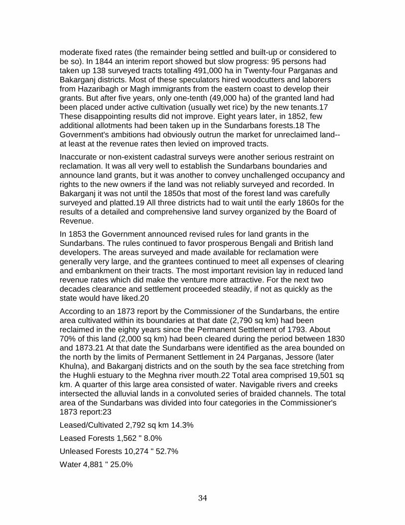
34
moderate fixed rates (the remainder being settled and built-up or considered to be so). In 1844 an interim report showed but slow progress: 95 persons had taken up 138 surveyed tracts totalling 491,000 ha in Twenty-four Parganas and Bakarganj districts. Most of these speculators hired woodcutters and laborers from Hazaribagh or Magh immigrants from the eastern coast to develop their grants. But after five years, only one-tenth (49,000 ha) of the granted land had been placed under active cultivation (usually wet rice) by the new tenants.17 These disappointing results did not improve. Eight years later, in 1852, few additional allotments had been taken up in the Sundarbans forests.18 The Government's ambitions had obviously outrun the market for unreclaimed land--at least at the revenue rates then levied on improved tracts.
Inaccurate or non-existent cadastral surveys were another serious restraint on reclamation. It was all very well to establish the Sundarbans boundaries and announce land grants, but it was another to convey unchallenged occupancy and rights to the new owners if the land was not reliably surveyed and recorded. In Bakarganj it was not until the 1850s that most of the forest land was carefully surveyed and platted.19 All three districts had to wait until the early 1860s for the results of a detailed and comprehensive land survey organized by the Board of Revenue.
In 1853 the Government announced revised rules for land grants in the Sundarbans. The rules continued to favor prosperous Bengali and British land developers. The areas surveyed and made available for reclamation were generally very large, and the grantees continued to meet all expenses of clearing and embankment on their tracts. The most important revision lay in reduced land revenue rates which did make the venture more attractive. For the next two decades clearance and settlement proceeded steadily, if not as quickly as the state would have liked.20
According to an 1873 report by the Commissioner of the Sundarbans, the entire area cultivated within its boundaries at that date (2,790 sq km) had been reclaimed in the eighty years since the Permanent Settlement of 1793. About 70% of this land (2,000 sq km) had been cleared during the period between 1830 and 1873.21 At that date the Sundarbans were identified as the area bounded on the north by the limits of Permanent Settlement in 24 Parganas, Jessore (later Khulna), and Bakarganj districts and on the south by the sea face stretching from the Hughli estuary to the Meghna river mouth.22 Total area comprised 19,501 sq km. A quarter of this large area consisted of water. Navigable rivers and creeks intersected the alluvial lands in a convoluted series of braided channels. The total area of the Sundarbans was divided into four categories in the Commissioner's 1873 report:23
Leased/Cultivated 2,792 sq km 14.3%
Leased Forests 1,562 " 8.0%
Unleased Forests 10,274 " 52.7%
Water 4,881 " 25.0%

35
Total Area 19,508 " 100.0%
The first century of British colonial rule in lower Bengal had but a minimal impact on the delta. Only fourteen percent of the total area was cleared and cultivated. Nearly twelve thousand square kilometers of forested wetlands remained. Actual cultivation always lagged behind the area taken up by leases given as grants. Relying upon large estate owners to clear and settle land may have reduced the costs of administration by the state, but the policy had undesirable consequences for a colonial regime increasingly convinced that its future lay with the sturdy peasant-farmer. As of 1873, outstanding leases for land reclamation totalled 4,355 sq km or 22% of the entire Sundarbans. Of this total 2,792 sq km were reclaimed, and 1,562 sq km lay in forest still awaiting clearing and cultivation.24
By the 1870s, the colonial state was anxious to pick up the pace of settlement. New revenues were needed. Moreover, the sight of potentially fertile land lying wild and idle was an affront to the progressive-minded revenue officers of the Bengal Civil Service. More complete cadastral surveys, carried out in the previous decades, offered both Government and potential landlord exact information as to the land available. Finally, in 1879, the Government of Bengal promulgated new waste land rules aimed at the Sundarbans:25
[B]locks of 200 acres or more [are] leased for forty years to large capitalists who are prepared to spend time and money in developing them; and plots not exceeding 200 acres leased to small capitalists for clearance by cultivators. Under these rules one-fourth of the entire area leased was held free of assessment for ten years. On the expiry of the term of the original lease, the lot was open to resettlement [reassessment] for a period of thirty years. It was stipulated that one-eighth of the entire grant should be rendered fit for cultivation at the end of the fifth year, and this condition was enforced either by forfeiture of the grant or by the issue of a fresh lease at enhanced rates.
These regulations opened up the Sundarbans for direct land claims by wealthier peasant farmers. Larger speculators and smaller men were both offered long-term forty-year leases. If rules for reclamation were met these leases could be renewed at thirty year intervals. Subject to payment of the assessed land tax, rights to leased lands were heritable and transferable. The government charged a nominal survey and registration fee (four annas on the acre) and made no charge for wood or timber. A duty was levied if any were exported for sale.26
Between 1873 (the date of the Sundarbans Commissioner's report) and 1904, a new spurt of clearing and settlement ensued. As cultivation proceeded, those responsible for official terminology reduced the area classified as "Sundarbans," as a measure of progress. The officially recognized area of the Sundarbans diminished by 2,608 sq km (13.3%), from 19,510 in 1873 to 16,902 sq km in 1904.27 This shrinkage reflected successful conversion of wetlands to cultivation and settlement in the area declassified. In the same year, 2,401 sq km of reclaimed cultivated land area within the Sundarbans was recorded. The latter represented new lands leased, cleared and cultivated over the ensuing three decades.

36
These figures conceal a counter-process of failure and land abandonment. Grantees beset by financial problems threw up their leases; cultivators unable to sustain their lands left in discouragement. Every year revenue officials began legal action to rescind grants whose holders had failed to clear and cultivate successfully in the required proportions. The 1876 cyclone and storm wave with its enormous destruction and loss of life killed off or discouraged many peasant farmers and grant holders. Nevertheless, new grantees pressed the arc of cleared land, and wet rice production moved inexorably outward. Despite setbacks, the agricultural economy of lower Bengal displayed remarkable strength and resilience in this period.28
Notwithstanding the advances under the 1879 rules, many British officers were dissatisfied with what they perceived to be the sluggish rate at which waste land was transformed to cropland. They were also displeased by the beneficiaries of that clearance--that is the middling level landlords who were seen as parasitic speculators. Certainly these new entrepreneurs were preferable to the older, large, absentee speculators, but these officers would have preferred to reward industrious peasants. The speculative land rush that followed the 1879 rules retained some of the older undesirable social and economic effects--at least in the official view. Revenue officers of the Bengal government objected to "the growth of an undesirable class of land speculators and middlemen, and to the grinding down of the actual cultivators by excessive rents."29 Investors and landlords rapidly sublet their leases in a chain of subinfeudation that forced excessive burdens on the actual cultivator.
By the turn of the century it was clear that Bakarganj district, rather than Twenty-four Parganas or Khulna district, was the area most favored by settlers. In 1904, the majority of Khulna's lands still lay in forest most of which had been Government Reserve Forest since the 1870s. Despite the proximity of Calcutta, Twenty-four Parganas was barely forty percent reclaimed.30 In Twenty-four Parganas, fears of damaging floods from breaks in the steep river embankments and tidal action inhibited settlement.31 After 1879 the settler stream poured into the fertile lands of Bakarganj. Here the conditions for rice cultivation were generally more favorable than in either of its neighboring districts. Land was higher and better drained. The tides were lower than those of adjoining areas. Embankments were required to prevent salt water from flowing into the new fields, but they need only be of modest height. The waters in Bakarganj streams tended to be less saline, with direct access to the larger rivers. The soil was fertile. As a result the district was over 90% occupied and reclaimed in 1904.32 In parts of the eastern Sundarbans, clearings and cultivation extended almost to the sea-face.33
In turn-of-the-century Bakarganj even the scattered "little blocks of jungle and waste" lands had begun to disappear.34 In place of the dense growth of sundri trees and associated vegetation laced with the waters of the winding estuaries, Bakarganj now displayed the "timeless" Bengal landscape of embanked rice paddies and farmsteads lining the water courses.
37
Anxious to exploit the district's lands to the fullest extent possible, the Bengal Government adopted a radically new approach to reclamation. In 1904 the Revenue Board shifted to a system of leasing small plots to individual cultivators who would colonize tracts under government supervision. The new rules for ryotwari, or "peasant-wise" leases and taxation, permitted individual cultivators to pay revenue direct to the government instead of rent to a landlord. The government also chose to offer reclamation loans and to invest in construction of irrigation tanks and embankments.35 For this new experiment, the Bengal Government aimed at the last remaining tracts of undisturbed forest in the lower delta of Bakarganj and Twenty-four Parganas Districts.
Revenue officers in Bakarganj district identified a block of land consisting of some twenty estates resumed by Government after the storm of 1876. Originally cleared and cultivated, at least in part, these estates were now rapidly returning to jungle. Four hundred fifty sq km of the total block were considered suitable for settlement and cultivation. A specially-appointed colonization officer, given wide powers and resources, began work. In this area along the coast, the abode of often-violent Magh or Arrakanese who engaged in salt smuggling and petty piracy, the colonization officer favored settlement of members of this group under the scheme.36
In the course of twelve years, 5,085 colonists were settled on 285 sq km of land--over half that allotted. The Government invested 500,000 rupees in loans for improvements and 200,000 rupees for administration. Some of the most forbidding remnants of Sundarbans jungle were transformed into fertile rice fields. Schools, dispensaries, post offices, markets and Cooperative Credit Societies adorned the young settlements. Once turbulent Maghs or Arrakanese had become worthy peasant farmers. Government officials hailed this new policy as a success.37
As the story of Bakarganj's colonization scheme suggests, even as early as 1910 Bengal's settlement frontier in the Delta had begun to close. Bakarganj District was almost entirely settled and cultivated, its wetland forests totally depleted. In Twenty-four Parganas and Khulna new policy aims prevented wholesale leasing of the remaining wetlands forests. Additions to arable land in the future would have to come from interstitial lands left uncultivated. Many of these areas were marginal or required heavy investment in drainage and bunding.
In one sense, however, Bengal offered a nearly endless frontier. Contrary to most situations, land continues to be made afresh in the delta. Silt deposition by the rivers added substantially to the land area of the Indian and Bangladesh districts. In 1915, J.C. Jack, a Bengal colonial administrator with pronounced analytic skills, estimated that in Bakarganj District alluvial action had increased the land area of the district by over four sq mi (10 sq km) per year in the half century since the 1859-65 Revenue Survey. Such new land was typically colonized by a sequence of plant communities, culminating in the establishment of sundri, the most economically desirable of the mangroves.38 Aggradation increased the land area of Bakarganj District by 18% between 1793 and 1905 (from 7,640 to 9,039 sq km: a net addition of 1,399 sq km). However, in the same
38
period, the occupied and settled area increased from 66% to 93% of the district area (a net increase of 4,027 sq km).39 On average, the settled area of the district thus expanded by 36 sq km per year, a rate three times that of natural accretion. These figures pertain to the entire district of Bakarganj and not to the area of the Sundarbans alone, but the implication is clear. In Bakarganj, Bengali peasant-cultivators levelled and plowed far more wooded land than natural processes could throw up at the river mouths.
In lower Bengal, the secular trend is clear. A reconstructed hundred year history of land use for the three districts in which the Sundarbans occur (Twenty-four Parganas, including the city of Calcutta, in West Bengal; and Bakarganj and Khulna in Bangladesh) reveals a massive transformation of the land (Figure 1).40 Between 1880 and 1980, cultivated land in these districts expanded by 6,210 sq km or 49% (Table 1).41 Wetlands decreased by 45% or 5,765 sq km.42 Both trends were particularly marked in the Sundarbans portion of the districts, where rates of anthropogenic change far outstripped the process of siltation and land formation. Over the century natural processes added an estimated 185 sq km (6.3% of the total land area) to the alluvial wetland formations along the water channels and at the sea face in the Bay of Bengal. During the century, the human population of these districts more than quadrupled, from 5.6 million to 25 million persons (Figure 2).
Between 1880 and 1910, arable land in these three districts expanded by 1,975 sq km (Table 1). Reclamation progressed primarily at the expense of the wetlands, which shrank by 1,744 sq km during the same period. The area of land in crops dropped between 1910 and 1920 but increased by 8% from 1920 to 1940. Large-scale land clearance occurred between 1940 and 1950: cropland expanded by 23%. This reflects a response to two large-scale traumatic events: the Bengal famine in 1943 and the massive dislocations of refugees in both directions across the newly created India/Pakistan border following the 1947 partition. Between 1950 and 1960, 2.7% of the newly planted land dropped temporarily out of cultivation, although the population of the three districts increased by 23% during the same period. Cultivated area rebounded after 1960 and by 1980 had reached a new peak, 2.6% above the 1950 level.
Post-colonial expansion did not cut into unreclaimed wetlands at the frontier but was concentrated in parts of the three districts outside the limits of the Sundarbans. For, by this time, Bengali pioneers seeking Sundarbans property faced either Reserve Forest boundaries and guards or the sea. The Government gave up no more forest land to cultivation.43 The boundaries and areas of reserved forests in the three districts did not change appreciably between 1920 and 1980. Instead, the landlords already established and their tenants encroached on every available variety of unused land. Marshy tracts distributed throughout the delta came under assault by drains and dikes. By the early 1950s it seems probably that Bengali peasants were even converting groves of trees and bamboos around their houses to paddy areas.44 Those areas left to bamboo, thatching grass, and reeds by every Bakarganj homesteader in the early twentieth century dwindled in size and luxuriance.45 With the closure of the

39
Sundarbans settlement frontier, agricultural expansion could no longer rely on seemingly limitless waste lands to transform. Instead a new process of agricultural intensification began which has not yet ended.
FOREST RESERVES In the 1870s, a governmental policy interest appeared--one that ran counter to the enthusiasm for land reclamation among landlords and revenue officers. Scientific forestry emphasized careful management and conservation of wood resources and stressed the importance of standing forests in water shed management. Which form of production offered greater benefits to the colonial state and its subjects? Was timber a more vital resource than additional rice cultivation? Just as the impetus to extend cultivation began to crest, one branch of the Government of India tried to slow the crushing momentum of the Sundarbans frontier.
The expanding urban population of South Bengal looked to the Sundarbans as the most accessible source for their timber and fuelwood. The most valuable timber tree in the Sundarbans was the sundri (Heritiera fomes), a "gregarious evergreen tree with buttressed stem and grey longitudinally cracked bark" common to the Sundarbans tidal forests as well as the Burma delta.46 Sundri wood was "elastic, strong, and very durable" and much sought after by boat and carriage builders, the makers of agricultural implements and furniture. The timber was also extensively used in local construction.47 In the late nineteenth century stocks of sundri were plentiful. Mature trees were frequently cut at nearly two meters in girth and up to 24 meters in height.48 Other species were also economically important: gengwa (Excoecaria agallocha) for box planking and matches; keora (Sonneratia apetala) and baen (Avicennia officinalis) for planks and poles; goran (Ceriops roxburghiana) for firewood in Calcutta; singra (Cynometra ramiflora), the preferred fuel within the Sundarbans. Minor forest produce collected included golpatta palm leaves (Nipa fruticans) and ullu grass (Saccharum spontaneum) for thatching, honey and wax collected under seasonal permits, as were shells of estuarine mollusks.49
Woodcutters moved ahead of the reclamation frontier, eluding as much as possible the tigers, crocodiles and other menaces of the tidal forests. Water transport reduced the cost of transporting timber and fuelwood from the delta forests to urban markets. Invariably, prices rose and cutting intensified. By the 1870s, the pattern of the wood trade had long stabilized:50
The regular woodcutters live for the most part just north of the Sundarbans; and when the rains have ceased, their season begins. A body of them start in a native ship for the Sundarbans--far south and near the seas....A party usually consists of ten or fifteen men, some of whom are always of the Bhawali, or regular woodcutting caste. They are generally engaged by a wholesale wood merchant, who enters into a contract with them, by which they receive advances from him, and agree to sell him their wood. During the four months they are
40
absent, they cut the wood, rough-hew it, and bind it into rafts....When the rafts are ready, some of the party float them up with the flood-tide to the place of delivery, while the rest go on with the woodcutting.
Professional parties like this specialized in harvesting the larger timbers--especially sundri. Occasional woodcutters drawn from the ranks of the agriculturalists in the area found it profitable to venture into the dangerous reaches of the Sundarbans for their own needs and for sale. As Hunter commented, "The demand for wood, and especially for firewood, is so great that it offers ample inducement to cultivators, even when comparatively well-off, to engage in the trade."51 In 1872-73 canals, and to a much smaller extent, railways carried 300,000 tons of timber and fuelwood into Calcutta from the southeast.52
As early as 1869, the nascent Forest Department first proposed a plan to regulate and tax the flow of timber and other forest produce coming from the Sundarbans tracts every year.53 The Lieutenant Governor of Bengal, George Campbell, squashed this initiative and a subsequent revision on the ground that such a system would unduly harass private enterprise. Richard Temple became Lieutenant Governor of Bengal in 1874. Shortly after assuming his office, Temple visited the Sundarbans on tour. He was struck by the value of the forest products of the wetlands:
The Sundarbans include not only a mass of sundri trees of comparatively higher growth, but also masses of trees and shrubs of lower growth. The former are used for carpentry and timber work the latter for fuel. The area of both is very considerable. The relation of the tract to the surrounding district was not to be lost sight of. The sundri forests supply wood for boat-building to the 24-Parganas to Jessore, to Backergunge, to Noakhali, and to other districts, and also furnish wood for many purposes of domestic architecture.54
Temple took the position that southern Bengal was dependent upon the Sundarbans for timber and fuel and that this need was as critical as the need for rice. He opposed the prevailing notion that the entire Sundarbans ought to be reclaimed and brought under cultivation.
Temple's view converged with that of William Schlich, the Conservator of Forests, who argued, on the basis of a detailed survey of the Sundarbans forests carried out in 1873-74, that sundri and other timber were rapidly being exhausted and must be protected.55 Schlich's arguments found a sympathetic audience. Under Temple's vigorous direction, the 2,292 sq km of tidal forest lying within Khulna district were demarcated in 1875 as the Sundarbans forest division--one of five in Bengal.56 The next year, Schlich succeeded in adding an additional 1,802 sq km to the reserved area under the control of the Forest Department. However, the Conservator was unable to persuade Temple to transfer the entire unleased area of the Sundarbans to reserved forest status.
These actions anticipated the sweeping affirmation of forest protection enacted by the Government of India in the late 1870s. After an extended period of investigation and debate, Act VII of 1878 constituted "Reserved" and "Protected"
41
forests for every province in British India. The newly forming Forest Service busied itself in surveying, mapping, and bounding government forest areas throughout the subcontinent. The Sundarbans came under this new regime. To the Reserved forests classification the Forest Department added the "Protected" category. These were lands that could only be opened for reclamation by consent of the Forest Department.57 By 1890, there were 4,095 sq km of Reserved Forests in Khulna District and Protected Forests totalling 4,480 sq km in 24 Parganas. Khulna also possessed 65 sq km of Protected Forest.58
This difference in classification offered far greater protection to the easternmost region of the Sundarbans (khulna). By designating the 24 Parganas tidal forests as Protected rather than Reserved, the Forest Department left itself an option. It could either lease these lands for clearing and conversion to rice, or it could transfer them to timber production and management as reserved forests.59
The firmly sequestered Reserved Forest tracts in eastern Bengal grew slowly but steadily in size. The Forest Department gradually transferred small areas of Protected Forest in Khulna District to this classification. By 1904, the Reserved Forest area in Khulna stood at 5,390 sq km (78% of the total area of 6,962 sq km classed as Sundarbans in the district). By 1938, the total Reserved Forest area had reached 6,000 sq km60--essentially the same reserved forest area maintained by Bangladesh in 1971. A 1978 survey based on satellite imagery estimated that Bangladesh Reserved Forests contained 3,882 sq km of wetland forest and 2,111 sq km of water, for a total area of 5,993 sq km.61
For the western Sundarbans in Twenty-four Parganas district, the story was somewhat different. The area classed as Protected Forest stayed relatively constant from 1890 through the 1930s at between 4,400 and 4,500 sq km. In other words, approximately sixty percent of the Sundarbans area in the district was administered by the Forest Department. The latter formed the basis for the West Bengal Sundarbans Forest Reserve after Partition.
It is important to realize that the state preserved these mangrove forests primarily as a means of ensuring a continuing supply of timber and other forest products. Designation as Reserved or Protected Forests was an intervention designed to protect the Sundarbans forests against the forces of the land market and reclamation pressure. The Sundarbans forests became and remained a production unit run as a state monopoly industry in lower Bengal. Throughout the last century of Forest Department management the state either produced directly or licensed the cutting and sale of large quantities of timber, bamboo, and other products from its reserved as well as its protected forests.62
In more recent years, the value of forests and forest products has increased relative to rice lands. Scarcity of timber, bamboo and grazing has reached alarming levels in Bangladesh. As a result, official classification of new alluvial tracts in the delta has changed over time. By 1980, the Government of Bangladesh had transferred 12,215 ha of newly formed land to the Forest Department for protection under the provisions of the 1927 Forest Act. These unoccupied "Government Khas" lands were additions to what was formerly
42
Bakarganj district and constituted a new tract of growing wetlands forest in that heavily cultivated district. No long, in the view of national decision makers, was rice land more valuable than forest land.63
SOCIAL FORCES: STATE, MARKET, AND POPULATION GROWTH The Government of India's policies largely determined the pace, the direction, the mode, and the beneficiaries of the exploitation of the Sundarbans wetlands. Under conditions of internal order imposed by the British in Bengal, official land grants, surveys and tax incentives were far from empty measures. These were powerful tools that commanded interest and respect. Landlords might reclaim lands unofficially, but they knew that eventually registration of their expanded holdings would be essential. Without firm state guarantee of their property rights no person in the chains of landlords and under-tenants could feel secure. The official motive was that of economic development. The Sundarbans wetlands were wastelands--the haunts of tigers, river pirates, and smugglers. This wasteland must be converted into a garden.
The most enthusiastic proponents of expansion into the Sundarbans were the British district officers charged with collecting the revenue from agricultural production and with peace-keeping duties. The typical Bengal district officer looked anxiously to improve rural production and thus enhance both official revenues and the life of the peasantry. The ideal landscape of lower Bengal was agricultural:
The homesteads cluster along the banks of the smaller streams and their gardens of the areca palm mingle with a background in which dark masses of the gab and graceful tamarind find relief in spreading clumps of the feathery bamboo. In September when the rice is young, the foliage fresh and the streams full of water and the busy ply of boats, there can be few scenes more picturesque.64
Uncultivated "waste" lands presented a different picture. To the observer floating on one of the Sundarbans streams, the forest's "height and tangled undergrowth without life or light or movement join with the muddy stream and slimy banks to make a sullen scene."65 Economic progress, human needs and the revenue demands of the state rested on continued clearing and reclamation. Rice rather than timber was the product of choice for these officers.
One model was that of the improving, energetic landlord, who would invest both energy and capital into reclaiming the waste lands of the Sundarbans. W.W. Hunter offered a glowing account of the founding and growth of a river port called Morrelganj on the Panguchi River in Jessore (later Khulna) district. Two Englishmen, Morrel and Lightfoot, purchased an estate from the Government of Bengal in 1849 and proceeded to clear and settle the "dense Sundarban forest" along fourteen miles of riverfront.66 The partners employed ten thousand laborers imported from nearby Bakarganj to clear land. Their costs averaged ten shillings or 20 rupees per hectare of cleared land.

43
After the initial phase, many of the original workers settled on assigned plots in the estate lands and took up rice cultivation under fixed rents. Soon these "pioneers of cultivation" became "well-to-do husbandmen, comfortably located in little groves of cocoanut trees of their own planting." Cultivated lands in the estate twenty years later reached 8,000 ha. The Morrelganj tenants produced 1,128 metric tons of rice and 261 tons of betel nuts for shipping on the half dozen river boats leased by the partners each year. In recognition of its commercial importance the Government of Bengal classified Morrelganj as a river port in 1869, set out buoys and markers and assigned a customs officer to collect excise duties on the exported commodities.
Morrelganj may have been one ideal model, but it was not typical. Bengali investors in land were more than willing to apply for and purchase leases for land to be reclaimed from the waste lands of the Sundarbans. They were less inclined to take up the direct management of large estates. Landlords might organize and fund the clearing of a portion of their leases but rarely the entire tract. Commonly they sold the rights to sublessees who might themselves be interested in organizing and financing tracts of land, or who might simply sublet their leases in turn to smaller operators.
At its most extreme, we find the intricate chains of tenure holders prevalent Bakarganj. In 1910, there were only 3,473 estates which actually paid land revenue to the state for the entire district. These estate-holders only retained one and a half percent of their holdings for residence and personally-directed cultivation. They either leased their remaining lands to tenants or gave them rent-free for charitable purposes to tenants who might in turn rent these lands.67 J.C. Jack diagrammed a typical descent from the estate holder down to 160 petty tenure holders who in turn collected rents from 360 cultivating peasants.68
Typical Descent from the Estate Holder to Petty Tenure Holders:
The Zamindar--With an estate of 2,000 acres and paying a revenue of Rs.200.
4 Talukdars--Each with a subordinate taluk of 500 acres and each paying a rent of Rs. 100 to the zamindar.
20 Osat Talukdars--Each with a tenure of 100 acres and each paying a rent of Rs. 25 to one of the 4 talukdars.
80 Haoladars--Each with a tenure of 25 acres and each paying a rent of Rs. 25 to one of the 20 Osat Talukdars.
160 Nim Haoladars--Each with a tenure of 12.5 acres for which he pays a rent of Rs. 20 to one of the 80 haoladars, and which he has sublet in turn to two cultivators in an ordinary raiyati lease stipulating the payment of Rs. 15 rent a piece.
All contemporary observers agree that even in this extreme case the Bengal tenure system did not inhibit, but rather encouraged, reclamation.69 From one perspective it permitted investment in land and its rising values by smaller investors. These stood to gain modestly and steadily from their investments without overwhelming risk. Nor did they have to commit energy and possess
44
managerial skill to make a profit. The system was virtually self-sustaining. Only the landlord at the top of the chain and more importantly, the land manager himself (the cultivating peasant) absorbed large risks and put large amounts of labor and skill into land reclamation. At every level the state guaranteed full rights of possession, alienation, mortgage and inheritance to every lease holder. The system provided incentives for cultivators to clear forests, build embankments, and plant rice in the realization that they would possess ownership rights even at the bottom of this chain.70
When opportunities for land reclamation contracted in various parts of Bakarganj, the pattern of chained tenures did not end. Rather, they became a form of highly liquid property that could be freely bought and sold. As such the tenurial system evolved into a massive cultural artifact that touched all aspects of life in the district.71
The district officer of Jessore commented that it was a group of "comfortably-circumstanced class of people residing immediately north of the Sundarbans" who were the primary entrepreneurs in land reclamation, not the wealthiest, large estate-holders:72
Many people [in the north]...derive a competence either from a tenure in land or from commerce, [who] also have some taluk in the Sundarbans, and they form for the most part, successful reclaimers. They have just enough money to enable them to carry on Sundarban reclamation with success; and they are not rich enough to leave everything in the hands of agents, and by forgetting their direct interest, relax the enterprise. Many of them also have raiyats of their own in their older-settled lands, and can use them for their newer lands. It is to the class which these men belong that the greater part of the agricultural improvements and extension since the Permanent Settlement is owing,....
British land policy in Bengal created an institutional basis for land clearance. Peace, order, and guaranteed ownership rights on firmly platted lands for all lessees proved adequate to encourage settlement. If neither improving landlords or hardy pioneer cultivators benefitted as much as the absentee right-holder, that was in some ways irrelevant. Embanked rice paddies spread; sundri swamps and their denizens retreated.
Rising land values and rents were indices for that other indispensable driving force in development: the growing market demand for foodgrains in Calcutta and its subsidiary urban centers. Calcutta's population swelled from 685,000 in 1881 to 2.2 million in 1951 to 3.2 million in 1971.73 Improvement of transport canals on the approaches to Calcutta by the Public Works Department eased access for the ubiquitous river boats of the delta. By 1905, Khulna town was a central market for rice shipments from the Sundarbans to both Calcutta and Dacca. Until 1950, all three districts were rice surplus areas that sent large cargoes to Calcutta.74 The price of rice rose steadily until the depression years. Thus, the January rate for aman rice in the 24 Parganas rose from 22.5 seers to one rupee in 1868 to just over 5 seers for one rupee in 1930. After the fall in the 1930s the price moved upward again to just over 2 seers of rice per rupee in 1951.75
45
Production for the market followed the stimulus of prices. On the basis of his detailed survey and settlement operations, J.C. Jack estimated that before World War I, in a normal year, the 1.8 million rural inhabitants of Bakarganj harvested enough rice to feed the total population of the district plus 261,000 tons for shipment to extra-district markets.76 The groves and orchards of the Sundarbans districts produced export crops as well. A census of Bakarganj nut and fruit trees revealed a minimum of 25.7 million areca palms bearing an annual betel nut crop worth 7 million rupees. Betel nuts from the Sundarbans districts were shipped to Calcutta, to Assam, and even to Burma.77 The agricultural productivity enjoyed by the inhabitants of Twenty-four Parganas, Khulna, and Bakarganj was subsidized by the rich natural resources of the region.
Timber and fuelwood were another resource tapped for the expanding market. Wood prices followed a trajectory similar to that of the rice rates. One could even argue that wood was as profitable as rice in the markets of Calcutta. Unfortunately, the ten to eighty year investment period required to bring wood to markets was excessive when compared to the twice-yearly return on rice. In addition, the techniques of plantation forestry were far from common knowledge. Only a few specialists, given state funds and lands, could attempt this type of production.
Finally, in reviewing the social forces at work in the transformation of the Sundarbans, we must not overlook the steady growth of population, both in this region and in the metropolitan area which it served. Over the one hundred years from 1880 to 1980, a 340% population increase in the combined districts of 24 Parganas, Bakarganj, and Khulna brought their total population to 24.9 million in 1980. (Figure 2, Table 1). Much of this increase occurred after 1930--after land reclamation on the frontier had largely ended. We see an especially steep ascent (52% increase) between 1950 and 1980. The pressure of population growth upon resources is illustrated dramatically in Figure 3. Despite one hundred years of cropland expansion, the available cultivated land per capita dropped from 0.22 to 0.08 ha. Even more striking was the reduction in per capita area of all forms of natural vegetation (wetlands, forest, scrub, grassland). This declined from 0.27 ha in 1880 to 0.04 ha in 1980.
In the period prior to 1910, during which Sundarbans forest reclamation represented true frontier expansion, population growth was not the most influential driving factor. Pride of place must be given to an expansionist state policy that guaranteed security of land tenures, operating in combination with market forces. Technological change did not play a major role at this time. Innovations in agricultural practices, crop varieties, fertilizer use, and mechanization were not adopted in this part of Bengal before the mid-twentieth century. Furthermore, the physiography of the Sundarbans limited the impact of modern transportation systems. Obviously, if population had been declining, the human energy needed for wetland reclamation would have been unavailable. The population in Bengal increased slowly and intermittently in the period between 1793 and 1910. A more telling case can be made that population growth
46
after 1930 drove the process of agricultural intensification in the delta and Bengal in general.78
CONCLUSION What was gained in this profound transformation carried out over two centuries? Certainly, we must count the supplies of wood drawn to a hierarchy of markets for a variety of purposes. When wood was the primary energy source and the most common construction material, the Sundarbans forests were a major supplier for a region otherwise poorly endowed with forests. Land reclaimed from the Sundarbans produced rice surpluses to help feed the entire region. Ever-increasing amounts of rice flowed every year into the storehouses of merchants of local, regional, and urban markets in lower Bengal. Bunded fields equipped with sluices leading to adjacent rivers and streams permitted a flourishing fish culture in reclaimed lands. The luxuriant orchards and groves of the delta produced arecanuts, coconuts, dates, and fruits for shipment up the river and canal systems to Calcutta. For some decades the society of the Bengal delta prospered. Wetlands, formerly the haunt of tigers and crocodiles, now support a dense population.
What was lost? Quite simply, the thousands of square kilometers of wetland forests that had extended up to the northern Sundarbans boundary in 1793. Vast unmanaged tidal forests have been replaced by domesticated wetlands dedicated to rice production. In general, this was a reasonable, even a necessary, trade-off. After all, human beings must be fed, and delta rice filled that need. A less obvious loss has been sustained by the sanctuary that escaped conversion--the 10,000 sq km remaining in the Indian and Bangladesh Reserved Forests. These forests have been carefully managed for long-term production of timber and firewood at sustainable levels.79 But it is clear that the density and luxuriance of the vegetation, and the diversity and abundance of animals and fish, is far less than what it was two centuries ago. Within the Sundarbans, the Javan rhinoceros was last recorded in 1870, and the last wild buffalo was shot in 1890.80 The muntjac and fishing cat are also locally extinct.81 Crocodiles, monkeys and other animals have been much depleted even in the Reserves since independence. Remnants of the threatened Bengal tiger population survive on the Reserves in both nation. But some of their prey (the swamp deer, hog deer, and gaur) are gone.82
The sundri tree formations that supplied the timber needs of the region for two hundred years are now on the edge of extinction in West Bengal due to overcutting and increased salinity.83 The first factor is clearly anthropogenic; the second, although aggravated by upstream diversions of Ganga water,84 is largely due to long-term geomorphic processes.85 The nypa palm (Nipa fruticans) has been grossly overexploited for thatch and is also threatened in the West Bengal Reserved Forest. Regeneration of economically species of Ceriops and Rhizophora, and also Phoenix paludosa, is inadequate to replace the quantities removed.86 In the Bangladesh portion of the Sundarbans, which
47
receive much greater infusions of fresh river water, both the sundri forests and the nipa stands are in better condition.87 Nevertheless, aggressive management is required to limit wood harvests in Bangladesh to a sustainable amount.88 Interventions for irrigation in the upper rivers threaten the water supplies to both reclaimed lands and naturally forested wetlands. High concentrations of heavy metal pollutants are building up in the leaves of mangrove vegetation downstream from metropolitan Calcutta.89 All threaten the critical role of the Sundarbans mangroves in maintaining estuarine productivity and providing spawning territory vital to the coastal fisheries.90
Far more than is generally acknowledged, dynamic growth in India's rural economy under British colonial rule depended upon the massive exploitation of natural resources. To survey the two hundred year history of agriculture and forestry in the tidal wetlands of West Bengal and Bangladesh is to be forcibly reminded of the power and strength of the social forces driving land clearing and transformation. The refuge areas left in the state reserve lands survive but precariously in the face of enormous pressure for further development and productivity.
The movement towards the sea in Bengal is part of a larger settlement frontier stretching from the Ganges to the Irrawaddy in Burma, to the Chao Phraya in Thailand, and to the Mekong in Vietnam. The pioneer effort in the Ganges delta began somewhat earlier than in the comparable Southeast Asian deltas.91 However, the process of reclamation in Burma, Thailand, and Vietnam was under way by the mid-nineteenth century, driven by a variety of direct and indirect external forces. In each of these riverine deltas intrepid peasant settlers, encouraged by state policy and market incentives, have pushed the line of paddy rice cultivation from the interior toward the sea. Wherever salinity could be controlled, the reclaimed alluvial soils proved fertile and productive.
The Sundarbans is an exception to the general trend of deltaic development in that it was the only area in which a state-organized barrier to agricultural expansion emerged. Nowhere else were forest reserves kept intact on the scale that we find in colonial India. In some ways this phenomenon has masked the essential similarity of the Sundarbans and Southeast Asian delta frontiers. By World War I, much of the mangrove forests of all four river deltas had been transformed into wet rice fields producing for voracious external markets.92
NOTES 1. Rabindra Kumar Sengupta, "Importance of the Sundarbans Region in West Bengal's Economy," pp. 308-12 in Kanan Gopal Bagchi, Sunil Kumar Munsi, and Rabindranath Bhattacharyya (eds.), The Bhagirathi-Hooghly Basin (Proceedings of the Interdisciplinary Symposium), (Calcutta: Sri Sibendranath Kanjilal, 1972), 309.
2. This description, taken from "Cultivation of Hindoostan," published anonymously is February 1830 in the short-lived journal Kaleidoscope (Vol. II,
48
Nov. VII) published by H.L.V. Derozio, is possibly by Derozio himself. Reprinted in Gautam Chattopadhyay (ed.), Bengal: Early Nineteenth Century (Selected Documents), (Calcutta: Research India Publications, 1978) pp. 95-99. Cited text is from p. 95.
3. For an extended discussion of these global transformations in the past three hundred years see John F. Richards, "Domination, the World Economy, and Land Use in the Modern World" forthcoming in William L. Turner, et al., The Earth as Transformed by Human Action, Cambridge: Cambridge University Press.
4. Sankarananda Mukherji, "Historical & Geographical Background," pp. 1-17 in Amal Kumar Das, Sankarananda Mukherji, and Mana Kamal Chowdhuri (eds.), A Focus on Sundarban (Calcutta: Editions Indian, 1981), 8.
5. Kumudranjan Naskar and Dwijendra Narayan Guha Bakshi, Mangrove Swamps of the Sundarbans: An Ecological Perspective (Calcutta: Naya Prokash, 1987), 28.
6. R.K. Sengupta, 310.
7. Ajit Kumar Mukherjee, "The Sundarban of India and its Biota" (Journal of the Bombay Natural History Society 72(1) (1975): 1-20), 8.
8. S.J. Curtis, Working Plan for the Sundarbans Division (1931-1951) (Calcutta: Bengal Forest Department, 1933), 23.
9. N. Ahmad, "Fish and Fisheries of the Sundarbans" in Government of Pakistan and UNESCO, Scientific Problems of the Humid Tropical Zone Deltas and Their Implications (Paris: UNESCO, 1966), 271-276.
10. See P.J. Marshall, "Bengal: The British Bridgehead" (Cambridge: Cambridge University Press, The New Cambridge History of India, II, 2 1987), esp. 122-127 for a detailed discussion of the Permanent Settlement.
11. Frederick E. Pargiter, A Revenue History of the Sundarbans from 1765 to 1870, (Alipore, Bengal: Bengal Government Press, 1934). The text has 1838 instead of 1828 which is the correct date.
12. Pargiter, 12.
13. Ibid. 22.
14. Ibid. 22-25.
15. Some of these lands were enclosed within the 1830 boundaries; some not. Statistical data from W.W. Hunter, A Statistical Account of Bengal, Vol. I, Districts of the 24 Parganas and Sundarbans (London, Trubner and Co., 1875). All citations of this source are taken from the reprint edition (New Delhi: DK Publishing House, 1973), which follows original pagination and volume numbers.
16. "A Visit to the Soonderbuns in 1827," by "A Wanderer," originally published in Kaleidoscope Vol. II, No. X (May 1830). Reprinted in Gautam Chattopadhyay (ed.), Bengal: Early Nineteenth Century (Selected Documents), pp. 119-127. (Calcutta: Research India Publications, 1978). Cited text is on p. 124.
49
17. Pargiter, 57.
18. Pargiter, 90.
19. J.C. Jack, Final Report of the Survey and Settlement Operations in the Bakarganj District, 1900 to 1908, (Calcutta: Bengal Secretariat Book Depot, 1915), 121. Hereafter cited as Jack, Bakarganj Settlement Report.
20. Pargiter, 92-96 for the new rules and the arguments surrounding them.
21. The report was prepared for W.W. Hunter, editor of the 20-volume series, A Statistical Account of Bengal, who used it as a source for Vol. I of this series (Districts of the 24- Parganas and Sundarbans, London: Trubner and Co., 1875). See 330-331 of the reprint edition cited earlier. Hunter also used two contemporary reports prepared by the district officers of the Sundarbans districts and other official Government of Bengal papers in compiling this statistical account.
22. Hunter I, 285.
23. Hunter I, 330.
24. Ibid.
25. Government of India, The Imperial Gazetteer of India, (26 volumes, Oxford: Clarendon Press, 1908). See "Sundarbans," 23:145.
26. B.H. Baden-Powell, The Land-Systems of British India, 2 volumes, (Oxford: The Clarednon Press, 1892), 2:480-483. Earlier waste-land rules had been in effect since the Bengal land survey of 1853. Under these rules 1,773 square miles of land or 459,158 hectares were made available for settlement and reclamation of the Sundarbans.
27. The 1873 figure is from Hunter I, 330-1. The 1904 value is from the Imperial Gazetteer, "Sundarbans," 23:140.
28. Imperial Gazetteer, "Sundarbans," 23:144-145. This calculation assumes that the area thus reduced from the total went into cultivation.
29. Ibid. 145.
30. F.D. Ascoli, A Revenue History of the Sundarbans from 1870 to 1920 (Calcutta: The Bengal Secretariat Book Depot, 1921), 122. Of the total 7,500 sq km in the district, only 3,115 sq km were assigned in various forms of grants to individual proprietors.
31. Ascoli, 121.
32. J.C. Jack, writing in the Bakarganj settlement report for 1903-08 offers this trenchant summary: "The greater part of the land included within the Sundarbans was dense forest at the time of resumption and from the earliest time it has been the object of Government to bring the Bakarganj forest under cultivation. None of it was ever reserved and, as the land was high and fertile and expensive embankments were unnecessary, the Bakarganj forest offered a favourable field to the colonist." (Jack, Bakarganj Settlement Report, 121).
50
33. D. Prain, "Flora of the Sundribuns," Records of the Botanical Survey of India II (1903): 231-369 (Calcutta: Office of the Superintendant of Government Printing, India), p. 235.
34. J.C. Jack, Bakarganj District Gazetteer, Vol. 36 of the Bengal District Gazetteers series edited by Lewis Sydney Steward O'Malley, (Calcutta: Bengal Secretariat Press, 1918), 54.
35. Ibid.
36. Ascoli, 101-112 gives a full description.
37. See Ascoli, 109-223 for brief descriptions of each of the colonies.
38. The process of ecological succession in the Sundarans was described as early as 1913 (R.C. Bhattacharyya, "Natural Extension of Sundri Areas in the Sundarbans, "Indian Forester 39:486-88). Grasses were the first colonists, followed by Sonneratia spp., Kandelia, and Nepa fruticans. As the mean elevation of the new land increased (reducing the depth and frequency of innundation), Excoecaria agallocha became dominant. Heritiera fomes (sundri), which can develop in the shade of the other species, is the final stage in the most typical Sundarbans successional sequence.
39. Jack, Bakarganj Settlement Report, 10.
40. Data presented in the tables and graphs for 1880-1980 were compiled as part of a larger research project on the history of land use in South and Southeast Asia. See Elizabeth P. Flint and John F. Richards, "Historical Analysis of Changes in Land Use and Carbon Stock of Vegetation in South and Southeast Asia" (forthcoming in a special issue of Canadian Journal of Forest Research, 1990) for description of methodology, definitions of major land use categories (e.g. net cultivated area, settled/ built-up, forest/woodland, interrupted woods, grass/shrub complexes, barren/sparsely vegetated, wetlands) and documentation of sources (including agricultural statistics, colonial and national censuses, and gazetteer series, as well as the extensive additional literature required to develop realistic estimates of land use and vegetative cover from the official figures). Land use categories shown in Table I were developed from, though not identical to, those used by J.S. Olson, J.A. Watts, and L.J. Allsion in Carbon in Live Vegetation of Major World Ecosystems, Oak Ridge: Oak Ridge National Laboratory, Environmental Sciences Division Publication No. 1997 (1983), available as ORNL-5862 from U.S. National Technical Information Service, Springfield, VA.
41. The time series of land use data shown in Figure I and Table I represent revisions of earlier published estimates, which were based primarily on information in the Agricultural Statistics of British India series of the colonial administration and its separate continuations by the governments of India, Pakistan, and Bangladesh. (See J.F. Richards and E.P Flint, "The Expanding Cultivation Frontier in the Sundarbans," in F. Berkowitz and R. Kurin (eds.). The Sundarbans as a Common Property Resource, forthcoming in 1990 from Smithsonian Institution, Washington, D.C.). Revised estimates have been
51
adjusted on the basis of information from Hunter, Jack's Bakarganj Settlement Report, (both cited earlier), the O'Malley series of Bengal District Gazetteers (published between 1905 and 1918), and a variety of other sources. Important information for the 1940-1950 decade is included in H.S.M. Ishaque, Agricultural Statistics by Plot to Plot Enumeration in Bengal, 1944-45, Part I (Alipore: Superintendant Government Printing, West Bengal Government Press, 1953) published for the Land and Land Revenue Department as part of the 1951 West Bengal Census. Corrections for errors in estimates of cultivated area suggested by M. Mukhafarul Islam in Bengal Agriculture 1920-1945: A Quantitative Study (Cambridge: Cambridge University Press, 1978, p. 42) have been applied as necessary to data for 1920, 1930, and 1940.
42. Because most of the original woody vegetation in these districts was tidal forest, deforestation in the Sundarbans generally took the form of reduction in total wetland area. Genuine tropical humid forest was scarce in southern Bengal even in 1880; most such vegetation had already been severely degraded to grossly discontinuous woodland (allocated in our table to the "Interrupted Woods" category) or even to grass/shrub communities. The small areas classified as "Forest/Woodland" in our tables, because of their low stature and incomplete canopy coverage, merit at best the designation of "woodland." Such vegetation was described in 1908 as "a little jungle, approaching to a true forest in character and appearance" by D. Prain (in "The Vegetation of the Districts of the Hughli-Howrah and the 24-Pergunnahs," Records of the Botanical Survey of India 3 (1908): 142-339 (Calcutta: Superintendant Government Printing, India), 150.
43. See S.P. Chatterjee, Bengal in Maps, (Calcutta: Orient Longmans Ltd., 1949), Map 43 Arable Land," for a clear delineation of the Sundarbans forest reserves.
44. James K. Boyce, Agrarian Impasse in Bengal, (New York: Oxford University Press, 1987), 99.
45. Jack, Bakarganj Settlement Report, 8.
46. R.S. Troup, The Silviculture of Indian Trees, (Oxford: The Clarendon Press, 1921) I, 153.
47. R.S. Pearson, "Note on Sundri Timber (Heritiera minor, Lam.)," Forest Bulletin No. 29 (Calcutta: Superintendent Government Printing, 1915), 3-4.
48. Troup I, 153.
49. F.C. Curtis, Working Plan, 23-25.
50. Hunter I, 304-313.
51. Ibid. 310.
52. Ibid. 311.
53. Ascoli, 55.
54. Quoted in C.E. Buckland, Bengal Under the Lieutenant Governors, 2 volumes, (Calcutta: Kedarnath Bose, 1902), II:613.
52
55. Ascoli, 56.
56. Ascoli, 56-57.
57. E.P. Stebbing, The Forests of India, 3 volumes (London: Bodley Head, 1922-26), Vol. II (1923), 470-481. Protected forests fell under that designation because private owners already held substantial holdings and rights therein. To be converted in Reserve forests the Forest Service first had to enquire into these rights and ultimately to compensate for them. (Ibid. II, 470).
58. India, Bengal Presidency, Forest Department, Annual Progress Report on Forest Administration in the Lower Provinces of Bengal, 1890-91 (Calcutta: Bengal Secretariat Press, 1891) Form No. 40, 22.
59. Government of Bengal, Forest Department, Annual Progress Report on Forest Administration in the Presidency of Bengal for the Year 1937-1938 (Alipore: Superintendent, Government Printing, Bengal Government Press, 1939), 58. Bakarganj district was left with little protection for its forest cover. As of 1938, only 25 sq km of forest area in Bakarganj fell under the Forest Department jurisdictions as protected forests. These tracts were not included in any proper forest division for administrative purposes.
60. The 1904 figure is cited in the Imperial Gazetteer, 23:143. The 1920 figure is from Government of India, Bengal presidency, Forest Department, Annual Progress Report on Forest Administration, 1920-21, Form No. 7, p. 19. The 1938 figure for Khulna district may be found in the 1937-38 Annual Report of the same series (cited above), p. 56. One unresolved question is the extent to which these figures include waterways. The gazetteer figure for 1904 refers to a total of 1,432 sq km in waterways or 27% of the total. It is not clear if this ratio persists over time in official accounts.
61. Estimation of forest areas by N. Rahman, et al cited in John Seidensticker, "The Bangladesh Sundarbans as Wildlife Habitat: Looking Ahead" prepared for Sundarbans Workshop. Table I, p. 18.
62. In 1937-38 the Forest Department sold 3,194,000 cubic feet of timber; 52,000 cubic feet of fuelwood; and other minor forest products from the Sundarbans tracts.
63. Government of the People's Republic of Bangladesh, Forest Directorate, Annual Progress Report of Forests Administration in Bangladesh for the Year 1979-80. (Superintendent, Bangladesh Government Press, Dhaka, 1983), pp. 26-27.
64. Jack, Bakarganj Settlement Report, 6.
65. Ibid.
66. W.W. Hunter, Statistical Account of Bengal, Vol. 2 (Districts of Nadiya and Jessor), 232-239. When this account was written, the modern district of Khulna was a part of Jessor. The town of Morrellganj bears the same name today.
67. Jack, Bakarganj Settlement Report, 60-63.
53
68. Ibid. 52.
69. Jack attributes the convolutions of the Bakarganj land tenure system to the process of land reclamation. The haola tenures, in his view, were designed for purposes of pioneering in the forest when tracts were split up by rivers and streams and could not be readily managed. Many of the investors were upper-caste men who were prevented by caste rules from cultivating. They found direct management difficult, hence the chain of under tenures. Jack also suggests that most of the landlords in the district came from Bikrampur town, near Dacca, and followed the same practices. Bakarganj Settlement Report, 48.
70. Ibid. 46.
71. In an earlier essay, Tapan Raychaudhuri can find no really compelling economic reason for the continued proliferation of tenures and holdings after reclamation ended in Bakarganj. Tapan Raychaudhuri, "Permanent Settlement in Operation: Bakarganj District, East Bengal," in R.E. Frykenberg, ed. Land Control and Social Structure in Indian History, (Madison, WI: University of Wisconsin Press, 1969), 163-174.
72. Baden Powell, Land-Systems, I:549-550. (Emphasis supplied).
73. Asok Mitra and Ram Prakash Sachdev, Population and Area of Cities, Towns and Urban Agglomerations 1872-1971, (Bombay: Indian Council of Social Science Research, Allied Publishers, 1980), 650-51.
74. The Bangladesh district gazetteers assign the turning point in food for these districts to 1950. By 1970, Khulna district had a deficit of just over 150,000 metric tons of rice. K.G.M. Latiful Bari, Bangladesh District Gazetteers: Khulna, (Dacca: Bangladesh Government Press, 1978), 162.
75. Mitra, Land Management, 291. Note: the seer (ser) was a measure of weight. One seer=.933 kg=2.057 lbs.
76. Jack, Bakarganj Settlement Report, 72. "Bakarganj is one of the chief rice exporting districts in Bengal. Estimating the agricultural population in 1901 at 1,800,000, the average crop in a normal year at 16 maunds aman and 10 maunds aus and the amount of rice required for the daily subsistence of the average inhabitant at three-quarters of a ser and for seed as 20 sers an acre, the surplus of rice available for sale by the agricultural population would be 10 million maunds or 44 per cent of the total crop, while after satisfying the requirements of every inhabitant of the district there would be a surplus for export of nearly 7 million maunds or 30 per cent of the crop." Note: one maund=37.321 kg=82.28 lbs; there are 26.7939 maunds per metric ton.
77. Jack, Bakarganj Settlement Report, 34-40. In 1911, the export markets of the district shipped nearly 30,000 metric tons (800,000 maunds) of betel nuts (p. 39).
78. Boyce, Agrarian Impasse, found that his analysis supported the "theory of induced innovation," associated with Boserup, "which predicts that districts with higher population growth will subsequently experience higher agricultural output
54
growth" (p. 158). Islam (Bengal Agriculture, p. 60) reached a similar conclusion for the interwar period.
79. J. Seidensticker and M.A. Hai, The Sundarbans Wildlife Management Plan: Conservation in the Bangladesh Coastal Zone (Gland, Switzerland: International Union for Conservation of Nature and Natural Resources, 1983), 75.
80. Ajit Kumar Mukherjee and Krishna Kant Tiwari, "Mangrove Ecosystem Changes Under Induce [sic] Stress: The Case History of the Sundarban, West Bengal, India," in E. Soepadmo, A.N. Rao, and D.J. MacIntosh (eds.), Proceedings of the Asian Symposium on Management Environment--Research and Management, 633-643. (Kuala Lumpur: University of Malaya and UNESCO, 1984).
81. A.K. Mukherjee, 10.
82. Seidensticker and Hai, Sundarbans Wildlife Management Plan, 44-45.
83. Naskar and Guha Bakshi, Mangrove Swamps of the Sundarbans, 68-69.
84. Naskar and Guha Bakshi, Mangrove Swamps of the Sundarbans, 14.
85. Kanagopal Bagchi, "The Ganges Delta," Calcutta: University of Calcutta, 1944); V.N. Nagaraja, "Hydrometeorological and Tidal Problems of the Deltaic Areas in India," in Scientific Problems of the Humid Tropical Zone Deltas and Their Implications: Proceedings of the Dacca Symposium (UNESCO, Paris, 1966), 115-119; Seidensticker and Hal, Sundarbans Wildlife Management Plan, 20, 77.
86. Naskar and Guha Bakshi, Mangrove Swamps of the Sundarbans, 68-70. 87. Nafis Ahmad, "Some Aspects of Economic Resources of Sundarban Mangrove Forest of Bangladesh," pp. 644-651 in E. Soepadmo, A.N. Rao, and D.J. MacIntosh (eds.), Proceedings of the Asian Symposium on Mangrove Environment--Research and Management, University of Malaya and UNESCO, Kuala Lumpur, 1984. Differential rates of tree growth between the eastern and western Sundarbans were ascribed to differences in river salinity as early as 1912 (See A.K. Banerjee, "Forests of Sundarbans," pp. 167-172 in West Bengal Forests: Centenary Commemoration Volume (Calcutta: Forest Directorate, Government of West Bengal, 1964), 168. 88. Seidensticker and Hai, Sundarbans Wildlife Management Plan, 75-77. 89. A.V. Natarajan and Apurba Ghosh, "Economic and Environmental Consideration of a Coastal Ecosystem--A Case Study in Respect of Sunderbans, West Bengal," pp. 43-55 in R.C. Dalela, M.N. Madhyastha and M. Mohan Joseph (eds.), Environmental Biology: Coastal Ecosystem, (Muzaffarnagar (U.P.): Academy of Environmental Biology, India, 1986), 53. 90. Ibid. 50. 91. See the essay be Richard Eaton for the Sundarbans workshop. 92. See J. Richards, "Rice Paddies for Mangroves: Domesticated Wetlands in South and Southeast Asia" forthcoming in Michael Williams, ed. Tropical Wetlands: A Threatened Landscape, London: Basic Blackwell, 1991.
55
Household Craft and Rural Industry in the Sundarbans: Extrapolations from Existing
Bangladesh Data
Shelley Feldman
INTRODUCTION Contemporary research on the uses and conservation of forest resources, especially that which examines the interaction between people and their natural environments, is applied rather than basic, is structured around programs and projects which correspond to selected crises, and tends to be evaluative in design. During the late 1970s and into the 1980s, for example, research support was substantively limited to examinations of human (read rural producer or peasant) uses and abuses of forest resources, the identification of minor forest products, and analyses of household demands on forest resources, of women and energy consumption, and of the link between forestry development programs and integrated rural development schemes. This latter area of interest has generally incorporated a participatory model of development, and has grown within a context of increased actions and coordinated struggles against those seen to be encroaching on "public lands."
Unfortunately, applied research, often premised on ahistorical and acontextual assumptions, obscures the importance of a number of central issues relevant to analyses of changing resource control and use. These issues are encapsulated by the following research questions: Why have extant agricultural and commercial practices generated a crisis in forest resource availability? How do present agricultural practices differ from previous ones, and how do they help account for shifts in the perceptions of and actual relationships to existing forest products? Do these relational shifts generate changes in preservation and conservation practices? What are the various relationships of different classes of rural producers to forest resource exploitation? How do the different agricultural and commercial practices articulate with each other? What might be the contradictory effects of shifts in the practices of a diverse set of forest product users, and what are the consequences for understanding the exploitation of forest resources? A research paradigm which generates and answers these questions would undoubtedly suggest an analysis of the variegated nature of the relations between people, their subsistence and employment opportunities, and their natural environments.
The initial focus of this paper, therefore, was intended to be the outlining of a set of salient relationships which would provide a framework for understanding the diverse conceptions and perceptions held by people engaged in household craft and rural industries about their access to and control of forest resources. The populations to be studied were those living within the Sundarbans area of

56
Bangladesh and the 24 Parganas of West Bengal. The relationships which were to be highlighted would include the differential use of forest products by modes of production, of household subsistence strategy, and of patterns of employment under three different control regimes: when resources are privately owned, when resources are under state jurisdiction and when resources are held as common property. These different aspects of analytic specificity--the juridical and legal relations of property, the relations of production, the subsistence mode and the enterprise management that together circumscribe resource use, and the ideas and practices people employ to engage forest products--would help define the social, political and economic context of forest resource exploitation.
A secondary purpose of this paper was to indicate the range of enterprises that might be included in the category of household craft and rural industry in the Sundarbans. The identification of the parameters of use would provide a baseline for understanding and measuring extant and changing forest product demand.
An analysis of these issues, especially one which focuses on the relationship between use and users' needs, also provides a data base for generating forest resource policy. How are forestry policy priorities in Bangladesh linked to the concerns and practices of forest product users? That is, how do national policy priorities and objectives contradict or facilitate the realization of users' needs and interests in the context of a defined resource base? An understanding of these relationships helps illuminate the possible contradictions that emerge at the policy level between those who represent state and commercial interests on the one hand and petty commodity producers and small scale entrepreneurs on the other.
As the project unfolded, however, it became clear that the data base for the analysis of these issues was extremely thin. There was little consideration of the topic of household and craft relations in the extant body of agroforestry literature. Further, the relationship of petty commodity production and forest resource exploitation was empirically uncharted, and disaggregated data on these regions could only be extrapolated from upazila or thana (county) and district level censuses. What this working paper elaborates, therefore, is limited to our second area of concern and is based on secondary sources. It includes the identification of the range of cottage and rural enterprises dependent on forest products, so as to ascertain likely areas of demand for forest-based resources. The paper also highlights recent policy initiatives taken in Bangladesh which may have contradictory consequences for the forestry sector. It is anticipated that this research strategy will begin to refine a framework for comparative work in the 24 Parganas and will be the basis for more specific data collection in both regions.
As the articles in this volume suggest, there has been an important shift in the discourse of "the commons," from a technocentric one assuming change is exogenous, to an analysis of culturally significant terms and of indigenous conceptual systems shaping resource use as these emerge in the context of actual resource availability. This new articulation of the problem invites an interdisciplinary research approach and includes the linking of natural resource use and conservation to demographic changes and changes in forms of

57
production and household survival strategies. Consequently, this new formulation generates priority questions located at the interface between the biological and the social sciences.
THE BANGLADESH SUNDARBANS Earlier ecological accounts of the mangrove area in Bengal and a history of the role of the East India Company and of the administrative development of the countryside, including the appointment of Judge and Magistrate Henckell to what is now Khulna, Jessore and Faridpur, and the subsequent purchase of private lands by Messrs. R. & T.H. Morell in what has become Morrelganj Thana, indicate changes in tenancy rights and the access people have had to forest products (Bari, 1978). While the historical record of these changes provides a rich source of data for ex-post facto analysis of land tenancy and land use, changes in access to natural resources are not fully elaborated in the secondary sources in terms of their implications for product availability or for conservation and preservation practices. Changes in resource availability are also consequences of increased demands (as epitomized by demographic trends in the region) placed on a declining resource base.
About 24 percent of actual land area in Bangladesh is under forest, although a large proportion of this land is presently inaccessible. Forest trees are essential sources of the country's energy needs; presently, the Sundarbans area is the main source of urban fuel wood supply for most of the country, while the share of fuel wood in rural energy varies with village proximity to forested areas. At current levels of production, there is a scarcity of fuel wood. Other forest products, such as sawnwood, poles and bamboo, make a major contribution to house construction, furniture and farm implements.
As distinct from their role in supplying forest products, forests play an important role in protecting watersheds and irrigation structures, in increasing the rate of land accretion, and in providing shelter against cyclones in coastal areas. What needs to be determined concerning these environmental benefits of the Sundarbans area is the extent to which they are recognized and supported by forest product users. What also needs to be determined is the extent to which the protection of such environmental benefits contradicts the satisfaction of the other demands of forest product users for such resources.
Suggestive information on households once inhabiting the Sundarbans and on the changing boundaries and use of the reserve is found in the Khulna District Gazetteer, where Bari notes that: "At any given time... the Sundarbans, geographically speaking, begins where cultivation ends." Bari then goes on to say of an earlier period that the Sundarbans "provided fields for reclamation and extension of cultivation," emphasizing potential areas of conflict given the differential demand for forest products (Bari, 1978:4-5, 149). In the context of the changing arenas of competition for resources, it is interesting to note that findings from thirty-nine countries in Africa, Latin America and Asia indicate that, in the

58
short term, deforestation is significantly linked to population growth and agricultural expansion, aggravated over the long term by wood harvesting for fuel and export (Allen and Barnes, 1985). That is to say, land availability and use has both a temporal and an aggregated dimension which need to be distinguished in order to ferret out the relationship between changing practices of forest product use and changing perceptions about availability and accessibility.
REGIONAL AND HOUSEHOLD DEMOGRAPHIC PROFILE As the above discussion suggests, the Sundarbans has been conceptualized in at least three distinct ways: as Bari envisions it in terms of land use; as a mangrove ecosystem of specific size; and in terms of its legal status as a reserve. For the present discussion, Bari's definition is most useful. However, it is necessary to recognize that a regional definition of population size masks the heterogeneity of a given population in terms of its class and occupational characteristics. One indicator of class and occupational diversification in an area is landholding size. Assuming increasing processes of landlessness in a country (Januzzi and Peach, 1977), the proportion of households engaged in agriculture on less than 2.5 acres suggests the likelihood of a diversified economic resource base. The table below, abstracted from Blair (1987), indicates that for most areas within the Sundarbans, small landholders take up more than 60 percent of all farm holdings.
As will be elaborated upon below, the demand for non-agricultural work and the range of enterprises characteristic of dwellers in the region are indicated by the relatively large proportion of the population engaged in small-scale agricultural production. This is clearly summarized in column 7 of the above table, which indicates that almost 50 percent of all landholders are operating units of less than 2.5 acres. The technical and economic constraints faced by small scale agricultural producers have been discussed elsewhere. What is important to realize from the growing body of data on non-agricultural rural production is that small-scale agricultural producers mediate income demands by engaging in non-agricultural employment. Given the particular set of resources available in the Sundarbans area, it is likely that income diversification strategies employed by households in the region place increased demands on forest products.
Another more specific indication of the growing demand on forest products is that suggested by demographic changes in the region. The table below indicates population density figures for the different sub-districts in the region, highlighting greater than average density figures than for the country as a whole. It should be noted that the population density figures shown exclude area under the forest reserve.
The total population of Bangladesh, estimated at 90 million in 1981, increased by 21.79 percent between the years 1974 to 1981 (Bangladesh Bureau of Statistics, 1984-853:112). This parallels slightly larger increases for the two main districts in the Sundarbans region, Khulna and Patuakhali, with rates for this same period of

59
22.37 percent and 22.94 percent respectively (Bangladesh Bureau of Statistics, Khulna, 1983:4-5; Bangladesh Bureau of Statistics, Patuakhali, 1983:5-7). These growth rates undoubtedly indicate exacerbation of resource shortages in the country as a whole and for households in selected areas.
We can assume that the information regarding population size, density and distribution in areas adjacent to or including parts of the forest reserve offers useful demographic comparisons for the Sundarbans Forest Reserve area. The patterns that emerge suggest that population growth and family size coalesce around the mean for the country as a whole. Family size and household dependency ratios also parallel those in other areas of Bangladesh. Population density for Khulna is somewhat higher (1,763 per square mile) than the national average of 1,567 people per square mile. For Patuakhali and representative subdivisions in both districts, figures are somewhat lower and range from 639 per square mile to 1,478 per square mile. These generally lower figures for upazilas in the Sundarbans region are, no doubt, partially accounted for by the fact that, while 48 percent of the total area of the Khulna District is occupied by forest land, it includes one of the larger towns and seaports in the country. The 303 square miles of riverine area in Patuakhali Upazila also suggest that people are likely to be densely located in selected areas, a fact masked by average density figures. The slightly higher population density figures for Barguna indicate its town status. Actual population distributions in areas bordering the reserve would enable more accurate predictions of resource access and use. At this point, it may be sufficient to point out that a more refined picture of classes of rural people bordering the forest areas, and the diversity of activities they undertake while there, would be required before one could guesstimate the effects of particular subsistence and production practices on forest resources.
A better understanding of the particular migration patterns in the region might be a useful addition to other demographic indicators in explaining resource use since migrants tend to differ from permanent dwellers in their priorities and interests regarding local resource conservation and use. Travels to Khulna and Patuakhali and discussions with residents, as well as work on the fisheries sector, for example, suggest that seasonal migration to the southern areas of Khulna and Patuakhali is not uncommon (Feldman, 1982). Families in the region rely on deep sea fishing near the islands of Dubla and Putny for wage income, and also engage in crop production on the Bay of Bengal border areas during the dry season. This generates patterns of migration that may differ from areas of the country where land ownership, greater use of modern rice varieties, and higher cropping intensities predominate and indicate more settled family living patterns. How household or individual migration affects forest resource use is an area yet to be researched, but it is likely that both the perception and use people make of the Sundarbans would differ depending on their residential status in the area.
The population growth rates and density figures noted in the previous table suggest a growing demand on extant resources and a likely increase in the numbers of people forced to exploit forest resources in future. For instance, as
60
border regions of the Sundarbans are exploited, the cleared lands in the ecotone border regions are likely to be the source of increased competition among different rural classes for controlled access to them. It is already well accepted that increased impoverishment and population density are causal elements in the crisis for control of forest areas. A more dynamic view of this hypothesis could be generated by including a fuller understanding of extant class antagonisms and resource competition in the region. This will also shed light on expected areas of conflict and indicate the nature of resource demand by local constituencies.
THE HOUSEHOLD ECONOMY At present, Bangladesh data on household use of forest resources, changing land productivity, and changes in household and craft production in villages in and adjacent to the Sundarbans is unavailable. An analysis of the extent to which changing use of open access forest resources have been exploited by increasing numbers of people requires reliable time series data on household resource use. However, in the absence of such data, one could either disaggregate extant upazila and sub-divisional data by village and household to highlight patterns of differential resource use over time and in comparison to non-forest villages or survey households living in and adjacent to forested areas to collect baseline data on resource availability and use. The former, if one were to use a stratified sample of households with different resource endowments, would suggest changes in patterns of use among villages while the latter would provide a base from which to generate patterns of expected resource use.
At present, the only measure of the exploitation of forest products in Khulna and Patuakhali is that summarized below. The figures cited are assumed to be limited to those commodities sold in the market. Exploitation of various products for home consumption or barter is probably excluded from census information.
Species included in the timber category are sundari, passur, kankra, keora, gewa, goran, amur, bean, kripa, and dhundal. The category of firewood adds bhola, singra and jir to this list. What is most interesting about the figures are the extreme variations in the quantity of forest products extracted from the district each year. Shifts in the amount of timber available between the years 1978-79 and 1981-82, for example, range from an almost 15 percent decline, between 1978-79 and 1979-80, to an increase of slightly more than 12 percent the following year. A similar pattern emerges in the category of firewood; a decrease of 33 and 16 percent for the years 1969-70 and 1978-79, an increase of 35.5 percent for the year 1979-80, and a subsequent decline of almost 14 percent the following year. An explanation of these shifts may reside either in reporting error or in exogeneous factors constraining access to the resources for a particular year.
The increasing prominence of fish production and sales, especially after the period 1981-82, indicates the growing importance of this resource to the regional economy. In addition to the strong emphasis the government has placed on
61
expanded shrimp cultivation in the region, international assistance agencies and private interests have played key roles in expanding shrimp production, especially for export. It is assumed that, if properly done, shrimp farming (which likely accounts for most of the expanded fish cultivation in the region) does not conflict with the use of land for mangroves. However, it has been asserted that there is potential conflict between shrimp farming and mangrove afforestation based on the lack of coordination between the different land use agencies in the country.
In addition to shrimp cultivation, the Sundarbans is generally an important fish resource area. Approximately 8 percent of Khulna District is under beels/baors, .5 percent under ponds or tanks, and an additional 12.3 percent under rivers and canals (BBS, 1983:61). In Patuakhali, more than 18 percent of the physical area is under river, fish ponds and tanks (BBS, 1983:95). These figures starkly contrast with those of 2 percent, 1 percent and 6 percent, respectively, for Bangladesh as a whole and suggest that fish catching or pisciculture may be an important household resource, well integrated into the farming system.
During much of the past decade, various national and international donors have supported expanded riverine and Bay of Bengal fish harvesting. The increased availability of ice, mechanized fish trawlers and improved freezing capacity enable both shrimp and fish to be exported from the Chittagong harbor. These technological and institutional advances suggest an increasing exploitation of these resources. One consequence may be "over-fishing" in the area of the Sundarbans, or non-selective fishing, resulting from the generally poor management practices of commercial interests and their limited attention to conservation concerns. The anticipated increased exploitation of fish products raises a number of important questions, including whether the expected increased demand is above, below or at the level of maximum sustainable yield. This is especially important given the probable decline in the size of the area being exploited, the increased effectiveness of the technology employed, and an increasing pressure on the part of the government to expand the commercial fisheries sector to meet foreign currency needs with increased exports of fish products.
Additionally, and as suggested earlier, the above table indicates selected areas of increasing resource exploitation and is useful in highlighting some of the effects of national policy intervention in terms of changes in product yields and harvest. Information which would indicate the kind and amount of resources used for home consumption, on the other hand, or of those exchanged on village and regional markets--such as products used for household energy, building materials, foods, and resources for household craft and cottage industries--is still unavailable. This is especially unfortunate in Bangladesh where commercial markets and formal sector employment still only represent a small proportion of exchange and employment relations in the country. While reliable estimates are lacking, it would be important to factor in estimated "unofficial use rates," if one wants to assess relations between sustainability and present rates of exploitation. These guesstimates could be formulated with an expectation of
62
reasonable accuracy following the undertaking of a household and cottage industry survey in the Sundarbans region. This is a reasonable first step since forest product use patterns are likely to be area-specific rather than conforming to a homogeneous pattern for the country. Such a finding is confirmed by the diversity of fuel sources used in different areas of the country.
To suggest the range of activities carried out by people in Khulna and Patuakhali, a number of extrapolations from upazilalevel land use patterns, indicators of integrated farming systems, and cottage industry production are summarized below.
Cropping intensity in these areas is significantly below the national average of 153 percent: for Khulna, intensity level is 126 percent of cultivated acreage while for Patuakhali it is 132 percent. Fully 93 percent of Patuakhali's cropped area is under paddy cultivation as compared to 63 percent for the nation, and both districts make only limited use of high- yielding varieties and the associated inputs of the green revolution. Thus, it could be assumed that households in these districts are more dependent on indigenous resources and integrated practices to maintain yields than households in areas where high-yielding or modern varieties predominate. Changes in resource availability and extant household production practices, therefore, are likely to generate significant changes in forms of resource exploitation and definitions of regional conservation practices.
The column 'percent holdings with cattle' is presented here to indicate that landless households may engage in cattle rearing. This finding suggests both the extent to which animals are integrated into the household economy and the proportion of animal-rearing households that may be totally dependent on public or rented land for animal grazing. Such figures also highlight the extent of likely demand on public or commonly held land in the Sundarbans area. The actual availability and accessibility of public lands or common lands would determine the legal right different households have to the grazing areas that they use and may suggest the minimum number of households under extreme pressure to clear forest land for animal rearing.
Changes in the articulation of the various productive activities in which people engage affect the way a household exploits resources which they do not privately own or control. That is, changes in the way resources are integrated into the household economy are likely to initiate new demands on resources which are either purchased from the market or gathered or collected from forested areas. Undoubtedly, policies defining the legal status of the reserve will serve either to facilitate or constrain household access to forest products.
In short, the apparent complexity of the household resource base in areas near the reserve, based as it is on a combination of fish, crop, and livestock production, suggests the degree to which the traditional subsistence household is an interdependent unit integrated into the resource base of the Sundarbans. With the erosion of subsistence production, the integration of household resource availability is already beginning to change. For instance, the rise in fuel wood
63
costs has forced increasing numbers of households to replace this source of fuel with agricultural residues and dung. For those with animals, this has resulted in the loss of the fertilizer value of farmyard manure with a consequent reduction in crop yields. The use of cattle dung as fuel in India, for instance, is estimated to be causing an annual loss of six million tons of nitrogenous fertilizer, which could have been effective in increasing grain production by several million tons (Sadu, 1986). Most important, it would have made an important contribution to the equipment of marginal and subsistence producers least dependent on new, HYV inputs and most acutely hit by any decline in their returns from production.
Another example of the changing demand on forest products with the breakdown of the traditional farming system is the growth in the number of rice mills and the expanded use of milling by families of all landholding classes. While paddy husking at home was an arduous task for women, it did mean that the bran, straw, and other crop residues remained within the household. The bran provided feed for poultry while the straw and other residue could be used for fertilizer or for cooking fuel. When rice is taken to the mill, the residue and bran become the property of the miller. The loss of these resources by agriculturally productive households increases their need either to purchase energy or to collect biomass for energy use from open access areas. Crop processing remains a major user of energy resources at the household level since parboiling paddy and the making of puffed rice are women's homestead production activities and depend on available energy resources.
As an alternative to purchasing or collecting biomass fuels, some households might plant a small stand of fast-growing trees for firewood. This has been one strategy proposed by those active in the social forestry movement; it assumes that households will have available acreage for this purpose. In the Bangladesh context, this is likely to be an intervention acceptable to a decreasing number of rural households given the growing number of landless households for which the strategies for securing fuel wood and other resources have to be quite different. It is in this context that baseline and time series data will be needed to help develop conservation policies and programs capable of realization and acceptance by the diverse sets of rural interests in the country.
HOUSEHOLD CRAFT AND COTTAGE INDUSTRY A turn from the farming system to a review of the available information on household craft and rural industries reveals that there has been only limited development of the secondary and tertiary sectors in Patuakhali. For Khulna, on the other hand, raw materials for a range of industrial and small and cottage industry enterprises are secured through the port city of Chalna-Mongla, indicating a much broader industrial base. Unfortunately, the available census, manpower, and industrial data for both these districts primarily accounts for enterprises in the 'formal' economy so that they uniformly underestimate the large number of households that engage in 'informal' activities. Informal or unorganized sector opportunities are those more likely to depend on locally
64
available resources, such as those available from forested land, rather than on imported raw materials, and they are also those more likely to be integrated into the household or town economy, rather than interregional or export markets.
The absence of data on household energy needs and homestead and small-scale industrial production makes the task of assessing resource use at this level extremely difficult and permits only a descriptive analysis of general areas of resource dependence. Such a description serves to highlight the range of subsistence and income generating activities dependent on forest products and alerts us to areas of information scarcity. At the household level, for example, forests provide fuel wood for cooking and crop processing, local production of agricultural equipment, cattle and livestock fodder and food resources, as well as other by-products such as gums, resins, and dyes for home use. The Sundarbans also support a number of small and cottage industry activities such as lac-culture, silk rearing, basketmaking, beekeeping, sale of firewood, construction, and the supply of raw materials for handmade paper. The range of primary and secondary forest industries likely to be engaged in include the following:
This summary table highlights the range of activities that are undertaken by those with access to forest resources. This information can be disaggregated at the district level to enable one to place Khulna and Patuakhali within the country's complexion of cottage industries development. Figures l and 2, for example, provide comparative information on Khulna and Patuakhali and other districts in the country. Khulna is fourth among districts in the number of industries in operation, and fourth among those employing family labor. Patuakhali, on the other hand, is in the bottom quarter of districts having recognized cottage industries, and, like other districts, is dominated by family run operations.
Nationally, the total number of cottage industries grew 28 percent between 1962 and 1980. There are no indications of significant regional differences in this growth rate. Thus, one might presume that an expansion in the numbers of cottage-based enterprises has increased the pressure on regional resources. In the Sundarbans area, then, it is likely that there was increased pressure on and exploitation of forest products between 1962 and 1980. Moreover, an anticipated expansion in the rural industries sector is likely to further pressure the forest resource base of the Khulna and Patuakhali area.
For each district, data highlighting the range of activities undertaken, their fixed investment, the total number of enterprises in operation, and the type and number of people employed, are available. For enterprises located in the Sundarbans area, detailed information is presented in the tables below. However, it should be mentioned that the available data does not enable one to extrapolate information on the relationship between those who operate the units and their control of industry inputs, as represented by fixed investment, nor does it enable one to tease out the number and kind of families dependent on cottage

65
industry production for survival. Moreover, it is quite likely that those engaged in household-based production are omitted from the following tables.
It can be noted from the information above that 90 percent of the enterprises listed for Patuakhali and 84 percent of those listed for Khulna are family-based. Unfortunately, enterprise location is unavailable, but it is likely that those in and near rural towns, rather than village-based enterprises, are represented in the above data. Given this limitation, it is still clear that a significant proportion of those enterprises noted rely on forest products. For example, fish canning and drying, bidi making, the range of activities using cane, bamboo, and other reeds and grass products, hides and leather processing, wooden furniture, boats, hand tools, musical instruments and other timber-using industries, and handicrafts, all depend on forest products. The use of energy sources for brick and pottery-making is also likely to be heavily dependent on forest products, as are such enterprises as saw mills, manufacture of matches, newsprint and paper products, food processing and goldsmithy. More than half of the activities noted in both summaries of cottage industry type indicate a dependence on forest-based resources.
For a useful understanding of anticipated increases in the dependence of local producers on forest products, it would be important to survey the ways in which these enterprises access forest products and their practices regarding conservation. If more accurate guesstimates are to be made of rates of exploitation and the forms of resource control that would likely increase conservation practices, one needs to generate baseline data on the differential use of forest-based resources by household and cottage-based enterprises. In addition, one would need to ensure that home-based industries and other areas of forest resource demand such as rice processing activities are included in the survey.
CONCLUSION The national policy initiatives taken by the government and their likely impact on the forestry sector are issues which have not been directly addressed in the body of this paper. This is the focus of one of the working papers so it is not developed here. However, brief mention ought to be made of the contradictory consequences likely to emerge as different ministries vie for control of forest-based resources. This is exemplified by the current situation in Bangladesh, where the Ministry of Industries, the Bangladesh Small and Cottage Industry Corporation, as well as the World Bank, USAID and the International Monetary Fund, are encouraging expanded production in the small and cottage industries sector, while the Ministry of Agriculture and Forests is seeking support for the expansion of commercial forest production and the development of social forestry programs while hoping to improve preservation and conservation practices.
An interest in privatization is premised on the assumption that employment generation is necessary if those forced out of agriculture are to survive and not

66
threaten the stability of the present regime. Government and donor assistance projects, therefore, have sought to increase the number of households engaged in cottage and family enterprises as one response to the increasing number of land-poor and landless households. The strategy of increasing small-scale and cottage industry production is envisioned as a means to supplement agricultural production and generate a secondary and tertiary sector able to provide employment for the growing land-poor and landless population. This strategy, in concert with changing relations of agricultural production and the separation of production from processing activities, will likely increase household dependence on forest products, especially non-renewable energy sources. It is in this context that efforts need to be made which synchronize disparate ministry-level policy at the national level so that a realistic forest policy can be developed and implemented, and a preservation and conservation focus can be brought in line with growing dependencies on forest products.
It is also worthwhile to mention that an expansion in the area of social forestry parallels a growing interest among policymakers in rural industrialization. This is exemplified by efforts to include the participation of people in social forestry programs. It is crucial to recognize that social forestry has an important role to play in integrated rural development and in the generation of forward and backward linkages to subsistence production, cottage industry development, and employment generation.
A third point that needs mention pertains to the government's policy on the tribal populations. It is apparent that there is little recognition of or understanding of the rights and practices of tribal peoples in the creation of forest policy in Bangladesh. It is also apparent that their use and/or control of extant forest-based resources conflicts with the interest of the government in seizing and/or maintaining control of these resources. Interestingly, a Dhbar Commission Report on the tribal economy in Orissa noted that their collection of minor forest produce is not at all likely to hinder the forest either in its growth or in its preservation, and there is no justification for auctioning out the right to collect the minor forest produce or to have a middleman exploit it (Rao in NIRD, 1983). This suggests that in the Bangladesh context, a better understanding of tribal practices and a mechanism for incorporating tribal interests and tribal people into social forestry programs needs to be made.
The last point to note concerns the view that women abuse forest resources, especially when they collect fuel wood to meet household needs. While it is undoubtedly true that women often carry the burden of firewood collection, blame for the fuel wood crisis does not reside in, and a solution to this crisis does not hinge upon, the immediate practices of rural women. Rather, women meet their reproductive obligations in a context of the household as a production and consumption unit. Any initiatives taken to alter extant practices need to be embedded in an understanding of both the farming system and the ways in which household production practices articulate with other production relations in their use of forest products. Such a view forces the recognition of the importance of the integration of forestry policy and other national policies, recognizing their
67
virtual interdependence. Such a view also recognizes that, without an integrated policy agenda, program and project implementation are likely to generate contradictory consequences among those relying on forest-based resources.
REFERENCES Bangladesh Bureau of Statistics
1983 Khulna District Statistics, 1983. Dhaka: Bangladesh Bureau of Statistics.
1983 Putuakhali District Statistics, 1983. Dhaka: Bangladesh Bureau of Statistics. Bangladesh Small and Cottage Industries Corporation.
1983 Cottage Industries of Bangladesh: A Survey. Dhaka: Bangladesh Small and Cottage Industries Corporation.
Bari, K. G. M. Latiful, Gen. ed. 1978. Bangladesh District Gazetteer: Khulna. Dacca: Bangladesh Government Press.
Blair, Harry W. 1987. "Local Government and Rural Development in the Bengal Sundarbans: An Inquiry in Managing Common Property Resources," paper written for the Sundarbans Workshop sponsored by the Smithsonian Institution and the Joint Committee on South Asia of the Social Science Research Council and the American Council of Learned Societies, Washington, D. C.
Bowonder, B. 1985-86. "Deforestation in Developing Countries." Journal of Environmental Systems 15, no. 2, pp. 171-92.
Briscoe, John. 1979. "Energy Use and Social Structure in a Bangladesh Village." Population and Development Review 5, no. 4 (December):615-41.
Hoskins, Marilyn W.
1979 "Women in Forestry for Local Community Development: A Programming Guide," paper written for Office of Women in Development, Agency for International Development, Washington, D. C.
1983 "Rural Women, Forest Outputs and Forestry Projects," draft of paper for Forestry Congress Session on Women in Forestry.
Jannuzi, F. Tomasson and James T. Peach
1980 The Agrarian Structure of Bangladesh: An Impediment to Development. Madras, India: Navabharat Printers and Traders.
Jodha, N. S. 1986. "Common Property Resources and Rural Poor in Dry Regions of India." Economic and Political Weekly 21, no. 27 (July 5):1169-81.
Patel, V. J. 1985. "Rational Approach Towards Fuelwood Crisis in Rural India." Economic and Political Weekly 20, no. 32 (August 10):1366-68.
Sahu, Nirmal Chandra. 1986. Economics of Forest Resources (Problems and Policies of a Regional Economy). Delhi: B.R. Publishing Corp.

68
Sen, Amartya K. 1985. "Women, Technology and Sexual Divisions," GE.85-55748, a study prepared at the request of the United Nations Conference on Trade and Development secretariat (Geneva) and the United Nations International Research and Training Institute for the Advancement of Women (New York).
World Bank. 1985. Staff Appraisal Report, Bangladesh Second Forestry Project. World Bank, report no. 5588-BD.

69
TABLE I: Households and Landholdings in the Bangladesh Sundarbans, 1983-1984
Percentage of all FARM OWNING households Percentage of ALL households number with holdings: total operated area: number with holdings: agric Region/District/Upazila: small medium large small medium large small medium large labor
BANGLADESH 70.3 24.7 4.9 29.0 45.1 25.9 51.1 18.0 3.6 39.8 Khulna Region 66.3 26.4 7.4 22.3 43.3 34.4 50.6 20.1 5.6 44.5 Satkhira District
66.0 26.1 7.9 22.1 41.6 36.3 49.8 19.7 6.0 51.9
Shyamnagar Upazila
60.7 27.5 11.8 15.4 38.5 46.1 44.2 20.0 8.6 58.7
Khulna District 63.0 29.0 8.0 20.5 45.2 34.3 46.2 21.2 5.9 33.5 Paikgacha Upazila
61.1 28.1 10.8 17.8 40.1 42.2 48.0 22.1 8.5 42.4
Koyra Upazila 64.5 26.3 9.2 19.9 39.8 40.4 50.2 20.4 7.2 49.1 Dacope Upazila 50.1 35.8 14.1 12.5 43.3 44.2 39.8 28.5 11.2 44.1 Bagerhat District
69.4 24.4 6.3 24.3 43.3 32.4 55.8 19.6 5.0 47.2
Rampal Upazila 65.5 25.3 9.2 18.7 38.9 42.5 52.6 20.4 7.4 50.5 Mongla Upazila 61.3 26.3 12.3 14.2 36.6 49.2 46.8 20.1 9.4 52.8 Sarankhola Upazila
69.1 25.4 5.6 22.6 48.6 28.8 50.7 18.6 4.1 42.9
_________
Source: Bangladesh Bureau of Statistics, Agricultural Census (1983-1984) in Blair, 1987. Small holdings = 0.05 <2.50 acres; medium="2.50" < 7.50 acres; large> 7.50.
TABLE 2: Representative Demographic Characteristics for Selected Upazilas in Khulna and Patuakhali*
District/Upazila Name
% Pop Growth 1974-81
Male-Female Pop Ratio
Household Population
Density (/sq. mile)
Average for Subdivision
Khulna** 22.37 108 5.9 1763 Syamnagar 17.19 97 5.9 1394 1544 Koyra 14.87 94 5.6 1226 2116

70
Dacope 23.69 103 5.6 639 2116 Sarankhola 20.33 102 5.9 1478 1624 Rampal 18.79 109 5.8 1289 1624 Sundarbans *** Patuakhali 22.94 103 5.8 1100 Pathergata 20.81 106 5.7 988 1154 Kalapara 41.12 107 6.1 1036 1069 Barguna 19.47 103 5.7 1352 1154 Amtali 24.04 102 6.0 900 1154 Galachipa 35.50 109 6.1 512 1069
BANGLADESH 21.79 104 5.8 1566
_________
Source: Bangladesh Bureau of Statistics, 1983, District Statistics, Patuakhali, pgs. 5-7; Khulna, pgs. 4-5.
* All figures for 1981. ** There are no statistics available for Mongla Thana, one of those central to the Sundarbans region. *** Only total population figures are available: 20,159 males and 523 females.
TABLE 3: Type and Quantity of Forest Products in Khulna for Selected Years, 1957-58 to 1981-82 (percent change)
Product Unit 1957-58 1969-70 1978-79 1979-80 1980-81 1981-82 Timber Cft 11,107,882* .01 -7.5 -14.7 12.2 -90.0 Firewood " 17,638,050 -33.0 -16.1 35.5 -13.6 .5 Golapata Mds 3,l63,000 -42.7 1.1 2.6 -3.4 -89.9 Golapata** " 3,507 21.9 14.8 Sungrass " 225,225 8.3 50.3 -34.8 Fish " 65,000*** na 251,135 -6.2 -11.3 881.3 Honey " 61,868 na 4,723 21.0 40.5 -24.9 Wax " 1,728 na 1,142 26.4 38.7 -28.1
_________
Source: Bari, 1978:150 and Bangladesh Bureau of Statistics, 1983 District Statistics, Khulna:62, Patuakhali:96. * Whole numbers equal base year. ** The only information available for Patuakhali. *** When information for intervening years is missing, figures are included to suggest change between 1957 and 1979.
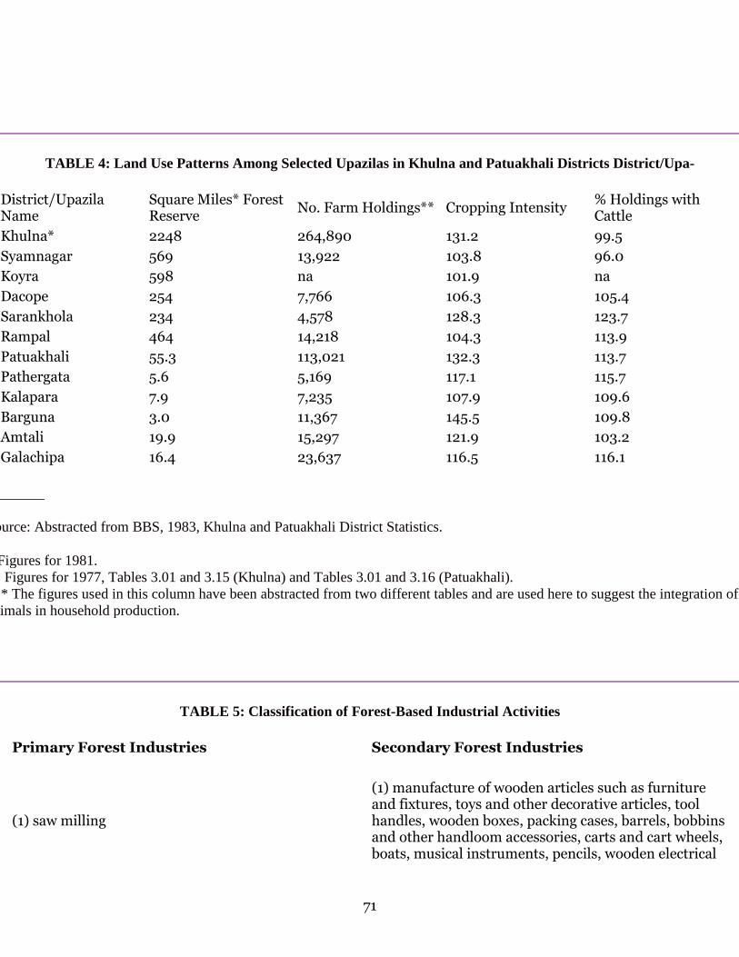
71
TABLE 4: Land Use Patterns Among Selected Upazilas in Khulna and Patuakhali Districts District/Upa-
District/Upazila Name
Square Miles* Forest Reserve
No. Farm Holdings** Cropping Intensity % Holdings with Cattle
Khulna* 2248 264,890 131.2 99.5 Syamnagar 569 13,922 103.8 96.0 Koyra 598 na 101.9 na Dacope 254 7,766 106.3 105.4 Sarankhola 234 4,578 128.3 123.7 Rampal 464 14,218 104.3 113.9 Patuakhali 55.3 113,021 132.3 113.7 Pathergata 5.6 5,169 117.1 115.7 Kalapara 7.9 7,235 107.9 109.6 Barguna 3.0 11,367 145.5 109.8 Amtali 19.9 15,297 121.9 103.2 Galachipa 16.4 23,637 116.5 116.1
________
Source: Abstracted from BBS, 1983, Khulna and Patuakhali District Statistics.
* Figures for 1981. ** Figures for 1977, Tables 3.01 and 3.15 (Khulna) and Tables 3.01 and 3.16 (Patuakhali). *** The figures used in this column have been abstracted from two different tables and are used here to suggest the integration of animals in household production.
TABLE 5: Classification of Forest-Based Industrial Activities
Primary Forest Industries Secondary Forest Industries
(1) saw milling
(1) manufacture of wooden articles such as furniture and fixtures, toys and other decorative articles, tool handles, wooden boxes, packing cases, barrels, bobbins and other handloom accessories, carts and cart wheels, boats, musical instruments, pencils, wooden electrical
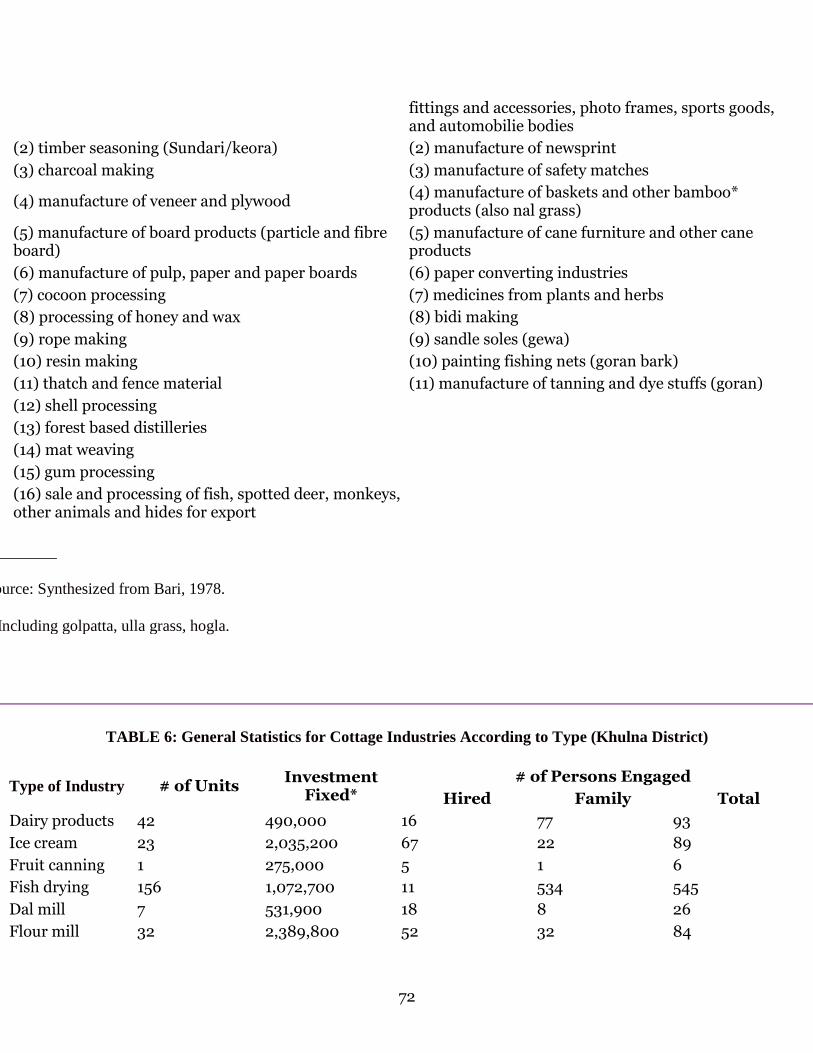
72
fittings and accessories, photo frames, sports goods, and automobilie bodies
(2) timber seasoning (Sundari/keora) (2) manufacture of newsprint (3) charcoal making (3) manufacture of safety matches
(4) manufacture of veneer and plywood (4) manufacture of baskets and other bamboo* products (also nal grass)
(5) manufacture of board products (particle and fibre board)
(5) manufacture of cane furniture and other cane products
(6) manufacture of pulp, paper and paper boards (6) paper converting industries (7) cocoon processing (7) medicines from plants and herbs (8) processing of honey and wax (8) bidi making (9) rope making (9) sandle soles (gewa) (10) resin making (10) painting fishing nets (goran bark) (11) thatch and fence material (11) manufacture of tanning and dye stuffs (goran) (12) shell processing (13) forest based distilleries (14) mat weaving (15) gum processing (16) sale and processing of fish, spotted deer, monkeys, other animals and hides for export
_________
Source: Synthesized from Bari, 1978.
* Including golpatta, ulla grass, hogla.
TABLE 6: General Statistics for Cottage Industries According to Type (Khulna District)
# of Persons Engaged Type of Industry # of Units Investment
Fixed* Hired Family Total Dairy products 42 490,000 16 77 93 Ice cream 23 2,035,200 67 22 89 Fruit canning 1 275,000 5 1 6 Fish drying 156 1,072,700 11 534 545 Dal mill 7 531,900 18 8 26 Flour mill 32 2,389,800 52 32 84

73
Other grain mill products
107 729,200 22 230 252
Oil mill 430 905,600 102 951 1,053 Rice mill 756 43,381,996 790 1,185 1,975 Wheat crushing 63 2,876,900 79 69 148 Other food products
284 2,867,099 17 679 696
Bakery 131 5,255,800 478 191 669 Biscuit & bakery 7 177,800 23 11 34 Gur making 7,233 10,948,197 860 3,587 4,447 Confectionary 18 620,100 44 26 70 Feeds for animal 2 43,500 3 2 5 Feeds for fowl 47 1,423,100 39 90 129 Ice 12 885,900 12 21 42 Salt mfg. 22 164,900 -- 51 51 Sweet meat 641 1,077,499 522 1,637 2,159 Honey processing
1 2,000 1 1 2
Biddies 101 258,606 8 237 245 Cotton products 18 311,500 10 34 44 Cloth printing 5 44,200 6 9 15 Yarn dyeing 7 11,000 -- 20 20 Mantle making 1 2,900 -- 1 1 Embroidery 7 44,000 16 9 25 Hosiery 1 4,100 -- 2 2 Socks 2 200 -- 2 2 Woolen goods 163 463,700 12 235 247 Coir mat 76 69,300 -- 106 106 Mats of reeds 1,872 3,898,700 116 6,291 6,407 Total hemp, jute, coir
560 447,500 116 1,466 1,582
Fish net 1,069 1,794,800 32 2,900 2,932 Blanket 1 300 -- 5 5 Ready-made garments
2 232,000 9 2 11
Tailorin 2,525 21,757,597 784 4,303 5,087 Hides, skin curing
21 220,000 1 51 52
Other leather products
12 166,000 30 17 47
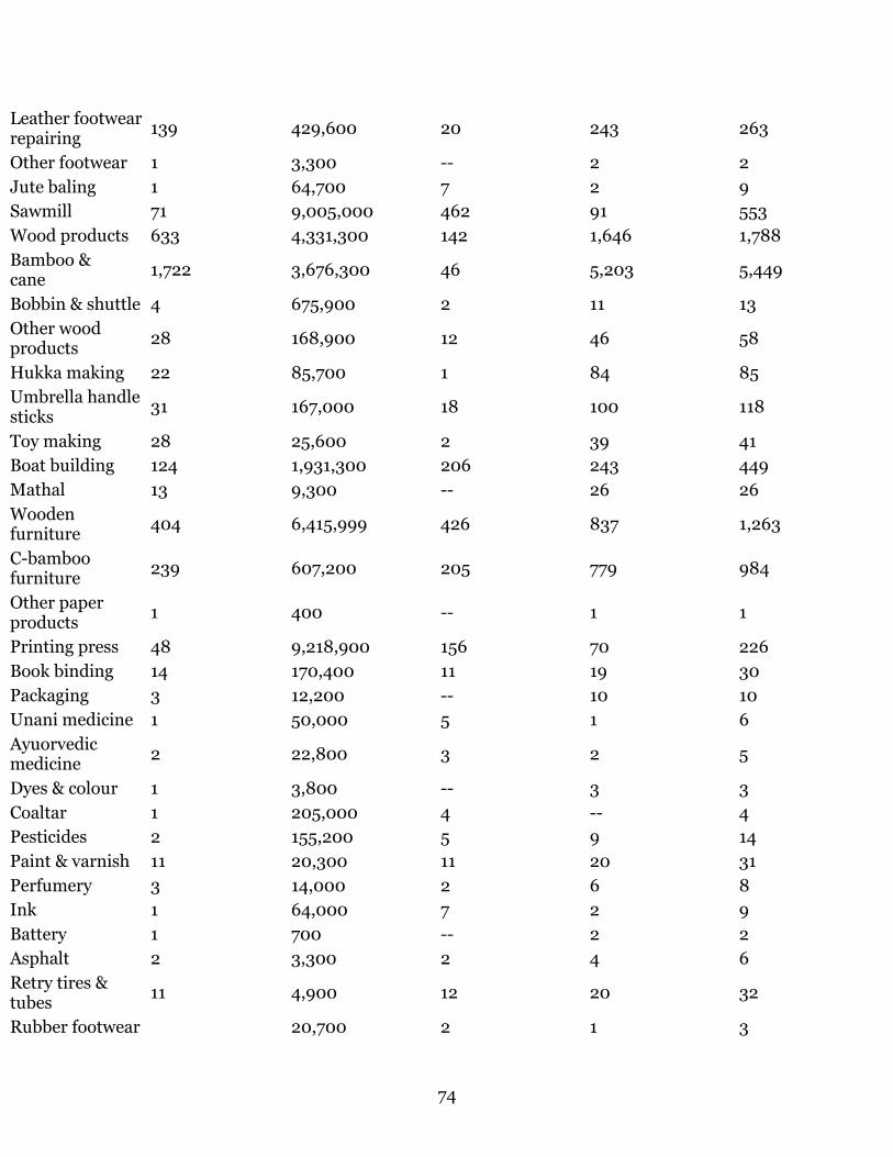
74
Leather footwear repairing
139 429,600 20 243 263
Other footwear 1 3,300 -- 2 2 Jute baling 1 64,700 7 2 9 Sawmill 71 9,005,000 462 91 553 Wood products 633 4,331,300 142 1,646 1,788 Bamboo & cane
1,722 3,676,300 46 5,203 5,449
Bobbin & shuttle 4 675,900 2 11 13 Other wood products
28 168,900 12 46 58
Hukka making 22 85,700 1 84 85 Umbrella handle sticks
31 167,000 18 100 118
Toy making 28 25,600 2 39 41 Boat building 124 1,931,300 206 243 449 Mathal 13 9,300 -- 26 26 Wooden furniture
404 6,415,999 426 837 1,263
C-bamboo furniture
239 607,200 205 779 984
Other paper products
1 400 -- 1 1
Printing press 48 9,218,900 156 70 226 Book binding 14 170,400 11 19 30 Packaging 3 12,200 -- 10 10 Unani medicine 1 50,000 5 1 6 Ayuorvedic medicine
2 22,800 3 2 5
Dyes & colour 1 3,800 -- 3 3 Coaltar 1 205,000 4 -- 4 Pesticides 2 155,200 5 9 14 Paint & varnish 11 20,300 11 20 31 Perfumery 3 14,000 2 6 8 Ink 1 64,000 7 2 9 Battery 1 700 -- 2 2 Asphalt 2 3,300 2 4 6 Retry tires & tubes
11 4,900 12 20 32
Rubber footwear 20,700 2 1 3
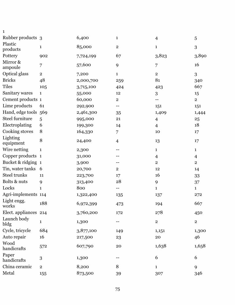
75
1 Rubber products 3 6,400 1 4 5 Plastic products
1 85,000 2 1 3
Pottery 902 7,724,199 67 3,823 3,890 Mirror & ampoule
7 57,600 9 7 16
Optical glass 2 7,200 1 2 3 Bricks 48 2,000,700 259 81 340 Tiles 105 3,715,100 424 423 667 Sanitary wares 1 55,000 12 3 15 Cement products 1 60,000 2 -- 2 Lime products 61 292,900 -- 151 151 Hand, edge tools 569 2,461,300 35 1,409 1,444 Steel furniture 5 995,000 21 4 25 Electroplating 6 199,300 14 4 18 Cooking stoves 8 164,330 7 10 17 Lighting equipment
8 24,400 4 13 17
Wire netting 1 2,300 -- 1 1 Copper products 1 31,000 -- 4 4 Bucket & ridging 1 3,900 -- 2 2 Tin, water tanks 6 20,700 2 12 14 Steel trunks 11 223,700 17 16 33 Bolts & nuts 9 313,400 28 9 37 Locks 1 800 -- 1 1 Agri-implements 114 1,322,400 135 137 272 Light engg. works
188 6,972,399 473 194 667
Elect. appliances 214 3,760,200 172 278 450 Launch body bldg
1 1,300 -- 2 2
Cycle, tricycle 684 3,877,100 149 1,151 1,300 Auto repair 16 217,500 23 20 46 Wood handicrafts
572 607,790 20 1,638 1,658
Paper handicrafts
3 1,300 -- 6 6
China ceramic 2 8,200 8 1 9 Metal 155 873,500 39 307 346

76
handicrafts Jute handicrafts 6 31,200 8 10 18 Other handicrafts
42 1,511,300 46 87 133
Nakshi kantha 33 51,700 19 49 68 Jewellery 153 2,323,900 112 266 378 Goldsmithery 364 3,448,999 53 663 716 Musical instruments
8 45,500 5 11 16
Totals: 18,333 206,791,377 8,437 45,237 53,674
* Value in taka.
TABLE 7: General Statistics for Cottage Industries According to Type (Patuakhali District)
# of Persons Engaged Type of Industry
# of Units Investment Fixed* Hired Family Total
Ice cream 1 45,000 2 1 3 Fish canning 1 1,100 -- 6 6 Fish drying 302 1,007,800 90 897 987 Other grain mill 5 20,300 -- 14 14 Oil mill 101 1,399,500 25 252 277 Rice mill 330 15,541,199 327 487 814 Wheat crushing
11 493,400 11 11 22
Other food products
28 30,900 9 138 147
Bakery 15 324,700 44 21 65 Biscuit & bakery 8 316,300 14 16 30 Gur making 118 306,800 10 397 407 Confectionary 2 50,000 8 2 10 Feeds for animal
1 900 -- 3 3
Feeds for fowl 79 407,100 -- 311 311 Shatifood 18 59,300 -- 70 70 Salt 10 10,400 -- 23 23

77
manufacturing Sweet meat 200 2,055,500 121 604 725 Biddies 9 125,800 52 14 66 Cotton products 19 115,500 10 136 146 Thread spinning 2 800 -- 4 4 Yarn dyeing 2 17,100 1 9 10 Embroidery 7 24,500 -- 20 20 Woolen goods 169 475,800 8 416 424 Coir mats 2 6,900 -- 3 3 Mats of reeds 744 992,900 224 2,006 2,230 Hemp, jute, coir
57 180,000 -- 156 156
Fish net 921 1,369,100 170 2,910 3,080 Blanket 4 2,300 -- 27 27 Tailoring 731 3,959,499 279 1,332 1,611 Hides, skin curing
86 260,000 77 286 313
Leather footwear repairing
3 12,700 -- 6 6
Sawmill 10 720,800 22 17 39 Plywood 1 1,000 -- 2 2 Wood products
241 1,009,800 18 747 765
Bamboo & cane 979 2,390,300 104 3,348 3,452 Umbrella handle stick
4 4,900 -- 5 5
Boat building 180 524,500 61 470 531 Wooden furniture
221 1,312,100 165 494 659
Printing press 13 2,174,600 40 16 56 Unani medicine 1 2,500 3 1 4 Ayurovedic medicine
2 50,700 -- 3 3
Pesticides 64 339,000 40 195 235 Hair oil 4 27,800 -- l0 10 Comb & button 7 7,000 -- 16 16 Pottery 40 433,100 16 156 172 Bricks 1 75,000 10 -- 12 Lime products 27 10,900 -- 71 71 Handle edge 257 910,700 26 704 730
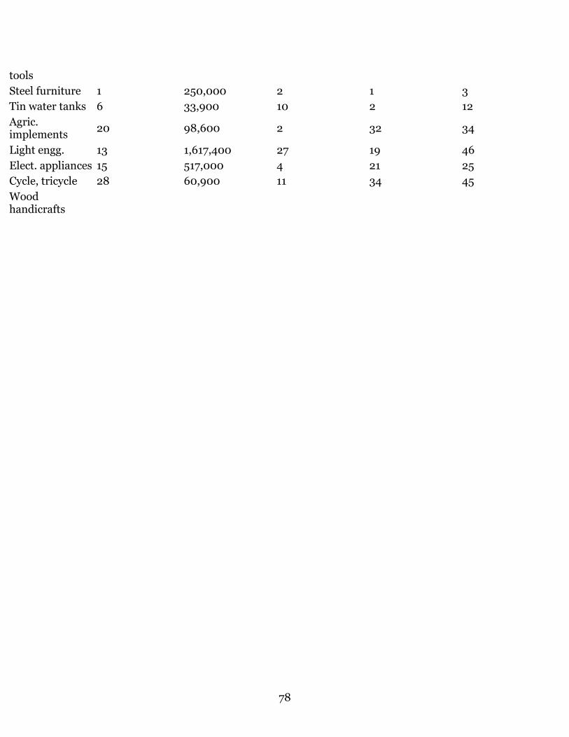
78
tools Steel furniture 1 250,000 2 1 3 Tin water tanks 6 33,900 10 2 12 Agric. implements
20 98,600 2 32 34
Light engg. 13 1,617,400 27 19 46 Elect. appliances 15 517,000 4 21 25 Cycle, tricycle 28 60,900 11 34 45 Wood handicrafts
79
Human Settlement and Colonization in the Sundarbans, 1200-1750
Richard Eaton
"A particular class of men make a profession of collection this oil, honey, and wax. They are Mohammedans and pay a duty to the Zemeendars for liberty to follow their profession. The woods, however, are not considered as property; for every ryot may go into them and cut whatever timber he wants"--Francis Buchanan, "An Account of a Journey Undertaken by Order of the Bd. of Trade through the Provinces of Chittagong and Tipperah in Order to Look Out for the Places Most Proper for the Cultivation of Spices" (March-May 1798).
At the advent of British rule in 1765, the Sundarbans forests were double their present size, while to their north lay rice paddy taken from earlier forests. During early British rule, zamindars, or landholders, were allowed to continue reclaiming as much of the jungle bordering their plots as they had been doing under the Mughals. In 1828, however, the British assumed proprietary right to the Sundarbans and, in 1830, began leasing out tracts of the forests to men willing to invest capital and labor for undertaking the clearing operations preparatory to planting paddy. Then followed forty-five years of rapacious reclamation until 1875-76 when the government declared unleased forest reserved and placed it under the jurisdiction of the Forest Department. This action, in effect, created today's Sundarbans forest.1
The present paper discusses the process of land reclamation and human settlement that had taken place prior to the advent of the British and, in the area north of the present forest, under both the Bengal Sultanate (1204-1575) and the Mughal Empire (1575-1765).
THE SUNDARBANS UNDER THE BENGAL SULTANS
For several centuries after 1200, the Bengal delta saw two frontiers, both of them moving--a cultural frontier dividing Turk and Bengali, and an agrarian frontier dividing forest and field. The cultural frontier was not a clean or stable line since the advance of Indo-Turkish garrisons in or near older cities was itself uneven, reflected in the extension of mint-towns from the original heartland of Indo-Turkish power in the northwest toward the southwest, the east, and the southeast. At the same time, a quieter sort of frontier was also advancing into Bengal's eastern and southern districts, as wet-rice cultivating communities moved into previously forested areas. Many of these new communities, moreover, professed an Islamic identity, for it was holy men, or, perhaps more accurately, men popularly endowed with charismatic authority and a Sufi identity, who played pivotal roles in this process. Indeed, in the subcontinent, generally,
80
Bengal is perhaps the only region in which the extension of agriculture is associated in popular memory with the lives of Sufis.
From 1349 to 1350, a Chinese merchant who visited Bengal, Wang Ta-yuan, made a significant observation. "These people," he wrote of the Bengali population,
owe all their tranquility and prosperity to themselves, for its source lies in their devotion to agriculture, whereby a land originally covered with jungle has been reclaimed by their unremitting toil in tilling and planting...the riches and integrity of its people surpass, perhaps, those of Ch'u-chiang (Palembang) and equal those Chao-wa (Java).2
As a Chinese admiring Bengali agriculture, Wang Ta-yuan was not alone. In 1436, another Chinese visitor, Fei Hsin, remarked that "the soil is fertile and produces in abundance, for they have two crops every year."3 Inasmuch as these remarks came from representatives of a civilization long expert in agricultural sciences, especially field-rice cultivation, they should merit our attention. Both were witnessing the transformation and reclamation of the land from jungle to rice paddy when the delta was under the rule of independent Indo-Turkish sultans. Although it was the Turkish conquest, after the advent of Indo-Turkish influence in the delta, Muslim holy men seem to have had a special hand in it.
So far as the Sundarbans are concerned, the link between the deeds of Sufis and the process of colonization is first seen in the life and legend of Khan Jahan (d. 1459), the patron saint of Bagerhat in Khulna District. From inscriptional evidence, we know that a tomb for "Ulugh Khan-i 'Azam Khan Jahan" was constructed in 1459, and that this Khan Jahan was described as a "feeble slave, the supplicant of the mercy of the Lord of the universe, the lover of the children of chief of Prophets (Muhammad), the sincere to the righteous savants, the despiser of the infidels and polytheists, the helper of Islam and the Muslims...."4 From his title "Ulugh," we can assume that this man was an ethnic Turk and, from his title "Khan-i 'Azam" that he had been a high-ranking officer in the Bengal Sultanate. To architectural historians, Khan Jahan is renowned as the builder of the famous Saithgumbad Mosque, an immense structure measuring 48 by 32.5 meters in area and consisting of sixty-seven domes. The tapering walls of this structure, which are not seen in any other monument in Bengal, are quite reminiscent of the Tughluq style of architecture in Delhi, suggesting that Khan Jahan may have originated from Upper India.5
Though little else concerning Khan Jahan can be drawn directly from contemporary sources, we do know that, in the mid-fifteenth century, the southern Jessore and northern Khulna region lay on the southern fringe of both the Bengal Sultanate's political authority and the frontier of arable land cleared for cultivation. That is, it lay on both the cultural and the economic frontiers of that time. Below Bagerhat lay more of the Sundarbans forest, dense jungle land awaiting reclamation. Two dimensions of Khan Jahan's career that have passed into local traditions are, therefore, highly significant: first, that he is specifically

81
identified with the clearing of jungle preparatory to rice cultivation; and, second, that he is locally revered as a Muslim saint and credited with the conversion of the local population to Islam. In 1870, J. Westland, British collector for the region, collected local traditions in both Bagerhat and neighboring Masjidpur, stating that Khan Jahan had come to the region
to reclaim and cultivate the lands in the Sundarbans, which were at that time waste and covered with forest. He obtained from the emperor, or from the King of Gaur, a jaghir [land assignment] of these lands, and in accordance with it established himself on them. The tradition of his cutcherry [court] site in both places corresponds with this view of his position, and the fact of his undertaking such large works--works which involve the necessity of supporting quite an army of laborers--also points to his position as receiver of the rents, or chief of the cultivation of the soil....After he had lived a long time as a great zamindar [landholder], he withdrew himself from worldly affairs and dwelt as a faqir in the place which...had been pointed out to him as the place where he should die.6
It is clear from the size of the monuments at Bagerhat--the congregational mosque is the largest in present-day Bangladesh--that it required great organizational skills to mobilize the labor necessary for transforming the thick virgin jungle of this area into rice paddy. First, the land had to be embanked along streams in order to keep the salt water out. Next, the forest had to be cleared, tanks had to be dug for water supply and storage, and huts built for the workers. These were arduous occupations since tigers and fevers were always dangerous companions of the process. When these were accomplished, rice had to be planted immediately, or a reed jungle would soon overrun the region again.7
It was presumably only after these tasks were completed that Khan Jahan could turn his men to the stupendous works of architecture that have justly spread his fame throughout Bengal. While tradition has it that he built 360 mosques and as many large tanks, recent archaeological surveys have revealed that more than fifty ancient monuments in the Bagerhat area survive from the period, all of them presumably belonging to Khan Jahan.8 Then, too, some 126 tanks in Bara Bazar, ten miles north of Jessore town, are attributed to the genius of this man, and, in Jessore itself, the shrines of two of his companions, Gharib Shah and Bahram Shah, are located.9 Westland further recorded that Khan Jahan's name was associated with the construction of numerous roads in the Bagerhat region, one of them so well-engineered that it never required repair since its original construction.10
Westland's portrait of Khan Jahan is, thus, primarily that of a clearer of jungle, a builder, and an administrator. Indeed, he observed that, in the Saithgumbad Mosque, there were the remains of two small brick platforms on the north side of the central aisle--one near a stone altar, which was for worshippers, "and one near the doorway, the place where it is said Khanjahan Ali sat to transact his business; for, this large hall was both a place of business and a place of worship."11 If Westland was right that Khan Jahan's mosque served both as an administrative center and as a congregational mosque for the population, we find

82
a phenomenon strikingly similar to the pattern described as typical in other much earlier Islamic cities such as Damascus, Baghdad, Jerusalem, or Cordova. Between the seventh and tenth centuries, during the earliest period of the Islamization of the Middle East, royal palaces and congregational mosques were often joined together, which symbolized the union of the religious and the administrative institutions in early Islam and reflected the social proximity of the ruling class and the general population.12
In the case of Khan Jahan, we have a man who might very well have come out with any army, but he and his army were never associated with armed struggle against pre-Muslim communities. Indeed, the region that Khan Jahan entered seems never to have been a center of Hindu or Buddhist civilization at all but rather a vast stretch of virgin jungle. Therefore, the frontier on which he worked was as much the economic one of field and forest as it was the cultural one of Turk and Bengali. And it was not "infidels" that he subdued but the forest itself. Yet, in addition to his reputation for having subdued the natural habitat of the Sundarbans, Khan Jahan is also associated with converting the local population of the Sundarbans to Islam.13 Hence, Khan Jahan's career exhibits a perfect fusion of the conquest of nature and the articulation of the Islamic religion.
Such a link is also found in contemporary Bengali Muslim associations between the dictates of Allah and the act of cultivating the soil. As the anthropologist John Thorp wrote concerning the popular beliefs among the Muslim farmers of the Pabna area,
Allah created Adam out of the earth in order that he might possess the earth and be its master, or malik. In the Bengali version of creation Adam exercised his mastery of the earth by farming it. All the jatis [groups] of men descended from Adam are also considered to have farmed the land. The farmers of Daripalla see themselves as immediate descendents of Adam, possessed of land and farming it as they were created to do.14
If today's Bengali farmers understand the ethos of Islam in terms of subduing the earth as Adam had been instructed to do, the basis for such an understanding may lie in the historical process by which much of eastern and southern Bengal was colonized after the Turkish conquest. By becoming the nuclei of new social groups loyal to them, Khan Jahan and his followers provided a certain measure of social stability in an otherwise fluid frontier environment. In time, this group loyalty became transformed into a cult of pious devotion while the objects of their piety, the historical pioneers like Khan Jahan, became metamorphosed into saints. Moreover, as loyalty to particular charismatic pioneer leaders, whatever their original function, became channeled into stable cults fixed on such persons, their graves, and their descendants, the religious ideology of the pioneers--Islam--gradually became rooted among the local communities. Hence, the political and economic integration of much of Bengal with the Muslim state involved a religious integration as well, as early pioneers like Khan Jahan in the Sundarbans, and Shah Jalal Mujarrad (d. 1346) in Sylhet, swelled in popular lore into mythico-historical figures personifying the Islamization of Bengal as a whole. In effect, the lives of such saints were metaphors for the union of agriculture and religion. And,
83
as such, they provide an internally coherent explanation of, or at least a model of, those processes of socio-religious change generated by the fact that in much of Bengal the agrarian and political-religious frontiers coincided with one another.
For subsequent generations, then, the importance of Sufis of the fourteenth and fifteenth centuries lay not so much in their confrontation with non-Muslims as in their confrontation with the forest and with uncultivated land. Thus, they occupy a position conceptually distinct from that of Bengal's ghazi-pirs, those zealous and militant missionaries who confronted Hindu civilization with a view to subjugating "infidelity." Moreover, while ghazi-pirs most typically were found in western and northern Bengal, where Hindu-Buddhist civilization was most deeply entrenced and could only be dislodged by physical force, Khan Jahan typifies the sort of saint found in Bengal's extreme south, the Sundarbans, far from both the centers of Indo-Turkish authority and Hindu-Buddhist civilization. For him, the association with the forest and its "taming" was primary, while his identity as a Muslim mystic appears, at best, secondary, apparently reflecting a process of a post facto santification.
As a further example of this process, we may consider the career of Mubarra Ghazi, a legendary pir identified with clearing the Sundarbans jungles of Twenty-four Parganas. Writing in 1894, James Wise recorded the following local tradition concerning this figure:
Mubarra Ghazi is said to have been a faqir, who reclaimed the jungle tracts along the left bank of the river Hugli, and each villager has an altar dedicated to him. No one will enter the forest, and no crew will sail through the district, without first of all making offerings to one of the shrines. The faqirs residing in these pestilential forests, claiming to be lineally descended from the Ghazi, indicate with pieces of wood, called Sang, the exact limits within which the forest is to be cut.15
Mubarra Ghazi's career represents the very process of forest clearing in the Sundarbans, for he was identified not only with the former forest area that he is thought to have cleared but also with the present forest area still to be cut and brought under plow. We also note how his charismatic authority has lingered on among those living pirs claiming descent from him. By claiming Mubarra Ghazi's authority for delimiting the exact areas in the forest that were to be cut, the pirs claiming descent from him were, in effect, commemorating the Ghazi's original act of organizing and directing forest-clearing operations.
A legacy of the same type has lingered in the Sundarbans regions to the east of 24-Parganas. The gazetteer for Khulna District, compiled in 1908, reported that certain parts of the Sundarbans were identified with the charismatic power of certain pirs who had jurisdiction over them. The gazetteer mentioned a class of professional woodcutters, described as including both Muslims and Hindus, who "proceed in boats to certain localities in the forests called gais, each of which is presided over by a fakir, who is supposed to possess the occult power of charming away tigers and who has, undoubtedly, some knowledge of woodcraft. Here, the woodcutters work six days in each week, for one day of the week (but
84
no particular day) is set apart for the worship of the sylvan deity presiding over that particular forest."16
Other legendary pirs are identified with the forest in more general terms, such as Zindah Ghazi, who was regarded in the late nineteenth century as a protector for woodcutters and boatmen all over the eastern delta. James Wise wrote that Zindah Ghazi "is believed to reside deep in the jungle, to ride about on tigers, and to keep them so subservient to his will that they dare not touch a human being without his express commands."17 This legend is related in its main features to the story found in a Bengali epic poem entitled Ray Mangal, composed by Krishnaram Das in 1686, the very time when historical Muslim shaikhs and pirs were penetrating and clearing the jungle tracts of Lower Bengal. This poem concerns a conflict between two antagonists, a tiger-god named Dakhshin Rai and a ghazi, or Muslim warrior, named Badi' Ghazi Khan. As "Dakhshin Rai" means, literally, "King of the South," or Lower Bengal, this deity may be taken to represent a personification of the sovereign deity protecting the Sundarbans forest, generally. Badi' Ghazi Khan, on the other hand, appears to be a personified representation of the penetration of the Sundarbans by Muslim pioneers in the period from which the poem is dated, the seventeenth century. Significantly, the encounter between Dakhshin Rai and Badi' Ghazi Khan, initially one of conflict, was resolved in a syncretic compromise: while the tiger-god would continue to possess authority over the whole of Lower Bengal, people everywhere would show respect to the holy pir Badi' Ghazi Khan by worshipping his burial spot, where there was also a symbol of the tiger-god's head.18 In such a way did Badi' Ghazi Khan, probably a sanctified pioneer like Khan Jahan, come to be seen as having initiated the cult of Islam in the forests.
It is noteworthy in this context how frequently forest pirs, both legendary and historical, bear the title ghazi, a word traditionally associated with Islamic warriors fighting against non-Muslims. In its usage in late medieval Bengal, however, while the term continued to convey the notion of struggle and mastery, the object of such mastery had shifted from non-Muslims to the forest itself, or, as in the case of Zindah Ghazi, to the dangers of the forest as represented most dramatically by the Bengal tiger. This preoccupation with taming the jungle, its persistence in the legends of Bengal, and, above all, its specific association with the "mastery" aspect of the Islamic ethos, represented an earlier phase of Islamization in the Bengal forests, a phase when the struggle against tiger and tree was still vivid in the collective memory of the people. Later, after the forest was cleared and the population became entirely wedded to the land as rice cultivators, the ethos of Islam seems to have shifted from one of mastering the forest and its beasts to one of mastering the earth and making its soil productive.
THE SUNDARBANS IN THE MUGHAL PERIOD Though visible in shadowy figures like Khan Jahan or Badi' Ghazi Khan, the outlines of the pioneer-saint become much more sharply defined as we move into the Mughal period. For example, people in Jessore District still speak of a certain
85
Mehr 'Ali who is said to have come to the jungles of Jessore from the Deccan in the early Mughal period, accompanied by his sister and another companion. Arrived in a village now named after him, Meherpur, this saint assisted the local population in clearing the jungle and making the cultivation of rice possible.19 Or, again, in Murarbon, located in the Habiganj region of Sylhet District, a certain Shah Saiyid Nasir al-Din is said to have come from the Middle East "several hundred years ago" and taught the local population how to cut the jungle and to plant rice, as well as the rudiments of Islam. Before him, the land had been jungle. And, in Pail, three miles from Habiganj, there is a mazar, or shrine, of another pioneer saint who is said to have come from the Middle East and taught the local jungle people both the techniques of rice farming and the rudiments of Islam. Later, his sons settled in Comilla and Sylhet districts where they did the same.20
In such accounts of pirs associated with the reclamation of forest and swamp for rice agriculture, the "local people" who came to comprise the Muslim peasantry were not themselves colonists, but indigenous, forest-dwelling folk whose economic and religious lives were, according to their own accounts, transformed through contact with outsiders. The axial figure in these traditions is the saint-developer, a figure whose economic role and whose relationship with the first tillers of the soil is clearly discernible in early British revenue records respecting eighteenth century Mughal Bengal. In such records, for example, we find a vivid account of a pioneer-saint named Pir 'Umar Shah, the patron saint of pargana Ambarabad in Noakhali District. The pargana is, in fact, named after this saint who is said to have come to the jungles of Noakhali from Iran in the early 1700s and "lived there in his boat working miracles and making multitudes of converts by whom the wastes were gradually reclaimed."21
The area cleared by Pir 'Umar Shah and his local followers covered about 175 square miles of land, which, in 1734, the Mughal authorities in Bengal made into a separate pargana, their basic territorial unit of administration. Thirty years later, control over revenue collection in Bengal passed from the Mughals to the British, who described this area as virgin forest recently cleared and brought into cultivation for the first time by a number of small landholders called jangal-buri ta'alluq-dars, that is, "jungle-cutting land-holders." These landholders claimed that they had originally been independent of any governmental authority above them, but, that, later, they requested the Mughal authorities in Bengal to appoint a collector, or zamindar, to manage the collection of their revenue due to the state. For this purpose, the ta'alluq-dars allowed the collectors to have allowance of the revenue of several of their villages in the pargana. Most interesting of all, the first two zamindars appointed were the sons of Shah 'Umar, the original pir after whom the pargana had been named, and who had originally converted the local people to Islam and organized them for the purpose of clearing the jungle. Of these two sons, named Amanulla and Chhanaulla, the former built a mosque in the town of Bazra, located five miles north of Begamgunj, in the year 1734.22
Analyzing the information given in this account, it would seem that the original pir associated with this process, Pir 'Umar Shah, must have established contact with

86
the forest-dwelling peoples of Noakhali area before 1734, since that was when the Mughal authorities organized the region into a pargana, which is, by definition, a district capable of producing revenue. It is also clear that, before the jungle tract became a Mughal pargana, the forest peoples who were now cultivators and called themselves jangal-buri ta'alluq-dars had been independent of government authority. Although, in their own words, these ta'alluq-dars had "requested" the government to give them a superior revenue collector, or zamindar, it would seem more likely that Mughal authority in that part of Noakhali and become sufficiently entrenched in 1734 that the ta'alluq-dars were forced to come to terms with this authority and so arranged that their collector should be the sons of the holy man, Pir 'Umar Shah. The latter was, after all, a man of some considerable local influence as he was credited both with organizing the ta'alluq-dars to clear the jungle and with making them Muslims. In other words, as the state incorporated these forest-dwelling peoples within its orbit, the charismatic authority of the pir became routinized into the bureaucratic authority of the pir's two sons, who now became government collectors, or zamindars.
We also note the Mughal government's role in this. It is curious that the year 1734 witnessed two important events in Ambarabad Pargana: the construction of the mosque by the pir's son and the integration of the pargana into the Mughal administrative system. What we know about the Mughal state suggests that these events were not at all coincidental. The Mughal authorities would not have integrated any new tract of land as a pargana unless that land were already capable of producing revenue and, therefore, of course, cleared of jungle. As for the construction of the mosque, although we have no original documents to guide us in the matter, it is probable that this mosque represents the institutional legacy of the Islamization of the local peoples. As the people attribute their Islamization to the pir and not to the son, who actually built this mosque, it is possible that Pir 'Umar had constructed an earlier, cruder mosque of which this represents a later improvement. At any rate, the fact remains that Mughal authority and Islamic institutions both reached central Noakhali at one and the same time. As in the case of Khan Jahan, the two outstanding events of Pir 'Umar Shah's life that are preserved in tradition are, first, his mobilizing the indigenous peoples to clear the jungle in preparation for plow agriculture and, second, his converting those same peoples to Islam. In the Pir 'Umar of memory, one sees a conceptual overlapping, if not a fusion, of the growth of Islam and of agriculture. Since the masses of non-ashraf Muslims in this part of Noakhali had become Muslims at the same time that they became peasant cultivators, rice cultivation and Islam were and remain intimately linked in their minds.
A similar process of settlement and reclamation is seen in the Sundarbans portion of Bakarganj District. Known in Mughal times as sarkar Bakla and, in British times as Bakarganj District, the Lower Bengali coastal region comprised of present-day Barisal and Patuakhali districts has always been an economic frontier zone. From a geologic point of view, Bakarganj, lying in the heart of the active portion of the Bengal delta, is one of the youngest districts in Bengal. Indeed, the entire district is composed, literally, of an amalgamation of marsh lands formed by the merging of islands brought into existence and built up by
87
alluvial soils washed down the great channels of the combined Brahmaputra-Ganges-Meghna river systems. In the early thirteenth century when Indo-Turkish armies began forcing Sena chieftains to flee eastward from their capitals in northwestern Bengal, the Bakarganj area was mainly a forest region hardly touched by Hindu civilization. As they moved east, these same Hindu chieftains reestablished themselves along the banks of the great rivers and islands of Bakarganj, far from Turkish cavalries. But, as J.C. Jack observed in his Settlement Report for the district, "the great rivers which put a limit upon the pursuit of their persecutors put a limit equally upon the size of their kingdoms, which clustered round the banks of the fresh water rivers and were surrounded by impenetrable forests."23
This settlement pattern seems to have persisted until the Mughal period; that is, the centers of Hindu civilization remained confined to northern and eastern Bakarganj--especially the thanas of Chandradwip, Srirampur, Idilpur, and Sahabazpur--while the district's western and southern portion remained covered by forests and laced with lagoons that, in time, became consolidated into marsh land. Local traditions associate the earliest pioneers of northern Bakarganj with the Hindu kingdom of Vikrampur, suggesting that the reclamation of the area dates at least from the thirteenth century.24 Village surveys compiled by the Indian Government between 1902 and 1913 confirm that, geologically, economically, and culturally, the oldest sector of Bakarganj is the north, where Hindu culture sank its deepest roots. This is also the only part of Bakarganj where the Hindu population exceeded Muslims in the early British census records.25 For, as Hindu immigrants pushed into this area, those native groups already inhabiting the region--mainly Chandal fishing tribes--became absorbed into Hindu society as peasant cultivators who make up the present-day Namasudras, the largest Hindu peasant community in eastern Bengal.
A second great period of economic and social expansion in the forests and marsh lands of the active delta occurred in the late seventeenth and early eighteenth centuries, a period when Muslim pioneers assumed a prominent role in the process. For one thing, the emergence of Dhaka in the early seventeenth century as the provincial Mughal capital had made the Bakarganj region more accessible to entrepreneurs and developers than at any previous time. However, rampant piracy along the coasts and rivers of southeastern Bengal by Arakanese and renegade Portuguese seamen inhibited any sustained attempts by the Mughal governors to push into the forests of Bakarganj. Extensive colonization of the interior had, therefore, to await the removal of Portuguese and Arakanese piracy in the Meghna estuary by Mughal naval forces in 1666, permitting the sort of peaceful conditions conducive to such development. Second, due to the activities of European trading companies, especially the Dutch and the English, immense quantities of silver came into local circulation in the late seventeenth and early eighteenth centuries, providing the capital the means by which credit could by advanced for the laborious business of reclamation of farm land from the forests.26

88
The chief instrument by which the interior was developed was the grant of a plot of land, or ta'alluq, bestowed either directly by Mughal authorities in Dhaka or Murshidabad, or by lesser chieftains closer to the fields of reclamation. Abundant and easily obtainable, these grants tended to be regarded by their possessors, called ta'alluq-dars, as deeds conferring on them permanent rights of land tenure. Having brought their ta'alluqs into agricultural production, ta'alluq-dars normally passed their revenue on to the government through a new class of intermediaries, called zamindars. Residing typically in Dhaka or Murshidabad where they had ready access to the provincial government, these latter emerged as the liaisons with the Mughal revenue authorities.
This process of forest-clearing and land reclamation produced extremely complex tenure chains extending from the zamindar, at their upper end, down to the actual cultivator at the lower end, with numerous ta'alluq-dars and sub-ta'alluq-dars in between. These ta'alluq-dars, wrote J.C. Jack in his discussion of eighteenth-century Bakarganj, "had usually no intention of undertaking, personally, the reclamation of their taluks and pursued, in their turn, the same system of subletting, but they generally selected as their sub-lesses men who were prepared to take colonies of cultivators to the land." The agricultural development boom in Bakarganj afforded, in other words, wide scope for countless intermediaries who were, in effect, capitalist speculators, or classical revenue farmers. The result was a complex system of subinfeudation described by Jack as "the most amazing caricature of an ordered system of land tenure in the world."27 On the other hand, one could equally argue that an expanding and expandable tenure chain may have been a perfectly appropriate form of land tenure for an economic frontier that was itself expanding amidst the forests and marsh lands of the Bakarganj interior. Moreover, as Jack wrote,
Reclamation of forest was no easy task. It took three or four years to clear the land for regular cultivation during which cultivators and labourers had to be maintained in a country where communications were difficult, rivers dangerous and markets few. Such work was in any case easier when responsibility was divided and it happened that reclamation was taken up when Dacca teemed with men whose occupations were gone. Such men were eager to get rich and unable by caste scruples to cultivate; but their attraction was drawn to colonisation and to Bakarganj by the example of Raja Raj Ballabh and many lesser men who lived in their neighborhood. The owners of the estates who had neither the energy nor the resources to reclaim their forests unaided turned naturally to such men, often their friends or relatives, for assistance.28
This passage hints at the historical origins of the distinctive land tenure system that emerged in the medieval East Bengal and was passed on to the British period, persisting until 1947. This system was characterized by a predominance of high-caste Hindus at the upper levels of the tenure chain, mainly as absentee zamindars and their immediate underlings, and non-ashraf Muslims at the lower lever of the chain as the actual cultivators. In order to maintain their social dominance, some high-caste Hindus already established in the southern delta encouraged and probably financed the settlement of other high-caste zamindars

89
in the region.29 Other Hindu colonizers moved down from Dhaka into northern Bakarganj after obtaining landholding rights from the Mughal authorities.30 One reason for the predominance of high-caste Hindus at the upper reaches of the tenure chain was, as Jack noted, the taboos among those castes that prevented them from undertaking the actual business of cultivation. Moreover, those same classes--typically residents of Dhaka or Murshidabad who were traders and money-lenders of the Brahmin and Baidya castes--had accumulated the sort of capital requisite to advance loans to sub-lessees, who, in turn, hired sub-lessees below them, and so on, until one reaches the mass of cultivators at the bottom of the tenure chain. Typically recruited from amongst indigenous peoples, these latter, while working as ordinary cultivators on lands newly reclaimed from the jungle, were, nonetheless, permitted continued access to the uncleared portion of the Sundarbans adjacent to these plots. In 1798, Hamilton Buchanan traveled into the Chittagong Hills, an area analagous to the Sundarbans proper so far as the land reclamation process is concerned, and wrote: "The woods, however, are not considered as property; for every ryot may go into them and cut whatever timber he wants."31
The immediate superiors to these cultivators occupied the middle ranks of the tenure chain linking them all to the zamindars at the top. It was these middle-ranking figures, typically members of the class of Muslim rural ashraf, who played a pivotal role in the social and religious history of the frontier. The sources describe them as qazis, pirs, or, simply, as "Shaikhs"; they do not at all appear to have been the sort of "military Muhammadans" who, according to Jack, comprised one of the two groups that spearheaded the reclamation movement, apart from high-caste Hindu capitalists.32 Indeed, these middle-ranking Muslims are often credited with the original founding of agricultural settlements in the active delta, just as pioneers like Khan Jahan had done during the Sultanate period. Village surveys collected by the government between 1902 and 1913 record that, in Barahanuddin Thana of Bakarganj, for example: "This mouza has got its name [Kazi Abad] from one Kazi who settled here first....The population is chiefly Mussalmans."33 Or, in Gaurnadi Thana, "The Mahomedans owe their origin directly or indirectly to one Kazi who was one of the original settlers of this village." Or, again, "There are a few families of Mohamedan Kazis who are the original settlers of this village. They were once prosperous. The population is 715, mostly Muslim."34
There were two distinct patterns by which these rural ashraf became established as local men of influence in the delta's countryside. The dominant pattern was of men acquiring ta'alluqs from some higher authority, either a local chieftain or a revenue contractor in the provincial capital, and then going out into the forest or marsh lands and organizing the clearing and settling of the land. The driving force behind this pattern was ultimately the Mughal government's ever-increasing revenue demand. For, by creating a demand for land revenue, the Nawabs of Bengal attracted speculators who agreed to pay that revenue while hoping to make a profit by subcontracting the work of reclamation to sub-lessees. These latter persons, many of whom came to constitute the rural ashraf, found it easy enough to establish themselves as the de facto landlords of whole regions that
90
eventually coalesced into settled villages. We see this kind of pattern in the following record concerning the settling of an exclusively Muslim village, population 1,300 in 1904, in Patuakhali, which was in the Sundarbans forest in the extreme southern part of Bakarganj District. There, we are told, in the eighteenth century a certain Shaikh Ghazi
befriended himself with Janaki Ballav Roy immediately after he [Roy] got the Zamindari of Arangapur from the Nawab. Janaki Ballar also got material assistance from this man in the work of reclamation of lands from Sundarbans [i.e., forest]. Shekh Gazi subsequently settled in Mithapur.35
This example illustrates the classic pattern of subinfeudation in the forests of eighteenth century Bakarganj: an absentee Hindu acquired zamindari rights from the Nawab and was, thereby, allowed to extract however much wealth he could from a given tract of land as long as he agreed to give a stipulated amount of it to the Nawab as land revenue. This Hindu zamindar then contacted some enterprising middleman, typically a member of the Muslim petty religious establishment, to undertake the arduous task of clearing the jungles for rice cultivation. This person would have agreed on an amount that he would forward to the zamindar, doubtless a larger sum than what the zamindar remitted to the Nawab, the difference being the zamindar's profit.
In this case, the reclamation process bridged communal lines at the juncture of the zamindar and the man responsible for clearing operations. It was the Hindu Janaki Ballav Roy who had the contacts with the Nawab's government and who settled with the Nawab's revenue officials on a tax payment. Roy then withdrew from the work of reclamation, getting "material assistance" from a man whose name, Shaikh Ghazi, suggests religious charisma and who was the man who actually settled in Mithapur and organized the forest-clearing operations. Thus, unlike J.C. Jack's picture of two distinct classes of developers moving separately into the forests of Bakarganj, Hindu "capitalists" and Muslim "adventurers," what this suggests is that both types operated in collaboration with each other but at different ends of the land tenure chain. Influential urban Hindus supplied the cash or, at least, the commitment to pay the revenue to the government; enterprising Muslims supplied the organizational ability and charisma to mobilize labor forces on the ground. This pattern of collaboration contributed to the characteristic configuration of land tenure in much of pre-1947 East Bengal, with high-caste Hindus, normally absentee zamindars, at the upper end of the tenure chain, and Muslim cultivators at the lower end.
Instead of first receiving the patronage of a higher authority, some pirs or qazis went directly into uncultivated regions, organized the local population for clearing the jungles and, only later, after having established themselves as local men of influence, entered into relations with the Mughal authorities. According to this second pattern of land development, the sacralization of a region by virtue of a pir's activities preceded his patronization by either local or provincial political authorities. Thus, for example, a village in southern Dhaka District, Khanda Kadam Rasul, owes its origins to some pirs who established a shrine to a footprint of the Prophet Muhammad. This, in turn, attracted the patronage of a
91
Muslim zamindar, who constructed an impressive mosque in the village and provided for its support by settling some landed property on it. Then, in 1641, the Mughal governor Shah Shuja made this village rent-free, placing it under the trusteeship of one Haji Nur Mahmud, and it has remained an all-Muslim village ever since.36 In cases like this, the Mughal government generally tried to appropriate the rural ashraf by defining them when possible as the petty zamindars, or primary taxpayers, of a settlement.
The relationship between these rural ashraf and the Mughal authorities was not always happy, however. For the natural ties of authority and patronage of the pir, who was in close touch with the grass roots of Bengali society, lay with the masses of peasants beneath him and not with the governors and bureaucrats in distant Dhaka or Murshidabad. This situation occasionally produced tensions, as is seen in the history of a settlement in remote Jhalakati Thana in the Bakarganj Sundarbans. There, an eighteenth century pir called Saiyid Faqir evidently wielded enormous influence with the cultivators of this village, who were described as "entirely Mahomedan, mostly illiterate." The village notes record that "the people of this part looked upon the Fakir as their guide and did not pay rent to the Nawab." So, one Lala Chet Singh, a captain in the employ of the Nawab, succeeded in persuading the pir to leave the country. For his efforts, Singh was given the pargana as a reward from the Nawab, though it was thenceforward called "Saidpur" after the name of the pir.37 This example suggests that, on the Bengal frontier, the peasantry's sense of loyalty seldom extended beyond their local holy man, which was why the government endeavored to win the loyalty of those same persons. In this case, even though the government failed to collect rent through the holy man and resorted to evicting him, the man's prestige lived on in the very name of the place.
CONCLUSION In general, the charismatic authority of the rural pirs in the Sundarbans rested on three overlapping and interconnected bases: their connection with the forest, a wild and dangerous domain that they are believed to have subdued, their connection with the supernatural world, with which they are believed to wield continuing influence;38 and their connection with mosques, which they are believed to have built, thereby institutionalizing the cult of Islam.
It appears that the indigenous tribes of the Sundarbans interior, for the most part communities of Chandal or Pod fishermen, provided the bulk of the labor for clearing the forests and marshes, together with laborers brought by the ta'alluq-dars from Dhaka or from neighboring districts for this purpose. These same indigenous communities came to comprise the hardy and turbulent class of Muslim cultivators, who returned themselves as "Shekhs" in the 1901 Census. Not without reason, then, have recent observers remarked on the many cultural similarities between the Hindu Namasudras and the Muslim Shekhs of East Bengal; for both, though formally divided as Hindus and Muslims, stem from essentially the same stock of indigenous peoples.39
92
Historically speaking, as the pressure of agrarian civilization in either its earlier Hindu form or its more recent Muslim form pushed into the Sundarbans forests, the pattern among the indigenous Bengali inhabiting the region--the Chandal in the east and the Pod in the west--has been one of movement from a life predominantly based on fishing to one predominantly based on rice cultivation.40 For one thing, both Hindu and Muslim governments in Bengal favored the culture of the peasant--sedentary, docile, and productive--to that of the semi-nomadic fisherman since the cultivator's product, grain, could easily be converted into cash that the government could tax, whereas the fisherman's product, being incapable of storage, was not easily converted into taxable cash.41 Second, over the centuries, as ever more silt was carried down the great rivers and was deposited on the deltaic plain, the fish-bearing lagoons (bil) that were formed in depressions in the soil gradually dried up. As this happened, the indigenous peoples shifted their livelihoods accordingly, relying less upon fishing and more upon cultivation.42
Whichever factor contributed more to causing this transformation, already in the fifteenth century, the fishing life had acquired definitely negative and lowly associations as compared to that of rice farming. In the version of the Manasa-mangal composed in 1495 by Vipradas, the snake-goddess Manasa was first accepted by cowherds, then by fishermen, and finally by respectable cultivating householders. As each new social group became her worshippers, her own standing as a proper deity improved, which, in the end, signaled her qualifications to enjoy the patronage of Brahmin priests.43 In recent centuries, Muslim cultivators have shown similar attitudes. As Wise wrote in 1883, "all fisher castes are still regarded [by Muslims] as belonging to one of the lowest grades of humanity, being generally remnants of aboriginal or outcast tribes who lived separate from, and strangers to, the Aryan population around them."44
The growth of new peasant communities in the former Sundarbans region can thus be attributed to three factors: 1) colonization by new migrants from the Upper Delta, from West Bengal, or from Upper India; 2) incorporation of the indigenous fishing and horticulturist peoples already inhabiting the region; and 3) natural growth of the population due to an increase in the food base arising from either the initiation or the intensification of rice cultivation. Although scanty records hint at the first two processes, the third is never mentioned. Nonetheless, far more people can be supported on an acre of well-cultivated rice paddy than on an acre of forest. Hence, once new settlements were established through one of the first two processes, the third, natural growth due to intensification of rice farming, quickly became a self-sustaining agent in its own right.
NOTES
1. Sir Abdelkerim Ghuznavi, The Forests of Bengal (Calcutta: Government of Bengal, Revenue Department, 1935), pp. 33-34.
93
2. Wang Ta-yuan, Tao I Chih Lio ("Description of the Barbarians of the Isles"), in W.W. Rockhill, "Notes on the Relations," T'ound Pao, vol. 16 (1915) Part II, section 4, p. 436.
3. Fei Hsin, Hsing Ch'a Sheng Lan, ("Description of the Starry Raft"), trans. W.W. Rockhill, "Notes on the Relations," T'ound Pao, vol. 16 (1915) Part II, section 4, p. 443.
4. Shamsud-din Ahmed, ed., Inscriptions of Bengal, vol. 4 (Rajshahi: Varendra Research Museum, 1961), p. 66.
5. Johana E. van Lohuizen de Leeuw, "The Early Muslim Monuments at Bagerhat," in George Michell, ed., The Islamic Heritage of Bengal (Paris: UNESCO, 1984), p. 177.
6. J. Westland, A Report on the District of Jessore: Its Antiquities, Its History, and Its Commerce (2nd ed., Calcutta, 1870), pp. 20-21.
7. L.S.S. O'Malley, ed., Bengal District Gazetteers: Khulna (Calcutta, 1908), p. 194.
8. Westland, Report, p. 15; Van Lohuizen de Leeuw, Early Muslim Monuments, p. 169.
9. Westland, Report, p. 19.
10. The best of them was a road running along the Bhairab River at Bagerhat. This road was made of bricks, about ten feet across, raised on a slightly elevated embankment. Westland, Report, pp. 11-12.
11. Westland, Report, p. 12.
12. Jere Bacharach, lecture given at University of Arizona April 4, 1986. In the great Damascus Mosque, the ruler's palace was attached on the qibla side of the mosque, which, itself, was grafted onto the Church of St. John in 705. From textual sources, we know that the Abbasid capital of Baghdad had at its center a mosque with a palace attached to its qibla side, twice the size of the mosque, and bearing a green dome, both of them enclosed within a circular structure. Excavations recently carried out on Jerusalem's Dome of the Rock and Masjid al-Aqsa reveal the same pattern, i.e., a palace area, or Dar al-Umra, located directly beside the Masjid-i Aqsa. In Cordova, the same phenomenon was found. From about the tenth century, however, this pattern was replaced by one in which the palace and the congregational mosque were separated, reflecting the growth of the Muslim population and the attempt by the ruling class to distance itself from the people. Now, a royal mosque was built for the ruling elite, located at a distance from the teeming bazaars and residential areas.
13. Syed Murtaza Ali, Saints of East Pakistan (Dacca: Oxford University Press, 1971), p. 41.
14. John P. Thorp, "Masters of Earth: Conceptions of 'Power' Among Muslims of Rural Bangladesh." Ph.D. Dissertation (University of Chicago, 1978), p. 54.
94
15. James Wise, "The Muhammadans of Eastern Bengal," Journal of the Asiatic Society of Bengal, vol. 63 (1894), p. 40. Wise here follows Major R. Smyth, "Statistical and Geographical Report of the 24-Pargannahs District," 1857.
16. O'Malley, ed., Bengal District Gazetteers: Khulna, pp. 193-94.
17. Wise, "Muhammadans," p. 40.
18. A. Bhattacharyya, "The Tiger-cult and its Literature in Lower Bengal," Man in India, vol. 27, no. 1 (March 1947), pp. 49-50.
19. Muhammad Sharif Hussain, Hon. Secretary, Jessore Public Library, Kharki Post, District Jessore. Personal Interview, May 19, 1982.
20. Muhammad Badrul Huda, Additional Superdivisional Officer, Revenue. Noakhali District Collectorate. Personal Interview, June 17, 1982.
21. J.E. Webster, Eastern Bengal and Assam District Gazetteers: Noakhali (Allahabad, 1911), pp. 100-01.
22. W.H. Thompson, Final Report on the Survey and Settlement Operations of the District of Noakhali, 1914 to 1919 (Calcutta, 1919), pp. 24, 60-61.
23. J.C. Jack, Final Report on the Survey and Settlement Operations in the Bakarganj District, 1900-1908 (Calcutta, 1915), p. 45.
24. Jack, Final Report, p. 17.
25. Jack, Final Report, p. 17. Thus, when speaking of a village in Gaurnadi Thana, the Mauza Notes record that it "is entirely inhabited by Hindus--mostly Brahmins in occupation of rent-free lands [given] under the Chandradwip zamindars." Barisal District Collectorate, Record Room. Mauza Notes, Gaurnadi Thana, vol. 2, R.S. 828.
26. Between 1709 and 1718, the English and Dutch East India Companies imported an annual average of Rs. 4.15 million into Bengal, most all of this silver. Om Prakash, "Bullion for Goods: International Trade and the Economy of Early Eighteenth Century Bengal," Indian Economic and Social History Review, 13/2 (April-June 1976), pp. 162-63.
27. Jack, Final Report, p. 58.
28. Jack, Final Report, p. 48.
29. The Mauza Notes noted that, in Barisal Thana "the Chakravartys of Rahamatpur previously resided in the North Rahamatpur; later, they came and settled in this mouza. The Chakravartys of Rahamatpur are staunch Brahmins, and, in order to keep their social position high, they brought several good kulin Brahmins from different parts and made them settle here." Barisal Mauza Notes, Barisal Thana, vol. 2, R.S. 2120.
30. "The Pals, Dasses and the Chandras are the owners," we read concerning a village in Swarupkata Thana. "They came down to settle here on receiving farming leases from the then zamindars of Nayerkaleri some 220 years ago [i.e., ca. 1686]." Barisal Thana Notes, Swarupkati Thana, vol. 2, R.S. 2984.

95
31. Francis Buchanan, "An Account of a Journey Undertaken by Order of the Bd. of Trade through the Provinces of Chittagong and Tipperah in Order to Look Out for the Places Most Proper for the Cultivation of Spices" (March-May 1798), (British Museum. European MSS. Add. 19286). p. 36.
32. Jack, Final Report, p. 46.
33. Barisal Mauza Notes, Barahanuddin Thana, R.S. 1846.
34. Barisal Mauza Notes, Gaurnadi Thana, vol. 1, R.S. 696-6:107 and vol. 2, R.S. 717.
35. Barisal Mauza Notes, Patuakhali Thana, vol. 2, R.S. 2855.
36. Dhaka District Collectorate, Record Room. Mauza Notes, Narayanganj Thana, vol. 5, No. 247.
37. Barisal Mauza Notes, Jhalakati Thana, vol. 3, R.S. 2517.
38. In one village in Bakarganj's Swarupkati Thana, we learn that "there was one Abu Sher Fakir of much renown here. He was the foremost disciple of Kabi Kalachand Fakir of Baruikhali near Khulna. The rumor goes that this Kalachand was gifted with supernatural powers....People from all quarters used to come over to him for redress of all sorts of grievances. The belief was that any sufferer was sure to get rid of his troubles (physical or mental) if he could propitiate the fakir. So, it happened that hundreds of rupees were paid by the solicitors of his favour. He could cure diseases....His dargah was considered the [place] of pilgrimmage." Barisal Mauza Notes, Swarupkati Thana, vol. 1, R.S. 308.
39. Ralph W. Nicholas, "Vaisnavism and Islam in Rural Bengal," in David Kopf, ed., Bengal, Regional Identity (East Lansing: Asian Studies Center, Michigan State University, 1969), pp. 39-41.
40. The transition from the one to the other was always gradual and incomplete. Given the natural environment of Lower Bengal, laced with numerous rivers and lagoons, it has always been easy for the inhabitants to lead a somewhat amphibious life in which both rice cultivation and fishing are practiced, depending on the season. O'Malley, ed. Bengal District Gazetteers, Khulna, pp. 59-60.
41. This, indeed, was the dilemma faced by all non-peasant societies in the great Muslim agrarian empires, and it proved as detrimental in the long run to pastoral communities as it was to fishing communities.
42. Dhaka District Collectorate, Record Room. Mauza Notes, Rupganj Thana, vol. 5, village No. 5021--7:41). This has been an extremely long-term process, of course, extending back to the earliest recorded habitation of the delta. In Sylhet and Mymensingh districts, there are many places whose names end with the suffix dwip, or "island," pointing to a period when much more of the delta was covered with permanent masses of water than is now the case. (See Kamalakanta Gupta, Copper-plates of Sylhet, vol. 1: 7th-11th Century A.D. (Sylhet: Lipika Enterprises, 1967), p. 105.

96
43. T.W. Clark, "Evolution of Hinduism in Medieval Bengali Literature: Siva, Candi, Manasa," Bulletin of the School of Oriental and African Studies, 17/3 (1955), pp. 507-09.
44. James Wise, Notes on the Races, Castes and Trades of Eastern Bengal. 2 vols. (London: Harrison and Sons, 1883). Unpublished copy in Dacca University Library. Vol. 1, p.90.