Th e vision : create a vibrant regional activity center ...
20
OHSU/AMBERGLEN CITY OF HILLSBORO PlaceMaking LELAND CONSULTING GROUP CONCEPT PLAN SUMMARY e vision : create a vibr ant regional activity center enlivened with high- quality pedtrian and environmental ameniti, taking advantage the region’s light rail stem
Transcript of Th e vision : create a vibrant regional activity center ...

OHSU/AMBERGLEN
CITY OF HILLSBORO PlaceMaking LELAND CONSULTING GROUP
CONCEPT PLAN SUMMARY
Th e vision : create a vibrant regional
activity center enlivened with high-
quality pedes trian and environmental
amenities , taking advantage of the
region’s light rail sy stem

2 PB PLACEMAKING, LELAND CONSULTING GROUP
OHSU/AMBERGLEN CONCEPT PLAN
Located on Portland’s westside between downtown Portland and Oregon’s Silicon Forest, the OHSU/AmberGlen area provides a unique opportunity for taking traditional suburban development to the next level. Development of the OHSU/AmberGlen area as an urban community would connect the adjacent regional Tanasbourne Town Center to the region’s Westside Light Rail line and create a vibrant mixed-use regional center in the Portland suburbs. Served by a major freeway close to the region’s most intensive high-tech industrial cluster and adjacent to major retail and service industry employers, the OHSU/AmberGlen area is the ideal suburban location in which to consider intensive urban development. The City of Hillsboro initiated the OHSU/AmberGlen Concept Plan recognizing the unique attributes of this location. The City considered this 582 acre planning area located on its eastern edge to be an excellent site for a new high quality urban-scale development in a suburban context. The factors contributing to Hillsboro’s decision to create an urban community plan for this site are the small number of property owners, large amounts of undeveloped and under-developed land, and proximity to the economically dynamic Tanasbourne Town Center, major employers and major transportation facilities. The City believes that the implementation of the OHSU/AmberGlen Concept Plan will provide an extraordinary opportunity for the City to use land more efficiently while creating mobility alternatives for its residents and employees and an opportunity for people to live close to employment.
INTRODUCTION
The OHSU/AmberGlen planning area is located at the southern edge of the Tanasbourne Town Center area a mile south of the Sunset Highway, US 26. The planning area is bounded by 185th Avenue on the east, Cornell and Walker Roads on the north, 206th Avenue on the west, and the Westside light rail line on the south. The area is served by the Willow Creek and Quatama Light Rail Stations. FIGURE 1. Location Map showing the OHSU/AmberGlen site
The Streets of Tanasbourne The northern edge of the OHSU/ AmberGlen site from the Streets of Tanasboune

CITY OF HILLSBORO 3
OHSU/AMBERGLEN CONCEPT PLANOHSU/AMBERGLEN CONCEPT PLAN
The City of Hillsboro is the 5th largest city in the state and is one of the fastest growing cities in the Portland metropolitan region. Hillsboro has built a reputation as one of the region’s most innovative cities by proactively seeking out and encouraging successful, complex, large scale, higher density suburban residential, industrial, and commercial developments, such as Orenco Station, Intel’s Ronler Acres campus, and the Tanasbourne Town Center. The City has become the epicenter of Oregon’s Silicon Forest with billions of dollars of high tech investment resulting in the employment of nearly 25,000 high tech workers. A large amount of industrial land remains undeveloped. The City is also the location of Oregon’s second busiest airport, accommodating corporate domestic and international flights.
The area surrounding the OHSU/AmberGlen site has been extensively developed within the last fifteen years. The Tanasbourne retail and office area along 185th Avenue, between US 26 and Cornell Road, is almost completely developed. Immediately north of the planning area are approximately 4,000 units of medium density housing, largely townhouses and apartments. North of Cornell Road is the new Streets of Tanasbourne retail center, the westside’s only “lifestyle center”, and part of over one million square feet of retail space in the Tanasbourne area. Two recently approved projects in Tanasbourne will complete development for a large majority of the remaining vacant acreage north of the planning area: the 800,000 square foot TheStandard office complex and the one million square foot Kaiser Westside Medical Center. The neighborhoods adjacent to the western, southern and eastern edges of the site consist of mainly low to medium density residential development. Approximately 2,000 dwelling units are located in the vicinity of the Willow Creek and Quatama Light Rail Stations.
The gently rolling topography of the plan area is bisected by the Bronson Creek corridor, essentially dividing the site into two distinct sub-areas. The dominant development features of the larger western part are the existing AmberGlen Business Center and the Oregon Graduate Institute (OGI) campus. The OHSU Research Campus, consisting of the Oregon National Primate Research Center, the Neurological Sciences Institute and the Vaccine Gene Therapy Institute, occupies the eastern side of Bronson Creek. Between this campus and 185th Avenue is a narrow strip of land partially developed with office, educational and retail uses near Walker Road, and medium density housing near the Willow Creek light rail station.
CONTEXT
Primary access to the site is from 185th Avenue, Cornell Road, Stucki Avenue, Walker Road and 206th Avenue. Cornell, 185th and Stucki are major, five lane arterials, with the first two near or at capacity, especially at rush hour. 206th is a three lane collector street serving traffic originating south of the site. Handling through traffic, in addition to traffic added by new development on this site, will be a major challenge. The site is well served by water and sewer service, although a new sewer trunk line may be necessary to handle future high density development on this site.
View of the Orenco Station development

4 PB PLACEMAKING, LELAND CONSULTING GROUP
OHSU/AMBERGLEN CONCEPT PLAN
1
To guide development of the Concept Plan the City formed a Steering Committee (SC), composed of property owners and other key stakeholders, and a Technical Advisory Committee (TAC), consisting primarily of public agency representatives. The planning process began in July, 2006 with an intensive series of confidential interviews to discuss the vision for the site with the project’s stakeholders. In addition to Steering Committee members, representatives from adjacent neighborhoods, City, County, Metro and state officials, and representatives from the development community were also interviewed. Public and private stakeholders were enthusiastic about the proposed vision. The interview process and committee composition are documented in Section II of the full Concept Plan Report.
Before creating land use alternatives consistent with the vision, the planning team analyzed existing conditions on the 582 acre site and its surroundings. The Existing Conditions Analyses are in Section III of the Plan Report.
In August the project team shifted its focus to the design process. A “charrette”, or design workshop, was held with representatives of the stakeholder groups, who developed four design alternatives for the planning area. The planning team synthesized the work of the participants to produce a list of Guiding Principles, which helped the team combine elements from the alternatives into a proposed concept plan. This proposed concept was presented to the project Steering Committee, Techical Advisory Committee, Hillsboro Planning Commission and City Council for feedback before further design work or analysis was undertaken. This process is documented in Section IV of the Plan Report.
In order to analyze the proposed concept and prepare for future planning work, a Development Program was produced. This document quantified the proposed concept plan by calculating numbers of residential units and square footage of employment uses for each block in the proposed plan area and provides more detail on the development types. This document along with background information are in Section V of the Plan Report.
Using the Development Program, the team prepared impact analyses of the proposed concept plan. These analyses are presented in Secton VI of the Concept Plan Report.
Modifications were then made to the proposed concept plan to address concerns about the feasibility of certain aspects of the development and the potential impacts of the plan. Following meetings with the SC and TAC to discuss the modifications and impact analyses, the planning team produced the final Concept Plan (Figure 2).
THE PLANNING PROCESS
This Summary synthesizes all the work related to preparation of the Concept Plan and articulates the principle features of the Plan. Key elements of the Plan are more fully explored in Sections II - VII of the full Concept Plan Report.
GUIDING PRINCIPLES
URBAN/GREEN
• THIRD PLACES
• CONNECTIVITY
• REGIONAL
LANDMARK
MARKET FLEXIBILITY
• BIG INITIAL PHASE
• MODEL
DEVELOPMENT
•
•

CITY OF HILLSBORO 5
OHSU/AMBERGLEN CONCEPT PLANOHSU/AMBERGLEN CONCEPT PLAN LAND USE CONCEPT PLAN
FIGURE 2. Land Use Concept Plan

6 PB PLACEMAKING, LELAND CONSULTING GROUP
OHSU/AMBERGLEN CONCEPT PLAN
The vision expressed by the City of Hillsboro for the OHSU/AmberGlen area is to “create a vibrant regional
activity center enlivened with high-quality pedes trian and environmental amenities , taking advantage of the
region’s light rail sy stem”. The Concept Plan implements the vision through the creation of a mixed-use urban community focussed on a dramatic central park feature and integrating residential, employment, shopping, education, and recreation throughout a high quality urban and natural environment. The Plan calls for almost 5,000 new medium to high density residential units, 3 million square feet of office, 850,000 square feet of retail and hotel, conference and entertainment uses.
Land Use Concept PlanThe basic land use concept is to create a varied mix of uses in all parts of the plan area, using zoning based on development types rather than use restrictions. Design standards, intensity thresholds and minimum square footage requirements for each development type will be part of the implementation package. Structured parking is assumed in most development types, although some on-site surface parking will be needed initially, and perhaps permanently in some lower intensity parts of the plan area.
The primary characteristics of the nine Development Types are articulated below:
Urban Activity Center
Intense mix of major retail, medium to high density housing (including point towers), office, restaurants, hotel, entertainment, conference center, and civic gathering space.3 to 25 story buildingsApprox. FAR: 3.0Approx. use mix: 25% retail; 24% residential; 14% office; 7% hotel/conference; 30% structured parking
Neighborhood Center 1
Neighborhood serving retail with some office adjacent and/or above residential 1 to 6 story buildingsApprox. FAR: 0.7Approx. use mix: 45% retail; 14% office; 11% residential; 30% structured parking
•
•••
•
•••
* FAR is Floor-Area Ratio – the ratio of the total constructed floor area to the site‘s square footage.** Approximate use mix - the relative amount of each use (including structured parking) assumed by the Development Program to be constructed at build-out in each development type.
THE PLAN ELEMENTS

CITY OF HILLSBORO 7
OHSU/AMBERGLEN CONCEPT PLANOHSU/AMBERGLEN CONCEPT PLAN
1
Neighborhood Center 2
Neighborhood serving retail with adjacent residential or office 1 to 6 story buildingsApprox. FAR: 0.45Approx. use mix: retail 65%; office 20%; residential 15%; surface parking
High Density Urban
High density residential and office with some ground floor retailAverage 10 -12 story buildings; up to 25 story point towerHousing range could include townhouses to point towers, up to 250 units per acreApprox. FAR: 3.0 Approx. use mix: 60% residential; 16% office; 4% retail; 20% structured parking
Medium Density Urban
Medium density residential with some office and retail3 – 6 story buildingsHousing range could include townhouses to apartments/lofts, primarily between 50 and 100 units per acreApprox. FAR: 1.5Approx. use mix: 71% residential; 6% office; 3% retail; 20% structured parking
•
•••
•
•
•
••
•
••
••
* FAR is Floor-Area Ratio – the ratio of the total constructed floor area to the site ‘s square footage.** Approximate use mix - the relative amount of each use (including structured parking) assumed by the Development Program to be constructed at build-out in each development type.
THE PLAN ELEMENTS

8 PB PLACEMAKING, LELAND CONSULTING GROUP
OHSU/AMBERGLEN CONCEPT PLAN
Medium Density Transition
Medium density residential with some office and retailProvides transition to adjacent neighborhoods3 - 4 story buildingsHousing range could include townhouses to low-rise apartments/lofts, between 20 and 50 units per acreApprox. FAR: 0.65Approx. use mix: 77% residential; 5% office; 3% retail; 15% structured parking
Employment/R&D/Office
Primarily office/R&D with service retail2 – 8 story buildingsUrban or campus settingApprox. FAR: 1.0Approx. use mix: 77% office; 3% retail; 20% parking
OHSU Research Campus
Existing and planned uses allowed in Master PlanUse mix: 100% office/R&D/lab.
Civic/Institutional
Open space, recreationPublic services (police, fire, etc.), schools, colleges/universities, civic/community Permitted anywhere
•
•
••
••
•
••••
•
•
••
•
THE PLAN ELEMENTS
* FAR is Floor-Area Ratio – the ratio of the total constructed floor area to the site ‘s square footage.** Approximate use mix - the relative amount of each use (including structured parking) assumed by the Development Program to be constructed at build-out in each development type.

CITY OF HILLSBORO 9
OHSU/AMBERGLEN CONCEPT PLANOHSU/AMBERGLEN CONCEPT PLAN NEIGHBORHOOD PLAN
FIGURE 3. Neighborhood Plan

10 PB PLACEMAKING, LELAND CONSULTING GROUP
OHSU/AMBERGLEN CONCEPT PLAN
Each part of the planning area will have its own unique character. The differentiating features of these neighborhoods are discussed in the following sections.
Urban Center This square, 15 acre area directly south of The Streets of Tanasbourne retail center will be intensively developed as an urban activity center. There are several alternative scenarios for how this area could develop, depending largely on whether or not the two existing four story office buildings remain. The original plan assumed the entire area would be redeveloped in a nine block urban grid. If the existing buildings stay, new development could take advantage of the topography, placing parking under a deck spanning the site. Access would be provided from the new Walker, Stucki and 194th alignments, as well as from an elevated street crossing Cornell from the Streets of Tanasbourne at the deck level. In any scenario, an active pedestrian environment, including an urban plaza, will be a major feature. A full mix of uses is anticipated, including a conference center hotel and entertainment facilities, creating an active 18-hour street life.
East & West ParkThese two neighborhoods form the sides of the central park, and will be the major residential neighborhoods for the plan area. They will be very densely developed, but closely associated with green amenities, including the park, green streets, pocket parks and Bronson Creek. Retail will line much of the park block frontage at the street level, and on some street corners serving other parts of these neighborhoods.
Station AreasThe Quatama light rail station is proposed to be moved to the east side
NEIGHBORHOODS

CITY OF HILLSBORO 11
OHSU/AMBERGLEN CONCEPT PLANOHSU/AMBERGLEN CONCEPT PLAN
1
of 205th, north of the MAX line, to take full advantage of the opportunity to create a mixed-use neighborhood center immediately adjacent to the station in this corner of the plan area. The station area itself is proposed to be a full mix of retail, residential and office uses, transitioning to a medium density residential character moving away from the station.
At the Willow Creek station, the plan proposes a mix of development types which will allow a wide range of uses around the station, including a neighborhood retail center (serving the existing and new medium density housing in the area) and significant office and education facilities.
Walker/185thThe neighborhood center at this intersection will serve a broader area than the medium intensity area to its south and west, which will redevelop largely as housing. Over time, the character of the neighborhood center will evolve into a retail, office and housing development, although with somewhat less intensity than the station areas.
OHSU Research CampusThe OHSU property occupied by the Oregon National Primate Research Center, the Neurological Sciences Institute and the Vaccine Gene Therapy Institute will continue to develop according to its master plan, as a research and development center. The campus will remain separated from the surrounding, redeveloping areas to its east and west by large open space buffers.
Amberwood Business CenterThis area has the opportunity to redevelop to a more intense, urban development form, though one still dominated by office and R&D uses, with retail serving the surrounding area.
NEIGHBORHOODS

12 PB PLACEMAKING, LELAND CONSULTING GROUP
OHSU/AMBERGLEN CONCEPT PLANURBAN GREEN
One of the Guiding Principles for the Concept Plan is that it combines an intense urban development form with the natural environment. The primary features that activate the “urban green” principle are discussed in the sections below.
Central Park Feature
The central park is the major amenity and central organizing feature for the Concept Plan. It will be an active urban park space, but one that also includes passive elements such as lush landscaping and a large pond. It will form a dramatic foreground view for the adjacent high rise apartments and office buildings. It will also serve as the main playground for residents of the area, enabling people who live nearby to walk to a major recreation facility in their neighborhood.
Natural Corridors
One major and two tributary stream corridors cross the site. The Concept Plan takes full advantage of these features, preserving them from development while also allowing them to be used for passive recreation. A trail system will skirt the edges of the wetlands and streams, allowing access for walking, biking and wildlife viewing, without adversely affecting ecological functions. Enhancement will occur as needed to mitigate any adverse impacts of development activities.
FIGURE 4. Green Network and Open Space Diagram

CITY OF HILLSBORO 13
OHSU/AMBERGLEN CONCEPT PLANOHSU/AMBERGLEN CONCEPT PLAN
Pocket Parks
Without dictating placement, the Concept Plan provides for pocket parks scattered throughout the neighborhoods. These small, urban green spaces provide light and open space, and a place in every part of the neighborhood to sit and enjoy the outdoors. Some may have play equipment for children, while others may have benches, landscaping and a fountain.
Green Streets
Providing a “green street” as the primary frontage for the interior blocks of the West and East Park Neighborhoods and the Walker/185th Neighborhood adds an amenity that enhances not only the street’s storm drainage capacity but also the quality of the pedestrian environment and the view from the dwellings that front the street. These streets limit stormwater runoff and allow infiltration by collecting it in surface landscaping in either the parking strips or the median, or both, giving the street the feel of a park block.
Green Connectors
In order to link the various elements of the “green infrastructure” together, the Concept Plan provides four connectors between the creeks, parks and green streets. Three connect the central park feature to Bronson and Rock Creeks. All four connect with green streets. These features provide excellent alternative routes to the street system for pedestrians and bicyclists, and also serve as part of the storm drainage system for adjacent neighborhood streets.
URBAN GREEN

14 PB PLACEMAKING, LELAND CONSULTING GROUP
OHSU/AMBERGLEN CONCEPT PLAN
One of the key elements of the Hillsboro 2020 Vision is to foster the creation of “third places”, those that are neither home nor work, but community gathering places. It also is a Guiding Principle for this plan, which has created a number of opportunities for third places to emerge, as outlined below.
Intense Mix of Uses
Encouraging a strong mix of uses in a structured, urban environment is a prerequisite for the creation of effective third places. The primary location where this occurs within the plan area is the Urban Center Neighborhood. It will provide the most active and intense mix of uses, creating the energy needed to generate those indoor places (cafes, bars, restaurants, entertainment venues, etc.) where people gather. The two transit station neighborhood centers also offer opportunities for this type of energy, as does the Walker/185th center to a lesser degree. And the opportunity for third places is always present where retail activity can spring up within residential neighborhoods, especially along the central park street frontage and strategic corners throughout the plan area.
Active Public Realm
The other key element to creating third places is providing outdoor spaces where this type of activity can readily occur. Wide sidewalks, especially adjacent to active uses, are critical. Plazas and other carefully sited urban, public spaces like pocket parks are very important features. The central park also provides opportunities for public gatherings, both in intimate settings such as a seating area next to a pond, or an open meadow for large public events.
The inter-relationship between the public realm and the private, the outdoor and indoor, is an important factor in the creation of third places. The synergy between the two is often the catalyst for creating interesting “people places”. The Plan creates that synergy by combining active outdoor spaces and buildings with a mix of uses in the same area. Design standards will need to be created to ensure that this intent is implemented through attention to the details of sidewalk treatment, building relationships to public spaces, and other important aspects of site development.
THIRD PLACES

CITY OF HILLSBORO 15
OHSU/AMBERGLEN CONCEPT PLANOHSU/AMBERGLEN CONCEPT PLAN
1
Determining how people move within, to and from the plan area is critical to the creation of a successful community. The Concept Plan maximizes the efficiency of each of the circulation systems serving the area’s residents, employees and businesses, while integrating them smoothly into the regional transportation network.
Circulation/Land Use Relationships
The most important part of the circulation system is the street network. It serves every property and land use. Although the automobile is anticipated to be the primary mode of transportation on the street network, it has been designed to facilitate the use of other modes - walking, biking, bus and streetcar. The primary issue for serving a high intensity area is finding the right balance among these modes to maximize efficient use of the streets.
Fortunately, in intense mixed-use areas a high proportion of the trips people make are naturally by foot, because the places people use in their daily lives (housing, work, shopping, recreation and entertainment) are close to one another. Convenient pedestrian system connectivity to buildings and pedestrian amenities are the most important aspect of ensuring that as many people as possible walk to their destinations. In an urban environment this means placing the fronts of buildings on the sidewalk. Design standards will be required to ensure a pedestrian friendly environment.
CONNECTIVITY AND MOBILITY
TransitAn efficient transit system, both within the street system and in separate rights-of-way, is critical to providing a viable alternative to the automobile for non-local trips. The Concept Plan focuses on building good connections to the existing MAX line, in order to take full advantage of the region’s light rail system. It does so by encouraging more intense development within walking distance of the two MAX stations, and by creation of a Transit Circulator, to facilitate quick connections between those stations and areas within the Concept Plan area that are beyond normal walking distance to the stations. In addition, Tri-Met’s bus system will need to be enhanced to serve other parts of this area as it intensifies over time.
FIGURE 5. Transit Circulator Diagram

16 PB PLACEMAKING, LELAND CONSULTING GROUP
OHSU/AMBERGLEN CONCEPT PLAN
Transit Circulator
The Circulator will connect the plan area with the Westside light rail line and other parts of the Tanasbourne Town Center. Initially, it is proposed to be a small electric bus system. Eventually, a streetcar is envisioned. It would circulate on three different routes, approximately as indicated in the Transit Circulator Diagram on page15, linking key features, such as the Urban Center, East and West Park Neighborhoods and the new Kaiser Permanente Northwest Medical Center and the Tanasbourne office parks, directly to MAX.
Trails
As mentioned in the Urban/Green section, a system of off-street trails serving both pedestrian and bicycle traffic will be provided to link all parts of the plan area.
Traffic Analysis
Automobile traffic presents the future development of the Concept Plan with its biggest challenge: how to balance the mobility needs of residents and employees with the livability amenities of an intense mixed-use development. There are context and timing elements to this equation. The plan area is in a suburban setting that demands a certain “level of service” for its roadway systems, yet in order to create a successful urban community, suburban-scale streets are not appropriate here. Smaller streets, slower speeds and pedestrian amenities are critical in an urban setting. The phasing of street improvements may mean that certain areas have more auto congestion while residents and employees are adjusting to the new circulation alternatives that are available. People who are used to driving everywhere may take time to develop new walking, biking or transit habits as these alternatives become much more appealing in the new setting.
The Traffic Analysis (presented in Section VI of the full Plan Report) describes the scope of this issue, and points the way to the types of projects needed to serve both the plan area and the surrounding area. The Analysis also describes the scope and cost of these street projects. A key, longer term, off-site project, for instance, is the proposed “split diamond” interchange at the 185th/US 26 interchange, which would help handle freeway-bound traffic from this and surrounding areas.
CONNECTIVITY AND MOBILITY

CITY OF HILLSBORO 17
OHSU/AMBERGLEN CONCEPT PLANOHSU/AMBERGLEN CONCEPT PLAN
1
All urban facilities and services will need to be provided to the Plan area, sized to accommodate the resident and visitor population.
Sewer, Water & Storm Drainage
Sewer, water and storm drainage systems will be incorporated into street rights-of-way. Additional sewer treatment capacity will also be needed, to accommodate development on this site and other areas served by the Bronson Creek interceptor line. Storm water reduction methods will be encouraged as part of the development process. Flow into adjacent creeks will first be directed through natural cleansing systems, either within street rights-of-way or the natural connectors, or on development sites.
Fire & Police
Fire protection will require, over time, a significant increase in staffing, new equipment and perhaps a new fire station to serve the area. Police services can be provided from their existing precinct office on Cornell Road, although staffing increases may be necessary to serve the increased population.
Schools
There is projected to be over 900 new students added to schools from this development at build-out. A new elementary school may need to be accommodated within the plan area, preferably using an urban rather than a suburban footprint. While a tentative site has been designated in the plan, the actual site could be in a number of different locations within the area.
Library & Other Community Facilities and Services
A new library is not necessarily required for this area, however a library, community center and other similar facilities and services should be included as part of a complete urban community. The urban center is a logical location for these types of facilities. It may also be desirable to reuse one of the existing, high quality buildings within the central park for a museum, gallery or theater.
PUBLIC FACILITIES AND SERVICES
18 PB PLACEMAKING, LELAND CONSULTING GROUP
OHSU/AMBERGLEN CONCEPT PLAN
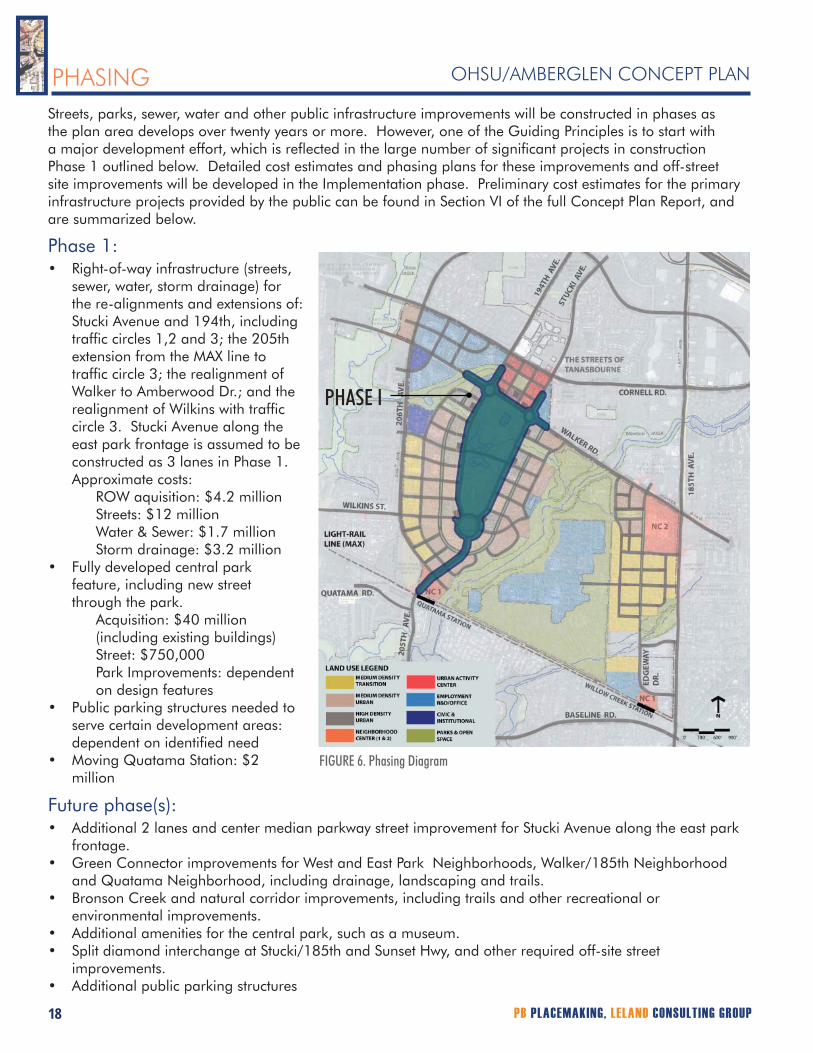
Streets, parks, sewer, water and other public infrastructure improvements will be constructed in phases as the plan area develops over twenty years or more. However, one of the Guiding Principles is to start with a major development effort, which is reflected in the large number of significant projects in construction Phase 1 outlined below. Detailed cost estimates and phasing plans for these improvements and off-street site improvements will be developed in the Implementation phase. Preliminary cost estimates for the primary infrastructure projects provided by the public can be found in Section VI of the full Concept Plan Report, and are summarized below.
Phase 1:Right-of-way infrastructure (streets, sewer, water, storm drainage) for the re-alignments and extensions of: Stucki Avenue and 194th, including traffic circles 1,2 and 3; the 205th extension from the MAX line to traffic circle 3; the realignment of Walker to Amberwood Dr.; and the realignment of Wilkins with traffic circle 3. Stucki Avenue along the east park frontage is assumed to be constructed as 3 lanes in Phase 1. Approximate costs: ROW aquisition: $4.2 million
Streets: $12 million Water & Sewer: $1.7 million Storm drainage: $3.2 million
Fully developed central park feature, including new street through the park.
Acquisition: $40 million (including existing buildings) Street: $750,000 Park Improvements: dependent on design features
Public parking structures needed to serve certain development areas: dependent on identified needMoving Quatama Station: $2 million
•
•
•
•
PHASING
Future phase(s):Additional 2 lanes and center median parkway street improvement for Stucki Avenue along the east park frontage.Green Connector improvements for West and East Park Neighborhoods, Walker/185th Neighborhood and Quatama Neighborhood, including drainage, landscaping and trails. Bronson Creek and natural corridor improvements, including trails and other recreational or environmental improvements.Additional amenities for the central park, such as a museum.Split diamond interchange at Stucki/185th and Sunset Hwy, and other required off-site street improvements.Additional public parking structures
•
•
•
••
•
FIGURE 6. Phasing Diagram
PHASE I

CITY OF HILLSBORO 19
OHSU/AMBERGLEN CONCEPT PLANOHSU/AMBERGLEN CONCEPT PLAN
The Concept Plan is the culmination of the first phase of the planning process for the OHSU/AmberGlen site. A significant amount of work remains to be done before development can proceed. The first step is the endorsement of the Concept Plan by the Hillsboro Planning Commission and City Council. Beyond that step, further work will be part of a second phase of planning work, outlined below. These major work elements are described in more detail in Section VII of the full Concept Plan Report.
A. Development of a Market Implementation Strategy to provide information to private sector organizations potentially interested in implementation of the Concept Plan.
B. Development of a Detailed Work Program for Phase II planning.
C. Because of the complexity of the work that needs to be accomplished in Phase II, a Memorandum of Understanding among the key parties – property owners, developers, City and Metro – should be created to agree on the scope of, and responsibilities for, the work that will follow.
D. The major work elements of Phase II can be categorized as Financial/Fiscal and Policy/Regulatory/Infrastructure. These will create the final agreements, ordinances and other work products necessary to proceed with development.
E. Implementation of Development Agreements between the City and developer (s).
F. Adoption of Land Use Code Amendments.
G. Implementation of Funding Strategy for public sector projects.
H. Preparation of Engineering documents for public improvements.
I. Construction of Public Improvements
IMPLEMENTATION
D1. Financial/Fiscal:
Market StrategyDevelopment Agreements between City and Developers/OwnersInfrastructure Phasing and Cost EstimatesFunding Strategy and specific plans for use of implementation tools, including tax increment financing; systems development charges; local improvement district; general obligation bonds; county, metro, state and federal funding sources
D2. Policy/Regulatory/Infrastructure
Master Planning, including: comprehensive plan revisionszoning code changesurban design standards: architecture, streetscapes, neighborhood character, parksinfrastructure analysis and plans: streets, transit, pedestrian, bicycle, water, sewer, stormwater
Regional and State policy and plan changes
••
•
•
•
•

City of Hillsboro
City CouncilTom Hughes, MayorEd Dennis, CouncilorNenice Andrews, CouncilorAron Carlson, CouncilorJoe Keizur, CouncilorDoug Johnson, CouncilorCynthia O’Donnell, Councilor
Planning CommissionJohn Coulter, PresidentJoe GallRoss MathewsKatie EyreCharles FleisherSteve CallawayRay Lankford
Planning StaffWink Brooks, Planning DirectorKarla Antonini, Urban Planner III Doug Miller, Urban Planner IIDan Rutzick, Urban Planner IDon Odermott, Transportation Planning Engineer
OHSU/AmberGlen Project Committees
Steering CommitteeDan Dorsa OHSULesley Hallick OHSUMarilyn Lanier OHSUFrank Parisi Parisi & Parisi, PCJay Fisher Principal Financial GroupBrian Pearce UnicoTom Bard SKBBruce Fong Kaiser PermanenteJay Kenton Oregon University SystemCraig Ramey Regency CentersBrad Farmer Parr LumberTrond Ingvaldsen TheStandard/ Standard Insurance CompanyBetsy Murphy The Streets of TanasbourneNeshia Cameron Resident, 206th areaStephen Cook Small landownerMarvin Lamacus Resident, Walker Road area Ian Dees Resident, South of planning area Charles Fleisher Planning CommissionerKatie Eyre Planning CommissionerRandy McEwen Portland Community College
Technical Advisory CommitteeKevin Smith Hillsboro Parks and RecreationRoy Gibson Hillsboro Public WorksRicky Icenogle Hillsboro Building DepartmentLt. John Specht Hillsboro Police DepartmentJohn Riner Hillsboro Fire DepartmentMarah Danielson Oregon Dept. of TransportationJillian Detweiler Tri-Met Jerry Green Beaverton School DistrictJennifer Garland Beaverton School DistrictGary Pippin Tualatin Valley Water DistrictGregg Leion Washington County PlanningCarrie Pak Clean Water ServicesAstrid Dragoy Clean Water ServicesTim O’Brien MetroMiranda Bateschell MetroCraig Eyestone AT&T BroadbandJoe Vandecoevering VerizonTrent Lutz PGECliff Crawford Northwest NaturalMeg Fernekees Dept. of Land Conservation and DevelopmentKaren Frost Westside Transportation AllianceAli Sadri OHSUMarilyn Lanier OHSUKristin Udvari Ball Janik LLP
SWCA FishmanStacy Benjamin, Senior Wetland EcologistChristie Galen, Senior Ecologist
PB EngineeringIsabella Bejarano, Lead Civil EngineerLaurie Line, Senior Civil EngineerRon Horres, Engineering Manager
Consultants
PB PlaceMakingPaul Morris, Principal ConsultantBrian Campbell, Project ManagerKimi Iboshi Sloop, Deputy Project ManagerTom Bennett, Senior Urban DesignerKokila Lochan, Urban DesignerEmily Hull, Urban DesignerJerry Goldberg, Senior Urban Designer/Architect
Leland Consulting GroupDave Leland, Principal ConsultantChris Zahas, PrincipalBrian Vanneman, Associate
Kittelson and AssociatesDan Seeman, Principal PlannerChris Tiesler, Engineering AssociateAndrew Ooms, Transportation AnalystRon Failmezger, Senior Engineer
ACKNOWLEDGEMENTS