Testing the Quality of RTK Positioning by Receiving ... · PDF fileISO 17123 standard defines...
10
TS 2 – Geodetic Networks, Data Quality Control, Testing and Calibration 245 Testing the Quality of RTK Positioning by Receiving Signals just from GLONASS Satellites according to the ISO 17123-8: 2015 Standard Ivica Šarušić 1 , Sanja Šarušić 2 , Mladen Zrinjski 3 1 Vještačenje Bajilo, Vučanska 8, Zagreb, Croatia, [email protected] 2 Geodetska tehnička škola, Av. V. Holjevca 15, Zagreb, Croatia, [email protected] 3 Faculty of Geodesy, University of Zagreb, Kačićeva 26, Zagreb, Croatia, [email protected] Abstract. The development of Russian global navigation system GLONASS has eliminated the technological reliance on single global navigation system – GPS. Precise GNSS instruments for RTK positioning that no longer depend on GPS have also been developed along with this system. Such a device called SP80 was developed by Spectra Precision. The company has developed Z-Blade technology that allows RTK positioning being independent of GNSS used, and it will be possible to use only BeiDou, GLONASS or Galileo (in near future). In this work, the quality of positioning in RTK mode on the Croatian territory by means of GLONASS is presented in accordance with ISO 17123-8:2015 standard. Keywords: GLONASS, ISO 17123-8:2015, RTK positioning, SP80, Z-Blade. 1. Introduction The development of GPS has provided faster, simpler and much more efficient positioning anywhere on the Earth surface. For this purpose, as well as for the purpose of surveying, terrestrial GPS rovers for centimetre-accurate positioning were developed. Since GPS represents the American military system, some countries decided to build their own navigation satellite system. It is first of all the Russian GLONASS, and more recently European Galileo, Chinese BeiDou, etc. However, in spite of the development of other satellite systems and the technological development of the GPS receivers that are turned into GNSS receivers in such a way that they receive and process the data from other satellite systems, they still depend on GPS that is still necessary for their operation, which makes them GPS-centric. Triggered by the above mentioned facts and the dependence on GPS, the company Spectra Precision started to develop the technologies that will enable the positioning without depending on GPS. For this purpose, Z-Blade technology
-
Upload
phamkhuong -
Category
Documents
-
view
216 -
download
0
Transcript of Testing the Quality of RTK Positioning by Receiving ... · PDF fileISO 17123 standard defines...

TS 2 – Geodetic Networks, Data Quality Control, Testing and Calibration
245
Testing the Quality of RTK Positioning by Receiving Signals just from GLONASS Satellites according to the ISO 17123-8:2015 Standard Ivica Šarušić1, Sanja Šarušić2, Mladen Zrinjski3
1 Vještačenje Bajilo, Vučanska 8, Zagreb, Croatia, [email protected] 2 Geodetska tehnička škola, Av. V. Holjevca 15, Zagreb, Croatia, [email protected] 3 Faculty of Geodesy, University of Zagreb, Kačićeva 26, Zagreb, Croatia, [email protected]
Abstract. The development of Russian global navigation system GLONASS has eliminated the technological reliance on single global navigation system – GPS. Precise GNSS instruments for RTK positioning that no longer depend on GPS have also been developed along with this system. Such a device called SP80 was developed by Spectra Precision. The company has developed Z-Blade technology that allows RTK positioning being independent of GNSS used, and it will be possible to use only BeiDou, GLONASS or Galileo (in near future). In this work, the quality of positioning in RTK mode on the Croatian territory by means of GLONASS is presented in accordance with ISO 17123-8:2015 standard.
Keywords: GLONASS, ISO 17123-8:2015, RTK positioning, SP80, Z-Blade.
1. Introduction
The development of GPS has provided faster, simpler and much more efficient positioning anywhere on the Earth surface. For this purpose, as well as for the purpose of surveying, terrestrial GPS rovers for centimetre-accurate positioning were developed. Since GPS represents the American military system, some countries decided to build their own navigation satellite system. It is first of all the Russian GLONASS, and more recently European Galileo, Chinese BeiDou, etc. However, in spite of the development of other satellite systems and the technological development of the GPS receivers that are turned into GNSS receivers in such a way that they receive and process the data from other satellite systems, they still depend on GPS that is still necessary for their operation, which makes them GPS-centric.
Triggered by the above mentioned facts and the dependence on GPS, the company Spectra Precision started to develop the technologies that will enable the positioning without depending on GPS. For this purpose, Z-Blade technology

SIG 2016 – International Symposium on Engineering Geodesy, 20–22 May 2016, Varaždin, Croatia
246
has been developed that makes the receivers GNSS-centric, and the last GNSS chip has introduced a new era in GNSS precise positioning that has become independent of one system only – GPS.
2. Z-blade technology
Z-Blade is a (patent pending) GNSS-centric positioning technology developed by Spectra Precision, based on many years of GNSS experience and know-how and the strong understanding that the future of GNSS receivers lies in making better use of all GNSS satellite signals, without unnecessary reliance on GPS satellite signals alone. Z-Blade technology provides GNSS receivers to be independent of GPS and to literary be GNSS receivers that can operate using any GNSS considering the that satellites from any system "equally valuable" [Spectra Precision 2013]. This provides a much better reception quality and processing of signals, and gives the ability to work in any other GNSS – GLONASS, Galileo, BeiDou, without using the signal from the GPS.
The figures 2.1 and 2.2 show the difference between GPS-centric and GNSS-centric (Z-Blade) approach, and the figure 2.1 shows that the position cannot be determined if there are not enough GPS satellites available which is used today by most receivers [Figure 2.1], [Figure 2.2], [Spectra Precision 2013].
Following this unique technology, we have decided to examine the precision of GNSS receivers in our work that use the signals only from the GLONASS satellites in RTK mode.
Figure 2.1 GPS-centric approach

TS 2 – Geodetic Networks, Data Quality Control, Testing and Calibration
247
Figure 2.2 GNSS-centric approach
The first GNSS receiver that enables measurements in RTK mode, but without using any GPS satellite signals, is the SP80, GNSS receiver from Spectra Precision [URL 1]. In order to test the possibility of such an operation on the Croatian territory, the precision of coordinate measurement was tested according to ISO 17123-8:2015.
3. ISO 17123-8:2015 standard
ISO 17123 standard defines the testing of geodetic and surveying instruments, and its common name is Optics and Optical instruments – Field Procedures for Testing Geodetic and Surveying Instruments [URL 2]. The field procedures for testing the precision of the GNSS field measurement systems in real-time kinematic (RTK) are defined in its eight chapter. ISO 17123-8:2015 standard specifies the field procedures for testing the precision of Global Navigation Satellite System, (this includes GPS, GLONASS, Galileo) in real-time kinematic (RTK), as well as of its ancillary equipment when used in construction, industrial, and other measurements [ISO 2015].
4. Implemented measurements and analysis of the obtained results
Field testing was made in Zagreb applying highly precise positioning (VPPS) CROPOS system and using GNSS receiver SP80, serial number 5410900102. The receiver was tested according to the full test of ISO 17123-8:2015 standard.

SIG 2016 – International Symposium on Engineering Geodesy, 20–22 May 2016, Varaždin, Croatia
248
There were two points set up and firmly stabilized on the ground at the distance of about 20 meters. The measurements were made in two series. Each series consisted of 3 sessions, each of them having 5 sets. Each set included the measurements on the points 1 and 2.
Horizontal distance and height difference between these two stabilized points were determined by means of geodetic methods with the accuracy higher than 3 mm. The obtained values were taken as reference values.
The first series of measurements was conducted by Sanja Šarušić on the 21st August 2015. The second series of measurements was conducted by Ivica Šarušić that same day.
Figure 4.1 shows the screen of the used GNSS receiver SP80 showing active GLONASS satellites [Figure 4.1].
In order to speed up the computational processes of testing the precision of the RTK measurement system, the computer program GNSS_RTK_ISO made in the software package Microsoft Office 2010 was used [Zrinjski et al. 2015].
Figure 4.1 Display of the active GLONASS satellites
When using the full test, the results of the measurements are processed in two steps. In the first step, the measured data are compared with the reference data, while in the second step, the statistical values are determined and 4 statistical tests made.
As a result of testing, ISO 17123-8:2015 standard sets four assumptions in the full test that need to be met by the measuring system.
GNSS measuring system Spectra Precision SP80 has a declared measurement uncertainty for the network RTK mode given in the technical specifications, horizontally (8 mm+0.5 ppm), vertically (15 mm+0.5 mm).
TS 2 – Geodetic Networks, Data Quality Control, Testing and Calibration
249
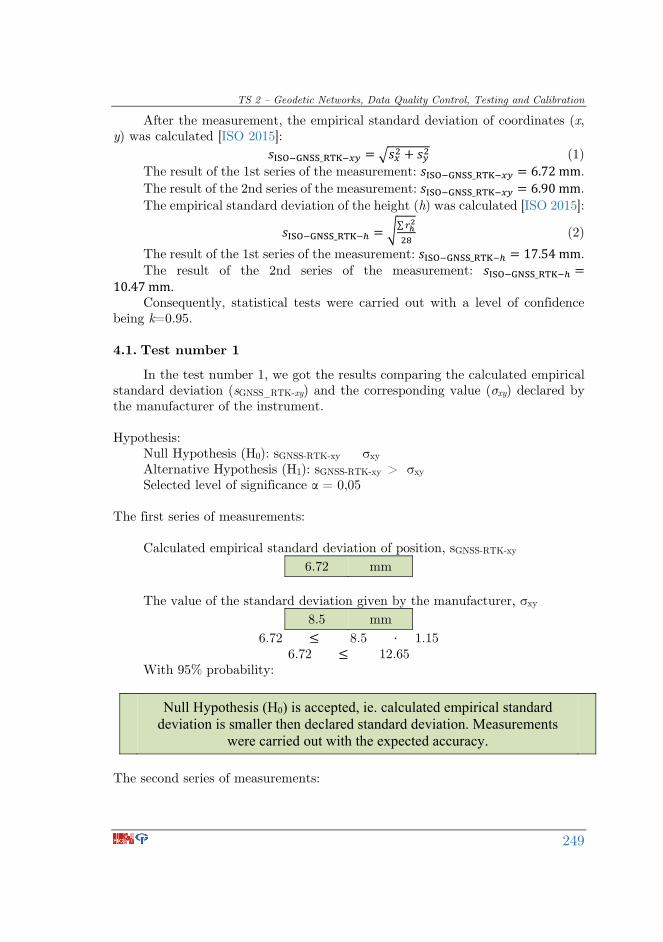
After the measurement, the empirical standard deviation of coordinates (x, y) was calculated [ISO 2015]:
_ = (1) The result of the 1st series of the measurement: _ = 6.72mm. The result of the 2nd series of the measurement: _ = 6.90mm. The empirical standard deviation of the height (h) was calculated [ISO 2015]:
_ = ∑ (2) The result of the 1st series of the measurement: _ = 17.54mm. The result of the 2nd series of the measurement: _ =10.47mm. Consequently, statistical tests were carried out with a level of confidence
being k=0.95.
4.1. Test number 1
In the test number 1, we got the results comparing the calculated empirical standard deviation (sGNSS_RTK-xy) and the corresponding value (σxy) declared by the manufacturer of the instrument. Hypothesis:
Null Hypothesis (H0): sGNSS-RTK-xy σxy Alternative Hypothesis (H1): sGNSS-RTK-xy > σxy Selected level of significance α = 0,05
The first series of measurements:
Calculated empirical standard deviation of position, sGNSS-RTK-xy
6.72 mm The value of the standard deviation given by the manufacturer, σxy
8.5 mm 6.72 ≤ 8.5 · 1.15
6.72 ≤ 12.65 With 95% probability:
Null Hypothesis (H0) is accepted, ie. calculated empirical standard deviation is smaller then declared standard deviation. Measurements
were carried out with the expected accuracy.
The second series of measurements:

SIG 2016 – International Symposium on Engineering Geodesy, 20–22 May 2016, Varaždin, Croatia
250
Calculated empirical standard deviation of position, sGNSS-RTK-xy
6.90 mm The value of the standard deviation given by the manufacturer, σxy
8.5 mm 6.90 ≤ 8.5 · 1.15
6.90 ≤ 12.65 With 95% probability:
Null Hypothesis (H0) is accepted, ie. calculated empirical standard deviation is smaller then declared standard deviation. Measurements
were carried out with the expected accuracy.
4.2. Test number 2
In the test number 2, we got the results comparing the calculated empirical standard deviation (sGNSS_RTK-h) and the corresponding value (σh) declared by the manufacturer of the instrument. Hypothesis:
Null Hypothesis (H0): sGNSS-RTK-h σh Alternative Hypothesis (H1): sGNSS-RTK-h > σh Selected level of significance α = 0,05
The first series of measurements:
Calculated empirical standard deviation of height, sGNSS-RTK-h
17.54 mm
The value of the standard deviation given by the manufacturer, σh 15.5 mm
17.54 ≤ 15.5 · 1.22 17.54 ≤ 25.62
With 95% probability:
Null Hypothesis (H0) is accepted, ie. calculated empirical standard deviation is smaller then declared standard deviation. Measurements
were carried out with the expected accuracy.

TS 2 – Geodetic Networks, Data Quality Control, Testing and Calibration
251
The second series of measurements: Calculated empirical standard deviation of height, sGNSS-RTK-h
10.47 mm
The value of the standard deviation given by the manufacturer, σh 15.5 mm
10.47 ≤ 15.5 · 1.22 10.47 ≤ 25.62
With 95% probability:
Null Hypothesis (H0) is accepted, i.e. calculated empirical standard deviation is smaller then declared standard deviation. Measurements
were carried out with the expected accuracy.
4.3. Test number 3
In the test number 3, we got the results comparing two empirical standard deviations of the horizontal position (s i ŝ) obtained from various measurements of the same number of degrees of freedom.
Hypothesis:
Null Hypothesis (H0): s = ŝ Alternative Hypothesis (H1): s ≠ ŝ Calculated empirical standard deviation of position for the first series of
measurements, sGNSS-RTK-xy
6.72 mm Calculated empirical standard deviation of position for the second series of
measurements, ŝGNSS-RTK-xy
6.90 mm The limits of mutual test:
0.59 ≤ s²/ŝ² ≤ 1.7
The ratio of the square of empirical standard deviations, s² / ŝ²
0.95

SIG 2016 – International Symposium on Engineering Geodesy, 20–22 May 2016, Varaždin, Croatia
252
With 95% probability:
Null Hypothesis (H0) is accepted, ie. empirical standard deviations come from the same sample.
4.4. Test number 4
In the test number 4, we got the results comparing two empirical standard deviations of the height (s i ŝ) obtained from various measurements of the same number of degrees of freedom. Hypothesis:
Null Hypothesis (H0): s = ŝ Alternative Hypothesis (H1): s ≠ ŝ Calculated empirical standard deviation of position for the first series of
measurements, sGNSS-RTK-h
17.54 mm Calculated empirical standard deviation of position for the second series of
measurements, ŝGNSS-RTK-h
10.47 mm The limits of mutual test:
0.47 ≤ s²/ŝ² ≤ 2.13
The ratio of the square of empirical standard deviations, s² / ŝ²
2.80 With 95% probability:
Null Hypothesis (H0) is not accepted.
5. Conclusion
The testing of SP80 GNSS surveying system with the signals used only from GLONASS satellites according to ISO 17123-8:2015 standard yielded the results of horizontal accuracy with a standard deviation of 6.72 mm and 6.90 mm, and the results of the accuracy of height determination with the standard deviation of 17.54 mm and 10.47 mm. According to the technical specification of the manufacturer, the accuracy in the network RTK mode is (8 mm+0.5 ppm) (horizontal position) and (15 mm+0.5 ppm) (height).

TS 2 – Geodetic Networks, Data Quality Control, Testing and Calibration
253
Based on the results of measurements and statistical tests and on their comparison with the technical specifications of the manufacturer, it can be concluded that the horizontal accuracy of the measured data is in accordance with the declared precision. The precision of the height measurement in the first series is not in accordance with the declared precision. On the other hand, the precision in the second series is in accordance with the declared precision. It resulted with the negative result of the fourth test. After reviewing the measured data of the first series, the deviation in one of the sets of measurements was noticed, which consequently makes the standard deviation higher than declared.
Regardless of the negative fourth statistical test being the result of individual variations in the real measurement conditions, we can conclude that GNSS receivers that receive only GLONASS satellite signals and use Z-Blade GNSS-centric technology comply with the precision declared by the manufacturer and can be used for a number of applications in cadastral and engineering geodesy. With this technological solution, the global reliance on GPS in determining the position no longer exists.
References
ISO (2015). ISO 17123–8:2015: Optics and optical instruments – Field procedures for testing geodetic and surveying instruments – Part 8: GNSS field measurement systems in real time kinematic (RTK), ISO, Geneva, Switzerland.
Spectra Precision (2013). Increased Productivity in Harsh Environments with Spectra Precision Z-Blade Technology, Spectra Precision, Westminster.
Zrinjski, M.; Barković, Đ.; Herent, M. (2015). Testing the Precision of GNSS RTK Measuring Systems by Applying of Computer Programme, Conference Proceedings, Volume II – 15th International Multidisciplinary Scientific GeoConference SGEM 2015, STEF92 Technology Ltd., Sofia, Bulgaria, 499-506.
URL 1: Spectra Precision, USA, http://www.spectraprecision.com, (3. 3. 2016).
URL 2: International Organization for Standardization – ISO, http://www.iso.org/iso/iso_catalogue.htm, (3. 3. 2016).

SIG 2016 – International Symposium on Engineering Geodesy, 20–22 May 2016, Varaždin, Croatia
254
Ispitivanje kvalitete RTK pozicioniranja primanjem signala samo s GLONASS satelita prema normi ISO 17123-8:2015 Sažetak. Razvitkom ruskoga globalnog navigacijskog sustava GLONASS prestaje tehnološka ovisnost o jednom globalnom navigacijskom sustavu – GPS-u. U korak s njegovim razvitkom razvijaju se i geodetski precizni GNSS uređaji za RTK pozicioniranje koji prestaju biti ovisni o GPS-u. Takav uređaj razvila je tvrtka Spectra Precision pod nazivom SP80. Tvrtka je razvila Z-Blade tehnologiju koja omogućuje RTK pozicioniranje neovisno o GNSS-u koji se koristi te je moguće neovisno koristiti samo GLONASS ili samo BeiDou ili samo Galileo (u bliskoj budućnosti) sustav. U radu će biti prikazana kvaliteta pozicioniranja u RTK modu rada na području Hrvatske koristeći GLONASS, a iskazana prema normi ISO 17123-8:2015.
Ključne riječi: GLONASS, ISO 17123-8:2015, RTK pozicioniranje, SP80, Z-Blade.
*scientific paper