
Tenmile – South Helena Project Draft Record of...
229
Tenmile – South Helena Project Draft Record of Decision Appendices: A - E USDA Forest Service Helena Ranger District, Helena-Lewis and Clark National Forest Lewis and Clark County and Jefferson County, Montana Lead Agency: USDA Forest Service Helena – Lewis and Clark National Forest Service Helena Ranger District Responsible Official: WILLIAM AVEY, FOREST SUPERVISOR Helena-Lewis and Clark National Forest 2880 Skyway Drive, Helena, MT 59602 For Information Contact: HEATHER DEGEEST, DISTRICT RANGER Helena Ranger District 2880 Skyway Drive, Helena, MT 59602 406-449-5201
Transcript of Tenmile – South Helena Project Draft Record of...
Tenmile – South Helena Project Draft Record of Decision
Appendices: A - E
USDA Forest Service Helena Ranger District, Helena-Lewis and Clark National Forest
Lewis and Clark County and Jefferson County, Montana
Lead Agency: USDA Forest Service Helena – Lewis and Clark National Forest Service Helena Ranger District
Responsible Official: WILLIAM AVEY, FOREST SUPERVISOR Helena-Lewis and Clark National Forest 2880 Skyway Drive, Helena, MT 59602
For Information Contact: HEATHER DEGEEST, DISTRICT RANGER Helena Ranger District 2880 Skyway Drive, Helena, MT 59602 406-449-5201

Tenmile – South Helena Project
Helena – Lewis and Clark National Forest
i
In accordance with Federal civil rights law and U.S. Department of Agriculture (USDA) civil rights regulations and policies, the USDA, its Agencies, offices, and employees, and institutions participating in or administering USDA programs are prohibited from discriminating based on race, color, national origin, religion, sex, gender identity (including gender expression), sexual orientation, disability, age, marital status, family/parental status, income derived from a public assistance program, political beliefs, or reprisal or retaliation for prior civil rights activity, in any program or activity conducted or funded by USDA (not all bases apply to all programs). Remedies and complaint filing deadlines vary by program or incident.
Persons with disabilities who require alternative means of communication for program information (e.g., Braille, large print, audiotape, American Sign Language, etc.) should contact the responsible Agency or USDA’s TARGET Center at (202) 720-2600 (voice and TTY) or contact USDA through the Federal Relay Service at (800) 877-8339. Additionally, program information may be made available in languages other than English.
To file a program discrimination complaint, complete the USDA Program Discrimination Complaint Form, AD-3027, found online at http://www.ascr.usda.gov/complaint_filing_cust.html and at any USDA office or write a letter addressed to USDA and provide in the letter all of the information requested in the form. To request a copy of the complaint form, call (866) 632-9992. Submit your completed form or letter to USDA by: (1) mail: U.S. Department of Agriculture, Office of the Assistant Secretary for Civil Rights, 1400 Independence Avenue, SW, Washington, D.C. 20250-9410; (2) fax: (202) 690-7442; or (3) email: [email protected].
USDA is an equal opportunity provider, employer and lender.
The Forest Service uses the most current and complete data available. GIS data and product accuracy may vary. They may be: developed from sources of differing accuracy, accurate only at certain scales, based on modeling or interpretation, incomplete while being created or revised, etc. Using GIS products for purposes other than those for which they were created may yield inaccurate or misleading results. The Forest Service reserves the right to correct, update, modify or replace GIS products without notification. For more information contact:
Helena-Lewis and Clark National Forest 2880 Skyway Drive Helena, Montana 59602 406-449-5201

Draft Record of Decision
Helena – Lewis and Clark National Forest
ii
Enclosed are the Appendices to the Tenmile – South Helena Draft Record of Decision. They include the following:
Appendix A: Threatened, Endangered and Sensitive Species Determinations
Appendix B: Proposed Unit-by-Unit Treatment Summary
Appendix C: Design Criteria for the Tenmile – South Helena Draft Decision
Appendix D: Tenmile South Helena Site-Specific Forest Plan Amendment for the Draft Record of Decision
Appendix E: Forestwide Standards, Management Area Direction, and Forest Plan Consistency

Tenmile – South Helena Project
Helena – Lewis and Clark National Forest
Appendix A: 1
Appendix A: Threatened, Endangered and Sensitive Species Determinations for the draft Record of Decision.
Table 1. Threatened, Endangered and Sensitive Species determinations for the Decision.
Species Decision Threatened, Endangered, and Proposed Species-Animals Grizzly Bear LAA Canada Lynx LAA Canada Lynx Critical Habitat NE, not in critical habitat Wolverine (Proposed) Not likely to jeopardized the species
continued existence. Sensitive and Federal Candidate Species-Animals Gray Wolf NI Fisher NI Townsend’s Big-eared Bat NI Northern Bog Lemming NI Bighorn Sheep NI Black-backed Woodpecker NI Flammulated Owl MIIH Peregrine Falcon NI Bald Eagle NI Harlequin Duck NI Boreal Toad MIIH Leopard Frog NI Plains Spadefoot Toad NI Sensitive and Federal Candidate Species-Plants Lesser Rushy Milkvetch MIIH Ascending Moonwort MIIH Wavy Moonwort MIIH Peculiar Moonwort MIIH Small Yellow Ladies’ Slipper MIIH Linear-leaf Fleabane MIIH Howell’s Gumweed MIIH Hall’s Rush MIIH Whitebark Pine MIIH Missoula Phlox MIIH Austin Knotweed MIIH Threatened and Endangered Species-Fish Bull Trout NE Bull Trout Critical Habitat NE Sensitive and Federal Candidate Species-Fish Westslope Cutthroat Trout NI Western Pearlshell Mussel NI Threatened and endangered Species Determinations: NE: No Effect; NLAA: May Affect, Not Likely to Adversely Affect; LAA: May Affect, Likely to Adversely Affect. Sensitive Species Determinations: NI: No Impact; MIIH: May Impact Individuals or habitat, but will not likely contribute to a trend towards federal listing or loss of viability to the population or species.
Note: There are no Threatened or Endangered Plant Species known on the Helena National Forest.


Tenmile – South Helena Project
Helena – Lewis and Clark National Forest
Appendix B: 1
Appendix B. Proposed Unit-by-Unit Treatment Summary
Table 1 (Proposed Unit-by-Unit Treatment Summary Table) lists the units associated in this decision. It includes information and descriptions on the units, visual quality objections, acre size, management area, treatment type, silviculture prescription and logging system, whether the unit is located within WUI and/or IRA, as well as tree species, size class and canopy cover.
Abbreviations found in table A-1
VQO Visual Quality Objective
DBH Diameter at Breast Height
IRA Inventoried Roadless Area
MA Management Area
WUI Wildland-urban Interface
J Jericho Mountain IRA
L Lazyman Gulch IRA
N No (referring to not within IRA or WUI)
Y Yes (referring to within WUI)
Key to Logging Systems/Method:
Mech Mechanical Equipment
N/A (none) Hand Treatment
S Skyline/Cable Harvest Equipment
T Tractor/Ground-based Harvest Equipment
Key to Species:
AS Aspen
DF Douglas-fir
G Grassland
LP Lodgepole pine
NF Not Forested
PP Ponderosa pine
SAF Subalpine fir
WBP Whitebark pine

Draft Record of Decision
Helena – Lewis and Clark National Forest
Appendix B: 2
Table 1. Proposed Unit-by-Unit Treatment Summary Table
Unit ID VQO Alternative Acres MA
Wildland-urban
Interface Treatment Type Prescription Logging
System IRA
(J/L/N) Dominant Species
Size Class (DBH)
Canopy Cover
(%)
1 Modification 53.00 H1 N Regeneration Harvest
Clearcut with Leave Trees, Site Prep
Burn T N LP 5.0-9.9 60+
4 Modification 25.00 H1 Y Regeneration Harvest
Clearcut with Leave Trees, Site Prep
Burn T N LP 0-4.9 60+
5 Modification 53.00 H1 Y Regeneration Harvest
Clearcut with Leave Trees, Site Prep
Burn T N LP 5.0-9.9 60+
8az Maximum Modification 10.00 T1, T5, H1, H2,
T4 Y Private Land Buffers
Rearrangement of Fuels, Handpile or
Jackpot Burn N/A J DF/LP/NF 5.0-9.10 60+
8cz Partial Retention/retention 93.00 T1, T5, H1, H2,
T4 Y Private Land Buffers
Rearrangement of Fuels, Handpile or
Jackpot Burn Mech J AS/DF 10-14.10 60+
8gz Maximum Modification 35.00 T1, T5, H1, H2,
T4 Y Private Land Buffers
Rearrangement of Fuels, Handpile or
Jackpot Burn N/A J DF/LP 5.0-9.10 60+
8iz Maximum Modification 36.00 T1, T5, H1, H2,
T4 Y Private Land Buffers
Rearrangement of Fuels, Handpile or
Jackpot Burn N/A J DF/LP/NF 10-14.10 40-61
8pz Partial Retention/Retention 42.00 T1, T5, H1, H2,
T4 Y Private Land Buffers
Rearrangement of Fuels, Handpile or
Jackpot Burn Mech N DF/LP/NF 10-14.10 60+
9a Maximum Modification 98.00 L1, T1 Y Low Severity
Prescribed Fire
Rearrangement of Fuels, Handpile,
Jackpot, or Underburn
N/A N NF 10-14.9 40-60
9az Maximum Modification 31.00 L1, T1 Y Private Land
Buffers
Rearrangement of Fuels, Handpile or
Jackpot Burn N/A N NF/DF/PP 10-14.9 40-60
11 Modification 200.00 H2, H1 Y Regeneration Harvest
Clearcut with Leave Trees, Site Prep
Burn T N DF/LP 5.0 - 9.9 60+
11z Modification 27.00 H2, H1 Y Private Land Buffers
Rearrangement of Fuels, Handpile or
Jackpot Burn Mech N LP 5.0-9.9 60+
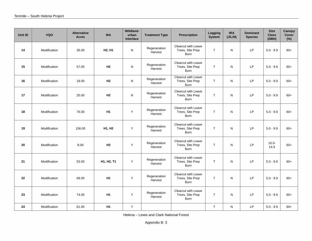
Tenmile – South Helena Project
Helena – Lewis and Clark National Forest
Appendix B: 3
Unit ID VQO Alternative Acres MA
Wildland-urban
Interface Treatment Type Prescription Logging
System IRA
(J/L/N) Dominant Species
Size Class (DBH)
Canopy Cover
(%)
14 Modification 26.00 H2, H1 N Regeneration Harvest
Clearcut with Leave Trees, Site Prep
Burn T N LP 5.0 - 9.9 60+
15 Modification 57.00 H2 N Regeneration Harvest
Clearcut with Leave Trees, Site Prep
Burn T N LP 5.0 - 9.9 60+
16 Modification 18.00 H2 N Regeneration Harvest
Clearcut with Leave Trees, Site Prep
Burn T N LP 5.0 - 9.9 60+
17 Modification 25.00 H2 N Regeneration Harvest
Clearcut with Leave Trees, Site Prep
Burn T N LP 5.0 - 9.9 60+
18 Modification 76.00 H1 Y Regeneration Harvest
Clearcut with Leave Trees, Site Prep
Burn T N LP 5.0 - 9.9 60+
19 Modification 156.00 H1, H2 Y Regeneration Harvest
Clearcut with Leave Trees, Site Prep
Burn T N LP 5.0 - 9.9 60+
20 Modification 8.00 H2 Y Regeneration Harvest
Clearcut with Leave Trees, Site Prep
Burn T N LP 10.0-
14.9 60+
21 Modification 53.00 H1, H2, T1 Y Regeneration Harvest
Clearcut with Leave Trees, Site Prep
Burn T N LP 5.0 - 9.9 60+
22 Modification 69.00 H1 Y Regeneration Harvest
Clearcut with Leave Trees, Site Prep
Burn T N LP 5.0 - 9.9 60+
23 Modification 74.00 H1 Y Regeneration Harvest
Clearcut with Leave Trees, Site Prep
Burn T N LP 5.0 - 9.9 60+
24 Modification 61.00 H1 Y T N LP 5.0 - 9.9 60+

Draft Record of Decision
Helena – Lewis and Clark National Forest
Appendix B: 4
Unit ID VQO Alternative Acres MA
Wildland-urban
Interface Treatment Type Prescription Logging
System IRA
(J/L/N) Dominant Species
Size Class (DBH)
Canopy Cover
(%)
Regeneration Harvest
Clearcut with Leave Trees, Site Prep
Burn
26 Maximum Modification 95.00 W1, T1 Y Regeneration
Harvest
Clearcut with Leave Trees, Site Prep
Burn T N LP 5.0 - 9.9 60+
26a Maximum Modification 42.00 W1, T1 Y Regeneration
Harvest
Clearcut with Leave Trees, Site Prep
Burn T N LP/DF 5.0-9.9 60+
27a Modification 53.00 H1 Y Regeneration Harvest
Clearcut with Leave Trees, Site Prep
Burn T N LP 5.0 - 9.9 60+
28 Modification 109.00 H1, T1 Y Low Severity Prescribed Fire
Rearrangement of Fuels, Handpile,
Jackpot, or Broadcast Burn
Mech N LP/DF 5.0-9.9 60+
29 Modification 23.00 H1 Y Regeneration Harvest
Clearcut with Leave Trees, Site Prep
Burn S N LP 5.0-9.9 60+
30 Modification 66.00 H1, H2 Y Regeneration Harvest
Clearcut with Leave Trees, Site Prep
Burn T N LP 5.0-9.9 60+
31 Modification 1.00 H2, H1 Y Regeneration Harvest
Clearcut with Leave Trees, Site Prep
Burn T N LP 5.0-9.9 60+
32 Modification 7.00 H2 Y Regeneration Harvest
Clearcut with Leave Trees, Site Prep
Burn T N DF/LP 10.0-
14.9 60+
33 Modification 23.00 H2 Y T N LP 5.0-9.9 60+

Tenmile – South Helena Project
Helena – Lewis and Clark National Forest
Appendix B: 5
Unit ID VQO Alternative Acres MA
Wildland-urban
Interface Treatment Type Prescription Logging
System IRA
(J/L/N) Dominant Species
Size Class (DBH)
Canopy Cover
(%)
Regeneration Harvest
Clearcut with Leave Trees, Site Prep
Burn
35a Modification 9.00 H2 Y Shaded Fuel Break
Rearrangement of Fuels, Handpile,
Jackpot, or Underburn
Mech J LP 5.0-9.9 60+
35c Modification 6.00 H2 Y Regeneration Harvest
Clearcut with Leave Trees, Site Prep
Burn T N LP 5.0-9.10 60+
35b Modification 23.00 H2 Y Regeneration Harvest
Clearcut with Leave Trees, Site Prep
Burn T J LP 5.0-9.11 60+
36 Modification 65.00 H2 Y Regeneration Harvest
Clearcut with Leave Trees, Site Prep
Burn T J LP 5.0-9.9 60+
39a Modification 16.00 L2, M1, T3 Y Low Severity Prescribed Fire
Rearrangement of Fuels, Handpile,
Jackpot, or Underburn
N/A L DF/NF 10.0-14.9 40-60
39c Partial Retention/ Retention 40.00 T3, T4 Y Regeneration
Harvest
Shelterwood with Reserves, Site Prep
Burn S N DF/LP 10.0-
14.9 60+
39d Modification 8.00 T3 Y Low Severity Prescribed Fire
Rearrangement of Fuels, Handpile,
Jackpot, or Underburn
Mech N DF 15.0+ 40-60
39q Modification 331.00 L2, M1, T3 Y Low Severity Prescribed Fire
Rearrangement of Fuels, Handpile,
Jackpot, or Underburn
Mech L NF 15.0+ 40-60
39v Modification 53.00 L2, M1, T3 Y Low Severity Prescribed Fire
Rearrangement of Fuels, Handpile,
Jackpot, or Underburn
N/A L DF 10.0-14.9 60+

Draft Record of Decision
Helena – Lewis and Clark National Forest
Appendix B: 6
Unit ID VQO Alternative Acres MA
Wildland-urban
Interface Treatment Type Prescription Logging
System IRA
(J/L/N) Dominant Species
Size Class (DBH)
Canopy Cover
(%)
40 Partial Retention 15.00 W1 Y Precommercial Thin
Precommercial Thin, Handpile or Jackpot
Burn Mech L DF/LP 5.0-9.9 60+
41 Modification 34.00 T3 Y Precommercial Thin
Precommercial Thin, Handpile or Jackpot
Burn Mech N DF/LP 5.0-9.9 60+
42 Maximum Modification 81.00 T1, L1 Y Low Severity
Prescribed Fire
Rearrangement of Fuels, Handpile,
Jackpot, or Underburn
N/A N PP/DF 15.0+ 40-60
42z Maximum Modification 23.00 T1, L1 Y Private Land
Buffers
Rearrangement of Fuels, Handpile or
Jackpot Burn Mech N PP/DF
43a Maximum Modification 190.00 T5, T1 Y Low Severity
Prescribed Fire
Rearrangement of Fuels, Handpile,
Jackpot, or Underburn
N/A N LP/DF 15.0+ 40-60
43b Maximum Modification 14.00 T1 Y Precommercial
Thin Precommercial Thin Mech N DF 10.0-14.9 40-60
43az Maximum Modification 29.00 T5, T1 Y Low Severity
Prescribed Fire
Rearrangement of Fuels, Handpile,
Jackpot, or Underburn
Mech N LP 10.0-14.9 40-59
44 Modification 28.00 T5 Y Low Severity Prescribed Fire
Rearrangement of Fuels, Handpile or
Jackpot Burn N/A N DF 10.0-
14.9 40-60
44z Modification 25.00 T5 Y Private Land Buffers
Rearrangement of Fuels, Handpile or
Jackpot Burn N/A N DF/PP 10.0-
14.9 60+
45 Modification 28.00 T5 y Low Severity Prescribed Fire
Rearrangement of Fuels, Handpile or
Jackpot Burn N/A N AS 10.0-
14.9 60+

Tenmile – South Helena Project
Helena – Lewis and Clark National Forest
Appendix B: 7
Unit ID VQO Alternative Acres MA
Wildland-urban
Interface Treatment Type Prescription Logging
System IRA
(J/L/N) Dominant Species
Size Class (DBH)
Canopy Cover
(%)
46 Modification 12.00 T5 Y Low Severity Prescribed Fire
Rearrangement of Fuels, Handpile or
Jackpot Burn N/A N AS 5.0-9.9 60+
47 Modification 100.00 T5 Y Improvement Harvest
Improvement Harvest, Salvage,
Jackpot or Underburn
T N DF/LP/AS 10.0-14.9 40-60
47z Modification 3.00 T5 Y Private Land Buffers
Rearrangement of Fuels, Handpile or
Jackpot Burn N/A N DF/PP 10.0-
14.9 40-60
48 Maximum Modification 38.00 T1 Y Precommercial
Thin Precommercial Thin N/A N PP/AS 10.0-14.9 40-60
49a Maximum Modification 10.00 T1 Y Improvement
Harvest
Improvement Harvest, Jackpot or
Underburn T N LP 10.0-
14.9 60+
49b Maximum Modification 13.00 T1 Y Low Severity
Prescribed Fire
Rearrangement of Fuels, Handpile,
Jackpot, or Underburn
N/A N DF 15.0+ 40-60
49cz Maximum Modification 12.00 T1 Y Private Land
Buffers
Rearrangement of Fuels, Handpile or
Jackpot Burn Mech N DF, PP 10.0-
14.9 40-60
49c Maximum Modification 43.00 T1 Y Improvement
Harvest
Improvement Harvest, Handpile or
Jackpot Burn N/A N DF 10.0-
14.9 40-60
50 Maximum Modification 84.00 T1 Y Low Severity
Prescribed Fire
Rearrangement of Fuels, Handpile,
Jackpot, or Broadcast Burn
Mech N DF 10.0-14.9 40-60
50z Maximum Modification 13.00 T1 Y Private Land
Buffers
Rearrangement of Fuels, Handpile or
Jackpot Burn Mech N DF/PP/AS 10.0-
14.9 40-60
51 68.00 T1 Y Mech N DF/PP/AS 40-60
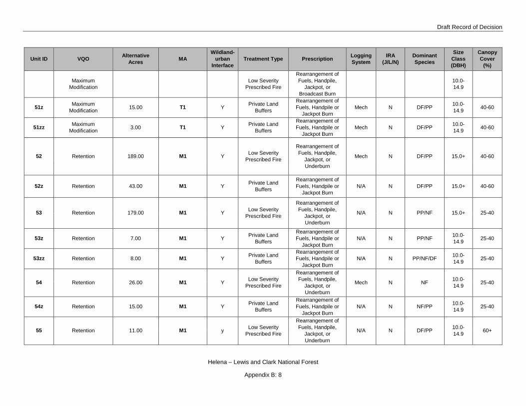
Draft Record of Decision
Helena – Lewis and Clark National Forest
Appendix B: 8
Unit ID VQO Alternative Acres MA
Wildland-urban
Interface Treatment Type Prescription Logging
System IRA
(J/L/N) Dominant Species
Size Class (DBH)
Canopy Cover
(%)
Maximum Modification
Low Severity Prescribed Fire
Rearrangement of Fuels, Handpile,
Jackpot, or Broadcast Burn
10.0-14.9
51z Maximum Modification 15.00 T1 Y Private Land
Buffers
Rearrangement of Fuels, Handpile or
Jackpot Burn Mech N DF/PP 10.0-
14.9 40-60
51zz Maximum Modification 3.00 T1 Y Private Land
Buffers
Rearrangement of Fuels, Handpile or
Jackpot Burn Mech N DF/PP 10.0-
14.9 40-60
52 Retention 189.00 M1 Y Low Severity Prescribed Fire
Rearrangement of Fuels, Handpile,
Jackpot, or Underburn
Mech N DF/PP 15.0+ 40-60
52z Retention 43.00 M1 Y Private Land Buffers
Rearrangement of Fuels, Handpile or
Jackpot Burn N/A N DF/PP 15.0+ 40-60
53 Retention 179.00 M1 Y Low Severity Prescribed Fire
Rearrangement of Fuels, Handpile,
Jackpot, or Underburn
N/A N PP/NF 15.0+ 25-40
53z Retention 7.00 M1 Y Private Land Buffers
Rearrangement of Fuels, Handpile or
Jackpot Burn N/A N PP/NF 10.0-
14.9 25-40
53zz Retention 8.00 M1 Y Private Land Buffers
Rearrangement of Fuels, Handpile or
Jackpot Burn N/A N PP/NF/DF 10.0-
14.9 25-40
54 Retention 26.00 M1 Y Low Severity Prescribed Fire
Rearrangement of Fuels, Handpile,
Jackpot, or Underburn
Mech N NF 10.0-14.9 25-40
54z Retention 15.00 M1 Y Private Land Buffers
Rearrangement of Fuels, Handpile or
Jackpot Burn N/A N NF/PP 10.0-
14.9 25-40
55 Retention 11.00 M1 y Low Severity Prescribed Fire
Rearrangement of Fuels, Handpile,
Jackpot, or Underburn
N/A N DF/PP 10.0-14.9 60+

Tenmile – South Helena Project
Helena – Lewis and Clark National Forest
Appendix B: 9
Unit ID VQO Alternative Acres MA
Wildland-urban
Interface Treatment Type Prescription Logging
System IRA
(J/L/N) Dominant Species
Size Class (DBH)
Canopy Cover
(%)
55a Retention 13.00 M1 Y Low Severity Prescribed Fire
Rearrangement of Fuels, Handpile,
Jackpot, or Underburn
N/A N PP/DF 10.0-14.9 60+
55z Retention 8.00 M1 Y Private Land Buffers
Rearrangement of Fuels, Handpile or
Jackpot Burn N/A N PP/DF 10.0-
14.9 60+
56a Retention 31.00 M1 Y Improvement Harvest
Improvement Harvest, Jackpot or
Underburn T N PP/DF/LP 10.0-
14.9 60+
56b Retention 15.00 M1 Y Private Land Buffers
Rearrangement of Fuels, Handpile or
Jackpot Burn Mech N PP/DF/LP 5.0-9.9 60+
56cz Retention 17.00 M1 Y Private Land Buffers
Rearrangement of Fuels, Handpile or
Jackpot Burn Mech N PP/DF/LP 10.0-
14.9 60+
56dz Retention 2.00 M1 Y Private Land Buffers
Rearrangement of Fuels, Handpile or
Jackpot Burn Mech N PP/DF/LP 10.0-
14.9 40-60
56e Retention 12.00 M1 Y Low Severity Prescribed Fire
Rearrangement of Fuels, Handpile or
Jackpot Burn N/A N PP/DF/LP 5.0-9.9 60+
56ez Retention 11.00 M1 Y Private Land Buffers
Rearrangement of Fuels, Handpile or
Jackpot Burn N/A N PP, DF 5.0-9.9 60+
57 Retention 49.00 M1 Y Low Severity Prescribed Fire
Rearrangement of Fuels, Handpile,
Jackpot, or Underburn
N/A N PP/DF 10.0-14.9 40-60
57z Retention 41.00 M1 Y Private Land Buffers
Rearrangement of Fuels, Handpile or
Jackpot Burn N/A N PP/DF 10.0-
14.9 60+
58 Retention 31.00 M1 Y T N PP/DF 60+

Draft Record of Decision
Helena – Lewis and Clark National Forest
Appendix B: 10
Unit ID VQO Alternative Acres MA
Wildland-urban
Interface Treatment Type Prescription Logging
System IRA
(J/L/N) Dominant Species
Size Class (DBH)
Canopy Cover
(%)
Improvement Harvest
Improvement Harvest, Jackpot or
Underburn
10.0-14.9
58a Retention 19.00 M1 Y Private Land Buffers
Rearrangement of Fuels, Handpile or
Jackpot Burn Mech N PP, DF 10.0-
14.9 60+
59 Retention 52.00 M1 Y Low Severity Prescribed Fire
Rearrangement of Fuels, Handpile,
Jackpot, or Underburn
N/A N DF/PP 10.0-14.9 25-40
59a Retention 23.00 M1 Y Private Land Buffers
Rearrangement of Fuels, Handpile or
Jackpot Burn Mech N PP/DF 10.0-
14.9 25-40
59bb Retention 10.00 M1 Y Low Severity Prescribed Fire
Rearrangement of Fuels, Handpile,
Jackpot, or Underburn
N/A N DF/PP 10.0-14.9 60+
59bbz Retention 3.00 M1 Y Private Land Buffers
Rearrangement of Fuels, Handpile or
Jackpot Burn N/A N DF/PP 10.0-
14.9 60+
59bz Retention 19.00 M1 Y Private Land Buffers
Rearrangement of Fuels, Handpile or
Jackpot Burn Mech N PP/NF 10.0-
14.9 40-60
59c Retention 9.00 M1 Y Low Severity Prescribed Fire
Rearrangement of Fuels, Handpile or
Jackpot Burn N/A N DF/PP 10.0-
14.9 60+
59cz Retention 18.00 M1 Y Private Land Buffers
Rearrangement of Fuels, Handpile or
Jackpot Burn N/A N DF/PP 10.0-
14.9 60+
60a Retention 47.00 M1 Y Low Severity Prescribed Fire
Rearrangement of Fuels, Handpile,
Jackpot, or Broadcast Burn
Mech N PP/NF 15.0+ <25
60az Retention 4.00 M1 Y Private Land Buffers
Rearrangement of Fuels, Handpile or
Jackpot Burn N/A N PP/NF 15.0+ <25

Tenmile – South Helena Project
Helena – Lewis and Clark National Forest
Appendix B: 11
Unit ID VQO Alternative Acres MA
Wildland-urban
Interface Treatment Type Prescription Logging
System IRA
(J/L/N) Dominant Species
Size Class (DBH)
Canopy Cover
(%)
60b Retention 82.00 M1 Y Low Severity Prescribed Fire
Rearrangement of Fuels, Handpile,
Jackpot, or Broadcast Burn
N/A N PP/NF 10.0-14.9 <25
60bz Retention 4.00 M1 Y Private Land Buffers
Rearrangement of Fuels, Handpile or
Jackpot Burn N/A N PP/NF 15.0+ <25
60c Retention 18.00 M1 Y Low Severity Prescribed Fire
Rearrangement of Fuels, Handpile,
Jackpot, or Broadcast Burn
Mech N PP/NF 10.0-14.9 <25
61a Retention 13.00 M1 Y Low Severity Prescribed Fire
Rearrangement of Fuels, Handpile,
Jackpot, or Underburn
Mech N DF/PP 10.0-14.9 40-60
61b Retention 88.00 M1 Y Low Severity Prescribed Fire
Rearrangement of Fuels, Handpile,
Jackpot, or Underburn
N/A N PP/DF/G 15.0+ <25
61c Retention 5.00 M1 Y Low Severity Prescribed Fire
Rearrangement of Fuels, Handpile,
Jackpot, or Underburn
Mech N PP/DF/G 15.0+ 40-60
61ca Retention 5.00 M1 Y Low Severity Prescribed Fire
Rearrangement of Fuels, Handpile,
Jackpot, or Underburn
Mech N PP 15.0+ 25-40
61cz Retention 22.00 M1 Y Private Land Buffers
Rearrangement of Fuels, Handpile or
Jackpot Burn Mech N PP 15.0+ 25-40
61d Retention 25.00 M1 Y Low Severity Prescribed Fire
Rearrangement of Fuels, Handpile,
Jackpot, or Underburn
N/A N PP 15.0+ 25-40
62a Retention 23.00 M1 Y Low Severity Prescribed Fire
Rearrangement of Fuels, Handpile,
Jackpot, or Underburn
N/A N DF 10.0-14.9 60+

Draft Record of Decision
Helena – Lewis and Clark National Forest
Appendix B: 12
Unit ID VQO Alternative Acres MA
Wildland-urban
Interface Treatment Type Prescription Logging
System IRA
(J/L/N) Dominant Species
Size Class (DBH)
Canopy Cover
(%)
62az Retention 17.00 M1 Y Private Land Buffers
Rearrangement of Fuels, Handpile or
Jackpot Burn Mech N NF 15.0+ 25-40
62bz Retention 10.00 M1 Y Private Land Buffers
Rearrangement of Fuels, Handpile or
Jackpot Burn N/A N PP, DF 10.0-
14.9 40-60
63 Retention 136.00 M1 Y Low Severity Prescribed Fire
Rearrangement of Fuels, Handpile or
Jackpot Burn Mech N PP/DF/G 10.0-
14.9 40-60
63z Retention 11.00 M1 Y Private Land Buffers
Rearrangement of Fuels, Handpile or
Jackpot Burn N/A N PP/NF 10.0-
14.9 40-60
64a Retention 55.00 M1 Y Low Severity Prescribed Fire
Rearrangement of Fuels, Handpile,
Jackpot, or Underburn
N/A N NF/PP 10.0-14.9 25-40
64az Retention 36.00 M1 Y Private Land Buffers
Rearrangement of Fuels, Handpile or
Jackpot Burn N/A N NF/PP 10.0-
14.9 25-40
64azz Retention 5.00 M1 Y Private Land Buffers
Rearrangement of Fuels, Handpile or
Jackpot Burn N/A N NF/PP 10.0-
14.9 25-40
64bz Retention 15.00 M1 Y Private Land Buffers
Rearrangement of Fuels, Handpile or
Jackpot Burn N/A N PP/DF 10.0-
14.9 25-40
65 Retention 562.00 M1, R1 Y Low Severity Prescribed Fire
Rearrangement of Fuels, Handpile,
Jackpot, or Underburn
N/A N PP/DF/NF 10.0-14.9 40-60
65z Retention 49.00 R1, M1 Y Private Land Buffers
Rearrangement of Fuels, Handpile or
Jackpot Burn N/A N PP/NF/DF 10.0-
14.9 40-60
65zz Retention 63.00 R1, M1 Y Private Land Buffers
Rearrangement of Fuels, Handpile or
Jackpot Burn N/A N PP/NF/DF 10.0-
14.9 40-60
65zzz Retention 61.00 R1, M1 Y Private Land Buffers
Rearrangement of Fuels, Handpile or
Jackpot Burn Mech N PP/NF/DF 10.0-
14.9 40-60
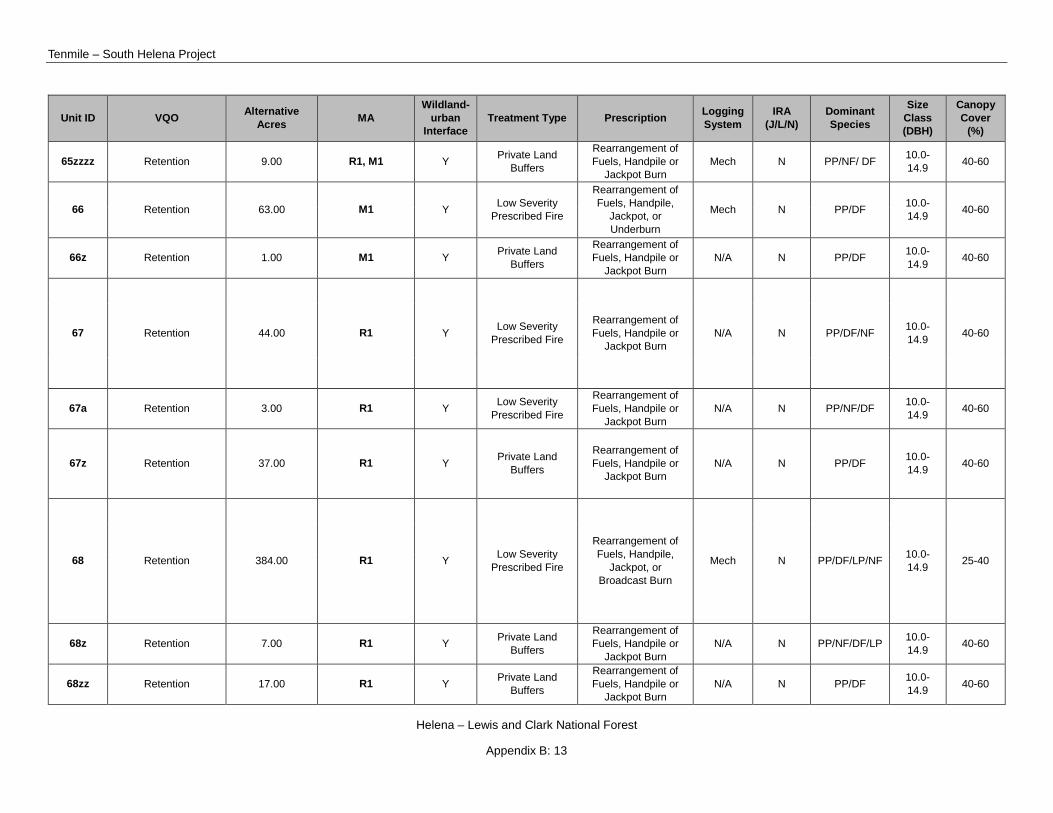
Tenmile – South Helena Project
Helena – Lewis and Clark National Forest
Appendix B: 13
Unit ID VQO Alternative Acres MA
Wildland-urban
Interface Treatment Type Prescription Logging
System IRA
(J/L/N) Dominant Species
Size Class (DBH)
Canopy Cover
(%)
65zzzz Retention 9.00 R1, M1 Y Private Land Buffers
Rearrangement of Fuels, Handpile or
Jackpot Burn Mech N PP/NF/ DF 10.0-
14.9 40-60
66 Retention 63.00 M1 Y Low Severity Prescribed Fire
Rearrangement of Fuels, Handpile,
Jackpot, or Underburn
Mech N PP/DF 10.0-14.9 40-60
66z Retention 1.00 M1 Y Private Land Buffers
Rearrangement of Fuels, Handpile or
Jackpot Burn N/A N PP/DF 10.0-
14.9 40-60
67 Retention 44.00 R1 Y Low Severity Prescribed Fire
Rearrangement of Fuels, Handpile or
Jackpot Burn N/A N PP/DF/NF 10.0-
14.9 40-60
67a Retention 3.00 R1 Y Low Severity Prescribed Fire
Rearrangement of Fuels, Handpile or
Jackpot Burn N/A N PP/NF/DF 10.0-
14.9 40-60
67z Retention 37.00 R1 Y Private Land Buffers
Rearrangement of Fuels, Handpile or
Jackpot Burn N/A N PP/DF 10.0-
14.9 40-60
68 Retention 384.00 R1 Y Low Severity Prescribed Fire
Rearrangement of Fuels, Handpile,
Jackpot, or Broadcast Burn
Mech N PP/DF/LP/NF 10.0-14.9 25-40
68z Retention 7.00 R1 Y Private Land Buffers
Rearrangement of Fuels, Handpile or
Jackpot Burn N/A N PP/NF/DF/LP 10.0-
14.9 40-60
68zz Retention 17.00 R1 Y Private Land Buffers
Rearrangement of Fuels, Handpile or
Jackpot Burn N/A N PP/DF 10.0-
14.9 40-60

Draft Record of Decision
Helena – Lewis and Clark National Forest
Appendix B: 14
Unit ID VQO Alternative Acres MA
Wildland-urban
Interface Treatment Type Prescription Logging
System IRA
(J/L/N) Dominant Species
Size Class (DBH)
Canopy Cover
(%)
68zzz Retention 25.00 R1 Y Private Land Buffers
Rearrangement of Fuels, Handpile or
Jackpot Burn N/A N PP/NF/DF/LP 10.0-
14.9 40-60
69 Retention 29.00 R1 Y Private Land Buffers
Rearrangement of Fuels, Handpile or
Jackpot Burn N/A N PP/DF/LP/NF 10.0-
14.9 25-40
70 Retention 30.00 R1, M1 Y Shaded Fuel Break
Rearrangement of Fuels, Handpile,
Jackpot, or Underburn
Mech L PP/DF 10.0-14.9 60+
70z Retention 16.00 R1, M1 Y Private Land Buffers
Rearrangement of Fuels, Handpile or
Jackpot Burn Mech L PP/DF 10.0-
14.10 60+
71 Retention 51.00 M1 Y Private Land Buffers
Rearrangement of Fuels, Handpile or
Jackpot Burn Mech L PP 15.0+ 25-40
72 Retention 36.00 M1 Y Private Land Buffers
Rearrangement of Fuels, Handpile or
Jackpot Burn Mech N DF 10.0-
14.9 60+
73a Maximum Modification 29.00 T1 y Precommercial
Thin
Precommercial Thin, Handpile or Jackpot
Burn Mech N DF 10.0-
14.9 40-60
73c Maximum Modification 11.00 T1 y Precommercial
Thin
Precommercial Thin, Handpile or Jackpot
Burn Mech N DF 10.0-
14.9 40-60
73d Maximum Modification 43.00 T1 y Precommercial
Thin
Precommercial Thin, Handpile or Jackpot
Burn Mech N PP 15.0+ 25-40
73e Maximum Modification 38.00 T1 y Improvement
Harvest Improvement
Harvest, Salvage, T N PP/DF 15.0+ 25-40
Tenmile – South Helena Project
Helena – Lewis and Clark National Forest
Appendix B: 15
Unit ID VQO Alternative Acres MA
Wildland-urban
Interface Treatment Type Prescription Logging
System IRA
(J/L/N) Dominant Species
Size Class (DBH)
Canopy Cover
(%) Jackpot or Underburn
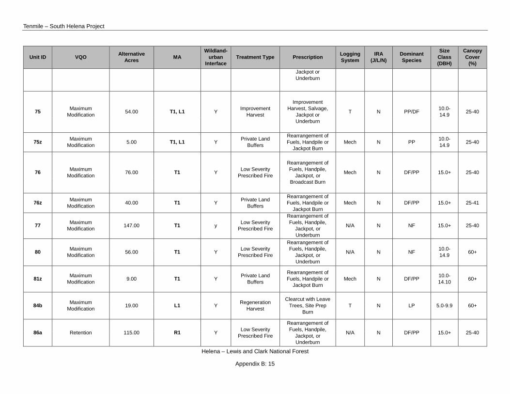
75 Maximum Modification 54.00 T1, L1 Y Improvement
Harvest
Improvement Harvest, Salvage,
Jackpot or Underburn
T N PP/DF 10.0-14.9 25-40
75z Maximum Modification 5.00 T1, L1 Y Private Land
Buffers
Rearrangement of Fuels, Handpile or
Jackpot Burn Mech N PP 10.0-
14.9 25-40
76 Maximum Modification 76.00 T1 Y Low Severity
Prescribed Fire
Rearrangement of Fuels, Handpile,
Jackpot, or Broadcast Burn
Mech N DF/PP 15.0+ 25-40
76z Maximum Modification 40.00 T1 Y Private Land
Buffers
Rearrangement of Fuels, Handpile or
Jackpot Burn Mech N DF/PP 15.0+ 25-41
77 Maximum Modification 147.00 T1 y Low Severity
Prescribed Fire
Rearrangement of Fuels, Handpile,
Jackpot, or Underburn
N/A N NF 15.0+ 25-40
80 Maximum Modification 56.00 T1 Y Low Severity
Prescribed Fire
Rearrangement of Fuels, Handpile,
Jackpot, or Underburn
N/A N NF 10.0-14.9 60+
81z Maximum Modification 9.00 T1 Y Private Land
Buffers
Rearrangement of Fuels, Handpile or
Jackpot Burn Mech N DF/PP 10.0-
14.10 60+
84b Maximum Modification 19.00 L1 Y Regeneration
Harvest
Clearcut with Leave Trees, Site Prep
Burn T N LP 5.0-9.9 60+
86a Retention 115.00 R1 Y Low Severity Prescribed Fire
Rearrangement of Fuels, Handpile,
Jackpot, or Underburn
N/A N DF/PP 15.0+ 25-40
Draft Record of Decision
Helena – Lewis and Clark National Forest
Appendix B: 16
Unit ID VQO Alternative Acres MA
Wildland-urban
Interface Treatment Type Prescription Logging
System IRA
(J/L/N) Dominant Species
Size Class (DBH)
Canopy Cover
(%)
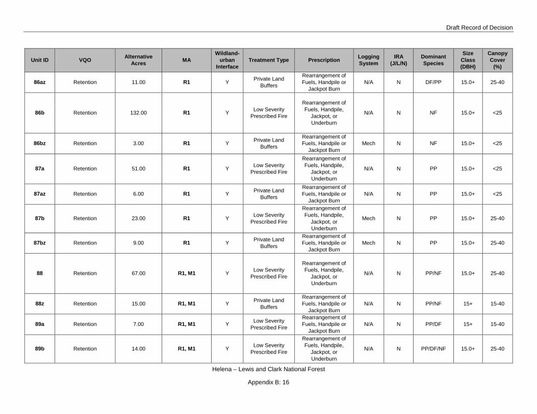
86az Retention 11.00 R1 Y Private Land Buffers
Rearrangement of Fuels, Handpile or
Jackpot Burn N/A N DF/PP 15.0+ 25-40
86b Retention 132.00 R1 Y Low Severity Prescribed Fire
Rearrangement of Fuels, Handpile,
Jackpot, or Underburn
N/A N NF 15.0+ <25
86bz Retention 3.00 R1 Y Private Land Buffers
Rearrangement of Fuels, Handpile or
Jackpot Burn Mech N NF 15.0+ <25
87a Retention 51.00 R1 Y Low Severity Prescribed Fire
Rearrangement of Fuels, Handpile,
Jackpot, or Underburn
N/A N PP 15.0+ <25
87az Retention 6.00 R1 Y Private Land Buffers
Rearrangement of Fuels, Handpile or
Jackpot Burn N/A N PP 15.0+ <25
87b Retention 23.00 R1 Y Low Severity Prescribed Fire
Rearrangement of Fuels, Handpile,
Jackpot, or Underburn
Mech N PP 15.0+ 25-40
87bz Retention 9.00 R1 Y Private Land Buffers
Rearrangement of Fuels, Handpile or
Jackpot Burn Mech N PP 15.0+ 25-40
88 Retention 67.00 R1, M1 Y Low Severity Prescribed Fire
Rearrangement of Fuels, Handpile,
Jackpot, or Underburn
N/A N PP/NF 15.0+ 25-40
88z Retention 15.00 R1, M1 Y Private Land Buffers
Rearrangement of Fuels, Handpile or
Jackpot Burn N/A N PP/NF 15+ 15-40
89a Retention 7.00 R1, M1 Y Low Severity Prescribed Fire
Rearrangement of Fuels, Handpile or
Jackpot Burn N/A N PP/DF 15+ 15-40
89b Retention 14.00 R1, M1 Y Low Severity Prescribed Fire
Rearrangement of Fuels, Handpile,
Jackpot, or Underburn
N/A N PP/DF/NF 15.0+ 25-40
Tenmile – South Helena Project
Helena – Lewis and Clark National Forest
Appendix B: 17
Unit ID VQO Alternative Acres MA
Wildland-urban
Interface Treatment Type Prescription Logging
System IRA
(J/L/N) Dominant Species
Size Class (DBH)
Canopy Cover
(%)
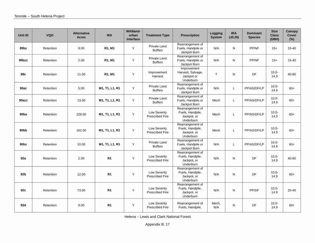
89bz Retention 9.00 R1, M1 Y Private Land Buffers
Rearrangement of Fuels, Handpile or
Jackpot Burn N/A N PP/NF 15+ 15-40
89bzz Retention 2.00 R1, M1 Y Private Land Buffers
Rearrangement of Fuels, Handpile or
Jackpot Burn N/A N PP/NF 15+ 15-40
89c Retention 11.00 R1, M1 Y Improvement Harvest
Improvement Harvest, Salvage,
Jackpot or Underburn
T N DF 10.0-14.9 40-60
90az Retention 5.00 M1, T1, L1, R1 Y Private Land Buffers
Rearrangement of Fuels, Handpile or
Jackpot Burn N/A L PP/AS/DF/LP 10.0-
14.9 60+
90azz Retention 13.00 M1, T1, L1, R1 Y Private Land Buffers
Rearrangement of Fuels, Handpile or
Jackpot Burn Mech L PP/AS/DF/LP 10.0-
14.9 60+
90ba Retention 229.00 M1, T1, L1, R1 Y Low Severity Prescribed Fire
Rearrangement of Fuels, Handpile,
Jackpot, or Underburn
Mech L PP/AS/DF/LP 10.0-14.9 60+
90bb Retention 162.00 M1, T1, L1, R1 Y Low Severity Prescribed Fire
Rearrangement of Fuels, Handpile,
Jackpot, or Underburn
Mech L PP/AS/DF/LP 10.0-14.9 60+
90bz Retention 10.00 M1, T1, L1, R1 Y Private Land Buffers
Rearrangement of Fuels, Handpile or
Jackpot Burn N/A L PP/AS/DF/LP 10.0-
14.9 60+
92a Retention 2.00 R1 Y Low Severity Prescribed Fire
Rearrangement of Fuels, Handpile,
Jackpot, or Underburn
N/A N DF 10.0-14.9 40-60
92b Retention 12.00 R1 Y Low Severity Prescribed Fire
Rearrangement of Fuels, Handpile,
Jackpot, or Underburn
N/A N DF 10.0-14.9 60+
92c Retention 73.00 R1 Y Low Severity Prescribed Fire
Rearrangement of Fuels, Handpile,
Jackpot, or Underburn
N/A N PP/DF 10.0-14.9 25-40
92d Retention 9.00 R1 Y Low Severity Prescribed Fire
Rearrangement of Fuels, Handpile,
Mech, N/A N DF 10.0-
14.9 60+
Draft Record of Decision
Helena – Lewis and Clark National Forest
Appendix B: 18
Unit ID VQO Alternative Acres MA
Wildland-urban
Interface Treatment Type Prescription Logging
System IRA
(J/L/N) Dominant Species
Size Class (DBH)
Canopy Cover
(%) Jackpot, or Underburn
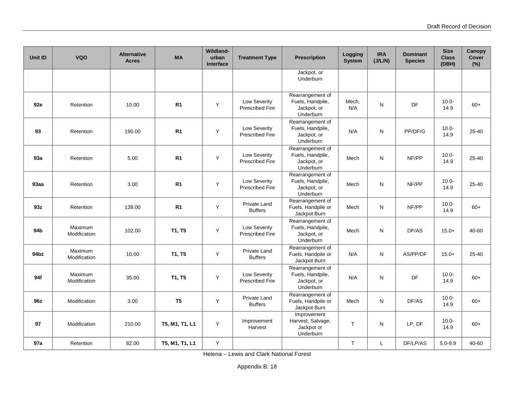
92e Retention 10.00 R1 Y Low Severity Prescribed Fire
Rearrangement of Fuels, Handpile,
Jackpot, or Underburn
Mech, N/A N DF 10.0-
14.9 60+
93 Retention 190.00 R1 Y Low Severity Prescribed Fire
Rearrangement of Fuels, Handpile,
Jackpot, or Underburn
N/A N PP/DF/G 10.0-14.9 25-40
93a Retention 5.00 R1 Y Low Severity Prescribed Fire
Rearrangement of Fuels, Handpile,
Jackpot, or Underburn
Mech N NF/PP 10.0-14.9 25-40
93aa Retention 3.00 R1 Y Low Severity Prescribed Fire
Rearrangement of Fuels, Handpile,
Jackpot, or Underburn
Mech N NF/PP 10.0-14.9 25-40
93z Retention 139.00 R1 Y Private Land Buffers
Rearrangement of Fuels, Handpile or
Jackpot Burn Mech N NF/PP 10.0-
14.9 60+
94b Maximum Modification 102.00 T1, T5 Y Low Severity
Prescribed Fire
Rearrangement of Fuels, Handpile,
Jackpot, or Underburn
Mech N DF/AS 15.0+ 40-60
94bz Maximum Modification 10.00 T1, T5 Y Private Land
Buffers
Rearrangement of Fuels, Handpile or
Jackpot Burn N/A N AS/PP/DF 15.0+ 25-40
94f Maximum Modification 35.00 T1, T5 Y Low Severity
Prescribed Fire
Rearrangement of Fuels, Handpile,
Jackpot, or Underburn
N/A N DF 10.0-14.9 60+
96z Modification 3.00 T5 Y Private Land Buffers
Rearrangement of Fuels, Handpile or
Jackpot Burn Mech N DF/AS 10.0-
14.9 60+
97 Modification 210.00 T5, M1, T1, L1 Y Improvement Harvest
Improvement Harvest, Salvage,
Jackpot or Underburn
T N LP, DF 10.0-14.9 60+
97a Retention 82.00 T5, M1, T1, L1 Y T L DF/LP/AS 5.0-9.9 40-60

Tenmile – South Helena Project
Helena – Lewis and Clark National Forest
Appendix B: 19
Unit ID VQO Alternative Acres MA
Wildland-urban
Interface Treatment Type Prescription Logging
System IRA
(J/L/N) Dominant Species
Size Class (DBH)
Canopy Cover
(%)
Regeneration Harvest
Clearcut with Leave Trees, Site Prep
Burn
97b Retention 2.00 M1, T5 Y Low Severity Prescribed Fire
Rearrangement of Fuels, Handpile,
Jackpot, or Broadcast Burn
N/A N LP/DF 5.0-9.9 40-60
98az Maximum Modification 7.00 T1 Y Private Land
Buffers
Rearrangement of Fuels, Handpile or
Jackpot Burn Mech N DF/AS 10.0-
14.9 40-60
98c Maximum Modification 47.00 T1, M1 Y Regeneration
Harvest
Clearcut with Leave Trees, Site Prep
Burn T N LP 5.0-9.9 60+
98cz Maximum Modification 8.00 T1, M1 Y Regeneration
Harvest
Clearcut with Leave Trees, Site Prep
Burn T N LP 10.0-
14.9 40-60
98dz Maximum Modification 7.00 T1 Y Private Land
Buffers
Rearrangement of Fuels, Handpile or
Jackpot Burn Mech N AS/LP 10.0-
14.9 40-60
98ez Maximum Modification 16.00 T1 Y Private Land
Buffers
Rearrangement of Fuels, Handpile or
Jackpot Burn Mech N DF 10.0-
14.9 40-60
98g Retention 54.00 T1, M1 Y Regeneration Harvest
Clearcut with Leave Trees, Site Prep
Burn T N LP 5.0-9.9 60+
100a Maximum Modification 10.00 T1, M1 Y Private Land
Buffers
Rearrangement of Fuels, Handpile or
Jackpot Burn Mech N DF/PP 15.0+ 60+
100b Maximum Modification 97.00 L1, T1, M1 y Shaded Fuel
Break
Rearrangement of Fuels, Handpile,
Jackpot, or Underburn
Mech L DF 10.0-14.9 40-60

Draft Record of Decision
Helena – Lewis and Clark National Forest
Appendix B: 20
Unit ID VQO Alternative Acres MA
Wildland-urban
Interface Treatment Type Prescription Logging
System IRA
(J/L/N) Dominant Species
Size Class (DBH)
Canopy Cover
(%)
100bz Retention 18.00 L1, T1, M1 Y Private Land Buffers
Rearrangement of Fuels, Handpile or
Jackpot Burn Mech N DF/PP 10.0-
14.9 40-60
100bzz Retention 2.00 L1, T1, M1 Y Private Land Buffers
Rearrangement of Fuels, Handpile or
Jackpot Burn Mech N DF 10.0-
14.9 40-60
100bzzz Retention 9.00 L1, T1, M1 Y Private Land Buffers
Rearrangement of Fuels, Handpile or
Jackpot Burn Mech L DF 10.0-
14.9 40-60
100c Maximum Modification 42.00 T1, M1 Y Improvement
Harvest
Improvement Harvest, Handpile or
Jackpot Burn T N DF/AS 10.0-
14.9 40-60
101 Retention 32.00 L1, M1 Y Improvement Harvest
Improvement Harvest, Jackpot or
Underburn T N DF/AS 10.0-
14.9 60+
101a Retention 12.00 L1, M1 Y Improvement Harvest
Improvement Harvest, Jackpot or
Underburn T N DF/PP 10.0-
14.9 60+
101b Maximum Modification 13.00 L1, M1 Y Improvement
Harvest
Improvement Harvest, Jackpot or
Underburn T N DF/PP 10.0-
14.9 60+
101c Maximum Modification 5.00 L1, M1 Y Improvement
Harvest
Improvement Harvest, Jackpot or
Underburn T N DF/PP 10.0-
14.9 60+
102 Retention 192.00 R1 Y Improvement Harvest
Improvement Harvest, Jackpot or
Underburn T L DF/LP 10.0-
14.9 60+
103a Retention 43.00 M1 Y Improvement Harvest
Improvement Harvest, Salvage,
Jackpot or Underburn
T N PP/DF 10.0-14.9 60+

Tenmile – South Helena Project
Helena – Lewis and Clark National Forest
Appendix B: 21
Unit ID VQO Alternative Acres MA
Wildland-urban
Interface Treatment Type Prescription Logging
System IRA
(J/L/N) Dominant Species
Size Class (DBH)
Canopy Cover
(%)
103bz Retention 5.00 M1 Y Private Land Buffers
Rearrangement of Fuels, Handpile or
Jackpot Burn Mech N DF/PP 15.0+ 40-60
103c Retention 25.00 M1 Y Low Severity Prescribed Fire
Rearrangement of Fuels, Handpile or
Jackpot Burn N/A N DF 10.0-
14.9 60+
103cz Retention 19.00 M1 Y Private Land Buffers
Rearrangement of Fuels, Handpile or
Jackpot Burn Mech N DF/PP 10.0-
14.9 40-60
104 Modification 57.00 T5 Y Regeneration Harvest
Clearcut with Leave Trees, Site Prep
Burn T N LP 5.0-9.9 60+
105 Maximum Modification 157.00 T1 Y Low Severity
Prescribed Fire
Rearrangement of Fuels, Handpile,
Jackpot, or Underburn
N/A N DF 10.0-14.9 40-60
105z Maximum Modification 7.00 T1 Y Private Land
Buffers
Rearrangement of Fuels, Handpile or
Jackpot Burn Mech N DF/NF 10.0-
14.9 40-60
105zz Maximum Modification 15.00 T1 Y Private Land
Buffers
Rearrangement of Fuels, Handpile or
Jackpot Burn Mech N DF/NF 10.0-
14.9 40-60
105zzz Maximum Modification 4.00 T1 Y Private Land
Buffers
Rearrangement of Fuels, Handpile or
Jackpot Burn Mech N DF/NF 10.0-
14.9 40-60
106a Modification 211.00 T5, T1 Y Regeneration Harvest
Clearcut with Leave Trees, Site Prep
Burn T N LP/AS 5.0-9.9 60+
106aa Modification 34.00 T5, T1 Y Improvement Harvest
Improvement Harvest, Jackpot or
Underburn T N DF/LP 5.0-9.9 60+

Draft Record of Decision
Helena – Lewis and Clark National Forest
Appendix B: 22
Unit ID VQO Alternative Acres MA
Wildland-urban
Interface Treatment Type Prescription Logging
System IRA
(J/L/N) Dominant Species
Size Class (DBH)
Canopy Cover
(%)
106ab Modification 15.00 T5, T1 Y Improvement Harvest
Improvement Harvest, Jackpot or
Underburn T N DF/LP/AS 5.0-9.9 60+
106c Modification 20.00 T5, T1 Y Regeneration Harvest
Clearcut with Leave Trees, Site Prep
Burn T N LP/AS 5.0-9.9 40-60
106d Modification 9.00 T5, T1 Y Improvement Harvest
Improvement Harvest, Jackpot or
Underburn T N DF 10.0-
14.9 60+
106e Modification 80.00 T5, T1 Y Regeneration Harvest
Clearcut with Leave Trees, Site Prep
Burn T N LP 5.0-9.9 60+
106f Modification 28.00 T5, T1 Y Improvement Harvest
Improvement Harvest, Jackpot or
Underburn T N DF/AS 10.0-
14.9 40-60
106g Modification 37.00 T5, T1 Y Regeneration Harvest
Clearcut with Leave Trees, Site Prep
Burn T N LP/AS 5.0-9.9 40-60
107a Retention 24.00 M1 y Low Severity Prescribed Fire
Rearrangement of Fuels, Handpile,
Jackpot, or Underburn
Mech N DF 10.0-14.9 60+
107az Retention 42.00 M1 Y Private Land Buffers
Rearrangement of Fuels, Handpile or
Jackpot Burn N/A N DF/LP 10.0-
14.9 60+
107b Maximum Modification 20.00 M1, T1 y Low Severity
Prescribed Fire
Rearrangement of Fuels, Handpile,
Jackpot, or Underburn
Mech N DF/LP 10.0-14.9 60+
107bz Maximum Modification 34.00 M1, T1 Y Private Land
Buffers
Rearrangement of Fuels, Handpile or
Jackpot Burn Mech N DF/LP 10.0-
14.9 60+
107c Retention 33.00 M1, T1 Y Low Severity Prescribed Fire
Rearrangement of Fuels, Handpile,
Jackpot, or Underburn
Mech N DF/LP 10.0-14.9 60+
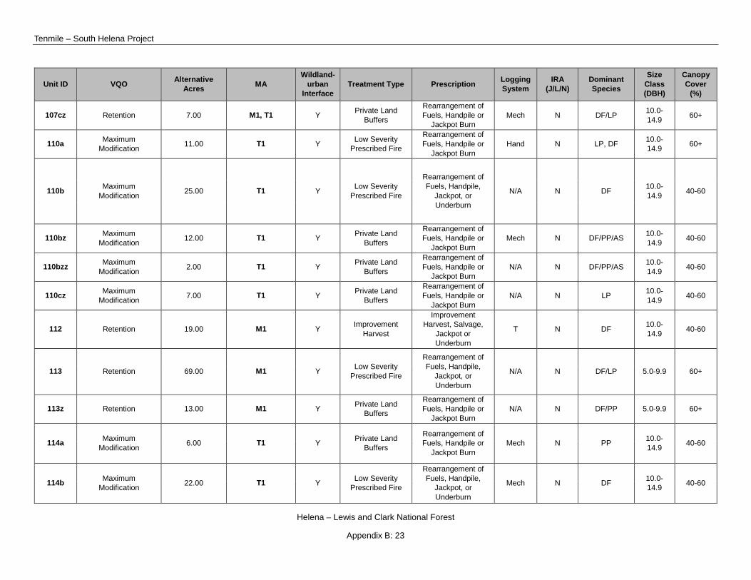
Tenmile – South Helena Project
Helena – Lewis and Clark National Forest
Appendix B: 23
Unit ID VQO Alternative Acres MA
Wildland-urban
Interface Treatment Type Prescription Logging
System IRA
(J/L/N) Dominant Species
Size Class (DBH)
Canopy Cover
(%)
107cz Retention 7.00 M1, T1 Y Private Land Buffers
Rearrangement of Fuels, Handpile or
Jackpot Burn Mech N DF/LP 10.0-
14.9 60+
110a Maximum Modification 11.00 T1 Y Low Severity
Prescribed Fire
Rearrangement of Fuels, Handpile or
Jackpot Burn Hand N LP, DF 10.0-
14.9 60+
110b Maximum Modification 25.00 T1 Y Low Severity
Prescribed Fire
Rearrangement of Fuels, Handpile,
Jackpot, or Underburn
N/A N DF 10.0-14.9 40-60
110bz Maximum Modification 12.00 T1 Y Private Land
Buffers
Rearrangement of Fuels, Handpile or
Jackpot Burn Mech N DF/PP/AS 10.0-
14.9 40-60
110bzz Maximum Modification 2.00 T1 Y Private Land
Buffers
Rearrangement of Fuels, Handpile or
Jackpot Burn N/A N DF/PP/AS 10.0-
14.9 40-60
110cz Maximum Modification 7.00 T1 Y Private Land
Buffers
Rearrangement of Fuels, Handpile or
Jackpot Burn N/A N LP 10.0-
14.9 40-60
112 Retention 19.00 M1 Y Improvement Harvest
Improvement Harvest, Salvage,
Jackpot or Underburn
T N DF 10.0-14.9 40-60
113 Retention 69.00 M1 Y Low Severity Prescribed Fire
Rearrangement of Fuels, Handpile,
Jackpot, or Underburn
N/A N DF/LP 5.0-9.9 60+
113z Retention 13.00 M1 Y Private Land Buffers
Rearrangement of Fuels, Handpile or
Jackpot Burn N/A N DF/PP 5.0-9.9 60+
114a Maximum Modification 6.00 T1 Y Private Land
Buffers
Rearrangement of Fuels, Handpile or
Jackpot Burn Mech N PP 10.0-
14.9 40-60
114b Maximum Modification 22.00 T1 Y Low Severity
Prescribed Fire
Rearrangement of Fuels, Handpile,
Jackpot, or Underburn
Mech N DF 10.0-14.9 40-60

Draft Record of Decision
Helena – Lewis and Clark National Forest
Appendix B: 24
Unit ID VQO Alternative Acres MA
Wildland-urban
Interface Treatment Type Prescription Logging
System IRA
(J/L/N) Dominant Species
Size Class (DBH)
Canopy Cover
(%)
114ba Maximum Modification 13.00 T1 Y Low Severity
Prescribed Fire
Rearrangement of Fuels, Handpile,
Jackpot, or Underburn
Mech N PP 10.0-14.9 40-60
114bz Maximum Modification 11.00 T1 Y Private Land
Buffers
Rearrangement of Fuels, Handpile or
Jackpot Burn Mech N PP 10.0-
14.9 60+
116a Modification 145.00 T5,W2,T4,M1,L2, L2 Y Low Severity
Prescribed Fire
Rearrangement of Fuels, Handpile,
Jackpot, or Broadcast Burn
N/A L DF 10.0-14.9 40-60
116az Partial Retention 40.00 T5,T4, W2, M1, L1, L2 Y Private Land
Buffers
Rearrangement of Fuels, Handpile or
Jackpot Burn N/A L DF/NF 10.0-
14.9 60+
116b Partial Retention/Retention 181.00 T5, W2, T4,
M1,L1,L3 y Low Severity Prescribed Fire
Rearrangement of Fuels, Handpile,
Jackpot, or Broadcast Burn
Mech L DF/LP 10.0-14.9 60+
116ba Partial Retention/Retention 41.00 T5,T4, W2, M1,
L1, L2 Y Improvement Harvest
Improvement Harvest, Jackpot or
Underburn T L DF/LP 10.0-
14.9 60+
116bz Partial Retention 28.00 T5,T4, W2, M1, L1, L2 Y Private Land
Buffers
Rearrangement of Fuels, Handpile or
Jackpot Burn N/A L DF/PP 10.0-
14.9 60+
116cz Modification 66.00
M1, L1, L2
Y Private Land Buffers
Rearrangement of Fuels, Handpile or
Jackpot Burn N/A L DF/PP 10.0-
14.9 60+ M1, L1, L2
116czz Modification 1.00 M1, L1, L2
Y Private Land Buffers
Rearrangement of Fuels, Handpile or
Jackpot Burn N/A L DF/PP 10.0-
14.9 40-59 M1, L1, L2
116g Maximum Modification 310.00 T5,T4, W2, M1,
L1, L2 Y Low Severity Prescribed Fire
Rearrangement of Fuels, Handpile,
Jackpot, or Broadcast Burn
N/A L DF 10.0-14.9 60+

Tenmile – South Helena Project
Helena – Lewis and Clark National Forest
Appendix B: 25
Unit ID VQO Alternative Acres MA
Wildland-urban
Interface Treatment Type Prescription Logging
System IRA
(J/L/N) Dominant Species
Size Class (DBH)
Canopy Cover
(%)
116gz Maximum Modification 27.00 T5, T4, W2, M1,
L1, L2 Y Private Land Buffers
Rearrangement of Fuels, Handpile or
Jackpot Burn N/A L DF/PP 10.0-
14.9 60+
117 Modification 53.00 H1 Y Regeneration Harvest
Clearcut with Leave Trees, Site Prep
Burn T N LP/AS 5.0-9.9 60+
118 Maximum Modification 37.00 M1, T1 Y Regeneration
Harvest
Clearcut with Leave Trees, Site Prep
Burn T N LP 5.0-9.9 40-60
119 Maximum Modification 28.00 T1 Y Improvement
Harvest
Improvement Harvest, Handpile or
Jackpot Burn T N DF 10.0-
14.9 40-60
121 Maximum Modification 21.00 T1 Y Precommercial
Thin
Precommercial Thin, Handpile or Jackpot
Burn Mech N DF/LP 5.0-9.9 60+
122a Retention 170.00 M1 Y Low Severity Prescribed Fire
Rearrangement of Fuels, Handpile,
Jackpot, or Underburn
Mech N DF/LP 10.0-14.9 60+
122b Retention 118.00 M1 Y Low Severity Prescribed Fire
Rearrangement of Fuels, Handpile,
Jackpot, or Underburn
N/A N DF 10.0-14.9 60+
122ba Retention 21.00 M1 Y Low Severity Prescribed Fire
Rearrangement of Fuels, Handpile,
Jackpot, or Underburn
N/A N DF 10.0-14.9 60+
122bz Retention 66.00 M1 Y Private Land Buffers
Rearrangement of Fuels, Handpile or
Jackpot Burn N/A N DF 10.0-
14.9 60+
122bzz Retention 21.00 M1 Y Private Land Buffers
Rearrangement of Fuels, Handpile or
Jackpot Burn Mech N DF/PP 10.0-
14.9 60+

Draft Record of Decision
Helena – Lewis and Clark National Forest
Appendix B: 26
Unit ID VQO Alternative Acres MA
Wildland-urban
Interface Treatment Type Prescription Logging
System IRA
(J/L/N) Dominant Species
Size Class (DBH)
Canopy Cover
(%)
122c Retention 26.00 M1 Y Low Severity Prescribed Fire
Rearrangement of Fuels, Handpile,
Jackpot, or Underburn
N/A N LP 5.0-9.9 60+
123 Modification 16.00 L1, T5, T1 Y Private Land Buffers
Rearrangement of Fuels, Handpile or
Jackpot Burn Mech N DF/LP 10.0-
14.9 60+
123aa Maximum Modification 20.00 L1, T5, T1 Y Private Land
Buffers
Rearrangement of Fuels, Handpile or
Jackpot Burn Mech N LP/DF 10.0-
14.9 60+
123ab Maximum Modification 8.00 L1, T5, T1 Y Private Land
Buffers
Rearrangement of Fuels, Handpile or
Jackpot Burn Mech N LP 10.0-
14.9 60+
123b Maximum Modification 20.00 L1, T5, T1 Y Private Land
Buffers
Rearrangement of Fuels, Handpile or
Jackpot Burn Mech N LP 10.0-
14.9 60+
123c Maximum Modification 37.00 L1, T5, T1 Y Private Land
Buffers
Rearrangement of Fuels, Handpile or
Jackpot Burn Mech N LP 5.0-9.9 60+
123d Maximum Modification 58.00 L1, T5, T1 Y Private Land
Buffers
Rearrangement of Fuels, Handpile or
Jackpot Burn Mech N DF 10.0-
14.9 60+
124a Retention 22.00 M1 Y Private Land Buffers
Rearrangement of Fuels, Handpile or
Jackpot Burn Mech N DF/LP 10.0-
14.9 60+
124b Retention 12.00 M1 Y Private Land Buffers
Rearrangement of Fuels, Handpile or
Jackpot Burn Mech N LP 5.0-9.9 60+
125 Maximum Modification 25.00 T1,Y1 Y Private Land
Buffers
Rearrangement of Fuels, Handpile or
Jackpot Burn Mech N DF/LP/AS 10.0-
14.9 60+
126 Maximum Modification 181.00 T1, M1 Y Private Land
Buffers
Rearrangement of Fuels, Handpile or
Jackpot Burn Mech N DF/LP 10.0-
14.9 60+
127a Modification 1.00 H1 Y Private Land Buffers
Rearrangement of Fuels, Handpile or
Jackpot Burn Mech N DF 10.0-
14.9 60+

Tenmile – South Helena Project
Helena – Lewis and Clark National Forest
Appendix B: 27
Unit ID VQO Alternative Acres MA
Wildland-urban
Interface Treatment Type Prescription Logging
System IRA
(J/L/N) Dominant Species
Size Class (DBH)
Canopy Cover
(%)
127b Modification 1.00 H1 Y Private Land Buffers
Rearrangement of Fuels, Handpile or
Jackpot Burn Mech N DF 10.0-
14.9 60+
127c Modification 0.06 H1 Y Private Land Buffers
Rearrangement of Fuels, Handpile or
Jackpot Burn Mech N DF 10.0-
14.9 60+
127d Modification 0.09 H1 Y Private Land Buffers
Rearrangement of Fuels, Handpile or
Jackpot Burn Mech N DF 10.0-
14.9 60+
127e Modification 1.00 H1 Y Private Land Buffers
Rearrangement of Fuels, Handpile or
Jackpot Burn Mech N DF 10.0-
14.9 60+
127i Modification 7.00 H1 Y Private Land Buffers
Rearrangement of Fuels, Handpile or
Jackpot Burn N/A N DF 10.0-
14.9 60+
127j Modification 2.00 H1 Y Private Land Buffers
Rearrangement of Fuels, Handpile or
Jackpot Burn Mech N DF 10.0-
14.9 60+
127k Modification 1.00 H1 Y Private Land Buffers
Rearrangement of Fuels, Handpile or
Jackpot Burn Mech N LP 5.0-9.9 60+
127l Modification 0.18 H1 Y Private Land Buffers
Rearrangement of Fuels, Handpile or
Jackpot Burn Mech N LP 5.0-9.9 60+
127n Modification 1.00 H1 Y Private Land Buffers
Rearrangement of Fuels, Handpile or
Jackpot Burn Mech N DF 5.0-9.9 60+
127o Modification 6.00 H1 Y Private Land Buffers
Rearrangement of Fuels, Handpile or
Jackpot Burn N/A N DF 10.0-
14.9 60+
127p Modification 1.00 H1 Y Private Land Buffers
Rearrangement of Fuels, Handpile or
Jackpot Burn Mech N DF 5.0-9.9 60+
127q Modification 0.40 H1 Y Private Land Buffers
Rearrangement of Fuels, Handpile or
Jackpot Burn Mech N DF 5.0-9.9 40-60

Draft Record of Decision
Helena – Lewis and Clark National Forest
Appendix B: 28
Unit ID VQO Alternative Acres MA
Wildland-urban
Interface Treatment Type Prescription Logging
System IRA
(J/L/N) Dominant Species
Size Class (DBH)
Canopy Cover
(%)
127r Modification 1.00 H1 Y Private Land Buffers
Rearrangement of Fuels, Handpile or
Jackpot Burn Mech N LP 10.0-
14.9 60+
128a Modification 106.00 H1 Y Private Land Buffers
Rearrangement of Fuels, Handpile or
Jackpot Burn Mech L DF/LP 5.0-9.9 60+
129a Modification 177.00 H1, H2 Y Private Land Buffers
Rearrangement of Fuels, Handpile or
Jackpot Burn Mech L DF/LP 5.0-9.9 60+
129ba Modification 189.00 H1, H2 Y Private Land Buffers
Rearrangement of Fuels, Handpile or
Jackpot Burn Mech N DF/LP 5.0-9.9 60+
129ba1 Modification 2.00 H1, H2 Y Private Land Buffers
Rearrangement of Fuels, Handpile or
Jackpot Burn Mech N LP/DF 5.0-9.9 60+
129ba2 Modification 98.00 H1, H2 Y Private Land Buffers
Rearrangement of Fuels, Handpile or
Jackpot Burn Mech N LP/DF 5.0-9.9 60+
129bb Modification 17.00 H1, H2 Y Private Land Buffers
Rearrangement of Fuels, Handpile or
Jackpot Burn Mech N LP/DF 5.0-9.9 60+
129bc Modification 265.00 H1, H2 Y Private Land Buffers
Rearrangement of Fuels, Handpile or
Jackpot Burn N/A N LP/DF 5.0-9.9 60+
129c Modification 19.00 H1, H2 Y Private Land Buffers
Rearrangement of Fuels, Handpile or
Jackpot Burn N/A N DF/LP/G 5.0-9.9 60+
129d Modification 31.00 H1, H2 Y Private Land Buffers
Rearrangement of Fuels, Handpile or
Jackpot Burn N/A N LP 5.0-9.9 60+
129e Modification 19.00 H1, H2 Y Private Land Buffers
Rearrangement of Fuels, Handpile or
Jackpot Burn N/A N DF/LP/WBP 5.0-9.9 60+

Tenmile – South Helena Project
Helena – Lewis and Clark National Forest
Appendix B: 29
Unit ID VQO Alternative Acres MA
Wildland-urban
Interface Treatment Type Prescription Logging
System IRA
(J/L/N) Dominant Species
Size Class (DBH)
Canopy Cover
(%)
129f Modification 6.00 H1 Y Private Land Buffers
Rearrangement of Fuels, Handpile or
Jackpot Burn N/A N LP 5.0-9.9 60+
130 Modification 62.00 T5 Y Regeneration Harvest
Clearcut with Leave Trees, Site Prep
Burn T N LP/AS 5.0-9.9 60+
131 Maximum Modification 6.00 T1 Y Precommercial
Thin
Precommercial Thin, Handpile or Jackpot
Burn Mech N LP 5.0-9.9 60+
132 Maximum Modification 8.00 T1 Y Precommercial
Thin
Precommercial Thin, Handpile or Jackpot
Burn Mech N LP 5.0-9.9 60+
133 Partial Retention/ Retention 12.00 T4 Y Low Severity
Prescribed Fire
Rearrangement of Fuels, Handpile,
Jackpot, or Underburn
Mech N LP 5.0-9.9 60+
134 Partial Retention/ Retention 19.00 T4 Y Precommercial
Thin
Precommercial Thin, Handpile or Jackpot
Burn Mech N LP 5.0-9.9 60+
135 Partial Retention/Retention 38.00 T4, H1 Y Precommercial
Thin
Precommercial Thin, Handpile or Jackpot
Burn Mech L DF/LP 5.0-9.9 60+
137 Maximum Modification 41.00 T1 Y Precommercial
Thin
Precommercial Thin, Handpile or Jackpot
Burn Mech N DF/LP/AS 5.0-9.9 <25
138 Maximum Modification 35.00 T1 Y Precommercial
Thin
Precommercial Thin, Handpile or Jackpot
Burn Mech N DF/AS 10.0-
14.9 40-60
141 Partial Retention/Retention 16.00 H1, T4 Y
Low Severity Prescribed Fire Shelterwood with
Reserves, Site Prep Burn
T L DF/LP/AS 5.0-9.9 60+ Regeneration
Harvest

Draft Record of Decision
Helena – Lewis and Clark National Forest
Appendix B: 30
Unit ID VQO Alternative Acres MA
Wildland-urban
Interface Treatment Type Prescription Logging
System IRA
(J/L/N) Dominant Species
Size Class (DBH)
Canopy Cover
(%)
141a Partial Retention/Retention 29.00 T4, H1 Y Low Severity
Prescribed Fire
Rearrangement of Fuels, Handpile or
Jackpot Burn Mech L DF/LP/PP/AS 5.0-9.9 60+
141z Modification 26.00 T4, H1 Y Private Land Buffers
Rearrangement of Fuels, Handpile or
Jackpot Burn Mech L DF/LP/PP/AS 5.0-9.9 60+
141zz Partial Retention/Retention 13.00 T4, H1 Y Private Land
Buffers
Rearrangement of Fuels, Handpile or
Jackpot Burn Mech N DF/LP/PP/AS 5.0-9.9 60+
149 Modification 120.00 H1 Y Private Land Buffers
Rearrangement of Fuels, Handpile or
Jackpot Burn Mech L DF/LP 5.0-9.9 60+
150 Maximum Modification 35.00 T1 Y Private Land
Buffers
Rearrangement of Fuels, Handpile or
Jackpot Burn Mech N DF/LP 5.0-9.9 60+
151a Modification 9.00 H2 Y Private Land Buffers
Rearrangement of Fuels, Handpile or
Jackpot Burn Mech N LP 5.0-9.9 60+
151b Modification 8.00 H2 Y Private Land Buffers
Rearrangement of Fuels, Handpile or
Jackpot Burn Mech N LP 5.0-9.9 60+
154 Modification 33.00 H2 Y Private Land Buffers
Rearrangement of Fuels, Handpile or
Jackpot Burn Mech N LP 5.0-9.9 40-60
156 Retention 26.00 M1 Y Private Land Buffers
Rearrangement of Fuels, Handpile or
Jackpot Burn Mech N LP 5.0-9.9 60+
157 Modification 21.00 T5 Y Private Land Buffers
Rearrangement of Fuels, Handpile or
Jackpot Burn Mech N DF/G 10.0-
14.9 40-60
158 Modification 45.00 T4, H1 Y Low Severity Prescribed Fire
Rearrangement of Fuels, Handpile or
Jackpot Burn Mech L DF 10.0-
14.9 40-60
159 Partial Retention 23.00 M1, T4 Y Private Land Buffers
Rearrangement of Fuels, Handpile or
Jackpot Burn Mech L DF 10.0-
14.9 40-60

Tenmile – South Helena Project
Helena – Lewis and Clark National Forest
Appendix B: 31
Unit ID VQO Alternative Acres MA
Wildland-urban
Interface Treatment Type Prescription Logging
System IRA
(J/L/N) Dominant Species
Size Class (DBH)
Canopy Cover
(%)
160 Retention 104.00 M1 Y Private Land Buffers
Rearrangement of Fuels, Handpile or
Jackpot Burn Mech L DF/LP 5.0-9.9 60+
161 Retention 23.00 M1 Y Private Land Buffers
Rearrangement of Fuels, Handpile or
Jackpot Burn Mech L DF 10.0-
14.9 60+
162 Modification 37.00 T1, T5 Y Private Land Buffers
Rearrangement of Fuels, Handpile or
Jackpot Burn Mech N DF/LP 10.0-
14.9 60+
173aa Retention 87.00 T1, T5, M1, L1 Y Shaded Fuel Break
Rearrangement of Fuels, Handpile,
Jackpot, or Underburn
Mech L PP/DF/LP/AS 10.0-14.9 40-60
173ab Maximum Modification 78.00 T1, T5, M1, L1 Y Shaded Fuel
Break
Rearrangement of Fuels, Handpile,
Jackpot, or Underburn
Mech L PP/DF/LP/AS 10.0-14.9 40-60
173bc Modification 59.00 T1, T5, M1, L1 Y Improvement Harvest
Improvement Harvest, Jackpot or
Underburn T L PP/DF/LP/AS 10.0-
14.9 40-60
173bd Modification 86.00 T1, T5, M1, L1 Y Low Severity Prescribed Fire
Rearrangement of Fuels, Handpile,
Jackpot, or Underburn
Mech L PP/DF/LP/AS 10.0-14.9 60+
173bf Modification 37.00 T1, T5, M1, L1 Y Improvement Harvest
Improvement Harvest, Jackpot or
Underburn T L PP/DF/LP/AS 10.0-
14.9 40-60
173bz Maximum Modification 54.00 T1, T5, M1, L1 Y Private Land
Buffers
Rearrangement of Fuels, Handpile or
Jackpot Burn Mech L PP/DF/LP/AS 10.0-
14.9 60+
173bzz Modification 9.00 T1, T5, M1, L1 Y Private Land Buffers
Rearrangement of Fuels, Handpile or
Jackpot Burn Mech L PP/DF/LP/AS 10.0-
14.9 40-60
173bzzz NA 21.00 T1, T5, M1, L1 Y Private Land Buffers
Rearrangement of Fuels, Handpile or
Jackpot Burn Mech L PP/DF/LP/AS 10.0-
14.9 60+

Draft Record of Decision
Helena – Lewis and Clark National Forest
Appendix B: 32
Unit ID VQO Alternative Acres MA
Wildland-urban
Interface Treatment Type Prescription Logging
System IRA
(J/L/N) Dominant Species
Size Class (DBH)
Canopy Cover
(%)
178a Modification 184.00 M1, H1 Y Shaded Fuel Break
Rearrangement of Fuels, Handpile,
Jackpot, or Broadcast Burn
N/A L DF/LP/G 5.0-9.9 40-60
178ba Modification 78.00 H1 Y Low Severity Prescribed Fire
Rearrangement of Fuels, Handpile,
Jackpot, or Broadcast Burn
Mech L DF/LP/AS 10.0-14.9 40-60
178bb Modification 43.00 H1 Y Low Severity Prescribed Fire
Rearrangement of Fuels, Handpile,
Jackpot, or Broadcast Burn
Mech L DF/LP/AS 10.0-14.9 40-60
180a Modification 104.00 H1, H2 Y Regeneration Harvest
Clearcut with Leave Trees, Site Prep
Burn T N LP/DF/AS 5.0-9.9 60+
180b Modification 111.00 H1, H2 Y Regeneration Harvest
Clearcut with Leave Trees, Site Prep
Burn T N LP/WBP 5.0-9.9 60+
200 Modification 115.00 H2 Y Improvement Harvest
Improvement Harvest, Jackpot or
Underburn T J LP/DF/AS 5.0-9.9 60+
200a Modification 465.00 H1, H2, T1 Y Shaded Fuel Break
Rearrangement of Fuels, Handpile,
Jackpot, or Underburn
N/A J LP/DF 5.0-9.9 60+
201 Modification 98.00 T1, T5 Y Shaded Fuel Break
Rearrangement of Fuels, Handpile,
Jackpot, or Underburn
N/A J DF/PP/LP 5.0-9.9 60+
202 Modification 13.00 H2 Y Low Severity Prescribed Fire
Rearrangement of Fuels, Handpile,
Jackpot, or Underburn
N/A J NF/LP 5.0-9.9 60+
203a Modification 61.00 H1, M1 Y Improvement Harvest
Improvement Harvest, Jackpot or
Underburn T J LP/DF 10.0-
14.9 40-60
203b Modification 36.00 H1, H2, T1, T5 Y Shaded Fuel Break
Rearrangement of Fuels, Handpile,
Jackpot, or Underburn
Mech J LP/DF 5.0-9.9 60+
Tenmile – South Helena Project
Helena – Lewis and Clark National Forest
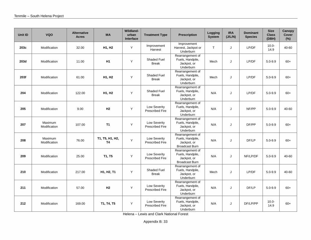
Appendix B: 33
Unit ID VQO Alternative Acres MA
Wildland-urban
Interface Treatment Type Prescription Logging
System IRA
(J/L/N) Dominant Species
Size Class (DBH)
Canopy Cover
(%)
203c Modification 32.00 H1, H2 Y Improvement Harvest
Improvement Harvest, Jackpot or
Underburn T J LP/DF 10.0-
14.9 40-60
203d Modification 11.00 H1 Y Shaded Fuel Break
Rearrangement of Fuels, Handpile,
Jackpot, or Underburn
Mech J LP/DF 5.0-9.9 60+
203f Modification 61.00 H1, H2 Y Shaded Fuel Break
Rearrangement of Fuels, Handpile,
Jackpot, or Underburn
Mech J LP/DF 5.0-9.9 60+
204 Modification 122.00 H1, H2 Y Shaded Fuel Break
Rearrangement of Fuels, Handpile,
Jackpot, or Underburn
N/A J LP/DF 5.0-9.9 60+
205 Modification 9.00 H2 Y Low Severity Prescribed Fire
Rearrangement of Fuels, Handpile,
Jackpot, or Underburn
N/A J NF/PP 5.0-9.9 40-60
207 Maximum Modification 107.00 T1 Y Low Severity
Prescribed Fire
Rearrangement of Fuels, Handpile,
Jackpot, or Underburn
N/A J DF/PP 5.0-9.9 60+
208 Maximum Modification 76.00 T1, T5, H1, H2,
T4 Y Low Severity Prescribed Fire
Rearrangement of Fuels, Handpile,
Jackpot, or Broadcast Burn
N/A J DF/LP 5.0-9.9 60+
209 Modification 25.00 T1, T5 Y Low Severity Prescribed Fire
Rearrangement of Fuels, Handpile,
Jackpot, or Broadcast Burn
N/A J NF/LP/DF 5.0-9.9 40-60
210 Modification 217.00 H1, H2, T1 Y Shaded Fuel Break
Rearrangement of Fuels, Handpile,
Jackpot, or Underburn
Mech J LP/DF 5.0-9.9 40-60
211 Modification 57.00 H2 Y Low Severity Prescribed Fire
Rearrangement of Fuels, Handpile,
Jackpot, or Underburn
N/A J DF/LP 5.0-9.9 60+
212 Modification 169.00 T1, T4, T5 Y Low Severity Prescribed Fire
Rearrangement of Fuels, Handpile,
Jackpot, or Underburn
N/A J DF/LP/PP 10.0-14.9 60+

Draft Record of Decision
Helena – Lewis and Clark National Forest
Appendix B: 34
Unit ID VQO Alternative Acres MA
Wildland-urban
Interface Treatment Type Prescription Logging
System IRA
(J/L/N) Dominant Species
Size Class (DBH)
Canopy Cover
(%)
213 Maximum Modification 44.00 T1, T5 Y Low Severity
Prescribed Fire
Rearrangement of Fuels, Handpile,
Jackpot, or Underburn
Mech J DF/LP/PP 5.0-9.9 60+
214 Maximum Modification 67.00 T1, T4 Y Low Severity
Prescribed Fire
Rearrangement of Fuels, Handpile,
Jackpot, or Underburn
Mech J DF/LP 5.0-9.9 60+
216 Modification 55.00 H1, T5 Y Low Severity Prescribed Fire
Rearrangement of Fuels, Handpile,
Jackpot, or Broadcast Burn
N/A J NF/LP/DF 5.0-9.9 40-60
217 Maximum Modification 118.00 T1 Y Low Severity
Prescribed Fire
Rearrangement of Fuels, Handpile,
Jackpot, or Broadcast Burn
N/A J DF/LP/PP 5.0-9.9 60+
218 Modification 30.00 H2 Y Shaded Fuel Break
Rearrangement of Fuels, Handpile,
Jackpot, or Underburn
Mech J LP/DF 5.0-9.9 60+
219 Modification 128.00 H1 Y Regeneration Harvest
Clearcut with Leave Trees, Site Prep
Burn T L LP/DF 5.0-9.9 60+
220 Retention 34.00 M1 Y Private Land Buffers
Rearrangement of Fuels, Handpile or
Jackpot Burn N/A N PP/DF 5.0-9.9 60+
222 Maximum Modification 7.00 T1 Y Private Land
Buffers
Rearrangement of Fuels, Handpile or
Jackpot Burn Mech N PP/DF 5.0-9.9 60+
225 Retention 10.00 M1 Y Private Land Buffers
Rearrangement of Fuels, Handpile or
Jackpot Burn N/A N PP/DF/NF 5.0-9.9 40-60
226 Retention 41.00 M1 Y Private Land Buffers
Rearrangement of Fuels, Handpile or
Jackpot Burn N/A N PP/DF/NF 5.0-9.9 40-60
227 Retention 20.00 M1 Y Private Land Buffers
Rearrangement of Fuels, Handpile or
Jackpot Burn N/A N PP/DF/NF 5.0-9.9 40-60
227a Retention 10.00 M1 Y Private Land Buffers
Rearrangement of Fuels, Handpile or
Jackpot Burn N/A N PP/DF 5.0-9.9 60+

Tenmile – South Helena Project
Helena – Lewis and Clark National Forest
Appendix B: 35
Unit ID VQO Alternative Acres MA
Wildland-urban
Interface Treatment Type Prescription Logging
System IRA
(J/L/N) Dominant Species
Size Class (DBH)
Canopy Cover
(%)
228 Maximum Modification 68.00 L1, T1, T5 Y Private Land
Buffers
Rearrangement of Fuels, Handpile or
Jackpot Burn Mech N DF/PP/NF 10.0-
14.9 40-60
229 Maximum Modification 68.00 H1, T1 Y Shaded Fuel
Break
Rearrangement of Fuels, Handpile,
Jackpot, or Underburn
Mech J LP/DF/AS 10.0-14.9 60+
230 Maximum Modification 17.00 L1, T1 Y Private Land
Buffers
Rearrangement of Fuels, Handpile or
Jackpot Burn Mech N DF/PP 5.0-9.9 60+
231 Maximum Modification 24.00 T1 Y Private Land
Buffers
Rearrangement of Fuels, Handpile or
Jackpot Burn Mech N DF/PP 5.0-9.9 60+
232 Maximum Modification 33.00 L1, T1 Y Private Land
Buffers
Rearrangement of Fuels, Handpile or
Jackpot Burn Mech N DF/NF 10.0-
14.9 60+
233 Maximum Modification 43.00 T1 Y Private Land
Buffers
Rearrangement of Fuels, Handpile or
Jackpot Burn Mech N LP/DF/AS 5.0-9.9 60+
234 Maximum Modification 63.00 T1 Y Private Land
Buffers
Rearrangement of Fuels, Handpile or
Jackpot Burn Mech N LP/DF/AS 5.0-9.9 60+
235 Retention 14.00 R1 Y Private Land Buffers
Rearrangement of Fuels, Handpile or
Jackpot Burn N/A N DF/PP 5.0-9.9 60+
236 Retention 5.00 R1 Y Private Land Buffers
Rearrangement of Fuels, Handpile or
Jackpot Burn N/A L LP/DF 5.0-9.9 60+
237 Retention 12.00 R1 Y Private Land Buffers
Rearrangement of Fuels, Handpile or
Jackpot Burn N/A L DF/PP 5.0-9.9 60+
238 Maximum Modification 55.00 H1, T1 Y Shaded Fuel
Break
Rearrangement of Fuels, Handpile,
Jackpot, or Underburn
Mech J AS/LP/DF 10.0-14.9 60+
239 Maximum Modification 5.00 T1, T5, H1, H2,
T4 Y Low Severity Prescribed Fire
Rearrangement of Fuels, Handpile,
Jackpot, or Broadcast Burn
N/A J LP/DF 5.0-9.9 60+
240 Modification 14.00 H2 Y Low Severity Prescribed Fire
Rearrangement of Fuels, Handpile, N/A J LP/DF/NF 5.0-9.9 40-60

Draft Record of Decision
Helena – Lewis and Clark National Forest
Appendix B: 36
Unit ID VQO Alternative Acres MA
Wildland-urban
Interface Treatment Type Prescription Logging
System IRA
(J/L/N) Dominant Species
Size Class (DBH)
Canopy Cover
(%) Jackpot, or
Broadcast Burn
242 Maximum Modification 38.00 L1, T1 Y Private Land
Buffers
Rearrangement of Fuels, Handpile or
Jackpot Burn Mech N DF/LP 5.0-9.9 60+
243 Maximum Modification 67.00 L1, T1 Y Private Land
Buffers
Rearrangement of Fuels, Handpile or
Jackpot Burn Mech N DF/LP/PP 10.0-
14.9 60+
245 Modification 15.00 T1, T5 Y Private Land Buffers
Rearrangement of Fuels, Handpile or
Jackpot Burn Mech N DF/LP/PP 10.0-
14.9 60+
246 Maximum Modification 11.00 L1, T1 Y Private Land
Buffers
Rearrangement of Fuels, Handpile or
Jackpot Burn Mech N NF/DF/PP 5.0-9.9 40-60
247 Retention 26.00 L1, M1, T1 Y Private Land Buffers
Rearrangement of Fuels, Handpile or
Jackpot Burn Mech N LP/DF/NF 5.0-9.9 40-60
248 Partial Retention/Retention 16.00 H1, T4 Y Private Land
Buffers
Rearrangement of Fuels, Handpile or
Jackpot Burn Mech N LP/DF/NF 5.0-9.9 40-60
249 Maximum Modification 12.00 T1 Y Private Land
Buffers
Rearrangement of Fuels, Handpile or
Jackpot Burn N/A J DF/LP 10.0-
14.9 60+
250 Modification 294.00 H1, T1, T5 Y Private Land Buffers
Rearrangement of Fuels, Handpile or
Jackpot Burn Mech J DF/LP/PP 5.0-9.9 60+
251 Modification 9.00 H1 Y Low Severity Prescribed Fire
Rearrangement of Fuels, Handpile,
Jackpot, or Broadcast Burn
N/A N NF/DF 5.0-9.9 40-60
252 Modification 12.00 H1 Y Low Severity Prescribed Fire
Rearrangement of Fuels, Handpile,
Jackpot, or Broadcast Burn
N/A N NF/DF 10.0-14.9 40-60
253 Maximum Modification 4.00 T1 Y Private Land
Buffers
Rearrangement of Fuels, Handpile or
Jackpot Burn N/A N LP/DF 5.0-9.9 60+
254 Maximum Modification 3.00 T1 Y Private Land
Buffers
Rearrangement of Fuels, Handpile or
Jackpot Burn N/A N LP/DF 5.0-9.9 60+

Tenmile – South Helena Project
Helena – Lewis and Clark National Forest
Appendix B: 37
Unit ID VQO Alternative Acres MA
Wildland-urban
Interface Treatment Type Prescription Logging
System IRA
(J/L/N) Dominant Species
Size Class (DBH)
Canopy Cover
(%)
261 Retention 28.00 R1 Y Private Land Buffers
Rearrangement of Fuels, Handpile or
Jackpot Burn N/A N PP/DF 5.0-9.9 60+


Tenmile – South Helena Project
Helena – Lewis and Clark National Forest
Appendix C: 1
Appendix C: Design Criteria for the Tenmile – South Helena Draft Decision Design criteria were developed to avoid or reduce potential adverse environmental impacts, as well as to respond to concerns expressed during public comment. Design criteria are an integral part of this draft record of decision. The following design criteria are considered a requirement of the decision.
Resource Area Design Criteria Application
Air Quality
General
Prior to initiating any burning activities, a burn plan in compliance with the Montana/Idaho Airshed Group Operating Guide will be prepared.
All units with proposed burning
The public and local residents will be notified of location, timing, and possible smoke effects prior to burning.
All units with proposed burning
Reasonably Available Control Measures (RACM) and Best Available Control Measures (BACM) will be incorporated into all planned burning activities associated with treatment units. RACM and BACM will include the prescribed burn boss performing a site specific smoke analysis with current weather and air quality conditions prior to ignition. Using that information, the burn boss will determine how many acres can be burned and identify any effects on sensitive receptors located downwind of the planned burn area.
All units with proposed burning
Coordination of prescribed fire activities within existing and adjacent Airsheds will take place to ensure the amount of smoke will be manageable if multiple units were burned.
All units with proposed burning
Transportation
General
All stream culverts installed or replaced as a part of the Tenmile-South Helena Project will be designed with the intent of passing at least a 25-year recurrence interval event.
All culverts
Project-area road segments with sediment delivery points should be repaired using appropriate measures (e.g. blading, grade dips, gravel surfacing, slash-filter wind-rows, straw bales) to remove point-source sediment delivery to adjacent streams or waterbodies.
All haul roads
Roads will receive pre-haul maintenance as needed to restore the cross slope and to clean culverts and ditches. The roads will also be maintained during and after log haul.
All haul roads
Road surface improvements will be maintained at minimum haul standards with an unrutted gravel or native surface and effective drainage for the duration of the project.
All haul roads
Road reconstruction and maintenance will be done in accordance with standard Best Management Practices. Use of roads during winter conditions (snow-covered roads) will include compliance with winter road-use Best Management Practices.
All roads

Draft Record of Decision
Helena – Lewis and Clark National Forest
Appendix C: 2
Resource Area Design Criteria Application
Temporary Roads
New temporary road construction will be conducted in accordance with standard Best Management Practices in a manner that eliminates or minimizes adverse effects to water resources and aids the effectiveness of decommissioning following project completion.
All temporary roads
Temporary roads will be constructed outside of wet areas and with minimal stream crossings. Roads will be located to avoid adverse effects to soil, water quality and riparian resources.
All temporary roads
If a temporary road crossing is required over a stream channel, including intermittent drainages, a Streamside Protection Act permit, Clean Water Act section 404 permit, and any other applicable permits will be obtained prior to implementation.
All temporary roads
Until temporary roads can be decommissioned, they will be maintained to haul standards in order to minimize the potential to erode or develop sediment delivery vectors.
All temporary roads
If temporary roads are to be left open over winter they should be winterized using appropriate surface stabilization methods, including waterbars, crossdrains and/or scattering of slash.
All temporary roads
All temporary roads will be decommissioned within 5 years following completion of harvest activities. Project area
All temporary roads will have locked gates and be closed to the public motorized use at all times Project area
Watershed / Hydrology
General
During road decommissioning or culvert replacements, measures to prevent damaging levels of sediment from entering streams will be undertaken, such as: (a) placing removable sediment traps below work areas to trap fines; (b) when working instream, removing all fill around pipes prior to bypass and pipe removal (where this is not possible, use non-eroding diversion); (c) revegetating scarified and disturbed soils with weed-free grasses for short-term erosion protection and with shrubs and trees for long-term soil stability; (d) utilizing erosion control mats on stream channel slopes and slides; (e) mulching with native materials, where available, or using weed-free straw to ensure coverage of exposed soils; (f) dissipating energy in the newly constructed stream channel sections using log or rock weirs; and (g) armoring channel banks and dissipating energy with large rock whenever possible.
All roads
All wetlands, seeps, and springs should be identified and marked during project implementation to facilitate avoidance during operations.
All mechanical treatment units
Exclude equipment/trucks from wetland areas unless during winter conditions as specified in the Tenmile-South Helena Project Soils Specialist Report.
All mechanical treatment units
Landings will be located in suitable sites to avoid, minimize or mitigate potential for erosion and sediment delivery to nearby waterbodies. All harvest units

Tenmile – South Helena Project
Helena – Lewis and Clark National Forest
Appendix C: 3
Resource Area Design Criteria Application
Erosion control and sediment plans will cover all disturbed areas, including skid trails and roads, landings, cable corridors, temporary road fills, water source sites, borrow sites or other areas disturbed during harvest operations.
All units with mechanical treatment and haul roads
Install sediment and storm water controls prior to initiating surface-disturbing activities to the extent practical and where needed to avoid sediment delivery to streams.
All units with mechanical treatment and haul roads
Contractors will have spill prevention and containment materials on site to minimize the risk of an accidental spill of petroleum products, as well as to protect water courses and aquatic biota from adverse effects in the event of a spill.
All units with mechanical treatment
Avoid hauling and other heavy-equipment traffic during conditions where the road surface is at or near saturation. All roads
Sediment filtering devices (e.g. wattles, weed-free straw bales, filter fence) should be used as needed to limit erosion and delivery of sediment from roads into streams or ephemeral drainages where such delivery cannot be avoided through road improvement measures.
All roads
Minimize cleaning of vegetated ditches that are still functional. All roads
Areas cleared of vegetation by maintenance or other activities should be seeded with an approved weed-free seed mix. Project area
Immediately upon completion of pile burning, install log erosion barriers or wattles where deemed appropriate by Soils or Hydrology staff in order to prevent potential runoff from burn sites, scarify the surface of the soil to mitigate any hydrophobic layer(s) which may have formed as a result of burning, and seed the charred areas with an approved seed mix.
All units with pile burning
No-ignition zones will be applied within streamside management zones, per Montana SMZ law.
All units with prescribed burning
Mechanical treatment adjacent to streams will follow Montana Streamside Management Zone Rules.
All units with mechanical treatment
For jackpot units, locate burn piles at least 100 feet from stream channels, preferably on flat to low gradient slopes where the sediment delivery potential is limited. For broadcast burn units, apply a 100-foot no-ignition buffer unless otherwise reviewed and agreed to by hydrologist and soil scientist.
All units with jackpot burning
Snowplowing
Leave a minimum of two inches of compacted snow on the road surface. All roads
Do not side-cast snow into any stream channels. All roads
Leave drainage points (breaches) in the snow berm to avoid concentration of snowmelt runoff on the road surface. All roads
Do not operate vehicles or equipment on snow-covered roads during warm/soft conditions to avoid setting ruts. All roads
Fisheries

Draft Record of Decision
Helena – Lewis and Clark National Forest
Appendix C: 4
Resource Area Design Criteria Application
Electrofishing Electrofishing for nonnative trout suppression efforts will follow current guidelines and conditions under the Montana Department of Fish, Wildlife and Parks scientific collectors permit.
As applicable
Soils
General
Operations (ground based and cable/skyline) will be conducted when soils are generally dry (as determined by Watershed staff), or during “winter-conditions”. Winter conditions are defined as a minimum of six inches of packed snow AND a minimum of six inches of frozen soil.
All units with mechanical treatment
Log landings and slash material will be placed only in dry, upland locations rather than wet areas.
All units with mechanical treatment
Ground-based heavy equipment operations will be limited to slopes less than 35% gradient, excluding steeper, short, isolated areas within harvest units that are determined to present no harm to the overall soil resource.
All units with mechanical treatment
On slopes greater than 35% gradient, larger in area than the above-mentioned short, isolated areas, use hand-falling and lead-end suspended log yarding operations, such as skyline cable or helicopter yarding.
All units with mechanical treatment
To sustain long-term soil nutrient cycling, retain a minimum of 5 tons per acre of coarse woody material (greater than 3-inch diameter) following treatments in warm, dry forest habitat types, and a minimum of 10 tons per acre in all other forest types.
All units with mechanical treatment
Conduct prescribed burning when the forest floor is moist. All units with prescribed burning
Design burn prescriptions to retain adequate ground cover and limit surface erosion rates to comply with applicable soil management guidelines. Maintain a minimum of 1 to 2 tons of ground cover per acre. Greater than 40% ground cover should be retained to prevent detrimental accelerated erosion following prescribed burning. Ground cover can include: plant duff or litter, coarse woody material that is in contact with the ground, basal vegetation, and rocks greater than 2 inch diameter.
All units with prescribed burning
Design burn prescriptions to achieve low to moderate fire severity. All units with prescribed burning
Following implementation of proposed vegetation treatments (including road construction and road decommissioning), sites will be monitored for noxious weed invasion, and subsequent weed treatments will be conducted to control and eradicate weeds.
All units

Tenmile – South Helena Project
Helena – Lewis and Clark National Forest
Appendix C: 5
Resource Area Design Criteria Application
Defer grazing in selected units for at least 1 growing season (by season we mean year) following vegetation treatments to minimize possible cumulative effects of grazing and vegetation treatments. Units will be selected by qualified USFS Watershed and Range Staff
All units
Avoid digging fire control lines. Where they are unavoidable, construct to the minimum size and standard necessary to contain the fire and meet overall resource objectives, and restore by pulling berm back and installing water bars as specified by Watershed staff.
All units with prescribed burning
Many of the access roads in the project area had roadside hazard trees removed recently as part of the Forest-wide hazardous tree removal project. These narrow strips overlap with many planned treatment units. Generally, very few if any additional trees will be cut in the overlap areas, but equipment may need to operate in them to facilitate tree removal for the rest of the unit. Impacts will be minimized by utilizing the same landings and skid trails to the extent that it is feasible.
All units
Locate and construct prescribed fire control lines in a manner that minimizes erosion by considering site slope and soil conditions, and using and maintaining suitable water and erosion control measures.
All units with prescribed burning
Avoid building prescribed fire control lines in or around riparian areas, wetlands, marshes, bogs, fens, or other sensitive water-dependent sites.
All units with prescribed burning
Wetlands are excluded from mechanical operations. All units
Skid trail spacing will be 100 feet except where the skid trails converge. All units
Unit Specific In order to meet Regional soil quality standards these units will require post- mechanical treatment soil monitoring and potential deferred burning with either summer or winter mechanical operations.
Units: 1, 4, 5, 11, 14, 15, 16, 18, 19, 20, 21, 22, 23, 24, 26, 29, 30, 32, 33, 36, 104, 130, 141, 106a, 106g, 127s, 143a, 180a, 180b, 26a, 27a, 35b, 39c, 84b, 97a and 98g

Draft Record of Decision
Helena – Lewis and Clark National Forest
Appendix C: 6
Resource Area Design Criteria Application
In order to meet Regional soil quality standards these units will require either: A) Summer mechanical operating conditions with post-mechanical treatment soil monitoring and potential deferred burning or B) winter mechanical operating conditions.
Units: 40, 47, 51, 70, 71, 75, 102, 117, 131, 135, 138, 140, 146, 147, 171, 172, 228, 100b, 100bzz, 100bzzz, 100c, 101a, 101b, 101c, 103a, 106aa, 106ab, 106d, 106f, 116ba, 124a, 124b, 141a, 151a, 173ab, 173bc, 173bd, 173bf, 203a, 35a, 49a, 49b, 49cz, 51z, 51zz, 55z, 56a, 58a, 73a, 73c, 73d, 73e, 89c, 90bb, 94f and 98cz
In order to meet soil quality standards these units will require winter mechanical operating conditions with post-mechanical treatment soil monitoring and/or potential deferred burning.
Units: 17, 58, 101, 118, 106c, 106e, 151b and 98c
To maintain compliance with FS Region 1 soil quality standards, hand operations under winter conditions will be used to minimize new soil disturbance. To move towards an improvement in soil quality within unit 69, both fine and coarse woody material will be retained following tree thinning, and soil restoration measures will be implemented on disturbed soil and could include recontouring areas of soil excavation, re-spreading topsoil, seeding, mulching, and treating noxious weeds. Any existing roads within the unit should be left undisturbed with the exception of entrance obliterations, this includes using the existing roads for transporting mechanical equipment into the unit.
Areas with past harvest and Unit 69
Noxious Weeds
Design Criteria applicable to National Forest System lands
For proposed activities on National Forest System lands, the invasive plant design criteria and mitigation measures for this project will follow the guidance contained in the 1986 Forest Plan, The Helena Weed Treatment Project FEIS/ROD and FSM 2900.
All Units

Tenmile – South Helena Project
Helena – Lewis and Clark National Forest
Appendix C: 7
Resource Area Design Criteria Application A weed inventory will be completed on all private land buffer units prior
to ground disturbing activities. Treatment schedule will be determined at time of inventory.
Private Land Buffers units
Prior to ground disturbance activities known weed infestations within treatment units, along haul routes, and within a half mile of implementation units will be treated.
All units and roads used for implementation
Biocontrol will be used to treat areas infested with dalmatian toadflax.
Units 93, 92c, 92e, 92d, 86a, 86b, 65, 53, 66, 122a, and 60d where Dalmatian Toadflax is established
Travel routes will be treated annually during implementation, as need is identified. Infestations along access routes (30ft either side or route), within treatment units and within ½ mile of perimeter of treatment units will be treated as needed.
All travel routes
A weed inventory will be completed on all road closure activities prior to ground disturbing activities. If weeds are present, treatment will occur prior to and post ground disturbing activities.
Project area
If new infestations are detected during implementation, infestation will be treated during the next treatment window after detection. Project area
Noxious weeds will be treated post ground disturbing activities within treatment units, and along travel routes. Project area
Remove all mud, dirt, and plant parts from all off road equipment before moving into project area. Cleaning must occur off National Forest System lands. This does not apply to service vehicles that will stay on the roadway, traveling frequently in and out of the project area.
Project area
Re-establish vegetation on bare ground due to construction and reconstruction activity to minimize weed spread. Use native seed mix where appropriate and available.
All units and roads within the project area
Minimize the movement of existing and new weed species caused by moving infested gravel and fill material. All gravel and borrow sources should be inspected and approved before use and transport. The source will not be used if the weeds present at the pit are not found at the site of intended use. If weeds are present, they must be treated before transport and use.
Project area
Workers need to inspect, remove, and properly dispose of weed seed and plant parts found on their clothing and equipment. Proper disposal means bagging the seeds and plant parts and removing them from the site following proper disposal procedures. All equipment shall be cleaned before leaving the project site. Identify sites where equipment can be cleaned. A Forest Officer, in coordination with the assigned Range/Weeds Specialist, needs to approve use of on-Forest cleaning sites in advance.
Project area
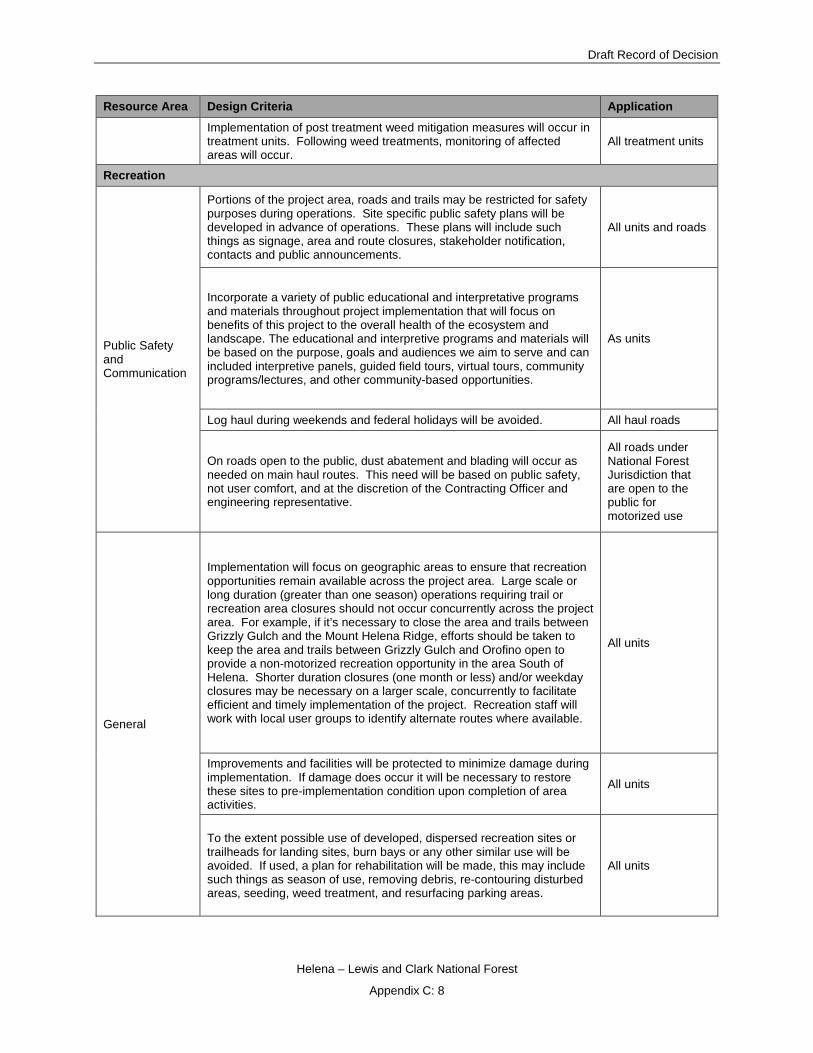
Draft Record of Decision
Helena – Lewis and Clark National Forest
Appendix C: 8
Resource Area Design Criteria Application
Implementation of post treatment weed mitigation measures will occur in treatment units. Following weed treatments, monitoring of affected areas will occur.
All treatment units
Recreation
Public Safety and Communication
Portions of the project area, roads and trails may be restricted for safety purposes during operations. Site specific public safety plans will be developed in advance of operations. These plans will include such things as signage, area and route closures, stakeholder notification, contacts and public announcements.
All units and roads
Incorporate a variety of public educational and interpretative programs and materials throughout project implementation that will focus on benefits of this project to the overall health of the ecosystem and landscape. The educational and interpretive programs and materials will be based on the purpose, goals and audiences we aim to serve and can included interpretive panels, guided field tours, virtual tours, community programs/lectures, and other community-based opportunities.
As units
Log haul during weekends and federal holidays will be avoided. All haul roads
On roads open to the public, dust abatement and blading will occur as needed on main haul routes. This need will be based on public safety, not user comfort, and at the discretion of the Contracting Officer and engineering representative.
All roads under National Forest Jurisdiction that are open to the public for motorized use
General
Implementation will focus on geographic areas to ensure that recreation opportunities remain available across the project area. Large scale or long duration (greater than one season) operations requiring trail or recreation area closures should not occur concurrently across the project area. For example, if it’s necessary to close the area and trails between Grizzly Gulch and the Mount Helena Ridge, efforts should be taken to keep the area and trails between Grizzly Gulch and Orofino open to provide a non-motorized recreation opportunity in the area South of Helena. Shorter duration closures (one month or less) and/or weekday closures may be necessary on a larger scale, concurrently to facilitate efficient and timely implementation of the project. Recreation staff will work with local user groups to identify alternate routes where available.
All units
Improvements and facilities will be protected to minimize damage during implementation. If damage does occur it will be necessary to restore these sites to pre-implementation condition upon completion of area activities.
All units
To the extent possible use of developed, dispersed recreation sites or trailheads for landing sites, burn bays or any other similar use will be avoided. If used, a plan for rehabilitation will be made, this may include such things as season of use, removing debris, re-contouring disturbed areas, seeding, weed treatment, and resurfacing parking areas.
All units

Tenmile – South Helena Project
Helena – Lewis and Clark National Forest
Appendix C: 9
Resource Area Design Criteria Application
To reduce the potential for establishment of user created routes, minimize the placement of skid/equipment trails and prescribed fire control lines in road and trail corridors. Where they cannot be avoided, rehabilitation must be completed timely to ensure the public does not begin using them for motorized or non-motorized recreation. The rehabilitation plan should include returning to natural contour, scarification, seeding with native mix and installing natural barriers.
All units
Hunting Season
Motorized and mechanized operations in remote locations (generally greater than ½ mile from a route designated open to the public for motorized travel or private property) will be minimized on National Forest System lands during big game rifle hunting season (approx. 10/15 – 12/2) to reduce the impact on hunter opportunities. Operations should generally be avoided the first two weeks of rifle season. When conflicts with other resource objectives or efficiency of operations require activity to occur during rifle hunting season, the public will be notified and signs will be posted in advance.
All units
Administrative use of closed roads during the hunting season will be minimized.
All roads closed to the public for motorized use
Trails
A Landscape Architect will provide site specific input during layout and design of treatment units in high value scenic corridors such as the area surrounding the Continental Divide National Scenic Trail and trails located in the City of Helena South Hills.
All units that intersect system trails
In situations where trails are currently located on a road prism that could be used during implementation, consider relocating segments of the trail to more desirable locations. Trail relocation may also be considered when activity that will likely be disruptive or visible long-term is anticipated to occur in the trail corridor.
All units within and adjacent to system trails
If the trail width is expanded to facilitate operations it will be restored to a desired width post implementation.
All units within and adjacent system trails
Character trees and trees that define the trail corridor will be retained when they do not compromise safety.
All units that are within and adjacent system trails
User created or non-system routes, which are identified during implementation as being used or maintained (motorized or non-motorized) without Forest Service authorization, will be closed.
Forest Service lands within the Project area
Vegetation

Draft Record of Decision
Helena – Lewis and Clark National Forest
Appendix C: 10
Resource Area Design Criteria Application
Tree Selection
Where live residual trees are available, the healthiest, generally largest, windfirm, and most fire resistant seral species (generally ponderosa pine and Douglas-fir, and all 5-nedle pine if present) will be selected for retention at the desired distribution specified in detailed silvicultural prescriptions. Remnant components will be retained in treated areas utilizing variable retention concepts to provide diversity and habitat features.
All units
Weed spraying and grazing
Weed spraying and grazing activities will be modified as necessary in regenerating areas to ensure these activities do not compromise the success of regeneration. Alternatives will be identified as needed, and may include tactics such as temporary avoidance, modifying the season of use, and modifying the timing of application or selection of herbicides.
All units
Slash Disposal Excess slash will be disposed of with a variety of methods, including, but not limited to, whole-tree yarding, chipping, mastication, maximizing utilization opportunities including firewood, and burning.
All units
Firewood Cutting
If firewood is available in treatment units and can be gathered by the public, areas along open roads could be made available to the public for firewood gathering after contract obligations are met and before burning.
All units with mechanical treatment adjacent to roads open to the public for motorized travel
Improvements (i.e.-fence lines, portals, gates, roads, parking areas, livestock watering features, etc.)
Improvements will be protected from damage during all phases of implementation. All units
Sensitive Plants
General
Any sensitive plant populations found prior to or during implementation will be protected using design criteria appropriate for the species. A FS Botanist will be consulted to determine necessary actions to protect populations identified during implementation.
All project activities on National Forest System lands
When herbicide treatment is planned in the vicinity of a sensitive plant population consultation with a Botanist will be necessary prior to implementation. Typically a no herbicide buffer, approximately 100 feet around any sensitive plant population will be required.
Project Boundary
The Botanist will provide maps of known populations within the project area to be reviewed prior to each implementation season. Adjustments to treatments will be made if necessary.
All project activities
Impacts to sensitive plant populations from road decommissioning will be minimized through implementation of techniques including, but not limited to: “no operation” buffers around sensitive plants; reduction in extent of ripped road prism adjacent to sensitive plant populations; or use of natural materials to create barriers to plant disturbance.
Decommissioned Roads
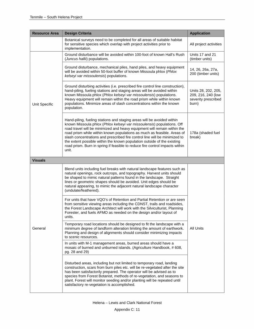
Tenmile – South Helena Project
Helena – Lewis and Clark National Forest
Appendix C: 11
Resource Area Design Criteria Application
Botanical surveys need to be completed for all areas of suitable habitat for sensitive species which overlap with project activities prior to implementation.
All project activities
Unit Specific
Ground disturbance will be avoided within 100-foot of known Hall’s Rush (Juncus hallii) populations.
Units 17 and 21 (timber units)
Ground disturbance, mechanical piles, hand piles, and heavy equipment will be avoided within 50-foot buffer of known Missoula phlox (Phlox kelseyi var missoulensis) populations.
14, 26, 26a, 27a, 200 (timber units)
Ground disturbing activities (i.e. prescribed fire control line construction), hand-piling, fueling stations and staging areas will be avoided within known Missoula phlox (Phlox kelseyi var missoulensis) populations. Heavy equipment will remain within the road prism while within known populations. Minimize areas of slash concentrations within the known population.
Units 28, 202, 205, 209, 216, 240 (low severity prescribed burn)
Hand-piling, fueling stations and staging areas will be avoided within known Missoula phlox (Phlox kelseyi var missoulensis) populations. Off road travel will be minimized and heavy equipment will remain within the road prism while within known populations as much as feasible. Areas of slash concentrations and prescribed fire control line will be minimized to the extent possible within the known population outside of the existing road prism. Burn in spring if feasible to reduce fire control impacts within unit.
178a (shaded fuel break)
Visuals
General
Blend units including fuel breaks with natural landscape features such as natural openings, rock outcrops, and topography. Harvest units should be shaped to mimic natural patterns found in the landscape. Straight lines or geometric shapes should be avoided. Unit edges should be natural appearing, to mimic the adjacent natural landscape character (undulate/feathered).
All Units
For units that have VQO’s of Retention and Partial Retention or are seen from sensitive viewing areas including the CDNST, trails and roadsides, the Forest Landscape Architect will work with the Silviculturist, Planning Forester, and fuels AFMO as needed on the design and/or layout of units.
Temporary road locations should be designed to fit the landscape with a minimum degree of landform alteration limiting the amount of earthwork. Planning and design of alignments should consider minimizing impacts to scenic resources.
In units with M-1 management areas, burned areas should have a mosaic of burned and unburned islands. (Agriculture Handbook, # 608, pg. 28 and 29)
Disturbed areas, including but not limited to temporary road, landing construction, scars from burn piles etc. will be re-vegetated after the site has been satisfactorily prepared. The operator will be advised as to species from Forest Botanist, methods of re-vegetation, and seasons to plant. Forest will monitor seeding and/or planting will be repeated until satisfactory re-vegetation is accomplished.

Draft Record of Decision
Helena – Lewis and Clark National Forest
Appendix C: 12
Resource Area Design Criteria Application
All equipment and construction debris will be removed from the site.
During road construction, save topsoil by side casting for later use in rehabilitation.
All Roads / Skid Trails
Where new access roads and skid trails meet a primary travel route, they should intersect at a right angle and, where feasible, curve after the junction to minimize the length of route seen from the primary travel route.
Where feasible, retain screening trees one tree-height below roads and landings (including portions of cable units). Avoid creating a straight edge of trees by saving clumps of trees and single trees with varied spacing.
During temporary or permanent (including maintenance or reconstruction) road construction, clearing slash and root wads will be eliminated or removed from view in the immediate foreground.
Cut and fill banks will be sloped to accommodate natural revegetation.
Cut and fill slopes will be revegetated with native species where ever possible. Ensure slash is abated near landings by scattering, chipping, or other techniques.
All Slash Piles
If slash piles are to be burned, take necessary actions to achieve 95% or more consumption. Following burning, concentrations of unconsumed slash will be scattered. Maximize utilization and removal of fuel to reduce the amount of slash to be burned.
Utilize designation by description (species designation) where appropriate to minimize the amount of necessary marking paint.
Minimize skyline corridors and work with the Forest Landscape Architect to blend the resulting corridors in with the surrounding environment. This can be achieved through the silvicultural prescription and design/layout.
Use cut tree (as opposed to leave tree) marking in visually sensitive areas where appropriate.
Log landings, roads, gravel pits, borrow areas, and bladed skid trails should be minimized within sensitive view sheds.
Aesthetic values should be considered when selecting landing locations. Project manager will consult with the Landscape Architect during implementation to identify options to minimize impacts in visually sensitive areas.
Where feasible road or trail closures should be considered to allow short-term landing and decking on the road to reduce the extent of disturbance.
In visually sensitive areas consideration should be given to processing trees within the unit and only decking adjacent to roadsides.
The views of skid trails should be minimized.
When appropriate, use Jack leg fence or natural barriers to block reclaimed skid trails and temp roads from further use.
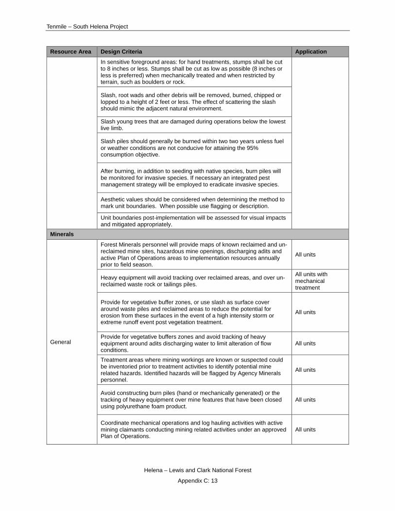
Tenmile – South Helena Project
Helena – Lewis and Clark National Forest
Appendix C: 13
Resource Area Design Criteria Application
In sensitive foreground areas: for hand treatments, stumps shall be cut to 8 inches or less. Stumps shall be cut as low as possible (8 inches or less is preferred) when mechanically treated and when restricted by terrain, such as boulders or rock.
Slash, root wads and other debris will be removed, burned, chipped or lopped to a height of 2 feet or less. The effect of scattering the slash should mimic the adjacent natural environment.
Slash young trees that are damaged during operations below the lowest live limb.
Slash piles should generally be burned within two two years unless fuel or weather conditions are not conducive for attaining the 95% consumption objective.
After burning, in addition to seeding with native species, burn piles will be monitored for invasive species. If necessary an integrated pest management strategy will be employed to eradicate invasive species.
Aesthetic values should be considered when determining the method to mark unit boundaries. When possible use flagging or description.
Unit boundaries post-implementation will be assessed for visual impacts and mitigated appropriately.
Minerals
General
Forest Minerals personnel will provide maps of known reclaimed and un-reclaimed mine sites, hazardous mine openings, discharging adits and active Plan of Operations areas to implementation resources annually prior to field season.
All units
Heavy equipment will avoid tracking over reclaimed areas, and over un-reclaimed waste rock or tailings piles.
All units with mechanical treatment
Provide for vegetative buffer zones, or use slash as surface cover around waste piles and reclaimed areas to reduce the potential for erosion from these surfaces in the event of a high intensity storm or extreme runoff event post vegetation treatment.
All units
Provide for vegetative buffers zones and avoid tracking of heavy equipment around adits discharging water to limit alteration of flow conditions.
All units
Treatment areas where mining workings are known or suspected could be inventoried prior to treatment activities to identify potential mine related hazards. Identified hazards will be flagged by Agency Minerals personnel.
All units
Avoid constructing burn piles (hand or mechanically generated) or the tracking of heavy equipment over mine features that have been closed using polyurethane foam product.
All units
Coordinate mechanical operations and log hauling activities with active mining claimants conducting mining related activities under an approved Plan of Operations.
All units
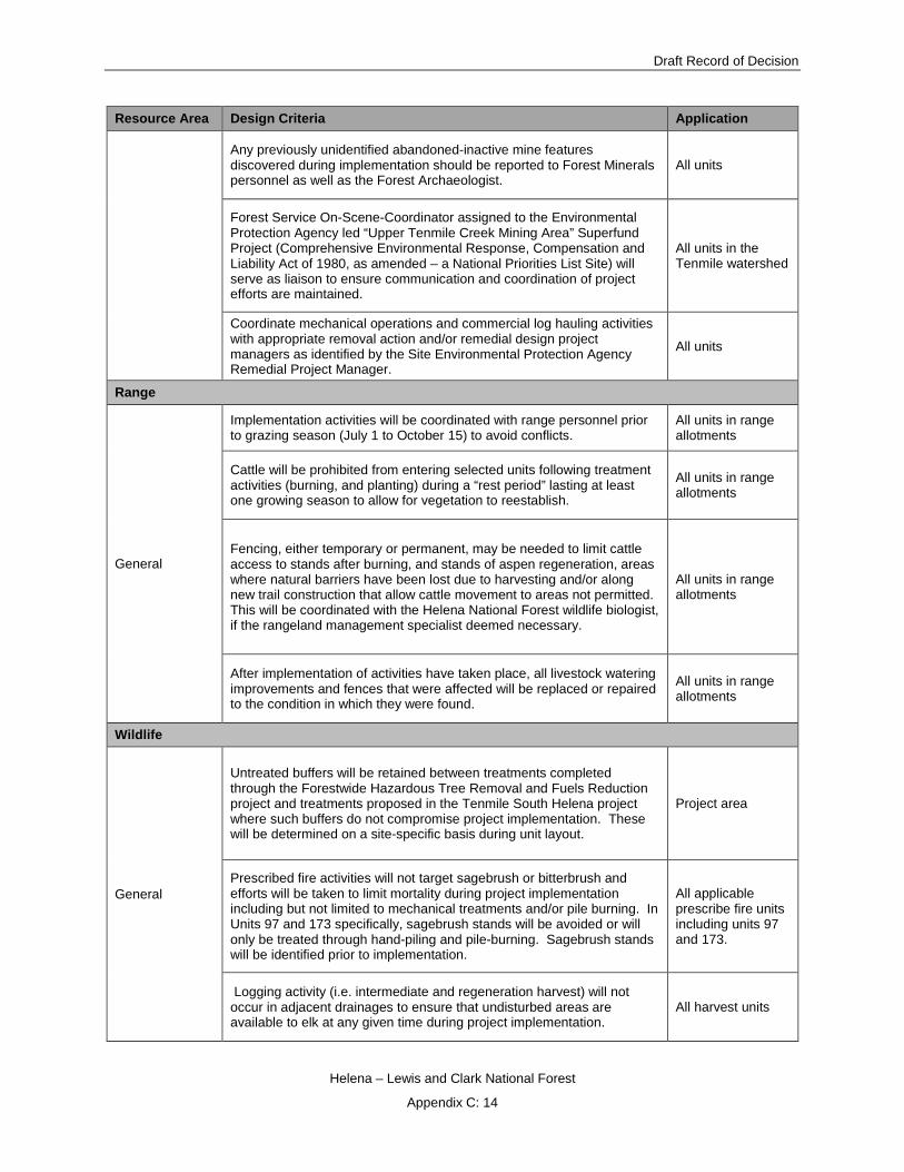
Draft Record of Decision
Helena – Lewis and Clark National Forest
Appendix C: 14
Resource Area Design Criteria Application
Any previously unidentified abandoned-inactive mine features discovered during implementation should be reported to Forest Minerals personnel as well as the Forest Archaeologist.
All units
Forest Service On-Scene-Coordinator assigned to the Environmental Protection Agency led “Upper Tenmile Creek Mining Area” Superfund Project (Comprehensive Environmental Response, Compensation and Liability Act of 1980, as amended – a National Priorities List Site) will serve as liaison to ensure communication and coordination of project efforts are maintained.
All units in the Tenmile watershed
Coordinate mechanical operations and commercial log hauling activities with appropriate removal action and/or remedial design project managers as identified by the Site Environmental Protection Agency Remedial Project Manager.
All units
Range
General
Implementation activities will be coordinated with range personnel prior to grazing season (July 1 to October 15) to avoid conflicts.
All units in range allotments
Cattle will be prohibited from entering selected units following treatment activities (burning, and planting) during a “rest period” lasting at least one growing season to allow for vegetation to reestablish.
All units in range allotments
Fencing, either temporary or permanent, may be needed to limit cattle access to stands after burning, and stands of aspen regeneration, areas where natural barriers have been lost due to harvesting and/or along new trail construction that allow cattle movement to areas not permitted. This will be coordinated with the Helena National Forest wildlife biologist, if the rangeland management specialist deemed necessary.
All units in range allotments
After implementation of activities have taken place, all livestock watering improvements and fences that were affected will be replaced or repaired to the condition in which they were found.
All units in range allotments
Wildlife
General
Untreated buffers will be retained between treatments completed through the Forestwide Hazardous Tree Removal and Fuels Reduction project and treatments proposed in the Tenmile South Helena project where such buffers do not compromise project implementation. These will be determined on a site-specific basis during unit layout.
Project area
Prescribed fire activities will not target sagebrush or bitterbrush and efforts will be taken to limit mortality during project implementation including but not limited to mechanical treatments and/or pile burning. In Units 97 and 173 specifically, sagebrush stands will be avoided or will only be treated through hand-piling and pile-burning. Sagebrush stands will be identified prior to implementation.
All applicable prescribe fire units including units 97 and 173.
Logging activity (i.e. intermediate and regeneration harvest) will not occur in adjacent drainages to ensure that undisturbed areas are available to elk at any given time during project implementation.
All harvest units

Tenmile – South Helena Project
Helena – Lewis and Clark National Forest
Appendix C: 15
Resource Area Design Criteria Application
If any listed or proposed species are detected in the project area during implementation, activities will be examined to determine if activity modification is necessary such as timing restrictions.
All units
Prescribed fire and underburning will be implemented prior to May 1 or after July in order to protect nesting birds. Exceptions may occur if burning windows become limited. These will be reviewed on a case by case basis with a wildlife biologist prior to implementation.
All units with prescribed burning
Recreational use of firearms will be prohibited for anyone working within an area closed to the general public.
Areas closed to the public
Slash clean-up inside clearcuts will be reduced below 1.5 feet. All harvest units
Proper food storage will be required of all personnel working in the project area. Project area
A retention of 5 tons/acre of down woody debris (greater than 3 inch diameter) following treatments in warm, dry forest habitat types and a minimum of 10 tons/acre in all other forest types will ensure adequate habitat for down woody debris-dependent species.
All treatment units
Woody debris will be randomly distributed in treatment units and natural concentrations will be retained to the extent that treatment objectives can be met. Concentrations will be identified by Silviculture, Fuels and Wildlife prior to implementation activities.
Where opportunities exist after harvest operations and prior to burning, pile concentrations of down woody debris within regeneration harvest units on average of 1 pile per acre approximately 6 feet high and 15 feet in diameter providing treatment objectives are met. Concentrations will be identified by Silviculture, Fuels and Wildlife prior to implementation activities.
Trees at landings that may sustain damage during project activities will remain on site unless they pose a safety hazard. All units
In areas otherwise closed to motorized vehicles, contractors will not be permitted to hunt, transport hunters, discharge firearms or transport big game with vehicles within the closed areas.
All units
In areas impacted by mountain pine beetle, forest stands or portions of stands with a preponderance of healthy, green trees in the overstory will be left untreated or will be treated so as to protect the live overstory component whenever the result enhances local wildlife habitat and does not compromise the purpose and need of the project. Priority areas include saddles, travel lanes, stands adjacent to riparian and wetland habitats, and sites within elk security areas.
All units

Draft Record of Decision
Helena – Lewis and Clark National Forest
Appendix C: 16
Resource Area Design Criteria Application
In beetle-impacted lodgepole pine habitats, concentrations of healthy conifer regeneration will be protected whenever possible in order to preserve existing or potential concealment cover, pockets of local habitat diversity, and maturing forest habitat.
All units
Goshawk
A buffer zone of uncut forest will be established around occupied or recently occupied goshawk nest located in treatment units or adjacent to treatment units if the nest stand overlaps with the respective unit. The size and configuration of this zone will depend on the location of the nest, the distribution of green overstory trees, and other local factors to be assessed by the wildlife biologist at the site. If possible, the buffer around an active nest tree should be at least 40 acres.
Project area
At least 180 acres of nesting habitat per home range will be retained in the project area with an emphasis on stands that have been used by goshawks for nesting.
Project area
No ground disturbing activities will occur inside post fledgling areas associated with active nests on the Forest from 15 April through 15 August to protect the goshawk pair and young from disturbance during the breeding season until fledglings are capable of sustained flight. For post-fledgling areas on BLM-administered land, no ground disturbing activities will occur between March 1 and September 30. Site-specific data will continue to be used and if needed, timing restrictions will be designed to reflect variations in fledgling dates.
Project area
Retain deformed trees for use by goshawks as nest trees. All units
Great Gray Owl
If a great gray owl nest is located in the project area, activities will be restricted within a quarter mile of the nest during the nesting season between March 1 and August 1. Timing restrictions may be modified to reflect variations in fledgling dates.
Project area
Snags
In regeneration harvest units, roughly 20 snags per 10 acres from a mixture of diameter classes available, including all snags >20” dbh, with seral species preferred, will be retained where they do not pose a safety or feasibility concern. There will be a few reserve trees/patches and inoperable areas to provide snags and/or replacement trees.
All regeneration harvest units
In intermediate harvest units, snag retention goals will be to retain all snags greater than 20” dbh; AND 7 ponderosa pine (where available) or Douglas-fir snags greater than 10” dbh, or as many are available less than that amount, where they do not pose a safety or feasibility concern. There will also be abundant live trees in various size classes retained for snag replacement (75-300/acre).
All intermediate harvest units
All whitebark pine snags will be retained where safe to do so in locations that do not pose a safety hazard during implementation. All applicable units
No retention of individual dead lodgepole pine is desired. Groups or clumps of lodgepole snags may be left in inoperable areas or when mixed in with other retention trees.
All applicable units

Tenmile – South Helena Project
Helena – Lewis and Clark National Forest
Appendix C: 17
Resource Area Design Criteria Application
In prescribed fire only units, prescriptions will generally include limiting cutting of snags >12” diameter unless they are a specific safety or line containment hazard.
All units with prescribed fire
The rare remnant snags that may be found in pre-commercial thinning units will be retained.
All precommercial thin units
If a snag designated for retention must be felled for safety (Occupational Safety and Health Administration), it will remain onsite as coarse woody debris and a substitute snag selected for retention.
All units with mechanical treatment
Elk
Logging operations will be prohibited during the first two weeks of the general rifle season in order to maintain big game habitat capability and hunting opportunity.
All harvest units.
Timbered areas adjacent to elk winter foraging areas will be retained. All applicable units
If elk calving and nursery areas are identified prior to or during project implementation, these areas will be protected. This will be from late May through July unless surveys indicate areas are no longer being used.
Project area
Project activities (timber harvest) including road building and use will be limited in security and intermittent refuge areas to one operating season in each subdivision between 9/1 and 12/1 in order to minimize disturbance to elk. Subdivisions will be defined at the time of sale layout.
Project area
Prescribed fire, re-arrangement of fuels, shaded fuel breaks, and precommercial thinning activities in elk security and/or intermittent refuge areas will be scheduled to minimize overlap with timber sale activities and to minimize disturbance to elk. Coordination with a wildlife biologist will occur prior to implementation of these activities.
All prescribed fire, re-arrangement of fuels, shaded fuel breaks, and precommercial thinning units
Precommercial thinning in elk hiding cover will be thinned at an average 12 foot spacing in order to retain hiding cover (see additional provisions below for lynx).
All precommercial thinning units in Alternatives 3 and 4
Lynx
Precommercial thinning in the WUI in early stand initiation hare habitat and stand initiation hare habitat will retain patches of unthinned forest in each unit. Approximately 80% of each unit will be thinned at an average 12 foot spacing and 20% of the total unit will retain uncut seedlings/saplings. Uncut portions will approximate a half acre in size.
All precommercial thinning units
Precommercial thinning (pct) outside of the WUI – conducted for whitebark pine release only – will be reviewed by a wildlife biologist and silviculturist prior to implementation to determine the extent of treatment within each unit. A majority of each PCT unit outside of the WUI will remain untreated and the densest patches of saplings will be retained and spatially well-distributed.
All precommercial thinning outside of WUI for whitebark pine
Stand initiation and early stand initiation habitat within regeneration harvest treatments within the WUI will be avoided to the extent practicable while meeting treatment objectives.
All regeneration harvest units

Draft Record of Decision
Helena – Lewis and Clark National Forest
Appendix C: 18
Resource Area Design Criteria Application
Where multistory hare habitat is present within prescribed fire and re-arrangement of fuels (e.g. shaded fuel breaks) treatment units outside of the WUI, these treatments will avoid effects to multistory habitat through hand-slashing only or coupled with pile burning or jackpot burning for which the fire effects can be controlled.
All units with mechanical treatment and/or prescribed burning
Regeneration harvest treatments in multistory hare habitat within the WUI will be designed to retain up to 20% of advanced regeneration where available with a focus on multistory hare habitat while meeting treatment objectives.
All regeneration harvest units
Special Habitats
Riparian
Treatments in and around riparian and wetland sites will retain enough healthy live trees, snags, and coarse woody debris to provide viable habitat for dependent wildlife species. Most often, all of these components will be left intact: In some instances, live conifers will be removed to promote aspen and other riparian shrubs and to restrict colonization of wet meadows. The zone (size) of restricted treatment in and around wet sites will be determined by the wildlife biologist prior to layout and design. For example, restricted treatments may apply to active ignition and/or mechanical treatments. These sites, will include sub-irrigated habitats as well as those with standing water, provide some of the best remaining enclaves of green forest in beetle-impacted areas.
All treatment units with riparian areas
Aspen
Within treatment units, healthy, viable aspen of all ages will be protected from damage generated by cutting and burning operations as much as possible. Coarse woody debris will be left in place in and around aspen stands where practicable to make it difficult for ungulates to browse on and suppress young aspen.
All units
Aspen communities will be favored in all treatment units. Conifers suppressing aspen clones will be thinned from within and around suppressed aspen, followed by prescribed fire where applicable (e.g., stagnating, decadent clones, etc.). Cut tree diameter limits and cutting distance from aspen will be established and defined in stand and unit prescriptions with input from a wildlife biologist.
All units
5-Needled Pines Including Whitebark Pine
No whitebark pine will be intentionally cut regardless of size, condition, or distribution. To the extent possible whitebark of all size classes will be protected from damage. This may include ensuring that designated equipment trails avoid whitebark and trees are directionally felled away when possible.
All applicable treatment units Precommercial thinning outside of the Wildland Urban Interface –
conducted for whitebark pine release only – will be reviewed by a wildlife biologist and silviculturist prior to implementation to determine the extent of treatment within each unit. A majority of each Precommercial Thin unit outside of the Wildland Urban Interface will remain untreated and the densest patches of saplings will be retained and spatially well-distributed.
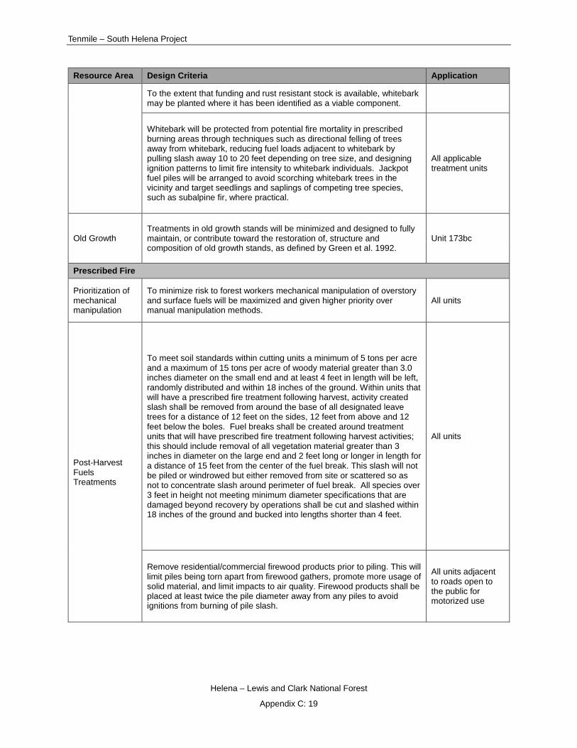
Tenmile – South Helena Project
Helena – Lewis and Clark National Forest
Appendix C: 19
Resource Area Design Criteria Application
To the extent that funding and rust resistant stock is available, whitebark may be planted where it has been identified as a viable component.
Whitebark will be protected from potential fire mortality in prescribed burning areas through techniques such as directional felling of trees away from whitebark, reducing fuel loads adjacent to whitebark by pulling slash away 10 to 20 feet depending on tree size, and designing ignition patterns to limit fire intensity to whitebark individuals. Jackpot fuel piles will be arranged to avoid scorching whitebark trees in the vicinity and target seedlings and saplings of competing tree species, such as subalpine fir, where practical.
All applicable treatment units
Old Growth Treatments in old growth stands will be minimized and designed to fully maintain, or contribute toward the restoration of, structure and composition of old growth stands, as defined by Green et al. 1992.
Unit 173bc
Prescribed Fire
Prioritization of mechanical manipulation
To minimize risk to forest workers mechanical manipulation of overstory and surface fuels will be maximized and given higher priority over manual manipulation methods.
All units
Post-Harvest Fuels Treatments
To meet soil standards within cutting units a minimum of 5 tons per acre and a maximum of 15 tons per acre of woody material greater than 3.0 inches diameter on the small end and at least 4 feet in length will be left, randomly distributed and within 18 inches of the ground. Within units that will have a prescribed fire treatment following harvest, activity created slash shall be removed from around the base of all designated leave trees for a distance of 12 feet on the sides, 12 feet from above and 12 feet below the boles. Fuel breaks shall be created around treatment units that will have prescribed fire treatment following harvest activities; this should include removal of all vegetation material greater than 3 inches in diameter on the large end and 2 feet long or longer in length for a distance of 15 feet from the center of the fuel break. This slash will not be piled or windrowed but either removed from site or scattered so as not to concentrate slash around perimeter of fuel break. All species over 3 feet in height not meeting minimum diameter specifications that are damaged beyond recovery by operations shall be cut and slashed within 18 inches of the ground and bucked into lengths shorter than 4 feet.
All units
Remove residential/commercial firewood products prior to piling. This will limit piles being torn apart from firewood gathers, promote more usage of solid material, and limit impacts to air quality. Firewood products shall be placed at least twice the pile diameter away from any piles to avoid ignitions from burning of pile slash.
All units adjacent to roads open to the public for motorized use

Draft Record of Decision
Helena – Lewis and Clark National Forest
Appendix C: 20
Resource Area Design Criteria Application
Pile Construction
Construct piles at a size-ratio of 2:3, meaning if pile is 10 feet tall it should be 15 feet diameter. Pile branches and tops with the butt ends towards the outside of the pile, and overlapping. The perimeter of piles should have very few loose ends meaning all edges of piles are pushed in or sawn off and added to pile. Place sufficient amount of 3 inches and smaller material throughout the pile, this should be approximately 30% of the pile volume. Minimum piling size should be approximately 8 feet across in diameter and 6 feet in height Piles should be kept compact. Do not place large stumps (> 14 inch diameter measured at the cut stump) in the piles.
All units
Do not include foreign objects (garbage), treated lumber, or non-flammable material in the pile. Use a crawler-type excavator equipped with grapple or bucket with a thumb.
All units
Piles that are to be burned will not be located over buried utility lines. Piles should be in an area void of overstory trees and utility lines. Anticipate flame lengths of up to three times the height of your pile(s). Piles will maintain a minimum spacing of twice the pile diameter from any live overstory vegetation and/or utility lines (includes utility boxes). Piles will maintain a minimum spacing of four times the pile diameter from any structures, creating safety zone where flames, radiant heat, and airborne embers will not set structure on fire. Placement of piles will be in locations that will minimize soil and ash movement.
All units
Piles are not to be located on active road surfaces, in road rights-of-way, or in ditches. Piles should maintain a minimum spacing of twice the pile diameter from center line of any active road surface.
All units
Piles will be monitored for post-fire vegetation response and reseeding/re-vegetating burn pile sites may be needed. All units
Prescribed Fire Control Line Construction
Fireline will be constructed by a combination of methods including hand, mechanical (less than 35% slope), and/or explosives to 18-24” wide to mineral soil. Use of natural and existing barriers is preferred. Fireline rehabilitation associated with burning activities will be pulling back (with hand tools) the berm adjacent to the constructed line, constructing water bars as needed and where fireline intersects NFS trails consider disguising the intersections by scattering cut vegetation. Whenever possible exiting trails will be used as fireline to reduce impacts to resources.
All prescribed burn units on National Forest System lands
Heritage
General – Implementation
Prior to implementation a site specific resource protection measures table will be discussed and signed by the District Ranger, Forest Archaeologist and Implementation leader(s) before any on the ground implementation occurs. Final resource protection measures will be established and consulted through the process laid out for compliance with the NHPA Section 106 compliance process. All cultural resources requiring special treatment or avoidance will be flagged by a Heritage Specialist prior to implementation.
All treatment units

Tenmile – South Helena Project
Helena – Lewis and Clark National Forest
Appendix C: 21
Resource Area Design Criteria Application
Where significant or potentially significant sites are known in treatments units, the Heritage Specialist identified potential treatments that could benefit site preservation and fit within the overall project goals. These special treatment measures will be identified in a confidential NHPA Section 106 report and unit specific table after additional Section 106 consultation has been completed.
All treatment units
If undocumented archaeological resources are found during project implementation, ground disturbances in the area must stop and the find must be reported to the Heritage Specialist. The Heritage Specialist will determine if project implementation must be modified to avoid impacts to those resources. The Heritage Specialist will also determine if these resources are subject to State and/or Tribal Historic Preservation Officer review and comment, according to the 36 CFR 800 compliance process.
All treatment units
If temporary roads are farther than 200 feet from the center line of the proposed routes in the final NEPA document, Heritage will need to be consulted prior to construction.
Temporary road construction
If user-created or non-system routes are found during project implementation a Heritage review is necessary prior to closing the route with any ground disturbance actions.
All non-system and user-created routes
All private land buffer units will receive a Heritage review ounce a proposal has been brought forward from the land owner and prior to any work being conducted.
All Private Land Buffer units
A final NHPA Section 106 inventory and/or review will be conducted for all new trails after the route has been flagged on the ground. This will ensure Section 106 inventories are completed at the correct location and after the final layout and design has been completed.
New Trails
If ground based mechanical equipment of any kind is going to be used in units proposed for prescribed burning, then additional Heritage review will be needed once the type of equipment is known and when the on the ground location has been determined. Since a 30% sample inventory was conducted in units proposed for burning, this extra step will ensure a good faith effort has been met prior to implementation.
All Prescribed Fire units
The Northern Region Protocols for Unanticipated Discoveries and Human Remains shall be followed during all phases and undertakings associated with this project
All treatment units
When finalized methods of treatment, haul routes and treatment unit maps for implementation are available, the Forest Archaeologist must be provided an opportunity to compare such maps with existing confidential cultural resource site locational information. This will allow for a further narrowing of focus for any on site resource protection measures, leading to greatest possible NHPA Section 106 compliance.
All treatment units

Draft Record of Decision
Helena – Lewis and Clark National Forest
Appendix C: 22
Resource Area Design Criteria Application
The Brooklyn Bridge to Black Hall Meadow Proposed Trail is planned to follow portions of the historic Park Ditch (24LC1048/24JF726), which is eligible for listing in the National Register of Historic Places (NRHP). Public interpretive signs, approved by the Forest Archaeologist, will need to be installed at key points along this trail to provide the public with information about the significances of this ditch to local history and shall explain how non-motorized multiple use of this historic feature must not degrade its integrity for listing in the NRHP. Annual monitoring of the Park Ditch (24LC1048/24LC726) will need to be conducted to ensure the historic integrity is being maintained. If at any time the integrity of the Park Ditch is being compromised by this multiple use, additional resource protection measure will need to be established or recreational use limited.
Brooklyn Bridge to Black Hall Meadow Proposed Trail
Lands and Special Uses
Non-recreation Special Uses
Corner monuments and accessories to corner monuments will be identified prior to implementation and protected during project activities. All units
Permittees will be notified in advance of implementation to minimize the impact to permitted activities on National Forest System land. To the extent possible, privately owned improvements will be protected during operations. If it is not possible to protect improvements, permittee will be notified in advance and terms and conditions included in the permit will determine how the situation will be remedied (improvement temporarily relocated for example).
All units on National Forest System land.
Project managers and contractors will need to be cognizant of the location of permitted private roads and classified private roads. Use of these routes during implementation will need to be agreed to in advance with permit holder or landowner.
All units and roads
Rights of way/private land
Road use will be coordinated with Lewis & Clark, Jefferson, and Powell Counties on roads having county jurisdiction. All county roads
Private rights-of-way will be pursued with both short-term project access needs and long-term public and administrative access needs in mind. As necessary
Inventoried Roadless Area
General
Regeneration treatments in the Jericho Mountain and Lazyman Roadless Areas will generally occur in lodgepole pine stands with greater than 50% MPB mortality and targeting dead, dying and down trees. Patches of predominantly live lodgepole pine will not be cut or removed. Individual trees may be felled if deemed operationally hazardous.
All regeneration units in IRA

Tenmile – South Helena Project
Helena – Lewis and Clark National Forest
Appendix D: 1
Appendix D: Tenmile South Helena Site-Specific Forest Plan Amendment for the Draft Record of Decision
Table of Contents
INTRODUCTION .............................................................................................................................................. 2
SITE-SPECIFIC AMENDMENT ANALYSIS ............................................................................................................... 3
Thermal Cover and Winter Range.......................................................................................................... 3
Hiding Cover on Summer Range ............................................................................................................ 6
Elk Security during the Hunting Season ................................................................................................. 6
Openings ................................................................................................................................................ 8
Effects of the Site-Specific Amendment on Elk Populations ................................................................ 13
CUMULATIVE EFFECTS OF OTHER FOREST PLAN AMENDMENTS ........................................................................... 14
Site-Specific Amendments.................................................................................................................... 14
Programmatic Amendments ................................................................................................................ 31
Cumulative Effects Conclusions ........................................................................................................... 34
Findings Required by Laws, Regulations, and Policies ......................................................................... 35
Conclusions .......................................................................................................................................... 42
RELATIONSHIP OF THE SITE-SPECIFIC AMENDMENT WITH OTHER WILDLIFE STANDARDS IN THE FOREST PLAN AND NRLMD ................................................................................................................................................................. 45
RELATIONSHIP OF THE SITE-SPECIFIC AMENDMENT WITH MANAGEMENT AREA GOALS ........................................... 62

Draft Record of Decision
Helena – Lewis and Clark National Forest
Appendix D: 2
Introduction The Forest is amending the 1986 Helena National Forest Plan for lands encompassed by the Tenmile South Helena project. This amendment only applies to land within the Helena-Lewis and Clark (HLC) National Forest. Unlike the analysis presented in the FEIS which includes both the National Forest and Bureau of Land Management (BLM) administered lands, this analysis addresses only those treatments on the HLC since the final Record of Decision (ROD) will be for the HLC only. All references included herein are listed in the FEIS.
Table 3.1 summarizes the Forest Plan standards that are the subject of this site-specific amendment for the draft ROD.
Standards for which an exemption would be needed (Yes) to implement the Tenmile South Helena project for the draft ROD
Standard Draft ROD Forestwide Standard 3 requires 50% hiding cover on each herd unit (USDA 1986, p. II/17)
Yes (Only Black Mountain-Brooklyn Bridge herd unit)
Forestwide Standard 3 requires 25% thermal cover on winter range for each herd unit (USDA 1986, p. II/17) Yes (All herd units)
Forestwide Standard 4a requires open road densities and hiding cover ratios (USDA 1986, pp. II/17-18)
Yes (Only Black Mountain-Brooklyn Bridge and Quartz
Creek herd units) Forestwide Standard 4c requires that winter range be closed to vehicles during the winter (USDA 1986, p. II/18) Yes
Forestwide Standard 6 requires that timber harvest openings should not exceed 100 acres (USDA 1986, p. II/19 and Appendix C, C/7) Yes
Forestwide Standard 6 requires that logging on winter range be scheduled outside of winter (USDA 1986, p. II/19 and Appendix C, C/10) Yes
Management Area H-1 requires that 25% thermal cover be provided on winter range (USDA 1986, p. III/18) Yes
Management Area H-2 requires that 25% thermal cover be provided on winter range (USDA 1986, p. III/21) Yes
The amendment is a site-specific amendment and is applicable only to implementation of the decision for the Tenmile South Helena project. This is a one-time exemption and is not intended to replace the existing standards.
Elk serve as a management indicator for hunted species for the Helena National Forest (Forest Plan p. II/17). Federal laws and direction applicable to management indicator species include the National Forest Management Act (NFMA) as well as the Forest Plan. The NFMA requires the Forest Service to “provide for diversity of plant and animal communities based on the suitability and capability of the specific land area in order to meet overall multiple-use objectives” [16 USC 1604(g) (3) (B)]. Forest Plan Standards are in place to ensure that this requirement is satisfied.
Within the multiple use mandate of the Forest Service, management for elk is only one of many considerations on National Forest System lands. Other multiple use considerations may be favored over elk in order to achieve management area goals of the Forest Plan. If these considerations conflict with a Forest Plan standard, the Forest Supervisor may approve an exception to that standard (USDA 1986, p. II/14).
This site-specific amendment is needed because:
1. The project is located within the municipal watershed for the City of Helena.

Tenmile – South Helena Project
Helena – Lewis and Clark National Forest
Appendix D: 3
2. Communities located within and adjacent to the project area have been identified by the Tri-County Community Wildfire Protection Plan (CWPP) as communities at risk of being impacted by wildfire due to their close proximity to extensive hazardous fuel accumulations on adjacent public lands (Tri-County CWPP 2015).
3. The project area is in the midst of a dramatic transformation in the aftermath of the mountain pine beetle outbreak, which has been ongoing for much of the past decade. Close to 40% of the project area has been affected with associated tree mortality >90% in some stands (see the Forest Vegetation section in the FEIS). Dead trees dominate the overstories of lodgepole pine forests – and to a lesser extent ponderosa pine - over thousands of acres in the project area.
4. Management Areas H-1 and H-2 comprise 30% of the project area. Management goals emphasize (among others) water quality and quantity in order to provide a satisfactory and safe domestic water supply for the City of Helena.
Site-Specific Amendment Analysis The project area includes three herd units: Black Mountain – Brooklyn Bridge, Jericho, and Quartz Creek. As indicated in Table 3.1 the exemptions needed to Forestwide standards vary in terms of herd unit affected and applicable standard. Management Area standards are measured at the Management Area scale within the project area.
This analysis is organized as follows: (1) effects to winter range as a result of reductions in thermal cover and the need to conduct some project activities on winter range during the winter period (December 2 – May 15); (2) effects to hiding cover on summer range; (3) effects to elk security during the hunting season as measured by the ratio of open road densities during project implementation relative to available hiding cover; and (4) effects of openings greater than 100 acres in size on elk habitat.
Thermal Cover and Winter Range Cover
Much of the Tenmile South Helena project area consists of elk summer range and spring/fall transitional range. Winter range is also mapped across a large portion of the project area (Figure 3.1). However, based on elk locations and routes flown during winter counts by MFWP, functional winter range is found in the extreme northern edge and the near the eastern project boundary along the foothills.
Most of the project area is not typically used by elk in winter. Rather, it serves as transitional range for animals moving toward summer range in spring and back toward wintering areas in the fall. For example, near Tenmile Creek at US 12, stands adjacent to winter foraging meadows are almost pure Douglas-fir and still green, but on the ridgetops lodgepole pine is mixed in and the overstory is beginning to open up due to the loss of live canopy. In its current state, very little of this lodgepole pine forest exhibits canopy closure dense enough to qualify as Forest Plan thermal cover. However, these stands do provide the kind of habitat to which elk will retreat during severe winter conditions or where they bed down at night after foraging in nearby private grasslands. Except in extremely mild, low-snow winters, however, elk do not begin moving into these forests until late April or early May when winter conditions have abated—thus the more accurate characterization is “transitional range”. Primary elk winter range is located on private and state lands to the north along US 12 and east near I-15.
Table 3.2 summarizes the thermal cover on winter range in the three herd units within which the project occurs. None of the herd units meet the Forest Plan threshold of 25% currently; the draft ROD would further reduce those percentages. At present, there are 14,886 acres of thermal cover on winter range

Draft Record of Decision
Helena – Lewis and Clark National Forest
Appendix D: 4
across all three herd units, about 15% of total winter range (100,467 acres for all three herd units). The draft ROD includes treatments on 2,653 acres of thermal cover on winter range which is 19% of the existing thermal cover on winter range.
Acres and percent of thermal cover on elk winter range by herd unit
Elk Herd Unit Winter Range Acres Thermal Cover on Winter Range Acres
Percent Thermal Cover on Winter Range
Black Mountain-Brooklyn Bridge
53,444 9,306 17%
Jericho 17,419 1,660 10% Quartz Creek 29,603 3,920 13%
Effects to thermal cover in the respective management areas that are the subject of this site-specific amendment are summarized in Table 3.3. Note that thermal cover affected in the management areas is a subset of the acres affected at the herd unit level.
Remaining thermal cover on winter range in Management Areas H-1 and H-2 for the draft ROD
Cover Alternative 1 Draft ROD H-1 H-2 H-1 H-2
Thermal Cover Acres on Winter Range 1,115 145 986 73 % Thermal Cover on Winter Range 19% 8% 16% 4%
Although winter range thermal cover would be reduced in in the draft ROD, the openings in the canopy that would be created, particularly on southerly aspects, could be beneficial to elk that rely on radiant heat in open areas for thermal gain (Cook et al. 1998, p. 41-48). The subsequent increase in forage may prove to be more important to elk productivity than the reduction in thermal cover, particularly given the extent of forested stands in the project area. Additional treatments in grasslands and shrublands should improve forage habitat on winter range by removing competing conifers and improving winter forage.

Tenmile – South Helena Project
Helena – Lewis and Clark National Forest
Appendix D: 5
Figure 3.1 Elk winter range within the project area
Roads and Project Activities Approximately 8 miles of temporary road would be built in winter range in the project area in the draft ROD. About 12.6 miles of closed roads in winter range would be used for hauling.
Several units are proposed for logging during the winter on winter range in the draft ROD. These are Units 58, 59, 101, 118, 106c, and 106e.

Draft Record of Decision
Helena – Lewis and Clark National Forest
Appendix D: 6
Winter range can be a key limiting factor for elk (and all ungulates). Project activities – logging, burning, and road use – during the winter on winter range could temporarily reduce usable habitat and could increase stress in individual animals (Ward and Cupal 1979).
Mitigation measures are in place that minimize disturbance to elk during timber harvest operations. These include prohibiting public access on temporary roads and closed roads and retained timbered areas adjacent to foraging habitat (See Design Criteria and Mitigation Measures).
Hiding Cover on Summer Range Most of the Tenmile South Helena project area has functioned as elk summer range at one time or another. Exceptions are obvious non-habitat sites such as cliffs, talus slopes, very steep slopes, larger bodies of water, and certain areas altered by humans. Many high elevation areas are occupied by elk in summer year after year regardless of the weather regime, vegetation condition, or other ephemeral circumstances. Other areas are used in summer only under special conditions, such as extremely late snow melt, severe drought, elevated predation, or displacement by human activity.
Table 3.4 summarizes hiding cover in the three herd units within which the project occurs. All of the herd units meet the Forest Plan threshold of 50% currently; the draft ROD would reduce those percentages to the extent that the Black Mountain-Brooklyn Bridge herd unit would not meet Forest Plan thresholds. Both the Jericho and Quartz Creek herd units would continue to be consistent with the hiding cover portion of big game standard 3.
Remaining acres and percent of elk hiding cover on summer range by herd unit for the draft ROD
Elk Herd Unit Alternative 1 Acres (Percent) /Meets Standard 3
Draft ROD Acres (Percent) /Meets Standard 3
Black Mountain- Brooklyn Bridge EHU 30,608 (57%) / Yes 22,178 (41%) / No
Jericho Mountain EHU 25,810 (73%) / Yes 21,693 (61%) / Yes Quartz Creek EHU 20,849 (57%) / Yes 20,032 (55%) / Yes
Timber harvest and burning in draft ROD would reduce cover in the short term while improving foraging capability in the short and long term. The reduction in canopy cover combined with site preparation would increase herbaceous and woody vegetation and elk forage for 10 to 20 years, although this will decline over time (Wisdom et al. 2005, Hayden et al. 2008). The increase in foraging habitat would improve habitat effectiveness to a greater degree than cover loss would diminish it; that is, in most areas proposed for treatment, quality forage is limited while screening cover provided by conifers, alive and dead, is abundant.
Regardless of project implementation, this loss of cover is occurring naturally due to extensive tree mortality and natural tree fall associated with the mountain pine beetle infestation (Mitchell and Preisler 1998, Lewis and Hartley 2005, among others). Dead trees within treatment areas comprised of lodgepole pine would continue to fall to the extent that these areas would no longer provide hiding cover.
Elk Security during the Hunting Season The Forest Plan standard for measuring elk security/vulnerability during the hunting season [big game standard 4a (USDA 1986, p. II/17 – II/18)] uses an index that combines open road density and hiding cover. Elk security/vulnerability during the hunting season can be a primary determinant of elk abundance and population structure. While the ability of elk to survive the hunting season is influenced by a number of environmental circumstances, analysis and management strategies in recent decades have focused on two factors: roads and hiding cover.
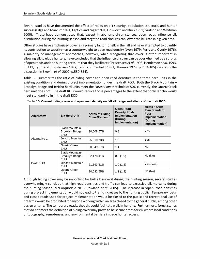
Tenmile – South Helena Project
Helena – Lewis and Clark National Forest
Appendix D: 7
Several studies have documented the effect of roads on elk security, population structure, and hunter success (Edge and Marcum 1991; Leptich and Zager 1991; Unsworth and Kuck 1991; Gratson and Whitman 2000). These have demonstrated that, except in aberrant circumstances, open roads influence elk distribution during the hunting season and targeted road closures can lower the kill rate in a given area.
Other studies have emphasized cover as a primary factor for elk in the fall and have attempted to quantify its contribution to security—as a counterweight to open road density (Lyon 1979; Perry and Overly 1976). A majority of management approaches, however, while recognizing that cover is often important in allowing elk to elude hunters, have concluded that the influence of cover can be overwhelmed by a surplus of open roads and the hunting pressure that they facilitate (Christensen et al. 1993; Henderson et al. 1993, p. 111; Lyon and Christensen 1992; Lyon and Canfield 1991; Thomas 1979, p. 104-105) (see also the discussion in Skovlin et al. 2002, p.550-554).
Table 3.5 summarizes the ratio of hiding cover and open road densities in the three herd units in the existing condition and during project implementation under the draft ROD. Both the Black-Mountain – Brooklyn Bridge and Jericho herd units meet the Forest Plan threshold of 50% currently; the Quartz Creek herd unit does not. The draft ROD would reduce those percentages to the extent that only Jericho would meet standard 4a in in the draft ROD.
Current hiding cover and open road density on fall elk range and effects of the draft ROD.
Alternative Elk Herd Unit Acres of Hiding Cover/Percent
Open Road Density Post-Implementation (During Implementation)
Meets Forest Plan Standard Post-Implementation (During Implementation)
Alternative 1
Black Mountain- Brooklyn Bridge EHU
30,608/57% 0.8 Yes
Jericho Mountain EHU 25,810/73% 1.0 Yes
Quartz Creek EHU 20,849/57% 1.1 No
Draft ROD
Black Mountain- Brooklyn Bridge EHU
22,178/41% 0.8 (1.0) No (No)
Jericho Mountain EHU 21,693/61% 1.0 (1.2) Yes (Yes)
Quartz Creek EHU 20,032/55% 1.1 (1.2) No (No)
Although hiding cover may be important for bull elk survival during the hunting season, several studies overwhelmingly conclude that high road densities and traffic can lead to excessive elk mortality during the hunting season (McCorquodale 2013, Rowland et al. 2005). The increase in ‘open’ road densities during project implementation would not lead to traffic increases by the hunting public. Temporary roads and closed roads used for project implementation would be closed to the public and recreational use of firearms would be prohibited for anyone working within an area closed to the general public, among other design criteria. The temporary roads, though, could facilitate walk in hunting. Furthermore, forest stands that do not meet the definition of hiding cover may prove to be secure areas for elk where local conditions of topography, remoteness, and environmental barriers impede hunter access.

Draft Record of Decision
Helena – Lewis and Clark National Forest
Appendix D: 8
Openings The Tenmile South Helena project includes regeneration harvest1 (hereafter referred to as ‘clearcuts’) units that exceed 100 acres - several of which are a conglomeration of separate units (Table 3.6). These clearcut treatments are primarily in lodgepole pine forests (a majority of which have been impacted by the mountain pine beetle) with a grass/forb understory (Photo 3.1).
Regeneration harvest units or groups of units that exceed 100 acres in size in the draft ROD
Unit ID(s) Draft ROD Acres Unit 11 200 Unit 19 156 Units 14, 15, 16 101 Unit 106a 211 Units 180a, 219 321 Unit 180b 111
Total 1,100
Several variables influence elk use of openings that are created as a result of clearcutting. For example, when lodgepole pine is clearcut, the typical response is a rapid development of lodgepole pine seedlings, unlike other forest types that may proceed through a forb/shrub phase. This can inhibit growth of forage, at least in the seedling stage, which in turn can affect elk use of clearcuts - more so than the size of the clearcut itself. In central Montana, as another example, a determining factor appears to be the presence of open roads in proximity to the openings created by clearcuts (Lyon and Jensen 1980, p. 357).
In this analysis, the effects to elk and their habitat as a result of these openings created through clearcutting are gauged in terms of (1) proximity of open roads to the openings; (2) vegetation response to clearcutting (3) the nature of adjacent forested cover; (4) disturbance associated with logging activities relative to the openings; and (5) effects of the openings to elk security during the hunting season.
Open Roads The draft ROD would result in 12.2 miles of temporary roads being built, all of which would be closed to the public and would be obliterated at project’s end. Project operations would also require use of 15.5 miles of closed roads as haul routes, which would also remain closed to public vehicle use. Several of these roads are within or adjacent to these openings. For most of the openings, all roads within and adjacent to the clearcuts are closed to the public, at least seasonally, which should increase the likelihood of elk use of these openings.
Lyon and Jensen (1980) found that elk use of clearcuts in eastern Montana was determined in part by vehicle traffic in or adjacent to the clearcut and that elimination of traffic can lead to an increase of elk use of clearcuts. They also found that in forest types with a grass-forb understory, as is the case here for a majority of the openings, cover at the edge of the opening could facilitate elk use of the opening itself. Road use associated with project activities in and adjacent to the openings will be minimized through design criteria as follows: (1) logging operations will be prohibited during the first two weeks of the general rifle season in order to maintain big game habitat capability and hunting opportunity and (2) all
1 Regeneration harvest can include different treatment types: seed tree, shelterwood, clearcut, among others. The treatments that will result in the openings that are the subject of this site specific amendment are considered ‘clearcut’ treatments.

Tenmile – South Helena Project
Helena – Lewis and Clark National Forest
Appendix D: 9
temporary roads would have locked gates and be closed to the public at all times (See Design Criteria and Mitigation Measures). It’s possible, therefore, that road use alone may not severely depress elk use of the openings.
Photo 3.1 Example of lodgepole pine stand with grass-forb understory
Vegetation Response in Openings Other factors that influence how elk use clearcuts is vegetation response and height inside the opening and the quality of adjacent cover (Lyons and Jensen 1980, p. 356). Where clearcutting occurs in forest types with a grass-forb understory, cover at the edge of the opening is important. Where shrubs provide cover and forage inside openings created through clearcutting, cover at the edge of the opening may be less important. This latter scenario, although less common, does exist within portions of the openings. However, a majority of the forest types in these proposed clearcuts consist of a grass-forb understory. Forest types also govern timing of use: elk use of a ‘grass-forb’ clearcut will occur earlier and won’t last as long as use of a ‘shrub’ clearcut.
Table 3.7 lists some of the habitat types that characterize the openings and the nature of the understory (i.e. grass-forb or shrub). This provides the context for the value of adjacent cover as described above. Table 3.7 also lists those plant species associated with the respective habitat type (Pfister et al. 1977) that are nutritionally valuable to elk (Knight 1970, Kufeld 1973, Cook 2002). Clearly as Table 3.7 indicates, the openings would yield high quality elk forage post-harvest until such time as lodgepole pine seedlings shade out the understory. Most of the understory response is comprised of low growing grasses and shrubs with the exception of Labrador tea and huckleberry (both up to 4 feet in height [Lessica 2012, pp. 231, 235]) and menziesia (up to 6 feet in height [Lessica 2012, p. 231]). Therefore, cover would be minimal within the openings.
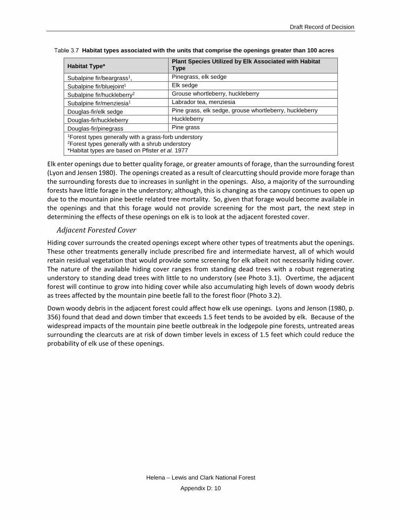
Draft Record of Decision
Helena – Lewis and Clark National Forest
Appendix D: 10
Habitat types associated with the units that comprise the openings greater than 100 acres
Habitat Type* Plant Species Utilized by Elk Associated with Habitat Type
Subalpine fir/beargrass1, Pinegrass, elk sedge Subalpine fir/bluejoint1 Elk sedge Subalpine fir/huckleberry2 Grouse whortleberry, huckleberry Subalpine fir/menziesia1 Labrador tea, menziesia Douglas-fir/elk sedge Pine grass, elk sedge, grouse whortleberry, huckleberry Douglas-fir/huckleberry Huckleberry Douglas-fir/pinegrass Pine grass 1Forest types generally with a grass-forb understory 2Forest types generally with a shrub understory *Habitat types are based on Pfister et al. 1977
Elk enter openings due to better quality forage, or greater amounts of forage, than the surrounding forest (Lyon and Jensen 1980). The openings created as a result of clearcutting should provide more forage than the surrounding forests due to increases in sunlight in the openings. Also, a majority of the surrounding forests have little forage in the understory; although, this is changing as the canopy continues to open up due to the mountain pine beetle related tree mortality. So, given that forage would become available in the openings and that this forage would not provide screening for the most part, the next step in determining the effects of these openings on elk is to look at the adjacent forested cover.
Adjacent Forested Cover Hiding cover surrounds the created openings except where other types of treatments abut the openings. These other treatments generally include prescribed fire and intermediate harvest, all of which would retain residual vegetation that would provide some screening for elk albeit not necessarily hiding cover. The nature of the available hiding cover ranges from standing dead trees with a robust regenerating understory to standing dead trees with little to no understory (see Photo 3.1). Overtime, the adjacent forest will continue to grow into hiding cover while also accumulating high levels of down woody debris as trees affected by the mountain pine beetle fall to the forest floor (Photo 3.2).
Down woody debris in the adjacent forest could affect how elk use openings. Lyons and Jenson (1980, p. 356) found that dead and down timber that exceeds 1.5 feet tends to be avoided by elk. Because of the widespread impacts of the mountain pine beetle outbreak in the lodgepole pine forests, untreated areas surrounding the clearcuts are at risk of down timber levels in excess of 1.5 feet which could reduce the probability of elk use of these openings.

Tenmile – South Helena Project
Helena – Lewis and Clark National Forest
Appendix D: 11
Photo 3.2 Example of down woody debris accumulations associated with mountain pine beetle related tree
mortality
Disturbance Associated with Logging Activities Several studies have documented the displacement effects of logging and road construction/use on elk (USDA 1978, Edge and Marcum 1985, Lyon et al. 1985, Wertz et al. 2004). However, in several of these studies, displacement of elk associated with logging activity tended to be temporary with some elk returning during nights and weekends when logging activity was suspended (Beall 1976, Edge and Marcum 1985, Edge 1982 as cited in Lyon and Christensen 2002, p. 562). Other research found that logging activity did not significantly alter elk home range size (Edge et al. 1986) and that home range fidelity tended to retain elk in an area as long as extensive cover remained within the home range (Hershey and Leege 1982, Edge et al. 1985).
The following design criteria are in place to minimize disturbance associated with logging activities (see Design Criteria and Mitigation Measures).
• Logging operations will be prohibited during the first two weeks of the general rifle season in order to maintain big game habitat capability and hunting opportunity.
• Logging activity (i.e. intermediate and regeneration harvest) will not occur in adjacent drainages to ensure that undisturbed areas are available to elk at any given time during project implementation.
• All work will be completed in the shortest time frame possible.
Draft Record of Decision
Helena – Lewis and Clark National Forest
Appendix D: 12
• All temporary roads would have locked gates and be closed to the public at all times.
• When human activity is restricted, elk will adjust their distribution patterns and return to former sanctuaries (Rickard et al. 1977, Lyon 1983).
Elk Security The openings that are the subject of this site-specific amendment overlap with several security areas (Figure 3.2). Extensive portions of the security area that overlaps with the Lazyman Gulch IRA would remain untreated
Many authors have identified combinations of cover quality, quantity, and habitat fragmentation as parameters that affect elk vulnerability (Lyon et al. 1998). Common to all of these studies is the proximity of cover to open motorized roads where road related variables are implicated for increasing elk vulnerability, more so than a reduction in cover (Marcum 1975, Irwin and Peek 1979, Lyon and Canfield 1991, Weber 1996, Leckenby et al. 1991, Vales 1996 as cited in Lyon et al. 1998).
Conversely, elk vulnerability is decreased in areas with closed roads and in roadless areas (Leptich and Zager 1991, Unsworth and Kuck 1991, Unsworth et al. 1993). Although, closed roads can serve as movement corridors along which hunters are able to access habitats that might otherwise be relatively secure (Lyon et al. 1998). In these situations, the size of the secure area can play an important role in reducing elk vulnerability (Lyon et al. 1998).
It’s likely that the openings created as a result of clearcutting could lead to increase vulnerability to elk during the hunting season. And, the use of temporary roads and roads closed to the public for hauling could further exacerbate impacts to elk. However, design criteria are in place to minimize effects to elk security (see Design Criteria and Mitigation Measures).

Tenmile – South Helena Project
Helena – Lewis and Clark National Forest
Appendix D: 13
Figure 3.2 Overlap of elk security with openings greater than 100 acres, Draft ROD
Effects of the Site-Specific Amendment on Elk Populations The amendment to exempt this project from the standards identified in the Introduction should have minimal effect long-term on overall elk populations. The herd units that comprise the project area are located in HD 335 in the Deerlodge Elk Management Unit (EMU) as defined in the state-wide Montana Elk Plan prepared by the Montana Department of Fish, Wildlife, and Parks [MFWP] (MFWP 2005a, pp. 188-194). HD 335 is a large unit that lies east of the Continental Divide.
The Elk Management Plan provides detailed information on the EMU relative to goals, objectives, and management challenges. Elk population goals for the EMU are to maintain the number of elk counted during post-season aerial trend surveys. Objectives for HD 335 are 600 elk (480-720). Aerial surveys conducted by MFWP personnel within HD 335 indicate that total elk numbers have been exceeding population objectives for several years (see Table 99 in the FEIS).
While many factors contribute to elk numbers, exempting the project from the standards identified in the Introduction should not preclude the ability of MFWP to realize its elk objectives in this HD given that a majority of the hunting district would remain unaffected.

Draft Record of Decision
Helena – Lewis and Clark National Forest
Appendix D: 14
Figure 3.3 Numbers of elk observed in HD 335 from 2005 through 2015; red line indicates trend
Cumulative Effects of Other Forest Plan Amendments Cumulative effects are the impacts on the environment which results from the incremental impact of the action when added to other past, present, and reasonably foreseeable future actions, Federal or non-Federal. The cumulative effects analysis considers spatial and temporal boundaries, how past activities have contributed to the existing condition, and whether the ecosystem can accommodate additional effects.
This section addresses cumulative effects in two ways: those associated with site-specific project amendments and those associated with programmatic amendments. The effects of site-specific project amendments are limited in time and space; programmatic amendments provide direction that would be applied to future management activities (i.e. activities that take place after a programmatic decision).
The scale of analysis – or the cumulative effects affected environment – is the entire Forest.
Site-Specific Amendments2 Existing Amendments
There have been thirty-one Forest Plan amendments to the Helena National Forest Plan (site-specific and programmatic) of which seven of the site-specific amendments have had implications on big game standards (Table 3.8).
2 Note that two previously proposed projects – Dalton Mountain Forest Restoration and Fuels Reduction Project and the Warm Springs Habitat Enhancement Project – included the potential for site-specific amendments related to some Big Game Forest Plan standards. These projects have since been cancelled;

Tenmile – South Helena Project
Helena – Lewis and Clark National Forest
Appendix D: 15
Forest Plan amendments and effects to big game (highlighted rows are those amendments that specifically address big game standards and are discussed in more detail). For more information on each
amendment, see project record)
Amendment # Subject Date of Amendment or Decision Document
Comments
1
Recreation Management Direction for Scapegoat Wilderness
April 1987
This amendment provided for increased protection in the Scapegoat Wilderness while permitting appropriate levels of recreational use. Although not directly related to elk, increasing protection in the wilderness would have benefitted all wildlife.
2 Wild and Scenic Rivers Eligibility Determination
May 1989
This amendment provided additional protection for four streams that are eligible for protection under the Wild and Scenic Rivers Act. Although not directly related to elk, increasing protection for these streams would have benefitted all wildlife.
3
Clarification of Plan Recommendations for Oil and Gas Leasing
August 1990
This amendment clarified Forest Plan language for leasable minerals and required an analysis prior to recommendation of lease applications. Although not directly related to elk, the analysis requirement would have provided opportunities to minimize impacts to elk.
4
Regional Forester ASQ Determination (which was subsequently vacated by the Secretary of Agriculture)
Vacated 1991 Not applicable, vacated.
5 Sheriff Gulch Management Allocation Change
August 1992
This amendment changed the Management Area designation from M-1 to T-1. That amendment analysis indicated that there would be no alteration in the multiple use goals and objections for long-term resource management (see USDA 1986, pp. III/5, 30).
6
Order for Weed-Free Feed Use in Bob Marshall Wilderness Complex
April 1993
This amendment stipulated that wilderness users should use an integrated past management approach to weed control. Although not directly related to elk, this amendment would have benefitted native plants and thereby elk forage.
7
Modification of Elk Security and Visual Quality Objectives for the Miller Mountain Mining Plan of Operations and 2012 Errata
June 1993, March 2012 Errata
See below.
8 Gipsy Creek Management Allocation Change;
August 1993 This amendment changed Management Area allocation from L-1 and T-1 to W-2 which has a
therefore any reference or analysis of those potential site-specific amendments are not included here, since they no longer exist. See http://www.fs.usda.gov/projects/helena/landmanagement/projects
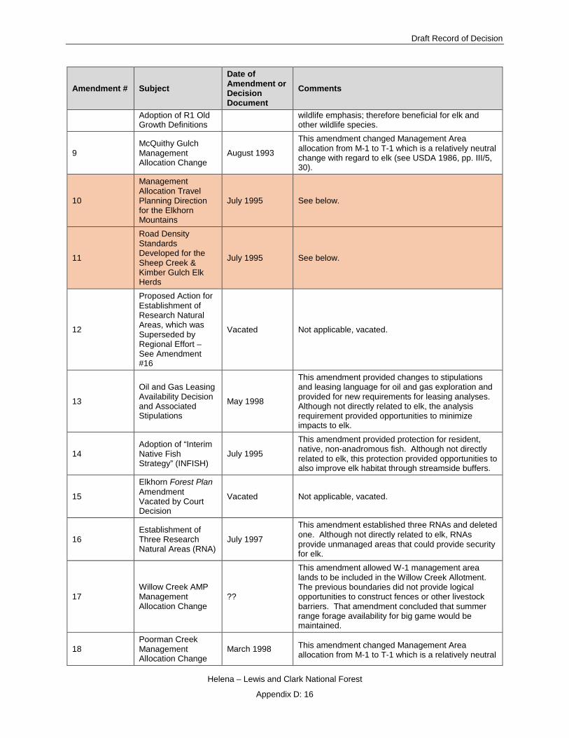
Draft Record of Decision
Helena – Lewis and Clark National Forest
Appendix D: 16
Amendment # Subject Date of Amendment or Decision Document
Comments
Adoption of R1 Old Growth Definitions
wildlife emphasis; therefore beneficial for elk and other wildlife species.
9 McQuithy Gulch Management Allocation Change
August 1993
This amendment changed Management Area allocation from M-1 to T-1 which is a relatively neutral change with regard to elk (see USDA 1986, pp. III/5, 30).
10
Management Allocation Travel Planning Direction for the Elkhorn Mountains
July 1995 See below.
11
Road Density Standards Developed for the Sheep Creek & Kimber Gulch Elk Herds
July 1995 See below.
12
Proposed Action for Establishment of Research Natural Areas, which was Superseded by Regional Effort – See Amendment #16
Vacated Not applicable, vacated.
13
Oil and Gas Leasing Availability Decision and Associated Stipulations
May 1998
This amendment provided changes to stipulations and leasing language for oil and gas exploration and provided for new requirements for leasing analyses. Although not directly related to elk, the analysis requirement provided opportunities to minimize impacts to elk.
14 Adoption of “Interim Native Fish Strategy” (INFISH)
July 1995
This amendment provided protection for resident, native, non-anadromous fish. Although not directly related to elk, this protection provided opportunities to also improve elk habitat through streamside buffers.
15
Elkhorn Forest Plan Amendment Vacated by Court Decision
Vacated Not applicable, vacated.
16 Establishment of Three Research Natural Areas (RNA)
July 1997
This amendment established three RNAs and deleted one. Although not directly related to elk, RNAs provide unmanaged areas that could provide security for elk.
17 Willow Creek AMP Management Allocation Change
??
This amendment allowed W-1 management area lands to be included in the Willow Creek Allotment. The previous boundaries did not provide logical opportunities to construct fences or other livestock barriers. That amendment concluded that summer range forage availability for big game would be maintained.
18 Poorman Creek Management Allocation Change
March 1998 This amendment changed Management Area allocation from M-1 to T-1 which is a relatively neutral

Tenmile – South Helena Project
Helena – Lewis and Clark National Forest
Appendix D: 17
Amendment # Subject Date of Amendment or Decision Document
Comments
change with regard to elk (see USDA 1986, pp. III/5, 30).
19
Rocky Mountain Front Mineral Withdrawal (North of Highway 200)
October 2000
This amendment closed portions of the Lincoln Ranger District to the staking of mining claims for locatable minerals. This would have been beneficial to elk and other wildlife.
20
Off-Highway Vehicle Record of Decision & Plan Amendment (Montana, North Dakota & Portions of South Dakota)
January 2001
This amendment eliminated wheeled motorized cross-country travel with a few specific exceptions. This resulted in reducing impacts to natural resources including big game.
21 Hiding Cover/Road Density Standard - Jimtown Project
May 2001 See below.
22
Allows Winter Logging with Implementation of North Elkhorns Project. This decision was reversed and remanded in a 9th Circuit court decision dated August 11, 2005
November 2002 Not applicable, reversed and remanded.
23
Allows for Temporary Increase in road Density with Implementation of the Cave Gulch Salvage Sale
November 2002 See below.
24
Forest-wide Noxious Weed Control Can Include Mechanical, Biological, Cultural, or Chemical Including Aerial, Ground, Backpack, Handheld Sprayer, or Granule Application (Supported in Two RODs)
May 2006 and November 2007
This amendment provided for integrated pest management in weed treatments. This in turn would benefit elk and other wildlife species by promoting native plant propagation.
25
Adoption of the “Northern Rockies Lynx Management Direction”
March 2007
This amendment provided several vegetation management standards that also would retain elk habitat in certain locations (e.g. no treatments in early stand initiation, stand initiation, and multistory hare habitat outside of the wildland urban interface with few specific exceptions).
26 Exempts “Forest-wide Hazard Tree Removal & Fuels Reduction Project”
August 2010 March 2012 Erratum
See below.

Draft Record of Decision
Helena – Lewis and Clark National Forest
Appendix D: 18
Amendment # Subject Date of Amendment or Decision Document
Comments
from Big-Game Forest Plan Standard #3 – Hiding Cover for Summer Range & Thermal Cover for Winter Range and #4 - Hiding Cover to Road Density During the General Big-Game Hunting Season and 2012 Erratum
27
Management Area Designation for Newly Acquired National Forest Lands – Lincoln Ranger District, Helena National Forest
September 2011
This amendment assigned Management Area designation to newly acquired lands: T-1, W-1, and W-2. W-1 and W-2 focus primarily on wildlife goals.
28
Site-Specific amendment exempts the Cabin Gulch Vegetation Treatment Project from FP Standards 3 & 4a hiding cover on summer range and open road density/hiding cover ratio during hunting season
March 2012 See below.
29
Site-Specific amendment exempts the Red Mountain Flume/Chessman Reservoir Project from FP Standards 3 & 4a hiding cover on summer range and open road density/hiding cover ratio during hunting season.
April 2014 See below.
30
Divide Travel Plan FEIS Programmatic Amendment for wildlife standard 4a [NOTE: this Amendment was withdrawn on December 2, 2016]
March 1, 2016 Not applicable, withdrawn.

Tenmile – South Helena Project
Helena – Lewis and Clark National Forest
Appendix D: 19
Amendment # Subject Date of Amendment or Decision Document
Comments
31 Stonewall Vegetation FEIS site specific amendment
October 25, 2016 See below.
32 Telegraph Vegetation FEIS Site specific amendment
January 9, 2017 See below.
33
(PENDING DECISION) Tenmile South Helena FEIS Site specific amendment
This is the subject of this analysis
Amendment #7 Miller Mountain Hard Rock Mineral Exploration Project 1993 (Standards 3 and 4a)
This site-specific amendment exempts the Miller Mountain hard rock mineral exploration project (1993) from Forest Plan Big Game standards 3 and 4a in the Confederate Gulch elk herd unit. Approximately 590 acres were exempted from these standards associated with the construction of new roads and excavation of drill sites. Most likely, these roads do not provide hiding cover; however, they remain closed to all use. There were additional closures in Jimmy’s Gulch, an area adjacent to this 1993 project, in order to minimize effects of this project. The corporation that originally conducted mineral explorations in the area is no longer active. As depicted in Figure 3.4, most of the area that was exempted from standards 3 and 4a is currently hiding cover.

Draft Record of Decision
Helena – Lewis and Clark National Forest
Appendix D: 20
Figure 3.4 Status of hiding cover in the Miller Mountain Mine site
This project is located in MFWP HD 392. Elk trends have been increasing in HD 392 since 2005; percent of bulls per total observed has also been increasing since 2007 (Figure 3.5). The decision to exempt this project from compliance with Standards 3 and 4a and the subsequent removal of 590 acres of cover does not appear to have negatively impacted elk numbers in this HD. Management challenges identified for this HD include public access and noxious weeds and not necessarily loss of cover (MFWP 2005a, p. 249).

Tenmile – South Helena Project
Helena – Lewis and Clark National Forest
Appendix D: 21
Figure 3.5 Observed elk in HD 392, 2005-2015; the red line indicates trend. Percent bulls per total elk observed in HD
392, 2007-2015; the black line indicates trend. (Note that HD boundaries shifted for 2016 so data aren’t comparable and therefore aren’t included.)
Amendment #21 Jimtown Project 2001 (Standard 4a)
This site-specific amendment exempted the Jimtown Project (2001) from Big Game Standard 4a. The wildlife analysis concluded that the existing condition was not consistent with this standard. Effects associated with this project included the removal of approximately 3% of the hiding cover in the Hedges Mountain herd unit. This area currently does not provide hiding cover3.
This project is also located in MFWP HD 392. The decision to exempt this project from Standard 4a and the subsequent removal of hiding cover does not appear to have negatively impacted elk numbers in this HD. This may be due to the fact that management challenges in this HD aren’t necessarily related to loss of cover but rather to limited public access and noxious weeds.
Amendment #23 Cave Gulch Post-Fire Salvage Project 2002 (Standard 4a)
This site-specific amendment exempted the Cave Gulch Post-Fire Salvage Project from Big Game Standard 4a in the Hedges Mountain and Hellgate herd units. The wildlife analysis for this project indicated that the existing condition was not consistent with Standard 4a. This was due in part to the loss of existing hiding cover from the Cave Gulch wildfire. Approximately 0.85 miles of temporary roads were built to implement the salvage sale and were subsequently decommissioned. This area currently does not provide hiding cover [see Footnote 4].
This project is also located in HD 392. As with the Miller Mountain Mine Exploration Project and the Jimtown Project, the impacts to elk as a result of the removal of hiding cover below Forest Plan thresholds appear minimal.
Amendment #26 Fuels Reduction and Hazardous Tree Removal Project 2010 (Standards 3 and 4a)
3 The methodology for modeling hiding cover is described in USDA (2009) and includes a consideration of stand age in areas that have experienced previous timber harvest and/or prescribed fire activity. Any stand that is less than 15 years old that has been treated with timber harvest or prescribed fire is not considered hiding cover. Conversely, stands that are greater than 15 years old and meet the requisite canopy cover of at least 40% are considered hiding cover.
0
500
1000
1500
2000
Num
ber o
f elk
obs
erve
d
Year
Observed Elk in Hunting District 392, 2005 - 2015
02468
1012
2007 2008 2009 2010 2011 2012 2015
Perc
ent b
ull e
lk p
er to
tal
obse
rved
Year
Percent Bulls/Total Observed HD 392, 2007 - 2015
Objective is > 7% bulls/total elk observed

Draft Record of Decision
Helena – Lewis and Clark National Forest
Appendix D: 22
This site-specific amendment exempted the Fuels Reduction and Hazardous Tree Removal Project from Forest Plan Big Game Standards 3 and 4a. The wildlife analysis for this project concluded that the existing condition for Forest Plan Standard 3 is not met within 17 of the 27 Elk Herd Units (EHU) for hiding cover and none of the EHUs meet Forest Plan Standard 3 for thermal cover. The existing condition for Forest Plan standard 4a is not met within 22 of the 27 EHUs. Implementation of the Decision did not result in any additional EHUs being below these Forest Plan Standards. The Decision resulted in minimal reductions of hiding cover within those EHUs where existing conditions were already below Forest Plan Standard 3; a 1% reduction in two EHUs, and less than a 1% reduction in all other EHUs. Twenty two EHUs did not currently meet Forest Plan Standard 4a. However, open road densities were not changed in this decision. These areas currently do not provide hiding cover or thermal cover4.
Figure 3.6 Observed elk in all HDs that overlap with the Forest 2005-2016. The black line indicates trend.
This project occurs within several HDs given that its scope is Forestwide. The trend in elk numbers continues to increase (Figure 3.6) despite the fact that this decision resulted in several herd units dropping further below thresholds specified in Forest Plan standards. Management challenges in these HDs include limited public access, development, and loss of cover and security.
Amendment #28 Cabin Gulch Vegetation Treatment Project 2012 (Standards 3 and 4a)
This amendment exempts the Cabin Gulch Vegetation Treatment Project from the Forest Plan standards for hiding cover on summer range and the open road density/hiding cover ratio during the hunting season (Big Game Standards 3 and 4a respectively, USDA 1986, p. II/17). Overall, this project would affect elk habitat to a limited extent by removing cover within the affected EHUs. Regardless of project implementation, this loss would occur naturally over the next few years due to extensive tree mortality and natural tree fall from the insect infestation. In addition, the selected treatments may be beneficial for elk over the current situation, as they could quicken the regeneration rate of new forests. The analysis concluded that through the life of the project and with the subsequent recovery of hiding cover over time, elk habitat would remain abundant and well distributed across the Forest. Approximately 2,313 acres of
4 Thermal cover must be at least 15 acres in size pre and post project implementation with a canopy cover of at least 60% (USDA 2009a).
02000400060008000
10000120001400016000
2005 2006 2007 2008 2009 2010 2011 2012 2013 2014 2015 2016
Num
ber o
f elk
obs
erve
d
Year
Observed Elk for Hunting Districts that Overlap with the Helena National Forest, 2005 - 2016

Tenmile – South Helena Project
Helena – Lewis and Clark National Forest
Appendix D: 23
hiding cover was analyzed for removal in the Cabin Creek Herd Unit which is a reduction of 6% from the existing condition. Approximately 190 acres of hiding cover was analyzed for removal in the North Fork Herd Unit which is less than a 1% reduction from the existing condition.
The Cabin Gulch Project Decision does not result in any increases in open road density during the hunting season. However, due to the removal of hiding cover within the Cabin Creek and North Fork EHUs and because both EHUs are below Forest Plan Standard 4a in the existing condition, the Project Decision does not meet Standard 4a thresholds. Mitigation measures have been included from the Montana Cooperative Elk-Logging Study that would minimize project-related disturbances.
Logging activities in the project area are nearing completion; it will be several years before hiding cover is available in treated units.
This project is located in HD 391. It is currently in the implementation phase. Elk numbers and the number of bull elk observed have been increasing since 2005 and 2007 respectively (Figure 3.7). The management challenges in this HD include limited public access and noxious weeds; not necessarily reductions in cover (MFWP 2005, pp. 255-257).
Figure 3.7 Observed elk in HD 391 2005-2016; the red line indicates trend. Number of bull elk observed in HD 391 2007-
2016; the black line indicates trend.
Amendment #29 Red Mountain Flume/Chessman Reservoir Project 2014 (Standards 3 and 4a)
This amendment exempts the Red Mountain Flume/Chessman Reservoir Project (2014) from Forest Plan standard 3 for hiding cover on summer range (USDA 1986, p. II/17) for the Quartz Creek herd unit and from Forest Plan standard 4a (USDA 1986, p. II/17-18) for both the Black Mountain-Brooklyn Bridge and Quartz Creek herd units. The decision to exempt this project from Standard 3 for the Quartz Creek EHU and 4a for both Black Mountain-Brooklyn Bridge and Quart Creek EHU may affect elk to some extent due to the removal of hiding cover from these EHUs. The project would treat approximately 490 acres, removing all dead trees and woody debris from an approximate 450 foot wide corridor, along the Red Mountain Flume and removing mostly dead trees and woody debris from a broad swath around Chessman Reservoir and its meadows. All hiding cover within the units, currently 434 acres (includes 4 acres from Jericho Mountain EHU), would be lost. Approximately 0.5 mile of low-grade road would be constructed east of Chessman Reservoir: It would not be open to public vehicle use and it would be obliterated after the project. Regardless of project implementation, this loss would occur naturally over the next few years
0
500
1000
1500
2000
2005
2006
2007
2008
2009
2010
2011
2012
2013
2014
2015
2016
Num
ber o
f elk
obs
erve
d
Year
Observed Elk in Hunting District 391, 2005 - 2016
050
100150200
2007
2008
2009
2010
2011
2012
2013
2014
2015
2016
Num
ber o
f bul
l elk
obs
erve
d
Year
Number of Bull Elk Observed HD 391, 2007 - 2016
Objective is at least 40 bulls

Draft Record of Decision
Helena – Lewis and Clark National Forest
Appendix D: 24
due to extensive tree mortality and natural tree fall associated with the mountain pine beetle infestation (Mitchell and Preisler 1998, Lewis and Hartley 2005, among others).
The Red Mountain Flume/Chessman Reservoir Project does not result in any increases in open road density during the hunting season. However, due to the removal of hiding cover within the Black Mountain – Brooklyn Bridge and Quartz Creek EHUs and because both EHUs are below Forest Plan Standard 4a in the existing condition, the Project Decision does not meet Standard 4a thresholds. Mitigation measures have been included from the Montana Cooperative Elk-Logging Study that would minimize project-related disturbances.
Logging activities in the project area have recently been completed; it will be several years before hiding cover is available in treated units [see Footnote 4].
This project occurs within HD 335. It is currently being implemented. Elk numbers have been increasing since 2005 while the bull/cow ratio has remained relatively static (Figure 3.8). Management challenges in this HD include housing development and mining activity, extensive motorized use, and wolf establishment (MFWP 2005, pp. 190-193).
Figure 3.8 Observed elk in HD 335 2005-2016; the red line indicates trend. Bull/cow ratios in HD 335 2005-2014; the
black line indicates trend.
Amendment # 31 Stonewall Vegetation Project 2016 (Standards 3, 4a, MA Standards T-2 and T-3)
The Stonewall Vegetation Project area is approximately 24,010 acres in size and is located on the Lincoln Ranger District, approximately 4 miles north and west of the town of Lincoln, Montana. The purpose of the project is to improve vegetative composition and structure across the landscape that is diverse, resilient, and sustainable to wildfire and insects. In order to meet the purpose and need, a site-specific amendment exempting the project from the following standards has been required:
• Forest-wide Standard 3 for hiding cover on summer range (USDA 1986, p. II/17) for the Beaver Creek and Keep Cool Creek elk herd units and thermal cover on winter range in the Beaver Creek herd unit
• Forest-wide Standard 4a for open road densities during the big game hunting season (USDA 1986, p. II/17-18) for the Beaver Creek and Keep Cool Creek elk herd units
• Management Area T-2 standard for thermal cover on winter range (USDA 1986, p. III/35) within the management area
0
200
400
600
800
1000
1200
1400
2005
2006
2007
2008
2009
2010
2011
2012
2013
2014
2015
2016
Num
ber o
f elk
obs
erve
d
Year
Observed Elk in Hunting District 335, 2005 -2016
0
5
10
15
20
2005
2006
2007
2008
2009
2010
2011
2012
2013
2014
Num
ber o
f bul
l elk
per
100
cow
s
Year
Bull/Cow Ratios HD 335, 2005 - 2014Objective is > 10 bulls/100 cows

Tenmile – South Helena Project
Helena – Lewis and Clark National Forest
Appendix D: 25
• Management Area T-3 standard for hiding cover (USDA 1986, p. III/39) within the management area
• Management Area T-2 and T-3 standards for hiding cover in timber harvest openings (USDA 1986, III/35 and III/39).
The Decision for this project was signed on August 25, 2016. Logging activities have not yet commenced.
This project occurs within HD 281. Elk numbers and bull/cow ratios have been generally increasing since 2005 although bull/cow ratios have fluctuated (Figure 3.9). Management challenges in this HD include access, disposition of Plum Creek Timber lands, predation, and habitat conditions related to forage availability (MFWP 2005, pp. 113-115).
Figure 3.9 Observed elk in HD 281 2005-2016; the red line indicates trend. Bull/cow ratios in HD 281 2005-2014; the
black line indicates trend.
Amendment # 32 Telegraph Vegetation Project 2017
The Telegraph Vegetation Project area (project area) including all ownership is approximately 23,669 acres (22,006 Forest Service System lands) in size and is located roughly 15 miles southwest of Helena, and 5 miles south from Elliston, MT, in the Little Blackfoot River drainage west of the Continental Divide. This project is designed to move this landscape towards desired forest conditions that are more resilient to future disturbance events. In order to achieve the desired conditions and purpose and need for the project5, a site-specific amendment has been included in the Decision that exempts the project from the openings provision of Standard 6 (USDA 1986, p. II/19, Appendix C p. C/7).
This project occurs within HD 215. Elk numbers have been increasing since 2005 while the bull/cow ratio has somewhat declined (Figure 3.10). Management challenges in this HD include housing development and mining activity, extensive motorized use, and wolf establishment (MFWP 2005a, pp. 190-193).
5 See the following link for information on the purpose and need for the Telegraph project - http://a123.g.akamai.net/7/123/11558/abc123/forestservic.download.akamai.com/11558/www/nepa/62989_FSPLT3_3913298.pdf
0200400600800
1000
2005
2006
2007
2008
2009
2010
2011
2012
2013
2014
2015
2016
Num
ber o
f elk
obs
erve
d
Year
Observed Elk in Hunting District 281, 2005 - 2016
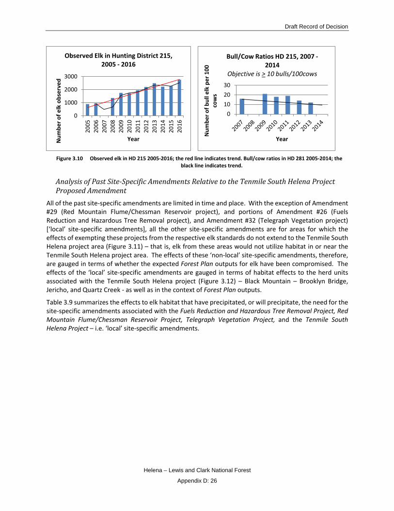
Draft Record of Decision
Helena – Lewis and Clark National Forest
Appendix D: 26
Figure 3.10 Observed elk in HD 215 2005-2016; the red line indicates trend. Bull/cow ratios in HD 281 2005-2014; the
black line indicates trend.
Analysis of Past Site-Specific Amendments Relative to the Tenmile South Helena Project Proposed Amendment
All of the past site-specific amendments are limited in time and place. With the exception of Amendment #29 (Red Mountain Flume/Chessman Reservoir project), and portions of Amendment #26 (Fuels Reduction and Hazardous Tree Removal project), and Amendment #32 (Telegraph Vegetation project) [‘local’ site-specific amendments], all the other site-specific amendments are for areas for which the effects of exempting these projects from the respective elk standards do not extend to the Tenmile South Helena project area (Figure 3.11) – that is, elk from these areas would not utilize habitat in or near the Tenmile South Helena project area. The effects of these ‘non-local’ site-specific amendments, therefore, are gauged in terms of whether the expected Forest Plan outputs for elk have been compromised. The effects of the ‘local’ site-specific amendments are gauged in terms of habitat effects to the herd units associated with the Tenmile South Helena project (Figure 3.12) – Black Mountain – Brooklyn Bridge, Jericho, and Quartz Creek - as well as in the context of Forest Plan outputs.
Table 3.9 summarizes the effects to elk habitat that have precipitated, or will precipitate, the need for the site-specific amendments associated with the Fuels Reduction and Hazardous Tree Removal Project, Red Mountain Flume/Chessman Reservoir Project, Telegraph Vegetation Project, and the Tenmile South Helena Project – i.e. ‘local’ site-specific amendments.
0
1000
2000
3000
2005
2006
2007
2008
2009
2010
2011
2012
2013
2014
2015
2016
Num
ber o
f elk
obs
erve
d
Year
Observed Elk in Hunting District 215, 2005 - 2016
0102030
Num
ber o
f bul
l elk
per
100
co
ws
Year
Bull/Cow Ratios HD 215, 2007 -2014
Objective is > 10 bulls/100cows
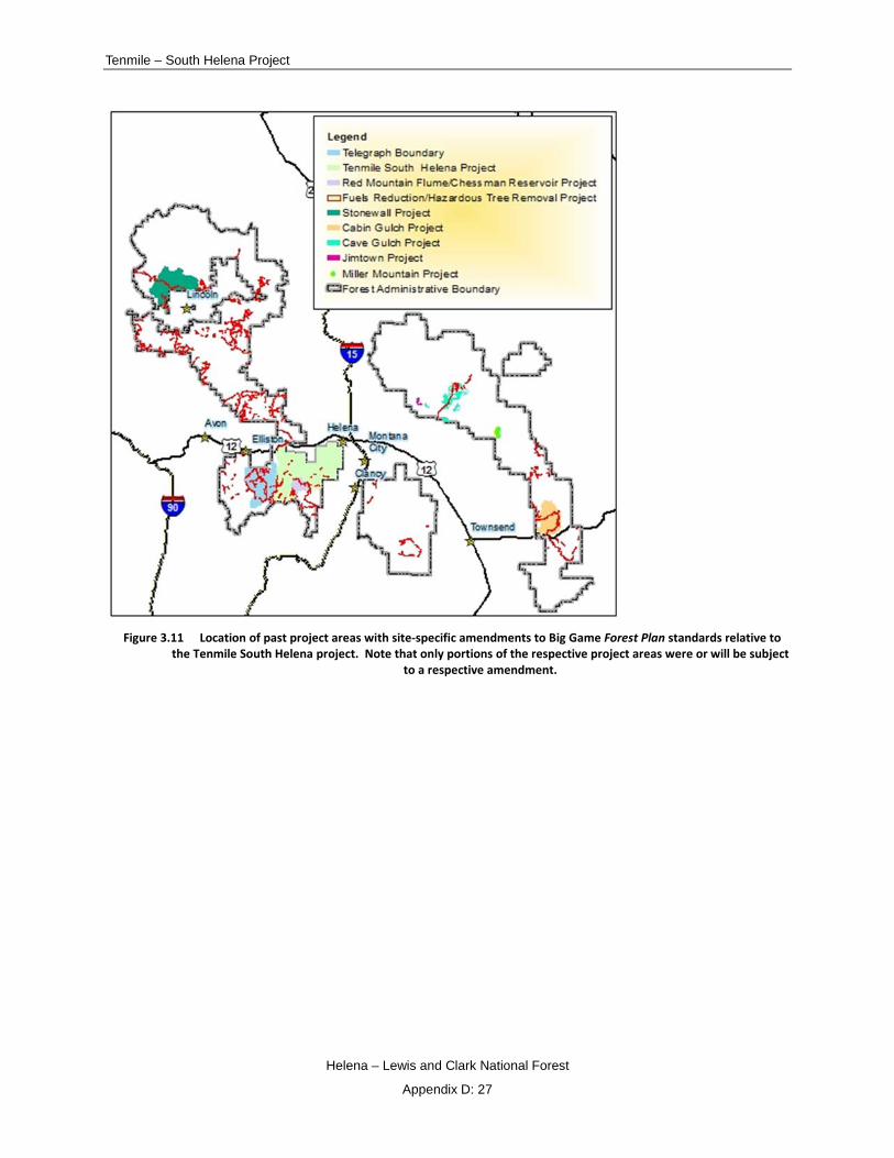
Tenmile – South Helena Project
Helena – Lewis and Clark National Forest
Appendix D: 27
Figure 3.11 Location of past project areas with site-specific amendments to Big Game Forest Plan standards relative to
the Tenmile South Helena project. Note that only portions of the respective project areas were or will be subject to a respective amendment.

Draft Record of Decision
Helena – Lewis and Clark National Forest
Appendix D: 28
Figure 3.12 Herd units associated with ‘local’ site-specific amendments

Tenmile – South Helena Project
Helena – Lewis and Clark National Forest
Appendix D: 29
Summary of Forest Plan Big Game standards that are the subject of the ‘local’ site-specific amendments. Cells with no data indicate that a site-specific amendment was not needed; these blank cells
are retained for comparison purposes. See also the Rocky Mountain Elk, Cumulative Effects Conclusions for the Action Alternatives section in the FEIS.
Herd Unit Project Big Game Standard 3 Hiding Cover
Big Game Standard 3 Thermal Cover
Big Game Standard 4a**
Big Game Standard 6
Quartz
Fuels Reduction and Hazardous Tree Removal Project*
274 acres treated; remaining hiding cover is 44%
17 acres treated; remaining thermal cover is 7%
274 acres treated; remaining hiding cover is 44%
Red Mountain Flume/Chessman Reservoir Project*
343 acres treated; remaining hiding cover is 44%
343 acres treated; remaining hiding cover is 44%
Tenmile South Helena Project***
15 acres proposed; remaining thermal cover would be 13%
817 acres proposed; remaining hiding cover would be 55%
There is one grouping of units that exceeds 100 acres (Figure 3.13) Logging activities proposed on winter range in winter
Black Mountain – Brooklyn Bridge
Fuels Reduction and Hazardous Tree Removal Project*
4 acres treated; remaining thermal cover is 13%
122 acres treated; remaining hiding cover is 53%
Red Mountain Flume/Chessman Reservoir Project*
87 acres treated; remaining hiding cover is 52%
Tenmile South Helena Project***
8,430 acres proposed; remaining hiding cover would be 41%
2,267 acres proposed; remaining thermal cover would be 12%
8,430 acres proposed; remaining hiding cover would be 41%
There are two groupings of units that exceed 100 acres (Figure 3.13); Logging activities proposed on winter range in winter
Jericho
Fuels Reduction and Hazardous Tree Removal Project*
11 acres treated; remaining thermal cover is 13%
Red Mountain Flume/Chessman Reservoir Project*
Tenmile South Helena Project***
372 acres proposed; remaining thermal cover would be 7%
4,117 acres proposed; remaining hiding cover would be 61%
There are three groupings of units that exceed 100 acres (Figure 3.2) Logging activities proposed on winter range in winter
Telegraph Project
There are no openings greater than 100 acres associated with the Telegraph project in the Jericho herd unit; cumulatively, the Tenmile South Helena project

Draft Record of Decision
Helena – Lewis and Clark National Forest
Appendix D: 30
Herd Unit Project Big Game Standard 3 Hiding Cover
Big Game Standard 3 Thermal Cover
Big Game Standard 4a**
Big Game Standard 6
results in openings greater than 100 acres in Jericho in the Telegraph project area
Little Blackfoot – Spotted Dog
Fuels Reduction and Hazardous Tree Removal Project*
231 acres treated in the former Spotted Dog herd unit; remaining hiding cover is 41%
Red Mountain Flume/Chessman Reservoir Project
Tenmile South Helena Project****
Telegraph Project
Two openings greater than 100 acres; one at 304 acres and one at 330 acres
*Note that elk hiding and thermal cover data have been updated since several of these project analyses were completed due to the release of VMap Version 14 which encompasses more of each herd unit than the previous version. Also, open road densities have changed as a result of the Divide Travel Plan decision since these two projects were completed. Note also that the Little Blackfoot and Spotted Dog herd units were separate at the time of the Fuels Reduction and Hazardous Tree Removal Project decision. Data reported are from the respective NEPA analysis for each project. **The data presented here are the same data used to determine consistency with standard 3; however, standard 4a also has a road density component that could result in a herd unit dropping below Forest Plan thresholds where it would otherwise meet standard 3. ***The Tenmile South Helena Project also proposes a site-specific amendment to exempt the project from the thermal cover provision in Management Areas H-1 and H-2. Remaining thermal cover on winter range in those management areas would be: 16% in H-1 and 4% in H-2. This project would also require an exemption to standard 4c which restricts activities in winter range during the winter. ****The Tenmile South Helena project does not overlap with the Little Blackfoot-Spotted Dog herd unit.
As can be seen in Table 3.9, effects to elk habitat associated with past site-specific amendments are minimal relative to those proposed in the Tenmile South Helena project. Of the past site-specific amendments, the Quartz herd unit bore the magnitude of effects due to the Fuels Reduction and Hazardous Tree Removal Project and the Red Mountain Flume/Chessman Reservoir Project. The effects associated with the Fuels Reduction and Hazardous Tree Removal Project were concentrated along roadsides; as such, habitat was readily available beyond treated areas to which elk could displace. The Red Mountain Flume/Chessman Reservoir Project, while also localized, had a larger footprint which meant elk had further to go to access habitat - primarily to either the Black Mountain – Brooklyn Bridge herd unit or the Jericho herd unit.
Current conditions in the Black Mountain Brooklyn Bridge, Jericho, and Quartz herd units ameliorate the effects associated with the past site-specific amendments and the site-specific amendment proposed in the Tenmile South Helena project. Currently, all three herd units meet Forest Plan standard 3 for hiding cover (57%, 73%, and 73% respectively). Security during the hunting season is adequate in Jericho and Black Mountain as measured by compliance with standard 4a (hiding cover/open road density) and security and/or intermittent refuge areas are well distributed in all three herd units such that elk vulnerability is mitigated during the hunting season. Very little activity has occurred in the Spotted Dog –
Tenmile – South Helena Project
Helena – Lewis and Clark National Forest
Appendix D: 31
Little Blackfoot herd unit that has precipitated a need for a site-specific amendment – only the Fuels Reduction and Hazardous Tree Removal.
The Tenmile South Helena Project would result in several standards needing an exemption. Cumulatively, the greatest impacts would occur along the continental divide at the Tenmile South Helena and Telegraph project boundaries. During implementation of the Telegraph project, elk may take advantage of untreated areas to the east of the continental divide until such time as these areas are treated under the Tenmile South Helena project. At that time, elk may either be displaced to the north towards private land or to the south where untreated areas would be available. If displaced to private land, this could impede the ability of MFWP to meet elk objectives.
Programmatic Amendments Existing Amendments
Amendment #10 Elkhorn Mountains Travel Management Plan
This amendment provided for several language changes in management area direction within the Elkhorns as part of the Elkhorn Mountains Travel Management Plan. These changes in all cases updated management area direction to specify that motorized activities are limited to designated routes and/or areas. Specifically,
• On page III/81 (USDA 1986), the paragraph under the Recreation standards for Management Area Elkhorn – 1 was replaced with the following: “Motorized dispersed recreation activities are limited to designated routes and/or areas”.
• On page III/83 (USDA 1986), the first paragraph under the Facilities standards for Management Area Elkhorn – 1 was replaced with the following: “The public lands in the Elkhorn Mountains are administered under an area closure. Motorized vehicle use is limited to designated routes and/or designated areas. Timing limitations identifying the permitted season of use or daily time of use may also be specified for individual designated routes or areas”.
• On page III/86 (USDA 1986), the following statement was deleted from the first paragraph under the Facilities standards section for Management Area Elkhorn - 2: “See Elkhorn Travel Management Direction, Figure III-1”.
• On page III/87 (USDA 1986), the paragraph under the Recreation standards for Management Area Elkhorn – 3 was replaced with the following: “Motorized dispersed recreation activities are limited to designated routes and/or areas”.
• On page III/89 (USDA 1986), the first paragraph under the Facilities standards for Management Area Elkhorn – 3 was replaced with the following: “The public lands in the Elkhorn Mountains are administered under an area closure. Motorized vehicle use is limited to designated routes and/or designated areas. Timing limitations identifying the permitted season of use or daily time of use may also be specified for individual designated routes or areas”.
• On page III/92 (USDA 1986), under the Facilities standards for Management Area Elkhorn – 4 the following statement was added: “The public lands in the Elkhorn Mountains are administered under an area closure. Motorized vehicle use is limited to designated routes and/or designated areas. Timing limitations identifying the permitted season of use or daily time of use may also be specified for individual designated routes or areas”.

Draft Record of Decision
Helena – Lewis and Clark National Forest
Appendix D: 32
• On page III/93 (USDA 1986), the entire page – Figure III-1 - was deleted. The Forest Visitor Map will be used to display the travel management program for the Elkhorn Mountains.
The Elkhorn Mountains Travel Management Plan in general, and the amended language specifically, improved habitat for elk (and other wildlife species) by reducing open road densities across all seasons and by focusing motorized use along designated routes.
Amendment #11 Elkhorn Mountains Travel Management Plan
This amendment changed open road density standards for the Sheep Creek and Kimber Gulch elk herd units based on information developed through travel planning. The specific language is as follows and has been added to the end of standard 4a (USDA 1986, p. II/18):
“Based on more detailed site-specific analysis, exceptions to the open road density limits listed above [reference to the table in the Forest Plan at USDA 1986, p. II/18] have been identified. Within the Elkhorn Mountain Sheep Creek elk herd unit, roads will be managed during the general big game hunting season to maintain an open road density of no more than 0.23 mi/mi2. Within the Elkhorn Mountain Kimber Gulch elk herd units, roads will be managed during the general big game hunting season to maintain an open road density of no more than 0.22 mi/mi2.”
This amendment programmatically changed the standard 4a thresholds under which the Kimber Gulch and Sheep Creek herd units would be governed. This change continues to benefit elk – and other wildlife- by imposing an upper limit on open road densities during the general big game hunting season.
Amendment #25 Northern Rockies Lynx Management Direction (NRLMD)
The NRLMD was amended to National Forest Plans in Montana and parts of Idaho, Wyoming, and Utah in 2007. The NRLMD incorporates management direction that conserves and promotes recovery of Canada lynx, by reducing or eliminating adverse effects from land management activities on National Forest System lands, while preserving the overall multiple use direction in existing plans. Some of the NRLMD standards may benefit elk and other big game by retaining winter snowshoe hare habitat which may provide cover, reducing disturbance associated with mineral development, and reducing habitat fragmentation (USDA 2007a, p. 210)
Proposed Amendments Proposed Forest Plan Amendment to incorporate relevant direction from the Northern Continental Divide Ecosystem Grizzly Bear Conservation Strategy
The purpose of the amendment is to incorporate relevant habitat-related direction from the Northern Continental Divide Ecosystem (NCDE) Grizzly Bear Conservation Strategy (GBCS) into the Forest Plans for the Helena, Kootenai, Lewis and Clark and Lolo National Forests (also referred to as “amendment forests”) to have an integrated set of plan direction (referred to as plan components from this point forward) consistent across the national forests that are a part of the NCDE.
Under the Endangered Species Act (ESA) of 1973, federal agencies are directed to use their authorities to seek to conserve endangered and threatened species. The amendment forests’ associated plans (Helena National Forest, approved by the Regional Forester in 1986), have management direction related to grizzly bear habitat, to support recovery of the threatened grizzly bear.
Since the development of this planning direction, the grizzly bear population in the NCDE has met and exceeded recovery goals. In particular, habitat conditions and management on the national forests have contributed importantly to the increased population size and improved status of the grizzly bear across

Tenmile – South Helena Project
Helena – Lewis and Clark National Forest
Appendix D: 33
the NCDE. To support a healthy, recovered grizzly population the Forest Services’ continued, effective management of the NCDE grizzly bear’s habitat is necessary.
In 2013, the U.S. Fish and Wildlife Service (USFWS) announced the availability of a draft GBCS for the NCDE population for public review and input. When finalized, the GBCS would become the post-delisting management plan for the NCDE grizzly bears and their habitat. By incorporating the relevant habitat-related direction from the GBCS into Forest Plans, the proposed amendments would demonstrate to the USFWS that adequate regulatory mechanisms exist on national forests within the NCDE to support delisting this grizzly population. Thus, the amendment forests need to amend their Forest Plans and incorporate the relevant desired conditions, standards, guidelines, and monitoring items related to habitat management on NFS lands in the NCDE and contained in the GBCS to show that the amendment forests have adequate regulatory mechanisms in place to support a recovered grizzly bear population.
The proposed action (GBCS) contains numerous standards and guidelines governing resource management on the Forest. These can be found at the following link, pages 5 – 16:
(http://www.fs.usda.gov/Internet/FSE_DOCUMENTS/stelprd3831237.pdf
Some of these standards and guidelines have little to no applicability to elk – i.e. food storage orders, special use permits for apiaries. The remaining standards and guidelines, if adopted, should overall benefit elk and their habitat as follows. Access and recreation standards and guidelines limit motorized access and developed recreation sites within the NCDE. There are provisions however for short term temporary increases in use associated with projects, existing mineral rights, or access to firewood. Terrestrial ecosystem guidelines provide timing considerations in the NCDE (i.e. prohibiting logging activities during the spring in key grizzly bear habitat) that would provide additional protection for elk primarily during the calving period. Grazing standards and guidelines limits grazing in the NCDE to existing allotments (except for purposes of weed control) which means that forage availability for elk should remain constant, all things being equal. Energy and mineral standards and guidelines include requirements to mitigate impacts associated with human disturbance and impacts to vegetation.
This amendment, although not specific to elk, should guide design criteria for future projects that could benefit elk and their habitat by minimizing management related disturbances and maintaining or enhancing available forage.
Helena-Lewis and Clark National Forest Plan Revision
Although technically not an amendment, the proposed Helena-Lewis and Clark National Forest Plan revision is included here since it involves changes to the existing Forest Plan goals, objectives, and standards.
Since the release of the 1986 Helena and Lewis and Clark (HLC) Forest Land and Management Plans, the Helena-Lewis and Clark National Forest natural resources and the communities surrounding the Forest have changed and new information and technologies are now available to help us analyze and plan on how to best manage the Forest into the future. The new Forest Plan will be developed using the 2012 Forest Planning rule. As stated in the 2012 planning rule, planning for a national forest is an iterative process that includes an assessment; developing, amending, or revising a plan; and monitoring.
The HLC has completed the assessment phase and is currently in the revision phase with a proposed action released in November, 2016. The revised Forest Plan will provide for ecological sustainability with a strong emphasis on “providing ecological conditions that support the diversity of plan and animal communities…” (USDA 2012, p. 21163). Because the intent of the revised Forest Plan is to “create ecological conditions which support the abundance, distribution, and long-term persistence of most
Draft Record of Decision
Helena – Lewis and Clark National Forest
Appendix D: 34
native species within a plan area” (USDA 2012, p. 21175), the future of elk and their habitat will be assured. For more information, see the following link:
http://www.fs.usda.gov/detail/helena/landmanagement/planning/?cid=fseprd524138
Cumulative Effects Conclusions All of the site-specific amendments described above have been or will be limited in time and space; as such, effects to elk and their habitat are expected to be transitory. None of these past amendments have resulted in degradation to habitat sufficient to precipitate declines in elk populations. The proposed site-specific amendment for the Tenmile South Helena project could affect elk to the extent that habitat requirements would not be fully realized for several years and it could take several years for elk to return to treated areas. Nevertheless, the cumulative effects to elk habitat and security from this and other site-specific Forest Plan amendments should not compromise the Forest’s ability to provide habitat potential to meet Forest Plan elk population goals across the Forest or to contribute to the State’s elk management objectives in the long-term. Elk will continue to be abundant across the Forest as evidenced by the increases in elk numbers since the incipience of the Forest Plan.
The past and proposed programmatic amendments (i.e. Amendment #10 and #11, NRLMD, Grizzly bear amendment, and Forest Plan revision) should provide standards and/or guidelines that, when implemented, could result in habitat improvements for elk.
The Forest is located within several hunting districts identified by MFWP. The total number of elk that have been observed in the hunting districts that primarily encompass the Forest is over 13,000 (based on MFWP aerial survey data through 2016 - see project record), well in excess of the 6,400 population target identified in the Forest Plan (USDA 1986, p. V/5). Taken together, the site-specific and programmatic amendments, existing and proposed, do not appear to have suppressed elk numbers.
The effects of exempting the Tenmile South Helena project from the aforementioned standards, along with the effects associated with the past site-specific amendments, could result in changes in elk distribution as elk seek out undisturbed areas that provide the requisite habitat requirements that have otherwise been compromised by the amendments – i.e. cover, seclusion, security. However, cumulative impacts to elk numbers are not anticipated as described in the following paragraphs.
Locally, elk numbers have continued to increase in the two hunting districts (HD) within which the ‘local’ site-specific amendments have already been applied and in which site-specific amendments for the Telegraph and Tenmile South Helena projects would apply. As described in the Montana Fish, Wildlife, and Parks Population Management - Hunting Districts section, elk numbers in HD 215 are well above population objectives (see Table 100 in the FEIS) while numbers in HD 335 are relatively constant (see Table 99 in the FEIS) .
Several factors are at play with regard to elk populations in HD 215. Until recently, elk moving off the Forest to the west had been able to settle in a large block of private ranchland in the Spotted Dog country, which had been off-limits to public hunting. Elk began moving to this winter range area as early as the start of the bow season in September. MFWP felt that the refuge provided by this private land suppressed hunting opportunity and allowed the elk population to maintain itself well in excess of Montana Elk Management Plan objectives (MFWP 2005a). In August 2010, the State was able to purchase most of this land and convert it to a Wildlife Management Area. Public hunting is now allowed, but most of the area is off-limits to motor vehicles. In spite of the change in ownership and management, elk continue to move to this off-Forest area and recent population trends in HD 215 still hold.

Tenmile – South Helena Project
Helena – Lewis and Clark National Forest
Appendix D: 35
Elsewhere in the HD, security areas cover a substantial amount of ground in large part due to the Electric Peak Roadless Area in the southwest corner of the Divide landscape. The availability of these security areas for elk during the hunting season is weather dependent. How long elk are able to remain in National Forest security areas depends on fall weather in any given year, but often they are forced down into transitional and winter ranges on the edge of the Forest and on private/State lands where hunting season security can be marginal.
To date, the Fuels Reduction and Hazardous Tree Removal Project and the Telegraph Vegetation Project are the only projects in HD 215 for site-specific amendments have been put in place to exempt the projects from big game standards. These Fuels Reduction and Hazardous Tree Removal Project was completed in 2013. Even if the dip in elk numbers in 2014 were related to the hazard tree project, the fact that elk numbers continued to increase in 2015 would suggest that elk were not influenced by exempting that project from big game standards. The Telegraph Vegetation Project has not yet been implemented.
Elk populations in HD 335 have remained relatively constant over the past several decades. In addition to the site-specific amendment for the Fuels Reduction and Hazardous Tree Removal Project, HD 335 has been the subject of the existing site – specific amendment for the Red Mountain Flume/Chessman Reservoir Project and now for the proposed site-specific amendment for the Tenmile South Helena Project. The Flume project is currently ongoing. Meanwhile, elk numbers remain within MFWP population objectives (see Table 99 in the FEIS).
HD 335 supports two relatively large elk security areas—one centered in the Lazyman Gulch Roadless Area southwest of Helena and another in the Jericho Mountain Roadless Area on the west side of the upper Tenmile Creek drainage (and extending over the Divide into the Telegraph project area). A few other security areas are scattered about the National Forest portion of the district—some fairly small and serving more as intermittent refuge areas than as “full service” security areas capable of holding elk through the hunting season.
Despite the checkered security, the elk population in HD 335 has remained relatively consistent in structure and size over three decades, meeting MFWP objectives for numbers, bull/cow ratios, and calf production and survival in most years. This population and structure exists in spite of its proximity to Helena which leads to more hunting pressure than in most hunting districts in Region 3.
The effects to elk numbers as a result the ‘local’ site-specific amendments in HDs 215 and 335 appear minimal given that the site-specific amendments have not affected the population trajectory (HD 215) or the ability of MFWP to meet their population objectives (HD 335).
Findings Required by Laws, Regulations, and Policies This section addresses the National Forest Management Act (NFMA) and the Endangered Species Act (ESA) since these are applicable to wildlife.
NFMA Significance/Non-Significance Finding The National Forest Management Act (NFMA) provides that Forest Plans may be amended in any manner, but if the management direction results in a significant change in the plan, additional procedures must be followed.
In April 2012, the Forest Service adopted new planning regulations at 36 CFR 219, Subpart A and Subpart B, which replaced the final 2000 land management planning rule (2000 rule) as reinstated in the Code of Federal Regulations on December 18, 2009 (74 FR 67062). The 2012 rule (USDA 2012) includes a transition period during which plan amendments may be initiated under the provisions of the prior planning regulation for 3 years after May 9, 2012 and may be completed and approved under those provisions.

Draft Record of Decision
Helena – Lewis and Clark National Forest
Appendix D: 36
The planning for the Tenmile – South Helena project was initiated in November of 2014 which is within the 3 year time period after May 9, 2012.This amendment is being completed under the requirements of the 1982 regulations.
The 1982 regulations at 219.10(f) require the agency to determine whether or not a proposed amendment would result in a significant change in the plan. If the change resulting from the proposed amendment is determined to be significant, the same procedure as that required for development and approval of a plan shall be followed. If the change resulting from the amendment is determined not to be significant for the purposes of the planning process, then the agency may implement the amendment following appropriate public notification and completion of the NEPA procedures.
Forest Service Manual section 1926.5 identifies factors to consider in determining whether an amendment is significant or non-significant for those plans using planning regulations in place before November 9, 2000. Table 3.10 provides an evaluation of those factors with an emphasis on wildlife goals, objectives, and standards.
Factors for consideration to determine amendment significance
Changes to the Land Management Plan that are Not Significant
Management Standard
Actions that do not significantly alter the multiple-use goals and objectives for long-term land and resource management.
This site specific amendment would not alter the goals and objectives for elk habitat as follows: The Forest Plan goal for big game is to “maintain and improve the habitat over time to support big game and other wildlife species” (USDA 1986, p. II/1). Although habitat conditions would be altered for elk as a result of exempting the project from the standards that are the subject of this amendment, elk habitat would be maintained in other portions of the project area. Over time, habitat would be improved as new stands regenerate unencumbered by deadfall that would otherwise impede understory regeneration if left untreated due to the high levels of dead trees in these units. Habitat will also be improved where units are thinned in turn promoting tree growth and understory development. Forest Plan objectives for elk include maintaining elk habitat capacity through prescribed burning on winter range and a road management program to decrease human disturbance (USDA 1986, p. II/4). While there would be short term disturbance to elk associated with construction and use of temporary roads – and project activities - these impacts would dissipate upon project completion since these roads would be reclaimed and the project area activity would subside. It’s noteworthy that prescribed burning on elk winter range is a part of project activities and up to 34 miles of roads that were closed as part of the Divide Travel Plan decision would be decommissioned.
Adjustments of management area boundaries or management prescriptions resulting from further on-site analysis when the adjustments do not cause significant changes in the multiple-use goals and objectives for long-term land and resource management.
The amendment does not adjust any management area boundaries or management prescriptions. The management areas in the Tenmile South Helena project area are: H-1, H-2, L-1, L-2, M-1, R-1, T-1, T-3, T-4, T-5, W-1, and W-2. Table 3.132 and Table 3.133 describe the relationship of this site-specific amendment with the management area wildlife standards in addition to Forestwide wildlife standards. This amendment does not adjust any management area standards.
Minor changes in standards and guidelines.
The amendment is a one-time, site-specific and project-specific exemption for the standards identified in the Introduction section. Exempting this project from those standards is not expected to impact overall elk population levels or preclude the ability of the project area to provide habitat for elk elsewhere in the project area. Effects to habitat are limited and impact a small portion of the overall Forest habitat for big game.
Opportunities for additional projects or activities that will
This site-specific amendment contributes to the achievement of management prescriptions since, as described in the Introduction, about 30% of the project area
Tenmile – South Helena Project
Helena – Lewis and Clark National Forest
Appendix D: 37
Changes to the Land Management Plan that are Not Significant
Management Standard
contribute to achievement of the management prescription.
is governed by Management Areas H-1 and H-2 where a primary goal is safe water for the City of Helena. In fact, by exempting the project these standards, the management area goals and prescriptions could be more fully realized than in the absence of this exemption.
In summary, this site-specific amendment would not alter the long-term relationship between levels of multiple-use goods and services originally projected in the Forest Plan, particularly with regard to wildlife habitat. Exempting this project from the standards identified in the Introduction should not compromise the intent of the Forest Plan relative to elk population potential. When the Forest Plan Record of Decision was signed in 1986, the selected alternative was E-1. Alternative E-1 established Forestwide elk population potential for summer and winter range. In 1986, the Forest Plan summer range elk potential was 6,300 elk; the winter range elk potential was 4,000 elk (USDA 19866, p. 13). By decade 5, summer range elk potential in the Forest Plan was projected at approximately 6,200 elk and winter range elk potential at 3,200 elk (USDA 19867, pp. II/56-60). Based on aerial survey data collected by MFWP staff in 2016, there are over 13,000 elk Forestwide within those hunting districts that overlap with a majority of the Forest. This is well in excess of the elk population potential estimated at the time the Forest Plan was crafted and also in excess of that predicted for decade 5 (6,400 elk).
Furthermore, this exemption should not preclude the Forest’s ability to achieve the goals and objectives as outlined in the Forest Plan. The goal, to “maintain and improve the habitat over time to support big game and other wildlife species” (USDA 1986, p. II/1) is being achieved through the retention of elk habitat elsewhere throughout the project area and by promoting resiliency and sustainability of forested stands in the project area. Our objective - “management will emphasize…the maintenance or enhancement of elk habitat...” (USDA 1986, p. II/4) – is also being realized for the same reasons.
Adoption of this site-specific amendment would not change the environmental impacts disclosed in the Forest Plan Final Environmental Impact Statement (USDA 198620, pp. IV/47-48, 68) with regard to hiding cover projections (the openings associated with this amendment would be created through the removal of hiding cover). Specifically, the FEIS projected that hiding cover on big game summer range would be at 42% by decade 5 if the alternatives unfolded as analyzed (USDA 198620, p. IV/48). Today hiding cover comprises 64% of summer range8 on the Forest.
6 Volume 2 of the Helena National Forest Plan Final Environmental Impact Statement
7 Volume 1 of the Helena National Forest Plan Final Environmental Impact Statement
8 Summer range in the Forest Plan FEIS is defined as a “range, usually at higher elevations, used by deer and elk during the summer; a summer range is usually more extensive than a winter range” (USDA 1986 (FEIS Vol. 2), p. VII/18). This is the same definition in the Forest Plan itself (USDA 1986, p. VI/16). The Forest Plan and its FEIS did not map summer range, by this definition. The Forest Plan also defines ‘important’ summer range as “[m]oist sites often found at the heads of drainages….that are preferred by elk during the summer months (June through September” (USDA 1986, p. VI/16). Important summer range has been mapped as part of the planning process. The summer range for which hiding cover was projected in the Forest Plan FEIS did not distinguish between the two summer range definitions. It is assumed that the projected hiding cover applied to the broader definition. So, the current hiding cover estimate of 64% has been calculated for that broad scale which covers all National Forest System lands within the (Forest) administrative boundary. Elk are known to use this extent at some point during the summer period. Current

Draft Record of Decision
Helena – Lewis and Clark National Forest
Appendix D: 38
Based on consideration of the four factors identified in the Forest Service Manual, 1926.51, and considering the Forest Plan in its entirety, exempting this project from the standards that are the subject of this amendment would not be a significant change under NFMA to the Helena Forest Plan. This amendment is fully consistent with, but further refines and clarifies the means to achieve, current Forest Plan goals and objectives.
Endangered Species Act The Endangered Species Act creates an affirmative obligation “…that all federal departments and agencies should seek to conserve endangered and threatened species” of fish, wildlife, and plants. There are two listed species in the project area – the grizzly bear and Canada lynx – and one proposed species – the wolverine. There is no critical habitat.
This analysis focuses on the effects of exempting the project from cover and road density standards, and from limitations in opening size – as well as from disturbance associated with allowing activities to occur on winter range during the winter period.
Grizzly Bears
Most of the habitat management guidelines in the MFWP Grizzly Bear Management Plan for Western Montana (Dood et al. 2006, p. 48-49), as well as those in previous management guidance dating back to the Grizzly Bear Recovery Plan (1993), are focused on roads (as agents of fragmentation and as conduits for bringing humans into bear habitat).
Open road densities would increase during project implementation due to temporary road construction and use of closed roads for project activities. Under the draft ROD open road density would increase from 0.8 mi/mi2 in the existing condition to 1.0 mi/mi2.
Many studies have found that grizzly bears will generally avoid areas near open roads, and avoid areas with high road densities (Wielgus et al. 2002). Mace and Manley (1993) found that adult grizzly bears used habitat with open road densities greater than 1 mi/mi2 less than expected. All sex and age classes of grizzly bears used habitat with total road densities greater than 2 mi/mi2 less than expected. Grizzly bears generally adjust to disturbance associated with roads by avoiding the area that in turn results in a reduction in the amount of habitat available to the bears. Although open road densities during project implementation exceed the thresholds of 1 mi/mi2 reported by Mace and Manley (1993), most of the timber harvest – and associated road use - occurs adjacent to or in the vicinity of an existing road where bear use is already expected to be low.
Vegetation management can negatively affect grizzly bears by removing cover and disturbing bears from habitat during project implementation. Timber harvest and prescribed fire in the draft ROD would remove conifers from stands that are currently providing forested cover, more so in regeneration harvest than in other treatment types.
Research in Alberta (Nielsen et al. 2004) and northwest Montana (Zager et al. 1983) has found that bears avoid new openings produced by forest management (typically, clearcuts) although they regularly use the edges and the forested areas adjacent to them (Zager et al. 1983, Mattson and Knight 1991). Once suitable forage develops in the openings—particularly if berry-producing shrubs are involved—grizzlies spend considerable time in them. Clearings that are not near open roads and are irregularly shaped so
levels of hiding cover have also been calculated at 73% for the ‘important’ summer range mapped during the planning process.

Tenmile – South Helena Project
Helena – Lewis and Clark National Forest
Appendix D: 39
that bears are usually within ~165 feet of cover receive the most use. Cover does not need to be in the form of mature closed-canopy timber: tall shrubs, clumps of regenerating conifers, and leave-trees either within cutting units or around the edges allow bears to regularly travel through and forage in these areas (Nielsen et al. 2004; Zager et al. 1983).
The openings that are the subject of this site-specific amendment range from about 100 acres to over 300 acres (see Table 3.6). The clearcut treatments would result in a reduction of cover that might otherwise provide screening for grizzly bears. However, much of the cover present in in these units comprises standing dead lodgepole pine – and some ponderosa pine - killed as a result of the mountain pine beetle outbreak. Left to its own device these units would continue to unravel over time creating large volumes of coarse woody debris. Some studies suggest that grizzly bears may avoid areas with high accumulations of woody debris (Archibald 1983, Zager and Jonkel 1983, Mattson 1997). Overall, bear use of these openings could be reduced with most bear use within the next 10 years expected to occur largely near edges of the openings (i.e. areas that provide cover).
While timber harvest would result in a reduction in forested cover for several years, available forage would increase in these openings. For example Nielson et al (2004) found that the occurrence of critical grizzly bear foods, including roots and tubers, herbaceous vegetation and ants were more common in clearcuts than the surrounding forest. Also shrubs including huckleberry and buffalo berry were found to increase, although this varied by site (Martin 1983, Zager et al 1983). Potential forage is expected to increase in these openings the effects of which could last up to 30 years (depending on the site) until trees become dense enough to shade out early successional understory plants.
Prescribed fire would stimulate the production of huckleberry and serviceberry (Zager et al. 1983, Simonin 2000), important summer and fall food items for grizzly bears in the NCDE (Mace and Manley 1993). It could be several years however before increases in berry production are realized: 5 to 10 years for huckleberry and 10 years for serviceberry (Zager et al. 1983, Simonin 2000).
Changes in the distribution, quantity, and quality of cover are not necessarily detrimental to grizzly bears. Grizzly bears will use a variety of habitats including open-canopied habitats such as areas where timber has been harvested (Waller and Mace 1997 and Mace and Waller 1997).
Disturbance to grizzly bears that might arise by conducting activities on winter range during the winter (December 2 – May 15) should be minimal. Any grizzly bears that may occur in the project area would be denning for much of that time period.
Canada Lynx
Rigorous research as to the effects of roads and trails on lynx and their prey is scant (McKelvey et al. 1999). Much of it is anecdotal, and studies that have specifically targeted road impacts have not produced definitive conclusions. Under the draft ROD 12.2 miles of temporary roads would be constructed and another 15.5 miles of closed roads would be used for project activities.
Lynx generally do not appear to be impacted by forest roads with low vehicular traffic (Squires et al. 2010) and may actually use the road for travel (Koehler and Brittell 1990). However, because lynx appear to den father away from roads than would be randomly expected (Squires et al. 2008), the temporary roads and use of closed roads may displace lynx from otherwise available denning habitat.
Some researchers have noted that adult female lynx may move kittens to new den sites in order to avoid nearby vehicle traffic that escalates as summer comes on (Ruggiero et al. 1999). In some cases, lynx may alter normal travel and hunting patterns to avoid open roads, but they are also likely to travel along roadways less than 50 feet wide with good cover along both edges (Koehler and Brittell 1990). Field research and observation have shown that in normal circumstances lynx do not avoid habitat near roads

Draft Record of Decision
Helena – Lewis and Clark National Forest
Appendix D: 40
except for those with high traffic volume (Aubry et al. 1999; Ruggiero et al. 1999). None of the temporary roads constructed for the project or the use of closed roads would yield high traffic volume since these roads would be closed to the public.
Timber harvest and prescribed fire proposed in the draft ROD would reduce snowshoe hare habitat in the short term rendering some areas unsuitable for snowshoe hares until the understory regenerates. Effects would be most pronounced in regeneration harvest treatment types.
Regeneration harvest would remove or alter stand structure, eliminating snowshoe hare habitat until the site is regenerated. Regeneration (and intermediate) harvest can also reduce potential denning habitat and red squirrel habitat by removing large trees and down logs on the site (Ruediger et al. 2000).
Lynx usually avoid large unforested areas and prefer to move between primary habitat sites under cover of mature forest, dense early-seral forest, or tall shrubs—typically following ridges or riparian zones and moving through saddles. Based on fieldwork in north-central Washington, Koehler (1990) concluded that openings created by clearcutting, where the distance to cover is more than about 325 feet [total opening width of no more than about 650 feet], had potential to divert local lynx movement and preclude other habitat use until forest cover had regrown. On the other hand, research has documented many instances of lynx crossing unforested openings (Roe et al. 2000, cited in USDA 2007b, p. 10). Lynx will move across extensive non-forested areas as needed during dispersal or other long-range excursions (Koehler and Aubry 1994, p. 88; Ruediger et al. 2000, p. 1-12; Aubry et al. 1999, p. 379), although they prefer to travel through forested habitats or along forest edges (Squires et al. 2013; Ruediger et al. 2000, ch.1 p.4; Mowat et al. 1999). Lynx seldom forage in open habitats, most likely because preferred prey species are uncommon there (Maletzke et al. 2007).
The openings that are the subject of this site-specific amendment are in LAUs di-05 and di-06 (Table 3.11). Most of the lynx habitat that would be affected is classified as stem exclusion.
Acres of lynx habitat affected by openings >100 acres
LAU Habitat Draft ROD
LAU di-05
Early Stand Initiation 10 Stand Initiation 22 Multistory 19 Stem Exclusion 538 Other 73 Total 662
LAU di-06
Early Stand Initiation Stand Initiation 1 Multistory 3 Stem Exclusion 123 Other 16 Total 143
It’s likely that lynx would avoid entering or crossing these openings since they approach the size of clearcut areas avoided by lynx (Squires et al. 2013). However, sufficient forested areas would remain outside of these openings to allow lynx to easily pass around these harvest units in their travels.
Intermediate harvest removes understory and overstory vegetation, reduces the availability of down wood and denning habitat, and reduces any existing forage opportunities for snowshoe hare. However, stands treated with intermediate harvest methods should retain their forested character following treatment.

Tenmile – South Helena Project
Helena – Lewis and Clark National Forest
Appendix D: 41
It’s unlikely that lynx would be affected by conducting activities on winter range during the winter (December 2 – May 15) since lynx habitat and elk winter range are generally mutually exclusive.
The draft ROD is consistent with the applicable NRLMD standards and guidelines.
Wolverine
Vegetation management alone should not affect wolverine; however, there is the potential for disturbance to wolverines that may be present in the project area, albeit negligible. Little is known about how wolverines respond to the types of activities that are planned in the Tenmile South Helena project. However, wolverines have been documented to reproduce and survive in areas with high human use and activities (Federal Register 2013, Vol. 78, No. 23, page 7877) suggesting that wolverines can survive in areas with human use and disturbance.
Although wolverines are frequently found in forested habitats, most researchers have concluded that they are not necessarily dependent on specific vegetation patterns of the sort that are typically manipulated by timber harvest, prescribed fire, or other forest management practices [see Federal Register 2013, Vol. 78, No. 23]. While wolverines avoid active management operations in the forest (logging, burning, and associated activity), they often move through and make use of the new open environments once humans have abandoned the areas, particularly if prey is readily available.
Hornocker and Hash (1981) noted that wolverines in Montana cross new clearcuts, but usually at a brisk pace. On the other hand, they saw no differences in movements, habitat use, or behavior between wolverines occupying the half of their study area that had been logged and the half that was not. Krebs et al. (2007) found that male wolverines used recently logged areas in British Columbia but that females were less likely to do so. They theorized that this reticence was more an aversion to human activity and infrastructure than to vegetation patterns. Wolverines are more apt to use these areas once the new openings begin to fill in with seedlings and saplings.
The openings that are the subject of this site-specific amendment overlap in their entirety with both male and female dispersal habitat (Inman et al. 2013). They also overlap with primary wolverine habitat (Inman et al. 2013) with areas of persistent spring snow (Copeland et al. 2010).
The size and configuration of the openings, particularly where surrounded by an expanse of denser cover, would be unlikely to discourage wolverine use particularly if food sources are present. Nor would the openings prevent wolverines from crossing them when moving through the area. Wolverines have been observed crossing new openings created by logging and are known to continue using newly harvested areas in much the same way as they do adjacent unlogged areas (Hornocker and Hash 1981).
As the USFWS has noted in its proposed rule to list the wolverine, “[w]olverines are not thought to be dependent on specific vegetation or habitat features that might be manipulated by land management activities, nor is there evidence to suggest that land management activities are a threat to the conservation of the species” (Federal Register 2013, Vol. 78, No. 23, page 7879).
The project includes road reconstruction and creation of temporary roads that will be decommissioned after the project is implemented. Two-lane highways or roads with less improvement (which is the case here) are not absolute barriers to wolverine movement and dispersal (Federal Register 2013, Vol. 78, No. 23, page 7879). Because these roads are temporary and/or not improved, they are not expected to be a barrier to wolverine movements.

Draft Record of Decision
Helena – Lewis and Clark National Forest
Appendix D: 42
Conclusions When the Forest Plan was crafted in 1986, big game standards were established to minimize impacts to elk during management activities and to ensure that Forest Plan goals and objectives could be met. Exempting the standards that are the subject of this site-specific amendment would affect elk as follows:
• Timber harvest or other overstory modification (i.e. prescribed fire) in thermal cover would inevitably lead to a loss of overstory density and of thermal function. On the other hand, carefully planned selective harvest in mature stands that creates the mix of forest structure described by Thompson et al. (2005) may improve the suitability of such stands as winter cover for elk – that is, a cover/forage mosaic where patches of dense cover are intertwined with more open-canopied forest and small openings. Activities on winter range during the winter period (December 2 – May 15) could temporarily reduce usable habitat and could increase stress in individual animals (Ward and Cupal 1979). However, mitigation measures are in place that minimize disturbance to elk during timber harvest operations.
• Timber harvest and prescribed fire would also result in the removal of hiding cover. While the reduction in canopy cover would reduce the ability of an area to hide an elk, treatments could increase herbaceous and woody vegetation and elk forage for 10 to 20 years, although this will decline over time (Wisdom et al. 2005, Hayden et al. 2008). The availability of forage for elk would depend on its proximity to cover and generally the highest elk use would occur within approximately 300 to 500 feet of cover, with use decreasing with increasing distance from edges/cover (Wisdom et al. 2005). Elk use of the landscape would change as elk seek out places where hiding cover remains.
• The vegetation response within the large openings would yield high quality elk forage post-harvest until such time as lodgepole pine seedlings shade out the understory. However, because most of the understory response is comprised of low growing grasses and shrubs, cover would be limited in the openings which could discourage elk use.
• The nature of hiding cover adjacent to the large openings ranges from standing dead trees with a robust regenerating understory to standing dead trees with little to no understory. Overtime, the adjacent forest will continue to grow into hiding cover while also accumulating high levels of down woody debris as trees affected by the mountain pine beetle fall to the forest floor. Down woody debris in the adjacent forest could affect how elk use openings. In other words, if cover isn’t available within the openings and the adjacent forest has high levels of down woody debris, elk may find the general vicinity unsuitable.
• Elk would most likely be displaced during logging activities. However, because displacement of elk associated with logging activity can be temporary, some elk could return to the vicinity during nights and weekends when logging activity has been suspended.
• It’s likely that the openings created as a result of clearcutting could lead to increase vulnerability to elk during the hunting season. And, the use of temporary roads and roads closed to the public for hauling could further exacerbate impacts to elk. However, design criteria are in place to minimize effects to elk security which could result in elk use of these openings, accounting for the aforementioned effects.

Tenmile – South Helena Project
Helena – Lewis and Clark National Forest
Appendix D: 43
• The size of the openings may be less impactive for elk herds that spend part of the year on ranges with large natural openings (Lyon and Jensen 1980, p. 357). In their study, Lyon and Jensen (1980) found that elk use of clearcuts larger than 40 acres was less than that of smaller clearcuts. However, they caution that where natural openings are relatively large – such as forests east of the Continental Divide, the size of openings created by clearcuts may not be as relevant as forests to the west. Lyons and others (1985) also conclude that because the large natural openings of central Montana are a normal component of elk summer and winter ranges, elk may be more tolerant of large clearcuts.
• Regardless of project implementation, the loss of cover is ongoing as dead trees fall in the lodgepole pine stands due to the extensive tree mortality associated with the mountain pine beetle infestation. Treatments may be more beneficial for elk in the long run in terms of quickening the regeneration rate of new forests.
• The subsequent decommissioning of up to 34 miles of roads in the draft ROD closed through the Divide Travel Planning effort would further offset impacts to elk.
Elk numbers have been increasing across the west and in Montana since the early to mid- 1900s. Statewide, elk numbers have increased from 8,000 in 1922 to 55,000 in 1978 to about 160,000 in 2004 (MFWP 2005a, pp. 4-5). Thus, there are no viability concerns for Rocky Mountain elk in Montana or on the Forest. This is also supported by their global status of ‘G5’ and the statewide status of ‘S5’ which are both defined as “common, widespread, and abundant…”9 However, elk remain a management indicator species on the Forest and are an economically and socially important species, with large public interest. They continue to provide hunting, wildlife viewing, and photography opportunities, as well as fill the ecological roles associated with having this native species on the landscape.
The big game standards found in the Forest Plan are based on state population goals outlined in The Northern Regional Plan (USDA 1981, pp. 4-16 and B-3). The Montana goals were derived from the 1978 Montana Statewide Comprehensive Outdoor Recreation Plan (SCORP 1978). Big game goals and objectives embodied in the Montana plan included maintaining “an available supply of big game to meet demand for all types of big game oriented recreation while insuring the protection and perpetuation of all big game species and their ecosystems” (SCORP 1978, p. 3). Statewide goals for elk in particular included protecting and perpetuating “elk and their habitat and to increase the supply of available, harvestable elk to meet demands for hunting and non-hunting recreation” (SCORP 1978, p. 35). The Montana Plan delineated goals and objectives by the respective ‘Fish and Game Regions’, the same regions in place today.
According to the Northern Regional Plan there were approximately 70,000 elk on the National Forests in Montana around 1981 (USDA 1981, p. 4-16 Table IV-4). State population goals projected for 1995 were intended to satisfy the growing demand for hunting and aesthetic purposes. The Northern Regional Plan identified desired population goals by State (USDA 1981, p. 4-17 Table IV-5) and National Forest based on those statewide goals (USDA 1981, p. B-3 Table B-3). The disaggregated total for the Forest was 6,400 by year 2000 (USDA 1986, p. V/5).
The Forest is located within several hunting districts identified by MFWP. Based on aerial survey data collected by MFWP biologists in 2016, there are over 13,000 elk Forestwide within those hunting districts that overlap with a majority of the Forest, well in excess of the 6,400 population target identified in the
9 See http://fieldguide.mt.gov/displayClasses.aspx?Kingdom=Animalia)
Draft Record of Decision
Helena – Lewis and Clark National Forest
Appendix D: 44
Forest Plan by the year 2000 (USDA 1986, p. V/5) as well as in excess of the elk population potential identified in the Record of Decision and FEIS for the Forest Plan (USDA 1986c, p. 13 and USDA 1986b, pp. II/56-60, respectively).
When the Forest Plan Record of Decision was signed in 1986, the selected alternative was E-1. Alternative E-1 established Forestwide elk population potential for summer and winter range. In 1986, the Forest Plan summer range elk potential was 6,300 elk; the winter range elk potential was 4,000 elk (USDA 1986, FEIS, Vol. 2, p. 13). By decade 5, summer range elk potential in the Forest Plan was projected at approximately 6,200 elk and winter range elk potential at 3,200 elk (USDA 1986, FEIS Vol. 1, pp. II/56-60).
Exempting this project from the standards that are the subject of this amendment should not affect the Forest’s ability to realize the elk population potential established in the Forest Plan. Furthermore, this exemption should not preclude the Forest’s ability to achieve the goals and objectives as outlined in the Forest Plan. The goal, to “maintain and improve the habitat over time to support big game and other wildlife species” (USDA 1986, p. II/1) is being achieved through the retention of cover and undisturbed areas elsewhere throughout the project area and by promoting resiliency and sustainability of forested stands in the project area. Our objective, - “management will emphasize…the maintenance or enhancement of elk habitat...” (USDA 1986, p. II/4) – is also being realized for the same reasons.
It is anticipated that the Forest would retain habitat components necessary to maintain a viable and huntable elk population. However, while habitat (e.g. hiding cover) is important to the long term viability of elk populations, elk populations – and their viability – are more likely to be controlled by harvest than by limits in cover (Unsworth et al. 1993, Bender and Miller 1999, Biederbeck et al. 2001, Conard et al. 2012).
MFWP elk population management focuses on maintaining numbers well above population viability thresholds, protecting certain sex and age classes from over-harvest, providing public hunting opportunity, and attempting to balance elk distribution across public and private lands. The Forest Service strives to complement MFWP’s efforts through management of elk habitat on National Forest System lands. However, within the multiple use mandate of the Forest Service, management for elk is only one of many considerations on National Forest System lands. Other multiple use considerations may be favored over elk in order to achieve management area goals of the Forest Plan. If these considerations conflict with a Forest Plan standard, the Forest Supervisor may approve an exception to that standard (USDA 1986, p. II/14). Such has been the case with the site-specific amendments described here. However, despite these amendments and their associated impacts to cover, elk numbers continue to exceed population goals. This is not to suggest that cover or open road densities do not play a role in elk population dynamics. Rather, it indicates that cover alone may not be a predicator of elk numbers (Lyon and Canfield 1991; Unsworth and Kuck 1991; Lyon and Christensen 1992; Christensen et al. 1993, Stubblefield et al. 2006 p. 1068, Montgomery et al. 2013, p. 322, Proffitt et al. 2013).
Elk are fairly resilient animals. Ernest Thompson Seton (as cited in RMEF 1997) postulated that 10 million elk lived in North America prior to European settlement. By 1907, there were less than 100,000. In Montana, elk were widely distributed during the era of exploration. As Montana was ‘settled’, elk began to decline were completely eliminated from eastern Montana by the early 1900s. Today, elk are abundant; their ability to withstand near extirpation at the turn of the last century strongly suggests that they can withstand temporary declines in available cover associated with the site-specific amendments described herein.

Tenmile – South Helena Project
Helena – Lewis and Clark National Forest
Appendix D: 45
Relationship of the Site-Specific Amendment with Other Wildlife Standards in the Forest Plan and NRLMD Relationship of the site-specific amendment with Forestwide and Management Area wildlife standards
Standards Relationship of the Site-Specific Amendment with Existing Standard
Forest Wide Wildlife and Fish Indicator Species Standard
1. Populations of wildlife "indicator species" will be monitored to measure the effect of management activities on representative wildlife habitats with the objective of ensuring that viable populations of existing native and desirable non-native plant and animal species are maintained. See Chapter IV, part D Monitoring and Evaluation for specific monitoring requirements. Indicator species have been identified for those species groups whose habitat is most likely to be changed by Forest management activities. The mature tree dependent group indicator species is the marten; the old growth dependent group is represented by the pileated woodpecker and the goshawks; the snag dependent species group is represented by the hairy woodpecker; the threatened and endangered species include grizzly bear, gray wolf, bald eagle and peregrine falcon; commonly hunted indicator species are elk, mule deer and bighorn sheep; fish indicator species is the cutthroat trout.
The site-specific amendment does not change the monitoring elements in the Forest Plan (USDA 1986, pp. IV/7-8) nor does it change the requirement that viable populations of elk are to be maintained. Old growth that is treated in the project would retain minimum old growth characteristics and Forest Plan snag standards are met (see Forest Plan Consistency in the FEIS). Elk populations will continue to remain above Forest Plan objectives of 6,400 elk identified in the Forest Plan (USDA 1986, p. V/5). The conclusions in the viability analysis in the FEIS (Wildlife, Appendix D – Viability Analysis) remain in place with regard to other MIS in the project area (pileated and hairy woodpeckers, goshawks, and mule deer). The standards that are the subject of this site-specific amendment will have an effect on grizzly bears but not to the extent of jeopardizing viability.
Forest Wide Big Game Standards
Big Game - 1. On important summer (see Glossary) and winter range, adequate thermal and hiding cover will be maintained to support the habitat potential.
The standards that are the subject of this site-specific amendment would result in the Black Mountain –Brooklyn Bridge herd unit dropping below Forest Plan thresholds in the draft ROD. All three herd units would not meet thresholds for thermal cover. However, when the Forest Plan Record of Decision was signed in 1986, the selected alternative was E-1. Alternative E-1 established Forestwide elk population potential for summer and winter range. In 1986, the Forest Plan summer range elk potential was 6,300 elk; the winter range elk potential was 4,000 elk (USDA 1986, FEIS, Vol. 2, p. 13). By decade 5, summer range elk potential in the Forest Plan was projected at approximately 6,200 elk and winter range elk potential at 3,200 elk (USDA 1986, FEIS, Vol. 1, pp. II/56-60). Today, more than 13,000 elk have been counted in hunting districts that overlap the Forest. Even though hiding and thermal cover thresholds have been breached, habitat potential is being realized as measured by the number of elk on the Forest.
2. An environmental analysis for project work will include a cover analysis. The cover analysis should be done on drainage or elk herd unit basis. (See Montana Cooperative Elk-Logging Study in Appendix C for recommendations and research findings on how to maintain adequate cover during project work.)
The standards that are the subject of this site-specific amendment do not affect the requirement to conduct the analysis at the herd unit scale. The cover analysis for the project has been completed at the herd unit scale (see the Rocky Mountain Elk section).

Draft Record of Decision
Helena – Lewis and Clark National Forest
Appendix D: 46
Standards Relationship of the Site-Specific Amendment with Existing Standard
3. Subject to hydrologic and other resource constraints, elk summer range will be maintained at 35 percent or greater hiding cover and areas of winter range will be maintained at 25 percent or greater thermal cover in drainages or elk herd units.
This standard is the subject of this amendment.
4. Implement an aggressive road management program to maintain or improve big game security. To decide which roads, trails, and areas should be restricted and opened, the Forest will use the following guidelines developed with the Montana Department of Fish, Wildlife, and Parks (MFWP). The Forest visitor map will document the road management program. 4a. Road management will be implemented to at least maintain big game habitat capability and hunting opportunity. To provide for a first week bull elk harvest that does not exceed 40 percent of the total bull harvest, roads will be managed during the general big game hunting season to maintain open road densities with the following limits.
Existing Percent Hiding cover (according to FS definition of hiding cover) (1)
Existing Percent Hiding Cover (according to MFWP definition of hiding cover) (2)
Max Open Road Density
56 80 2.4 mi/mi (2)
49 70 1.9 mi/mi (2)
42 60 1.2 mi/mi (2)
35 50 0.1 mi/mi (2)
(1) A timber stand which conceals 90 percent or more of a standing elk at 200 feet.
(2) A stand of coniferous trees having a crown closure of greater than 40 percent.
The existing hiding cover to open road density ratio should be determined over a large geographic area, such as a timber sale analysis area, a third order drainage, or an elk herd unit.
This standard is the subject of this amendment.
4b. Elk calving grounds and nursery areas will be closed to motorized vehicles during peak use by elk. Calving is usually in late May through mid-June and nursery areas are used in late June through July.
The site-specific amendment does not change this requirement; if elk calving and nursery areas are identified prior to or during project implementation, these areas will be protected whether or not they are located within the openings that are the subject of this site-specific amendment.
4c. All winter range areas will be closed to vehicles between December 1 and May 15. Exceptions (i.e., access through the winter range to facilitate land management or public use activities on other lands) may be granted.
This standard is the subject of this amendment.

Tenmile – South Helena Project
Helena – Lewis and Clark National Forest
Appendix D: 47
Standards Relationship of the Site-Specific Amendment with Existing Standard
4d. At restricted roads, trails, and areas, signs will be posted which tell: 1. Type of restriction. 2. Reason for restriction. 3. Time period of restriction. 4. Cooperating agencies.
The site-specific amendment doesn’t pertain to this standard since this standard is applicable to broad scale travel planning. However, temporary roads will be posted.
4e. Roads that will be closed will be signed during construction or reconstruction telling the closure date and the reason for closure.
The site-specific amendment doesn’t pertain to this standard. However, temporary roads will be posted.
4f. Enforcement is a shared responsibility. Enforcement needs will be coordinated with the MFWP.
The site-specific amendment doesn’t pertain to this standard.
4g. Opened Forest roads will normally have a designed speed of less than 15 miles per hour. Exact design speeds will be determined through project planning. Loop roads are not recommended and will be avoided in most cases.
The site-specific amendment doesn’t pertain to this standard.
4h. The Forest Road Management Program will be developed in conjunction with MFWP and interested groups or individuals. The Road Management Program will contain the specific seasonal and yearlong road, trail, and area restrictions and will be based on the goals and objectives of the management areas in Chapter III of the Forest Plan.
The site-specific amendment doesn’t pertain to this standard.
4i. Representatives from the Helena Forest and MFWP will meet annually to review the existing Travel Plan.
The site-specific amendment doesn’t pertain to this standard.
5. On elk summer range the minimum size area for hiding cover will be 40 acres and the minimum size area on winter range for thermal cover will be 15 acres.
Hiding and thermal cover are reconfigured into 40 acre and 15 patches or greater, respectively, to account for project effects. See Assumptions, information used, and methodologies used to determine effects to wildlife in the FEIS.
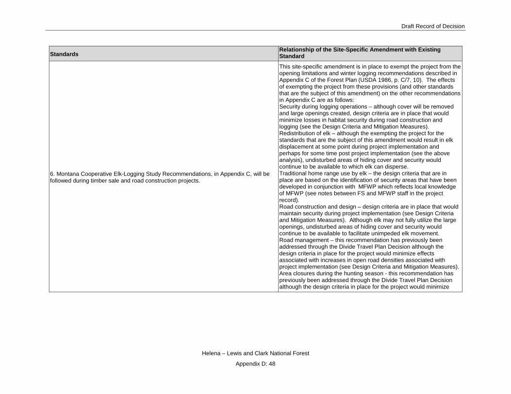
Draft Record of Decision
Helena – Lewis and Clark National Forest
Appendix D: 48
Standards Relationship of the Site-Specific Amendment with Existing Standard
6. Montana Cooperative Elk-Logging Study Recommendations, in Appendix C, will be followed during timber sale and road construction projects.
This site-specific amendment is in place to exempt the project from the opening limitations and winter logging recommendations described in Appendix C of the Forest Plan (USDA 1986, p. C/7, 10). The effects of exempting the project from these provisions (and other standards that are the subject of this amendment) on the other recommendations in Appendix C are as follows: Security during logging operations – although cover will be removed and large openings created, design criteria are in place that would minimize losses in habitat security during road construction and logging (see the Design Criteria and Mitigation Measures). Redistribution of elk – although the exempting the project for the standards that are the subject of this amendment would result in elk displacement at some point during project implementation and perhaps for some time post project implementation (see the above analysis), undisturbed areas of hiding cover and security would continue to be available to which elk can disperse. Traditional home range use by elk – the design criteria that are in place are based on the identification of security areas that have been developed in conjunction with MFWP which reflects local knowledge of MFWP (see notes between FS and MFWP staff in the project record). Road construction and design – design criteria are in place that would maintain security during project implementation (see Design Criteria and Mitigation Measures). Although elk may not fully utilize the large openings, undisturbed areas of hiding cover and security would continue to be available to facilitate unimpeded elk movement. Road management – this recommendation has previously been addressed through the Divide Travel Plan Decision although the design criteria in place for the project would minimize effects associated with increases in open road densities associated with project implementation (see Design Criteria and Mitigation Measures). Area closures during the hunting season - this recommendation has previously been addressed through the Divide Travel Plan Decision although the design criteria in place for the project would minimize

Tenmile – South Helena Project
Helena – Lewis and Clark National Forest
Appendix D: 49
Standards Relationship of the Site-Specific Amendment with Existing Standard
effects associated with increases in open road densities associated with project implementation (see Design Criteria and Mitigation Measures). Clearcuts – this recommendation is the subject of this site-specific amendment. This is addressed throughout this analysis. Cover type – the site-specific amendment analysis includes a discussion and consideration of cover type. Moist sites – moist sites in the project area have been identified and buffered. Logging activity will not occur within these buffers (see Design Criteria and Mitigation Measures). Elk/cattle relationships –area allocations have already been established. Winter range – this recommendation is the subject of this amendment and is addressed in this analysis.
7. Inventorying and mapping important big game summer/fall and winter ranges will continue.
The site-specific amendment doesn’t affect this requirement.
8. Any proposed sagebrush reduction programs will be analyzed on a case-by-case basis for the possible impact on big game winter range.
The treatments on winter range within thermal cover could impact some shrub communities, including sagebrush. This is analyzed in the Dry Forested Habitats and Associated Species section.

Draft Record of Decision
Helena – Lewis and Clark National Forest
Appendix D: 50
Standards Relationship of the Site-Specific Amendment with Existing Standard
9. Occupied bighorn sheep and mountain goat range will be protected during resource activities. Project plans for livestock, timber, or other resource development will include stipulations to avoid or mitigate impacts on their range. Conflicts between livestock and these wildlife species will be resolved in favor of the big game.
The site-specific amendment doesn’t pertain to this standard since bighorn sheep and mountain goats are not present in the project area (see wildlife Appendix A Wildlife Analysis Approach).
10. Moose habitat will be managed to provide adequate browse species diversity and quantity to support current moose populations.
The site-specific amendment could actually improve moose foraging habitat. Table 3.128 in the Vegetation Response in Openings section identifies the habitat types that comprise these openings. Where shrubbery is a component of the vegetation response of a given habitat type, browse for moose is expected to increase.
Forest Wide Threatened and Endangered (T&E) Species Standards 1. A biological evaluation will be written for all projects that have potential to impact any T&E species or its habitat. All evaluations will address each projects potential to adversely modify a listed species habitat or behavior. If an adverse impact is determined, mitigation measures will be developed to avoid any adverse modification of a listed species habitat or behavior. If all possible mitigation measures do not result in a no affect determination, then informal and/or formal consultation with the U.S. Fish and Wildlife Service will be initiated.
Formal consultation will be completed with the U.S. Fish and Wildlife Service for effects of the project on grizzly bears and lynx - listed species – and wolverines, a proposed species. The site-specific amendment analysis includes a discussion of these species in the Findings Required by Laws, Regulations, and Policies, Endangered Species Act section.
2. Grizzly bear -- Apply the guidelines in Appendix D to the Management Situation 1 and 2 (referred to essential and occupied prior to 1984) grizzly bear habitat on the Forest (see map in Appendix D). Initiate field studies in undesignated areas known to be used by grizzlies, to determine if the areas should be designated as grizzly habitat. Until sufficient evidence is available to determine the status of these areas, manage them according to Appendix E, Grizzly Management Guidelines Outside of Recovery Areas.
The project area is neither in Management Situation 1 or 2 (see the Forest Plan, USDA 1986, p. D/4). Field studies via rub trees have been conducted in the general project area (see Project Record). MFWP regularly investigates and maintains records of grizzly bears in the area (see for example Mace and Roberts 2012). Data from these findings have been used to update the extent of grizzly bear distribution within the Divide landscape (see USDA 2013 and USDI 2014). The area is not considered a biological activity center at this time. The effects of the exempting the standards that are the subject of this amendment have been analyzed in the Findings Required by Laws, Regulations, and Policies, Endangered Species Act section.
3. In occupied grizzly habitat, to minimize man-caused mortality the open road density will not exceed the 1980 density of 0.55 miles per square mile, which was determined to have little effect on habitat capability.
The project area is not in occupied grizzly habitat (see USDA 1986, p. D/3).
4. Research activity on grizzly bears or their habitat will be reviewed by the Research Subcommittee of the Interagency Grizzly Bear Committee.
The site-specific amendment doesn’t pertain to this standard since there currently is no Forest Service research ongoing in the project area.
5. Bald Eagle and Peregrine Falcon -- Continue working with the MFWP, the USFWS, and the BLM to identify nesting and wintering areas. Identify nesting territories and roosting sites, and protect both from adverse habitat alteration. (Guidelines for how to identify bald eagle habitat are in the Wildlife Planning Records.) Powerlines constructed
The site-specific amendment doesn’t pertain to this standard since bald eagles and peregrine falcons are not considered present in the project area (see Wildlife Appendix A, Wildlife Analysis Approach).

Tenmile – South Helena Project
Helena – Lewis and Clark National Forest
Appendix D: 51
Standards Relationship of the Site-Specific Amendment with Existing Standard
within bald eagle or peregrine falcon habitat will be designed to protect raptors from electrocution. See Appendix D for bald eagle and peregrine falcon habitat maps. 6. Gray Wolf -- With the USFWS and MFWP, investigate reported gray wolf observations to confirm or deny gray wolf presence. If presence of gray wolf is confirmed, determine if the habitat is necessary for the wolves’ recovery. If the habitat is necessary, coordinate with the MFWP and the USFWS to implement the Wolf Recovery Plan. See Appendix D for gray wolf habitat map.
The site-specific amendment doesn’t pertain to this standard; the wolf has been delisted for several years. In other words, the wolf is considered ‘recovered’.
7. No known threatened or endangered plants are on the Helena National Forest. The site-specific amendment doesn’t pertain to this standard since there are no listed plant species on the Forest, let alone the project area.
8. Species of Special Concern There are habitats on the Forest where the following species of special concern may be found (Plant Species of Special Concern, USDA-FS, l980) Lemhi penstemon (Penstemon lemhiensis) Howell's gumweed (Grindelia howellii) Missoula phlox (Phlox missoulensis) Cliff toothwort (Cardamine rupicola) Missoula phlox and cliff toothwort have been located on the Helena Forest. Other Plants that are termed rare have also been located on the Helena Forest. They are Klaus' bladderpod (Lesquerella plausii) and Long-styled thistle (Cirsium longistylum). Two additional rare plants, Moschatel (Adoxa moschalellina) and Lesser rushy milkvetch (Astragalus connvallarius) are believed to occur on the Helena Forest but currently have no occurrence records. If any of these species are verified on the Helena Forest, appropriate measures, pursuant to Section 7 of the Endangered Species Act, will be taken.
Sensitive plant surveys have been, or will be prior to implementation, conducted to determine if sensitive plant species are present within the treatments associated with the site-specific amendment. If present, they will be protected accordingly (see the Design Criteria in the FEIS).
Forestwide Old Growth Standards An old growth stand is generally characterized by a high level of standing and down, dead and rotting woody material; two or more levels of tree canopies and a high degree of decadence indicated by heart rot, mistletoe, dead or broken tree tops, and moss. Five percent of each third order drainage should be managed for old growth. The priority for old growth acres within each drainage is: first, land below 6000 feet in elevation; second, riparian zones and mesic drainage heads; and third, management areas emphasizing wildlife habitat. These areas will normally be managed on a 240 year rotation and will range from 10 acres to several hundred acres. Management areas other than T-1 through T-5 will be the primary source for old growth. However, if adequate old growth area cannot be achieved then the T management areas will be considered to meet old growth objectives.
Old growth that would be treated that overlaps with those areas that are the subject of this amendment would retain minimum old growth characteristics.
Forestwide Snag Standards 1. To keep an adequate snag resource (standing dead trees) through the planning horizon, snags should be managed at 70 percent of optimum (average of 2 snags/acre) within each third order drainage.
While exempting the project from the standards that are the subject of this site-specific amendment would reduce snag densities, the draft

Draft Record of Decision
Helena – Lewis and Clark National Forest
Appendix D: 52
Standards Relationship of the Site-Specific Amendment with Existing Standard
2. Snag management guidelines need not be applied within a quarter mile of riparian areas, because riparian standards should provide for adequate snags.
ROD is consistent with these Forest Plan standards (see the Snags and Down Woody Debris and Associated Wildlife Species section).
3. Larch, ponderosa pine, Douglas-fir, spruce, and subalpine fir, in that priority, are the preferred species for snags and replacement trees (live trees left to replace existing snags). 4. Management areas other than T-1 should be the primary source for snag management. However, if adequate snags cannot be found outside of T-1, then the following numbers and sizes of snags should be retained in cutting units, if available. A. In units with snags, keep a minimum of 20 snags and 10 replacement trees per 10 acres, if available. If 20 snags are not available, then any combination totaling 30 should be left, by the following dbh classes: 13 snags and 6 replacement trees from 7-11 inches 5 snags and 3 replacement trees from 12-19 inches 2 snags and 1 replacement trees 20+ inches B. In units--except those of pure lodgepole--without snags keep a minimum of 30 wind firm trees per 10 acres, if available, by the following dbh classes: 21 trees from 7-11 inches 7 trees from 12-19 inches 2 trees from 20+ inches If wildlife funds are available, a third of the replacement trees should be girdled or otherwise killed to provide snags, by the following dbh classes: 7 trees from 7-11 inches dbh 2 trees from 12-19 inches dbh 1 tree from 20+ inches dbh Management Area H-1 Wildlife and Fisheries – Wildlife habitat improvement practices, including road management, prescribed fire, and other techniques, will be used to maintain and/or enhance the diversity of wildlife habitats. Maintain adequate thermal and hiding cover adjacent to forage areas. Generally this means providing at least 25 percent cover, where available, on identified winter range.
Exempting the project from the standards that are the subject of this site-specific amendment would not preclude the treatments from maintaining/enhancing wildlife habitat (see the analysis in this report). However, the thermal cover provision of this standard is the subject of this amendment.
Management Area H-2 Wildlife and Fisheries – Wildlife habitat improvement practices, including road management, prescribed fire, and other techniques, will be used to maintain and/or enhance the diversity of wildlife habitats. Maintain adequate thermal and hiding cover adjacent to forage areas. Generally this means providing at least 25 percent cover, where available, on identified winter range.
Exempting the project from the standards that are the subject of this site-specific amendment would not preclude the treatments from maintaining/enhancing wildlife habitat (see the analysis in this report). However, the thermal cover provision of this standard is the subject of this amendment.
Management Area L-1
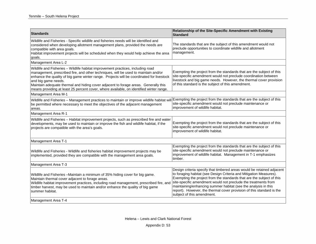
Tenmile – South Helena Project
Helena – Lewis and Clark National Forest
Appendix D: 53
Standards Relationship of the Site-Specific Amendment with Existing Standard
Wildlife and Fisheries - Specific wildlife and fisheries needs will be identified and considered when developing allotment management plans, provided the needs are compatible with area goals. Habitat improvement projects will be scheduled when they would help achieve the area goals.
The standards that are the subject of this amendment would not preclude opportunities to coordinate wildlife and allotment management.
Management Area L-2 Wildlife and Fisheries – Wildlife habitat improvement practices, including road management, prescribed fire, and other techniques, will be used to maintain and/or enhance the quality of big game winter range. Projects will be coordinated for livestock and big game needs. Maintain adequate thermal and hiding cover adjacent to forage areas. Generally this means providing at least 25 percent cover, where available, on identified winter range.
Exempting the project from the standards that are the subject of this site-specific amendment would not preclude coordination between livestock and big game needs. However, the thermal cover provision of this standard is the subject of this amendment.
Management Area M-1 Wildlife and Fisheries – Management practices to maintain or improve wildlife habitat will be permitted where necessary to meet the objectives of the adjacent management areas.
Exempting the project from the standards that are the subject of this site-specific amendment would not preclude maintenance or improvement of wildlife habitat.
Management Area R-1 Wildlife and Fisheries – Habitat improvement projects, such as prescribed fire and water developments, may be used to maintain or improve the fish and wildlife habitat, if the projects are compatible with the area’s goals.
Exempting the project from the standards that are the subject of this site-specific amendment would not preclude maintenance or improvement of wildlife habitat.
Management Area T-1
Wildlife and Fisheries - Wildlife and fisheries habitat improvement projects may be implemented, provided they are compatible with the management area goals.
Exempting the project from the standards that are the subject of this site-specific amendment would not preclude maintenance or improvement of wildlife habitat. Management in T-1 emphasizes timber.
Management Area T-3
Wildlife and Fisheries –Maintain a minimum of 35% hiding cover for big game. Maintain thermal cover adjacent to forage areas. Wildlife habitat improvement practices, including road management, prescribed fire, and timber harvest, may be used to maintain and/or enhance the quality of big game summer habitat.
Design criteria specify that timbered areas would be retained adjacent to foraging habitat (see Design Criteria and Mitigation Measures). Exempting the project from the standards that are the subject of this site-specific amendment would not preclude the treatments from maintaining/enhancing summer habitat (see the analysis in this report). However, the thermal cover provision of this standard is the subject of this amendment.
Management Area T-4

Draft Record of Decision
Helena – Lewis and Clark National Forest
Appendix D: 54
Standards Relationship of the Site-Specific Amendment with Existing Standard
Wildlife and Fisheries –Where elk habitat exists, project design will incorporate management practices to maintain or enhance summer and winter habitat, to the extent that the VQOs for the area are met. Wildlife and fisheries habitat improvement projects may be implemented, provided they are compatible with the management area goals.
Exempting the project from the standards that are the subject of this site-specific amendment would not preclude maintenance or improvement of wildlife habitat.
Management Area T-5 Wildlife and Fisheries –Wildlife and fisheries habitat improvement projects may be implemented, provided they are compatible with the management area goals. Maintain adequate thermal and hiding cover adjacent to forage areas, provided timber harvest volumes are not significantly reduced over the rotation period.
The openings associated with the site-specific amendment are not in Management Area T-5.
Management Area W-1 Wildlife and Fisheries –Wildlife habitat improvement practices, including road management, prescribed fire, and other techniques, will be used to maintain and/or enhance the quality of big game and nongame habitat. Maintain adequate thermal and hiding cover adjacent to forage areas. Generally this means providing at least 25 percent cover, where available, on identified winter range.
Exempting the project from the standards that are the subject of this site-specific amendment would not preclude the treatments from maintaining/enhancing wildlife habitat (see the analysis in this report). However, the thermal cover provision of this standard is the subject of this amendment.
Management Area W-2
Wildlife and Fishers - Most new roads and about 50% of existing roads will be closed, at least seasonally. Wildlife habitat improvement practices, including road management, prescribed fire, and other techniques, will be used to maintain and/or enhance big game calving and summer habitat. Maintain adequate thermal and hiding cover adjacent to forage areas.
There are no existing or proposed roads in management area W-2. Design criteria specify that timbered areas would be retained adjacent to foraging habitat (see Design Criteria and Mitigation Measures). Exempting the project from the standards that are the subject of this site-specific amendment would not preclude the treatments from maintaining/enhancing calving and summer habitat (see the analysis in this report).

Tenmile – South Helena Project
Helena – Lewis and Clark National Forest
Appendix D: 55
Relationship of the site-specific amendment with the Northern Rockies Lynx Management Direction (USDA 2007b)
Northern Rockies Lynx Management Direction(NRLMD)
Management Standards Relationship of the Site-Specific Amendment with Existing Standard
Standard ALL S1 New or expanded permanent developments and vegetation management projects must maintain habitat connectivity in an LAU and/or linkage area.
The treatments areas associated with the site-specific amendment may preclude use by lynx while these areas remain in the shrub/forb stage. However, as described in the Findings Required by Laws, Regulations, and Policies, Endangered Species Act section, habitat is available outside of these treatment areas.
Guideline ALL G1 Methods to avoid or reduce effects on lynx should be used when constructing or reconstructing highways or forest highways across federal land. Methods could include fencing, underpasses or overpasses.
The site-specific amendment does not pertain to this guideline since it doesn’t involve highway construction or reconstruction.
Standard LAU S1 Changes in LAU boundaries shall be based on site-specific habitat information and after review by the Forest Service Regional Office.
The site-specific amendment does not pertain to this standard since LAU boundaries are not being adjusted.
VEGETATION MANAGEMENT PROJECTS (VEG) The following objectives, standards and guidelines apply to vegetation management projects in lynx habitat in lynx analysis units (LAU). With the exception of Objective VEG O3 that specifically concerns wildland fire use, the objectives, standards and guidelines do not apply to wildfire suppression, wildland fire use, or removal of vegetation for permanent developments like mineral operations, ski runs, roads and the like. None of the objectives, standards, or guidelines applies to linkage areas.
Standard VEG S1 – Stand initiation structural stage limits Standard VEG S1 applies to all vegetation management projects that regenerate timber, except for fuel treatment projects within the wildland urban interface (WUI) as defined by HFRA, subject to the following limitation: Fuel treatment projects within the WUI that do not meet Standards VEG S1, VEG S2, VEG S5, and VEG S6 may occur on no more than 6 percent (cumulatively) of lynx habitat on each administrative unit (a unit is a National Forest). For fuel treatment projects within the WUI see guideline VEG G10. The Standard: Unless a broad scale assessment has been completed that substantiates different historic levels of stand initiation structural stages limit disturbance in each LAU as follows: If more than 30 percent of the lynx habitat in an LAU is currently in a stand initiation structural stage that does not yet provide winter snowshoe hare habitat, no additional habitat may be regenerated by vegetation management projects.
The effects associated with this site-specific amendment are applicable to this standard because the clearcutting that comprises some of the treatments is creating ‘stand initiation structural stage that does not yet provide winter snowshoe hare habitat’. However, the analyses in the Canada Lynx section, demonstrates that the project is consistent with this lynx standard since none of the LAUs within which treatment would occur would approach 30% ‘stand initiation not yet snowshoe hare habitat’. Nor have the total fuel exception acres been exceeded.
Standard VEG S2 – Limits on regeneration from timber mgmt. projects
The effects associated with this site-specific amendment are applicable to this standard because some of the treatments include regeneration harvest. However, the analyses in the

Draft Record of Decision
Helena – Lewis and Clark National Forest
Appendix D: 56
Northern Rockies Lynx Management Direction(NRLMD)
Management Standards Relationship of the Site-Specific Amendment with Existing Standard
Standard VEG S2 applies to all vegetation management projects that regenerate timber, except for fuel treatment projects within the wildland urban interface (WUI) as defined by HFRA, subject to the following limitation: Fuel treatment projects within the WUI that do not meet Standards VEG S1, VEG S2, VEG S5, and VEG S6 may occur on no more than 6 percent (cumulatively) of lynx habitat on each administrative unit (a unit is a National Forest). For fuel treatment projects within the WUI see guideline VEG G10. The Standard: Timber management projects shall not regenerate more than 15 percent of lynx habitat on NFS lands in an LAU in a ten-year period.
Canada Lynx section demonstrates that the project is consistent with this lynx standard.
Standard VEG S5 – Precommercial thinning limits Standard VEG S5 applies to all precommercial thinning projects, except for fuel treatment projects that use precommercial thinning as a tool within the wildland urban interface (WUI) as defined by HFRA, subject to the following limitation: Fuel treatment projects within the WUI that do not meet Standards VEG S1, VEG S2, VEG S5, and VEG S6 may occur on no more than 6 percent (cumulatively) of lynx habitat on each administrative unit (a unit is a National Forest). For fuel treatment projects within the WUI see guideline VEG G10. The Standard: Precommercial thinning projects that reduce snowshoe hare habitat, may occur from the stand initiation structural stage until the stands no longer provide winter snowshoe hare habitat only: 1. Within 200 feet of administrative sites, dwellings, or outbuildings; or 2. For research studies or genetic tree tests evaluating genetically improved reforestation stock; or Based on new information that is peer reviewed and accepted by the regional levels of the Forest Service and FWS, where a written determination states: that a project is not likely to adversely affect lynx; or that a project is likely to have short term adverse effects on lynx or its habitat, but would result in long-term benefits to lynx and its habitat; or 4. For conifer removal in aspen, or daylight thinning around individual aspen trees, where aspen is in decline; or 5. For daylight thinning of planted rust-resistant white pine where 80 % of the winter snowshoe hare habitat is retained; or 6. To restore whitebark pine.
The effects associated with this site-specific amendment are applicable to this standard because some of the treatments include precommercial thinning. However, the analyses in the Canada Lynx section, demonstrates that the project is consistent with this lynx standard.
Standard VEG S6 – Multi-storied stands & snowshoe hare horizontal cover Standard VEG S6 applies to all vegetation management projects that regenerate timber, except for fuel treatment projects within the wildland urban interface (WUI) as defined by HFRA, subject to the following limitation:
The effects associated with this site-specific amendment are applicable to this standard because the treatments would remove multistory habitat. However, the analyses in the Canada Lynx section, demonstrates that the project is consistent with this lynx standard.

Tenmile – South Helena Project
Helena – Lewis and Clark National Forest
Appendix D: 57
Northern Rockies Lynx Management Direction(NRLMD)
Management Standards Relationship of the Site-Specific Amendment with Existing Standard
Fuel treatment projects within the WUI that do not meet Standards VEG S1, VEG S2, VEG S5, and VEG S6 may occur on no more than 6 percent (cumulatively) of lynx habitat on each administrative unit (a unit is a National Forest). For fuel treatment projects within the WUI see guideline VEG G10. The Standard: Vegetation management projects that reduce snowshoe hare habitat in multi-story mature or late successional forests29 may occur only: 1. Within 200 feet of administrative sites, dwellings, outbuildings, recreation sites, and special use permit improvements, including infrastructure within permitted ski area boundaries; or 2. For research studies or genetic tree tests evaluating genetically improved reforestation stock; or 3. For incidental removal during salvage harvest (e.g. removal due to location of skid trails). (NOTE: Timber harvest is allowed in areas that have potential to improve winter snowshoe hare habitat but presently have poorly developed understories that lack dense horizontal cover [e.g. uneven age management systems could be used to create openings where there is little understory so that new forage can grow]).
Guideline VEG G1 – Lynx habitat improvement Vegetation management projects should be planned to recruit a high density of conifers, hardwoods, and shrubs where such habitat is scarce or not available. Priority should be given to stem-exclusion, closed-canopy structural stage stands for lynx or their prey (e.g. mesic, monotypic lodgepole stands). Winter snowshoe hare habitat should be near denning habitat.
The treatments associated with this site-specific amendment include regeneration harvest that would quicken recruitment of a ‘high density of conifers’ (see the Canada Lynx section).-
Guideline VEG G4 – Prescribed Fire Prescribed fire activities should not create permanent travel routes that facilitate snow compaction. Constructing permanent firebreaks on ridges or saddles should be avoided.
No permanent fire breaks will be constructed in the project associated with this site-specific amendment; or in the project area as a whole for that matter.
Guideline VEG G5 – Habitat for alternate prey species Habitat for alternate prey species, primarily red squirrel, should be provided in each LAU.
The regeneration harvest that is included in treatments that are the subject of this site-specific amendment would reduce red squirrel habitat by removing large trees and down logs. However, red squirrel densities may be declining in these units due to reduced cone crop associated with the mountain pine beetle outbreak. A majority of each LAU will remain untreated (see the Canada Lynx section).
Guideline VEG G10 – Fuel treatments in the WUI Fuel treatment projects in the WUI as defined by HFRA should be designed considering standards VEG S1, S2, S5, and S6 to promote lynx conservation.
See responses above for VEG S1, S2, S5, and S6.
Guideline VEG G11 – Denning habitat Denning habitat should be distributed in each LAU in the form of pockets of large amounts of large woody debris, either down logs or root wads, or large piles of small wind thrown trees
The effects associated with this site-specific amendment are applicable to this standard because the treatments are also removing existing down woody debris that could provide

Draft Record of Decision
Helena – Lewis and Clark National Forest
Appendix D: 58
Northern Rockies Lynx Management Direction(NRLMD)
Management Standards Relationship of the Site-Specific Amendment with Existing Standard
(“jack-strawed” piles). If denning habitat appears to be lacking in the LAU, then projects should be designed to retain some coarse woody debris, piles, or residual trees to provide denning habitat in the future.
denning and future down woody debris that would be created as dead trees fall. However, since most of the project area would remain untreated, concentrations of down woody debris would remain abundant and wide-spread.
LIVESTOCK MANAGEMENT (GRAZ) The following objectives and guidelines apply to grazing projects in lynx habitat in lynx analysis units (LAU). They do not apply to linkage areas.
Guideline GRAZ G1 – Livestock grazing and openings In fire- and harvest-created openings, livestock grazing should be managed so impacts do not prevent shrubs and trees from regenerating.
Design criteria are in place that provide protection, where needed, from grazing impacts in treatment units that are the subject of this site specific amendment. For example, (1) burn units within grazing allotments would be rested at least one growing season following burning to allow for adequate vegetation recovery and (2) fencing, either temporary or permanent, may be needed to protect stands after burning or where natural barriers have been lost due to treatment activities. This should be coordinated with the wildlife biologist.
Guideline GRAZ G2 – Livestock grazing and aspen In aspen stands, livestock grazing should be managed to contribute to the long-term health and sustainability of aspen.
The treatments that are the subject of this site-specific amendment do not include aspen.
Guideline GRAZ G3 – Livestock grazing and riparian areas & willow carrs In riparian areas and willow carrs, livestock grazing should be managed to contribute to maintaining or achieving a preponderance of mid- or late-seral stages , similar to conditions that would have occurred under historic disturbance regimes.
The treatments that are the subject of this site-specific amendment will not impact riparian areas, including willows such that maintaining or achieving mid to late seral conditions would be precluded.
Guideline GRAZ G4 – Livestock grazing and shrub-steppe habitats In shrub-steppe habitats, livestock grazing should be managed in the elevation ranges of forested lynx habitat in LAUs, to contribute to maintaining or achieving a preponderance of mid- or late-seral stages, similar to conditions that would have occurred under historic disturbance regimes.
The treatments that are the subject of this site-specific amendment are not within shrub-steppe habitats.
HUMAN USE PROJECTS (HU) The following objectives and guidelines apply to human use projects, such as special uses (other than grazing), recreation management, roads, highways, and mineral and energy development, in lynx habitat in lynx analysis units (LAU), subject to valid existing rights. They do not apply to vegetation management projects or grazing projects directly. They do not apply to linkage areas.

Tenmile – South Helena Project
Helena – Lewis and Clark National Forest
Appendix D: 59
Northern Rockies Lynx Management Direction(NRLMD)
Management Standards Relationship of the Site-Specific Amendment with Existing Standard
Guideline HU G1 – Ski area expansion & development, inter-trail islands When developing or expanding ski areas, provisions should be made for adequately sized inter-trail islands that include coarse woody debris, so winter snowshoe hare habitat is maintained.
The treatments that are the subject of this site-specific amendment do not involve ski expansion or other related winter recreation.
Guideline HU G2 – Ski are expansion & development, foraging habitat When developing or expanding ski areas, foraging should be provided consistent with the ski area’s operational needs, especially where lynx habitat occurs as narrow bands of coniferous forest across mountain slopes.
The treatments that are the subject of this site-specific amendment do not involve ski expansion or other related winter recreation.
Guideline HU G3 – Recreation developments Recreation developments and operations should be planned in ways that both provide for lynx movement and maintain the effectiveness of lynx habitat.
The treatments that are the subject of this site-specific amendment are not related to recreation development.
Guideline HU G4 – Mineral & energy development For mineral and energy development sites and facilities, remote monitoring should be encouraged to reduce snow compaction.
The treatments that are the subject of this site-specific amendment do not involve mineral and energy development.
Guideline HU G5 – Mineral & energy development, habitat restoration For mineral and energy development sites and facilities that are closed, a reclamation plan that restores lynx habitat should be developed.
The treatments that are the subject of this site-specific amendment do not involve mineral and energy development.
Guideline HU G6 – Roads, upgrading Methods to avoid or reduce effects to lynx should be used in lynx habitat when upgrading unpaved roads to maintenance levels 4 or 5, if the result would be increased traffic speeds and volumes, or a foreseeable contribution to increases in human activity or development.
Temporary roads will be constructed to access the treatments that are the subject of this site-specific amendment. Roads closed to the public would be utilized for hauling. None of these roads – temporary or closed – will be upgraded to a maintenance level that is higher than the existing condition.
Guideline HU G7 – Roads, locations New permanent roads should not be built on ridge-tops and saddles, or in areas identified as important for lynx habitat connectivity. New permanent roads and trails should be situated away from forested stringers.
The treatments that are the subject of this site-specific amendment do not include construction of permanent roads.
Guideline HU G8 – Roads, brushing Cutting brush along low-speed, low-traffic-volume roads should be done to the minimum level necessary to provide for public safety.
Road maintenance is a component of project activities and is likely to occur on roads associated with the treatments that are the subject of this site-specific amendment. The “intention of road maintenance is to keep the road at an acceptable level that meets Best Management Practices (BMP) standards and allows for safe timber haul. Road maintenance activities would include surface blading, vegetation removal, minor slump repair, and drainage structure cleaning and/or installation” (see Design Criteria in the FEIS).

Draft Record of Decision
Helena – Lewis and Clark National Forest
Appendix D: 60
Northern Rockies Lynx Management Direction(NRLMD)
Management Standards Relationship of the Site-Specific Amendment with Existing Standard
Guideline HU G9 – Roads, new On new roads built for projects, public motorized use should be restricted. Effective closures should be provided in road designs. When the project is over, these roads should be reclaimed or decommissioned, if not needed for other management objectives.
Temporary roads will be constructed to access the treatments that are the subject of this site-specific amendment. All temporary roads used to access these openings would be closed to the public and decommissioned upon project completion.
Guideline HU G10 – Roads, ski area access When developing or expanding ski areas and trails, consider locating access roads and lift termini to maintain and provide lynx security habitat.
The treatments that are the subject of this amendment do not include ski area/trail development or expansion.
Guideline HU G11 – Snow compaction Designated over-the-snow routes, or designated play areas, should not expand outside baseline areas of consistent snow compaction, unless designation serves to consolidate use and improve lynx habitat. This is calculated on an LAU basis, or on a combination of immediately adjacent LAUs. This does not apply inside permitted ski area boundaries, to winter logging, to rerouting trails for public safety, to accessing private inholdings, or to access regulated by Guideline HU G12. Use the same analysis boundaries for all actions subject to this guideline.
The treatments that are the subject of this site-specific amendment do not involve designating over the snow routes or designated play areas.
Guideline HU G12 – Winter access for non-recreation SUP & mineral & energy development Winter access for non-recreation special uses, and mineral and energy exploration and development, should be limited to designated routes or designated over-the-snow routes.
The treatments that are the subject of this site-specific amendment do not include non-recreation SUP or mineral/energy development.
LINKAGE AREAS (LINK) The following objective, standard and guidelines apply to all projects within linkage areas, subject to valid existing rights.
Standard LINK S1 – Highway or forest highway construction in linkage areas When highway or forest highway construction or reconstruction is proposed in linkage areas, identify potential highway crossings.
The treatments that are the subject of this site-specific amendment do not involve highway or forest highway construction.
Guideline LINK G1 – Land exchanges NFS lands should be retained in public ownership.
Land exchange is not a component of the project.
Guideline LINK G2 – Livestock grazing in shrub-steppe habitats Livestock grazing in shrub-steppe habitats should be managed to contribute to maintaining or achieving a preponderance of mid- or late-seral stages, similar to conditions that would have occurred under historic disturbance regimes.
The treatments that are the subject of this site-specific amendment are not within shrub-steppe habitats.
REQUIRED MONITORING
Map the location and intensity of snow compacting activities, and designated and groomed routes that occurred inside LAUs during the period of 1998 to 2000. The mapping is to be
Not applicable

Tenmile – South Helena Project
Helena – Lewis and Clark National Forest
Appendix D: 61
Northern Rockies Lynx Management Direction(NRLMD)
Management Standards Relationship of the Site-Specific Amendment with Existing Standard
completed within one year of this decision and changes in activities and routes are to be monitored every five years after the decision.
Annually report the number of acres where any of the exemptions listed in Standard VEG S5 and Standard VEG S6 were applied. Report the type of activity, the number of acres, and the location (by unit, and LAU).
This will be completed upon signing of the Decision.
Report the acres of fuel treatment in lynx habitat within the wildland urban interface as defined by HFRA when the project decision is approved. Report whether or not the fuel treatment met the vegetation standard. If standard(s) are not met, report, which standard(s) are not met, why they were not met, and how many acres were affected. Units will report to their respective USFS Regional Office. Region 1 of the USFS will consolidate all reports.
This will be completed upon signing of the Decision.
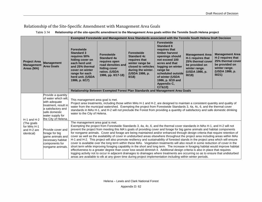
Draft Record of Decision
Helena – Lewis and Clark National Forest
Appendix D: 62
Relationship of the Site-Specific Amendment with Management Area Goals Relationship of the site-specific amendment to the Management Area goals within the Tenmile South Helena project
Project Area Management Areas (MA)
Management Area Goals
Exempted Forestwide and Management Area Standards associated with the Tenmile South Helena Draft Decision
Forestwide Standard 3 requires 50% hiding cover on each herd unit and 25% thermal cover on winter range for each herd unit. (USDA 1986, p. II/17)
Forestwide Standard 4a requires open road densities and hiding cover ratios. (USDA 1986, pp. II/17-18)
Forestwide Standard 4c requires that winter range be closed to vehicles during the winter. (USDA 1986, p. II/18)
Forestwide Standard 6 requires that timber harvest openings should not exceed 100 acres and that logging on winter range be scheduled outside of winter (USDA 1986, p. II/19 and Appendix C, C/7&10)
Management Area H-1 requires that 25% thermal cover be provided on winter range. (USDA 1986, p. III/18)
Management Area H-2 requires that 25% thermal cover be provided on winter range. (USDA 1986, p. III/21)
Relationship Between Exempted Forest Plan Standards and Management Area Goals
H-1 and H-2 (The goals for MAs H-1 and H-2 are identical)
Provide a quantity of water which will, with adequate treatment, result in a satisfactory and safe domestic water supply for the City of Helena.
This management area goal is met. Project area treatments, including those within MAs H-1 and H-2, are designed to maintain a consistent quantity and quality of water from the municipal watershed. Exempting the project from Forestwide Standards 3, 4a, 4c, 6, and the thermal cover standards in MAs H-1, and H-2 will not preclude the Forest from providing a quantity of satisfactory and safe domestic drinking water to the City of Helena.
Provide cover and forage for big game animals and necessary habitat components for nongame animals.
The management area goal is met. Exempting the project from Forestwide Standards 3, 4a, 4c, 6, and the thermal cover standards in MAs H-1, and H-2 will not prevent the project from meeting this MA’s goals of providing cover and forage for big game animals and habitat components for nongame animals. Cover and forage are being maintained and/or enhanced through design criteria that require retention of cover as well as the availability of cover in undisturbed areas elsewhere throughout the project area including areas within MAs H-1 and H-2. This project will also promote resiliency and sustainability of forested stands in the project area which will ensure cover is available over the long term within these MAs. Vegetation treatments will also result in some reduction of cover in the short term while improving foraging capability in the short and long term. The increase in foraging habitat would improve habitat effectiveness to a greater degree than cover loss would diminish it. Additional design criteria is also in place that requires logging activity not to occur in adjacent drainages to drainages where treatments are occurring so as to ensure that undisturbed areas are available to elk at any given time during project implementation including within winter periods.

Tenmile – South Helena Project
Helena – Lewis and Clark National Forest
Appendix D: 63
Project Area Management Areas (MA)
Management Area Goals
Exempted Forestwide and Management Area Standards associated with the Tenmile South Helena Draft Decision
Forestwide Standard 3 requires 50% hiding cover on each herd unit and 25% thermal cover on winter range for each herd unit. (USDA 1986, p. II/17)
Forestwide Standard 4a requires open road densities and hiding cover ratios. (USDA 1986, pp. II/17-18)
Forestwide Standard 4c requires that winter range be closed to vehicles during the winter. (USDA 1986, p. II/18)
Forestwide Standard 6 requires that timber harvest openings should not exceed 100 acres and that logging on winter range be scheduled outside of winter (USDA 1986, p. II/19 and Appendix C, C/7&10)
Management Area H-1 requires that 25% thermal cover be provided on winter range. (USDA 1986, p. III/18)
Management Area H-2 requires that 25% thermal cover be provided on winter range. (USDA 1986, p. III/21)
Relationship Between Exempted Forest Plan Standards and Management Area Goals
Provide for dispersed recreation opportunities
The management area goal is met. Exempting the project from Forestwide Standards 3, 4a, 4c, 6, and the thermal cover standards in MAs H-1, and H-2 will not preclude the Forest from providing disperse recreation opportunities within MA H1 and H2. Some dispersed recreation opportunities could temporarily be effected by project activities during implementation within H1 and H2 management areas. Due to the temporal nature of effects, disperse recreation goals would be met over the long run. To add, effects would be isolated to specific locations leaving the majority of the project area unencumbered and available to the public for dispersed recreation. Furthermore, design criteria will be in place to minimize impacts to this resource.
L-1
Optimize livestock production through intensive grazing systems, while maintaining other resource uses.
This management area’s goals are met. Exempting the project from Forestwide Standards 3, 4a, 4c, 6, and the thermal cover standards in MAs H-1, and H-2 will not prevent the project from meeting this MA’s goals of optimizing livestock production and maintaining or improving vegetation conditions and livestock forage productivity. Project activities will result in additional acres of transitory range across the project area including areas within MA L-1. This will result in additional forage and improved conditions for livestock. Project activities and exemption to the standards, will not change the existing grazing systems within this MA over the long term however, some interruptions in short durations (a few days to a week) could occur for the purpose of accomplishing project objections.
Maintain or improve vegetation conditions and livestock forage productivity.
L-2
Maintain or improve range vegetative conditions and forage production for livestock and elk.
This management area’s goal is met. Exempting the project from Forestwide Standards 3, 4a, 4c, 6, and the thermal cover standards in MAs H-1, and H-2 will not prevent the project from meeting this MA’s goals of maintaining or improving range vegetative conditions and forage production for livestock and elk. Project activities will result in additional acres of transitory range and promote foraging habitat for elk across the project area including areas within MA L-2. This will result in additional forage and improved palatability for livestock and elk. Also, only low severity prescribe fire treatments will occur in L-2. These activities would not occur during the winter period and thus will not result in a disturbance to elk that may use this area as winter range.
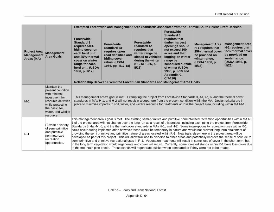
Draft Record of Decision
Helena – Lewis and Clark National Forest
Appendix D: 64
Project Area Management Areas (MA)
Management Area Goals
Exempted Forestwide and Management Area Standards associated with the Tenmile South Helena Draft Decision
Forestwide Standard 3 requires 50% hiding cover on each herd unit and 25% thermal cover on winter range for each herd unit. (USDA 1986, p. II/17)
Forestwide Standard 4a requires open road densities and hiding cover ratios. (USDA 1986, pp. II/17-18)
Forestwide Standard 4c requires that winter range be closed to vehicles during the winter. (USDA 1986, p. II/18)
Forestwide Standard 6 requires that timber harvest openings should not exceed 100 acres and that logging on winter range be scheduled outside of winter (USDA 1986, p. II/19 and Appendix C, C/7&10)
Management Area H-1 requires that 25% thermal cover be provided on winter range. (USDA 1986, p. III/18)
Management Area H-2 requires that 25% thermal cover be provided on winter range. (USDA 1986, p. III/21)
Relationship Between Exempted Forest Plan Standards and Management Area Goals
M-1
Maintain the present condition with minimal investment for resource activities, while protecting the basic soil, water, and wildlife resource.
This management area’s goal is met. Exempting the project from Forestwide Standards 3, 4a, 4c, 6, and the thermal cover standards in MAs H-1, and H-2 will not result in a departure from the present condition within the MA. Design criteria are in place to minimize impacts to soil, water, and wildlife resource for treatments across the project area including within MA M-1.
R-1
Provide a variety of semi-primitive and primitive nonmotorized recreation opportunities.
This management area’s goal is met. The existing semi-primitive and primitive nonmotorized recreation opportunities within MA R-1 of the project area will not change over the long run as a result of this project, including exempting the project from Forestwide Standards 3, 4a, 4c, 6, and the thermal cover standards in MAs H-1, and H-2. Some interruptions to recreation uses within R-1 could occur during implementation however these would be temporary in nature and would not prevent long term attainment of providing the semi primitive and primitive nature of areas located within R-1. New trails elsewhere in the project area will be developed as part of this project. This will allow trail use to disperse to other areas and potentially improve the sense of solitude to semi-primitive and primitive recreational uses in R-1. Vegetation treatments will result in some loss of cover in the short term, but in the long term vegetation would regenerate and cover will return. Currently, some forested stands within R-1 have loss cover due to the mountain pine beetle. These stands will regenerate quicker when compared to if they were not to be treated.

Tenmile – South Helena Project
Helena – Lewis and Clark National Forest
Appendix D: 65
Project Area Management Areas (MA)
Management Area Goals
Exempted Forestwide and Management Area Standards associated with the Tenmile South Helena Draft Decision
Forestwide Standard 3 requires 50% hiding cover on each herd unit and 25% thermal cover on winter range for each herd unit. (USDA 1986, p. II/17)
Forestwide Standard 4a requires open road densities and hiding cover ratios. (USDA 1986, pp. II/17-18)
Forestwide Standard 4c requires that winter range be closed to vehicles during the winter. (USDA 1986, p. II/18)
Forestwide Standard 6 requires that timber harvest openings should not exceed 100 acres and that logging on winter range be scheduled outside of winter (USDA 1986, p. II/19 and Appendix C, C/7&10)
Management Area H-1 requires that 25% thermal cover be provided on winter range. (USDA 1986, p. III/18)
Management Area H-2 requires that 25% thermal cover be provided on winter range. (USDA 1986, p. III/21)
Relationship Between Exempted Forest Plan Standards and Management Area Goals
Provide for maintenance and/or enhancement of fishery, big game, and nongame habitat, grazing allotments, visual quality, and water quality.
This management area’s goal is met. Exempting the project from Forestwide Standards 3, 4a, 4c, 6, and the thermal cover standards in MAs H-1, and H-2 will not prevent the project from meeting this MA’s goals. This project will introduce westslope cutthroat trout into two tributaries of Upper Tenmile Creek which will enhance the overall fishery within the project area. Cover and forage are being maintained and/or enhanced through design criteria that require retention of cover as well as the availability of cover in undisturbed areas elsewhere throughout the project area including areas within MAs H-1 and H-2. This project will also promote resiliency and sustainability of forested stands in the project area which will ensure cover is available over the long term within these MAs. Vegetation treatments will also result in some reduction of cover in the short term while improving foraging capability in the short and long term. The increase in foraging habitat would improve habitat effectiveness to a greater degree than cover loss would diminish it. Additional design criteria is also in place that requires logging activity not to occur in adjacent drainages to drainages where treatments are occurring so as to ensure that undisturbed areas are available to elk at any given time during project implementation including within winter periods. Treatments within allotments will result in an increase of transitory range which will provide a palatable resource for livestock and elk. Also, design criteria will be in place during implementation that will ensure visual quality standard of retention is met for this MA. Best management practices will also be followed throughout the project area during implementation to ensure impacts to soil and water resources are minimize. This project will result in a net reduction in sediment delivery to streams in the long run due to road maintenance activities and other watershed improvement activities describe in the FEIS chapter 2.
T-1
Provide healthy timber stands and optimize timber growing potential over the planning horizon.
This management area’s goals are met. Treatments located in MA T-1 will be used to reduce hazardous fuels and would utilize harvest techniques such as improvement and regeneration harvest. Most forested stands within T-1 in the project area have been effected by the mountain pine beetle. Regeneration would occur post implementation which would provide for healthy stands of timber in the long term and at a more rapid pace when compared to regeneration within untreated stands. Design criteria, including the use of best management practices will be in place during implementation which would minimize impacts to disperse recreation, wildlife habitat, and livestock use. Design criteria such as (but not limited to) retention, minimize disturbances to big game during implementation, and considerations to the timing of treatments are also incorporated in this project that will provide suitable wildlife habitat during and post implementation.
Emphasize cost-effective timber production, while protecting the soil productivity.

Draft Record of Decision
Helena – Lewis and Clark National Forest
Appendix D: 66
Project Area Management Areas (MA)
Management Area Goals
Exempted Forestwide and Management Area Standards associated with the Tenmile South Helena Draft Decision
Forestwide Standard 3 requires 50% hiding cover on each herd unit and 25% thermal cover on winter range for each herd unit. (USDA 1986, p. II/17)
Forestwide Standard 4a requires open road densities and hiding cover ratios. (USDA 1986, pp. II/17-18)
Forestwide Standard 4c requires that winter range be closed to vehicles during the winter. (USDA 1986, p. II/18)
Forestwide Standard 6 requires that timber harvest openings should not exceed 100 acres and that logging on winter range be scheduled outside of winter (USDA 1986, p. II/19 and Appendix C, C/7&10)
Management Area H-1 requires that 25% thermal cover be provided on winter range. (USDA 1986, p. III/18)
Management Area H-2 requires that 25% thermal cover be provided on winter range. (USDA 1986, p. III/21)
Relationship Between Exempted Forest Plan Standards and Management Area Goals Maintain water quality and stream bank stability. Provide for dispersed recreation opportunities, wildlife habitat, and livestock use, when consistent with timber management goals.
T-3
Maintain and/or enhance habitat characteristics favored by elk and other big game species.
This management area’s goal is met. Exempting the project from Forestwide Standards 3, 4a, 4c, 6, and the thermal cover standards in MAs H-1, and H-2 will not prevent the project from meeting this MA’s goals of maintaining and/or enhancing habitat characteristics favored by elk and other big game species. Thermal cover will not be treated within this management area and hiding cover within this MA will remain above the 35% (or 50%) threshold this MA requires. Cover and forage are also being maintained and/or enhanced through design criteria that require retention of cover; cover will also be retained in undisturbed areas elsewhere throughout the project area including areas within MA T-3. This project will also promote resiliency and sustainability of forested stands in the project area which will ensure cover is available over the long term. Vegetation treatments will also result in some reduction of cover in the short term while improving foraging capability in the short and long term. The increase in foraging habitat would improve habitat effectiveness to a greater degree than cover loss would diminish it. Additional design criteria is also in place that requires logging activity not to occur in adjacent drainages to ensure that undisturbed areas are available to elk at any given time during project implementation.

Tenmile – South Helena Project
Helena – Lewis and Clark National Forest
Appendix D: 67
Project Area Management Areas (MA)
Management Area Goals
Exempted Forestwide and Management Area Standards associated with the Tenmile South Helena Draft Decision
Forestwide Standard 3 requires 50% hiding cover on each herd unit and 25% thermal cover on winter range for each herd unit. (USDA 1986, p. II/17)
Forestwide Standard 4a requires open road densities and hiding cover ratios. (USDA 1986, pp. II/17-18)
Forestwide Standard 4c requires that winter range be closed to vehicles during the winter. (USDA 1986, p. II/18)
Forestwide Standard 6 requires that timber harvest openings should not exceed 100 acres and that logging on winter range be scheduled outside of winter (USDA 1986, p. II/19 and Appendix C, C/7&10)
Management Area H-1 requires that 25% thermal cover be provided on winter range. (USDA 1986, p. III/18)
Management Area H-2 requires that 25% thermal cover be provided on winter range. (USDA 1986, p. III/21)
Relationship Between Exempted Forest Plan Standards and Management Area Goals Provide for healthy timber stands and a timber harvest program compatible with wildlife habitat goals for this area.
This management area goal is met. Exempting the project from Forestwide Standards 3, 4a, 4c, 6, and the thermal cover standards in MAs H-1, and H-2 will not prevent the project from meeting this MA’s goals. Treatments located in MA T-3 will be used to reduce hazardous fuels and would utilize a variety of treatment types to develop resilient forested stands resistant to future potential disturbances such as mountain pine beetle and wildfire. The design of treatments considered important wildlife habitat needs within this MA and retained certain components such as thermal and hiding cover. Activities may occur during the winter period. However, design criteria is in place that requires logging activity not to occur in adjacent drainages to ensure that undisturbed areas are available to elk at any given time during project implementation including within winter periods. Additional design criteria also include prohibiting public access on temporary roads and closed roads and retained timbered areas adjacent to foraging habitat
Emphasize cost-effective timber production, while protecting the soil productivity.
Maintain water quality and stream bank stability.
This management area goal is met. Exempting the project from Forestwide Standards 3, 4a, 4c, 6, and the thermal cover standards in MAs H-1, and H-2 will not prevent the project from meeting this MA’s goals of maintaining water quality and stream back stability. Watershed improvements and road activates are included in this project such as culvert upgrades, road reconstruction and maintenance, and decommissioning and/or closing of non-system routes. Sediment to streams will have a net reduction as a result of watershed improvement activities across the project area. Also design criteria are in place that protect stream bank stability such as no-ignition buffers within State of Montana streamside management zones (SMZs), and prohibiting mechanical equipment from operating in SMZs.
Provide for other resource objectives where compatible with the big game summer range and timber goals
This management area goal is met. Exempting this project from standards does not prevent the Forest from meeting other resource objectives. Please see chapter 3 of the FEIS to see how other resource objectives will be met.

Draft Record of Decision
Helena – Lewis and Clark National Forest
Appendix D: 68
Project Area Management Areas (MA)
Management Area Goals
Exempted Forestwide and Management Area Standards associated with the Tenmile South Helena Draft Decision
Forestwide Standard 3 requires 50% hiding cover on each herd unit and 25% thermal cover on winter range for each herd unit. (USDA 1986, p. II/17)
Forestwide Standard 4a requires open road densities and hiding cover ratios. (USDA 1986, pp. II/17-18)
Forestwide Standard 4c requires that winter range be closed to vehicles during the winter. (USDA 1986, p. II/18)
Forestwide Standard 6 requires that timber harvest openings should not exceed 100 acres and that logging on winter range be scheduled outside of winter (USDA 1986, p. II/19 and Appendix C, C/7&10)
Management Area H-1 requires that 25% thermal cover be provided on winter range. (USDA 1986, p. III/18)
Management Area H-2 requires that 25% thermal cover be provided on winter range. (USDA 1986, p. III/21)
Relationship Between Exempted Forest Plan Standards and Management Area Goals
T-4
Maintain healthy stands of timber within the visual quality objective of retention and partial retention. This management area’s goals are met. Exempting the project from Forestwide Standards 3, 4a, 4c, 6, and the thermal cover
standards in MAs H-1, and H-2 will not prevent the project from meeting this MA’s goals. Treatments within this MA will reduce hazardous fuels and will utilize a variety of treatment types to develop resilient forested stands resistant to future potential disturbances such as mountain pine beetle and wildfire. Regeneration guidelines and standards will be met following any harvest activities which will maintain stands of healthy timber over the long. Design criteria will be in place during implementation that will ensure visual quality standard of retention and partial retention are met for this MA. Other resource uses will be provided for and will be compatible with visual quality objectives (see chapter 3 of the FEIS for additional information).
Provide for other resource uses as long as they are compatible with visual quality objectives. Emphasize cost-effective timber projection, while protecting the soil productivity.
Maintain water quality and stream bank stability.
This management area goal is met. Exempting the project from Forestwide Standards 3, 4a, 4c, 6, and the thermal cover standards in MAs H-1, and H-2 will not prevent the project from meeting this MA’s goals of maintaining water quality and stream back stability. Watershed improvements and road activates are included in this project such as culvert upgrades, road reconstruction and maintenance, and decommissioning and/or closing of non-system routes. Sediment to streams will have a net reduction as a result of watershed improvement activities across the project area. Also design criteria are in place that protect stream bank stability such as no-ignition buffers within State of Montana streamside management zones (SMZs), and prohibiting mechanical equipment from operating in SMZs.
T-5 Increase production and quality of forage.
This management area’s goals are met. Exempting the project from Forestwide Standards 3, 4a, 4c, 6, and the thermal cover standards in MAs H-1, and H-2 will not prevent the project from meeting this MA’s goals. Cover and forage are being maintained and/or enhanced through design criteria that require retention of cover as well as the availability of cover in
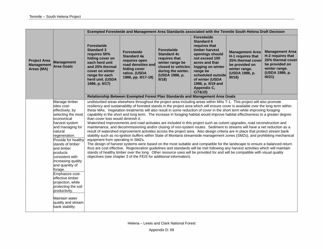
Tenmile – South Helena Project
Helena – Lewis and Clark National Forest
Appendix D: 69
Project Area Management Areas (MA)
Management Area Goals
Exempted Forestwide and Management Area Standards associated with the Tenmile South Helena Draft Decision
Forestwide Standard 3 requires 50% hiding cover on each herd unit and 25% thermal cover on winter range for each herd unit. (USDA 1986, p. II/17)
Forestwide Standard 4a requires open road densities and hiding cover ratios. (USDA 1986, pp. II/17-18)
Forestwide Standard 4c requires that winter range be closed to vehicles during the winter. (USDA 1986, p. II/18)
Forestwide Standard 6 requires that timber harvest openings should not exceed 100 acres and that logging on winter range be scheduled outside of winter (USDA 1986, p. II/19 and Appendix C, C/7&10)
Management Area H-1 requires that 25% thermal cover be provided on winter range. (USDA 1986, p. III/18)
Management Area H-2 requires that 25% thermal cover be provided on winter range. (USDA 1986, p. III/21)
Relationship Between Exempted Forest Plan Standards and Management Area Goals Manage timber sites cost-effectively, by selecting the most economical harvest system and managing for natural regeneration.
undisturbed areas elsewhere throughout the project area including areas within MAs T-1. This project will also promote resiliency and sustainability of forested stands in the project area which will ensure cover is available over the long term within these MAs. Vegetation treatments will also result in some reduction of cover in the short term while improving foraging capability in the short and long term. The increase in foraging habitat would improve habitat effectiveness to a greater degree than cover loss would diminish it. Watershed improvements and road activates are included in this project such as culvert upgrades, road reconstruction and maintenance, and decommissioning and/or closing of non-system routes. Sediment to streams will have a net reduction as a result of watershed improvement activities across the project area. Also design criteria are in place that protect stream bank stability such as no-ignition buffers within State of Montana streamside management zones (SMZs), and prohibiting mechanical equipment from operating in SMZs. The design of harvest systems were based on the most suitable and compatible for the landscape to ensure a balanced return thus are cost effective. Regeneration guidelines and standards will be met following any harvest activities which will maintain stands of healthy timber over the long. Other resource uses will be provided for and will be compatible with visual quality objectives (see chapter 3 of the FEIS for additional information).
Provide for healthy stands of timber and timber products consistent with increasing quality and quantity of forage. Emphasize cost-effective timber projection, while protecting the soil productivity.
Maintain water quality and stream bank stability.
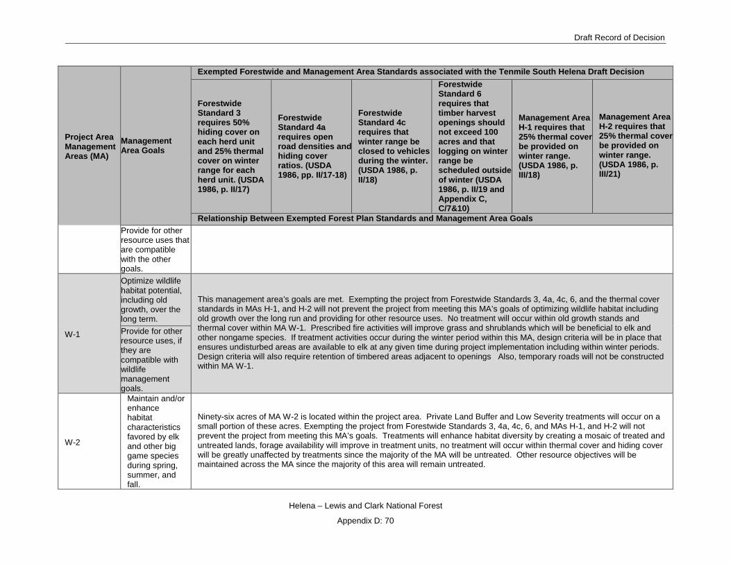
Draft Record of Decision
Helena – Lewis and Clark National Forest
Appendix D: 70
Project Area Management Areas (MA)
Management Area Goals
Exempted Forestwide and Management Area Standards associated with the Tenmile South Helena Draft Decision
Forestwide Standard 3 requires 50% hiding cover on each herd unit and 25% thermal cover on winter range for each herd unit. (USDA 1986, p. II/17)
Forestwide Standard 4a requires open road densities and hiding cover ratios. (USDA 1986, pp. II/17-18)
Forestwide Standard 4c requires that winter range be closed to vehicles during the winter. (USDA 1986, p. II/18)
Forestwide Standard 6 requires that timber harvest openings should not exceed 100 acres and that logging on winter range be scheduled outside of winter (USDA 1986, p. II/19 and Appendix C, C/7&10)
Management Area H-1 requires that 25% thermal cover be provided on winter range. (USDA 1986, p. III/18)
Management Area H-2 requires that 25% thermal cover be provided on winter range. (USDA 1986, p. III/21)
Relationship Between Exempted Forest Plan Standards and Management Area Goals Provide for other resource uses that are compatible with the other goals.
W-1
Optimize wildlife habitat potential, including old growth, over the long term.
This management area’s goals are met. Exempting the project from Forestwide Standards 3, 4a, 4c, 6, and the thermal cover standards in MAs H-1, and H-2 will not prevent the project from meeting this MA’s goals of optimizing wildlife habitat including old growth over the long run and providing for other resource uses. No treatment will occur within old growth stands and thermal cover within MA W-1. Prescribed fire activities will improve grass and shrublands which will be beneficial to elk and other nongame species. If treatment activities occur during the winter period within this MA, design criteria will be in place that ensures undisturbed areas are available to elk at any given time during project implementation including within winter periods. Design criteria will also require retention of timbered areas adjacent to openings Also, temporary roads will not be constructed within MA W-1.
Provide for other resource uses, if they are compatible with wildlife management goals.
W-2
Maintain and/or enhance habitat characteristics favored by elk and other big game species during spring, summer, and fall.
Ninety-six acres of MA W-2 is located within the project area. Private Land Buffer and Low Severity treatments will occur on a small portion of these acres. Exempting the project from Forestwide Standards 3, 4a, 4c, 6, and MAs H-1, and H-2 will not prevent the project from meeting this MA’s goals. Treatments will enhance habitat diversity by creating a mosaic of treated and untreated lands, forage availability will improve in treatment units, no treatment will occur within thermal cover and hiding cover will be greatly unaffected by treatments since the majority of the MA will be untreated. Other resource objectives will be maintained across the MA since the majority of this area will remain untreated.
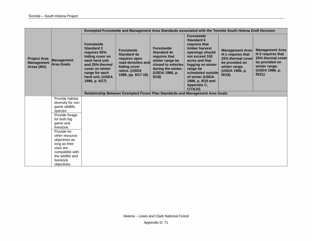
Tenmile – South Helena Project
Helena – Lewis and Clark National Forest
Appendix D: 71
Project Area Management Areas (MA)
Management Area Goals
Exempted Forestwide and Management Area Standards associated with the Tenmile South Helena Draft Decision
Forestwide Standard 3 requires 50% hiding cover on each herd unit and 25% thermal cover on winter range for each herd unit. (USDA 1986, p. II/17)
Forestwide Standard 4a requires open road densities and hiding cover ratios. (USDA 1986, pp. II/17-18)
Forestwide Standard 4c requires that winter range be closed to vehicles during the winter. (USDA 1986, p. II/18)
Forestwide Standard 6 requires that timber harvest openings should not exceed 100 acres and that logging on winter range be scheduled outside of winter (USDA 1986, p. II/19 and Appendix C, C/7&10)
Management Area H-1 requires that 25% thermal cover be provided on winter range. (USDA 1986, p. III/18)
Management Area H-2 requires that 25% thermal cover be provided on winter range. (USDA 1986, p. III/21)
Relationship Between Exempted Forest Plan Standards and Management Area Goals Provide habitat diversity for non game wildlife species. Provide forage for both big game and livestock. Provide for other resource objectives as long as their uses are compatible with the wildlife and livestock objectives.

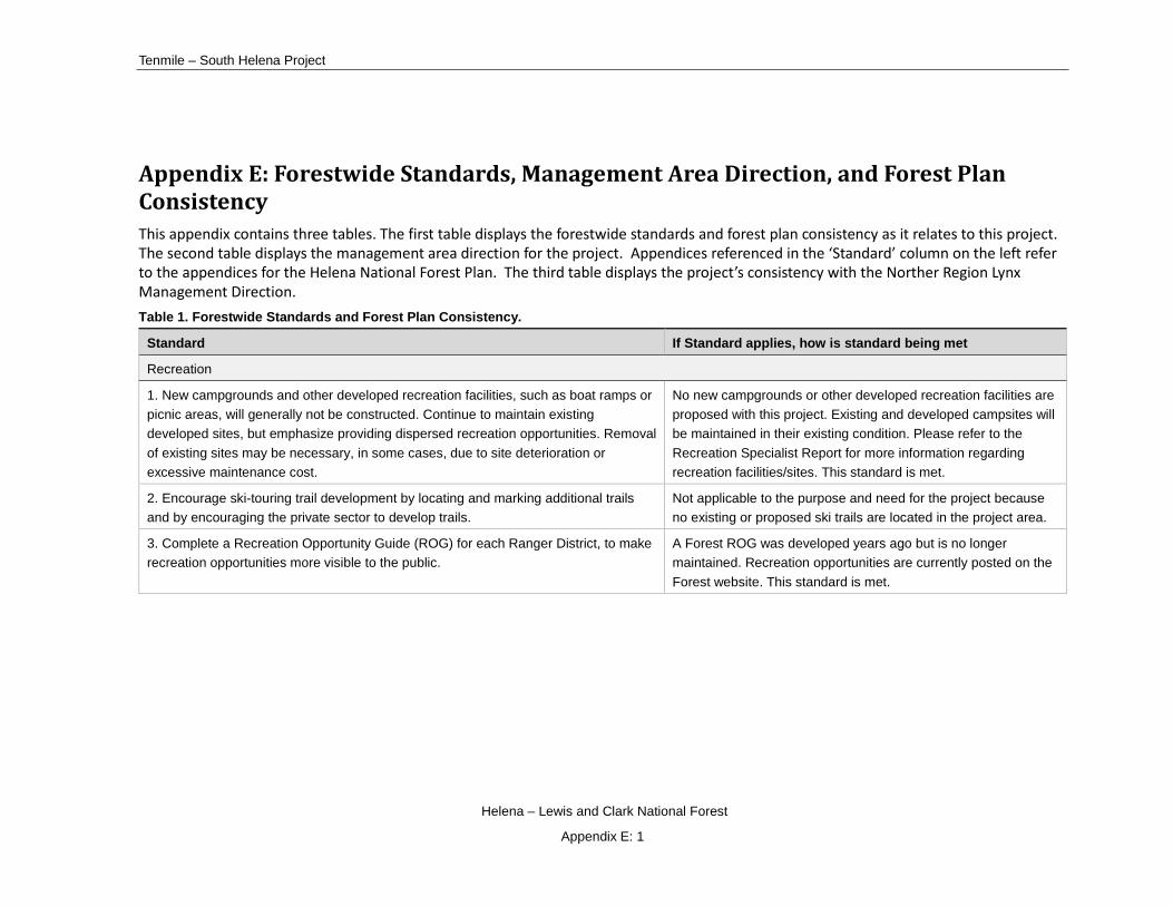
Tenmile – South Helena Project
Helena – Lewis and Clark National Forest
Appendix E: 1
Appendix E: Forestwide Standards, Management Area Direction, and Forest Plan Consistency This appendix contains three tables. The first table displays the forestwide standards and forest plan consistency as it relates to this project. The second table displays the management area direction for the project. Appendices referenced in the ‘Standard’ column on the left refer to the appendices for the Helena National Forest Plan. The third table displays the project’s consistency with the Norther Region Lynx Management Direction. Table 1. Forestwide Standards and Forest Plan Consistency.
Standard If Standard applies, how is standard being met
Recreation
1. New campgrounds and other developed recreation facilities, such as boat ramps or picnic areas, will generally not be constructed. Continue to maintain existing developed sites, but emphasize providing dispersed recreation opportunities. Removal of existing sites may be necessary, in some cases, due to site deterioration or excessive maintenance cost.
No new campgrounds or other developed recreation facilities are proposed with this project. Existing and developed campsites will be maintained in their existing condition. Please refer to the Recreation Specialist Report for more information regarding recreation facilities/sites. This standard is met.
2. Encourage ski-touring trail development by locating and marking additional trails and by encouraging the private sector to develop trails.
Not applicable to the purpose and need for the project because no existing or proposed ski trails are located in the project area.
3. Complete a Recreation Opportunity Guide (ROG) for each Ranger District, to make recreation opportunities more visible to the public.
A Forest ROG was developed years ago but is no longer maintained. Recreation opportunities are currently posted on the Forest website. This standard is met.

Draft Record of Decision
Helena – Lewis and Clark National Forest
Appendix E: 2
Standard If Standard applies, how is standard being met
4. A specific Continental Divide National Scenic Trail (CDNST) route will not be identified prior to approval of the comprehensive plan being prepared by the Forest Service and the Secretary of Agriculture's Advisory Council. Once the comprehensive plan is approved, the management direction will be incorporated further in this plan. Based on the Comprehensive Plan, a more detailed analysis will be completed to show trail segments, objectives and specific route locations. The legislation authorizing the CDNST specifically intended that the trail would not adversely affect or preclude the application of normal management practices on lands adjacent to or within the trail corridor (both public and private). It is not the intent of the legislation that a separate "management plan" be developed for the CDNST, but to provide for the development and management of the trail as a management practice which is integrated into the overall prescription for the land through which the trail passes.
Not applicable to the purpose and need for the Tenmile – South Helena project because the intent of the project does not include amending or incorporating into the Helena National Forest Plan (1986) management direction for the CDNST.
5. Emphasize "Pack-In Pack-Out" use in dispersed recreation areas and in wilderness to reduce resource impacts and management costs.
Not applicable to the Tenmile South Helena Project, although, this is done via Frontline and recreation Forest personnel.
6. Provide information to users of remote areas and wilderness about potential conflicts with humans and bears and proper camping methods to avoid such conflicts.
Not applicable to the Tenmile South Helena Project, although, this is done via Frontline and recreation Forest personnel.
7. Outfitter and guide use will generally be maintained at a level determined from the highest 2 years of actual use experienced during the period l979 through l983. Application for additional or new use will be considered on a case-by-case basis, with consideration of resource limitations and public need.
Not applicable to the Tenmile South Helena Project, because no outfitter and guide usage is proposed for consideration with this project.
Visuals
1. A visual quality objective (VQO) is stated for each management area. These visual quality objectives provide the guidelines for altering the landscape. Portions of each management area may have a more or less restrictive VQO. Appendix B lists roads, trails, campgrounds, etc., that are within sensitive viewing areas. The VQO for these areas is noted in Appendix B. The VQO's for the Continental Divide National Scenic Trail will be the same as the Management Areas through which the trail passes.
Implementation of this draft decision will be consistent with the 1986 Helena National Forest Plan. By implementing the design criteria for the project, VQOs for maximum modification, modification, partial retention, and retention will be met.
Proposed landings, temporary roads, skyline corridors, and, skid trails in areas with VQOs of retention and partial retention will meet VQO standards but not immediately upon implementation of activities. However, design criteria will minimize any short-term
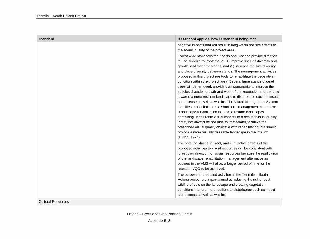
Tenmile – South Helena Project
Helena – Lewis and Clark National Forest
Appendix E: 3
Standard If Standard applies, how is standard being met negative impacts and will result in long –term positive effects to the scenic quality of the project area.
Forest-wide standards for Insects and Disease provide direction to use silvicultural systems to: (1) improve species diversity and growth, and vigor for stands, and (2) increase the size diversity and class diversity between stands. The management activities proposed in this project are tools to rehabilitate the vegetative condition within the project area. Several large stands of dead trees will be removed, providing an opportunity to improve the species diversity, growth and vigor of the vegetation and trending towards a more resilient landscape to disturbance such as insect and disease as well as wildfire. The Visual Management System identifies rehabilitation as a short-term management alternative. “Landscape rehabilitation is used to restore landscapes containing undesirable visual impacts to a desired visual quality. It may not always be possible to immediately achieve the prescribed visual quality objective with rehabilitation, but should provide a more visually desirable landscape in the interim” (USDA, 1974).
The potential direct, indirect, and cumulative effects of the proposed activities to visual resources will be consistent with forest plan direction for visual resources because the application of the landscape rehabilitation management alternative as outlined in the VMS will allow a longer period of time for the retention VQO to be achieved.
The purpose of proposed activities in the Tenmile – South Helena project are impart aimed at reducing the risk of post wildfire effects on the landscape and creating vegetation conditions that are more resilient to disturbance such as insect and disease as well as wildfire.
Cultural Resources
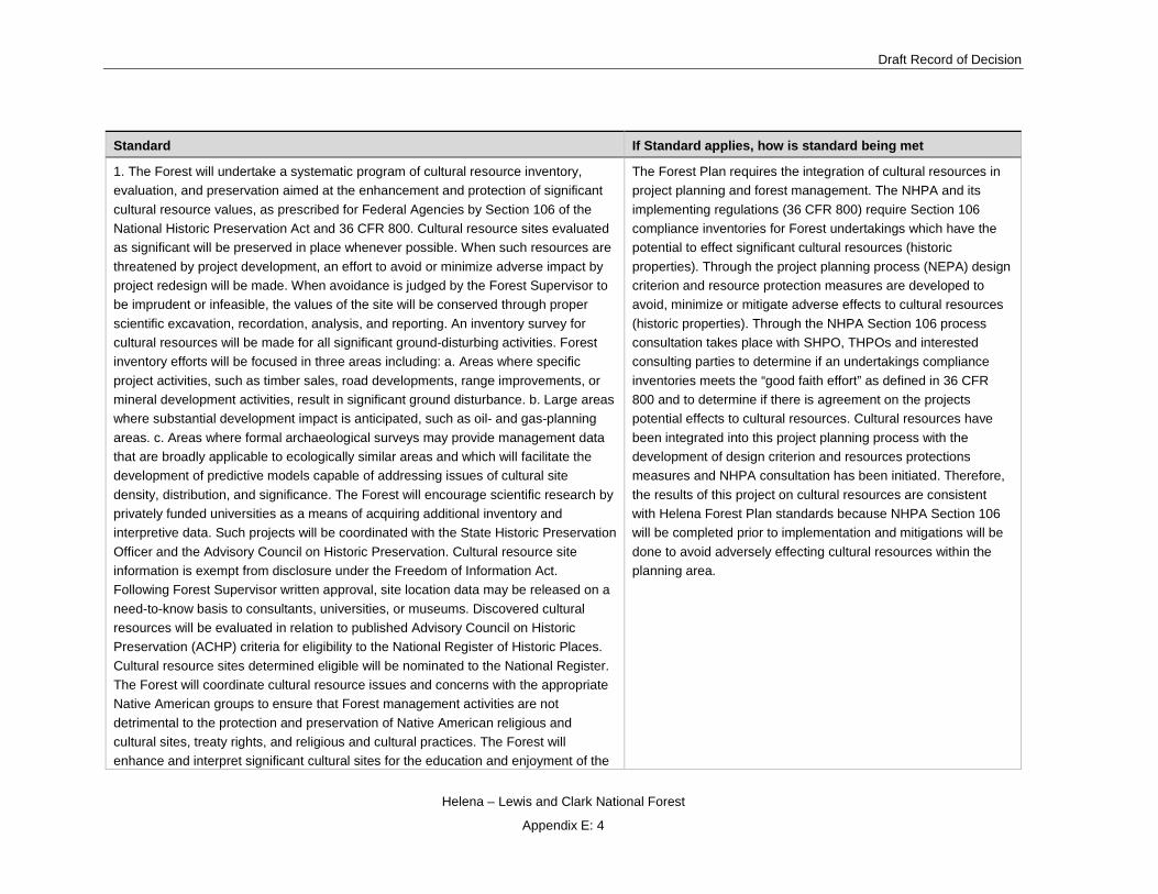
Draft Record of Decision
Helena – Lewis and Clark National Forest
Appendix E: 4
Standard If Standard applies, how is standard being met
1. The Forest will undertake a systematic program of cultural resource inventory, evaluation, and preservation aimed at the enhancement and protection of significant cultural resource values, as prescribed for Federal Agencies by Section 106 of the National Historic Preservation Act and 36 CFR 800. Cultural resource sites evaluated as significant will be preserved in place whenever possible. When such resources are threatened by project development, an effort to avoid or minimize adverse impact by project redesign will be made. When avoidance is judged by the Forest Supervisor to be imprudent or infeasible, the values of the site will be conserved through proper scientific excavation, recordation, analysis, and reporting. An inventory survey for cultural resources will be made for all significant ground-disturbing activities. Forest inventory efforts will be focused in three areas including: a. Areas where specific project activities, such as timber sales, road developments, range improvements, or mineral development activities, result in significant ground disturbance. b. Large areas where substantial development impact is anticipated, such as oil- and gas-planning areas. c. Areas where formal archaeological surveys may provide management data that are broadly applicable to ecologically similar areas and which will facilitate the development of predictive models capable of addressing issues of cultural site density, distribution, and significance. The Forest will encourage scientific research by privately funded universities as a means of acquiring additional inventory and interpretive data. Such projects will be coordinated with the State Historic Preservation Officer and the Advisory Council on Historic Preservation. Cultural resource site information is exempt from disclosure under the Freedom of Information Act. Following Forest Supervisor written approval, site location data may be released on a need-to-know basis to consultants, universities, or museums. Discovered cultural resources will be evaluated in relation to published Advisory Council on Historic Preservation (ACHP) criteria for eligibility to the National Register of Historic Places. Cultural resource sites determined eligible will be nominated to the National Register. The Forest will coordinate cultural resource issues and concerns with the appropriate Native American groups to ensure that Forest management activities are not detrimental to the protection and preservation of Native American religious and cultural sites, treaty rights, and religious and cultural practices. The Forest will enhance and interpret significant cultural sites for the education and enjoyment of the
The Forest Plan requires the integration of cultural resources in project planning and forest management. The NHPA and its implementing regulations (36 CFR 800) require Section 106 compliance inventories for Forest undertakings which have the potential to effect significant cultural resources (historic properties). Through the project planning process (NEPA) design criterion and resource protection measures are developed to avoid, minimize or mitigate adverse effects to cultural resources (historic properties). Through the NHPA Section 106 process consultation takes place with SHPO, THPOs and interested consulting parties to determine if an undertakings compliance inventories meets the “good faith effort” as defined in 36 CFR 800 and to determine if there is agreement on the projects potential effects to cultural resources. Cultural resources have been integrated into this project planning process with the development of design criterion and resources protections measures and NHPA consultation has been initiated. Therefore, the results of this project on cultural resources are consistent with Helena Forest Plan standards because NHPA Section 106 will be completed prior to implementation and mitigations will be done to avoid adversely effecting cultural resources within the planning area.

Tenmile – South Helena Project
Helena – Lewis and Clark National Forest
Appendix E: 5
Standard If Standard applies, how is standard being met public when such development will not degrade the cultural property or conflict with other resource considerations. Known significant cultural resource sites on the Forest will be protected from inadvertent or intentional damage or destruction. Portions of the Lewis and Clark National Historic Trail are on the Helena Forest. Some interpretive signing has been placed along the trail. Normal management practices can still access land adjacent to or within the trail corridor, however, project activities will be conducted to minimize disturbance to the cultural site.
Wildlife and Fish Indicator Species
1. Populations of wildlife "indicator species" will be monitored to measure the effect of management activities on representative wildlife habitats with the objective of ensuring that viable populations of existing native and desirable non-native plant and animal species are maintained. See Chapter IV, part D Monitoring and Evaluation for specific monitoring requirements. Indicator species have been identified for those species groups whose habitat is most likely to be changed by Forest management activities. The mature tree dependent group indicator species is the marten; the old growth dependent group is represented by the pileated woodpecker and the goshawks; the snag dependent species group is represented by the hairy woodpecker; the threatened and endangered species include grizzly bear, gray wolf, bald eagle and peregrine falcon; commonly hunted indicator species are elk, mule deer and bighorn sheep; fish indicator species is the cutthroat trout.
Westslope cutthroat trout (WCT) are an indicator species. The Tenmile - South Helena Project Fisheries Specialist Report and Biological Evaluation analyzed and measured potential effects of the project on this indicator species. However, WCT are not known to be present in any streams in the project area.
Monitoring element C7 focuses on pileated woodpeckers, among other species. Pileated woodpeckers were chosen as a management indicator species (MIS) because they were the largest primary excavator on the Helena National Forest. Pileated woodpeckers were also chosen as an MIS species because they have the most restrictive requirements in terms of snag size of any cavity nester on the Forest. Forest Plan Standards applicable to pileated woodpeckers are those that provide thresholds for snags. Out-year monitoring will occur in the project as part of Forest Plan monitoring specific to element C7.
Monitoring element C7 focuses on northern goshawks, among other species. The northern goshawk was chosen as an MIS species for old growth due to the diverse prey base and nesting habitat commonly found in late-successional forests. Dispersion of late-successional habitat throughout the Forest was considered important for goshawks although recent science has shown that goshawks also make use of a wide variety of habitats

Draft Record of Decision
Helena – Lewis and Clark National Forest
Appendix E: 6
Standard If Standard applies, how is standard being met so long as a diverse prey base is present along with mature trees for nesting. Out-year monitoring will occur in the project as part of Forest Plan monitoring specific to element C7.
Monitoring element C7 focuses on hairy woodpeckers, among other species. Hairy woodpeckers have wide ecological amplitude in terms of nesting and foraging. Hairy woodpeckers are abundant across the Forest. Forest Plan Standards applicable to hairy woodpeckers are those that provide thresholds for snags. Out-year monitoring will occur in the project as part of Forest Plan monitoring specific to element C7.
Monitoring element C8 focuses on martens. Martens were chosen as a management indicator species (MIS) because they are associated with mesic mature and late-successional forests. Specifically, they require at least 25% canopy cover and generally avoid large openings. Consequently, they are sensitive to management actions. Furthermore, because they are predators they are good indicators of ecosystem health due to their position on the food chain. According to the Forest Plan EIS, Appendix B (p. B/68), old growth requirements of the Forest Plan are intended to provide the minimum management requirements for several species including martens. Forest Plan Standards applicable to martens are those that provide thresholds for snags. Out-year monitoring will occur in the project as part of Forest Plan monitoring specific to element C8.
Viability for MIS species affected by the project is described in the Biological Evaluation section in the wildlife section in Chapter 3 of the FEIS and in the Wildlife Appendices in the FEIS. Also, viability determinations are also provided within the Forest Plan Consistency section for the respective MIS species. Those conclusions show that habitat will remain well-distributed and abundant post project implementation and that viability will not be threatened.
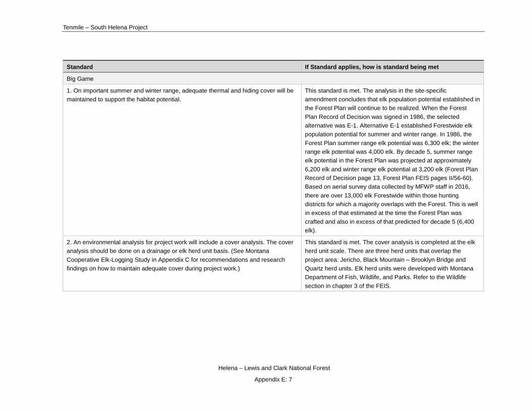
Tenmile – South Helena Project
Helena – Lewis and Clark National Forest
Appendix E: 7
Standard If Standard applies, how is standard being met
Big Game
1. On important summer and winter range, adequate thermal and hiding cover will be maintained to support the habitat potential.
This standard is met. The analysis in the site-specific amendment concludes that elk population potential established in the Forest Plan will continue to be realized. When the Forest Plan Record of Decision was signed in 1986, the selected alternative was E-1. Alternative E-1 established Forestwide elk population potential for summer and winter range. In 1986, the Forest Plan summer range elk potential was 6,300 elk; the winter range elk potential was 4,000 elk. By decade 5, summer range elk potential in the Forest Plan was projected at approximately 6,200 elk and winter range elk potential at 3,200 elk (Forest Plan Record of Decision page 13, Forest Plan FEIS pages II/56-60). Based on aerial survey data collected by MFWP staff in 2016, there are over 13,000 elk Forestwide within those hunting districts for which a majority overlaps with the Forest. This is well in excess of that estimated at the time the Forest Plan was crafted and also in excess of that predicted for decade 5 (6,400 elk).
2. An environmental analysis for project work will include a cover analysis. The cover analysis should be done on a drainage or elk herd unit basis. (See Montana Cooperative Elk-Logging Study in Appendix C for recommendations and research findings on how to maintain adequate cover during project work.)
This standard is met. The cover analysis is completed at the elk herd unit scale. There are three herd units that overlap the project area: Jericho, Black Mountain – Brooklyn Bridge and Quartz herd units. Elk herd units were developed with Montana Department of Fish, Wildlife, and Parks. Refer to the Wildlife section in chapter 3 of the FEIS.

Draft Record of Decision
Helena – Lewis and Clark National Forest
Appendix E: 8
Standard If Standard applies, how is standard being met
Big Game 3. Subject to hydrologic and other resource constraints, elk summer range will be maintained at 35 percent or greater hiding cover and areas of winter range will be maintained at 25 percent or greater thermal cover in drainages or elk herd units.
Big game standard 3 (HFP, p. II/17) requires that hiding cover on elk summer range be maintained at or above 35 percent (or, on in this case, 50 percent crown closure using the MFWP criterion). Hiding cover must be in blocks of at least 40 acres to be tallied as Forest Plan hiding cover. The draft decision will result in the reduction of hiding cover but only the Black Mountain-Brooklyn Bridge herd unit will drop below Forest Plan thresholds for the draft decision.
Standard 3 also requires that thermal cover on winter range be maintained at or about 25 percent in blocks of at least 15 acres. Under Alternative 1, none of the herd units meets the thermal cover portion of this standard. The draft decision will further reduce thermal cover on winter range in all three EHUs and reduce the winter range thermal cover such that all EHUs will be further out of compliance with standard 3, thermal cover. A site-specific exemption to this standard is required.

Tenmile – South Helena Project
Helena – Lewis and Clark National Forest
Appendix E: 9
Standard If Standard applies, how is standard being met
Big Game 4. Implement an aggressive road management program to maintain or improve big game security. To decide which roads, trails, and areas should be restricted and opened, the Forest will use the following guidelines developed with the Montana Department of Fish, Wildlife, and Parks (MDFWP). The Forest visitor map will document the road management program.
4a. Road management will be implemented to at least maintain big game habitat capability and hunting opportunity. To provide for a first week bull elk harvest that does not exceed 40 percent of the total bull harvest, roads will be managed during the general big game hunting season to maintain open road densities with the following limits.
Existing Percent Hiding cover (according to FS definition of hiding cover) (1)
Existing Percent Hiding Cover (according to MDFWP definition of hiding cover) (2) Max Open Road Density
56 80 2.4 mi/mi (2)
49 70 1.9 mi/mi (2)
42 60 1.2 mi/mi (2)
35 50 0.1 mi/mi (2)
(1) A timber stand which conceals 90 percent or more of a standing elk at 200 feet.
(2) A stand of coniferous trees having a crown closure of greater than 40 percent.
The existing hiding cover to open road density ratio should be determined over a large geographic area, such as a timber sale analysis area, a third order drainage, or an elk herd unit.
Big game standard 4(a) (HFP, p. II/17-18) requires implementation of an aggressive road management program to maintain or improve big game security (habitat capability and hunting opportunity). This standard is not met under the no action alternative in the Quartz EHU, and is met for the other EHUs. Under the draft decision only the Jericho EHU will meet the standard. A site-specific exemption to the standard is required.

Draft Record of Decision
Helena – Lewis and Clark National Forest
Appendix E: 10
Standard If Standard applies, how is standard being met
Big Game 4b. Elk calving grounds and nursery areas will be closed to motorized vehicles during peak use by elk. Calving is usually in late May through mid-June and nursery areas are used in late June through July.
Forest Plan standard 4(b) requires that elk calving grounds and nursery areas be closed to motorized vehicles during peak use by elk. This is usually from late May through July. While the project area has not been mapped by MFWP or the Forest as a calving ground/nursery area, some calving probably occurs around the meadows and heads of drainages in the project area. Elk with calves probably remain in the general area during the nursing period. A number of roads in and around the project area have been open to public vehicles for several decades without problems for calf production and survival. The temporary roads planned for the project will not be open to public use. Project operations will not occur during the calving season if calving areas have been identified. If nursery sites are discovered during the course of the project, operations will be modified to avoid the sensitive areas. The draft decision will be consistent with this standard.
4c. All winter range areas will be closed to vehicles between December 1 and May 15. Exceptions (i.e., access through the winter range to facilitate land management or public use activities on other lands) may be granted.
Forest Plan standard 4(c) (HFP, p. II/18) requires that all winter ranges will be closed to vehicles between December 1 and May 15. The draft decision include treatments during the winter in winter range. A site-specific exemption to the standard has been prepared and is located in the wildlife section in Chapter 3 in the FEIS.
4d. At restricted roads, trails, and areas, signs will be posted which tell:
1. Type of restriction.
2. Reason for restriction.
3. Time period of restriction.
4. Cooperating agencies.
This standard is met. All restricted roads, trails, and areas are posted and continually reposted with this information. All roads that are constructed as a part of the project will be posted with the appropriate restriction.
4e. Roads that will be closed will be signed during construction or reconstruction telling the closure date and the reason for closure.
Roads that are closed as part of project implementation will be signed with closure dates and purpose of closure.

Tenmile – South Helena Project
Helena – Lewis and Clark National Forest
Appendix E: 11
Standard If Standard applies, how is standard being met
4f. Enforcement is a shared responsibility. Enforcement needs will be coordinated with the MDFWP.
This standard is met as enforcement is coordinated with MDFWP.
4g. Opened Forest roads will normally have a designed speed of less than 15 miles per hour. Exact design speeds will be determined through project planning. Loop roads are not recommended and will be avoided in most cases.
This standard is met. No loop roads are proposed with this project.
Big Game 4h. The Forest Road Management Program will be developed in conjunction with MDFWP and interested groups or individuals. The Road Management Program will contain the specific seasonal and yearlong road, trail, and area restrictions and will be based on the goals and objectives of the management areas in Chapter III of the Forest Plan.
The standard is met. Several miles of roads closed through the Divide Travel Plan decision will be decommissioned in the draft decision. Otherwise the project does not propose any changes to the current Forest’s road management program.
4i. Representatives from the Helena Forest and MDFWP will meet annually to review the existing Travel Plan.
This standard is not applicable because the Tenmile – South Helena project does not propose any travel management changes. Annual meetings with MDFWP is out of the scope of this project, however, roads within the project area along with other forest roads will be reviewed annually with MDFWP.
5. On elk summer range the minimum size area for hiding cover will be 40 acres and the minimum size area on winter range for thermal cover will be l5 acres.
Thermal and hiding cover have been modeled according to the Criteria for Wildlife Models Helena National Forest that specifies patch size as 40 acres for hiding cover and 15 acres for thermal cover. The standard is met.
6. Montana Cooperative Elk-Logging Study Recommendations, in Appendix C, will be followed during timber sale and road construction projects.
Forest Plan standard 6 (Forest Plan II/19 and C/1 -11) requires that the recommendations embodied in the Montana Cooperative Elk-Logging study (Appendix C of the Forest Plan) be followed during timber sale and road construction projects. There are a total of eleven recommendations some of which have been incorporated as design criteria. The following discussion describes the project’s consistency with each of the eleven recommendations.
Security during logging operations – The draft decision is consistent with this recommendation. Design criteria have been incorporated that confine logging to a single drainage at a time to

Draft Record of Decision
Helena – Lewis and Clark National Forest
Appendix E: 12
Standard If Standard applies, how is standard being met minimize disturbance to elk. Also, logging activities will be completed in the shortest time frame possible. Use of firearms will be prohibited for anyone working within an area closed to the general public.
Redistribution of elk – The draft decision is consistent with this recommendation which requires that timber sales be planned in a manner that does not redistribute elk onto adjacent or nearby property. Management challenges associated with HDs 215 and 335 do include redistribution of elk to private land (MFWP 2005a, pp. 190-193). The redistribution of elk that is currently occurring in HDs 215 and 335 will not be exacerbated by the draft decision.
Traditional home range use by elk – This recommendation is intended to ensure that timber harvest and road construction are planned to minimize impacts to elk and elk hunting. The draft decision is consistent with this recommendation since all temporary roads will be closed to the public during logging operations and decommissioned post-implementation.
Road construction and design – This recommendation is intended to maintain the integrity of elk movement patterns and provide security for unimpeded movement. The draft decision is consistent with this recommendation in so far as security will remain the same post-implementation and all temporary roads will be closed to the public during implementation and decommissioned afterwards. There may be some temporary disruption to traditional movement patterns; however, ample blocks of unroaded areas exist that will provide alternative travel ways.
Road management – This recommendation is also intended to maintain elk security through management of road densities. Implementation of the draft decision does not affect open road placement.

Tenmile – South Helena Project
Helena – Lewis and Clark National Forest
Appendix E: 13
Standard If Standard applies, how is standard being met Area closures during the hunting season – This recommendation is intended to ensure that travel restrictions are carefully considered relative to elk management objectives so that hunting opportunities aren’t unnecessarily impacted. This recommendation is not applicable to the Tenmile South Helena project.
Clearcuts – This recommendation is intended to ensure that forage produced through clear-cutting is available to elk and includes two considerations – slash depth and opening size. The draft decision is consistent with the slash depth consideration since slash clean up inside clearcuts will be reduced to less than 1.5 feet and all temporary roads will be closed to the public. Several openings - or groups of openings - will be larger than 100 acres. A site-specific exemption to the standard has been prepared and is located in the wildlife section in Chapter 3 in the FEIS.
Cover type – This recommendation is intended to ensure that cover types, important to elk, are considered during planning and implementation of silvicultural practices. The draft decision is consistent with this recommendation since cover type data are available Forestwide (via R1-VMap) and have been utilized for the Tenmile South Helena project to identify cover and forage.
Moist sites – This recommendation is intended to ensure that the integrity of moist sites is maintained since these areas comprise important components of elk habitat. Design criteria have been developed to retain green trees, standing snags, and coarse woody debris in and around the fringes of those sites that occur in treatment units. This should preserve their utility for elk and other wide-ranging species as well as for smaller resident mammals, birds, and amphibians.
Elk/cattle relationships – This recommendation is intended to ensure that forage created as a result of timber harvest remain
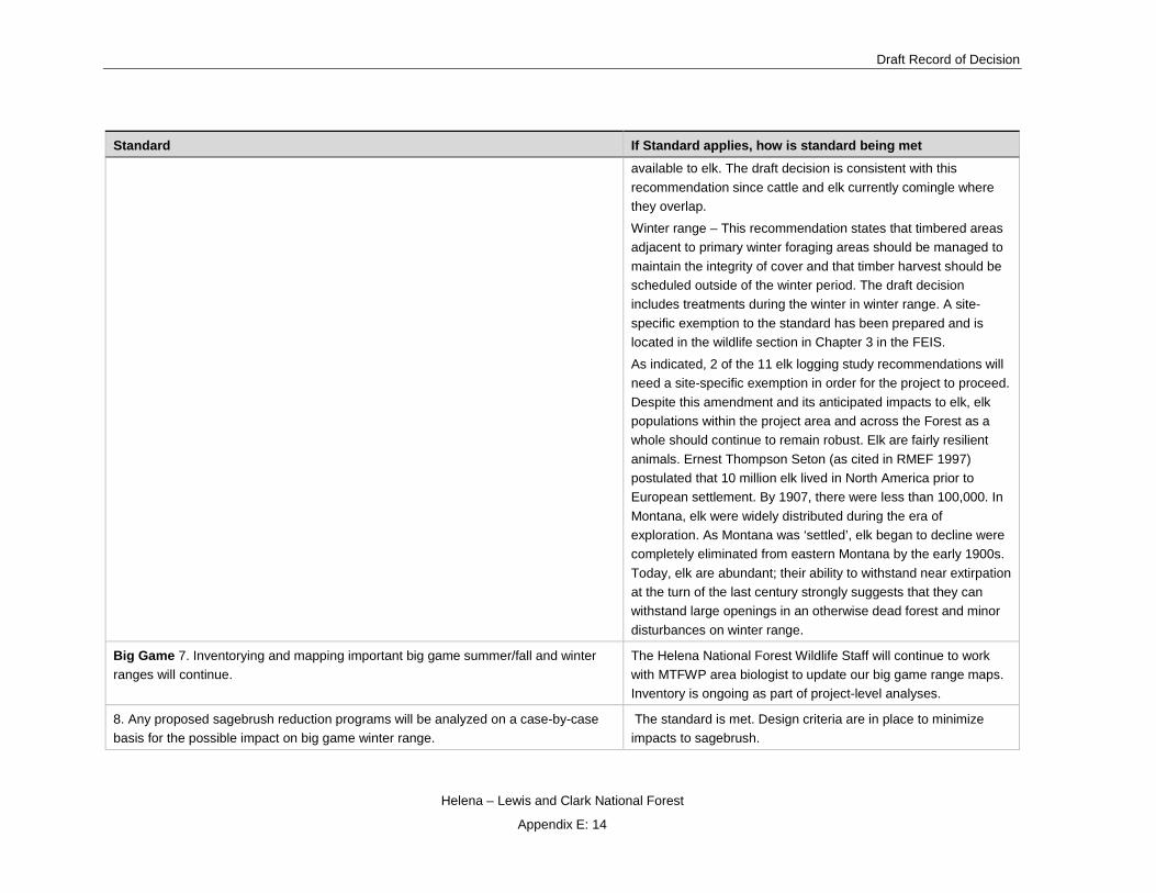
Draft Record of Decision
Helena – Lewis and Clark National Forest
Appendix E: 14
Standard If Standard applies, how is standard being met available to elk. The draft decision is consistent with this recommendation since cattle and elk currently comingle where they overlap.
Winter range – This recommendation states that timbered areas adjacent to primary winter foraging areas should be managed to maintain the integrity of cover and that timber harvest should be scheduled outside of the winter period. The draft decision includes treatments during the winter in winter range. A site-specific exemption to the standard has been prepared and is located in the wildlife section in Chapter 3 in the FEIS.
As indicated, 2 of the 11 elk logging study recommendations will need a site-specific exemption in order for the project to proceed. Despite this amendment and its anticipated impacts to elk, elk populations within the project area and across the Forest as a whole should continue to remain robust. Elk are fairly resilient animals. Ernest Thompson Seton (as cited in RMEF 1997) postulated that 10 million elk lived in North America prior to European settlement. By 1907, there were less than 100,000. In Montana, elk were widely distributed during the era of exploration. As Montana was ‘settled’, elk began to decline were completely eliminated from eastern Montana by the early 1900s. Today, elk are abundant; their ability to withstand near extirpation at the turn of the last century strongly suggests that they can withstand large openings in an otherwise dead forest and minor disturbances on winter range.
Big Game 7. Inventorying and mapping important big game summer/fall and winter ranges will continue.
The Helena National Forest Wildlife Staff will continue to work with MTFWP area biologist to update our big game range maps. Inventory is ongoing as part of project-level analyses.
8. Any proposed sagebrush reduction programs will be analyzed on a case-by-case basis for the possible impact on big game winter range.
The standard is met. Design criteria are in place to minimize impacts to sagebrush.

Tenmile – South Helena Project
Helena – Lewis and Clark National Forest
Appendix E: 15
Standard If Standard applies, how is standard being met
9. Occupied bighorn sheep and mountain goat range will be protected during resource activities. Project plans for livestock, timber, or other resource development will include stipulations to avoid or mitigate impacts on their range. Conflicts between livestock and these wildlife species will be resolved in favor of the big game.
This standard does not apply to the Tenmile – South Helena project as bighorn sheep and mountain goats are not present in the project area.
10. Moose habitat will be managed to provide adequate browse species diversity and quantity to support current moose populations.
Effects to moose are addressed through the discussion on effects to Riparian habitat. Treatments that mimic disturbance processes (as in the case of this project) in wetlands and riparian zones are important in maintaining species richness and diversity, both plants and animals. The draft decision is consistent with this standard.
Threatened and Endangered (T&E) Species
1. A biological evaluation will be written for all projects that have potential to impact any T&E species or its habitat. All evaluations will address each projects potential to adversely modify a listed species habitat or behavior. If an adverse impact is determined, mitigation measures will be developed to avoid any adverse modification of a listed species habitat or behavior. If all possible mitigation measures do not result in a no effect determination, then informal and/or formal consultation with the U.S. Fish and Wildlife Service will be initiated.
A biological evaluation has been prepared for this project to assess impacts to both aquatic and terrestrial T&E species. Since mitigation measures do not result in a “no effect” determination, discussions with the U.S. Fish and Wildlife Service have commenced; formal consultation with the U.S. Fish and Wildlife Service will be initiated.
The biological evaluation of terrestrial wildlife species for the Tenmile – South Helena project occurs throughout the body of the wildlife report wherever the different species of concern are addressed as well as in the Biological Evaluation section in the FEIS. These include in detail 2 threatened species (lynx and grizzly bear) and one proposed species (wolverine).
No Threatened or Endangered plant species are known or suspected in the project area.
2. Grizzly bear -- Apply the guidelines in Appendix D to the Management Situation 1 and 2 (referred to essential and occupied prior to 1984) grizzly bear habitat on the Forest (see map in Appendix D).
Initiate field studies in undesignated areas known to be used by grizzlies, to determine if the areas should be designated as grizzly habitat. Until sufficient evidence is
The project area is not in Management Situation 1 and 2. Therefore, this part of the standard does not apply to the Tenmile – South Helena project.

Draft Record of Decision
Helena – Lewis and Clark National Forest
Appendix E: 16
Standard If Standard applies, how is standard being met available to determine the status of these areas, manage them according to Appendix E, Grizzly Management Guidelines Outside of Recovery Areas.
At this time, the size of the local grizzly population is unknown and its status uncertain. All that can be said, based on field observations to this point, is the following:
Population density is very low (only 5 verified occurrences in the general area 2004-2012—although several additional observations are highly credible).
Reproduction is uncommon (4 reports of a sow with cubs since 1991).
The stability and persistence of the current population may be tenuous (since the presence of grizzlies may be indicative of a linkage zone with transient individuals rather than an incipient Biological Activity Center) (HFP, Appendix E). South of U.S. Highway 12, most observations have come from the upper reaches of the Little Blackfoot watershed and along the border between the Helena NF and the Beaverhead-Deerlodge NF (including the upper Cataract and Basin Creek drainages just to the south). The number of credible grizzly bear reports in these areas has been increasing in recent years as the population in the NCDE expands to the point that more bears are exploring new territory further to the south (J. Jonkel, personal communication, 2007). Be that as it may, recent monitoring efforts designed to identify individual grizzlies through DNA analysis of hair samples collected from rub trees (2009-2010) have yet to turn up any sign of the bears south of Highway 12—a further indication of their scarcity in this area.
At this time, the project area is not considered a biological activity center (BAC) because the following criteria for BAC have not been met: Observations [of grizzly bears] must include females with cubs or yearlings at least 5 or the 10 years.
Threatened and Endangered (T&E) Species 3. In occupied grizzly habitat, to minimize man-caused mortality the open road density will not exceed the 1980 density of 0.55 miles per square mile, which was determined to have little effect on habitat capability.
This standard does not apply to the Tenmile – South Helena Project because the project area is outside occupied grizzly bear habitat as defined in the Helena National Forest Plan appendix D.

Tenmile – South Helena Project
Helena – Lewis and Clark National Forest
Appendix E: 17
Standard If Standard applies, how is standard being met
4. Research activity on grizzly bears or their habitat will be reviewed by the Research Subcommittee of the Interagency Grizzly Bear Committee.
Not applicable at this time. Currently, there is no ongoing research on grizzly bears in the project area so this standard is not applicable.
5. Bald Eagle and Peregrine Falcon -- Continue working with the MDFWP, the USFWS, and the BLM to identify nesting and wintering areas. Identify nesting territories and roosting sites, and protect both from adverse habitat alteration. (Guidelines for how to identify bald eagle habitat are in the Wildlife Planning Records.) Powerlines constructed within bald eagle or peregrine falcon habitat will be designed to protect raptors from electrocution. See Appendix D for bald eagle and peregrine falcon habitat maps.
This standard is met because there are no known bald eagles and peregrine falcons nesting territories and/or roosting sites in the project area.
Falcon eyries are located on high cliffs, often near water. Peregrine falcons were extirpated from the Divide landscape in the mid-20th century, and no new occupied eyries have been located in the landscape since the falcons have become re-established in and around the Helena NF (almost entirely in the Big Belt Range) in the early 1990s.
No active bald eagle nests have been located on HNF lands in the Divide landscape since the rejuvenation of local eagle populations over the last 3 decades. All known nests near the landscape are in the Little Blackfoot drainage on private land to the west. Most resident eagles on the Forest are located along the Missouri River in the Big Belt Range and along the Big Blackfoot River.
Threatened and Endangered (T&E) Species 6. Gray Wolf -- With the USFWS and MDFWP, investigate reported gray wolf observations to confirm or deny gray wolf presence. If presence of gray wolf is confirmed, determine if the habitat is necessary for the wolf’s recovery. If the habitat is necessary, coordinate with the MDFWP and the USFWS to implement the Wolf Recovery Plan. See Appendix D for gray wolf habitat map.
Wolves have been delisted based on achievements of recovery goals. Wolves may occur in the project area and are discussed in the Wildlife section in Chapter 3 of the FEIS. This standard is no longer applicable because the wolf has been recovered.
7. No known threatened or endangered plants are on the Helena National Forest. This standard is met. No threatened and endangered plant species are known or suspected to be in the project area.

Draft Record of Decision
Helena – Lewis and Clark National Forest
Appendix E: 18
Standard If Standard applies, how is standard being met
8. Species of Special Concern
There are habitats on the Forest where the following species of special concern may be found (Plant Species of Special Concern, USDA-FS, l980) Lemhi penstemon (Penstemon lemhiensis), Howell's gumweed (Grindelia howellii), Missoula phlox (Phlox missoulensis), Cliff toothwort (Cardamine rupicola). Missoula phlox and cliff toothwort have been located on the Helena Forest.
Other Plants that are termed rare have also been located on the Helena Forest. They are Klaus’ bladderpod (Lesquerella plausii) and Long-styled thistle (Cirsium longistylum). Two additional rare plants, Moschatel (Adoxa moschalellina) and Lesser rushy milkvetch (Astragalus connvallarius) are believed to occur on the Helena Forest but currently have no occurrence records.
If any of these species are verified on the Helena Forest, appropriate measures, pursuant to Section 7 of the Endangered Species Act, will be taken.
The Forest Plan direction for sensitive plants (USDA 1986, II/20) refers to the Endangered Species Act and pertains only to listed species, none of which occur on the Helena National Forest. Therefore, this direction is not applicable at this time. Subsequent guidance from the Regional Office provides direction regarding sensitive plants and their habitats with which the project as proposed is consistent with. This standard is met.
Old Growth
An old growth stand is generally characterized by a high level of standing and down, dead and rotting woody material; two or more levels of tree canopies and a high degree of decadence indicated by heart rot, mistletoe, dead or broken tree tops, and moss.
Five percent of each third order drainage should be managed for old growth. The priority for old growth acres within each drainage is: first, land below 6000 feet in elevation; second, riparian zones and mesic drainage heads; and third, management areas emphasizing wildlife habitat. These areas will normally be managed on a 240-year rotation and will range from 10 acres to several hundred acres.
Management areas other than T-1 through T-5 will be the primary source for old growth. However, if adequate old growth area cannot be achieved then the T management areas will be considered to meet old growth objectives.
This standard applies and is being met with all Alternatives. Approximately 5 percent of each of the third order drainages associated with the project have been designated for old growth management. The designation protocol included consideration of all the priority criteria listed by this standard. The draft decision will treat within a designated old growth stand. Treatments in old growth stands will be minimized and designed to fully maintain, or contribute toward the restoration of, structure and composition of old growth stands, as defined by Green et al. 1992. Refer to the project’s Forest Vegetation section in the FEIS and the project file for more detailed information (USDA 2012c).
Snags
1. To keep an adequate snag resource (standing dead trees) through the planning horizon, snags should be managed at 70 percent of optimum (average of 2 snags/acre) within each third order drainage.
This standard applies and is met in the draft decision. There will be snags well in excess of this level in each third order drainage. See the Forested Vegetation Report.

Tenmile – South Helena Project
Helena – Lewis and Clark National Forest
Appendix E: 19
Standard If Standard applies, how is standard being met
2. Snag management guidelines need not be applied within a quarter mile of riparian areas, because riparian standards should provide for adequate snags.
This standard applies and is being met because riparian standards are being followed with the draft decision.
3. Larch, ponderosa pine, Douglas-fir, spruce, and subalpine fir, in that priority, are the preferred species for snags and replacement trees (live trees left to replace existing snags).
This standard applies and is met. Lodgepole is not specified as a desirable snag species but will account for the majority of snags. Other species are present as well such as Douglas-fir, ponderosa pine, and subalpine fir. Design criteria also include snag retention goals for ponderosa pine, whitebark pine, and Douglas-fir.
Snags 4. Management areas other than T-1 should be the primary source for snag management. However, if adequate snags cannot be found outside of T-1, then the following numbers and sizes of snags should be retained in cutting units, if available.
A. In units with snags, keep a minimum of 20 snags and 10 replacement trees per 10 acres, if available. If 20 snags are not available, then any combination totaling 30 should be left, by the following dbh classes:
13 snags and 6 replacement trees from 7-11 inches
5 snags and 3 replacement trees from 12-19 inches
2 snags and 1 replacement trees 20+ inches
B. In units--except those of pure lodgepole--without snags keep a minimum of 30 wind firm trees per 10 acres, if available, by the following dbh classes:
21 trees from 7-11 inches
7 trees from 12-19 inches
2 trees from 20+ inches
If wildlife funds are available, a third of the replacement trees should be girdled or otherwise killed to provide snags, by the following dbh classes:
7 trees from 7-11 inches dbh
2 trees from 12-19 inches dbh
1 tree from 20+ inches dbh
This standard applies and is being met with this decision. No snags will be cut under the no-action alternative with the exception of ongoing public firewood gathering. Snags are available across multiple management areas in the project area. In the draft decision, snags are primarily provided for outside of treatment units, although snag retention guidelines are prescribed. Also, replacement snags will be provided by green trees of species other than lodgepole that will be retained to the extent possible in regeneration harvest units; and to the desired density of generally the largest and healthiest trees available in improvement harvest units. Refer to the Forested Vegetation section in the FEIS.
Fisheries

Draft Record of Decision
Helena – Lewis and Clark National Forest
Appendix E: 20
Standard If Standard applies, how is standard being met
1. Maintain quality water and habitat for fish by coordinating Forest activities and by direct habitat improvement (see Forest Wide Standards for riparian).
Hydrologic modeling estimates short-term sediment impacts to streams and fisheries resources is typically 1-5 years. Sediment delivery is highest one year post-treatment and nears zero by year-six due to re-establishment of vegetation. Implementation of BMP’s and project specific mitigations under all action alternatives will lessen sediment effects to aquatic resources (road improvements, culvert replacement, road decommissioning, and wetland restoration).
Fisheries 2. Instream activities should allow for maximum protection of spring and fall spawning habitats.
Standard will be met. Instream structures will be limited to existing culvert replacement. No new culverts will be installed as part of this project except where damaged or undersized culverts are proposed for replacement or upgrade resulting in a long-term benefit to fishery resources. BMPs will be in place to minimize impacts to and fish bearing habitat. A summary of design criteria and mitigation measures are included in the Assumptions section of the Fisheries Specialist Report and Biological Evaluation.
3. Structures installed within streams supporting fisheries will be designed to allow upstream fish movement, especially to spawning areas.
Standard will be met. Instream structures will be limited to existing culvert replacement. No new culverts will be installed as part of this project except where damaged or undersized culverts are proposed for replacement or upgrade resulting in a long-term benefit to fishery resources. BMPs will be in place to minimize impacts to and fish bearing habitat. A summary of design criteria and mitigation measures are included in the Assumptions section of the Fisheries Specialist Report and Biological Evaluation.
Range
1. Riparian condition within livestock allotments will be mapped and become part of the Allotment Management Plan.
Standard does not apply to the Tenmile-South Helena project.
2. Where analysis shows range resource damage, the cause will be identified and corrective action will be initiated through an allotment management plan.
Standard does not apply to the Tenmile-South Helena project.

Tenmile – South Helena Project
Helena – Lewis and Clark National Forest
Appendix E: 21
Standard If Standard applies, how is standard being met
3. Chemical spraying should not be used on sagebrush control projects if other control methods are feasible.
Standard does not apply to the Tenmile – South Helena project since no chemical control of sagebrush is planned.
4. Best Management Practices (BMPs) will be used to minimize livestock damage to lakeside soils, stream sides, and other fragile areas.
This standard is met. Design criteria have been developed to address potential effects to soils, stream sides, and other fragile areas from livestock post implementation such as providing a rest period after prescribe burning activities are completed.
5. Allotment management plans will specify the utilization standards of key plant species needed to protect the soil and water quality. Allowable forage utilization of these plants should be based on local range conditions, soil stability, and known individual plant requirements. The guides for allowable utilization of key species, by condition classes, are in the Range Management Handbook (FSH 2209.21).
Standard does not apply to the Tenmile-South Helena project.
6. Allotment Management Plans will be developed using the interdisciplinary process. Standard does not apply to the Tenmile-South Helena project.
Noxious Weeds
1. Implement an integrated weed control program in cooperation with the state of Montana and County Weed Boards to confine present infestations and prevent establishing new areas of noxious weeds. Noxious weeds are listed in the Montana Weed Law and designated by County Weed Boards.
This project incorporates the Helena National Forest Weed Control program. The Helena National Forest Noxious Weed Vegetation Treatment Environmental Impact Statement (USDA Forest Service 2006b) is part of the project file. Addressed by unit and species in design criteria and mitigations. This standard is met.
2. Integrated Pest Management, which uses chemical, biological, and mechanical methods, will be the principal control method. Spot herbicide treatment of identified weeds will be emphasized. Biological control methods will be considered as they become available.
This analysis considers integrated pest management with the estimates of weed spread and control. The Helena National Forest Noxious Weed Vegetation Treatment Environmental Impact Statement (USDA Forest Service 2006b) is part of the project file. This standard is met
3. Funding for weed control on disturbed sites will be provided by the resource which causes the disturbance.
This standard does not apply to the Tenmile – South Helena project.
Revegetation
1. Seeding will be done in a timely manner on disturbed areas, to prevent erosion and to achieve best revegetation results.
Re-vegetation is incorporated into the project design criteria for the project.

Draft Record of Decision
Helena – Lewis and Clark National Forest
Appendix E: 22
Standard If Standard applies, how is standard being met
2. Seeding mixtures of native plants (naturally occurring) should be used, if practical, in all revegetation projects greater than two acres. On smaller disturbances, the responsible official may authorize the use of exotic species.
Recommended certified weed seed free native seed mixtures are included (see noxious weed report appendix A.
3. Seeding guidelines, based on elevation, soil type, parent material, habitat type, and reasonable cost, are listed in Appendix F.
Recommended certified weed seed free native seed mixtures that meet the seeding guidelines are included.
Timber
1. Silvicultural examinations and prescriptions will be required before any timber manipulation or silvicultural treatment takes place. Exceptions include cutting of trees that block vision along roads, cutting hazard trees, clearing right-of-way, clearing for mineral development, minor and incidental amounts of free use, and cutting personal firewood. Final determination of what silvicultural system will be used for a particular project will be made by a certified silviculturist after an on-the-ground site analysis. This site specific analysis will determine the appropriate even or un-even age silvicultural system that best meets the goals and objectives of the management area. Standards for applying all silvicultural systems, as well as supporting research references are in the Northern Region guide (June 10, 1983). In addition, broad guidelines are found in Appendix H and M. Even-aged management methods will be used only where it is determined to be appropriate to meet objectives. Clearcutting will be used only where it is the optimum method.
Silvicultural prescriptions will be prepared prior to any stand manipulation.
Even aged management will be used only where appropriate to meeting project objectives and clearcutting will only be used where it is the optimal method for regenerating the stand as documented in the Silvicultural Prescriptions.
This standard is met.
2. Tree improvement will be conducted in accordance with the current Regional and Forest level tree improvement plans.
Standard does not apply. There is no tree improvement activities proposed as part of this project.
3. Transportation plans and logging systems must be designed jointly to provide for long-term stand management, with full consideration given to topography and slope, the overall economic efficiency of roading and yarding costs, and the needs of other resources.
This has been completed as part of the design of the proposed action and subsequent action alternatives. It is located in the project record. This standard is met.
4. Timber stand openings created by even-aged silvicultural systems will normally be 40 acres or less. Creation of larger openings will require a 60-day public review and Regional Forester approval. Exceptions are listed in the Northern Regional Guide.
This standard applies and is met. Openings over 40 acres will be created but exceptions to the Regional Forester approval process apply due to insect-caused mortality. Refer to Forested Vegetation Specialist Report. This standard is met.
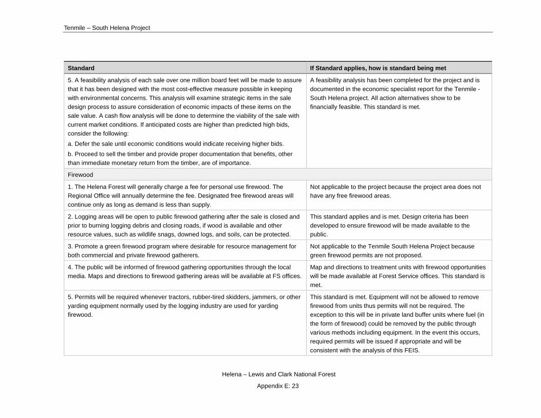
Tenmile – South Helena Project
Helena – Lewis and Clark National Forest
Appendix E: 23
Standard If Standard applies, how is standard being met
5. A feasibility analysis of each sale over one million board feet will be made to assure that it has been designed with the most cost-effective measure possible in keeping with environmental concerns. This analysis will examine strategic items in the sale design process to assure consideration of economic impacts of these items on the sale value. A cash flow analysis will be done to determine the viability of the sale with current market conditions. If anticipated costs are higher than predicted high bids, consider the following:
a. Defer the sale until economic conditions would indicate receiving higher bids.
b. Proceed to sell the timber and provide proper documentation that benefits, other than immediate monetary return from the timber, are of importance.
A feasibility analysis has been completed for the project and is documented in the economic specialist report for the Tenmile - South Helena project. All action alternatives show to be financially feasible. This standard is met.
Firewood
1. The Helena Forest will generally charge a fee for personal use firewood. The Regional Office will annually determine the fee. Designated free firewood areas will continue only as long as demand is less than supply.
Not applicable to the project because the project area does not have any free firewood areas.
2. Logging areas will be open to public firewood gathering after the sale is closed and prior to burning logging debris and closing roads, if wood is available and other resource values, such as wildlife snags, downed logs, and soils, can be protected.
This standard applies and is met. Design criteria has been developed to ensure firewood will be made available to the public.
3. Promote a green firewood program where desirable for resource management for both commercial and private firewood gatherers.
Not applicable to the Tenmile South Helena Project because green firewood permits are not proposed.
4. The public will be informed of firewood gathering opportunities through the local media. Maps and directions to firewood gathering areas will be available at FS offices.
Map and directions to treatment units with firewood opportunities will be made available at Forest Service offices. This standard is met.
5. Permits will be required whenever tractors, rubber-tired skidders, jammers, or other yarding equipment normally used by the logging industry are used for yarding firewood.
This standard is met. Equipment will not be allowed to remove firewood from units thus permits will not be required. The exception to this will be in private land buffer units where fuel (in the form of firewood) could be removed by the public through various methods including equipment. In the event this occurs, required permits will be issued if appropriate and will be consistent with the analysis of this FEIS.

Draft Record of Decision
Helena – Lewis and Clark National Forest
Appendix E: 24
Standard If Standard applies, how is standard being met
6. Providing firewood will be emphasized as a slash treatment method. This standard applies and is met. Firewood gathering opportunities may be utilized as a slash disposal method in treatment units where post-treatment debris exceeds soil coarse woody debris retention guidelines. Refer to the Forested Vegetation and Soils Specialist Reports.
Water, Soil, and Air - Municipal Watershed Guidance
1. Municipal watersheds will be managed under multiple-use concepts and direction. Management area guidelines will identify permissible land uses, restrictions on land uses, and special measures required to ensure a high quality and quantity municipal water supply. Presently, there are two municipal watersheds on the Forest, Tenmile and McClellan.
This standard applies and is met. This project is consistent with management area standards and guidelines.
2. Design and implementation of projects within the watershed will be guided by FSM 2542.12, as well as specific management area standards and guidelines.
This standard applies and is met. Pertinent soil and water best management practices (BMPs) or resource protection measures listed in the Forest Service National Core BMP Technical Guide (USDA FS, 2012)) will be implemented.
Water, Soil, and Air - Municipal Watershed Guidance 3. An environmental analysis will be prepared in coordination with the concerned municipality and the State Water Quality Bureau for each new project proposed within the municipal watershed which could potentially result in degradation of water quality.
This standard applies and is met. This project and associated analysis was developed in coordination with the City of Helena and Montana DEQ.
4. Each project implemented in the municipal watersheds will have a designated Forest Service representative responsible for maintenance of water quality within appropriate state standards. Each contractor will designate a representative, who will normally be at the project site, with the authority to take whatever action necessary to remedy any situation which might result in violation of state water quality standards.
This standard applies and is met. The project has a “designated FS representative responsible for maintenance of water quality within appropriate state standards,” and “each contractor will designate a representative with the authority to take whatever action necessary to remedy any situation which might result in violation of state water quality standards.”
Project implementation and post-implementation effects will be monitored to ensure that resource protection measures are implemented properly and are effective.

Tenmile – South Helena Project
Helena – Lewis and Clark National Forest
Appendix E: 25
Standard If Standard applies, how is standard being met
5. Plans and specifications for projects proposed for municipal watersheds will be coordinated with the municipality involved and submitted to the Montana State Department of Health and Environmental Sciences for review and approval as required by Montana Laws regarding public water supply as amended by Chapter No. 556, l979, 75-6-112.
This standard applies and is met. Montana Code Annotated Title 75, Chapter 6, Section 112 prohibits alteration of a system of water supply without Department of Environmental Quality (DEQ) review and approval. The design of the Project was coordinated with the City of Helena Staff and the State of Montana DEQ Staff. Comments were solicited from Montana DEQ staff, but no response was received. In a follow-up conversation with a senior DEQ water quality staff member, he stated that Montana DEQ did not have comments or recommendations on the project proposal.
General Watershed Guidance
1. Coordination with the State of Montana, as required by the Clean Water Act (33 CFR §208), concerning stream channels and water quality protection.
This standard applies and is met. The project was developed in coordination with the City of Helena and Montana DEQ. See remark above in response to Municipal Watershed Standard #5.
2. Watershed improvement projects will be identified, prioritized, and developed on a watershed basis (see Appendix T).
This standard applies and is met. Several watershed improvement projects are key components of this project, and are outlined in the Hydrology Report.
3. A project which causes excessive water pollution, undesirable water yield, soil erosion, or site deterioration will be corrected where feasible, or the project will be re-evaluated or terminated.
This standard applies and is met. Net project effects were predicted to be positive for water quality and watershed conditions (see Hydrology Report). However, in the event that issues as outlined in this standard were to arise during project implementation, the project will be corrected as dictated in the Project Criteria section of the EIS, Hydrology Report, and ROD.
General Watershed Guidance 4. Projects involving significant vegetation removal will, prior to including them on implementation schedules, require a watershed cumulative effects feasibility analysis to ensure that water yield or sediment will not increase beyond acceptable limits. The analysis will also identify opportunities, if any exist, for mitigating adverse effects on water-related beneficial uses.
This standard applies and is met. The potential effects discussed in this standard were evaluated and described in the Hydrology Report.

Draft Record of Decision
Helena – Lewis and Clark National Forest
Appendix E: 26
Standard If Standard applies, how is standard being met
5. Practices in the Soil and Water Conservation Practices Handbook (FSH 2509.22) developed cooperatively by the State Water Quality Agency and the Forest Service will be incorporated, where appropriate, into all land use and project plans as a principal mechanism for controlling non-point pollution sources and meeting soil, State water quality standards and other resource goals.
This standard applies and is met. Pertinent soil and water best management practices (BMPs) or resource protection measures listed in the Forest Service National Core BMP Technical Guide (USDA FS, 2012) will be implemented.
6. Water rights for non-consumptive water uses (instream flows) necessary to maintain fisheries habitat, recreational uses, or other beneficial water uses will be claimed for appropriate waterbodies and streams.
This standard does not apply to the Tenmile – South Helena project.
7. An environmental analysis, following the process in FSMs 2526 and 2527, will be made for all management actions planned for flood plains, wetlands, riparian areas, or bodies of water prior to implementation. This analysis will determine the short- and long-term adverse impacts and mitigating measures associated with the planned management actions.
This standard applies and is met. The potential effects discussed in this standard were evaluated and described in the Hydrology Report.
8. Water transmission lines, dams, and hydro-meteorological data sites will be maintained by the permittee in a safe and serviceable condition. Unsafe or unserviceable facilities will be repaired to approved engineering standards or removed from service.
This standard applies and is met. This project has been designed in coordination with the City of Helena and NRCS snow survey.
9. Activities that might affect the validity of data collected at hydro-meteorological data sites will be coordinated with the permittee or cooperating agency before implementation of the project.
This standard applies and is met. This project has been designed in coordination with the City of Helena and NRCS snow survey.
10. Applications for hydropower, water diversion, water storage, or other water-related facilities will be evaluated on a case-by-case basis. The applicant may be required to use private consultants or other personnel to make environmental studies needed by the Forest Service and/or state agencies for evaluation of the proposal. Close coordination and cooperation with other agencies where appropriate will be sought.
This standard does not apply to the Tenmile – South Helena project.
11. Instream flows adequate to protect the aquatic environment will be maintained during any project which removes water from any stream.
This standard applies and is met. Instream flows will be maintained at streams where culverts are replaced as part of this project (see Hydrology Report).
Airshed Guidance

Tenmile – South Helena Project
Helena – Lewis and Clark National Forest
Appendix E: 27
Standard If Standard applies, how is standard being met
1. Management activities that affect air quality will comply with Federal and state standards and the Montana Cooperative Smoke Management Plan. (The Plan is part of Fire Planning Records.)
Implementation of the action alternatives will be compliant with the Forest Plan because all prescribed fire operations will comply with Federal and State standards and the Montana Cooperative Smoke Management Plan.
2. Protect air quality by cooperating with Montana Air Quality Bureau in the Prevention of Significant Deterioration (PSD) program and State Implementation Plan (SIP).
Regardless of no action, any Forest Service treatments either ongoing or planned will be required to adhere to air quality standards and direction as outlined in the Forest Plan.
Soil Guidance
1. In accordance with NFMA, RPA, and Multiple Use-Sustained Yield Act, all management activities will be planned to sustain site productivity. During project analysis, ground disturbing activities will be reviewed and needed mitigating actions prescribed.
The Tenmile - South Helena Project complies with Forest Plan soil guidance because effects from soil disturbance will not be an irreversible commitment of resources (refer to Soils Specialist Report), and thus will not cause permanent impairment of the productivity of the land in accordance with MUSY, RPA and NFMA. In addition, proposed ground disturbing activities have been reviewed for the Tenmile – South Helena Project and necessary mitigation has been prescribed including erosion control measures for all areas of soil disturbance. Refer to the Soils Specialist Report.
2. Areas of decomposed granite soils will be identified and erosion control measures planned prior to any ground disturbing activities.
Areas of granitic soils have been identified and mitigation measures identified. See Soils Specialist Report.
3. To reduce sedimentation associated with management activities, the highly sensitive granitic soils, which cover about 20 percent of the Forest, will have first priority for soil erosion control.
Areas of granitic soils have been identified and mitigation measures identified. See Soils Specialist Report.
Minerals General
1. The 1964 Wilderness Act stipulates that effective December 31, 1983, no further mineral entry would be permitted in existing wilderness areas. This includes leasing for oil and gas, applying for patent on existing claims, and staking new claims. However, citizens' rights to enter public land for prospecting or working valid existing claims is unchanged.
This standard does not apply. The project area does not include wilderness.

Draft Record of Decision
Helena – Lewis and Clark National Forest
Appendix E: 28
Standard If Standard applies, how is standard being met
2. Areas withdrawn from mineral entry should be reevaluated every five years in accordance with Federal Land Policy and Management Act (FLPMA) to determine if the withdrawal is still necessary. (See Appendix Q.)
This standard is met because no areas are being withdrawn from mineral entry.
Minerals General 3. Access for development of locatable and leasable minerals will be allowed on a case-by-case basis. Access should be directed toward minimizing resource impacts and be coordinated with other land uses.
This standard is met because access is not being precluded in relation to this project.
Locatable Minerals
1. Consistent with the Mining and Mineral Policy Act of 1970, continue to encourage the responsible development of mineral resources on National Forest lands. Concurrently, require mitigation measures to protect surface resources.
This standard is being met because development of mineral is not being precluded in relation to this project.
2. Provide guidance to miners and prospectors for planning reclamation and to minimize environmental damage.
This standard does not apply because the project is not related to giving guidance to miners.
3. Increase I&I efforts through publicizing the appropriate laws, regulations, and policies, to reduce cases of non-compliance from lack of knowledge of mining rules.
This standard does not apply because the project is not related to giving guidance to miners.
4. Increase compliance inspections commensurate with mineral activities. This standard does not apply because the project is not related to giving guidance to miners.
5. When every reasonable attempt has failed to correct mining operations that are unnecessarily or unreasonably causing or threatening to cause irreparable injury, loss, or damage to surface resources, the Forest Service will seek judicial relief.
This standard does not apply because the project will not interfere with regulations of mining operators.
6. Maintain a liaison with local mining industry and mining associations. Cooperate with Federal and State agencies which administer mineral laws.
This standard does not apply because the project will not interfere with regulations of mining operators.
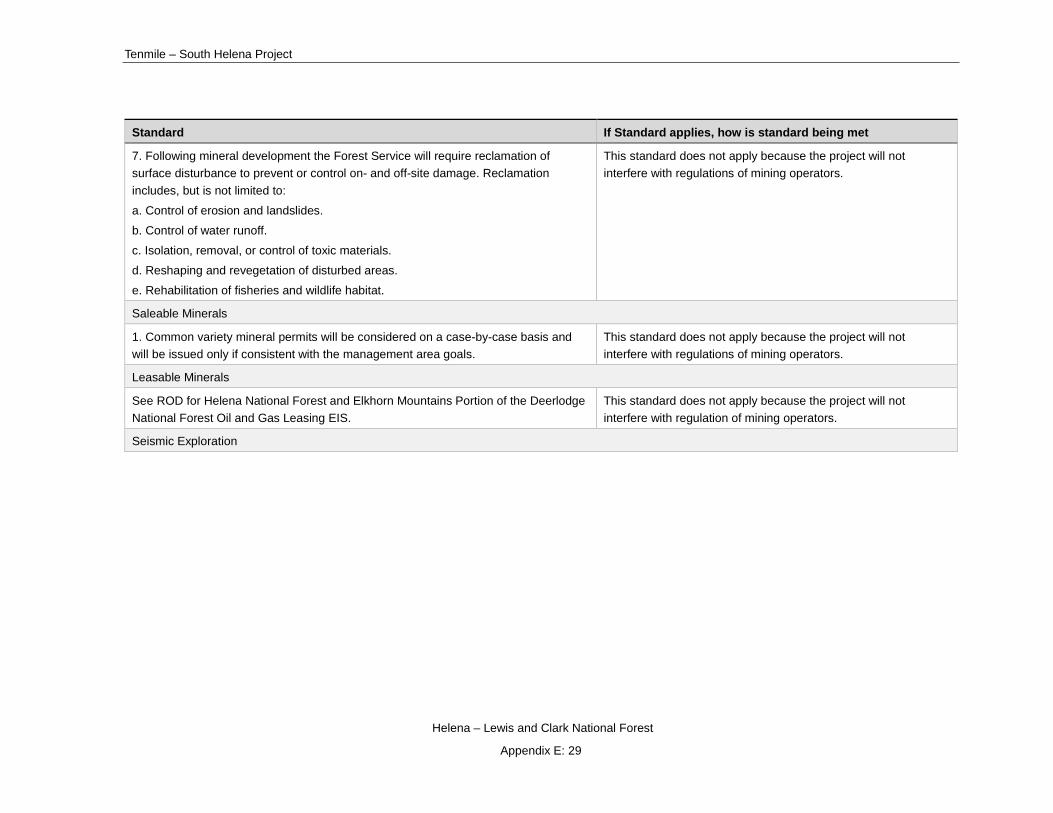
Tenmile – South Helena Project
Helena – Lewis and Clark National Forest
Appendix E: 29
Standard If Standard applies, how is standard being met
7. Following mineral development the Forest Service will require reclamation of surface disturbance to prevent or control on- and off-site damage. Reclamation includes, but is not limited to:
a. Control of erosion and landslides.
b. Control of water runoff.
c. Isolation, removal, or control of toxic materials.
d. Reshaping and revegetation of disturbed areas.
e. Rehabilitation of fisheries and wildlife habitat.
This standard does not apply because the project will not interfere with regulations of mining operators.
Saleable Minerals
1. Common variety mineral permits will be considered on a case-by-case basis and will be issued only if consistent with the management area goals.
This standard does not apply because the project will not interfere with regulations of mining operators.
Leasable Minerals
See ROD for Helena National Forest and Elkhorn Mountains Portion of the Deerlodge National Forest Oil and Gas Leasing EIS.
This standard does not apply because the project will not interfere with regulation of mining operators.
Seismic Exploration

Draft Record of Decision
Helena – Lewis and Clark National Forest
Appendix E: 30
Standard If Standard applies, how is standard being met
1. An environmental analysis will be completed for each application. A prospecting permit will be issued on a case by case basis and will contain stipulations designed to coordinate surface resource values. The following apply where appropriate:
a. Water quality and quantity: Stipulations may be issued to limit activities within 100 feet of all streams, lakes, springs, and ponds.
b. Threatened and endangered species habitat: Stipulations will be issued to protect threatened and endangered species by limiting activities during critical periods, and protecting important habitat elements.
c. Nongame habitat: Stipulations may be used to limit surface use as a coordination and/or mitigation measure for species listed in State of Montana, Species of Special Interest and Concern. (The State species list is part of the Wildlife Planning Records.)
d. Big game habitat: To protect key areas for big game (i.e., winter range, summer concentration habitats, calving areas, lambing areas, big game travel routes, etc.), stipulations may be used during critical periods.
e. Archeological and Historic Resources: Proposed seismic survey work which may impact identified cultural and paleontological resources will be required to skip portions of the work or to relocate survey lines around known resource areas. Other resource threatening work will be required to fully comply with the Antiquities Act of 1906 and other related Acts pertaining to cultural resources.
f. Special Uses, Leases, and Permits: To protect authorized special uses, leases, and permits, include stipulations to restrict occupancy by timing and location on a case-by-case basis.
g. Fire: Seismic work during periods of high fire danger may not be allowed. To prevent wildfire, stipulations may be included to restrict timing and location of seismic operations. Stipulations may also be used to specify procedures and firefighting equipment required by seismic crews.
h. Land Stability and Erosion: Surface occupancy stipulations may be used to prohibit occupancy on lands subject to mass wasting and on slopes 60 percent and greater.
i. Recreation: To accommodate concentrated recreational areas (i.e., picnic grounds and campgrounds), stipulations may be used to restrict seismic activities by location and timing.
This standard does not apply because the project will not interfere with regulations of seismic exploration operations.

Tenmile – South Helena Project
Helena – Lewis and Clark National Forest
Appendix E: 31
Standard If Standard applies, how is standard being met
Land Uses
1. Approve special use permits only when they comply with the goals of the management area affected. Appendix O provides guidelines for special uses and subdivisions.
This standard does not apply because the project does not include the approval of special use permits.
2. Enhance resource management by working with other agencies and landowners to develop and achieve common resource objectives.
This standard is met as this project has utilized a public scoping process to inform and enhance project planning a design.
3. The Forest will encourage governing entities to proceed with land use planning and zoning prior to subdivision development on lands adjacent to or within the Forest boundary.
This standard does not apply because the project does not include planning and zoning decisions.
4. Developers should provide for all necessary services within the limits of the subdivision without infringing on adjacent National Forest lands. But National Forest lands adjacent to subdivisions can be used for services associated with primary access and/or primary utility corridors if these services cannot reasonably be incorporated within the subdivision, or on other adjacent or nearby properties not administered by the Forest Service.
This standard does not apply because the project does not involve any subdivisions.
5. The Forest Service will attempt to inform non-Federal landowners and land developers adjacent to the Forest of the management direction on the Forest land.
This standard applies and is met because the project has utilized numerous public outreaches and participation opportunities such as open house, scoping, and public comment periods.
6. Adjacent private lands will not preclude multiple use management of lands administered by the Forest Service. But management of Forest Service land will be modified where appropriate and necessary to complement land uses on adjacent non-Federal property.
This standard applies and is met. The purpose of Private land buffer units is, in part, to complement fuel reduction activities on adjacent private land. Other treatment types in the project area will serve a similar purpose by reducing the risk of wildfire and providing for firefighter and public safety.

Draft Record of Decision
Helena – Lewis and Clark National Forest
Appendix E: 32
Standard If Standard applies, how is standard being met
7. When an environmental analysis for a proposed Forest project indicates that activities on adjacent land will require Forest Service management activities to be restricted to protect soil, water, and wildlife resources, the necessary restrictions will be determined. If no activity on Forest land is possible, the desired management will be scheduled for later decades when sufficient recovery has occurred on adjacent lands to permit the proposed activities on Forest Service land to continue. Exceptions to this policy will be considered on a case-by-case basis, when deferring management would result in adverse impacts to other Forest resources.
This standard is met through project design criteria and BMP implementation.
Landownership Adjustment
1. A landownership adjustment schedule for the Helena Forest will be developed using the following criteria:
a. The priority for acquisition will be for lands with assessed high wildlife, recreation, and watershed values. Acquisition may entail purchase or donation of fee simple or partial interests, such as conservation and scenic easements, or exchange procedures.
b. Emphasize acquisition of land and interests in land to allow access to all Helena National Forest lands.
c. Emphasize acquisition of trailhead facilities and trail rights-of-ways, especially to wilderness and dispersed recreation areas.
d. Consider disposal of tracts where past patenting has resulted in isolated, intermingled National Forest ownerships, such as at York, Rimini, and Unionville.
This standard does not apply because the project does not include acquisition or disposal of land.
Administration Facilities
1. Provide a cost effective program of maintenance to necessary administrative facilities. This will protect the investment, provide for public and employee's health and safety in accordance with current building codes and standards, and present a neat, well-kept appearance in harmony with its surroundings.
The standard does not apply to the Tenmile – South Helena project because no administrative facilities are in the area, or impacted by any alternative.
2. Construct new administrative facilities to replace existing structures that are no longer cost effective to maintain or expand or are inadequate to serve the needs of resource management.
This standard does not apply the Forest Service will not construct new facilities to replace existing structures as part of this project.

Tenmile – South Helena Project
Helena – Lewis and Clark National Forest
Appendix E: 33
Standard If Standard applies, how is standard being met
Roads
1. Road construction and reconstruction will be the minimum density, cost, and standard necessary for the intended need, user safety, and resource protection.
The minimum road work is proposed to provide for safe access and fuel removal from the proposed units in the action alternatives. Where short segments of road are identified, they will be designed to current standards as set forth in Forest Service handbook and manual direction FSM 7700, FSH 7709.55 and FSH 7709.56 and will be in compliance with BMP standards. This standard is met.
2. Forest development roads will not be constructed without an approved Area Transportation Analysis. Other road construction will be evaluated on a case-by-case basis.
No new construction of National Forest System roads are proposed under the action alternatives. Construction of temporary roads is evaluated on a case-by-case basis as part of this project. This standard is met.
Roads 3. Forest Specialists representing soils, watershed, and fisheries shall identify potential soil erosion, water quality and fisheries problems and provide input to the development of road design standards. Mitigating measures which will be considered in developing these standards include but not limited to:
a. Reestablishing vegetation on exposed soils.
b. Protecting the road surface through surface stabilization techniques such as dust oil or gravel, especially on decomposed granitic soils.
c. Preventing downslope movement of sediment with the use of slash windrows below the fill slopes near stream crossings, baled straw in ditches and catch basins at culvert inlets.
d. Reducing soil disturbance in or near streams by diverting clear water around culvert installation sites, especially in important fisheries streams.
e. Controlling the concentration of water flow by insloping, outsloping, and using minimum grades at stream crossings.
Proposed road work included in the action alternatives including maintenance, reconstruction, temporary roads, and stream crossing improvements, will be conducted in compliance with Montana and FS Region 1 BMPs. These BMPs provide for many mitigation measures associated with roads, including those mentioned in the Forest Plan. An interdisciplinary approach composed of forest Specialists representing soils, watershed, and fisheries provided input into the proposed road network. This standard is met.
4. Short-term local roads will be used for one time road access needs. Temporary roads used for the project action alternatives will meet this standard for short term local roads.

Draft Record of Decision
Helena – Lewis and Clark National Forest
Appendix E: 34
Standard If Standard applies, how is standard being met
5. Coordinate transportation planning and road management with State and local agencies and owners of intermingled land.
There are several county and private roads identified as necessary for haul in the action alternatives. Coordination with these agencies and individuals is needed prior to use and haul in accordance with the Forest Plan. This standard is met.
Road Management
1. The Helena National Forest will generally be open to vehicles except for roads, trails, or areas which may be restricted. (See Forest Visitor Map for specific information.) The Forest Road Management Program will be used to review, evaluate, and implement the goals and standards of the management areas in the Forest Plan with regard to road, trail, and area wide motorized vehicle use.
No changes in existing travel management direction are proposed under the alternatives with respect to allowed uses and roads available for public use. This standard is met.
Road Management 2. Road management decisions will be based on user needs, public safety, resource protection, and economics. Most existing roads will be left open. But most new roads will be closed, at least during critical periods for big game.
The criteria to be used for road, trail, or area restrictions are as follows:
a. Safety - Restrictions may be necessary to provide for safety of Forest users.
b. Resource Protection - Unacceptable damage to soils, watershed, fish, wildlife, or historical/archaeological sites will be mitigated by road restrictions or other road management actions as necessary. Restrictions for wildlife reasons will be coordinated with the MDFWP.
c. Economics - Restrictions will be considered if maintenance costs exceed benefits.
d. Conflicting Use - Conflicts between user groups (especially motorized vs. non-motorized) may require restrictions.
e. Facility Protection - Restrictions may be necessary to prevent damage to administrative sites, special use facilities, or other improvements.
f. Public Support - Public concern may necessitate restricting or opening some roads, trails, or areas.
g. Management Objectives - Road management will be used to achieve land management objectives.
No changes in existing travel management direction are proposed under the alternatives with respect to allowed uses and roads available for public use. Vegetation treatments proposed in the action alternatives will improve road conditions and also reduce potential danger trees along lower standard forest roads not yet receiving roadside danger tree felling and removal. This standard is met.

Tenmile – South Helena Project
Helena – Lewis and Clark National Forest
Appendix E: 35
Standard If Standard applies, how is standard being met
3. The travel restrictions will be reviewed annually and revised as necessary to meet the goals and objectives of the Forest Plan.
This standard is met because no changes in travel management direction are proposed under the project’s alternatives with respect to allowed uses and roads available for public use, as the scope of the project is associated with implementing proposed vegetation treatments.
4. Enforcement of the Road Management Program will be a high priority. Weekend patrolling, signing, gating, obliterating unnecessary roads, and public education will be used to improve enforcement. Enforcement will be coordinated with the MDFWP and other State and local agencies.
This standard is met because no changes in travel management direction are proposed under the project’s alternatives with respect to allowed uses and roads available for public use. Short-term delays and closures may be planned in order to provide for public safety during implementation of the vegetation treatments and fuel removal haul associated with the action alternatives.
Road Maintenance
1. Roads will be maintained in accordance with direction provided in FSH 7709.15 (Transportation System Maintenance Handbook) and will be at a level commensurate with the need for the following operational objectives: resource protection, road investment protection, user safety, user comfort, and travel efficiency.
This standard is met because road maintenance and reconstruction in the action alternatives will be performed in accordance with the Forest Plan and the Montana and Region 1 BMPs.
Road Maintenance 2. Assigned maintenance levels will be reviewed annually and revised if management objectives change.
This standard is met because no changes in assigned maintenance levels are proposed in the alternatives.
3. A Forest Road Maintenance Schedule will be prepared annually and be responsive to the long term needs of the Forest Transportation System.
Not applicable to this project, though, there are several roads proposed in the action alternatives for maintenance and reconstruction to accommodate safe product haul while providing for minimal negative resource impacts.
4. Forest specialists representing soils and watershed shall provide input to the road maintenance planning process to verify maintenance standards, identify rehabilitation needs, and designate roads which should be permanently closed for resource protection. Specialists will annually submit capital investment project proposals for major road reconstruction needs.
This standard is met. Fisheries and watershed specialists worked with the IDT Team and transportation specialist to develop site-specific improvements for inclusion in each action alternative. Once a decision is made, these sites may qualify for a number of supplemental funding opportunities as they may not be required for haul. No improvements will occur under the no-action alternative.
Trails

Draft Record of Decision
Helena – Lewis and Clark National Forest
Appendix E: 36
Standard If Standard applies, how is standard being met
1. Trail management, such as trail standards, maintenance schedules, funding, trail use, construction, and reconstruction, will follow the guidance in Trails Management Handbook, FSH 2309.18.
This standard is met. Alternative 4 proposes to add approximately 18 mile of non-motorized trail to Forest Service system trail network. The new trail will be composed of existing non-system trail and new construction. Construction and maintenance of the new trails system will be consistent with Forest Service Handbook direction.
2. Generally, trail maintenance work priorities will be established as follows:
a. Priority 1. Activities to correct unsafe conditions relative to management objectives.
b. Priority 2. Activities to minimize unacceptable resource and trail damage.
c. Priority 3. Activities that restore the trail to planned design standards.
This standard is met. The design of the trail proposal associated with alternative 4 will follow these priorities.
3. Trail construction/reconstruction will be designed and accomplished to be compatible with the recreation settings and management area goals.
This standard is met. New construction of non-motorized trails are designed so that they will consistent with Forestwide and Management Area goals.
4. Trails may be abandoned or rerouted when a road changes the character of the trail or when the maintenance cost exceeds the benefit.
Some trails proposed under alternative 4 that are concurrent or intersect roads will be realign to more suitable and sustainable locations. This standard is met.
Protection - Insect and Disease
1. Silvicultural systems will be the primary tool for preventative pest management. Use silvicultural systems to: (1) improve species diversity, growth, and vigor for stands and (2) increase the size diversity and class diversity between stands.
This standard applies and is met with the action alternatives through the application of silvicultural tools that promote growth and vigor. Refer to the Forested Vegetation specialist report and silvicultural diagnoses (project file). Alternative 1 does not utilize silvicultural systems.

Tenmile – South Helena Project
Helena – Lewis and Clark National Forest
Appendix E: 37
Standard If Standard applies, how is standard being met
2. During ongoing infestations, control insects and disease through silvicultural and biological practices. Chemical controls will be limited to high value areas or used on a broader scale only when all other measures have failed and other resource values can be protected. Emphasize cooperative control measures between Federal, State, and private landowners.
This standard applies and is met. Proposed silvicultural treatments with the action alternatives address the mountain pine beetle infestation by attempting to limit future susceptibility to a variety of insects on a mosaic of treated stands as described in the Forested Vegetation Specialist Report. The HNF has also done extensive outreach and coordination efforts with other landowners concerning the mountain pine outbreak. No silvicultural or biological practices will occur with alternative 1.
3. Biological practices will be considered in controlling insect and disease infestations. The standard does not apply. There are no feasible biological practices developed for the control of the insects or diseases currently active in the project area.
4. If possible, harvest stands which are a high risk for mountain pine beetle attack before harvesting moderate or low risk stands.
This standard does not currently apply since lodgepole pine stands have already lost most of the susceptible trees.
Protection - Wildfire
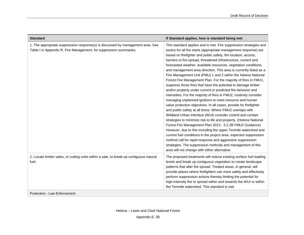
Draft Record of Decision
Helena – Lewis and Clark National Forest
Appendix E: 38
Standard If Standard applies, how is standard being met
1. The appropriate suppression response(s) is discussed by management area. See Table I in Appendix R, Fire Management, for suppression summaries.
This standard applies and is met. Fire suppression strategies and tactics for all fire starts (appropriate management response) are based on firefighter and public safety, fire location, access, barriers to fire spread, threatened infrastructure, current and forecasted weather, available resources, vegetation conditions, and management area direction. This area is currently listed as a Fire Management Unit (FMU) 1 and 2 within the Helena National Forest Fire Management Plan. For the majority of fires in FMU1, suppress those fires that have the potential to damage timber and/or property under current or predicted fire behavior and intensities. For the majority of fires in FMU2, routinely consider managing unplanned ignitions to meet resource and human value protection objectives. In all cases, provide for firefighter and public safety at all times. Where FMU2 overlaps with Wildland Urban Interface (WUI) consider control and contain strategies to minimize risk to life and property. (Helena National Forest Fire Management Plan 2013 - 3.2.2B FMU2 Guidance) However, due to this including the upper Tenmile watershed and current fuel conditions in the project area, expected suppression method call for rapid response and aggressive suppression strategies. The suppression methods and management of this area will not change with either alternative.
2. Locate timber sales, or cutting units within a sale, to break-up contiguous natural fuel.
The proposed treatments will reduce existing surface fuel loading levels and break up contiguous vegetation to create landscape patterns that alter fire spread. Treated areas, in general, will provide places where firefighters can more safely and effectively perform suppression actions thereby limiting the potential for high-intensity fire to spread within and towards the WUI or within the Tenmile watershed. This standard is met
Protection - Law Enforcement
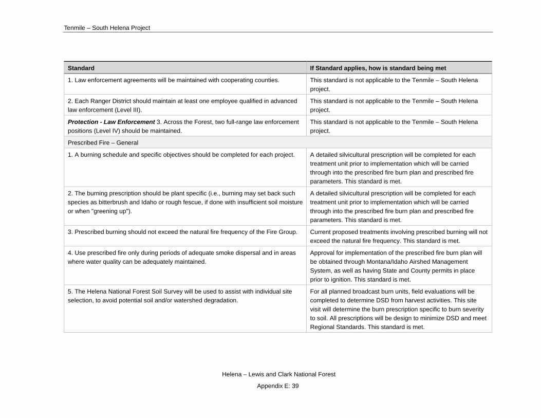
Tenmile – South Helena Project
Helena – Lewis and Clark National Forest
Appendix E: 39
Standard If Standard applies, how is standard being met
1. Law enforcement agreements will be maintained with cooperating counties. This standard is not applicable to the Tenmile – South Helena project.
2. Each Ranger District should maintain at least one employee qualified in advanced law enforcement (Level III).
This standard is not applicable to the Tenmile – South Helena project.
Protection - Law Enforcement 3. Across the Forest, two full-range law enforcement positions (Level IV) should be maintained.
This standard is not applicable to the Tenmile – South Helena project.
Prescribed Fire – General
1. A burning schedule and specific objectives should be completed for each project. A detailed silvicultural prescription will be completed for each treatment unit prior to implementation which will be carried through into the prescribed fire burn plan and prescribed fire parameters. This standard is met.
2. The burning prescription should be plant specific (i.e., burning may set back such species as bitterbrush and Idaho or rough fescue, if done with insufficient soil moisture or when "greening up").
A detailed silvicultural prescription will be completed for each treatment unit prior to implementation which will be carried through into the prescribed fire burn plan and prescribed fire parameters. This standard is met.
3. Prescribed burning should not exceed the natural fire frequency of the Fire Group. Current proposed treatments involving prescribed burning will not exceed the natural fire frequency. This standard is met.
4. Use prescribed fire only during periods of adequate smoke dispersal and in areas where water quality can be adequately maintained.
Approval for implementation of the prescribed fire burn plan will be obtained through Montana/Idaho Airshed Management System, as well as having State and County permits in place prior to ignition. This standard is met.
5. The Helena National Forest Soil Survey will be used to assist with individual site selection, to avoid potential soil and/or watershed degradation.
For all planned broadcast burn units, field evaluations will be completed to determine DSD from harvest activities. This site visit will determine the burn prescription specific to burn severity to soil. All prescriptions will be design to minimize DSD and meet Regional Standards. This standard is met.

Draft Record of Decision
Helena – Lewis and Clark National Forest
Appendix E: 40
Standard If Standard applies, how is standard being met
6. Smoke sensitive areas will be identified and burning prescriptions developed accordingly.
All Class I Airsheds and sensitive receptors have been identified within 60 kilometer radius around the project area and will be carried forward into the prescribed fire burn plans. Prior to ignition County Health Services for both Lewis & Clark and Powell Counties will be notified of predicted impact areas so they can notify sensitive receptors within the area. This standard is met.
7. The MDFWP should be invited to participate in selecting treatment sites, executing burning plans, and monitoring and evaluating the overall program.
MDFWP will be on the burn plan contact list. This standard is met.
Prescribed Fire - Timber
1. Where timber production is a primary land use, prescribed burning will only be applied where timber production can be maintained or enhanced by burning.
No burning is proposed with no action, but the standard applies to the action alternatives and is met. Burning will primarily occur after harvest, in part to promote desirable regeneration. This burning will be designed to not preclude natural regeneration and future timber production.
2. Prescribed fire, when used as a fuels management or site preparation technique after harvest, should be coordinated with the timber stand's silvicultural prescription.
Standard does not apply to no action, but does apply to the action alternatives and is met. Burning will be incorporated into silvicultural prescriptions.
Prescribed Fire - Range and Wildlife
1. Areas that have a demonstrated need to maintain or increase forage because of conifer encroachment, shrub invasion, and imbalance in forb/grass ratios, and/or where grass and shrubs are deteriorating should be recommended for prescribed burning.
This standard is met. Prescribe burning is proposed in range allotments in areas where treatment units are located.
2. Where livestock and wildlife share sagebrush areas, prescribed fire will be designed to produce a mosaic of burned and unburned islands.
Prescribed fire is primarily focused in timber stands. The prescription for any sagebrush stands with the RX units will have a low severity prescription designed to create a mosaic burn pattern. This standard is met.
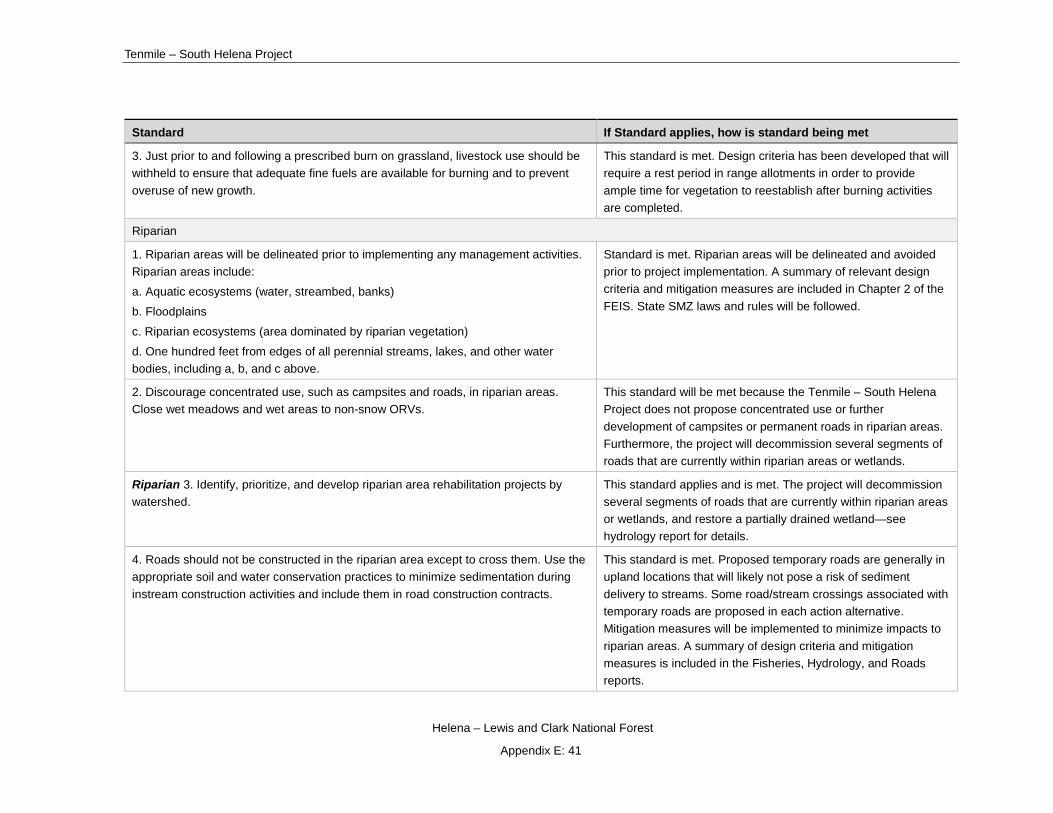
Tenmile – South Helena Project
Helena – Lewis and Clark National Forest
Appendix E: 41
Standard If Standard applies, how is standard being met
3. Just prior to and following a prescribed burn on grassland, livestock use should be withheld to ensure that adequate fine fuels are available for burning and to prevent overuse of new growth.
This standard is met. Design criteria has been developed that will require a rest period in range allotments in order to provide ample time for vegetation to reestablish after burning activities are completed.
Riparian
1. Riparian areas will be delineated prior to implementing any management activities. Riparian areas include:
a. Aquatic ecosystems (water, streambed, banks)
b. Floodplains
c. Riparian ecosystems (area dominated by riparian vegetation)
d. One hundred feet from edges of all perennial streams, lakes, and other water bodies, including a, b, and c above.
Standard is met. Riparian areas will be delineated and avoided prior to project implementation. A summary of relevant design criteria and mitigation measures are included in Chapter 2 of the FEIS. State SMZ laws and rules will be followed.
2. Discourage concentrated use, such as campsites and roads, in riparian areas. Close wet meadows and wet areas to non-snow ORVs.
This standard will be met because the Tenmile – South Helena Project does not propose concentrated use or further development of campsites or permanent roads in riparian areas. Furthermore, the project will decommission several segments of roads that are currently within riparian areas or wetlands.
Riparian 3. Identify, prioritize, and develop riparian area rehabilitation projects by watershed.
This standard applies and is met. The project will decommission several segments of roads that are currently within riparian areas or wetlands, and restore a partially drained wetland—see hydrology report for details.
4. Roads should not be constructed in the riparian area except to cross them. Use the appropriate soil and water conservation practices to minimize sedimentation during instream construction activities and include them in road construction contracts.
This standard is met. Proposed temporary roads are generally in upland locations that will likely not pose a risk of sediment delivery to streams. Some road/stream crossings associated with temporary roads are proposed in each action alternative. Mitigation measures will be implemented to minimize impacts to riparian areas. A summary of design criteria and mitigation measures is included in the Fisheries, Hydrology, and Roads reports.

Draft Record of Decision
Helena – Lewis and Clark National Forest
Appendix E: 42
Standard If Standard applies, how is standard being met
5. Assure that road construction in riparian areas is substantially completed or winterized during winter shut down to minimize peak flow sediment yield during spring thaw.
This standard is met. Design criteria will minimize impacts from roads to riparian areas during winter—see design criteria in Chapter 2 and in the hydrology report for details.
6. Generally, avoid lateral fills within normal high water marks. This standard is met. Design criteria will minimize impacts from roads to riparian areas during winter—see design criteria in Chapter 2 and in the hydrology report for details.
7. Generally, avoid stream course encroachment and channelization. This standard is met. Stream course encroachment and channelization are not expected as a result of the Tenmile – South Helena project.
8. Use of chemicals within the riparian area will be minimized to the extent feasible, will be coordinated with wildlife, watershed, and fisheries personnel and a certified pesticide applicator.
This standard is met. Use of chemicals near riparian areas and water bodies will be limited—see Noxious Weeds report.
Riparian 9. Riparian areas will be managed to be compatible with dependent wildlife species.
This standard is met. Under the action alternatives, the structure and functioning of local wetlands and riparian zones will differ little from what will occur under natural conditions. Dead and live trees within viable wet sites and around their margins will be left intact. Primary departure from natural conditions will be in the surrounding upland areas from which most snags and woody debris will be removed. Wildlife species approaching the wetlands and riparian zones will thus be moving across open grass/forb/shrub habitat rather than through a maze of woody debris. In either case, the overhead cover will be gone. Differences generated by the action alternatives will not be noteworthy. Treatments that mimic disturbance processes (as is the case here) in wetlands and riparian zones are important in maintaining species richness and diversity, both plant and animal.
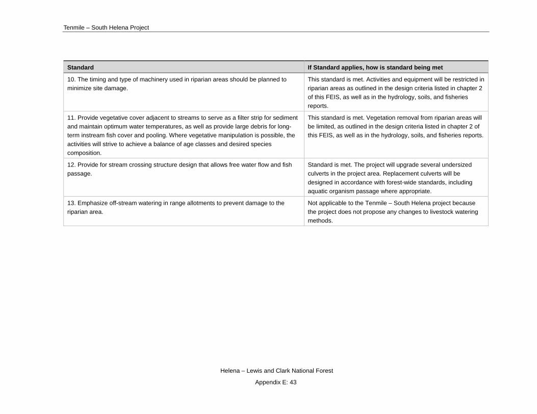
Tenmile – South Helena Project
Helena – Lewis and Clark National Forest
Appendix E: 43
Standard If Standard applies, how is standard being met
10. The timing and type of machinery used in riparian areas should be planned to minimize site damage.
This standard is met. Activities and equipment will be restricted in riparian areas as outlined in the design criteria listed in chapter 2 of this FEIS, as well as in the hydrology, soils, and fisheries reports.
11. Provide vegetative cover adjacent to streams to serve as a filter strip for sediment and maintain optimum water temperatures, as well as provide large debris for long-term instream fish cover and pooling. Where vegetative manipulation is possible, the activities will strive to achieve a balance of age classes and desired species composition.
This standard is met. Vegetation removal from riparian areas will be limited, as outlined in the design criteria listed in chapter 2 of this FEIS, as well as in the hydrology, soils, and fisheries reports.
12. Provide for stream crossing structure design that allows free water flow and fish passage.
Standard is met. The project will upgrade several undersized culverts in the project area. Replacement culverts will be designed in accordance with forest-wide standards, including aquatic organism passage where appropriate.
13. Emphasize off-stream watering in range allotments to prevent damage to the riparian area.
Not applicable to the Tenmile – South Helena project because the project does not propose any changes to livestock watering methods.

Draft Record of Decision
Helena – Lewis and Clark National Forest
Appendix E: 44
Riparian 14. Livestock grazing in riparian areas will be controlled at the following levels of utilization:
Vegetative Type Grazing Systems
Vegetative Condition Class
Forage Utilization by Weight
Browse Utilization by % of Leader Use
Grasslands/ Grass-like/Forb
Continuous Good
Fair
Poor
5%
5%
20%
N.A.
N.A.
N.A.
Rest-
Rotation
Heavy Use
Pasture 1/
Light Use
Pasture
60%
5%
N.A.
N.A.
Defer-
Rotation
Heavy Use
Pasture
Light Use
Pasture
50%
40%
N.A.
N.A.
Willow/ Grass/ Grasslike
and Willow/
Forest
Continuous Good
Fair
Poor
55%
5%
5%
50%
50%
50%
Rest-
Rotation
Heavy Use
Pasture 2/
Light Use
Pasture
70%
50%
50%
50%
Defer-Rotation
Heavy Use
Pasture
Light Use
Pasture
60%
5
50%
50%
Not applicable to the Tenmile – South Helena project because project proposals do not affect the levels at which livestock graze in riparian areas.

Tenmile – South Helena Project
Helena – Lewis and Clark National Forest
Appendix E: 45
Standard If Standard applies, how is standard being met 1 Trampled areas and streambank damage caused during heavy use year should be healed or stabilized with the following year. 2/ Disturbance on heavy use pasture should be stabilized or healed prior to use the following year.
Table 2. Management Area Direction and Acres.
Management Standards If Standard applies, how is standard being met
Management Area H1 (14,292 acres) Management Goals - Provide a quantity and quality of water which will, with adequate treatment, result in a satisfactory and safe domestic water supply for the City of Helena. Provide cover and forage for big game animals and necessary habitat components for nongame animals. Provide for dispersed recreation opportunities.
Description - This management area consists of about 75 percent of the National Forest System land in the Tenmile municipal watershed, which lies about 10 air miles southwest of Helena. The entire watershed currently supplies about one-half of Helena’s domestic water. About 25 percent of this watershed management area is in private ownership, consisting mostly of patented mining claims. Some of these mines are currently active. The town of Rimini also lies within this management area. Vegetative cover varies from dense lodgepole and brush on north and east slopes to open scattered Douglas-fir and ponderosa pine on south and west slopes. This area provides a variety of recreational opportunities as well as habitat for wildlife. This management area contains trail segments that will likely be proposed as part of the Continental Divide National Scenic Trail System.
Recreation – Non-motorized dispersed recreation will continue within the drainage; however, no additional facilities will be constructed to support the use.
Developed recreation facilities will not be constructed.
This standard is met. No construction of additional facilities will occur under any of the action alternatives.
Visual – Management practices will generally follow guidelines for the modification VQO. The portions of this area (if any) that are within the sensitive viewing areas of the roads, trails, and areas listed in Appendix B will be managed to meet the VQOs noted in the appendix. [See Forest Landscape Management Book, vol. 2 (Ag. Hdbk. No. 462) for definitions of VQOs and how they are applied.]
Implementation of both action alternatives will be consistent with the 1986 Helena National Forest Plan. By implementing the design criteria described above, VQOs
for modification will be met.

Draft Record of Decision
Helena – Lewis and Clark National Forest
Appendix E: 46
Management Standards If Standard applies, how is standard being met
Management Area H1 (14,292 acres) Management Goals - Provide a quantity and quality of water which will, with adequate treatment, result in a satisfactory and safe domestic water supply for the City of Helena. Provide cover and forage for big game animals and necessary habitat components for nongame animals. Provide for dispersed recreation opportunities.
Wildlife and Fisheries – Wildlife habitat improvement practices, including road management, prescribed fire, and other techniques, will be used to maintain and/or enhance the diversity of wildlife habitat.
Maintain adequate thermal and hiding cover adjacent to forage areas as determined by a wildlife biologist. Generally this means providing at least 25 percent thermal cover, on identified winter range.
This standard applies. Various watershed improvement activities are proposed as part of all action alternatives. This draft decision will result in anticipated
improvement in road BMPs reducing sediment delivery to riparian areas benefiting aquatic resources in the project area. Additionally, wetland restoration, native fish
restoration, and road and stream crossing decommissioning will improve watershed conditions. Proposed vegetation and prescribe fire treatments will reduce the probability of high-severity wildfires and their associated detrimental effects to
important values including wildlife habitat.
Under the existing condition, thermal cover is below Forest Plan thresholds in this management area. Currently, there are 14,350 acres in Management Area H-1 of which 6,133 acres are in winter range. There are 1,115 acres of thermal cover on
that winter range, or 19%. This draft decision will further reduce thermal cover below Forest Plan thresholds. A site-specific exemption has been prepared to
address this (see the Wildlife section in Chapter 3 of the FEIS).
Range – The area grazed and the number of AUMs permitted in the watershed will not be increased. However, if livestock grazing decreases the water quality, then the grazing practices will be changed to maintain the water quality.
Not applicable because the Tenmile-South Helena Project does not propose any changes to livestock use within the project area.
Timber – Timber harvest should be implemented only if it can be used as a tool to maintain or enhance watershed and wildlife habitat values. Forested land is classified as unsuitable for timber management.
Vegetation treatment, including commercially removing fuel from units, will be used to regenerate stands with heavy mortality, and to maintain healthy stands that
provide wildlife habitat and soil stabilization. Reduction of down fuels is intended to reduce fire residence time and resultant soil damage.
Water and Soils – Watershed improvement needs have been inventoried in the Tenmile watershed and priority projects identified. The drainage has the top priority for implementation of watershed
This standard applies and is met. The Tenmile – South Helena project proposes to implement watershed improvement activities.

Tenmile – South Helena Project
Helena – Lewis and Clark National Forest
Appendix E: 47
Management Standards If Standard applies, how is standard being met
Management Area H1 (14,292 acres) Management Goals - Provide a quantity and quality of water which will, with adequate treatment, result in a satisfactory and safe domestic water supply for the City of Helena. Provide cover and forage for big game animals and necessary habitat components for nongame animals. Provide for dispersed recreation opportunities.
improvement projects as funding becomes available. (See Appendix T).
Minerals – Locatable – To the extent feasible, timing of mineral activities will be coordinated with the needs of wildlife and water quality standards. This generally will require negotiations during development of operating plans for no surface occupancy, from December 1 to May 15 on winter range and during peak runoff.
-Leasable - See Forest Plan Amendment #13 for lease standards
This standard does not apply. The Tenmile – South Helena does not propose any mineral activities or changes to existing mineral operations.
Lands – This management area is an avoidance area for utility corridors (see Appendix P).
This standard does not apply to the Tenmile – South Helena Project because the project does not include proposals for utility corridors.
Facilities - Roads will be constructed as needed to meet the management objectives of the area. Minimizing road length, grade and amount of disturbed area will be primary project design criteria.
Portions of existing roads that are reconstructed will be maintained at a standard that will prevent unacceptable erosion or will be closed and stabilized.
All new roads will be closed and stabilized when projects are terminated.
This standard applies and is met. Temporary Roads will be constructed for the action alternatives to access vegetation treatment units. Design criteria incorporate minimizing road length, grade and amount of disturbed area. Temporary roads will
be closed and rehabilitated after use.
Existing roads will be maintained or reconstructed in accordance with Montana and R1 BMPs under the action alternatives.
Protection – Evaluate areas periodically for significant insect and disease problems. Endemic levels will be accepted as normal. If epidemic levels develop and control is necessary, the control method should minimize impacts on watershed and wildlife values.
Use rapid and aggressive fire control methods in this management area.
This standard applies and is met through removal of insect-killed trees, establishment of desirable regeneration, and improving forest health to be more resistant to bark beetle activity in the future. Insect-killed trees are proposed for
removal in treatment units with all action alternatives.
Fire suppression strategy will not change with any alternative.
Prescribed burning will be used in action alternatives to improve wildlife forage.

Draft Record of Decision
Helena – Lewis and Clark National Forest
Appendix E: 48
Management Standards If Standard applies, how is standard being met
Management Area H1 (14,292 acres) Management Goals - Provide a quantity and quality of water which will, with adequate treatment, result in a satisfactory and safe domestic water supply for the City of Helena. Provide cover and forage for big game animals and necessary habitat components for nongame animals. Provide for dispersed recreation opportunities.
Prescribed fire may be used as a tool to reduce natural fuels and improve quantity and quality of wildlife forage.
Fire suppression methods will be selected to minimize or eliminate soil disturbance of the watershed.
Riparian – See Forest-Wide Standards.
Management Standards If Standard applies, how is standard being met
Management Area H2 (4,145 acres) Management Goals - Provide a quantity and quality of water which will, with adequate treatment, result in a satisfactory and safe domestic water supply for the City of Helena. Provide cover and forage for big game animals and necessary habitat components for nongame animals. Provide healthy timber stands and optimize growing potential over the planning horizon while protecting the soil and water resources. Provide for dispersed recreation opportunities.
Description - This management area consists of about 25 percent of the Tenmile Municipal watershed with lies about 10 air miles south west of Helena. The entire watershed supplies about one-half of Helena’s domestic water. This management area contains parcels of productive timber stands of lodgepole pine and Douglas-fir. These parcels are found in Tenmile, Minnehaha, and Walker Creeks on the west side of the watershed and in Beaver and Banner Creek on the east side. This area provides winter and summer habitat for a variety of wildlife species. This management area contains trail segments that will likely be proposed as part of the Continental Divide National Scenic Trail System.
Recreation – Non-motorized dispersed recreation will continue within the drainage, however no additional facilities will be constructed to support the use.
Developed recreation facilities will not be constructed.
Controls on motorized recreation will be implemented where necessary, to protect the vegetation, soil, and water resources and to prevent road damage.
This standard is met. No construction of additional facilities will occur under any of the action alternatives.

Tenmile – South Helena Project
Helena – Lewis and Clark National Forest
Appendix E: 49
Management Standards If Standard applies, how is standard being met
Management Area H2 (4,145 acres) Management Goals - Provide a quantity and quality of water which will, with adequate treatment, result in a satisfactory and safe domestic water supply for the City of Helena. Provide cover and forage for big game animals and necessary habitat components for nongame animals. Provide healthy timber stands and optimize growing potential over the planning horizon while protecting the soil and water resources. Provide for dispersed recreation opportunities.
Description - This management area consists of about 25 percent of the Tenmile Municipal watershed with lies about 10 air miles south west of Helena. The entire watershed supplies about one-half of Helena’s domestic water. This management area contains parcels of productive timber stands of lodgepole pine and Douglas-fir. These parcels are found in Tenmile, Minnehaha, and Walker Creeks on the west side of the watershed and in Beaver and Banner Creek on the east side. This area provides winter and summer habitat for a variety of wildlife species. This management area contains trail segments that will likely be proposed as part of the Continental Divide National Scenic Trail System.
Visual – Management practices will generally follow guidelines for the modification VQO. The portions of this area (if any) that are within the sensitive viewing areas of the roads, trails, and areas listed in Appendix B will be managed to meet the VQOs noted in the appendix. [See Forest Landscape Management Book, Vol. 2 (Ag. Hdbk. No. 462) for definitions of VQOs and how they are applied.]
Implementation of both action alternatives will be consistent with the 1986 Helena National Forest Plan. By implementing the design criteria
described above, VQOs for modification will be met.
Wildlife and Fisheries – Wildlife habitat improvement practices, including road management, prescribed fire, and other techniques, will be used to maintain and/or enhance the diversity of wildlife habitat.
Forest-wide Standards and Appendix D contain guidance for T&E species habitat.
Maintain adequate thermal and hiding cover adjacent to forage areas as determined by a wildlife biologist. Generally this means providing at least 25 percent thermal cover on identified winter range.
This standard applies and is met. Various watershed improvement activities are proposed as part of the draft decision. Proposed vegetation and prescribe fire treatments will reduce the probability of high-severity
wildfires and their associated detrimental effects to important values including wildlife habitat.
Under the existing condition, thermal cover is below Forest Plan thresholds in this management area. Currently, there are 4,370 acres in Management Area H-2 of which 1,735 acres are in winter range. There are 145 acres of
thermal cover on that winter range, or 8 percent. This draft decision will further reduce thermal cover below Forest Plan thresholds. A site-specific exemption has been prepared to address this (see the Wildlife section in
Chapter 3 of the FEIS).
Range – See Forest-Wide Standards Not applicable because the Tenmile-South Helena Project does not propose any changes to livestock use within the project area.

Draft Record of Decision
Helena – Lewis and Clark National Forest
Appendix E: 50
Management Standards If Standard applies, how is standard being met
Management Area H2 (4,145 acres) Management Goals - Provide a quantity and quality of water which will, with adequate treatment, result in a satisfactory and safe domestic water supply for the City of Helena. Provide cover and forage for big game animals and necessary habitat components for nongame animals. Provide healthy timber stands and optimize growing potential over the planning horizon while protecting the soil and water resources. Provide for dispersed recreation opportunities.
Description - This management area consists of about 25 percent of the Tenmile Municipal watershed with lies about 10 air miles south west of Helena. The entire watershed supplies about one-half of Helena’s domestic water. This management area contains parcels of productive timber stands of lodgepole pine and Douglas-fir. These parcels are found in Tenmile, Minnehaha, and Walker Creeks on the west side of the watershed and in Beaver and Banner Creek on the east side. This area provides winter and summer habitat for a variety of wildlife species. This management area contains trail segments that will likely be proposed as part of the Continental Divide National Scenic Trail System.
Timber - This management area is suitable for timber management activities.
Timber harvest practices include clearcuting, group selection, and shelterwood harvest, depending on habitat group, physical site conditions, and silvicultural objectives. Precommercial thinning and intermediate harvest may occur where needed as determined by silvicultural objectives and project planning. (Appendies H and M provide broad guidelines for various habitat groups.)
As a minimum, a cutover area will not be considered an opening when: (1) a new forest stand is established and certified as stocked (2) vegetative conditions reach the point where harvest of additional timber can occur and the combined area can still meet watershed management objectives.
Prescribed burning or other techniques may be used for slash disposal, site preparation, and silvicultural objectives. In habitat groups where fire is not a useful treatment tool, lopping and scattering, yarding unmerchantable material (YUM), or other methods will be used to reduce fuel accumulations and prepare sites for regeneration.
Project level planning will provide for stand regeneration within five years of final harvest.
Even-aged stands will be scheduled for final regeneration harvest when they generally have reached the culmination of mean annual increment (CMAI) of
Timber management will occur within this MA as a result of the draft decision for the purpose of removing fuel from units. This standard is met.

Tenmile – South Helena Project
Helena – Lewis and Clark National Forest
Appendix E: 51
Management Standards If Standard applies, how is standard being met
Management Area H2 (4,145 acres) Management Goals - Provide a quantity and quality of water which will, with adequate treatment, result in a satisfactory and safe domestic water supply for the City of Helena. Provide cover and forage for big game animals and necessary habitat components for nongame animals. Provide healthy timber stands and optimize growing potential over the planning horizon while protecting the soil and water resources. Provide for dispersed recreation opportunities.
Description - This management area consists of about 25 percent of the Tenmile Municipal watershed with lies about 10 air miles south west of Helena. The entire watershed supplies about one-half of Helena’s domestic water. This management area contains parcels of productive timber stands of lodgepole pine and Douglas-fir. These parcels are found in Tenmile, Minnehaha, and Walker Creeks on the west side of the watershed and in Beaver and Banner Creek on the east side. This area provides winter and summer habitat for a variety of wildlife species. This management area contains trail segments that will likely be proposed as part of the Continental Divide National Scenic Trail System.
growth. Exceptions include thinning or other stand improvement measures, salvage or sanitation harvest, management for experimental or research purposes and to meet other resource objectives. CMAI for primary species on the Helena National Forest is shown in Appendix H.
Water and Soils – Watershed improvement needs have been inventoried in the Tenmile watershed and priority projects identified. The drainage has the top priority for implementation of watershed improvement projects as funding becomes available (See Appendix T).
Timber harvest will not create runoff increases which are likely to result in stream channel degradation. All timber sale proposals will include an analysis of current conditions and potential sediment production. The project proposal will analyze and evaluate the potential water quantity and quality, and soil productivity impacts; mitigation measures will be developed to minimize adverse effects. If a proposal shows the water quality cannot be maintained, within State standards for A-1 watersheds and public water supplies the project will be redesigned to meet the standards or terminated. Water quality monitoring will be an integral part of all timber harvest proposals.
This standard applies and is met. The Tenmile – South Helena project proposes to implement watershed improvement activities. As part of the proposal, design criteria and BMPs will be in place with the purpose of
preventing any runoff increases.
Minerals – Locatable – To the extent feasible, timing of mineral activities will be coordinated with the needs of wildlife and water quality standards. This generally will require negotiations during development of operating plans for
This standard does not apply. The Tenmile – South Helena does not propose any mineral activities or changes to existing mineral operations.

Draft Record of Decision
Helena – Lewis and Clark National Forest
Appendix E: 52
Management Standards If Standard applies, how is standard being met
Management Area H2 (4,145 acres) Management Goals - Provide a quantity and quality of water which will, with adequate treatment, result in a satisfactory and safe domestic water supply for the City of Helena. Provide cover and forage for big game animals and necessary habitat components for nongame animals. Provide healthy timber stands and optimize growing potential over the planning horizon while protecting the soil and water resources. Provide for dispersed recreation opportunities.
Description - This management area consists of about 25 percent of the Tenmile Municipal watershed with lies about 10 air miles south west of Helena. The entire watershed supplies about one-half of Helena’s domestic water. This management area contains parcels of productive timber stands of lodgepole pine and Douglas-fir. These parcels are found in Tenmile, Minnehaha, and Walker Creeks on the west side of the watershed and in Beaver and Banner Creek on the east side. This area provides winter and summer habitat for a variety of wildlife species. This management area contains trail segments that will likely be proposed as part of the Continental Divide National Scenic Trail System.
no surface occupance, from December 1 to May 15 on winter range and during peak runoff. All minerals operations will be closely monitored to insure that water quality standards are maintained.
- Leasable See Forest Plan Amendment #13 for lease standards
Lands – This management area is an avoidance area for utility corridors. This standard does not apply to the Tenmile – South Helena Project because the project does not include proposals for utility corridors.
Facilities – Portions of existing roads that are reconstructed will be maintained at a standard that will prevent unacceptable erosion or will be closed and stabilized.
Roads will be constructed as needed to meet the management objectives of the area. Minimizing road width, grade and amount of disturbed area will be primary project design criteria.
All new roads will be closed and stabilized when projects are terminated to minimize erosion.
Where existing trails or non-system roads are intersected by new road construction, the trail or non-system road will be evaluated to determine if it should be retained on the system or abandoned.
This standard applies and is met. Temporary Roads will be constructed for the action alternatives to access vegetation treatment units. Design criteria
incorporate road width, grade and amount of disturbed area. Temporary roads will be closed and rehabilitated after use.
Existing roads will be maintained or reconstructed in accordance with Montana and R1 BMPs under the action alternatives.
Protection - Insect and disease control should emphasize reduction and prevention through timber harvest and timber stand improvement. The use
This standard applies and is met through removal of insect-killed trees, establishment of desirable regeneration, and improving forest health to be

Tenmile – South Helena Project
Helena – Lewis and Clark National Forest
Appendix E: 53
Management Standards If Standard applies, how is standard being met
Management Area H2 (4,145 acres) Management Goals - Provide a quantity and quality of water which will, with adequate treatment, result in a satisfactory and safe domestic water supply for the City of Helena. Provide cover and forage for big game animals and necessary habitat components for nongame animals. Provide healthy timber stands and optimize growing potential over the planning horizon while protecting the soil and water resources. Provide for dispersed recreation opportunities.
Description - This management area consists of about 25 percent of the Tenmile Municipal watershed with lies about 10 air miles south west of Helena. The entire watershed supplies about one-half of Helena’s domestic water. This management area contains parcels of productive timber stands of lodgepole pine and Douglas-fir. These parcels are found in Tenmile, Minnehaha, and Walker Creeks on the west side of the watershed and in Beaver and Banner Creek on the east side. This area provides winter and summer habitat for a variety of wildlife species. This management area contains trail segments that will likely be proposed as part of the Continental Divide National Scenic Trail System.
of other approved pest management techniques consistent with municipal watershed goals may be necessary at times.
Use rapid and aggressive fire control methods in this management area.
Prescribed fire may be used as a tool to reduce natural fuels and improve quantity and quality of wildlife forage.
Fire suppression methods will be selected to minimize or eliminate soil disturbance of the watershed.
more resistant to bark beetle activity in the future. Insect-killed trees are proposed for removal in treatment units with this draft decision.
Fire suppression strategy will not change with any alternative.
Prescribed burning will be used in action alternatives to improve wildlife forage. Standards will be met through the development of silvicultural prescriptions and burn plan development. Additionally, adherence to
design criteria will help meet standards relating to prescribed burning.
Riparian – Timber harvest will be on a 240-year rotation and harvest types will generally be selection or group selection.
This standard applies and is met. Timber harvest is not proposed in management area H2 within riparian areas as part of the Tenmile – South
Helena project.
Management Standards If Standard applies, how is standard being met
Management Area L1 (1,532 acres) Management Goals - Maintain or improve vegetative conditions and livestock forage productivity. Optimize livestock production through intensive grazing systems, while maintaining other resource uses.
Description – These lands are within grazing allotments and are generally nonforested consisting of bunchgrasses, sage and other shrubs or sparsely forested areas with Douglas-fir or ponderosa pine as the dominant species. Slopes vary from 10 percent to greater than 60. This management area contains inclusion of elk calving areas, hiding cover, and summer range, but excludes identified elk winter range.
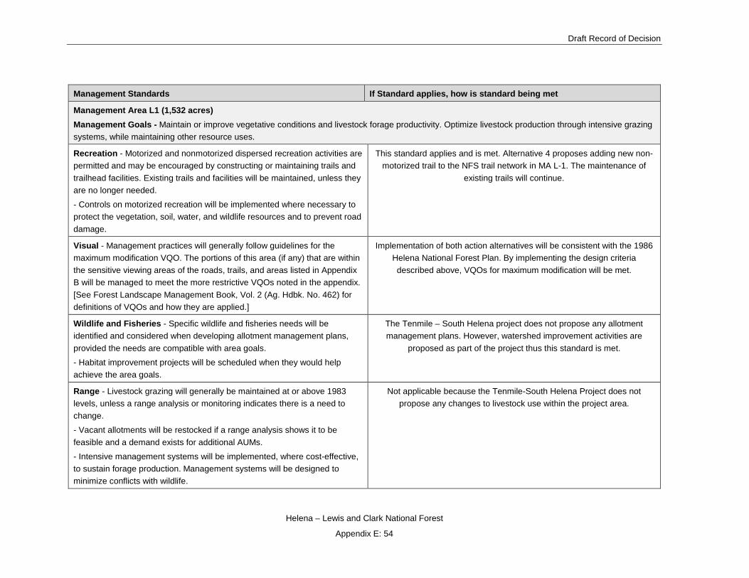
Draft Record of Decision
Helena – Lewis and Clark National Forest
Appendix E: 54
Management Standards If Standard applies, how is standard being met
Management Area L1 (1,532 acres) Management Goals - Maintain or improve vegetative conditions and livestock forage productivity. Optimize livestock production through intensive grazing systems, while maintaining other resource uses.
Recreation - Motorized and nonmotorized dispersed recreation activities are permitted and may be encouraged by constructing or maintaining trails and trailhead facilities. Existing trails and facilities will be maintained, unless they are no longer needed.
- Controls on motorized recreation will be implemented where necessary to protect the vegetation, soil, water, and wildlife resources and to prevent road damage.
This standard applies and is met. Alternative 4 proposes adding new non-motorized trail to the NFS trail network in MA L-1. The maintenance of
existing trails will continue.
Visual - Management practices will generally follow guidelines for the maximum modification VQO. The portions of this area (if any) that are within the sensitive viewing areas of the roads, trails, and areas listed in Appendix B will be managed to meet the more restrictive VQOs noted in the appendix. [See Forest Landscape Management Book, Vol. 2 (Ag. Hdbk. No. 462) for definitions of VQOs and how they are applied.]
Implementation of both action alternatives will be consistent with the 1986 Helena National Forest Plan. By implementing the design criteria described above, VQOs for maximum modification will be met.
Wildlife and Fisheries - Specific wildlife and fisheries needs will be identified and considered when developing allotment management plans, provided the needs are compatible with area goals.
- Habitat improvement projects will be scheduled when they would help achieve the area goals.
The Tenmile – South Helena project does not propose any allotment management plans. However, watershed improvement activities are
proposed as part of the project thus this standard is met.
Range - Livestock grazing will generally be maintained at or above 1983 levels, unless a range analysis or monitoring indicates there is a need to change.
- Vacant allotments will be restocked if a range analysis shows it to be feasible and a demand exists for additional AUMs.
- Intensive management systems will be implemented, where cost-effective, to sustain forage production. Management systems will be designed to minimize conflicts with wildlife.
Not applicable because the Tenmile-South Helena Project does not propose any changes to livestock use within the project area.

Tenmile – South Helena Project
Helena – Lewis and Clark National Forest
Appendix E: 55
Management Standards If Standard applies, how is standard being met
Management Area L1 (1,532 acres) Management Goals - Maintain or improve vegetative conditions and livestock forage productivity. Optimize livestock production through intensive grazing systems, while maintaining other resource uses.
- Forage improvement projects such as sagebrush burning, tree encroachment burning, and noxious plant control will be carried out on a scheduled basis. The schedule will be developed as part of the allotment management plans.
- Improvements, such as cattleguards, fences, and watering facilities, will be maintained and reconstructed as needed to continue present levels of grazing. New improvements may be constructed if the need is identified in an approved allotment management plan.
Timber - Timber harvest may be used as a tool to improve forage production. However, forested land is classified as unsuitable for timber management.
This standard applies and is met. Some proposed vegetation activities along with prescribe burning are proposed in this management areas and
could improve forage production.
Water and Soils – See Forest-Wide Standards. Standard is met; see Forest-Wide Standards above.
Minerals -See Forest Plan Amendment #13 for lease standards. This standard does not apply to the Tenmile – South Helena project
because there are no current oil and gas leases present in the project area.
Lands – See Forest-Wide Standards. See Forest-Wide standard.
Facilities - Roads normally will not be constructed for range management activities, but may be constructed for other activities, such as mining, or to provide access to adjacent management areas. When an existing barrier is intersected, the necessary structures to prevent cattle drift (fences, gates, cattleguards, etc.) will be installed during road construction.
- Where existing trails are intersected by new road construction, the trail will be evaluated to determine if it should be retained on the system or abandoned.
This standard applies and is met. Temporary Roads will be constructed for the action alternatives to access vegetation treatment units. Design criteria
incorporate road width, grade and amount of disturbed area. Temporary roads will be closed and rehabilitated after use.
Existing roads will be maintained or reconstructed in accordance with Montana and R1 BMPs under the action alternatives.

Draft Record of Decision
Helena – Lewis and Clark National Forest
Appendix E: 56
Management Standards If Standard applies, how is standard being met
Management Area L1 (1,532 acres) Management Goals - Maintain or improve vegetative conditions and livestock forage productivity. Optimize livestock production through intensive grazing systems, while maintaining other resource uses.
Protection - Use prescribed fire as a tool to increase the quality and quantity of forage.
- The appropriate fire suppression response ranges from control to confinement depending upon location, expected fire behavior, and other decision logic criteria related to values at risk. These decision criteria are stated in the Fire Management Direction in Appendix R.
- Prescribed fire with planned ignitions will be used in this management area, for the enhancement and maintenance of resources.
- Prescribed fire with unplanned ignitions may be used in this management area, for the enhancement and maintenance of resources, when within pre-established prescribed fire criteria. These criteria are detailed in the Fire Management Direction in Appendix R.
Standards is met through the development of silvicultural prescriptions and burn plan development. Additionally, adherence to design criteria will help
meet standards relating to prescribed burning.
Fire suppression will still occur within established direction considering firefighter and public safety first.
Riparian – See Forest-Wide Standards. See Forest-Wide standard.
Management Standards If Standard applies, how is standard being met
Management Area L2 (739 acres)
Management Goals - Maintain or improve range vegetative conditions and forage production for livestock and elk.
Description - This management area is land which is both identified big game winter range and within existing grazing allotments. The land is generally non-forest with bunchgrass, sage and other shrubs or sparsely forested areas of Douglas fir and ponderosa pine. The area is usually at lower elevations in the foothills and has slopes from 10 to 60 percent. The area provides thermal and hiding cover on identified winter range.

Tenmile – South Helena Project
Helena – Lewis and Clark National Forest
Appendix E: 57
Management Standards If Standard applies, how is standard being met
Management Area L2 (739 acres)
Management Goals - Maintain or improve range vegetative conditions and forage production for livestock and elk.
Recreation - Motorized access will be prohibited or limited to designated routes during wintering periods, generally from December 1 to May 15.
Non-motorized dispersed recreation may be supported by constructing trails and trailhead facilities when compatible with area goals.
This standard applies and is met. Alternative 4 proposes adding new non-motorized trail to the NFS trail network in MA L-2.
Visual - Management practices will generally follow the guidelines for the modification VQO. The portions of this area (if any) that are within the sensitive viewing areas of the roads, trails, and areas listed in Appendix B will be managed to meet the more restrictive VQOs noted in the appendix [See Forest Landscape Management Book, Vol. 2 (Ag. Hdbk. No. 462) for definitions of VQOs and how they are applied].
Implementation of both action alternatives will be consistent with this management area. By implementing the design criteria described above,
VQOs for modification will be met.
Wildlife and Fisheries - Wildlife habitat improvement practices, including road management, prescribed fire, and other techniques, may be used to maintain and/or enhance the quality of big game winter range. Projects will be coordinated for livestock and big game needs.
Maintain adequate thermal and hiding cover adjacent to forage areas. Generally this means providing at least 25 percent thermal cover, where available, on identified winter range.
Under the existing condition, thermal cover is below Forest Plan thresholds in this management area. Currently, there are 739 acres in Management Area L-2 all of which is in winter range. There are 242 acres of thermal
cover on that winter range, or 33%. Treatments located in L2 are design to avoid thermal cover in winter range in this draft decision. This standard is
met.
Range - Livestock grazing will be maintained at the 1983 level, however, the level may be increased or decreased if monitoring or range analysis shows a need or opportunity to change.
Not applicable because the Tenmile-South Helena Project does not propose any changes to livestock use within the project area.
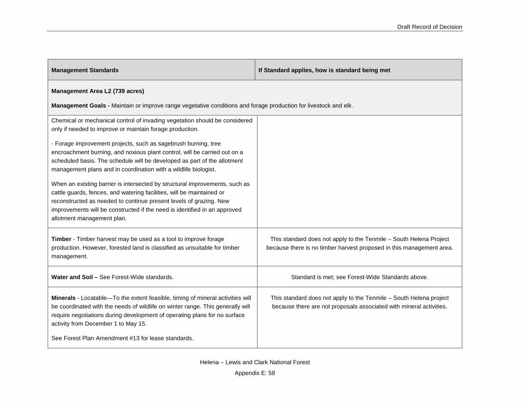
Draft Record of Decision
Helena – Lewis and Clark National Forest
Appendix E: 58
Management Standards If Standard applies, how is standard being met
Management Area L2 (739 acres)
Management Goals - Maintain or improve range vegetative conditions and forage production for livestock and elk.
Chemical or mechanical control of invading vegetation should be considered only if needed to improve or maintain forage production.
- Forage improvement projects, such as sagebrush burning, tree encroachment burning, and noxious plant control, will be carried out on a scheduled basis. The schedule will be developed as part of the allotment management plans and in coordination with a wildlife biologist.
When an existing barrier is intersected by structural improvements, such as cattle guards, fences, and watering facilities, will be maintained or reconstructed as needed to continue present levels of grazing. New improvements will be constructed if the need is identified in an approved allotment management plan.
Timber - Timber harvest may be used as a tool to improve forage production. However, forested land is classified as unsuitable for timber management.
This standard does not apply to the Tenmile – South Helena Project because there is no timber harvest proposed in this management area.
Water and Soil – See Forest-Wide standards. Standard is met; see Forest-Wide Standards above.
Minerals - Locatable—To the extent feasible, timing of mineral activities will be coordinated with the needs of wildlife on winter range. This generally will require negotiations during development of operating plans for no surface activity from December 1 to May 15.
See Forest Plan Amendment #13 for lease standards.
This standard does not apply to the Tenmile – South Helena project because there are not proposals associated with mineral activities.

Tenmile – South Helena Project
Helena – Lewis and Clark National Forest
Appendix E: 59
Management Standards If Standard applies, how is standard being met
Management Area L2 (739 acres)
Management Goals - Maintain or improve range vegetative conditions and forage production for livestock and elk.
Lands – See Forest-Wide Standards. See Forest-Wide Standards.
Facilities - Roads normally will not be constructed for range or wildlife management activities, but may be constructed for other activities, such as mining, or to provide access to adjacent management areas. The necessary structures to prevent cattle drift (fences, gates, cattle guards, etc.) will be installed during road construction.
The Tenmile-South Helena project does not propose any new temporary road construction in this management area. This standard is met.
Protection - Evaluate areas periodically for significant insect and disease problems. Endemic levels will be accepted as normal. If epidemic levels develop and control is necessary, the control method should minimize impacts on big game and other wildlife values.
The appropriate fire suppression response ranges from control to confinement depending upon location, expected fire behavior, and other decision logic criteria related to values at risk. These decision criteria are stated in the Fire Management Direction in Appendix R.
Prescribed fire with unplanned ignitions may be used in this management area, for the enhancement and maintenance of resources, when within pre-established prescribed fire criteria. These criteria are detailed in the Fire Management Direction in Appendix R.
Prescribed fire may be used as a tool to reduce fuels and increase the productivity of forage for wildlife and livestock.
This standard applies and is met through removal of insect-killed trees, establishment of desirable regeneration, and improving forest health to be more resistant to bark beetle activity in the future. Insect-killed trees are
proposed for removal in treatment units with this draft decision.
Fire suppression strategy will not change with this draft decision.
Prescribed burning will be used in this draft decision to improve forage. Standards will be met through the development of silvicultural prescriptions and burn plan development. Additionally, adherence to design criteria will
help meet standards relating to prescribed burning.

Draft Record of Decision
Helena – Lewis and Clark National Forest
Appendix E: 60
Management Standards If Standard applies, how is standard being met
Management Area L2 (739 acres)
Management Goals - Maintain or improve range vegetative conditions and forage production for livestock and elk.
Riparian – See Forest-Wide Standards. See Forest-Wide Standards
Management Standards If Standard applies, how is standard being met
Management Area M1 (7,486 acres) Management Goals - Maintain the present condition with minimal investment for resource activities, while protecting the basic soil, water, and wildlife resources.
Description – These areas are nonforested and forested land where timber management and range or wildlife habitat improvements are currently uneconomical or environmentally infeasible. The area is scattered throughout the Forest and is found at all elevations and slopes ranging from 10 percent to over 60 percent. The parcels range in size from 20 to 500 acres.
Recreation - Dispersed recreation can be supported by constructing trails, trailhead facilities, and sanitation facilities.
This standard applies and is met. This draft decision proposes adding new non-motorized trail to the NFS trail network in MA M-1.
Visual - Because of the lack of activity, the general visual quality objective (VQO) is retention. Less restrictive VQOs may be considered on a case-by-case basis, if project level planning on an adjacent management area affects M-1 management area. [See Forest Landscape Management Book, Vol. 2 (Ag. Hdbk. No. 462) for definitions of VQOs and how they are applied.]
Implementation of this draft decision will be consistent with this management area. By implementing the design criteria described
above, VQOs for retention will be met.
Proposed landings, temporary roads, skyline corridors, and skid trails in areas with VQO’s of retention and partial retention will meet
VQO standards but not immediately upon implementation of activities. However, design criteria will minimize any short-term
negative impacts and will result in long-term positive effects to the scenic quality of the project area.
Wildlife and Fisheries - Management practices to maintain or improve wildlife habitat will be permitted where necessary to meet the objectives of adjacent management areas.
This standard applies and is met. Watershed improvement activities are proposed for the project which will potentially have a beneficial

Tenmile – South Helena Project
Helena – Lewis and Clark National Forest
Appendix E: 61
Management Standards If Standard applies, how is standard being met
Management Area M1 (7,486 acres) Management Goals - Maintain the present condition with minimal investment for resource activities, while protecting the basic soil, water, and wildlife resources.
effect on aquatic resources. Management practices are consistent with this management area.
Range - Livestock use may remain at the 1983 level if the area is within existing allotments. Maintain range improvements and build new improvements, if they are needed to facilitate management of adjacent areas.
Not applicable because the Tenmile-South Helena Project does not propose any changes to livestock use within the project area.
Timber - Timber harvest, such as salvage and firewood removal, may occur where access exists. Slash created by any management practice will be disposed of in a manner consistent with the management area goals. Forested lands are classified as unsuitable for timber management.
No timber harvest proposed in this management area. Slash created by the rearrangement of fuels will be disposed of in a
variety of ways consistent with this management area. See Fire and Fuels report for additional information.
Facilities - Roads will be allowed for special uses, mineral development, or to provide access to other management areas, consistent with protection of soil and water values. Roads may be opened or closed, depending on the objectives of the adjacent management areas.
- Existing roads and trails will be maintained as needed.
This standard applies and is met. Temporary Roads will be constructed for this draft decision to access vegetation treatment
units and other management areas. Design criteria incorporate road width, grade and amount of disturbed area. Temporary roads will be
closed and rehabilitated after use.
Existing roads will be maintained or reconstructed in accordance with Montana and R1 BMPs under this draft decision.
Minerals – See Forest Plan Amendment #13 for lease standards. This standard does not apply because there are no proposals associated with this project associated with mineral activities.
Protection - Salvage of dead, dying, or high-hazard trees is permitted to prevent disease and insect population build-up.
- The appropriate fire suppression response ranges from control to confinement depending upon location, expected fire behavior, and other decision criteria related to values at risk. These criteria are stated in the Fire Management Direction in Appendix R.
- Prescribed fire with planned ignitions may be used in this management area, for the enhancement and maintenance of resources.
This standard applies and is met. Part of the purpose and need for this project includes salvage of insect-killed trees, establishing desirable regeneration, and improving forest health to be more
resistant and resilient to bark beetle activity in the future. Insect-killed and currently infested trees are proposed for removal in
harvest units with this draft decision.
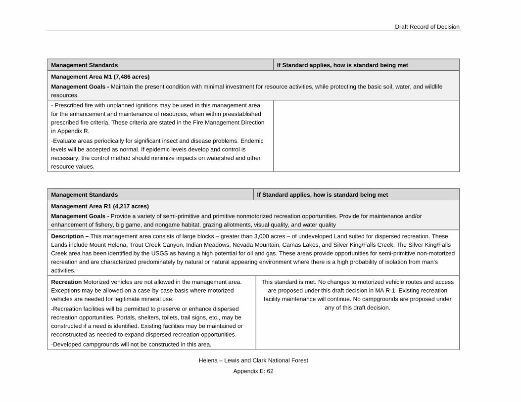
Draft Record of Decision
Helena – Lewis and Clark National Forest
Appendix E: 62
Management Standards If Standard applies, how is standard being met
Management Area M1 (7,486 acres) Management Goals - Maintain the present condition with minimal investment for resource activities, while protecting the basic soil, water, and wildlife resources.
- Prescribed fire with unplanned ignitions may be used in this management area, for the enhancement and maintenance of resources, when within preestablished prescribed fire criteria. These criteria are stated in the Fire Management Direction in Appendix R.
-Evaluate areas periodically for significant insect and disease problems. Endemic levels will be accepted as normal. If epidemic levels develop and control is necessary, the control method should minimize impacts on watershed and other resource values.
Management Standards If Standard applies, how is standard being met
Management Area R1 (4,217 acres) Management Goals - Provide a variety of semi-primitive and primitive nonmotorized recreation opportunities. Provide for maintenance and/or enhancement of fishery, big game, and nongame habitat, grazing allotments, visual quality, and water quality
Description – This management area consists of large blocks – greater than 3,000 acres – of undeveloped Land suited for dispersed recreation. These Lands include Mount Helena, Trout Creek Canyon, Indian Meadows, Nevada Mountain, Camas Lakes, and Silver King/Falls Creek. The Silver King/Falls Creek area has been identified by the USGS as having a high potential for oil and gas. These areas provide opportunities for semi-primitive non-motorized recreation and are characterized predominately by natural or natural appearing environment where there is a high probability of isolation from man’s activities.
Recreation Motorized vehicles are not allowed in the management area. Exceptions may be allowed on a case-by-case basis where motorized vehicles are needed for legitimate mineral use.
-Recreation facilities will be permitted to preserve or enhance dispersed recreation opportunities. Portals, shelters, toilets, trail signs, etc., may be constructed if a need is identified. Existing facilities may be maintained or reconstructed as needed to expand dispersed recreation opportunities.
-Developed campgrounds will not be constructed in this area.
This standard is met. No changes to motorized vehicle routes and access are proposed under this draft decision in MA R-1. Existing recreation
facility maintenance will continue. No campgrounds are proposed under any of this draft decision.

Tenmile – South Helena Project
Helena – Lewis and Clark National Forest
Appendix E: 63
Management Standards If Standard applies, how is standard being met
Management Area R1 (4,217 acres) Management Goals - Provide a variety of semi-primitive and primitive nonmotorized recreation opportunities. Provide for maintenance and/or enhancement of fishery, big game, and nongame habitat, grazing allotments, visual quality, and water quality
Visual - Management practices will follow the guidelines for the retention VQO. Short term deviations may occur during construction or reconstruction of facilities or from management activities. [See Forest Landscape Management Book, Vol. 2 (Ag. Hdbk, No. 462) for definitions of VQOs and how they are applied.]
Implementation of this draft decision will be consistent with this management area. By implementing the design criteria described above,
VQOs for retention will be met.
Proposed landings, temporary roads, skyline corridors, and, skid trails in areas with VQO’s of retention and partial retention will meet VQO
standards but not immediately upon implementation of activities. However, design criteria will minimize any short-term negative impacts and will result
in long –term positive effects to the scenic quality of the project area.
Wildlife and Fisheries – Habitat improvement projects, such as prescribed fire and water developments, may be used to maintain or improve the fish and wildlife habitat, if the projects are compatible with the area’s goals.
Prescribe fire is proposed on units within this management area and will improve forest health to be more resistant to bark beetle activity in the
future which will have a potential beneficial effect to wildlife habitat
Range - Livestock grazing will be maintained at the 1983 levels within existing allotments, however, the level may be increased or decreased if monitoring or range analysis shows a need or opportunity to change.
-Range improvements, such as salting, water developments, etc., may be implemented to disperse livestock use.
Not applicable because the Tenmile-South Helena Project does not propose any changes to livestock use within the project area.
Timber - Forested lands are classified as unsuitable for timber management.
This standard for the Tenmile – South Helena project is met because there is no timber harvest proposed within this management area.
Water and Soils – See Forest-Wide Standard. Standard is met, see Forest-Wide Standards above.
Minerals – Locatable – Maintain an unroaded environment to the extent practical under the mining laws and the Mining Act Use Regulations. Use of motorized vehicles and timing of mineral activities will be coordinated with dispersed recreation and wildlife needs during development of the operating plan.
-Leasable See Forest Plan Amendment #13 for lease standards
This standard does not apply to the Tenmile – South Helena project because there are no proposed mineral activities or associated road
construction with the project.
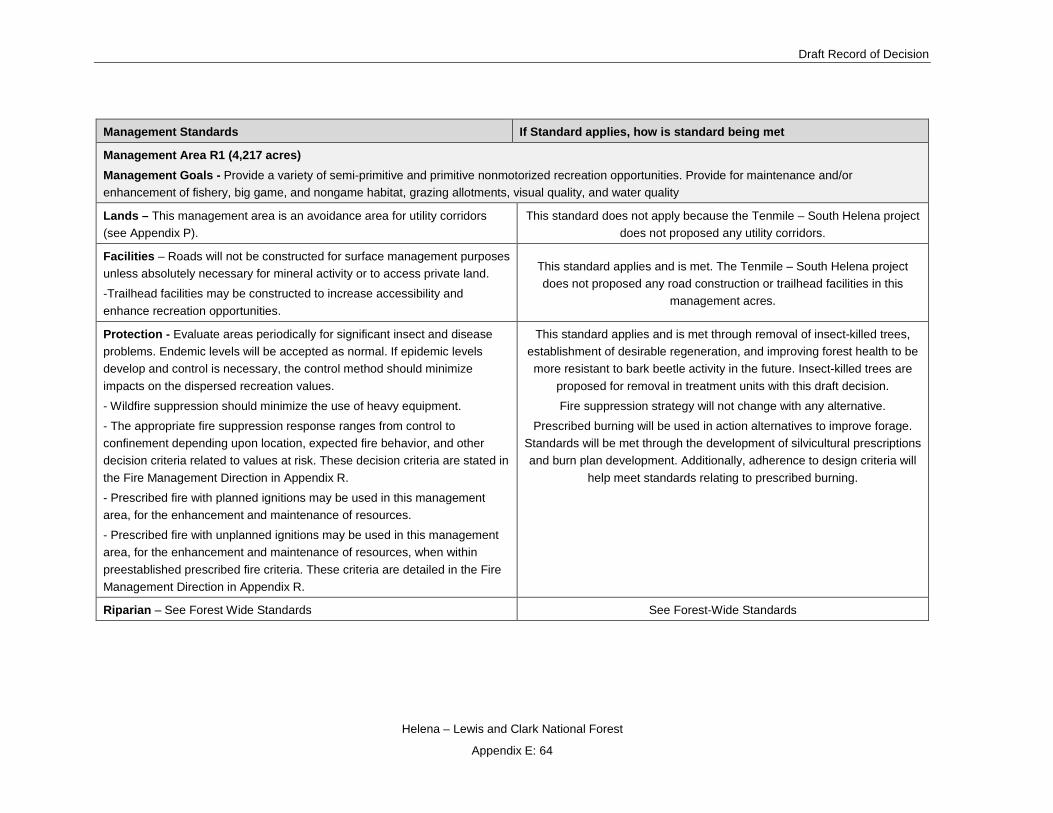
Draft Record of Decision
Helena – Lewis and Clark National Forest
Appendix E: 64
Management Standards If Standard applies, how is standard being met
Management Area R1 (4,217 acres) Management Goals - Provide a variety of semi-primitive and primitive nonmotorized recreation opportunities. Provide for maintenance and/or enhancement of fishery, big game, and nongame habitat, grazing allotments, visual quality, and water quality
Lands – This management area is an avoidance area for utility corridors (see Appendix P).
This standard does not apply because the Tenmile – South Helena project does not proposed any utility corridors.
Facilities – Roads will not be constructed for surface management purposes unless absolutely necessary for mineral activity or to access private land.
-Trailhead facilities may be constructed to increase accessibility and enhance recreation opportunities.
This standard applies and is met. The Tenmile – South Helena project does not proposed any road construction or trailhead facilities in this
management acres.
Protection - Evaluate areas periodically for significant insect and disease problems. Endemic levels will be accepted as normal. If epidemic levels develop and control is necessary, the control method should minimize impacts on the dispersed recreation values.
- Wildfire suppression should minimize the use of heavy equipment.
- The appropriate fire suppression response ranges from control to confinement depending upon location, expected fire behavior, and other decision criteria related to values at risk. These decision criteria are stated in the Fire Management Direction in Appendix R.
- Prescribed fire with planned ignitions may be used in this management area, for the enhancement and maintenance of resources.
- Prescribed fire with unplanned ignitions may be used in this management area, for the enhancement and maintenance of resources, when within preestablished prescribed fire criteria. These criteria are detailed in the Fire Management Direction in Appendix R.
This standard applies and is met through removal of insect-killed trees, establishment of desirable regeneration, and improving forest health to be more resistant to bark beetle activity in the future. Insect-killed trees are
proposed for removal in treatment units with this draft decision.
Fire suppression strategy will not change with any alternative.
Prescribed burning will be used in action alternatives to improve forage. Standards will be met through the development of silvicultural prescriptions and burn plan development. Additionally, adherence to design criteria will
help meet standards relating to prescribed burning.
Riparian – See Forest Wide Standards See Forest-Wide Standards

Tenmile – South Helena Project
Helena – Lewis and Clark National Forest
Appendix E: 65
Management Standards If Standard applies, how is standard being met
Management Area T1 (9,059 acres) Management Goals - Provide healthy timber stands and optimize timber growing potential over the planning horizon. Emphasize cost-effective timber production, while protecting the soil productivity. Maintain water quality and stream bank stability. Provide for dispersed recreation opportunities, wildlife habitat, and livestock use, when consistent with the timber management goals.
Description - This management area consists of lands available and suitable for timber management with varying physical and biological environments as determined by soil, slope, aspect, elevation, and climatic factors. Vegetation varies from ponderosa pine on the drier sites to spruce in the more mesic sites with nearly all slopes and aspects represented. Although this area consists primarily of suitable forest land, there are inclusions of nonforest and nonproductive forest lands. This area includes some small ponds and marshes which are considered unique to this part of Montana.
Recreation - Motorized and non-motorized dispersed recreation activities are permitted and may be supported by constructing or maintaining trails and trailhead facilities. Existing trails and facilities will be maintained unless they are no longer needed. - Controls on motorized recreation will be implemented where necessary, to protect the vegetation, soil, and water resources and to prevent road damage.
This standard is met. No changes to existing motorized recreation opportunities are proposed under this draft decision. This draft decision
proposes adding new non-motorized trail to the NFS trail network in MA T-1.
Visual - Management practices will generally follow guidelines for the maximum modification VQO. The portions of this area (if any) that are within the sensitive viewing areas of the roads, trails, and areas listed in Appendix B will be managed to meet more restrictive VQOs noted in the appendix. [See Forest Management Book, Vol. 2 (Ag. Hdbk, No. 462) for definitions of VQOs and how they are applied.]
Implementation of this draft decision will be consistent with this management area. By implementing the design criteria described above,
VQOs for maximum modification retention will be met.
Wildlife and Fisheries - Wildlife and fisheries habitat improvement projects may be implemented, provided they are compatible with the management area goals.
Forest-Wide Standards and Appendix D contain guidance for T&E species habitat.
Wildlife and fisheries habitat improvements as a result of proposed treatments in this MA have been identified. Refer to the Wildlife and
Fisheries sections in Chapter 3 of the FEIS. Refer to the T&E section under Forest-Wide Standards for more information. This standard is met.
Range - Livestock grazing is compatible, except where it conflicts with stand establishment. Fencing, temporary herding, or other techniques may be used to protect regeneration where needed.
This standard applies and is met. The design criterion for the project incorporates this standard.

Draft Record of Decision
Helena – Lewis and Clark National Forest
Appendix E: 66
Management Standards If Standard applies, how is standard being met
Management Area T1 (9,059 acres) Management Goals - Provide healthy timber stands and optimize timber growing potential over the planning horizon. Emphasize cost-effective timber production, while protecting the soil productivity. Maintain water quality and stream bank stability. Provide for dispersed recreation opportunities, wildlife habitat, and livestock use, when consistent with the timber management goals. Pasture and allotment boundaries should be maintained during and following timber harvest. This may require additional fencing, where natural barriers are breached by timber sale activities.
Livestock grazing will be maintained at the 1983 levels within existing allotments, however, the level may be increased or decreased if monitoring or range analysis shows a need or opportunity to change.
Timber - This management area is suitable for timber management activities.
Timber harvest practices include clearcut, group selection, and shelterwood harvest, depending on habitat group, physical site conditions, and silvicultural objectives. Precommercial thinning and intermediate harvest may occur where needed as determined by silvicultural objectives and project planning. (Appendices H and M provide broad guidelines for various habitat groups.)
As a minimum, a cutover area will not be considered an opening when: (1) a new forest stand is established and certified as stocked, and (2) vegetative conditions reach the point where harvest of additional timber can occur and the combined area can still meet watershed management objectives.
Prescribed burning or other techniques may be used for slash disposal, site preparation, silvicultural, and livestock objectives. In habitat groups where fire is not a useful treatment tool, lopping and scattering, yarding unmerchantable material (YUM), or other methods will be used to reduce fuel accumulations and prepare sites for regeneration.
Project-level planning will provide for stand regeneration within five years of final harvest.
Even-aged stands will be scheduled for final regeneration harvest when they generally have reached the culmination of mean annual increment (CMAI) of
The draft decision incudes conducting timber management activities in the MA for the purpose of removing fuels from stands. This standard is met.

Tenmile – South Helena Project
Helena – Lewis and Clark National Forest
Appendix E: 67
Management Standards If Standard applies, how is standard being met
Management Area T1 (9,059 acres) Management Goals - Provide healthy timber stands and optimize timber growing potential over the planning horizon. Emphasize cost-effective timber production, while protecting the soil productivity. Maintain water quality and stream bank stability. Provide for dispersed recreation opportunities, wildlife habitat, and livestock use, when consistent with the timber management goals. growth. Exceptions include thinning or other stand improvement measures, salvage or sanitation harvest, management for experimental or research purposes and to meet other resource objectives. CMAI for primary species on the Helena National Forest is shown in Appendix H.
Water and Soils
Timber harvest will not create runoff increases which are likely to result in long term stream channel degradation. All timber sale proposals will include an analysis of the current and projected status of sediment produced. The project proposal will analyze and evaluate the potential water quantity and quality, and soil productivity impacts; mitigation measures should be developed to minimize adverse effects. If a proposal shows the water quality cannot be maintained, the project will be reevaluated or terminated.
This standard applies and is met. Chapter 3 of the DEIS discloses the analysis for hydrology and soil resources. Analysis includes current and projected sediment production; potential water quantity and quality, and
soil productivity impacts; and mitigation measures have been developed to minimize adverse effects.
Minerals – Locatable – See Forest-Wide Standards.
Leasable See Forest Plan Amendment #13 for lease standards This standard does not apply to the Tenmile – South Helena project because the project proposal does not included mineral activities.
Lands – See Forest-Wide Standards See Forest Wide Standard.
Facilities - Roads will be constructed as needed to meet the management objectives of the area.
Where existing trails are intersected by new road construction, the trail will be evaluated to determine if it should be retained on the system or abandoned.
This standard is met. New temporary road construction is proposed under the draft decision in this management area to access vegetation treatment
units and remove fuel. New temporary roads will be closed and decommissioned after harvest activities are completed. See chapter 2 of
this FEIS for design criteria associated with temporary roads.
Protection
Insect and disease control should emphasize reduction and prevention through timber harvest and timber stand improvement. The use of other approved integrated pest management techniques may be necessary at times.
Standard does apply to the draft decision and is met. Proposed harvest will respond to insect-caused mortality and lower the hazard of future insect problems within treatment units. Prescribed fire will be used to reduce
natural fuels. Refer to Forested Vegetation Specialist Report.

Draft Record of Decision
Helena – Lewis and Clark National Forest
Appendix E: 68
Management Standards If Standard applies, how is standard being met
Management Area T1 (9,059 acres) Management Goals - Provide healthy timber stands and optimize timber growing potential over the planning horizon. Emphasize cost-effective timber production, while protecting the soil productivity. Maintain water quality and stream bank stability. Provide for dispersed recreation opportunities, wildlife habitat, and livestock use, when consistent with the timber management goals. The appropriate fire suppression response ranges from control to containment depending upon location, expected fire behavior, and other decision logic criteria related to values at risk. These decision criteria are stated in the Fire Management Direction in Appendix R.
Prescribed fire with planned ignitions may be used in this management area, for the enhancement and maintenance of resources.
Fuel reduction methods for activity created fuels include burning, removing residue, or rearranging, such as dozer trampling.
Prescribed burning will be used in action alternatives to improve forage. Standards will be met through the development of silvicultural prescriptions and burn plan development. Additionally, adherence to design criteria will
help meet standards relating to prescribed burning.
Riparian - Generally, harvesting will only occur in riparian areas in conjunction with sale activity on adjacent lands.
In riparian areas, any timber harvest should be on a 240-year rotation, and harvest types should be selection or group selection.
See Forest-Wide Standards for grazing in riparian.
The small ponds and marshes in Section 15, 16, 21, and 22 of T8N, R6W PMM are unique to this part of Montana and will be protected in project design and implementation.
Standard does apply to the draft decision and is met. Riparian best management practices will be followed.
Management Standards If Standard applies, how is standard being met
Management Area T3 (265 acres) Management Goals - Maintain and/or enhance habitat characteristics favored by elk and other big game species. Provide for healthy timber stands and a timber harvest program compatible with wildlife habitat goals for this area. Emphasize cost-effective timber production, while protecting the soil productivity. Maintain water quality and stream bank stability. Provide for other resource objectives where compatible with the big game summer range and timber goals.
Description - This management area consists of lands that have primary forage, resting, and security characteristics that provide important spring and summer requirements for all big game species. These lands also supply the habitat needs of a wide variety of nongame forest dwelling wildlife. In addition

Tenmile – South Helena Project
Helena – Lewis and Clark National Forest
Appendix E: 69
Management Standards If Standard applies, how is standard being met
Management Area T3 (265 acres) Management Goals - Maintain and/or enhance habitat characteristics favored by elk and other big game species. Provide for healthy timber stands and a timber harvest program compatible with wildlife habitat goals for this area. Emphasize cost-effective timber production, while protecting the soil productivity. Maintain water quality and stream bank stability. Provide for other resource objectives where compatible with the big game summer range and timber goals.
lands within this management area contain productive timber sites that are available and suitable for timber management. The variation in elevation, topography, slope, and aspect, in addition to the often abundant surface water (seeps, springs, etc.), make these areas rich in species diversity and total numbers within species groups. This area also has inclusions of small grassland parks.
Recreation - Controls over motorized dispersed recreation will be implemented where necessary to protect wildlife habitat values.
Nonmotorized dispersed recreation may be supported by constructing trails and trailhead facilities when compatible with management area goals.
This standard is met. Design criteria has been developed to reduce the potential for establishments of user created (motorized and non-motorized) routes (see chapter 2 of the FEIS). This draft decision does not propose to develop new non-motorized disperse recreation opportunities in MA T-3.
Visual - Management practices will generally follow guidelines for the modification VQO. The portions of this area (if any) that are within the sensitive viewing areas of the roads, trails, and areas listed in Appendix B will be managed to meet the more restrictive VQOs noted in the appendix. [See Forest Landscape Management Book, Vol. 2 (Ag. Hdbk. No. 462) for definitions of VQOs and how they are applied.]
Implementation of this draft decision will be consistent with this management area. By implementing the design criteria described above,
VQOs for modification will be met.
Wildlife and Fisheries - Maintain a minimum of 35 percent hiding cover for big game.
Maintain thermal cover adjacent to forage areas. Appendix C provides guidance for thermal cover.
Wildlife habitat improvement practices, including road management, prescribed fire, and timber harvest, may be used to maintain and/or enhance the quality of big game summer habitat.
(1) Maintain thermal cover adjacent to forage areas. There are broad parks adjacent to thermal cover in this management area. Treatment effects will vary, from substantial cover reductions associated with improvement cuts
to more cover retention in prescribed fire units. Because design criteria are in place that require retention of timbered areas (i.e., thermal cover) adjacent to openings, this draft decision will be consistent with this
standard.
(2) Maintain a minimum of 35 percent hiding cover for big game. There are 211 acres of hiding cover (80 percent) in this management area in the
existing condition. The draft decision includes treatments on 40 acres of hiding cover of which 31 acres are precommercial thinning which are

Draft Record of Decision
Helena – Lewis and Clark National Forest
Appendix E: 70
Management Standards If Standard applies, how is standard being met
Management Area T3 (265 acres) Management Goals - Maintain and/or enhance habitat characteristics favored by elk and other big game species. Provide for healthy timber stands and a timber harvest program compatible with wildlife habitat goals for this area. Emphasize cost-effective timber production, while protecting the soil productivity. Maintain water quality and stream bank stability. Provide for other resource objectives where compatible with the big game summer range and timber goals.
designed to retain hiding cover post-treatment. As a result, 202 acres of hiding cover will remain or 75 percent. This standard is met.
(3) Wildlife habitat improvement practices, including road management, prescribed fire, and other techniques, will be used to maintain and/or
enhance the quality of big game summer habitat. The project is designed to improve forage conditions. Prescribed fire goals include improving grass
and shrublands as well as promoting open grown forests that are beneficial to elk and deer.
(4) Openings created by timber harvest will be reforested to the extent necessary to meet the hiding cover requirements of big game before
harvesting adjacent areas. Timber harvest is proposed in T-3; however, past timber harvest within T-3 is currently providing hiding cover.
Range - Livestock grazing will be maintained at the 1983 levels within existing allotments, however, the level may be increased or decreased if monitoring or range analysis show a need or opportunity to change.
Grazing systems will be designed to be compatible with wildlife needs.
Improvements for livestock management, such as fencing and water developments, will be implemented unless they are a detriment to big game.
Not applicable because the Tenmile-South Helena Project does not propose any changes to livestock use within the project area.
Timber - This management area is suitable for timber management activities.
Timber harvest methods and volumes may be modified as necessary to achieve the management area goals.
Even-aged stands will be scheduled for final regeneration harvest when they generally have reached the culmination of mean annual increment (CMAI) of growth. Exceptions include salvage or sanitation harvest and management
Timber management in this draft decision increases vegetative diversity and provides for healthy timber stands. See the above Fisheries and
Wildlife standard for this management area for Timber management and wildlife habitat goals.

Tenmile – South Helena Project
Helena – Lewis and Clark National Forest
Appendix E: 71
Management Standards If Standard applies, how is standard being met
Management Area T3 (265 acres) Management Goals - Maintain and/or enhance habitat characteristics favored by elk and other big game species. Provide for healthy timber stands and a timber harvest program compatible with wildlife habitat goals for this area. Emphasize cost-effective timber production, while protecting the soil productivity. Maintain water quality and stream bank stability. Provide for other resource objectives where compatible with the big game summer range and timber goals.
for experimental or research purposes and to meet other resource objectives. CMAI for primary species on the Helena National Forest is shown in Appendix H. Appendix M provides guidance for various vegetative management practices by habitat group.
Stocking control may be maintained through pre-commercial and commercial thinning. The timing and planning of thinning operations will be coordinated with a wildlife biologist.
Vegetative diversity will be encouraged.
Openings created by timber harvest will be reforested to the extent necessary to meet the hiding cover requirements of big game before harvesting adjacent areas.
Water and Soils - Timber harvest will not create runoff increases which are likely to result in long term channel degradation. All timber sale proposals will include an analysis of the current and projected status of sediment produced. The project proposal will analyze and evaluate the potential water quantity and quality and soil productivity impacts; mitigation measures should be developed to minimize adverse effects. If a project proposal shows the water quality cannot be maintained, the project will be reevaluated or terminated.
This standard applies and is met. Chapter 3 of the FEIS discloses the analysis for hydrology and soil resources. Analysis includes current and projected sediment production; potential water quantity and quality, and
soil productivity impacts; and mitigation measures have been developed to minimize adverse effects.
Minerals - Locatable—To the extent feasible, timing of activities will be coordinated with the needs of wildlife on summer range. This will require negotiations during development of operating plans for minimum disturbance to wildlife.
Leasable ---- See Forest Plan Amendment #13 for lease standards
This standard does not apply to the Tenmile – South Helena project because the project does not propose any changes to mineral activities.
Lands – See Forest-Wide Standards See Forest-Wide Standards

Draft Record of Decision
Helena – Lewis and Clark National Forest
Appendix E: 72
Management Standards If Standard applies, how is standard being met
Management Area T3 (265 acres) Management Goals - Maintain and/or enhance habitat characteristics favored by elk and other big game species. Provide for healthy timber stands and a timber harvest program compatible with wildlife habitat goals for this area. Emphasize cost-effective timber production, while protecting the soil productivity. Maintain water quality and stream bank stability. Provide for other resource objectives where compatible with the big game summer range and timber goals.
Facilities - Roads will be constructed as needed to meet the management area goals.
Where existing trails are intersected by new road construction, the trail will be evaluated to determine if it should be retained on the system or abandoned.
New temporary road construction is proposed under this draft decision to access vegetation treatment units. New temporary roads will be closed
and rehabilitated after use. This standard is met.
Protection - Insect and disease control should emphasize reduction and prevention through timber harvest and timber stand improvement. The use of other approved integrated pest management techniques may be necessary at times.
The appropriate fire suppression response ranges from control to containment depending upon location, expected fire behavior, and other decision criteria related to values at risk. These decision criteria are stated in the Fire Management Direction in Appendix R.
Prescribed fire with planned ignitions may be used in this management area, for the enhancement and maintenance of resources.
Fuel reduction methods for activity created fuels include burning, removing residue, or rearranging, such as dozer trampling. Disposal activities will meet visual quality objectives.
Standard does apply to this draft decision and is met. Proposed harvest will respond to insect-caused mortality and lower the hazard of future insect problems within treatment units. Prescribed fire will be used to reduce natural fuels. Refer to Forested Vegetation Specialist Report.
Standards will be met through the development of silvicultural prescriptions and burn plan development. Additionally, adherence to design criteria will
help meet standards relating to prescribed burning.
Riparian - See Forest Wide Standards for grazing in riparian.
Generally, harvesting will only occur in riparian areas if in conjunction with sale activity on adjacent lands.
In riparian areas, any timber harvest should be on a 240-year rotation and harvest types should be selection or group selection.
This standard applies and is met for the Tenmile – South Helena project. The project does not propose any changes to grazing activities. Riparian
best management practices will be followed.
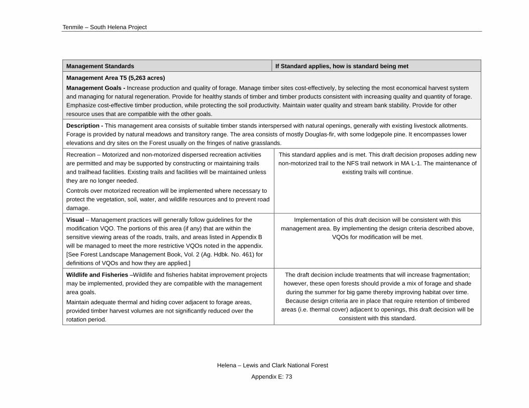
Tenmile – South Helena Project
Helena – Lewis and Clark National Forest
Appendix E: 73
Management Standards If Standard applies, how is standard being met
Management Area T5 (5,263 acres) Management Goals - Increase production and quality of forage. Manage timber sites cost-effectively, by selecting the most economical harvest system and managing for natural regeneration. Provide for healthy stands of timber and timber products consistent with increasing quality and quantity of forage. Emphasize cost-effective timber production, while protecting the soil productivity. Maintain water quality and stream bank stability. Provide for other resource uses that are compatible with the other goals.
Description - This management area consists of suitable timber stands interspersed with natural openings, generally with existing livestock allotments. Forage is provided by natural meadows and transitory range. The area consists of mostly Douglas-fir, with some lodgepole pine. It encompasses lower elevations and dry sites on the Forest usually on the fringes of native grasslands.
Recreation – Motorized and non-motorized dispersed recreation activities are permitted and may be supported by constructing or maintaining trails and trailhead facilities. Existing trails and facilities will be maintained unless they are no longer needed.
Controls over motorized recreation will be implemented where necessary to protect the vegetation, soil, water, and wildlife resources and to prevent road damage.
This standard applies and is met. This draft decision proposes adding new non-motorized trail to the NFS trail network in MA L-1. The maintenance of
existing trails will continue.
Visual – Management practices will generally follow guidelines for the modification VQO. The portions of this area (if any) that are within the sensitive viewing areas of the roads, trails, and areas listed in Appendix B will be managed to meet the more restrictive VQOs noted in the appendix. [See Forest Landscape Management Book, Vol. 2 (Ag. Hdbk. No. 461) for definitions of VQOs and how they are applied.]
Implementation of this draft decision will be consistent with this management area. By implementing the design criteria described above,
VQOs for modification will be met.
Wildlife and Fisheries –Wildlife and fisheries habitat improvement projects may be implemented, provided they are compatible with the management area goals.
Maintain adequate thermal and hiding cover adjacent to forage areas, provided timber harvest volumes are not significantly reduced over the rotation period.
The draft decision include treatments that will increase fragmentation; however, these open forests should provide a mix of forage and shade during the summer for big game thereby improving habitat over time. Because design criteria are in place that require retention of timbered
areas (i.e. thermal cover) adjacent to openings, this draft decision will be consistent with this standard.
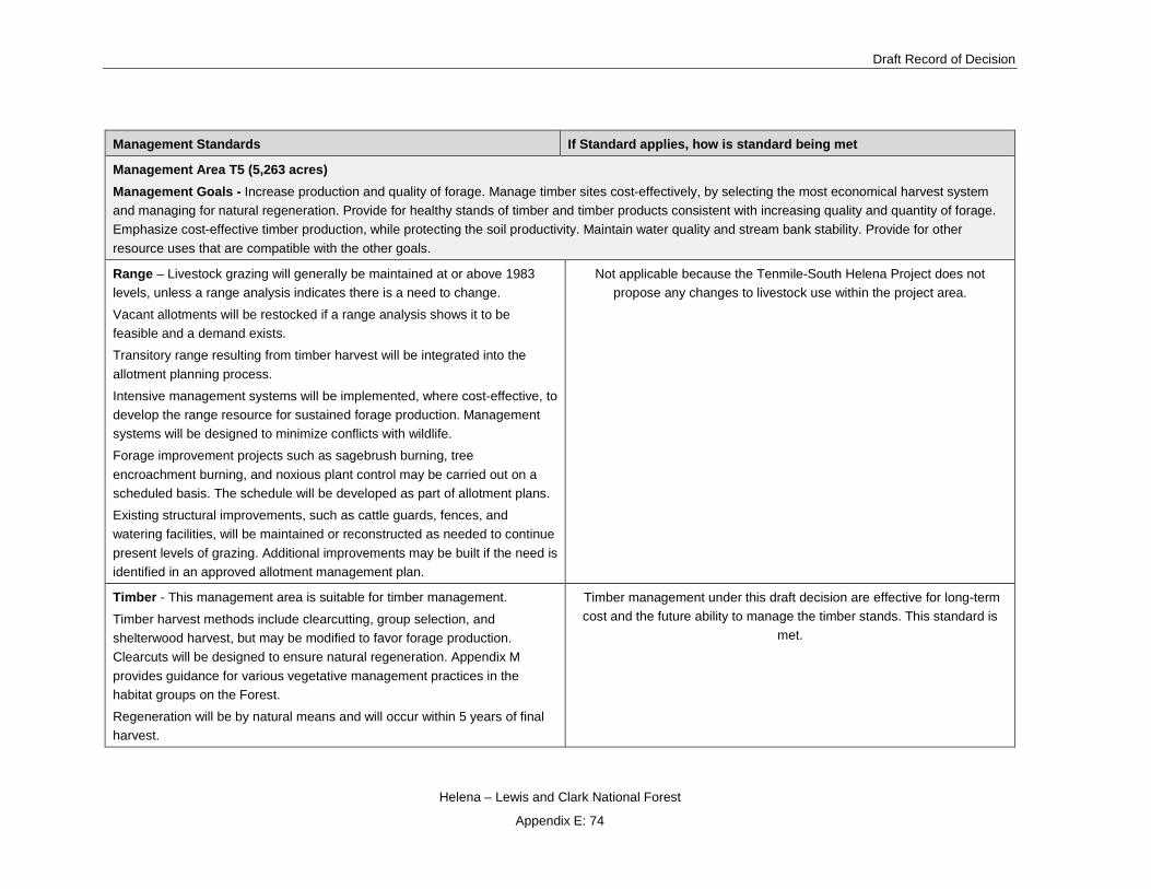
Draft Record of Decision
Helena – Lewis and Clark National Forest
Appendix E: 74
Management Standards If Standard applies, how is standard being met
Management Area T5 (5,263 acres) Management Goals - Increase production and quality of forage. Manage timber sites cost-effectively, by selecting the most economical harvest system and managing for natural regeneration. Provide for healthy stands of timber and timber products consistent with increasing quality and quantity of forage. Emphasize cost-effective timber production, while protecting the soil productivity. Maintain water quality and stream bank stability. Provide for other resource uses that are compatible with the other goals.
Range – Livestock grazing will generally be maintained at or above 1983 levels, unless a range analysis indicates there is a need to change.
Vacant allotments will be restocked if a range analysis shows it to be feasible and a demand exists.
Transitory range resulting from timber harvest will be integrated into the allotment planning process.
Intensive management systems will be implemented, where cost-effective, to develop the range resource for sustained forage production. Management systems will be designed to minimize conflicts with wildlife.
Forage improvement projects such as sagebrush burning, tree encroachment burning, and noxious plant control may be carried out on a scheduled basis. The schedule will be developed as part of allotment plans.
Existing structural improvements, such as cattle guards, fences, and watering facilities, will be maintained or reconstructed as needed to continue present levels of grazing. Additional improvements may be built if the need is identified in an approved allotment management plan.
Not applicable because the Tenmile-South Helena Project does not propose any changes to livestock use within the project area.
Timber - This management area is suitable for timber management.
Timber harvest methods include clearcutting, group selection, and shelterwood harvest, but may be modified to favor forage production. Clearcuts will be designed to ensure natural regeneration. Appendix M provides guidance for various vegetative management practices in the habitat groups on the Forest.
Regeneration will be by natural means and will occur within 5 years of final harvest.
Timber management under this draft decision are effective for long-term cost and the future ability to manage the timber stands. This standard is
met.
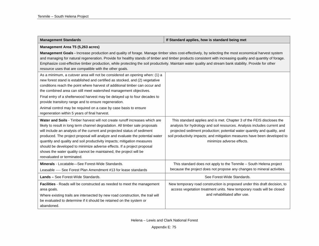
Tenmile – South Helena Project
Helena – Lewis and Clark National Forest
Appendix E: 75
Management Standards If Standard applies, how is standard being met
Management Area T5 (5,263 acres) Management Goals - Increase production and quality of forage. Manage timber sites cost-effectively, by selecting the most economical harvest system and managing for natural regeneration. Provide for healthy stands of timber and timber products consistent with increasing quality and quantity of forage. Emphasize cost-effective timber production, while protecting the soil productivity. Maintain water quality and stream bank stability. Provide for other resource uses that are compatible with the other goals. As a minimum, a cutover area will not be considered an opening when: (1) a new forest stand is established and certified as stocked, and (2) vegetative conditions reach the point where harvest of additional timber can occur and the combined area can still meet watershed management objectives.
Final entry of a shelterwood harvest may be delayed up to four decades to provide transitory range and to ensure regeneration.
Animal control may be required on a case by case basis to ensure regeneration within 5 years of final harvest.
Water and Soils - Timber harvest will not create runoff increases which are likely to result in long term channel degradation. All timber sale proposals will include an analysis of the current and projected status of sediment produced. The project proposal will analyze and evaluate the potential water quantity and quality and soil productivity impacts; mitigation measures should be developed to minimize adverse effects. If a project proposal shows the water quality cannot be maintained, the project will be reevaluated or terminated.
This standard applies and is met. Chapter 3 of the FEIS discloses the analysis for hydrology and soil resources. Analysis includes current and projected sediment production; potential water quantity and quality, and
soil productivity impacts; and mitigation measures have been developed to minimize adverse effects.
Minerals - Locatable—See Forest-Wide Standards.
Leasable ---- See Forest Plan Amendment #13 for lease standards
This standard does not apply to the Tenmile – South Helena project because the project does not propose any changes to mineral activities.
Lands – See Forest-Wide Standards. See Forest-Wide Standards.
Facilities - Roads will be constructed as needed to meet the management area goals.
Where existing trails are intersected by new road construction, the trail will be evaluated to determine if it should be retained on the system or abandoned.
New temporary road construction is proposed under this draft decision, to access vegetation treatment units. New temporary roads will be closed
and rehabilitated after use.
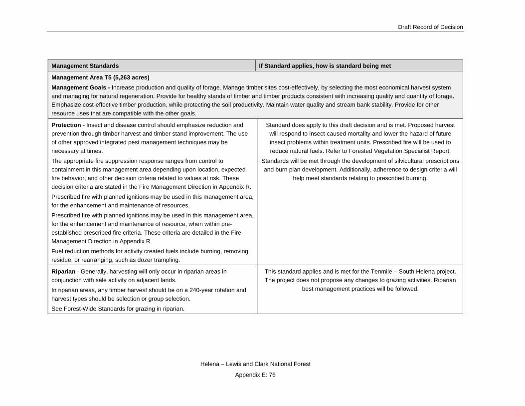
Draft Record of Decision
Helena – Lewis and Clark National Forest
Appendix E: 76
Management Standards If Standard applies, how is standard being met
Management Area T5 (5,263 acres) Management Goals - Increase production and quality of forage. Manage timber sites cost-effectively, by selecting the most economical harvest system and managing for natural regeneration. Provide for healthy stands of timber and timber products consistent with increasing quality and quantity of forage. Emphasize cost-effective timber production, while protecting the soil productivity. Maintain water quality and stream bank stability. Provide for other resource uses that are compatible with the other goals.
Protection - Insect and disease control should emphasize reduction and prevention through timber harvest and timber stand improvement. The use of other approved integrated pest management techniques may be necessary at times.
The appropriate fire suppression response ranges from control to containment in this management area depending upon location, expected fire behavior, and other decision criteria related to values at risk. These decision criteria are stated in the Fire Management Direction in Appendix R.
Prescribed fire with planned ignitions may be used in this management area, for the enhancement and maintenance of resources.
Prescribed fire with planned ignitions may be used in this management area, for the enhancement and maintenance of resource, when within pre-established prescribed fire criteria. These criteria are detailed in the Fire Management Direction in Appendix R.
Fuel reduction methods for activity created fuels include burning, removing residue, or rearranging, such as dozer trampling.
Standard does apply to this draft decision and is met. Proposed harvest will respond to insect-caused mortality and lower the hazard of future insect problems within treatment units. Prescribed fire will be used to reduce natural fuels. Refer to Forested Vegetation Specialist Report.
Standards will be met through the development of silvicultural prescriptions and burn plan development. Additionally, adherence to design criteria will
help meet standards relating to prescribed burning.
Riparian - Generally, harvesting will only occur in riparian areas in conjunction with sale activity on adjacent lands.
In riparian areas, any timber harvest should be on a 240-year rotation and harvest types should be selection or group selection.
See Forest-Wide Standards for grazing in riparian.
This standard applies and is met for the Tenmile – South Helena project. The project does not propose any changes to grazing activities. Riparian
best management practices will be followed.

Tenmile – South Helena Project
Helena – Lewis and Clark National Forest
Appendix E: 77
Management Standards If Standard applies, how is standard being met
Management Area W1 (1,412 acres) Management Goals - Optimize wildlife habitat potential, including old growth, over the long term. Provide for other resource uses, if they are compatible with wildlife management goals.
Description - This management area contains a variety of wildlife habitat ranging from important big game summer range to big game winter range. It has a variety of physical environments including riparian, calving or fawning areas, and hiding cover. All slopes, aspects and elevations are represented as well as a wide variety of vegetation ranging from grasslands to densely timbered areas.
Recreation – Controls over motorized recreation will be implemented where necessary to protect wildlife habitat values of this area.
Nonmotorized dispersed recreation may be supported by constructing trails and trailhead facilities when compatible with management area goals.
Control measures on motorized recreation will be implemented as a result of decommissioning of unauthorized roads in the project area and with
implementation of design criteria (see chapter 2 of this FEIS). Construction of non-motorized dispersed recreation will not occur under this draft
decision in MA W-1. This standard is met.
Visual – Management practices will generally follow guidelines for the partial retention VQO. Exceptions may occur on a case-by-case basis to meet wildlife objectives. The portions of this area (if any) that are within the sensitive viewing areas of the roads, trails, and areas listed in Appendix B will be managed to meet the VQOs noted in the appendix. [See Forest Landscape Management Book, Vol. 2 (Ag. Hdbk. No. 462) for definitions of VQOs and how they are applied.]
Implementation of this draft decision will be consistent with this management area. By implementing the design criteria described above,
VQOs for partial retention will be met.
Proposed landings, temporary roads, skyline corridors, and, skid trails in areas with VQO’s of retention and partial retention will meet VQO
standards but not immediately upon implementation of activities. However, design criteria will minimize any short-term negative impacts and will result
in long –term positive effects to the scenic quality of the project area.
Wildlife and Fisheries –Wildlife habitat improvement practices, including road management, prescribed fire, and other techniques, will be used to maintain and/or enhance the quality of big game and nongame habitat.
Maintain adequate thermal and hiding cover adjacent to forage areas. Generally this means providing at least 25 percent cover, where available, on identified winter range.
(1) Wildlife habitat improvement practices, including road management, prescribed fire, and other techniques, will be used to maintain and/or
enhance the quality of big game and nongame habitat. Roads to be used for the project activities will be managed to minimize effects to elk during project implementation. Prescribed fire goals include improving grass and shrublands which will be beneficial to elk. This draft decision is consistent
with this recommendation.
(2) Maintain adequate thermal and hiding cover adjacent to forage areas; this generally means providing at least 25% [thermal] cover, where
available, on identified winter range. There are 1,412 acres of W-1 in the project area of which 1,296 are considered winter range. Of that, 311

Draft Record of Decision
Helena – Lewis and Clark National Forest
Appendix E: 78
Management Standards If Standard applies, how is standard being met
Management Area W1 (1,412 acres) Management Goals - Optimize wildlife habitat potential, including old growth, over the long term. Provide for other resource uses, if they are compatible with wildlife management goals.
acres are considered Forest Plan thermal cover which is 24%, less than Forest Plan thresholds. The draft decision will not treat any thermal cover
in W-1. This standard is met.
Range – Livestock grazing generally does not occur in this management area, except for minor amounts within existing allotments. Livestock grazing will continue within active allotments, however, the level may be increased or decreased if monitoring or range analysis show a need or opportunity to change.
Not applicable because the Tenmile-South Helena Project does not propose any changes to livestock use within the project area.
Timber - Timber will be harvested only if it can be used as a tool to maintain or enhance wildlife habitat values. Productive forest land is classified as unsuitable for timber management
This standard applies and is met because there is no timber harvest proposed in this management area.
Water and Soils – See Forest-Wide Standards. Standard is met, see Forest-Wide Standards above.
Minerals – Locatable – Timing of mineral activities will be coordinated where practical with the needs of wildlife. This generally will require negotiations during development of operating plans for no surface occupancy during critical wildlife use.
Leasable ---- See Forest Plan Amendment #13 for lease standards
This standard does not apply to the Tenmile – South Helena project because the project does not propose any changes to mineral activities.
Lands – See Forest-Wide Standards. See Forest-Wide Standard
Facilities – Roads will generally not be constructed for surface management activities within this area. Exceptions may occur if needed for wildlife improvement projects. Roads through this area, which provide access to adjacent areas, are permitted only if project planning indicates it is the most feasible access.
Road construction should avoid important big game areas, such as wet, boggy areas.
The Tenmile-South Helena project does not propose any new or temporary road construction in this management area. This standard is
met.
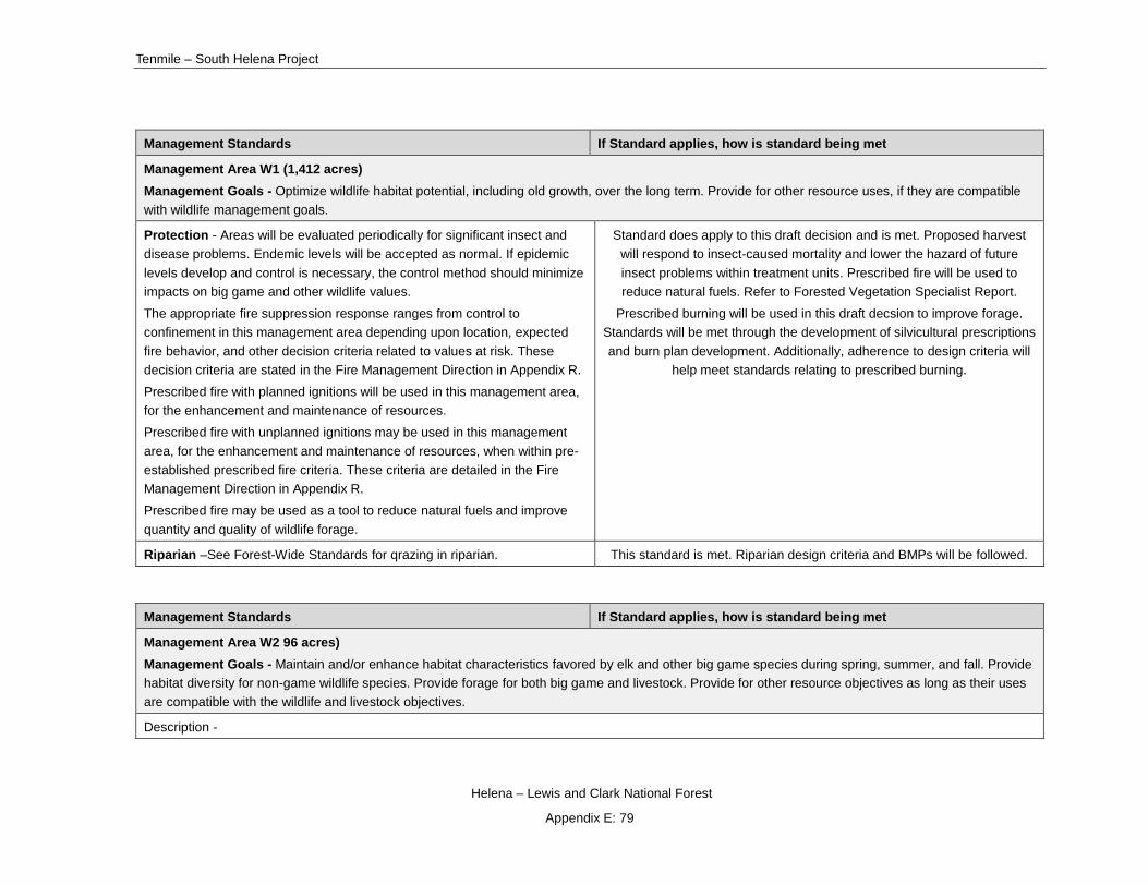
Tenmile – South Helena Project
Helena – Lewis and Clark National Forest
Appendix E: 79
Management Standards If Standard applies, how is standard being met
Management Area W1 (1,412 acres) Management Goals - Optimize wildlife habitat potential, including old growth, over the long term. Provide for other resource uses, if they are compatible with wildlife management goals.
Protection - Areas will be evaluated periodically for significant insect and disease problems. Endemic levels will be accepted as normal. If epidemic levels develop and control is necessary, the control method should minimize impacts on big game and other wildlife values.
The appropriate fire suppression response ranges from control to confinement in this management area depending upon location, expected fire behavior, and other decision criteria related to values at risk. These decision criteria are stated in the Fire Management Direction in Appendix R.
Prescribed fire with planned ignitions will be used in this management area, for the enhancement and maintenance of resources.
Prescribed fire with unplanned ignitions may be used in this management area, for the enhancement and maintenance of resources, when within pre-established prescribed fire criteria. These criteria are detailed in the Fire Management Direction in Appendix R.
Prescribed fire may be used as a tool to reduce natural fuels and improve quantity and quality of wildlife forage.
Standard does apply to this draft decision and is met. Proposed harvest will respond to insect-caused mortality and lower the hazard of future insect problems within treatment units. Prescribed fire will be used to reduce natural fuels. Refer to Forested Vegetation Specialist Report.
Prescribed burning will be used in this draft decsion to improve forage. Standards will be met through the development of silvicultural prescriptions and burn plan development. Additionally, adherence to design criteria will
help meet standards relating to prescribed burning.
Riparian –See Forest-Wide Standards for qrazing in riparian. This standard is met. Riparian design criteria and BMPs will be followed.
Management Standards If Standard applies, how is standard being met
Management Area W2 96 acres) Management Goals - Maintain and/or enhance habitat characteristics favored by elk and other big game species during spring, summer, and fall. Provide habitat diversity for non-game wildlife species. Provide forage for both big game and livestock. Provide for other resource objectives as long as their uses are compatible with the wildlife and livestock objectives.
Description -

Draft Record of Decision
Helena – Lewis and Clark National Forest
Appendix E: 80
Management Standards If Standard applies, how is standard being met
Management Area W2 96 acres) Management Goals - Maintain and/or enhance habitat characteristics favored by elk and other big game species during spring, summer, and fall. Provide habitat diversity for non-game wildlife species. Provide forage for both big game and livestock. Provide for other resource objectives as long as their uses are compatible with the wildlife and livestock objectives.
Recreation – Controls over motorized recreation will be implemented where necessary to protect wildlife habitat values of this area.
-Nonmotorized dispersed recreation may be supported by constructing trails and trailhead facilities when compatible with management area goals.
Control measures on motorized recreation will be implemented as a result of decommissioning of unauthorized roads in the project area and with
implementation of design criteria (see chapter 2 of this FEIS). Construction of non-motorized dispersed recreation will not occur under this draft
decision in MA W-2. This standard is met.
Visual – Management practices generally will follow guidelines for the partial retention VQO. Exceptions may occur on a case-by-case basis where necessary to meet the area goals. [See Forest Landscape Management Book, Vol. 2 (Ag. Hdbk. No. 462) for definitions of VQOs and how they are applied.]
Implementation of this draft decision will be consistent with this management area. By implementing the design criteria described above,
VQOs for partial retention will be met.
Proposed landings, temporary roads, skyline corridors, and, skid trails in areas with VQO’s of retention and partial retention will meet VQO
standards but not immediately upon implementation of activities. However, design criteria will minimize any short-term negative impacts and will result
in long –term positive effects to the scenic quality of the project area.
Wildlife and Fisheries – Most new roads and about 50% of existing roads will be closed, at least seasonally.
-Wildlife habitat improvement practices, including road management, prescribed fire, and other techniques, will be used to maintain and/or enhance big game calving and summer habitat.
-Maintain adequate thermal and hiding cover adjacent to forage areas.
(1) Most new roads and about 50% of existing roads will be closed, at least seasonally. There are no existing or proposed roads in management area
W-2. Therefore this is not applicable.
(2) Wildlife habitat improvement practices, including road management, prescribed fire, and other techniques, will be used to maintain and/or
enhance big game calving and summer habitat. The project is designed to avoid calving and nursery areas; elsewhere prescribed fire in summer
habitat should improve forage conditions.
(3) Maintain adequate thermal and hiding cover adjacent to forage areas. The draft decision includes treatment in hiding cover on 34 acres. The
thermal and hiding cover to be removed is adjacent to openings that most likely provide foraging opportunities for elk. However, design criteria are in place that require retention of timbered areas (i.e. hiding or thermal cover)
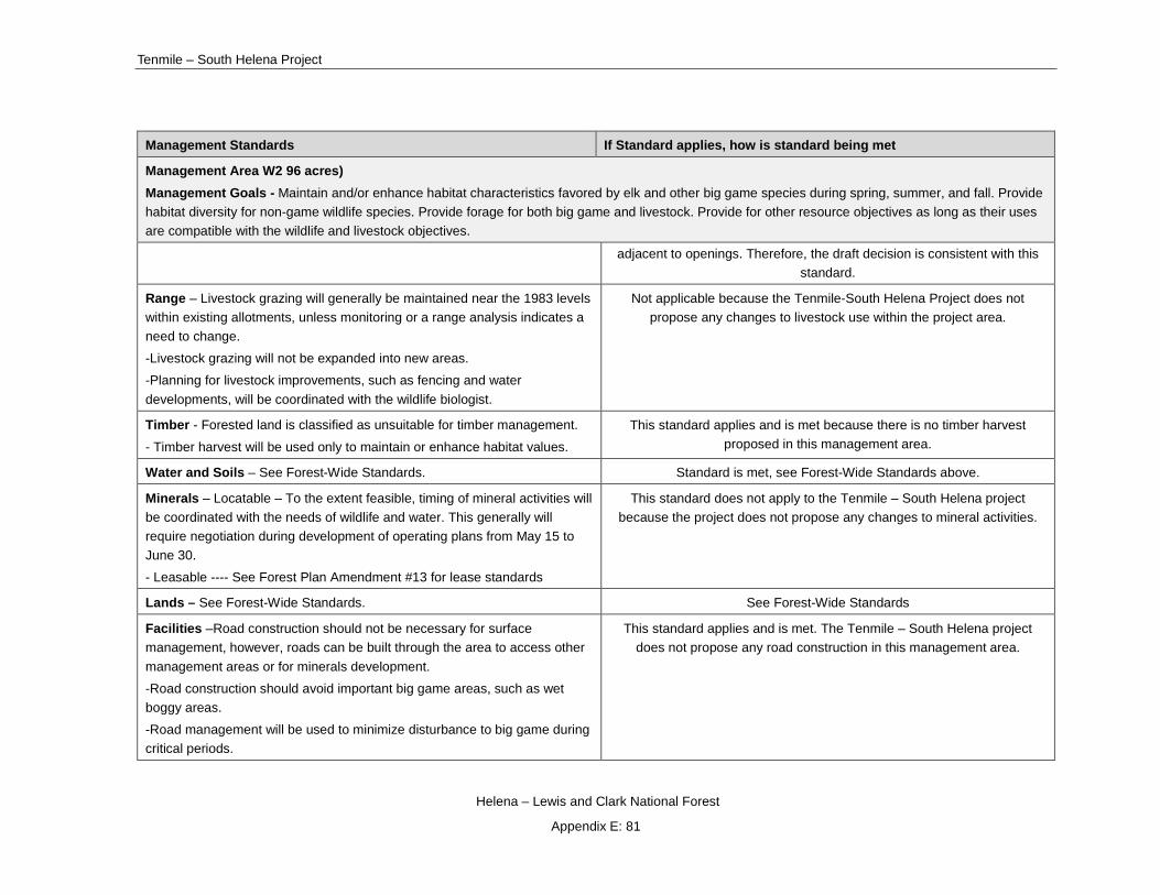
Tenmile – South Helena Project
Helena – Lewis and Clark National Forest
Appendix E: 81
Management Standards If Standard applies, how is standard being met
Management Area W2 96 acres) Management Goals - Maintain and/or enhance habitat characteristics favored by elk and other big game species during spring, summer, and fall. Provide habitat diversity for non-game wildlife species. Provide forage for both big game and livestock. Provide for other resource objectives as long as their uses are compatible with the wildlife and livestock objectives.
adjacent to openings. Therefore, the draft decision is consistent with this standard.
Range – Livestock grazing will generally be maintained near the 1983 levels within existing allotments, unless monitoring or a range analysis indicates a need to change.
-Livestock grazing will not be expanded into new areas.
-Planning for livestock improvements, such as fencing and water developments, will be coordinated with the wildlife biologist.
Not applicable because the Tenmile-South Helena Project does not propose any changes to livestock use within the project area.
Timber - Forested land is classified as unsuitable for timber management.
- Timber harvest will be used only to maintain or enhance habitat values.
This standard applies and is met because there is no timber harvest proposed in this management area.
Water and Soils – See Forest-Wide Standards. Standard is met, see Forest-Wide Standards above.
Minerals – Locatable – To the extent feasible, timing of mineral activities will be coordinated with the needs of wildlife and water. This generally will require negotiation during development of operating plans from May 15 to June 30.
- Leasable ---- See Forest Plan Amendment #13 for lease standards
This standard does not apply to the Tenmile – South Helena project because the project does not propose any changes to mineral activities.
Lands – See Forest-Wide Standards. See Forest-Wide Standards
Facilities –Road construction should not be necessary for surface management, however, roads can be built through the area to access other management areas or for minerals development.
-Road construction should avoid important big game areas, such as wet boggy areas.
-Road management will be used to minimize disturbance to big game during critical periods.
This standard applies and is met. The Tenmile – South Helena project does not propose any road construction in this management area.
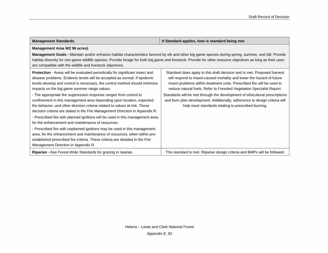
Draft Record of Decision
Helena – Lewis and Clark National Forest
Appendix E: 82
Management Standards If Standard applies, how is standard being met
Management Area W2 96 acres) Management Goals - Maintain and/or enhance habitat characteristics favored by elk and other big game species during spring, summer, and fall. Provide habitat diversity for non-game wildlife species. Provide forage for both big game and livestock. Provide for other resource objectives as long as their uses are compatible with the wildlife and livestock objectives.
Protection - Areas will be evaluated periodically for significant insect and disease problems. Endemic levels will be accepted as normal. If epidemic levels develop and control is necessary, the control method should minimize impacts on the big game summer range values.
- The appropriate fire suppression response ranges from control to confinement in this management area depending upon location, expected fire behavior, and other decision criteria related to values at risk. These decision criteria are stated in the Fire Management Direction in Appendix R.
- Prescribed fire with planned ignitions will be used in this management area, for the enhancement and maintenance of resources.
- Prescribed fire with unplanned ignitions may be used in this management area, for the enhancement and maintenance of resources, when within pre-established prescribed fire criteria. These criteria are detailed in the Fire Management Direction in Appendix R.
Standard does apply to this draft decision and is met. Proposed harvest will respond to insect-caused mortality and lower the hazard of future insect problems within treatment units. Prescribed fire will be used to reduce natural fuels. Refer to Forested Vegetation Specialist Report.
Standards will be met through the development of silvicultural prescriptions and burn plan development. Additionally, adherence to design criteria will
help meet standards relating to prescribed burning.
Riparian –See Forest-Wide Standards for grazing in riparian. This standard is met. Riparian design criteria and BMPs will be followed.

Tenmile – South Helena Project
Helena – Lewis and Clark National Forest
Appendix E: 83
Table 3. Consistency with NRLMD objectives, standards and guidelines for the Draft Decision1
Northern Rockies Lynx Management Direction Consistency with the Draft Decision
ALL MANAGEMENT PRACTICES AND ACTIVITIES (ALL) The following objectives, standards and guidelines apply to management projects in lynx habitat in lynx analysis units (LAU) and in linkage areas, subject to valid existing rights. They do not apply to wildfire suppression, or to wildland fire use
Objective30 ALL O1
Maintain26 or restore39 lynx habitat23 connectivity16 in and between LAUs21, and in linkage areas22.
The forested character of the area will be retained and connectivity within and between LAUs will be maintained. The project will have no effect upon lynx linkage area and the draft decision meets ALL O1.
Standard43 ALL S1
New or expanded permanent developments33 and vegetation management projects48 must maintain26 habitat connectivity16 in an LAU21 and/or linkage area22.
The project area is to the east of the continental divide which has been identified as a linkage area in the NRLMD. The project maintains the general forested nature of the action area as well as landscape connectivity permitting broader lynx movements. Habitat connectivity is maintained although lynx may need to adjust movement patterns during project implementation. Given that harvest and prescribed burn patterns will match historical patterns; these anticipated shifts will be no greater than what lynx will typically do after small to moderate-sized natural disturbances. Standard is met.
Guideline15 ALL G1
Methods to avoid or reduce effects on lynx should be used when constructing or reconstructing highways18 or forest highways12 across federal land. Methods could include fencing, underpasses or overpasses.
The project does not include construction or reconstruction of highways or forest highways. Guideline is not applicable.
Standard LAU S1
Changes in LAU21 boundaries shall be based on site-specific habitat information and after review by the Forest Service Regional Office.
LAU boundaries have not been changed. Standard is not applicable.
VEGETATION MANAGEMENT PROJECTS (VEG) The following objectives, standards and guidelines apply to vegetation management projects in lynx habitat in lynx analysis units (LAU). With the exception of Objective VEG O3 that specifically concerns wildland fire use, the objectives, standards and guidelines do not apply to wildfire suppression,
1 Superscripts refer to definitions in the glossary of the NRLMD.

Draft Record of Decision
Helena – Lewis and Clark National Forest
Appendix E: 84
Northern Rockies Lynx Management Direction Consistency with the Draft Decision
wildland fire use, or removal of vegetation for permanent developments like mineral operations, ski runs, roads and the like. None of the objectives, standards, or guidelines applies to linkage areas.
Objective VEG O1 – Manage vegetation to mimic or approximate natural succession and disturbance processes while maintaining habitat components necessary for the conservation of lynx.
The draft decision is designed to mimic landscape patterns and create conditions that will increase the resiliency of the project area to natural disturbance processes.
Objective VEG O2 – Provide a mosaic of habitat conditions through time that support dense horizontal cover and high densities of snowshoe hares. Provide winter snowshoe hare habitat in both the stand initiation structural stage and in mature, multi-story conifer vegetation.
The draft decision is designed to regenerate dead lodgepole pine which will in turn increase stand initiation habitat in about 15 years post-treatment. Intermediate harvest is designed to accelerate multistory development.
Objective VEG O3 – Conduct fire use activities to restore ecological processes and maintain or improve lynx habitat.
Prescribed fire proposed in the draft decision is designed to restore appropriate fire regimes to the project area.
Objective VEG O4 – Focus vegetation management in areas that have potential to improve winter snowshoe hare habitat but presently have poorly developed understories that lack dense horizontal cover.
The purpose of the project is to be responsive to the mountain pine beetle outbreak in the area; this includes regenerating dead lodgepole pine stands which will give rise to stand initiation habitat and thinning live stands to hasten development of multistory characteristics.
Standard VEG S1 – Stand initiation structural stage limits
Standard VEG S1 applies to all vegetation management48 projects that regenerate37 timber, except for fuel treatment13 projects within the wildland urban interface (WUI)
49 as defined by HFRA, subject to the following limitation:
Fuel treatment projects within the WUI that do not meet Standards VEG S1, VEG S2, VEG S5, and VEG S6 may occur on no more than 6 percent (cumulatively) of lynx habitat on each administrative unit (a unit is a National Forest).
For fuel treatment projects within the WUI see guideline VEG G10.
The Standard: Unless a broad scale assessment has been completed that substantiates different historic levels of stand initiation structural stages44 limit disturbance in each LAU as follows:
If more than 30 percent of the lynx habitat in an LAU is currently in a stand initiation structural stage that does not yet provide winter snowshoe hare habitat, no additional habitat may be regenerated by vegetation management projects.
Early stand initiation structural stage that does not currently provide snowshoe hare habitat exists on about 3% of LAUs di-04 and LAU di-05 and about 1% of LAU di-06. LAU di-03, adjacent to the western edge of LAU di-04, has about 1% in an early stand initiation structural stage. LAU di-02, north of LAU di-05, includes 5% early stand initiation structural stage.
Percentages of early stand initiation habitat in draft decision will increase to 3% in LAU di-04, 10% in LAU di-05, and 3% in LAU di-06. The percent of early stand initiation habitat in all three LAUs does not exceed 30%.
Standard VEG S1 is met within the LAUs containing the Tenmile South Helena Vegetation Project. See also Canada Lynx, Forest Plan and Regulatory Framework in the FEIS.
The total fuel treatment exception acres metered out to the Forest as part of the NRLMD Incidental Take Statement are 26,400 acres. To date, the Forest has treated 2,544 acres of lynx habitat under the WUI exception and 151 acres under the precommercial thinning exceptions (these calculations

Tenmile – South Helena Project
Helena – Lewis and Clark National Forest
Appendix E: 85
Northern Rockies Lynx Management Direction Consistency with the Draft Decision
include recent decisions yet to be implemented – i.e. Stonewall and Telegraph). Treatments in early stand initiation, stand initiation, and multistory habitat are well under the limit.
Standard VEG S2 – Limits on regeneration from timber mgmt. projects
Standard VEG S2 applies to all vegetation management48 projects that regenerate37 timber, except for fuel treatment13 projects within the wildland urban interface (WUI)49 as defined by HFRA, subject to the following limitation:
Fuel treatment projects within the WUI49 that do not meet Standards VEG S1, VEG S2, VEG S5, and VEG S6 may occur on no more than 6 percent (cumulatively) of lynx habitat on each administrative unit (a unit is a National Forest).
For fuel treatment projects within the WUI49 see guideline VEG G10.
The Standard: Timber management projects shall not regenerate37 more than 15 percent of lynx habitat on NFS lands in an LAU in a ten-year period.
Since January 2006, four NEPA project decisions resulted in regeneration of lynx habitat in the three analyzed LAUs. This includes the Forest-wide Hazardous Tree Removal and Fuels Reduction – HFRA Project (LAUs di-04, di-05 and di-06), the Clancy-Unionville Vegetation Manipulation and Travel Management Project (LAUs di-05 and di-06), the Red Mountain Flume Chessman Reservoir Project (LAUs di-05 and di-06), and the Telegraph Vegetation Project (LAU di-04).
Currently, regeneration harvest in LAU di-04 has occurred on 0.06% of lynx habitat on NFS lands within the past ten years, prior to the Telegraph Decision. The Telegraph Decision adds an additional 1,966 acres of regeneration harvest in LAU di-04 which increases the percentage to 11%. Past regeneration harvest in LAUs di-05 and di-06 is about 2% and less than 1% respectively. The draft decision will result in the following percentages of regeneration harvest: 11% in LAUs di-04 and di-05 and 2% in di-06..
Standard VEG S2 is met under the draft decision in all LAUs.
Standard VEG S5 – Precommercial thinning limits
Standard VEG S5 applies to all precommercial thinning35 projects, except for fuel treatment13 projects that use precommercial thinning as a tool within the wildland urban interface (WUI)49 as defined by HFRA, subject to the following limitation:
Fuel treatment projects within the WUI49 that do not meet Standards VEG S1, VEG S2, VEG S5, and VEG S6 may occur on no more than 6 percent (cumulatively) of lynx habitat on each administrative unit (a unit is a National Forest).
For fuel treatment projects within the WUI49 see guideline VEG G10.
The Standard: Precommercial thinning projects that reduce snowshoe hare habitat, may occur from the stand initiation structural stage44 until the stands no longer provide winter snowshoe hare habitat only:
1. Within 200 feet of administrative sites, dwellings, or outbuildings; or
Precommercial thinning is proposed in snowshoe hare habitat in LAUs di-05 and di-06. In the draft decision, approximately 5 acres of LAU di-05 and 49 acres of LAU di-06 are proposed for precommercial thinning. These acres all fall within the WUI, therefore the exception to the standard will be applied.
All acres of early stand initiation habitat and stand initiation habitat proposed for treatment outside of the WUI will be field validated and dropped from units if the field validation indicates that these acres are either early stand initiation or stand initiation.
Standard is met.
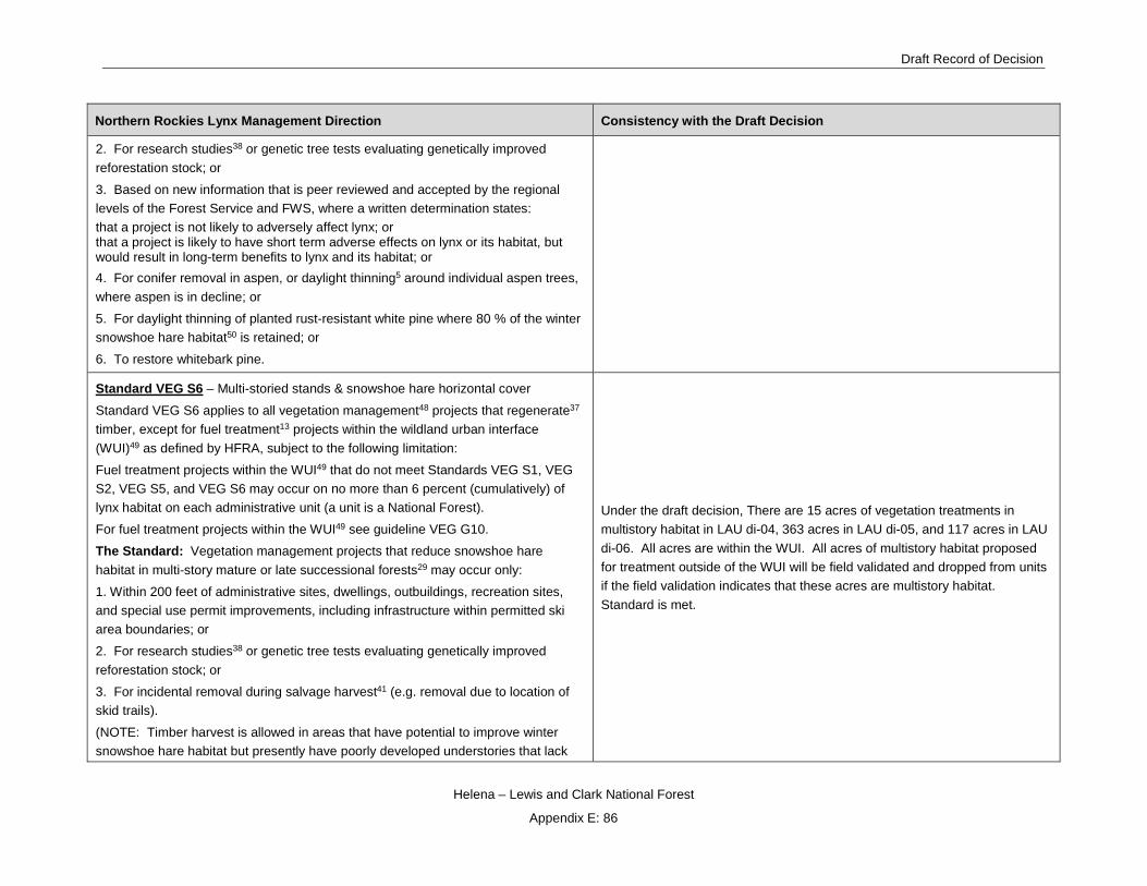
Draft Record of Decision
Helena – Lewis and Clark National Forest
Appendix E: 86
Northern Rockies Lynx Management Direction Consistency with the Draft Decision
2. For research studies38 or genetic tree tests evaluating genetically improved reforestation stock; or
3. Based on new information that is peer reviewed and accepted by the regional levels of the Forest Service and FWS, where a written determination states:
that a project is not likely to adversely affect lynx; or that a project is likely to have short term adverse effects on lynx or its habitat, but
would result in long-term benefits to lynx and its habitat; or 4. For conifer removal in aspen, or daylight thinning5 around individual aspen trees, where aspen is in decline; or
5. For daylight thinning of planted rust-resistant white pine where 80 % of the winter snowshoe hare habitat50 is retained; or
6. To restore whitebark pine.
Standard VEG S6 – Multi-storied stands & snowshoe hare horizontal cover
Standard VEG S6 applies to all vegetation management48 projects that regenerate37 timber, except for fuel treatment13 projects within the wildland urban interface (WUI)49 as defined by HFRA, subject to the following limitation:
Fuel treatment projects within the WUI49 that do not meet Standards VEG S1, VEG S2, VEG S5, and VEG S6 may occur on no more than 6 percent (cumulatively) of lynx habitat on each administrative unit (a unit is a National Forest).
For fuel treatment projects within the WUI49 see guideline VEG G10.
The Standard: Vegetation management projects that reduce snowshoe hare habitat in multi-story mature or late successional forests29 may occur only:
1. Within 200 feet of administrative sites, dwellings, outbuildings, recreation sites, and special use permit improvements, including infrastructure within permitted ski area boundaries; or
2. For research studies38 or genetic tree tests evaluating genetically improved reforestation stock; or
3. For incidental removal during salvage harvest41 (e.g. removal due to location of skid trails).
(NOTE: Timber harvest is allowed in areas that have potential to improve winter snowshoe hare habitat but presently have poorly developed understories that lack
Under the draft decision, There are 15 acres of vegetation treatments in multistory habitat in LAU di-04, 363 acres in LAU di-05, and 117 acres in LAU di-06. All acres are within the WUI. All acres of multistory habitat proposed for treatment outside of the WUI will be field validated and dropped from units if the field validation indicates that these acres are multistory habitat. Standard is met.
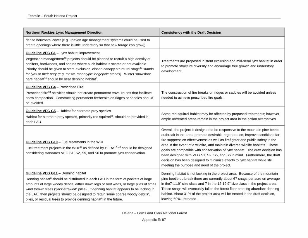
Tenmile – South Helena Project
Helena – Lewis and Clark National Forest
Appendix E: 87
Northern Rockies Lynx Management Direction Consistency with the Draft Decision
dense horizontal cover [e.g. uneven age management systems could be used to create openings where there is little understory so that new forage can grow]).
Guideline VEG G1 – Lynx habitat improvement
Vegetation management48 projects should be planned to recruit a high density of conifers, hardwoods, and shrubs where such habitat is scarce or not available. Priority should be given to stem-exclusion, closed-canopy structural stage44 stands
for lynx or their prey (e.g. mesic, monotypic lodgepole stands). Winter snowshoe hare habitat50 should be near denning habitat6.
Treatments are proposed in stem exclusion and mid-seral lynx habitat in order to promote structure diversity and encourage tree growth and understory development.
Guideline VEG G4 – Prescribed Fire
Prescribed fire34 activities should not create permanent travel routes that facilitate snow compaction. Constructing permanent firebreaks on ridges or saddles should be avoided.
The construction of fire breaks on ridges or saddles will be avoided unless needed to achieve prescribed fire goals.
Guideline VEG G5 – Habitat for alternate prey species
Habitat for alternate prey species, primarily red squirrel36, should be provided in each LAU.
Some red squirrel habitat may be affected by proposed treatments; however, ample untreated areas remain in the project area in the action alternatives.
Guideline VEG G10 – Fuel treatments in the WUI
Fuel treatment projects in the WUI 49 as defined by HFRA17, 48 should be designed considering standards VEG S1, S2, S5, and S6 to promote lynx conservation.
Overall, the project is designed to be responsive to the mountain pine beetle outbreak in the area, promote desirable regeneration, improve conditions for fire suppression effectiveness as well as firefighter and public safety in the area in the event of a wildfire, and maintain diverse wildlife habitats. These goals are compatible with conservation of lynx habitat. The draft decision has been designed with VEG S1, S2, S5, and S6 in mind. Furthermore, the draft decision has been designed to minimize effects to lynx habitat while still meeting the purpose and need of the project.
Guideline VEG G11 – Denning habitat
Denning habitat6 should be distributed in each LAU in the form of pockets of large amounts of large woody debris, either down logs or root wads, or large piles of small wind thrown trees (“jack-strawed” piles). If denning habitat appears to be lacking in the LAU, then projects should be designed to retain some coarse woody debris4, piles, or residual trees to provide denning habitat6 in the future.
Denning habitat is not lacking in the project area. Because of the mountain pine beetle outbreak there are currently about 67 snags per acre on average in the7-11.9” size class and 7 in the 12-19.9” size class in the project area. These snags will eventually fall to the forest floor creating abundant denning habitat. About 31% of the project area will be treated in the draft decision, leaving 69% untreated.

Draft Record of Decision
Helena – Lewis and Clark National Forest
Appendix E: 88
Northern Rockies Lynx Management Direction Consistency with the Draft Decision
LIVESTOCK MANAGEMENT (GRAZ)
The following objectives and guidelines apply to grazing projects in lynx habitat in lynx analysis units (LAU). They do not apply to linkage areas.
Guideline GRAZ G1 – Livestock grazing and openings
In fire- and harvest-created openings, livestock grazing should be managed so impacts do not prevent shrubs and trees from regenerating.
Prescribed fire, regeneration, and planting units within grazing allotments will be rested at least one growing season following burning to allow for adequate vegetation recovery.
Guideline GRAZ G2 – Livestock grazing and aspen
In aspen stands, livestock grazing should be managed to contribute to the long-term health and sustainability of aspen.
Aspen will be favored in all harvest treatments; if post-treatment monitoring indicates that livestock are impeding the ability of aspen to regenerate then appropriate measures will be taken to protect aspen regeneration (e.g. fencing).
Guideline GRAZ G3 – Livestock grazing and riparian areas & willow carrs
In riparian areas40 and willow carrs3, livestock grazing should be managed to contribute to maintaining or achieving a preponderance of mid- or late-seral stages28, similar to conditions that would have occurred under historic disturbance regimes.
If treatments proposed in the draft decision result in resource concerns in riparian areas, appropriate measures will be taken to alleviate those concerns.
Guideline GRAZ G4 – Livestock grazing and shrub-steppe habitats
In shrub-steppe habitats42, livestock grazing should be managed in the elevation ranges of forested lynx habitat in LAUs21, to contribute to maintaining or achieving a preponderance of mid- or late-seral stages, similar to conditions that would have occurred under historic disturbance regimes.
If treatments proposed in the draft decision result in resource concerns in shrub-steppe habitats, appropriate measures will be taken to alleviate those concerns.
HUMAN USE PROJECTS (HU) The following objectives and guidelines apply to human use projects, such as special uses (other than grazing), recreation management, roads, highways, mineral and energy development, in lynx habitat in lynx analysis units (LAU), subject to valid existing rights. They do not apply to vegetation management projects or grazing projects directly. They do not apply to linkage areas.
Guideline HU G1 – Ski area expansion & development, inter-trail islands
When developing or expanding ski areas, provisions should be made for adequately sized inter-trail islands that include coarse woody debris4, so winter snowshoe hare habitat49 is maintained.
The project does not include ski expansion or development. Standard is not applicable.

Tenmile – South Helena Project
Helena – Lewis and Clark National Forest
Appendix E: 89
Northern Rockies Lynx Management Direction Consistency with the Draft Decision
Guideline HU G2 – Ski are expansion & development, foraging habitat
When developing or expanding ski areas, foraging should be provided consistent with the ski area’s operational needs, especially where lynx habitat occurs as narrow bands of coniferous forest across mountain slopes.
The project does not include ski expansion or development. Standard is not applicable.
Guideline HU G3 – Recreation developments
Recreation developments and operations should be planned in ways that both provide for lynx movement and maintain the effectiveness of lynx habitat23.
The project does not include recreation development. Standard is not applicable.
Guideline HU G4 – Mineral & energy development
For mineral and energy development sites and facilities, remote monitoring should be encouraged to reduce snow compaction.
The project does not include mineral & energy development. Standard is not applicable.
Guideline HU G5 – Mineral & energy development, habitat restoration
For mineral and energy development sites and facilities that are closed, a reclamation plan that restores39 lynx habitat should be developed.
The project does not include mineral & energy development. Standard is not applicable.
Guideline HU G6 – Roads, upgrading
Methods to avoid or reduce effects to lynx should be used in lynx habitat when upgrading unpaved roads to maintenance levels 4 or 5, if the result would be increased traffic speeds and volumes, or a foreseeable contribution to increases in human activity or development.
Some road reconstruction will occur as part of the draft decision to improve routes used for hauling. This is primarily to reduce resource damage that may occur during hauling (e.g. erosion and sediment delivery to adjacent streams). Maintenance levels will not be upgraded as a result of these road improvements.
Guideline HU G7 – Roads, locations
New permanent roads should not be built on ridge-tops and saddles, or in areas identified as important for lynx habitat connectivity16.
New permanent roads and trails should be situated away from forested stringers.
No new permanent roads will be constructed in the draft decision. Standard is not applicable.
Guideline HU G8 – Roads, brushing
Cutting brush along low-speed25, low-traffic-volume roads should be done to the minimum level necessary to provide for public safety.
Road maintenance will occur along haul routes, including brushing in some instances, for safety purposes.
Guideline HU G9 – Roads, new
On new roads built for projects, public motorized use should be restricted. Effective closures should be provided in road designs. When the project is over, these roads
Temporary roads that will be built in the draft decision will be closed to public use. Post-project implementation, these roads will be decommissioned.
Draft Record of Decision
Helena – Lewis and Clark National Forest
Appendix E: 90
Northern Rockies Lynx Management Direction Consistency with the Draft Decision
should be reclaimed or decommissioned, if not needed for other management objectives.
Guideline HU G10 – Roads, ski area access
When developing or expanding ski areas and trails, access roads and lift termini to maintain and provide lynx security10 habitat.
The project does not include ski expansion or development. Standard is not applicable.
Guideline HU G11 – Snow compaction
Designated over-the-snow routes, or designated play areas, should not expand outside baseline areas of consistent snow compaction1, unless designation serves to consolidate use and improve lynx habitat. This is calculated on an LAU basis, or on a combination of immediately adjacent LAUs.
This does not apply inside permitted ski area boundaries, to winter logging, to rerouting trails for public safety, to accessing private inholdings, or to access regulated by Guideline HU G12.
Use the same analysis boundaries for all actions subject to this guideline.
The project does not include ski expansion or development. Standard is not applicable.
Guideline HU G12 – Winter access for non-recreation SUP & mineral & energy development
Winter access for non-recreation special uses, and mineral and energy exploration and development, should be limited to designated routes8 or designated over-the-snow routes7.
The project does not include non-recreation SUP or mineral/energy development. Standard is not applicable.
LINKAGE AREAS (LINK) The following objective, standard and guidelines apply to all projects within linkage areas, subject to valid existing rights.
Standard LINK S1 – Highway or forest highway construction in linkage areas
When highway18 or forest highway12 construction or reconstruction is proposed in linkage areas22, identify potential highway crossings.
The project does not include highway or forest highway construction. The standard is not applicable.
Guideline LINK G1 – Land exchanges
NFS lands should be retained in public ownership. The project does not include land exchanges. The standard is not applicable.
Guideline LINK G2 – Livestock grazing in shrub-steppe habitats The project is not an allotment management plan. The standard is not applicable.

Tenmile – South Helena Project
Helena – Lewis and Clark National Forest
Appendix E: 91
Northern Rockies Lynx Management Direction Consistency with the Draft Decision
Livestock grazing in shrub-steppe habitats42 should be managed to contribute to maintaining or achieving a preponderance of mid- or late-seral stages28, similar to conditions that would have occurred under historic disturbance regimes.


