Tectonic Map of South America - CCGM Notes Tectonic Map South America... · The inset located at...
16
Explanatory Notes Umberto G Cordani, Victor A Ramos, Lêda M Fraga, Marcelo Cegarra, Inácio Delgado, Kaiser G de Souza, Francisco EM Gomes and Carlos Schobbenhaus Tectonic Map of South America Second edition, scale 1:5 000 000 2016 COMMISSION DE LA CARTE GÉOLOGIQUE DU MONDE COMMISSION FOR THE GEOLOGICAL MAP OF THE WORLD
Transcript of Tectonic Map of South America - CCGM Notes Tectonic Map South America... · The inset located at...
Explanatory NotesUmberto G Cordani, Victor A Ramos, Lêda M Fraga, Marcelo Cegarra, Inácio Delgado, Kaiser G de Souza, Francisco EM Gomes and Carlos Schobbenhaus
Tectonic Map of South AmericaSecond edition, scale 1:5 000 000 2016
COMMISSION DE LA CARTE GÉOLOGIQUE DU MONDE
COMMISSION FOR THE GEOLOGICAL MAP OF THE WORLD

The reproduction of excerpts or the totality of this text is authorized provided the authors and the publisher are duly credited.Fica autorizada a reprodução do texto, no todo ou em parte, desde que sejam citados os autores e o editor.Se permite reproducir extractos o la totalidad del presente texto bajo reserva de citar los autores y el editor de la publicación.Tout ou partie de ce texte peut être reproduit sous réserve d’en mentionner les auteurs et l’organisme responsable de la publication.
© CCGM/CGMW 2016ISBN 978-2-917310-26-7doi: 10.14682/2016TEMSA
CCGM/CGMW77, rue Claude-Bernard, 75005 Paris, [email protected] www.ccgm.org
Rio Grande Rise
Nazc
a Rid
ge
North Scotia Ridge
Carnegie
Ridge
Mal
pelo
Ridge
Paraiba Ridge
North Brazilian Ridge
Vitória-Trindade Chain
Juan Fernandez Ridge
Abrolhos Volcanic Complex
Jean Charcot ChainSão Paulo
Ridge
Mid-A
tlant icRidge
Chile Ridge
Coiba Microplate
Cocos Plate
Nazca Plate
Antarctica Plate
Scotia Plate
South America Plate
Caribbean Plate
20°O
20°O
40°O
40°O
60°O
60°O
80°O
80°O
0°100°O
10°N
10°N
10°S
10°S
30°S
30°S
50°S
Main Tectonic Elements of South America
11b
1a
3
4
5
6
7
2
c
b
a
d
e
f
6 Luiz Alves Craton
5 Paranapanema Block
3 Parnaiba Block
4 São Francisco Craton
2 São Luis Craton
Terranes accreted in the Mesozoic to Cenozoic
Terranes accreted in the early Paleozoic
CRATONS
Plate boundary by oceanic accretionary ridge
Plate boundary by active subduction zone
Plate boundary
Terranes accreted in the late Paleozoic
Cenozoic cover
1 Amazonian Craton
1b Central Brazil Shield1a Guyana Shield
0 960 km
Archean nuclei (partially reworked)
Paleoproterozoic terrains
Mesoproterozoic belts
Neoproterozoic belts
Phanerozoic tectonic terrains
Terrain with unknown tectonicsignificance
Transbrasiliano - KandiLineament (mega-shear zone)
Schematic West Gondwana Reconstruction
Andes belt
Volcanoes
Interpreted limit of Neoproterozoic craton
Transbrasiliano lineament
Faults and Magnetic lineaments
7 Rio de La Plata Craton
Suture zone within Neoproterozoic mobile belts and Phanerozoic alochthonous terranes, inferredwhere dashed
Neoproterozoic cratonsSouth American Platform
Neoproterozoic belts
d Arequipa - Antofalla
f Chibcha and related terranes
b Chilenia
e Oceanic terranes
a Patagonia
c Cuyania
TERRANES
Cenozoic island arc

COMMISSION FOR THE GEOLOGICAL MAP OF THE WORLDCOMMISSION DE LA CARTE GÉOLOGIQUE DU MONDE
TECTONIC MAP OF SOUTH AMERICA
Second edition, scale 1:5 000 000
2016
Explanatory notes
By
Umberto G Cordani, USP-University of São Paulo, BrasilVictor A Ramos, UBA-University of Buenos Aires, Argentina
Lêda M Fraga, CPRM – Geological Survey of BrazilMarcelo Cegarra, SEGEMAR – Geological and Mining Survey of Argentina
Inácio Delgado, CPRM – Geological Survey of BrazilKaiser G de Souza, CPRM – Geological Survey of Brazil
Francisco EM Gomes, CPRM – Geological Survey of BrazilCarlos Schobbenhaus, CPRM – Geological Survey of Brazil
SUMMARY
INTRODUCTION AND DEVELOPMENT OF THE WORK, 3
2. THE MAIN TECTONIC ELEMENTS OF SOUTH AMERICA, 4
3. GENERAL COMMENTS ON THE LEGEND, 4
3.1 Age of tectonism, 5
3.2 Intraplate settings, 6
3.3 Orogenic settings, 6
3.4 Conventions for geologic features, 7
3.5 Offshore areas, 7
- Age of oceanic lithosphere, 7
- Tectonic features, 7
- Bathymetry; 7
- Anomalous relief features, 7
- Isopachs of sedimentary basins, 7
4. TECTONIC EVOLUTION OF SOUTH AMERICA, 8
4.1 Generalities, 8
4.2 Tectonic evolution of the Andean domain, 8
4.3 Tectonic evolution of the South American Platform, 10
Acknowledgements, 12
2

TECTONIC MAP OF SOUTH AMERICAAt the scale of 1:5 000 000 – Second edition
2016
EXPLANATORY NOTES
INTRODUCTION AND DEVELOPMENT OF THE WORK
The decision to prepare a second edition of the Tectonic Map of South America under the aegis of the Commission for the Geological Map of the World (CGMW), at 1:5 000 000 scale (printed at 1:5.9 M scale), in digital format, using GIS technology, was approved by the General Assembly of the commission held in Paris in 2002. The work started in 2004 and the presentation of the new map, updated by recent geological mapping and with new geochronological data, was possible through the technical and financial support received from the Geological Survey of Brazil (CPRM) and the Geological and Mining Survey of Argentina (SEGEMAR). CPRM made the final integration of the GIS database in 2015 and, following the recommendation of CGMW, the final version of the map was evaluated and subjected to a peer review process.
For more than a decade, the general coordinators of the work (UGC and VAR) held discussions with many experts from the different South American countries in regional scientific meetings in order to receive critical comments and suggestions. Concerning the South American Platform, previously called the Brazilian Shield, the work began with the use of the digital archives (shapefiles) of the Geobank of CPRM, at 1:1.000.000 scale, containing the attributes of the Brazilian lithostratigraphic units. The latest tectonic information available for the main geological units was compiled for the map. Additionally, for Colombia, Venezuela, Guyana, Suriname, French Guiana, Bolivia, Paraguay and Uruguay, all available GIS information was integrated in the newly built database. SEGEMAR in Argentina compiled the information for the Andean sector based on tectonic data of the Metallogenetic Map of South America (2005, 1:5 M scale) published by SEGEMAR under the aegis of CGMW, ASGMI and UNESCO. The compilation involved liaison with colleagues from all Andean countries – Chile, Peru, Ecuador, Bolivia, Colombia and Venezuela. All information was adjusted on Landsat TM images and SRTM of South America and complemented with subsequent updates and suggestions received from regional specialists. This enabled the preparation of a new georeferenced base map of South America, carried out by CPRM and SEGEMAR.
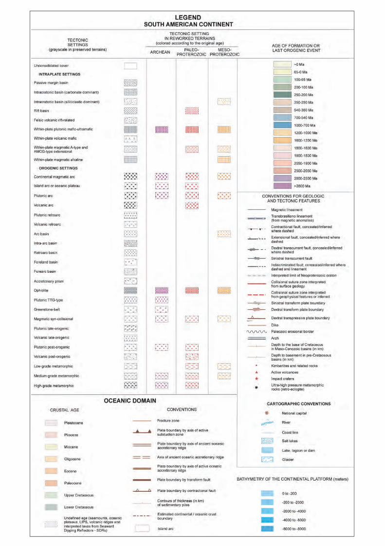
A unified legend for the South American Platform and the Andean region was adopted after several discussions. Three essential attributes were developed to allow the application of that legend and were added to the new integrated GIS database: (1) age of the last tectonic event that affected the area; (2) nature of the tectonic setting; and (3) age of formation of the rocks. The attributes of about 8,000 individual polygons were included in the final database. Owing to the scale of the map, many of the regionally mapped geologic and tectonic units could not be included because of their relatively small outcrop areas. Polygons with a size below two millimetres had to be discarded. In the legend, the colours of the polygons indicate the age of the last tectonic episode that affected the rocks they represent. In addition, the graphic convention included in each of them indicates a specific tectonic setting. Moreover, the colour of the graphic convention for each polygon indicates the probable original age of the respective rock system.
During the development of the work several regional tectonic settings, initially adopted with the help of many collaborators, were assembled with the use of the unified legend and an integrated tectonic interpretation for the entire South American continent was attempted. Finally a consolidated tectonic map was prepared, simplified and harmonized for printing at the scale of 1: 5.9 M. A specific legend integrated the data from offshore areas including crustal ages, plate boundaries, axes of ancient accretionary ridges and other features.
3
2 THE MAIN TECTONIC ELEMENTS OF SOUTH AMERICA
The inset located at the left side of the Tectonic Map of South America is a revised drawing of the main geotectonic elements of this continent, combined with a small sketch dealing with the tectonic correlation of South America and Africa in a West Gondwana reconstruction.
The separation of the Andean orogenic belt (orange and green) and the South American Platform (pink and blue) is evident. In between both geotectonic realms, a very large area with Cenozoic cover (yellow) corresponds to the foreland sedimentary basins related to the Andean tectonics. Plate boundaries and other features of the oceanic domains are also shown in the inset. For the Andean domain, the emphasis is given to the allochthonous terranes accreted in three different periods during the Phanerozoic of which the largest is the Arequipa-Antofalla. Cenozoic island arcs are also shown, as well as the location of active volcanoes, represented by small triangles.
For the South American Platform, the stable counterpart of the Andean tectonic domain, in the inset, the tectonic situation in Neoproterozoic times is considered, making a clear distinction between the cratonic areas and the orogenic belts for that time. For this, it was necessary to strip out the Paleozoic and Mesozoic intracratonic basins that cover large parts of this platform.
The cratonic units are shown in pink. The largest is the huge Amazonian Craton (1), which in the map is divided into the northern (Guyana, 1a) and southern (Central Brazil, formerly called Guaporé, 1b) shields by the Cenozoic cover located along the Amazon River. The São Francisco Craton (4) occupies a large part of eastern Brazil, and in the West Gondwana reconstruction figure, it is shown as a part of a much greater São Francisco-Congo Craton. In the same reconstruction, the São Luís Craton (2) is depicted as a small part of the much greater West African Craton. The Parnaíba (3) and Paranapanema (5) cratonic blocks are concealed below the large Parnaíba and Paraná intracratonic basins respectively. The Rio de La Plata (7) is almost entirely concealed under the Cenozoic cover, and the Luiz Alves Craton (6) is a small isolated cratonic fragment. The Neoproterozoic orogenic belts are shown in blue. They correspond to the eastern margin of the Amazonian Craton, and surround entirely the São Francisco, Rio de La Plata and the other minor cratonic areas. Their tectonic boundaries are also interpreted in the figure. An outstanding tectonic element of both the main inset and the West Gondwana reconstruction figure is the Transbrasiliano Lineament, a mega-shear zone that crosses both South America and Africa, that had an important role in the formation of Gondwana.
3 GENERAL COMMENTS ON THE LEGEND
During the planning phase of the map production, the possibility of producing two different legends for the South American Platform and the Andean Belt was discussed. However, as already mentioned, a unified legend was preferred in order to make it easier for users to interpret the map. The selected colours induce, at a glance, the identification and location in the map of the major tectonic divisions. For example, the light yellow unconsolidated cover, the green tinted Andean Belt and the large intracratonic basins, the blue tinted Neoproterozoic orogenic provinces and the purple red tints of the Amazonian and São Francisco cratonic areas are manifest through their colours.
33 specific patterns were employed in the map and the graphic conventions represent the tectonic settings which were considered important. One of them, related to recent unconsolidated cover and covering very large areas in the map, was left without a symbol. Nine patterns are related to intraplate settings, four of them concern sedimentary basins and five deal with different types of within-plate magmatic processes. Two patterns are related to oceanic features such as ophiolites and island arcs, and the remaining 21 represent continental orogenic settings of different type. Sedimentary systems are characterized by six of these patterns occurring within the supra-crustal levels of the Andean domain. For the South American Platform metamorphic rocks of different ages are included in three patterns, from low-grade to high grade terrains, depending on the crustal level in which they exist in the orogenic belt to which they belong. Two of the map patterns are left to the tectonic regime that produced greenstone belts and associated TTG granitoid terrains. The last 10 map patterns are related to igneous rocks belonging to orogenic magmatic arcs, usually exhibiting some kind of geochronological control. One of them, “generic”, refers to continental magmatic arcs. Four others refer to volcanic or plutonic rocks related to magmatic arcs or retroarcs. Five other patterns are used specifically for the Neoproterozoic/Cambrian belts of the Brasiliano orogenic cycle in eastern Brazil. When the situation of the tectonic units within an orogenic belt is characterized, they can indicate the volcanic or plutonic late and post-orogenic environments, as well as the syn-collisional settings.
The graphic symbols of the map patterns remain in ‘black’ or ‘dark grey’ if the element is part of an orogenic belt affected by a single tectonic cycle, regardless of the age of the unit. However, the legend also aims at characterizing the tectonic units that went through more than one orogenic cycle. In this case the original age of the unit is kept if the tectonic overprint is discrete. However, when intense structural overprint is recognized, such as the one produced by medium-grade metamorphism with
4
anatexis and migmatization, the graphic symbol changes colour according to the original age of the rock system. For example, the Paleoproterozoic age of many of the basement inliers within the Brasiliano belts coloured in blue are indicated by the red graphic symbol.
3.1 AGE OF TECTONISM
As already indicated the colour of each polygon indicates the age of formation in the case of a magmatic unit, or the age of the last tectono-metamorphic episode imprinted on a deformed orogenic association. For the selected time-intervals, with the exception of the recent sedimentary cover, the other sixteen have their boundaries marked by some significant episode of tectonism, which is relevant for South America. The selected colours for the continental and oceanic areas were chosen in order to keep a relatively smooth intensity in order to enhance the graphic conventions of the map patterns. Two very light yellow hues were selected for the unconsolidated cover and the polygons related to the younger part of the Cenozoic Andean orogenic phases. Three shades of green were selected for the Mesozoic tectonic environments, and light brown was chosen for the Paleozoic. The Neoproterozoic tectonic provinces of the Brasiliano Cycle were indicated by two shades of blue and the Mesoproterozoic ones of the Rondonian and Sunsás provinces, located in the central part of the map, by two shades of orange. Four shades grading from pink to red were used for the widespread Paleoproterozoic tectonic environments which cover large areas in the map within the Amazonian, São Francisco, Rio de La Plata and São Luís cratonic areas. Finally, two shades of purple were chosen for the early and late Archean domains of the Amazonian and São Francisco cratons.
For the Phanerozoic the selected time-intervals for the South American map are related to the main tectonic episodes registered within the Andean domain. The synorogenic deposits and related igneous rocks of the Andean orogeny, linked to the main uplift of the mountain chain, and the within-plate basalts and intracratonic deposits of the Cenozoic (65-0 Ma), are depicted in yellow, while the compressional deposits, as well as the volcanic and igneous rocks of the same orogeny, formed in the Late Cretaceous (100-65 Ma), are defined in a pale light green. The pre-Andean extensional deposits and associated igneous rocks of the Triassic-Early Jurassic (250-200 Ma) rifts are represented in green and the subduction related deposits of Jurassic to Early Cretaceous (200-100 Ma) in a light green. The substratum of the Andean and pre-Andean tectonic systems is formed by late Paleozoic (350-250 Ma) igneous and metamorphic rocks of the Gondwanan orogenic belt, represented by subduction and collisional related rocks. Finally, all along the Andean domain the basement is represented by the early Paleozoic (540-350
Ma) igneous and metamorphic rocks of the Famatinian orogenic belt, shown in a light brown.
For the Precambrian the selected age intervals followed strictly the boundaries suggested by the International Stratigraphic Chart of the IUGS. This could accommodate with little difficulty the known age intervals for the different tectonic units included in the map.
For instance, a good geochronological control is encountered in all Neoproterozoic orogenic belts of the Brasiliano Cycle, which practically covers the eastern half of Brazil. The older interval (1000-750 Ma, dark blue) is found in the granitic rocks of the Goiás Magmatic Arc and in rare granitic outcrops in the Borborema Province and the Ribeira Belt. The younger interval (750-540 Ma, light blue) is encountered in all the Brasiliano belts, Brasilia, Ribeira, Dom Feliciano, Araguaia and Paraguay and also in the Borborema province, plus several generalized exposures in the Pampean Belt (Sierras Pampeanas) of Argentina. It must be noted that several post-tectonic granites of the Brasiliano belts yielded Cambrian ages but, on the other hand, Cambrian syntectonic activities were also registered in the Cabo Frio Complex and in the Pampean Belt in Argentina.
For the Mesoproterozoic the main exposures are found in the South-western half of the Amazonian Craton. In this large region the Rondonian - San Ignacio province (1600 -1200 Ma, dark orange) as well as the Sunsás belt and the Garzón Massif (1200-1000 Ma, light orange) occur. A cratonic cover of the São Francisco Craton and some within-plate intrusive granites in the Amazonian craton are also present, as well as the Arequipa Massif and a few basement inliers in the Sierras Pampeanas (Pampean Ranges) within the Andean domain.
The Paleoproterozoic tectonic units are indicated by four shades of pink/red (2500-2050 Ma, 2050-1900 Ma, 1900-1800 Ma and 1800-1600 Ma). The largest Proterozoic region of the map is the Guyana Shield which includes contrasting tectonic units. Vast areas of greenstone-belts and TTG-type terrains limited by high-grade metamorphic belts occur in the north-eastern part of the Guyana Shield (2200-2050 Ma). A younger unit including island arcs and plutonic arc settings, high-grade metamorphic belts and an extensive late-orogenic magmatism occur to the south (2050-1900 Ma). The central-northern part of the shield is occupied by a huge sedimentary cratonic cover and post-orogenic to within-plate A-type magmatism prevails over its south-central part (1900-1800 Ma). Rocks recording tectonic settings such as island arc, continental magmatic arc and post-orogenic or within-plate A-type magmatism occur in the south-western border of the shield (1800-1600 Ma). Other
5
exposures occur in the São Francisco, São Luís and Rio de La Plata cratons, as well as basement inliers of the Borborema, Brasília and Ribeira tectonic provinces
The largest exposure of Archean rocks are encountered in the Carajás domain, eastern part of the Amazonian Craton (>2800 Ma, dark purple; and 2800-2500 Ma, light purple). Moreover, Archean domains are also present in Central Bahia and Minas Gerais, within the São Francisco Craton, as well as basement inliers within younger orogenic belts.
3.2 INTRAPLATE SETTINGS
On the map the larger areal extent is characterized by a very light yellow colour, without a graphic symbol, and refers to the Cenozoic unconsolidated cover. Of the intraplate settings four are related to sedimentary basins. Two of them cover large areas of the map: the intracratonic basins of many different ages, divided into siliciclastic and carbonate dominant sedimentary rocks, encountered especially within the Amazonas, Solimões, Parnaíba, Paraná and Chaco-Paraná sedimentary basins. Two others correspond to passive margin environments and rift-related basins located mainly along the Atlantic coast of South America. Where possible, the sedimentary basins can also be identified by the isopachs of the sedimentary fill.
Moreover, five intraplate magmatic environments are characterized in the map, one of them concerned with rift-related felsic volcanism, with a large occurrence in Patagonia. Mafic volcanism of different ages occurs in many places in South America with an important occurrence within the Paraná basin. Mafic-ultramafic complexes occur in Goiás, in central Brazil and within-plate A-type igneous intrusions of AMCG or alkaline character, of different ages, are widespread in the continent.
3.3 OROGENIC SETTINGS
23 graphic symbols were created to represent orogenic tectonic environments of different types. One of them corresponds to ophiolites, the largest part being encountered in the Northern Andes. Another corresponds to oceanic tectonic environments, such as the island arc and/or oceanic plateaus which occur in the Mesozoic Caribbean terrains of Venezuela, Colombia and Ecuador. However, the same graphic symbols are applied to older terrains where granitoid rocks predominate in different parts of the Amazonian, São Francisco and São Luis cratonic areas when the correspondent tectonic unit was interpreted as the root of an ancient island arc.
Six of the map patterns are related to sedimentary systems of the Andean domain, for which usually there is adequate fossil control. They include accretionary
prisms and arc basins as well as forearcs, intra-arcs and retroarcs, when these can be properly characterized, and they are completely interspersed and integrated within the supra-structure of the entire tectonic system where a great number of polygons is drawn. In contrast the sixth pattern is related to foreland sedimentary basins, extending over very large domains of Cenozoic age, located to the east of the Northern and Central Andes.
For the South American Platform, on the other hand, where the orogenic tectonic units are exposed at deeper crustal levels, the graphic symbols correspond to tectonic units which include igneous or metamorphic rocks usually exhibiting some kind of geochronological control. Two of the graphic symbols deal with the tectonic regime that produced greenstone belts and associated TTG granitoid terrains, typical of the Archean rocks of the São Francisco Craton and the Carajás domain but also for the Paleoproterozoic rocks of the northern part of the Guyana Shield.
Three other symbols are related to polygons representing low, medium or high-grade metamorphic terrains in cases when the original tectonic environment cannot be specified. They depend on the crustal level in which they are inserted in the orogenic belt to which they belong and can be encountered in all the Proterozoic belts of the South American Platform.
The last ten map patterns are related to igneous rocks belonging to orogenic magmatic arcs whose rocks usually exhibit a robust geochronological control. Four of them are related generically to volcanic or plutonic rocks associated with magmatic arcs or retroarcs within the Andean domain. Another is generically related to continental magmatic arcs of all ages, usually when the available isotopic analyses indicate crustal reworking. Finally, when the situation of the tectonic unit within an orogenic belt is relatively well known, its correspondent polygon is featured by a specific graphic symbol indicating syn, late or post-orogenic setting,
In a few cases, when structural overprint was recognized, the decision on the colour for a given polygon presented some difficulties. When the overprint was not intense enough to modify the structure of the original rock, the original colour was kept. This is clear, among other examples, concerning two Paleoproterozoic inliers within the Borborema province and at the Crixás Archean inlier within the Brasilia belt. To the contrary, when the overprint substantially modifies the original rock to the extent of producing migmatites, the colour of the map pattern is that of the last tectonic deformation and metamorphism, but the graphic symbol changes colour according to the original age of the rock system. Other Paleoproterozoic inliers within the Borborema province exemplify this case.
6
3.4 CONVENTIONS FOR GEOLOGIC FEATURES
Conventions for geologic and tectonic features include linear and punctual symbols. On linear symbols non-discriminated faults, as well as contractional, extensional, dextral transcurrent and sinistral transcurrent faults, are represented by black lines (dashed in case of inferred or concealed faults) adorned with the symbols usually adopted for each specific kinematic situation. The Transbrasiliano Lineament, a first order tectonic feature of the South American Platform, is highlighted by a thick dashed black line superposed to a grey line. Magnetic lineaments are represented by a blue line and some of the major dyke intrusions are shown in brown.
Plate boundaries exibiting sinistral transform, dextral transform and dextral transpressive character are represented by brown lines enhanced by specific kinematic indicative symbols. Collisional suture zones are shown in red and are dashed in the case of interpreted or inferred zones. The interpreted limits of the Neoproterozoic cratons are represented by dashed grey lines bounded by fine solid grey lines.
Regarding isopachs for the sedimentary basins, the depth to the base of the Cretaceous in the Meso-Cenozoic basins is represented by light brown lines. Depth to basement in pre-Cretaceous basins is plotted using green lines. In both cases the indication of the depth values is shown in kilometres. In the case of the Amazonas Basin a black wavy line represents its erosional border and the tectonic arcs, which are the boundaries of the sub-basins, are shown in a grey thick line.
Specific punctual symbols include a purple dot for kimberlites and related rocks, a red triangle for active volcanoes, a red star for impact craters, and a black asterisk for ultra-high pressure metamorphic rocks.
3.5 OFFSHORE AREAS
The mapping of the substrate of the submerged continental margins and oceanic areas that frame the South American continent highlights the following issues generated by the processing and interpretation of geophysical and geological datasets:
Age of oceanic lithosphere
This layer results from the cartographic edition of the “Age of the World’s ocean crust grid”, published in 2008 by the American Geophysical Union and the Geochemical Society, with age units in millions of years multiplied by 100 with a 2 minute latitude/longitude resolution. The crustal ages were divided in geological epochs according to the geochronological intervals of the International Stratigraphic Chart. They are represented by different
shades of magenta in the mid ocean ridges and by brownish and greenish hues towards the borders of the continental crust.
Tectonic features
The main tectonic elements include oceanic fracture zones and the estimated continental/oceanic crust boundary. They were compiled from several previous works and consolidated by the analysis and interpretation of gravimetric, bathymetric and magnetic data from various sources. The three main types of boundaries of present day plate tectonics were considered: (1) Divergent, corresponding to active spreading centers, such as the Mid-Atlantic Ridge and the Chile Ridge. The latter is currently subducting beneath the South American Plate. (2) Convergent, represented by the series of subduction zones in the Pacific Ocean that separate the Antarctic, Nazca and Cocos plates along the entire western margin of the South American Plate. In the Atlantic Ocean, another subduction zone is drawn between the Caribbean and South American plates. (3) Transform, represented by a large mega-shear zone at the boundary of the Scotia and the South American plates.
Bathymetry
The bathymetric digital elevation model, values in meters, was obtained by processing of the GEBCO_08 Grid, with a spatial resolution of 30 arc-seconds. The data range from 0 to -8000 meters in depth and were classified into five intervals. The first one, from 0 to -200m, corresponds to the continental shelf. The other intervals were set at 2, 4, 6, and 8 km. They are represented by bright bluish bands, along the continental shelves and continental margins. The GEBCO_08 grid was also used to generate the greyscale hill-shaded image of the basemap.
Anomalous relief features
To improve the legibility of the printed map, only a few submarine physiographic features were indicated as follows:
1. Rises - Rio Grande and Northeast Georgia 2. Aseismic Ridges - Scotia, Malpelo, Nazca, Cocos,
Coiba, Carnegie, North Brazilian, Paraíba and SãoPaulo.
3. Seamount Chains - Vitória-Trindade and Jean-Charcot
4. Abrolhos Volcanic Complex.
Isopachs of sedimentary basins
These contour lines, in meters, represent the minimum thickness of the sediment pile, i.e. the depth to acoustic basement. The isopachs are derived from a digital total-sediment-thickness database for the world’s oceans and marginal seas, compiled by the NOAA, and gridded with a spatial resolution of 5 arc-minutes.
7
4 TECTONIC EVOLUTION OF SOUTHAMERICA
4.1 GENERALITIES
The South American tectonic plate is formed by half of the South Atlantic oceanic lithosphere and the South American continental lithosphere which can be divided into two major features: the Andean tectonic domain, and the South American Platform domain.
The Andean domain exhibits several different tectonic environments developed at the specific convergent boundaries of the South American Plate with a few oceanic lithospheric plates. All along the Pacific margin the boundaries with the Cocos, Nazca and Antarctic plates are characterized by tectonic environments driven by subduction. To the north, the boundary with the Caribbean plate of the equatorial Atlantic Ocean is characterized by obduction of oceanic slivers. To the South the boundary with the Scotia plate is characterized by very long strike-slip mega-faults. As a result of such contrast in tectonic settings, a clear distinction is seen for the Northern, Central and Southern Andes.
In the Tectonic Map the structural complexity of the Andean domain is indicated by the juxtaposition of allochthonous terranes, the very long contractional and transcurrent faults and the large number of active volcanoes. The tectonic evolution is also apparent in the Central Andes by the Paleozoic orogenic system (light brown) along the eastern side, followed by the Meso-Cenozoic mainly volcanic and plutonic rocks (green and yellow) at the western side of the chain.
The South American Platform can be defined as the stable continental region which serves as the cratonic counterpart for the Andean domain during the entire Phanerozoic. Its western boundary with the Andean domain, along the Llanos-Beni-Pampas regions, is concealed beneath a series of extended foreland basins. Its eastern boundary with the South Atlantic oceanic lithosphere is marked by a series of passive margin basins. The last major tectonic system that affected it was the Neoproterozoic/Cambrian Brasiliano-Pan African orogeny – responsible for the formation of the Gondwana Supercontinent. At its SW margin, Gondwana was affected during the Paleozoic by the subduction of the proto-Pacific Ocean. In Mesozoic times, when Gondwana (at that time included in Pangea) was finally disrupted, South America became one of its major resulting continental fragments.
The orogenic belts of the Brasiliano Cycle surround the few cratonic areas which are tectonically stable at least since Neoproterozoic times. In the tectonic map they are shown with bluish map patterns while the cratonic areas, the so-called Amazonian, São Francisco, Rio de
La Plata, São Luís and Luiz Alves, include a mosaic of polygons exhibiting different colours depending on of the age of their respective tectonic activity.
4.2 TECTONIC EVOLUTION OF THEANDEAN DOMAIN
The Andean domain comprises several orogenic cycles well developed all along the Pacific margin of the continent. At present, many specific tectonic settings have been identified and large contrasts have been described among the Northern, Central and Southern Andes. The Northern Andes, encompassing mostly Venezuela, Colombia and Ecuador, are characterized by collisions of island arcs and oceanic plateaux during the Meso-Cenozoic, while the Central Andes of Peru, Bolivia and northern Argentina and Chile are the typical location of an orogen related to subduction. The Southern Andes have their own characteristics, where the main deformation is related to the opening and closure of an oceanic marginal basin developed in a back arc setting.
Three main orogenic cycles are recognized during Phanerozoic times within the Andean domain: the Famatinian in the early Paleozoic, the Gondwanan in the late Paleozoic, and the Andean cycle during the Meso-Cenozoic. Basement inliers are not frequent in the Andean domain, however relatively small occurrences of late Mesoproterozoic and Neoproterozoic rocks are exposed especially in northern Colombia.
The Famatinian orogen is well represented from the Merida Andes of Venezuela, through the Santander Massif and Eastern Cordillera of Colombia; the Marañón Massif of northern Peru; the southern Peru – northern Chile coastal domains, and the Sierras Pampeanas of Argentina. This early Paleozoic belt is characterized by late Cambrian-early Ordovician subduction-related granitoids and collisional granites associated with metamorphic rocks and synorogenic deposits. The main deformation has a middle Ordovician age, around ~ 460 Ma, which is related to the docking and amalgamation of different microcontinents such as the Merida, Chibcha, Paracas, Arequipa-Antofalla and Cuyania basement terranes. Most of them are para-autochthonous and most likely were detached during the continental break-up of Rodinia in the Neoproterozoic. The only exception is Cuyania, a Laurentian derived allochthonous terrane.
The late Paleozoic Gondwanan orogen, which occurs in most of the Central Andes of Peru and Northern Chile, is represented by subduction related granitoids and volcanic rocks. The metamorphic rocks of this orogeny, forming a paired belt of high pressure-low temperature and low pressure - middle temperature rocks, are part of the accretionary prism located along the continental margin. During this time, the southern and northern ends of South
8
9
America are characterized by collisional orogens which eventually took part in the amalgamation of Pangea. The Northern Andes were affected in the Late Carboniferous – Early Permian by the continental collision of Laurentia with Gondwana that formed the Alleghanides orogeny, encompassing several small blocks that are nowadays in Mexico and Central America. At about the same time, the Southern Andes were part of a different collisional orogen, the Gondwanides, formed by the collision of Patagonia and other southern continents against Gondwana.
These late Paleozoic collisions were followed by large amounts of anatectic magmas. The Choiyoi large rhyolitic province in Chile or the Mitu igneous rocks in Peru were emplaced subsequently to the main Early Permian compressional deformation in the Central Andes. Similar anatectic rocks are also described in the Northern Andes. Such post-tectonic rocks led to the formation of important rift systems during the Triassic to Early Jurassic, associated with the breakup of Pangea. At ca. 200 Ma, the Bolivian Andes and part of northern Brazil were affected by mafic volcanism and associated rifts of the Central Atlantic Magmatic Province (CAMP), related to the formation of the Ecuatorial Atlantic Ocean. In the early Jurassic the southern part of South America was characterized by the Chon Aike Rhyolitic Province, widespread through most of Patagonia, which is associated to the Karoo mantle plume and the opening of the Weddell Sea prior to the opening of the South Atlantic. This large scale Early Jurassic anatectic magmatism is related to the beginning of the Andean subduction. At this time, magmatic rocks were emplaced all along the continental margin during a period of subduction with extension that lasted until the Early Cretaceous. The opening of the South Atlantic Ocean marked the initiation of subduction in a compressional regime along the Pacific margin.
For the Meso-Cenozoic Andean Cycle, the tectonic map shows the large exposures of the successive magmatic arcs, mostly represented by long lasting granitic batholiths along the continental margin. These plutonic rocks are associated with thick piles of calcalkaline volcanic rocks and volcaniclastic sediments of andesitic to dacitic composition. Widespread synorogenic deposits filled the foreland basins that developed for the first time in the Late Cretaceous and during the Cenozoic along the foothills of the Andean mountain chain, which are in large part covered by Quaternary alluvial deposits.
For the Northern Andes, the tectonic map of South America depicts some second order features superimposed on the previous general trends. In Venezuela, the interaction of the Caribbean and the South American plates developed the Caribbean Ranges, formed by obduction of oceanic fragments, and later displaced by important strike-slip faults.
The Andes of Colombia and Ecuador also show a series
of ophiolitic rocks obducted and deformed in successive phases of accretion. At first, the amalgamation of island arcs and the closure of back arc basins occurred at the end of the Early Cretaceous, followed by the collision of oceanic plateaux in the latest Cretaceous and finally by the final accretion of an island arc in the Miocene. These successive tectonic events produced highly deformed terrains which display low-grade metamorphic rocks including blueschists.
The northern part of the Central Andes is considered a typical occurrence of normal subduction of oceanic lithosphere. However, in some areas where the magmatic arc shifted to the foreland, the tectonic map illustrates a complex pattern of sedimentary and igneous rocks along the axis of the tectonic unit. These areas are presently characterized by flat subduction and broken forelands which may expose large blocks of metamorphic and igneous basement rocks.
The central part of the Central Andes, in southern Peru – northern Chile and Bolivia, has a normal dipping subduction zone. As a result, the region is composed by thick piles of Cenozoic volcanic and volcaniclastic deposits where large stratovolcanoes stand out. This area, which represents the Central Volcanic Zone of the Andes, was affected by crustal and lithospheric delamination processes that produced large calderas and widespread ignimbrites of dacitic to rhyolitic composition. This area of large calderas is associated in the foreland with large Sub-Andean thin-skinned fold and thrust belts.
The southern part of the Central Andes, in northern Argentina and Chile, is an area of transition between normal and flat subduction. Therefore, the map illustrates a decrease in the amount of volcanic rocks to the south until reaching the area of the Pampean flat slab segment. This segment is represented by a lack of Quaternary arc volcanic rocks and the presence of the Main Cordillera where the highest mountains of the Andes are found such as Mount Aconcagua. This segment is also characterized by a broken foreland that exposes the basement rocks of the Sierras Pampeanas and the widening of the orogen with the uplift of Palaeozoic igneous and metamorphic rocks. South of the Pampean flat slab subduction, there is another segment characterized by a large field of retroarc volcanic plateau, known as the Payenia basaltic province. This large Quaternary volcanic region is the largest basaltic province of the Andes and has an unusual setting as result of a late Cenozoic steepening of the subduction zone.
The Southern Andes of Patagonia are characterized by an axial granitic batholith where successive Jurassic to Tertiary sequences of telescopic arc plutons have been emplaced. The foreland region shows the thick Jurassic rhyolites of the Chon Aike Province related to the opening of the South Atlantic. These rocks are covered by Late Cretaceous and Tertiary synorogenic deposits capped

by younger and extensive basaltic rocks associated with the collision of seismic ridges. Moreover, some classic intracratonic basins along Patagonia are now interpreted as distal foreland basins controlled by dynamic subsidence associated with subduction and tectonic loading along the Andean margin. Finally, the southernmost Southern Andes, the Fueguian Andes, are split by important strike-slip faults which are detaching the Scotia microplate from the rest of South America.
As a whole, the Andean domain depicted in the Tectonic Map of South America shows a complex distribution of forearc, arc, and retro-arc deposits that globally characterize a normal orogenic system driven by subduction. It is known worldwide as the reference locality of the “Andean-type” orogenic systems.
4.3 TECTONIC EVOLUTION OF THE SOUTHAMERICAN PLATFORM
The South American Platform came into being in Neoproterozoic to Cambrian time when several continental masses were amalgamated to form West Gondwana. During this process, when all the cratonic fragments were united by continental sutures, the orogenic belts of the Brasiliano/ Pan African Orogenic Cycle were formed and two large oceanic realms were consumed by subduction-to-collision tectonic episodes. One of them was the huge Goiás-Pharusian Ocean, which was closed after a long duration subduction phase that brought together, on one side, the Amazonian and the West African cratonic masses and, on the other side, the São Francisco-Congo, the Rio de La Plata and the Saharan counterparts. This ca. 5000 km long continental collision produced Himalayan-type mountains and was concluded along the West Gondwana Orogen, a region where the Transbrasiliano mega-shear zone is now located. As a result of this collision, the Brasilia and Paraguay orogenic belts were developed, as well as the Borborema tectonic province and the Trans-Saharan belts in Africa. The second large ocean that disappeared when Gondwana was formed was the Adamastor. It included a rifted embayment of the São Francisco-Congo paleocontinent and an extended oceanic region that later would become the site of the amalgamation of smaller cratonic masses such as the Rio de La Plata, Paranapanema, Luiz Alves and Kalahari (see the South America-Africa correlation sketch of the inset of the Tectonic Map). In this way, along the Brazilian and Uruguayan Atlantic coast, the Araçuaí, Ribeira and Dom Feliciano orogenic belts were developed.
Therefore, at the dawn of the Paleozoic the platform was tectonically stabilized and since then it served as basement for a series of intracratonic sedimentary domains. From the Middle Ordovician until Cenozoic time, extensive cratonic covers were developed within five major Paleozoic intracontinental basins and are
preserved in individual depocenters, whose names are derived from the major rivers that flow along the main axis of each one: the Amazonas, Solimões and Parnaíba basins in Brazil; the Paraná basin, largely in Brazil and in minor areas of Paraguay, Uruguay and Argentina, and the Chaco-Paraná basin in Argentina. In the map, they show elliptical to semi-circular shapes, and range in size from 500M to more than 1,000M km². Together, they occupy ca. 3,500M km² of South America. In common, these syneclises have a relatively simple structural and stratigraphic framework and are associated with the presence of enormous volumes of Triassic intrusive mafic rocks in northern Brazil and Cretaceous extrusive and intrusive igneous rocks in the Parnaíba and Paraná sedimentary basins. Moreover, Meso-Cenozoic alkaline and peralkaline igneous rocks, sometimes associated with carbonatites, as well as kimberlite pipes and related rocks, occur in many different areas of the South American Platform.
From Mesozoic times onward the break-up of Gondwana produced an extensive divergent margin at the eastern part of South America with the opening of the South Atlantic Ocean. The rifting processes occurred along the entire continental margin and formed a set of sedimentary basins that are subdivided into (1) aborted rifts covering a series of basins that occur particularly in the equatorial and northeast margins and (2) rifts that evolve to form sedimentary basins of the passive margin divided into transform and divergent margin basins. Their tectono-stratigraphic evolution is generally similar. It starts with a pre-rift mega-sequence, including remnants of intracratonic sedimentation of Paleozoic and Mesozoic units. Then a syn-rift mega-sequence usually occurs, associated with extensional processes, with fluvial and lacustrine continental deposits. It is followed by a transitional marine gulf mega-sequence with evaporitic deposits, and finally the sedimentary basin ends up with a post-rift predominantly marine mega-sequence.
Regarding the tectonic setting during the Brasiliano orogenic Cycle, the inset of the Tectonic Map shows that the Amazonian Craton, the São Luís Craton and the inferred Parnaíba block, concealed beneath the Parnaíba Basin, are located to the west of the Transbrasiliano Lineament. On the other hand, the São Francisco Craton, as well as the Rio de La Plata and the Luiz Alves cratons, plus the inferred Paranapanema block concealed beneath the Paraná basin, are located to the East of it. Therefore the Neoproterozoic to Cambrian belts are members of a tectonic collage which concluded the convergence of the above mentioned cratonic elements by a series of continental collisions in the Ediacaran period. All the Brasiliano belts comprise tectonic-stratigraphic sections including some rift-type and passive margin-type deposits, with some oceanic crust fragments and turbiditic successions linked to coeval magmatic arcs, formed
10

11
usually between ca. 900 and 500 Ma. Thrust-and fold belts are common where metamorphism is restricted to low to medium grade, but areas of high-grade metamorphic rocks are described in some of the belts. Tectonically reworked basement inliers are quite common and those of Paleoproterozoic age predominate.
The earliest tectonic episode, with an age interval between ca. 900 and 700 Ma, is registered in the Brasiliano belts that formed the West Gondwana Orogen. It is related to the granitoid rocks which make up the roots of the Goiás Magmatic Arc, located right over the Transbrasiliano Lineament, in central Brazil. These rocks are remnants of the juvenile intra-oceanic island arcs formed within the Goiás-Pharusian Ocean and are the best evidence of the character and age of that oceanic realm. Later the convergence within the Brasília belt affected the passive margin of the western São Francisco Craton and the collisional phases, with associated continental magmatic arcs, occurred between 650 and 560 Ma. The long duration subduction which closed the Goiás-Pharusian Ocean is also described for the Ceará State of Northeast Brazil, where UHP retro-eclogites with an age of ca. 600 Ma are characterized close to the Transbrasiliano Lineament. To the east of it, the Borborema Province forms a mosaic of tectonic elements of different age and evolution, including inliers of Archean and Paleoproterozoic age, and a very large amount of granitoid intrusive rocks formed between 600 and 500 Ma. This indicates a pervasive disruption, during the Brasiliano orogeny of a previously coherent cratonic region. Such “ghost” cratonic region must have been present when a coherent Borborema province converged and collided against the São Francisco Craton producing the tectonic structures of the Sergipano belt.
At the eastern border of the Amazonian Craton, two Brasiliano belts occur: the Araguaia belt in the northern and the Paraguay belt in the southern regions. The first one has its greater part below the Parnaíba basin and may not have been part of an extensive oceanic realm. If the West African Craton, of which the São Luís cratonic fragment was its southern part, had always been relatively close to the hidden Parnaíba block, the Araguaia belt may be considered as a tectonically activated aulacogen during the Brasiliano orogeny. It forms a thrust and fold belt with tectonic vergence towards the Amazonian Craton, and includes slivers of oceanic lithosphere and basement inliers of Archean age, similar to the rocks of the Carajás domain. The Paraguay belt is also a fold and thrust belt of Ediacaran to Cambrian age with tectonic convergence towards the Rio Apa cratonic fragment, considered to be a possible southernmost extension of the Amazonian Craton. It brings an important sedimentary sequence, the Corumbá Group, with diagnosed Ediacaran fossils, and in association to it the large foreland sequence of the Parecis basin is located over the craton.
Regarding the closing of the Adamastor Ocean, several orogenic belts of Brazil and Africa took part in the amalgamation process that produced Gondwana. They are the Araçuaí, Ribeira and Dom Feliciano in South America, and the West Congo, Kaoko, Damara and Gariep in Africa. The initial rifting of the São Francisco-Congo paleocontinent, which separated the regions in which the precursor basins of the Araçuaí and West Congo belts were formed, occurred in the late Tonian, at about 900 Ma. However, the rifting did not separate the São Francisco and Congo cratonic nuclei that remained attached through the Bahia-Gabon tectonic bridge. Therefore, during its oceanic phases, the Adamastor was never a very large ocean. The subduction-driven contraction phase produced some juvenile magmas, but most isotopic signatures of the granitoid rocks encountered in the Brasiliano belts indicate a major involvement of continental crust in their generation. Within the Araçuaí, Ribeira and Dom Feliciano belts, the tectono-magmatic evolution was similar with the supracrustal rocks showing low to medium grade metamorphic parageneses. Continental magmatic arcs are widespread, and pre-, syn- and late-collisional granitoid rocks are formed in successive pulses between 630 and 530 Ma. Orogenic collapse, followed by post-collisional granites and intrusion of some A-type granites occur within these belts between 530 and 480 Ma.
The Amazonian craton is the largest, covering an area of more than 4.3 M km². The Guyana Shield, at the northern part of it, is made up of a mosaic of tectonic units formed in the Paleoproterozoic. This includes a series of Rhyacian of juvenile granite-gneiss terrains, and coeval continental magmatic arcs, represented by greenstone belts and TTG granitoid complexes, located close to the Amapá and Imataca reworked domains of Archean age. Relicts of island arcs and plutonic arcs (2.03 Ga) and the collisional high-grade Cauarane-Coeroeni supracrustal belt occupies the central area of the Guyana Shield and at least two major post-collisional igneous belts are recognized, located at both sides of it. Moreover, the little disturbed Roraima Supergroup covers a large area of the central-northern part of the shield. The Uatumã magmatism (1.89-1.87 Ga), comprising volcanic and plutonic rocks related to post-orogenic to anorogenic settings, seems to continue below the sediments of the Amazon basin to occupy a large area of the Central Brazil Shield. Finally, during the Mesoproterozoic, many A-type granitic bodies were intruded and the central part of the Guyana Shield was affected by an important within-plate deformation and heating along the region of the K’Mudku/Nickerie mega-shear zone.
The Central Brazil Shield, at the southern part of the Amazonian Craton, includes the Carajás domain, the largest exposed area with Archean rocks, corresponding to the more important mining district of Brazil. It comprises granite-greenstone terrains, as well as supracrustal rocks of late Archean age, which include important iron formations.
12
To the south-west of the Carajás domain, in the Tapajós área, the Uatumã igneous rocks obliterate the basement, and only relicts of island arc settings with 2.02 Ga are exposed. Further to the south-west the Rio Negro-Juruena tectonic province is found, made up by accretionary belts of Paleoproterozoic and Mesoproterozoic age, driven by subduction processes which lasted about 300 Ma, from 1.8 to 1.5 Ga. Magmatic arcs are the predominant tectonic units, forming a “basement” complex in which granitic rocks predominate, many of them with juvenile isotopic signatures. Archean basement was not detected. To the south-west, the Mesoproterozoic Rondonian-San Ignacio tectonic province is located, possibly colliding with the craton at 1.35 Ga, and finally a younger tectonic province, the Sunsás belt, is considered to be a witness of the Grenvillian collision of Laurentia and Amazonia, at about 1.0 Ga.
The much smaller São Francisco Craton is almost completely surrounded by the Brasiliano belts. Archean rocks outcrop in two areas in the southern and northern portions of this craton, in tectonic contacts with two important Paleoproterozoic belts. The Archean domains are made up by granite-greenstone associations which include episodic magmatic pulses between 3.6 and 2.6 Ga in both cratonic portions. These represent a tectono-magmatic evolution by means of juvenile accretion/differentiation events characterized by multiple TTG plutonism. The collisional Eastern Bahia orogenic domain comprises mainly amphibolite to granulite facies rocks of Paleoproterozoic age and the Mineiro belt, together with the adjacent mining Iron Quadrangle, represents a fairly complete segment of a Paleoproterozoic orogen preserved in the southern São Francisco Craton. The plutonic rocks
of the Mineiro belt are subduction-driven granitoids generated between 2.5 and 2.1 Ga and are coeval with the low-grade metasedimentary successions of the Minas Supergroup which comprises passive margin and syn-orogenic sediments. Mesoproterozoic within-plate rifting events, with the formation of aulacogenic-type basins, are widespread over the central portion of the craton.
Regarding the other cratonic areas, only a small part of the Rio de La Plata Craton crops out. In southern Brazil and Uruguay it is mostly covered by the sedimentary rocks of the Paraná basin and in the Buenos Aires province of Argentina is almost entirely hidden by the Cenozoic cover. It is usually formed by medium to high grade ortho-metamorphic rocks, including granulites, and the major exposures are related to the Piedras Altas juvenile Paleoproterozoic Complex in Uruguay. In the case of the very small Luiz Alves cratonic fragment, it is formed by Paleoproterozoic high-grade rocks and is bounded by the Itajaí foreland belt of the Dom Feliciano Neoproterozoic belt. For the São Luís Craton, it is a small cratonic area in the northern part of Brazil that was split from the much larger West African Craton when the equatorial Atlantic was formed. It includes TTG granitoid rocks of Paleoproterozoic age which correlate well with the coeval ones affected by the Eburnian orogeny in West Africa and it is bounded to the south by the low to medium grade metamorphic rocks of the Gurupi belt. Finally, the Parnaíba and Paranapanema blocks are completely hidden below the sediments of the intracratonic Parnaíba and Paraná basins. They are inferred mainly through geophysical data and geological reasoning, although there is some geochronological evidence obtained from a few basement cores.
ACKNOWLEDGEMENTS
The authors wish to express gratitude to all the persons who generously provided substantial assistance for the interpretation of the tectonic settings represented in the map with original information and useful advices and suggestions. Although 52 are listed in the text inset of the map, numerous others were actually involved in fruitful discussions. A special acknowledgement is due to Prof. Benjamim Bley de Brito-Neves (University of São Paulo) and Prof. Francisco Hervé Allamand (University of Chile) for their thorough analyses of the final version of the map, in the frame of the peer review process recommended by CGMW. Thanks are also due to Peter Miles (CGMW) for his review of the English text of this note.
Recognition is due to the University of São Paulo, Brazil and to the University of Buenos Aires, Argentina, for their consent related to the continued work of the co-coordinators Umberto Cordani and Victor Ramos. Recognition is also due to the Geological Surveys of Brazil (CPRM) and Argentina (SEGEMAR) that provided full technical assistance, and allowed the participation of officials Carlos Schobbenhaus, Lêda M Fraga, Francisco EM Gomes, Marcelo Cegarra, Inácio Delgado (CPRM by 2011) and Kaiser G de Souza (CPRM by 2012).
Finally, the authors wish to acknowledge the continued support and the guidance received from the Commission for the Geological Map of the World (CGMW), as well as the support received from the International Union of Geological Sciences (IUGS), the United Nations Educational, Scientific and Cultural Organization (UNESCO) and the Association of Iberoamerican Geological and Mining Surveys (ASGMI).
COMMISSION DE LA CARTE GÉOLOGIQUE DU MONDECOMMISSION FOR THE GEOLOGICAL MAP OF THE WORLD
77, rue Claude-Bernard75005 Paris, France
Phone +33 (0)1 47 07 22 84 Fax +33 (0)1 43 36 95 18
http://www.ccgm.org [email protected]
©CCGM/CGMW, 2016Paris, France
With the support of
A project carried out by