Tectonic geomorphology and Holocene paleoseismicity of the...
18
\ew Zealand Journal of Geology and Geophysics, 1996, Vol. 39: 33—50 0028-8306/96/0033 $2.50/0 © The Royal Society of New Zealand 1996 33 Tectonic geomorphology and Holocene paleoseismicity of the Molesworth section of the Awatere Fault, South Island, New Zealand JAMES P. McCALPIN GEO-HAZ Consulting Inc. P.O. Box 1377 EstesPark, CO 80517, U.S.A. Abstract The Molesworth section comprises a 55 km long, N72°E-striking reach of the 175 km long dextral-reverse(?) Awatere Fault, which has an overall trend of N55-60°E. Well-preserved fault scarps display normal-oblique slip, with vertical offsets up to 30 m and horizontal offsets up to 72 m on latest glacial terraces (age c. 10 000 yr B.P.), equating to a mean slip rate of c. 8 mm/yr. The two latest paleo- carthquakes on the main fault trace are bracketed by I4 C and weathering-rind age estimates of 522-597 cal. yr B.P. and c. 2500-4500 years ago, respectively, and display single- event horizontal offsets of 6-8 and 4—8 m. The two latest paleoearthquakes on the 9.5 km long upper Wairau splay fault yield sufficiently different ages (751—873 cal. yr B.P. and 1296-2923 cal. yr B.P.) that they are inferred to be different from the events on the main trace. The large displacements per event imply ruptures much longer than the 55 km length of the Molesworth section. This disparity suggests that this geometrically defined section is not bounded by persistent segment boundaries, and probably ruptures along with longer segments to the east and west, in earthquakes of A/ w = 7.5-7.8. Keywords Awatere Fault; Molesworth Station; tectonic geomorphology; paleoseismicity; neotectonics; slip rates; recurrence interval; radiocarbon dates; NZMS sheets N30C, N30D INTRODUCTION The 175 km long Awatere Fault is one of four major dextral faults in the Marlborough fault system (Fig. 1). Over most of its length, the Awatere Fault strikes N55-60°E, but the 55 km long section between Lake Tennyson and the Vlolesworth homestead, herein termed the Molesworth ?>ection, trends much more easterly (N75—80°E) and is bounded by double bends. Due to the transtensive nature of this more easterly striking section, faulting includes a significant normal-fault component. Several small extensional tectonic basins (Tarndale valley, Isolated Flat; Fig. 2) have formed along this section of the Awatere Fault, and the fault trace itself is expressed as south-facing scarps up to 30 m high across Quaternary deposits on the northern margin of the basins. (195006 Received 22 February 1995; accepted 13 September 1995 Reconnaissance field observations were made over 6 months between 5 October 1987 and 25 March 1988, and four backhoe trenches were excavated in March 1988. Additional supporting data, including 114 fault scarp profiles, 50 weathering rind stations, 33 14 C dates, 23 soil profiles, and 15 auger holes, are contained in McCalpin (1990). The Quaternary stratigraphy and geochronology of the western part of the Molesworth section was described by McCalpin (1992a, b). TECTONIC GEOMORPHOLOGY Mega-geomorphology The four northeast-trending Marlborough faults break the crust into four north-tilted fault blocks (e.g., Cotton 1950, fig. 6), with the major rivers (Wairau, Awatere, and Clarence) flowing N55—60°E down the fault-angle depressions. Cotton (1950, fig. 4) defined the rugged range front northwest of the Awatere River as the type locality of the "Awatere-type" fault scarp, inferred to result from "steep normal or reverse faulting". Almost all of the larger tributaries to the four major rivers are aligned N15-20°E (Fig. 3). Barbed tributary junctions are common, especially on the northern side of major rivers. These barbed junctions suggest that tributaries now flowing SI5-20°W may have originally flowed N15- 20°E, but were later captured by headward extension of the major rivers. In the Molesworth section, the four large tributary valleys on the north side of the Awatere Fault (from west to east, the upper Wairau, Severn, Saxton, and Acheron valleys) do not continue straight across the fault to the south. Instead, similar valleys, often containing underfit streams flowing either northeast or southwest, are observed with a 7-8 km dextral separation across the fault (numbers 1-5 in Fig. 3). This dextral separation is so consistent that it is presumed related to dextral displacement on the Awatere Fault, although other explanations may be possible. Lensen (1960) suggested a net (post-Cretaceous) dextral offset of 20 km across the Awatere Fault east of the Molesworth section, and Suggate et al. (1961) described 7- 8 km dextral offset of metamorphic isograds near the confluence of the Awatere and Alpine Faults west of the Molesworth section (later revised upward to 13 km by McLean 1986). Suggate (1963) concluded that the Marlborough faults were formed entirely in the Kaikoura Orogeny, which began in the middle Miocene and has continued to the present (Suggate et al. 1978). DeMets et al. (1990) indicated a change in plate motion at c. 3.5 Ma that may have triggered the transition from vertical to horizontal displacement on the Marlborough faults. If the 7—8 km dextral separations of streams date from c. 3.5 Ma, then a long-term slip rate of c. 2.0—2.3 mm/yr is indicated. The drainage anomalies suggest the following geo- morphic history: (1) existence of a N15—20°E-flowing drainage system in pre-Kaikoura time; (2) disruption of the
Transcript of Tectonic geomorphology and Holocene paleoseismicity of the...

\ew Zealand Journal of Geology and Geophysics, 1996, Vol. 39: 33—500028-8306/96/0033 $2.50/0 © The Royal Society of New Zealand 1996
33
Tectonic geomorphology and Holocene paleoseismicity of the Molesworthsection of the Awatere Fault, South Island, New Zealand
JAMES P. McCALPINGEO-HAZ Consulting Inc.P.O. Box 1377EstesPark, CO 80517, U.S.A.
Abstract The Molesworth section comprises a 55 km long,N72°E-striking reach of the 175 km long dextral-reverse(?)Awatere Fault, which has an overall trend of N55-60°E.Well-preserved fault scarps display normal-oblique slip, withvertical offsets up to 30 m and horizontal offsets up to 72 mon latest glacial terraces (age c. 10 000 yr B.P.), equating toa mean slip rate of c. 8 mm/yr. The two latest paleo-carthquakes on the main fault trace are bracketed by I4Cand weathering-rind age estimates of 522-597 cal. yr B.P.and c. 2500-4500 years ago, respectively, and display single-event horizontal offsets of 6-8 and 4—8 m. The two latestpaleoearthquakes on the 9.5 km long upper Wairau splayfault yield sufficiently different ages (751—873 cal. yr B.P.and 1296-2923 cal. yr B.P.) that they are inferred to bedifferent from the events on the main trace. The largedisplacements per event imply ruptures much longer thanthe 55 km length of the Molesworth section. This disparitysuggests that this geometrically defined section is notbounded by persistent segment boundaries, and probablyruptures along with longer segments to the east and west, inearthquakes of A/w= 7.5-7.8.
Keywords Awatere Fault; Molesworth Station; tectonicgeomorphology; paleoseismicity; neotectonics; slip rates;recurrence interval; radiocarbon dates; NZMS sheets N30C,N30D
INTRODUCTION
The 175 km long Awatere Fault is one of four major dextralfaults in the Marlborough fault system (Fig. 1). Over mostof its length, the Awatere Fault strikes N55-60°E, but the55 km long section between Lake Tennyson and theVlolesworth homestead, herein termed the Molesworth?>ection, trends much more easterly (N75—80°E) and isbounded by double bends. Due to the transtensive nature ofthis more easterly striking section, faulting includes asignificant normal-fault component. Several smallextensional tectonic basins (Tarndale valley, Isolated Flat;Fig. 2) have formed along this section of the Awatere Fault,and the fault trace itself is expressed as south-facing scarpsup to 30 m high across Quaternary deposits on the northernmargin of the basins.
(195006Received 22 February 1995; accepted 13 September 1995
Reconnaissance field observations were made over 6months between 5 October 1987 and 25 March 1988, andfour backhoe trenches were excavated in March 1988.Additional supporting data, including 114 fault scarpprofiles, 50 weathering rind stations, 33 14C dates, 23 soilprofiles, and 15 auger holes, are contained in McCalpin(1990). The Quaternary stratigraphy and geochronology ofthe western part of the Molesworth section was describedby McCalpin (1992a, b).
TECTONIC GEOMORPHOLOGY
Mega-geomorphologyThe four northeast-trending Marlborough faults break thecrust into four north-tilted fault blocks (e.g., Cotton 1950,fig. 6), with the major rivers (Wairau, Awatere, and Clarence)flowing N55—60°E down the fault-angle depressions. Cotton(1950, fig. 4) defined the rugged range front northwest ofthe Awatere River as the type locality of the "Awatere-type"fault scarp, inferred to result from "steep normal or reversefaulting". Almost all of the larger tributaries to the four majorrivers are aligned N15-20°E (Fig. 3). Barbed tributaryjunctions are common, especially on the northern side ofmajor rivers. These barbed junctions suggest that tributariesnow flowing SI5-20°W may have originally flowed N15-20°E, but were later captured by headward extension of themajor rivers. In the Molesworth section, the four largetributary valleys on the north side of the Awatere Fault (fromwest to east, the upper Wairau, Severn, Saxton, and Acheronvalleys) do not continue straight across the fault to the south.Instead, similar valleys, often containing underfit streamsflowing either northeast or southwest, are observed with a7-8 km dextral separation across the fault (numbers 1-5 inFig. 3). This dextral separation is so consistent that it ispresumed related to dextral displacement on the AwatereFault, although other explanations may be possible.
Lensen (1960) suggested a net (post-Cretaceous) dextraloffset of 20 km across the Awatere Fault east of theMolesworth section, and Suggate et al. (1961) described 7 -8 km dextral offset of metamorphic isograds near theconfluence of the Awatere and Alpine Faults west of theMolesworth section (later revised upward to 13 km byMcLean 1986). Suggate (1963) concluded that theMarlborough faults were formed entirely in the KaikouraOrogeny, which began in the middle Miocene and hascontinued to the present (Suggate et al. 1978). DeMets etal. (1990) indicated a change in plate motion at c. 3.5 Mathat may have triggered the transition from vertical tohorizontal displacement on the Marlborough faults. If the7—8 km dextral separations of streams date from c. 3.5 Ma,then a long-term slip rate of c. 2.0—2.3 mm/yr is indicated.
The drainage anomalies suggest the following geo-morphic history: (1) existence of a N15—20°E-flowingdrainage system in pre-Kaikoura time; (2) disruption of the

34 New Zealand Journal of Geology and Geophysics, 1996, Vol. 3 >
MARLBOROUGH FAULT SYSTEM
ri
Fig. 1 Location map of theAwatere Fault and Molesworhsection. Heavy solid line shov sthe late Quaternary fault trac .heavy dashed lines show older i rless well preserved fault traceUWS = upper Wairau splay fauiWG = Wairau Gorge. Majcrdrainages shown as thin solid li ~i< •;with arrows. Dotted pattern shcv •;sediment-filled transtensionalbasins. Grid numbers are NZM S270 map co-ordinates.
Fig. 2 Aerial oblique phougraph of the Awatere Fault(between lower arrows) along th :northern margin of Isolated Fl. i(IF), looking northeast. Upperarrows show ridge rents. A =Acheron River, S = Saxton River,BH = Big Horst. Distance betweenBH and A is 9 km. Mountainsnorth of the fault are composed ofTorles.se Supergroup (Jurassic)greywacke and rise to elevationsof 2200 m, in contrast to ele\ -ations of 950-1000 m along thefault.
system by development of rising normal fault blocks (cf.Lensen 1962) early in the Kaikoura Orogeny (early—midMiocene); (3) defeat of streams on the scarp slopes of faultblocks and reversal of drainage to flow southwest into(closed?) fault-angle depressions; (4) increasing dextralshear on the Marlborough faults (late Miocene — earlyPliocene?) and headward erosion of the Wairau, Awatere,and Clarence Rivers into the fault-angle depressions; and(5) continuing dextral offset of N20°E-trending valleys andeventual integration of the present N55-60°E-flowingdrainage. Future headward erosion by the Awatere River at
low points such as Saxton Pass will ultimately lead to captureof the southwest-flowing Acheron and Saxton Rivers (atlocations 3 and 4 north of the Awatere Fault; Fig. 3). Suchcapture would result in yet another barbed tributary junction,such as exists at the present confluence of the Acheron andClarence Rivers (Fig. 3).
Meso-geomorphologyThe fault bends at each end of the Molesworth section aremarked by rhomboidal fault-bounded mountain blocks (Fig.1) that are pervasively faulted. At the eastern bend near

VlcCalpin—Tectonic geomorphology on the Awatere Fault 35
ClarenceRiver
PacificOcean
10 30I
50 km
Fig. 3 Drainage network of southern Marlborough showing mainrivers (Wairau, Awatere, Clarence) and their major tributaries. "b"sindicate barbed tributary junctions. Numbers 1-5 on either side ofthe Awatere Fault indicate N15-20°E-trending valley segmentsthat appear to have been displaced dextrally.
Molesworth homestead, the "Mt Chisholm block" isbounded on the north, east, and south by well-preservedsidehill scarps and "ridge rents". The relatively flat top ofMt Chisholm is split by a complex system of slightly sinuousscarps that roughly parallel the ridge crest and form crestalhorsts, graben, and uphill-facing scarps. These scarpsresemble sackungen (e.g., Varnes et al. 1989). The right-stepping geometry of the Mt Chisholm rhomboid impliesthat the mountain is undergoing fault-parallel extension(transtension), so the sackung-like scarps may have formedat least partly during coseismic rupture of the Awatere Fault,
the mechanism suggested for similar features elsewhere inNew Zealand by Beck (1968).
At the western bend, the "Mt Maling block" is less welldefined but seems to contain a left step (transpressive) inthe late Quaternary trace of the Awatere Fault. Abundantscarps on or near the ridge crest make a plan pattern similarto that on Mt Chisholm, but scarps are abnormally steepnear their bases, a geometry possibly associated with areverse component of faulting (see next section).
Between the end blocks, the fault bounds the northernside of open valleys (Fig. 2) or crosses valleys such as theTarndale valley (Fig. 1). West of the Tarndale valley, theAwatere Fault is composed of two traces, a main trace thatcontinues southwest to Island Pass, and a northern 9.5 kmlong trace that crosses the upper Wairau River and dextrallyoffsets the mouths of five glaciated tributaries of Turk Ridge(see McCalpin 1992b, fig. 2). This "upper Wairau splay"(UWS) turns sharply southwest at the mouth of Island GullyStream and merges with scarps in the Mt Maling block. Theuppermost part of the Wairau River valley, however, is alsounderlain by a shear zone that is discontinuously exposedin streamcuts and exits the valley through a col at its head;this trace may mark an older, currently inactive trace of theAwatere Fault. Another older fault trace is inferred from asystem of aligned valleys and saddles that lies parallel to,but 5-6 km north of, the late Quaternary trace of the AwatereFault (see Fig. 8) between the Wairau River and MunroeHut, 5 km north of the Molesworth homestead.
Micro-geomorphology
The late Quaternary trace of the Awatere Fault has four typesof geomorphic expression, varying with fault strike andtopography: (1) symmetrical (normal-oblique?) fault scarps;(2) asymmetrical (reverse-oblique?) fault scarps; (3) lineartroughs; and (4) uphill-facing scarps on steep hillslopes(ridge rents). Along the eastern half of Isolated Flat and inthe Tarndale valley, the Awatere Fault strikes N72°E and
Fig. 4 Asymmetrical fault scarpof the Awatere Fault on the,northern margin of the westernhalf of Isolated Flat across a earlyi?)Otiran alluvial fan. Person atbase of scarp (arrow) indicatesscale. Above person, scarp height= 27.5 m, vertical surface offset =22.5 m, maximum scarp slopeangle = 38°, far-field slope = 9°.

36 New Zealand Journal of Geology and Geophysics, 1996, Vol. 39
! ! •
1 '.
• ^ > • • '
" • ' " . v * "•.-••-••'•
v '
„ • ,
• : ' < *
' • • • . •
- ', ik, » r̂
a '
...
& V
•' ' i
• . . • ' ; '
M -
1
A
- x i • -. -'-". -
' •" \ "c ' "• •
Fig. 5 Geomorphology am'stratigraphy along linear traces olthe Awatere Fault. A, Lineaitrough marking the fault tracebetween the Acheron and SaxtonRivers across the latest glacialaggradation surface; trench 4 is inforeground. B, Log of trench 4Sediments beneath the troughconsist of cobbly-to-sandy collu-vium that has been sheared inmultiple faulting events.
EXPLANATION
Cobble° l graver
o I Pebbleoo| gravel
|5-!"-| Pebbly\\'i:\ mud
»thin Ahorizon
imbricatedclasts
individuallarge clasts
W Fault
©Unit number
A*c Soil horizons
-LOG OF TRENCH ACROSS THE AWATERE FAULT,
0.5 KM WEST OF THE ACHERON RIVER 8RIDGE.
'LOGGED 5-6 MAY 1988 BY JAMES WcCALPIN
-GROUNDWATER TABLE COINCIDES WITH BOTTOM
OF TRENCH BETWEEN 4 m AND 8 m ON LOG
the trace is a very linear, narrow trough with little net verticalrelief across the fault (see Fig. 5A). The lack of conistentvertical relief suggests that the overall slip vector trendsc. N72°E. Lateral offsets of small landforms were easy tomeasure along these linear traces, but fault-zone stratigraphy(see Fig. 7B) proved unrewarding because of the lack ofsignificant post-faulting sedimentation in the trough.
Theoretically, normal-oblique scarps should form (dueto transtension) wherever local scarp strike is more easterlythan the N72°E overall strike of the Molesworth section,and reverse-oblique scarps should form wherever strikes aremore northerly. Indirect geomorphic evidence suggests thatthis does occur. Normal fault scarps are typically sym-metrical (e.g., Wallace 1977; McCalpin in press) becausethe footwall is displaced upslope and away from theaccumulating colluvial wedge, and thus the wedge canincrease in surface area through time. Reverse fault scarpsare often asymmetrical, because repeated overriding of thecolluvial wedge by the hanging wall tends to decrease thesurface area of the wedge (Carver in press).
The actual distribution of scarp symmetries containsmany exceptions to the scarp strike versus symmetryrelationship described above. Many of the most asym-metrical scarps strike more easterly than N72°E (e.g., alongthe western part of Isolated Flat; Fig. 4). In some scarps,symmetry appears to be controlled by surface vegetation.Where vegetation is sparse, colluvial aprons are large andwell developed, resulting in generally symmetrical scarps,but where a thick turf mat covers the surface, colluviationis minimal and scarps are often asymmetrical. A reversecomponent of faulting can thrust and fold the plastic siltysoils without breaking them and exposing fresh sediment,and this can lead to asymmetrical scarps with steepest slopesnear the foot.
Nearly pure dextral slip across the rugged topographyof the upper Wairau splay has produced unique scarpgeometries (Fig. 6). Each interfluve between glaciatedtributaries is dextrally offset c. 10 m on each of two parallelfault strands. This offset of the c. 24-25° sloping valley wallshas created south-facing fault scarps on the (true) right valley

McCalpin—Tectonic geomorphology on the Awatere Fault 37
F'ig. 6 Aerial oblique photo-graph of displaced mouths ofglaciated tributaries on thenorthern side of the upper Wairauvalley. Two prominent faulttraces in middle ground (arrows)have dextrally offset valley wallssuch that valley-facing scarps(shadowed) occur on one valleywall, and mountain-facing scarps(light tones) on the opposite wall.The upper Wairau River is atbottom right. Field of view is 2km across and covers the areashown in Fig. 8 between profiles22 and 24.
Fig. 7 Ridge rent acrossweathered remnant of pre-Otiran(?) alluvial fan, typical ofmost scarps observed along theMolesworth section. Locationshown on Fig. 2 at tip of far-rightarrow. Surface offset = 3.7 m,scarp height = 2.4 m, maximumscarp slope angle = 24°. Personholding rod is 1.7 m tall.
walls and identical north-facing fault scarps on the (true)left valley walls. In contrast, across fault traces on interfluvesummits and valley floors, which are nearly flat, there islittle or no vertical relief. The net slip vector on each strand(20.7—20.8 m dextral) can be reconstructed by trigonometrybased on the valley wall slope angle (24—25°) and the verticalsurface offsets of the 9.4—9.7 m high north or south facingfault scarps.
In the Mt Chisholm and Mt Maling blocks, and alongthe foothills north of Isolated Flat (Fig. 2), traces of theAwatere Fault are expressed as uphill-facing scarps thatparallel contours on steep hillslopes. This type of scarp hasbeen termed a "ridge rent" in previous papers (e.g., Cotton
1950). Scarp morphology ranges from relatively sharp (Fig7) to very eroded, presumably indicative of scarp ageSurface offsets reconstructed from topographic profilestypically range from 0.7—12 m (mode 5—6 m) and are muchlarger than scarp heights (0.8-5.0 m, mode 1-3 m)Maximum scarp slope angles range 15-39°, with a mode of25—30°. The origin of these ridge rents is uncertain becausethe underlying faults are nowhere exposed, and landformsthat might record a lateral component of offset are generallylacking. Based purely on scarp morphology, ridge rents coulc.be interpreted as "seismo-gravitational" features (after theclassification of Solonenko 1977) formed by either outwardtoppling or dip-slip gravitational spreading during

38 New Zealand Journal of Geology and Geophysics, 1996, Vol. 39
70 m-
60 m-
50 m-
40m-
30m-
20m-
H O R I Z O N T A L D I S P L A C E M E N T
t •
F A U L T T R A C E S , M O t E S W O R T H S E C T I O N
"{0' • • • i \ u w s ,rvV\..Nv-•"
TARNDALE - ' ' ' ,» IVALLEY 0 { I 5
" ' ' • •, 5 4 - 5 7
/0*m I ISOLATED FLAT
20 m -
t l O m -
0 -
20m —
2480 E
N SIDE
UP
- - - - -
S SIDEUP
2490 E
: * .•
:
2500 E V E R T I C A L
• ":. v - • • • •* ->
D I S P L A C E M E N T
• • - •
-0 - " • - * _
2520 E1
2530 E
Fig 8 Trend of displacement along-strike in the Molesworth section. Fault traces (at centre) are marked by solid lines where scarpsare well preserved by dashed lines where poorly preserved; dotted lines indicate vegetation lineaments, dashed-and-dotted lines a-ealignments of saddles that possibly indicate older (or less active) fault traces. Numbers indicate profile numbers keyed to Table 1 ancto McCalpin (1990) LS = Lake Sedgemere, BT = Bowscale Tarn, M = Molesworth homestead, MH = Munroe Hut, MCB - Mt:Chisholm block MMB = Mt Maling block, UWS = upper Wairau splay. Grid numbers are NZMS 270 map co-ordinates Ages forhorizontal displacements are based on weathering rind based age estimates for Saxton River terraces by Knuepfer (1988, 1992).
earthquakes (Beck 1968). However, the parallelism of ridgerents with traces of the Awatere Fault implies that they maybe underlain by tectonic faults, as inferred by Cotton (1947,1949). If ridge rents were formed episodically (rather thanby continuous creep), the stratigraphy of sediments in theadjacent sediment trap should include colluvial wedges,buried soils, and subsidiary fractures, as proposed byMcCalpin & Irvine (1995). Because of the reconnaissancenature of this study and difficulty of access, no trenches wereexcavated across ridge rents, but such exploration shouldbe a priority in future studies.
SPATIAL PATTERNS OF FAULT DISPLACEMENT
The ratio of vertical to horizontal displacement on theAwatere Fault, and thus scarp morphology, is stronglydetermined by local variations in fault strike. The largesthorizontal displacements occur on straight reaches of thefault trace (e.g., Fig. 5) where vertical displacement is smalland scarp strike is near the N72°E overall strike of the section(Fig. 8). As scarp strike trends progressively more easterlythan N72°E, normal-oblique scarps (usually symmetrical inprofile) become higher (Table 1). More northerly obliquitiesare associated with progressively higher asymmetrical(reverse-oblique?) scarps. Local variations in strike arerelatively random in length and obliquity, and do not form asystematic zig-zag pattern such as described by Norris &Cooper (1995) on the Alpine Fault.
The largest horizontal offsets of landforms are foundalong the northern edge of Isolated Flat (Fig. 8), where latestglacial aggradation terraces and alluvial fans are offset up
to 72 m dextrally. These deposits are correlated to the latestaggradation surface in the upper Wairau Valley, datecbetween 9460 ± 150 I4C yr B.R and 12 600 ± 160 I4C yjB.P., with a best-estimate age of c. 10 070 ± 170 14C yr B. P.(McCalpin 1992a, b).
The largest vertical surface offsets are found near thecentre of the Molesworth section immediately west of thezone of largest horizontal displacements (Fig. 8) and amountto 29.8 m in Waimean (c. 150 ka?) alluvial fans (profiles54-57, Fig. 8). Similar scarps with up to 28.5 m verticaloffset mark the main trace of the Awatere Fault east of theMt Chisholm block in Muller Station (profiles 107, 114 ir.Fig. 8).
Horizontal displacements could be accurately measuredat 62 locations along the 55 km length of the Molesworthsection. All landforms were sufficiently well preserved tofall into the categories "excellent" or "good" (Sieh 1978:McGill & Sieh 1991) for displaying lateral offset. Each offsetmeasurement (Table 1) is characterised by measurementuncertainty that mainly results from projecting the offsetpiercing-point landform to the inferred fault trace,Measurement uncertainty was found to vary consistentlywith the type of landforms (i.e., small stream channels, ±1 m:moraine crests, ±1-2 m; terrace risers, ±2-4 m; and axes ofalluvial fans, ±5 m). Small stream channels tend to be offsetby 6-12 m, moraine crests by 10-20 m, terrace risers by15-64 m, and alluvial fan axes by 62-96 m, so thatmeasurement uncertainty is also roughly proportional to totallateral offset. The 25 measurements from terrace risers (Table1) are minimum estimates, because terrace risers may havebeen trimmed by lateral stream erosion after faulting (Lensen1964).

McCalpin—Tectonic geomorphology on the Awatere Fault 39
Table 1 Locations and amounts of horizontal offsets along the Molesworth segment.
Location1
Drincess StreamDrincess Streamsland Passisland PassIsland GullyUpper Wairau R.Jpper Wairau R.-pper Wairau R.Jpper Wairau R.Jpper Wairau R.Jpper Wairau R.^pper Wairau R.Jpper Wairau R.jpper Wairau R.^ake Sedgemere3owscale TarnNE Tarndale valleyW of Severn Riveri side, Severn Riveri side, Severn RiverI side, Severn River\l of Severn RiverW of Isolated SaddleW of Isolated Saddle\V of Isolated SaddleW of Isolated Saddlesolated Saddleisolated SaddleW of Big HorstW of Big HorstW of Big HorstBig Horst, N sideBig Horst, N sideBig Horst, S sideBig Horst, S sideBig Horst, S sideBig Horst, S sideBig Horst, S sideisolated Flatisolated Flatisolated Flatisolated Flatisolated Flatisolated Flatsolated Flatsolated Flat
: solated Flatisolated Flatisolated Flatisolated Flatisolated FlatW side, Saxton RiverW side, Saxton River1; side, Saxton Riveri; side, Saxton RiverH side, Saxton RiverK side, Saxton RiverH side, Saxton RiverIsolated FlatAcheron River•\cheron RiverMuller StationMuller Station
Profile2
3366
20-
2222—-
24—_——
4145—
484950_
54575858—
61—————-——
66—
71—
72,74—_
75—_—__——
78—
798081
82-8388919898
107114
Deposit3
mid-Otiran moraineWaimean (?) morainemid-Otiran alluviummid-Otiran alluviumearly Holocene fanmid-Otiran morainemid-Otiran morainemid-Otiran morainemid-Otiran morainemid-Holocene terracelate Holocene terracelate Holocene terracemid-Otiran morainelate Otiran moraine3 ka landslide1 m terracechannel, Otiran fanmid-Holocene terracelate Holocene terraceOtiran fanOtiran fanchannel, Otiran fanWaimean? fanWaimean? fanlate Holocene terracemid-Holocene terraceOtiran fanearly Holocene fanmid-Holocene terraceolder channelchannel, Otiran fanlate Holocene terracelate Holocene terracemid-Holocene terracemid-Holocene terraceearly Holocene terraceearly Holocene terraceearly Holocene terracechannel, Otiran fanyoung channelchannel, Holocene fanchannel, Holocene fanchannel, Holocene fanearly Holocene fan axischannel, Holocene fanOtiran? fan edgeearly Holocene fan axischannel, Holocene fanmid-Holocene fan axisearly Holocene fan axischannel, Holocene fan7 ka terrace5.5 ka terrace2.5 ka terrace4.5 ka terrace5.5 ka terrace7 ka terracelatest glacial terracechannel, Holocene fanlatest glacial terracelatest glacial terraceearly Otiran fanearly Otiran fan
/ / (m)4
30.8327?
22.936.6 net
5.5222221.523186.56
51146
122.81.71.51.08
149.5
646
124040304011.54.5
101093.5
1610.5
>616
2313135732
91-96621328701172187.4
11.738.762643213.527.5 net
106.7?86?
V(m)5
-13.1—
^1.4—
<1.9—6.62.80.9-6.0—_—1.81.20.80.60.8
-1.36.41.15.59.44.46.17.8
11.62.8——1.4
10.2?1515115.3—7.70.9
-0.2-—
>1.5——8.5_—-—2.1—
-0.4-0.7-3.4-1.0
1.62.4
-1.9-
>28.516.4
Net (m)6
33.4—
23.3_5.8—
2321.723-8.8—_—6.3
122.91.81.71.6
10.214.011.064.7
7.413.540.841.630.1——4.7
14.3?1817.511.516.9—
61.56.1
23-—
57——
62.6—
-—
72—7.4
11.838.9626432.113.6-
110.4?87.5?
V/H1
0.42—0.19_0.35—0.300.130.04-0.93—__0.300.100.290.310.531.300.80.080.580.150.730.510.200.290.09——0.311.021.501.673.140.33—0.130.150.01——0.03—-0.14——-—0.03—0.050.060.090.020.030.080.14—0.270.19
Azimuth8
6060797980—
909070—
95—__
707561896061608086808080888895——
555552525252—
786969-—
69——
69——-—
73—
73727073787169695660
1 General location within the Molesworth section, see Fig. 8 for place names.• Scarp profile numbers increase from west to east, see Fig. 8; numbers also keyed to 1:25 000-scale fault trace maps in McCalpin (1990
plates 1—6).Faulted deposit. Approximate ages for named deposits: Waimean, 140? ka; early Otiran, 50—60? ka; mid-Otiran, 25^40 ka; late Otiran,14—18 ka; latest glacial aggradation (= early Aranuian), 10 ka; early Holocene, 7—1 Oka; mid-Holocene, 3—7 ka; late Holocene, 0—3 ka.Ages after Suggate (1965) and Suggate & Moar (1970).
"H = horizontal offset (m). Approximate measurement uncertainties are: small stream channels, ±1 m; moraine crests, ±1—2 m; terracerisers, ±2-4 m; axes of alluvial fans, +5 m. The 25 measurements from terrace risers are minimum estimates.1= vertical surface offset (m), measured from detailed topographic profiles. Accuracy +3—5%.
' Net = net slip (m). assuming a 45° dip for the underlying fault.V/H = ratio of vertical to horizontal offset.Azimuth = azimuth of local scarp strike where measurement was taken.
40 New Zealand Journal of Geology and Geophysics, 1996, Vol. 3'
2.1
Theoretical relation forrigid blocks: V/H= tan 8.where 6= angle of obliquityfrom azimuth of 72 degrees
Overall Strike of Molesworthsection = 72 degrees
50 55 65 70 75 80 85Local Scarp Azimuth (degrees)
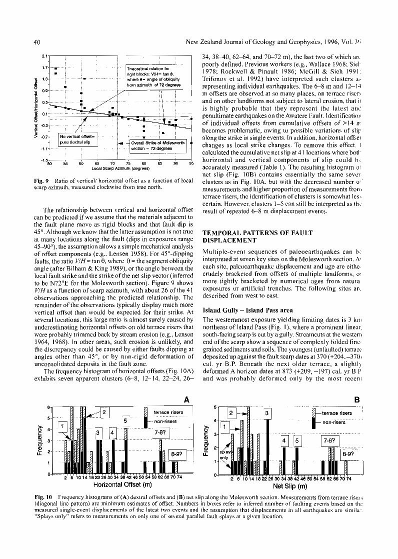
Fig. 9 Ratio of vertical/ horizontal offset as a function of localscarp azimuth, measured clockwise from true north.
The relationship between vertical and horizontal offsetcan be predicted if we assume that the materials adjacent tothe fault plane move as rigid blocks and that fault dip is45°. Although we know that the latter assumption is not trueat many locations along the fault (dips in exposures range45—90°), the assumption allows a simple mechanical analysisof offset components (e.g., Lensen 1958). For 45°-dippingfaults, the ratio VIH= tan 8, where 0 = the segment obliquityangle (after Bilham & King 1989), or the angle between thelocal fault strike and the strike of the net slip vector (inferredto be N72°E for the Molesworth section). Figure 9 showsVIHas a function of scarp azimuth, with about 26 of the 41observations approaching the predicted relationship. Theremainder of the observations typically display much morevertical offset than would be expected for their strike. Atseveral locations, this large ratio is almost surely caused byunderestimating horizontal offsets on old terrace risers thatwere probably trimmed back by stream erosion (e.g., Lensen1964, 1968). In other areas, such erosion is unlikely, andthe discrepancy could be caused by either faults dipping atangles other than 45°, or by non-rigid deformation ofunconsolidated deposits in the fault zone.
The frequency histogram of horizontal offsets (Fig. 10A)exhibits seven apparent clusters (6-8, 12-14, 22-24, 26-
34, 38-40, 62-64, and 70-72 m), the last two of which arcpoorly defined. Previous workers (e.g., Wallace 1968; Sicl1978; Rockwell & Pinault 1986; McGill & Sieh 1991:Trifonov et al. 1992) have interpreted such clusters a-representing individual earthquakes. The 6-8 m and 12-14m offsets are observed at so many places, on terrace risersand on other landforms not subject to lateral erosion, that iiis highly probable that they represent the latest am:penultimate earthquakes on the Awatere Fault. Identificationof individual offsets from cumulative offsets of >14 nbecomes problematic, owing to possible variations of slipalong the strike in single events. In addition, horizontal offsetchanges as local strike changes. To remove this effect, !calculated the cumulative net slip at 41 locations where botlhorizontal and vertical components of slip could txaccurately measured (Table 1). The resulting histogram otnet slip (Fig. 10B) contains essentially the same severclusters as in Fig. 10A, but with the decreased number ofmeasurements and higher proportion of measurements fromterrace risers, the identification of clusters is somewhat lesscertain. However, clusters 1-5 can still be interpreted as theresult of repeated 6—8 m displacement events.
TEMPORAL PATTERNS OF FAULTDISPLACEMENT
Multiple-event sequences of paleoearthquakes can b<.interpreted at seven key sites on the Molesworth section. A'each site, paleoearthquake displacement and age are eitheicrudely bracketed from offsets of multiple landforms, oimore tightly bracketed by numerical ages from naturaexposures or artificial trenches. The following sites an.-described from west to east.
Island Gully - Island Pass areaThe westernmost exposure yielding limiting dates is 3 kmnortheast of Island Pass (Fig. 1), where a prominent linear,south-facing scarp is cut by a gully. Streamcuts at the westernend of the scarp show a sequence of complexly folded finegrained sediments and soils. The youngest (unfaulted) terracedeposited up against the fault scarp dates at 370 (+204,-3701cal. yr B.P. Beneath the next older terrace, a slightlydeformed A horizon dates at 873 (+209, -197) cal. yr B.Pand was probably deformed only by the most recen;
Bterrace risers
non-risers
8-9?
2 6 1014182226303438424650545862667074
Horizontal Offset (m)
4-
§i 2
1-
terrace risers
nbn-nsers
7-8?
1 8-9?
2 6 10 14 18 22 26 30 34 38 42 46 50 54 58 62 66 70 74
Net Slip (m)
Fig. 10 Frequency histograms of (A) dextral offsets and (B) net slip along the Molesworth section. Measurements from terrace risers(diagonal line pattern) are minimum estimates of offset. Numbers in boxes refer to inferred number of faulting events based on themeasured single-event displacements of the latest two events and the assumption that displacements in all earthquakes are similar."Splays only" refers to measurements on only one of several parallel fault splays at a given location.

McCalpin—Tectonic geomorphology on the Awatere Fault 41
Fig. 11 Log of hand-dug trench across the 0.8 m high fault scarpon a late Holocene terrace at the entrance to the Wairau Gorgei NZMS 270 co-ordinates 5897600N, 2502600E). Thick line showsfault plane; note steep dips of units on downthrown block, possiblycaused by drag. Large clasts are solid black. i4C date is on bulkorganics from the buried and faulted fossil A horizon.
(earthquake) event (MRE). A lower, more deformed soildates at 3082 (+189, -185) cal. yr B.P. and must record theMRE and the penultimate event (PE).
Anomalously large landslides, possibly coseismic,originated in a steep valley head 3 km WNW of Island Passand were deposited on a broad alluvial flat 2 km southwestof Island Pass (McCalpin 1992a). Three landslide depositsare differentiated, based on surface morphology, weatheringrind thickness, and 14C ages (Table 2). Holocene fault scarpsintersect both sides of the amphitheater, suggesting thatearthquake shaking, shearing, and displacement triggeredthe slides.
Upper Wairau SplayKey sites along the 9.5 km long upper Wairau splay are thefaulted Holocene terraces at the entrance to the WairauGorge, and offset moraines at the mouths of five glaciatednorthern tributaries to the Wairau River. At the first site, anorthwest-striking normal fault has offset several low
terraces of the Wairau River. The oldest terrace is offset 5.8 mvertically and carries weathering rinds with a largestsignificant mode (LSM)/mean = 3.0/3.62 mm (estimated age4194-4453 years according to calibrated age equations; seeTable 2). The two next younger terraces are offset 0.8-1.0 mvertically, the older of which carries weathering rinds ofLSM/mean = 2.8/2.43 mm (estimated age 3826-4089 years).The youngest (unfaulted) terrace carries weathering rindsof LSM/mean = 1.0/1.05 mm (estimated age 973-1285years). Based on the estimated ages of terraces, the MRE isbracketed between 973-1285 years and 3826-4089 years.A shallow trench across the 0.8 m high scarp (Fig. 11)exposed the fault plane and a truncated buried soil on thedownthrown block dated at 1110 (+213, -164) cal. yr B.P.This soil is developed on the same terrace that yields (onthe upthrown block) a weathering-rind age of 3826-4089years, or nearly four times the 14C age.
Similar discrepancies between the weathering rind agesof terrace gravels, and radiocarbon ages from soils or fine-grained sediments atop the terraces, occur at many locationsin the Molesworth section and suggest the following. Partsof gravelly floodplains may be abandoned by activedeposition before the floodplain is incised and transformedinto a terrace. Thus, weathering rind measurements taken atrandom locations on a terrace provide only a maximum ageestimate for terrace abandonment. In the early stages ofterrace incision, overbank flooding may still deposit fine-grained sediments on the terrace tread, and eolian depositioncontinues long after terrace formation. Thus, radiocarbonages from detrital organics atop terraces provide onlyminimum age estimates for terrace formation. Dates fromsoil A horizons or peat in fine-grained terrace cappingdeposits provide even looser minimum age constraints onterrace formation. In this study, the stratigraphically lowestparts of peats and soils were dated to provide the closestconstraints on age of terrace formation. At most sites alongthe Awatere Fault, 14C dates from soils atop terraces areseveral hundred to several thousand years younger than agesestimated from weathering rinds on exposed clasts on thesame terrace; these dates thus crudely bracket the time ofterrace formation.
About 1.5 km farther west, on the upper Wairau splay, astreamcut through the fault scarp reveals three boulderycolluvial wedges overlying a charcoal-rich soil (Fig. 12).That soil, buried by colluvium shed after the latest
Table 2 Ages of large landslides in the western part of the Molesworth section.
Location
Serpentine CreekSerpentine CreekUpper Wairau valleyLake Sedgemere
Deposit
younger slideolder slide5
youngest slideolder slide
Rind thickness (mm)
LSM1
1.02.82.63.0
Mean
0.671.771.892.12
Estimated
K-LSM2
973382734684195
age(14C
K-Mean3
1071228924972909
yr B.P.)
W-LSM4
1286409037394453
'LSM = largest significant mode (contains >5% of population).2K-LSM = age calculated from LSM and calibrated age equation of Knuepfer (1988) where age = (973± 70) LSM™+0-05.
3 K-Mean = age calculated from Mean and calibrated age equation of Knuepfer (1988) where age= (1071+ 125) Mean1 3 3 + o l ° .
4W-LSM = age calculated from LSM and calibrated age equation of Whitehouse et al. (1986) where age= (-10 530) ln[(8.7-LSM)/8.7].
'Radiocarbon ages bracket this deposit between 2830 ± 80 I4C yr B.P. and 3130 + 80 14C yr B.P. (McCalpin1992a, p. 207).

42 New Zealand Journal of Geology and Geophysics, 1996, Vol. 39
Fig. 12 Log of streamcut in the easternmost northern glaciatedtributary of the upper Wairau valley (NZMS 270 co-ordinates5897400N, 2501100E). Thick lines show faults and shear zones(cross-hached). Tilted pebble gravels and underlying weatheredzone in bedrock (sinuous line pattern) are truncated by cobblegravels that are themselves steeply tilted, indicating repeatedfaulting and sedimentation. Scarp-derived colluviums arenumbered 1 (oldest) through 3. Colluvium 1 is significantly finergrained than colluviums 2 and 3 and possesses a mottled clay-richmatrix indicative of reducing conditions. Boulders are shown insolid black.
.1
686±55thin turf
mat
- pebblegravel
. base of trench
- J 1 1 L J L _L2.4m
Fig. 14 Log of hand-dug trench across fault scarp on the youngest(Holocene) faulted terrace on the east bank of the Severn River.Thick line shows fault plane, line with "x"s shows buried freeface. Scarp-derived colluvium overlying the faulted A horizon iscomposed primarily of silt because it is derived from the fine-grained cap of the faulted terrace. Boulders are shown as solidblack.
s1m
N
6 2 9 * IO5l4CyrB.R
dense turfmat limit of
trench
\ mixture ofloess andgravel
1.4m
Fig. 13 Log of hand-dug trench across the eastern margin of alinear gully of the Awatere Fault trace 1.5 km northeast of LakeSedgemere. Thick line shows fault plane. The A horizon developedon postglacial loess on the hanging wall is thrusted and folded,and the tip of the soil displays severe drag and overturning.Although most of the organic material dated in this soil mustpredate faulting, some additional organics may have been addedafter faulting, and thus the 14C age should be considered as a loosemaximum age constraint on faulting.
displacement, dates at 1296 (+226,-228) cal. yr B.P. Another3 km farther west on the same fault trace, complex faultingof ground moraine created narrow sag ponds in elongatetension(?) fractures. Charcoal within the oldest sag pondsediments dates at 751 (+174, -84) cal. yr B.P. and mustpostdate latest faulting by the unknown time interval requiredto accumulate the c. 4—13 cm of fine-grained sedimentsbeneath the dated detrital charcoal.
Tarndale valleyThe MRE on the main trace of the Awatere Fault displace;a large Holocene landslide by 6 m dextrally and 1.8 mvertically at the northwest corner of Lake Sedgemere (Fig1). If the landslide was coseismic, this displacement isevidence for two paleoearthquakes. The Lake Sedgemereslide is dated at 4195—4453 years by weathering rinds (Table2), but that is a maximum age estimate. One kilometrenortheast of Lake Sedgemere, the fault trace is marked by a1 m wide, 0.5 m deep linear trough with a marshy bottomA shallow trench across the eastern trough margin reveals a50° northwest-dipping reverse-oblique fault that has foldedand overthrust a buried A horizon dated at 597 (+131, —102;cal. yr B.P. (Fig. 13).
Severn RiverAt the Severn River, two Holocene terraces and the lates!glacial aggradation surface are vertically offset 0.8,6.4, and11.5 m, respectively. Respective apparent horizontal offsetsof the risers below these surfaces are 1.5, c. 2, and 8 m, buithe last two values have almost certainly been decreasedfrom the original offset by lateral stream erosion. A shallov,trench across the 0.8 m high scarp on the lowest Holoceneterrace reveals a faulted and folded buried A horizon datedat 646 (+65, -80) cal. yr B.P. (Fig. 14). Exposed clasts orthe upthrown part of this terrace surface carry weatherinj;rinds of LSM/mean = 2.0/1.5 mm, indicating an age of 244<>-2750 years. Thus, it appears that fine-grained deposition andsoil formation continued for some 2000 years after terraceformation, after which the MRE displaced the terrace c. 65< >cal. yr B.P.
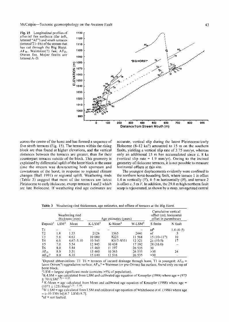
Big HorstAt the northwest corner of Isolated Flat, the Awatere Faultbifurcates around an elliptical uplifted block 1.5 km long,0.5 km wide, and 100 m high (herein informally termed theBig Horst; see Fig. 2). A southeast-flowing stream cuts
McCalpin—Tectonic geomorphology on the Awatere Fault 43
Fig. 15 Longitudinal profiles ofalluvial fan surfaces (far left,lettered "AF") and strath terraces(lettered T1-T6) of the stream thathas cut through the Big Horst.AFw, Waimean(?) fan; AFo,Otiran fan. Major faults arelettered A-D.
1130
1120
1110
1100
1090
-p-1080
h- 1060
W 1050
LLJ1040
1030
1020
1010
1000
990
100 200 300 400 500 600Distance from Stream Mouth (m)
700 800 900
across the centre of the horst and has formed a sequence offive strath terraces (Fig. 15). The terraces within the risingblock are thus found at higher elevations, and the verticaldistances between the terraces are greater, than for theircounterpart terraces outside of the block. This geometry isexplained by differential uplift of the horst block at the sametime the stream was downcutting both upstream anddownstream of the horst, in response to regional climatechanges (Bull 1991) or regional uplift. Weathering rinds(Table 3) suggest that most of the terraces are latestPleistocene to early Holocene, except terraces 1 and 2 whichare late Holocene. If weathering rind age estimates are
accurate, vertical slip during the latest Pleistocene/earlyHolocene (8-12 ka?) amounted to 15 m on the southernfaults, yielding a vertical slip rate of 3.75 mm/yr, whereasonly an additional 15 m has accumulated since c. 8 ka(vertical slip rate = 1.9 mm/yr). Owing to the incisedgeometry of Holocene terraces, it is not possible to measurehorizontal offsets at this site.
The youngest displacements evidently were confined tothe northern horst-bounding fault, where terrace 1 is offset1.4 m vertically (V), 4—5 m horizontally (//), and terrace 2is offset c. 5 m V. In addition, the 29.8 m high northern faultscarp is rejuvenated, as shown by a steep, unvegetated central
Table 3 Weathering rind thicknesses, age estimates, and offsets of terraces at the Big Horst.
Deposit'
TlT2T3T4T5T6AF0
AFW?
Weathering rindthickness (mm)
LSM2 Mean
_1.85.86.07.08.08.08.0
—1.334.634.67-5.105.545.845.516.35
Ag<
K-LSM3
212610 08010 54512 94515 46015 46015 640
e estimates (years)
K-Mean4
_156582238317-9351
10 43811 19710 36312 516
W-LSM5
_2441
11 56812 32117 19226 53526 53526 535
Cumulative verticaloffset (m); horizontaloffset in parentheses
S faults
nf6
nf15(10-11?)21 (10.5)28(16.0)30>30>30
N fault
1.4(4-5)5
1017——
24-
'Deposit abbreviations: T1-T6 = terraces of incised drainage through horst, Tl is youngest; AFo =
latest Otiran(?) aggradation surface; AFW? = Waimean (or pre-Otiran) fan surface, found only on top ofhorst block.-LSM = largest significant mode (contains >5% of population).3K-LSM = age calculated from LSM and calibrated age equation of Knuepfer (1988) where age = (973±70)LSM 1 ? 3 + 0 0 5 .4 K-Mean = age calculated from Mean and calibrated age equation of Knuepfer (1988) where age =(1071 ± 125) Mean133 + O l °5W-LSM = age calculated from LSM and calibrated age equation of Whitehouse et al. (1986) where age= (-10 530) ln[(8.7-LSM)/8.7],6nf = not faulted.

44 New Zealand Journal of Geology and Geophysics, 1996, Vol. 3'
Fig. 16 North-side horstbounding fault scarp at the Bi.Horst site (fault D in Fig. 15]Total scarp height here is 29.8 rrArrows indicate the rejuvenate-,central part of the scarp; perso •••near lower arrow for scale.
489 * 67 yr B.P.
Fig. 17 Log of streamcut at the "colluvial wedge" site on thenorthern margin of Isolated Fiat (NZMS 270 co-ordinates5901000N, 2520200E). Units 1-4 are mostly distal (wash facies)scarp-derived colluvium, units 5—6 are proximal (debris-facies)colluvium, units 7—12 (patterned) are faulted alluvium. Thick linesshow faults. Vertical line pattern shows four A horizons, the lowerthree of which were radiocarbon dated (Table 5).
section (Fig. 16) which has a vertical surface offset of 5.1 m.Based on the offset of terrace 1 nearby (1.4 m V, 4—5 m //) ,this rejuvenation must represent the two latest earthquakes,the main trace MRE of c. 500-600 cal. yr B.P. (as dated atother sites), and the PE.
Isolated FlatThe fault trace along the northern margin of Isolated Flathas only a single natural exposure (a streamcut) into the mainfault trace 0.9 km northwest of the airstrip at Isolated Flat(Fig. 8, near location 74). The fault here is expressed as anasymmetrical horst with a 3.6 m high north-facing scarp anda 7.7 m high south-facing scarp. As a result of dextralmovement of the fault, the horst has been displaced across
the path of a small drainage. The drainage now makes a sharpright-angle bend as it erodes into the horst, creating anexposure of the northern horst-bounding fault.
The cut exposes three colluvial units and buried soils(Fig. 17). The oldest soil (soil A4, age 517 [+120, -186]cal. yr B.P.) is tilted to an anomalous angle and is inferredto predate latest faulting on that basis, although it pinchesout before it can be traced to the fault zone. Overlying soilsA3 (515 [+59,-139] cal. yr B.P.) and A2 ("modern") gradescarpward into weakly organic proximal scarp-derivedcolluvium, and presumably postdate latest faulting. If theabove interpretation is correct, then latest faulting is ratheitightly bracketed between 515 and 517 cal. yr B.P.
Saxton RiverThe best preserved geomorphic evidence for recurrenifaulting in the Molesworth section occurs where the AwatereFault offsets six terraces at Saxton River. Previous workers(Lensen 1973; Knuepfer 1988, 1992) deduced that 64 m ofdextral displacement had occurred in the past 10 000 years.The youngest terrace (a^) is offset 7.2—8.0 m dextrally.Knuepfer (1988) calculated an age of 2427-2446 years forthe gravel underlying this terrace based on weathering rindmeasurements (Table 4). In contrast, organics from the capof silty overbank and loessial sediments overlying grave'sof this terrace date at 1172 (+111,-111) cal. yr B.P., whichprovides a maximum age limit for the MRE.
The second youngest terrace (a^) at Saxton River isdextrally offset 11.5-15 ± 4 m (Knuepfer 1992), which Iinterpret to be the result of two faulting events, the youngerof which was the MRE. Weathering rinds measured byKnuepfer (1988) suggest that this terrace is c. 4373-4828years old (Table 4), whereas the younger faulted terrace hasrinds suggesting an age of c. 2400 years old. These ageestimates crudely bracket the penultimate event betweenc. 2400 and 4800 years ago.
Three older terraces are also faulted, the highest of whichcomprises the main aggradation surface (c. 920Q-

McCalpin—Tectonic geomorphology on the Awatere Fault 45
loessfine
gravel
F'ig. 18 Sketch of streamcut on the east bank of the AcheronRiver 200 m upstream from the road bridge (NZMS 270 co-ordinates 5902800N, 2525300E). Crushed greywacke and claygouge (and possibly a diamicton and pebbly alluvium) are thrustover an A horizon developed on sandy Holocene(?) alluvium. Thealluvium is anomalously fine grained for the gravel-transportingAcheron River, and may indicate deposition in a reach of the riverDonded after faulting.
10 200 years old by weathering rinds) which is offset 64—72 m. The exact number of faulting events that havedisplaced these older terraces is uncertain; inspection of theoffset histograms (Fig. 10) suggests that the largest offsetsmay record at least 8—9 earthquakes.
Acheron River Bridge site
At the junction of the Acheron River and the main fault trace(Fig. 1), datable samples were collected from a streamcuton the east bank and from four trenches west of the river. Inthe streamcut, a buried A horizon in alluvium dated at 7441+255, —127) cal. yr B.P. was overthrust by Torlessegreywacke in a dextral-reverse sense during the MRE (Fig.18). In trench 4, c. 1 km west of the river, organics derivedfrom the pre-MRE soil (age 751 [+204, -64] cal. yr B.P.)were incorporated into a tectonic fissure fill. The oldestundeformed organics overlying the fissure fill date at 522I +92, -147) cal. yr B.P. (Fig. 5B). These three dates suggestthat the MRE occurred between c. 744 and 751 cal. yr B.P.
Offset terraces and four backhoe trenches west of theAcheron River give information on earlier faulting events.Trench 1 was excavated across a 5.6 m high south-facingscarp that offsets the latest aggradation surface. Alluvialgravels are found on both sides of a steep normal-obliqueshear zone, and are overlain by 30 cm of loess. Faulting hasdeformed the loess on the downthrown block and led todeposition of four colluvial wedges at the base of the scarp.If each colluvial unit represents an individual faulting event,there have been four events since deposition of the post-aggradation loess. Trench 2 exposes the lower part of an8 m high scarp on the north side of an elliptical pressureridge (Fig. 19). The top of the pressure ridge is veneeredwith pre-latest aggradation gravels, while the pressure ridgeis surrounded by the latest aggradational surface. This trenchexposes five colluvial wedges and one scarp-base fluvial(channel) deposit. If each of the five wedges represents afaulting event, there has been one more event on this scarpthan at trench 1. All 4—5 events must postdate the latestglacial aggradation surface, dated by weathering rinds andcorrelation to c. 10 000 years ago. The colluvial stratigraphythus suggests fewer than the 8-9 paleoearthquakes inferredduring this same time span at the nearby Saxton River, butadditional events may have occurred at the Acheron Riveron untrenched splay faults.
Characteristics of the latest two paleoearthquakes
The offset landforms and faulted stratigraphy associated withthe latest two paleoearthquakes are well-enough preservedto permit estimates of rupture age, displacement, andmagnitude.
Rupture age
Tables 5 and 6 summarise the 14C and weathering rind ageestimates that constrain the ages of the MRE and PE on themain fault trace and upper Wairau splay (UWS), respectively.The MRE on the main trace is definitely bracketed between522 (+92, -147) cal. yr B.P. and 597 (+131, -102) cal. yrB.P.-, and may be younger than 517 (+120, -186) cal. yr B.P.The PE is crudely bracketed by weathering rind age estimatesof c. 2400 years and 4200-4800 years. The MRE on the
Table 4 Ages and offsets of the terraces at Saxton River.
Terraceno.
ah6
ahal4ahal6
Weathering
K-LSM1
24464570534569819166
rind age
K-Mean
24274373564678477847
(14CyrB.P.)
2 W-LSM3
2750482856247420
10 207
Horizontal
K4
7.2 ±0.5, 8 ±215+435 + 552 + 566 + 5
offset (m)
M5
7.2-7.611.5-12.035.5^2.062, 68, 7061,60-64
Vertical
K4
-0.45 + 0.-2.7 ± 0.-3.5 ± 0.
var.var.
offset
1535
(m)
M5
-0.35-O.6-3.4var.var.
1 K-LSM = age calculated from LSM and calibrated age equation of Knuepfer (1988) where age = (973f 3 3 + 0 0 5
^ )2K-Mean = age calculated from Mean and calibrated age equation of Knuepfer (1988) where age =(1071 ± 125) Mean1 •33 + 0-10.
3W-LSM = age calculated from LSM and calibrated age equation of Whitehouse et al. (1986) where age= (-10 530) ln[(8.7-LSM)/8.7].
4As measured from offset terrace risers by Knuepfer (1992); may be minima if the downstream riser hasbeen trimmed by erosion; negative numbers indicate south side up.
?As measured from offset terrace risers or abandoned channels by the author.6Cut-and-fill structure on this terrace dates at 1285 ± 45 I4C yr B.P. (Knuepfer 1992).

46 New Zealand Journal of Geology and Geophysics, 1996, Vol. 3'
AWATERE FAULT - TRENCH * 2 ~ l 8 m
EXPLANATION
| o g ° | COBBLE GRAVEL
[ \ | ^ 1 PEBBLE GRAVEL
Ijijggl PEA GRAVEL
r ^ T l GRAVEL WITH SILTYl l £ j (LOESS) MATRIX
A 1 SOIL HORIZONS
CRUSHED/FRACTUREDGRAYWACKE
LOESSY COUUVIUMWITH RARE STONES
19m 18
Fig. 19 Log of trench 2 west of the Acheron River (NZMS 270 co-ordinates 5902600N, 2524700E). Units 1-3 are sheared greywackof the Torlesse Supergroup; units 5-6 are colluviated gravels shed down the scarp face from pre-Otiran(?) gravels atop the pressur,ridge (to right of log). Units 7—9 are sheared gravel possibly transported laterally along the fault. Unit 10 is a zone of scarp-derivedcolluvium that has been affected by drag beneath the fault. Unit 11 is latest glacial aggradation gravel, and unit 12 is the post-aggradatio;iloess. Units 13—19 are scarp-derived colluvium, except for unit 15 which is interpreted as a fluvial channel gravel.
UWS is bracketed between 751 (+174, -84) cal. yr B.P. and873 (+209, -197) cal. yr B.P. This suite of bracketing agesfor the UWS is consistently 400-600 years older than thatfor the main trace MRE and suggests that the MREs on thetwo fault traces were different events. The PE on the UWSis bracketed between 1296 (+226, -228) cal. yr B.P. and2923 (+255,-153) cal. yr B.P. (if landsliding was coseismic)
or 3082 (+189,-185) cal. yr B.P. otherwise. These limitim:ages barely overlap with the limits of the PE on the maintrace (Table 5) and again suggest that the PEs on the twtraces were different events.
The dates described above have several importarimplications. First, there is no evidence of rupture on thiMolesworth section due to the A.D. 1848 M~l earthquake
Table 5 Limiting radiocarbon dates on the MRE and PE on the main trace of the Awatere Fault.
Radiocarbondate( l 4CyrB.P.)
Calibrated age(cal. yrB.P.)1 Significance and location Material
453 ± 66480 ± 80
376(515)574375(522)614
Most recent event (MRE)489 + 67 331(517)637629 + 105686 ± 55870 ± 114880 + 701253+482446-27505
Penultimate event (PE)6
495(564,597,640) 728566(646)711617(744)999687(751)9551061(1172)1283
4570-48286
post-faulting colluvium, colluvial wedge sitepost-fissuring soil, Acheron trench #4
faulted (?) A horizon, colluvial wedge siteoverthrust A horizon, Lake Sedgemerefaulted A horizon, Severn Riveroverthrust A horizon, Acheron Riverbasal tectonic fissure fill, Acheron trench #4fine-grained cap of terrace 1, Saxton Riveronce-faulted terrace 1, Saxton River
slide, Lake Sedgemeretwice-faulted terrace 2, Saxton River
A horizonA horizon
A horizoncharcoalA horizonA horizonA horizoncharcoalwx. rinds
wx. rindswx. rinds
-25.9-26.1
-24.8-24.9-26.3-26.2-26.7NANA
NANA
FieldLab. no.3 no.4
NZ-7670P-31593
NZA-478NZ-7672NZ-7644NZ-7684p-31592K
2342
2428255041KK
21K
1 I4C dates were calibrated using the CALIB 3.0 program of Stuiver & Reimer (1993). Age in parentheses is the intercept age, flankingnumbers are 2-sigma limits. Multiple ages within parentheses indicate multiple intercepts of the calibration curve. A horizons arcassumed to have a carbon age span of 200 years, except for NZA-478 (small sample dated by accelerator).
25I3C values computed in parts per mill relative to the PDB-1 international standard. NA, not measured or not applicable.3NZ = Institute of Nuclear Sciences, DSIR, Lower Hutt, New Zealand; (3 = Beta Analytic Inc., Miami, Florida, U.S.A.4Field numbers permit correlation to Radiocarbon Record Dating Forms and Weathering Rind Station numbers in McCalpin (1990): K
= data from Knuepfer (1988).5Cut-and-fill sediments on this terrace date at 1061-1283 cal. yr B.P. (2-sigma range), indicating age estimates from weathering rind-;
may be c. 1200-1500 years older than final terrace abandonment at this site.6Based on comparison of I4C ages and weathering rind age estimates, the latter may be consistently too old by c. 800-1500 years (se,
also Table 6).

McCalpin—Tectonic geomorphology on the Awatere Fault 47
(Eiby 1980). The MRE appears to be at least 500 years old.Second, dates on ruptures on the long linear trace of theAwatere Fault east of the Tarndale valley do not match wellwith dates from the Upper Wairau splay. This mismatch mayimply that there is a segment boundary west of the Tarndalevalley, perhaps associated with the Mt Maling trans-pressional block and the left bend in the Awatere Fault. Thereis no numerical age control on paleoearthquakes east of thetranstensional Mt Chisholm block at the eastern end of theMolesworth section, so it cannot be determined if that blockis also a rupture boundary. Some kinematic models (e.g.,King & Nabelek 1985) propose that transtensional(dilational) features (rather than transpressional features)should control the ends of strike-slip ruptures. However,Knuepfer (1989) reported that in historic ruptures trans-pressional features are only slightly less likely to formrapture endpoints than are transtensional features. Definitionof the eastern limit of the Molesworth rupture segment willhave to await detailed studies on the relatively inaccessiblefault trace east of the Mt Chisholm block.
Displacement andpaleomagnitudes
Displacement during the MRE on the main trace ismeasurable at numerous locations between Lake Sedgemereand the Saxton River. At four sites described earlier (SaxtonRiver, Isolated Flat [2], and Lake Sedgemere), terrace risersor landslide edges are offset 7.2-8 ± 1 m //, 0.4 ± 0.1 m V;6 0+ 1 m H, 4.4 ± 0.2 m F;6.0± 1 m// , 0.9 ±0.1 m V; and6 0 + 1.5 m H, 1.8 ± 0.1 m V, respectively. Dextral offsetsless than these values are rarely observed, except onindividual strands in areas of multiple parallel fault traces(Fig. 10), which suggests that 6-8 m is probably the latest,single-event displacement.
The paleomagnitude estimated for the MRE differsdepending on whether it is deduced from maximumdisplacement, average displacement, or from length of
surface rupture. Maximum displacements of 8 m on strike-slip faults correlate with historic earthquakes of Ms = 7.7(Bonilla et al. 1984) or Mw = 7.5 (Wells & Coppersmith1994). Average displacements of 6 m are associated withhistoric earthquakes of Mw - 7.7. In contrast, a rupture thatonly spanned the distance between measured sites (20 km)yields inferred magnitudes of only Ms = 7.0 (Bonilla et al.1984) or Mw = 6.6 (Wells & Coppersmith 1994). Thisdisparity suggests that the MRE almost certainly extendedbeyond the limits of the sites where 6-8 m offsets arepreserved. The actual extent of rupture is unknown; typicallyruptures with maximum displacements of 8 m are associatedwith rupture lengths of 122 km (Wells & Coppersmith 1994),or over twice the length of the Molesworth section.
Displacement associated with the PE can be calculatedby subtracting the displacements of the MRE from featuresfaulted by both the MRE and PE. At Saxton River, such acalculation for the second youngest terrace yields a PEdisplacement of 4.3—7.0 m H (Table 4). Numerous streamcourses between the Saxton and Severn Rivers are offset10—14 m dextrally, suggesting 4—8 m offsets during the PE(see Table 1).
The smallest offsets observed on the UWS are 5.5 ± 1 mH, <1.9±0.1 m F ; 6 . 5 ± l m// , 6.0 +0.3 m V; and 6.0 ± 1m//(Table 1; profiles 20,24, unnumbered). The last two ofthese offsets are across late Holocene terraces and mayrepresent the MRE. Late Holocene terraces at the mouth ofthe Wairau Gorge (described previously) are only offset 0.8—1.0 m V, with no horizontal offset, but this 1.2 km long splayprobably contains only a fraction of the total displacementof the UWS, as suggested by its pure dip-slip motion.Paleoearthquake magnitudes implied by average displace-ments of 5.5—6.5 m range from A/w = 7.7—7.8, but suchdisplacements are usually associated with ruptures 150—168 km long (Wells & Coppersmith 1994). Because theUWS is only 9.5 km long, the MRE probably represents a
Table 6 Limiting radiocarbon dates on the MRE and PE on the upper Wairau splay and western main trace of the Awatere Fault.
Radiocarbondate(14CyrB.P.)
Calibrated age(cal. yr B.P.)1 Significance and location Material 513C2 Lab. no.3 no.
Field4
345+ 104 0(326,370,432)543667(751)925
Most recent event (MRE)' '54+ 116 676(873)1082"73-1286!210 ± 100 946(1110)1323;401 ± 108 1068(1296)1522
Penultimate event (PE)2830 + 802940 + 603130 ±803468-37395
3827-40906
2770(2923)31782897(3082)32713088(3354)3475
unfaulted terrace, Island Gully Streampost-fault sag pond fill, Wairau tributary
folded A horizon, Island Gully Streamyoungest slide, Serpentine Creekfaulted A horizon, Wairau Gorgefaulted A horizon, Wairau tributary #1
max. age of intermed. slide, Serpentine Creektwice-folded soil, Island Gully Streamolder slide, Serpentine Creekyoungest slide, upper Wairau Riverintermed. slide, Serpentine Creek
charcoalcharcoal
A horizonwx. rindsA horizoncharcoal
peatA horizonwoodwx. rindswx. rinds
-24.0-27.3
-24.1
-29.7-25.0
-29.6NA-23.2
NZ-7674NZ-7659
NZ-7652
NZ-7657NZ-7673
P-31591P-59100NZ-7639
4943
477
3932
13481186
' I4C dates were calibrated using the CALIB 3.0 program of Stuiver& Reimer (1993). Age in parentheses is the intercept age, flankingnumbers are 2-sigma limits. Multiple ages within parentheses indicate multiple intercepts of the calibration curve. Assumed carbonage spans: A horizons, 200 years; peat, 50 years; wood, 0 years.
-5I3C values computed in parts per mill relative to the PDB-1 international standard. NA, not measured or not applicable.- NZ = Institute of Nuclear Sciences, DSIR, Lower Hutt, New Zealand; p = Beta Analytic Inc., Miami, Florida, U.S.A."Field numbers permit correlation to Radiocarbon Record Dating Forms and Weathering Rind Station numbers in McCalpin (1990).'Based on comparison of I4C ages and weathering rind age estimates, the latter may be consistently too old by c. 800-1500 years (see
also Table 5).fAge estimates based on weathering rinds are c. 1000—1260 years older than I4C ages for the intermediate-age slide.

48 New Zealand Journal of Geology and Geophysics, 1996, Vol. 31
'Elplsojat[ j Saxtorjt River
2 4 6 8 10Age of Faulted Deposit (ka)
Fig. 20 Net slip as a function of deposit age for deposits in theIsolated Flat and Saxton River areas. Data are from Table 1.
long rupture originating far west of the Mt Maling blockthat overlapped onto the western part of the Molesworthsection. However, no detailed paleoseismic studies have beenmade west of Mt Maling.
The short length and multiple traces on the UWS prohibitidentifying any geomorpliic offsets that can definitely beattributed to the PE. An indirect indicator of magnitude isthe occurrence of large landslides which imply that the PEwas a stronger event than the MRE, or may simply reflectwetter slope conditions during the shaking of the PE thanoccurred during the MRE.
Slip rates and recurrenceSlip rates are most easily computed where lateral offsets aregreatest and well-preserved landforms are dated by 14C orweathering rinds, such as at Saxton River and Isolated Flat(Fig. 1, 8; Table 1). Deposit ages at Isolated Flat are onlyapproximately known (wide boxes in Fig. 20), whereas thefaulted terraces at Saxton River are better dated (maximumages) by weathering rinds (Knuepfer 1988, 1992). The long-term dextral slip rate since the earliest Holocene has averagedc. 8 mm/yr, but has seemingly varied from 2.6 to 13.7 mm/yr. These rates differ slightly from those computed byKnuepfer (1992) at Saxton River (mean 6.9 mm/yr, min.3.8 mm/yr, max. 9.4 mm/yr), but should still be consideredas minimum estimates because: (1) some lateral offset mayhave been removed by erosion, and (2) weathering rinds tendto yield maximum age estimates for terrace formation.
Only a single recurrence interval (between the MRE andPE) can be computed for the main fault trace. From Table 5,this inter-event time could range from 1929 years (517-2446cal. yr B.P.) to 3931 years (522-4453 cal. yr B.P.), the widerange resulting from poor age control on the PE. This singlerecurrence interval can be compared to the mean recurrenceimplied by 8—9 displacement events of 6—8 m each in thepast 10 000 years, or 1110—1250 years. The geomorphicevidence at Saxton River suggests decreased slip rates andincreased recurrence times in the mid-late Holocene, as doesthe temporal variation in uplift at the Big Horst site describedearlier. Knuepfer (1992) observed this same temporalvariation in slip rates throughout the Marlborough faultsystem and attributed it'to episodic plate motions.
Slip rates on the UWS are difficult to estimate precise!.due to multiple parallel fault strands and poor age contrclfor faulted deposits. Based on relatively consistent 23—33 mlateral offsets of mid-Otiran moraines (age 25—40 ka?; Tab) >1), a long-term slip rate of 0.6—1.3 mm/yr can be calculates,but this rate should be considered a minimum. Faster sli irates over shorter time periods are indicated by the 8.8 I inet displacement of a late Holocene terrace (Table 1, profi :24), but data are insufficient to prepare a graph such as Fij.20 for the UWS.
Recurrence on the UWS is also hard to calculate, due 1 ipoor age control for the PE; the permissible range (base Ion Table 6) for recurrence between the MRE and PE is 4471961 years, with a mean value of 1205 years. This mea iivalue is similar to long-term Holocene values inferred abov J;for the main trace of the Awatere Fault, but may pertai nmainly to the fault section west of the Mt Maling block.
CONCLUSIONS
Despite the reconnaissance nature of this study, measure-ments of offset landforms and numerical ages fro nstreamcuts and hand-dug trenches permit characterisationof the several Holocene paleoearthquakes. The latest twoevents on the main trace of the Awatere Fault occurred atc. 522-597 cal. yr B.P. and <2500-4500 years ago, wkhhorizontal displacements of 6—8 m and 4—8 m, respectively.The latest two events on the upper Wairau splay yie dsufficiently different ages (751-873 cal. yr B.P. and 1296 -2923 cal. yr B.P.) that they are inferred to be different eventsfrom those on the main trace. All four inferred paleo-earthquakes display single-event displacements of 4—8 m,implying rupture lengths of 120-170 km, or 2—3 times thelength of the 55 km long Molesworth section. Thus, itappears that the Molesworth section functions as part oflonger earthquake rupture segments that extend far to theeast and west. Because no detailed paleoseismic studies ha\ebeen performed adjacent to the Molesworth section, it isunknown what the extent of these rupture segments is, orwhether they are bounded by structural or geometricboundaries typical of other strike-slip faults.
ACKNOWLEDGMENTS
This study was supported by a Fulbright Research Fellowship IOVictoria University of Wellington. R. I. Walcott, P. Vella, and it.W. Wellman provided logistical support and assisted in interpretii gfield data. I am indebted to R. P. Suggatc, P. R. Wood, R. J. V nDissen, and Jarg Pettinga for stimulating discussions on t eQuaternary tectonics of the region. K. R. Berryman and P. L, •...Knuepfer gave insightful reviews of this paper. DSIR Geolo;:vand Geophysics provided funding for most of the critical I4C dan sthat constrain fault timing. Access to Muller and St James Statioi 3was kindly permitted by Steve Sattcrthwaite, and Jim Stephens! nand Harvey Riddle, respectively. Access to Molesworth Stationand lodging were kindly provided by Don and Ann Reid, who alsobailed us out of trouble on a regular basis. Barry Coughlan (HannvrSprings) excavated the four backhoe trenches at the Acheron Riv orsite; Hugh Cowan and Judy Ballantyne assisted in trench loggirj.Les Basher assisted with recognition of regional soils. Murp ivIhe (Timberlands Corp.) provided lodging in Hanmcr Springs a idgood cheer. Lastly, I thank Gayle McCalpin for her patience atliving in our Land Rover for 6 months, recording data, cooki igmeals, fording streams, and finally breaking her finger on our lastday in the field.

McCalpin—Tectonic geomorphology on the Awatere Fault 49
REFERENCES
Beck, A. C. 1968: Gravity faulting as a mechanism of topographicadjustment. New Zealand journal of geology andgeophysics 11: 191-199.
Bilham, R.; King, G. C. P. 1989: Slip distribution and obliquesegments of the San Andreas fault, California; observationsand theory. In: Schwartz, D. P.; Sibson, R. H. ed. Faultsegmentation and controls of rupture initiation andtermination. U.S. Geological Survey open-file report 89-315: 80-93.
Bonilla, M. G.; Mark, R. K.; Lienkaemper, J. J. 1984: Statisticalrelations among earthquake magnitude, surface rupturelength, and surface fault displacement. Bulletin of theSeismological Society of America 74: 2379—2411.
Bull, W. B. 1991: Geomorphic responses to climatic change.Oxford University Press. 326 p.
Carver, G. A.; McCalpin, J. P. in press: Paleoseismology ofcompressional tectonic environments. Chapter 5 in:McCalpin, J. P. ed. Paleoseismology. New York, AcademicPress.
Cotton, C. A. 1947: Revival of major faulting in New Zealand.Geological magazine 84: 79—86.
Cotton, C. A. 1949: Rejuvenation of the Awatere Fault cicatrice.Transactions of The Royal Society of New Zealand 77:273-274.
Cotton, C. A. 1950: Tectonic scarps and fault valleys. GeologicalSociety of America bulletin 61: 717—758.
De Mets, C ; Gordon, R. G.; Argus, S.; Stein, S. 1990: Currentplate motions. Geophysical journal international 101:425-478.
Eiby, G. A. 1980: The Marlborough earthquakes of 1848. DSIRbulletin 225. Wellington, New Zealand. Department ofScientific and Industrial Research. 81 p.
King, G. C. P.; Nabelek, J. 1985: The role of bends in faults in theinitiation and termination of earthquake rupture. Science228: 984-987.
Knuepfer, P. L. K. 1988: Estimating ages of late Quaternary streamterraces from analysis of weathering rinds and soils.Geological Society of America bulletin 100: 1224—1236.
Knuepfer, P. L. K. 1989: Implications of the characteristics of end-points of historical surface fault ruptures for the nature offault segmentation. U.S. Geological Survey open-file report89-315: 193-228.
Knuepfer, P. L. K. 1992: Temporal variations in latest Quaternaryslip across the Australian-Pacific plate boundary,northeastern South Island, New Zealand. Tectonics 11:449^64.
Lensen, G. J. 1958: Rationalized fault interpretation. New Zealandjournal of geology and geophysics 1: 307—317.
Lensen, G. J. 1960: A 12 mile lateral drag along the Awatere Fault(abstract). Royal Society of New Zealand 9th ScientificCongress.
1 ensen, G. J. 1962: Sheet 16—Kaikoura. Geological map of NewZealand, 1:250,000. Wellington, New Zealand. Departmentof Scientific and Industrial Research.
lensen, G. J. 1964: The general case of progressive faultdisplacement of flights of degradational terraces. NewZealand journal of geology and geophysics 7: 864—870.
lensen, G. J. 1968: Analysis of progressive fault displacementduring downcutting at the Branch River terraces, SouthIsland, New Zealand. Geological Society of Americabulletin 79: 545-556.
Lensen, G. J. 1973: Guidebook for excursion A10. 9th INQUACongress, Christchurch, New Zealand. Lower Hutt, NewZealand Geological Survey.
McCalpin, J. P. 1990: Fault scarp and weathering data from theMolesworth section of the Awatere fault, Marlborough,New Zealand. Unpublished report, Earth DeformationSection File 831/16, Institute of Geological and NuclearSciences, Lower Hutt, New Zealand. 216 p.
McCalpin, J. P. 1992a: Glacial and post-glacial geology near LakeTennyson, Clarence River, New Zealand. New Zealandjournal of geology and geophysics 35: 203—212.
McCalpin, J. P. 1992b: Glacial geology of the upper Wairau valley,Marlborough, South Island. New Zealand journal ofgeology and geophysics 35: 213—224.
McCalpin, J. P. in press: Paleoseismology of extensional tectonicenvironments. Chapter 3 in: McCalpin, J. P. ed. Paleo-seismology. New York, Academic Press.
McCalpin, J. P.; Irvine, J. R. 1995: Sackungen at Aspen HighlandsSki Area, Pitkin County, Colorado. Environmental andengineering geoscience 1: 277-290.
McGill, S. F.; Sieh, K. 1991: Surficial offsets on the central andeastern Garlock Fault associated with prehistoricearthquakes. Journal of geophysical research 96: 21597—21621.
McLean, G. W. 1986: Structure and metamorphism near the Alpineand Awatere Faults, Lewis Pass. Unpublished M.Sc. thesis,lodged in the Library, University of Canterbury,Christchurch, New Zealand.
Norris, R. J.; Cooper, A. F. 1995: Origin of small-scalesegmentation and transpressional thrusting along theAlpine fault, New Zealand. Geological Society of Americabulletin 107:231-240.
Rockwell, T. K.; Pinault, C. T. 1986: Holocene slip events on thesouthern Elsinore Fault, Coyote Mountains, southernCalifornia. In: Ehlig, P. ed. Neotectonics and faulting insouthern California. Geological Society of AmericaGuidebook for the Cordilleran Section Meeting in LosAngeles. Pp. 193-196.
Sieh, K. E. 1978: Slip along the San Andreas fault associated withthe great 1857 earthquake. Bulletin of the SeismologicalSociety of America 68: 1421-1448.
Solonenko, V. P. 1977: Landslides and collapses in seismic zonesand their prediction. Bulletin of the InternationalAssociation of Engineering Geology 15: 4—8.
Stuiver, M.; Reimer, P. J. 1993: Extended I4C data base and revisedCALIB 3.0 14C age calibration program. Radiocarbon 35:215-230.
Suggate, R. P. 1963: The Alpine Fault. The Royal Society of NewZealand transactions in geology 2: 105-129.
Suggate, R. P. 1965: Late Pleistocene geology of the northern partof the South Island. New Zealand Geological Surveybulletin 77: 91 p.
Suggate, R. P.; Moar, N. T. 1970: Revision of the chronology ofthe late Otira glacial. New Zealand journal of geology andgeophysics 13: 742—746.
Suggate, R. P.; Gair, H. S.; Gregg, D. R. 1961: The south-westextension of the Awatere Fault. New Zealand journal ofgeology and geophysics 4: 264—269.
Suggate, R. P.; Stevens, G. R.; Te Punga, M. T. ed. 1978: Thegeology of New Zealand. Wellington, New Zealand, E. C.Keating, Government Printer. 820 p.
Trifonov, V. G.; Makarov, V. I.; Skobelev, S. F. 1992: The Talas-Fergana active right-lateral fault. Annales tectonicaesupplement to v. VI: 224-237.

50 New Zealand Journal of Geology and Geophysics, 1996, Vol. 3")
Varnes, D. J.; Radbruch-Hall, D. H.; Savage, W. Z. 1989:Topographic and structural conditions in areas ofgravitational spreading of ridges in the western UnitedStates. U.S. Geological Survey professional paper 1496:28 p.
Wallace, R. E. 1968: Notes on stream channels offset by the SanAndreas fault, southern Coast ranges, California. In:Dickinson, W. R.; Grantz, A. ed. Proceedings of conferenceon geological problems of San Andreas fault system.Stanford University publications in geology 11: 6—21.
Wallace, R. E. 1977: Profiles and ages of young fault scarps, north-central Nevada. Geological Society of America bulletin 88:1267-1281.
Wells, D. L.; Coppersmith, K. J. 1994: Empirical relationshipamong magnitude, rupture length, rupture area, and surfac „displacement. Bulletin of the Seismological Society <America 84: 974-1002.
Whitehouse, I. E.; McSaveney, M. J.; Knuepfer, P. L. K.; ChinrT. J. H. 1986: Growth of weathering rinds on Tories;;sandstone, Southern Alps, New Zealand. In: Colma; .S. M.; Dethier, D. P. ed. Rates of chemical weathenrof rocks and minerals. New York, Academic Press. P:<419^35.