
Riverton Collegiate Institute Psychology 40S Instructor: Mr. Ewert.
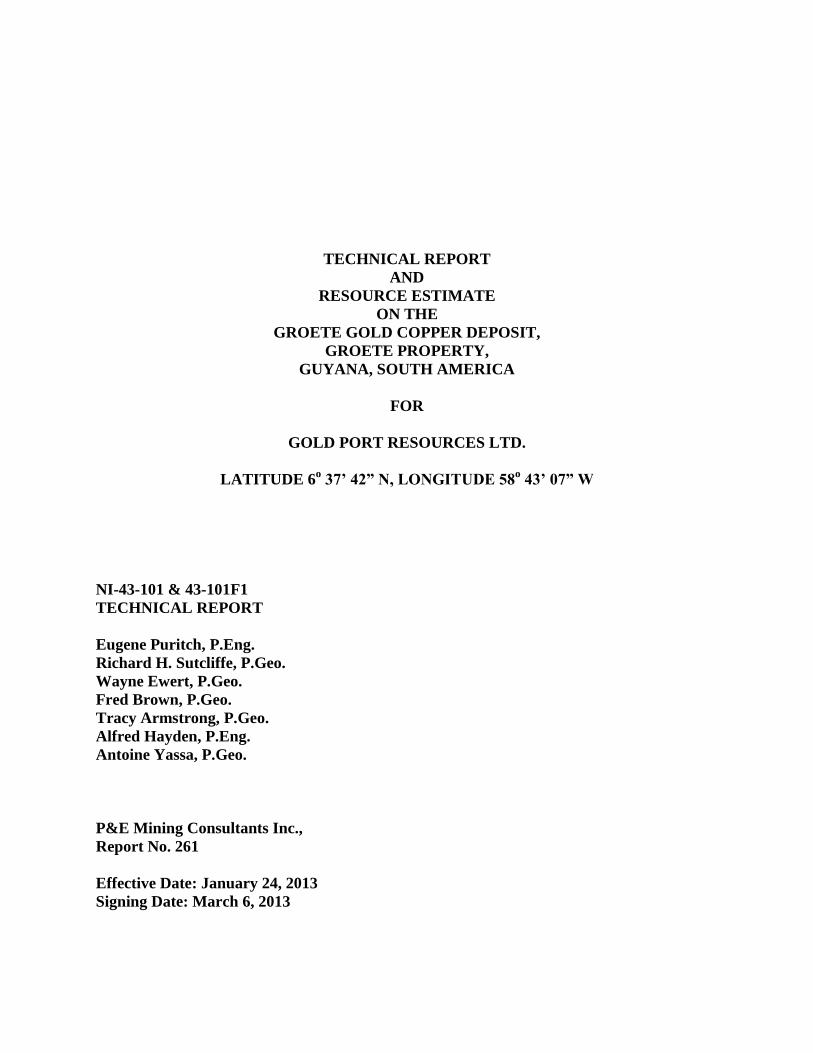
TECHNICAL REPORT
AND
RESOURCE ESTIMATE
ON THE
GROETE GOLD COPPER DEPOSIT,
GROETE PROPERTY,
GUYANA, SOUTH AMERICA
FOR
GOLD PORT RESOURCES LTD.
LATITUDE 6o 37’ 42” N, LONGITUDE 58
o 43’ 07” W
NI-43-101 & 43-101F1
TECHNICAL REPORT
Eugene Puritch, P.Eng.
Richard H. Sutcliffe, P.Geo.
Wayne Ewert, P.Geo.
Fred Brown, P.Geo.
Tracy Armstrong, P.Geo.
Alfred Hayden, P.Eng.
Antoine Yassa, P.Geo.
P&E Mining Consultants Inc.,
Report No. 261
Effective Date: January 24, 2013
Signing Date: March 6, 2013
TABLE OF CONTENTS
1.0 SUMMARY .........................................................................................................................1
1.1 MINERAL RESOURCE ESTIMATE .....................................................................1 1.2 CONCLUSIONS AND RECOMMENDATIONS ..................................................2
2.0 INTRODUCTION AND TERMS OF REFERENCE .........................................................3 2.1 TERMS OF REFERENCE ......................................................................................3 2.2 SOURCES OF INFORMATION ............................................................................3
2.3 UNITS AND CURRENCY .....................................................................................3 3.0 RELIANCE ON OTHER EXPERTS ..................................................................................5 4.0 PROPERTY DESCRIPTION AND LOCATION ...............................................................6
4.1 PROPERTY LOCATION ........................................................................................6 4.2 PROPERTY DESCRIPTION AND TENURE ........................................................7
5.0 ACCESSIBILITY, CLIMATE, LOCAL RESOURCES, INFRASTRUCTURE AND
PHYSIOGRAPHY ...............................................................................................................9
5.1 ACCESS ..................................................................................................................9 5.2 CLIMATE ..............................................................................................................10 5.3 LOCAL RESOURCES ..........................................................................................10 5.4 INFRASTRUCTURE ............................................................................................10
5.5 PHYSIOGRAPHY .................................................................................................10 6.0 HISTORY ..........................................................................................................................11
6.1 HISTORICAL RESOURCE ESTIMATES ...........................................................13 7.0 GEOLOGICAL SETTING AND MINERALIZATION ...................................................15
7.1 REGIONAL GEOLOGY .......................................................................................15
7.2 LOCAL GEOLOGY ..............................................................................................16 7.3 DEPOSIT GEOLOGY ...........................................................................................17
7.4 MINERALIZATION .............................................................................................18
8.0 DEPOSIT TYPES ..............................................................................................................20
9.0 EXPLORATION................................................................................................................21 9.1 2008 - EXPLORATION PROGRAM ...................................................................21
9.2 2009 - EXPLORATION PROGRAM ...................................................................21 9.3 2010 - EXPLORATION PROGRAM ...................................................................21 9.4 2011–2012 - EXPLORATION PROGRAM .........................................................23
9.5 CURRENT ARTISANAL MINING AND PROSPECTING ACTIVITY ............24 10.0 DRILLING .........................................................................................................................25
10.1 RECONCILIATION OF HISTORICAL DRILL HOLE LOCATION DATA .....25 10.2 TWIN HOLE DRILLING PROGRAM .................................................................26
10.3 GOLD ASSAY VALUES .....................................................................................28 10.4 COPPER ASSAY VALUES..................................................................................29 10.5 INFILL DRILLING PROGRAM ..........................................................................30
10.6 2012 - GEOPROBE DEEP SOIL DRILLING PROGRAM..................................31 11.0 SAMPLE PREPARATION, ANALYSES AND SECURITY ..........................................33
11.1 SAMPLE PREPARATION AND SECURITY .....................................................33 11.2 LAB PROTOCOL FOR SAMPLE ANALYSIS ...................................................33
12.0 DATA VERIFICATION ...................................................................................................34 12.1 SITE VISIT AND INDEPENDENT SAMPLING ................................................34 12.2 QUALITY ASSURANCE/QUALITY CONTROL PROGRAM .........................35
12.2.1 Performance of Certified Reference Materials ..........................................36 12.2.2 Performance of Blank Material ..................................................................36 12.2.3 Performance of Field Duplicates ...............................................................36
13.0 METALLURGICAL PROCESSING AND METALLURGICAL TESTING ..................37
14.0 MINERAL RESOURCE ESTIMATES ............................................................................38
14.1 INTRODUCTION .................................................................................................38
14.2 PREVIOUS RESOURCE ESTIMATE .................................................................38 14.3 DATA SUPPLIED .................................................................................................38 14.4 DATABASE VALIDATION ................................................................................40 14.5 SPECIFIC GRAVITY ...........................................................................................40 14.6 DOMAIN MODELING .........................................................................................40
14.7 COMPOSITING ....................................................................................................41 14.8 COMPOSITE SUMMARY STATISTICS ............................................................41 14.9 TREATMENT OF EXTREME VALUES.............................................................42 14.10 CONTINUITY ANALYSIS ..................................................................................42 14.11 BLOCK MODEL ...................................................................................................42
14.12 ESTIMATION & CLASSIFICATION .................................................................43 14.13 MINERAL RESOURCE ESTIMATE ...................................................................43
14.14 MINERAL RESOURCE SENSITIVITY ..............................................................45 14.15 VALIDATION .......................................................................................................45
15.0 MINERAL RESERVE ESTIMATES................................................................................49 16.0 MINING METHODS ........................................................................................................50
17.0 RECOVERY METHODS ..................................................................................................51 18.0 PROJECT INFRASTRUCTURE ......................................................................................52
19.0 MARKET STUDIES AND CONTRACTS .......................................................................53 20.0 ENVIRONMENTAL STUDIES, PERMITTING AND SOCIAL OR COMMUNITY
IMPACT ............................................................................................................................54
21.0 CAPITAL AND OPERATING COSTS ............................................................................55 22.0 ECONOMIC ANALYSIS .................................................................................................56
23.0 ADJACENT PROPERTIES ..............................................................................................57
24.0 OTHER RELEVANT DATA AND INFORMATION .....................................................58
25.0 INTERPRETATION AND CONCLUSIONS ...................................................................59 26.0 RECOMMENDATIONS ...................................................................................................60
26.1 RECOMMENDATIONS AND PROPOSED BUDGET.......................................60 27.0 REFERENCES ..................................................................................................................61 28.0 CERTIFICATES ................................................................................................................62
LIST OF TABLES
Table 1.1 Summary of the Groete Deposit In-Pit Mineral Resources ..................................... 1
Table 1.2 Recommended Program and Budget ....................................................................... 2 Table 4.1 Mining Permit Boundaries ...................................................................................... 8 Table 6.1 Historical Exploration on the Groete Gold Copper Project .................................. 11 Table 7.1 Generalized Stratigraphy of the Groete Creek Area, Guyana ............................... 16 Table 9.1 Groete Project 2010 Grab Sample Results >0.10 g/t Au....................................... 22
Table 10.1 Comparison of Assay results for TW12-03 and 94-03 ......................................... 29 Table 13.1 Composite Head Analyses .................................................................................... 37 Table 14.1 Database Summary ................................................................................................ 38 Table 14.2 Domain Summary Statistics for Au ...................................................................... 42 Table 14.3 Domain Summary Statistics for Cu ....................................................................... 42
Table 14.4 Block Model Setup ................................................................................................ 43 Table 14.5 Summary of the Groete Deposit In-Pit Mineral Resources ................................... 44
Table 14.6 Global In-Situ Sensitivity of the Mineral Resources Estimate ............................. 45 Table 14.7 Domain Validation Statistics ................................................................................. 48 Table 14.8 Volume Comparison ............................................................................................. 48 Table 26.1 Recommended Program and Budget ..................................................................... 60
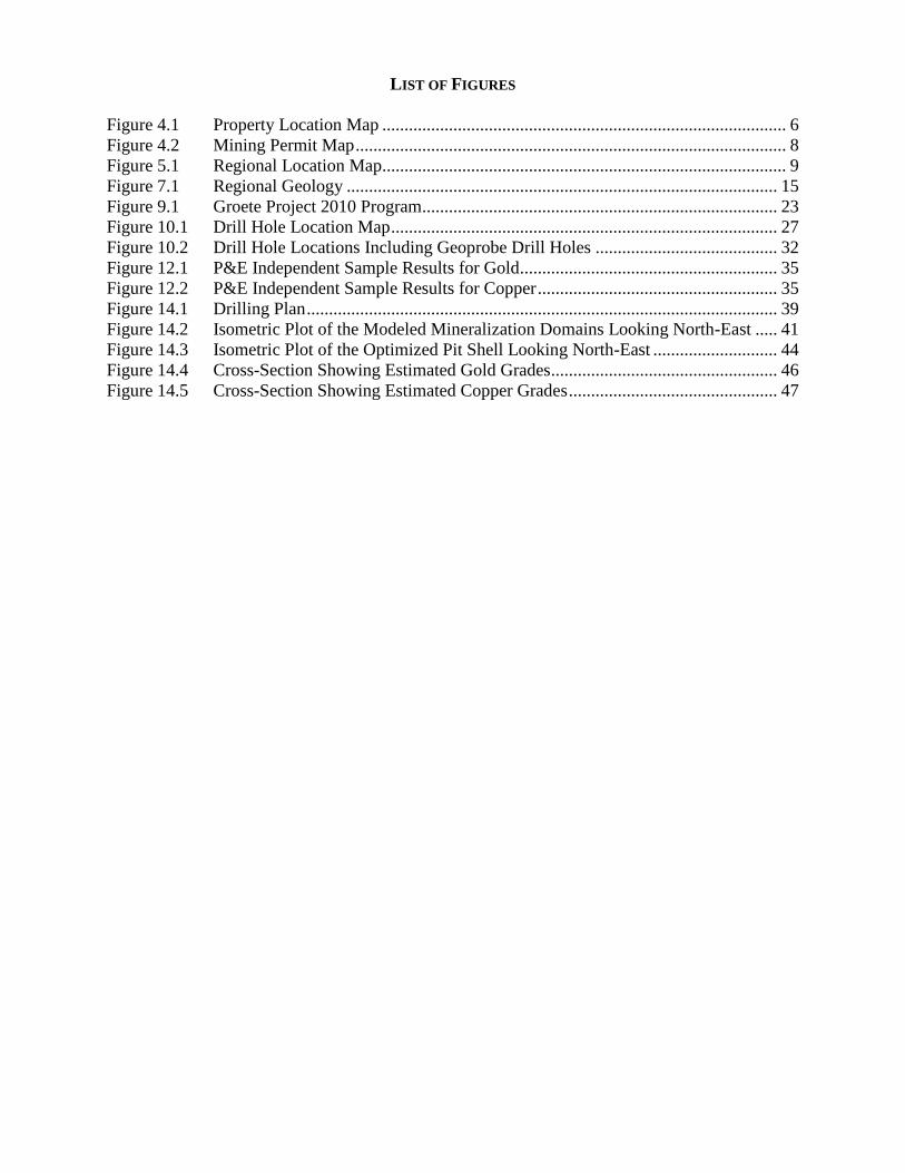
LIST OF FIGURES
Figure 4.1 Property Location Map ........................................................................................... 6
Figure 4.2 Mining Permit Map ................................................................................................. 8 Figure 5.1 Regional Location Map........................................................................................... 9 Figure 7.1 Regional Geology ................................................................................................. 15 Figure 9.1 Groete Project 2010 Program ................................................................................ 23 Figure 10.1 Drill Hole Location Map ....................................................................................... 27
Figure 10.2 Drill Hole Locations Including Geoprobe Drill Holes ......................................... 32 Figure 12.1 P&E Independent Sample Results for Gold.......................................................... 35 Figure 12.2 P&E Independent Sample Results for Copper ...................................................... 35 Figure 14.1 Drilling Plan .......................................................................................................... 39 Figure 14.2 Isometric Plot of the Modeled Mineralization Domains Looking North-East ..... 41
Figure 14.3 Isometric Plot of the Optimized Pit Shell Looking North-East ............................ 44 Figure 14.4 Cross-Section Showing Estimated Gold Grades................................................... 46
Figure 14.5 Cross-Section Showing Estimated Copper Grades ............................................... 47
P&E Mining Consultants Inc. Page 1 of 68
Gold Port Resources Ltd. Groete Property, Report No. 261
1.0 SUMMARY
Gold Port Resources Ltd. (“Gold Port” or the “Company”) retained P&E Mining Consultants
Inc. (“P&E”) to complete an independent National Instrument 43-101 (“NI 43-101”) compliant
Technical Report and Resource Estimate for the Groete Gold Copper Deposit (“Groete
Deposit”), on the Groete Creek Property (“Groete Property” or “Property”), located in the
Cuyuni Mining District 4, Co-operative Republic of Guyana, in South America. The Resource
Estimate considers gold and copper mineralization at the Groete Deposit that is potentially
amenable to surface mining.
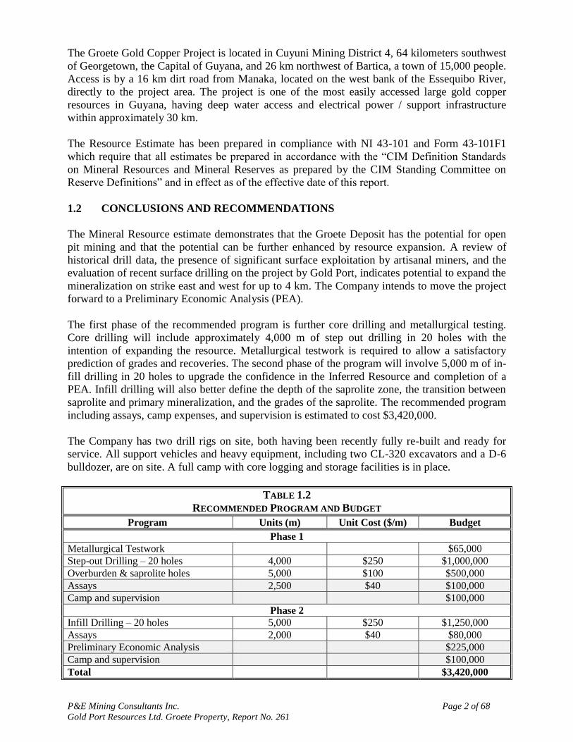
1.1 MINERAL RESOURCE ESTIMATE
The Groete Deposit contains an in-Pit Inferred Resource of 1.59 M gold equivalent (AuEq)
ounces at 0.66 g/t AuEq including 0.49 g/t Au and 0.12% Cu contained in 74.8 M tonnes. A
global sensitivity to the in-pit resource estimate (inside plus outside of pit) was calculated to be
2.0M AuEq ounces at 0.64 g/t AuEq including 0.47 g/t Au and 0.11% Cu contained in 97.4 M
tonnes.
The NI 43-101 Mineral Resource Estimate in the Inferred Resource category for an open pit cut-
off grade of 0.22 g/t AuEq is summarized in Table 1.1. Resource parameters including bulk
density, metal values, recoveries and pit optimization costs are detailed in Section 14 of the
report. A gold price of US$1,600 was used for the Resource Estimate.
TABLE 1.1
SUMMARY OF THE GROETE DEPOSIT IN-PIT MINERAL RESOURCES(1-4)
Class Domain M Tonnes Au g/t Cu % AuEq g/t AuEq
Mozs
Inferred
Saprolite 5.6 0.48 0.09 0.61 0.11
Fresh 69.2 0.49 0.12 0.67 1.48
Total 74.8 0.49 0.12 0.66 1.59
(1) Mineral resources are reported inside an optimized pit shell and tabulated against a cut-off of 0.22 g/t AuEq.
(2) Mineral resources which are not mineral reserves do not have demonstrated economic viability. The estimate
of mineral resources may be materially affected by environmental, permitting, legal, title, taxation, socio-
political, marketing, or other relevant issues.
(3) The quantity and grade of reported Inferred resources in this estimation are uncertain in nature and there
has been insufficient exploration to define these Inferred resources as an Indicated or Measured mineral
resource and it is uncertain if further exploration will result in upgrading them to an Indicated or Measured
mineral resource category.
(4) The mineral resources have been estimated using the Canadian Institute of Mining, Metallurgy and
Petroleum (CIM), CIM Standards on Mineral Resources and Reserves, Definitions and Guidelines prepared
by the CIM Standing Committee on Reserve Definitions and adopted by CIM Council.
The Groete Deposit initial mineral resource estimate was prepared in accordance with NI 43-101
standards by P&E with a database incorporating eight surface diamond drill holes (1,426 meters)
drilled by Gold Port during 2012, and eighteen diamond drill holes (3,477 meters ) completed by
a previous owner between 1994 and 1996. The mineral resource estimate was prepared with the
objective of confirming the historical drill results, and identifying a gold resource which would
be amenable to open-pit mining methods. Four of the holes drilled by Gold Port utilized in this
estimate were twin holes of historic collars 94-3, 94-5, 96-13 and 96-15, all of which were
survey confirmed in their original location on the property.
P&E Mining Consultants Inc. Page 2 of 68
Gold Port Resources Ltd. Groete Property, Report No. 261
The Groete Gold Copper Project is located in Cuyuni Mining District 4, 64 kilometers southwest
of Georgetown, the Capital of Guyana, and 26 km northwest of Bartica, a town of 15,000 people.
Access is by a 16 km dirt road from Manaka, located on the west bank of the Essequibo River,
directly to the project area. The project is one of the most easily accessed large gold copper
resources in Guyana, having deep water access and electrical power / support infrastructure
within approximately 30 km.
The Resource Estimate has been prepared in compliance with NI 43-101 and Form 43-101F1
which require that all estimates be prepared in accordance with the “CIM Definition Standards
on Mineral Resources and Mineral Reserves as prepared by the CIM Standing Committee on
Reserve Definitions” and in effect as of the effective date of this report.
1.2 CONCLUSIONS AND RECOMMENDATIONS
The Mineral Resource estimate demonstrates that the Groete Deposit has the potential for open
pit mining and that the potential can be further enhanced by resource expansion. A review of
historical drill data, the presence of significant surface exploitation by artisanal miners, and the
evaluation of recent surface drilling on the project by Gold Port, indicates potential to expand the
mineralization on strike east and west for up to 4 km. The Company intends to move the project
forward to a Preliminary Economic Analysis (PEA).
The first phase of the recommended program is further core drilling and metallurgical testing.
Core drilling will include approximately 4,000 m of step out drilling in 20 holes with the
intention of expanding the resource. Metallurgical testwork is required to allow a satisfactory
prediction of grades and recoveries. The second phase of the program will involve 5,000 m of in-
fill drilling in 20 holes to upgrade the confidence in the Inferred Resource and completion of a
PEA. Infill drilling will also better define the depth of the saprolite zone, the transition between
saprolite and primary mineralization, and the grades of the saprolite. The recommended program
including assays, camp expenses, and supervision is estimated to cost $3,420,000.
The Company has two drill rigs on site, both having been recently fully re-built and ready for
service. All support vehicles and heavy equipment, including two CL-320 excavators and a D-6
bulldozer, are on site. A full camp with core logging and storage facilities is in place.
TABLE 1.2
RECOMMENDED PROGRAM AND BUDGET
Program Units (m) Unit Cost ($/m) Budget
Phase 1
Metallurgical Testwork $65,000
Step-out Drilling – 20 holes 4,000 $250 $1,000,000
Overburden & saprolite holes 5,000 $100 $500,000
Assays 2,500 $40 $100,000
Camp and supervision $100,000
Phase 2
Infill Drilling – 20 holes 5,000 $250 $1,250,000
Assays 2,000 $40 $80,000
Preliminary Economic Analysis $225,000
Camp and supervision $100,000
Total $3,420,000
P&E Mining Consultants Inc. Page 3 of 68
Gold Port Resources Ltd. Groete Property, Report No. 261
2.0 INTRODUCTION AND TERMS OF REFERENCE
2.1 TERMS OF REFERENCE
Gold Port retained P&E to complete an independent NI 43-101 compliant Technical Report and
Resource Estimate for the Groete Gold Copper Deposit, on the Groete Creek Property, located in
the Cuyuni Mining District 4, Guyana. The Resource Estimate considers gold and copper
mineralization at the Groete Deposit that is potentially amenable to surface mining.
The current P&E Resource Estimate presented in this report has been prepared in full
conformance and compliance with the “CIM Standards on Mineral Resources and Reserves –
Definitions and Guidelines” as referred to in NI 43-101 and Form 43-101F, Standards of
Disclosure for Mineral Projects and in force as of the effective date of this report.
This report was prepared by P&E, at the request of Mr. Adrian F.C. Hobkirk, President and
Chief Executive Officer of Gold Port Resources Ltd., a British Columbia registered company,
trading under the symbol of “GPO” on the TSX-V Exchange with its corporate office at:
837 Hastings Street West, Suite 408,
Vancouver, BC,
Canada, V6C 3N6
This report is considered current as of the effective date, January 24, 2013.
Mr. Antoine Yassa, P.Geo., a qualified person under the terms of NI 43-101, conducted a site
visit of the Property on November 12 to 16, 2012. A due diligence validation sampling program
was conducted as part of the on-site review.
2.2 SOURCES OF INFORMATION
This Report is based, in part, on internal company technical reports, and maps, published
government reports, company letters, memoranda, public disclosure and public information as
listed in the References at the conclusion of this Report. Sections from reports authored by other
consultants have been directly quoted or summarized in this Report, and are so indicated where
appropriate.
Parts of this report refer to the NI 43-101 Technical Reports for the Property by Sharpe (2011),
Sharpe (2010), and Pelke (2009) that were previously filed on SEDAR by Gold Port.
The present Technical Report is prepared in accordance with the requirements of NI 43-101 and
in compliance with Form NI 43-101F1 of the Ontario Securities Commission (OSC) and the
Canadian Securities Administrators (CSA). The Resource Estimate is prepared in compliance
with the CIM Definitions and Standards on Mineral Resources and Mineral Reserves that are in
force as of the effective date of this report.
2.3 UNITS AND CURRENCY
Unless otherwise stated all units used in this report are metric. Gold assay values (Au) are
reported in grams per tonne (“g/t”) of metal unless ounces per ton (“oz/T”) are specifically
stated. Copper (Cu) assay values are reported in percentage (%). The US$ is used throughout this
P&E Mining Consultants Inc. Page 4 of 68
Gold Port Resources Ltd. Groete Property, Report No. 261
report unless the CDN$ is specifically stated. At the time of this report the rate of exchange
between the US$ and the CDN$ is 1 US$ = 1.00 CDN$.
The coordinate system used by Gold Port for locating and reporting drill hole information is the
UTM system. The property is in UTM Zone 21N and the WGS84/NAD83 datum is used. Maps
in this Report use either the UTM coordinate system or latitude and longitude.
The following list shows the meaning of the abbreviations for technical terms used throughout
the text of this report.
Abbreviation Meaning
“Au” gold
“AuEq” gold equivalent
“CIM” Canadian Institute of Mining, Metallurgy and Petroleum
“cm” centimetre(s)
“Cu” copper
“DDH” diamond drill hole
“EM” electromagnetic
“ft” foot
“Ga” billions of years
“g/t” grams per tonne
“ha” hectare(s)
“km” kilometre(s)
“M” million
“m” metre(s)
“Ma” millions of years
“NI” National Instrument
“NSR” Net Smelter Royalty
“oz” troy ounce
“P&E” P&E Mining Consultants Inc.
“PEA” preliminary economic analysis
“ppm” parts per million
“t” metric tonne(s)
“T” Imperial ton
“UTM” Universal Transverse Mercator
P&E Mining Consultants Inc. Page 5 of 68
Gold Port Resources Ltd. Groete Property, Report No. 261
3.0 RELIANCE ON OTHER EXPERTS
P&E has assumed that all of the information and technical documents listed in the References
section of this report are accurate and complete in all material aspects. While we have carefully
reviewed all of the available information presented to us, we cannot guarantee its accuracy and
completeness. We reserve the right, but will not be obligated to revise our report and conclusions
if additional information becomes known to us subsequent to the date of this report.
Although selected copies of the tenure documents, operating licenses, permits, and work
contracts were reviewed, an independent verification of land title and tenure was not performed.
P&E has not verified the legality of any underlying agreement(s) that may exist concerning the
licenses or other agreement(s) between third parties. Information on tenure and permits was
obtained from Gold Port. Gold Port has provided a legal opinion from Cameron & Shepherd,
Attorneys-at-Law, Georgetown, Guyana dated March 6, 2013, confirming that Mining Permits
V3/MP/000, V3/MP/001, and V3/MP/002 are in good standing, that the Acquisition Agreement
dated September 19, 2005 is valid and binding, and that Gold Port has full authority to operate,
maintain and manage the Properties.
A draft copy of the report has been reviewed for factual errors by Gold Port. Any changes made
as a result of these reviews did not involve any alteration to the conclusions made. Hence, the
statement and opinions expressed in this document are given in good faith and in the belief that
such statements and opinions are not false and misleading at the date of this report.
P&E Mining Consultants Inc. Page 6 of 68
Gold Port Resources Ltd. Groete Property, Report No. 261
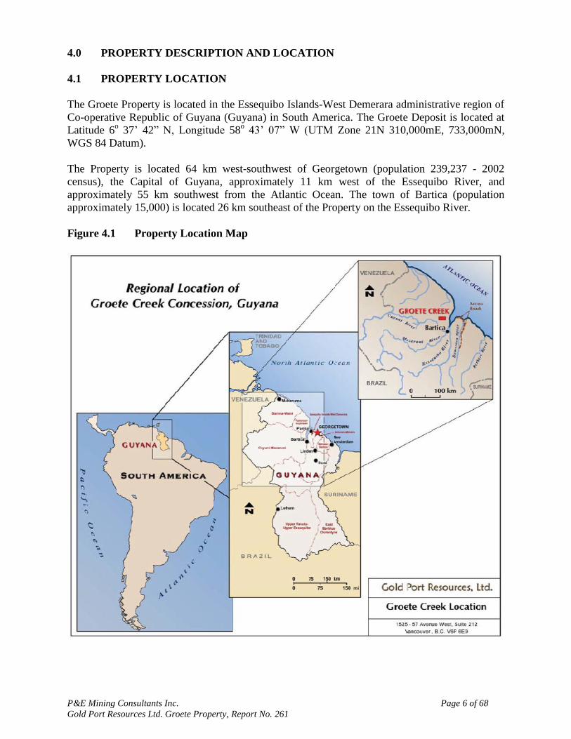
4.0 PROPERTY DESCRIPTION AND LOCATION
4.1 PROPERTY LOCATION
The Groete Property is located in the Essequibo Islands-West Demerara administrative region of
Co-operative Republic of Guyana (Guyana) in South America. The Groete Deposit is located at
Latitude 6o 37‟ 42” N, Longitude 58
o 43‟ 07” W (UTM Zone 21N 310,000mE, 733,000mN,
WGS 84 Datum).
The Property is located 64 km west-southwest of Georgetown (population 239,237 - 2002
census), the Capital of Guyana, approximately 11 km west of the Essequibo River, and
approximately 55 km southwest from the Atlantic Ocean. The town of Bartica (population
approximately 15,000) is located 26 km southeast of the Property on the Essequibo River.
Figure 4.1 Property Location Map

P&E Mining Consultants Inc. Page 7 of 68
Gold Port Resources Ltd. Groete Property, Report No. 261
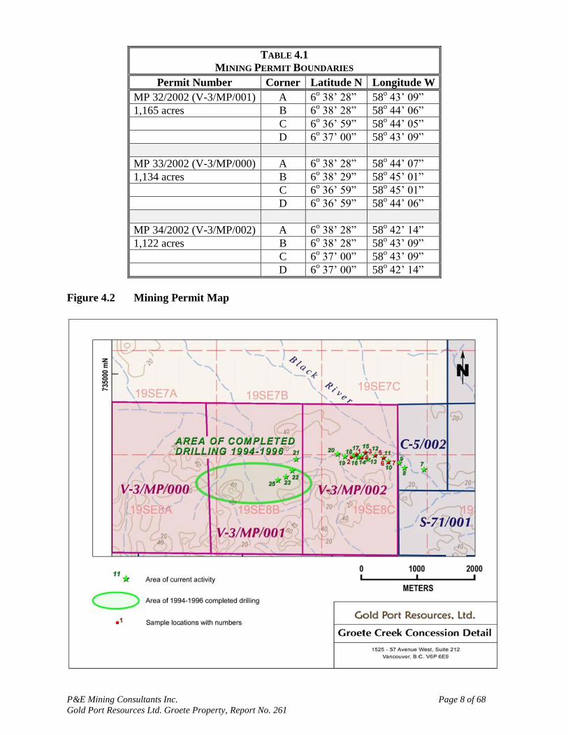
4.2 PROPERTY DESCRIPTION AND TENURE
The Groete Property consists of three Mining Permits (Permit Numbers V-3/MP/000, V-
3/MP/001, and V-3/MP/002), totalling 3,421 acres (1,384 ha) (Table 4.1 and Figure 4.2). The
Mining Permits are issued by the Guyana Geology and Mining Commission for the “purpose of
mining gold, precious stones and all other valuable minerals” to Mr. Michael Vieira of
Georgetown, Guyana. The Permits were originally issued on July 18, 2002, and may be renewed
in 5 year increments.
Gold Port acquired the Groete Creek Property through an acquisition agreement with Mr.
Michael Vieira dated September 19, 2005. The property was acquired for total payments of
US$500,000 over a three year period. Gold Port now holds a 100% interest in the Groete Creek
Property subject to a 1.5% NSR in favour of Michael Vieira, which may be purchased for
US$3,000,000.
The three concessions are subject to annual rental payments of US$3,421 to the Guyana Geology
and Mines Commission. Gold Port has provided receipts from the Guyana Geology and Mining
Commission showing payment of G$673,937 (Guyanese dollars) (equivalent to US$3,421 at the
exchange rate of US$1.00 = G$197) on January 17, 2013 for rental of the three concessions.
Gold Port must negotiate with the Government of Guyana and the Guyana Geology and Mines
Commission in regards to royalties payable to the state. Currently Guyana Government
documents indicate that foreign companies are required to pay 5% of the net gold price plus an
additional windfall royalty payment of 3% when gold is over US$1,000/oz.
Other conditions of the Permits include: posting an environmental bond of G$200,000; carrying
out operations in a manner that is satisfactory to the Commissioner and complies with the
Mining Act 1989; meeting environmental and regulatory compliance; and a requirement to post
the Permit boundaries.
Selected copies of the tenure documents and the acquisition agreement were reviewed, however,
an independent verification of land title and tenure was not performed by P&E. P&E has not
verified the legality of any underlying agreement(s) that may exist concerning the licenses or
other agreement(s) between third parties. Information on tenure and permits was obtained from
Gold Port. Gold Port has provided a legal opinion from Cameron & Shepherd, Attorneys-at-
Law, Georgetown, Guyana dated March 6, 2013, confirming that Mining Permits V3/MP/000,
V3/MP/001, and V3/MP/002 are in good standing, that the Acquisition Agreement dated
September 19, 2005 is valid and binding, and that Gold Port has full authority to operate,
maintain and manage the Properties.
P&E Mining Consultants Inc. Page 8 of 68
Gold Port Resources Ltd. Groete Property, Report No. 261
TABLE 4.1
MINING PERMIT BOUNDARIES
Permit Number Corner Latitude N Longitude W
MP 32/2002 (V-3/MP/001) A 6o 38‟ 28” 58
o 43‟ 09”
1,165 acres B 6o 38‟ 28” 58
o 44‟ 06”
C 6o 36‟ 59” 58
o 44‟ 05”
D 6o 37‟ 00” 58
o 43‟ 09”
MP 33/2002 (V-3/MP/000) A 6o 38‟ 28” 58
o 44‟ 07”
1,134 acres B 6o 38‟ 29” 58
o 45‟ 01”
C 6o 36‟ 59” 58
o 45‟ 01”
D 6o 36‟ 59” 58
o 44‟ 06”
MP 34/2002 (V-3/MP/002) A 6o 38‟ 28” 58
o 42‟ 14”
1,122 acres B 6o 38‟ 28” 58
o 43‟ 09”
C 6o 37‟ 00” 58
o 43‟ 09”
D 6o 37‟ 00” 58
o 42‟ 14”
Figure 4.2 Mining Permit Map
P&E Mining Consultants Inc. Page 9 of 68
Gold Port Resources Ltd. Groete Property, Report No. 261
5.0 ACCESSIBILITY, CLIMATE, LOCAL RESOURCES, INFRASTRUCTURE AND
PHYSIOGRAPHY
5.1 ACCESS
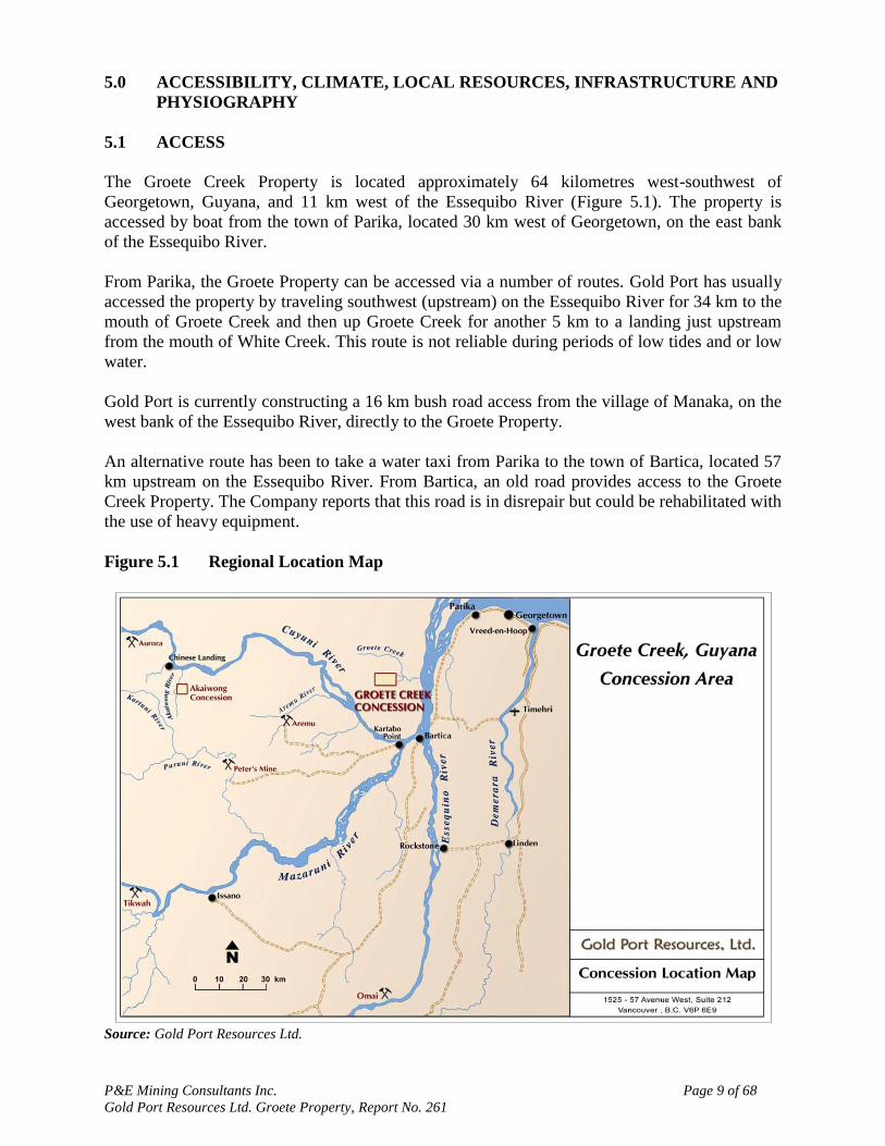
The Groete Creek Property is located approximately 64 kilometres west-southwest of
Georgetown, Guyana, and 11 km west of the Essequibo River (Figure 5.1). The property is
accessed by boat from the town of Parika, located 30 km west of Georgetown, on the east bank
of the Essequibo River.
From Parika, the Groete Property can be accessed via a number of routes. Gold Port has usually
accessed the property by traveling southwest (upstream) on the Essequibo River for 34 km to the
mouth of Groete Creek and then up Groete Creek for another 5 km to a landing just upstream
from the mouth of White Creek. This route is not reliable during periods of low tides and or low
water.
Gold Port is currently constructing a 16 km bush road access from the village of Manaka, on the
west bank of the Essequibo River, directly to the Groete Property.
An alternative route has been to take a water taxi from Parika to the town of Bartica, located 57
km upstream on the Essequibo River. From Bartica, an old road provides access to the Groete
Creek Property. The Company reports that this road is in disrepair but could be rehabilitated with
the use of heavy equipment.
Figure 5.1 Regional Location Map
Source: Gold Port Resources Ltd.
P&E Mining Consultants Inc. Page 10 of 68
Gold Port Resources Ltd. Groete Property, Report No. 261
5.2 CLIMATE
The climate is humid and tropical. Georgetown has an average annual temperature of 27.0oC.
Average monthly lows of 24oC occur in December to March and June to August. Average
monthly highs of 31oC occur in September and October. Average annual rainfall is 2,418 mm
with heaviest rain falling in May to July and October to December
(www.guyana.climatemps.com). During the May to July wet season, more than half of the
annual rainfall takes place, making daily work difficult due to high water levels and flooding.
5.3 LOCAL RESOURCES
Labourers with a variety of experience in heavy equipment operation are available in
Georgetown and from villages situated along the rivers. Water for drilling is readily available
throughout the year.
The nearest supply center to the Property is the town of Bartica, with a population of 15,000,
located 26 km southeast of the property,. All major items must be obtained from Georgetown.
There is no habitation within the concessions. The nearest houses are located at the mouth of
Groete Creek.
5.4 INFRASTRUCTURE
The project is one of the most easily accessed gold copper resources in Guyana, having both
deep water and electrical power / support infrastructure within approximately 25 km. The nearest
electrical power is at Bartica, 26 km to the southeast.
Local Guyanese small scale miners, known as “Porknockers”, were previously operating on the
permits under a sub-lease from Mr. Michael Vieira.
5.5 PHYSIOGRAPHY
The area of the Groete Property is covered by dense rain forest and drained by the Groete Creek,
a tributary of the Essequibo River. The topography is flat to gently undulating with elevations
ranging from under 20 m to 60 m above sea level.
P&E Mining Consultants Inc. Page 11 of 68
Gold Port Resources Ltd. Groete Property, Report No. 261
6.0 HISTORY
Much of the historical summary in this section draws upon material presented in Paul A Pelke's
August 2009 NI-43-101 Report titled “NI 43-101 Technical Report on the Groete Creek
Property, Guyana”
TABLE 6.1
HISTORICAL EXPLORATION ON THE GROETE GOLD COPPER PROJECT
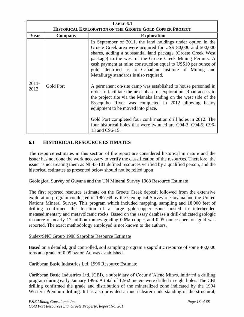
Year Company Exploration
1895
The first known discovery of gold in the general Groete Creek
area was in 1895, when gold was recovered from panning along
Groete River
1964 Geological Survey
of Guyana
The first systematic exploration of the general Groete region
was undertaken in 1964 when the Geological Survey of Guyana
completed an area-wide geochemical and geophysical survey. A
broad copper in soil anomaly and coincident E-M anomaly was
identified in the Groete area
1966 Torbrid Silver Mines
Ltd.
During 1966, Torbrid Silver Mines Ltd., in association with the
Geological Survey, investigated the geochemical anomaly by
drilling six core-drill holes. Results were ambiguous and the
program was terminated.
1967-
1968
Geological Survey
of Guyana / United
Nations Mineral
Survey Project
Starting in 1967 a joint exploration program between the
Geological Survey of Guyana and the United Nations Mineral
Survey Project was conducted for the purpose of further testing
of the low-grade copper mineralization indicated by the Torbrid
Silver Mines drilling program. Forty-two core-drill holes,
totalling over 5,500 meters, were completed along with further
surface soil geochemical sampling. This work confirmed the
existence of a broad, low-grade, gold-copper zone hosted in
interbedded metasedimentary and metavolcanic rocks
1988 Sudex/SNC Group
After remaining idle since the late 1960‟s the Sudex/SNC group,
in 1998, evaluated the Groete creek claims for their potential to
host saprolite related gold mineralization. A geologic resource
of 460,000 tons averaging approximately 0.05 oz/t Au was
identified. No further work was done on the property until 1994.
1994
CAMDICO /
Western Premium
Resources
Corporation
In 1994, CAMDICO and Western Premium Resources
Corporation undertook an extensive geochemical and
geophysical survey followed by drilling 9 core-drill holes (94-1
through 94-9) totalling nearly 1,915 meters. The presence of low
grade gold-copper mineralization at least 1200 meters along
strike and several hundred meters down dip was confirmed. The
mineralized zone remained open both down dip and along strike
and although drilling density did not warrant calculation of a
resource, it did indicate mineralization is continuous enough and
of sufficient grade to warrant further evaluation.
.
P&E Mining Consultants Inc. Page 12 of 68
Gold Port Resources Ltd. Groete Property, Report No. 261
TABLE 6.1
HISTORICAL EXPLORATION ON THE GROETE GOLD COPPER PROJECT
Year Company Exploration
1996 -
1997
Caribbean Basic
Industries
In January 1996, Caribbean Basic Industries (CBI), a wholly
owned subsidiary of Coeur d‟Alene Mines Corporation, initiated
a review of all of the available geologic data. While it was not
possible to verify and thus integrate all of the historical data into
a single database CBI was able to use the relevant Western
Premium data. However, the data from 1966 through 1968
(Geological Survey of Guyana and Torbrid Silver mines) were
never incorporated into the data base.
In the 1996 drill program CBI drilled a total of 562 meters. At
the conclusion of the field program, Coeur d‟Alene using a
simple polygonal method in drilling by cross section, identified
a gold-copper zone comprising approximately 94 million tonnes
grading 0.6 grams per tonne gold and 0.11% total copper
(Caution: The issuer has not done the work necessary to verify
the classification of the resource or reserve, the issuer is not
treating them as a NI 43-101 defined resource or reserve verified
by a qualified person, and the historical estimate should not be
relied upon.).
In 1997, Caribbean Basic Industries Ltd. completed a third
phase exploration program. The program included a wide area
surface sample program, preliminary metallurgical testing of
existing drill core, and a further 1,684 meters of core drilling in
eight holes (97-18 through 97-25). Six (97-18 to 97-23) of the
eight holes were completed within the 1200 metre long and
previously untested Central Zone and although assay results
were not reported it is known that holes encountered similar
geology to that of the central zone, with the exception of
significantly mineralized granitic dikes ( gold grades reported to
be greater than 1.5 g/t Au within the dikes ), which were not
encountered in the central zone. Holes 97-24 and 97-25 were
drilled outside the known mineralized zone and did not yield any
significant gold assay values.
The 1997 report concluded that the Groete Creek Shear Zone is
mineralized over a strike length of at least 4 kilometers east to
west.
2008 -
2010 Gold Port
During 2008 Gold Port completed the purchase of the Groete
Creek Project.
Surface artisanal type mining or “pork-knocker” activity from
alluvium, saprolite, and bedrock on the Groete property
increased with the recent and on-going rise in the gold price.
Gold Port staff and security personnel removed most of these
operations during 2009 and the first quarter of 2010.
P&E Mining Consultants Inc. Page 13 of 68
Gold Port Resources Ltd. Groete Property, Report No. 261
TABLE 6.1
HISTORICAL EXPLORATION ON THE GROETE GOLD COPPER PROJECT
Year Company Exploration
2011-
2012 Gold Port
In September of 2011, the land holdings under option in the
Groete Creek area were acquired for US$180,000 and 500,000
shares, adding a substantial land package (Groete Creek West
package) to the west of the Groete Creek Mining Permits. A
cash payment at mine construction equal to US$10 per ounce of
gold identified as to Canadian Institute of Mining and
Metallurgy standards is also required.
A permanent on-site camp was established to house personnel in
order to facilitate the next phase of exploration. Road access to
the project site via the Manaka landing on the west side of the
Essequibo River was completed in 2012 allowing heavy
equipment to be moved into place.
Gold Port completed four confirmation drill holes in 2012. The
four historical holes that were twinned are C94-3, C94-5, C96-
13 and C96-15.
6.1 HISTORICAL RESOURCE ESTIMATES
The resource estimates in this section of the report are considered historical in nature and the
issuer has not done the work necessary to verify the classification of the resources. Therefore, the
issuer is not treating them as NI 43-101 defined resources verified by a qualified person, and the
historical estimates as presented below should not be relied upon
Geological Survey of Guyana and the UN Mineral Survey 1968 Resource Estimate
The first reported resource estimate on the Groete Creek deposit followed from the extensive
exploration program conducted in 1967-68 by the Geological Survey of Guyana and the United
Nations Mineral Survey. This program which included mapping, sampling and 18,000 feet of
drilling confirmed the location of a large gold-copper zone hosted in interbedded
metasedimentary and metavolcanic rocks. Based on the assay database a drill-indicated geologic
resource of nearly 17 million tonnes grading 0.6% copper and 0.05 ounces per ton gold was
reported. The exact methodology employed is not known to the authors.
Sudex/SNC Group 1988 Saprolite Resource Estimate
Based on a detailed, grid controlled, soil sampling program a saprolitic resource of some 460,000
tons at a grade of 0.05 oz/ton Au was established.
Caribbean Basic Industries Ltd. 1996 Resource Estimate
Caribbean Basic Industries Ltd. (CBI), a subsidiary of Coeur d‟Alene Mines, initiated a drilling
program during early January 1996. A total of 1,562 meters were drilled in eight holes. The CBI
drilling confirmed the grade and distribution of the mineralized zone indicated by the 1994
Western Premium drilling. It has also provided a much clearer understanding of the structural,

P&E Mining Consultants Inc. Page 14 of 68
Gold Port Resources Ltd. Groete Property, Report No. 261
stratigraphic and mineralogical controls on the mineralization and the effect these parameters
have on its continuity and distribution of grade.
The resource estimate presented by CBI was calculated employing a simple cross-section -
polygonal method using only the drill hole data from the 1994 and 1996 drilling programs. The
resource estimate utilized a hypothetical-pit outline, assuming a maximum slope angle of 50°,
and cut-off grades of 0.10 g/t Au and 0.34 g /t Au.
CBI‟s polygonal-resource estimate calculated 93.653 M tonnes averaging 0.594 g/t Au and 0.1 1
% Cu at the 0.10 g/t Au cut-off. A similar estimate at a 0.34 g/t Au cut- off yielded a geologic
resource of 65.436 M tonnes averaging 0.761 g/t Au and 0.13% Cu. No economic parameters
were applied to these estimates, other than cut-off grade and a hypothetical-pit boundary. Copper
was not considered an economically significant contributor to the project.
Note that the term “drill indicated geologic resource” is a historical term used by CBI, not
comparable to the CIM defined inferred resource, and should be compared to a potential mineral
deposit requiring further definition.
P&E Mining Consultants Inc. Page 15 of 68
Gold Port Resources Ltd. Groete Property, Report No. 261
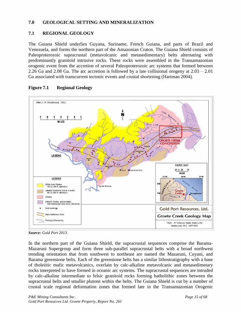
7.0 GEOLOGICAL SETTING AND MINERALIZATION
7.1 REGIONAL GEOLOGY
The Guiana Shield underlies Guyana, Suriname, French Guiana, and parts of Brazil and
Venezuela, and forms the northern part of the Amazonian Craton. The Guiana Shield consists of
Paleoproterozoic supracrustal (metavolcanic and metasedimentary) belts alternating with
predominantly granitoid intrusive rocks. These rocks were assembled in the Transamazonian
orogenic event from the accretion of several Paleoproterozoic arc systems that formed between
2.26 Ga and 2.08 Ga. The arc accretion is followed by a late collisional orogeny at 2.03 – 2.01
Ga associated with transcurrent tectonic events and crustal shortening (Hartman 2004).
Figure 7.1 Regional Geology
Source: Gold Port 2013.
In the northern part of the Guiana Shield, the supracrustal sequences comprise the Barama-
Mazaruni Supergroup and form three sub-parallel supracrustal belts with a broad northwest
trending orientation that from southwest to northeast are named the Mazaruni, Cuyani, and
Barama greenstone belts. Each of the greenstone belts has a similar lithostratigraphy with a base
of tholeiitic mafic metavolcanics, overlain by calc-alkaline metavolcanic and metasedimetary
rocks interpreted to have formed in oceanic arc systems. The supracrustal sequences are intruded
by calc-alkaline intermediate to felsic granitoid rocks forming batholithic zones between the
supracrustal belts and smaller plutons within the belts. The Guiana Shield is cut by a number of
crustal scale regional deformation zones that formed late in the Transamazonian Orogenic
P&E Mining Consultants Inc. Page 16 of 68
Gold Port Resources Ltd. Groete Property, Report No. 261
events. The northwest trending Makapa-Kuribrong and Issano Appapuru Shear Zones extend for
100‟s of kms and are considered to be a major control on gold mineralization (e.g. at the Omai
deposit, Voicu et al. 1999).
Geological mapping and exploration in the Guiana Shield is handicapped by thick tropical
vegetation and deep weathering profiles. Some significant gold deposits in the Guiana Shield
include: the past-producing Omai deposit (formerly Cambior Inc.); the Aurora deposit (Guyana
Goldfields Inc.); and Toroparu deposit (Sandspring Resources Ltd.) in Guyana; the currently
producing Gros Rosebel deposit (IAMGOLD Corporation) in Suriname; and the Las Christinas
and Las Brisas deposits of the kilometer 88 district of Venezuela.
7.2 LOCAL GEOLOGY
The local geological setting of the Groete Creek area was originally described by Bryn-Davis
(1936) and Hamilton (1968). The information presented here is primarily from the report of
Atwood (1997) for Caribbean Basic Industries Ltd. (“CBI)” and the reports of Pelke (2009) and
Sharpe (2010, 2011) for Gold Port.
Geological formations in the Groete Creek area are summarized in Table 7.1.
TABLE 7.1
GENERALIZED STRATIGRAPHY OF THE GROETE CREEK AREA, GUYANA
Age Formation and Rock types
Cenozoic
Recent Alluvial and residual deposits (sand, soil, saprolite)
Quaternary/Late
Tertiary Berbice Formation, white sands
Unconformity
Precambrian
Mesoproterozoic Roraima Intrusive Rocks, Gabbro, diabase
Intrusive Contact
Mesoproterozoic Roraima Formation (ca. 1.6 Ga), Quartz arenite, quartzite, interbeded
mudstones, pyroclastics
Unconformity
Paleoproterozoic Intrusive rocks (ca. 2.14-2.08 Ga)-
Barama-Mazaruni Supergroup (ca. 2.26-2.08 Ga), metavolcanic and
metasedimentary rocks
Source: Modified from Sharpe (2011)
The Groete Creek Property is underlain by the approximately 2 km wide, east-north east striking,
Barama Greenstone belt that is bounded to the north and south by granitoid plutons (Pelke 2009,
Sharpe 2011). In the vicinity of the Property the rocks dip at 45o to the northwest.
Pelke (2009) describes the supracrustal rocks at Groete Creek as consisting of a sequence of
complexly interbedded and intercalated felsic to mafic volcanic and volcaniclastic rocks with
interbedded pelitic sediments. Hamilton (1968) suggests that sedimentary rocks predominate
with volcanic rocks being primarily confined to the center of the belt between the granite
intrusions. Atwood (1997) and subsequent reports by Pelke (2009) and Sharpe (2010, 2011)
P&E Mining Consultants Inc. Page 17 of 68
Gold Port Resources Ltd. Groete Property, Report No. 261
indicate that much of what was previously interpreted as sediments are felsic pyroclastic deposits
or the partially reworked equivalents.
The northern intrusion is reported by Hamilton (1968) to be a medium-grained biotite-
hornblende granite with a melanocratic, granodiorite facies marking its contact with greenstone.
The granite is cut by numerous pegmatite and aplite dikes which extend across its contact into
the metamorphic rocks. It is marked by a prominent lineation which is parallel to regional
foliation at 060-070o. In contrast, the southern granite is a small body of leucocratic biotite
granite with distinctive white feldspar and poorly defined foliation (Hamilton, 1968; Gibbs,
1980). The contact of the granite with the greenstone is sharp. Lineation (foliation) is absent or
obscure.
Atwood‟s (1997) report for CBI identifies a sheeted dike zone that is coincident with the Groete
Creek Shear Zone and the higher grade mineralization. CBI geologists identified several types of
dikes of intermediate composition based on colour, texture and compositional characteristics.
Type A dikes are gray green and contain large clots of plagioclase and distinct hornblende
phenocrysts. Type B typically are pale green, aphanitic to very weakly porphyritic with euhedral
plagioclase phenocrysts. Type C dikes are least common and are dark green, medium grained,
porphyritic dacite with hornblende phenocrysts. In addition, CBI identified late diabase dikes
with chill margins that cross cut earlier units.
Hamilton (1968) reported that the regional stratigraphic sequence between the two regional
granitic intrusions is suggestive of a broad northeast-trending isoclinal fold that is overturned to
the southeast. Foliation strikes east-northeast parallel to this trend. All rocks are foliated except
for some, late, intrusive rocks. Two distinct shear zones, an east-trending shear zone, controlling
the gold mineralization (Groete Creek Shear Zone), and a near parallel, probably younger,
chloritic shear zone, are evident in drill core.
Sharpe (2011) reports that the Mesoproterozoic Roirama Formation that unconformably overlies
the Paleoproteroic rocks of the Barama-Mazaruni Supergroup is not known to occur within the
Groete Creek property. The youngest formations in the Groete Creek area are the regionally
widespread white sands of the Tertiary Berbice Formation and recent alluvial deposits.
7.3 DEPOSIT GEOLOGY
Gold Port drilling has defined the Groete Gold Copper Deposit over a 1 km strike length. The
deposit strikes at 070o
and dips 45o to the northwest. The Main mineralized zone is
approximately 150 m wide. The smaller South zone is approximately 15 m wide and occurs in
the footwall, south of the main zone.
Atwood (1997) reports that the higher grade mineralization is associated with a sheeted dike
zone and is coincident with the core of the Groete Creek Shear Zone. Atwood (1997) further
indicates that mineralization in the Groete Creek Shear Zone has been traced over a strike length
of 4 km and that the sheeted dike zone has been traced over 2.5 km by CBI drilling.
Drill logs from the 1994 drilling campaign (in Pelke‟s 2009 report) hole series indicate that
felsic-intermediate metavolcanic rocks structurally overlie the mafic-intermediate metavolcanic
rocks in the vicinity of the Groete Deposit and the felsic intermediate metavolcanics form the
hangingwall (northwest side) of the Main mineralized zone. The sheeted dike zone is 12 to 30
P&E Mining Consultants Inc. Page 18 of 68
Gold Port Resources Ltd. Groete Property, Report No. 261
meters in thickness and occurs in the core of the Main mineralized zone The sheeted dike zone
contains approximately 15 to 30% of predominately type B aphanitic intermediate dikes.
The upper 20 to 25 m of the Groete deposit has been weathered to become saprolite. Atwood
(1997) considers that the surface expression of the mineralized part of the Groete Creek shear
zone can be defined by gold colour counts and Cu values in excess of 100 ppm in the saprolite.
Pelke (2009) reports that where observed, all of the current mining activity is within alluvium.
The upper levels of alluvium are removed by an excavator in order to access the lower, higher
grade gravels. No operations in saprolite were seen, but it is possible that this type of deposit is
being exploited in this area.
7.4 MINERALIZATION
Pelke (2009) considers that Groete copper gold mineralization is associated with both sulphides
and quartz veining.
Pelke (2009) notes that the mineralized zone at Groete contains pyrite, pyrrhotite and
chalcopyrite. The relative sulphide abundances range from a trace up to +20% locally with
pyrrhotite and pyrite more abundant than chalcopyrite. Pyrite occurs ubiquitously throughout the
stratigraphic section in concentrations ranging from a trace to in excess of 10%. It is most
abundant near the base of the felsic/intermediate sequence. Although pyrrhotite is not as widely
distributed as pyrite, its total volume may exceed that of pyrite. Pyrrhotite occurs as fine
disseminations, millimeter wide lenses along foliation, veinlets and irregular patches up to 2 cm
diameter. Pyrrhotite was noted to generally correlate with the gold mineralization. Pyrrhotite
occurs most abundantly (up to 20%), in the hanging wall of a Dike Zone, below the lower
contact of the felsic/intermediate sequence.
Pelke (2009) reports that copper sulphides are less abundant than either pyrite or pyrrhotite, and
that only chalcopyrite has been identified. It occurs as fine disseminations, lenses and with other
sulfides in quartz veinlets. Its concentration locally exceeds a few percent.
Pelke (2009) identifies two types of quartz “veins” in drill core and surface exposures. Most
abundant are lenses and streaks of recrystallized quartz ranging from one millimeter to one
centimeter. They occur parallel to foliation and may contain small amounts of sulphides. These
lenses may be metamorphic or sheared quartz veinlets. They are more common within the
felsic/intermediate sequence and the mineralized part of the intermediate/mafic sequence.
The second type of quartz veining occurs as white quartz veins ranging from a few millimeters to
20 cm in width that crosscut foliation and occur in all rock types, including both mineralized and
unmineralized host rocks. The veins contain a variety of minerals including, quartz only, quartz-
biotite, quartz-chlorite ± biotite, quartz-calcite-epidote ± potassium feldspar, quartz-pyrite,
quartz-pyrrhotite and quartz-pyrite-chalcopyrite. These veins probably represent several episodes
of metamorphic-quartz veining as well as those associated with the peripheral granite bodies.
They do not appear to be important controls on the distribution of gold or copper mineralization.
Pelke (2009) reports that silicification is not a common characteristic of the Groete
mineralization, however, identification of silicification is greatly complicated by metamorphism.
Zones of high sulphide concentrations and gold and/or copper mineralization commonly do not
exhibit identifiable silicification.

P&E Mining Consultants Inc. Page 19 of 68
Gold Port Resources Ltd. Groete Property, Report No. 261
Pelke (2009) considers that there is no clear correlation between gold and copper. Higher-grade
gold concentrations tend to follow the trend of the sheeted dike zones whereas copper
concentrations appear to intersect this trend at an oblique angle. The gold and copper zones are
coincidental west of drill hole 94-2, but diverge to the east. Pelke (2009) concludes that the
copper mineralization at Groete Creek may be a distinct zone.
P&E Mining Consultants Inc. Page 20 of 68
Gold Port Resources Ltd. Groete Property, Report No. 261
8.0 DEPOSIT TYPES
The Guiana Shield is a dismembered portion of the West African Craton that was separated by
the rifting event that formed the Atlantic Ocean. Both the Guiana Shield and West African
Craton are well known for gold mineralization associated with Paleoproterozoic greenstone belts,
granitoid magmatism and compressional tectonic events at approximately 2.0 Ga. In Guyana,
deep tropical weathering has transformed the upper 20 to 30 m of the shield into saprolite and
obscured primary lithology and structure making the interpretation of surface geology more
difficult.
As the consequence, of the tropical weathering and vegetation cover, the geological controls and
origin of the Groete Deposit are still being established. The Groete Deposit is a gold-copper
mineralized system that is hosted in metavolcanic and metasedimentary rocks of the Barama
Greenstone belt and adjacent to granodiorite and granite intrusions. The copper gold
mineralization is associated with disseminated sulphides in the host rocks and with quartz
veinlets that may be associated with the Groete Creek shear zone.
The geological controls at the Omai gold deposit, located 130 km south of Groete and associated
with a similar geological environment, have been well documented. The Omai deposit
historically produced 3.8 M oz at a grade of 1.5 g/t (Smith and Lunceford, 2012). Voicu et al.
(1999) describe the deposit as a Paleoproterozoic hydrothermal quartz vein system, hosted in the
Barama-Mazauni supracrustal rocks and structurally controlled by the Makapa-Kuribong shear
zone. U-Pb geochronology (Norcross et al. 1998) has dated the host metavolcanics at 2,120 Ma,
granitoid intrusions at 2,094 Ma and mineralization at 2,002 Ma. This latter age indicates that
mineralization is associated with late phases of the trans-Amazonian orogeny and the
mineralization classified as an orogenic, mesothermal type gold deposit.
Compared to other deposits in the Guyana Shield, Sandspring Resources Ltd.‟s Toroparu Gold
Copper Deposit (Guyana), and Gold Reserve Inc.‟s Brisas Gold Copper Deposit (Venezuela)
exhibit a similar gold and copper tenor to the Groete Gold Copper Deposit and are hosted in
similar Paleoproterozoic greenstone belts. Toroparu, located approximately 148 km west of
Groete, has Measured and Indicated Resources of 241 MT at 0.78 g/t Au and 0.08% Cu (P & E,
2012) whereas Brisas, located 305 km west southwest of Groete, is a larger deposit with 484 MT
at 0.66 g/t Au and 0.13% Cu. These deposits are also considered to be related to trans-
Amazonian orogenic events.
A similar orogenic, mesothermal deposit classification can probably be inferred for the Groete
Deposit.
P&E Mining Consultants Inc. Page 21 of 68
Gold Port Resources Ltd. Groete Property, Report No. 261
9.0 EXPLORATION
9.1 2008 - EXPLORATION PROGRAM
During 2008 the Company completed the purchase of the Groete Creek Property and set-up an
exploration base camp from which preliminary prospecting of the Property was completed.
Concurrent with the prospecting activities a reconnaissance geological survey was undertaken
with the intent of establishing the locations of prior drill hole collars. Three historical drill holes
from previous drill campaigns were located. It was also noted that a small scale unauthorized
surface mining operation was being conducted on the property. Efforts to curtail such activity
were initiated.
9.2 2009 - EXPLORATION PROGRAM
Gold Port‟s initial detailed evaluation of the Groete Creek Property involved a field
reconnaissance program over the entire property that included an on-site assessment of the
expanding mining activities of the artisanal miners and the sampling of in-situ material from
these activities.
By early 2009 approximately twenty pits varying in size and depth were excavated on the project
by unauthorized miners. The largest pit measured approximately 100 meters by 100 meters by 15
meters deep. Grab samples were collected from five unauthorized pits approximately 100 meters
apart. The pits follow and extend an area of known gold mineralization. Initially, three grab
samples of highly weathered rock were taken from a single pit by Mr. Paul Pelke a Qualified
Person as defined by NI 43-101. A further four grab samples of highly weathered rock were
taken from four other pits along strike.
The initial three samples returned gold values of 4.7 g/t Au, 1.05 g/t Au, and 0.119 g/t Au. The
four separate pit samples returned gold values of 1.5 g/t Au, 0.568 g/t Au, 0.417 g/t Au and 0.108
g/t Au. All assays were completed by Loring Laboratories of Georgetown Guyana and were
screened fire assays.
Results indicate gold is widely disseminated within a significant gold zone. The zone as then
indicated encompassed not only the original 2 kilometer long area but was extended by at least
an additional kilometer to the east through the on-going expansion of unauthorized local mining
activity.
9.3 2010 - EXPLORATION PROGRAM
In order to facilitate their own exploration activities on the Property, Gold Port requested the
assistance of the Guyana Geology and Mines Commission in the removal of unauthorized
mining operations at the Groete Gold Copper Project. This was successfully accomplished in
early 2010 and along with construction of a permanent campsite with road access brought
stability and security to the site.
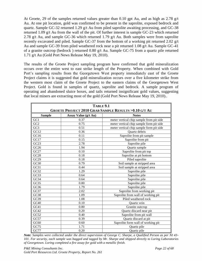
In late spring of 2010 a ground reconnaissance and sampling program at the Groete Project was
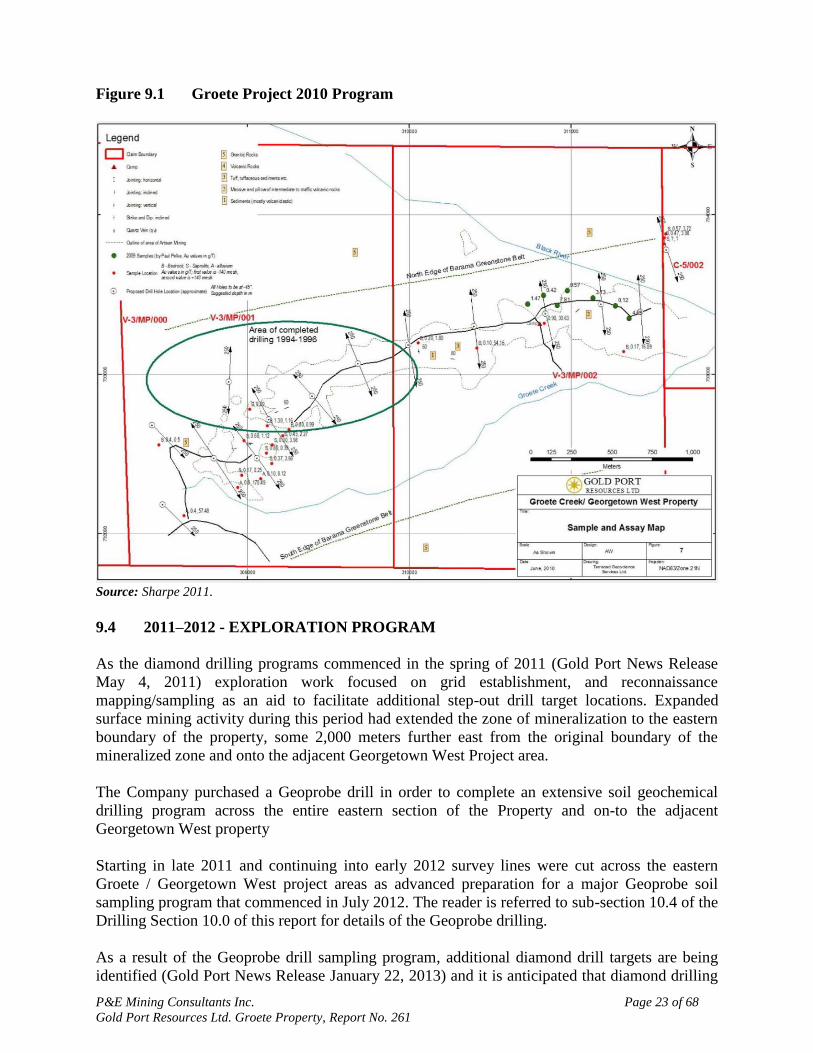
initiated. A total of 47 grab samples were collected at locations shown in Figure 9.1. All
anomalous results in excess of 0.1 g/t Au are detailed in Table 9.1.
P&E Mining Consultants Inc. Page 22 of 68
Gold Port Resources Ltd. Groete Property, Report No. 261
At Groete, 29 of the samples returned values greater than 0.10 gpt Au, and as high as 2.78 g/t
Au. At one pit location, gold was confirmed to be present in the saprolite, exposed bedrock and
quartz. Sample GC-32 returned 1.29 g/t Au from piled saprolite awaiting processing, and GC-38
returned 1.09 g/t Au from the wall of the pit. Of further interest is sample GC-23 which returned
2.78 g/t Au, and sample GC-36 which returned 1.79 g/t Au. Both samples were from saprolite
recently excavated and piled. Sample GC-37 from the bottom of a working pit returned 2.02 g/t
Au and sample GC-39 from piled weathered rock near a pit returned 1.08 g/t Au. Sample GC-41
of a granite outcrop (bedrock ) returned 0.80 g/t Au. Sample GC-75 from a quartz pile returned
1.71 g/t Au (Gold Port News Release May 19, 2010).
The results of the Groete Project sampling program have confirmed that gold mineralization
occurs over the entire west to east strike length of the Property. When combined with Gold
Port‟s sampling results from the Georgetown West property immediately east of the Groete
Project claims it is suggested that gold mineralization occurs over a five kilometer strike from
the western most claim of the Groete Project to the eastern claims of the Georgetown West
Project. Gold is found in samples of quartz, saprolite and bedrock. A sample program of
operating and abandoned sluice boxes, and tails returned insignificant gold values, suggesting
that local miners are extracting most of the gold (Gold Port News Release May 19, 2010)..
TABLE 9.1
GROETE PROJECT 2010 GRAB SAMPLE RESULTS >0.10 G/T AU
Sample Assay Value (g/t Au) Notes
GC1 0.37 meter vertical chip sample from pit side
GC2 0.75 meter vertical chip sample form pit side
GC3 0.51 meter vertical chip sample form pit side
GC12 0.36 Quartz debris
GC16 0.11 Saprolite from pit sample
GC17 0.15 Saprolite from pit
GC23 2.78 Saprolite pile
GC26 1.94 Quartz sample
GC27 0.10 Saprolite from pit top
GC28 0.18 Saprolite at pit bottom
GC29 0.18 Piled saprolite
GC30 0.79 Soil sample at stripped area
GC31 0.44 Soil sample at stripped area
GC32 1.29 Saprolite pile
GC33 0.64 Saprolite pile
GC34 0.64 Saprolite pile
GC35 0.80 Saprolite pile
GC36 1.79 Saprolite pile
GC37 2.02 Saprolite from working pit
GC38 1.09 Saprolite from wall of working pit
GC39 1.08 Piled weathered rock
GC40 0.10 Quartz vein
GC41 0.80 Granite outcrop
GC42 0.20 Quartz discard near pit
GC52 0.40 Saprolite from pit wall
GC57 0.39 Quartz discard at pit
GC60 0.60 Saprolite form wall of working pit
GC75 1.71 Quartz pile
GC77 0.20 Quartz pile
Note: Samples were collected under the direct supervision of George C. Sharpe, a Qualified Person as per NI 43-
101. For security, each sample was bagged and tagged by Mr. Sharpe and shipped directly to Loring Laboratories
of Georgetown. Loring completed a fire assay for gold with a metallic finish.
P&E Mining Consultants Inc. Page 23 of 68
Gold Port Resources Ltd. Groete Property, Report No. 261
Figure 9.1 Groete Project 2010 Program
Source: Sharpe 2011.
9.4 2011–2012 - EXPLORATION PROGRAM
As the diamond drilling programs commenced in the spring of 2011 (Gold Port News Release
May 4, 2011) exploration work focused on grid establishment, and reconnaissance
mapping/sampling as an aid to facilitate additional step-out drill target locations. Expanded
surface mining activity during this period had extended the zone of mineralization to the eastern
boundary of the property, some 2,000 meters further east from the original boundary of the
mineralized zone and onto the adjacent Georgetown West Project area.
The Company purchased a Geoprobe drill in order to complete an extensive soil geochemical
drilling program across the entire eastern section of the Property and on-to the adjacent
Georgetown West property
Starting in late 2011 and continuing into early 2012 survey lines were cut across the eastern
Groete / Georgetown West project areas as advanced preparation for a major Geoprobe soil
sampling program that commenced in July 2012. The reader is referred to sub-section 10.4 of the
Drilling Section 10.0 of this report for details of the Geoprobe drilling.
As a result of the Geoprobe drill sampling program, additional diamond drill targets are being
identified (Gold Port News Release January 22, 2013) and it is anticipated that diamond drilling
P&E Mining Consultants Inc. Page 24 of 68
Gold Port Resources Ltd. Groete Property, Report No. 261
of these targets will commence in the 2013-14 field seasons. Additional phases of follow-up
Geoprobe drilling will also likely be required.
9.5 CURRENT ARTISANAL MINING AND PROSPECTING ACTIVITY
The “artisanal mining” activities of local “pork-knockers” can be used as a somewhat imprecise
but initial indication of the tenor and distribution of mineralization in an area. Many companies
view such activity as a form of prospecting and such is the case at the Groete Deposit. The
Groete Property area has recently become the location of significant exploitation by small scale
miners. Approximately 15 small scale operations have become established along a two mile zone
trending north-easterly, across the property. Much of the mining activity is focused in the area of
prior exploration drilling. Most operations involve the hydraulic removal of the overburden, and
the recovery of gold using a basic sluice being fed by gravel pumps.
The more recent level of activity and the size of the area of operations indicate that gold
mineralization is present outside the previously identified mineralized areas. The expansion of
the areas being worked by the unauthorized miners has exposed new potential exploration target
areas on the property. Future exploration efforts are being expanded to encompass the enlarged
area of artisanal activities
P&E Mining Consultants Inc. Page 25 of 68
Gold Port Resources Ltd. Groete Property, Report No. 261
10.0 DRILLING
10.1 RECONCILIATION OF HISTORICAL DRILL HOLE LOCATION DATA
One of the first tasks undertaken by Gold Port was to try and reconcile existing historical drill
hole locations in an effort to establish a project database. All exploration surveying and drilling
campaigns undertaken by Gold Port on the Groete Property are done within the WGS 84 co-
ordinate system utilizing data stations and drill hole collar locations established in the field
through the use of GPS units. Gold Port is the first Company to use such modern techniques on
the project. In order to incorporate historical data into the project database Gold Port‟s geologists
have had to attempt to assess and verify the reliability and accuracy of the original drill hole and
survey data point locations. The magnitude of this undertaking is outlined in an internal
Company progress report by Paul A Pelke titled “Progress Report and Exploration Direction”
dated March 31, 2012 and briefly summarized below.
The previous work done in the late 1980s and 1990‟s often relied on the Brunton compass and
tape method for geochemical sampling lines, location of drill holes etc. This has resulted in
certain discrepancies between the historical and more modern GPS location data as described
below. When possible the older data locations are being re-surveyed using modern GPS methods
in an on-going attempt to bring all such information to a common state.
In 1988, Sudex established a field grid beginning at a theoretical point of origin designated
0E/0N. All points east and north of the origin were deemed positive. The entire project area lay
in the north western quadrant of the grid system which was used to locate all Sudex survey
stations.
In 1994, Western Premium Resources and CADMICO extended the grid and geochemical
sampling to outline drill targets. The 1994 drilling program hole locations were based on this
extended grid. In 1996, CBI conducted a follow-up drill program based on geologic offsets of the
1994 drill holes. Both of these programs used the extended 1988 Sudex grid. For reasons
outlined below, this has caused certain complexities with regard to the reconciliation of the drill
collar and other exploration survey data points based on the Sudex grid with subsequent and
more modern survey and drill collar location data based on GPS derived locations.
The 1988 Sudex grid was designed on paper with an E-W baseline orientated at 270o but was in
fact orientated in the field at an azimuth of 280o resulting in a variable misalignment (depending
on the distance of the hole from the origin of the grid) between the hole location on the paper
grid and the location in the field. This misalignment was first recognized by CBI who
immediately corrected the Western Premium grid and drill hole coordinates. Both the 1996 core
holes and the 1994 core holes were then plotted on the same grid, which was orthogonal and is
oriented true N-S. Unfortunately use of the field grid continued resulting in a paper grid that
accurately represents the spatial relationship between the drill holes but does not accurately
represent the true orientation of the mineralization in the field.
In 1996 the WGS 84 coordinate system was adopted using drill hole 96-13 as the origin of the
grid. Although the co-ordinate system changed, the existing field grid continued as the basis for
the drill programs. This propagated the 10o difference, meaning that the N – S distance is offset
by approximately 10% of the E – W difference in location between 96-13 and a subject drill
hole. For example, a drill hole located 600 meters east would be shifted approximately 60 meters
north and drill holes 1000 meters east (e.g. 94-7, 96-15) would lie shifted approximately 100
P&E Mining Consultants Inc. Page 26 of 68
Gold Port Resources Ltd. Groete Property, Report No. 261
meters north of its position as plotted on the paper grid. Gold Port has found these differences to
be generally accurate. The solution to the problem is to have the computer rotate the grid 10o
about the location of hole 96-13.
Presently, Gold Port is using GPS‟s and the WGS 84 coordinate system to locate drill holes and
to map the roads and local infrastructure. As of the end of March, 2012 most of the 1994 and
1996 drill hole collars have been found in the field and plotted in WGS 84 coordinates.
Gold Port began a confirmation drill program in July of 2011, the purpose of which was to twin
and replicate if possible, the historical results from the property. The initial Groete Project drill
program commenced in early May, 2011 (Gold Port News Release May 4, 2011).
The Company owned Acker MP 8 track mounted drill rig was used to drill the holes. As the drill
program progressed, a second Acker MP 8 drill was purchased and delivered to the property
along with a Geoprobe drill in early 2012 (Gold Port News Release Dec 13, 2011).
In general, drill production averaged 30 metres per day. Core recovery in the surface layers was
often difficult due to past mining activity, while core recovery in the bedrock was 100%. Core
was logged and stored on site.
Mr. Antoine Yassa, P. Geo. of P&E defined and implemented the Quality Assurance and Quality
Control standards for the program. Drill core from the complete drill program was sent to ACME
Laboratories of Guyana for preparation work and to ACME Laboratories of Vancouver, B.C.
Canada for assaying as depicted in Section 11.0 “Sample Preparation, Analysis and Security” of
this report.
Figure 10.1 is a drill hole location plan map showing the Gold Port drill holes together with those
historical holes whose position has been determined and located in the field.
10.2 TWIN HOLE DRILLING PROGRAM
The Company completed the following four twin holes at the Groete Project by year-end 2011
(Gold Port News Release Dec 2, 2011) with assay results received starting in the spring of 2012.
Hole TW12-13 was located as a twin to historical drill hole C96-13, and is located
at the western edge of the known mineralized zone. Hole TW11-013 was located
with the identical angle and azimuth as the historical hole, and drilled to 206
metres depth.
Hole TW12-12 was located as a twin to historical drill hole C96-12 and was
located approximately 200 metres east of TW11-013.
Hole TW12-03 was located approximately 600 metres north east of TW11-013
and was drilled as a twin to historical hole C94-03.
Hole TW12-15 was drilled approximately 1,000 metres east of TW11-013 and is
a twin to historical drill hole C96-15.

P&E Mining Consultants Inc. Page 27 of 68
Gold Port Resources Ltd. Groete Property, Report No. 261
Figure 10.1 Drill Hole Location Map
Source: Gold Port 2013.
P&E Mining Consultants Inc. Page 28 of 68
Gold Port Resources Ltd. Groete Property, Report No. 261
Drill Hole TW12-13
Drill hole 96-13 was the first drill collar located from the historical drilling completed in the
1994-97 period and provided solid physical evidence that it might be possible to establish the
actual location of at least some of the historical holes despite the on-going surface mining
activity of the artisanal miners. Hole 96-13 is situated at the western most point of the historical
gold zone, on the outer fringe of the known mineralizing system. The twin hole was sited to
within 3 metres of the original collar location of 96-13. It was drilled at an azimuth of 169
degrees south, and at a 45 degree angle thereby replicating the historical hole parameters as
closely as possible.
Drill results for both the historical and twin holes identified the following multiple zones of more
intense gold mineralization although the entire hole is more or less mineralized.
A Near Surface Zone In The Saprolite
An Interval From 50.3 Metres Through 100.6 Metres
An Interval From 109.8 Metres Through 117.4 Metres
10.3 GOLD ASSAY VALUES
For the following comparisons core intercept intervals corresponding as close as possible to
those intervals in both the historic and twin holes were selected.
The top three metres of the historic drill hole 96-13 averaged 0.25 g/t Au, while the top 4.5
metres of the 2012 twin drill hole (TW12-13) averaged 0.495 g/t Au. These values clearly show
the nugget effect present in the near surface saprolite. For the 50.3 meter intervals ranging from
50.3 metres through 100.6 metres, there were two differences between the recent and the
historical drill holes. In the historical drill hole, there were seven sample intervals which were
above 1 g/t Au, while four samples above 1 g/t Au were found in the twin drill hole. In addition,
one of the seven intervals in the historic drill hole showed 7.7 g/t Au, while the most closely
corresponding interval in the recent TW drill hole showed 0.654 g/t Au. For purposes of
comparing the composited assay results over the entire core length of each hole, the 7.7 g/t Au
value in the historical drill hole was cut to 1.0 g/t Au and the average of the complete
mineralized interval calculated.
Hole TW12-13 averaged 0.276 g/t Au over 238 metres total depth, while the historical drill hole
averaged 0.297 g/t Au over 206.9 metres total depth. For the 50.3 meter interval from 50.3
metres through 100.6 metres, TW12-13 had an average grade of 0.560 g/t Au, while the
historical drill hole had an average grade of 0.615 g/t Au. The 7.2 meter interval from 109.8
metres through 117.4 metres had an average grade of 0.423 g/t Au in TW12-13, while the
historical drill hole had an average grade of 0.510 g/t Au.
More intense gold mineralization was encountered at the bottom of both the current TW12-13
and historic drill holes, from 117.4 metres to the final depth. Twin hole TW12-13 averaged 0.226
g/t Au over 120.6 metres, to its bottom at 238 metres, while historical hole 96-13 averaged 0.228
g/t Au over 89.5 metres to its bottom at 206.9 metres.
P&E Mining Consultants Inc. Page 29 of 68
Gold Port Resources Ltd. Groete Property, Report No. 261
10.4 COPPER ASSAY VALUES
TW12-13 returned a copper average of 702 ppm over 228 metres of total depth, including 971
ppm from 48.9 metres to 165.5 metres. The historical values for 96-13 returned 0.06% Cu over
206.9 metres of total depth, which compares closely with the current results. The twin hole was
drilled to a greater depth and confirmed the continuation of mineralization
Drill Hole TW12-15
TW12-15 was drilled to a total depth of 186 meters and returned an average of 0.279 ppm Au
and 424 ppm Cu over this length. Historical values for 96-15, which was drilled to a total depth
of 138.7 meters, are 0.32 ppm Au and 0.05% Cu over this length. Hole TW12-15 was drilled
47.3 meters deeper and confirms the continuation of mineralization.
Drill Hole TW12-05
TW12-05 was drilled to a total depth of 221 meters, and returned 0.416 g/t Au, including 0.685
g/t Au from 65.5 to 117.1 meters, and 0.081% ppm Cu over the entire interval. The historical
comparison is 0.282 ppm Au and 0.08% Cu over 227 meters.
Drill Hole TW12-03
Twin hole TW12-03 was drilled as an attempted twin to historical hole 94-03. The first attempt
was drilled to 65 metres where it was terminated due to water flow, and is referred to as TW12-
03A. The hole was restarted and successfully drilled to a total depth of 304 metres, the deepest
hole drilled at the Groete Project to date.
Contained within Hole TW12-03 are multiple zones of increased gold and copper mineralization.
The entire 304 metres grades 0.368 g/t Au, and includes 12 metres of 0.795 g/t Au from 4.56 to
16.72 metres, 31.92 metres of 0.824 g/t Au from 100.32 to 132.24 metres, 24.88 metres of 0.759
g/t Au from 176.32 to 205.20 metres, and 10.64 metres of 0.592 g/t Au from 240.16 to 250.80
metres.
Table 10.1 compares the assay results for TW12 -03A to 65 metres, TW12-03 to 304 metres, and
the historical values for hole 94-03.
TABLE 10.1
COMPARISON OF ASSAY RESULTS FOR TW12-03 AND 94-03
Hole Total Depth
(m) Au (g/t) Cu (%)
TW12-03A 65.0 0.322 0.155
TW12-03 304.0 0.368 0.076
94-03 270.1 0.405 0.070
Note: The historical value of 31.0 g/t Au from 30.5 to 32.0 meters in hole 94-03 cut to 10 g/t Au for calculating the
average.
P&E Mining Consultants Inc. Page 30 of 68
Gold Port Resources Ltd. Groete Property, Report No. 261
10.5 INFILL DRILLING PROGRAM
Drill Hole GC12-01
Drill Hole GC12-001 was located 300 metres southwest of hole TW96-13 and was drilled across
a known boundary fault. As expected, it did not encounter gold mineralization and has been
interpreted as confirming that the western limit of the mineralization is fault controlled.
Drill Hole GC12-02
Drill Hole GC12-02 was drilled approximately 125 metres south of the southernmost historical
drill collar, and to 255 metres depth. The hole was drilled at minus 45 degrees and at an azimuth
of 169 degrees. The drill hole showed gold mineralization in the top 75 metres, returning 0.363
g/t Au from surface to 24 metres, and averaging 0.231 g/t Au for the entire top 75 metres. This
drill hole has gold in both the saprolite and the bedrock, and shows that the mineralization
extends at least another 125 metres further south of the area of historical drilling.
Drill Hole GC12-04
In March 2012, the Company reported results from Hole GC12-04, which was located as an infill
not as the original planned twin of historical hole AK96-12. Past mining activity (prior to Gold
Port involvement) on the project had resulted in the hole collar of AK96-12 having been
removed. A substantial pit from past mining activity made it impossible to re-locate this hole.
Hole GC12-04 was therefore moved to the west approximately 35 metres, and considered an
infill hole. Hole GC12-04 averaged 244 metres of 0.5 grams per tonne gold, which includes a 63
meter zone of 0.987 grams per tonne gold, from 24 to 87 metres. The highest gold value
encountered was 2.64 grams per tonne gold over 1.5 metres, with the hole requiring no “high
cut“ in the calculation.
In May 2012, the Company announced results from twin hole TW12-05, an attempted twin of
historical hole 94-05. This hole returned 221 metres of 0.416 grams per tonne gold. Drilling has
continued at the project, with the completion of hole TW12-03, an attempted twin of historical
hole 94-03
Drill Hole GC12-07
Hole GC12-07 started as an attempted twin of historical hole 94-10, but the drill hole
encountered stability issues due to the presence of surface tailings, and was re-started as a
vertical hole. Gold and copper mineralization was encountered throughout the hole. The best
gold interval was encountered from 51.68 to 107.92 metres and returned 1.02 g/t Au over a true
width of 39.27 metres. Two significant copper intervals were encountered, the first from 57.20 to
110.96 metres, for 0.168% copper over a true width of 38 metres, and the second from 117 to
235.6 metres returning 0.151% copper over a true width of 83.83 metres. The entire hole
averaged 0.467 g/t Au and 0.119% copper over the total depth of 253.8 metres.
Drill Hole GC12-08
Hole GC12-08 was located as a vertical hole approximately 50 metres north of historical 96-12,
in an area previously untested. The hole was drilled to a total depth of 219.48 metres,
encountering gold and copper mineralization to the bottom. The best interval was encountered at
P&E Mining Consultants Inc. Page 31 of 68
Gold Port Resources Ltd. Groete Property, Report No. 261
83.6 metres to 139.84 metres and returned 1.393 g/t Au over a true width of 39.7 metres. From
104.88 to 106.40 metres, a value of 36.3 g/t Au was returned. This value was cut from 36.3 g/t
Au to 18.15 g/t Au for the calculation of the average value for this interval. The best copper
interval was between 92.72 metres to 205.2 metres and returned 0.163% copper over a true width
of 79.53 metres. The entire hole returned 0.560 g/t Au and 0.093% copper over the total depth of
220.4 metres.
10.6 2012 - GEOPROBE DEEP SOIL DRILLING PROGRAM
The track mounted Geoprobe system collects a 1.2 meter sample interval via an enclosed plastic
lined rod string. Sample recovery was generally high (greater than 70 percent; mostly 100 per
cent).
Beginning in July 2012, the Company conducted a Phase I Geoprobe deep soil drilling program
comprised of 29 holes that extended the known surface gold zone by 250 meters east of the
eastern most historical drill hole. A total of 23 Geoprobe holes were completed as a follow up to
this program bringing the total holes completed as of year-end 2012 to 52. The locations of the
Geoprobe holes are shown in Figure 10.2.
Holes were located approximately 50 metres apart, taking into consideration terrain features. The
depth of the holes ranged from approximately 3 to 12 metres. Samples were labeled on site, and
transported by Company staff to Loring Laboratories of Georgetown Guyana, for a 1 ton fire
assay with an AA finish. The lower detection limit was 0.01 ppm gold and the upper detection
limit was 3.0 g/t Au. Blanks and standards were inserted for quality assurance and quality
control. The program was supervised by Mr. Paul A. Pelke, a Qualified Person under NI 43-101.
A total of 47 of the 52 holes contained an average gold grade greater than 0.1 g/t Au and are
considered anomalous. Five holes returned less than 0.1 g/t Au although all were considered
somewhat anomalous. Excluding the five slightly anomalous holes, complete hole average
values ranged from 0.1 g/t Au to 2.65 g/t Au. Two holes encountered single sample (1.2 metres)
values greater than the upper detection limit, returning 3.4 g/t Au and 3.20 g/t Au. When
mapped, a highly anomalous surface gold zone is defined running 200 metres east of the last
known drill area. Further work east was constrained by the presence of a mined out pit,
indicating the prior exploitation of surface gold in that area.
Gold Port reported the completion of 5 additional Geoprobe holes (R1H-ST5 through ST8 and
hole R1H6-ST 5) on the Groete Copper Gold Project in a January 22-13 news release. These
step-out holes were located in the area of hole R1H5. The series of holes were located
approximately 40 metres east, west, north and south of Geoprobe hole R1H5. Hole R1H5-ST5
returned 0.19 grams per tonne gold over 12.5 metres. Hole R1H5-ST6 returned 0.55 grams per
tonne gold over 12.5 metres. Hole R1H5- ST7 returned 0.21 grams per tonne gold over 12.5
metres. Hole R1H5-ST8 returned 0.3 grams per tonne gold over 12.5 metres. Hole R1H6-ST5
was located approximately 80 metres east of hole R1H5 and returned 1.2 grams per tonne gold
over 12.5 metres. Results in this area indicate a large soil surface gold anomaly returning high
values. The area is one of the zones identified for follow up core drilling. As of the date of this
report the Geoprobe drill was being re-located to the western portion of the Groete Gold Copper
Project to continue surface evaluation.
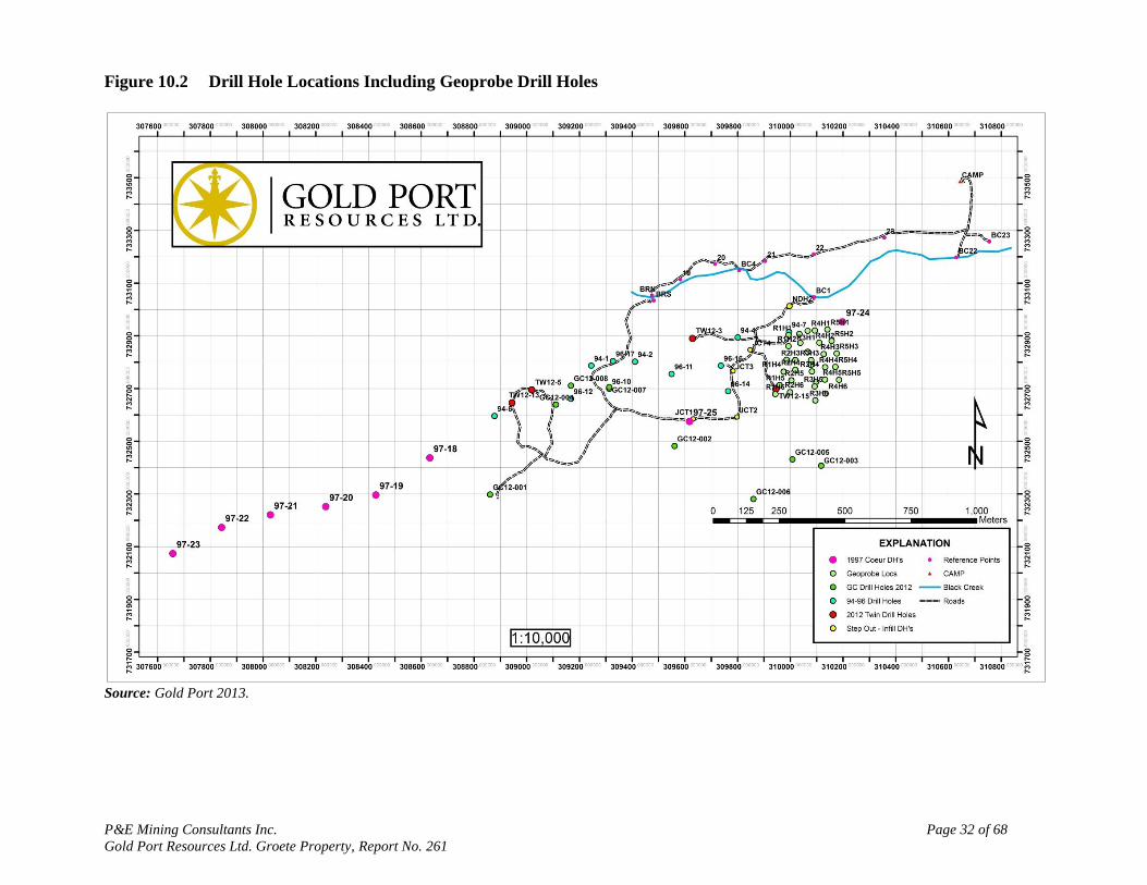
P&E Mining Consultants Inc. Page 32 of 68
Gold Port Resources Ltd. Groete Property, Report No. 261
Figure 10.2 Drill Hole Locations Including Geoprobe Drill Holes
Source: Gold Port 2013.

P&E Mining Consultants Inc. Page 33 of 68
Gold Port Resources Ltd. Groete Property, Report No. 261
11.0 SAMPLE PREPARATION, ANALYSES AND SECURITY
11.1 SAMPLE PREPARATION AND SECURITY
One of the Gold Port geologists logged and marked the drill core, and supervised the sawing of
the samples by a helper. Usual sample lengths were 1.5 m, and one half of the core remained
in the box as a witness sample. Samples were bagged with a unique tag and each bag was sealed.
For every sequence of 20 samples, a certified reference material, (standard), duplicate and blank
were included. The duplicate was obtained by ¼ sawing the ½ of the core retained in the box as a
witness. The blank material was sourced from what was believed to be barren bedrock in the
general project area.
The bagged samples remained locked in the core shack at the Groete Project until hand delivery
of them to the ACME prep lab in Georgetown was made by one of the project geologists. Upon
reception of the samples, the shipment manifest was signed by lab personnel.
All of the samples were submitted to the ACME sample preparation lab in Georgetown, and once
pulverized, the pulps were forwarded by ACME to their analytical laboratory in Santiago, Chile
for analysis.
11.2 LAB PROTOCOL FOR SAMPLE ANALYSIS
Analyses for gold and copper were completed by ACME in Santiago, Chile.
ACME operates 19 offices in 11 countries. At each lab, a quality system compliant with the
International Standards Organization (ISO) 9001 Model for Quality Assurance and ISO/IEC
17025 General Requirements for the Competence of Testing and Calibration Laboratories is
implemented. On November 13, 1996, Acme became the first commercial geochemical analysis
and assaying lab in North America to be accredited under ISO 9001. The laboratory has
maintained its registration in good standing since that time.
In 2005, the Santiago, Chile laboratories received ISO 9001:2000 registration with the
preparation facilities in Mendoza, Argentina and Guyana following in 2006.
In October 2011 the Vancouver laboratory received formal approval of its ISO/IEC 17025:2005
accreditation from the Standards Council of Canada for the tests listed in the approved scope of
accreditation. The lab will continue to add methods to this scope.
Acme Labs Santiago received ISO:17025 accreditation from the Standards Council of Canada in
November, 2012.
Gold was analyzed by lead collection fire assay with AAS finish. Analyses for copper were
completed by 4-acid digest, and analyzed by ICP-ES.
P&E considers that the sample preparation, security and analytical procedures are in keeping
with industry best practices and have produced accurate and precise results for the elements in
the resource estimate.
P&E Mining Consultants Inc. Page 34 of 68
Gold Port Resources Ltd. Groete Property, Report No. 261
12.0 DATA VERIFICATION
12.1 SITE VISIT AND INDEPENDENT SAMPLING
The Groete Project was visited by Mr. Antoine Yassa, P. Geo., an independent Qualified Person
(“QP”) as defined by Canadian NI 43-101 Standards of Disclosure for Mineral Projects, from
November 13 to 15, 2012, for the purposes of completing a site visit and independent sampling
program.
Access to the Groete Project in Guyana was made by boat to the camp on November 13th. The
site visit and sample collection were made that same day, and Mr. Yassa returned to Georgetown
November 14th.
A visit was made November 15th to the Georgetown office, where meetings and discussions
were held regarding core logging and sampling procedures, QA/QC and general field procedures.
Mr. Yassa collected 12 samples from four holes by sawing a quarter core from the remaining
half core in the box. Samples were selected from a range of grades and placed in a plastic bag
with a unique tag. Each bag was sealed, and once all the samples had been collected they were
placed in a larger bag and taken by Mr. Yassa back to Canada to the offices of P&E. From there
the samples were delivered by courier to a certified analytical laboratory.
At no time were any officers or employees of Gold Port notified as to the location of the samples
to be collected.
At AGAT Labs in Mississauga, ON, the site visit samples were analyzed for gold and copper,
and specific gravities were measured.
Gold was determined by fire assay with an AAS finish. Copper was determined by a four-acid
digest and an AAS read.
AGAT has developed and implemented at each of its locations a Quality Management System
(QMS) designed to ensure the production of consistently reliable data. The system covers all
laboratory activities and takes into consideration the requirements of ISO standards.
AGAT maintains ISO registrations and accreditations, which provide independent verification
that a QMS is in operation at the location in question. Most AGAT laboratories are registered or
are pending registration to ISO 9001:2000.
Results of the Groete samples are presented in Figure 12.1 and Figure 12.2.
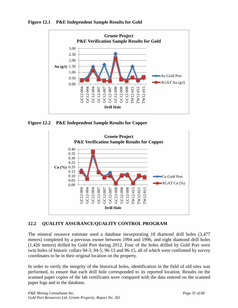
P&E Mining Consultants Inc. Page 35 of 68
Gold Port Resources Ltd. Groete Property, Report No. 261
Figure 12.1 P&E Independent Sample Results for Gold
Figure 12.2 P&E Independent Sample Results for Copper
12.2 QUALITY ASSURANCE/QUALITY CONTROL PROGRAM
The mineral resource estimate used a database incorporating 18 diamond drill holes (3,477
meters) completed by a previous owner between 1994 and 1996, and eight diamond drill holes
(1,426 meters) drilled by Gold Port during 2012. Four of the holes drilled by Gold Port were
twin holes of historic collars 94-3, 94-5, 96-13 and 96-15, all of which were confirmed by survey
coordinates to be in their original location on the property.
In order to verify the integrity of the historical holes, identification in the field of old sites was
performed, to ensure that each drill hole corresponded to its reported location. Results on the
scanned paper copies of the lab certificates were compared with the data entered on the scanned
paper logs and in the database.
0.00
0.50
1.00
1.50
2.00
2.50
3.00
GC
12
-004
GC
12
-004
GC
12
-004
GC
12
-007
GC
12
-007
GC
12
-007
GC
12
-008
GC
12
-008
GC
12
-008
TW
12
-01
5
TW
12
-01
5
TW
12
-01
5
Au (g/t)
Drill Hole
Groete Project
P&E Verification Sample Results for Gold
Au Gold Port
AGAT Au (g/t)
0.00
0.05
0.10
0.15
0.20
0.25
0.30
0.35
0.40
GC
12
-004
GC
12
-004
GC
12
-004
GC
12
-007
GC
12
-007
GC
12
-007
GC
12
-008
GC
12
-008
GC
12
-008
TW
12
-01
5
TW
12
-01
5
TW
12
-01
5
Cu (%)
Drill Hole
Groete Project
P&E Verification Sample Results for Copper
Cu Gold Port
AGAT Cu (%)
P&E Mining Consultants Inc. Page 36 of 68
Gold Port Resources Ltd. Groete Property, Report No. 261
Gold Port implemented a quality assurance/quality control (“QA/QC” or “QC”) program in 2012
at the beginning of the diamond drill program, with the addition of certified reference materials,
blanks and duplicates to the sample stream.
12.2.1 Performance of Certified Reference Materials
Three certified reference materials, (standards) were purchased from CDN Resource Labs in
Langley, BC and used throughout the program. Two of the standards were certified for gold and
copper, and the third one was certified for copper only. Fifty-nine reference materials were
inserted with the core samples. P&E graphed all samples, along with the mean and the +/- two
and three standard deviations from the mean for each reference material.
The standards generally performed well, remaining within the +/- two standard deviations from
the mean. The minor number of failures was examined in detail and the lab‟s QC was examined
on a case by case basis, with no action required.
12.2.2 Performance of Blank Material
The blank material was locally sourced rock. Sixty-five blank samples were inserted into the
sample stream and were analyzed for gold and copper. Evaluation of the blank material results
revealed many gold and copper values in excess of acceptable limits. Eighty pulps were rerun
and six pulps were re-prepared from the coarse reject material. The 86 samples were analyzed at
a Canadian lab. All results confirmed the original results, which demonstrated that the blank
material was in fact not devoid of mineralization. Another blank material will be sourced for
future programs.
12.2.3 Performance of Field Duplicates
Sixty-seven core duplicate pairs were collected and analyzed. Simple scatter graphs were plotted,
which indicated that the precision for gold at the core duplicate level was fair to good, and better
than expected for this level of homogeneity. Copper had excellent precision.
P&E declares the data to be satisfactory and appropriate for use in the mineral resource estimate.
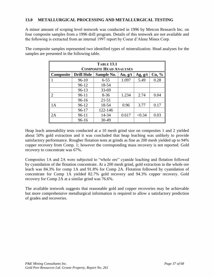
P&E Mining Consultants Inc. Page 37 of 68
Gold Port Resources Ltd. Groete Property, Report No. 261
13.0 METALLURGICAL PROCESSING AND METALLURGICAL TESTING
A minor amount of scoping level testwork was conducted in 1996 by Metcon Research Inc. on
four composite samples from a 1996 drill program. Details of this testwork are not available and
the following is extracted from an internal 1997 report by Coeur d‟Alene Mines Corp.
The composite samples represented two identified types of mineralization. Head analyses for the
samples are presented in the following table.
TABLE 13.1
COMPOSITE HEAD ANALYSES
Composite Drill Hole Sample No. Au, g/t Ag, g/t Cu, %
1 96-10 6-55 1.097 5.49 0.28
96-12 18-54
96-13 33-69
2 96-11 8-36 1.234 2.74 0.04
96-16 21-51
1A 96-12 18-54 0.96 3.77 0.17
96-17 122-146
2A 96-11 14-34 0.617 <0.34 0.03
96-16 30-49
Heap leach amenability tests conducted at a 10 mesh grind size on composites 1 and 2 yielded
about 50% gold extraction and it was concluded that heap leaching was unlikely to provide
satisfactory performance. Rougher flotation tests at grinds as fine as 200 mesh yielded up to 94%
copper recovery from Comp. 1; however the corresponding mass recovery is not reported. Gold
recovery to concentrate was 67%.
Composites 1A and 2A were subjected to “whole ore” cyanide leaching and flotation followed
by cyanidation of the flotation concentrate. At a 200 mesh grind, gold extraction in the whole ore
leach was 84.3% for comp 1A and 91.8% for Comp 2A. Flotation followed by cyanidation of
concentrate for Comp 1A yielded 82.7% gold recovery and 94.3% copper recovery. Gold
recovery for Comp 2A at a similar grind was 76.6%.
The available testwork suggests that reasonable gold and copper recoveries may be achievable
but more comprehensive metallurgical information is required to allow a satisfactory prediction
of grades and recoveries.

P&E Mining Consultants Inc. Page 38 of 68
Gold Port Resources Ltd. Groete Property, Report No. 261
14.0 MINERAL RESOURCE ESTIMATES
14.1 INTRODUCTION
The mineral resource estimate presented herein is reported in accordance with the Canadian
Securities Administrators‟ National Instrument 43-101 and has been estimated in conformity
with generally accepted CIM “Estimation of Mineral Resource and Mineral Reserves Best
Practices” guidelines. Mineral resources are not mineral reserves and do not have demonstrated
economic viability. There is no guarantee that all or any part of the mineral resource will be
converted into mineral reserve. Confidence in the estimate of Inferred mineral resources is
insufficient to allow the meaningful application of technical and economic parameters or to
enable an evaluation of economic viability worthy of public disclosure. Mineral resources may
also be affected by further infill and exploration drilling that may result in changes to subsequent
mineral resource estimates
All mineral resource estimation work reported herein was carried out by Fred Brown, P.Geo,
Antoine Yassa, P.Geo., and Eugene Puritch, P.Eng., all independent Qualified Persons in terms
of National Instrument 43-101, from information and data supplied by Gold Port Resources Ltd.
Mineral resource modeling and estimation were carried out using the commercially available
Gemcom GEMS software program.
14.2 PREVIOUS RESOURCE ESTIMATE
To the best of P&E‟s knowledge no previous National Instrument 43-101 compliant mineral
resource estimate has been publically released.
14.3 DATA SUPPLIED
All data were provided by Gold Port in the form of Excel files and scanned copies of original
reports and logs. The database as implemented by P&E contains results from seven surface
diamond drill holes completed by Gold Port and fifteen historical diamond drill holes (Figure
14.1 and Table 14.1). Four of the Gold Port drill holes were drilled as twins to historical drill
holes.
TABLE 14.1
DATABASE SUMMARY
Type Record Count Total Meters
Gold Port 7 1,656.5
Historical 15 4,864.9
Total 22 6,521.4
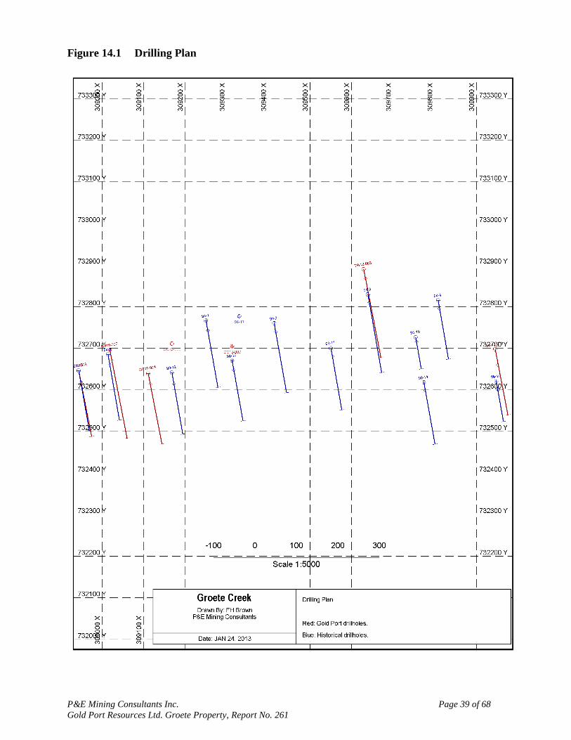
P&E Mining Consultants Inc. Page 39 of 68
Gold Port Resources Ltd. Groete Property, Report No. 261
Figure 14.1 Drilling Plan

P&E Mining Consultants Inc. Page 40 of 68
Gold Port Resources Ltd. Groete Property, Report No. 261
14.4 DATABASE VALIDATION
Industry standard validation checks were completed on the supplied databases. P&E typically
validates a mineral resource database by checking for inconsistencies in naming conventions or
analytical units, duplicate entries, interval, length or distance values less than or equal to zero,
blank or zero-value assay results, out-of-sequence intervals, intervals or distances greater than
the reported drill hole length, inappropriate collar locations, and missing interval and coordinate
fields. Several trivial out-of-sequence errors were noted and corrected. The database was verified
for all historical and current assay results using old certificates and digital copies of assay
certificates received from the laboratory. P&E believes that the supplied database is suitable for
mineral resource estimation.
14.5 SPECIFIC GRAVITY
The bulk density used for the mineral resource estimate was based on check samples collected
from drill hole core by Antoine Yassa, P.Geo. Specific gravity values for the twelve samples
ranged from 2.80 tonnes per cubic metre to 3.14 tonnes per cubic metre. The average value of
2.89 tonnes per cubic metre was used for the mineralized domains. An assumed value of 2.50
tonnes per cubic metre was assigned to the waste rock and 1.80 tonnes per cubic metre to the
saprolite.
14.6 DOMAIN MODELING
Local topography was derived from the supplied collar elevations, and a saprolite contact was
modeled from drill hole logs. Domain models were generated by P&E from successive polylines
spaced along drill hole sections oriented perpendicular to the general trend of the mineralization.
The domain outlines were influenced by the selection of mineralized material above 0.30 g/t Au
that demonstrated lithological and grade continuity along strike and down dip. Where
appropriate lower grade mineralization was included for the purpose of maintaining zonal
continuity. On each section polyline interpretations were digitized from drill hole to drill hole but
not typically extended more than fifty metres. Where appropriate edges were smoothed in order
to avoid jogs and a saw-tooth appearance. All polyline vertices were snapped directly to drill
hole assay intervals, in order to generate a true three-dimensional representation of the extent of
the mineralization. Domain wireframes were then clipped above the topographic surface.
A total of three domains were developed: the Main domain, with a strike length of approximately
1,250 m, the South domain, with a strike length of approximately 1,200 m, and the Footwall
domain, with a strike length of approximately 800 m. Sporadic results were also noted in the
saprolitic horizon, but were not included in the current modeling. The modeled domains were
used for rock coding, statistical analysis, compositing limits and definition of the mineralization
(Figure 14.2).
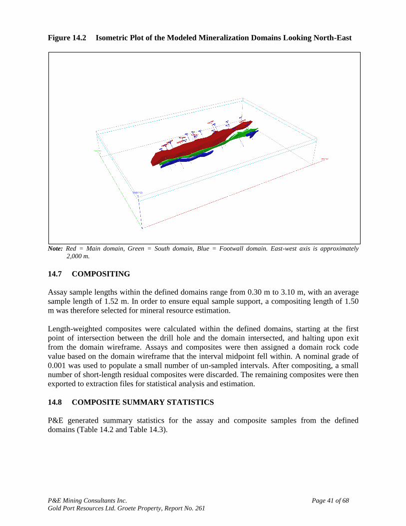
P&E Mining Consultants Inc. Page 41 of 68
Gold Port Resources Ltd. Groete Property, Report No. 261
Figure 14.2 Isometric Plot of the Modeled Mineralization Domains Looking North-East
Note: Red = Main domain, Green = South domain, Blue = Footwall domain. East-west axis is approximately
2,000 m.
14.7 COMPOSITING
Assay sample lengths within the defined domains range from 0.30 m to 3.10 m, with an average
sample length of 1.52 m. In order to ensure equal sample support, a compositing length of 1.50
m was therefore selected for mineral resource estimation.
Length-weighted composites were calculated within the defined domains, starting at the first
point of intersection between the drill hole and the domain intersected, and halting upon exit
from the domain wireframe. Assays and composites were then assigned a domain rock code
value based on the domain wireframe that the interval midpoint fell within. A nominal grade of
0.001 was used to populate a small number of un-sampled intervals. After compositing, a small
number of short-length residual composites were discarded. The remaining composites were then
exported to extraction files for statistical analysis and estimation.
14.8 COMPOSITE SUMMARY STATISTICS
P&E generated summary statistics for the assay and composite samples from the defined
domains (Table 14.2 and Table 14.3).
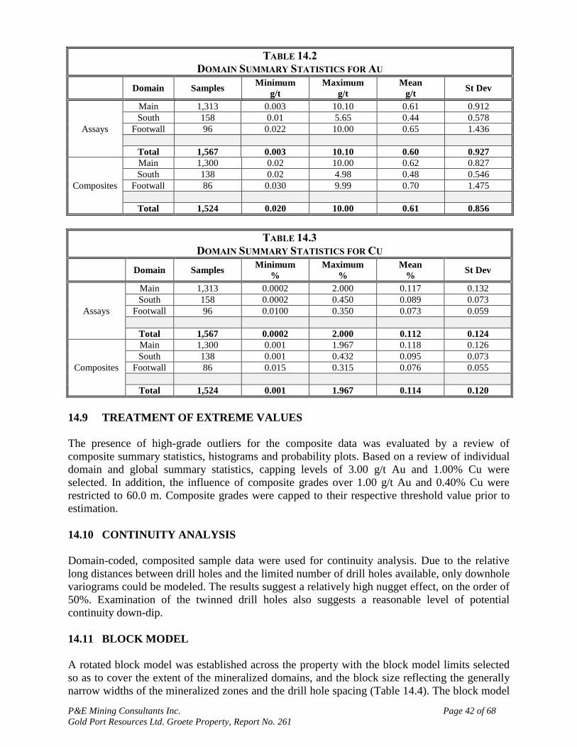
P&E Mining Consultants Inc. Page 42 of 68
Gold Port Resources Ltd. Groete Property, Report No. 261
TABLE 14.2
DOMAIN SUMMARY STATISTICS FOR AU
Domain Samples
Minimum
g/t
Maximum
g/t
Mean
g/t St Dev
Assays
Main 1,313 0.003 10.10 0.61 0.912
South 158 0.01 5.65 0.44 0.578
Footwall 96 0.022 10.00 0.65 1.436
Total 1,567 0.003 10.10 0.60 0.927
Composites
Main 1,300 0.02 10.00 0.62 0.827
South 138 0.02 4.98 0.48 0.546
Footwall 86 0.030 9.99 0.70 1.475
Total 1,524 0.020 10.00 0.61 0.856
TABLE 14.3
DOMAIN SUMMARY STATISTICS FOR CU
Domain Samples
Minimum
%
Maximum
%
Mean
% St Dev
Assays
Main 1,313 0.0002 2.000 0.117 0.132
South 158 0.0002 0.450 0.089 0.073
Footwall 96 0.0100 0.350 0.073 0.059
Total 1,567 0.0002 2.000 0.112 0.124
Composites
Main 1,300 0.001 1.967 0.118 0.126
South 138 0.001 0.432 0.095 0.073
Footwall 86 0.015 0.315 0.076 0.055
Total 1,524 0.001 1.967 0.114 0.120
14.9 TREATMENT OF EXTREME VALUES
The presence of high-grade outliers for the composite data was evaluated by a review of
composite summary statistics, histograms and probability plots. Based on a review of individual
domain and global summary statistics, capping levels of 3.00 g/t Au and 1.00% Cu were
selected. In addition, the influence of composite grades over 1.00 g/t Au and 0.40% Cu were
restricted to 60.0 m. Composite grades were capped to their respective threshold value prior to
estimation.
14.10 CONTINUITY ANALYSIS
Domain-coded, composited sample data were used for continuity analysis. Due to the relative
long distances between drill holes and the limited number of drill holes available, only downhole
variograms could be modeled. The results suggest a relatively high nugget effect, on the order of
50%. Examination of the twinned drill holes also suggests a reasonable level of potential
continuity down-dip.
14.11 BLOCK MODEL
A rotated block model was established across the property with the block model limits selected
so as to cover the extent of the mineralized domains, and the block size reflecting the generally
narrow widths of the mineralized zones and the drill hole spacing (Table 14.4). The block model
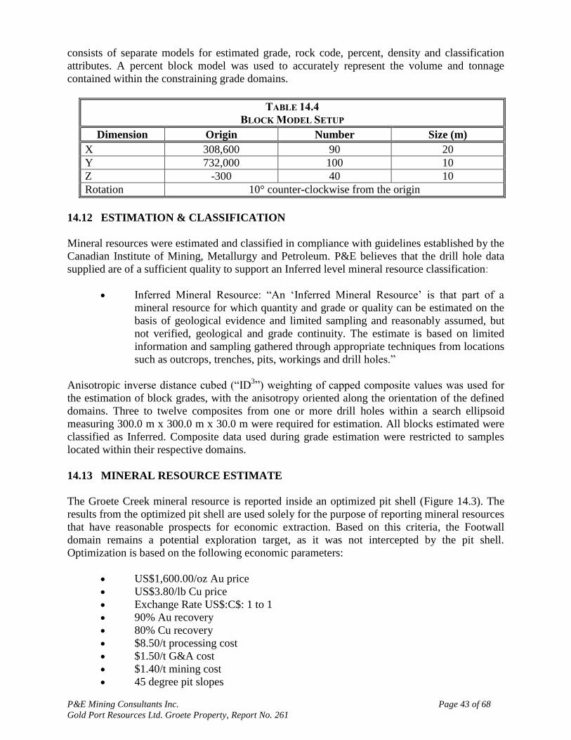
P&E Mining Consultants Inc. Page 43 of 68
Gold Port Resources Ltd. Groete Property, Report No. 261
consists of separate models for estimated grade, rock code, percent, density and classification
attributes. A percent block model was used to accurately represent the volume and tonnage
contained within the constraining grade domains.
TABLE 14.4
BLOCK MODEL SETUP
Dimension Origin Number Size (m)
X 308,600 90 20
Y 732,000 100 10
Z -300 40 10
Rotation 10° counter-clockwise from the origin
14.12 ESTIMATION & CLASSIFICATION
Mineral resources were estimated and classified in compliance with guidelines established by the
Canadian Institute of Mining, Metallurgy and Petroleum. P&E believes that the drill hole data
supplied are of a sufficient quality to support an Inferred level mineral resource classification:
Inferred Mineral Resource: “An „Inferred Mineral Resource‟ is that part of a
mineral resource for which quantity and grade or quality can be estimated on the
basis of geological evidence and limited sampling and reasonably assumed, but
not verified, geological and grade continuity. The estimate is based on limited
information and sampling gathered through appropriate techniques from locations
such as outcrops, trenches, pits, workings and drill holes.”
Anisotropic inverse distance cubed (“ID3”) weighting of capped composite values was used for
the estimation of block grades, with the anisotropy oriented along the orientation of the defined
domains. Three to twelve composites from one or more drill holes within a search ellipsoid
measuring 300.0 m x 300.0 m x 30.0 m were required for estimation. All blocks estimated were
classified as Inferred. Composite data used during grade estimation were restricted to samples
located within their respective domains.
14.13 MINERAL RESOURCE ESTIMATE
The Groete Creek mineral resource is reported inside an optimized pit shell (Figure 14.3). The
results from the optimized pit shell are used solely for the purpose of reporting mineral resources
that have reasonable prospects for economic extraction. Based on this criteria, the Footwall
domain remains a potential exploration target, as it was not intercepted by the pit shell.
Optimization is based on the following economic parameters:
US$1,600.00/oz Au price
US$3.80/lb Cu price
Exchange Rate US$:C$: 1 to 1
90% Au recovery
80% Cu recovery
$8.50/t processing cost
$1.50/t G&A cost
$1.40/t mining cost
45 degree pit slopes
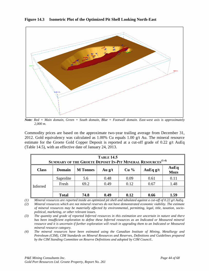
P&E Mining Consultants Inc. Page 44 of 68
Gold Port Resources Ltd. Groete Property, Report No. 261
Figure 14.3 Isometric Plot of the Optimized Pit Shell Looking North-East
Note: Red = Main domain, Green = South domain, Blue = Footwall domain. East-west axis is approximately
2,000 m.
Commodity prices are based on the approximate two-year trailing average from December 31,
2012. Gold equivalency was calculated as 1.00% Cu equals 1.00 g/t Au. The mineral resource
estimate for the Groete Gold Copper Deposit is reported at a cut-off grade of 0.22 g/t AuEq
(Table 14.5), with an effective date of January 24, 2013.
TABLE 14.5
SUMMARY OF THE GROETE DEPOSIT IN-PIT MINERAL RESOURCES(1-4)
Class Domain M Tonnes Au g/t Cu % AuEq g/t AuEq
Mozs
Inferred
Saprolite 5.6 0.48 0.09 0.61 0.11
Fresh 69.2 0.49 0.12 0.67 1.48
Total 74.8 0.49 0.12 0.66 1.59
(1) Mineral resources are reported inside an optimized pit shell and tabulated against a cut-off of 0.22 g/t AuEq.
(2) Mineral resources which are not mineral reserves do not have demonstrated economic viability. The estimate
of mineral resources may be materially affected by environmental, permitting, legal, title, taxation, socio-
political, marketing, or other relevant issues.
(3) The quantity and grade of reported Inferred resources in this estimation are uncertain in nature and there
has been insufficient exploration to define these Inferred resources as an Indicated or Measured mineral
resource and it is uncertain if further exploration will result in upgrading them to an Indicated or Measured
mineral resource category.
(4) The mineral resources have been estimated using the Canadian Institute of Mining, Metallurgy and
Petroleum (CIM), CIM Standards on Mineral Resources and Reserves, Definitions and Guidelines prepared
by the CIM Standing Committee on Reserve Definitions and adopted by CIM Council..
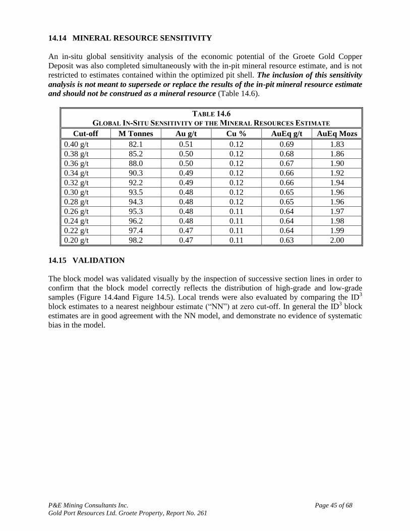
P&E Mining Consultants Inc. Page 45 of 68
Gold Port Resources Ltd. Groete Property, Report No. 261
14.14 MINERAL RESOURCE SENSITIVITY
An in-situ global sensitivity analysis of the economic potential of the Groete Gold Copper
Deposit was also completed simultaneously with the in-pit mineral resource estimate, and is not
restricted to estimates contained within the optimized pit shell. The inclusion of this sensitivity
analysis is not meant to supersede or replace the results of the in-pit mineral resource estimate
and should not be construed as a mineral resource (Table 14.6).
TABLE 14.6
GLOBAL IN-SITU SENSITIVITY OF THE MINERAL RESOURCES ESTIMATE
Cut-off M Tonnes Au g/t Cu % AuEq g/t AuEq Mozs
0.40 g/t 82.1 0.51 0.12 0.69 1.83
0.38 g/t 85.2 0.50 0.12 0.68 1.86
0.36 g/t 88.0 0.50 0.12 0.67 1.90
0.34 g/t 90.3 0.49 0.12 0.66 1.92
0.32 g/t 92.2 0.49 0.12 0.66 1.94
0.30 g/t 93.5 0.48 0.12 0.65 1.96
0.28 g/t 94.3 0.48 0.12 0.65 1.96
0.26 g/t 95.3 0.48 0.11 0.64 1.97
0.24 g/t 96.2 0.48 0.11 0.64 1.98
0.22 g/t 97.4 0.47 0.11 0.64 1.99
0.20 g/t 98.2 0.47 0.11 0.63 2.00
14.15 VALIDATION
The block model was validated visually by the inspection of successive section lines in order to
confirm that the block model correctly reflects the distribution of high-grade and low-grade
samples (Figure 14.4and Figure 14.5). Local trends were also evaluated by comparing the ID3
block estimates to a nearest neighbour estimate (“NN”) at zero cut-off. In general the ID3 block
estimates are in good agreement with the NN model, and demonstrate no evidence of systematic
bias in the model.

P&E Mining Consultants Inc. Page 46 of 68
Gold Port Resources Ltd. Groete Property, Report No. 261
Figure 14.4 Cross-Section Showing Estimated Gold Grades

P&E Mining Consultants Inc. Page 47 of 68
Gold Port Resources Ltd. Groete Property, Report No. 261
Figure 14.5 Cross-Section Showing Estimated Copper Grades
As a further check on the model the average model block grade was compared to the NN block
average as well as the declustered mean and the mean of the composite data. No significant bias
between the block model and the input data was noted (Table 14.7).
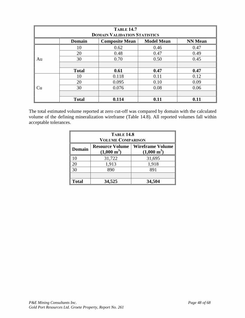
P&E Mining Consultants Inc. Page 48 of 68
Gold Port Resources Ltd. Groete Property, Report No. 261
TABLE 14.7
DOMAIN VALIDATION STATISTICS
Domain Composite Mean Model Mean NN Mean
Au
10 0.62 0.46 0.47
20 0.48 0.47 0.49
30 0.70 0.50 0.45
Total 0.61 0.47 0.47
Cu
10 0.118 0.11 0.12
20 0.095 0.10 0.09
30 0.076 0.08 0.06
Total 0.114 0.11 0.11
The total estimated volume reported at zero cut-off was compared by domain with the calculated
volume of the defining mineralization wireframe (Table 14.8). All reported volumes fall within
acceptable tolerances.
TABLE 14.8
VOLUME COMPARISON
Domain Resource Volume
(1,000 m3)
Wireframe Volume
(1,000 m3)
10 31,722 31,695
20 1,913 1,918
30 890 891
Total 34,525 34,504
P&E Mining Consultants Inc. Page 49 of 68
Gold Port Resources Ltd. Groete Property, Report No. 261
15.0 MINERAL RESERVE ESTIMATES
This section is not applicable to this report.
P&E Mining Consultants Inc. Page 50 of 68
Gold Port Resources Ltd. Groete Property, Report No. 261
16.0 MINING METHODS
This section is not applicable to this report.
P&E Mining Consultants Inc. Page 51 of 68
Gold Port Resources Ltd. Groete Property, Report No. 261
17.0 RECOVERY METHODS
This section is not applicable to this report.
P&E Mining Consultants Inc. Page 52 of 68
Gold Port Resources Ltd. Groete Property, Report No. 261
18.0 PROJECT INFRASTRUCTURE
A full camp with core logging and storage facilities are in place. There is no other infrastructure
on the Property except for the bush roads that provide access to the Property. Water and timber
are available on the property.
The Company has two drill rigs on site, both having been recently fully re-built and ready for
service. All support vehicles and heavy equipment, including two CL-320 excavators and a D-6
bulldozer, are on site.

P&E Mining Consultants Inc. Page 53 of 68
Gold Port Resources Ltd. Groete Property, Report No. 261
19.0 MARKET STUDIES AND CONTRACTS
This section is not applicable to this report.
P&E Mining Consultants Inc. Page 54 of 68
Gold Port Resources Ltd. Groete Property, Report No. 261
20.0 ENVIRONMENTAL STUDIES, PERMITTING AND SOCIAL OR COMMUNITY
IMPACT
The Company reports that no permits are required in order to conduct exploration and drilling on
the Groete Property. Customarily, the Guyana Geology and Mines Commission is notified when
drilling commences.
The Company reports that there are no known environmental liabilities on the Groete Property.
The small scale operators do not use mercury in their primary sluicing recovery process,
however, gold is recovered from the concentrates by amalgamation, which is then retorted to
recover the mercury and the bullion.

P&E Mining Consultants Inc. Page 55 of 68
Gold Port Resources Ltd. Groete Property, Report No. 261
21.0 CAPITAL AND OPERATING COSTS
This section is not applicable to this report.
P&E Mining Consultants Inc. Page 56 of 68
Gold Port Resources Ltd. Groete Property, Report No. 261
22.0 ECONOMIC ANALYSIS
This section is not applicable to this report.
P&E Mining Consultants Inc. Page 57 of 68
Gold Port Resources Ltd. Groete Property, Report No. 261
23.0 ADJACENT PROPERTIES
Immediately to the east of the Groete Creek Property are the Georgetown West Concessions that
are controlled by Gold Port. P&E has not reviewed tenure information or exploration data on the
Georgetown West Concession.
Pelke (2009) reports that the closest mineral property to the Groete Property is the Aremu
deposit (see Figure 5.1). At Aremu, the principal gold targets at present are shear zone hosted
and gold bearing vein systems. The historic gold mining activities at Aremu date back to the
1940‟s, when Anaconda Mining carried out a significant gold exploration program which led to
the discovery of the Aremu Mine. The Aremu deposit consisted of several high grade quartz
veins located on the contact between granites and metasediments. The area was mined in the late
1940‟s with reported grades of nearly one ounce per ton.
The Guyana Goldfields‟ Aurora deposit is located 120 kilometers west -northwest of the Groete
Property. The SRK February 24, 2012 mineral reserve estimate for the Aurora Gold Project is
45.2 Mt of Proven and Probable reserves at an average grade of 3.17 g/t Au, containing 4.60
million ounce of gold. The Aurora Deposit is hosted in folded metasedimentary and
metavolcanic rock of the lower Cuyuni Formation that has been metamorphosed to greenschist
assemblages. The mineralization is located within a broad regional, northwest trending, high
strain zone characterized by strong northwest trending and subvertical foliation and
interconnected network of discrete shear zones. Gold mineralization at the Aurora Gold Project
exhibits features analogous to mesothermal or “orogenic” gold deposits in the West-African
Palaeoproterozoic Birimian Supergroup (Reipas, 2012).
P&E Mining Consultants Inc. Page 58 of 68
Gold Port Resources Ltd. Groete Property, Report No. 261
24.0 OTHER RELEVANT DATA AND INFORMATION
To the best of the authors‟ knowledge there is no other relevant data, additional information or
explanation necessary to make the Report understandable and not misleading.
P&E Mining Consultants Inc. Page 59 of 68
Gold Port Resources Ltd. Groete Property, Report No. 261
25.0 INTERPRETATION AND CONCLUSIONS
The Groete Gold Copper Deposit is located in the Paleoproterozoic Barama greenstone belt of
the Guiana Shield, a region known for significant gold mineralization. The Deposit consists of
disseminated and vein-related gold and copper mineralization in metavolcanic and
metasedimentary rocks that are deformed by the Groete Creek shear zone and intruded by a
sheeted dike complex. The upper 20 to 30 m of the deposit is weathered to saprolite.
P&E‟s NI 43-101 compliant Mineral Resource estimate for the Groete Deposit comprises an in-
Pit Inferred Resource of 1.59 M gold equivalent (AuEq) ounces at 0.66 g/t AuEq including 0.49
g/t Au and 0.12% Cu contained in 74.8 M tonnes. A global sensitivity to the in-pit resource
estimate (inside plus outside of pit) was calculated to be 2.0M AuEq ounces at 0.64 g/t AuEq
including 0.47 g/t Au and 0.11% Cu contained in 97.4 M tonnes.
Gold Port‟s drilling has defined gold and copper mineralization over a 1 km strike length. The
deposit strikes at 070o and dips at 45
o to the northwest. The main mineralized zone is 150 m wide
and the smaller south zone is approximately 15 m wide and occurs in the footwall of the main
zone. The Mineral Resource estimate demonstrates that the Groete Deposit has the potential for
open pit mining and that the potential can be further enhanced by resource expansion.
The Resource Estimate has been prepared in compliance with NI 43-101 and Form 43-101F1
which require that all estimates be prepared in accordance with the “CIM Definition Standards
on Mineral Resources and Mineral Reserves as prepared by the CIM Standing Committee on
Reserve Definitions” and in effect as of the effective date of this report.
The Mineral Resource estimate demonstrates that the Groete Deposit has the potential for open
pit mining and that the potential can be further enhanced by resource expansion. A review of
historical drill data, the presence of significant surface exploitation by artisanal miners, and the
evaluation of recent surface drilling on the project by Gold Port, indicates potential to expand
the mineralization on strike east and west for up to 4 km. The Company intends to move the
project forward to a Preliminary Economic Analysis (PEA).
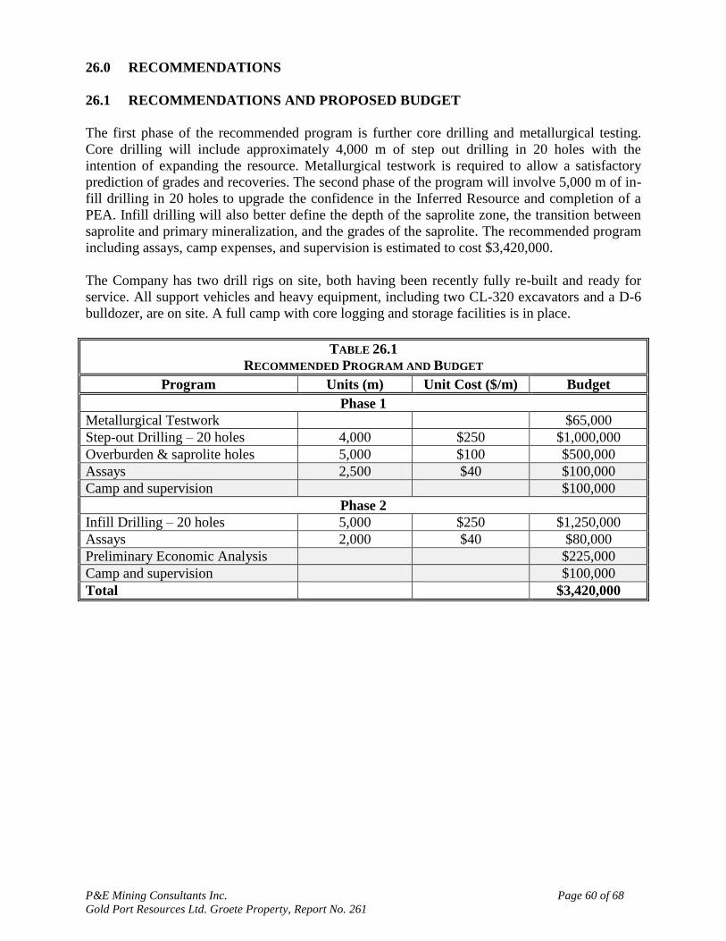
P&E Mining Consultants Inc. Page 60 of 68
Gold Port Resources Ltd. Groete Property, Report No. 261
26.0 RECOMMENDATIONS
26.1 RECOMMENDATIONS AND PROPOSED BUDGET
The first phase of the recommended program is further core drilling and metallurgical testing.
Core drilling will include approximately 4,000 m of step out drilling in 20 holes with the
intention of expanding the resource. Metallurgical testwork is required to allow a satisfactory
prediction of grades and recoveries. The second phase of the program will involve 5,000 m of in-
fill drilling in 20 holes to upgrade the confidence in the Inferred Resource and completion of a
PEA. Infill drilling will also better define the depth of the saprolite zone, the transition between
saprolite and primary mineralization, and the grades of the saprolite. The recommended program
including assays, camp expenses, and supervision is estimated to cost $3,420,000.
The Company has two drill rigs on site, both having been recently fully re-built and ready for
service. All support vehicles and heavy equipment, including two CL-320 excavators and a D-6
bulldozer, are on site. A full camp with core logging and storage facilities is in place.
TABLE 26.1
RECOMMENDED PROGRAM AND BUDGET
Program Units (m) Unit Cost ($/m) Budget
Phase 1
Metallurgical Testwork $65,000
Step-out Drilling – 20 holes 4,000 $250 $1,000,000
Overburden & saprolite holes 5,000 $100 $500,000
Assays 2,500 $40 $100,000
Camp and supervision $100,000
Phase 2
Infill Drilling – 20 holes 5,000 $250 $1,250,000
Assays 2,000 $40 $80,000
Preliminary Economic Analysis $225,000
Camp and supervision $100,000
Total $3,420,000
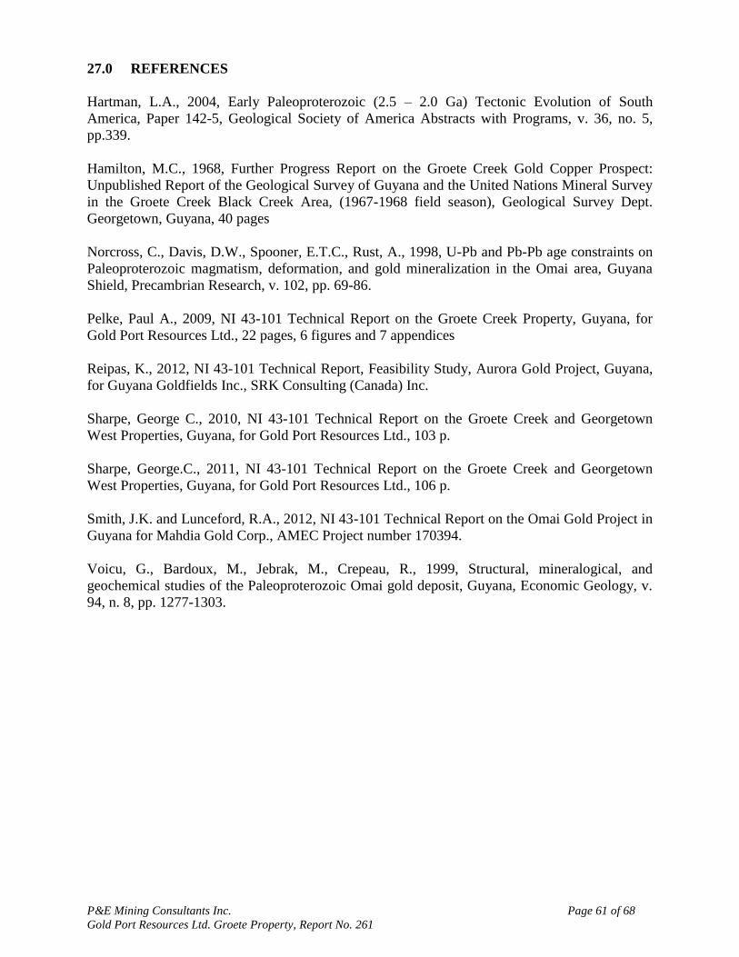
P&E Mining Consultants Inc. Page 61 of 68
Gold Port Resources Ltd. Groete Property, Report No. 261
27.0 REFERENCES
Hartman, L.A., 2004, Early Paleoproterozoic (2.5 – 2.0 Ga) Tectonic Evolution of South
America, Paper 142-5, Geological Society of America Abstracts with Programs, v. 36, no. 5,
pp.339.
Hamilton, M.C., 1968, Further Progress Report on the Groete Creek Gold Copper Prospect:
Unpublished Report of the Geological Survey of Guyana and the United Nations Mineral Survey
in the Groete Creek Black Creek Area, (1967-1968 field season), Geological Survey Dept.
Georgetown, Guyana, 40 pages
Norcross, C., Davis, D.W., Spooner, E.T.C., Rust, A., 1998, U-Pb and Pb-Pb age constraints on
Paleoproterozoic magmatism, deformation, and gold mineralization in the Omai area, Guyana
Shield, Precambrian Research, v. 102, pp. 69-86.
Pelke, Paul A., 2009, NI 43-101 Technical Report on the Groete Creek Property, Guyana, for
Gold Port Resources Ltd., 22 pages, 6 figures and 7 appendices
Reipas, K., 2012, NI 43-101 Technical Report, Feasibility Study, Aurora Gold Project, Guyana,
for Guyana Goldfields Inc., SRK Consulting (Canada) Inc.
Sharpe, George C., 2010, NI 43-101 Technical Report on the Groete Creek and Georgetown
West Properties, Guyana, for Gold Port Resources Ltd., 103 p.
Sharpe, George.C., 2011, NI 43-101 Technical Report on the Groete Creek and Georgetown
West Properties, Guyana, for Gold Port Resources Ltd., 106 p.
Smith, J.K. and Lunceford, R.A., 2012, NI 43-101 Technical Report on the Omai Gold Project in
Guyana for Mahdia Gold Corp., AMEC Project number 170394.
Voicu, G., Bardoux, M., Jebrak, M., Crepeau, R., 1999, Structural, mineralogical, and
geochemical studies of the Paleoproterozoic Omai gold deposit, Guyana, Economic Geology, v.
94, n. 8, pp. 1277-1303.
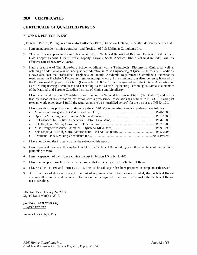
P&E Mining Consultants Inc. Page 62 of 68
Gold Port Resources Ltd. Groete Property, Report No. 261
28.0 CERTIFICATES
CERTIFICATE OF QUALIFIED PERSON
EUGENE J. PURITCH, P. ENG.
I, Eugene J. Puritch, P. Eng., residing at 44 Turtlecreek Blvd., Brampton, Ontario, L6W 3X7, do hereby certify that:
1. I am an independent mining consultant and President of P & E Mining Consultants Inc.
2. This certificate applies to the technical report titled “Technical Report and Resource Estimate on the Groete
Gold Copper Deposit, Groete Creek Property, Guyana, South America” (the “Technical Report”), with an
effective date of January 24, 2013.
3. I am a graduate of The Haileybury School of Mines, with a Technologist Diploma in Mining, as well as
obtaining an additional year of undergraduate education in Mine Engineering at Queen‟s University. In addition
I have also met the Professional Engineers of Ontario Academic Requirement Committee‟s Examination
requirement for Bachelor‟s Degree in Engineering Equivalency. I am a mining consultant currently licensed by
the Professional Engineers of Ontario (License No. 100014010) and registered with the Ontario Association of
Certified Engineering Technicians and Technologists as a Senior Engineering Technologist. I am also a member
of the National and Toronto Canadian Institute of Mining and Metallurgy.
I have read the definition of “qualified person” set out in National Instrument 43-101 (“NI 43-101”) and certify
that, by reason of my education, affiliation with a professional association (as defined in NI 43-101) and past
relevant work experience, I fulfill the requirements to be a “qualified person” for the purposes of NI 43-101.
I have practiced my profession continuously since 1978. My summarized career experience is as follows:
Mining Technologist - H.B.M.& S. and Inco Ltd., ..................................................................... 1978-1980
Open Pit Mine Engineer – Cassiar Asbestos/Brinco Ltd., .......................................................... 1981-1983
Pit Engineer/Drill & Blast Supervisor – Detour Lake Mine, ...................................................... 1984-1986
Self-Employed Mining Consultant – Timmins Area, ................................................................. 1987-1988
Mine Designer/Resource Estimator – Dynatec/CMD/Bharti, .................................................... 1989-1995
Self-Employed Mining Consultant/Resource-Reserve Estimator,.............................................. 1995-2004
President – P & E Mining Consultants Inc, ............................................................................ 2004-Present
4. I have not visited the Property that is the subject of this report.
5. I am responsible for co-authoring Section 14 of the Technical Report along with those sections of the Summary
pertaining thereto.
6. I am independent of the Issuer applying the test in Section 1.5 of NI 43-101.
7. I have had no prior involvement with the project that is the subject of this Technical Report.
8. I have read NI 43-101 and Form 43-101F1. This Technical Report has been prepared in compliance therewith.
9. As of the date of this certificate, to the best of my knowledge, information and belief, the Technical Report
contains all scientific and technical information that is required to be disclosed to make the Technical Report
not misleading.
Effective Date: January 24, 2013
Signed Date: March 6, 2013
{SIGNED AND SEALED}
[Eugene Puritch]
Eugene J. Puritch, P. Eng

P&E Mining Consultants Inc. Page 63 of 68
Gold Port Resources Ltd. Groete Property, Report No. 261
CERTIFICATE OF QUALIFIED PERSON
RICHARD SUTCLIFFE, Ph.D., P. GEO.
I, Richard Sutcliffe, Ph.D., P. Geo., residing at 100 Broadleaf Crescent, Ancaster, Ontario, do hereby certify that:
1. I am an independent geological consultant and Vice President Geology, P&E Mining Consultants Inc.
2. This certificate applies to the technical report titled “Technical Report and Resource Estimate on the Groete
Gold Copper Deposit, Groete Creek Property, Guyana, South America” (the “Technical Report”), with an
effective date of January 24, 2013.
3. I am a graduate of the University of Toronto with a Bachelor of Science degree in Geology (1977). In addition,
I have a Master of Science in Geology (1980) from University of Toronto and a Ph.D. in Geology (1986) from
the University of Western Ontario. I have worked as a geologist for a total of 32 years since obtaining my M.Sc.
degree. I am a geological consultant currently licensed by the Association of Professional Geoscientists of
Ontario (License No 852).
I have read the definition of “qualified person” set out in National Instrument 43-101 (“NI 43-101”) and certify
that, by reason of my education, affiliation with a professional association (as defined in NI 43-101) and past
relevant work experience, I fulfill the requirements to be a “qualified person” for the purposes of NI 43-101.
My relevant experience for the purpose of the Technical Report is:
Precambrian Geologist, Ontario Geological Survey .................................................................. 1980-1989
Senior Research Geologist, Ontario Geological Survey ............................................................ 1989-1991
Associate Professor of Geology, University of Western Ontario. .............................................. 1990-1992
President and CEO, URSA Major Minerals Inc.. ....................................................................... 1992-2012
President and CEO, Patricia Mining Corp.................................................................................. 1998-2008
President and CEO, Auriga Gold Corp. ..................................................................................... 2010-2012
Consulting Geologist .............................................................................................................. 1992-Present
4. I have not visited the Property that is the subject of this report.
5. I am responsible for authoring Sections 2 to 5, 7,8, and 15-26, and of the Technical Report along with those
sections of the Summary pertaining thereto.
6. I am independent of the Issuer applying the test in Section 1.5 of NI 43-101.
7. I have had no prior involvement with the Property that is the subject of this Technical Report.
8. I have read NI 43-101 and Form 43-101F1 and this Technical Report has been prepared in compliance
therewith.
9. As of the date of this certificate, to the best of my knowledge, information and belief, the Technical Report
contains all scientific and technical information that is required to be disclosed to make the Technical Report
not misleading.
Effective Date: January 24, 2013
Signing Date: March 6, 2013
{SIGNED AND SEALED}
[Richard Sutcliffe]
Dr. Richard H. Sutcliffe, P.Geo.

P&E Mining Consultants Inc. Page 64 of 68
Gold Port Resources Ltd. Groete Property, Report No. 261
CERTIFICATE OF QUALIFIED PERSON
WAYNE D. EWERT, P.GEO.
I, Wayne D. Ewert, P. Geo., residing at 10 Langford Court, Brampton, Ontario, L6W 4K4, do hereby certify that:
1. I am a principal of P & E Mining Consultants Inc.
2. This certificate applies to the technical report titled “Technical Report and Resource Estimate on the Groete
Gold Copper Deposit, Groete Creek Property, Guyana, South America” (the “Technical Report”), with an
effective date of January 24, 2013.
3. I graduated with an Honours Bachelor of Science degree in Geology from the University of Waterloo in 1970
and with a PhD degree in Geology from Carleton University in 1977. I have worked as a geologist for a total of
42 years since obtaining my B.Sc. degree. I am a P. Geo., registered in the Province of Saskatchewan (APEGS
No. 16217), the Province of British Columbia (APEGBC No. 18965), the Province of Ontario (APGO No.
0866) and the Province of Newfoundland and Labrador (PEG No. 06005 ).
I have read the definition of “qualified person” set out in National Instrument 43-101 (“NI 43-101”) and certify
that by reason of my education, affiliation with a professional association (as defined in NI 43-101) and past
relevant work experience, I fulfill the requirements to be a “qualified person” for the purposes of NI 43-101.
My relevant experience for the purpose of the Technical Report is:
Principal, P&E Mining Consultants Inc. ..............................................................................2004 – Present
Vice-President, A.C.A. Howe International Limited ............................................................... 1992 – 2004
Canadian Manager, New Projects, Gold Fields Canadian Mining Limited ............................. 1987 – 1992
Regional Manager, Gold Fields Canadian Mining Limited ..................................................... 1986 – 1987
Supervising Project Geologist, Getty Mines Ltd. .................................................................... 1982 – 1986
Supervising Project Geologist III, Cominco Ltd. .................................................................... 1976 – 1982
4. I have not visited the Property that is the subject of this Technical Report.
5. I am responsible for authoring Sections 6, 9 and 10 of this Technical Report along with those sections of the
Summary pertaining thereto.
6. I am independent of the Issuer applying all of the tests in section 1.5 of National Instrument 43-101.
7. I have not had prior involvement with the project that is the subject of this Technical Report.
8. I have read NI 43-101 and Form 43-101F1 and the Technical Report has been prepared in compliance
therewith.
9. As of the date of this certificate, to the best of my knowledge, information and belief, the Technical Report
contains all scientific and technical information that is required to be disclosed to make the Technical Report
not misleading.
Effective Date: January 24, 2013
Signed Date: March 6, 2013
{SIGNED AND SEALED}
[Wayne Ewert]
________________________________
Dr. Wayne D. Ewert P. Geo.
P&E Mining Consultants Inc. Page 65 of 68
Gold Port Resources Ltd. Groete Property, Report No. 261
CERTIFICATE OF QUALIFIED PERSON
FRED H. BROWN, P.GEO.
I, Fred H. Brown, residing at Suite B-10, 1610 Grover St., Lynden WA, 98264 USA, do hereby certify that:
1. I am an independent geological consultant and have worked as a geologist continuously since my graduation
from university in 1987.
2. This certificate applies to the technical report titled “Technical Report and Resource Estimate on the Groete
Gold Copper Deposit, Groete Creek Property, Guyana, South America” (the “Technical Report”), with an
effective date of January 24, 2013.
3. I graduated with a Bachelor of Science degree in Geology from New Mexico State University in 1987. I
obtained a Graduate Diploma in Engineering (Mining) in 1997 from the University of the Witwatersrand and a
Master of Science in Engineering (Civil) from the University of the Witwatersrand in 2005. I am registered with
the South African Council for Natural Scientific Professions as a Professional Geological Scientist (registration
number 400008/04), the American Institute of Professional Geologists as a Certified Professional Geologist
(certificate number 11015) and the Society for Mining, Metallurgy and Exploration as a Registered Member
(#4152172).
I have read the definition of “qualified person” set out in National Instrument 43-101 (“NI 43-101”) and certify
that by reason of my education, affiliation with a professional association (as defined in NI 43-101) and past
relevant work experience, I fulfill the requirements to be a “qualified person” for the purposes of NI 43-101
This report is based on my personal review of information provided by Gold Port and on discussions with its
representatives. My relevant experience for the purpose of the Technical Report is:
Underground Mine Geologist, Freegold Mine, AAC ................................................................. 1987-1995
Mineral Resource Manager, Vaal Reefs Mine, Anglogold......................................................... 1995-1997
Resident Geologist, Venetia Mine, De Beers ............................................................................ 1997-2000
Chief Geologist, De Beers Consolidated Mines ......................................................................... 2000-2004
Consulting Geologist .................................................................................................................. 2004-2008
4. I have not visited the Property that is the subject of this Technical Report.
5. I am responsible for co-authoring Section 14 of this Technical Report along with those sections of the Summary
pertaining thereto.
6. I am independent of the issuer applying the test in Section 1.5 of NI 43-101.
7. I have not had any prior involvement with the Project that is the subject of this Technical Report.
8. I have read NI 43-101 and Form 43-101F1 and the Technical Report has been prepared in compliance
therewith.
9. As of the date of this certificate, to the best of my knowledge, information and belief, the Technical Report
contains all scientific and technical information that is required to be disclosed to make the Technical Report
not misleading.
Effective Date: January 24, 2013
Signed Date: March 6, 2013
{SIGNED AND SEALED}
[Fred H. Brown]
_______________________________
Fred H. Brown P.Geo.
P&E Mining Consultants Inc. Page 66 of 68
Gold Port Resources Ltd. Groete Property, Report No. 261
CERTIFICATE of AUTHOR
TRACY J. ARMSTRONG, P.GEO.
I, Tracy J. Armstrong, residing at 2007 Chemin Georgeville, res. 22, Magog, QC J1X 0M8, do hereby certify that:
1. I am an independent geological consultant contracted by P&E Mining Consultants Inc. and have worked as a
geologist continuously since my graduation from university in 1982.
2. This certificate applies to the technical report titled “Technical Report and Resource Estimate on the Groete
Gold Copper Deposit, Groete Creek Property, Guyana, South America” (the “Technical Report”), with an
effective date of January 24, 2013.
3. I am a graduate of Queen‟s University at Kingston, Ontario with a B.Sc. (HONS) in Geological Sciences
(1982). I am a geological consultant currently licensed by the Order of Geologists of Québec (License 566), the
Association of Professional Geoscientists of Ontario (License 1204) and the Association of Professional
Engineers and Geoscientists of British Columbia, (Licence No. 34720).
I have read the definition of "qualified person" set out in National Instrument 43-101 (NI 43-101) and certify
that by reason of my education and past relevant work experience, I fulfill the requirements to be a "qualified
person" for the purposes of NI 43-101. This report is based on my personal review of information provided by
the Issuer and on discussions with the Issuer‟s representatives. My relevant experience for the purpose of the
Technical Report is:
Underground production geologist, Agnico-Eagle Laronde Mine 1988-1993;
Exploration geologist, Laronde Mine 1993-1995;
Exploration coordinator, Placer Dome 1995-1997;
Senior Exploration Geologist, Barrick Exploration 1997-1998;
Exploration Manager, McWatters Mining 1998-2003;
Chief Geologist Sigma Mine 2003
Consulting Geologist 2003-to present
4. I have not visited the Property that is the subject of this Technical Report.
5. I am responsible for co-authoring of Sections 11 and 12 of this Technical Report along with those sections of
the Summary pertaining thereto.
6. I am independent of issuer applying the test in Section 1.5 of NI 43-101.
7. I have had no prior involvement with the Property that is the subject of this Technical Report.
8. I have read NI 43-101 and Form 43-101F1 and the Technical Report has been prepared in compliance
therewith.
9. As of the date of this certificate, to the best of my knowledge, information and belief, the Technical Report
contains all scientific and technical information that is required to be disclosed to make the Technical Report
not misleading.
Effective Date: January 24, 2013
Signing Date: March 6, 2013
{SIGNED AND SEALED}
[Tracy J. Armstrong]
________________________________
Tracy J. Armstrong, P. Geo.
P&E Mining Consultants Inc. Page 67 of 68
Gold Port Resources Ltd. Groete Property, Report No. 261
CERTIFICATE OF QUALIFIED PERSON
ALFRED S. HAYDEN, P. ENG
I, Alfred S. Hayden, P. Eng., residing at 284 Rushbrook Drive, Newmarket, Ontario, L3X 2C9, do hereby certify
that:
1. I am currently President of:
EHA Engineering Ltd.,
Consulting Metallurgical Engineers
Box 2711, Postal Stn. B.
Richmond Hill, Ontario, L4E 1A7
2. This certificate applies to the technical report titled “Technical Report and Resource Estimate on the Groete
Gold Copper Deposit, Groete Creek Property, Guyana, South America” (the “Technical Report”), with an
effective date of January 24, 2013.
3. I graduated from the University of British Columbia, Vancouver, B.C. in 1967 with a Bachelor of Applied
Science in Metallurgical Engineering. I am a member of the Canadian Institute of Mining, Metallurgy and
Petroleum and a Professional Engineer and Designated Consulting Engineer registered with Professional
Engineers Ontario. I have worked as a metallurgical engineer for a total of 42 years since my graduation from
university.
I have read the definition of “qualified person” set out in National Instrument 43-101 (“NI 43-101”) and certify
that by reason of my education, affiliation with a professional association (as defined in NI 43-101) and past
relevant work experience, I fulfill the requirements to be a “qualified person” for the purposes of NI 43-101.
4. I have not visited the Property that is the subject of this report.
5. I am responsible for authoring of Section 13 of the Technical Report along with those sections of the Summary
pertaining thereto.
6. I am independent of the issuer applying the test in Section 1.5 of NI 43-101.
7. I have had no prior involvement with the Property that is the subject of this Technical Report.
8. I have read NI 43-101 and Form 43-101F1 and the Technical Report has been prepared in compliance
therewith.
9. As of the date of this certificate, to the best of my knowledge, information and belief, the Technical Report
contains all scientific and technical information that is required to be disclosed to make the Technical Report
not misleading.
Effective Date: January 24, 2013
Signing Date: March 6, 2013
{SIGNED AND SEALED}
[Alfred Hayden]
__________________________
Alfred S. Hayden, P.Eng.
P&E Mining Consultants Inc. Page 68 of 68
Gold Port Resources Ltd. Groete Property, Report No. 261
CERTIFICATE OF QUALIFIED PERSON
ANTOINE R. YASSA, P. GEO.
I, Antoine R. Yassa, P. Geo., residing at 3602 Rang des Cavaliers, Rouyn-Noranda, Quebec, J0Z 1Y2, do hereby
certify that:
1. I am an independent geological consultant contracted by P&E Mining Consultants Inc.
2. This certificate applies to the technical report titled “Technical Report and Resource Estimate on the Groete
Gold Copper Deposit, Groete Creek Property, Guyana, South America” (the “Technical Report”), with an
effective date of January 24, 2013.
3. I am a graduate of Ottawa University at Ottawa, Ontario with a B.Sc (HONS) in Geological Sciences (1977). I
have worked as a geologist for a about 32 years since obtaining my B.Sc. degree. I am a geological consultant
currently licensed by the Order of Geologists of Québec (License No 224) and a practising member of the
APGO (Registration Number 1890).
I have read the definition of “qualified person” set out in National Instrument 43-101 (“NI 43-101”) and certify
that, by reason of my education, affiliation with a professional association (as defined in NI 43-101) and past
relevant work experience, I fulfill the requirements to be a “qualified person” for the purposes of NI 43-101.
My relevant experience for the purpose of the Technical Report is:
Minex Geologist (Val d‟Or), 3D Modeling (Timmins), Placer Dome ....................................... 1993-1995
Database Manager, Senior Geologist, West Africa, PDX .......................................................... 1996-1998
Senior Geologist, Database Manager, McWatters Mine ............................................................ 1998-2000
Database Manager, Gemcom modeling and Resources Evaluation (Kiena Mine) QAQC
Manager (Sigma Open pit), McWatters Mines........................................................................... 2001-2003
Database Manager and Resources Evaluation at Julietta Mine, Far-East Russia, Bema Gold
Corporation ................................................................................................................................ 2003-2006
Consulting Geologist ................................................................................................................. since 2006
4. I have visited the Property that is the subject of this Technical Report on November 12 to 16, 2012.
5. I am responsible for co-authoring Sections 11, 12 and 14 of the Technical Report along with those sections of
the Summary pertaining thereto.
6. I am independent of the Issuer applying the test in Section 1.5 of NI 43-101.
7. I have had no prior involvement with the Property that is the subject of this Technical Report.
8. I have read NI 43-101 and Form 43-101F1 and this Technical Report has been prepared in compliance
therewith.
9. As of the date of this certificate, to the best of my knowledge, information and belief, the Technical Report
contains all scientific and technical information that is required to be disclosed to make the Technical Report
not misleading.
Effective Date: January 24, 2013
Signed Date: March 6, 2013
{SIGNED AND SEALED}
[Antoine Yassa]
Antoine R. Yassa, P. Geo.


![Index [msu.edu]Continuing education eWeRt HouSe, eWeRt PlACe, SuMMeRtoWn (off MAP) B1 Continuing education ReWley HouSe, 1 Wellington SquARe B5 Continuing Professional development](https://static.fdocuments.net/doc/165x107/5e718db0c7ad31345e781ee5/index-msuedu-continuing-education-ewert-house-ewert-place-summertown-off-map.jpg)


