Tablelands System Information Pack - Queensland Rail · 2016-10-11 · Queensland Rail does not...
54
Queensland Rail does not warrant the fitness for purpose or accuracy of this information Tablelands System Information Pack Issue 3.0 – October 2016 Page 1 of 54 Tablelands System Information Pack Cairns to Forsayth Normanton to Croydon Version Information Version 3.0: 05/10/2016 • Removed closed lines/systems • Updated References Queensland Rail Network to Queensland Rail • Updated References Queensland Transport to DTMR • Removed references 2005 Access Undertaking • EPA changed to Department • Updated Standards references • Updated Line Diagrams • Updated Climate Information • Updated Track Grade • Updated Network Control Regions & Singalling Centres • Updated Safeworking Systems • Update Noise Management System
Transcript of Tablelands System Information Pack - Queensland Rail · 2016-10-11 · Queensland Rail does not...

Queensland Rail does not warrant the fitness for purpose or accuracy of this information Tablelands System Information Pack
Issue 3.0 – October 2016 Page 1 of 54
Tablelands System Information Pack
Cairns to Forsayth
Normanton to Croydon
Version Information Version 3.0: 05/10/2016
• Removed closed lines/systems • Updated References Queensland Rail Network to Queensland Rail • Updated References Queensland Transport to DTMR • Removed references 2005 Access Undertaking • EPA changed to Department • Updated Standards references • Updated Line Diagrams • Updated Climate Information • Updated Track Grade • Updated Network Control Regions & Singalling Centres • Updated Safeworking Systems • Update Noise Management System

Queensland Rail does not warrant the fitness for purpose or accuracy of this information Tablelands System Information Pack
Issue 3.0 – October 2016 Page 2 of 54
Table of Contents Introduction ...................................................................................................................................................... 4
General Information ......................................................................................................................................... 5
General Climate - Queensland Wide ............................................................................................................... 6 Cyclones ..................................................................................................................................................................... 6
Humidity .................................................................................................................................................................... 6
Rainfall ....................................................................................................................................................................... 6
Temperatures ............................................................................................................................................................ 9
Description of the Railway ............................................................................................................................. 11 Axle Loadings ........................................................................................................................................................... 11
Basic Track Configuration ........................................................................................................................................ 11
Cairns to Kuranda .................................................................................................................................................... 11
Kuranda to Mareeba ................................................................................................................................................ 13
Mareeba to Almaden ............................................................................................................................................... 14
Almaden to Forsayth ................................................................................................................................................ 16
Normanton to Croydon ........................................................................................................................................... 17
Description of the Track ................................................................................................................................. 18
Operational Constraints - Infrastructure ........................................................................................................ 20
Trackside Detection Equipment..................................................................................................................... 20
Weighbridges ................................................................................................................................................. 20
Operational Systems & Train Control ............................................................................................................ 21
Information Systems ...................................................................................................................................... 23
Operational Constraints - Rollingstock ........................................................................................................... 23
Communications ............................................................................................................................................ 23
Sectional Running Times ............................................................................................................................... 24
Incident Recovery Time and Management .................................................................................................... 25
Rail / Road Interfaces .................................................................................................................................... 26
Rail Operations and the Environment ............................................................................................................ 26
Environmental Noise ..................................................................................................................................... 26
Noise Management ....................................................................................................................................... 27
Wheel Squeal & Flanging .............................................................................................................................. 27
Noise Complaints .......................................................................................................................................... 28
Third Party Requirements .............................................................................................................................. 28 Maximum Train Length ........................................................................................................ 29

Queensland Rail does not warrant the fitness for purpose or accuracy of this information Tablelands System Information Pack
Issue 3.0 – October 2016 Page 3 of 54
Rollingstock Braking Rate .............................................................................................................................. 29
Future Infrastructure Improvements .............................................................................................................. 30
Infrastructure Management and Access ........................................................................................................ 30
APPENDIX A ................................................................................................................................................. 31
APPENDIX B ................................................................................................................................................. 37
APPENDIX C ................................................................................................................................................. 42
APPENDIX D ................................................................................................................................................. 44
APPENDIX E ................................................................................................................................................. 47
APPENDIX F ................................................................................................................................................. 52
APPENDIX G ................................................................................................................................................. 53
APPENDIX H ................................................................................................................................................. 54

Queensland Rail does not warrant the fitness for purpose or accuracy of this information Tablelands System Information Pack
Issue 3.0 – October 2016 Page 4 of 54
Introduction The detail provided in this pack relates to infrastructure and operational information necessary to develop a conceptual operating plan/Access Application. It is envisaged that Access Seekers will liaise closely with Queensland Rail to formulate a detailed operating specification as part of a full access agreement negotiation. Operational parameters outlined in this pack may be varied by mutual agreement with Queensland Rail. All railway operators, wishing to operate in Queensland, require Accreditation under the Transport Infrastructure Act 1994 (Qld) and need to consider, but not limited to, the following aspects of typical rail operations:-
• Provisioning, stabling or stowing areas for rollingstock • Train crewing • Safeworking • Training • Route knowledge • Environmental requirements • Track standards • Signalling and traction systems standards and constraints • Safety training • Management of risk • Rollingstock registration and Train authorisation • Legal issues as contained in Queensland Rail’s Access Undertaking, Access
Agreements and information contained in this pack. Operators will be required to have accreditation with the Department of Transport and Main Roads, hold an Access Agreement with Queensland Rail and meet any conditions and precedents specified in the Access Agreement prior to commencing operations. Accreditation means an applicant has confirmed that they are able to meet the requirements to carry out railway operations in Queensland. The Director-General, the Department of Transport and Main Roads, must be satisfied that the applicant has demonstrated:
• Effective management and control of rolling stock • Competence and capacity to manage risks to safety associated with railway operations • Competence and capacity to implement the required safety management system and has
met the legislative requirements • Financial capacity, or public risk insurance arrangements for potential liabilities.
Contact details are:
Customer Services, Safety and Regulation Division: Ph: 07 3066 2689 Email: [email protected] Post: PO Box 673 Fortitude Valley QLD 4006 Web: www.tmr.qld.gov.au Operators need to be aware of and comply with other general legislation such as but not limited to Workplace Health & Safety, Environmental legislation and Heritage legislation.

Queensland Rail does not warrant the fitness for purpose or accuracy of this information Tablelands System Information Pack
Issue 3.0 – October 2016 Page 5 of 54
This package is issued to railway operators as an UNCONTROLLED DOCUMENT and is reviewed annually. It is the onus of railway operators to ensure they are using the current version of this document. This Information Pack is provided for information purposes only and Queensland Rail does not make any representation or warranty, express or implied, as to the accuracy, suitability or completeness of the information. To the extent that any inconsistency arises between this Information Pack and the Access Agreement or Queensland Rail’s Access Undertaking, the provisions of the Access Agreement and Queensland Rail’s Access Undertaking shall prevail.
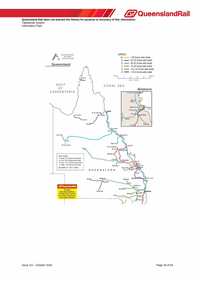
General Information The Tablelands System is located in Northern Queensland between the latitudes 16°49' S and 18°35' S and longitudes 141°04' E and 145°46' E, stretching from the Coral Sea to the Gulf of Carpentaria. There are two distinct railways that comprise the Tablelands System. The first system extends from Cairns on the eastern coast, inland to Forsayth and carries general freight and passenger services. The second system extending from Normanton on the Gulf of Carpentaria, inland to Croydon and carries passengers catering for the tourist industry.
Descriptive distances within this document (unless otherwise stated) are based on physical kilometre posts in the field and are to be used only as location descriptors ie they do not compensate for equalities resulting from deviations. Access charges and performance statistics are generated using actual through distances derived from relevant Working Plan and Sections and reflected on Line Code Diagrams. Generally distances originate from the junction of the branch and commence at 0 km.

Queensland Rail does not warrant the fitness for purpose or accuracy of this information Tablelands System Information Pack
Issue 3.0 – October 2016 Page 6 of 54
General Climate - Queensland Wide The system is situated in north/north-west Queensland and in a generally warm to hot temperature climate. The following sub-sections specify general climatic parameters. For latest and more specific information potential railway operators should consult The Australian Bureau of Meteorology at its Internet Website: http://www.bom.gov.au/climate
Cyclones Tropical lows, which develop from November to April, occasionally deepen to cause tropical cyclones. Tropical cyclones show great variation in behaviour. They foster high winds, heavy, flood-producing rainfall (especially when a cyclone moves over high ground), and coastal storm surges. The high wind risk does not usually extend further inland than 50 km. Inland movement reduces the inflow of moisture and cyclone intensity declines, often within a few hours. Not all cyclones are severe.
Humidity This region could experience prolonged periods of high humidity and potential railway operators should consider this when planning / designing rollingstock and machinery to operate on this rail system.
Rainfall The wettest places in Queensland are located on the tropical coast between Innisfail and Cairns. Highest rainfall occurs on the seaward side of the Great Divide. However, at times in summer the inland extension of low-level moist airflow, in combination with intense surface heating, produces significant thunderstorm activity. Rainfall is mostly confined to summer months in the northern tropics, where in excess of 90% of the annual total is recorded between November and April. In the north, rain is mostly associated with monsoonal troughs. The wet season in Queensland is predominantly from January to April when monthly rain falls of 400 mm or more can occur. Flooding of low lying areas is likely to occur during periods of extreme rainfall, and the Cairns to Forsayth Railway is closed on average for 3 days every year due to flooding, whilst the Normanton to Croydon Railway is closed on average for 6 days every year.

Queensland Rail does not warrant the fitness for purpose or accuracy of this information Tablelands System Information Pack
Issue 3.0 – October 2016 Page 7 of 54

Queensland Rail does not warrant the fitness for purpose or accuracy of this information Tablelands System Information Pack
Issue 3.0 – October 2016 Page 8 of 54

Queensland Rail does not warrant the fitness for purpose or accuracy of this information Tablelands System Information Pack
Issue 3.0 – October 2016 Page 9 of 54
Temperatures The average annual values of the daytime maximum of the hottest (January) and night- time minimum of the coldest (July) months are indicated on the climatic maps. During the period of peak temperature, it may be an operational requirement that Line Speed be reduced to minimise the risk of incident (refer Operational Constraints).

Queensland Rail does not warrant the fitness for purpose or accuracy of this information Tablelands System Information Pack
Issue 3.0 – October 2016 Page 10 of 54

Queensland Rail does not warrant the fitness for purpose or accuracy of this information Tablelands System Information Pack
Issue 3.0 – October 2016 Page 11 of 54
Description of the Railway The track (1067 mm gauge) on the Tablelands System is mix of 47, 41 and nominal 31 and 20 kg/m rails on timber and some steel sleepers.
Axle Loadings Maximum axle loads used throughout this document have been determined by either the track configuration or the railway structures below rail. Railway structures were designed for axle loads, axle spacings and vehicle lengths that produce bending moments roughly equivalent to the moments for metric Cooper’s loadings as follows :-
Maximum axle load Metric Cooper’s Loading 26 tal M 220 20 tal M 160 15.75 tal M 130
With most of this System, the track and structures are rated at a lesser axle load capacity namely, 12.2 tal, 10.62 tal, 8,8 tal and Railmotor.
Basic Track Configuration Basic track configuration is detailed on APPENDIX B - SCHEMATIC LAYOUTS.
Cairns to Kuranda This railway consists of single track and heads north out of Cairns (elevation 3m above mean Sea Level) and traverses the coastal plain until it reaches Redlynch (elevation 10.4m) at the foot of the Lamb Range. The railway then climbs to Barron Falls (elevation 327.7m) a distance of approx. 19 km passing through 15 tunnels, all the time following the Barron Gorge. The run into Kuranda (elevation 329.5 m) is relatively flat. The line travels through the Wet Tropics Region requiring of operators, a greater awareness of environmental issues. Activities within this Wet Tropics Region are subject to the "Wet Tropics World Heritage Protection and Management Act 1993" and should not proceed until the appropriate Licences/Permits/Approvals have been obtained. Structures on the range may be heritage listed. An Over Height Container Detector is located at 8.6 km (refer Trackside Detection Equipment). There are three passing loops on this section namely Redlynch, Stoney Creek and Kuranda. Seismic monitoring of some geologically sensitive areas on the range is being trialled to identify incidents that may impact upon rail operations. Track structure is 41 kg/m rail on timber and steel sleepers with nominal 30 kg/m rail in the mainline at Kuranda.

Queensland Rail does not warrant the fitness for purpose or accuracy of this information Tablelands System Information Pack
Issue 3.0 – October 2016 Page 12 of 54
The maximum allowable axle load is 15.75 tonnes between Cairns and Redlynch. Beyond Redlynch the maximum allowable axle load is 15.75 tonnes for wagons and 12.2 tonnes for locomotives. The maximum speed for traffic between Cairns and Kuranda is 70 km/h, however the Kuranda Range is restricted to a maximum speed of 30 km/h. The maximum grade (not compensated for horizontal alignment) that a westbound (Up) train will encounter is 1 in 48 whilst for an eastbound (Down) train the maximum grade is 1 in 50. Existing minimum nominal horizontal curve radii are as follows :-
Corridor Cairns to Kuranda
System Tablelands No. of Tracks 1 Route km 33.357 Track km 33.357 Electrified No Safeworking System DTC
Control Centre Townsville Crossing Loops No. 3
Location and Length Redlynch (217 m), Stoney Creek (215 m), Kuranda (335 m)
Bridges Timber Number 133 Length (m) 789.7
Steel Number 69 Length (m) 723
Concrete Number 4 Length (m) 33
Tunnels Length (m) Number 15 Length (m) 1745
Curves (% of total track) <80 km/h 55 <60 km/h 45
Level Crossings Public 15 Occupation 4 Flashing Lights 7 Boom Gates 2
Track Structure Rail Mass 41 kg (Cairns- Freshwater),60 AS/63 lb (Freshwater-Redlynch),
41 kg(Redlynch- Kuranda - (5 km 60
AS/63 lb)). Jointed LWR (Cairns-Redlynch),
Bolted(Redlynch-Barron Falls), LWR (Barron
Falls-Kuranda)
Sleeper Type Cairns - Redlynch : 60% T/S 1in4, 40% Timber. Redlynch - 31.25 km :
T/S 1in4 on open curves & straights, T/S 1in2 on
check rail curves. 31.25 km - Kuranda : 100%
Steel
Maximum Allowable Axle Load (tal) 15.75 Route Speed km/h Pass 70
Freight 70 Block 70
Max Container Height - (m) 2.65 Allowable Gross Tonnes p.a.("000") 1,500

Queensland Rail does not warrant the fitness for purpose or accuracy of this information Tablelands System Information Pack
Issue 3.0 – October 2016 Page 13 of 54
running line 80 m Fencing along this corridor complements adjacent land usage and is at the following standard, poor (30 %), medium (50 %) and good (20 %). Fencing will be maintained at its current standard. Description of the Track The track on this system is a mix of nominal 60 kg/m, 53 kg/m, 50 kg/m, 47 kg/m, 41 kg/m and 31 kg/m rail and timber, steel and concrete sleepers on crushed rock ballast. Speeds through the curved leg of turnouts are governed by the angle of that turnout ie. 1 in 12 25 km/h 1 in 16 50 km/h 1 in 25 80 km/h In general, curves (with the exception of turnout curves) are transitioned. Preliminary Track Data and Grade Diagrams for the following major route are included in Appendix E.
Kuranda to Mareeba After leaving Kuranda, the single track railway follows the Barron River to Koah then climbs westerly to Mareeba (elevation 404.5 m above mean Sea Level). There is one passing loop on this section at Koah. Track structure is a mix of 47, 41 and nominal 30 kg/m rails on timber and steel sleepers at a rate of 1 steel in every 4 sleepers.
Corridor Kuranda to Mareeba
System Tablelands No. of Tracks 1 Route km 41.229 Track km 41.229 Electrified No Safeworking System DTC
Control Centre Townsville Crossing Loops No. 1
Location and Length Koah (415 m)
Bridges Timber Number 141 Length (m) 937.3
Steel Number 15 Length (m) 378.9
Concrete Number 0 Length (m) 0
Tunnels Length (m) Number 0 Length (m) 0
Curves (% of total track) <80 km/h 27 <60 km/h 12
Level Crossings Public 7 Occupation 10 Flashing Lights 1 Boom Gates 0

Queensland Rail does not warrant the fitness for purpose or accuracy of this information Tablelands System Information Pack
Issue 3.0 – October 2016 Page 14 of 54
Track Structure Rail Mass 60R lb, 60AS lb, 31 kg, 41 kg, 47 kg
Jointed SWR/LWR (60R lb - 24 m Lengths), (31 kg - 12 & 24 m Lengths), (41 &
47 kg - 19 km (110m lengths))
Sleeper Type T/S 1 in 4
Maximum Allowable Axle Load (tal) 15.75 Route Speed km/h Pass 70
Freight 70 Block 70
Max Container Height - (m) 2.65 Allowable Gross Tonnes p.a.("000") 800
The maximum allowable axle load is 15.75 tonnes for wagons and 12.2 tonnes for locomotives. The maximum speed for traffic is 70 km/h. The maximum grade (not compensated for horizontal alignment) that a westbound (Up) train will encounter is 1 in 50 whilst for an eastbound (Down) train the maximum grade is 1 in 50. Existing minimum nominal horizontal curve radii are as follows:- running line 120 m Fencing along this corridor complements adjacent land usage and is at the following standard, poor or non-existent (80 %), medium (10 %) and good (10 %). Fencing will be maintained at its current standard.
Mareeba to Almaden From Mareeba, the single track railway heads in a south-westerly direction then climbs the Featherbed Range to Lappa (elevation 596.2 m above mean Sea Level) then drops down to Almaden (elevation 493.5 m). Track structure is nominal 30 kg/m rail on timber sleepers. The maximum allowable axle load for traffic between Mareeba and Arriga Junction is 15.75 tonnes for wagons and 12.2 tonnes for locomotives. West of Arriga Junction rail motor axle loads only are permitted. The maximum speed is 70 km/h from Mareeba to Arriga Junction, then 40 km/h to Almaden. The maximum grade (not compensated for horizontal alignment) that a westbound (Up) train will encounter is 1 in 50 whilst for an eastbound (Down) train the maximum grade is 1 in 50. Existing minimum nominal horizontal curve radii are as follows :-

Queensland Rail does not warrant the fitness for purpose or accuracy of this information Tablelands System Information Pack
Issue 3.0 – October 2016 Page 15 of 54
running line 100 m Fencing along this corridor complements adjacent land usage and is at the following standard, poor or non-existent (60 %), medium (30 %) and good (10 %). Fencing will be maintained at its current standard.
Corridor Mareeba to Almaden
System Tablelands No. of Tracks 1 Route km 119.91 Track km 119.91 Electrified No Safeworking System Staff & Ticket
Control Centre Townsville Crossing Loops No. 0
Location and Length -
Bridges Timber Number 309 Length (m) 1910.6
Steel Number 13 Length (m) 316.3
Concrete Number 0 Length (m) 0
Tunnels Length (m) Number 0 Length (m) 0
Curves (% of total track) <80 km/h 30 <60 km/h 19
Level Crossings Public 23 Occupation 38 Flashing Lights 0 Boom Gates 0
Track Structure Rail Mass 30/31 kg
Jointed B
Sleeper Type T, T/S 1in 4 (on a few curves as far as Arriga
Junction)
Maximum Allowable Axle Load (tal) 15.75/12.2/Railmotor Route Speed km/h Pass 70/40
Freight 70/40 Block 70 to Arriga
Max Container Height - (m) 2.65 Allowable Gross Tonnes p.a.("000") 400

Queensland Rail does not warrant the fitness for purpose or accuracy of this information Tablelands System Information Pack
Issue 3.0 – October 2016 Page 16 of 54
Almaden to Forsayth From Almaden, the single track railway heads south west through generally undulating country except for 16 km from Einasleigh where it climbs up and over the Newcastle Range and plateau (Wirra Wirra - elevation 659.6 m) before dropping down the Delaney Creek gorge to Forsayth (elevation 405.1 m). Track structure is a mix of nominal 20 and 30 kg/m rails on predominantly timber sleepers. However some curves on this section have steel sleepers interspersed at 1 in 4. The maximum allowable axle load is that of a railmotor with a maximum allowable line speed of 40 km/h to Mt Surprise and then 30 km/h beyond to Forsayth. The maximum grade (not compensated for horizontal alignment) that a westbound (Up) train will encounter is 1 in 25 whilst for an eastbound (Down) train the maximum grade is 1 in 25. Existing minimum nominal horizontal curve radii are as follows :- running line 100 m
Corridor Almaden to Forsayth
System Tablelands No. of Tracks 1 Route km 229.22 Track km 229.22 Electrified No Safeworking System Staff & Ticket
Control Centre Townsville Crossing Loops No. 1
Location and Length Einasleigh (195 m)
Bridges Timber Number 482 Length (m) 2723.9
Steel Number 6 Length (m) 51
Concrete Number 0 Length (m) 0
Tunnels Length (m) Number 0 Length (m) 0
Curves (% of total track) <80 km/h 31 <60 km/h 19
Level Crossings Public 17 Occupation 4 Flashing Lights 0 Boom Gates 0
Track Structure Rail Mass 41.25 lb/30/31 kg
Jointed B

Queensland Rail does not warrant the fitness for purpose or accuracy of this information Tablelands System Information Pack
Issue 3.0 – October 2016 Page 17 of 54
Sleeper Type T, T/S 1in4 (on the curves)
Maximum Allowable Axle Load (tal) 5 (Railmotor) Route Speed km/h Pass 40/30
Freight 30/25 Block 0
Max Container Height - (m) 2.65 Allowable Gross Tonnes p.a.("000") 50
Fencing along this corridor complements adjacent land usage and is at the following standard, poor or non-existent (80 %), medium (5 %) and good (15 %). Fencing will be maintained at its current standard.
Normanton to Croydon This stand-alone railway provides a railmotor service to the tourist industry in the Gulf territory of north Queensland and comprises single track heading west-north-west from Croydon to Normanton on the coast. There are no passing loops. Track structure is nominal 20 kg/m on steel and timber sleepers. The predominant sleeper type being the original steel sleepers used during construction of the railway circa 1888. These steel sleepers were of hollow section, filled with clay, overcoming the need for ballast and were laid on the "surface formation" minimising the need for earthworks. Timber sleepers are used as replacements. The maximum allowable axle load is 8.8 tal with a maximum allowable line speed of 40 km/h. The maximum grade (not compensated for horizontal alignment) that an eastbound (Up) train will encounter is 1 in 66 whilst for a westbound (Down) train the maximum grade is 1 in 66, both grades occurring after leaving Croydon. Elsewhere on the railway, grades are relatively flat. Existing minimum nominal horizontal curve radii are as follows :- running line 400 m
Corridor Normanton to Croydon
System Tablelands No. of Tracks 1 Route km 152.58 Track km 152.58 Electrified No Safeworking System Local Operating
Procedures Control Centre Local Crossing Loops No. 0
Location and Length
Bridges Timber Number 10 Length (m) 58.4
Steel Number 81 Length (m) 509.6
Concrete Number 0

Queensland Rail does not warrant the fitness for purpose or accuracy of this information Tablelands System Information Pack
Issue 3.0 – October 2016 Page 18 of 54
Length (m) 0 Tunnels Length (m) Number 0
Length (m) 0 Curves (% of total track) <80 km/h 1
<60 km/h 0 Level Crossings Public 9
Occupation 12 Flashing Lights 0 Boom Gates 0
Track Structure Rail Mass 41.25 lb, 42 lb
Jointed B
Sleeper Type S, T(where the steel sleepers have corroded)
Maximum Allowable Axle Load (tal) 8.8 Route Speed km/h Pass 40
Freight 0 Block 0
Max Container Height - (m) 2.65 Allowable Gross Tonnes p.a.("000") 50
This corridor is fenced between Normanton and Blackbull.
Description of the Track The track structure on this system is a mix of 47, 41 and nominal 31 and 20 kg/m rails on timber and steel sleepers with a variety of ballast materials including rock, gravel and sand. Steel sleepers are generally interspersed at 1 in 4 with the exception of Normanton to Croydon. The rails are a combination of short, short welded (SWR) and long welded (LWR) all bolted. Throughout the Queensland Rail network, speeds through the curved leg of turnouts are governed by the angle of that turnout ie.
1 in 25 80 km/h
1 in 16 50 km/h
1 in 12 (tangential ) 40 km/h
all other 25 km/h
In general, curves (with the exception of turnout curves) are transitioned. Preliminary Track Data and Grade Diagrams for the following major route are included in Appendix E.
Queensland Rail does not warrant the fitness for purpose or accuracy of this information Tablelands System Information Pack
Issue 3.0 – October 2016 Page 19 of 54

Queensland Rail does not warrant the fitness for purpose or accuracy of this information Tablelands System Information Pack
Issue 3.0 – October 2016 Page 20 of 54
Operational Constraints - Infrastructure During the summer months of high temperatures, hot weather precautions for track stability are observed to reduce the risk of incident in accordance with Safety Management Standard MD-10-143 Hot Weather Precautions for Track Stability, namely :-
Air Temperature 38°C and above - On timber sleepered track, restrict trains to 60 km/h (#)
On concrete sleepered track, restrict all trains to 120 km/h
Air Temperature 40°C and above - On timber sleepered track, restrict
trains to 40 km/h (#)
On concrete sleepered track, restrict all trains to 60 km/h
(#) Steel sleepered track and timber sleepered track with interspersed steel sleepers shall be regarded as equivalent to timber sleepered track for track stability. Speed restrictions may also be put in place after maintenance activities in accordance with Queensland Rail Safety Standards. The extent of restriction will depend upon the type of maintenance activity and risk of track misalignments. Force Majeure Events will also see the imposition of speed restrictions, the extent and severity of the restrictions being dependent on the event.
Trackside Detection Equipment Over Height Container Detector and Signals Located at 8.6 km with associated two aspect Red/Green Signal at 9.9 km on the Cairns to Redlynch section, to detect containers over 2.65 m in height. Over height containers, once identified are detached at Redlynch.
Weighbridges There are no weighbridges on this System as described herein.

Queensland Rail does not warrant the fitness for purpose or accuracy of this information Tablelands System Information Pack
Issue 3.0 – October 2016 Page 21 of 54
Operational Systems & Train Control The Tablelands System is operated by Direct Traffic Control (DTC) between Cairns and Mareeba and Staff and Ticket west of Mareeba with train movements controlled from Townsville. Normanton to Croydon is operated by Staff and Ticket (Local operating procedures).

Queensland Rail does not warrant the fitness for purpose or accuracy of this information Tablelands System Information Pack
Issue 3.0 – October 2016 Page 22 of 54

Queensland Rail does not warrant the fitness for purpose or accuracy of this information Tablelands System Information Pack
Issue 3.0 – October 2016 Page 23 of 54
Information Systems ViziRail is the key software system designed as a tool for use in integrated scheduling, possession planning, monitoring and reporting on the Queensland Rail network. Functionality includes modules: • Train notices • Actual train running (ATR) • Incidents • Train consists (Train Builder) • Speed restrictions • Rollingstock allocations • Rollingstock maintenance • Fresh turnouts • Planning graphs • Scheduling enhancements • Possession enhancements • OTIS (Operational to Information Systems) - which converts train steps to actual arrival and
departure train information.
Operational Constraints - Rollingstock All new rollingstock requires to be accepted via the Rollingstock Authorisation Process, rollingstock which conforms with Drawing Nos. 2236 may operate in an unrestricted manner on main lines. For rollingstock to conform with Drawing Nos. 2236 the static rollingstock profile must be within the diagram, refer APPENDIX H - Rollingstock Gauges. As well as the static component, dynamic effects need to be considered and these effects are contained within Rollingstock Interface Standards. Rollingstock not conforming to these drawings may be accepted via the Rollingstock Authorisation Process and may be operated subject to constraints / limitations imposed as a result of the Authorisation Process. Potential railway operators should ensure that they have the latest revision of these drawings before the planning and construction of rollingstock.
Communications Communications on the Tablelands System (Cairns to Forsayth) between Driver and Controller is via a UHF radio system (Train Control Radio - TCR) utilising Queensland Rail channels 81 (Vote group comprising channels 21, 22 and 23) and 83 (Vote group comprising channels 27, 28 and 29). The extent of network coverage for DTC Territory being Level 3 and for Staff and Ticket Territory being Level 4 as per Queensland Rail Standard MD-10-114 (refer APPENDIX A - Definitions). Control phones are located at Staff Stations only.

Queensland Rail does not warrant the fitness for purpose or accuracy of this information Tablelands System Information Pack
Issue 3.0 – October 2016 Page 24 of 54
The frequency specifications for the train radio are :-
Access to the Maintenance Supervisory Radio System (MSR) can be gained by using the following Queensland Rail telephone extensions depending on location. The UHF TCR between Mareeba and Forsayth is also accessible via a commercial telephone network. In addition, all locomotives carry and all new locomotives to the System will be required to carry Wayside communication via Channel 1 (TX 411.375 MHz and RX 411.375 MHz which provides end to end, train to train and train to Track Gangs over a distance on average of 8 - 10 km. All train and maintenance radios utilise mobile to base subaudio of 162.2 Hz. The Normanton to Croydon Railway being stand-alone, the Officer-In-Charge communicates with both Townsville Control and Maintenance Gangs via mobile satellite telephones. Communications on board locomotives must conform to Queensland Rail’s Safety and Security Standard MD-10-86 - Mobile Voice Radio Communications Systems.
Sectional Running Times The sectional running times, expressed as minutes, for various types of trains currently operating on the system are contained in APPENDIX F. The sectional running times are “Pass to Pass” times for a running move and do not reflect acceleration and deceleration characteristics of trains. Sectional running times are provided for two (2) types of locomotive-hauled trains - passenger and container (inter-modal).
CHANNEL 81 Channel 21 Channel 22 Channel 23
TX 408.650 MHz TX 408.675 MHz TX 408.700 MHz
RX 418.100 MHz RX 418.125 MHz RX 418.150 MHz
CHANNEL 83 Channel 27 Channel 28 Channel 29
TX 409.250 MHz TX 409.300 MHz TX 409.350 MHz
RX 418.700 MHz RX 418.750 MHz RX 418.800 MHz

Queensland Rail does not warrant the fitness for purpose or accuracy of this information Tablelands System Information Pack
Issue 3.0 – October 2016 Page 25 of 54
Proposed train configurations would need to be confirmed by the relevant operator against the infrastructure constraints to determine if the sectional running times can be achieved. If the sectional running times cannot be achieved then different arrangements, including for access charges, may need to be negotiated as part of the access agreement negotiations. Changes to the sectional running times for the system are also possible over time. Any changes would be confirmed as part of the access agreement negotiations. Trains travelling south to Brisbane are travelling in the Up Direction whilst trains travelling north to Cairns are travelling in the Down Direction.
Incident Recovery Time and Management Historically it is anticipated that on the Tablelands System a minor incident could result in disruption to services for 6 hours and a major incident for 2 days. Incident recovery is dependent on the nature, severity and location of each unique incident that may occur on this system. The Normanton to Croydon Railway is prone to flooding for lengthy periods during the cyclone season. To enable quick response in case of emergency, latitudes and longitudes of passing loops are detailed below:
Location Cairns
Latitude
16° 55' S
Longitude
145° 46' E Redlynch Stoney Creek Kuranda Koah Mareeba Atherton Dimbulah Almaden Lyndbrook Mt Surprise Einasleigh Forsayth
16° 53' S 16° 53' S 16° 49' S 16° 48' S 16° 59' S 17° 16' S 17° 09' S 17° 20' S 17° 50' S 18° 08' S 18° 30' S 18° 35' S
145° 41' E 145° 39' E 145° 38' E 145° 30' E 145° 25' E 145° 28' E 145° 06' E 144° 40' E 144° 26' E 144° 18' E 144° 05' E 143° 36' E
Croydon Blackbull Glenore Normanton
18° 12' S 17° 57' S 17° 49' S 17° 40' S
142° 14' E 141° 45' E 141° 07' E 141° 04' E

Queensland Rail does not warrant the fitness for purpose or accuracy of this information Tablelands System Information Pack
Issue 3.0 – October 2016 Page 26 of 54
Rail / Road Interfaces Operators on the Tablelands System will encounter 159 Rail / Road Interfaces (see Appendix C for details) categorised as follows:-
Public (Active with Flashing Light/Boom Gate Protection) - 14 Public (with Passive Protection - Signs) - 76 Occupation (Private Access) - 80
Rail Operations and the Environment All railway operators are required to comply with all relevant State, Federal and Local Legislation and Laws, current at the time, relating to the management and protection of the Environment. Queensland Rail currently has a number of licences and/or approvals for activities undertaken at either Queensland Rail facilities or on the Queensland Rail corridor. Queensland Rail’s licences and approvals fall under two main areas: 1. Fixed Locations;
Queensland Rail has a number of licences for activities managed by its operational Business Groups in particular locations, such as refuelling locations. 2. Itinerant or Varied Locations;
Queensland Rail also has a number of licences for activities that occur at more than one location, such as maintenance activities. Railway operators will need to ascertain with the Department of Environment and Heritage Protection or Other Regulatory Body their responsibilities in regard to obtaining an Environmental Authority(ies) for the type of operation proposed. Copies of all Environmental Authorities administered by the Department within Queensland are available upon request from the Department. The Department of Environment and Heritage Protection contact details can be found via the web at https://www.ehp.qld.gov.au/
Environmental Noise The Environmental Protection (Noise) Policy (EPP Noise) recognises a railway as a beneficial asset, which is necessary for the community’s environmental, social and economic well-being. The Environmental Protection (Noise) Policy is available from the Office of the Queensland Parliamentary Council website at http://www.legislation.qld.gov.au/OQPChome.htm

Queensland Rail does not warrant the fitness for purpose or accuracy of this information Tablelands System Information Pack
Issue 3.0 – October 2016 Page 27 of 54
The EPP Noise nominates “planning levels” for railway noise which may be used as a guide in deciding a reasonable noise level for the activity. The EPP Noise recognises, however, those levels may not be appropriate for an existing railway. It envisages that it may be reasonable to apply the levels only in the long term to allow time to progressively reduce any significantly adverse effects on the environmental values from its operation. The long term planning levels are:
They are to be assessed one (1) metre in front of the most exposed part of the building facade of an affected noise sensitive place.
Noise Management While noise from the operation of a railway is exempt from environmental nuisance provisions under the Queensland Environment Protection Act 1994, Queensland Rail strives to manage noise associated with both its rail operations and network wherever reasonable and practical.
As the rail manager, Queensland Rail works closely with customers regarding environmental issues, and provides feedback to Rail Operators to allow them to investigate and address as applicable, noise related issues that may be associated with their locomotives and wagons.
There are various sources of noise from a railway and to aid efficient and effective noise reduction, a range of noise management measures are utilised by Queensland Rail. These are detailed at:
http://www.queenslandrail.com.au/inthecommunity/environment/noisemanagement
Wheel Squeal & Flanging Wheel Squeal is caused by friction forces between the top of rail and wheel interface. Whereas, flanging noise is predominantly caused by friction forces between the side of rail and wheel interface. Continuous or sustained wheel squeal produced primarily on the low rail side, is distinct from discontinuous “flanging noise” that is produced on the high rail side. Continuous wheel squeal is of a high level, and Queensland Rail’s experience is that it may cause significant community reaction, while flanging noise is of a lower level and is more accepted by the community. Generally, tighter radius curves (i.e. under 300 metre radius) when associated with a number of rollingstock factors that promote wheel squeal, may result in squeal being produced. Rollingstock factors that may promote wheel squeal include:
• Higher wheel hardness • Stiff primary suspensions • High centre plate friction

Queensland Rail does not warrant the fitness for purpose or accuracy of this information Tablelands System Information Pack
Issue 3.0 – October 2016 Page 28 of 54
• Worn wheel treads • Misaligned axles • Unmatched wheel tread diameters, and • Incorrectly adjusted sidebearers
Noise Complaints Queensland Rail is corporately committed to act towards its neighbours in a considerable and reasonable manner. This good neighbour commitment assumes a reasonable degree of tolerance from neighbours and a commitment by Queensland Rail to take action where appropriate. Where Queensland Rail receives complaints about noise from railway activities for which Queensland Rail may be responsible, Queensland Rail responds to those complaints and maintains records of those complaints in accordance with its Environmental Management System (EMS). Where available, generic data will be supplied on request to a third party operator who is proposing operations within a defined network. That data will indicate those areas where Queensland Rail has received prior complaints relating to its train operations. It will be made available when a third party operator is undertaking the development of its Environmental Investigation and Risk Management Report as part of its Access Agreement conditions.
Third Party Requirements Any railway operator obtaining access to Queensland Rail’s Network shall be required to commission an environmental investigation of the proposed operations. This investigation will be conducted by a suitably qualified person, reasonably acceptable to both parties. In response to the findings of such an investigation, the operator shall produce an Environmental Investigation and Risk Management Report that identifies the risks of Environmental Harm associated with the operation and provides proposed controls to address the risks. This shall be reviewed by, and agreed with, Queensland Rail. In addition, the operator shall have in place an EMS, which, amongst other things, has regard for the issues, risk and control measures identified in the Environmental Investigation and Risk Management Report. Further details on requirements for environmental issues can be found in Queensland Rail’s Access Undertaking. Queensland Rail has determined that it holds no EMS documentation that, without disclosure to a third party operator, would either:
• Compromise or restrict a third party’s operations or increase or place at risk the environmental performance of the third party operator or itself, and
• Limit or restrict the abilities of a third party operator to develop such
documentation that would not be reasonably expected of the operator to develop on its own behalf, commensurate with the size and subsequent environmental risks of the proposed operations and the organisational resources available to it, to undertake such operations.

Queensland Rail does not warrant the fitness for purpose or accuracy of this information Tablelands System Information Pack
Issue 3.0 – October 2016 Page 29 of 54
Any EMS documentation (wholly or partially) identified as specifically relating to the control of corridor infrastructure (below rail) environmental issues, will be made available to the operator to assist in formulating appropriate and consistent operational (above rail) controls within their Environmental Investigation and Risk Management Report and EMS.
Maximum Train Length
The maximum length of trains is determined by:
• requirements for crossing/passing other trains • requirements for braking performance of the train • capacity of the route • drawgear capacity • train handling • requirements for road/pedestrian access across the track
Where it is necessary for a train to cross, pass or be passed by another train, the maximum train length allowable shall be such that the comparison train length (including allowance for stretching and train handling) is not longer than the crossing loop length. Crossing loops on the Tablelands System vary in length as listed below:
Redlynch 217 m Stoney Creek 215 m Kuranda 335 m Koah 415 m Einasleigh 195 m
Crossing loop length is the maximum length in metres of the train which can be accommodated in the loop to allow normal operation of the signalling systems for crossing or passing movements.
Variations of train length for a particular train configuration is possible and would need to be negotiated as part of access agreement negotiations. Variations of train length for a particular train configuration are possible and would need to be negotiated as part of access agreement negotiations.
Rollingstock Braking Rate The signalling system and flashing light protection at rail / road interfaces has been designed to cater for the variety of trains that currently use this system. Signal design parameters and train braking characteristics will be compared during the development of the Interface Risk Management Plan.

Queensland Rail does not warrant the fitness for purpose or accuracy of this information Tablelands System Information Pack
Issue 3.0 – October 2016 Page 30 of 54
Future Infrastructure Improvements No major infrastructure improvements identified
Infrastructure Management and Access APPENDIX B - SCHEMATIC LAYOUT is colour coded to indicate Management of Infrastructure and Access. Third party access to non-Queensland Rail managed infrastructure is by commercial arrangement with the relevant party. The initial point of contact for Queensland Rail managed below rail assets is: General Manager Access Revenue Level 9 | 305 Edward Street Brisbane Qld 4001 Telephone 61 07 3072 1145 Facsimile 61 07 3072 8248 Email: [email protected]

Queensland Rail does not warrant the fitness for purpose or accuracy of this information Tablelands System Information Pack
Issue 3.0 – October 2016 Page 31 of 54
APPENDIX A Definitions (Statewide) Access Agreement Access Agreement means an agreement between Queensland Rail and an Access Holder for the provision of Access. Access Undertaking A document approved by the Queensland Competition Authority (QCA) in accordance with the QCA Act 1997 (Q) that sets out principles for negotiating access to Queensland Rail’s declared services. Accreditation Accreditation in accordance with part 4, Chapter 6 of the Transport Infrastructure Act 1994 (Qld) and “Accredited” has a similar meaning. ATP (Automatic Train Protection) Automatic Train Protection is a computer controlled system designed to make sure the train
• does not exceed the current speed limit • does not exceed the limit of authority generated by the interlocking (and usually indicated
by a signal at STOP) • does not make unreasonable train movements during shunting, when stationary, or at
startup AWS (Automatic Warning System) Automatic Warning System is designed to
• provide an in-cab visible and audible indication of the aspect displayed in the next signal • prompt and warn the train driver of a RESTRICTED signal aspect displayed in the next
signal • stop the train if the driver fails to acknowledge the AWS alarm of a RESTRICTED signal
aspect Axle Counters At some locations in Remote Controlled Signalling (RCS) Territory an axle counter system has been provided to detect occupancy of a section of track. An axle counter at each end of a section determines whether an axle is entering or leaving the section and counts the number of axles passing the counter in each direction. By keeping an accurate count of axles into the section, then the number of axles out of the section, the system can determine if the section is occupied or not.

Queensland Rail does not warrant the fitness for purpose or accuracy of this information Tablelands System Information Pack
Issue 3.0 – October 2016 Page 32 of 54
Block Train A train consisting entirely of similar classes of wagons of axle loads over 12.2 tonnes marshalled together for a certain class of traffic. The definition is also extended to cover trains in which 12 or more such wagons loaded to more than 12.2 tonnes gross per axle are included within a length of 315 metres or less of the train. Crossing Loop Length The maximum length in metres of the train which can be accommodated in the loop to allow normal operation of the signalling systems for crossing or passing movements. Daily Train Plan (DTP) Collectively, the scheduled times for all Train Services operating on Queensland Rail’s Rail Infrastructure and any Planned Possession on a particular day. Declared Services Services declared as available for access by third party operators in accordance with the QCA Act 1997 (Q). Declared Infrastructure Infrastructure declared as available for access by third party operators in accordance with the QCA Act 1997 (Q). Design Neutral Temperature The rail temperature at which the track is designed to be stress free as defined in Queensland Rail’s Civil Engineering Publication #26 “Rail Stressing Manual”. Direct Traffic Control (DTC) Direct Traffic Control (DTC) is an absolute block safeworking system used to control the movement of trains in non-signalled territory. Central to DTC is an on-board DTC computer which displays authorities stored in its database. The relevant authority is activated by the train crew following an exchange of codes between the crew and the controller. Codes are exchanged verbally using the train control radio. The procedures governing the operation of DTC are detailed in Queensland Rail’s Standard MD-10-113 “Direct Traffic Control Manual”. Dragging Equipment Detectors (DED) A mechanism positioned on sections of track to detect any dragging equipment on train.

Queensland Rail does not warrant the fitness for purpose or accuracy of this information Tablelands System Information Pack
Issue 3.0 – October 2016 Page 33 of 54
Dragging Equipment Detectors Alarm (DED Alarm) Part of the Queensland Rail System which advises the Train Controller either by a computer prompt message that a D.E.D. has been activated and the train driver by a recorded voice message. Electromagnetic Compatibility (EMC) The ability of an equipment or system to function satisfactorily in its electromagnetic environment without introducing intolerable electromagnetic disturbances to anything in that environment. Electric Train Staff A ‘token’ system of train working between Interlockings on single lines in non track- circuited areas, where release of a token is controlled by electrically connected and interlocked instruments. EPP (Noise) Environmental Protection (Noise) Policy 1997; Subordinate Legislation to the Queensland Environmental Protection Act 1994. Force Majeure Event Means any cause, event or circumstance, or combination of causes, events or circumstances, which is beyond the reasonable control of the Party affected thereby and which by the exercise of due diligence such Party is not reasonably able to prevent or overcome, including but not limited to, results of abnormal weather conditions, act of God, breakdown of any facilities or machinery or unavailability of essential equipment, strikes or other industrial dispute. Hot Wheel & Bearing Detectors (HWD/HBD) Heat sensors located at strategic locations on the system that identify abnormal temperatures in wheels and wheel bearings as the train passes over, transmits a signal to the train control panel that necessitates an inspection of the suspect wagon and remedial action Line Code Line Code, a unique alpha-numeric identifier applied to a section of track on Queensland Rail’s network and usually run from junction point to junction point. Each numeric identifier is unique and can be further rolled up into Corridors using the alpha identifier. LWR Long welded rail. Rail that has mechanical rail joints spaced at intervals between 110m and 220m.

Queensland Rail does not warrant the fitness for purpose or accuracy of this information Tablelands System Information Pack
Issue 3.0 – October 2016 Page 34 of 54
LSC Line Section Code, a unique alpha-numeric identifier applied to a section of Queensland Rail’s network. Master Train Plan (MTP) Collectively, the scheduled times as advised by Queensland Rail from time to time for all Train Services operating on Queensland Rail’s Rail Infrastructure where such scheduled times remain unchanged from week to week, and any Planned Possessions. Nominal Rail Size Rail sizes 20, 31 and 41 kg/m are all nominal rail sizes used to group together a range of rail types and sizes originally designated in the imperial unit “lb/yd”. The term “nominal” is used in recognition of the variation in the dimensions, mass and engineering properties of the rails in this category. Ordinary Staff and Ticket Working A token based system of safeworking where the movement of trains on bi-directional single lines is on possession of a staff token or ticket. Each section of single line has a unique token. Staff & Ticket The Staff and Ticket System allows for the movement of trains over a bidirectional track. The Staff and Ticket System operates (in accordance with Queensland Rail’s Standard MD-10-114) on the principle of absolute block working, which provides that only one train will be authorised to be on any one section at any one time. Railway Operator A person who has, or is seeking, Access from Queensland Rail to operate Train Services on the Rail Infrastructure and who is, or who will become, Accredited in respect of those Train Services. Remote Controlled Signalling (RCS) A system of Safeworking where train movements are governed by aspects displayed in Colour Light Signals which are controlled from a remote location and by the passage of trains. Some colour light signals and points may be released by the Train Controller to be operated from a local area by using:
• a local control panel; • an electrically released shunting frame; • a zone released shunting system, or • emergency push buttons.

Queensland Rail does not warrant the fitness for purpose or accuracy of this information Tablelands System Information Pack
Issue 3.0 – October 2016 Page 35 of 54
Railway Operators trains are expected to meet existing signalling standards to ensure track circuits and other signalling equipment operate safely and effectively - in particular Queensland Rail’s Standard MD-10-76 “Principles for the Signalling of Trains” must be complied with. Rollingstock Authorisation Process The process for determining and validating rollingstock compliance and registration as detailed in Queensland Rail’s Standard MD-10-140 - Rollingstock Validation, Acceptance and Registration Remote Train Overview Application (RTOA) A PC based system providing real time operational information, gathering information on train running and rail network status for immediate and continuously updated display and historical analysis. Being a multi-tier client-server application, different levels of access/security ensure confidentiality of an Operator’s train performance statistics. SN Speed Boards Speed Normal Boards are speed boards that place the onus on the Driver of a train to travel at speeds considered safe for that section of track being travelled over. These boards are gradually being phased out in accordance with Queensland Rail’s Civil Standard MD-10-87 - SPEED BOARDS Standard Train The predominant type of train operating on the line/system. SWR Short welded rail. Rail that has mechanical rail joints spaced at intervals less than 110m. Train Authorisation The process for acceptance of a train configuration whose rollingstock is registered under Queensland Rail’s Standard MD-10-140 - Rollingstock Validation, Acceptance and Registration. Train Length The total length in metres of a train including the locomotives. For the purposes of comparison with the length of crossing loops, an addition of 1% (1 metre for every 100 metres) shall be allowed to the calculated length of the train to allow for train stretching. Unit Train A train composed entirely of the one class and one drawgear classification of rollingstock.

Queensland Rail does not warrant the fitness for purpose or accuracy of this information Tablelands System Information Pack
Issue 3.0 – October 2016 Page 36 of 54
Universal Traffic Control (UTC) A PC based train control supervisory system that provides the means to remotely control train movements over a large area and provide management and train users with real time train related information. ViziRail A fully integrated scheduling, possession planning, monitoring and reporting tool for managing the Queensland Rail below-rail network. ViziRail also supports the provision of all QCA and the Department of Transport and Main Roads reporting requirements. Weather Monitoring System (WMS) Remote weather monitoring stations providing critical information regarding temperature, rainfall and stream levels. Wheel Impact Load Detector (WILD) In track monitoring system to identify wheel flats.

Queensland Rail does not warrant the fitness for purpose or accuracy of this information Tablelands System Information Pack
Issue 3.0 – October 2016 Page 37 of 54
APPENDIX B Schematic Layout

Queensland Rail does not warrant the fitness for purpose or accuracy of this information Tablelands System Information Pack
Issue 3.0 – October 2016 Page 38 of 54

Queensland Rail does not warrant the fitness for purpose or accuracy of this information Tablelands System Information Pack
Issue 3.0 – October 2016 Page 39 of 54

Queensland Rail does not warrant the fitness for purpose or accuracy of this information Tablelands System Information Pack
Issue 3.0 – October 2016 Page 40 of 54

Queensland Rail does not warrant the fitness for purpose or accuracy of this information Tablelands System Information Pack
Issue 3.0 – October 2016 Page 41 of 54

Queensland Rail does not warrant the fitness for purpose or accuracy of this information Tablelands System Information Pack
Issue 3.0 – October 2016 Page 42 of 54
APPENDIX C Rail/Road Interface Details
CAIRNS RAILWAY
697 0.21 APLIN STREET Public Level Boomgates Open MRD 697 0.46 FLORENCE STREET Public Level Boomgates PWB Open MRD 697 0.73 MINNIE STREET Public Level Signs X S Open LGA 697 0.98 UPWARD STREET Public Level Signs X S Open LGA 697 1.5 GROVE STREET Public Level Signs X S Open LGA 697 2.15 JAMES STREET Public Level Flashing Lights Open MRD 697 2.98 ARTHUR STREET Public Level Flashing Lights PWB Open LGA 697 3.456 COLLINS AVENUE Public Level Flashing Lights Open LGA 697 4.275 AEROGLEN DRIVE Public Level Flashing Lights Open LGA 697 5.479 WHITFIELD STREET Public Level Flashing Lights Open LGA 697 7.3 GREENBANK ROAD Public Level Flashing Lights Open LGA 697 8.26 Occupation Signs X G Open PRI 697 9.35 ANDEE JACK'S ROAD Public Level Signs X G Open MRD 697 10.1 LOWER FRESHWATER ROAD Public Level Signs X T Open LGA 697 11.675 KAMERUNGA ROAD Public Level Flashing Lights PWB Open MRD 697 12.8 Occupation Open 697 13.31 SHAWS RD Public Level Signs X S Open LGA 697 15.14 Occupation Open 697 31.35 Occupation Open 698 42.25 Public Level Signs X G Open MRD 698 44.17 OAK FOREST ROAD Public Level Signs X S Open MRD 698 45.37 McCORRY ROAD Occupation Signs X G Open PRI 698 50.406 KOAH ROAD Occupation Signs X G Open PRI 698 51.54 BRAY ROAD Occupation Signs X G Open PRI 698 55.52 QR Nil Open QR 698 55.8 Occupation Signs X T Open PRI 698 57.2 Occupation Signs X T Open PRI 698 60.45 QR Nil Open QR 698 64.34 Public Level Signs X T Open LGA 698 65.18 Occupation Signs X T Open PRI 698 65.72 Occupation Signs X S Open PRI 698 66.18 Public Level Signs X T Open LGA 698 67.71 Occupation Signs X T Open PRI 698 72.08 Mt. MOLLOY HIGHWAY Public Level Signs X T Open MRD 698 73.59 MAREEBA-DIMBULAH ROAD Public Level Flashing Lights PWB Open MRD 698 74.26 KEEBLE STREET Public Level Signs X S Open MRD

Queensland Rail does not warrant the fitness for purpose or accuracy of this information Tablelands System Information Pack
Issue 3.0 – October 2016 Page 43 of 54
699 74.994 RANKIN STREET Public Level Signs X G Open MRD 699 75.77 BASALT STREET Public Level Signs X G Open MRD 699 76.31 COSTIN STREET Public Level Signs X G Open MRD 699 77.288 McIVER ROAD (RYE ROAD) Public Level Signs X T Open MRD 699 78.397 MINES ROAD Public Level Signs X T Open LGA 699 79.488 Occupation Signs X T Open PRI 699 81.057 GALLO ROAD Public Level Signs X G Open MRD 699 83.225 KENNEDY HIGHWAY Public Level Flashing Lights Open MRD 699 84.45 KENNEDY HWY Public Level Flashing Lights X S Open 699 84.703 TURKENGEE ROAD Occupation Signs X T Open PRI 699 86.46 HENERY HANNAN DRIVE Occupation Signs X T Open PRI 699 90.606 ORAN ROAD Public Level Signs X T Open LGA 699 92.5 CARBEEN ROAD Public Level Signs X T Open LGA 699 94.49 Occupation Signs X T Open PRI 699 94.55 Occupation Signs X T Open PRI 699 95.515 POULTRY FARM ACCESS ROAD Occupation Signs X T Open PRI 699 96.664 KENNEDY HIGHWAY Public Level Flashing Lights Open MRD 699 98.062 FRASER ROAD (ROCCA ROAD) Public Level Signs X T Open MRD 699 99.828 Occupation Signs X T Open PRI 699 101.165 MARANE ROAD Public Level Signs X T Open LGA 699 102.276 RACE TRACK ROAD Occupation Signs X T Open PRI 699 103.115 KENNEDY HIGHWAY Public Level Flashing Lights Open MRD 699 103.582 MAIN STREET Public Level Signs X T Open MRD 699 104.578 BEAN TREE CREEK ROAD Public Level Signs X G T Open LGA 699 105.95 MANTHEY ROAD Public Level Signs X G Open LGA 699 107.71 GROVE STREET Public Level Signs X S G Open MRD 699 108.174 KENNEDY HWY (GOLF LINKS
ROAD) Public Level Signs X T Open MRD
NORMANTON RAILWAY
704 0.2 Public Level Open 704 0.47 Public Level Open 704 0.85 Public Level Open 704 1.5 Public Level Open 704 4.1 Occupation Open 704 4.25 Occupation Open 704 5.2 Occupation Open 704 6.1 Public Level Open 704 7.6 Public Level Open 704 22.25 Occupation Open 704 24.5 Public Level Open 704 63.1 Public Level Open 704 78.6 Public Level Open 704 81.7 Occupation Open 704 91.1 Occupation Open 704 112.52 Occupation Open 704 128.915 Occupation Open 704 139.37 Occupation Open 704 143.17 Occupation Open 704 147.32 Occupation Open 704 151.42 Occupation Open
Queensland Rail does not warrant the fitness for purpose or accuracy of this information Tablelands System Information Pack
Issue 3.0 – October 2016 Page 44 of 54
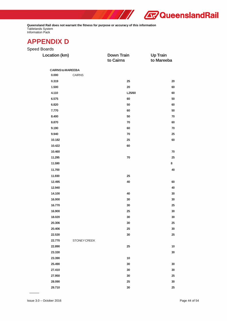
APPENDIX D Speed Boards
Location (km) Down Train Up Train to Cairns to Mareeba
CAIRNS to MAREEBA
0.000 CAIRNS
0.319 25 20
1.500 20 60
4.110 L25/60 60
6.575 60 50
6.820 50 60
7.770 60 50
8.400 50 70
8.870 70 60
9.190 60 70
9.940 70 25
10.182 25 60
10.422 60
10.460 70
11.295 70 25
11.590 8
11.700 40
11.930 25
12.495 40 60
12.940 40
14.100 40 30
16.000 30 30
16.770 30 25
16.900 25 30
18.020 30 30
20.306 30 25
20.406 25 30
22.530 30 25
22.770 STONEY CREEK
22.890 25 10
23.330 30
23.390 10
25.490 30 30
27.410 30 30
27.950 30 25
28.090 25 30
29.710 30 25

Queensland Rail does not warrant the fitness for purpose or accuracy of this information Tablelands System Information Pack
Issue 3.0 – October 2016 Page 45 of 54
Location (km) Down Train Up Train to Cairns to Mareeba
29.840 25 30
31.300 30 50
32.440 40
32.900 40 10
33.240 KURANDA
33.450 10 60
34.030 60
35.020 50 40
35.720 40 60
36.690 60 60
36.920 60 60
37.730 60
38.890 60 40
38.990 40 60
39.490 60 60
39.850 60 40
40.340 40 50
41.300 50 40
41.510 40 60
41.740 60 60
42.270 60 30
42.510 30 60
42.860 60 60
43.450 60 60
43.500 60 60
44.560 60 60
44.710 60 40
45.110 40 30
45.290 30 40
46.860 40 60
47.430 60 50
47.870 50 40
48.010 40 60
49.130 60 60
49.660 60 50
50.105 50 60
50.350 L25
50.550 KOAH
51.011 R25
51.110 60
51.440 60 60

Queensland Rail does not warrant the fitness for purpose or accuracy of this information Tablelands System Information Pack
Issue 3.0 – October 2016 Page 46 of 54
Location (km) Down Train Up Train to Cairns to Mareeba
51.780 60 50
51.910 50 60 52.960 60 60 53.500 60 50 53.730 50 60
54.500 60 50
54.630 50 50
56.010 50 60
58.700 60 60
59.300 60 40
59.550 40 60
60.100 60 60
65.976 60 L25/60
66.150 BIBOOHRA
66.440 R25/60 60
74.200 60 25
74.470 MAREEBA
MAREEBA to FORSAYTH Maximum speed allowable speed is 40 km/hr to Mt Surprise and 30 km/hr to Forsayth with speed boards erected where track geometry warrants reduction. NORMANTON to CROYDON Maximum speed allowable speed is 40 km/hr with speed boards erected where track geometry warrants reduction.

Queensland Rail does not warrant the fitness for purpose or accuracy of this information Tablelands System Information Pack
Issue 3.0 – October 2016 Page 47 of 54
APPENDIX E Track Data & Grade Diagrams

Queensland Rail does not warrant the fitness for purpose or accuracy of this information Tablelands System Information Pack
Issue 3.0 – October 2016 Page 48 of 54

Queensland Rail does not warrant the fitness for purpose or accuracy of this information Tablelands System Information Pack
Issue 3.0 – October 2016 Page 49 of 54

Queensland Rail does not warrant the fitness for purpose or accuracy of this information Tablelands System Information Pack
Issue 3.0 – October 2016 Page 50 of 54

Queensland Rail does not warrant the fitness for purpose or accuracy of this information Tablelands System Information Pack
Issue 3.0 – October 2016 Page 51 of 54

Queensland Rail does not warrant the fitness for purpose or accuracy of this information Tablelands System Information Pack
Issue 3.0 – October 2016 Page 52 of 54
APPENDIX F Sectional Running Times
The sectional running times listed below are for a standard trains. On the Tablelands System, standard trains are deemed typical of the freight trains currently operating on the system. New trains or train configuration changes would need to be checked by the relevant operator against the infrastructure constraints to determine if these running times can be achieved. FREIGHT TRAVELTRAIN
UP DOWN UP DOWN
From To P/P P/S S/P S/S P/P P/S S/P S/S P/P P/S S/P S/S P/P P/S S/P S/S
Cairns Edgehill 9 11 12 14 9 11 12 14 10 11 12 13 9 10 11 12
Edgehill Freshwater 10 12 13 15 10 12 13 15 11 12 13 14 11 12 13 14
Freshwater Redlynch 4 6 7 9 4 6 7 9 3 4 5 6 3 4 5 6
Redlynch Stoney Creek 35 37 38 40 40 42 43 45 28 29 30 31 26 27 28 29
Stoney Creek Barron Falls 22 24 25 27 30 32 33 35 25 26 27 28 23 24 25 26
Barron Falls Kuranda 8 10 11 13 8 10 11 13 2 3 4 5 2 3 4 5
Kuranda Koah 23 25 26 28 30 32 33 35 26 27 28 29 26 27 28 29
Koah Biboohra 13 15 16 18 15 17 18 20 15 16 17 18 15 16 17 18
Biboohra Mareeba 17 19 20 22 20 22 23 25 15 16 17 18 15 16 17 18
Mareeba Arriga Junction 35 37 38 40 35 37 38 40 27 28 29 30 27 28 29 30
Arriga Junction Dimbulah 50 52 53 55 45 47 48 50 30 31 32 33 30 31 32 33
Dimbulah Verdue 44 46 47 49 44 46 47 49 40 41 42 43 40 41 42 43
Verdue Lappa 61 63 64 66 61 63 64 66 40 41 42 43 40 41 42 43
Lappa Almaden 65 67 68 70 70 72 73 75 62 63 64 65 60 61 62 63
Almaden Gelaro 28 29 30 31 44 45 46 47
Gelaro Bullock Creek 30 31 32 33 40 41 42 43
Bullock Creek Lyndbrook 30 31 32 33 40 41 42 43
Lyndbrook Frewhurst 30 31 32 33 40 41 42 43
Frewhurst Mt Surprise 29 30 31 32 43 44 45 46
Mt Surprise Einasleigh 162 163 164 165 102 103 104 105
Einasleigh Forsayth 177 178 179 180 162 163 164 165

Queensland Rail does not warrant the fitness for purpose or accuracy of this information Tablelands System Information Pack
Issue 3.0 – October 2016 Page 53 of 54
APPENDIX G
Altitudes
Location Cairns
Altitude in metres
3 Redlynch 10 Stoney Creek 205 Kuranda 329 Koah 363 Biboohra 391 Mareeba 404
Tabacum 501 Dimbulah 462 Verdure 480 Lappa 596 Almaden 493
Ootaan 445 Gelaro 514 Bullock Creek 447 Lyndbrook 436 Fossilbrook 460 Frewhurst 506 Mount Surprise 455 Einsaleigh 452 Wirra-Wirra 660 Forsayth 404
Tolga 750 Atherton 752
Normanton 12 Clarina 6 Glenore 8 Haydon 31 Blackbull 53 Croydon 112

Queensland Rail does not warrant the fitness for purpose or accuracy of this information Tablelands System Information Pack
Issue 3.0 – October 2016 Page 54 of 54
APPENDIX H Rollingstock Gauges