
Synthesis of Unit Hydrographs from a Digital Elevation Model THEODORE G. CLEVELAND, AND XIN HE...
39
Synthesis of Unit Hydrographs from a Synthesis of Unit Hydrographs from a Digital Elevation Model Digital Elevation Model THEODORE G. CLEVELAND, AND XIN HE THEODORE G. CLEVELAND, AND XIN HE University of Houston, Houston, Texas 77204 University of Houston, Houston, Texas 77204 Phone: 713 743-4280, Fax: 713-743-4260 Phone: 713 743-4280, Fax: 713-743-4260 Email: [email protected]; [email protected] Email: [email protected]; [email protected] XING FANG XING FANG Lamar University, Beaumont, Texas 77710-0024 Lamar University, Beaumont, Texas 77710-0024 Phone: 409 880-2287, Fax: 409 880-8121 Phone: 409 880-2287, Fax: 409 880-8121 Email: [email protected] Email: [email protected] DAVID B. THOMPSON DAVID B. THOMPSON R.O. Anderson Inc., Minden, Nevada R.O. Anderson Inc., Minden, Nevada (formerly Associate Professor, Texas Tech (formerly Associate Professor, Texas Tech University) University) Email: [email protected] Email: [email protected]
-
Upload
rudolf-bradford -
Category
Documents
-
view
215 -
download
0
Transcript of Synthesis of Unit Hydrographs from a Digital Elevation Model THEODORE G. CLEVELAND, AND XIN HE...

Synthesis of Unit Hydrographs from a Digital Elevation Synthesis of Unit Hydrographs from a Digital Elevation ModelModel
THEODORE G. CLEVELAND, AND XIN HETHEODORE G. CLEVELAND, AND XIN HEUniversity of Houston, Houston, Texas 77204University of Houston, Houston, Texas 77204
Phone: 713 743-4280, Fax: 713-743-4260Phone: 713 743-4280, Fax: 713-743-4260Email: [email protected]; [email protected]: [email protected]; [email protected]
XING FANGXING FANGLamar University, Beaumont, Texas 77710-0024Lamar University, Beaumont, Texas 77710-0024
Phone: 409 880-2287, Fax: 409 880-8121Phone: 409 880-2287, Fax: 409 880-8121Email: [email protected]: [email protected]
DAVID B. THOMPSONDAVID B. THOMPSONR.O. Anderson Inc., Minden, NevadaR.O. Anderson Inc., Minden, Nevada
(formerly Associate Professor, Texas Tech University)(formerly Associate Professor, Texas Tech University)Email: [email protected]: [email protected]

AcknowledgementsAcknowledgements
Texas Department of Transportation:Texas Department of Transportation: Transportation research projects 0-Transportation research projects 0-
4193, 0-4194, and 0-4696.4193, 0-4194, and 0-4696. David Stolpa, P.E., Jaime E. Villena, David Stolpa, P.E., Jaime E. Villena,
P.E., and George R. Herrmann, P.E., P.E., and George R. Herrmann, P.E., P.H. P.H.
U.S. Geologic Survey:U.S. Geologic Survey: Dr. William Asquith, P.G., Meghan Dr. William Asquith, P.G., Meghan
Roussel, P.E., and Amanda GarciaRoussel, P.E., and Amanda Garcia

DisclaimerDisclaimer
The contents do not reflect the The contents do not reflect the official view or policies of the Texas official view or policies of the Texas Department of Transportation Department of Transportation (TxDOT). (TxDOT).
This paper does not constitute a This paper does not constitute a standard, specification, or standard, specification, or regulation.regulation.

Background and Background and SignificanceSignificance
Unit hydrograph (UH) methods are used by Unit hydrograph (UH) methods are used by TxDOT (and others) to obtain peak TxDOT (and others) to obtain peak discharge and hydrograph shape for discharge and hydrograph shape for drainage design.drainage design. Drainage areas too large for rational methods.Drainage areas too large for rational methods. For drainage areas small enough for lumped-For drainage areas small enough for lumped-
parameter model.parameter model. Generally on un-gaged watersheds.Generally on un-gaged watersheds.
Estimating the time-response Estimating the time-response characteristics of a watershed is characteristics of a watershed is fundamental in rainfall-runoff modeling.fundamental in rainfall-runoff modeling.

Timing ParametersTiming Parameters The time-response characteristics of the The time-response characteristics of the
watershed frequently are represented by watershed frequently are represented by two conceptual time parameters, time of two conceptual time parameters, time of concentration (concentration (TcTc) and time to peak () and time to peak (TpTp). ). TcTc is typically defined as the time required is typically defined as the time required
for runoff to travel from the most distant for runoff to travel from the most distant point along a pathline in the watershed to point along a pathline in the watershed to the outlet. the outlet.
TpTp is defined as the time from the beginning is defined as the time from the beginning of direct runoff to the peak discharge value of direct runoff to the peak discharge value of a unit runoff hydrograph. of a unit runoff hydrograph.

SchematicSchematic Loss modelLoss model
Account for Account for portion of portion of rainfall that rainfall that becomes becomes available for available for runoff.runoff.
UH modelUH model Temporal Temporal
redistribution redistribution of the available of the available excess excess precipitation at precipitation at the outlet.the outlet.
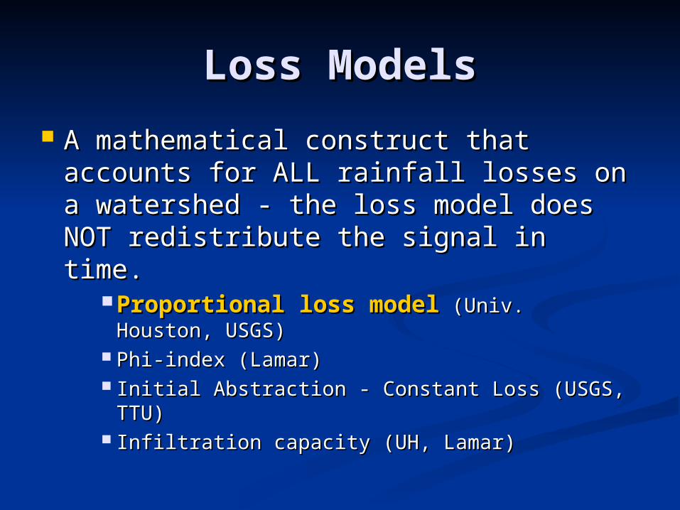
Loss ModelsLoss Models
A mathematical construct that A mathematical construct that accounts for ALL rainfall losses on a accounts for ALL rainfall losses on a watershed - the loss model does watershed - the loss model does NOT redistribute the signal in time.NOT redistribute the signal in time.
Proportional loss modelProportional loss model (Univ. (Univ. Houston, USGS)Houston, USGS)
Phi-index (Lamar)Phi-index (Lamar) Initial Abstraction - Constant Loss (USGS, Initial Abstraction - Constant Loss (USGS,
TTU)TTU) Infiltration capacity (UH, Lamar)Infiltration capacity (UH, Lamar)

UH ModelsUH Models
A mathematical construct that A mathematical construct that accounts for temporal accounts for temporal redistribution of the excess (after redistribution of the excess (after loss) rainfall signal. loss) rainfall signal.
Gamma unit hydrograph (USGS, Lamar)Gamma unit hydrograph (USGS, Lamar) Discrete unit hydrographs (Lamar, TTU)Discrete unit hydrographs (Lamar, TTU) Generalized gamma and Generalized gamma and geomorphic geomorphic IUHIUH (UH). (UH).

Estimating Timing Estimating Timing ParametersParameters
AnalysisAnalysis Use actual rainfall and runoff data for a Use actual rainfall and runoff data for a
watershed.watershed. SynthesisSynthesis
Absence of data, sub-watershed, etc. Absence of data, sub-watershed, etc. Variety of formulas for timing parameters:Variety of formulas for timing parameters:
Characteristic lengthCharacteristic length Characteristic slopeCharacteristic slope Flow regimes (overland, concentrated, channel)Flow regimes (overland, concentrated, channel) Friction, conveyance, land type, etc.Friction, conveyance, land type, etc.
Loss modelsLoss models

Estimating Timing Estimating Timing ParametersParameters
Representative Representative formulas:formulas: Overland Flow:Overland Flow:

Estimating Timing Estimating Timing ParametersParameters
Representative Representative formulas:formulas: Channel FlowChannel Flow

Estimating Timing Estimating Timing ParametersParameters
The formulas beg the questions:The formulas beg the questions: Which “lengths, slopes, friction factors” Which “lengths, slopes, friction factors”
?? What is “bankful discharge” on an What is “bankful discharge” on an
ungaged watershed ?ungaged watershed ? Which “paths” to examine ?Which “paths” to examine ?

Statistical-Mechanical Statistical-Mechanical HydrographHydrograph
Leinhard (1964) postulated that the unit Leinhard (1964) postulated that the unit hydrograph is a raindrop arrival time hydrograph is a raindrop arrival time distribution.distribution.

Statistical-Mechanical Statistical-Mechanical HydrographHydrograph
Further Assumed:Further Assumed: The arrival time of a raindrop is proportional to The arrival time of a raindrop is proportional to
the distance it must travel, the distance it must travel, ll.. The number of drops arriving at the outlet in a The number of drops arriving at the outlet in a
time interval is proportional to the square of time interval is proportional to the square of travel time (and travel time (and l l 2 2 ).).
By enumerating By enumerating allall possible arrival time possible arrival time histograms, and selecting the most probable histograms, and selecting the most probable from maximum likelihood arrived at a probability from maximum likelihood arrived at a probability distribution that represents the temporal distribution that represents the temporal redistribution of rainfall on the watershed.redistribution of rainfall on the watershed.

Statistical-Mechanical Statistical-Mechanical HydrographHydrograph
Resulting distribution is a generalized gamma distribution.Resulting distribution is a generalized gamma distribution.
The distribution parameters have physical significance.The distribution parameters have physical significance. is a mean residence time of a raindrop on the watershed.is a mean residence time of a raindrop on the watershed. nn, is an accessibility number, related to the exponent on the distance-, is an accessibility number, related to the exponent on the distance-
area relationship (a shape parameter). area relationship (a shape parameter). , is the degree of the moment of the residence time; , is the degree of the moment of the residence time; =1=1 is an arithmetic mean time is an arithmetic mean time =2=2 is a root-mean-square time is a root-mean-square time
rmt
⎥⎥
⎦
⎤
⎢⎢
⎣
⎡
⎟⎟⎠
⎞⎜⎜⎝
⎛−⎟
⎟⎠
⎞⎜⎜⎝
⎛⎟⎟⎠
⎞⎜⎜⎝
⎛Γ
=−
rm
n
rmrm
n
t
tn
t
t
t
n
ntf exp
1
)()(
1

Statistical-Mechanical Statistical-Mechanical HydrographHydrograph
Conventional Formulation:Conventional Formulation:
prm Tn
nt
1
1⎟⎠⎞
⎜⎝⎛
−=)( pp TfQ =
⎥⎥
⎦
⎤
⎢⎢
⎣
⎡
⎟⎟
⎠
⎞
⎜⎜
⎝
⎛−⎟
⎟⎠
⎞⎜⎜⎝
⎛−−⎟
⎟⎠
⎞⎜⎜⎝
⎛=
−
11
exp
1 β
β p
n
pp T
tn
T
t
Q
Q
Estimating Timing Estimating Timing ParametersParameters
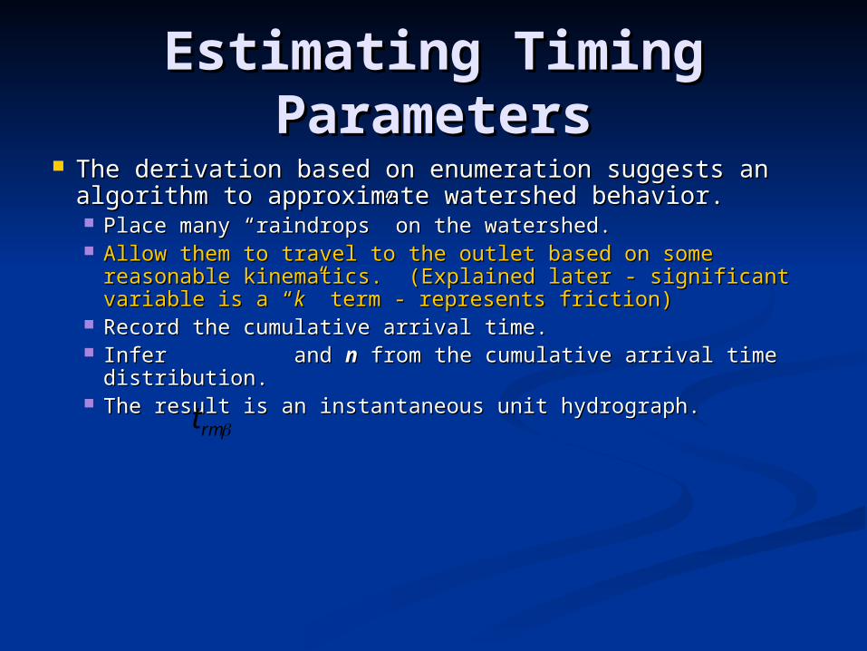
The derivation based on enumeration suggests an The derivation based on enumeration suggests an algorithm to approximate watershed behavior.algorithm to approximate watershed behavior. Place many “raindrops” on the watershed.Place many “raindrops” on the watershed. Allow them to travel to the outlet based on some Allow them to travel to the outlet based on some
reasonable kinematics. (Explained later - significant reasonable kinematics. (Explained later - significant variable is a “variable is a “kk” term - represents friction)” term - represents friction)
Record the cumulative arrival time.Record the cumulative arrival time. Infer and Infer and nn from the cumulative arrival time from the cumulative arrival time
distribution. distribution. The result is an instantaneous unit hydrograph.The result is an instantaneous unit hydrograph.rmt

Estimating Timing Estimating Timing ParametersParameters
Illustrate with Ash Creek WatershedIllustrate with Ash Creek Watershed Calibration watershed – the “Calibration watershed – the “kk” term ” term
was selected by analysis of one storm was selected by analysis of one storm on this watershed, and applied to all on this watershed, and applied to all developeddeveloped watersheds studied. watersheds studied.
About 7 square miles. (20,000+ About 7 square miles. (20,000+ different “paths”)different “paths”)

Ash Creek WatershedAsh Creek Watershed(sta08057320)(sta08057320)

Ash Creek WatershedAsh Creek Watershed(sta08057320)(sta08057320)

Ash Creek WatershedAsh Creek Watershed(sta08057320)(sta08057320)
Estimating Timing Estimating Timing ParametersParameters
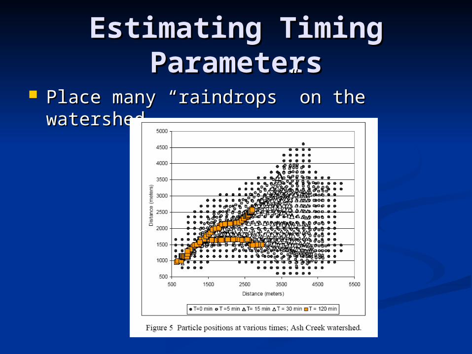
Place many “raindrops” on the Place many “raindrops” on the watershed.watershed.

Estimating Timing Estimating Timing ParametersParameters
Allow them to travel to the outlet based Allow them to travel to the outlet based on some reasonable kinematics.on some reasonable kinematics. Path determined by 8-cell pour point model.Path determined by 8-cell pour point model. Speed from quadratic-type drag, Speed from quadratic-type drag, kk selected selected
to “look” like a Manning’s equation.to “look” like a Manning’s equation.
)(
2 *)()(ξξ
ξξddz
kuu =⋅
3
25.1d
nk
f
=

Estimating Timing Estimating Timing ParametersParameters
Allow them to travel Allow them to travel to the outlet based to the outlet based on some reasonable on some reasonable kinematics.kinematics. Path determined by 8-Path determined by 8-
cell pour point model.cell pour point model. Speed from local Speed from local
topographic slope topographic slope and and kk
Each particle has a Each particle has a unique pathline. unique pathline.
Pathlines converge at Pathlines converge at outlet.outlet.

Estimating Timing Estimating Timing ParametersParameters
Record the cumulative arrival Record the cumulative arrival time.time.

Estimating Timing Estimating Timing ParametersParameters
Infer and Infer and nn from the cumulative arrival from the cumulative arrival time distribution. time distribution.
rmt
0
0.1
0.2
0.3
0.4
0.5
0.6
0.7
0.8
0.9
1
0 20 40 60 80 100 120 140 160
Time (min)
Washout Fraction
0
0.002
0.004
0.006
0.008
0.01
0.012
0.014
0.016
Rate (in/min)
Leinhard Hydrograph
Empirical S -Curve Hydrograph
Cumulative Leinhard
Hydrograph

Estimating Timing Estimating Timing ParametersParameters
The result is an The result is an instantaneous unit instantaneous unit hydrograph (IUH).hydrograph (IUH).
IUH and observed storm to IUH and observed storm to produce simulated runoff produce simulated runoff hydrograph.hydrograph.
The The kk is adjusted, particle is adjusted, particle tracking repeated until the tracking repeated until the observed and simulated observed and simulated hydrographs are the same.hydrographs are the same.
This This kk value is then used for all value is then used for all watersheds.watersheds.
Only change from watershed Only change from watershed to watershed is topographic to watershed is topographic data (elevation maps)data (elevation maps)

Estimating Timing Estimating Timing ParametersParameters
Typical resultTypical result Ash Creek Ash Creek
WatershedWatershed May 1978 stormMay 1978 storm IUH from the IUH from the
calibrated June calibrated June 1973 storm.1973 storm.

Estimating Timing Estimating Timing ParametersParameters
Typical resultTypical result Ash Creek Ash Creek
WatershedWatershed May 1978 stormMay 1978 storm IUH from the IUH from the
calibrated June calibrated June 1973 storm.1973 storm.

Study WatershedsStudy Watersheds
Study WatershedsStudy Watersheds 130+ watersheds130+ watersheds
2600 paired rainfall-runoff events studied. 2600 paired rainfall-runoff events studied. (Data base now has over 3,400 storms)(Data base now has over 3,400 storms)
Most stations have 5 or more storms, some Most stations have 5 or more storms, some nearly 50 events.nearly 50 events.
Watershed boundaries, etc. determined by Watershed boundaries, etc. determined by several methods.several methods.
Using the single value of “Using the single value of “kk” determined on ” determined on the Ash Creek calibration event, applied the the Ash Creek calibration event, applied the particle tracking approach to allparticle tracking approach to all developed developed watersheds. A second value of “watersheds. A second value of “kk” for ” for undevelopedundeveloped watersheds is obtained from watersheds is obtained from Little Elm watershed in an identical fashion.Little Elm watershed in an identical fashion.

Illustrative Results Illustrative Results (GIUH)(GIUH)
Peak Peak comparison.comparison.
Bias (low)Bias (low) ““kk” value ” value
same all same all developed.developed.
““kk” value ” value same all same all undeveloped.undeveloped.

Illustrative Results Illustrative Results (CONV)(CONV)

Development DistinctionDevelopment Distinction
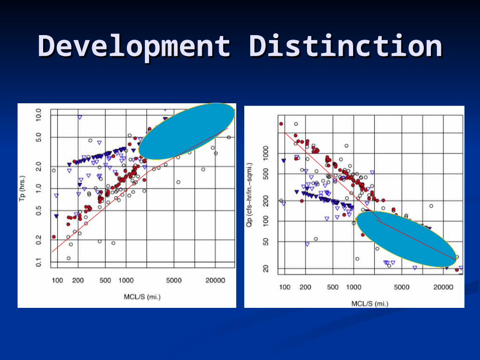
Development DistinctionDevelopment Distinction

Quantitative ResultsQuantitative Results
Comparison to other methodsComparison to other methods

ConclusionsConclusions
The terrain-based generates The terrain-based generates qualitatively acceptable runoff qualitatively acceptable runoff hydrographs from minimal physical hydrographs from minimal physical detail of the watershed. detail of the watershed.
The approach simulated episodic The approach simulated episodic behavior at about the same order of behavior at about the same order of magnitude as observed behavior, magnitude as observed behavior, without any attempt to account for without any attempt to account for land use.land use.

ConclusionsConclusions
For the watersheds studied, For the watersheds studied, topography is a significant factor topography is a significant factor controlling runoff behavior and controlling runoff behavior and consequently the timing parameters consequently the timing parameters common in all hydrologic models.common in all hydrologic models.

PublicationsPublications http://library.ctr.utexas.edu/dbtw-wpd/textbase/http://library.ctr.utexas.edu/dbtw-wpd/textbase/
websearchcat.htm (Search for authors: Asquith; websearchcat.htm (Search for authors: Asquith; Roussel; Thompson; Fang; or Cleveland).Roussel; Thompson; Fang; or Cleveland).
http://cleveland1.cive.uh.edu/publications http://cleveland1.cive.uh.edu/publications (selected papers on-line).(selected papers on-line).
http://infotrek.er.usgs.gov/pubs/ (Search for http://infotrek.er.usgs.gov/pubs/ (Search for author Asquith; Roussel)author Asquith; Roussel)
http://www.techmrt.ttu.edu/reports.php (Search http://www.techmrt.ttu.edu/reports.php (Search for author Thompson)for author Thompson)
http://ceserver.lamar.edu/People/fang/http://ceserver.lamar.edu/People/fang/research.htmlresearch.html


