SUGGESTIONS FOR THE WUA STRATEGY IN WSSP …€¦ · 1. Introduction This report summarizes...
28
SUGGESTIONS FOR THE WUA STRATEGY IN WSSP December 2010
-
Upload
doankhuong -
Category
Documents
-
view
221 -
download
1
Transcript of SUGGESTIONS FOR THE WUA STRATEGY IN WSSP …€¦ · 1. Introduction This report summarizes...

SUGGESTIONS FOR THE WUA STRATEGY IN WSSP December 2010
Summary of main points This report describes the strategy for WUA development in WSSP and in particular NIP. There is with WSSP and NIP a ‘golden opportunity’ to move local water management substantially farther. Several of the ingredients for a successful move to local water management are there:
Over the last ten years several projects have supported the development of WUAs – though the sustainability of these appears variable there is now a large institutional basis for local management of water resources
There are now a large number of areas where water users themselves have spontaneously formulated rule on groundwater use
Recently the bye-law for WUAs is endorsed providing a stepping stone A Union of WUAs has formed – creating opportunities for farmer-driven
development, particularly if aligned with basin management under the Basin Water Management Committees.
The further development of sustainable WUAs should not be seen as a project activity but as a national program – with WUA being in place for a long time to come – to manage water and to improve agricultural livelihoods. The report recommends the following: Apply the byelaws. Byelaws have been under discussion for a considerable period and they
were issued and approved only very recently by the Ministery of Water and Environment. It
will be useful know to popularize them and start working with them – and then assess their strong and weak points and ways to make use of the provisions.
Develop a register of WUAs. WUGs and WUOs. It is important to create an overview of WUA – where they are and what is their status. This could also be used to encourage the WUAs to register themselves under the provision of the new law. Activate the role of WUAs and WUOs in local ground water management. This is already happening – with several examples of drinking water WUOs setting restrictions on groundwater development, but should be systematically incorporated in the IAS Plus foreseen under NIP and in the future also in the follow up to GSCP. Work on a larger agricultural development picture. There are many ways of increasing water productivity beyond the promotion of conveyance systems and drip and sprinkler systems. There is much to gain from irrigation scheduling and practices to manage soil moisture (mulching etc). There is an even much larger picture that needs to be addressed in NIP and IAS Plus: introducing better crop varieties, promoting improved agronomic practices and better marketing. Linking WUA/WUOs to Basin Water Management Committees. There is a need to develop operational links between the WUAs and the Basin Water Management Committee – based on the examples and institutional provisions that exist. Develop support mechanisms for WUAs. A network of WUAs will be an important asset in many respects – for channeling agricultural extension and training; for developing and strengthening market chains; for selling and distributing equipment and

services and for exchanging experiences between WUAs. Once such a network is created it would serve as an important mechanism to deliver services and improve agriculture. The national union of WUAs should be explored – to see how this can be recognized and made to align in the larger picture.
1. Introduction
This report summarizes suggestions for a WUA Strategy for the WSSP program, with a specific focus on the National Irrigation Project (NIP). The report is based on two field missions to Yemen as part of GWMATE support to the WSSP – including discussion with all major parties and a briefing wrap up. The first part of this note discusses the bigger picture of WSSP support to water governance in Yemen, whereas the second part goes into detail into the activities of the NIP to promote sustainable local water management and the development of the IAS Plus program. Annex 1 present the cases of local groundwater manageent and annex 2 a breakdown of the IAS Plus methodology. 2. Water governance in WSSP 2.1 Background The WSSP is an important vehicle to improve effective water governance in Yemen and to help turn around the water crisis in Yemen. WSSP brings together different water sector organizations in Yemen – the Ministry of Agriculture and Irrigation, the Ministry of Water and Environment – including the Urban Water Sector and the General Authority for Rural Water Supply and Sanitation as well as the main water regulator - the National Water Resources Authority. It also brings together some of the important funding organizations in the water sector in a single sector support program – the World Bank, EKN and GtZ. The water governance agenda of WSSP has several aspects:
Integration of water-consuming and water-regulating sub sectors: NWRA, agriculture, rural and urban water supply
Support to improved basin management Promotion of local (community) water management Support and investment in enduring institutions – the WUA/WUOs (in irrigated
areas and water supply systems) and the Basin Water Management Committees This can make a solid contribution to water management within main basins in Yemen - both at basin level and at local level, so as to contribute to sustainable water services (see figure 1). It needs to be noted and highlighted that Yemen has a rich and ingenious history of water management and water resources development, largely imparalleled in the world – including its rich tradition of spate irrigation dating back to the Shebaan times; the construction of limestone qanats with even inflow regulation in Hadramawt and a unique practice such as stone mulching in Harraz.
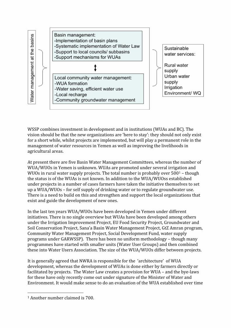
WSSP combines investment in development and in institutions (WUAs and BC). The vision should be that the new organizations are ‘here to stay’: they should not only exist for a short while, whilst projects are implemented, but will play a permanent role in the management of water resources in Yemen as well as improving the livelihoods in agricultural areas. At present there are five Basin Water Management Committees, whereas the number of WUA/WUOs in Yemen is unknown. WUAs are promoted under several irrigation and WUOs in rural water supply projects. The total number is probably over 5001 – though the status is of the WUAs is not known. In addition to the WUA/WUOss established under projects in a number of cases farmers have taken the initiative themselves to set up a WUA/WUOs – for self supply of drinking water or to regulate groundwater use. There is a need to build on this and strengthen and support the local organizations that exist and guide the development of new ones. In the last ten years WUA/WUOs have been developed in Yemen under different initiatives. There is no single overview but WUAs have been developed among others under the Irrigation Improvement Project, EU Food Security Project, Groundwater and Soil Conservation Project, Sana’a Basin Water Management Project, GtZ Amran program, Community Water Management Project, Social Development Fund, water supply programs under GARWSSP). There has been no uniform methodology – though many programmes have started with smaller units (Water User Groups) and then combined these into Water Users Association. The size of the WUA/WUOs differ between projects. It is generally agreed that NWRA is responsible for the ‘architecture’ of WUA development, whereas the development of WUAs is done either by farmers directly or facilitated by projects. The Water Law creates a provision for WUA – and the bye-laws for these have only recently come out under signature of the Minister of Water and Environment. It would make sense to do an evaluation of the WUA established over time
1 Another number claimed is 700.

reviewing their status and where useful encouraging them to make use of the opportunities created with the new bye-law. The following activities would add substance to the functioning of WUA/WUOs: Apply the byelaws. Byelaws have been under discussion for a considerable period and they
were issued and approved only very recently by the Ministery of Water and Environment2.
Though NWRA who initiated the process claim they were widely discussed, they are still not
very well known by at least some of the main stakeholders in the field. It will be useful know
to popularize them and start working with them – and then assess their strong and weak points and ways to make use of the provisions.
Ideally WUAs, within their area of jurisdiction should be able to make and enforce rules, including fees and penalties, such as mandatory fees and contributions, for construction and for management and for proper utilization of water resources. In addition the byelaws should also define the minimum criteria for WUAs (again making this light and not heavy) both in irrigation/ water resources development and in drinking water supply. This should include a definition of their main task (provision of water supply services, local water resource management, role in licensing and planning, local promotion of improved water use techniques and agronomy), financing mechanisms. minimum size, representation, position of women, finance, replacement, reregistration.
Develop a register of WUAs. WUGs and WUOs. It is important to create an overview of WUA – where they are and what is their status. At present there is no complete overview of the WUA established under different projects – though the Union of WUAs claims to have a register of 200 WUAs. It will be relatively easy to create such an overview on the basis of the concerned project records and the Union register. Preferably this is done under NWRA as being the custodian/ architect of the WUA development and/or the Union of WUAs. This could also be used to encourage the WUAs to register themselves under the provision of the new law. Activate the role of WUAs and WUOs in local water management. This is already happening – with several examples of drinking water WUOs setting restrictions on groundwater development (see later in annex 1) Linking WUA/WUOs to Basin Water Management Committees. There is a need to develop links between the WUAs and the Basin Water Management Committee. On paper the design for this exists and is now being developed for the Abyan Basin. Preferably the structuring is done in a light way – making use of the organizational structures that exists. There are two routes. First is to federate WUAs – particularly those that are closely related (in a large spate irrigation system). The Irrigation Councils in Wadi Zabid and Wadi Tuban may form the example here. These Councils include the local government, security and irrigation service providers and serve to arrange the 2 In a reaction to an earlier version of this report NWRA suggested that the bye-laws were ‘widely shared’ - yet among main persons involved in this field they were not available, or they just came in. They are not available in translation yet. However this significant step that has taken its due time now needs to be built upon.
active management of the irrigation systems. In other areas the WUAs may federate on a basin level in a union (or subpart of the National Union) and as such serve as the user group matching the Basin Committee, as is done in Abyan.3 The second route is the activation of the local elected councils. Experience in Amran shows that the local councils can play a positive role in water management but that they have to come from far – they are often not familiar with basic requirements and are not used to work together – and group training programs have been successful. Develop support mechanisms for WUAs. A network of WUAs will be an important asset in many respects – for channeling agricultural extension and training; for developing and strengthening market chains; for selling and distributing equipment and services and for exchanging experiences between WUAs. Once such a network is created it would serve as an important mechanism to deliver services and improve agriculture. The role of the National Union of WUAs should be explored – the degree to which it can provide services and be aligned with the basin structure that is being developed. WSSP is the single most important investment program in the water sector in Yemen and should actively pursue the four activities above. Under WSSP also systematic relations should be created with the Basin Water Management Committee, particularly since WSSP is focusing on three basins in detail – see below.
In two of these three basins (Sana’a, Amran) Basin Water Management Committees are in place. The Basin Water Management Committee have issued a basin plan and discuss larger allocation issues. At present there is no systematic linkage to the WUAs in the Basins. The following activities are proposed:
Support the development of Basin Water Management Committee in Dhamar
Consider further support to Basin Water Management Committee in Sana’a – as described in proposed IWRM project
Create stronger linkage between WUAs and Basin Water Management Committee in Amran
Consider training of local councils and creation of WUA unions )or sections of the current National Union) in each of the three basins.
Consider support to register, byelaw development and support program of existing WUA/WUOs.
3. Support to WUAs under NIP Within the WSSP the NIP project aims to improve local water management – by promoting local measures in irrigation efficiency – in particular conveyance systems and
3 This could also be as basin division of the National Union of WUAs. At present there is little synergy between this Union and NWRA and other organizations working in the same field. Though there may be imperfections on either side it also appear that there are many opportunities lost because of this disconnect.

localized irrigation systems (drip and sprinkler) and by developing Water User Groups4 and Water Users Associations. The targets for the introduction of the improved irrigation systems are given below. Given the experience from the GSCP these are considered ambitious – especially for the localized systems. An obstacle in the rapid introduction of the localized systems is that generally existing horticultural plantations have wide rooted systems (as flood irrigation has been the norm) – making the application of the new localized precision irrigation systems less effective. The subsidies moreover do not apply for qat farms – that constitute an important part of the cultivated area in the three basins.
Amran Dhamar Sana’a Total Conveyance 6900 6900 7200 21000
ha Localized 840 840 1820 3500
ha Apart from groundwater dependent areas NIP will operate in a number of spate irrigated areas, the largest area being Wadi Ahwar. Here investments will concentrate on improved diversion structures and improvement in the canal systems. WUAs will be established following the methodology successfully developed under the Irrigation Improvement Project – creating informal WUGs and subsequently WUAs that are federated in an Irrigation Council. The outreach, promotion and support to WUAs in NIP will be done through the Irrigation Advisory Services Plus (or IAS Plus). The ‘Plus’ stands for the larger attention to local community water management and agricultural development in NIP. In the groundwater programs in Dhamar, Amran and Sana’a in particular the IAS Plus will promote the efficient irrigation systems, but would equally important be deeply engaged with promoting local groundwater management as well as introducing a broad range of water efficiency measures that go beyond the installation of conveyance pipes. Promoting local groundwater management entails the implementation of local rules on groundwater use. Typically these are rules that are easy to agree on and observe and hence enforce. Examples are minimum distance between wells, maximum depth of wells, bans on water being sold to tankers, bans on certain crops, delineation of zones where no well development is allowed but also farmers own investment in recharge measures. Local management can also reinforce and is in turn reinforced by the implementation of the Water Law – for instance by farmers systematically insisting on well licensing for instance. This development of such local groundwater systems is already happening spontaneously in a large number of areas – see annex 1. The advantage of effective local groundwater management is that it can significantly contribute to restoring the balance
4 The informal Water User Groups (WUGs) are the building blocks for the formal Water Users Associations (WUAs) and are generally created first.
between groundwater recharge and consumption (or at least reducing the gap), that it encourages water users to invest in efficient water use; that it promotes the acceptance of new farming practices and sometimes new crops; that it encourages farmers to accept government regulation. Experience in twenty-two hydrological units in Andhra Pradesh for instance 5in India showed that making restrictions on groundwater encourages (1) a shift to less water consuming crops – significantly in all water stressed areas and (2) a larger adaptation of water efficiency measures – from 21 to 32% in three years. At the same time the agricultural value of output in the twenty-two units went up between 6 to 116% per unit, whereas in control area in the same period agricultural value either declined or increased modestly. In the GSCP farmers receiving subsidized equipment signed up not to expand the area under cultivation and in some cases went further in putting in place restrictions on groundwater use. In the NIP this development of local community groundwater management should go an important step further and should be systematically encouraged. NIP in this respect has a large role to play and should make local community groundwater one of its central challenges. There is also scope to promote water efficiency measures beyond the promotion of conveyance systems and localized irrigation6. There is a range of water efficiency measures is as yet uncommon in the different groundwater irrigation systems in Yemen and that would deserved to be better promoted: irrigation scheduling (this is promoted under the GSCP), land leveling, root zone irrigation and moisture conservation measures (mulching). It is also worth discussing that the investments in conveyance systems can be extended so as to connect different wells with one another. This will have a number of advantages. It will connect the wells so as to turn them into collective systems – making it possible to (1) have a fall back from other wells in case a well fails (2) make it easier to come to collective agreement on local groundwater management (3) encourage efficiency as flow from several wells can be combined leading to less proportional losses. IAS Plus in groundwater management should also work on improved agronomy and better marketing systems. This need for this has been expressed by farmers on a number of occasions for instance the need for better marketing of grapes/ raisins, effective pest control and access to new sapling (almonds etc). In fact in the IIP project
5 Van Steenbergen, Frank. 2010. Community-Based Ground Water Management in Andhra Pradesh: Moving
Towards Proven Models. Mimeo, Washington: World Bank GW Mate.
6 In NIP the conveyance systems and drip/sprinkler systems are given against a very high subsidy percentage – higher than in GSCP. The reason is that it is felt that otherwise the physical targets will be beyond reach. There is a need to consider the development of so-called ‘smart subsidies’. In smart subsidies the delivery of the equipment would be routed through the local private sector instead of directly through project staff. The local private hardware and fitting shops would identify ‘customers’ in line with the critieria and geographical selection of the project. Providing this service (and helping farmer groups) clear the formalities would create turnover for the harware shop and create the retail infrastructure in rural areas. Another suggestion is to make the installation of micro-irrigation
compulsory for any new well permit.

most of the improvements came from the agricultural extension component. In general in Yemen (as elsewhere) there is a large potential for improved farming practices (including some of the water efficiency measures). In the spate irrigation systems the focus of WUA differs from that in groundwater areas. It focuses on (1) future maintenance of the structures (2) introduction of improved land and water management and (3) improved farming practices. There is also scope for the improved of land and water management within the command area, for instance in (1) local mesquite eradication (2) commercial acacia plantations (3) introduction of field overflow structures to avoid field rutting and maintain sustainable balance (4) better moisture management in general and (5) more considerate water sharing of spate flow – looking at the recharge of drinking water wells. Similar agronomy improvements are important and can be significant – as was the lesson of the IIP project - where improvements in cotton and sorghum farming increased yields with over 30%. Other improvement worth considering are the promotion of new crops - such as oilseeds or legumes. In summary the activities for the IAS Plus in NIP – in the spate and surface water components are summarized in table 4.
ROLE OF WUAS Groundwater systems
Spate irrigation systems
Field water management
Introducing conveyance and localized irrigation systems
Promoting wide range of water saving
O&M of improved systems
Introducing better field level water management practices
Local water resources management
Discussing and enforcing rules on local groundwater use and groundwater recharge
Discussing management and water distribution in spate irrigation systems
Agricultural development
Interface with agricultural extension
Interface with marketing channels
Interface with agricultural extension
Interface with marketing channels
What requires attention and decision are:
(1) the development of the IAS Plus program (see section 4) (2) the opportunity of using the conveyance component to interconnect wells in an
area.
4. Developing the IAS Plus Program in NIP To develop the IAS Plus Program on the lines above the following steps are necessary:
Team formation and mobilization Development of methodology Development of management information system Training and support activities
The proposed activities on this front are discussed below 4.1 Team formation and mobilization The operation of the NIP can start from the basis of GSCP, but the activities will be broader as they will also include (1) promotion of local groundwater management and (2) support in agricultural development. For this reason it is proposed to add a social mobilizer and an agronomist to each district team. The task description of the social mobilizer and agronomist are described below. The social mobilizer would put together a packages of visual tools and background studies to be used in the first step of his activities – the awareness raising. He would plan awareness visits alongside other members of the team – to raise the larger need for better water management and water use and to also break the ground for the introduction of localized and conveyance systems. He would then discuss local regulation of groundwater – using examples and resource persons from the area (i.e. farmers who have already taken action in using improved systems and in making rules). The agronomist would with a core of local farmers put together an agricultural extension package. He would organize extension visits and help develop linkages between WUAs and suppliers of agricultural inputs and services – including the market parties.
Social mobilizer Agronomist Develop awareness package7 Develop with local farmers package
of agronomic and water efficiency measures
Awareness visits Extension visits
7 This can be done on the basis of like-minded projects and studies from the area. The package would consist of posters and videos and other visual tools. It would also consist of short explanations of the local groundwater situation on the basis of studies undertaken in the concerned area.

Identifying wells for participatory monitoring of water levels
Develop linkage with local market chain operators and WUA
Discussing local regulation of groundwater
Develop linkage with supplier of seeds, seedlings
Organize exchange visits between WUAs – based on roster of resource persons
Develop linkage with research organizations
4.2 Development of methodology A detailed proposed methodology of introducing the NIP package, promote adaptation and encourage local groundwater management is described in annex 2. For details reference is made to the annex. The following steps are proposed:
Preparation Mapping of villages and units, collecting earlier studies, composing package of awareness material
Step 1 Introduction – village profiling, identification of key persons, introducing NIP program/ package with village and with local council
Step 2 Awareness creation – using resource mapping, trend analysis, transect walk
Step 3 Micro planning – discussing investment in conveyance and localized systems and implementation of local measures for improved local regulation and for recharge
Step 4 Implementation of investment activities Step 5 Follow up and exchange between areas Special case Introduction of participatory monitoring and crop planning
4.3 Development of Management Information System As the NIP will be active in a large number of places – with subsidized investment, institutional improvement and agricultural development – a Management Information System that allows the tracking of progress and the performance of different areas and units is important. The MIS that is in use by GARWSSP can serve as an example. The MIS should identify areas of fast and slow progress and generate the basic information (on agriculture and local management) that will allow exchange between areas too. Basic information from the MIS is: Parameter set 1 Progress in each area against step 1-5 following detailed breakdown 2 Actual adaptation of conveyance and localized system in each area 3 Actual adaptation of local management in each area
4 Status of WUA (detail) incl performance against basic criteria 5 Agricultural program in each area 6 Impact measurement (in year 3) 4.4 Training and support activities A number of support activities – both training and general – would facilitate implementation of the IAS plus program. Target group Training IAS Plus Team (Groundwater) IAS Plus Methodology and Workplan – including
international experiences in ground water management and reporting to MIS
IAS Plus Team (Spate) IAS Plus Methodology and Workplan – including international experience in improved water management in spate systems
Local councils, NWRA and other main stakeholders in project areas
Team building and introduction to mandates of local councils and link to water regulation and Water Law
Project team Development and operation of MIS Target group General preparation Project management Base line information (existing sources) IAS Plus Team, NWRA WUA mapping and registration IAS Plus team Development of agricultural package WUAs Support to WUA unions and link to Basin Water
Management Committees WUAs Exchange visits within the country
ANNEX 1: CASES OF LOCAL GROUNDWATER MANAGEMENT IN YEMEN
1. BACKGROUND
This annex discusses local groundwater management in Yemen. The last decades the
discourse on groundwater management in Yemen has been cast in terms of crisis – triggered
by rapid declining groundwater tables around cities and in main agricultural areas. In a large
number of areas in the country farmers however have now responded to these threats to local
water security by implementing local rules and restrictions on the use of groundwater. This
annex describes several such cases.
Of recent two new trends have emerged. First is that where local conflicts on groundwater
development were exceptional, they are more common now - for instance in Amran and Sana’
a Basins. Whereas Lichtenthaeller (2003)8 observed that in spite of falling groundwater tables
there were no conflicts on water in Amran in 2000, in Lichtenthaeller (2010) he describes that
protests and blockages are common in Amran now. Second is that in many areas farmers have
come to local rules and regulations. Increased extraction from the common pool resources of
aquifers has dried up springs and wells. Many communities have sought to prevent harm to
existing users, most notably by norms restricting well spacing and banning export of water
from their area by tankers. In other cases farmers have closed disputed wells, invested in
groundwater recharge or have connected separate wells by a shared network of pipelines,
allowing water to travel from one area to the other. The agricultural wells also double in
several cases as sources of domestic water supply and private village pipe networks supplying
domestic water supply services.
Under the Water Law well licensing procedures have been introduced. Even so, as mentioned
many wells continue to be unlicensed. Some communities have sought support stopping
potentially harmful wells through local councils, security authorities, courts, and the branches
of the National Water Resource Authority. This has no always been successful and sometimes
time-consuming and fruitless. Even so the fact that in principle well development is in
principle no longer a ‘free for all’ and needs to be licensed under the Water Law has been
very important in that it has given legitimacy to local initiatives in introducing restrictions and
rules.
2. EXAMPLES
Below a number of cases are described of local groundwater management in Yemen9. An
8 Lichtenthaeler, G. 2003. Political ecology and the role of water: environment, society and economy in northern Yemen. Ashgate Pub Ltd 9 The cases are partly recently collected and partly come from:
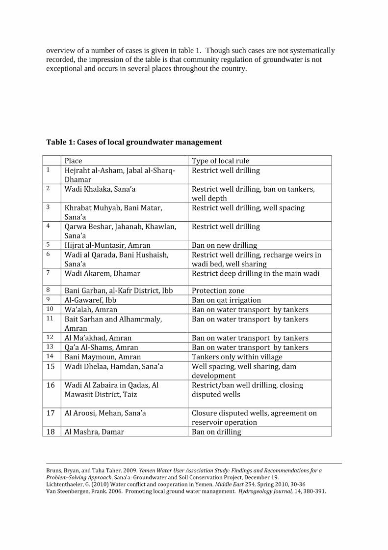
overview of a number of cases is given in table 1. Though such cases are not systematically
recorded, the impression of the table is that community regulation of groundwater is not
exceptional and occurs in several places throughout the country.
Table 1: Cases of local groundwater management Place Type of local rule 1 Hejraht al-Asham, Jabal al-Sharq-
Dhamar Restrict well drilling
2 Wadi Khalaka, Sana’a Restrict well drilling, ban on tankers, well depth
3 Khrabat Muhyab, Bani Matar, Sana’a
Restrict well drilling, well spacing
4 Qarwa Beshar, Jahanah, Khawlan, Sana’a
Restrict well drilling
5 Hijrat al-Muntasir, Amran Ban on new drilling 6 Wadi al Qarada, Bani Hushaish,
Sana’a
Restrict well drilling, recharge weirs in wadi bed, well sharing
7 Wadi Akarem, Dhamar Restrict deep drilling in the main wadi
8 Bani Garban, al-Kafr District, Ibb Protection zone 9 Al-Gawaref, Ibb Ban on qat irrigation
11 Wa’alah, Amran Ban on water transport by tankers 11 Bait Sarhan and Alhamrmaly,
Amran Ban on water transport by tankers
12 Al Ma’akhad, Amran Ban on water transport by tankers 13 Qa’a Al-Shams, Amran Ban on water transport by tankers 14 Bani Maymoun, Amran Tankers only within village 15 Wadi Dhelaa, Hamdan, Sana’a Well spacing, well sharing, dam
development 16 Wadi Al Zabaira in Qadas, Al
Mawasit District, Taiz
Restrict/ban well drilling, closing disputed wells
17 Al Aroosi, Mehan, Sana’a Closure disputed wells, agreement on reservoir operation
18 Al Mashra, Damar Ban on drilling
Bruns, Bryan, and Taha Taher. 2009. Yemen Water User Association Study: Findings and Recommendations for a Problem-Solving Approach. Sana'a: Groundwater and Soil Conservation Project, December 19. Lichtenthaeler, G. (2010) Water conflict and cooperation in Yemen. Middle East 254. Spring 2010, 30-36 Van Steenbergen, Frank. 2006. Promoting local ground water management. Hydrogeology Journal, 14, 380-391.

19 Wadi Al-Har, Anss, Dhamar
New agricultural wells only if they serve drinking water too
20 Mawia, Taiz
Joint WUA to regulate new well development, replacement of qat in some area
Qarada One example of local management of groundwater concerns Qarada in Sana’a Basin. Qarada is a distributary of the Wadi El Sir. The short terms floods in the wadi are diverted to spate irrigate the land but more importantly they recharge the shallow aquifers. Grapes – in different varieties - are the almost exclusive crop in the area. Because the area is open, it is prone to frost and growing qat is no option. There are over 100 wells in the area – typically these are 300 meter apart. Up to 2002/3 well drilling continued unabated – with a fifteen meter decline a year till the water table reached 320 meters in 2008 the threat of sulphur and fluoride levels increasing with increased depth. In anticipation of the new Water Law additional wells were developed that were subsequently covered and are not yet used. The production of the wells over the years also dropped to less than 50%. For a long time the answer to water scarcity was to invest in new and deepened shared wells rather than in shared conveyance networks. The cost of developing a well is considerable however – and can go up to YR 40 M. Part of the resistance to investing in modernized irrigation systems was the skepticism – partly well founded – on the usefulness of drip systems, as these would not work with the widely spread out root system of the old grape plants. In 2003 two WUAs were established for the area – Al Qarada and Al Ashraf. This was triggered by the Sana’a Basin Water Management Project that also worked on creating awareness and increasing the interest for improved irrigation systems. Membership grew over the years: Al Qarada started with 70 members but now has 130 members. The WUAs regulate and monitor the drilling of wells. The way it works is that if in the area of the Al Qarada WUA unlicensed drilling is about to start a complaint will be lodged to the government by the Al Asharaf WUA. This is done to preserve harmony in the area of Al Qarada. The reverse process is initiated if unlicensed drilling is planned in Al Asharaf. Recharge in the area greatly improved after the construction of 47 stone checkdams in the riverbed under the Sana’a Basin Water Management Project. These structure slow down the speed of the floods – and increase the infiltration rate. The speed of the water moreover ensures that sediment is still removed. The investment in the structures including the stone bank protection amounted to USD 1 M. A comparison of these type of structure with recharge dams – indicate that they are significantly more effective in recharging local aquifers – particularly in comparison with large dams (Alderwish and Alderwish 2009).
There are several plans to improve water use in the area. One plan is to promote drip irrigation but use a storage tank to create enough pressure. The development of drip systems suitable for the wide-rooted crops is a special challenge. There are also request for better support in marketing and extension: grapes suffer from pest attacks but there is no effective extension. Also there is concern that the grapes may suffer from import of raisin from other countries. Khrabat Muhyab, Bani Matar, Sana’a
The main water source of the Khrabat Muhyab area is the run-off from Jebel Mountains. The run-off feeds springs and the aquifers. Over the years farmers have moved to groundwater irrigation, typically pumping water from 150 to 180 meter deep. The wells – if only because of their cost – are shared by many families. A typical well may have seventeen shares and ownership is between 25-30 families. Following a violent conflict in a nearby area over the sharing of water from a dam that was to be built by the government farmers decided to regulate the use of water in their area. The establishment of the WUA – called ‘Bled Agustan’ was triggered by seeing the conflict and hardship arising from overuse of groundwater in nearby areas – it was not set up by any project but created at the initiative of concerned farmers. The WUA initially regulated the seven wells in Khrabat Muhyab village. Minimum rules were set on the distance between wells that irrigate 53 ha10 under fruits and staple crops (not qat). Wells were to be at least five hundred meters apart – but dependent on the location the distance can be even larger. The minimum distance to a spring for instance is 2000 meter. Whereas the WUA initially covered seven wells in two villages its usefulness has been recognized and it now covers the area of 58 wells in eight villages. The membership went up from 80 to several hundred. The development of new wells in the area is not allowed unless a clear need for a new well (rather than getting water from an existing well) is proven and the minimum distance is observed. Improved irrigation techniques are relatively exceptional in the area and there appears to be a good scope for improving water management on this front too. Dhelaa, Hamdan, Sana’a Dhelaa is located at relatively close proximity to Sana’a and has a long history of irrigated agriculture. The area is supplied surface water from the four kilometer Matba tributary of the Wadi Dhelaa and used to supplied both by surface flows from the river bed and by ancient qanats or horizontal wells. Sabean inscriptions inside the tunnel of the qanats suggest that they were developed at least two thousand years ago. Over the years the tunnel was gradually deepened to keep up with fluctuating water tables. Land levels also increased over time– with sediment from the adjacent hills causing land levels to rise. Fifty years ago dugwells were developed – initially operated by animals but as water tables became deeper the wells were deepened diesel pumps were
10 12000 lebba (= 44 sqm)

increasingly resorted to. At this time grapes, apricots and maize were the main crop – mixed with qat and fuelwood. As the qanat ran dry from 1982 onwards and as shallow wells started to fail around 1990 farmers shifted over to deepwells – boring over the years up to 300 meter – with water tables between 150 to 200 metres. The transition to deep wells coincided with a transition to growing qat and fuel wood trees mainly – as the deep wells required a higher value crop. In Dhelaa five wells have been developed – all under shared ownership. Ownership in the wells is divided in shares – corresponding to half days water supplies (contingent on availability of high voltage electricity). The shares – for instance sixteen per well – may be owned by more than family. This can bring well ownership up to thirty families per well. All wells are shared and families have shares in more than one well. Moreover, the five wells in Dhelaa are connected through a shared pipeline system. This makes it possible to irrigate the entire area from different wells and to compensate for the temporary breakdown of one deep well by sourcing water from another well. In Dhelaa a minimum distance on new wells has been imposed as well. This used to be 500 meters from an existing well - but has now increased to 700 meter. Within these distances it is not allowed to develop a new well – but one can always buy water from one of the existing wells. Because all landowners are interconnected and because everybody has a share in at least one well enforcement of this rule has not been unproblematic. Farmers in Dhelaa came to the regulated and shared system after seeing the severe decline in groundwater in nearby Shamlan where many wells were develop in a very short timeframe. The rule was introduced gradually – under the leadership in this case of the local sheikh family. There is no water users association in Dhelaa. If there would be a conflict on the local regulations then the local council, security forces or members of parliament could be called upon. In fact, if there are conflicts it is on the joint running of the shared wells: who is first, how to compensate for power outages and how to pay for the cost of maintenance and repairs. The wells in Dhelaa are not only used for agriculture but they are used for drinking water supply as well. The community has in fact built up their own water supply system from the same wells. Special pipes connect to different sections of the small town. This developed over the years. The wells were initially for irrigation mainly – but were next connected to the mosques and then to individual households and public water points. YR 2000/month (nearly USD 10) is paid per month for a house connection. The water table has more or less stabilized, More or less – because some wells still need to be deepened – but very modestly. The main drinking water well for instance has to be deepened with six meter over the last three years but other wells are stable.The seeming balance is also attributed to the construction of a recharge dam at Al Merbaha – one of the two sources of Wadi Madla. The work was initiated by the sheikh family – who invested YR 6 M in the construction of dam at the end of the 1991’s. The dam was subsequently upgraded in 2002 to a 25 mtr high structure with a sand core and rip rap covering at a cost pf YR 150 M. The dam is overdimensioned – even in the recent wet year it has not filled for more than a third of its capacity. The dam however is reportedly successfully contributing to recharge in the area. In fact the reservoir is also positioned

on top of the mother well of the qanat though the tunnel system has been disconnected in this area. Wadi Ghulaka, Nahem, Sana’a The area of Wadi Ghulaka has still has sufficient groundwater and carefully guards it. The construction of the Arisha Dam was initiated to improve recharge to the mainly shallow wells in the area. There is in fact a ban on drilling well too deep – with the upper limit set at 200 meters. The fear is the quality of the deeper groundwater – that is expected to be saline. Another local rule is a strict ban on selling water outside the area. Tankers are not allowed into the area – neither to collect water from the shallow wells nor from the dam reservoir. The local rules were initiated by the chairman of the WUA established for the Arisha Dam. Wadi Al Zabaira, Al Mawasit, Taiz In Wadi Al Zabaira in Qadas, Al Mawasit District, Taiz Governorate of Yemen, local committees already existed but they increased their agenda so as to include groundwater management and address the issue of water security (van Steenbergen 2006). Drinking water management committees were established in Al Dhuniab and Kareefah, in 1992 and 1994. This was done as part of a large rural drinking water program. In both settlements village networks were constructed, supplied from 30 m deep dugwells. The committees in both Al Dhuniab and Kareefah developed an impressive track record in the management of their ru- ral water supply system. Their boards were systematically re-elected and business rules regularly updated. Revenues are kept and maintained in secured special accounts with interest rates. This enabled the water committee to reduce the water tariff for the local poor. In addition, public centers such as schools, mosques, and health centers are connected free of charge. Official bills are issued for all other connections. Since the completion of the schemes, water has been available 24 h a day and occasional breakdowns have been solved in a timely manner. These committees are a source of pride and have substantial goodwill. Though they were set to manage the drinking water systems, the committees in both Al Dhuniab and Kareefah extended their scope of activities to include the sustainable protection of the groundwater resource. In Al Dhunaib, the project water committee issued a rule that no well could be drilled within 1 km from the drinking water source. One farmer in Al Dhuniab made an attempt to drill a 2 m diameter hand dug well with reinforced concrete rings with a depth of 25 m in a location 200 m away from the water source of the drinking water scheme. Well development took place within the confines of the courtyard. It was done at night, when villagers were away to nearby towns. The covert operation was discovered in the end, however. A joint meeting was organized with all leading villagers. The meeting concluded that a large representation should visit the site and meet the farmer to ask him to backfill the newly developed well. This social pressure and the argument that no precedents should be allowed was effective and the newly developed well was closed.
The enforcement of a local ban on additional wells in Kareefah was even more intriguing. In Kareefah one local farmer was about to get an official permit to develop a well from the National Water Resource Authority (NWRA) under the provisions of the national water law. This greatly alarmed the Kareefah drinking water management committee, that suspected that any additional well in this area would jeopardize the drinking water system on which all livelihoods depended. The chairman of the Kareefah committee cajoled the local branch of the National Water Resource Committee by phone and through visits. He argued with the Authority not to even give a well permit to himself, if he ever requested, even though he was one of the largest land owners. This anecdote had the important effect in Kareefah of a social leader ‘leading by example’ and clearly putting public interest above individual interest. The fear in Kareefah moreover was that—whatever the criteria for awarding official well permits—once one farmer succeeded in drilling an irrigation well, many farmers would follow and the source of drinking water would be threatened sooner or later. The two committees of Al Dhuniab and Kareefah also teamed up when the General Authority for Rural Water Supply Projects (GARWSP) planned a borewell for a neighbouring village within a kilometre distance of the existing surface water source of one of the water schemes. The committee recommended GARWSP to develop a shallow dug well instead. Unfortunately, the rural water authority went ahead and drilled a borehole of more than 200 m deep, yet without finding groundwater.
Wa’alah, Amran
Several WUGs in Amran basin have been established in the past few years by GSCP with the help of GTZ. The WUGs have started working towards the conservation of the depleted aquifers. The communities felt that they have to do something against the misuse of groundwater.
Wa’alah WUG had been established in 2006. There were about 15 wells working day and night to supply water to tankers for transport to other areas for drinking and qat irrigation. The community realized that water levels in their wells were getting lower and lower which caused them either to invest in drilling new wells or deepening their recent wells. They got together and discussed the situation and realized that the transport of water outside the area is the main reason for the drop of the water levels in the wells. They agreed to prevent any well from selling water to tankers and prevent tankers to transport water outside the area. So they made a petition (Markoum) signed by every well owner and sheik, to establish a new regulation. This was approved by the local authority. The fine of 50,000YR is to be paid to the local authority as a penalty for the breaking of Al-Markoum. The community agreed with the Sheiks, who the violators belong to, to report the violators to their Sheiks to make the necessary judgment against them, and to prevent them from coming back to transport water outside the area. This agreement has prevented any conflicts between the different tribes in the area.
The community got very involved in implementing Al-Markoum. The result is that no more tankers are coming to the area for qat irrigation. They have agreed also to not stop small tankers who supply water for drinking. The outcome is that the water levels stabilized in the area and no significant drop was seen.
Hijrat al-Muntasir, Amran
Like in many other parts of Amran, in Hijrat al-Muntasir the cultivation of qat has been on a meteoric rise, bringing a fragile wealth in a remote rural area (Lichtenthaeller 2010). The cultivation of qat was enabled as elsewhere by deep wells but these were prone to failure. This was partly compensated by purchasing water tankers from nearby villages – in particular al-Qarin. With water tables falling in al-Qarin itself, however, the village issued an official local decree (marqoum) signed by village elders forbidding the sale and trade from their wells to outsiders. As the ban in al-Qarin came into effect, qat farmers in Hijrat al-Muntasir made on more effort to develop a well. This met fierce resistance from the other villagers, who were very concerned about the effect of yet another well on the spring that is the main drinking water source of the seven hundred inhabitants. The conflict was brought to the attention of the Deputy Governor of Amran and chairman of the Amran Basin Water Management Committee. Following the dispute the drilling was stopped and also investment in local sanitation facilities was initiated under a project of the Social Fund for Development. The ban on new wells unfortunately did not prevent the spring from drying.
Wadi Al-Har, Anss, Dhamar
The area is located in Anss district. The main character of the area is the water scarcity and the qat plantations. People are aware of the problem since drilling of wells is costing a lot of money. In addition is the failure of finding groundwater. People are striving very hard to collect water for drinking and for household use. This is in addition to the need to irrigate the qat plantations which are the main income source. They agree (verbally) amongst them that there is no objection against anybody drilling a deep well for agriculture as long as the well will supply drinking water to the nearby communities. They suggested that the priority is for drinking as along as the owner is able to drill a well and bear the relevant costs. Most wells are drilled without licensing.
In the past before 1982, the area was cultivating vegetables and other crops that are irrigated from springs. After the earthquake, most of the springs fade away and the area faced water shortages. Several shallow wells and two deep (failed) were drilled to overcome the water shortages and irrigate the vegetables. However this has cost the farmers more money which was not covering the input costs of the vegetables. Therefore, they have changed to cultivate qat which earns a lot of money. They know that qat takes a lot of water, but they have no choice since it is the main source of income.
Wadi Akarem, Dhamar
This wadi is shared by two influential Sheiks. One of them is leading Bani Umar and the other one Abo Yabes. Both have rights to the Wadi Akarem and tried to drill deep wells to irrigate their qat plantations. Disputes concerned who should drill wells (more than 150m deep) in the wadi. To prevent any conflict, the two tycoons agreed verbally that no deep wells be drilled in the main wadi. Such agreement have been adopted by farmers and become a doctrine. The agreement added that deep well can be drilled at the outskirt of the main wadi and can be used for qat plantation as well as for water supply. The agreement also allows farmers to drill shallow wells in the main wadi (30-50m). Farmers are happy about this agreement since it settles the dispute which might result

in unrest in the area. Farmers are depending on qat as the main source of income and don’t want to shift to other crops unless they would provide the same income.
Mawia, Taiz
Mawia district is an important area for qat cultivation in Taiz. Wells became dry in some parts of the area, which resulted in outmigration by farmers, exporting the experience of qat plantation to nearby areas of Taiz such as Warazan causing the same water problem.
Other farmers in the area tried to drill more wells and deepen their own wells, in order to overcome the water scarcity problem and increase water productivity to cover the increased expansion of qat plantations. The farmers approached NWRA to obtain licenses. NWRA suggested that licenses will be provided if farmers are organized into WUOs served by the representative wells. Farmers agreed to that suggestions and organized themselves to about 26 WUOs. Most of the board of members of these WUOs are headed by the well owners who influence the decisions in the board. The WUOs tried to make arrangements related to water distributions and conservations such as:
If the area under the WUO has several wells and there is a need to increase well productivity, it suggests the well to be deepened and used by the beneficiaries under the WUO. If the water is not enough to cover the requirements of the farmers, the WUO may deepen or drill a new well. This means that water distribution amongst farmers will be scheduled and allocations will be set accordingly with cost of 1500-2000YR/hr. Some WUOs are paying back ¼ the harvest to the WUO (well owner!). Some farmers argue that such system may affect the productivity of qat plantations since they will not receive enough water.
Suhail-AlGranee WUO has prevented the plantation of new qat trees and introduced mango trees (500 trees) so that in the long run there will be another alternative for qat
.
Bani Garban, Al Kafr, Ibb
Bani Garban is located in Al-Kafr district. RWSSP has handed the water supply project to the WUO in 2003 when it started working. In the same site where the water supply well is located, there is an agricultural well drilled in an earlier time.
The idea came from NWRA during the starting period of the project to make the wadi as a protection zone to preserve the water and use it only for the water supply project. So NWRA established the protection zone aiming at preventing drilling of new agricultural wells. The community was very happy about the protection zone and worked very hard to implement the decision of NWRA.
The dilemma started in the beginning of 2009 where NWRA provide a license to drill a well in the protection zone to irrigate qat, which contradicts the earlier decision of NWRA to make the area as a protection zone. The community is striving very hard not allow any new drilling and has several letters supporting them from the minister of MWE, the parliament, RWSSP and other authorities. They even had support from the president.
Al-Gawaref, Ibb
This project was handed over to the WUO by RWSSP in 2006. The WUO has obtained a similar protection zone decision from NWRA resembling Bani Garban WUO. However this association has failed to prevent new drilling and a new well was drilled in the
protection zone area with license from NWRA. Both areas suffer from water shortages and the communities completely agreed to prevent any use of the water for irrigating qat.
Other WUGs in Amran basin have agreed on the same Markoum regulations such as Bait Sarhan and AlHarmaly WUG, Al Ma’akhad WUG, and Qa’a Al Shams WUG.
3. CONCLUSIONS
There are several conclusions to be drawn from these cases:
First there is a high level of local management in several cases – often introduced very recently. The local rules consist of well spacing, closure of disputed wells, bans on sales to water tankers. In some cases wells are interconnected and there is often considerable community effort to improve groundwater recharge. The notion that groundwater development is an individual affair is in many cases not correct: deep wells in particular are costly and are shared between a large number of farmers. In some cases several wells in a local area are connected to one another – so that water can be shared – in case of well failure. Some wells are not exclusive for agriculture either but feed local self supply village drinking water systems – as for example in Delaa.
Second local management is in some cases encouraged by projects – such as the awareness activities under the Sana’a Basin Water Management Project or the Groundwater and Soil Conservation Project. In other cases communities come together after having seen disaster striking nearby areas or after having been faced with conflicts occurring in their own area. In general such conflicts are ‘functional’: they trigger a response – as in the case of Hijrat-al-Muntasir. They are preferable to the default situation were wells continue to be developed unabatedly and the ‘race to the bottom’ is unchecked.
Thirdly, the Water Law and the licensing procedures imbedded in it are important – though not necessarily in a direct way. The fact that wells in principle need to be licensed has made sure that groundwater no longer is an open access resource and that restrictions should apply. This has given impetus and strength to local groundwater management. Invoking the licensing procedures under the Water Law is one of the instruments in local water management – as the case of Al Qarada shows. From the Sana’a Basin Water Management Project there are examples of villages pressurizing local councils and the National Water Resources Authority to more effectively regulate and license. In an essentially tribal society this demand for regulation – local and central - is remarkable. NWRA has also played a constructive role in encouraging farmers to develop a WUA.
Fourth, where local groundwater management is in place the initiative may be taken by a local sheikh, by another respected leader or by a WUA, as in Wadi Al Zabaira. There may be many sources of local leadership – not necessarily the traditional sheikh. In Khrabat farmers themselves established a WUA and this WUA subsequently attracted more members. Some rules may be explicit and are managed by a local organizations, but other rules exist as norms and excepted practices and do not require a specific organization to support it.
Finally the local rules and regulation concerns a broad range of measures – location and depth of wells, recharge measures, management of reservoirs and in some exceptional

cases cropping bans. Their impact can be high and they are an important component in managing local water resources. It is in fact hard to see how groundwater use in Yemen can be regulated without it being built on a foundation of local acceptance and initiative.

ANNEX 2 SUGGESTIONS FOR IAS PLUS METHODOLOGY Background and objectives of IAS Plus
To introduce water saving meaures To put local groundwater management on the agenda To identify measures – both in water saving, local regulation and local investment To create linkages between different villages and create ‘peer’ effects
The working methodology will have the following steps:
Preparation Mapping of villages and units, collecting earlier studies, composing package of awareness material
Step 1 Introduction – village profiling, identification of key persons, introducing NIP program/ package with village and with local council
Step 2 Awareness creation – using resource mapping, trend analysis, transect walk
Step 3 WUA development and Micro planning – discussing investment in conveyance and localized systems and implementation of local measures for improved local regulation and for recharge
Step 4 Implementation of investment activities Step 5 Follow up and exchange between areas, link to Basin Water
Management Committee or WUA Union Special case Introduction of participatory monitoring and crop planning
in selected areas Preparation stage
- Mapping of the area: definition of units (village, hydrological units, subsection of village
- Develop awareness package – based on other projects
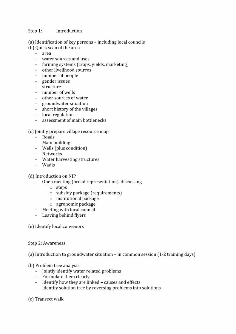
Step 1: Introduction (a) Identification of key persons – including local councils (b) Quick scan of the area
- area - water sources and uses - farming systems (crops, yields, marketing) - other livelihood sources - number of people - gender issues - structure - number of wells - other sources of water - groundwater situation - short history of the villages - local regulation - assessment of main bottlenecks
(c) Jointly prepare village resource map
- Roads - Main building - Wells (plus condition) - Networks - Water harvesting structures - Wadis
(d) Introduction on NIP
- Open meeting (broad representation), discussing o steps o subsidy package (requirements) o institutional package o agronomic package
- Meeting with local council - Leaving behind flyers
(e) Identify local convenors Step 2: Awareness (a) Introduction to groundwater situation – in common session (1-2 training days) (b) Problem tree analysis
- Jointly identify water related problems - Formulate them clearly - Identify how they are linked – causes and effects - Identify solution tree by reversing problems into solutions
(c) Transect walk

- Systematic joint route through the area o –Stop at each water point, structure or gully o –Stop at each drinking water facility
- Making observations at all water points - Summarize findings
(d) Trend analysis
- Discuss with group situation now and in the past - Take 3-4 points in time and discuss:
o –Population numbers o –Livestock numbers o –Type of crops o –Type and number of wells o –Condition of wadis, terraces and other structures o –Depth of water table o –Quality of water
(e) Basic water balance
- Jointly prepare a simple water balance for the area, calculating: o Rainfall and recharge co-efficient; o Water consumption: o Cropped area (main crops) times water consumption o No of domestic users times use/capita o No of animals times use/ capita
(f) Discuss WUA
- Provision under Water Law - Minimum requirement - Process of selection and long term functioning - Registration
Step 3: WUA development and prepare micro plans (a) Support to establishment of WUA
- Endorsement meeting - Selection of members - Agreement on rules of procedure - Agreement on financing - Help in registration
(b) Prepare and process application for conveyance and localized irrigation systems – incl agreements endorsed by WUA (c) Prepare micro plan for local water management
- Compare results from trend analysis, water budget, transect walks and resource maps
- Identify actions:

o Social regulation o Use of provision in the Water Law o Investment in recharge (also other sources of funds) o Water efficiency measures o Irrigation scheduling o Connecting wells
(d) Micro-plan to be endorsed by WUA and local council Step 4: Implementation (a) Installation of improved irrigation systems (b) Setting up and registration of WUA (c) Implementation of micro-plan Step 5 (a) Follow up to installation of improved irrigation systems, use of other water saving measures and functioning of WUA (b) Create peer effects – bring together representatives of several areas in subbasin, so that they start to:
- Share experiences - Identify common issues - Experience mild competition (why are others doing better than we)
(c) Monitoring of impact
- Cropped area - Crop yields - Water consumption - Water levels
(d) Linking WUAs to Basin Water Management Committee and other main stakeholder organizations