
Structure from motion - Quantitative Evaluation of ... · applicability for traffic accident...
13
Structure from motion - Quantitative Evaluation of structure from motion software for the 3D-reconstruction of traffic accidents Tim KAISER, Christian CLEMEN and Robert KADEN, Germany Key words: Structure from Motion, traffic accident, 3D scene reconstruction SUMMARY In case of severe traffic accidents, German Police is required to provide a scaled sketch of the accident scene. Therefore, police authorities need tools helping them to measure the affected scene in a short period of time to reduce the traffic obstructions while maintaining the demanded statutory accuracy. With the progress in the fields of computer vision and digital photogrammetry new and simple low-cost methods can be established for accurate data acquisition. In an ongoing research project at the Dresden University of Applied Sciences Structure from Motion techniques are used to generate a 3D-reoconstruction of the accident location as a first step. Afterwards the information contained in the gained dense point cloud has to be extracted and converted into a 2-dimensional vector-based map or 3-dimensional model that can be used in court. This requires that distinctive objects for the mapping of the traffic scene can be located with a high accuracy and on the spatially correct location. This paper examines a series of Structure from Motion software packages regarding their applicability for traffic accident reconstruction. Special focus was put on the investigation of the geometric accuracy of the registered camera stations since these results are crucial for the following step of generating a dense point cloud. Besides of that other criteria such as hardware requirements or processing time were considered. In the end, a decision for the further used Structure from Motion tool is presented.
Transcript of Structure from motion - Quantitative Evaluation of ... · applicability for traffic accident...

Structure from motion - Quantitative Evaluation of structure from motion
software for the 3D-reconstruction of traffic accidents
Tim KAISER, Christian CLEMEN and Robert KADEN, Germany
Key words: Structure from Motion, traffic accident, 3D scene reconstruction
SUMMARY
In case of severe traffic accidents, German Police is required to provide a scaled sketch of the
accident scene. Therefore, police authorities need tools helping them to measure the affected
scene in a short period of time to reduce the traffic obstructions while maintaining the demanded
statutory accuracy. With the progress in the fields of computer vision and digital
photogrammetry new and simple low-cost methods can be established for accurate data
acquisition.
In an ongoing research project at the Dresden University of Applied Sciences Structure from
Motion techniques are used to generate a 3D-reoconstruction of the accident location as a first
step. Afterwards the information contained in the gained dense point cloud has to be extracted
and converted into a 2-dimensional vector-based map or 3-dimensional model that can be used
in court. This requires that distinctive objects for the mapping of the traffic scene can be located
with a high accuracy and on the spatially correct location.
This paper examines a series of Structure from Motion software packages regarding their
applicability for traffic accident reconstruction. Special focus was put on the investigation of
the geometric accuracy of the registered camera stations since these results are crucial for the
following step of generating a dense point cloud. Besides of that other criteria such as hardware
requirements or processing time were considered. In the end, a decision for the further used
Structure from Motion tool is presented.
Structure from Motion - Quantitative Evaluation of structure from motion software for the 3D-reconstruction of traffic
accidents (9534)
Tim Kaiser, Christian Clemen and Robert Kaden (Germany)
FIG Congress 2018
Embracing our smart world where the continents connect: enhancing the geospatial maturity of societies
Istanbul, Turkey, May 6–11, 2018

Structure from motion - Quantitative Evaluation of structure from motion
software for the 3D-reconstruction of traffic accidents
Tim KAISER, Christian CLEMEN and Robert KADEN, Germany
1. INTRODUCTION
In case of severe traffic accidents, German police authorities are required to provide a sketch
of the incident location that has to contain the most important features of the scene such as the
final location of cars, traffic signs, skid marks or road markings. In the state of Saxony this
sketch is prepared in the scale of 1:200 so that it can be used in court (Sächsisches
Staatsministerium des Innern 2016). This means that accurate reconstruction of the scene using
appropriate measurement methods is essential. Clearly, the field of geodesy and surveying is
offering various techniques to fulfill this task. Nevertheless, there is always the area of conflict
between the reachable accuracy and the ease of use of the respected method since assigned
police officers are not intensively trained experts in surveying.
In addition, the exact and accurate surveying of the location is in great conflict with the demand
of clearing the affected roads as fast as possible. Closing roads for multiple hours for mapping
the scene has negative impact on the remaining traffic. There is an estimation that by saving
one minute for the time of road clearance affected motorists will also save four to five minutes
on their primary way (Cooner, Balke 2000).
In a prior research project, the Dresden University of Applied Sciences in cooperation with the
company SOEASY has developed a specific CAD application for police authorities in Saxony.
The software is specifically tailored to the requirements in the respective field of use. The
software features a direct connection to a total station with the aim of trying to make the whole
mapping workflow as easy as possible. However, police officers still have to be trained
extensively for operating the devices. Additionally it would be very cost-intensive to supply
each police unit with their own total station and the necessary training for the officers.
The recent and rapid progress in the domain of photogrammetric Computer Vision and
especially in the field of Structure from Motion (SfM) influenced the idea to make use of such
measuring techniques for the 3D-reconstruction of traffic accidents. Therefore, the overall aim
of the current ongoing research project is to implement a SfM-workflow generating a 3D point
cloud that in the end can be used to generate an accurate sketch of the accident scene. Since a
complete new implementation of a robust SfM-workflow is very complex and time-consuming,
we decided to search for an open source pipeline. The overall aim of this paper was to agree on
one of the investigated SfM tools for our further research based on this evaluation. Some of the
characteristics / questions that were specifically evaluated are among other things:
Accuracy of the registered camera views
Structure from Motion - Quantitative Evaluation of structure from motion software for the 3D-reconstruction of traffic
accidents (9534)
Tim Kaiser, Christian Clemen and Robert Kaden (Germany)
FIG Congress 2018
Embracing our smart world where the continents connect: enhancing the geospatial maturity of societies
Istanbul, Turkey, May 6–11, 2018

Hardware requirements and ease of use
To which extent affect the implemented feature detection algorithms the results of the
SfM-workflow?
2. RELATED WORK
2.1 3D Reconstruction and Mapping of Traffic Accidents
The application of “traditional” geodetic and photogrammetric measurement methods for the
reconstruction and mapping of traffic accidents is not something new. Police units around the
world make use of various techniques for capturing the incident scene. This includes very basic
measuring methods such as surveying wheels or tape measures (Kaden 2005). However, using
these devices is time consuming and the accomplished results are negatively affected by error
sources like curbs or little hills. In addition, these analogous methods are very error-prone.
During the stressful situation of accident reconstruction when officers are under time pressure
transposing of digits or reading errors are likely to happen. Therefore, a complete digital data
processing workflow can ease the accident reconstruction
That is why many police authorities make use of total stations for the capturing of accident
scenes (Agent et al. 2005; Stáňa et al. 2017). This can speed up the reconstruction process
especially if the accident scene is widespread. The Saxon police also noted the benefits of a
total station so that the development of the customized CAD software ForensicSurvey started.
In recent years, Terrestrial Laser Scanners (TLS) gained more and more attraction for
applications in the forensic sector. Buck et al. (2013) for example showed the benefits of TLS
data for the reconstruction of the circumstances of fatal casualties. Whereas Pagounis et al.
(2006) directly investigated the use of laser scanners for the application of accident
reconstruction. They successfully showed that the captured 3D data can be turned into a 2D
map respectively sketch of the accident scene. However, TLS produces a huge amount of data
that needs to be filtered. This requires a notable amount of time for training the officers. Besides
of that the respective gear is expensive so that it might not be feasible to equip every police
unit.
Besides of using total stations or Terrestrial Laser Scanning a couple of research projects
already investigated the capabilities of photogrammetric methods for the reconstruction of
traffic accident scenes. For example Fraser et al. (2008) and Du et al. (2009) demonstrated that
photogrammetry can deliver accurate reconstruction results using consumer grade cameras and
a self-calibrating process. However, a big downside of the proposed methods are that specific
coded targets and/or special scale bars have to be placed at the accident location. The need to
prepare the scene properly before the image acquisition is one of the major drawbacks of the
photogrammetric measurement technique and significantly increases the burden for a
successful application within police departments. Police officers for example have to make sure
that they always capture the coded target markers with enough detail so that they can be
identified in multiple images. In addition, the present light conditions at the scene have to be
Structure from Motion - Quantitative Evaluation of structure from motion software for the 3D-reconstruction of traffic
accidents (9534)
Tim Kaiser, Christian Clemen and Robert Kaden (Germany)
FIG Congress 2018
Embracing our smart world where the continents connect: enhancing the geospatial maturity of societies
Istanbul, Turkey, May 6–11, 2018

considered in a way that the correct matching of the markers becomes possible. Since accident
locations are outdoors this can be a challenging task. Furthermore, a notable amount of time is
needed for the installation of the markers that in turn extends the duration of road closures and
obstructions.
One advantage that both TLS and photogrammetric methods have in common is the fact that
by producing a complete 3D reconstruction of the scene it becomes possible to map important
objects that might have been missed during the initial data acquisition. After the accident
location is once cleared, a later mapping becomes impossible when using a total station or a
surveyor’s wheel for the capturing process. The location can be revisited, at least virtually,
though when TLS or photogrammetry techniques were applied instead.
These findings show that photogrammetric accident reconstruction can deliver good results.
However, it is very important to keep the reconstruction process for the police officers as simple
as possible in order to raise the acceptance and to foster the utilization for the particular
measuring method. That is why our reconstruction idea makes use of the Structure from Motion
approach. As can be seen in the next chapters, Structure from Motion needs neither specialized
coded targets nor specialized measurement cameras making the raw data acquisition a lot easier.
The most important aspect to get good results is to respect some basic principles regarding the
image capturing process and the resulting image network geometry. The teaching of police
members in these principles is a lot easier compared to the required training for a total station.
2.2 Structure from Motion
Despite of differing in some details throughout the specific pipeline, all investigated software
packages perform similar steps for the photo-based 3D reconstruction. The first step always
comprises of extracting homologous points (also called keypoints) from the input images. The
most common approach for this task is the so-called SIFT-Operator (Scale Invariant Feature
Transform) presented by Lowe (2004). All in our evaluation investigated software systems
make use of SIFT-Features or slightly variants thereof, except regard3D that uses so-called
AKAZE-Features (Alcantarilla et al. 2013). Since the SIFT algorithm is patented (using it for
research purposes is free though) AKAZE-Features might be a good alternative for the keypoint
extraction process as there are no legal restrictions.
After matching the extracted key points, they are used to determine the cameras orientation and
position. Robust parameter estimation is required to filter wrongly matched outliers. In most
SfM tools this is done with the help of the RANSAC algorithm (Random Sample Consensus,
Fischler, Bolles (1981)) or one of its variations. After determining the camera intrinsics and
extrinsics as well as the 3D location of the extracted feature points, a bundle block adjustment
is performed to refine the initial values. This step concludes the actual SfM workflow.
In most applications the resulting camera parameter and especially the sparse point cloud
contains to less information in terms of measured 3D points. Therefore, dense matching or
multi-view stereo algorithms (MVS) are applied to generate a much denser point cloud with
Structure from Motion - Quantitative Evaluation of structure from motion software for the 3D-reconstruction of traffic
accidents (9534)
Tim Kaiser, Christian Clemen and Robert Kaden (Germany)
FIG Congress 2018
Embracing our smart world where the continents connect: enhancing the geospatial maturity of societies
Istanbul, Turkey, May 6–11, 2018

much more information. In a first step, the algorithms use the calculated camera parameters to
undistort the images. Afterwards the dense point cloud can be generated using the distortion
free images.
3. EVALUATION OF SOFTWARE PACKAGES
3.1 Selected Software Packages
In recent years, numerous open-source software tools and software packages dealing with
structure from motion have been developed and released. However, these systems vary in
respect to their targeted use case and usability. The first published SfM tools originated from
the computer vision discipline. They put their main emphasis on robust reconstruction even
when using an inhomogeneous set of input images and not on generating a very accurate 3D
object reconstruction as known from photogrammetric tools.
Since it is not possible to evaluate all available SfM-packages at once, we have chosen four
systems for further investigation. The four packages are:
VisualSFM (Wu 2011)
Colmap (Schonberger, Frahm 2016)
openMVG (Moulon et al. 2017)
regard3D (Regard3D 2018)
Furthermore, the tests were carried out with the commercial Software Agisoft Photoscan. Due
to its easy handling and usability, Agisoft Photoscan is a very widely used SfM tool in the field
of geosciences and can be regarded as a reference tool. For the better comprehension of the
results, it is important to note that all tests were performed using the default parameters of the
respective software tool. By adjusting some of the changeable parameters, it might be possible
to get other results.
The resulting camera positions and point clouds are typically only referenced in a local arbitrary
coordinate system. Additionally they are not up to scale. In order to correctly georeference the
results, Ground Control Points (GCP) are needed. The various SfM software tools differ in
respect to the processing step when the GCP based transformation is performed. Some tools
allow to integrate the GCP information into the bundle adjustment step as further constraints.
Whereas with other systems the transformation is performed by searching the corresponding
point locations in the dense point cloud. This way the parameters for a seven-parameter Helmert
transformation can be estimated. In general, the approach to supply the GCP data during bundle
adjustment is the preferred way as the step of selecting the corresponding points in the dense
point cloud can be a challenging task and has to be regarded as an additional error source.
3.1.1 Implemented camera models
In computer vision and photogrammetry, various options for the modelling of a camera exist.
Depending on the chosen camera model a different number of distortion parameters are
Structure from Motion - Quantitative Evaluation of structure from motion software for the 3D-reconstruction of traffic
accidents (9534)
Tim Kaiser, Christian Clemen and Robert Kaden (Germany)
FIG Congress 2018
Embracing our smart world where the continents connect: enhancing the geospatial maturity of societies
Istanbul, Turkey, May 6–11, 2018

considered. Using simpler camera models can have negative effect on the obtained results
during the MVS stage. Eltner, Schneider (2015) for example demonstrated that SfM pipelines
that implement only one radial distortion parameter (such as VisualSFM and Colmap) can
produce a dense point cloud with great deviations from the real world object.
To overcome this effect, they undistorted the initial images with their own camera parameters
obtained from a separate camera calibration using a specialized test procedure. After running
the pipeline with the separately undistorted images better results could be obtained. However,
this calibration procedure would be an additional step for the police officers to deal with. Since
deeper photogrammetric knowledge is required for camera calibration this can negatively
influence the willingness and acceptance to use SfM as the basic reconstruction tool. To sum it
up, it can be said that the implemented camera model influences the result of the dense point
cloud as undistorted input images are needed for the dense matching. Therefore, a camera model
that considers additional distortion parameters should be preferred over a rather simplistic
camera model.
3.1.2 Basic characteristics of the software systems
This section shall summarize some basic specifications for each software system (Table 1). The
used default settings are underlined. Concerning the implemented camera models, parameters
abbreviated with k are radial distortion coefficients and the ones with p are tangential distortion
coefficients.
Table 1: Characteristics of the evaluated software tools
VisualSFM openMVG Colmap regard3D
Agisoft
Photoscan
Dense
Matching PMVS/CMVS openMVS
integrated
(CUDA
required)
openMVS integrated
License
Freeware
(not for
commercial
purposes)
Mozilla
Public
License 2
GNU
General
Public
License v3
MIT License Proprietary
Camera
Model
parameters
(in addition
to fx, fy, cx,
cy)
k1
(one set of
parameters for
each image)
various
models;
k1,k2,k3
various
models;
k1
various
models;
k1
k1, k2, k3,
p1, p2
one model
for all
images
Interface
(GUI or
CLI)
GUI + CLI CLI GUI+CLI GUI GUI+CLI
Structure from Motion - Quantitative Evaluation of structure from motion software for the 3D-reconstruction of traffic
accidents (9534)
Tim Kaiser, Christian Clemen and Robert Kaden (Germany)
FIG Congress 2018
Embracing our smart world where the continents connect: enhancing the geospatial maturity of societies
Istanbul, Turkey, May 6–11, 2018

Feature
Detector SIFT
SIFT +
AKAZE SIFT AKAZE Proprietary
Geo-
referencing
With external
tool after
dense
matching
During
bundle
adjustment
With
external tool
after dense
matching
With
external tool
after dense
matching
During
bundle
adjustment
Hardware
specialties
Video card
required -
CUDA card
required - -
3.2 Sample Image Data
In order to test the different software tools a set of images was acquired. The set covers an
intersection in a densely build urban area (see Fig. 1). Since real photos of an accident scene
were not available, we used this setting to simulate a real accident location as good as possible.
Totally 61 photos were taken using a Canon EOS 5D Mark III with a sensor size of 5670 x 3840
pixel. The photos were captured circular around the intersection in order to achieve a high
overlapping between the images. During the image acquisition step, no additional GCPs were
measured.
Fig. 1: Overview of the location on the intersecton of Hochulstraße and Reichenbachstraße, Dresden. (Map data
©OpenStreetMap contributors, CC-BY-SA)
Structure from Motion - Quantitative Evaluation of structure from motion software for the 3D-reconstruction of traffic
accidents (9534)
Tim Kaiser, Christian Clemen and Robert Kaden (Germany)
FIG Congress 2018
Embracing our smart world where the continents connect: enhancing the geospatial maturity of societies
Istanbul, Turkey, May 6–11, 2018
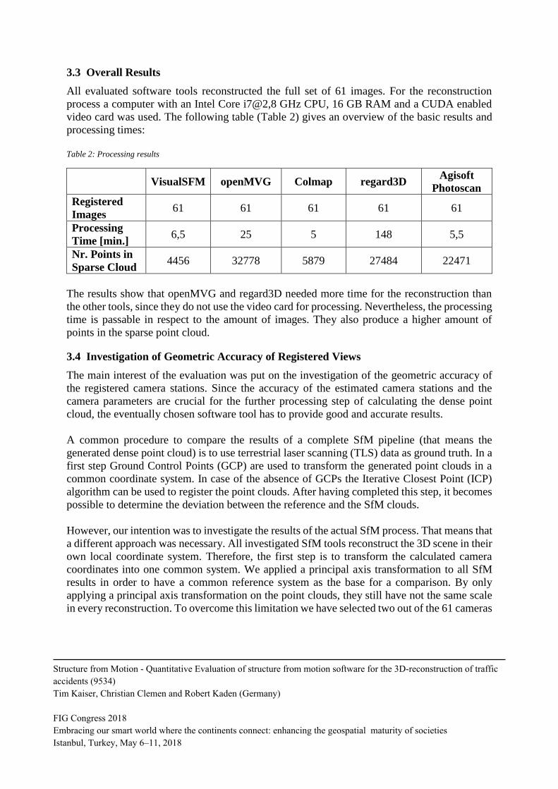
3.3 Overall Results
All evaluated software tools reconstructed the full set of 61 images. For the reconstruction
process a computer with an Intel Core i7@2,8 GHz CPU, 16 GB RAM and a CUDA enabled
video card was used. The following table (Table 2) gives an overview of the basic results and
processing times:
Table 2: Processing results
VisualSFM openMVG Colmap regard3D Agisoft
Photoscan
Registered
Images 61 61 61 61 61
Processing
Time [min.] 6,5 25 5 148 5,5
Nr. Points in
Sparse Cloud 4456 32778 5879 27484 22471
The results show that openMVG and regard3D needed more time for the reconstruction than
the other tools, since they do not use the video card for processing. Nevertheless, the processing
time is passable in respect to the amount of images. They also produce a higher amount of
points in the sparse point cloud.
3.4 Investigation of Geometric Accuracy of Registered Views
The main interest of the evaluation was put on the investigation of the geometric accuracy of
the registered camera stations. Since the accuracy of the estimated camera stations and the
camera parameters are crucial for the further processing step of calculating the dense point
cloud, the eventually chosen software tool has to provide good and accurate results.
A common procedure to compare the results of a complete SfM pipeline (that means the
generated dense point cloud) is to use terrestrial laser scanning (TLS) data as ground truth. In a
first step Ground Control Points (GCP) are used to transform the generated point clouds in a
common coordinate system. In case of the absence of GCPs the Iterative Closest Point (ICP)
algorithm can be used to register the point clouds. After having completed this step, it becomes
possible to determine the deviation between the reference and the SfM clouds.
However, our intention was to investigate the results of the actual SfM process. That means that
a different approach was necessary. All investigated SfM tools reconstruct the 3D scene in their
own local coordinate system. Therefore, the first step is to transform the calculated camera
coordinates into one common system. We applied a principal axis transformation to all SfM
results in order to have a common reference system as the base for a comparison. By only
applying a principal axis transformation on the point clouds, they still have not the same scale
in every reconstruction. To overcome this limitation we have selected two out of the 61 cameras
Structure from Motion - Quantitative Evaluation of structure from motion software for the 3D-reconstruction of traffic
accidents (9534)
Tim Kaiser, Christian Clemen and Robert Kaden (Germany)
FIG Congress 2018
Embracing our smart world where the continents connect: enhancing the geospatial maturity of societies
Istanbul, Turkey, May 6–11, 2018

and set an approximate distance between these two views. This way it becomes possible to scale
all resulting camera views and point clouds the same way.
As a result, all calculated camera views are defined in the same coordinate system. In the next
step, deviations in the camera center position are investigated. As reference for the five different
bundle adjustment results, the median (out of five) camera center position for all 61 images was
calculated. By calculating the median as reference observation, outliers and gross errors are not
taken into account as strong as by using the average as the reference value. The median is then
used to get the distance error for every image and for every software tool (Fig. 2). The results
of VisualSFM show a significant higher error compared to the other systems. Colmap’s
deviations are also quite high. On the other side, openMVG and regard3D deliver acceptable
results. Evidently, Agisoft Photoscan delivers the best results. The main reason for investigating
regard3D was that the tool by default uses AKAZE-features. The statistical examination shows
that the results are comparable to the results of openMVG.
Fig. 2: Deviaton in meters from median for every image
4. DISCUSSION AND CONCLUSION
The results of section 3.4 show that especially VisualSFM but also Colmap have strong
deviations from the median for the calculated camera centers. This might be attributed to their
applied feature extraction process. If images with a higher resolution of 3200 pixels are used,
both tools resize the images accordingly for faster processing. As a negative effect of the
downsizing, less keypoints are computed leading to the presented results.
One problem all software tools have in common is the detection of keypoints on road areas.
Asphaltic roads usually look very homogeneous and uniform without a lot of texture. This
makes it hard for feature detection algorithms to find keypoints. Fig. 3 shows one of the sample
images with the detected keypoints. The red dots indicate the keypoints found by Colmap, the
Structure from Motion - Quantitative Evaluation of structure from motion software for the 3D-reconstruction of traffic
accidents (9534)
Tim Kaiser, Christian Clemen and Robert Kaden (Germany)
FIG Congress 2018
Embracing our smart world where the continents connect: enhancing the geospatial maturity of societies
Istanbul, Turkey, May 6–11, 2018

yellow dots are the keypoints calculated by openMVG and the blue dots show the calculated
AKAZE-features. It clearly shows that very few keypoints are detected on asphaltic road
segments, while the most keypoints are found on objects of the built environment. The figure
also demonstrates that there is no big difference between the two feature detection algorithms
SIFT and AKAZE. Both methods cannot find many points on the street due to the lack of
textured areas.
Fig. 3: Feature point detection on road. Feature points in red are detected by Colmap in yellow by openMVG and in blue by
regard3D
Concerning the registration process of two images, the best results are achieved when correctly
matched feature points are evenly distributed over the whole image. Within the application of
traffic accident mapping and hence the need to work with road image data this distribution
might not always be guaranteed. When thinking about a reconstruction on a country road where
objects from the built environment are missing the task of accurate camera reconstruction can
become difficult. Consequently, it has to be investigated in future work, if the basic feature
detection and matching algorithms of the used tools can be modified accordingly in order to
increase the amount of detected keypoints on country road scenes.
The intention of the conducted investigation was to select an appropriate SfM tool for the
accident scene reconstruction. After finishing the study, we agreed on using openMVG for our
further research project. An important reason was that openMVG performed quite good
Structure from Motion - Quantitative Evaluation of structure from motion software for the 3D-reconstruction of traffic
accidents (9534)
Tim Kaiser, Christian Clemen and Robert Kaden (Germany)
FIG Congress 2018
Embracing our smart world where the continents connect: enhancing the geospatial maturity of societies
Istanbul, Turkey, May 6–11, 2018

regarding the geometric accuracy of the registered views. In addition, it implements more
sophisticated camera models compared to for example VisualSFM. openMVG also can be
considered as a complete SfM software library additionally providing useful features that go
beyond the basic SfM pipeline. Furthermore, the openMVG community features an active
development and improvement of the library. Another benefit of openMVG is that it does not
require a special hardware / video card as all calculation are executed on the CPU. In fact, this
makes the reconstruction process last a bit longer compared to VisualSFM or Colmap but as
police departments usually are limited concerning their hardware infrastructure the waiver of
GPU-computing might be also an advantage. Since openMVG can be operated completely from
its command line interface, it would become possible to implement a customized GUI for the
police around the openMVG executables. This way it would be ensured to keep the SfM
processing for police authorities as easy as possible.
ACKNOWLEDGMENTS
The European Social Fund (ESF) and the Free State of Saxony (funding no. 100316427)
financially support this research project.
REFERENCES
Agent, J.R.; Barrett, M.L.; Agent, K.R. (2005): Evaluation of Methods to Limit the Time Taken
to Investigate Crash Sites. Kentucky Transportation Center.
Alcantarilla, P. F.; Nuevo, J.; Bartoli, A. (2013): Fast Explicit Diffusion for Accelerated
Features in Nonlinear Scale Spaces. In : British Machine Vision Conf. (BMVC).
Buck, U.; Naether, S.; Räss, B.; Jackowski, C.; Thail, M. J. (2013): Accident or homicide -
Virtual crime scene reconstruction using 3D methods. In Forensic Science Internationl (225),
pp. 75–84.
Cooner, S. A.; Balke, K. N. (2000): Use of Photogrammetry for Investigation of Traffic Incident
Scenes. Texas Department of Transportation.
Du, X.; Jin, X.; Zhang, X.; Shen, J.; Hou, X. (2009): Geometry features measurement of traffic
accident for reconstruction based on close-range photogrammetry. In Advances in Engineering
Software 40 (7), pp. 497–505.
Eltner, A.; Schneider, D. (2015): Analysis of Different Methods for 3D Reconstruction of
Natural Surfaces from Parallel-Axes UAV Images. In Photogram Rec 30 (151), pp. 279–299.
Fischler, M. A.; Bolles, R. C. (1981): Random sample consensus. A paradigm for model fitting
with applications to image analysis and automated cartography. In Commun. ACM 24 (6),
pp. 381–395.
Structure from Motion - Quantitative Evaluation of structure from motion software for the 3D-reconstruction of traffic
accidents (9534)
Tim Kaiser, Christian Clemen and Robert Kaden (Germany)
FIG Congress 2018
Embracing our smart world where the continents connect: enhancing the geospatial maturity of societies
Istanbul, Turkey, May 6–11, 2018

Fraser, C.; Hanley, H.; Cronk, S. (2008): Close-range photogrammetry for accident
reconstruction. In Proceedings of XXI ISPRS congress commission V, WG V, pp. 125–128.
Kaden, R. (2005): Entwicklung eines digitalen Aufnahmeverfahrens zur räumlichen Erfassung
von Verkehrsunfallstellen. Diplomarbeit. Hochschule für Technik und Wirtschaft, Dresden.
Moulon, P.; Monasse, P.; Perrot, R.; Marlet, R. (2017): OpenMVG: Open Multiple View
Geometry. In Bertrand Kerautret, Miguel Colom, Pascal Monasse (Eds.): Reproducible
Research in Pattern Recognition. 1st ed.: Springer International Publishing.
Pagounis, V.; Tsakiri, M.; Palaskas, S.; Biza, B.; Zaloumi, E. (2006): 3D Laser Scanning for
Road Safety and Accident Reconstruction. In : Proceedings of the XXIIIth international FIG
congress, pp. 8–13.
Regard3D (2018). Available online at www.regard3d.org.
Sächsisches Staatsministerium des Innern (2016): Verwaltungsvorschrift Verkehrsunfall. VwV
Verkehrsunfall, revised 10/7/2016.
Schonberger, J. L.; Frahm, J.-M. (2016): Structure-from-Motion Revisited. In : Proceedings of
the IEEE Conference on Computer Vision and Pattern Recognition. 2016., pp. 4104–4113.
Stáňa, I.; Tokař, S.; Bucsuházy, K.; Bilík, M. (2017): Comparison of Utilization of
Conventional and Advanced Methods for Traffic Accidents Scene Documentation in the Czech
Republic. In Procedia Engineering 187, pp. 471–476.
Wu, C. (2011): VisualSFM: A Visual Structure from Motion System. Available online at
http://ccwu.me/vsfm/.
BIBLIOGRAPHICAL NOTES
Tim Kaiser, born 1992. Graduated in 2017 as a M.Eng. in Geomatics/Management from the
HTW Dresden, University of Applied Sciences. Since then he is a PhD Student at the Faculty
of Geoinformation.
Christian Clemen, born 1976. Graduated in 2004 as a Dipl.-Ing. in Surveying from the
Technical University of Berlin. From 2004 to 2010 he was an Assistant at the Department of
Geodesy and Geoinformation, Technical University of Berlin. He then worked as a GNSS
software engineer for Alberding GmbH, Wildau. Since 2013 he has been a full professor at the
HTW Dresden, University of Applied Sciences. Within FIG he is national delegate for
commission 10 and chairing the JWG BIM.
Robert Kaden, born 1979. Graduated in 2009 as a M.Sc. in Geodesy and Geoinformation
Science from the Technical University of Berlin. From 2009 to 2012 he was an Reseach
Assistant at the Department of Geodesy and Geoinformation Science, Technical University of
Berlin and from 2013 to 2015 at the Chair of Geoinformatics, Munich University of
Structure from Motion - Quantitative Evaluation of structure from motion software for the 3D-reconstruction of traffic
accidents (9534)
Tim Kaiser, Christian Clemen and Robert Kaden (Germany)
FIG Congress 2018
Embracing our smart world where the continents connect: enhancing the geospatial maturity of societies
Istanbul, Turkey, May 6–11, 2018

Technology. He then worked as a office manager for the Surveying Company Kaden in
Dresden. Since 2016 he is Postdoc at the HTW Dresden, University of Applied Sciences.
CONTACT
Tim Kaiser
PhD student, Faculty of Geoinformation
HTW Dresden, University of Applied Sciences
Friedrich-List-Platz 1
D-01069 Dresden, Germany
Tel: +49 351 462-3164
Fax: +49 351 462-2191
E-Mail: [email protected]
Web site: http://www.htw-dresden.de/geo
Prof. Dr.-Ing. Christian Clemen
Chair of CAD and Virtual Reality, Faculty of Geoinformation
HTW Dresden, University of Applied Sciences
Friedrich-List-Platz 1
D-01069 Dresden, Germany
Tel: +49 351 462-3199
Fax: +49 351 462-2191
E-Mail: [email protected]
Web site: http://www.htw-dresden.de/geo
Dr.-Ing. Robert Kaden
Postdoc Geodesy and BIM, Faculty of Geoinformation
HTW Dresden, University of Applied Sciences
Friedrich-List-Platz 1
D-01069 Dresden, Germany
Tel: +49 351 462-2050
Fax: +49 351 462-2191
E-Mail: [email protected]
Web site: http://www.htw-dresden.de/geo
Structure from Motion - Quantitative Evaluation of structure from motion software for the 3D-reconstruction of traffic
accidents (9534)
Tim Kaiser, Christian Clemen and Robert Kaden (Germany)
FIG Congress 2018
Embracing our smart world where the continents connect: enhancing the geospatial maturity of societies
Istanbul, Turkey, May 6–11, 2018