Status of Kermadec red-crowned parakeets and the likely ... · a proposed kiore eradication...
33
Status of Kermadec red-crowned parakeets and the likely effects of a proposed kiore eradication programme Macauley Island expedition July 2002 DOC SCIENCE INTERNAL SERIES 179 T.C. Greene, R.P. Scofield and P.J. Dilks Published by Department of Conservation PO Box 10-420 Wellington, New Zealand
Transcript of Status of Kermadec red-crowned parakeets and the likely ... · a proposed kiore eradication...
Status of Kermadec red-crownedparakeets and the likely effects ofa proposed kiore eradicationprogramme
Macauley Island expedition July 2002
DOC SCIENCE INTERNAL SERIES 179
T.C. Greene, R.P. Scofield and P.J. Dilks
Published by
Department of Conservation
PO Box 10-420
Wellington, New Zealand

DOC Science Internal Series is a published record of scientific research carried out, or advice given,
by Department of Conservation staff or external contractors funded by DOC. It comprises reports and
short communications that are peer-reviewed.
Individual contributions to the series are first released on the departmental website in pdf form.
Hardcopy is printed, bound, and distributed at regular intervals. Titles are also listed in the DOC
Science Publishing catalogue on the website, refer http://www.doc.govt.nz under Publications, then
Science and Research.
© Copyright July 2004, New Zealand Department of Conservation
ISSN 1175�6519
ISBN 0�478�22579�2
In the interest of forest conservation, DOC Science Publishing supports paperless electronic
publishing. When printing, recycled paper is used wherever possible.
This report was prepared for publication by DOC Science Publishing, Science & Research Unit; editing
by Helen O�Leary and layout by Lynette Clelland. Publication was approved by the Manager, Science &
Research Unit, Science Technology and Information Services, Department of Conservation, Wellington,
New Zealand.
CONTENTS
Abstract 5
1. Introduction 6
2. Itinerary and study areas 6
2.1 Macauley Island�access and campsites 7
2.2 Haszard Islet�access 9
2.3 Cheeseman Island�access 9
3. Methods 10
3.1 Assessment of the risks of kiore eradication to Kermadec
red-crowned parakeets 10
3.2 Diet and foraging behaviour of Kermadec red-crowned
parakeets on Macauley Island 11
3.3 Estimation of the population size of Kermadec red-crowned
parakeets on Macauley Island 11
3.4 Status of kiore on Macauley Island and Haszard Islet 12
3.5 Observations of birds, plants and invertebrates seen on
the southern Kermadec Islands 12
4. Results and discussion 13
4.1 Risks of kiore eradication to Kermadec red-crowned parakeets 13
4.2 Diet and foraging behaviour of Kermadec red-crowned
parakeets on Macauley Island 14
4.3 Estimation of the population size of Kermadec red-crowned
parakeets on Macauley Island 14
4.4 Status of kiore on Macouley Island and Haszard Islet 16
4.5 Annotated list of birds seen on the southern Kermadec Islands 16
4.6 Notes on the flora of the southern Kermadec Islands 20
4.6.1 Macauley Island 20
4.6.2 Haszard Islet 24
4.6.3 Cheeseman Island 24
4.7 Notes on the invertebrates of the southern Kermadec Islands 25
4.7.1 Macauley Island 25
4.7.2 Haszard Islet 25
5. Conclusions 25
6. Recommendations 27
7. Acknowledgements 28
8. References 29
Appendix 1
Kermadec red-crowned parakeet measurements and
biotracer presence 31

4 Greene et al.�Status of Kermadec red-crowned parakeets
Appendix 2
Bird specimens collected 33
Appendix 3
Plant specimens collected 33

5DOC Science Internal Series 179
© July 2004, New Zealand Department of Conservation. This paper may be cited as:
Greene, T.C.; Scofield, R.P.; Dilks, P.J. 2004: Status of Kermadec red-crowned parakeets and the
likely effects of a proposed kiore eradication programme: Macauley Island expedition July
2002. DOC Science Internal Series 179. Department of Conservation, Wellington. 33 p.
Status of Kermadec red-crownedparakeets and the likely effects ofa proposed kiore eradicationprogramme
Macauley Island expedition July 2002
T.C. Greene1, R.P. Scofield2 and P.J. Dilks1
1 Science & Research Unit, Department of Conservation, PO Box 13049,
Christchurch, New Zealand
Email: [email protected] Canterbury Museum, Rolleston Avenue, Christchurch, New Zealand
A B S T R A C T
Macauley Island in the Kermadec Group, northeast of New Zealand, was visited
in July 2002 to investigate the potential risk to the resident population of
Kermadec red-crowned parakeets Cyanoramphus novaezelandiae cyanurus
of a proposed kiore Rattus exulans eradication programme. Ecological and
behavioural observations were made of the Macauley Island parakeet
population and feather samples collected. The status of kiore and seabirds on
Macauley Island and Haszard Islet was assessed, and plant communities
monitored. To simulate an eradication operation, 50 kg of non-toxic cereal baits
containing pyranine biotracer were spread by hand over 6 ha at a concentration
of 8 kg/ha. Parakeets were then observed and / or captured and examined for
any evidence of bait ingestion. None was found. The parakeet population on
Macauley Island was estimated at 8000�10 000 birds despite a perceived
contraction in suitable habitat. Kiore numbers were very low on Macauley
Island and there was little evidence for their presence on nearby Haszard Islet.
Vegetation on Macauley Island was dominated by the fern Hypolepis
dicksonioides, a dramatic change from the vegetation observed in 1988.
Notable botanical finds included the discovery of Achyranthes aspera and
Lepidium oleraceum on Macauley Island. It was concluded that risks to the
Macauley Island parakeet population from the proposed kiore eradication
programme were negligible and that kiore eradication should proceed,
providing a number of conditions are met. More regular monitoring of the
vegetation changes and of their impact on the ecology and communities of
Macauley Island is recommended.
Keywords: red-crowned parakeets, Cyanoramphus novaezelandiae cyanurus,
kiore, Rattus exulans, eradication, monitoring, seabirds, vegetation, succession,
Kermadec Islands, Macauley Island, New Zealand.

6 Greene et al.�Status of Kermadec red-crowned parakeets
1. Introduction
The eradication of introduced mammalian pests from Macauley Island and Raoul
Island in the Kermadec group was scheduled for the winter months of 2002.
However, several concerns were raised by Friends of the Earth over the proposed
aerial application of toxic baits containing brodifacoum on Macauley I. Firstly,
Macauley I. is the major population stronghold for the Kermadec red-crowned
parakeet Cyanoramphus novaezelandiae cyanurus, which could be at risk
during the kiore Rattus exulans eradication programme. Secondly, there was no
information on the diet and foraging behaviour of the parakeets during the period
of the year proposed for the aerial operation. Finally, the current numeric and
taxonomic status of the parakeets was uncertain or unknown.
Although there has been no detectable effect on the resident parakeet
populations following a number of similar aerial poisoning operations on
numerous offshore islands since 1989 (McFadden & Greene 1994; Towns et al.
1994; Empson & Miskelly 1999; Towns & Broome 2003), it was agreed to
postpone the eradication of kiore on Macauley I. until these concerns could be
addressed.
A visit to Macauley I. was planned for the winter of 2002. During this visit the
authors aimed to:
� Assess the likelihood of cereal pellet bait ingestion by Kermadec red-crowned
parakeets and other non-target species.
� Record the winter diet and foraging behaviours of Kermadec red-crowned
parakeets on Macauley I.
� Estimate the population size of Kermadec red-crowned parakeets on Macauley I.
� Collect parakeet feather samples for genetic analysis.
� Assess bait palatability to kiore on Macauley I.
� Attempt to visit Haszard Islet and assess its rodent status and that of its native
flora and fauna.
� Assess the presence and abundance of seabird species on Macauley I.
� Assess the status of terrestrial bird species on Macauley I.
� Monitor changes in plant communities on Macauley I.
� Collect invertebrates on both Macauley I. and Haszard Islet.
2. Itinerary and study areas
Transportation to the southern Kermadec Islands was provided by the vessel
Braveheart, and a Robinson R22 helicopter. We left Auckland at 1700 h on
18 July 2002. Extremely fine and calm conditions were experienced on the trip
north, resulting in a course deviation to L�Esperance Rock which was reached
about 1500 h on 20 July 2002. About an hour was spent sailing around the islet

7DOC Science Internal Series 179
in flat calm conditions before sailing on to Curtis and Cheeseman Is. These
islands were reached about 2130 h with the remainder of the night spent
anchored off Curtis I. near the mouth of the active crater. By 1000 h on 21 July
2002 the Institute of Geological and Nuclear Science (IGNS) team visiting
Curtis I. had been successfully offloaded by helicopter and by about 1200 h we
had reached Macauley I. In a very calm sea Paul Scofield, Terry Greene and Peter
Dilks were flown from the Braveheart onto Macauley I. to the only place
between Access Gully and Sandy Bay that the helicopter could be set down.
A suitable site for a campsite amongst dense fern was located nearby and all
remaining gear delivered to this point (Fig. 1). Fine weather and the calm sea
allowed the Macauley I. party to then be landed on the top and the lower slopes
of Haszard Islet between 1400 h and 1545 h before being returned to
Macauley I. After securing the helicopter, Braveheart then departed for Raoul I.
We remained on Macauley I. until 26 July 2002 when we were flown back onto
the Braveheart between 0830 h and 0900 h. Curtis I. was reached at 1130 h
with our departure occurring at about 1500 h. During this time the transfer of
IGNS staff and equipment from Curtis I. was completed and about 40 min was
spent ashore on Cheeseman I. by Paul Scofield and Terry Greene. After a very
rough trip we arrived back at Auckland at 1100 h on 29 July 2002.
2 . 1 M A C A U L E Y I S L A N D � A C C E S S A N D C A M P S I T E S
Macauley I. (30°13′S, 178°33′W) is the remnant (282 ha) of an extinct basaltic
volcano bounded on all sides by vertical coastal cliffs (Fig. 1). The top of the
island is a sloping plateau which steadily climbs from the relatively low eastern
cliffs about Windy Head to the summit of Mt. Haszard (240 m) in the northwest.
The plateau itself is heavily dissected by numerous erosion gullies, some of
which have developed into vertical-sided ravines where they exit through the
sea cliffs. Only a few of these ravines provide practical and safe access from the
coast to the interior of the island.
Previous expeditions to Macauley I. have usually been landed by sea and had
therefore chosen to base themselves at Sandy Bay�the only sandy beach in an
otherwise unbroken rocky coastline (Williams & Rudge 1969; Taylor &
Tennyson 1988). A talus platform caused by the collapse of the tuff cliff behind
the beach was usually used for a campsite. By 1988 this platform was being
actively eroded by the sea (Taylor & Tennyson 1988). By the time of our visit
the entire remaining talus platform had been washed away, rendering Sandy Bay
unsuitable as a campsite. We spent very little time on the coast during our visit,
but other visitors might find a possible campsite at the mouth of Access Gully,
although exposure to high winds and seas from the north and east as well as
flooding during heavy rain would make this a risky option. Our ability to utilise
a helicopter to transport team members and equipment to the top of the island
rather than landing by sea proved essential to the success of this short visit.
Access to the coast was achieved via Access Gully, Quadrat Gully and the Lava
Cascade (Fig. 1). Unlike the situation in 1988, Quadrat Gully was easily
negotiated both to and from the coast. This gully is, however, very deeply
entrenched and only just wide enough for a person to fit through, thereby

8 Greene et al.�Status of Kermadec red-crowned parakeets
Figure 1. Location map of Macauley Island (tick marks denote cliffs).

9DOC Science Internal Series 179
limiting its usefulness as a main thoroughfare. These changes since 1988 seem
to reflect the continued active erosion of the island by water (Williams & Rudge
1969; Taylor & Tennyson 1988) and the geological instability of the area (one
small earthquake was felt during our visit). The lava cascade is very steep and
probably too dangerous for anything other than emergency access, given the
available alternatives. Such access points and campsites should not be taken for
granted on future visits.
Although the top of Macauley I. is relatively flat, particularly on the lower
slopes, locating a suitable campsite was a challenge. A decision was made to site
the campsite in an area of Hypolepis dicksonioides fern about 1.5 m high south
of Quadrat Gully. The fern was easily trampled to provide a flat area in which
our tents could be pitched and a helicopter landed. The depth of the vegetation
and the very friable soil made standard tent pegs useless. Sections of mist net
pole were required to secure our tents and withstand gale-force winds and rain.
2 . 2 H A S Z A R D I S L E T � A C C E S S
Haszard Islet lies about 300 m East of Windy Head and Sandy Bay (Fig.1). The
island is about 300 m long and 100 m across at its widest point and is entirely
cliff-bound. The eastern face is almost vertical and completely inaccessible. The
western side has a large sparsely vegetated talus slope resulting from a collapse
of the tuff cliffs above. Access to the summit from the lower slopes appears
impossible.
Although a landing could be made on this island from the sea, conditions would
have to be very calm to avoid the influence of large ocean swells that tend to be
funnelled through the channel between Macauley I. and Haszard Islet (Fig. 1). On
arrival at Macauley I. we took advantage of the presence of the helicopter and the
settled weather and sea conditions to visit Haszard Islet. As far as we are aware,
this was the first landing on this island and the first visit to the summit plateau.
2 . 3 C H E E S E M A N I S L A N D � A C C E S S
Cheeseman I. is a small (7.6 ha) rocky island lying approximately 20 km south-
southwest of Macauley I. (Fig. 1). Apart from a small section of its western
coastline, Cheeseman I. is almost entirely cliff-bound with very limited access
from the sea. Landing on this island from the sea could only be accomplished in
the calmest of sea conditions. The island is predominantly rocky with steep
slopes descending into a small central gully that exits on the western coast.
Very little woody vegetation is present and areas where soil has accumulated
are heavily burrowed by seabirds.
A short visit of about 40 min was only possible because of the presence of the
helicopter and the need to remove IGNS staff and equipment from Curtis I.
during the return voyage. As far as we are aware, this is the first visit to
Cheeseman I. for about 20 years.

10 Greene et al.�Status of Kermadec red-crowned parakeets
3. Methods
3 . 1 A S S E S S M E N T O F T H E R I S K S O F K I O R EE R A D I C A T I O N T O K E R M A D E C R E D - C R O W N E DP A R A K E E T S
Fifty kilograms of non-toxic bait was provided for this operation. Pestoff 20R
baits, 12 mm in diameter and weighing approximately 2 g, were used. These
baits contained pyranine (at a concentration of 0.4% w/w) as a biotracer (it also
dyed the baits pale green) but no lure, wax coating or Bitrex®. During the
voyage to Macauley Island, we measured the bait into 500-g lots. On arrival, a
study area was chosen between our campsite and the Grand Canyon (Fig. 2).
This contained dominant vegetation types (Cyperus ustulatus, Scaevola
gracilis and Hypolepis dicksonioides). To simulate an aerial bait operation, a
grid of 11 lines running north / south and 25 m apart was established using a
compass and two rangefinders. The location of the end of each line was
recorded using a handheld GPS. At 25-m intervals along each line, a 500-g bag of
bait was spread by hand around each point as evenly as possible. On 22 July
2002 a total area of about 6 ha received bait coverage at the recommended 8 kg/
ha density. Application of the bait took three people 5 h.
Figure 2. Location of baitgrid (vertical lines) on
Macauley Island.
Tent site
Acc
ess
Gul
ly
GrandCanyon
0 1 km

11DOC Science Internal Series 179
Strong winds and squalls severely hampered attempts to directly observe or
capture parakeets� response to the baits until 24 July 2002. The return of the
fine weather enabled us to erect four mist nests toward the eastern boundary of
our bait grid. This area was chosen mainly because of the abundance of
S. gracilis, upon which numerous parakeets fed. Despite the breezy and bright
sunny conditions encountered, a total of 31 parakeets (19 female and 12 male,
all adults) were captured. All birds captured were weighed, measured and had
feather samples removed. They were banded with a single metal band and
examined for traces of the fluorescing pyranine biotracer using a UV light
source in darkened conditions. Birds were checked for pyranine about the bill
and cloaca. The inside of catch bags and other faecal material were also checked
for traces of pyranine (Appendix 1).
3 . 2 D I E T A N D F O R A G I N G B E H A V I O U R O F
K E R M A D E C R E D - C R O W N E D P A R A K E E T S O NM A C A U L E Y I S L A N D
There was insufficient time to make systematic feeding observations of
Kermadec red-crowned parakeets on Macauley I. Instead, foraging observations
were recorded opportunistically and only the �first food� seen consumed
(Greene 1998) was recorded. The records are, therefore, heavily biased toward
the areas most frequently visited by observers and the foods most commonly
eaten at the time of year the records were made.
3 . 3 E S T I M A T I O N O F T H E P O P U L A T I O N S I Z E O FK E R M A D E C R E D - C R O W N E D P A R A K E E T S O N
M A C A U L E Y I S L A N D
During the July 2002 visit we attempted to estimate the density and abundance
of the red-crowned parakeet population on Macauley I. using distance sampling
methods (Buckland et al. 2001). In summary, this technique involves
measurement of the distance of a target object (in this case a parakeet or group
of parakeets) from a sampling line or point and then attempting to model the
observed decline in detectability using program DISTANCE (Barraclough 2000;
Buckland et al. 2001).
On arrival at Macauley I., it was immediately apparent to us that a random or
systematic survey design over representative habitats would not be possible
given the limited amount of time available. For this reason most of the sampling
was either conducted in the immediate vicinity of the campsite where we had
established a rat-trapping grid or in areas where access was reasonable, such as
gullies and near the edges of cliffs (Fig. 3). A total of 16 line transects totalling
3152 m were surveyed within an approximate area of 73 ha. Groups of
Kermadec red-crowned parakeets were recorded as clusters and distances
(perpendicular to the line) measured to the centre of these clusters. The size of
each cluster was also recorded. Parakeets flying into or over the count area
were excluded from the analysis. Every effort was made to record the
perpendicular distance from the line to the point from which birds were
flushed. All distances were recorded to the nearest metre (to a maximum of
50 m) using a laser rangefinder.

12 Greene et al.�Status of Kermadec red-crowned parakeets
3 . 4 S T A T U S O F K I O R E O N M A C A U L E Y I S L A N D
A N D H A S Z A R D I S L E T
To assess kiore status and abundance as well as the palatability of the non-toxic
baits to kiore on Macauley I., standard snap traps were set around the campsite
and within the bait grid (four lines of eight traps, 25 m apart). Traps were baited
with a mixture of peanut butter and sardines and checked daily for 104 trap
nights following the spread of non-toxic baits.
During our short visit to Haszard Islet a basic search was made for evidence
(faeces, feeding sign, corpses, etc.) of kiore.
3 . 5 O B S E R V A T I O N S O F B I R D S , P L A N T S A N D
I N V E R T E B R A T E S S E E N O N T H E S O U T H E R NK E R M A D E C I S L A N D S
Given the infrequent number of visits to the islands of the southern Kermadec
group, every opportunity was taken to record general observations that we
thought might be of interest. In particular, notes were made on all birds
encountered and a rough estimate made of their numbers and / or size of their
colonies. Dead birds were also collected for museum (Canterbury) collections
Figure 3. Location ofparakeet sampling transects
(n = 16) on MacauleyIsland.
Par
akee
t Val
ley
Acc
ess
Gul
ly
GrandCanyon
0 1 km

13DOC Science Internal Series 179
and a list of these can be found in Appendix 2. Feather samples from captured
Kermadec red-crowned parakeets were also collected and have been forwarded
to the School of Biological Sciences, Victoria University of Wellington for
analysis as part of an ongoing taxonomic revision of the genus Cyanoramphus.
Notes were also made on the flora of the three islands visited, with particular
attention paid to current vegetation patterns and species records of interest.
Plant specimens collected have also been deposited in a museum (Auckland)
and a list of these can be found in Appendix 3.
Invertebrates were collected on an ad hoc basis whenever and wherever the
opportunity presented itself. Efforts were made to collect samples on both
Macauley I. and Haszard Islet in all of the habitats we visited. All samples were
placed directly into alcohol and forwarded to Chris Green, an entomologist
working for the Department of Conservation in Auckland.
4. Results and discussion
4 . 1 R I S K S O F K I O R E E R A D I C A T I O N T O K E R M A D E C
R E D - C R O W N E D P A R A K E E T S
None of the birds examined showed any traces of pyranine, nor were any
parakeets seen foraging directly on baits. Direct foraging observations,
however, were difficult to record in dense vegetation. It is possible that some
parakeets fed on baits then moved out of the area undetected and uncaptured.
Poor weather immediately following bait distribution may have also
compromised the palatability of baits. In addition, the area over which baits
were spread was small and only in one part of Macauley I. Some habitats, such
as bare scoriacious slopes in gullies, cliffs and very low littoral vegetation (e.g.
Disphyma australe), could not be sampled given the quantity of bait provided,
the logistics involved in spreading bait by hand, and the short visit to the island.
By far the bulk of the bait penetrated the vegetation and was immediately lost to
sight. Most parakeets were observed feeding on top of the vegetation (see
Section 4.2). This would reduce the chance of parakeets encountering aerially
applied baits over much of the island. Exceptions to this would be relatively
small areas of very short vegetation on the littoral / cliff edge and amongst
exposed scoria �soils�. It should be noted that parakeets are also likely to be
encountered in these areas (see Section 4.2) and, as such, will be at increased
risk from toxic baits.
Macauley I. is covered in low, dense sedges and ferns with few trees. This
vegetation is similar to that of other islands from which kiore have been
eradicated. Burgess Island (in the Mokohinau group), for example, has few large
trees but large areas of dense, low Cyperus sp., buffalo grass Stenotaphrum
secundatum and rank pasture grasses. Kiore were successfully eradicated from
Burgess I. following an aerial bait drop (at 30 kg/ha) in 1994, and there was no
detectable impact on its red-crowned parakeet C. n. novaezelandiae population
(McFadden & Greene 1994). Similarly, aerial application of toxic baits over

14 Greene et al.�Status of Kermadec red-crowned parakeets
significant areas of mowed and rank pasture grasses on Tiritiri-Matangi Island had
negligible effect on the resident red-crowned parakeet population, despite this
being a favoured foraging habitat (Greene 1998).
4 . 2 D I E T A N D F O R A G I N G B E H A V I O U R O FK E R M A D E C R E D - C R O W N E D P A R A K E E T S O N
M A C A U L E Y I S L A N D
Table 1 summarises observations of plant species and food types consumed by
parakeets and provides a subjective assessment of their dietary importance. It is
worth noting that we never saw parakeets eating any part of Hypolepis
dicksonioides, despite its dramatic increase in abundance over the top of the
island.
4 . 3 E S T I M A T I O N O F T H E P O P U L A T I O N S I Z E O FK E R M A D E C R E D - C R O W N E D P A R A K E E T S O N
M A C A U L E Y I S L A N D
Analysis of the data collected (following truncation of the distance data to only
include recorded distances between the transect line and parakeets of less than
13 m) using program DISTANCE (Buckland et al. 2001) suggested that both half-
normal and uniform models described the data well (∆AICc = 1.21 and high
Goodness of Fit (GOF), Table 2)1. Model averaging and the derivation of
unconditional variances (see Burnham & Anderson 1998) provided the
estimates of density and abundance presented in Table 2.
PLANT SPECIES FOOD TYPE IMPORTANCE
Myoporum kermadecense Flowers Rare
Cyperus ustulatus Leaves Some
Scaevola gracilis New leaves / leaf buds Common
Flowers Rare
Solanum americanum Berries Some
Flowers Some
Leptinella australis Flowers Common
Pseudognaphalium Flower buds (?) Rare
luteoalbum (?)
Oxalis corniculate Seeds Rare
Lepidium oleraceum Leaves (?) Possibly common on Haszard Islet;
rare / nonexistent elsewhere
Ipomea cairica Leaves Some�restricted to relatively small
area
Bidens pilosa Flowers and seeds Common
Polycarpon tetraphyllum Seeds Common
Disphyma spp. Leaves Common
Sicyos angulata Flowers / buds Some
TABLE 1 . OPPORTUNISTIC OBSERVATIONS OF KERMADEC RED-CROWNED
PARAKEET FOOD ITEMS AND SUBJECTIVE ASSESSMENT OF DIETARY
IMPORTANCE.
1 ∆AICc refers to the difference in Akaike Information Criterion adjusted for small sample sizes. The
larger the ∆ value (> 2 units), the less support there is for the model.

15DOC Science Internal Series 179
Although model fit was good, the variance estimates were very high. This was
probably a function of the number of transect lines (only 16�as opposed to a
minimum of 20 recommended by Buckland et al. 2001), the short length of
some, the lack of independence between lines, the poor distribution of
sampling effort (i.e. line placement) over the island and the large variation in
encounter rates of parakeets between these lines.
Encounter rate (n/L; where n is the number seen and L the length of the line)
varied from a high of 0.2 parakeets/m (in Cyperus ustulatus / Solanum / Grass
spp. habitats) to a low of 0.006 (in Hypolepis dicksonioides ferns with small
patches of C. ustulatus). The average encounter rate across all transects was 0.03
parakeets/m (95% CI = 0.02�0.05). This suggests that those habitats comprising
virtual monocultures of C. ustulatus and H. dicksonioides, or a mix of both,
supported very low densities of parakeets. Our disproportionate sampling of
coastal, gully and cliff habitats, however, effectively skewed the sampling frame
toward those areas with greatest botanical diversity and an apparent high density
of parakeets. Given the large areas of Macauley I. now covered by low-diversity
habitats (see Section 4.6.1), any attempt to extrapolate our results to the rest of
the island would be inappropriate. However, using this information and making
allowance for the sampling bias, we estimate the parakeet population at 8000�
10 000 birds, similar to that recorded in 1980 (Taylor 1985).
Previous estimates of the parakeet population have usually been little more than
informed guesses (Taylor 1985). In 1966, a population of about 1000 parakeets
was estimated (Taylor 1985). Subsequently, more robust estimates were
calculated by counting all parakeets within �representative� quadrats of known
size, then extrapolating this figure over the rest of the island (Taylor & Tennyson
1988). Using this method, the parakeet population was estimated at between
17 000 and 20 000 birds during September 1988. Two months later, using the
same method, the parakeet population was estimated at between 1700 and 2000
birds (Tennyson et al. 1989). The driving forces behind such massive fluctuations
remain unknown, although seasonal drought and food shortages on the island
have been implicated (G. Taylor, DOC, pers. comm.; Tennyson et al. 1989).
This result confirms the status of Kermadec red-crowned parakeets on
Macauley I. as locally abundant. However, whether this estimate is indicative of
an actual decline in the population since 1988 (perhaps mediated by significant
changes in vegetation) and / or sampling error is unknown. More accurate
assessments of the population size will only be possible given appropriate time
scales and a more representative sampling regime.
ESTIMATE CV 1 (%) 95% CI 2 GOF3 NO. OF
OBSERVATIONS
Density (birds/ha) 41.9 23.0 26.2 � 66.1 0.60 96
Abundance4 3059 23.0 1908 � 4824
1 CV = Coefficient of variation2 CI = Confidence interval3 GOF = Goodness of fit4 Parakeet abundance within the 73 ha sampled
TABLE 2 . DENSITY AND ABUNDANCE ESTIMATES FOR KERMADEC RED-
CROWNED PARAKEET.

16 Greene et al.�Status of Kermadec red-crowned parakeets
Future sampling of the Macauley I. parakeet population should continue to be
based on distance sampling methods (or some other relatively �unbiased�
estimator) using clusters as the sampling units so that absolute measures or
density and abundance (rather than indices such as 5 min counts) can be
derived and compared over time. Every effort should also be made to sample as
representative an area of the island�s habitats as possible. Although a minimum
of 20 independent line transects arranged systematically with a random start is
recommended (see Buckland et al. 2001), we acknowledge this is likely to be
logistically difficult to put into practice.
4 . 4 S T A T U S O F K I O R E O N M A C A U L E Y I S L A N DA N D H A S Z A R D I S L E T
As on previous winter visits to Macauley I., we saw very little evidence for the
presence of kiore. One fresh, partly eaten rat corpse, presumably killed by one
of the Australasian harrier hawks Circus approximans on the island, was found
near the Grand Canyon soon after our arrival. A second, mummified corpse was
subsequently located within Quadrat Gully. Both rat corpses have been
deposited with the Canterbury Museum.
No rats were captured nor were any traps sprung during the period spent
trapping on Macauley I. No evidence for live kiore was seen until the last night
on the Island, when two kiore were seen fighting adjacent to the campsite.
Whether kiore on Macauley I. find the type of baits to be used for the rat
eradication operation palatable remains unknown, although evidence from
elsewhere suggests that palatability is unlikely to be a significant concern
(McClelland 2002).
No evidence for the presence of kiore on Haszard Islet was found. We saw
numerous intact fruits and seeds on the ground (particularly under ngaio
Myoporum kermadecense scrub), many small centipedes and Hawaiian beet
moths Spoladea (Hymenia) recurvalis that were uncommon on Macauley I.,
and small petrel burrows (most probably the Kermadec white-faced storm
petrel Pelagodroma marina albiclunis). Given the islet�s small size and its
close proximity to Macauley I., it would be prudent to assume that kiore may be
present in low numbers on Haszard Islet. Any future attempt to eradicate kiore
from Macauley I. should, therefore, include sufficient bait to treat Haszard Islet,
as a precautionary measure, as well.
4 . 5 A N N O T A T E D L I S T O F B I R D S S E E N O N T H ES O U T H E R N K E R M A D E C I S L A N D S
Kermadec petrel (Pterodroma neglecta)
One pale-phased bird was seen flying close to L�Esperance Rock on 20 July and
one near Curtis I. on 21 July. Two dark-phased birds were seen on the ground
on inaccessible cliffs on the eastern side of Haszard Islet. An adult dark-phase
bird on an egg in an area of Cyperus ustulatus behind the beach on the western
side of Haszard Islet was photographed by PJD. We saw six birds of the three
known colour phases flying over Haszard Islet and around Sandy Bay cliffs on 21

17DOC Science Internal Series 179
July and three on 22 July. A corpse was found on the Perpendicular Cliffs but no
breeding birds were located during our quick survey. We saw a single chick
(nearly fledged, probably of the intermediate phase) on the ground on
Cheeseman I. On 26 July, between leaving Macauley I. and arriving at
Cheeseman I., we saw 20�30 Kermadec petrels of all three colour phases.
Providence petrel (Pterodroma solandri)
On 26 July, between leaving Macauley I. and arriving at Cheeseman I., we saw at
least five providence petrels.
Black-winged petrel (Pterodroma nigripennis)
Our subjective estimates of burrow density and corpse numbers, when
compared with similar estimates made by RPS on Macauley I. in 1988, suggest
that the increase in fern cover has not affected the huge numbers of this species
breeding on Macauley I. The large number of corpses, and burrows of a size
made by black-winged petrels, suggest this species is also the dominant summer
nester on Cheeseman I. and Haszard Islet.
White-naped petrel (Pterodroma cervicalis)
Similarly, our subjective estimates and comparisons of them with those made by
RPS in 1988 suggest that the increase in fern cover has not drastically affected the
numbers of white-naped petrels breeding on Macauley I. This species appears to
be most common at the eastern side of the island. Large numbers of corpses
(> 50) in Access and Quadrat Gullies suggest healthy populations there. The loss
of the talus slope in Sandy Bay has meant the loss of nesting sites for the c. 200
pairs that nested here in 1988. If this loss occurred during the summer (i.e. during
a tropical cyclone) it may have been detrimental to the population. However, if it
was during the winter, then most birds would probably have moved up onto the
plateau. The large size of a number of burrows and the finding of an egg confirm
this species is present in small numbers on Haszard Islet.
Wedged-tailed shearwater (Puffinus pacificus)
Comparison of our estimates of burrow density and corpse numbers with those
made by RPS in 1988 suggests that the increase in fern may have adversely
affected the numbers of this species breeding on Macauley I. Few corpses were
found (< 10) and large-shearwater-type burrows were restricted to within 20�
50 m of the cliff edge. Corpses and burrow sizes suggest that wedged-tailed
shearwaters are present in small numbers on Haszard Islet, but no direct
evidence was found of them being on Cheeseman I.
Kermadec little shearwater (Puffinus assimilis kermadecensis)
We spotlighted or heard about 20 birds flying overhead at night on
Macauley I. None were captured. The loss of the talus slope in Sandy Bay has
probably meant the loss of breeding sites for some of the 50 pairs that nested
here (Taylor & Tennyson 1988). If the talus slope was lost during the winter, it
may have been detrimental to the population. However, if the storm that
destroyed the slope occurred during the summer (i.e. a tropical cyclone), then
most birds would probably have moved elsewhere. Little-shearwater-sized
burrows and the finding of a broken egg confirm this species is present in very
small numbers on top of Haszard Islet. None were captured during our short
stay. Little shearwaters were an abundant breeding species on Cheeseman I.

18 Greene et al.�Status of Kermadec red-crowned parakeets
The majority of burrows on this heavily burrowed island appeared to be of this
species. We found at least 20 incubating birds by putting our hands into
burrows. Eggs were at an advanced stage of incubation.
White-bellied storm petrel (Fregetta grallaria)
We spotlighted five birds and heard three calling on Macauley I. None were
caught. We were unable to find any nests on Cheeseman I., but the discovery of
one corpse suggests that they are probably present. The timing of our visit may
have been too late in the breeding season for the species to be detected in
significant numbers.
Kermadec white-faced storm petrel (Pelagodroma marina albiclunis)
Three birds, believed to be the Kermadec subspecies of the white-faced storm
petrel, were spotlighted by us on three separate nights on Macauley I. None
were caught. The presence of this species on the island in mid-winter suggests
it may be an early breeder. Between 50 and 100 small burrows in bare ground
on top of Haszard Islet and the apparent absence of Rattus exulans (as
indicated by the presence of Lepidium) are strongly indicative that this species
may nest on top of the islet.
Sooty tern (Sterna fuscata)
A dark-plumaged immature bird was seen by us off L�Esperance Rock. We found
eggs or desiccated corpses at six sites on Macauley I. The available area for
sooty terns to nest in the Microlaena sward on Macauley I. has considerably
reduced since 1988 (Taylor & Tennyson 1988). The IGNS Curtis I. party
reported large numbers of corpses of this species in the crater of Curtis I. that
they suspected of being killed by poisonous gasses from volcanic activity
(C. de Ronde, IGNS, pers. comm.). Several corpses and eggs suggest that a large
colony of this species may also occur on the northern point of Cheeseman I. in
the summer. We found six desiccated sooty tern corpses on Cheeseman I. and
one above Access Gully on Macauley I.
Masked booby (Sula dactylatra)
Two nest sites appear to be occupied by masked bobbies on L�Esperance Rock.
This is the first record of this species here. The IGNS party reported about 100
occupied nests on Curtis I. They saw many nests with one egg and some with
two eggs. No chicks were seen. On Macauley I., masked boobies are now
entirely restricted to within 20 m of the cliffs surrounding the island. During a
walk from our camp to the summit of Mt Haszard on 25 July, we observed 48
occupied nest sites. Of these, nine had one egg, two had two eggs and one had
a newly hatched single chick. It is RPS�s opinion that the size of the population
is similar to that seen in 1988, but that the birds are now distributed closer to
the coast. Five banded birds were seen. Of these, three were captured. Band
numbers and places captured were: M-38883 Haszard Islet; M-38885 Macauley,
above Sandy Bay; M-38853 Macauley, halfway up Mt Haszard. All birds were
banded in 1988 on Macauley Island as juveniles / immature (Taylor & Tennyson
1988).

19DOC Science Internal Series 179
Grey ternlet (Procelsterna cerulea)
We saw more than 2000 birds roosting and flying around L�Esperance Rock. The
cavernous hole in the centre of the island was white with ternlet guano,
suggesting this may be a large colony. L�Esperance Rock may have one of the
densest colonies of grey ternlets anywhere. We observed more than 1000 birds
roosting and flying around the coasts of Curtis and Cheeseman Is; and more
than 500 around the short piece of the coastline of Macauley I. that we
explored. Between 100 and 200 birds were roosting and preparing nest sites in
caverns, and on cliff faces in Quadrat Gully, and c. 50 were seen in Access
Gully. We did not see any birds on eggs, nor any banded birds. One bird was
seen carrying nest material. A freshly eaten, still warm ternlet corpse was found
on Cheeseman I.�we suspect it was a victim of harrier hawk predation.
White-capped noddy (Anous tenuirostris)
No white-capped noddies were seen by us on any island. This species appears to
be absent from the Kermadec Is during the non-breeding season.
Common noddy (Anous stolidus)
We saw two common noddies off L�Esperance Rock and two off Curtis I. on
21 July amongst feeding grey ternlets. The presence of this species suggests it
may nest on L�Esperance Rock.
Red-tailed tropic bird (Phaethon rubricauda)
We found one red-tailed tropic bird chick, near fledging, on the cliffs on the east
side of Haszard Islet, and at least three other potential nest sites. Ten chicks near
fledgling, all with little or no down, were found whilst we walked around
Macauley I. On 25 July, we saw more than 20 adults, possibly all feeding chicks,
flying and landing along the northeastern cliffs of Macauley I. Recent corpses of
three fledglings that appeared to have crash-landed in the tall fern and been
unable to recover were found. We estimate that the winter breeding population
of red-tailed tropic birds on Macauley I. is between 200 and 300 pairs. None were
seen by our or the IGNS party on Curtis or Cheeseman Is or L�Esperance Rock.
Pacific golden plover (Pluvialis fulva)
Two Pacific golden plovers were seen flying north over our campsite on 22 July.
Turnstone (Arenaria interpres)
A small flock of six turnstones was disturbed from the coastal lava platform near
the mouth of Access Gully in the late afternoon of 25 July.
Kermadec red-crowned parakeet (Cyanoramphus novaezelandiae
cyanurus)
Kermadec red-crowned parakeets were ubiquitous on Macauley Island�by far
the most common terrestrial bird species observed by us (see Section 4.3).
Large flocks of 20 to 30 were commonly seen flying about our campsite early in
the morning and in the late afternoon. Large groups were seen foraging
throughout the day, particularly on lower vegetation and in or near large ngaio
trees. No parakeets were seen on the coast. They were common on the top of
Haszard Islet, but were not seen on either Curtis or Cheeseman Is.
Australasian harrier (Circus approximans)

20 Greene et al.�Status of Kermadec red-crowned parakeets
Single, adult harrier hawks were seen over Curtis I. during both visits and one
was seen each day over Macauley I.
Blackbird (Turdus merula)
Blackbird alarm calls were heard on 23 July in Access Gully. A female was seen
on 24 July at the head of Grand Canyon, and a male was seen flying between
Sandy Bay and Grand Canyon on 23 July.
Song thrush (Turdus philomelos)
One song thrush was seen on the beach between Access Gully and Quadrat
Gulley on 23 July.
Starling (Sturnus vulgaris)
Two starlings were seen by us on L�Esperance Rock. A flock of 12 was seen
above Haszard Islet on 21 July. The cliffs and gullies of Macauley I. were home
to furtive pairs of starlings and the total population could be as large as 100
birds. We observed a flock of 12 starlings and 8 swallows flying around
Cheeseman I. on 26 July.
Welcome swallow (Hirundo tahitica)
At least 8 swallows were present on Macauley I. and were seen by us each day.
Another 8 were seen above Cheeseman I. in a mixed flock with starlings.
We identified at least some of this flock as welcome swallows, as they had long
tails, whitish under-parts and liberally-spotted upper tails.
We also saw smaller swallows with shorter, squarer tails than welcome
swallows. These birds had grey underparts and little (if any) spotting on the
uppersides of the rectrices. They were seen by us most days on Macauley I.
In our opinion these were the Pacific subspecies of the welcome swallow, but it
will be necessary to capture some of them to confirm the identification.
Omissions
No silvereyes or introduced finches were seen (c.f. Taylor & Tennyson 1988;
Tennyson et al. 1989)
4 . 6 N O T E S O N T H E F L O R A O F T H E S O U T H E R NK E R M A D E C I S L A N D S
4.6.1 Macauley Island
Although there is no direct archaeological evidence, it is likely that Macauley
Island was visited by early Polynesian or Melanesian peoples (Anderson &
McFadgen 1990). The presence of kiore certainly suggests early Pacific people
visited this island, but whether they had any impact on the vegetation is
unknown. The first discovery of the island by Europeans was by Captain Sever
aboard the Lady Penrhyn on 30 June 1788. The surgeon on this vessel�Arthur
Bowes-Smith�stated that the plateau was �covered with a coarse kind of grass�
(Fidlon & Ryan 1979). Sykes (1977) suggests this �grass� was probably Cyperus
ustulatus which is still a dominant part of the flora. It is not clear when
ungulates were introduced, but in 1836 Captain W.B. Rhodes recorded that
Macauley I. �abound[ed] with goats and pigs� (Straubel 1954). Pigs Sus scrofa
21DOC Science Internal Series 179
have not been reported since. By 1966 goats Capra hircus had reached large
numbers; and an expedition in 1966 killed a minimum of 3200 (O�Brien, 1966).
A further 18 were killed in 1970 (Bell 1970).
The vegetation was severely affected by the goats but has recovered remarkably
since 1966. However, concerns have been expressed about the effects of the
rapid regrowth and the apparent successional trajectory on various plant and
animal species (Taylor & Tennyson 1988; Tennyson et al. 1989).
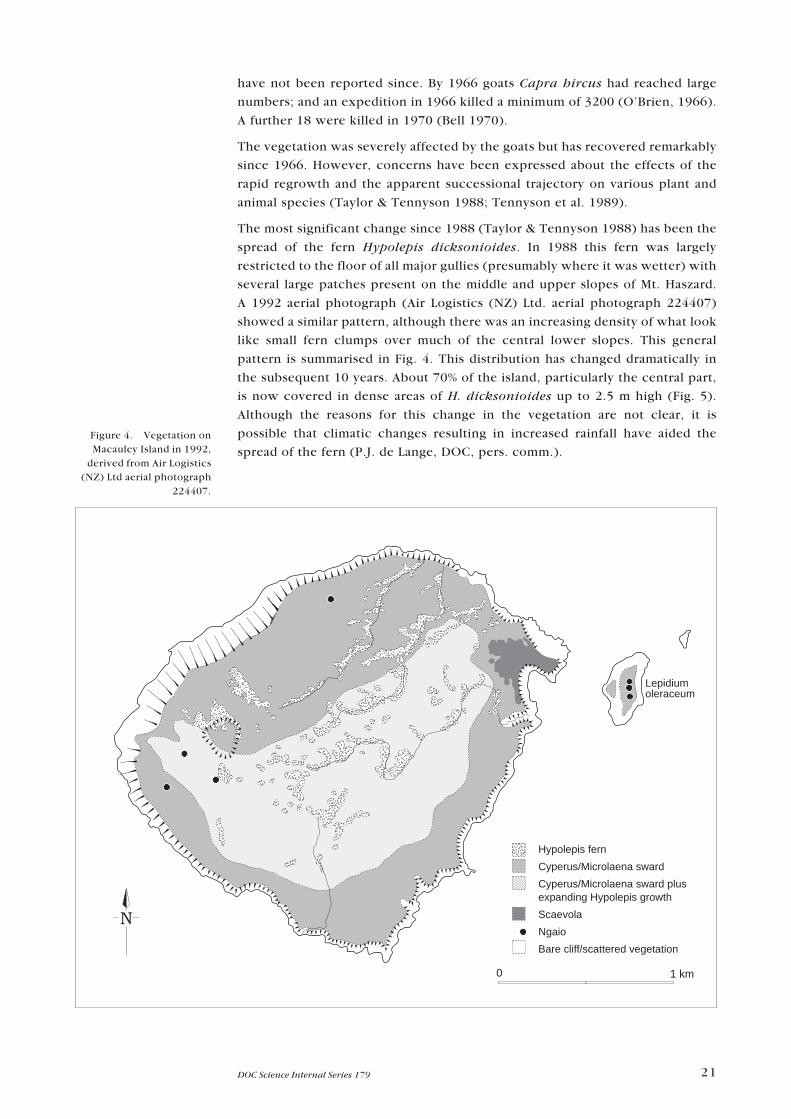
The most significant change since 1988 (Taylor & Tennyson 1988) has been the
spread of the fern Hypolepis dicksonioides. In 1988 this fern was largely
restricted to the floor of all major gullies (presumably where it was wetter) with
several large patches present on the middle and upper slopes of Mt. Haszard.
A 1992 aerial photograph (Air Logistics (NZ) Ltd. aerial photograph 224407)
showed a similar pattern, although there was an increasing density of what look
like small fern clumps over much of the central lower slopes. This general
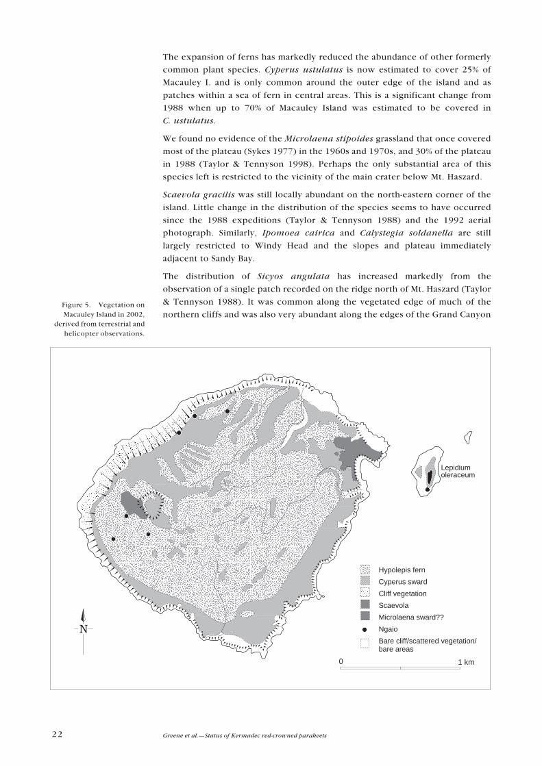
pattern is summarised in Fig. 4. This distribution has changed dramatically in
the subsequent 10 years. About 70% of the island, particularly the central part,
is now covered in dense areas of H. dicksonioides up to 2.5 m high (Fig. 5).
Although the reasons for this change in the vegetation are not clear, it is
possible that climatic changes resulting in increased rainfall have aided the
spread of the fern (P.J. de Lange, DOC, pers. comm.).Figure 4. Vegetation onMacauley Island in 1992,
derived from Air Logistics(NZ) Ltd aerial photograph
224407.
Lepidium oleraceum
Lepidiumoleraceum
Sicyos angulata
Achyranthesaspera
Sicyos angulata
Hypolepis fern
Cyperus/Microlaena sward
Cyperus/Microlaena sward plusexpanding Hypolepis growth
Scaevola
Ngaio
Bare cliff/scattered vegetation
0 1 km
22 Greene et al.�Status of Kermadec red-crowned parakeets
The expansion of ferns has markedly reduced the abundance of other formerly
common plant species. Cyperus ustulatus is now estimated to cover 25% of
Macauley I. and is only common around the outer edge of the island and as
patches within a sea of fern in central areas. This is a significant change from
1988 when up to 70% of Macauley Island was estimated to be covered in
C. ustulatus.
We found no evidence of the Microlaena stipoides grassland that once covered
most of the plateau (Sykes 1977) in the 1960s and 1970s, and 30% of the plateau
in 1988 (Taylor & Tennyson 1998). Perhaps the only substantial area of this
species left is restricted to the vicinity of the main crater below Mt. Haszard.
Scaevola gracilis was still locally abundant on the north-eastern corner of the
island. Little change in the distribution of the species seems to have occurred
since the 1988 expeditions (Taylor & Tennyson 1988) and the 1992 aerial
photograph. Similarly, Ipomoea cairica and Calystegia soldanella are still
largely restricted to Windy Head and the slopes and plateau immediately
adjacent to Sandy Bay.
The distribution of Sicyos angulata has increased markedly from the
observation of a single patch recorded on the ridge north of Mt. Haszard (Taylor
& Tennyson 1988). It was common along the vegetated edge of much of the
northern cliffs and was also very abundant along the edges of the Grand CanyonFigure 5. Vegetation onMacauley Island in 2002,
derived from terrestrial andhelicopter observations.
Lepidium oleraceum
Lepidiumoleraceum
Sicyos angulata
Achyranthesaspera
Sicyos angulata
Hypolepis fern
Cyperus sward
Cliff vegetation
Scaevola
Microlaena sward??
Ngaio
Bare cliff/scattered vegetation/bare areas
0 1 km

23DOC Science Internal Series 179
and was scattered in patches through the vegetation on the cliffs above Sandy
Bay (Fig. 6). Of interest were the large numbers of damaged leaves of this
species that were observed (suggestive of disease).
On the northern cliffs, vegetation has continued to re-establish on the more
stable slopes. Large numbers of young ngaio are present, some of which have
reached a height of 2 m. Other vegetation seen on the cliffs included Parietaria
debilis, Juncus spp., Achyranthes aspera (see Section 5) and a small amount of
Cyperus ustulatus. No young or seedling ngaio were seen on the flatter parts of
the island that we were able to access.
Two new plant species were recorded from Macauley Island. A single, 7-cm-
high seedling of Lepidium oleraceum was found near a large ngaio tree on the
cliff edge northeast of Mt. Haszard (Fig. 6). The second important find was
significant numbers of Achyranthes aspera, again on the northern cliffs,
approximately 50 m northeast of the L. oleraceum specimen (Fig. 6). This
appears to be a new indigenous species for the New Zealand flora and is very
similar to plants from Norfolk Island (de Lange et al. 2004). This species� spiny
seeds are well suited to avian dispersal. Possible vectors include Kermadec
petrels and masked boobies, both of which breed on these cliffs and are known
to visit Norfolk Island.
Figure 6. Notablebotanical discoveries,Macauley Island 2002.
Lepidium oleraceum
Lepidiumoleraceum
Sicyos angulata
Achyranthesaspera
Sicyos angulata
0 1 km

24 Greene et al.�Status of Kermadec red-crowned parakeets
4.6.2 Haszard Islet
A number of distinct vegetation types occurred on the top of Haszard Islet,
despite its small size. The northern end and the cliff edges surrounding the top
of the islet were dominated by Disphyma australe with patches of Parietaria
debilis and native spinach Tetragonia tetragonioides. The remainder of the
island was covered in Cyperus ustulatus with scattered clumps of ngaio. Gaps
between clumps of C. ustulatus (where there were no petrel burrow entrances)
were filled with Parietaria debilis, spinach, Leptinella australis, Gnaphalium
spp., scurvy grass, Scaevola gracilis, Polycarpon tetraphyllum, Microlaena
stipoides, Solanum spp., Sonchus spp. and Apium australis. Ngaio plants were
generally prostrate and not higher than 1.5 m. The entire surface was heavily
burrowed by seabirds.
Of particular interest were the large numbers of Lepidium oleraceum plants in
very poor condition (Fig. 6). Most leaves appeared to have been extensively
browsed back to the mid-rib, but the immediate cause of this (invertebrate or
parakeet?) was unclear. Subsequent examination of the invertebrates on the
island revealed that the Hawaiian beet moth prefers to forage on brassicas and is
classified as a pest of brassica crops where it occurs overseas. Lepidium
oleraceum is a brassica and it would, therefore, seem likely that caterpillars of
this moth were the main cause of the poor condition of L. oleraceum plants on
Haszard Islet. Whether this moth is native to the Kermadec group is not known,
but it is conceivable that it may pose a significant threat to the few L. oleraceum
plants that remain on the southern islands of the group and the future recovery
of L. oleraceum on Macauley I.
The vegetation on the accessible western face at the base of the islet was
dominated by iceplant Disphyma australe and spinach with small patches of
Cyperus ustulatus, Solanum spp., Sonchus spp. and Gnaphalium spp. in more
sheltered places. A small number of stunted ngaio plants were also present.
4.6.3 Cheeseman Island
This island has a relatively small flora. The central valley between the two high
points of the island was almost entirely dominated by Cyperus ustulatus. With
the exception of a few scattered plants on the surrounding slopes, this species
was largely restricted to this gully. The bulk of the remaining sloping and rocky
area was dominated by a mix of Parietaria debilis and iceplant with the more
exposed areas dominated by the latter. Interspersed amongst these dominant
species in relatively sheltered places were individual plants of Asplenium
obtusatum, Sonchus spp., Leptinella australis, Lachnagrostris littoralis,
something resembling a Stellaria or Polycarpon spp. and both Solanum
americanum and S. nodiflorum. A last-minute discovery was the presence of
two or three Lepidium oleraceum plants. A layered part of one of these plants
was collected as a live specimen.

25DOC Science Internal Series 179
4 . 7 N O T E S O N T H E I N V E R T E B R A T E S O F T H E
S O U T H E R N K E R M A D E C I S L A N D S
The following is a brief summary of the invertebrates encountered.
4.7.1 Macauley Island
Blowflies (species not identified) were extremely common on Macauley I. and
considerable care was required to keep them out of tents and food supplies.
Hawaiian beet moths were also present on Macauley I., but at much lower
densities to those seen on Haszard Islet and then only about the cliffs above
Sandy Bay. It was thought the distribution of these moths may reflect the
proximity of Haszard Islet to Macauley I. (Sandy Bay) and the almost complete
absence of L. oleraceum on the latter. The small dark crickets seen on Haszard
Islet were also extremely common on Macauley Island and their high-pitched
�calls� could be heard night and day. Both adult and juvenile crickets were
collected. Much larger orthopterans were also present on Macauley I. and
although none could be collected, they were thought to be Locusta migratoria.
A number of spiders, several very small dark brown beetles, a click beetle and
what appeared to be a small vinegar fly were also collected. Of some note was
the large number of very small snails (1�2 mm) that were found foraging on the
damp, non-toxic baits following two days of poor weather. These were
extremely common and a number were collected for identification. We were
also able to collect a very large specimen of a convolvulous sphinx moth Agrius
convolvuli. A single yellow-admiral butterfly Bassaris itea was seen on the
summit of Mt. Haszard.
4.7.2 Haszard Islet
The top of this islet was extremely dry which undoubtedly influenced the
invertebrates we were able to observe and collect. Given the high density of
petrel burrows and surface-nesting boobies, blowflies of at least two species
(not identified) were particularly common. Small black- and yellow-striped
hoverflies were also common about flowering ngaio plants, as were Hawaiian
beet moths (see Section 4.6.2). On the ground and beneath what litter was
present there were numerous late instar nymphs of a small dark cricket species
and small (1 cm) red / brown centipedes, both of which were able to be
collected. A specimen of a very small ant and a number of spiders were also
collected.
5. Conclusions
We view the eradication of kiore as essential to the ecological recovery of
Macauley I. Although such an operation undeniably poses a risk to the large
population of Kermadec red-crowned parakeets, we still expect any negative
impacts to be localised (possibly to those few areas of remaining open ground)
and minimal in terms of the status of the overall population. Total extirpation of

26 Greene et al.�Status of Kermadec red-crowned parakeets
the Macauley I. parakeet population is extremely unlikely. Evidence from
previous rat eradication operations in similar environments, our bait trials
during this visit (despite their limitations), parakeet foraging behaviours and
diet during this time of year, and the overall density of vegetation on
Macauley I. give us considerable confidence in our assessment, providing
conditions (food plant phenology, vegetation types, parakeet numbers, water
availability, etc.) remain broadly similar to those experienced in July 2002.
In the unlikely event that significant mortality of parakeets occurs as a direct
result of kiore eradication, we would expect to see rapid population recovery
typical of that noted for this species and its close relatives. However, if any of
these factors have altered significantly prior to the eradication attempt, then our
appraisal of the risks to the parakeet population will require reassessment.
In particular, the timing of the eradication operation is important given the
uncertain cause of the mass mortality event observed for parakeets between
September and November 1988�especially if such events are a regular
phenomenon. Food shortages have been suggested as a cause of this event
(C. Miskelly, DOC, pers. comm.), but a severe drought was known to have
occurred in October and November 1988 (G. Taylor, pers. comm.). For this
reason, every effort should be made to assess the status of the parakeet
population on Macauley I. immediately prior to any rat removal operation. If the
number of parakeets is found to be much lower than current estimates (< 5000),
it may be prudent to consider either postponing the operation, holding birds on
Macauley I. or considering the transfer of parakeets to Raoul I.�dependent on its
status as a rat-free island2. If the latter course of action is an option, then it would
be prudent to collect feather samples from the remnant Kermadec red-crowned
parakeet population inhabiting the Meyer Is (northwest of Raoul I.). This would
confirm the current supposition that these and the Macauley I. parakeets are of
the same genetic provenance and any interbreeding would not be deleterious to
the genetic integrity of the Meyer Is birds.
Any eradication attempt should be timed to coincide with the period of least
risk to the Kermadec red-crowned parakeet population. From late autumn until
winter, food and water are likely to be abundant for parakeets (Cyperus
ustulatus is thought to flower from November to February, with seeds ripening
from February to April; G. Taylor, pers. comm.), and seabirds are largely absent,
making this period the ideal time in which to attempt kiore eradication.
The historical impacts of kiore occupation of Macauley I. are likely to have been
severe. Although the vast seabird population suggests that kiore have little
direct impact on the major species, the current distribution of the Kermadec
little shearwater, grey ternlets, white-bellied storm petrel and Kermadec white-
faced storm petrel suggests a significant effect on the breeding success of these
smaller species. More insidious is the potential for impacts on the successional
pathway of the island�s flora as it continues to recover from the past
depredations of goats. Experience from elsewhere in New Zealand suggests that
kiore have a significant destructive impact on fruits and seeds of a wide variety
of plants (Campbell & Atkinson 2002). This may be a contributing factor to the
much slower than predicted colonisation of the plateau by ngaio and other
plant species such as Scaevola gracilis and Lepidium oleraceum (Taylor &
Tennyson 1988). Given recent research, it seems likely that kiore have also had
a significant impact on the larger invertebrate species (Green 2002).
2. It should be noted that Raoul Island is likely to be declared rodent-free in 2004 and it may be more
expedient to catch and transfer parakeets to this island.

27DOC Science Internal Series 179
Whether the reason for the dramatic expansion of Hypolepis dicksonioides ferns
has had anything to do with the continued presence of kiore and / or is the result
of larger-scale climatic change (i.e. wetter conditions over the last
20 years) is uncertain. Whatever the reason, this fern is now dominant over much
of the island, markedly reducing the distribution of Cyperus and leading to the
possible elimination of the Microlaena stipoides sward previously reported. An
obvious impact of these changes has been a marked reduction in the distribution
of nesting masked boobies. Nesting pairs of this species are now only found about
the cliff margins, having been forced from the centre of the island. It seems likely
that other surface-nesting seabirds such as sooty terns have also experienced
reductions in available nesting habitat. Although previous measurements of
petrel burrow density in areas of Cyperus ustulatus, Scaevola gracilis and
H. dicksonioides showed that the density of petrel burrows was much lower than
that in open areas (Taylor & Tennyson 1988), the spread of the H. dicksonioides
ferns does not seem to have drastically affected the numbers of either black-
winged petrels or white-naped petrels. It also seems likely that the change in
population estimates for Kermadec red-crowned parakeets�from 17 000�
20 000 in 1988 (Taylor & Tennyson 1988) to our estimate of 8000�10 000�is
entirely explicable in terms of the large changes in vegetation composition and
the availability of suitable foods.
The continued spread of H. dicksonioides over much of the plateau has
probably had a significant impact on the Kermadec red-crowned parakeet
population. It is unlikely that H. dicksonioides produces much, if anything, of
food value for these parakeets, particularly when compared with the large seed
heads of the formerly much more common Cyperus ustulatus and Microlaena
stipoides. During our visit, no parakeets were seen foraging in areas of fern and
very few were even seen in these patches. It is likely that parakeet density has
declined significantly since 1988 and will continue to do so as the fern
continues to spread. Nevertheless, considerable suitable habitat is likely to
persist and should begin to increase again following the removal of kiore and
the projected regeneration of ngaio trees.
The long-term implications of the appearance of Achyranthes aspera on the
western cliffs are unknown. If the species continues to spread along these cliffs it
may well begin to impact on the breeding sites of Kermadec petrels. Whether
A. aspera is capable of competing with either C. ustulatus or H. dicksonioides on
the main plateau of Macauley I. is, as yet, unknown.
6. Recommendations
Based on our investigations, as reported in this paper, we make the following
recommendations:
� Kiore should be eradicated from Macauley I. and Haszard Islet between May
and September as soon as possible. The long-term benefits of kiore eradication
outweigh the perceived negative impacts and would do much to ensure the
survival of the Kermadec white-faced storm petrel and assist the revegetation
of Macauley I.

28 Greene et al.�Status of Kermadec red-crowned parakeets
� A serious attempt should be made to obtain useful GPS (preferably Differential
GPS) position fixes so that aerial photos are able to be accurately geo-
referenced and accurate maps drafted. This could be achieved during the kiore
eradication operation using the DGPS system onboard helicopters used for
eradication.
� A small team of observers should be sent to Macauley I. immediately prior to
and during any kiore eradication operation to assess the status of the
Kermadec red-crowned parakeet population.
� If a significant decrease in numbers of parakeets on Macauley I. is observed
(< 5000), planned kiore eradication should be postponed or consideration
given to maintaining a group of birds in captivity. However, it should be noted
that Raoul I. is likely to be declared rodent free in 2004 and it may be more
expedient to catch and transfer parakeets to this island.
� To enable genetic comparison with samples already taken from Macauley I.,
feathers should be collected from Kermadec red-crowned parakeets resident
on the Meyer Is as soon as possible.
� Regular aerial and / or satellite photos be taken so that vegetation changes can
be monitored over time. Regular physical visits of longer duration also need to
be made to Macauley I. so that regular and more systematic population
assessments of parakeets, surface-nesting seabirds and burrowing petrels can
be made and related to any changes in vegetative cover.
� The continued spread of Hypolepis dicksonioides and the recently arrived
Achyranthes aspera should continue to be closely monitored.
� If possible, a night visit to the top of Haszard Islet should be made in the month
of October to confirm the presence of Kermadec white-faced storm petrels.
A night trip is also desirable to Cheeseman I. (between March and June) to
confirm the presence of white-bellied storm petrels.
� The impact of Hawaiian beet moths on Lepidium oleraceum should be
investigated.
� Alternative coastal camp sites should be identified following the loss of the
site at Sandy Bay.
7. Acknowledgements
We would like to offer our thanks to Mike Ambrose for providing us with the
opportunity to visit Macauley I. Kelly Thomas did sterling work assisting with
logistics and communications as well as ensuring that our supply of coffee and
chocolate cake lasted the distance. Kath Walker and Graeme Elliott displayed a
great deal of trust in letting us borrow their satellite telephone, making
communication whilst on Macauley Island simplicity itself. In particular, we
wish to thank Nigel Jolly and the crew of the �Braveheart� for getting us there
and back in relative comfort. Brenda Greene, Craig Gillies, Graeme Taylor,
Colin Miskelly and Helen O�Leary provided some much-needed critical
comment on an earlier draft of this manuscript. Peter de Lange and Chris Green
assisted with the identification of plant and invertebrate specimens. We also
wish to thank Chris Edkins for producing the maps. This project was funded by
the Department of Conservation (Science Investigation no. 3657).

29DOC Science Internal Series 179
8. References
Anderson, A.; McFadgen, B. 1990: Prehistoric two-way voyaging between New Zealand and East
Polynesia: Mayor Island obsidian on Raoul Island, and possible Raoul Island obsidian in New
Zealand. Archeology in Oceania 25: 37�42.
Barraclough, R. 2000: Distance sampling: a discussion document produced for the Department of
Conservation. Science & Research Internal Report 175. Department of Conservation,
Wellington, New Zealand. 26 p.
Bell, B.D. 1970: Macauley Expedition 1970. Wildlife Division, Department of Internal Affairs No. 30/
3/13. Wellington, New Zealand (unpublished).
Buckland, S.T.; Anderson, D.R.; Burnham, K.P.; Laake, J.L.; Borchers, D.L.; Thomas, L. 2001:
Introduction to distance sampling: estimating abundance of biological populations. Oxford
University Press, Oxford, United Kingdom. 432 p.
Burnham, K.P.; Anderson, D.R. 1998: Model selection and inference: a practical information-
theoretic approach. Springer, New York, USA. 353 p.
Campbell, D.J.; Atkinson, I.A.E. 2002: Depression of tree recruitment by the Pacific rat (Rattus
exulans Peale) on New Zealand�s northern offshore islands. Biological Conservation 107:
19�35.
de Lange, P.J.; Scofield, R.P.; Greene, T.C. 2004: Achyranthes aspera (Amaranthaceae) a new
indigenous addition to the flora of the Kermadec Islands group. New Zealand Journal of
Botany 42: 167�173.
Empson, R.A.; Miskelly, C.M. 1999: The risks, costs and benefits of using brodifacoum to eradicate
rats from Kapiti Island, New Zealand. New Zealand Journal of Ecology 23: 241�254.
Fidlon, P.J.; Ryan, R.J. 1979: The journal of Arthur Bowes-Smith, surgeon in the Lady Penrhyn, 1787�
1789. Trustees of the Public Library of New South Wales, Australia.
Green, C.J. 2002: Recovery of invertebrate populations on Tiritiri Matangi Island, New Zealand
following eradication of Pacific rats (Rattus exulans) (abstract). In Veitch, C.R.; Clout, M.N.
(Eds): Turning the tide: the eradication of invasive species. IUCN SSC Invasive Species
Specialist Group. Gland, Switzerland and Cambridge, UK, IUCN.
Greene, T.C. 1998: Foraging ecology of the red-crowned parakeet (Cyanoramphus
novaezelandiae novaezelandiae) and yellow-crowned parakeet (C. auriceps auriceps) on
Little Barrier Island, Hauraki Gulf, New Zealand. New Zealand Journal of Ecology 22: 161�
171.
McClelland, P. 2002: Eradication of Pacific rats (Rattus exulans) from Whenua Hou Nature Reserve
(Codfish Island), Putauhinu and Rarotoka Islands, New Zealand. Pp. 173�181 in Veitch, C.R.;
Clout, M.N. (Eds): Turning the tide: the eradication of invasive species. IUCN SSC Invasive
Species Specialist Group. Gland, Switzerland and Cambridge, UK, IUCN.
McFadden, I.; Greene, T.C. 1994: Using brodifacoum to eradicate kiore (Rattus exulans) from
Burgess Island and the Knights Group of the Mokohinau Islands. Science & Research Series
70. Department of Conservation, Wellington, New Zealand. 18 p.
O�Brien, J. 1966: Macauley Island Expedition. Unpublished report, Wildlife Branch, Department of
Internal Affairs, Wellington, New Zealand. 4 p.
Taylor, G.A.; Tennyson, A.J.D. 1988: Report to the Department of Conservation on a trip to the
southern Kermadec Islands, September 1988. New Zealand Department of Conservation,
Auckland Conservancy (unpublished). 32 p.
Taylor, R.H. 1985: Status, habits and conservation of Cyanoramphus parakeets in the New Zealand
region. Pp 195�211 in Moors, P.J. (Ed.): Conservation of island birds. International Council
for Bird Preservation Technical Publication No. 3, ICBP, Cambridge, UK.
Tennyson, A.J.D.; Taylor, G.A.; Scofield, P. 1989: Another visit to Macauley Island. Ornithological
Society of New Zealand News 52: 4�5.

30 Greene et al.�Status of Kermadec red-crowned parakeets
Towns, D.R.; Broome, K.G. 2003: From small Maria to massive Campbell: forty years of rat
eradications from New Zealand islands. New Zealand Journal of Zoology 30: 377�398.
Towns, D.R.; McFadden, I.; Thomson, P.; Robertson, H.; Colbourne, R. 1994: Offshore islands co-
operative conservation project with ICI Crop Care Division: Phase two (Red Mercury
Island). Science and Research Internal Report 142. Department of Conservation,
Wellington, New Zealand. 12 p.
Straubel, C.R. 1954: The whaling journal of Captain W. B. Rhodes: barque �Australian� of Sydney,
1836�1838. Whitcombe & Tombs, Wellington, New Zealand.
Sykes, W.R. 1977: Kermadec Islands flora�An annotated check list. DSIR Bulletin 219: 1�219.
Williams, G.R.; Rudge, M.R. 1969: A population study of feral goats (Capra hircus L.), from Macauley
Island, New Zealand. Proceedings of the New Zealand Ecological Society 16: 17�28.

31DOC Science Internal Series 179
Appendix 1
Kermadec red-crowned parakeet measurements andbiotracer presence (table overleaf)

32 Greene et al.�Status of Kermadec red-crowned parakeets
BA
ND
LE
GD
AT
ES
EX
AG
EB
ILL
(m
m)
TA
RS
US
TA
ILW
ING
WE
IGH
TF
EA
TH
ER
SP
YR
AN
INE
LW
D(m
m)
(mm
)(m
m)
(g)
CO
LL
EC
TE
DD
ET
EC
TE
D
D1
05
84
7R
24
/07
/02
M?
Ad
.1
6.5
10
.08
.52
1.0
145
133
66
Yes
No
D1
05
84
8L
24
/07
/02
FA
d.
14
.19
.78
.72
1.2
151
132
67
Yes
No
D1
05
84
9L
24
/07
/02
FA
d.
14
.91
0.0
8.5
21
.415
013
07
5Y
esN
o
D1
05
85
0R
24
/07
/02
MA
d.
18
.21
2.1
10
.22
1.8
165
146
89
Yes
No
D1
05
85
1R
24
/07
/02
MA
d.
20
.31
2.9
10
.02
2.0
150
141
89
Yes
No
D1
05
85
2L
24
/07
/02
FA
d.
15
.61
0.4
8.6
20
.314
913
37
6Y
esN
o
D1
05
85
3R
24
/07
/02
MA
d.
17
.91
1.0
9.9
22
.616
513
69
3Y
esN
o
D1
05
85
4L
24
/07
/02
FA
d.
14
.61
0.1
8.1
20
.615
113
66
7Y
esN
o
D1
05
85
5L
24
/07
/02
FA
d.
15
.39
.68
.42
2.3
151
135
73
Yes
No
D1
05
85
6L
24
/07
/02
FA
d.
14
.21
0.9
8.5
20
.014
913
66
7Y
esN
o
D1
05
85
7R
24
/07
/02
MA
d.
19
.11
1.8
10
.62
3.7
160
139
88
Yes
No
D1
05
85
8R
24
/07
/02
MA
d.
19
.21
2.0
10
.42
4.6
158
147
109
Yes
No
D1
05
85
9L
24
/07
/02
FA
d.
15
.01
0.0
8.6
22
.015
013
26
7Y
esN
o
D1
05
86
0L
24
/07
/02
FA
d.
15
.09
.78
.42
1.0
153
134
68
Yes
No
D1
05
86
1L
24
/07
/02
FA
d.
14
.89
.98
.82
1.5
154
134
56
Yes
No
D1
05
86
2L
24
/07
/02
FA
d.
15
.61
0.3
9.0
21
.615
813
57
7Y
esN
o
D1
05
86
3L
24
/07
/02
FA
d.
15
.29
.98
.52
2.0
146
132
69
Yes
No
D1
05
86
4R
24
/07
/02
MA
d.
17
.51
1.0
9.5
22
.8�
141
71
Yes
No
D1
05
86
5L
24
/07
/02
FA
d.
13
.91
0.0
8.5
20
.014
612
97
8Y
esN
o
D1
05
86
6L
24
/07
/02
FA
d.
15
.21
0.2
8.5
22
.314
413
27
1Y
esN
o
D1
05
86
7R
24
/07
/02
MA
d.
18
.61
2.5
10
.12
3.0
165
143
99
Yes
No
D1
05
86
8R
24
/07
/02
MA
d.
17
.81
0.5
9.7
21
.314
913
17
9Y
esN
o
D1
05
86
9R
24
/07
/02
MA
d.
18
.51
1.9
10
.32
1.7
164
144
98
Yes
No
D1
05
87
0R
24
/07
/02
MA
d.
19
.91
2.2
10
.62
3.0
158
145
102
Yes
No
D1
05
87
1L
25
/07
/02
FA
d.
14
.31
0.0
8.4
21
.315
613
37
9Y
esN
o
D1
05
87
2L
25
/07
/02
FA
d.
14
.31
0.0
8.1
21
.512
513
16
5Y
esN
o
D1
05
87
3L
25
/07
/02
FA
d.
13
.99
.47
.92
0.1
146
132
70
Yes
No
D1
05
87
4R
25
/07
/02
M?
Ad
.1
6.1
10
.09
.82
1.8
147
136
70
Yes
No
D1
05
87
5L
25
/07
/02
FA
d.
15
.39
.78
.42
0.5
154
136
65
Yes
No
D1
05
87
6R
25
/07
/02
MA
d.
19
.31
2.9
10
.52
3.6
163
145
89
Yes
No
D1
05
87
7L
25
/07
/02
FA
d.
14
.91
0.1
8.6
19
.6�
136
71
Yes
No
Ad
. =
ad
ult
M =
mal
e
F =
fem
ale
33DOC Science Internal Series 179
Appendix 2
Bird specimens collected
Desiccated corpses of the following species were collected from Macauley I.,
Haszard Islet and Cheeseman I. for skeletal material and deposited within the
Canterbury Museum�s collection:
Black-winged petrel (n = 5)
Kermadec petrel (n = 1)
White-naped petrel (n = 1)
Sooty tern (n = 4)
Red-tailed tropic bird (n = 2)
Little shearwater (n = 1)
Appendix 3
Plant specimens collected
Live plant specimens
Cyperus ustulatus (Macauley I.) (n = 1)
Lepidium oleraceum (Cheeseman I.) (n = 1)
Lachnagrostris littoralis (Cheeseman I.) (n = 1)
Specimens in alcohol
Sicyos angulata (Macauley Island) (n = 1)
Lepidium oleraceum (Haszard Islet) (n = 1)
Achyranthes aspera (Macauley Island) (n = 1)
Pressed plant specimens
A selection of pressed specimens has been passed on to the Auckland Museum
herbarium.