State of Conservation in Vanuatu
87
State of Conservation in Vanuatu SOCO 1 Purpose of this assessment For the Ninth Pacific Islands Conference on Nature Conservation and Protected Areas December 2013, the Secretariat of the Pacific Regional Environment Programme (SPREP) commissioned an assessment of the status of biodiversity and conservation in Oceania. For the purposes of this report, Oceania refers to the 21 countries and territories of the SPREP region. Pitcairn Island is also included in many analyses because the UK is a member of SPREP, although Pitcairn is not formally included as a SPREP territory. The assessment was produced as a comprehensive report, State of Conservation in Oceania 2013, along with separate individual country assessments for the countries and territories of the Pacific Regional Environment Programme region. About this assessment This Vanuatu Country assessment provides key findings for Vanuatu that contributed to developing the comprehensive State of Conservation in Oceania 2013 report. This report assesses the overall state of conservation in Vanuatu using 16 indicators. The indicators provide information not only about the state of conservation in Vanuatu but also regarding the pressures and threats it is facing and what action is being taken to halt further loss or degradation and improve its long-term sustainability. Each indicator aims to provide a measure of the current situation and demonstrate whether it is getting better or worse. Because the amount and quality of available information varies among the indicators, a measure of confidence in the data is also provided.
Transcript of State of Conservation in Vanuatu

State of Conservation in Vanuatu
SO
CO
1
Purpose of this assessment
For the Ninth Pacific Islands Conference on Nature Conservation and Protected Areas December 2013,
the Secretariat of the Pacific Regional Environment Programme (SPREP) commissioned an assessment of
the status of biodiversity and conservation in Oceania. For the purposes of this report, Oceania refers to
the 21 countries and territories of the SPREP region. Pitcairn Island is also included in many analyses
because the UK is a member of SPREP, although Pitcairn is not formally included as a SPREP territory.
The assessment was produced as a comprehensive report, State of Conservation in Oceania 2013, along
with separate individual country assessments for the countries and territories of the Pacific Regional
Environment Programme region.
About this assessment
This Vanuatu Country assessment provides key findings for Vanuatu that contributed to developing the
comprehensive State of Conservation in Oceania 2013 report.
This report assesses the overall state of conservation in Vanuatu using 16 indicators. The indicators
provide information not only about the state of conservation in Vanuatu but also regarding the
pressures and threats it is facing and what action is being taken to halt further loss or degradation and
improve its long-term sustainability.
Each indicator aims to provide a measure of the current situation and demonstrate whether it is getting
better or worse. Because the amount and quality of available information varies among the indicators, a
measure of confidence in the data is also provided.

State of Conservation in Vanuatu
SO
CO
2
Approach to reporting on the key findings from
the review of the state of conservation in Vanuatu
The assessment is structured in two related parts:
• State, Pressures and Threats considers the current health of key habitat types and resources across
Vanuatu as well as the factors and drivers of environmental change affecting Vanuatu’s biodiversity.
• Response details action being taken to improve the health and sustainability of Vanuatu’s biodiversity,
considering two key aspects: environmental governance and conservation initiatives.
In each case, a mixture of habitat-related (such as forest or mangroves) and biodiversity-related (such as
endangered species) indicators have been used to present a picture of how biodiversity is threatened
and where action is needed to protect it.
A summary table of indicators assessments is provided. A table is also provided mapping the relevant
Strategic Plan for Biodiversity 2011–2020 Aichi Biodiversity Targets against the indicators used in this
assessment.
The indicators encompass:
I ecosystems including
terrestrial ecosystems
oforest cover
freshwater ecosystems
coastal ecosystems
ocoral reefs
omangrove forests
oseagrass beds
marine ecosystems
oocean health
outilised species
II species including
endemic species
endangered species
migratory marine species of conservation concern
III response including
environmental governance
oratification and implementation of Multilateral Environment Agreements
onational legislation relating to environmental and species protection
otraditional governance
oNational Biodiversity Strategy and Action Plans (NBSAPs) and other reports to the
Convention on Biological Diversity
conservation initiatives oestablishment of protected areas for preservation of ecosystems and species, and
protected area coverage.

State of Conservation in Vanuatu
SO
CO
3
The ecosystem and biodiversity indicators on which this assessment focuses were chosen in
consultation with SPREP and were those considered to best provide an overview of the key issues facing
conservation in Vanuatu, taking into account the need to use indicators for which a reasonable amount
of information was thought to be available.
STATUS
For Pressures and Threats, status represents the assessed level of threat, from minimal to high (Good >
Fair > Poor).
For State of conservation, status represents the current condition of biodiversity, habitats and
ecosystems (Good > Fair > Poor).
For Responses to safeguard biodiversity, status represents the assessed level and effectiveness of
activity to protect biodiversity (Good > Fair > Poor).
TREND
For each indicator, this factor assesses whether things are getting better or worse or are staying about
the same. For some indicators, there was insufficient information to judge the trend or even to
determine the current state at the regional level.
MIXED: Some aspects have improved, and some have worsened
DETERIORATING: The state of biodiversity related to this indicator has worsened
IMPROVING: The state of biodiversity related to this indicator has improved
UNDETERMINED: Not enough information was available to determine a baseline
UNKNOWN:
DATA CONFIDENCE
This term provides an estimate of the amount and quality of data available that were used to assess the
trend for each indicator.
HIGH: A large amount of recent data available
MEDIUM: A moderate amount of recent and relatively recent data available
LOW: Not enough information was available to determine a baseline

State of Conservation in Vanuatu
SO
CO
4
Table of contents
Introduction Country ................................................................................................................................... 8
STATE, PRESSURE AND THREATS
1. Ecosystems .................................................................................................................................... 11
1.1. Terrestrial ecosystems – Forest cover ........................................................................................... 11
1.2. Freshwater ecosystems.................................................................................................................. 14
1.3. Coastal ecosystems ........................................................................................................................ 18
1.4. Marine ecosystems ........................................................................................................................ 26
2. Native species ................................................................................................................................ 35
2.1. Threatened species ........................................................................................................................ 36
2.2. Endemic species ............................................................................................................................. 40
2.3. Threatened migratory marine species ........................................................................................... 42
RESPONSE
3. Environmental governance ................................................................................................................ 48
4. Conservation initiatives ..................................................................................................................... 56
Bibliography ............................................................................................................................................... 68
Appendix A: Ratification of International Conventions and related regional and national frameworks, policies and legislation in Vanuatu................................................................. 73 Appendix B: National Governance - Governance of terrestrial and marine ecosystems in Vanuatu ...... 77
Appendix C: How key threats to habitats are addressed in Vanuatu ...................................................... 83
Appendix D: Participation in non-governmental conservation initiatives ............................................... 84

State of Conservation in Vanuatu
SO
CO
5
Index of tables
Table 1: Vanuatu ....................................................................................................................................... 9
Table 2: Summary of population and economic trends in Vanuatu ......................................................... 9
Table 3: Extent of terrestrial ecosystems in Vanuatu ............................................................................. 12
Table 4: State of Vanuatu’s coral reefs ................................................................................................... 19
Table 5: Estimates of change in mangrove area in Vanuatu in response to relative sea level change 22
Table 6: Species of sea grass found in Vanuatu ...................................................................................... 24
Table 7: Pacific Climate Change Science Programme Countries Report for Vanuatu ............................. 28
Table 8: Species in Vanuatu included on the IUCN Red List (version 2013.1) ........................................ 37
Table 9: Threats faced by extant IUCN Red Listed threatened species (CR, EN, VU) in Vanuatu ........... 39
Table 10: Total number and percentage of extant IUCN Red List single country endemic species in Vanuatu impacted by each threat type** with relative ranking given. ................................... 41
Table 11: Marine species of conservation concern in Vanuatu ............................................................... 43
Table 12: Vanuatu and MEAs ................................................................................................................... 49
Table 13: Summary of reporting by Vanuatu to the CBD up to 2013 ...................................................... 55
Table 14: Protected Area cover in Vanuatu ............................................................................................. 57
Table 15: Protected marine and terrestrial areas in Vanuatu ................................................................. 57
Table 16: Ecologically or Biologically Significant Areas (EBSAs) in Vanuatu ............................................ 60

State of Conservation in Vanuatu
SO
CO
6
Index of figures
Figure 1: Map of Vanuatu ....................................................................................................................... 8
Figure 2: Monitoring of Vanuatu’s reefs .............................................................................................. 19
Figure 3: Number of assessed species in Vanuatu in each IUCN category ........................................... 38
Figure 4: Assessed threats to migratory marine species in Vanuatu based on MTSG data for the Pacific South Central RMU for the Green Turtle and Hawksbill Turtle, and Pacific West for the Leatherback Turtle and mean values for cetaceans based IUCN Red List 2008 global species assessments. ............................................................................................................. 45

State of Conservation in Vanuatu
SO
CO
7
Key acronyms
ACRONYM DEFINITION
AFD Agence Française de Développement
AUSAID Australia Aid
CBD Convention on Biological Diversity
CCCPIR Coping with Climate Change in the Pacific Island Region
CITES Convention on International Trade in Endangered Species of Wild Fauna and Flora
CMS Convention on the Conservation of Migratory Species of Wild Animals
FAO Food and Agriculture Organization
GEF Global Environment Facility
GIZ Deutsche Gesellschaft für Internationale Zusammenarbeit
IOSEA Indian Ocean South East Asia (Marine Turtle MoU)
IUCN International Union for Conservation of Nature
MEA Multilateral Environmental Agreement
MoU Memorandum of Understanding
NBSAP National Biodiversity Strategy and Action Plan
NGO Non-Governmental Organisation
PACC Pacific Adaptation to Climate Change
PAS Pacific Alliance for Sustainability
PIGGAREP Pacific Islands Greenhouse Gas Abatement through Renewable Energy project
Ramsar Convention on Wetlands of International Importance
SPC Secretariat of the Pacific Community
SPREP Secretariat of the Pacific Regional Environment Programme
UNCCD United Nations Convention to Combat Desertification
UNCLOS United Nations Convention on Law of the Sea
UNDP United Nations Development Program
UNEP United Nations Environment Programme
UNFCCC United Nations Framework Convention on Climate Change
USP University of the South Pacific
WCPFC Convention for the Conservation and Management of Highly Migratory Fish Stocks in
the Western and Central Pacific Ocean
WHC World Heritage Convention

State of Conservation in Vanuatu
SO
CO
8
Introduction: Country
Vanuatu (once referred to as the New Hebrides) gained independence from the United Kingdom and
France in 1980. This group of islands located in the South Pacific Ocean (about three-quarters of the
way from Hawaii to Australia) includes more than 80 islands, about 65 of which are inhabited. The
combined land area of all islands in the group is over 12,000 square kilometres with a combined
coastline of about 2,500 kilometres. The weather in this region is tropical, characterised by moderate
rainfall from November to April, and cyclones are not uncommon from December to April. The terrain is
described as mostly of volcanic origin with narrow coastal plains and the highest point at Tabwemasana
(on Espiritu Santo) reaching almost 1,900 metres. The population of Vanuatu is estimated at
approximately 267,000 people.
Figure 1: Map of Vanuatu

State of Conservation in Vanuatu
SO
CO
9
Table 1: Vanuatu
Vanuatu
Land area 12,189 km2
Agricultural land (2011) 1,870 km2
Coastline 2,528 km
Territorial sea 12 naut. miles
Exclusive Economic Zone 200 naut. miles
ECONOMY
Vanuatu’s economy is based primarily on small-scale agriculture, which provides a living for about two-
thirds of the population. Fishing, offshore financial services and tourism are other key sectors. There
were almost 200,000 visitors to the country in 2008. Other service industries include food and fish
freezing, wood processing and meat canning. Agricultural products include copra, coconuts, cocoa,
coffee, taro, yams, fruits, vegetables, beef and fish. Mineral deposits are negligible. In mid-2002, the
government introduced a number of steps to boost tourism including improved air connections, resort
development and cruise ship facilities. Agriculture (especially livestock farming) is a second target for
economic growth. The main suppliers of tourists and foreign aid are Australia and New Zealand.
Table 2: Summary of population and economic trends in Vanuatu
Population 266,940 2014
Population growth rate 2.01% 2014
Labour force 115,900 2007
Unemployment rate 4.60% 2009
Employment by sector
Agriculture 65.00%
Industry 5.00%
Services 30.00% 2000
Export commodities Copra, beef, cocoa, timber,
kava, coffee
International tourism arrivals 94,000 2011
Yearly tourist arrivals to residents ratio 41.90% 2011
GDP growth rate 3.30% 2013
Inflation rate 1.40% 2012
GDP per capita (Purchasing Power Parity [PPP]) USD 4,800 2013
GDP by sector
Agriculture 22.40%
Industry 9.70%
Services 67.90% 2013
ENVIRONMENTAL ISSUES
Deforestation, lack of a potable water supply and invasive species are pressing environmental concerns
in Vanuatu.
State of Conservation in Vanuatu
SO
CO
10
State, Pressures and Threats
The many and significant pressures and threats impacting Vanuatu’s biodiversity have
undoubtedly had a serious impact on many terrestrial, freshwater and marine
ecosystems and species.
There is an urgent need to take stock of the current state of the natural systems and
resources of the Vanuatu, so the greatest risks can be identified and mitigation and
recovery actions developed.
The greatest current threats to biodiversity conservation result from human activities.
These threats are habitat loss; invasive alien species; urban, agricultural and industrial
pollution; and over-exploitation. The direct effects of climate change and their
interactions with the current threats will only exacerbate the risks to biodiversity. These
pressures work singly or in tandem with each other in complex ways, and the actual
magnitude of each pressure varies from country to country.
This section looks at the state of Vanuatu’s natural systems and the species that inhabit
them as well as the effects of these pressures and threats on biodiversity.
Commented [E11]: This image/symbol appears as a black box on my computer. Please ensure that the image/symbol displays correctly in the final publishing software.

State of Conservation in Vanuatu
SO
CO
11
1. Ecosystems
1.1. Terrestrial ecosystems – Forest cover
KEY POINTS
Most countries and territories of Oceania have relatively high forest cover, with an average of 61%
of land area covered in forest in 2010, higher than the global average of 31%.
Across Oceania, the 0.4% of forest cover area lost per year between 2005 and 2010 is significantly
higher than the global deforestation average for the same period of 0.14%. Most of the loss in
Oceania is accounted for by Papua New Guinea.
Rates of deforestation vary widely across the countries and territories of the SPREP region, but
they have risen in the larger countries such as the Solomon Islands and Papua New Guinea in
recent years.
Forest habitat loss in the Pacific is mostly due to economic activities, such as logging and
agriculture, and to a lesser extent to mining and infrastructure development, such as roads and
settlements. Forest degradation is also caused by natural disasters, such as cyclones and fire,
and the spread of invasive species.
Future projected increases in the human population are likely to intensify pressure on the Pacific’s
forest resources. Climate change is also expected to have a significant, but as yet unpredictable,
impact on the health, vitality and biodiversity of Pacific forests.
Most countries only have low percentages of their land area protected.
BACKGROUND AND RELEVANCE OF INDICATOR
This indicator considers the extent of terrestrial ecosystems in Vanuatu. It measures the rates of forest
cover change and identifies key pressures and threats to forest cover.
Forest is defined as land area greater than 0.5 hectares with trees over 5 metres high and/or canopy
cover of more than 10%. Forest habitat conversion and loss directly impoverish biodiversity and may
facilitate other pressures, such as the influx of weeds and browsing animals, increased soil erosion,
reduced water quality and the sedimentation of lagoon areas.
HOW THE INDICATOR WAS ASSESSED
Data for this indicator come primarily from the FAO Forest Resource Assessment, the most
comprehensive five to ten yearly global assessment of forest status and trends (Forestry Department
Food and Agriculture Organization of the United Nations 2010).
STATE
Vanuatu's island chains are mostly of volcanic origin and are mountainous by Pacific standards with
many island interiors remaining uninhabited. The highest peak of Mount Tabwemasana on Espiritu

State of Conservation in Vanuatu
SO
CO
12
Santo rises to 1,879 metres above sea level. At present, 74% of land in Vanuatu is covered with
natural vegetation. Forest types include tropical lowland evergreen rain forest, broad-leaved
deciduous forest, closed conifer forest, montane rain forest, cloud forest and coastal forest. Other
notable vegetation includes swamp forest on Efate, kauri pine strands on Erromango and scattered
mangrove forests covering around 3,000 hectares (most of which occur on Malakula).
Lowland forest has largely been cleared and replaced by anthropogenic vegetation, but forested areas
remain the dominant landscape element on most islands. High forests are restricted on most of the
islands (especially those that are densely populated, such as Pentecost, Aoba, Tanna and Shepherd, or
have active volcanoes, such as Ambrym). However, low montane forests are generally well preserved
and occupy large areas. Secondary forests (often consisting of a Hibiscus community) are dense and
extensive in Vanuatu.
PRESSURES AND THREATS
The forests of Vanuatu are less complex, in terms of biodiversity, compared with forests in larger
countries. Human activities have diminished and altered forest cover and biodiversity. There has also
been immense pressure on some timber species on the larger islands, where harvesting is concentrated.
In 1998, for instance, 92% of the logs harvested were of just two species, Endospermum medullosum
(whitewood or basswood) and Antiaris toxicaria (known in Vanuatu as milk tree) (Bakeo and Qarani
2005). Many landowners have used their logged forest lands for alternative activities like commercial
agriculture.
In addition to traditional forest management concerns, such as declining forest cover and imbalance
between utilisation and reforestation, alien species are increasingly becoming a concern (Bakeo and
Qarani 2005). Of all invasive plants in Vanuatu, perhaps the most widely cited pest is Cordia alliodora
(Ecuador laurel or salmwood). Introduced as a forestry tree to Vanuatu in the 1970s, this species has
now become dominant and is considered a serious pest in locations where it was planted. Another
invasive plant species that is common in the drier parts of certain islands is Leucaena leucocephala
(kasis), which forms dense monospecific thickets and is difficult to eradicate, rendering extensive areas
unusable and inaccessible (Bakeo and Qarani 2005).
Table 3: Extent of terrestrial ecosystems in Vanuatu
Country/area
Land area Inland Country
Forest Other wooded land Other land (1,000 ha) water area
1,000 ha % of
1,000 ha % of
Total
of which with
(1,000 ha)
(1,000 ha)
land area land area tree cover
Vanuatu 440 36 476 39 304 - 0 1,220
Oceania 33,816 61 5,553 10 14,725 306 1,157 55,248
World 4,033,060 31 1,144,687 9 7,832,762 79,110 423,723 13,434,232
*Change in forest cover over time in Vanuatu is unavailable because there is only one measurement of forest cover in
Vanuatu in 2010

State of Conservation in Vanuatu
SO
CO
13
State of Conservation in Vanuatu
SO
CO
14
1.2. Freshwater ecosystems
KEY POINTS
Some of the most isolated and inaccessible freshwater lakes in the world are in Oceania. Most of
these lakes infill old volcanic craters.
Oceania rivers contain high levels of endemic species, and these species exhibit behaviours and
life-history traits that are fostered by a number of environmental factors, such as unmodified
flows, free passage, natural vegetation cover, quality estuaries or the absence of introduced
species.
Freshwater ecosystem baseline assessment, mapping and classification is lacking. In many islands,
more and better meteorological, hydrological, hydrogeological and water quality data are being
gathered, but more data are still needed to generate adequate water resource assessments.
Assessment of inland wetlands in Oceania shows a reduction from 36 million to 28 million hectares
between 1999 and 2004.
Owing to ecological connectivity, cloud forest, riparian forest, groundwater systems and
subterranean flows, forest, agricultural wetlands and estuaries are considered of critical
importance for freshwater wetland management, and a ‘mountain to the sea’ approach to
monitoring is required.
Threats affecting river, lake and wetland systems are increasing rapidly and are already leading to
reduced freshwater species richness (from flow alteration, barriers, habitat and water quality
degradation, introduction of invasive species and overharvesting).
The cumulative effects of these threats are exacerbating the risk of extinctions, with several
endemic fish species reported in the IUCN Red List as threatened, and are compromising the
sustainable use of freshwater ecosystems by local communities.
BACKGROUND AND RELEVANCE OF INDICATOR
Maintenance of freshwater and wetland ecosystems is vital for Oceania because many of these systems
provide an important contribution to ecosystem services and subsistence livelihoods, especially river
systems. On the larger volcanic islands, there are significant areas of riverine (rivers), lacustrine (lakes,
ponds) and palustrine (non-tidal wetlands) habitats. The smaller atoll countries and territories of
Oceania generally have few, if any, wetlands other than reef systems, although there may be small
areas of mangrove or Pandanus swamp. Freshwater resources on atolls and coral and limestone islands
are generally limited to groundwater. Nauru, Niue, Kiribati, Tonga, Tuvalu and the Republic of the
Marshall Islands have no significant surface water resources.
This indicator assesses the threats to river, lake and wetland ecosystems. Availability and reliability of
water resources limit economic and social development, especially in countries that rely almost entirely
on a single source of supply, such as groundwater (Kiribati), rainwater (Tuvalu, northern Cook Islands),
surface reservoirs, or rivers and other surface flows.
HOW THE INDICATOR WAS ASSESSED
Threat assessments and other relevant information were sourced from recent reviews, reports and

State of Conservation in Vanuatu
SO
CO
15
scientific publications, (Cushing et al. 1995, Abell et al. 2007, Govan 2009, Govan et al. 2009,
Schabetsberger et al. 2009, Jenkins et al. 2010, Keith et al. 2011, Secretariat of the Pacific Regional
Environmental Programme (SPREP) 2011, Gehrke et al. 2012, International Union for Conservation of
Nature (IUCN) 2012, Keith et al. 2013).
STATE
Most islands of Vanuatu contain a dense hydrographic network. The larger islands are well watered by
rapid mountain rivers and creeks. Other freshwater systems include low-gradient lowland streams, deep
pits called blue holes, lakes and swamps/marshes on plains (Keith et al. 2011). The latter two categories
are rare in Vanuatu. Most of the 25 to 30 lakes are crater lakes, with the largest-Lake Letas, 1,900
hectares, on Gaua—being the largest in Oceania outside PNG. The caldera lakes of Ambae lie at over
1,300 metres altitude and are the highest of the South Pacific (Scott 1993). Freshwater swamps and
swamp forests are generally restricted to fringing areas around lakes (Efate, Thion), in depressions on
plateaux (Efate, Epi, Maewo and Gaua), in extinct volcanoes (Vanua Lava) or on floodplains (East Santo).
Dasheen (taro) fields may sometime host freshwater species.
Streams and rivers in Vanuatu are highly variable in size and length and can be divided into 5 zones
depending on altitude and water velocity (Keith et al. 2011): spring zone (over 800 metres), higher
course (450–800 metres; steep), middle course (150–450 metres; less than 10% slope), upper lower
course (50-150 metres) and lower course (less than 50 metres; tidal).
Noting this typical zonation is important to understand the distribution of freshwater species. While the
majority of species are found in low-velocity reaches, high-velocity reaches often contain unique species
adapted to this type of environment (such as Sicyopterus spp. and Gobiidae). The estuarine zone is also
an important thoroughfare for a freshwater fauna dominated by migratory species.
Freshwater fish biodiversity can be highly localised, and even small lake or stream systems may harbour
unique locally evolved forms of life. The numbers of different species in any given freshwater habitat
can be high even if the population numbers of the individual species are low. Generally speaking, the
fauna of riverine systems has been better studied than that of other systems. The number of endemic
species is greater in older islands that have retained a good natural vegetation cover and where flows
have not been altered. Of the 96 known crustacean and fish species (29 decapod crustaceans and 67
fish), five are endemic to Vanuatu and seven to Vanuatu/New Caledonia area.
PRESSURES AND THREATS
The major threats to freshwater ecosystems in Vanuatu are from human activities, including poor land-
use practices; catchment alteration primarily for irrigation, weirs or hydropower dams; pollution from
urban areas; and invasion of exotic species, such as water hyacinths (Eichhornia crassipes), guppy
(Poecilia reticulata), mosquitofish (Gambusia affinis) and tilapia (Sarotherodon occidentalis).
Poor agricultural practices often result in loss of riparian habitat, erosion of soil and increased turbidity,
which may disrupt feeding success of fishes. Forest clearance and land reclamation may affect river
flows and water temperature in some catchments. Higher-course species in particular require good
vegetation cover to survive. Dams or weirs reduce or block flow in others systems to the extent that
lower reaches of waterways can no longer support aquatic life and migratory species, such as eels and

State of Conservation in Vanuatu
SO
CO
16
amphidromous species, lose their migratory paths and cannot complete their life cycles.
Pollutants from increased agricultural practices may be washed into the water during rainfall events and
affect the chemical and biophysical characteristics of the water, making the habitat non-conducive to
aquatic life. Other threats to freshwaters include overfishing. For example, during the Santo expedition
in 2006, it was observed that some villages were relying on freshwater fish for food because of the
scarcity of marine resources. The aquarium trade is another threat to freshwater fish, especially
colourful species.
Vanuatu is particularly exposed to cyclones, and hydrological changes resulting from climate change
could be significant in some of the catchments.
Recent conservation initiatives include freshwater surveys by the Environment Bureau and the
requirement for an assessment of impacts on freshwater ecosystems as part of development projects
and to implement good practice. Keith et al. (2011) have also considered options for optimising
conservation of freshwater habitats in Santo (Keith et al. 2011).
A stream in Efate, Vanuatu (Photo credit: Phillip. C. Wikipedia Commons)

State of Conservation in Vanuatu
SO
CO
17

State of Conservation in Vanuatu
SO
CO
18
1.3. Coastal ecosystems
1.3.1. Coral reefs
KEY POINTS
Coral reefs are vital to land protection and food security across Oceania. There are over 650,000
square kilometres of coral reefs within the Pacific. More than 60% of them are now at risk of
environmental damage.
Reefs are vulnerable to elevated sea temperature and acidity, cyclones, predation (by crown-of-
thorns starfish [COTS], Drupella snails, etc.) and disease, increased water turbidity, overfishing
and pollution as well as physical breakage from coastal developments.
Most Pacific reefs have suffered some form of serious damaging event in the past decade, with
climate change considered the major cause. Pacific reefs have shown strong recovery from
many of these events, in part because levels of local threats from human activities are lower
than in many other parts of the world.
The extent of coral reef in the Oceania region is stable, but most reefs show declining quality
around heavily populated areas.
Although most coral reef fisheries have been sufficient for subsistence livelihoods, commercial
exploitation has rarely been sustainable.
As Pacific island populations and development levels increase, local man-made threats to reefs will
increase unless policy makers take definitive actions to control them.
By 2050, most reefs in the Pacific are predicted to be rated as threatened, with more than half
rated at high, very high or critical levels as a result.
BACKGROUND AND RELEVANCE OF INDICATOR
Coral reefs and their associated ecosystems are fundamental to Pacific island life and cultural practices,
providing goods and services such as food from fish, molluscs and algae, tourism benefits and shoreline
protection. Oceania contains extensive coral reefs covering a huge area, with a multitude of reef types,
including fringing, barrier, double barrier, submerged barrier, platform, patch, oceanic ribbon, mid-
ocean, atolls, oceanic atolls and near-atolls.
The world has lost an estimated 19% of productive reef area, with another 15% under immediate threat
of loss. This indicator assesses the state of and threats to coral reefs across Vanuatu.
HOW THE INDICATOR WAS ASSESSED
Data for the indicator were extracted predominantly from Reefs at Risk assessments and Global Coral
Reef Monitoring Network (GCRMN) reports for the region and each specific country (Brooke and
Hepburn 1992, Bryant et al. 1998, Wilkinson 2008, Spalding et al. 2010, Chin et al. 2011).
High/Medium/Low threat level was taken from the Reefs at Risk assessment within the GCRMN report
(2011).

State of Conservation in Vanuatu
SO
CO
19
STATE
Vanuatu has a large coral reef area: 4,110 square kilometres (411,000 hectares) distributed around 80
islands (see Table 4). There are fringing, platform and oceanic ribbon reefs and volcanic atolls, but most
reefs are in close proximity to islands. Marine biodiversity is quite rich, with records of 295 hard coral
species and 469 reef fish.
Reef monitoring has been sporadic and limited to certain areas. Coral cover is very variable but quite
high in places, and reefs seem to be recovering from coral bleaching and COTS outbreaks; however,
data are insufficient to establish long-term trends (see Figure 2) (Wilkinson 2008, Chin et al. 2011).
At present, 26 Marine Protected Areas (MPAs) are listed in Vanuatu, including the well known diving
tourism attractions, the wreck of the President Coolidge and Million Dollar Reef Marine Reserve. An
estimated 80 traditional Locally Managed Marine Areas (LMMAs) exist, and there is evidence that they
have been effective at increasing size and abundance of target species, but they are not well
documented.
Table 4: State of Vanuatu’s coral reefs
Reef condition and trend
Data confidence 2000–2004
reported coral cover
2006–2007 reported coral cover
Most recent reported coral damaging events
Unknown Low
Efate: 6% to 58%
Efate: 49%
Temperature-related bleaching 2001/2002
Average 27% COTS outbreak
Cyclone 2003
Volcanic eruption
Earthquake 2002
(Wilkinson 2008 and Chin et al. 2011)
Figure 2: Monitoring of Vanuatu’s reefs
(Chin et al. 2011)

State of Conservation in Vanuatu
SO
CO
20
PRESSURES AND THREATS
Pressures on Vanuatu’s coral reefs can be categorised into those arising from global factors, including
climate change, and Vanuatu-specific local factors.
Globally, the largest pressures on coral reefs are factors such as increasing water temperature, ocean
acidification, outbreaks of crown-of-thorns starfish (COTS) and storms and cyclones. These same factors
all potentially affect Vanuatu’s reefs.
1) Factors relating to climate change may have a negative impact on the health of Vanuatu’s coral reefs
and include increasing water temperature, ocean acidification and increased intensity of storms and
cyclones. Vanuatu’s reefs were affected by temperature-related bleaching in 2001–2002; see Table 4.
2) Cyclones may cause local breakage of corals on shallow reef tops. A cyclone in 2003 damaged corals
reefs in Vanuatu.
3) Outbreaks of the invasive crown-of-thorns starfish (COTS) have occurred in Vanuatu and caused
damage to reefs.
On a more local scale, most of Vanuatu’s reefs are under threat from coastal influences, particularly
overfishing, deforestation, agriculture and coastal development (Chin et al. 2011). At present, 92% of
Vanuatu’s reefs are considered to be at Medium or higher threat level from local factors.
Overfishing around all island coastlines is affecting reef health, and corals are under great pressure from
muddy water and sedimentation caused by floods and landslides from landscapes altered by
deforestation and agriculture.
There is also serious water pollution around Port Villa due to inadequate sewage treatment and solid
waste disposal.
Lack of attention to these local threats is likely to affect the coral reefs’ capability to resist and recover
from global-level pressures and to put all Vanuatu’s reefs at High to Critical Threat level by 2030.

State of Conservation in Vanuatu
SO
CO
21
1.3.2. Mangrove ecosystems
KEY POINTS
The Pacific islands, while containing only 3.8% of the global mangrove area, support unique
mangrove community structures and provide valuable site-specific services and products.
Due to limited monitoring, there is little information available on pressure on mangroves or trends
in the area and health of Pacific Island mangroves.
Mangroves may experience serious problems due to rising sea level, and low-island mangroves
may already be under stress. A reduction in area by 13% of the current 524,369 hectares of
mangroves of the 16 Pacific island countries and territories where mangroves are indigenous is
predicted using an Intergovernmental Panel on Climate Change (IPCC) upper projection for
global sea level rise by the year 2100.
In addition to climate change effects, mangroves and other coastal ecosystems face numerous
other threats, ranging from filling for development to disease outbreaks.
BACKGROUND AND RELEVANCE OF INDICATOR
Mangroves are one of the vitally important coastal ecosystems of the region. Their complex root
structures allow them to survive the roughest of weather and to protect coastal communities from
coastal erosion. They also provide nursery and feeding grounds for fish and other marine animals that
Pacific islanders rely on for food security and income. This indicator assesses key pressures and threats
to mangrove ecosystems in Vanuatu.
HOW THE INDICATOR WAS ASSESSED
Information on mangrove area, diversity, threats and climate change predictions was sourced from
various reports and publications (Food and Agriculture Organization of the United Nations 2005,
Spalding et al. 2010, Waycott et al. 2011).
STATE
Mangroves are the most extensive wetland vegetation in Vanuatu but are only found on some islands in
localised areas in sheltered coasts. Other smaller mangrove stands are found at Hiu, Efate, Emae, Epi,
Vanua Lava, Ureparapara, Mota Lava and Aniwa. The only significant mangrove stands are two large
regions along the east coast of Malekula—Port Stanley and Port Sandwich—while elsewhere,
mangroves occur only as small stands or narrow belts along lagoons, sea shores and estuaries (Food and
Agriculture Organization of the United Nations 2005).
Sixteen mangrove species have been reported in Vanuatu (Bani and Esrom 1993, Food and Agriculture
Organization of the United Nations 2005, Spalding et al. 2010, Waycott et al. 2011). Estimates of
mangrove cover in Vanuatu range from 20–30 square kilometres (Bani and Esrom 1993, Food and
Agriculture Organization of the United Nations 2005, Ellison 2009, Spalding et al. 2010, Waycott et al.
2011), of which the majority occurs on the island of Malekula (Bani and Esrom 1993). There was a loss
of around 3 square kilometres (approximately 16.7%) in total mangrove area from 1980 to 1990, and in

State of Conservation in Vanuatu
SO
CO
22
2005, a further loss of 2 square kilometres was recorded, bringing the total estimated mangrove area
for Vanuatu to 25 square kilometres. Differences in methodology, classification and mapping scales may
have resulted in discrepancies between estimates of mangrove trends in Vanuatu. However, the trend
of decreasing area of mangroves in Vanuatu highlights the need for effective monitoring and proper
management of mangrove forests in this country. There is no current legislation that specifically relates
to mangrove conservation in Vanuatu.
PRESSURES AND THREATS
Vanuatu’s population is growing at an annual rate of 2.6%, and urban development is also accelerating,
placing increasing pressure on both urban infrastructure and the environment in Port Vila and the
Luganville coast (Department of Economic and Sector Planning 2006). Growth of Port Vila and other
major townships sustains expansion of tourism and other industries that are important to the country’s
economy, but this growth places mangrove forests surrounding urban areas at high risk of conversion.
Coastal communities and infrastructure are threatened by climate change and sea level rise
(Department of Economic and Sector Planning 2006, Gilman et al. 2006), and these factors could
potentially change the species composition of mangrove forests in Vanuatu (Gilman et al. 2006).
Table 5: Estimates of change in mangrove area in Vanuatu in response to relative sea level change
under climate change predictions
Vanuatu - Mangroves
Total land area (km2)
No. of species (Hybrids)
Area (km2) 2100 projected area (km2)
IPCC Upper Projection7
11,880 14 (3) 13.78 22.06

State of Conservation in Vanuatu
SO
CO
23
1.3.3. Seagrasses
KEY POINTS
Seagrass beds are important marine habitats and nursery and feeding grounds.
Seagrasses also have important sediment-stabilising and water-quality regulating functions.
Species richness is greatest in the western Pacific, declining to the east, with no seagrass found in
the far east of the region.
Detailed data are available in some countries, but many have no or extremely limited data on
location or state of seagrass beds.
Many seagrass beds have been destroyed or severely affected by localised coastal development,
but there are few data on large-scale state.
BACKGROUND AND RELEVANCE OF INDICATOR
The shallow subtidal and intertidal zones around the coasts of Pacific island countries and territories
often support large areas of seagrass, extending long distances away from the shoreline in lagoons and
sheltered bays and often adjoining coral reefs. Seagrasses are of special interest to coastal fisheries
worldwide because of the role they play in providing nursery areas for commonly harvested fish and
invertebrates.
In addition to their roles as nursery areas, seagrasses provide feeding habitats for many species of fish
as well as endangered sea turtles. In some countries and territories of Oceania, such as Palau and the
Solomon Islands, seagrass beds are vital feeding grounds for the endangered marine mammal, the
dugong.
Seagrasses and intertidal flats are also permanent habitats for several species of sea cucumbers, the
main group of invertebrates targeted as an export commodity in the region, and for a wide range of
molluscs gleaned for subsistence. Movement of nutrients, detritus, prey and consumers between
mangrove, seagrass and intertidal habitats can have major effects on the structure and productivity of
food webs, with nutrients and detritus increasing primary and secondary productivity both directly and
indirectly. Both mangroves and seagrasses improve water quality by trapping sediments, nutrients and
other pollutants.
Most seagrasses in the tropical Pacific are found in waters shallower than 10 metres and usually close to
island shores. Their growth and health is limited by several factors, including water clarity, nutrient
availability and exposure to wave action. Changes in these factors, whether caused by climate change or
local human activities, may quickly destroy seagrass beds. Seagrass is also the favoured food of the
dugong, and changes in its availability are likely to affect dugong populations.
HOW THE INDICATOR WAS ASSESSED
Data for the indicator were extracted from a recent report (Waycott et al. 2011) as well as from a

State of Conservation in Vanuatu
SO
CO
24
literature search of relevant papers and reports (Ellison et al. 1999, Coles et al. 2011).
High/Medium/Low threat level was based on projected percentage loss under three possible climate
change scenarios, where less than 5% loss = Low threat, 6–20% = Medium, and 21–35% = High.
Confidence levels were taken as 5–32% = Low, 33–66% = Medium, and 67–100% = High.
STATE
Twelve seagrass species have been recorded from Vanuatu ((Ellison 2009, Waycott et al. 2011).
Vanuatu’s seagrass beds are not fully mapped (Waycott et al. 2011), although surveys of 60 sites from
Aneityum in the south to Ureparapara in the north found dense and extensive seagrass beds in 39 of
those sites (Chambers et al. 1990). However, it is likely that Vanuatu has considerable seagrass area
given its location at the eastern limit of the range of the dugong and the presence of green turtle
populations, both of which rely on seagrass beds as feeding grounds. Furthermore, large seagrass
mounts are present in neighbouring Papua New Guinea, New Caledonia, Solomon Islands and Fiji.
Sixteen species of seagrass including one endemic to Hawai’i, one found only in Papua New Guinea,
Australia and New Zealand and one endemic to Australia and New Caledonia, are found throughout the
South Pacific region, in addition to one subspecies endemic to Fiji, Tonga and Samoa (Ellison 2009).
Sheltered shallow waters supporting seagrass beds are comparatively rare but are found in Havannah
Harbour and Undine Bay (Efate), Lamen Bay (Epi), the Maskelyne Islands and the southeast and east
coasts of Malakula, Santo and Ureparapara (Marsh et al. 2002).
Table 6: Species of seagrass found in Vanuatu
Species
Present Status in
Indo-Pacific Normal habitat
in Region
Vanuatu Shallow
flats Deeper
flats (>1.0 m)
Deep-
Notes
(<1.0 m) water
passages
Enhalus acoroides X Common X X Near rivers and mangroves
Thalassia hemprichii X Common X X
Halophilia decipiens X Uncommon X
Halophila capricornii Rare X Aust. and New Cald. only
Halophila hawaiiana Common X X Hawai’i only
Halophilia minor X Common X X
Halophilia ovalis X Common X X X
Halophilia ovalis spp. bullosa
Uncommon X Fiji, Samoa, Tonga only
Halophilia ovata Common X X
Halodule uninervis X Common X X
Halodule pinifolia X Common X
Cymodocea serrulata X Common X
Cymodocea rotundata X Common X
Zostera capricorni X Uncommon X X PNG, Aust. and NZ only
Commented [E12]: Please ensure that the intended
meaning has been maintained in this edit. (As written, this
phrase suggests the southeast and east coasts of the three
areas listed.)

State of Conservation in Vanuatu
SO
CO
25
Syringodium isoetifolium X Common X X
Thallassodendron ciliatum X Variable X Near coral reefs
PRESSURES AND THREATS
Seagrass beds are likely to be impacted by global pressures related to climate changes, such as
increasing cyclone incidence, rainfall, temperature and light levels. Sea-level rise is expected to result in
the loss of those seagrasses growing in deep water at their present depth limit. Such climate change
issues may result in a 5–20% loss of Vanuatu’s seagrass by the year 2035 and between 5 and 35% loss by
2100 (Waycott et al. 2011).
Local threats to seagrasses are similar to those affecting coral reefs, including coastal residential and
tourism development, improper methods of disposal of solid waste, sewage pollution, depletion of
fisheries, coral harvesting, coastal erosion, storm surge and flooding, and siltation of rivers and coastal
areas as a result of soil erosion due to inland agriculture and forestry and sand mining (McKenzie and
Yoshida 2007).
At present, 92% of Vanuatu’s reefs are considered to be at Medium or Higher threat level from local
factors, and this pressure is predicted to rise to High to Critical Threat level by 2030 (Chin et al. 2011).
Many of the factors pressuring coral reefs also threaten coastal seagrass beds, including:
muddy water and sedimentation caused by floods and landslides from landscapes altered by
deforestation and agriculture; and
serious water pollution around Port Villa due to inadequate sewage treatment and solid waste
disposal (Chin et al. 2011).
These local factors are likely to have a greater effect on seagrass areas in coastal areas near population
centres than the global pressures, if the local factors remain uncontrolled or poorly controlled as at
present. Stronger implementation of existing development and environmental guidelines and policies
could assuage many of these pressures if there were sufficient resources and governmental will.
Commented [E13]: Please ensure that the intended
meaning has been maintained in this edit.

State of Conservation in Vanuatu
SO
CO
26
1.4. Marine ecosystems
1.4.1. Ocean health
KEY POINTS Oceania supports the world’s largest tuna fisheries, yet stocks of the major species are declining or
are overfished. Bigeye tuna stock is in a critical condition with fishing mortality well in excess of
its Maximum Sustainable Yield level; yellowfin is also overfished.
Six marine turtle species feed and migrate through Oceania, and the Pacific region supports the
world’s largest remaining nesting populations of green and hawksbill turtles.
Over-exploitation has reduced many fish stocks throughout the Pacific, limited fish catches and
caused ecological shifts that reduce biodiversity and productivity. By-catch during commercial
fishing activities and live capture and harvesting for the aquarium trade contribute to these
impacts.
The biggest threats to ocean health are climate change, particularly through effects of rising sea
temperatures, acidification and de-oxygenation, and over-exploitation, mainly over-fishing.
The Pacific small island developing states are amongst the most vulnerable countries to climate
change, especially to sea level rise and climate perturbation. Changes in oceanic circulation and
precipitation patterns are already evident.
Evidence is accumulating that ocean oxygen levels are declining while acidification is increasing.
Habitat destruction, extractive activities, pollution and invasive species are also serious threats.
Seabed mining has the potential to damage large areas of benthos, but detailed impacts are
currently undetermined.
Any further deterioration of the ocean could have a significant impact on the economic well-being
of Pacific Islanders, primarily those residing in or near coastal areas.
BACKGROUND AND RELEVANCE OF INDICATOR
The Pacific Ocean covers half of the world’s surface and is the largest ecosystem in the world. The
coastal and marine environments of Oceania sustain numerous activities that fuel local, national and
international economies and provide livelihoods and food security for millions of people. Evidence is
mounting that this unique ecosystem is being adversely affected by overfishing, habitat destruction,
pollution and climate change. Fishing of large predators (such as sharks, tunas and billfish) has a
particularly negative effect on the ocean by, for example, allowing an increase in the abundance of their
prey or influencing prey species by causing behavioural changes to their habitat use, activity level and
diet.
Oceanic megafauna populations cannot support the massively increased fishing pressure to which they
are currently subjected: for example, more than 5,645 commercial vessels alone were actively fishing in
the Pacific Ocean in 2011.

State of Conservation in Vanuatu
SO
CO
27
The oceans are fundamental to the Earth’s carbon cycle, climate and weather patterns, which ultimately
maintain all life on the planet. Although generally described as separate oceans, with the Pacific being
the largest at about 46% of the total hydrosphere, they are all interconnected, and ocean boundaries
are arbitrary. Migratory species frequently cross these ocean boundaries. While ocean ecosystems are
relatively low-production areas, their vast size means that their contribution to global production is
relatively large.
The Pacific Ocean is larger than the Earth’s total land mass. The vast size also correlates with great
biodiversity resources, although much of it is under-explored and relatively unknown, particularly the
deeper ocean systems.
HOW THE INDICATOR WAS ASSESSED
Much of this information came from IUCN Oceania report 2010 (Siedel and Lal 2010, Chassot et al.
2012) with additional information from other sources (SPREP 2007, Herr and Galland 2009, Morgan et
al. 2009, Harley et al. 2012, Miller and Prideaux 2013).
Key findings from the recent International Program on State of the Ocean (IPSO) Center for Ocean
Solutions reports (International Programme on the State of the Ocean 2013, Rogers and Laffoley 2013)
and scientific papers and reports were used to identify key threats to ocean health.
STATE, PRESSURES AND THREATS
GLOBAL FACTORS
A recent assessment of global factors affecting ocean health (Rogers and Laffoley 2013) identified the
greatest causes for concern as acidification, warming and reduced oxygen levels.
These three factors will interactively affect ocean health and have cascading consequences for marine
biology, including altered food web dynamics and increases in pathogen impacts.
Table 7 details data published in the Pacific Climate Change Science Program Countries Report showing
projected change in the annual mean climate conditions and oceanic conditions for Vanuatu under low,
medium and high greenhouse gas emissions scenarios (IPPC emissions scenarios B1, A1B and A2). The
projections discussed are not specific to a city or state; they refer to an average change over the
geographic region of the country of interest and the surrounding ocean.
The level of confidence associated with a given projection is described as high, moderate or low. The
determination of an appropriate confidence level depends upon expert judgement by Pacific Climate
Change Science Program scientists.
Acidification: If current levels of greenhouse gas release continue, extremely serious consequences are
predicted for ocean life and, in turn, for food and coastal protection. At CO2 concentrations projected
for 2030–2050, erosion will exceed calcification in the coral reef-building process, resulting in the
extinction of some coral species, significant effects on coral reefs and declines in biodiversity overall.
Ocean acidification is measured using aragonite saturation. Aragonite is a form of calcium carbonate
used by marine animals to build structures and shells. Aragonite saturation is a ratio that compares the
amount of aragonite present with the total amount that the water could hold if it were completely

State of Conservation in Vanuatu
SO
CO
28
saturated. The more negative the change in aragonite saturation, the larger the decrease in aragonite
available in the water and the harder it is for marine organisms to produce skeletons and shells.
In the case of Vanuatu, there is moderate confidence of a decline in aragonite saturation of
approximately 0.4 by 2090 under a low emissions scenario (Table 7).
Warming: The ocean is undergoing significant warming, with direct and well-documented physical and
biogeochemical consequences. The impacts of continued warming in the decades to 2050 are predicted
to include increasing stratification of ocean layers, leading to oxygen depletion and increased incidence
of anoxic and hypoxic (low oxygen) events, although the significance of these effects in the Pacific is
unclear.
For Vanuatu, there is moderate confidence of a 1.3°C rise in sea surface temperature under a low
emissions scenario (Table 7).
Reduced oxygen levels: There is increasing evidence that, in addition to the coastal hypoxia events that
have increased in frequency globally due to eutrophication, there is a general trend for reduced oxygen
levels in tropical oceans over the last 50 years (Pitcher and Cheung 2013). This trend is due to a number
of climate change-related processes, principally increased sea surface temperatures. Estimates indicate
a decline in the total mass oxygen content of the oceans of between 1 and 7% by 2100 (Pitcher and
Cheung 2013).
Table 7: Pacific Climate Change Science Program Countries Report for Vanuatu
Variable Emission Scenario
2030 2055 2090 Confidence
Surface air temperature (°C)
Low +0.6 ± 0.4 +1.0 ± 0.5 +1.4 ± 0.7
High Moderate +0.7 ± 0.4 +1.4 ± 0.6 +2.2 ± 0.9
High +0.7 ± 0.3 +1.4 ± 0.3 +2.6 ± 0.6
Total rainfall (%)*
Low +3 ± 9 +1 ± 12 +1 ± 16
Low Moderate +2 ± 11 +3 ± 15 +3 ± 19
High +1 ± 17 +3 ± 16 +8 ± 20
Sea-surface temperature (°C)
Low +0.6 ± 0.4 +0.9 ± 0.5 +1.3 ± 0.5
High Moderate +0.6 ± 0.3 +1.2 ± 0.5 +2.0 ± 0.7
High + 0.6 ± 0.4 +1.3 ± 0.4 +2.5 ± 0.6
Aragonite saturation state (Ωar)
Low +3.5 ± 0.1 +3.2 ± 0.1 +3.1 ± 0.1
Moderate Moderate +3.4 ± 0.1 +3.0 ± 0.1 +2.6 ± 0.1
High +3.4 ± 0.1 +3.0 ± 0.1 +2.5 ± 0.1
Mean sea level (cm)
Low +10 (5–16) +19 (10–27) +32 (17–47)
Moderate Moderate +10 (5–16) +20 (8–31) +40 (20–59)
High +10 (3–17) +19 (7–31) +42 (21–63)
LOCAL FACTORS
Utilised species: Continued overfishing is further undermining the resilience of ocean systems, and in
many cases, fisheries management is failing to halt the decline of key species and damage to marine
ecosystems. A recent FAO report (Food and Agriculture Organisation of the United Nations (FAO) 2012)
indicated that 70% of world fish populations are exploited unsustainably, of which 30% show population
declines to less than 10% of unfished levels. A recent global assessment of compliance with Article 7
(fishery management) of the 1995 FAO Code of Conduct for Responsible Fisheries (Pitcher and Cheung

State of Conservation in Vanuatu
SO
CO
29
2013) awarded 60% of countries a ‘fail’ grade and saw no country identified as being overall ‘good’. See
below for an assessment of utilised species in Vanuatu.
Marine pollution: Human activities that change the marine environment by altering water quality, such
as sedimentation from mining or agricultural practices, may make it unsuitable for marine animals with
precise environmental requirements. Other than oil and gas extraction, most of the pollution in the
ocean originates from industry, agriculture or domestic sources on land. Deep-sea mineral extraction is
a potential future threat.
While ocean systems are generally less exposed to land-based sources of pollution, and the vast bulk of
the oceans means that dilution is extreme, there are accumulations of persistent pollutants in the
oceanic gyres, such as the South Pacific Subtropical Gyre (Eriksen et al. 2013). The most visible of these
pollutants is plastic litter, but persistent organic pollutants have also been shown to accumulate in the
gyres and may be bio-concentrated in the fish food chain (Gassel et al. 2013).
Marine bioinvasions: Marine ecosystems are also significantly threatened by invasive species. Shipping
transports marine species and their larvae over huge distances and introduces them as invaders into
new ecosystems. This transport can happen deliberately (for example, when ballast water taken aboard
a ship in one region is dumped in another) or accidentally.

State of Conservation in Vanuatu
SO
CO
30
1.4.2. Utilised species
KEY POINTS Oceania waters provide food and livelihoods for peoples both within and outside the region.
Fishing activities range from subsistence reef food gathering to foreign fishing vessels licensed
to fish in national waters under quota, the fees secured providing valuable revenue for nations.
In Oceania, 70–80% of the catch from inshore fisheries is used for subsistence purposes, with
around 20% going to markets.
Overfishing and the loss of marine biodiversity are negatively affecting coastal ecosystems
throughout Oceania.
Pelagic fish stocks are monitored to try to assure sustainability; however, each year, illegal fishing
activity is detected.
Locally managed marine areas have the potential to improve reef ecosystems, restore marine
biodiversity and reverse the effects of overfishing on fish stocks.
The main aquaculture industries in Oceania are pearls in French Polynesia and the Cook Islands,
prawns in New Caledonia and seaweed in Kiribati.
International markets for bêche-de-mer, trochus, live coral and live reef fish, coupled with the
aquarium trade, in conjunction with fishing pressure from increasing human populations have
reduced stocks of marine species generally in Oceania.
BACKGROUND AND RELEVANCE OF INDICATOR
Oceania waters provide food and livelihoods for peoples both within and outside the region. Fishing
activities range from subsistence reef food gathering to foreign fishing vessels licensed to fish in
national waters under quota, the fees secured providing valuable revenue for nations.
HOW THE INDICATOR WAS ASSESSED
Information for this indicator was sourced from several publications and reports (Bani and Esrom 1993,
Food and Agriculture Organization of the United Nations (FAO) 2005, Department of Economic and
Sector Planning. Ministry of Finance and Economic Management- Vanuatu 2006, Ellison 2009, Spalding
et al. 2010, Waycott et al. 2011).
STATE
Coastal fisheries
Coastal fishing in Vanuatu is primarily carried out for subsistence purposes and for sales in local
markets. In addition, there are some coastal fisheries that are export-oriented, including trochus, bêche-
de-mer and aquarium fish.
A study by the Secretariat of the Pacific Community used the 1991 Agriculture Census to conclude that
fishing lines were by far the most common coastal fishing gear and were used by 94% of the fishing
households enumerated at that time, followed by hand-spears (46%), spearguns (36%), bows and
arrows (33%) and gill nets (19%). Estimates of catches from the coastal fisheries vary widely. However,
an Asian Development Bank study estimated:

State of Conservation in Vanuatu
SO
CO
31
the annual coastal commercial production in the mid-2000s as 538 tonnes, worth USD
2,176,923; and
the annual coastal subsistence fisheries production in the mid-2000s as 2,830 tonnes, worth
USD 5,740,385.
A study by the Secretariat of the Pacific Community in 2010 partitioned the above coastal catches into
categories: demersal fish 51.4%, nearshore pelagics 22.4%, and invertebrates 26.3%. The Forum
Fisheries Agency listed 22 fish species that are important finfish in Vanuatu’s coastal fisheries. Important
invertebrate species include rock lobsters, slipper lobster, coconut crab, green snail, trochus, aquarium
fish, various crustaceans and bêche-de-mer. Trochus is especially important in Vanuatu. It is a source of
cash for remote communities, forms the basis of a small manufacturing industry in Port Vila, has been
cultured by the Fisheries Department and is the object of much management effort.
For the aquarium ornamentals, the National Marine Aquarium Trade Management Plan gives the six fish
groups most commonly targeted: the angelfish (Pomacanthidae), gobies (Gobiidae), tangs
(Acanthuridae), damsels (Pomacentridae), groupers (Serranidae) and wrasses (Labridae). Of the
Pomacanthidae, the flame angel (Centropyge loriculus) has been the most exported fish species,
representing 12.5% of Vanuatu’s average total annual fish exports.
The commercial food fish catch (that is, deep-water demersal fish) is mainly offloaded in Port Vila. The
non-food catch (that is, trochus shells) is mostly non-perishable and is often landed close to the fishing
areas, which are scattered around the country. Subsistence fishery landings occur at coastal villages
throughout the country, roughly in proportion to the distribution of the population.
Management plans for the coastal commercial fisheries have been prepared for aquarium ornamentals,
trochus and bêche-de-mer. These plans have been made in accordance with Part 2 Section 3 of the
Fisheries Act. For example, the National Marine Aquarium Trade Management Plan has been
formulated to include sections on management measures, monitoring, training and research.
The management authority for subsistence fisheries is primarily vested with the traditional reef
custodians through customary marine tenure. This is legally recognised in Vanuatu in Chapter 12 of the
Constitution, which provides to the customary owners the right to manage their land and reefs as they
have traditionally done for centuries through the use of taboos and other fisher behaviour restrictions.
A SPREP study (Amos 2007) commented on the status of some of Vanuatu’s coastal resources, stating
that:
there has been no attempt to assess any reef fish stocks in Vanuatu. Compilation of data by the Department of Fisheries makes it impossible to trace trends of individual species;
the expanding tourist industry and the decline in local copra-based economies has resulted in a significant increase in the socioeconomic value of the coconut crab, which in turn has led to an increase in exploitative pressures on local coconut crab populations;
assessment surveys carried out by the Department of Fisheries indicate that rock lobster stocks in Vanuatu are in danger of being overfished. The exploitation level is determined by access to urban markets in Port Vila and Luganville and by the population size of the island or coastal communities;

State of Conservation in Vanuatu
SO
CO
32
green snail stocks have been greatly reduced throughout Vanuatu. Assessment surveys carried out by the Department of Fisheries from 1998 to 2001 all indicate that green snail stocks have been exploited to near depletion in several islands;
recent assessment surveys by the Secretariat of the Pacific Community in collaboration with the Department of Fisheries in 2004 indicate that only two sites were affected by the collection of aquarium fish by exporting companies. The remaining islands within the archipelago have healthy aquarium fish stocks; and
stock assessment surveys of giant clams by the Department of Fisheries from 1998–2000 were conducted at 57 sites on the islands of Anietyum, Erromango, Tanna, Efate, Emae, Mataso, Makira, Malekula, Gaua, Vanua Lava, Mota Lava, Ureparapara and Torres. The average density of all giant clams was generally low at all survey sites.
Offshore fisheries
Information supplied to the Western and Central Pacific Fisheries Commission (WCPFC) by the Vanuatu
government shows that:
fishing activity in the Vanuatu EEZ is by foreign long-line fleets, mainly Fijian, Taiwanese and
Chinese flagged vessels;
in the period 2008 to 2012, the total annual tuna catch for all the foreign fleets that were
undertaking fishing operations in Vanuatu waters ranged from 5,000 to 10,000 tonnes; and
the annual estimated tuna catch composition by weight for 2012 was albacore (85%), yellowfin
(14%) and bigeye (12%).
Vanuatu operates the Vanuatu International Shipping Registry with some 500 ships registered, including
fishing vessels. Those Vanuatu-flagged fishing vessels (about 164 vessels) are foreign-owned and rarely,
if ever, fish in Vanuatu waters but have a presence in the Pacific, Atlantic and Indian Oceans.
Vanuatu is a member of the Western and Central Pacific Fisheries Commission that was established by
the Convention for the Conservation and Management of Highly Migratory Fish Stocks in the Western
and Central Pacific Ocean. The Convention entered into force in June 2004.
Because the tuna are a regional resource, to some degree, their assessment and management are most
appropriately carried out across the western and central Pacific Ocean. Recent assessments by the
Secretariat of the Pacific Community indicate concern over tuna stock condition of bigeye and to a
lesser degree yellowfin. Numerous attempts in recent years within the Western and Central Pacific
Fisheries Commission to prevent an increase in bigeye and yellowfin catches have not been successful.
The total catch of bigeye in the region in 2012 was 161,679 metric tons, which was a 7% increase over
the average of 2007–2011. The yellowfin catch in 2012 was 655,668 metric tons, which was a 22%
increase over 2007–2011.
The three types of offshore fishing result in by-catch, with long-lining producing the most and pole and
line fishing the least. Relatively good data are available on the by-catch in the Vanuatu zone and are
published by the WCPFC. On a regional basis, there is concern over the condition of some shark species
taken as by-catch, most notably the silky shark and the oceanic whitetip shark.
Commented [E14]: Should this be “two sites on _island name_”? If so, please insert the island name.

State of Conservation in Vanuatu
SO
CO
33
PRESSURES AND THREATS
The main trends and issues in Vanuatu coastal fisheries include the following:
there has been an increase in the exploitation of the coastal resources, especially those close to
urban markets where many of the resources are over-exploited;
small-scale fishers have difficulty in economically accessing the relatively abundant offshore fishery
resources;
there are considerable difficulties associated with marketing fishery products from the remote
areas where abundance is greatest to the urban areas where the marketing opportunities are
greatest;
the enthusiasm on the part of the government for cooperation in fisheries matters with other
Melanesian countries has grown in recent years;
with the demise of the government fish market and ice plants in the rural areas, there is a shortage
of fish in the Port Vila urban area; and
for the subsistence fisheries, there is a need to support and strengthen traditional management to
resist growing commercial pressure.
The main trends and issues in Vanuatu’s offshore fishery include:
increasing numbers of Asian long-liners based in Port Vila in recent years and foreign fishing
vessels fishing in Vanuatu waters, which has been accompanied by increased tuna processing
capacity in Port Vila;
difficulty in reconciling the benefits of increasing Asian fishing and processing with impacts on
Vanuatu’s important tourism industry. From a larger perspective, better coordination with the
growing tourism sector is required to prevent potential areas of conflict from growing; and
the fact that small long-line operations are now ‘piggybacking’ on to the new fishing/processing
infrastructure.
State of Conservation in Vanuatu
SO
CO
34
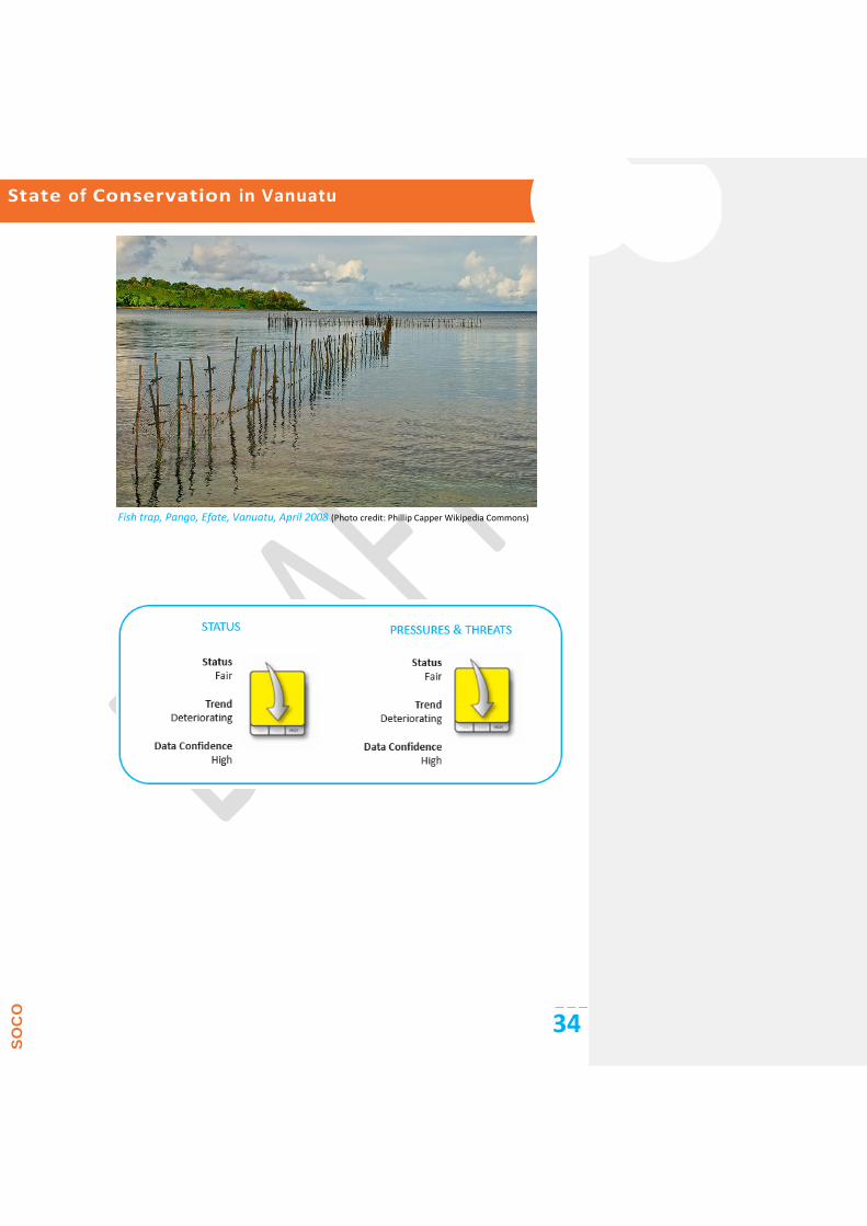
Fish trap, Pango, Efate, Vanuatu, April 2008 (Photo credit: Phillip Capper Wikipedia Commons)

State of Conservation in Vanuatu
SO
CO
35
2. Native species
Much of biodiversity conservation in the countries and territories of the SPREP region is focussed on
individual species. This set of indicators focuses on pressures on individual species using three different
measures. First, pressures on those species currently classified as ‘Threatened’ in the IUCN Red List of
Threatened Species (International Union for Conservation of Nature (IUCN) 2013) are assessed. Second,
because of their additional vulnerability, pressures on species found only in one of the countries and
territories (single-country endemic species) are assessed. Third, recognising that over half of the world’s
known species of cetaceans are found in the region along with the world’s largest remaining
populations of dugongs and green, hawksbill and loggerhead turtles, the pressures those species face
are assessed.
Marine and coastal species
Marine and coastal ecosystems in Vanuatu are diverse, which gives rise to high diversity of marine
species. To date, 295 hard corals have been recorded and over 460 reef fish. Marine mammals include
cetaceans and the dugong (Dugong dugon), and two species of marine turtles have nesting sites in
Vanuatu.
Terrestrial and freshwater species
There are about 1,000 vascular plant species in Vanuatu, of which around 150 are endemic. There is
high diversity of orchids, with 158 species, and palms, with 21 species, including 14 endemic species
(Government of Vanuatu 2014). There are 121 bird species, 30 species of reptiles and 12 species of
Chiropterae (flying foxes and bats). Invertebrate diversity is not fully described but includes the coconut
crab (Birgus latro), which is an important food resource in Vanuatu (Government of Vanuatu 2014).
Invasive animal species are a threat in Vanuatu and include the Indian mynah Acridotheres tristis, the
giant African snail Alcatina fulica and the rosy wolf snail Euglandina rosea. E. rosea was introduced as a
biological control agent for Achatina fulica, but the species has caused the extinction of numerous
native snails in other countries. Another species of concern in Vanuatu is the little fire ant Wasmannia
auropunctata, which has reduced arthropod species diversity in other locations and may threaten crab
species, including the coconut crab (Bakeo and Qarani 2005).

State of Conservation in Vanuatu
SO
CO
36
2.1. Threatened species
KEY POINTS Of the 3,166 threatened species (2013) in the 22 Pacific Island nations assessed in the State of
Conservation in Oceania 2013 report, most occur in the marine (59%) biome, followed by the
terrestrial biome (33%).
Invasive species have the greatest impact on the largest numbers of terrestrial threatened
endemic and non-endemic species and Critically Endangered species, followed by impacts of
land-use change due to agriculture, farming and forestry activities, and exploitation.
BACKGROUND AND RELEVANCE OF INDICATOR
Extinction rates are disproportionately high on islands, with approximately 80% of all known species
extinctions occurring on islands. This indicator focuses on the pressures on endemic and non-endemic
species that face the highest risk of extinction: those species classified as ‘Threatened’ (species
belonging to the top three classifications of Critically Endangered, Endangered and Vulnerable:
CR+EN+VU) in the IUCN Red List of Threatened Species. Cnidaria (such as corals, jellyfish and sea
anemones) were excluded from the much of the analysis because specific threats are not identified in
the Red List database. Non-coral marine species that were retained and analysed included sharks, rays
and skates, sea birds, shore fish, marine mammals, sea turtles and sea snakes.
HOW THE INDICATOR WAS ASSESSED
Data for this indicator were compiled from the IUCN Red List of Threatened Species online public
database (Version 2013.1). Information was extracted from the text by identifying threat categories that
were relevant in the assessment and interpreting the absolute estimated threat level. For each species,
a High/Medium, Low or Potential threat level was assigned to each threat category. Threats were
categorised as follows: Residential and commercial development and transport (Development);
Agriculture, farming and forestry (Agriculture); Energy production and mining (Mining); Biological
resource use (Exploitation); Anthropogenic otherwise uncategorised habitat loss/degradation (Habitat
loss); Invasive species (Invasives); Genetic (hybridisation/inbreeding) (Genetic); Pollution; Geological
events; Extreme weather and climate change (Climate); Fire, unclear whether natural or anthropogenic
(Fires); and Other, such as disease (Other). Only the ten worst threats were graphed.
STATE
As of August 2013, 1,160 species in Vanuatu were assessed according to the IUCN Categories and
Criteria for inclusion in the Red List of Threatened Species. Table 8 provides a summary of these species,
and Figure 3 shows the assessed species by Category. The majority of assessed species are found in
marine habitats, but a greater percentage of terrestrial species are threatened. This pattern can be
explained by the more restricted range of many terrestrial species.

State of Conservation in Vanuatu
SO
CO
37
Table 8: Species in Vanuatu included on the IUCN Red List (version 2013.1)
Taxonomic group Sub-group Number of
species assessed
No. of species assessed as
Threatened (CR, EN, VU)
No. of species
assessed as Data
Deficient
Estimated number of
species described*
Plants
Bryophytes 0 136
Ferns and allies 1 0 0 269
Cycads 1 1 0 5
Conifers 6 1 0 11
Gnetopsida 1
Magnoliopsida (Dicotyledons)
26 4 0 693
Liliopsida (Monocotyledons)
31 4 0 393
Algae 0 10
Vertebrates
Birds 87 9 0 87
Mammals 27 7 10 28
Reptiles 25 4 2 17
Amphibians 0 0
Bony fish (freshwater and marine)
358 8 38 719
Cartilaginous fish 18 7 2 18
Invertebrates
Insects 10 0 1 301
Arachnids 0 3
Hard corals (Anthozoa)
378 78 11 378
Molluscs (bivalves and gastropods)
111 4 3 169
Molluscs (cephalopods)
2 0 1 unknown
Crustaceans 28 0 3 unknown
Holothuroidea (sea cucumbers)
44 10 13 unknown
Hydrozoa 6 0 0 unknown
Other invertebrates 0 unknown
Fungi 0 477
Totals 1,160 137 84 3,714

State of Conservation in Vanuatu
SO
CO
38
Figure 3: Number of assessed species in Vanuatu in each IUCN category
Of the 137 threatened flora and fauna (CR, EN or VU; IUCN 2013) of Vanuatu, 78 (57%) are corals
(Phylum: Cnidaria), with the majority in the order Scleractinia. These species have been excluded from
the country threats analysis and are addressed in the Regional State of Conservation Report.
Vanuatu has one recorded extinction: the tanna ground dove (Gallicolumba ferruginea). Extinction
drivers for this species are believed to have been hunting and predation by domesticated mammals.
PRESSURES AND THREATS
Exploitation is the most significant threat faced by (or potentially faced by) non-Cnidarian threatened
(CR, EN or VU) species recorded in the IUCN Red List in Vanuatu (see Table 9). Hunting and exploitation
affect 66% of total threatened species in Vanuatu. Agriculture and invasive species are the second- and
third-worst threats and impact 20% and 15% of threatened species in Vanuatu, respectively. Marine
species including marine reptiles, marine mammals, fish, echinoderms (sea cucumbers) and sharks and
rays are frequently under potential to intense fisheries pressure, accounting for most of the occurrences
of exploitation recorded in the dataset.
Some species face multiple threats. For example, the Endangered red Santa Cruz ground dove
(Gallicolumba sanctaecrucis) is threatened by hunting and exploitation, the establishment of the
invasive vine Merremia peltata in the Vatthe Conservation Area and competition from the common
native emerald dove (Chalcophaps indica) in degraded forest habitats.
Agriculture, farming and forestry impact a number of threatened plant species in Vanuatu, including the
endangered Fijian kauri pine (Agathis macrophylla), which faces on-going unsustainable logging in
natural forests in parts of its range. The Pacific sheath-tailed bat (Emballonura semicaudata) is also
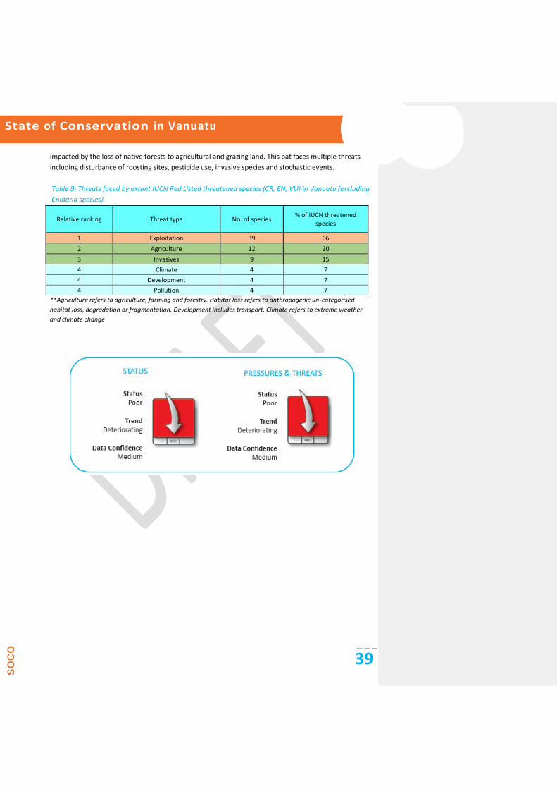
State of Conservation in Vanuatu
SO
CO
39
impacted by the loss of native forests to agricultural and grazing land. This bat faces multiple threats
including disturbance of roosting sites, pesticide use, invasive species and stochastic events.
Table 9: Threats faced by extant IUCN Red Listed threatened species (CR, EN, VU) in Vanuatu (excluding
Cnidaria species)
Relative ranking Threat type No. of species % of IUCN threatened
species
1 Exploitation 39 66
2 Agriculture 12 20
3 Invasives 9 15
4 Climate 4 7
4 Development 4 7
4 Pollution 4 7
**Agriculture refers to agriculture, farming and forestry. Habitat loss refers to anthropogenic un-categorised
habitat loss, degradation or fragmentation. Development includes transport. Climate refers to extreme weather
and climate change

State of Conservation in Vanuatu
SO
CO
40
2.2. Endemic species
KEY POINTS Of the 2,189 single-country endemic species recorded across Oceania, 115 (5.3%) are already
extinct, and 12 (0.5%) now exist only in captivity.
At present, 930 of the 2,062 extant single-country endemic species (nearly 45%) are at a risk of
extinction.
Land-use change due to agriculture, the spread of invasive species, fires, habitat degradation and
alteration, mining activities and over-exploitation are the main threats to all single-country
endemic species.
The biggest threats to single-country endemic species classified as Threatened are the spread of
invasive species followed by land-use change due to agriculture, fires and habitat loss.
BACKGROUND AND RELEVANCE OF INDICATOR
Endemic species once extinct are lost forever. Endemic species found only on one island or group of
islands in Oceania are particularly vulnerable to the consequences of increasing human activity. This
indicator identifies the key pressures and threats to single-country endemic species and the extent to
which these species have already been impacted. Most of these species are terrestrial, as information
about marine endemic species is lacking generally. Species extinction or species decline disrupt
ecological processes and may also lead to cascading and catastrophic co-extinctions.
HOW THE INDICATOR WAS ASSESSED
Data for the indicator were extracted from the IUCN Red List of Threatened Species Version 2013.11.
A High/Medium, Low or Potential threat level was assigned to each pressure in order to compare actual
and potential threats as well as their relative estimated level of severity. The relative importance of
different pressures was also analysed in relation to current conservation status using the IUCN Red List
categories (CR/EN/VU = Critically Endangered/Endangered/Vulnerable; LR/LC/NT = Low Risk/Least
Concern/Near Threatened; DD = Data Deficient).
STATE
Of a total of 39 extant Vanuatu endemics, 28% are plants, and 23% are birds. Fifteen species (38% of the
total) have been assessed as threatened (CR/EN/VU).
PRESSURES AND THREATS
Exploitation, habitat loss and agriculture are the three leading threats faced by or potentially faced by
single-country endemic species in Vanuatu (see Figure 3). These threats each impact approximately 20%
to 25% of the total number of endemic species. Endemic birds, mammals and reptiles are all impacted
by exploitation in Vanuatu to some degree. The Vulnerable New Hebrides scrub fowl (Megapodius
layardi) is hunted and its eggs are collected; the Vulnerable Vanuatu flying fox (Pteropus anetianus) is
hunted, especially following typhoons; the Endangered Banks flying fox (Pteropus fundatus) is also

State of Conservation in Vanuatu
SO
CO
41
hunted for food; and the Endangered Anatom emo skink (Emoia aneityumensis) is potentially smuggled
for the international pet trade.
Over 60% (5 out of 8) of Vanuatu’s endemic bird fauna are impacted by agricultural activities. For
example, the Vulnerable Vanuatu imperial-pigeon (Ducula bakeri) is threatened by the degradation of
habitat due to cattle farming, logging and conversion of forest to kava plantations. The Vulnerable royal
parrotfinch (Erythrura regia) is impacted by the loss of lowland and mid-altitude forest due to logging.
Invasive species are fourth on the list of worst threats impacting 15% of endemic species in Vanuatu.
This threat is particularly relevant to the two endemic gastropods (the Critically Endangered Partula
milleri and the Endangered Partula auraniana), which are under threat from the predatory snail
Euglandina rosea and would likely be under threat from future introductions of the predatory flatworm
Platydemus manokwari.
Table 10: Total number and percentage of extant IUCN Red List single-country endemic species in
Vanuatu impacted by each threat type** with relative ranking given
Relative ranking Threat type No. of endemic
species % endemic species
1 Exploitation 10 26
2 Habitat loss 9 23
2 Agriculture 9 23
3 Invasives 6 15
4 Development 4 10
5 Climate 3 8
6 Human disturbance 1 3 (Source: IUCN 2013)
**Habitat loss refers to anthropogenic un-categorised habitat loss, degradation or fragmentation. Agriculture refers to agriculture, farming and forestry. Development includes development of transportation links. Climate refers to extreme weather and climate change

State of Conservation in Vanuatu
SO
CO
42
2.3. Threatened migratory marine species
KEY POINTS The key threats to cetaceans are from fisheries operations, boat strikes, habitat degradation and
pollution, anthropogenic noise, climate change and unregulated tourism.
The major threat to marine turtle populations remains the direct harvest and illegal poaching of
eggs and adults of all species. Climate change is predicted to be an increasing threat.
The population status of many species of cetaceans is poorly known. The ability to quantify and
address threats is hampered by the absence of regular research and monitoring of species
distributions and abundance globally and in the Pacific region.
BACKGROUND AND RELEVANCE OF INDICATOR
Over half of the world’s known species of cetaceans are found in the Pacific region, and the Pacific also
supports the world’s largest remaining populations of dugongs and green, hawksbill and loggerhead
turtles. These species are vulnerable to a wide range of threats, including fisheries by-catch; human
harvest; habitat loss and degradation from coastal development; pollution and pathogens; and climate
change.
HOW THE INDICATOR WAS ASSESSED
Data for the indicator were extracted from the IUCN Red List of Threatened Species (International
Union for Conservation of Nature (IUCN) 2013) for dugong, migratory marine turtles and cetaceans.
Key sources of information on population status and threats to marine species included species
assessments, peer-reviewed journal articles and regional and global reports on marine species (Marsh
et al. 2002, Miller 2007, Garrigue et al. 2008, International Union for Conservation of Nature (IUCN)
2008, Polidoro et al. 2011, Wallace et al. 2011, Coral Reef Research Foundation 2012, Secretariat of
the Pacific Regional Environmental Programme (SPREP) 2013b).
Threats were ranked from 0 (data deficient) to 3, with threat levels of 1 (low), 2 (medium) and 3
(high).
STATE
Cetaceans
As at March 2011, Vanuatu was not a signatory to the Pacific Islands Cetacean Memorandum of
Understanding. Anecdotal records dominate cetacean data for Vanuatu (Miller 2009).
Marine Turtles
The IUCN Marine Turtle Specialist Group (MTSG) conducts regular Red List assessments of each marine
turtle species on a global scale (Wallace et al. 2011). Regional Management Units (RMUs) have been
established based on biogeographical data for each species, providing a framework for defining
populations for assessment (Wallace et al. 2011). Vanuatu is located within the Pacific South Central
RMU for the green turtle (Chelonia mydas) (Wallace et al. 2011).
Confirmed marine turtles in Vanuatu include the green turtle (Chelonia mydas) and hawksbill turtle
Commented [E15]: Should this be “cetaceans and turtles”?

State of Conservation in Vanuatu
SO
CO
43
(Eretmochelys imbricata) (www.iucnredlist.org).
Population status:
C. mydas: short- and long-term trends are unknown (Table 11);
E. imbricata: decreasing (Table 11).
Dugong Dugong dugon
The Vanuatu Archipelago is the eastern limit of the dugong’s range because seagrass beds have both
lower frequency of occurrence and less diversity progressing eastwards across the Pacific, placing a
natural barrier to the eastwards expansion of the dugong’s range (Marsh et al. 2002). The population
size and status of dugongs in Vanuatu is unknown because most of the species information is out-dated,
and there is little knowledge on seagrass distribution in the region (Marsh et al. 2002). Results of aerial
and postal surveys indicated that dugongs occur in small groups (single or pairs of animals) throughout
the sheltered waters of Vanuatu (Chambers et al. 1989, see Marsh et al. 2002). Tame dugongs are
known to reside in Lamen Bay (Epi Island) and Tanna Bay (Tanna Island) (Pacific Island Travel 1999;
Lohmann, pers comm.; see Marsh et al. 2002).
Dugong are protected in Vanuatu under the Fisheries Act 1982, which prohibits the capture of marine
mammals in Vanuatu’s international waters (Marsh et al. 2002).
Table 11: Marine species of conservation concern in Vanuatu
Species Common name IUCN Red List status
2008
Population trend worldwide
Vanuatu population
Dugong dugon Dugong, sea cow VU A2bcd Unknown Declining
Marine turtles
Eretmochelys imbricata Hawksbill turtle CR A2bd Decreasing Unknown
Chelonia mydas Green turtle EN A2bd Decreasing Unknown
Cetaceans – confirmed sightings
Physeter macrocephalus Sperm whale VU Unknown Unknown
Megaptera novaeangliae Humpback whale LC Increasing Unknown
Peponocephala electra Melon-headed whale LC Unknown Unknown
Stenella attenuata Pantropical spotted dolphin
LC Unknown Unknown
Stenella coeruleoalba Striped dolphin LC Unknown Unknown
Tursiops sp. Bottlenose dolphin LC Unknown Unknown
Balaenoptera sp. Bryde's whale DD Unknown Unknown
Globicephala macrorhynchus Short-finned pilot whale DD Unknown Unknown
Orcinus orca Orca, killer whale DD Unknown Unknown
Stenella longirostris Spinner dolphin DD Unknown Unknown

State of Conservation in Vanuatu
SO
CO
44
PRESSURES AND THREATS
Pressures on marine species
Threats to marine turtle, cetacean and dugong populations include:
fisheries impacts due to by-catch mortality, habitat destruction and food web impacts. Some
cetacean species are threatened by over-fishing of prey species;
harvest, which includes taking of turtles and their eggs and scientific whaling, drive hunts and
capture for captivity for cetaceans and hunting and poaching of dugong;
habitat degradation via coastal development, nesting beach degradation (turtle nesting), seafloor
dredging, vessel traffic, construction and changes to vegetation and dune systems (turtle
nesting) as well as sedimentation affecting the health of seagrasses (dugong);
pollution and pathogens, including plastics and other marine debris affecting both cetaceans and
marine turtles as well as light pollution, which may disrupt turtle nesting and hatchling
behaviour;
boat strikes and ecotourism;
anthropogenic noise from sonar and seismic activity, which has been associated with mass
strandings of certain cetacean species; and
global climate change, which may impact sex ratios of turtle hatchlings and cause loss of nesting
beaches.
Cetaceans
The main threats to cetaceans in the Pacific Islands are by-catch in fishing operations (including purse
seines and gill nets); vessel strikes (particularly if marine mammal watching operations are poorly
managed); entanglement in marine debris and ingestion of discarded plastic; anthropogenic noise
(including seismic surveys and military sonar); and climate change, which may not only result in changes
of distribution of ocean currents and prey species but may also lead to some key prey species such as
squid declining in abundance. In most cases, the ability to further quantify and address these threats is
hampered by gaps in species knowledge as well as lack of monitoring or assessment in the region (Miller
2007).
There are limited data on population status and threats to cetaceans in Vanuatu.
Turtles
Green turtle populations in the Pacific South Central RMU have been assessed as being Low Risk-Low
Threat (LR-LT), implying that these populations have high, increasing or stable abundance and high
genetic diversity and are under low to moderate threat levels (Wallace et al. 2011).
Hawksbill turtles continue to face exploitation and a suite of insidious but destructive new threats,
including loss of nesting and coral reef foraging habitat, incidental capture in fisheries operations and
marine pollution (IUCN 2008). These issues are reflected in the assessed High Risk-High Threat (HR-HT)
status of hawksbill turtles in the Pacific South Central RMU, implying that populations of this species
have low and declining abundance, low genetic diversity and are under high threat levels (Wallace et al.

State of Conservation in Vanuatu
SO
CO
45
2011). The HR-HT category is shared by more than half the global RMUs for hawksbill turtles, indicating
that this species warrants the most urgent conservation intervention (Wallace et al. 2011).
Dugong
Development: The major development in Vanuatu is agriculture, but tourism and forestry are
expanding (Marsh et al. 2002). The overall level of development in this region is low, but instances of
soil erosion and pollution have been reported and are expected to increase (Chambers et al. 1989, see
Marsh et al. 2002).
Fisheries interactions: Accidental dugong deaths appear to be rare in Vanuatu, and those that do occur
are attributed to fishing nets and/or boat strikes (Chambers et al. 1989, see Marsh et al. 2002).
Human harvest: Although dugong are protected in Vanuatu, hunting still occurs in some areas,
particularly the Maskelynes area of southeast Malakula, northern Epi and parts of Etale (Chambers et al.
1989, see Marsh et al. 2002), but dugong meat is generally a minor component of the subsistence diet
of the people of Vanuatu (Marsh et al. 2002). An estimated 5–15 dugongs are deliberately killed for
food annually despite laws prohibiting the capture, possession and sale of dugong.
Boat-related threats and eco-tourism: Swimming with ‘tame’ dugong is a major tourist attraction at
Lamen Bay (Epi Island) and Port Resolution, Tanna Bay (Tanna Island). Dugong-tourist interactions
increase the risk of boat strikes and mother-calf separation (Marsh et al. 2002).
Figure 4: Assessed threats to migratory marine species in Vanuatu based on MTSG data for the Pacific
South Central RMU for the green turtle and hawksbill turtle and for the Pacific West RMU for the
leatherback turtle and mean values for cetaceans based on IUCN Red List 2008 global species
assessments (www.iucnredlist.org). Threat levels are 0 (data deficient), 1 (low), 2 (medium) and 3 (high)
(Wallace et al. 2011)
Commented [E16]: This sentence was moved up from the following section. Please ensure that your intended meaning has not been altered.

State of Conservation in Vanuatu
SO
CO
46

State of Conservation in Vanuatu
SO
CO
47
Response
Responses to protect and conserve Oceania’s terrestrial and aquatic biodiversity must be
built on a sound platform of national and international legislation and traditional governance
mechanisms. The establishment of protected areas is a key component of national biodiversity
programmes, as is direct action to mitigate impacts of invasive species, over-exploitation,
habitat loss and climate change guided by appropriate national action plans, such as National
Biodiversity Strategy and Action Plans.
This section examines the extent of Vanuatu’s protected areas, participation in and national
implementation of international biodiversity agreements and specific policy and management
actions to deal with invasive species.
Commented [E17]: This image/symbol appears as a black box on my computer. Please ensure that the image/symbol displays correctly in the final publishing software.

State of Conservation in Vanuatu
SO
CO
48
3. Environmental governance
3.1. Multilateral Environment Agreements
KEY POINTS Most of the Pacific island countries have made commitments to the main biodiversity Multilateral
Environmental Agreements (MEAs), in particular the Convention on Biological Diversity.
Pacific island territories of France, New Zealand, the United Kingdom and the United States are non-
parties to MEAs but have, to various degrees, delegated authority for environmental governance, and
some may be party to regional agreements.
BACKGROUND AND RELEVANCE OF INDICATOR
This indicator identifies the status of ratification of environment-related MEAs for Vanuatu and shows
the extent of commitment of Vanuatu to international cooperation for the good of all mankind and its
natural habitats. The MEAs considered in this assessment include the following:
(a)Cartagena Protocol on Biosafety
(b)Convention on Biological Diversity (CBD)
(c)Convention on the Conservation of Migratory Species of Wild Animals (CMS) and relevant
Memoranda of Understanding
i.The Memorandum of Understanding on the Conservation and Management of Dugongs and
their Habitats throughout their Range (Dugong MoU)
ii.The Memorandum of Understanding on the Conservation and Management of Marine
Turtles and their Habitats of the Indian Ocean and South-East Asia (IOSEA Marine Turtle
MOU)
iii.Pacific Islands Cetaceans
iv.The Memorandum of Understanding (MoU) on the Conservation of Migratory Sharks
(d)Convention on Wetlands of International Importance (Ramsar)
(e)Convention on International Trade in in Endangered Species of Wild Fauna and Flora (CITES)
(f)Nagoya Protocol on Access to Genetic Resources and the Fair and Equitable Sharing of Benefits
Arising from their Utilization (Nagoya Protocol)
(g)United Nations Convention on the Law of the Sea (UNCLOS)
(h)United Nations Framework Convention on Climate Change (UNFCCC)
(i)Convention Concerning the Protection of the World Cultural and Natural Heritage (WHC)
HOW THE INDICATOR WAS ASSESSED
The data for each Pacific island country’s status of commitment to the MEAs were extracted from the
InforMEA country profile and relevant MEA Country profiles (InforMEA 2014).

State of Conservation in Vanuatu
SO
CO
49
STATE
Vanuatu has signed, ratified, accepted, adhered to or acceded to the main biodiversity MEAs; see Table
12. Although not a Party to the CMS, Vanuatu has signed the Memorandum of Understanding relating to
Dugong, Sharks and Pacific Island Cetaceans (see Appendix A).
Appendix A below indicates which biodiversity conservation MEAs Vanuatu has ratified and has become
a Party to and the scope at which these MEAs are implemented at the national and sub-national level.
The table reflects the commitment that Vanuatu has to integrating its international commitments at the
national level through national policies and legislations. Details of national legislation relating to the
biodiversity MEAs to which Vanuatu is a Party are also outlined.
Table 12: Vanuatu and MEAs
Cartagena Protocol on Biosafety
Convention on Biological Diversity (CBD)
Convention on the Conservation of Migratory Species of Wild Animals (CMS) and relevant Memoranda of Understanding
The Memorandum of Understanding on the Conservation and Management of Dugongs and their Habitats throughout their Range (Dugong MoU)
The Memorandum of Understanding on the Conservation and Management of Marine Turtles and their Habitats of the Indian Ocean and South-East Asia (IOSEA Marine Turtle MOU)
Pacific Islands Cetaceans
The Memorandum of Understanding (MoU) on the Conservation of Migratory Sharks
Convention on Wetlands of International Importance (Ramsar)
Convention on International Trade in in Endangered Species of Wild Fauna and Flora (CITES)
Nagoya Protocol on Access to Genetic Resources and the Fair and Equitable Sharing of Benefits Arising from their Utilization (Nagoya Protocol)
United Nations Convention on the Law of the Sea (UNCLOS)
United Nations Framework Convention on Climate Change (UNFCCC)
Convention Concerning the Protection of the World Cultural and Natural Heritage (WHC)

State of Conservation in Vanuatu
SO
CO
50
3.2. National policies and legislation
KEY POINTS Most Pacific island countries have enacted legislation relating to environmental protection or have
enacted sectoral legislation containing environmental protection provisions.
Also, most Pacific island countries have not enacted specific or comprehensive legislation to
address the obligations of State parties under the MEAs.
Updating environmental legislation is urgently needed in the region but is hindered by the lack of
capacity and resources to develop, monitor and enforce environmental legislation and is
delayed by bureaucratic processes.
BACKGROUND AND RELEVANCE OF INDICATOR
This indicator identifies the status of national implementation of the biodiversity conservation MEAs
that Vanuatu has signed or ratified. It focuses on identifying the specific legislations that Vanuatu has
developed and enforced. For the purpose of this report, ‘legislation’ refers to statutory law enacted by
legislature or a governing body in the Pacific island countries and territories. Where no specific
legislation is available, the indicator focuses on related legislation that has aspects relevant to the
objectives of the biodiversity conservation MEAs.
HOW THE INDICATOR WAS ASSESSED
The data for Vanuatu’s status of national implementation commitment to the MEAs were assessed
through research and extracted from various sources (ECOLEX 2013, Pacific Islands Legal Information
Institute (PACLII) 2013, Secretariat of the Pacific Regional Environmental Programme (SPREP) 2013a),
relevant government websites, published reports and various articles. Whilst every endeavour was
made to obtain the current legislation, policies, strategies and action plans, consultation with relevant
government departments is needed to ensure more recent developments have been considered.
STATE
Effective institutional arrangements or regimes are important for environmental management and
conservation, in particular the implementation and enforcement of national legislations and policies
that support the conservation of biodiversity.
Appendix B attached indicates both governmental and inter-governmental institutions set up in
Vanuatu to govern the conservation and management of terrestrial and marine ecosystems as required
under the relevant legal framework.

State of Conservation in Vanuatu
SO
CO
51

State of Conservation in Vanuatu
SO
CO
52
3.3. Traditional governance
KEY POINTS Traditional governance has an essential role in land and natural resources management in Pacific
island countries and territories.
The majority of land in the Pacific islands is customarily owned and is held in customary tenure.
State lands or freehold lands represent only a comparatively small percentage of lands.
Customary definition of land in most of the Pacific islands extends to the foreshore and inshore
waters, although in some countries, the national law vests ownership of foreshore lands to the
State, while recognising customary rights of access and use by traditional landowners.
BACKGROUND AND RELEVANCE OF INDICATOR
This indicator assesses the recognition of customary land ownership and customary rights of access and
use of land and marine resources in each country. It identifies the percentage of land owned
customarily and whether customary land ownership extends to foreshores and beyond. It also briefly
covers the impact of customary ownership on environmental governance.
HOW THE INDICATOR WAS ASSESSED
The data for Vanuatu’s status of traditional governance were assessed through desktop research and
extracted from the country profile on the Pacific Environment Information Network (PIEN) website
(Secretariat of the Pacific Regional Environmental Programme (SPREP) 2013a), government websites,
published reports and various articles (Clarke et al. 2008).
STATE
In Vanuatu, constitutionally vested, inalienable land ownership rights rest with customary tenure, with
recognised leasing arrangements under Ministerial consent. All land in Vanuatu belongs to the
indigenous 'custom owners', and almost all land is held under customary tenure, whether leased (9.3%)
or un-leased (89.7%).
A recently concluded National Land Summit resolution seeks to include a wider recognition, inclusive of
mandatory consultative process, with traditional governance systems, from the national to local
(community/village/land-owning unit) levels. These recommendations will drive the call for major
Constitutional changes giving more jurisdictions to traditionally instituted forums at local levels (and less
to the Courts) for land dispute determination/settlement. Where previously any Minister of Land could
exercise unhindered discretion to deal with land lease applications, and/or bring a land law-related
amendment proposal to Parliament, new resolutions will call for pre-parliament amendment proposals
decision-making at the Council of Ministers (COM) level informed by prior consultation with National
Council of Chiefs.
Under a Draft National Land Use Planning Policy (May 2012), Kastom provides one of three pillar

State of Conservation in Vanuatu
SO
CO
53
foundations informing the way forward for land-use planning. Vanuatu’s traditional societies and the
inter-relationships between units of family, clans and tribes are organised in meaningful patterns of
customary resource access rights, which are communally shared and which in turn support a highly
resilient traditional economy. Of particular note is that such access rights are borne of and born within
kinship ties, which transcend the physical boundaries of defined localities. Although direct and physical
access to land and its produce is guaranteed to those that hold active stewardship over customary
land/marine areas, participation and access (to land/sea and its produce) is open to kin-folk in urban
areas. Regenvanu (above) also further notes:
“However, the ill-considered alienation of land from the traditional economy in Vanuatu through
leasehold title, for example, is removing the means for ordinary people to be economically
productive and enjoy food and social security, in addition to often massively degrading our natural
environment.”
M(L)PAs as conservation measures are being increasingly used with villages/communities, as a unique
and time-tested customary tool in resource management, accepted and understood by the indigenous
population.

State of Conservation in Vanuatu
SO
CO
54
3.4. National Biodiversity Strategy and Action P lans and
national reporting to the Convention on Biological
Diversity
KEY POINTS Fourteen of the countries of the SPREP region are Parties to the Convention on Biological Diversity
(CBD), and 12 have National Biodiversity Strategies and Action Plans (NBSAPs).
National reporting to the CBD includes submission of national reports and thematic reports on
various themes, such as alien species, protected areas, etc. Parties to the CBD have also
submitted Action Plans for Implementing the Convention on Biological Diversity’s Programme of
Work on Protected Areas, known as PoWPA Action Plans.
BACKGROUND AND RELEVANCE OF INDICATOR
NBSAPs are the principal instruments for implementing the CBD at the national level. The Convention
requires parties to prepare a National Biodiversity Strategy (or equivalent instrument) and to ensure
that this strategy is mainstreamed into the planning and activities of all those sectors whose activities
may have an effect (positive and negative) on biodiversity.
HOW THE INDICATOR WAS ASSESSED
The Goals and Targets of the CBD Strategic Plan 2001–2010 were used to assess current NBSAPs
because Parties were required to report progress against them in their Fourth National Reports to the
Secretariat of the CBD. Scores were then given to Targets within each Goal for each country.
Note: The Strategic Plan on Biodiversity 2011–2020 and the Aichi Biodiversity Targets were adopted by
the Parties to the CBD during the Tenth Conference of the Parties (COP10) in Nagoya, Japan.
The fifth national report (scheduled for submission in early 2014) is to provide a mid-term review of
progress towards the implementation of the Strategic Plan for Biodiversity 2011–2020 and progress
towards the Aichi Biodiversity Targets. The fifth national report has not been considered for this
assessment.
STATE
The NBSAP was adopted by government in 1999, one of the earliest in the Pacific. It addresses some of
the Thematic Areas and Cross-cutting Issues but was prepared prior to the CBD Strategic Plan 2001–
2010 and does not directly address the goals of that plan. It has not been updated since its initial
production and does not address the Aichi Biodiversity Targets of the CBD Strategic Plan 2011–2020.
Six key objectives, with more than 20 priority actions, were identified for effective management of
biological resources: 1. Protection and wise use of biodiversity; 2. Application of policy, planning and
legal mechanisms to enable sustainable management of biodiversity; 3. Research, assessment and

State of Conservation in Vanuatu
SO
CO
55
monitoring of biodiversity; 4. Capacity building for environmental management; 5. Environmental
education, awareness and information sharing; and 6. Participation of local communities in the
management of biodiversity.
The Priorities and Action Agenda 2006–2015 (the document that guides national development)
discusses Environment in Chapter 6.2 but concludes that there are few data available to measure
performance in achieving the objectives. Sustainable use of biological resources (goods derived from
environmental resources) is the only conservation guideline presented.
The Third National Report template used a repetitive process to collect information on the 2010 CBD
targets, which made it difficult for small countries to complete and use to analyse progress. The report
contains statements that show an awareness of the need for conservation, but at the time of reporting,
government priorities directed Vanuatu’s limited national resources toward social services, governance
and development of a private economic sector. In general, effort was directed to species of high value,
and Vanuatu’s biodiversity remained poorly known with little species or ecosystem information.
Table 13: Summary of reporting by Vanuatu to the CBD up to 2013
NBSAP developed yes
NBSAP with measurable targets no
NBSAP with Indicators no
NBSAP updated Post-Nagoya no
First National Report to the CBD yes
Second National Report to the CBD yes
Third National Report to the CBD yes
Fourth National Report to the CBD no
Fifth National Report to the CBD no
National Action Plan for the Programme of Work on Protected Areas yes

State of Conservation in Vanuatu
SO
CO
56
4. Conservation initiatives
4.1. Protected areas
KEY POINTS Coverage of the land and seas of Oceania by protected areas is low. Only four countries appear to
have met the Aichi Target 11 commitment made through the CBD for terrestrial coverage, and
just one has met the commitment for marine coverage.
There are no protected areas in international waters within the region.
Locally Managed Marine Areas (LMMAs) contribute to biodiversity conservation, and their
implementation by over 500 communities represents a unique achievement.
Across Oceania, protection of both terrestrial and marine Important Bird Areas (IBAs) is very poor,
with only 10% of the area of marine IBAs and 20% of the area of terrestrial IBAs encompassed
within protected areas.
Similarly, of the Alliance for Zero Extinction sites (AZEs), which hold the last remaining populations
of Critically Endangered or Endangered species, only three (8.1%) are completely protected, and
eight (22%) are partially protected by inclusion in protected areas.
BACKGROUND AND RELEVANCE OF INDICATOR
Protected areas are a key mechanism for conserving biodiversity. This indicator assesses the extent to
which nationally designated protected areas, including Locally Managed Marine Community Areas
(LMMAs), and other sites of global significance for the conservation of biodiversity, such as Important
Bird Areas (IBAs), Endemic Bird Areas (EBAs), Key Biodiversity Areas (KBAs) and Alliance of Zero
Extinction Sites (AZE), provide terrestrial and marine coverage.
Note: Gaps in information and listing of protected areas have been noted in the WDPA.
HOW THE INDICATOR WAS ASSESSED
The analysis presented here relies on the official data supplied by the Government of Vanuatu and data
held in the World Database on Protected Areas (World Database on Protected Areas (WDPA) 2013),
Birdlife International database (BirdLife International 2013a) and Alliance for Zero Extinction Sites
database (Alliance for Zero Extinction Sites (AZE) 2013, Integrated Biodiversity Assessment Tool (IBAT)
2013).
STATE
Terrestrial Protected Areas
Vanuatu has a total land area of 12,189 square kilometres. Protected terrestrial and inland waters

State of Conservation in Vanuatu
SO
CO
57
comprise 531 square kilometres or 4.2% of the total land area (Integrated Biodiversity Assessment Tool
(IBAT) 2013).
Marine Protected Areas
Currently, approximately 45 square kilometres (0.0%) of coastal and marine areas are covered by some
form of Protected Area status in Vanuatu (Integrated Biodiversity Assessment Tool (IBAT) 2013).
Table 14: Protected Area cover in Vanuatu
Country Terrestrial area covered by PAs (km2)
% terrestrial area covered by PAs
Marine area covered by PAs (km2)
% marine area covered by PAs
Total extent PAs (km2)
Vanuatu 531 4.2 45 0 576
Region (excl. international waters) 27,805 4.97 548,052 1.91 575,857
Region (incl. international waters) 27,805 4.97 x x x
There are currently 34 designated terrestrial and marine protected areas and one proposed terrestrial
protected area listed in the WDPA; see Table 15.
Table 15: Protected marine and terrestrial areas in Vanuatu
IUCN Marine Total Name Designation category Marine area area Status Status
year (km2) (km2)
President Coolidge and Million Dollar Point
Marine Reserve III 1 1 1 Designated 1983
Vatthe Forest Conservation Area
VI 1 2.9 34.7 Designated 1994
Nguna-Pele Marine Protected Area
VI 1 30.0 30 Designated 2001
Nguna-Pele Marine Protected Area
Marine Protected Area
VI 1 30.0 30 Designated 2001
Erromango Kauri Forest Conservation Area
VI 32.07 Designated 1995
Nevnal Protected Area Forest Conservation Area
NR Designated
Western Peninsular Forest Conservation Area
NR Designated
Tegua Island Reserve Forest Conservation Area
NR Designated
Pankumo Protected Area Forest Conservation Area
NR Designated
Central Efate (Teouma) Forest Conservation Area
NR Designated
Wiawi Conservation Area Forest Conservation Area
NR 50 Designated
Lownahuru Protected Area Forest Conservation Area
NR Designated
Lakorombanga Protected Area
Forest Conservation Area
NR Designated
Lasenuwi Forest Conservation Area
NR Designated
Loh Island Reserve Forest Conservation Area
NR Designated
Lake Letas Conservation Area NR Proposed

State of Conservation in Vanuatu
SO
CO
58
Ponkovio Marine Protected Area
NR 1 Designated 1989
Emua Marine Protected Area
NR 1 1.5 1.5 Designated 1995
Nagha mo Pineia Protected Area
Marine Reserve NR 1 10.5 Designated 1994
Nguna Pele Marine Reserve Marine Protected Area
NR 1 30 Designated
Lekavik Marine Protected Area
NR 1 Designated 1993
Aore Recreation Reserve NR 1 0.37 0.37 Designated 1984
Naomebaravu-Malo Reserve NR 1 0.11 0.11 Designated 1984
Ambrym Megapode Reserve Forest Conservation Area
NR 1 Designated
Narong Marine Marine Reserve NR 1 1.6 Designated 1991
Bucaro Aore Recreation Reserve NR 1 0.2 0.2 Designated 1984
Loru Protected Area Forest Conservation Area
NR 1 2.2 Designated 1993
Whitesands Reserve Recreation Reserve NR 1 0.14 0.4 Designated 1984
Erakor and Empten Lagoon Marine Protected Area
NR 1 0 Designated 1997
Ringi Te Suh Marine Conservation Reserve
Forest Conservation Area
NR 1 1 Designated 1991
Vendik Protected Area Forest Conservation Area
NR 1 0 Designated
Hideaway Island Marine Protected Area
NR 1 0 Designated 1996
Ringi te Extension Reserve Forest Conservation Area
NR 1 0 Designated
Hiu Island Reserve Forest Conservation Area
NR 1 0 Designated
Uri Marine Park Forest Conservation Area
NR 1 0 Designated
Community Conserved Areas, such as LMMAs
The Pacific has experienced a proliferation of Marine Managed Areas (MMAs) in the last decade. The
approaches being developed at national levels are built on a unique feature of the region—customary
tenure and resource access—and make use of existing community strengths in traditional knowledge
and governance, combined with a local awareness of the need for action.
Govan (2009) reported that many communities in Vanuatu have preserved traditional management in
the form of tabu areas, and in others, this tradition has been revived with the support of fisheries
officers, other government organisations and NGOs. Over 40 villages have been reported to manage
their marine resources in this manner in Vanuatu, but the real numbers may be significantly higher
(Govan 2009).
An estimated 80 traditional Locally Managed Marine Areas (LMMAs) exist in Vanuatu, and there is
evidence that they have been effective at increasing size and abundance of target species, but they are
not well documented.
Important Bird Areas (IBAs) and Endemic Bird Areas (EBAs)
Important Bird Areas (IBAs) are sites of global biodiversity conservation importance that are chosen
using internationally agreed, objective, quantitative and scientifically defensible criteria. IBAs are
selected because they may hold threatened birds, birds restricted to particular regions or biomes or

State of Conservation in Vanuatu
SO
CO
59
significantly large populations of congregatory water birds. Through this process, sites directly
important for bird conservation are identified and prioritised for conservation actions. In addition, birds
have been shown to be extremely good indicators of overall biodiversity, and throughout the world,
IBAs themselves protect a high percentage of many nations’ total biodiversity (Stattersfield et al. 1998).
There are currently no IBAs in Vanuatu (www.birdlife.org/datazone/country/vanuatu).
Over 2,500 bird species are restricted to an area smaller than 50,000 square kilometres, and they are
said to be endemic to these home ranges. BirdLife has identified regions of the world where the
distributions of two or more of these restricted-range species overlap to form Endemic Bird Areas
(EBAs).
There are currently no EBAs in Vanuatu (www.birdlife.org/datazone/country/vanuatu)
Alliance for Zero Extinction Sites (AZEs)
The Alliance for Zero Extinction (AZE), a joint initiative of biodiversity conservation organisations from
around the world, aims to prevent extinctions by identifying and safeguarding key sites, each one of
which is the last remaining refuge of one or more Endangered or Critically Endangered species. AZE is
first focusing on species that face extinction either because their last remaining habitat is being
degraded at a local level or because their tiny global ranges make them especially vulnerable to external
threats. To be designated as an AZE site, a site must meet all 3 criteria: it must contain at least one
Endangered (EN) or Critically Endangered (CR) species, as listed on the IUCN Red List; it must be the only
area where an EN or CR species occurs and contain the overwhelmingly significant known resident
population (>95%) of the EN or CR species; and it must have a definable boundary.
There is one AZE site in Vanuatu on Vanua Lava and Mota for the Vanikoro flying fox (Pteropus
tuberculatus).
Key Biodiversity Areas (KBAs)
The KBA approach builds on and complements other conservation priority setting approaches by
extending to all taxonomic groups the methodology employed by Bird Life International and Plant life
International to identify Important Bird Areas (IBAs) and Important Plant Areas (IPAs), respectively.
KBAs can be used as a tool by governments, inter-governmental organisations, NGOs, the private sector
and other stakeholders to expand protected area networks and, more generally, for targeting
conservation action. Additionally, KBAs provide the building blocks for landscape-level conservation
planning and for maintaining effective ecological networks aimed at preventing biodiversity loss. In the
Pacific, KBAs have been identified in three biodiversity hotspots, namely the Polynesia-Micronesia
hotspot, the East Melanesia Islands hotspot and the New Caledonia hotspot, which collectively include
all Pacific island countries and territories except for mainland PNG.
There are no KBAs identified for Vanuatu apart from the single AZE site (Integrated Biodiversity
Assessment Tool (IBAT) 2013).
Ecologically or Biologically Significant Areas
Ecologically or Biologically Significant Areas (EBSAs) in the global marine realm are classified based on
seven scientific criteria: 1. Uniqueness or rarity, 2. Special importance for life history of species, 3.

State of Conservation in Vanuatu
SO
CO
60
Importance for threatened, endangered or declining species and/or habitats, 4. Vulnerability, fragility,
sensitivity and slow recovery (fragile), 5. Biological productivity, 6. Biological diversity, and 7.
Naturalness.
There is one EBSA recognised in Vanuatu, shown in Table 16 below.
Table 16: Ecologically or Biologically Significant Areas (EBSAs) in Vanuatu
Name of area meeting EBSA criteria
Country Area (km²)
9. New Hebrides Trench Region
New Caledonia/Vanuatu 107,380
Protected Area Coverage
In summary, 4.2% of terrestrial and 0% of coastal and marine areas in Vanuatu are covered by some
form of protected area, as shown in the World Database of Protected Areas (Integrated Biodiversity
Assessment Tool (IBAT) 2013).
The one AZE identified in Vanuatu has 0% protected area coverage.
Mile a minute weed (Mikania
micrantha) smothering native species
on Vatthe Conservation Area, Espiritu
Santo, Vanuatu
(Photo credit: Nick Turner/Alamy)
State of Conservation in Vanuatu
SO
CO
61

State of Conservation in Vanuatu
SO
CO
62
4.2. Conservation initiatives
Participation in non-governmental conservation initiatives
Non-government organisation (NGOs) and inter-governmental organisations play a vital role in the
conservation of biodiversity in the region, and governments are to be commended for allowing these
organisations to play such a role. Appendix C outlines initiatives by non-government and inter-
governmental organisations in Vanuatu and is divided into regional, specific and conservation areas
initiatives.
A summary of non-governmental conservation initiatives in Vanuatu is outlined in Appendix C.
Conservation of species and sites
Vanuatu has taken steps toward better species governance by ratifying several MEAs (see Table 12).
With the increase of commercial infrastructural developments in Vanuatu, habitats and species living in
these habitats are threatened with extinction or change in status from resident to migratory species.
These threats may be mitigated through better land-use planning, proper environmental impact-
assessment processes, proper management of waste and pollution, sustainable forestry and mining
activities and better mitigation of climate change and disaster impacts. Appendix D indicates the specific
legal framework, institutional arrangement and strategy or action plans, if any, by which these
mitigating factors are governed.
Invasive alien species management
There are over 265 introduced species recorded in Vanuatu, of which 73 are known to be invasive. Of
the 73 known invasive species, 52 species (71%) are plants, and 20 (28%) are animals. Seventy invasive
species are associated with terrestrial systems; four are freshwater species, and one species occurs in
marine ecosystems.
The National Biodiversity Strategy and Action Plan includes invasive species management in Priority 2
(Management of introduced species) of Objective 1: Biodiversity protection and conservation and in
Priority 3 (Improve awareness of the invasive risks of introduced species and their movement between
islands) of Objective 5: Environmental Education, Awareness and Information Sharing. Vanuatu has yet
to prepare a National Invasive Species Strategy and Action Plan.
Some of the nine Thematic Areas of the three Sections of the Guidelines for Invasive Species
Management in the Pacific (A. Foundations, B. Problem Definition, Prioritisation and Decision-Making,
C. Management Action) are being addressed. Planned awareness-raising and capacity development
activities include a project to increase the quality of information in Vanuatu about invasive species and
to increase awareness and capacity of the government and rural communities to manage the impact
and spread of invasive species. The project will focus on priority areas where communities depend on
food resources that are negatively affected by invasive species, and it is not clear how biodiversity will
benefit from the project.
An early report (2001) surveyed ‘invasive pest’ species on 17 islands in Vanuatu. The report noted that
training is really focussed on economic pests and identified a need to take a “wider outlook on pests to
include non-economic [ones]”. The report recommended that “natural resource training institutions in

State of Conservation in Vanuatu
SO
CO
63
the region and national level change their pest identification and control to include pests affecting the
environment”.
A project to manage the invasive vine Merremia peltata has been underway in Vatthe Conservation
Area on Santo Island for some years. About 1,000 hectares have been cleared, and it is reported that
the crowns of hundreds of trees have regenerated and the forest floor is covered with seedlings.
Another project in Vatthe, funded by the GEF Small Grants Fund, has been concluded, but a report is not
yet available.

State of Conservation in Vanuatu
64
5. Summary and conclusions
Summary of Indicator Assessments
Details Reference Indicator Vanuatu
Status Trend Data quality
STATE, PRESSURES AND THREATS
ECOSYSTEMS
TERRESTRIAL ECOSYSTEMS 1.1. Forest cover State: Fair Deteriorating Low
Pressures and Threats: Fair
FRESHWATER ECOSYSTEMS 1.2. Freshwater ecosystems State: Fair
Mixed Medium
Pressures and Threats: Fair
COASTAL ECOSYSTEMS 1.3.1. Coral reefs State: Fair Deteriorating Medium
Pressures and Threats: Poor
1.3.2. Mangrove ecosystems State: Fair Deteriorating Medium
Pressures and Threats: Fair
1.3.3. Seagrass beds State: Fair Deteriorating Medium
Pressures and Threats: Fair
MARINE ECOSYSTEM 1.4.1. Ocean health State: Fair Mixed Medium
Pressures and Threats: Fair
1.4.2. Utilised species State: Fair Deteriorating High
Pressures and Threats: Fair

State of Conservation in Vanuatu
65
Summary of Indicator Assessments
Details Reference Indicator Vanuatu
Status Trend Data quality
NATIVE SPECIES 2.1 Threatened species State: Poor
Deteriorating Medium
Pressures and Threats: Poor
2.1 Endemic species State: Poor
Deteriorating Medium
Pressures and Threats: Poor
2.3 Threatened marine migratory species
State: Fair Deteriorating Medium
Pressures and Threats: Poor
RESPONSE
ENVIRONMENTAL GOVERNANCE 3.1 Multilateral Environmental Agreements
Good Improving High
3.2 National policies and legislation
Fair Improving Medium
3.3 Traditional governance Good Improving Medium
3.4 National Biodiversity Strategy and Action Plans
Fair Improving Medium
CONSERVATION INITIATIVES 4.1 Protected area coverage
Poor Unknown Medium
4.2 Conservation initiatives Fair Improving Medium

State of Conservation in Vanuatu
66
Mapping of Aichi Biodiversity targets with indicators in this assessment
Aichi Biodiversity Target Target # Indicator
By 2020, the rate of loss of all natural habitats, including forests, is at least halved and where feasible brought close to zero, and degradation and fragmentation is significantly reduced.
5 Terrestrial ecosystems: Forest cover
By 2020 all fish and invertebrate stocks and aquatic plants are managed and harvested sustainably, legally and applying ecosystem based approaches, so that overfishing is avoided, recovery plans and measures are in place for all depleted species, fisheries have no significant adverse impacts on threatened species and vulnerable ecosystems and the impacts of fisheries on stocks, species and ecosystems are within safe ecological limits.
6
Marine ecosystems: Ocean health and Utilised species Coastal ecosystems: Coral reefs, Mangrove ecosystems and Seagrass beds
By 2020, areas under agriculture, aquaculture and forestry are managed sustainably, ensuring conservation of biodiversity.
7 Terrestrial ecosystems: Forest cover Freshwater ecosystems
By 2020, pollution, including from excess nutrients, has been brought to levels that are not detrimental to ecosystem function and biodiversity.
8 Marine ecosystems: Ocean health and Utilised species Freshwater ecosystems
By 2020, invasive alien species and pathways are identified and prioritized, priority species are controlled or eradicated, and measures are in place to manage pathways to prevent their introduction and establishment.
9 Conservation initiatives: Invasive alien species management
By 2015, the multiple anthropogenic pressures on coral reefs and other vulnerable ecosystems impacted by climate change or ocean acidification are minimized, so as to maintain their integrity and functioning.
10
Marine ecosystems: Ocean health and Utilised species Coastal ecosystems: Coral reefs, Mangrove ecosystems and Seagrass beds
By 2020, at least 17% of terrestrial and inland water and 10% of coastal and marine areas, especially areas of particular importance for biodiversity and ecosystem services, are conserved through effectively and equitably managed, ecologically representative and well-connected systems of protected areas and other effective area-based conservation measures and are integrated into the wider landscapes and seascapes.
11 Conservation initiatives: Protected area coverage

State of Conservation in Vanuatu
67
Mapping of Aichi Biodiversity targets with indicators in this assessment
Aichi Biodiversity Target Target # Indicator
By 2020, the extinction of known threatened species has been prevented, and their conservation status, particularly of those most in decline, has been improved and sustained.
12 Native species: Threatened species, Endemic species, Endangered marine migratory species
By 2020, ecosystems that provide essential services, including services related to water, and contribute to health, livelihoods and well-being are restored and safeguarded, taking into account the needs of women, indigenous and local communities, and the poor and vulnerable.
14
Terrestrial ecosystems Freshwater ecosystems Marine ecosystems: Ocean health and Utilised species Coastal ecosystems: Coral reefs, Mangrove ecosystems and Seagrass beds
By 2015, each Party has developed, adopted as a policy instrument and commenced implementing an effective, participatory and updated national biodiversity strategy and action plan.
17 Environmental governance: National Biodiversity Strategy and Action Plans
By 2020, the traditional knowledge, innovations and practices of indigenous and local communities relevant for the conservation and sustainable use of biodiversity, and their customary use of biological resources, are respected, subject to national legislation and relevant international obligations, and fully integrated and reflected in the implementation of the Convention with the full and effective participation of indigenous and local communities, at all relevant levels.
18 Environmental governance: Traditional governance

State of Conservation in Vanuatu
SO
CO
68
Bibliography
Abell R., Allan J.D. and Lehner B. 2007. Unlocking the Potential of Protected Areas for Freshwaters.
Biological Conservation 134:48-63.
Alliance for Zero Extinction Sites (AZE). 2013. Alliance for Zero Extinction Sites. Amos M. 2007. Vanuatu Fishery Resource Profiles. IWP-Pacific Technical Report (International Waters
Project) no. 49. Apia, Samoa: SPREP. Bakeo R. and Qarani F. 2005. Country Report on the Forestry Invasive Species Situation in Vanuatu. In:
The Unwelcome Guests: Proceedings of the Asia-Pacific forest invasive species conference 2005. http://fao.org/docrep/008/.
Bani E. and Esrom D. 1993. Republic of Vanuatu. In: Scott A (ed) Directory of Wetlands in Oceania. Slimbridge, UK: International Waterfowl and Wetlands Research Bureau (IWRB).
BirdLife International. 2013. BirdLife Datazone. Brooke M.d.L. and Hepburn I. 1992. The Wetlands of the Pitcairn Islands. Used with permission of
Wetlands International.
Bryant D., Burke L., McManus L. and Spalding M. 1998. Reefs at Risk: A Map-Based Indicator of
Threats to the World’s Coral Reefs. A joint publication by World Resources Institute (WRI),
International Center for Living Aquatic Resources Management (ICLARM), World Conservation
Monitoring Centre (WCMC), United Nations Environment Programme (UNEP). World
Resources Institute.
Chambers M.R., Nguyen F. and Navin K.F. 1990. Seagrass Communities In: Done T.J. and Navin K.F. (eds) Vanuatu Marine Resources: Report of a Biological Survey. Australian Institute of Marine Science. p 92-103.
Chassot E., Dubroca L., Delgardo de Molina A., Assan C., Soto M., Floch L. and Fonteneau A. 2012.
Decomposing Purse Seine CPUEs to Estimate an Abundance Index for Yellowfin Free-
swimming Schools in the Indian Ocean during 1981–2011. Victoria: IOTC.
Chin A., Lison De Loma T., Reytar K., Planes S., Gerhardt K., Clua E., Burke L. and Wilkinson C. 2011.
Status of Coral Reefs of the Pacific and Outlook: 2011. Global Coral Reef Monitoring Network.
Clarke P., Millar I. and Sollberger K. 2008. Capacity Building for Environmental Law in the South
Pacific. Gland, Switzerland: IUCN.
Coles R., Grech A., Rasheed M., McKenzie L., Unsworth R. and Short F. 2011. Seagrass Ecology and
Threats in the Tropical Indo-Pacific Bioregion, Chapter 9. In: Pirog R (ed) Seagrass: Ecology,
Uses and Threats. ISBN 978-1-612761-987-8.
Coral Reef Research Foundation. 2012. Palau Dugong dugon Awareness Campaign 2010-2011.
Cushing C.E., Cummins K.W. and Minshall G.W. 1995. River and Stream Ecosystems of the World.
Ecosystems of the World, vol 22. Elsevier.
Department of Economic and Sector Planning. 2006. Priorities and Action Agenda for Vanuatu 2006-2015. Port Vila, Vanuatu: Ministry of Finance and Economic Management.

State of Conservation in Vanuatu
SO
CO
69
Department of Economic and Sector Planning. Ministry of Finance and Economic Management- Vanuatu. 2006. Priorities and Action Agenda for Vanuatu 2006-2015. Department of Economic and Sector Planning. Port Vila, Vanuatu: Ministry of Finance and Economic Management.
ECOLEX. 2013. The Gateway to Environmental Law. Available at http://www.ecolex.org.
Ellison A.M., Farnsworth E.J. and Merkt R.E. 1999. Origins of Mangrove Ecosystems and the Mangrove
Biodiversity Anomaly. Global Ecology and Biogeography 8:95-115.
Ellison J.C. 2009. Wetlands of the Pacific Island Region. Wetlands Ecology and Management 17:169-206. Eriksen M., Maximenko N., Thiel M., Cummins A., Lattin G., Wilson S., Hafner J., Zellers A. and Rifman
S. 2013. Plastic Pollution in the South Pacific Subtropical Gyre. Marine Pollution Bulletin
68:71-76.
Food and Agriculture Organisation of the United Nations (FAO). 2012. The State of World Fisheries
and Aquaculture. Rome: FAO.
Food and Agriculture Organization of the United Nations. 2005. Global Forest Resources Assessment 2005: Thematic Study on Mangroves, Republic of Vanuatu, Country Profile. Rome: FAO.
Food and Agriculture Organization of the United Nations (FAO). 2005. Global Forest Resources Assessment 2005: Thematic Study on Mangroves, Republic of Vanuatu, Country Profile. Rome: FAO.
Forestry Department Food and Agriculture Organization of the United Nations. 2010. Global Forest Resources Assessments Country Reports Vanuatu. FRA2010/227. Rome: FAO.
Garrigue C., Patenaude N. and Marsh H. 2008. Distribution and Abundance of the Dugong in New
Caledonia, Southwest Pacific. Marine Mammal Science 24:81-90.
Gassel M., Harwani S., Park J.-S. and Jahn A. 2013. Detection of Nonylphenol and Persistent Organic
Pollutants in Fish from the North Pacific Central Gyre. Marine Pollution Bulletin 73:231-242.
Gehrke P.C., Sheaves M.J., Figa B.S., Boseto D.T., Terry J.P. and Ellison J.C. 2012. Vulnerability of
Freshwater Habitats and Fisheries to Climate Change in the Tropical Pacific. Proceedings of
the 9th International Symposium on Ecohydraulics, 17-21 September 2012, Vienna, Austria, p.
1-8.
Gilman E., Van Lavieren H., Ellison J.C., Jungblut V., Wilson L., Areki F., Brighouse G., Bungitak J., Dus
E., Henry M., Sauni J.I., Kilman M., Matthews E., Teariki-Ruatu N., Tukia S. and Yuknavage K.
2006. Pacific Island Mangroves in a Changing Climate and Rising Sea. UNEP Regional Seas
Reports and Studies No. 179. Nairobi, Kenya: UNEP Regional Seas Programme.
Govan H. 2009. Status and Potential of Locally-managed Marine Areas in the South Pacific: Meeting
Nature Conservation and Sustainable Livelihood Targets through Wide-spread
Implementation of LMMAs. SPREP/WWF/WorldFish-ReefBase/CRISP. 95 pp.
Govan H., Tawake A., Tabunakawai K., George S., Alefaio S., Troniak S., Maltali T., Tafea H., Walton H.,
Bartlett C. and Jenkins A. 2009. Community Conserved Areas: A Review of Status and Needs in
Melanesia and Polynesia. ICCA regional review for ENESTA/TILCEPA/TGER/IUCN/GEF-SGP.
Gland, Switzerland: IUCN.
Government of Vanuatu. 2014. Vanuatu's Flora and Fauna, Ministry of Lands and Natural Resources, Environment and Conservation, http://www.mol.gov.vu/environment-vanuatu's-flora-and-

State of Conservation in Vanuatu
SO
CO
70
fauna. Harley S.J., Berger A.M., Pilling G.M., Davies N. and Hampton J. 2012. Evaluation of Stock Status of
South Pacific Albacore, Bigeye, Skipjack and Yellowfin Tunas and Southwest Pacific Striped
Marlin against Potential Limit RPs. MOW1-IP-04. WCPFC Management Objectives Workshop
report.
Herr D. and Galland G.R. 2009. The Ocean and Climate Change. Tools and Guidelines for Action.
Gland, Switzerland: IUCN.
InforMEA. 2014. United Nations Information Portal on Multilateral Environmental Agreements (MEAs). Integrated Biodiversity Assessment Tool (IBAT). 2013. Protected Area and Key Biodiversity Area data
downloaded from the Integrated Biodiversity Assessment Tool (IBAT) (http://www.ibatforbusiness.org). Provided by BirdLife International, Conservation International, IUCN and UNEP-WCMC. Please contact [email protected] for further information.
International Programme on the State of the Ocean. 2013. The State of the Ocean 2013: Perils, Prognoses and Proposals.
International Union for Conservation of Nature (IUCN). 2008. Summary of species on the 2008 IUCN Red List - Oceania. Gland, Switzerland: IUCN.
International Union for Conservation of Nature (IUCN). 2012. The Current Status and Distribu. Gland,
Switzerland: IUCN.
International Union for Conservation of Nature (IUCN). 2013. IUCN Red List of Threatened Species.
Gland, Switzerland: IUCN.
Jenkins A.P., Jupiter S.D., Qauqau I. and Atherton J. 2010. The Importance of Ecosystem-based
Management for Conserving Aquatic Migratory Pathways on Tropical High Islands: A Case
Study from Fiji. Marine and Freshwater Ecosystems 20:224-238.
Keith P., Lord C., Gerbeaux P. and Kafalkak D. 2011. Freshwater Biota: Focus on Fish, Shrimp and Crabs. In: Bouchet P, Le Guyader H, Pascal O (eds) The Natural History of Santo. p. 242-251.
Keith P., Marquet G., Gerbeaux P., Vigneux E. and Lord C. 2013. Freshwater Fish and Crustaceans of
Polynesia: Taxonomy, Ecology, Biology and Management. Societe Francaise d’Ichtyologie.
Marsh H., Penrose H., Eros C. and Hugues J. 2002. Dugong Status Report and Action Plans for
Countries and Territories. United Nations Environment Programme Division of Early Warning
and Assessment.
McKenzie L.J. and Yoshida R.L. 2007. Seagrasses of the Fiji Islands: Review of Current Knowledge Seagrass Habitats in the Fiji Islands. Proceedings of a training workshop, Corpus Christi Teachers College, Laucala Bay, Suva, Fiji, 16th June 2007.
Seagrass-Watch: Guidelines for Monitoring (Seagrass-Watch HQ, Cairns). 42pp. Miller C. 2007. Current Knowledge of Cetacean Threats, Diversity and Habitats in the Pacific Islands
Region. Whale and Dolphin Conservation Society Australasia. 98p. Miller C. 2009. Current State of Knowledge of Cetacean Threats, Diversity and Habitats in the Pacific
Islands Region, 2009 Revision. Report submitted by the Whale and Dolphin Conservation Society for the Second Meeting of the Signatories to the Memorandum of Understanding for the Conservation of Cetaceans and their Habitats in the Pacific Islands Region. UNEP/CMS/PIC2/Inf.6-01.
Miller C. and Prideaux M. 2013. Proactive Cetacean Conservation in the Midst of “Data Deficiency”: Knowledge of Cetacean Threats, Diversity and Habitat in the Pacific Islands Region. Progress of the Convention on Migratory Species Cetacean Agreement in the Pacific Islands. Second

State of Conservation in Vanuatu
SO
CO
71
Meeting of the Signatories, Auckland, NZ 28–29 July 2009. UN Doc. UNEP/CMS/PIC2/Inf.6-01 (15 July 2009).
Morgan A., Carlson J., Ford T., Siceloff L., Hale L., Allen M.S. and Burgess G. 2009. Temporal and Spatial Distribution of Fish Bycatch in the US Atlantic Bottom Longline Shark Fishery. Marine Fisheries Review 72:34-38.
Pacific Islands Legal Information Institute (PACLII). 2013. Available at www.paclii.org. Pitcher T.J. and Cheung W.W.L. 2013. Fisheries: Hope or Despair. Marine Pollution Bulletin 74:505-516. Polidoro B.A., Elfes C.T., Sanciangco J.C., Pippard H. and Carpenter K.E. 2011. Conservation Status of
Marine Biodiversity in Oceania: An Analysis of Marine Species on the IUCN Red List of Threatened Species. Journal of Marine Biology 2011:247030.
Rogers A.D. and Laffoley D. 2013. Introduction to the Special Issue; Interactions between Stresses, Impacts and Some Potential Solutions. Synthesis papers from the International Programme on the State of the Ocean 2011 and 2012 workshops. Marine Pollution Bulletin 74:491-494.
Schabetsberger R., Drozdowski G., Rott E., Lenzenweger R., Jersabek C.D., Fiers F., Traunspurger W., Reiff N., Stoch F., Kotov A.A., Martens K., Schatz H. and Kaiser R. 2009. Losing the Bounty? Investigating Species Richness in Isolated Freshwater Ecosystems of Oceania. Pacific Science 63:153–179.
Scott D.A. 1993. A Directory of Wetlands in Oceania. Compiled for IWRB, AWB, SPREP and Ramsar Convention Bureau. Published by IWRB and AWB. 444p.
Secretariat of the Pacific Regional Environmental Programme (SPREP).2007. Secretariat of the Pacific Regional Environment programme: Pacific Islands Regional Marine Species Programme 2008-2012. Apia, Samoa: SPREP.
Secretariat of the Pacific Regional Environmental Programme (SPREP). 2011. Regional Wetlands Action Plan for the Pacific Islands 2011-2013. Apia, Samoa: SPREP.
Secretariat of the Pacific Regional Environmental Programme (SPREP). 2013a. Pacific Environment Information Network (PEIN): Country Profiles- The Cook Islands. Apia, Samoa: SPREP.
Secretariat of the Pacific Regional Environmental Programme (SPREP). 2013b. Pacific Environment Information Network (PEIN): Country Profiles - Vanuatu http://www.sprep.org/Vanuatu/vanuatu. Apia, Samoa: SPREP.
Secretariat of the Pacific Regional Environmental Programme (SPREP). 2013c. Pacific Islands Regional Marine Species Programme 2013-2017. Apia, Samoa: SPREP.
Siedel H. and Lal P.N. 2010. Economic Value of the Pacific Ocean to the Pacific Island Countries and Territories. IUCN Oceania, July 2010.
Spalding M., Kainuma M. and Collins L. 2010. World Atlas of Mangroves. Earthscan. Stattersfield A., Crosby M.J., Long A.J. and Wege D.C. 1998. Endemic Bird Areas of the World: Priorities
for Biodiversity Conservation. Cambridge, UK: BirdLife International. Wallace B.P., DiMatteo A.D., Bolten A.B., Chaloupka M.Y., Hutchinson B.J., Abreu-Grobois F.A.,
Mortimer J.A., Seminoff J.A., Amorocho D., Bjorndal K.A., Bourjea J., Bowen B.W., Dueñas R.B., Casale P., Choudhury B.C., Costa A., Dutton P.H., Fallabrino A., Finkbeiner E.M., Girard A., Girondot M., Hamann M., Hurley B.J., López-Mendilaharsu M., Marcovaldi M.A., Musick J.A., Nel R., Pilcher N.J., Troëng S., Witherington B. and Mast R.B. 2011. Global Conservation Priorities for Marine Turtles. PLoS ONE 6:e24510.
Waycott M., McKenzie L.J., Mellors J.E., Ellison J.C., Sheaves M.T., Collier C., Schwarz A.M., Webb A., Johnson J.E. and Payri C.E. 2011. Vulnerability of Mangroves, Seagrasses and Intertidal Flats in the Tropical Pacific to Climate Change. In: Bell J.D., Johnson J.E., Hobday A.J. (Eds.) Vulnerability of Tropical Pacific Fisheries and Aquaculture to Climate Change. Noumea, New Caledonia: Secretariat of the Pacific Community.
Wilkinson C. 2008. Status of Coral Reefs of the World. Global Coral Reef Monitoring Network and Reef and Rainforest Research Centre, Townsville, Australia. Global Coral Reef Monitoring Network.
World Database on Protected Areas (WDPA). 2013. Protected Planet.

State of Conservation in Vanuatu
SO
CO
72

State of Conservation in Vanuatu
73
Appendix A: Ratification of International Conventions and related regional and national
frameworks, policies and legislation in Vanuatu International/Multilateral Environment Agreement/Convention
Protocol Regional Agreement
National Policy
National Strategy and/or Action Plan National Legislation Subsidiary Legislation
CBD Apia Convention
Revised VPAA, See strategic Priority Area 4
NBSAP 1999, governance plans under Objective 2; Cross cutting priorities under Objective 2:
CBDRA; EMCA (now EPCA) as amended by EMCAA (Section 11 and 12, activities subject to EIA)
EIA Regulations Order 175 of 2011
Priorities 1, 2 and 5. EIA Regulations (Amendment) Order 102 of 2012
Signed 09.06.1992 Related: Related Options for Conservation: FOA, FA, PSAA, NPA, DA, MMA, PPA, WRMA (below)
+ Related Regulations under FOA, FA, PSAA. NPA. DA, WRMA, MMA
Ratified 25.03.1993 NCAPEM (2007–2010)
Revised PAA Action Plan-Policy Objectives and Strategies. PO 4.5
Nagoya Protocol, Signed 18.11.2011
Revised VPAA and VUNBF
NBSAP as to conservation of biodiversity generally a vital prerequisite for continued realisation of access to benefits of genetic resources, plans under the VUNBF. In terms of protection of genetic resources through biosafety. Revised PAA 4.3
EPCA (See: Part 4 Division 1 on Bioprospecting), Section 34(6)(a) on determinations of bioprospecting applications and mention of ABS
EIA Regulations Order 175 of 2011

State of Conservation in Vanuatu
74
International/Multilateral Environment Agreement/Convention
Protocol Regional Agreement
National Policy National Strategy and/or Action Plan
National Legislation Subsidiary Legislation
UNCCD, (UN-REDD+) Apia Convention, Revised VPAA, NCAPEM,
NBSAP, for terrestrial biodiversity, PSrAP-CMSU-FTGR
FOA, FRRTHGA, ECA Section 11 and 12, activities subject to EIA s12(2)(i) for unsustainable use of renewable resources
Forestry Regulations Order 41 of 2004
PIRPF-REDD RNFP, NAPA Part 3 – environment Protection
Signed 28.09.1995;
Ratified 10.08.1999 Forestry (Management and Control of Sandalwood Trade and Exports) Order
s9(f) Forestry (Control of Mobile sawmills) Regulations considerations for sustainable level of timber harvesting, as a factor for determining license for mobile sawmills
UNFCCC Kyoto Protocol (A)
PIFACC REVISED VPAA, section 9.4.4, NCAPEM
NAPA FCCCRA, MPSDOLRA
EIA Regulations Order 175 of 2011
NICMF OLPA OLPA Regulations (Fees and Penalties – 2011)
Signed 09.06.1992; Forestry Act, (Schedule to OLPA Amendment Act, 2012)
Ratified 25.03.1993
EPCA (various provisions: s12(1)(a), s5A(3) CC consideration to guide decision making, s6(g)(a) for CC database in Environmental Registry, s7(ea) National Environment Report to include CC activities, impacts and issues, s35 (ba) CC factored into decision for biodiversity significant sites, 45(2)(ba) Regulations for EPCA related to CC)

State of Conservation in Vanuatu
75
International/Multilateral Environment Agreement/Convention
Protocol Regional Agreement
National Policy National Strategy and/or Action Plan
National Legislation Subsidiary Legislation
WCH Revised VPAA NBSAP (mission statement point 1, Biodiversity Protection and Conservation Priority Area 4)
PSAA, NPA, EPCA section 35(c), + ECA Section 11 and 12, activities subject to EIA; s12(2)(c) for species and habitat protection
PSAA Regulations (Yasur Volcano)
Ratified 13.06.2002
CITES NCAPEM (Table 2 – mention of Environment taxation)
NBSAP; Objective 2, Priority Area 4
ITFFA, EPCA Section 11 and 12, activities subject to EIA; s12(2)(c) for species and habitat protection
ITTFFA regulations Order, EIA Section 11 and 12, activities subject to EIA
Acceded 17.07.1989;
Entry into force 15.10.1989

State of Conservation in Vanuatu
76
International/Multilateral Environment Agreement/Convention
Protocol Regional Agreement
National Policy National Strategy and/or Action Plan
National Legislation Subsidiary Legislation
(CMS) MOU's - Dugong, Sharks, Pacific Island Cetaceans
NBSAP Objective 1 Priority 5 Fisheries Act Cap 315 (Act 55 of 2005), EPCA Section 11 and 12, activities subject to EIA; s12(2)(c) for species and habitat protection, s35 for identification of site having national biodiversity significance (relevant by virtue of the whale sanctuary)
EIA Regulations Order 175 of 2011
UNCLOS Noumea Convention,
Revised VPAA, NICMF, Revised VTMP,
NBSAP, for coastal and marine biodiversity
Fisheries Act Cap, 315, Maritime Zones Act 2010
Fisheries Regulations Order, 28 of 2009
Pacific Fisheries Tuna Commission, Agreement, CCM-HSFR-RA, CCM-THMS-WCP-RA,
Vanuatu Aquarium Trade Management Plan
Signed 10.12.1982; Ratified 10.08.1999
MTFAR, Niue Treaty
Objective 1 Priority 3 and5 Various EPCA sections: Section 11 and 12, activities subject to EIA;
EIA Regulations Order 175 of 2011
S12(2)(c) for species and habitat protection;
s12(2)(i) for unsustainable use of renewable resources.
1Provisions relating to Significant Environmental Impact Assessments (esp, re: Deep Sea Minerals)

State of Conservation in Vanuatu
77
Appendix B: National Governance - Governance of terrestrial and marine ecosystems in
Vanuatu
Institutional Arrangement Framework that sets up the Institutional Arrangement
Function of the Institutional Arrangement and Status of
Brief Comments/Status
Biodiversity Advisory Council CBDRA, EPCA
EPCA Section 31, BAC holds advisory capacity to Minister on CBD matters and in particular biodiversity research and commercial bioprospecting.
Status: TBD. Included as an action point under the Revised PAA document, for its establishment, relevant to the 2011–2015 timeframe.
Scientific Advisory Council Vanuatu Agricultural Research and Technical Centre, Cap 286, section 24
Function under Section 24(1). At the moment is limited to the Agricultural Research and Technical Centre and does not include the DEPC as a member.
A central scientific authority ought to be set up, that involves input from the DEPC and which also services EIA scientific requirements. At the moment, there is no recognised input from the DEPC under the VARTC.

State of Conservation in Vanuatu
78
NAB – CC and DRR (merges together the National Advisory Committee on Climate Change and National Task Force in Disaster Reduction)
Legislative reforms to include NAB-CCandDRR scheduled for 2013
The supreme policy making and advisory body for all disaster risk reduction and climate change programs, projects, initiatives and activities. (Replaces 2 former bodies NACCC and NTF DRR.)
Active. Plans of action include forest conservation initiatives, at Community levels, Rural Water Security (in support with the NWRMAC below).
National Water Resource Management Advisory Committee (NWRMAC)
Water Resources Management Act Cap 281, section 15
WRMA section 15(2), related conservation provision: s26 (Declaration of Water Protection Zone).
SOPAC-VoG work together for strengthening capacity of the NWRMAC.

State of Conservation in Vanuatu
79
National Ozone Advisory Committee (NOAC)
Ozone Layer Protection Act 2010
OLPA Section 28(2)
Tuna Management Advisory Committee (NTAC)
Section 3.1, Tuna Management Plan 2009
Section 3.1, Tuna Management Plan 2009
Scientific and Management Authority (SMA)
International Trade Fauna and Flora Act, Cap 210
As established by the Minister concerned. By implication, for all Vanuatu Related (export/import) in Flora and Fauna, ought to have an equivalent of scientific and management authority.
Status unconfirmed.

State of Conservation in Vanuatu
80
EIA Review Committee (EIARC)
EPCA s5(1) (b) – Director to establish committees for the purpose of ensuring better inter-departmental and inter-agency coordination of the Act
Review EIA Reports in accordance with s13 EIA Regulations.
Active.
EIA Regulations s13
Provincial Governments Vanuatu Constitution, s(82), s(83) Decentralisation Act Cap 230
Generally under Section 20(1) and specifically subsection(8) for environmental protection.
Active. Act establishes Local Government Councils, Area Councils, Decentralisation Review Commission and Advisory Committees.

State of Conservation in Vanuatu
81
Alternative Dispute Resolution (ADR) for Environmental Related disputes
EPCA, section 45(1)(c) – Minister has the power to make regulations concerning establishing of ADR
Not invoked as yet.
Traditional governance
Vanuatu Constitution, s29, Chapter 12 (dealing with Land) and customary rules/law (s74)
Vanuatu Constitution, s30, s78(2)
Recent Land Summit resolutions hope to seek out Constitutional and legislative amendments to Land law that will give greater legal authority to traditional governance of land. National Council of Chiefs Act, section 3
National Council of Chiefs Act
Customary Land Tribunal Act, section 1 and 2
Customary Land Tribunal Act
EPCA (EMCA + EMCAA) CCA provisions: s34(6), 34B, s39

State of Conservation in Vanuatu
82
Mechanisms for stakeholder consultation
EPCA, s9(5) for preparation of national policies and plans, s18(4) as to mandatory requirement for consultation where EIA’s applicable, 19(2) in EIA TOR’s special need for consulting custom land owners, chiefs, National Council of Chiefs and others for application for bio-prospecting: as to form s33(2)(fb) – community endorsement that consultation was made by bioprospecting applicant, s33(2A) director to consult landowners; as to determination by BAC s34 satisfied that customary landowners consulted, for Community Conservation Areas (see Division 2) EIA Regulations Order 175 of 2011, s 5(2), s10, and s14
Ensure adequate stakeholder consultation and avoidance of series of impacts identified under the EPCA.

State of Conservation in Vanuatu
83
Appendix C: How key threats to habitats are addressed in Vanuatu
Threats Legal Framework, Institutional Arrangements, and Strategy/Plans/Comments
Land use and land-use change
At a broader governance level, irregularities in land dealings emanating from Lands Department and frequent changes in government (due to political instability) play a part in maintaining clear, coordinated and effectively managed connections between land use and environmental governance, especially, for example, at the community level where traditional governance is concerned with protected areas.
One of the four guiding principles under the LSF is "stewardship of land resources must guarantee environmental sustainability". 2013 Land Summit resolutions will aim to legally institutionalise a Land Management Planning Committee, to comprise departments of environment, land, cultural centre and provincial planning, which should better address what is at present a wide discretionary power of the Minister of Lands and puts in a more transparent, checks and balance process.
At a practical level, the EPCA section 11 and 12, and the EPCA EIA regulations, comprehensively institutionalises EIAs to address and avoid potential threats. The Precautionary Principle as well as climate change considerations guide environmental governance. Also see National Coastal Management Framework, which supports the use of four levels of assessments: (i) EIA, (ii) EMMP,(iii) PEA, and (iv) SEA.
Environment impact of developments and activities
See: EPCA Sections 11 and 12, and 12A specifically for foreshore development, and consequent Regulations. The Director of DEPC administers the EIA provisions under the EPCA. With the wide definition of Environment jurisdiction, the combined legislated requirements of EIA (especially as provided under the Amendment provisions of the EMCAA) and the application of the Precautionary principle, as well as the inclusion of important sustainable principles, ought to ideally produce in principle high standards of environmental protection and conservation in the country. However, effective implementation of these provisions depends, inter alia, on a well-resourced DEPC especially in terms of EIA staffing and scientific capacity.
Pollution and waste management
Toward the end of 2012, two bills, one each for pollution and waste management, were finalised as a culmination of the policy development and stakeholder consultation process, concluded by the DEPC. To date, of the two, only the Pollution Control Act has just been recently passed. Also see: National Coastal Management Framework, PandWM classification and treatment. An excerpt from the Review PPA (2011) states:
Problems associated with poor (or none) sewage treatment and high levels of pollution are largely a problem associated with sites near the urban centres and communities living near lagoons (such as Erakor near Port Vila). However, this is also an emerging concern in other urban centres and communities, for example, the sinking of the ship Bercy Jean in Lenakel harbour in October 2010, which could cause considerable pollution from fuel spillage. By the time the government agencies, provincial council and municipal council had fully assessed the situation it was too late to prevent the pollution in the harbour and its surroundings. Government is ill equipped to respond to such emergencies and it does not have any insurance schemes or funds for rehabilitation or compensation. Draft laws relating to pollution standards have been prepared, but not yet implemented.
Deforestation and mining
s20, of the Forestry Act deals with the Conservation as it relates to forest utilisation or clearing: (a) within 10 metres of streams; and (b) under Ministerial direction and appeals (from such directions). Section (21) confers power on Minister to order the moratorium on clearing and utilisation as environmental protection, preservation, preventative and conservation measures. The forestry industry also operates under a Code of Logging Practice (2000) and Silviculturla Prescriptions for different forest types, and Reduced Impact Logging Guidelines.
As regards mining, of particular note is the large number of DSM prospecting licenses issued under the Mines and Minerals Act; although the Act includes in its definition of land the seabed and subsoil below the Territorial Seas and Continental shelf, the regime created for the Act basically is land-based, and licenses are issued using a land-based criteria and hence may not adequately reflect the uniqueness of the seabed and deep-sea habitats, as well as the consequent potential threats that can be posed through prospecting/exploration works. Again, the EPCA, EIA provisions provide recourse in terms of addressing threats to habitat conservation and the application of the precautionary principle in decision-making.
Climate change and disaster impacts
Again the EPCA (EMCA + EMCAA), EIA provisions are relevant in this regard with respect to development activities taking into account the necessary climate change considerations. Of particular relevance is the National Adaptation Plan of action (NAPA), as well as the consequent provisions under the FCCCRA, and the establishing of a National Advisory Board on Climate Change and Disaster Reduction.). Currently projects are being undertaken with the NAB CC+DRR as a key stakeholder in terms of Forestry and Conservation Initiatives. Emerging initiatives also focus on incentivising reduced carbon emissions through forest conservation. In that respect, as of November 2012, "Vanuatu was the only Melanesian country in the South Pacific which already has a statutory framework for forest carbon rights, although this only applies to leased land under the Forestry Rights Registration and Timber Harvest Guarantee Act 2000". The revised VPAA significantly brings and provides for policy direction and strategic action plans for climate change adaptation/mitigation agenda. A notable government initiative is the establishment of a Climate Change ministry.

State of Conservation in Vanuatu
84
Appendix D: Participation in non-governmental conservation initiatives International or Multilateral Environmental Agreement/
Initiative name Type (such as NGO project or Brief description
Comments/Status
Convention intergovernmental regional initiative) (purpose, achievements, etc.)
Region Wide- Platform Initiatives (as informed by MEA)
CBD/ 2002 Pacific Islands regional Ocean Policy
(progressive) Multilateral regional initiatives used as a platform for informing policy and specific action strategies/initiative at national/local levels.
UNFCCC/
2003 Action Strategy for Nature Conservation in the Pacific Islands region (including 30 year goals for the Environment and Pacific Protected Area Database)
UNREDD+/ 2006 Region-wide initiative pledge for MPAs in line with NBSAP collective implementation
UNCLOS 2007 Our Sea of Islands Forum
2010 Pacific Oceanscape Framework
Specific Initiatives
CBD Coral Triangle Project
- Regional Initiative.
- Coral Triangle in the Pacific Ocean is the global centre of biodiversity of fish and corals and combines parts of the EEZs of the participating countries.
On-going
- Executive Agency: ADB’s Pacific Department.
- Involves DEPC development of integrated coastal resource management and eco-system based fisheries management.
- Funded by: ADB, GEF, AIMS, State Parties.
CBD/UNFCCC/REDD+
Forestry and Protected Area Management in Fiji, Niue, Vanuatu and Samoa: Specific Initiatives through the Our Forest – Our Future project. Jointly coordinated by GEF-PAS-FAO and DEPC/DOF
Regional: PAS-GEF.
- Policy Legal and Institutional arrangements effectively support biodiversity, conservation, sustainable land management and increases in biodiversity mainstreaming
Legislative initiative via Part 8 of FA, applied over all Vanuatu water for conservation of marine mammals

State of Conservation in Vanuatu
85
International or Multilateral Environmental Agreement/
Initiative name
Type (such as NGO project or Brief description
Comments/Status
Convention intergovernmental regional initiative) (purpose, achievements, etc.)
CBD CRISP
Regional Initiative for French Territories and Developing island countries. (Coordinated by CRISP CCU, partnering with FSP.)
-Includes Vanuatu within its partner countries.
CBD/UNFCCC/ The Pacific Mangrove Initiative: The Pacific Mangroves Initiative (PMI) is a partnership-based initiative promoting investment and action for sustainable mangrove futures in the Pacific Islands.
- Mangrove Mapping in Vanuatu.
REDD+ - MESCAL,
- MARCH
CBD/UNFCCC/ Equator Initiative
Brings together the United Nations, governments, civil society, businesses and grassroots organisations to recognise and advance local sustainable development solutions for people, nature and resilient communities
Equator Initiative products:
Featured a special publication on the Nugna-Pele MPA
(i) Equator Prize
(ii) Equator Dialogues
(iii) Equator Knowledge
Also: Case Studies database.
UN-REDD+ (Pacific Regional REDD+ Policy Framework)
International Climate Initiative
- Regional Initiative via the PIRPF-REDD.
Among others:
· Climate protection through forest conservation in the South Pacific
Vanuatu REDD+ Demonstration Activities – Participatory Pilot Site Selection.
· Managing Marine and Coastal Biodiversity in Pacific Island States and Atolls
Various assistance offered, for example, in production of Vanuatu's Proposed Forest Carbon Inventory.
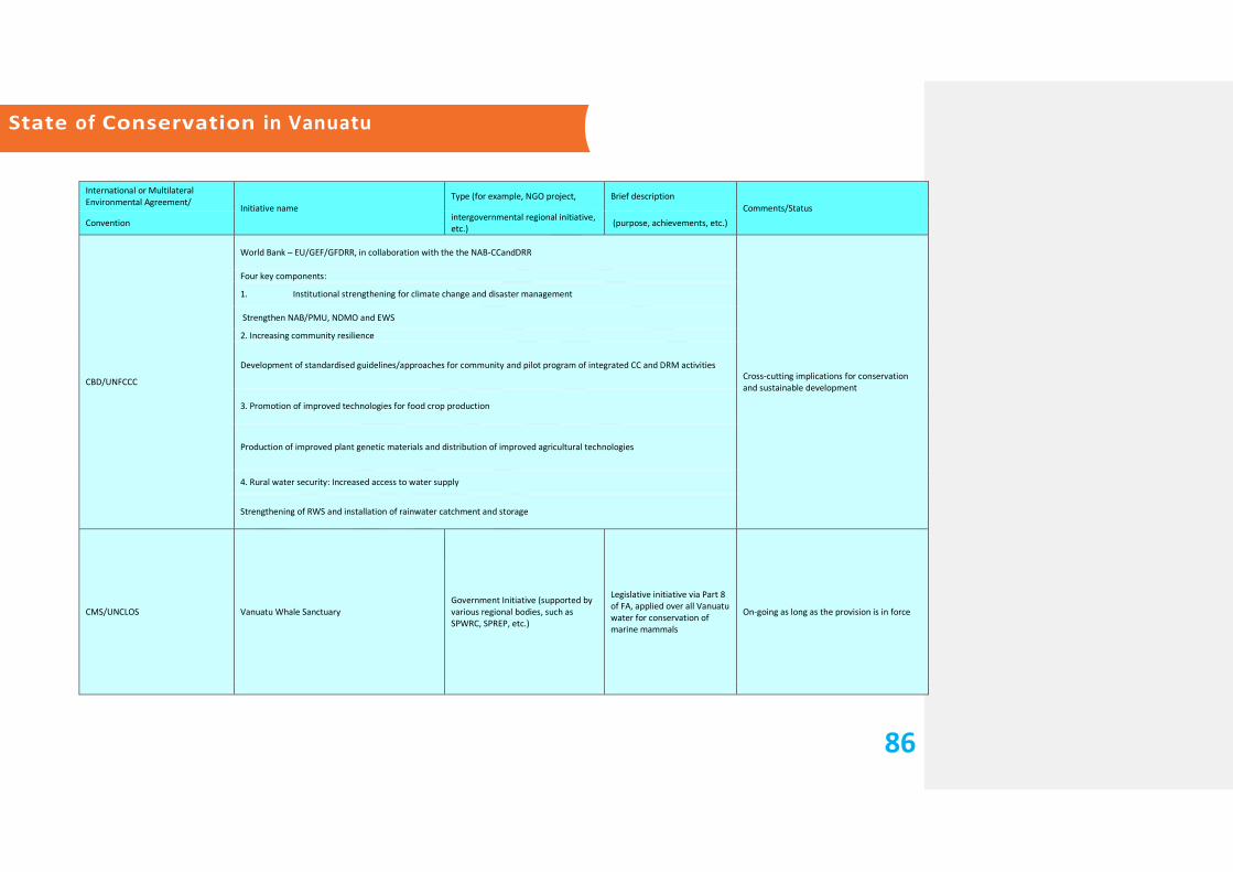
State of Conservation in Vanuatu
86
International or Multilateral Environmental Agreement/
Initiative name
Type (for example, NGO project, Brief description
Comments/Status
Convention intergovernmental regional initiative, etc.)
(purpose, achievements, etc.)
CBD/UNFCCC
World Bank – EU/GEF/GFDRR, in collaboration with the the NAB-CCandDRR
Cross-cutting implications for conservation and sustainable development
Four key components:
1. Institutional strengthening for climate change and disaster management
Strengthen NAB/PMU, NDMO and EWS
2. Increasing community resilience
Development of standardised guidelines/approaches for community and pilot program of integrated CC and DRM activities
3. Promotion of improved technologies for food crop production
Production of improved plant genetic materials and distribution of improved agricultural technologies
4. Rural water security: Increased access to water supply
Strengthening of RWS and installation of rainwater catchment and storage
CMS/UNCLOS Vanuatu Whale Sanctuary
Government Initiative (supported by various regional bodies, such as SPWRC, SPREP, etc.)
Legislative initiative via Part 8 of FA, applied over all Vanuatu water for conservation of marine mammals
On-going as long as the provision is in force

State of Conservation in Vanuatu
87
International or Multilateral Environmental Agreement/
Initiative name Type (such as NGO project or Brief description
Comments/Status
Convention intergovernmental regional initiative) (purpose, achievements, etc.)
UNCLOS
Various Regional Initiatives for the sustainable use and conservation fish stocks, via for example FFA (for tuna fishery within the Pacific), Western Pacific Fisheries Commission, etc.
- Ratification Acts for regional conservation efforts for Tuna and other Highly Migratory Fish stocks;
- Review of the Fisheries Act and the overall regulatory framework for fisheries.
- Assistance in monitoring and surveillance of EEZ
COMMUNITY CONSERVATION AREAS
CBD/UNCLOS
· Nguna-Pele Marine Protected Area Network
NGO-community based (usually supported via established donor funding/initiative mechanisms)
Multi-community-wide CCAs, managed via traditional governance, with full multi-stakeholder support for its maintenance. Involves capacity building from community level and up.
On-going
· VTCCAN
· VPAI
OTHER CCAs: NETEN, CRAB BAY, Lake Fanteng Conservation Area, etc.
UN-REDD (cross implications with CBD)
Sarakata Basin Integrated Flood Management Plan Vanuatu GEF Pacific IWRM Demonstration Project (Sustainable Management of Sarakata Watershed)
Establishment of SBIFMP, includes inter alia sustainable forest and land management practices established, draft management plans for forest conservation/protected areas
On-going
WCH VATTE, Chief Roimata's Domain UNESCO World Heritage Sites VATTE, Chief Roimata's Domain