State Board of Irrigation - Nebraska Department of Natural ...FIRST BIENNIAL REPORT OJ' THE . State...
309
FIRST BIENNIAL REPORT OJ' THE . State Board of Irrigation OF THill • STATE OF NEBRASKA, FOR THill YEARS 1895 AND 1896. PREPARED BY W. R. AKERS, Secreto,r: Stlite Board ot Irrigatlon, . __ NEBRASKA STATE HISTORICAL 80C1E rY LINCOLN: JACOB NORTH & Co., PRINTERS, 1897.
Transcript of State Board of Irrigation - Nebraska Department of Natural ...FIRST BIENNIAL REPORT OJ' THE . State...

FIRST BIENNIAL REPORT
OJ' THE .
State Board of Irrigation OF THill
• STATE OF NEBRASKA,
FOR THill
YEARS 1895 AND 1896.
PREPARED BY
W. R. AKERS,
Secreto,r: Stlite Board ot Irrigatlon, .
__ NEBRASKA STATE
HISTORICAL 80C1E rY LINCOLN:
JACOB NORTH & Co., PRINTERS,
1897.

OFFICE STATE BoARD OF IRRIGATION, } .. : LINCOLN, NEB., November 30, 1896
To His Excellency, Silas A. Holcomb, Governor: DEAR Sm:-In accordance with the provisions of Sec
tion 10, House Roll No 443, of the Legislature of 1895, I herewith hand you my biennial report of the doings of this Board from the time of the organization of the same on the 24th day of April, 1895, to the last day of November, 1896.
Very respectfully submitted, W. R. AKERS,
Secretary.
STATE BOARD OF IRRIGATION.
BILAS A HoLCOMB, Governor.
A S. CHURCHILL, Attorney General.
H. 0. RussELL, Com. Public Lands and Buildings.
OFFICERS OF THE BOARD.
SILAS A. HoLCOMB (Governor)
w. R. AKERS,
E. T. Y OUNGFELT,
AoNA DoBsoN, {
FRANK BACON, ~
President.
Secretary.
Assistant Secretary.
Under Secretaries.

t\[ 8RASKA
rii8 i·ufiiCAL S T/, 1 E ~0\..'itl(
REPORT.
At the time Hon. R. B. Howell, first engineer and secretary of this Board, retired from the same, he made a true and accurate report of the business transacted by the Board up to that time, which I publish herewith in full, and simply add to the same by bringing it up to November 30, 1896. I also add to my report several special reports made to me by Adna Dobson, in cases where he had been specially authorized to make investigations and report his findings to me. Also a report of stream gauging by Assistant Secretary, Emil T. Youngfelt and Prof. 0. V. P. Stout of the United States Geological Survey. I desire to say in this connection, that I made arrangements with Prot 0. V. P. Stout, of the State University whereby I secured double work; in other words, by furnishing him an assistant in the person of Mr. Youngfelt. I received the benefit of the work of both these able engineers, and the Professor received a like benefit. At least one-half or more of the expenditures was borne by the United States government. I have also selected some valuable papers read at the several Irrigation Associations in the state, touching the history of irrigation and irrigation legislation, and by permis· sion of President Wolfenbarger, who has copyrights on the same, I publish them. It is earnestly hoped that these publications may prove both interesting and valuable to the people of the state who may be interested in irrigation. There are a number of features in connec-

10 REPORT OF SECRETARY.
tion with irrigation which would have been profitable to have investigated, but which I have been unable to do for want of time and means with which to work, among which might be mentioned irrigation by windmills and artesian wells. There is more of this kind of irrigation than is generally known by the people of the state, and some very credible work has been done in this way. Some men have made more money during the year 1895 from a single wind-mill plant than neighboring farmers have been able to make from a farm of 160 acres without irrigation. It is hoped that farmers will continue to erect wind-mills and reservoirs wherever they are unable to secure ditches. The fact is, that the office has been handicapped during the past year for want of funds. It will be noticed by reference to the report of Hon. R. B. Howell, that the expense account for stationery, postage, etc., was overdrawn $26.00 when he left the office. There was no money with which to pay stenographers for the last several months, and the money to pay two stenographers, buy postage and stationery, was collected from the people, which is wrong, and it is hoped that the next legislature may see it to be in the interest of the state to make a liberal appropriation, in order that these several investigations may be fully carried out. A continuance of stream gauging should be kept up for several years, and much field work should be done in order to locate, plat, and map all sites where water could be stored in reservoirs in order that the waters that are otherwise wasted may be conserved, and the area irrigated thereby could at least be doubled.
I think it proper in this connection to give a general history of irrigation in our state as far as possible, and I have asked a number of gentlemen to write brief his-

STATE BOARD OF IRRIGATION. 11
tories of irrigation in their respective counties, but as yet have received none. However, if they come in in time, I will incorporate them in this report. I do this in hope that the people of the state in general may see what has been done by others, and seeing and knowing what others have done will be encouraged to greater exertion themselves, and the business of irrigation will be greatly stimulated and more widely spread over our state.
Probably the first irrigation in the state was that practiced at Sidney by the United States government. Here a small ditch was constructed for the purpose of irrigating the trees surrounding Fort Sidney and the lawns in front of the officers' quarters and the barracks of the men. This, however, did not do much to educate the minds of Nebraskans to the belief that irrigation could be used in this state for the irrigation of ordinary crops. The water for this ditch was taken from the Lodge Pole creek. A number of gentlemen, however, along the creek at a later date, began to take out small ditches from this creek for purpose of irrigating grass land, and a large amount of grass land was actually irrigated, and still it did not seem to occur to any one that it could be practically used to raise ordinary crops. A little later on, in 1884, I am informed, an eccentric individual, one Lord Ogelvie, of Colorado (claimed to be an English nobleman), constructed a ditch in the neighborhood of North Platte, taking water from the North Platte river some miles above that city, and watering a large amount of land on the peninsula between the two Platte rivers. But the people of the neighborhood did not share his enthusiasm and the ditch was not used for practical irrigation until about the year 1890, and then only by a few men who came from Colorado, and in 1891, when there was a considerable rt~in fall, these men were

12 REPORT OF SECI\ETARY.
merely made a laughing stock by men who had reasonable success in farming where there were no ditches. But the tide is now turned and the men under this ditch and other ditches constructed since that time, have been continually successful in crop raising and are fast becoming Buccessful farmers. I had the pleasure of visiting this locality during the crop season this past summer, and I am obliged to confess that I never in my life saw finer crops of wheat, oats, and corn, in fact, all kinds of farm products.
The progress of irrigation in Lincoln county has been phenomenal as well as in Dawson and other counties in the state, and I think I am not putting it too strongly when I say, that never in the history of irrigation countries has the art progressed so rapidly or made such rapid strides in any country in the world. As early as 188() there were some small canals built for irrigating hay land along the Republican Valley, but not until 1890 were steps taken by W. D. Williams to take out water for irrigation on a large scale. The fmnchise of this ditch was afterwards purchased by the Culbertson Water Power and Irrigation Company, and a large ditch was constructed costing over 8140,< 00, and other ditches were immediately constructed covering nearly all the bottom lands along the Republican River, among which is the Meeker Ditch and many smaller ones. I simply desire to say that all of these enterprises have been crowned with success, and the only question in any of them is the water Bupply, which is more limited in this valley than most parts of the state where irrigation is practiced. But large fields of alfalfa and other crops which are grown in great abundance are making farming a great success in this valley. The first irrigation in the state of N ebmska for general crops was practiced in .Scott's Bluff county, where a few

•
STATE BOARD OF lltRIGATION, 13
gentlemen from Colorado made a settlement and organized the Farmers' Canal Company, and incorporated under the laws of the state of Nebraska, and at once commenced the construction of a small ditch. The country over which this ditch was to be built was very rough, and the projectors met with many obstacles which rendered the construction very difficult. But, as I now intend to publish in this report a letter written by me and published in the World-Herald, which gives the history o' Scott's Bluff county, I will leave the further history in this county t~ that description.
THE LETTER.
The va,J.ley of the North Platte through Scott's Bluff county varies from two to six miles in width on each side of the river, is a splendid sandy loam, and is capable of producing any kind of crops grown in this altitude or latitude in any country in the world. But, as I am asked to write the history of irrigation, I will leave the productiveness of the soil to someone else; suffice it to say, that, in my opinion, there is no finer country in Nebraska or any where in our latitude for farming, than the great Platte valley under a proper and economic system of irrigation. Irrigation is the life, the salvation of western Nebraska, and is the hope of eastern Nebraska.
The people in this country in 1888 and 1881! were miserably poor, having emigrated from eastern Nebraska, Iowa, and Kansas, in order to secure the benefits of the homestead act, and believing that irrigation would not be necessary, or rather knowing absolutely nothing about irrigation, they undertook to farm, and for two or three years there was enough rain to produce partial crops, in fact, in some localities, very good crops. . But in the years following, there was a terrible drouth.
..
14 REPORT OF SEOI<ETARl.
These people, as a rule, "had lost no irrigation ditch,' and were not in search of a place to irrigate, and when one who had some idea of what irrigation meant would dare to suggest that irrigation would solve the question uppermost in their minds, as to whether western Nebraska could ever be made a farming country, you cvuld hear such expressions as the following: "If I have to irrigate, I will emigrate instead." "How long will it take to build a ditch to irrigate this valley?" "We will all be dead." "If I have to put so much money in a ditch. in order to have a farm, I will go back to where God irrigates," and a thousand and one other expressions, many of them more forcible, if less elegant, than the above. But in the years of 1887, 1888, and 1889, the drouths ~ere quite universal, and the all absorbing question was, "Will western Nebraska ever be a farming country?" There were those who were ready to say no, because they did not desire that it should be, and there were those who said yes, we have been through the same thing in eastern Nebraska, and the history of eastern Nebraska will repeat itself in western Nebraska, and there were a .few who dared to say, ~Without irrigation farming must be a failure in this part of Nebraska.
In regard to the history of irrigation in Scott's Bluff county, I have to say, that in the fall of 1887 a few gentlemen who had been residents of Colorado and there learned somflthing of the benefits of irrigation, among whom were C. W. Ford, the present county clerk of the county, John W. ~Weeks, who is also still 11 resident in the county and is the owner of one of the best irrigated farms in the county, John Richards, now a resident of Colorado, and a few othflrs, incorporated the Farmers' Canal Company and commenced the construction of a small canal. The first act after incorporating was the

STATE BOARD OF IRRIGATION. 15
filing of a notice of appropriation of which the following is a copy:
To Whom it May Concern:
NOTICE OF APPROPRIATION.
Notice is hereby given that the Farmers' Canal Company of Cheyenne county, organized under the laws of the state of Nebraska, have appropriated a sufficient amount of water to be taken from the North Platte river at a point near where the section line of section 10, township 23, range 58, comes in contact with said river bank to fill a canal forty feet wide at the bottom, and to convey water to the depth of four feet. Dated this 16th day of September, 1887.
(SIGNED.)
Attest:
w. R. AKERS, President.
G. W. FonD, Secretary.
Filed for record this 10th day of September, 1887, at 9 o'clock A.M., and recorded in book two of miscellaneous n~ord at page 195. F. H. DECAsTRO,
County Clerk. This is the first paper filed in the state of Nebraska,
making a claim to water for irrigation purposes, and is the first step taken to make a legal appropriation of water in the state, though there had been some earlier attempts to irrigate in the state, all of which have heretofore been mentioned so far as they have come to the knowledge of the writer. The country over which the Farmers' Canal was to be constructed was very rough. The people, all non-believers in the business of irrigation and opposed entirely to the idea of irrigation, made the enterprise inove very slowly, and long before the Farmers' Canal had water to use for irrigation the drouth had convinced many of
16 REPORT OF SECRETARY
the inhabitants of the valley that irrigation was essential, and little groups of meu formed in different parts of the county for the purpose of constructing small ditches. The first public demonstration which the writer knows of was a public meeting called at Mini tare, at which a number of irrigationists congregated and discussed the question of building a ditch the entire length of the valley on which the Farmers' Canal is now being constructed. The proposition, however, met with m nch opposition, and the only result of this meeting was the organization of the Minitare Ditch Company, the leading members of which were George W. Fairfield, Theodore Harshamn, A. W. Mills, and others. This company moved along with wonderful push, and by the summer of 1888 had their dik:h constructed some six or eight miles in length, and are entitled to the honor of having the first ditch in the North Platte valley in Nebraska, which made a practicable and profitable use of water for the production of crops. By this time the people were being rapidly converted to the belief that irrigation was necessary, and other enterprises were .started. First in point of time was the Winter's Creek ditch, starting some seven or eight miles above Minitare, and covering something like seven or eight thousand acres of the very finest land in the state of Nebraska. This company was organized, as I remember it, with Thomas Reeves as president, Lot L. Feltham, secretary. Its membership at the time of commencement of construction consisted of sixteen members, among whom were the above number and others. A ditch was commenced on the 5th day of December, 1888, and on the first day of the next May1 1889, the water was conducted the entire length of the ditch, which was ten miles. While thet·e were but sixteen members to start, before spring there were about thirty interested, and immediately all hands commenced

STATE BOARD OF IRRIGATION. 17
farming, and from that day the question of successful irrigation was settled, and there never has existed a doubt in the mind of anyone in Scott's Bluff county as to the utility and practicability of irrigation. I desire to add that the men who built this ditch still reside under the line of the ditch, and are fast becoming the most success- · ful farmers in the state. The country, which was nothing but a desert, is now one of the most beautiful farming countries in the state of Nebraska.
Immediately after the opening of the Winter's Creek ditch, another group of farmers became interested and said, "Well, if these Winter's Creek fellows can build a ditch so easily, we can also build one." And as a result, the Enterprise Ditch Company was organized with William Barber as president and Chas. A. Simmons as secretary. Their aim was to cover about 12,000 acres of beautiful valley land, and the ditch was to be twenty-three miles in length. This was a much more difficult ditch to construct, owing to the length, than the Winter's Creek, and no more people to do it; consequently it took a longer time to finish the work. The work of surveying was commenced in the middle of the winter, some time, I think, after the new year of 1889, and the ditch was not used for watering crops until July, 1890, and was then in an unfinished condition. In fact, this ditch has never been fully completed until very recently. In the first place it was sixteen feet in width on the bottom, which was found to be too small to accommodate the land under it, and it is now enlarged to a twenty-four foot ditch, carrying two and one-half feet of water. The country was very new and the people miserably poor, and this work progressed necessarily very slowly. With the Minitare Winter's Creek and the Enterprise ditches at work raising fine crops on all the land cultivated, the irrigation crank of a few years

18 REPORT OF SECRETARY
ago had nothing to do but to listen to the croaking of the men who before had been enemies of irrigation, and hear them tell how they had always been the strongest advocates of irrigation in the country. In fact, to hear some of the former enemies of irrigation and doubting Thomases talking of the trials and adversities which the early irrigationists had to contend with, one would imagine that he had struck the original irrigationists himself. All right, let it be so. It was always so. Even when "Sallie killed the bear," hAr husband had to be included, and it was "I and Sallie who killed the bear."
With these educational forces at work, the people soon became of one mind, and one ditch organization after another sprung into existence on each side of the river, and from the Wyoming line on the west to the eastern side of the county, all the laud is now under ditch and practically all of it reclaimed from its desert condition and is now a great oasis in the desert. Immediately after the events above recorded the people of Mitchell Valley on the south side of the river and west of Scott's Bluff organized the Mitchell Ditch Company, and constructed a very fine ditch twenty-four feet wide on the bottom and twenty-five or twenty-seven miles in length, covering perhaps 20,000 acres of very fine land. The greater part of the ditch was built by stockmen who had some means, and it was pushed with greater vigor than any ditch which had ever been constructed in the country. The same has been true of the country under this ditch. The country has been developed faster than any part of the county and it is now in fine condition, and the people are among the most prosperous in the state. The sod houses of the past are fast giving place to large, fine, frame houses and barns, and the country is fast assuming the appearance of an old settled country. Some of the farmers, or ranchmen as they

(
(
STATE BOARD OF IRRIGATION. 19
are called in western Nebraska, are growing rich from the products of their farms. I might mention one or two instances under this ditch that I think will compare in
profits with any farming country anywhere to be found,
one of which is the sale of a farm by one Herman Beasley to four young men who assisted him in his haying operation's, none of whom had any money, Beasley agreeing to take his pay from the proceeds of the farm, allowing so much per ton for hay and so much per bushel for alfalfa seed. Now, at the end of three years, the young men have their farm practically paid for, and all from the proceeds of the farm itself.
Another instance is the alfalfa seed crop of John R. Stitts this year, 1896. He had forty acres of alfalfa and from this he took an average of thirteen bushels and three pecks of 'seed per acre, which is worth at least $3 per bushel, besides a crop of hay. It is fair to say that the hay crop and the straw will pay all the expense of cutting and thrashing the seed, which will leave him $41.55 clear profit on his land per acre, or an interest of ten per cent on $410.50 per acre. I have no doubt if you had offered John $40 per acre for his land before he cut this crop you would have got it.
While these events were going on in the west end of the county, the people in the east and middle were not idle. The people of Gering built a nice little ditch and undertook to fill it from the river by means of an immensfl steam pump, and they did irrigation in this way and irrigated a considerable amount of land, and fully demonstrated that they were the right kind of material, and that they were thorough converts to the belief in irrigation. But they also demonstrated that irrigation in this mode was much more expensive than from the river by the use of open ditches. They disposed of their pnmp

20 REPORT OF SECRETARY
and boiler and opened the ditch to the river, and now have a nice tract of country covered by what is known as the Central Ditch, and good crops are raised each year. Also farther east, on each side of the river, other enterprises sprung into existence, and in April, 1889, the Castle Rock Irrigation Company was organized and commenced the construction of a very fine canal, heading some four or five miles east of Gering, the county seat of Scott's Bluff county, and running about seventeen miles east and southeast along the edge of the Bluff, and covering about 10,000 acres of very fine bottom lands. This ditch is constructed on a somewhat different plan from the rest of the ditches in the immediate neighborhood. It is eighteen feet on the bottom for the first nine miles and then divides, and for the rest of the distance there are two ditches, each about eight feet on the bottom, and carries about three feet of water in depth. On the north side of the river, near the east line, the people of Bayard have constructed a fine ditch heading in Scott's Bluff county, and traversing the county and into Cheyenne county, covering the beautiful town of Bayard. I examined this ditch during the past summer and found it to be one of the very best constructed ditches in the state, covering a fine country, and for the length of time the same has been constructed, I think is doing excellent work, and I venture the prophecy that it will not be long until the farms will be among the best in the country. On this ditch, at or near the town of Bayard, is a most excellent chance to drop a water power sufficient to do manufacturing on a large scale, and the water, after passing the wheels and making the power can be used for irrigation. Thus, the water power will be inexpensive or practically a find to the owners of the ditch, and I very much mistake the character of the man at the bead of the enterprise, if in

T
STATE BOARD OF IRRIGATION. 21
the near future they do not have a power developed that will astonish even the projectors of this enterprise. About the 20th of March, 1893, Yorrick and Carroll Nickols commenced the construction of the Ramshorn ditch, in the western part of Scott's Bluff county, and rapidly pushed the same to completion. Some time before the ditch was finished it was incorporated and several other parties became interested and assisted in the construction. A very nice ditch was built, covering some 2,000 acres of land. The ditch was constructed by Mr. A. B. McCosky, engineer, and has been a success. I see no good reason for the name of this ditch, it b6ing as straight as contour ditches usually are. I desire to say in a general way that the county has probably 75,000 acres of land under ditch, not more than one-fourth of which has ever been broken out and cultivated, owing to the poverty of the people, who started to irrigate after they had eaten up all they took with them, and who were reduced to such poverty that nearly every man who engaged in the building of a ditch in the county was compelled to place a mortgage on his team to procure the means with which to feed his team and family while he worked. When you take into account the fact that the county never had 500 voters, and that not one-half the voters or land owners are interested in irrigation, and that they were poorer than jack rabbits in summer, I say that the few irrigationists of Scott's Bluff county have accomplished more than I ever saw done by the same number of men in any country in my life. Think of 75,000 acres of desert transformed to a veritable garden and under 148 miles of ditch (and when I say ditch, I mean ditch), for all the ditches of the county are large, fine ditches. One hundred and forty-eight miles built and owned by less than 200 men, and no debt upon them. You ask, "how thie

22 REPORT OF SECRETARY
was done?" I answer, by organizing stock companies, selling the stock to individuals, and they paying for it almost entirely in work. In other words, these 200 men have created $250,000 in wealth, simply dug out of the ground. No bonds, no debt-the best way to build a ditch in any county.
The Farmers' Canal, before spoken of, was sold by the original proprietors, owing to the cost of construction, to several gflntlemen whom it was believed at thfl time were able to build it at once; but the truth very soon developed that these men did not have the money, and were unable to get it to finish the ditch. However, this company has done an immense amount of work, and the ditch is so far constructed as to make it a sure thing in the near future. The company has constructed one of the finest head-gates in the northwest at a cost of about $12,000. The gate has a front opening of about one hundred and fifty-six feet, and is controlled by twenty-seven head-gates, and is capabie of taking in an eight-foot head of water. The ditch is to be sixty feet in width on the bottom and is intended to carry eight feet of water in depth. The first mile is completed sixty feet wide on the bottom, and from there for twenty miles it is finished to thirty feet on the bottom. This ditch is seventy-one miles in length, and will probably when finished be eighty-five miles in length, and will cover about 150,000 acres of the very finest land in the state. When a railroad is built in this valley, and this ditch and the Laramie and Scott's Bluff on the south side of the river, which is to cover over 100,000 acres, and which is now being pushed along by the enterprising citizens of Gering is finished, the vallfly below is destined to be the finest part of the state of N ebraska. And I predict that these things are all in the near future. The development of irrigation has been mar-
•
STATE BOARD OF lRR!GATION. 23
velous in Nebraska, and is still in its infancy. When all the waters are taken and used for irrigation, and our people understand the real value of irrigation, and begin the work of storing the waters that are now run to waste, and spread it over the highlands and divides, then Nebraska will be truly great. Let every lover of Nebraska, regardless of what his business may be, join the throng of irrigationists, and let us not stop or let the interest abate until we have saved and used all the water which flows through our state, and then the millenium will have come to us.
Following is the report of Ron. R. B. Howell on retiring from this office:
OFFICE STATE BOARD OF IRRIGATION, } LINCOLN, NEB, April1, 1896.
To the Honorable State Board of Irrigation: GENTLEMEN-The ten months that have elapsed since
the State Board of Irrigation entered upon the active discharge of its functions and duties have been occupied largely by the work of organization deemed essential to the future usefulness of the department.
After the induction of the administrative officers of your Honorable Board into office, transcripts of notices of appropriation filed with tho various county clerks of the state, in compliance with the general irrigation law of 1889, were collected from forty-four different counties. These transcripts formed about 1,000 pages of transcript, setting forth in a meager manner the claims of 780 alleged appropriators of the public waters of the state.
To each of those claimants of record, blank claim affidavits of a form and character prescribed by your engineer and secretary were then forwarded for the purpose that they might properly be filled out and returned for the

•
24 RtPORT OF SECRETARY
more definite information of the board, respecting appropriations actually made. Statistics from 400 of these claim affidavits filed on or before the 31st day of December, 1895, show that there were under construction in this state, on or before April 4, 1895, when the present irrigation law became effective, some 2,219 miles of canal, estimated to cost when completed, $2,752,390 covering 1,061,-017 acres of land. Of this total mileage, 1319 miles have been completed at an expense of $1,456,369.
As soon as the collection of claim affidavits had proceeded to the point deemed necessary, the state was divided into watersheds, and the adjudication of the various claims represented undertaken.
Hearings for the purpose of giving claimants an opportunity to be heard by the board in support of their alleged appropriations were first held within the watershed of the Republican river, and upon the conclusion of the work therein the watersheds of the Elkhorn and the Loup rivers were taken up in the order indicated.
These hearings were set for and covered twenty-seven different counties, forming a docket of 373 cases, 353 inre, and twenty contests. Of these 373 cases, 220 have been reviewed and passed upon by your engineer and secretary, leaving the docket still ·encumbered with 153 cases.
In addition to the claim affidavits above enumerated, 289 applications for permits to appropriate the public waters of the state have been filed with the board since its creation. Statistics !rom 220 of this number filed on or before the 31st day of December, 1895, show that the total additional mileage of canals proposed subsequent to April 4th, of last year, amounted to 2,112 miles, estimated to cost $6,209,285, covering 2,367,689 acres.
None of these applications have been granted, thus far, as directed by your honorable board by resolution, adopted
STATE BOARD OF IRRIGATION. 25
May Hl, 1895. The same being held in this office for record until such time as the adjudication upon each watershed effected have proceeded to such a point that the board may deem itself justified, because of an apparent unappropriated supply of water, in granting the same.
In the conduct of this work, the expenditures of the Board, exclusive of the salary of the engineer and secretary, have been as follows: under secretaries, appropriation $3,200; expended, $1,416; additional assistants, appropriation $1,200; expended, $607; expenses of Board, appropriation $1,000; expended, $546; stationery, instruments, postage, etc., appropriation $600; expended, $626.95.
The fees charged up for taking and transcribing testimony, copying records, etc., amount to $280.55, of which $195.30 has been collected, and is on deposit in the name of the Board with the Columbia National Bank of Lincoln.·
The Board at this time finds itself with much upon its hands and much additional work before it. During the coming year adjudications must be carried on, streams gauged, waters divided among the numerous claimants therefor, and portions of the state mapped, for the purpose of showing the course of the various canals to which water has been allowed.
Unfortunately the appropriations made by the last legislature for the use of the Board were not at all commensurate with the work entailed. Therefore, if this department falls short during the coming year of meeting the expectations of those interested in the development of irrigation in this state, it will be largely due to the inadequate appropriations made for the necessary expenses of carrying on a work of the magnitude of that in hand.
In closing this brief synopsis of the work begun and accomplished during the first ten months' of this Board's
•

•
26 nEPORT OF SECnETARY
existence, I would suggest that as the law establishing the State Board of Irrigation, like most new creations, has some defects, and as the same should be rectified by the next legislature, I therefore would recommend that a commission of five persons be designated by the Board to act without compensation, for the purpose of investigating and suggesting to your Honorable body such amendatory legislation as it may be deemed desirable by said commission for the Board to recommend to the next legislature.
I am, sirs, very respectfully, your obedient servant,
(SIGNED.) R. B. HowELL.
At the present time to-wit.: November 30, 1896, there was 975 cases on the appearance docket of which number forty-one are contests, leaving 934 cases in re. In these 934 cases there are 540 claim affidavits filed, leaving 414 cases unsupported by any proof of validity and are treated as cases abandoned. Of the 940 cases the testimony has been taken and written in 920 cases. In the forty-one contests, thirty-four have been heard, leaving about twenty cases on the docket to be yet disposed of. There are about ten claim affidavits on file in which the testimony has not been taken for the reason that they have been filed after the hearing was held. Of the 97 5 cases on the docket, 340 have been disposed of by the opinion of the secretary and reviewed by the Board, with the exception of two contests which have been filed since the sitting of the Board, leaving on the docket to be disposed of 635 cases at this date.
There are on file in the office 361 applications for permits to appropriate the waters of the state, few of which have been acted upon. In the conduct of this work, the expenditures of the Board, exclusive of the salaries of the engineer and assistant, has been as follows:

STATE BOARD uF InRIGA'£ION. 27
Under secretaries, appropriation, $3,200; expended, $2,636.25.
Additional assistance, appropriation, $1,200; all expended.
Expenses of Board, appropriation, $1,000; expended,
$813.02. Stationery, instruments, etc., appropriation, $600; all
expended. Fees collected from individuals for taking testimony,
copying records, etc., $437.55, of which $379,75 has been collected and the remainder is still unpaid, and has all been expended in the payment of salaries for stenographers, postage, and stationery.
w. R. AKERS,
Secretary.
HISTORY OF IRRIGATION IN DAWSON COUNTY.
H. 0. SMITH.
A history of irrigation in Dawson county is the history of a long, bitterly waged war against ignorance and prejudice as well as poverty. At the beginning, a very large proportion of the people, both business men and farmers of the best class, were thoroughly imbued with the idea, that to completely ruin the reputation of western Nebraska it was only necessary to publish the fact that irrigation was required or practised in raising crops. In the minds of these men, born and raised in the agricultural states of thb Mississippi valley and east, irrigation was associated with a barren desert region, where people struggled along on a few acres of ground, producing a

28 REPORT OF SECRETARY
little fruit and a few vegetables. Probably it was profitable, but it was not their idea of farmiug. Real farming consisted in raising an immense acreage of wheat, corn, rye, oats, barley, the chief products. 'fhe greater the acreage, the greater the farmer. It was better to farm 640 acres for a bare living, or· less, than to farm forty acres and have a bank account. This idea of farming large areas has made more business for the sheriff than any other branch of industry. Examples of a perfect success in that line are so rare as to be only exceptions that go to prove the rule of general failure.
It has taken time, patience, perseverance, energy, and push to overcome this prejudice, and to bring about the success already attained by irrigation in this county and
community. That success is assured there is no question. Even
in the season of 1896, when the rainfall was about normal, and its distribution through the season of growth nearly all that could be asked, the difference between irrigated and non-irrigated crops has been so marked, so pronounced in favor of irrigation, that the most skeptical have to acknowledge that the question is practically settled. I will hereafter q note a few of the instances of which I have personal knowledge.
The first attempt to introduce irrigation into Dawson county was made in the fall of 1890 by a company that asked no concessions and professed a willingness to pay for all the rights acquired by them; but the opposition they met with, not only from those along the line proposed, whose lands, while they might not have been helped, could not possibly have been injured by the ditch, was so strong and persistent, that after nearly a year of expensive and wearying struggle the company gave up the fight, pocketed its losses, and retired. Since that tJme,
flTATll: BOARD OF IR11IGA'rtON. 29
many who were most strenuous in their opposition have seen their mistake, and have acknowledged that if this company had been allowed to carry out their enterprise, Dawson county would have been spared the disgrace of having to appeal to the people of the east for food a few yea.rs later.
In regard to this appeal I would say, that it came largely from a class of people who require assistance nearly every winter, and who usually receive it from the more thrifty and prosperous of this immediate vicinity; but the partial failure of 1893, and almost totRI failure of 1894, has reduced this latter clRss to circumstances that would not stand a division.
The season of 1891 was very unfavorable to irrigation. Never since the settlement of this country had there been so much rain-such a continual downpour. The ground became so thoroughly saturated that, though in the following season, 1892, the precipitation was much below the amount usually required to produce a crop, fairly good crops were raised. The following year, 1893, we returned to our normal condition, alternating between hope and dispair. Long continued drouths, during which the farmers watched the crops with one eye and the heavens with the other; occasional showers that caused the stunted and dust-choked crops to revive and take on a new lease of life, shooting up under the influence of a little moisture and proving the abundant fertility of the soil, and filling the hearts of the husbandmen with the hopes of a continued era of moisture, and the assurance of a full granary. He could pay the interest on that mortgage and hold his home, a little home, a while longer. Vain hope! The dry weather predominated and the harvesters were dragged wearily over fields yielding barely enough for bread and seed, so that the regular

30 REPORT OF SECRETARY
routine could be followed next year. Sowing in hope, cultivating in doubt, and harvesting in dispair. For persistence, pluck, and endurance, commend to me the farmer of western Nebraska.
During the winter and spring of 1893-4 agitation of the question of irrigation was resumed. It began to be regarded as a paramount question. Opposition went down before the light of reason, common sense, and experience. Meetings were held at the various school houses over the county and the gospel of irrigation was preached to all.
In June preliminary surveys wore made, and in July '.fhe Farmers' and Merchants' Irrigation Company was organized and incorporated. The company was purely a local one, its capital stock exceedingly limited and its expectations not large. It has, by pluck, perseverance, energy, and with the assistance of eastern capital developed into what is probably one of the largest, most complete, and perfect systems of irrigation Jitches in all the country. It covers 60,000 acres of the most fertile and productive land that the sun ever shone on. It has eighty-three miles of canal and principal branches completed and in operation. In its construction nearly a million cubic yards of earth were moved, and over one million one hundred thousand feet of lumber have been used. It has acquired nearly nine hundred acres of land in right of way alone. It is a grand success, and proves conclusively that no country on earth is better adapted to the application of water or possesses more natural advantages in the way of natural slopes and productive soil than the valley of the Platte River, in Dawson county.
Active wot~k on the construction of the Farmers' and Merchants' ditch was begun in August, HH.J4, and pushed forward as rapidly as possible. The enterprise was a
r
r
STATE BOARD OF IllRIGATION. 31
gigantic one for men to undertake, who were entirely without experience in that line. They had to learn as they went along with the work.
There is one mistake common to enterprises of this kind that this company were shrewd enough to avoid-the mistake of thinking that money could be saved in engineering. From the start a thoroughly competent engineer was employed and kept on the work till it was completed, and to this fact is the success of the enterprise largely attributable. Mistakes in engineering are always costly and frequently irreparable. A good engineer knows what he is worth and will not work cheap. A cheap man guesses at his value, and guesses at his work, too, and the best guessers cannot guess right all the time. A com"pany that puts a costly enterprise in the hands of a guesser don't have to guess at the result; it is an assured failure.
On the 27th day of June, 1895, just one year from the day that the appropriation of water was filed by this committee, the head-gates were opened, and the water started down the ditch. About fifty-three miles were completed at this time. The progress of the water was necessarily slow. Drops and checks had to be filled slowly and packed carefully. It was not till the sixth day of July that water from the ditch could be applied to its proper use, and then only for two or three days.
Notwithstanding the care used in the introduction of water, accidents would happen. The soft, loose, dry dirt seemed to dissolve like sugar before the water. Banks melted away, drops and checks that had sheet piling sunk six feet in the ground and wings extending eight to ton feet out in the banks, raised up, turned over, and absolutely refused to "stay put." Owing to difficulties of this kind, it was not till early in August water Col:lld
•
32 REPORT OF SECRETARY
be used effectually. I will state here that these difficulties, once overcome, were never met with again. When the ground once became soaked and packed, it remained firm.
By this time the small grain was beyond redemption. The yield was very small. On the whole it amounted to about the usual "feed and seed" crop. Mr. James Carr had about twenty acres of rye, a volunteer crop. He did not consider it worth cutting, in fact he had turned his stock in on it. On the 6th of July, having first got permission from the company, he turned the water in on it, letting it run where it would, making no attflmpt to control it. The rye took a new start, in fact put on new growth, and in August he harvested and thrashed out of it 260 bushels of rye. The same fall he· gave the same ground a thorough and complete soaking from the ditch, and again sowed it to rye. Without using any water after that, he cut and thrashed the following (this) season 800 bushels of rye. I don't think the eye of man ever beheld a prettier sight than that field of rye. Imagine, if you can, how it looked to the farmers who had for years seen nothing but the poor, stunted, shriveled growth, such as is common to the country. It stood at least six feet high, and as compact and even as a floor. Every summer breeze that swept over it carried waves of color across that even surface that would have delighted the eye of an artist; but the best of them could not have transferred its whole beauty to the canvas. Only nature can paint such pictures.
At this time (August, 1895) when water was ready to be applied to the fields, the corn was badly damaged. The growth was stunted, and though the time had come for the ears to shoot, very few had started. In many cases thetassel was dead and dry; not altogether, but a large proportion .
•
T

STATE BOAI\D OF IRRIGATION. 33
The farmers were not ready for the water. They had made no preparation for it, they did not know when to expect it, and doubted, even when it was at their door. But everything else was abandoned and all started in to save their corn. '\Vater was furnished abundantly, the fields drank it up greedily and were soaked; men, women, and children worked days, nights, and Sundays. There was no time to lose. During the month of August, without any previous preparation, more than 5,000 acres of cDl'n were watered. Did it pay? The results made some of the farmers fairly delirious. Ears shot out of the stunted stalks like magic. They formed and grew almost while you were looking at them. It was no "feed and seed " crop this time. It was principally surplus. It was a pleasure to see how gaily they waltzed up and paid for their water. Considering the condition of the crop at the time that the water was applied the results were wonderful. In many fields the ears appeared to be half as long as the stalk. Croakers said it wouldn't mature, but it did, and made good sound corn. The yield varied according to conditions. Very few fields went under forty bushels to the acre, many went sixty bushels, the average was probably about fifty bushels. Of the crops not irrigated the same year, and same conditions existing, many yielded from ten to twelve bushels, and very many nothing.
Th.us ended the first chapter of irrigation in Dawson county. The company pushed on the work of construction, completing the system to its present proportions in July, 189U. There still remains l'Oom for considerable extension over a very rich territory, which can be made whenever the 'company sees fit.
I will give further along some of the results of the present year. One thing has been proved conclusively,

llEPORT OF SECRETARY
and that is, that under irrigation Dawson county's productions are not to be confined to staple products. Fruit, both large and small, vines, alfalfa, sugar beets, celery, and other products susceptible of more intense and profitable cultivation can be raised with an assurance ol success equal to the staples.
'Vhile the Farmers' and Merch11nts' system was still in its infancy, a dozen or more thrifty and enterprising farmers living southwest of the city of Lexington near the Platte river, joined forces and constructed a ditch, a little more than hal£ a mile long into a natural draw that parallels the river at an average distance of about a mile, for six miles from the point where ditch and draw intersect. The banks of this draw are considerably higher than the laud on each side. (There are two peculiarities of the draws, or dry water courses, of the Platte valley, or nearly all of them. First, they do not run towards the river, but parallel to it for long distances, in some instances from twenty-five to thirty miles; second, the banks are higher than the adjoining territory on each side.) To get the water out of this draw, dams are constructed at intervals, which raises the surface of the water above the level of the fields, which generally have a regular slope away from the draw. This is known as the Farmers' ditch, and proved a very successful and cheap method of irrigation. M. Delahunty, in the season of 1895, sowed sixty bushels of wheat on forty acres. Tlueo acres of this were not irrigated and we1·e not harvested, not being worth the cost. The remaining thirty-seven acres yielded 1,402 bushels, and sold for two cents per bushel above the market price for wheat on the day of sale. In the summer of 1895 I visited the farm of Mr. Delahunty and found fruit trees, apples, cherries, 'plums, and .apricots loaded with luscious fruit. In the season he had

STATE BOARD OF IRRIGATION. 35
raspberries, strawberries, and currants in abundance. All the fruit in this part of the country was killed by late frosts in the spring. I asked Mr. Delahunty how he saved his, and he simply pointed to the small laterals winding about among the trees. This orchard never yielded before in quantities worth mentioning, though some of the trees were more than fifteen years old. It was not in cultivation but in grass, therefore the best results were not attained.
All the crops raised under this ditch were excellent, and I heard of some that exceeded the yield of Mr. Delahunty, but I did not get the exact figures, so do not attempt to quote them.
The Cozad Irrigation Company's system was constructed during the fall of 1894 and spring of 1895. Its head is about ten miles above the head of the Farmers' & Merchants', running in about the same general direction, and covering the territory lying between the two systems. This system is a very complete and well constructed one, and the territory covered is extremely fertile and productive.
Next above the Cozad systein, and covering the territory between, is the Gothenburg Power & Irrigation Company's ditch. This ditch is an extension of the canal built some years ago, for power purposes, and is still used for lighting the town of Gothenburg, and running two flooring mills. The irrigation ditch starts from the lake north of the town and extends in a northeast direction, a distance of about twenty miles.
On a large island in the Platte river is a ditch about five miles long, owned by Booker and Ralston, the two principal land owners on the island.
South of the river is the "Six Mile Ditch," owned and operated by the farmers owning the land covered. Still

36 llEPORT OF SECRETARY
south of this lies the Gothenburg South Side Irrigation Ditch. This ditch starts in Lincoln county, west of Dawson, and extends into this county where about fifteen miles have been constructed and about as much more contemplated. This district is organized under a modification of the Wright law of California, enacted by the Legislature of Nebraska in 1895, and embraces a territory of about 25,000 acres, beautifully situated and very rich.
East of this, and still on the south side, is the Orchard & Alfalfa ditch, about twenty-five miles long, completed and in successful operation, and owned principally by the farmers along its course.
On the north side again lies the Platte Valley Ditch. This, like the Farmers' Ditch, runs from the river into a natural draw, the same one used by the Farmers', but lower down the water is drawn out in the same way.
East of this still lies the Elk Creek Ditch. This ditch runs from the river in a northeast direction about ten miles to the county line between Dawson and Buffalo counties.
Back in the northwest corner of the county, and comprising all the territory in the Platte Valley north and west of the Gothenburg ditch, is the Lincoln and Dawson Counties' Irrigation District. This district, like the Gothenburg South Side, is organized under the modification of the Wright law and has voted bonds to the amount of $275,000. Under the recent favorable ruling of the supreme court of the United states, on that law, they expect to sell the bonds and proceed at once to the construc
tion of the ditch.

STATE BOARD OF IRRIGATION. 37
Below I give a tabulated statement of the ditches in this county: CONSTRUCTED. LENGTH. CAPACITY.
~:tiles. Acres.
Farmers' & Merchants' ............ . 83 60,000 Farmers' ....................... . 8 3,500 Cozad .......................... . 40 30,000 Gothenburg ..................... . 20 12,000 Booker & Ralston ................ . 5 1,500 Six Mile Ditch .................. . 8 2,000 Gothenburg South Side ........... . 15 20,000 Orchard and Alfalfa .............. . 25 20,000 Platte Valley .................... . 15 8,000 CONTEMPLATED.
Elm Creek ..................... . 10 8,000 Lincoln and Dawson County ....... . 30 40,000 Gothenburg South Side, Extension .. . 15 10,000 Cozad, Ext ............... · ....... . 20 10,000 Farmers' & Merchants' Extension ... . 15 10,000 Farmers' & Merchants' South Side .. . 15 12,000
All of this work has been done since 1894, and all these ditches draw their supply from the Platte river. The question naturally arises. Is the supply adequate to the demand? Is it ample?
A word of explanation.
The Platte valley enters Dawson county at the northwest corner and leaves it at the southeast corner. It is forty.five miles long and averages ten miles in width. It has an area of over 400,000 acres, all of which is fertile and nearly all susceptible of irrigation.
The Platte river flows through this valley, and onefourth the width of the valley from the bluffs on the south side. It is a wide, shallow stream, having a fall of more than seven feet to the mile. Its average width is

38 REPORT OF SECRETARY
nearly a mile. It has a sandy bottom, and the level of the water over the whole valley is practically the same as in the river, and has the same fall towm·ds the Missouri valley. The depth to water in any part of the valley simply indicates the height of that point above the river. A ditch constructed with one-fourth of the fall of the river, which is ample, will leave the river at an angle of from fifty to sixty degrees, and sometimes even more. No dam is required to take the water from the river, a simple opening with gates to control the flow and keep out the sand are all that is required. The water is rich in silt and sediment, furnishing food as well as drink to all the plant life with which it comes in contact.
About thirty miles west of Dawson county the river divides into the North and South Platte. The South Platte originates in the eastern slopes of the Rocky mountain\> in Colorado. Its drainage area is limited and in a country where the annual precipitation is comparatively small. Notwithstanding, a very large proportion of the water used for irrigation in Colorado is derived from this source. The North Platte, the principal source from which our supply is taken, rises in 'Vestern Colorado and flows north into W yarning and east to the N ebraska line, a distance of more than six hundred miles. Its drainage area ranges from three to four hundred miles in width, and the annual precipitation is enormous. Its source is through narrow valleys into which open mountain gorges innumerable, that contain the heavy snows of the long winters that prevail in that region. These immense snow drifts are the storage reservoirs provided by nature to supply the river with water for summer use. Nature despises waste as she hates a vacuum. But a very small proportion of the valleys beyond the Nebraska line of susceptible of irrigation. This
T
STATE fiOAHD UF IH!l!GATION. 39
enormous amount of water is delivered to Nebraska almost intact, and at the time exactly when it is most needed for agricultural purposes.
If not for use, for what?
Having provided so liberally in this direction, nature naturally limits the supply from above. Other and less favored communities require that.
The normal flow of the river at this point has been variously estimated at from 2,000 to 5,000 second feet. Accurate measurements have never been made in this county. In April the regular rise begins. gradually increasing till the middle of June or first of July, when the maximum is reached, without, however, the usual accompaniment of eastern rivers, overflows, and damaging floods. The great fall and extreme width of the river bed carries off this enormous volume of water, without loss or damage, except the waste of precious material.
The flow at this time has been estimated as high as 30,000 second feet, sufficient, on the basis established by law in Nebraska, one second foot to seventy acres, to water 2,100,000 acres,. five times the total area of the valley in Dawson county. From the time last named, the flow is gradually diminished, till tho minimum is reached, generally the latter part of August. Some seasons, especially after a long, hot speil, the bed of the river becomes dry, the evaporation from the broad, shallow stream being enormous. That it is largely due to evaporation is indicated by the fact that a few cool or cloudy days brings the water back, and wh0n the cool days of the latter port of September or October comes the flow becomes normal, regardless of l'ainfall. Local rains have no perceptible effect on the river except when it is at the extreme low mark, and then I have known it

40 REPORT OF SECRETAI\Y
to raise more than a foot in one night, when the amount of rainfall wonld not warrant a mise of an inch.
Is the supply sufficient for the ditches constructed and contemplated? I say, yes; and for many more.
That it is deficient at a time when it is not needed is immaterial. That it is ample at the time most needed, and that the source is unfailing. is very material. Spring and summer Irrigation should be completed early in August. October irrigation is invaluable.
Does irrigation pay? Does it pay to raise three bushels of grain on the
ground that has only raised one? Does it pay to raise products that are six, eight-yes,
ten times-more profitable than grain? Does it pay to increase your business threefold and
your profits in proportion? Does it pay to have an income, instead of an outgo; to
have a bank account instead of a mortgage; to be happy, prosperous, ami contented, instead of being ground down and soured by poverty.
Granted that these things do pay, then it pays to irrigate. I have about a dozen apple trees in my door yard that are fourteen years old, and till this year have never borne. They have blossomed and fruit has set, but never attained more than half growth. In the fall of 1895 I ,gave the ground a thorough soaking, and twice again during the summer, and I had a good crop of very large apples, mostly l3<m Davis, and as fine flavored as any I ever ate.
I have also a small patch of alfalfa, about two and a half acres. It was sowed in 18U!, and the stan<l was very poor, in fact so poor that in the fall of 18U5 I concluded to plow it nuder the following spring; but I wanted the ground wet up, and turned the water on. In
STATE BOARD OF IRRIGATION. 41
the spring the stand had improved so much that I concluded not to plow it up. On the 30th day of May I cut it; on the 30th day of J nne I cut it again, and being busy did not turn on the water at once as I intended. It stood two weeks and did not grow an inch. I turned on the water, and again in the middle of August I cut it for the third time, and again watered it, and about the first of October I cut it for the fourth time, getting in all over sixteen tons of the very best of feed. The stand now is as good as any one could ask.
Mr. H. V. Temple has also a small patch alongside of mine, planted at the same time, and the same size. He cut two crops of hay and let one go to seed, from which he got nine and a half bushels of seed, worth in the market five dollars ($5.00) a bushel. This was practically off from less than two acres, as a part of the field got water by accident at a time that spoiled it for seed; besides, he had the feed from which the seed was threshed, which is excellent horse feed.
Mr. Anton Abel, out of 450 acres of corn, watered over two hundred acres. The watering was not very well done, as he had not prepared for it; but his average yield of irrigated corn was sixty bushels per acre, and non-irrigated, all on the same land and on exactly the same conditions, yielded from nothing to fifteen blJshels per acre. His irrigated wheat went from twenty-five to thirty bushels, and non-irrigated from five to ten bushels. He also raised a fine crop of apples.
Mrs. Mary White cut twenty tons, seven hundred fifty pounds of alfalfa from ten acres, the first crop after sowing, from one watering the previous fall. Her second cutting was still larger, but was not weighed. She also gt~thered twenty-five bushels of corn from a measured acre, non-irrigated, which was a very large yield, and

42 REPORT OF SECRETARY
seventy-five bushels from a measured acre in the same field, that was irrigated twice.
F. J. Rosenburg harvested 1,660 bushels of wheat from fifty acres, of which only thirty-five acres had been irrigated the previous fall. He estimated that his yield on the land irrigated was over forty bushels.
Frank Fagot's corn went seventy bushels; H. Menke's seventy-five bushels; S. Butler's seventy-five bushels, and his spring wheat twenty-five bushels, whereas the general average of spring wheat was not over six bushels.
I could fill a book with these examples, but I am reminded that my space is limited. In 1R9o but few beets were planted, as the factory at Grand Island could get all it could use nearer hoine. In 1895 the crop was the poorest generally ever known in the state, the percentage of saccharine being generally very low, ranging from ten to twelve percent. That year five acres were raised on the farm of E B. Smith and irrigated twice. They yielded 100 tons of beets that tested sixteen percent of saccharine, and netted $4.20 per ton at the station here. Mr. E. F. Stephens, the President of the State Horticultural Society, stated at the Irrigation Convention at Lexington that "apple trees that, under ordinary conditions, produce fruit bi-annually only, would with proper irrigation produce annually." This statement is supported by the experience of Mr. Delahunty, who raised a good crop in 1895, and from the same trees a better crop in 189().
We feel that a very material change is taking place in Dawson county. We believe that an era of prosperity is now upon us, that will soon be heralded over the whole country, and irrigation will be the prime and principal factor in the movement.
LEXINGTON, NEB., November 28, 1896.
STATE BOARD OF IRRIGATION. 43
IRRIGATION IN LINCOLN COUNTY.
BY E. F. SEEBERGER.
Lincoln county has been working steadily on her irrigation enterprises, until now she has more miles of completed irrigation canals than any other county in the state. The total length of completed main canals is 250 miles, built at a cost of over a quarter of a million dollars and covering about 200,000 acres of lands. To the main canal mileage may be added about 250 milbs of main lateral ditches that would only need the additional feature of a head in the river to acquire the dignity of a main wmal. Present developments of irrigation enterprises assure another 250 miles of main lateral ditches that will be constructed within the next six months. By the close of the irrigation season of 1897 the county will have a foundation on which to base future agricultural developments under irrigation not equaled by any other county in the United States. These are strong statements, but they are borne out by the facts, and they stand as a monument to the enterprise of "the man from Nebraska" especially when you consider that the greater portion of this work was done during the. hardest times in the history of the West,
The first irrigation idea to take practical effect in N ebraska was brought from the land across the sea by Mr. John Burke, who settled in Lincoln county, near old Fort McPherson, in the early sixties. In the spring of 1866 he constructed a ditch about four miles long, which tapped the Platte river, on its south bank, about fifteen miles west of the present site oi the city of North Platte. This ditch has long since been abandoned, but the banks are yet clearly defined, and the settlers, who came

44 REPORT OF SECRETARY
here many years ago to fight Indians and kill buffalo remember well of seeing the water flow to the farm of Mr. Burke, where the patch of vegetables and corn thrived under its influence in a manner never before thought of by them. This was the shadow that foretold the coming of a great system, and the land then irrigated by this pioneer ditch is now covered by a canal forty miles in length that is built to supply 50,000 acres of land.
The first incorporated ditch company in the state was organized in 1871 by Col. Josiah B. Park, the father of Mr. W. L. Park, of North Platte, and Mr. Guy C. Barton, .now of Omaha. This company constructed a ditch from a point about three miles west of North Platte, on the north bank of the South Platte river, and extended to the city. Many fine trees are still standing to bear ~vidence of its beneficent existence. It was used for a few years and did good, but a succeeding few seasons of heavy rains brought on a period of nearly ten years of inactivity in this line.
The North Platte Canal must be credited with presenting to our people the first practical demonstration on a large scale of the value of the artificial application of water to the soil. The results have beC>n a revelation to our people, and have stimulated them to the prodigious enterprises in this direction that are being carried forward with such commendable zeal. This canal was constructed by the North Platte Irrigation & Land Company in 1&83 and 1884, and has been in constant and ever-increasing w.;e since that time. Its headgate and diversion works are located on the south bank of the North Platte river, four miles northeast of the town of Sutherland. It has a total length of twenty-five miles, covering 25,000 acres of the rich alluvial soil of the delta between the North and South Platte rivers, near their

STATE BOARD OF IRRIGATION. 45
confluence. It empties into the river at a point due north of the city of North Platte. The many fine farms and happy homes under this canal are owned by prosperous farmers, many of whom came to this country a few years ago without a cent. 'rhey are here to tell for themselves of the advantages of irrigation farming in Nebraska over sky farming in any other place on earth. That later undertakings in the line of irrigation are not doubtful or uncertain experiments is demonstrated by the farms and orchards under this canal. It shows what a rich and prosperous country this will be when a few more' years have added to the development and cultivation of the lands under newer canals.
In 1893 and 189! three of Lincoln county's progressive farmers, David Hunter, Alex. Neilson, and John Conway, built the Sutherland & Paxton canal. This is one of the large canals of the state, built by three men, who, while not as rich as scores of our other farmL•rs, had the remarkable energy and enterprise to undertake the work and the staying qualities to bring it to a very successful completion. This canal heads in Keith county, in the North Platte river, follows the north edge of the bluffs as far east as Sutherland; thence takes a southerly direction through the bluffs in a thirty-foot cut, and returns west along the southern edge of the bluffs for about four miles. It is thirty miles long, has first-class diversion and distributing works, and covers over 30,000 acres of especially fine land. As an evidence of the productiveness of the soil and the efficiency of the canal, their magnificent crop record of 1895 and 1896 speaks for itself.
Col. W. F. Cody and Mr. Isaac Dillon, whp own large and valuable tracts of land adjoining and near North Platte, appropl'iated water from the North Platte river for

46 REPORT OF SECRETARY
their canal in December, of 1893. This canal was completed in 1894, and as a result about 10,000 acres of land in the vicinity of North Platte has been put under cultivation. It heads about ten miles above North Platte, covering the Cody and Dillon ranches, and then extending along the north side of the city east to the point at the junction of the North and South Platte. It is about thirteen miles long, and heading in a very favorable location in the North river it furnishes a splendid supply of water to its patrons. _
Th'e Paxton & Hershey Irrigating Canal & Land Company constructed their canal in 1894, and about 9,000 acres of land is now under cultivation uniler it and being put in a high state of cultivation. This company has erected about forty comfortable houses on their lands, and they are all occupied by a thrifty and progressive people. This canal is sixteen miles long and heads twenty-four miles west of North Platte in the North Platte river. It has a large head-gate, 125 feet wide, and is well constructed and giving good satisfaction.
The Keith canal heads on the north bank of the North Platte river, two miles east of North Platte, and covers the land in the valley along the_ north side for ten miles, placing about 3,000 acres in a condition to farm successfully. It was built in 1894 and 1895 by M. C. Keith, and is owned by him.
In the summer and fall of 1894 a number of our progressive citizens and farmers began the construction of the Farmers' & Merchants' Canal for the purpose of watering lands on the delta south of the Union Pacific railway, and that immediately adjoining North Platte on west, south, and east. This canal opens up about 10,000 acres directly tributary to the city, covering lands easily fertilized and especially adapted in the most part to small

STATE BOARD OF IRRIGATION. 47
farming and gardening. It is about eighteen miles long, heading in the North Platte river, about fourteen miles west of North Platte. The first practical trial of the irrigation district law, known as the Wright law, passed by our legislature two years ago, will be made under this canal, as it is now the property of the Suburban Irrigation District, organized in 1896. Under this law a dis-· trict was forme::!, comprising about 10,000 acres of land susceptible to irrigation by this canal; bonds were issued and sold, and the canal is now being completed and will be ready in every detail at the beginning of the irrigating season in 1897. The canal became the property of the Suburban District by purchase from the original company, many of the stockholders of which own farms in the district to be irrigated by it.
The big South Side Canal is rapidly nearing completion. Some water was run in it last season out of the South Platte, and some by arrangements with other canals. For 1897 it will be supplied through its own head from both the North and South Platte rivers. It was a long pull, and it is proving a strong pull by a lot of farmers on the south side of the south river, whose splendid soil needed but the magic touch of water to make it the most productive. This canal was built at a very large outlay of money and work, without any aid to its builders but their own limited means and about $10,000 donation bonds. It is forty-two miles long, beads in the North Platte river about twenty-six miles west of North Platte, crossing the South Platte river by a flume, or rather an inverted syphon, probably the most expensive undertaking of the kind in irrigation works. This syphon is sunk below the bed of the river. It has a cross section of nearly fifty square feet, is 1800 feet long and cost over $12,000. At this point on the south river another head-

48 REPORT OF SECRETARY
gate has been provided to permit the use of water from the south river. The canal covers 40,000 acres of the fertile lands lying along the south side of the valley. Its estimated cost is $100,000. The waste water from this canal will flow back into the river about sixteen miles east of North Platte.
Beginning the good work where the South Side Canal leaves off, the Farmers' Canal heads in the Platte river six miles east of North Platte and runs nearly forty miles, crossing in its course the United State.>' military reservation at Cottonwood Springs, known as Fort McPherson. This canal is being completed now, and will have over 30,000 acres of land under it. The work was commenced in the fall of 1894 by the farmers in that territory. In the winter of 1895 and '96 they organized the Gaslin Irrigation District and have voted $85,000 to complete the works. These bonds have been approved by the court and since the recent decision on the Wright law by the United States supreme court they are valuable property and should find a ready market.
Another district canal is that of the Maxwell Irrigation District. Bonds for $24,000 have been voted and the contract for the completion of the canal has been let. A great portion of the work is now done. The canal will head on the north bank of the Platte river, about fourteen miles east of North Platte. It will be twelve miles long and will cover 20,000 acres.
Flowing into the North Platte river from the north, and about twenty miles west from North Platte is the Birdwood creek. It is a perennial stream, with no marked fluctuations and having a discharge of about 150 cubic feet of water per second. Within its limits no better irrigation stream can exist, and the Birdwood Canal,

STATE BOARD OF IRRIGATION. 49
tapping it as it does, gets the benefit of its steady flow. The canal was built by Messrs. John Bratt & Co. in 1894 and 1895. It is about twenty-five miles long, and covers 10,000 acres of land on the north edge of the valley.
There are numerous other canals in Lincoln county, of smaller dimensions or with less territory. Among these are the Hall & Hubbart canal, about five miles long, on the north side of the North river, heading just north of North Platte, completed in 1895; the Murphy canal, taking its water from Pawnee creek, north of the Platte and near Maxwell; this is now being extended and will be six or seven miles long when completed; the Gus Smith canal on the North river, three miles east of North Platte; the McCollough canal, five miles long, on the north side of the Platte river, heading two miles east of the town of Maxwell; Appleford canal on Brady Island, about five miles long; the Dikeman canal, four miles long, heading on.the north side of North river, opposite the town of Hershey. Bratt's Fremont Creek Canal, on the south side of the South river opposite North Platte, is about four miles long. The Pawnee canal, owned by Mr. M. C. Keith, about three miles long, and the Martin Holcomb canal, about five miles long, both taking water from Pawnee creek. The Hinman & Alexander canal is now being built, and is the latest undertaking in the line of irrigation construction. It taps East Birdwood creek and will be seven miles long when completed. Besides these the Gothenburg Power canal heads in this county on the north side of the Platte and flows through about five miles of the county and into Dawson county, and the Lincoln & Dawson County canal, on the south side of the river taps the Platte seven miles west of the east county line.

50 REPORT OF SECRETARY
These are the canals that have been built and are being completed in Lincoln county. They cover an irrigation territory fifty miles long and from three to twenty miles wide, averaging six miles in width, giving us 300 square miles of irrigated lands. Land enough, when properly cultivated, to support 23,000 people who can live without the dread of drouth, and with the knowledge that success will crown their efforts.
THE STRUGGLE AND TRIUMPH OF IRRIGATION IN NEBRASKA.
BY HON. M. A. DAUGHERTY, OOALALLA.
[This paper read by lion. M. A. Daugherty, at the Rtnte Irr·i,l.mtiun ARRO(•iation held in Sidu~>.v in the fn.ll of lbH:-,, is publiHhed h.v permission of A. G. Wolft:>nhar~J:er·, PrP!lhlent or tbP Association, who has a copyright on tile same In thB "Nehral'!ka Jrrigallon Annual, HlOO.]
Less than one hundred years ago an envious critic, speaking of our national literature said: "\Vho reads an American book?" But to-day we can boast of a literature as distinctly national as that of any on the globe. American books are read by the millions of all lands. All this has been accomplished in less than half a century.
Less than half a dozen years ago little was thought or know.n of irrigation in Nebraska. It was almost impossible to interest any one in the subject; but now it is a popular theme, and what has been done for our national literature in the past in so short a time is now being done for in·igation. It is a leading topic in the daily press, in the periodicals, and in all the agricultural journals of our land. It is subject for discussion of scientific agriculture in conventions, international, national, state, and district. It is the theme for the states-

STATE BOARD OF IRRIGATION. 51
man, and is well worthy his best efforts. Courts have and must recognize it, not by weighing irrigation statutes within technical lines of construction, but upon the broad plane of fair construction of constitution and statutes. We regret that Judge Ross of the United States bench of California did technically construe the Federal Constitution, as against the people of that and other states, or, as has been more aptly put by another, "Judge Rosa measured the possibilitiea of an empire by the yard-stick of the confines of a municipality."
With a new invasion which came to this part of the "Great American Desert" in 1883 aud 1884 came people
' from the rain belt states, and many also from the eastern part of our own state. These settled upon the public lands, pinning their faith and hope to such a change of climatic conditions as those which had taken place in their own experience in new countries. They conceived the idea that they had but to wait a short time until the beautiful table-lands of this western half of Nebraska would yield as rich return for their labors as did the lands from whence they came. The struggle was heroic and challenges the admiration of all, as does any like body of pioneers who go forth to subdue the wilds of nature. They plowed, sowed, and cultivated, but reaped no return when the harvest came. Heroically the work was repeated the next year and the next with the same result. Yet through these early years to speak of irrigation as the solution for crop raising was to invite condemnation upon oneself. One hardly dare advance such a theory in Nebraska, although in 1889 the St. Raynor law was passed permitting water-rights, but few were taken. Not until 1890 was irrigation considered by any great number of persons to be the means by which western Nebraska could be saved. Though in 1884 and 1885 Lord Ogilvie,

52 REPORT OF SECRETARY
of Denver, beaded a company which built in those years the first large canal in Nebraska, namely, the one in Lincoln county. The water from it was not used to any extent until 1890, which year several used it, reaping great returns in harvest, which fact so aroused the people of that locality that irrigation has become most popular and has made wonderful progress.
Probably the terrible drouth of 1890 did more to pave the way for a general movement in the matter of irrigation than any other one thing. Mr. W. E. Smythe, then of the Omaha Bee and founder of the Irrigation Age, was the pioneer of the organized movement which began in Nebraska and bas spread until it is national, old Faneuil Hull in Boston sending out from u great meeting held there, presided over by Edward Everett Hale, words of cheer to speed on the good work in the West. Through the instrumentality of Mr. Smythe, a call was issued for an irrigation convention to be held at Ogulalla, Neb., in January, 1891. Invitations were sent to Representative Parnell, of the fifty-third district, and to Senator J. K. Stevens, of the thirtieth district, who were present, as were also a number of delegates from western· counties. The meeting was given up to a discussion of irrigation legislation. Mr. Purnell had already introduced in the house a bill which failed to embody the legislation required. The result of the meeting at Ogalalla was a call for a state irrigation convention, to be held in Lincoln, Neb., February 11, 1891, to which convention delegates were appointed. A district meeting was also to be held at McCook, Neb. Thus Ogalalla bears the honor of having the first organized meeting for the cause of irrigation in the state.
The first state irrigation convention was culled to order at 2 P.l\I., Fe~ruary 11, in Representative Hall, Lincoln,
STATE BOARD OF IRHIGAT!ON. 53
Nebraska. At this convention there were delegates in attendance from thirty-six counties. Ex-Governor R. W. Furnas was elected president and ·walt. l\1. Seeley, secretary. The important work of the convention was the appointing of a committee to prepare and present a bill on irrigation. J. K. Stevens, C. H. Meeker, L. Masses, Henry St. Raynor, L. B. Carey, W. E. Smythe, E. J. Short, J. R. Brotherton, Thomas Stimson, Thomas Beck, 0. P. Mason, W. D. Wildman were appointed. These gentlemen prepared a bill and reported it to the convention, which adopted it, and it was then introduced as a substitute for the original Parnell bill. The committee to whom it was referred reported it back for passage as substituted. The bill was ordered printed February 23, 1891, and was put upon its final passage March 21, 1891, receiving thirty-four votes for to thirty-two against, thirtythree not voting. This failure of a constitutional majority ended all hope of legislation during the session of 1891. The bill prepared by this committee, and afterwards known as the ';Parnell bill," is the one finally passed, and stands upon the statute books to-day with but little modification.
'rhe convention at Lincoln also appointed a committee of five to arrange for au interstate convention to be composed of delegates from the states of Nebraska, Kansas, Wyoming, Colorado, North Dakota, South Dakota, Texas, and the territories of Oklahoma and New Mexico. The convention was held in the state of Kansas in 1892.
In 1893 a convention was held in North Platte, at whicn time was organized the State Irrigation Association. A constitution aJHl by-laws was adopted and Hon. I. A. Fort was made its first president and J. G. P. Hildebrand, secretary. The next state meeting was held in Omaha in March, 181H, rrnd the next one in Kearney in

54 HEPORT OF SECllETARY
1895. I might add that in addition to these meetings a national convention was held at Los Angeles, Califomia, in September of 18U3, and another at Albuquerque, New Mexico, September 16 to 21, 18U5.
Early in the session of the winter of 1893 the friends of irrigation again appeared on the scene and prepared a bill similar to the bill defeated in the former session. It was introduced by Senator Darner, of Dawson county. While no particular fight was made upon the Lill in the session of 18Ul, it was now fought with bitterness in committee stages as well as in the session. This, too, by localities in the western portion of the state where it should have had its staunchest friends; bnt this, as we understand it now, was done through a misapprehension. The bill was defeated on a test vote in committee of the whole, and the friends of the bill had to be content with securing a simple amendment to the St. Raynor law, which permitted water rights to be filed on streams twenty feet wide and over. This delay proved disastrous, the two succeeding years being years of calamity to the whole state, which calamity could have been averted had the ·asked for lt>gislation been granted at a time so sorely needed. State appropriations had to be made owing to the cry of distress which arose from the people of the western half of the state.
True, the condition of many of our people was a serious one, yet the entire state has suffered a set-back from which even yt>t it has not recovered. Even the curse of the grasshopper year was not so great as that upon the state given it by the press East and West during the past year, in its overdrawn advertisement of our condition. Unprincipled solicitors, too, went through the land, overstating our condition, relating stories that many of our people 'vere dying of want and their bones left

STATE BOARD OF IRRIGATION.
bleaching upon the prairie; others were suetaining life by subsisting upon prairie dogs. Stories like these could not help but bring the blush of shame to our own cheeks, and we can hardly realize the effect it must have had upon the minds of strangers. The result of all this has been that Nebraska has lost her credit abroad, and has suffered much in material advancement, even more than in any former period of her history.
Could our legislators have. but foreseen such a disaster to the state as a loss of forty-two pE1r cent of its live stock industry in a single year, which fact has been shown in the report of the Secreta1·y of the South Omaha Stock Yards Company, they woul<l not have refused the legislation pleaded for by the people. Now the people of the eastern portion of the state are as v.ealous in regard to irrigation as are we of the west, and no longer <lo we hear the foolish objection made th~:~t irrigation laws will ruin Nebraska, as it will advertise to the world the fact of our lack of sufficient rainfall, or the objection, even more foolish, that of ovorprod nction, so as to ruin competition with the older por{ions of the state.
In the campaign of 1894 we entered upon the final struggle for irrigation legislation in this state. Senator Akers of the thirtieth senatorial district made it the issue of his campaign, as did also Representative Harris, and many other members of the legislature from the western portion of the state, upon the Republican ticket. The result was a triumphant election and a great stride was taken towards the desired goal. When the legislature convened in January last, at Lincoln, there were five republican members of the lower house, and two repu blican members of the Senate from the sixth congressional district direclly interested in irrigation. This representation was happily in line with the majority in both

56 REPORT OF SECRETARY
bodies of the legislature, and with a unity of purpose and agreement among themselves, they stood a small but Spartan band for irrigation They did nobly, aml we are glad to honor them. They led in the election of the speaker, they aided in the organization of the Senate, and in turn were rewarded with the chairmanship of the Committee on Irrigation, in the House, in the person of Mr. Myers, of Rock county, and the balance of the committee appointed were the friends of irrigation. In the Senate like success attended their efforts. Senator Akers, the champion of the irrigation law upon our statute books to-day, was made chairman of the Irrigation Committee, and had with him on that committee a following loyal to the cause. Thus organized for the fight, success seemed assured. The bill was introduced by Mr. Akers in the Senate, and by Mr. Myers in the House, and was considered by a joint committee of both bodies. It was attacked by covert means and opposed in committees, but was piloted by its friends safely through committee and on to its final passage in the Senate without serious opposition. But in the House opposition arose from an unexpected quarter, namely, from the home of irrigation• Lincoln county, which was the means of almost defeating the bill. The cause of the opposition was fear that the present law would interfere with an enterprise already undertaken. This fear was groundless, as has been since demonstrated by the decision of the supreme court.
The bill weathered the storm and became a law April 4, 1895. Under its provisions the State Irrigation Board was organized and immediately entered upon its duties The Alfalfa Irrigation District was the first organized under the new law. Taking advantage of its provisions, a bill was filed in the district court to test the constitutionality of the law. 'rhe lower court held the law valid,

STATE BOARD OF IRRIGATION. 57
as subsequently did the supreme court of this state. Thus the work begun by friends of irrigution in 18!)0 and 1891 was brought to a successful finish. Yet we must not stop here. A great work is before us. We must carry the fight into our national Congress, and there secure legislation for the regulation of interstate waters, the providing for the survey of reservoirs for storage of surface watMs, etc. By hard, persistent labor we have been enabled to overcome difficulties which seemed at first almost insurmountable in the way of irrigation in this our beloved state, and we have reason to believe that what has been done for irrigation here can, by the use of the same means, be accomplished in our legislative halls at Washington and in our supreme court as well.
While the struggle for legislation was on the people were not idle. Astonishing progress has been made in the construction of canals and the putting of large acreage under crop conditions. There is now completed and under construction 1, 990 miles of canals, and there are already completed 1,195 miles. The cost of constructing said canals has been $1,399,281. The territory now covered by water for irrigation amounts to over nine hundred thousand acres. The irrigable acreage in crops in 1894 was 50,730. This was increased in 1895 to 141,482. The outlook for a still greater increase in 18!)6 is most promising.

58 REPORT OF SECRETARY
REMINISCENCES AND REALIZATION OF
NEBRASKA.
WEST OF THE 100TH MERIDIAN, FROM 1874 TO 189fi-A
PERIOD OF TWENTY-TWO YEABS.
BY EDWARD M'LERNON.
One bright May morning in the year 1874, I stood waiting, 0, how anxiously, the opening of the U uited States Land Office in the city of North Platte. A land boom was in full blast, which accounted for my being there. Had it been otherwise, I should no doubt have b'"en elsewhere, eagerly listening to the seductive tales of the land agent, in some other part of the Great West, where Uncle Sam, in his princely way, gives free homes to all. Armed with a description furnished by Mr. E. Sandison, one of the smoothest of his class, for which the paltry sum of ten dollars was cheerfully paid, I succeeded in homesteading and timber-claiming 3:20 acres of land, in town 12, range 24, about twenty miles west from this city of Lexington. 0 how rich I felt! The prospective owner of 320 acres in my own right forever! My enthusiasm and ambition were worked up to their greatest tension. I plowed, and sowed,· and built, as long as my money lasted. Then I called a halt, of
· course-to see where I was at. I soon found out. The spring and early summer were very hot and dry. I had been so busy heretofore that I scarcely noticed it. Now when my pockets were empty I began to think of the winter coming on. My crops were burned up by the deadly simoon, and the air was full of grasshoppers, so I heard the old settlers say, and that they would alight

STATE BOARD OF IRRIGATION. 59
later on and take everything. These predictions proved only too true. There was not much to take, and it did not take them long. I took one long, last look at my 320 acres of land, breathed one deep s£gh, from the depths of my empty pocket book, and started in search of a school district minus a teacher.
A brother pedagogue, whom old timers here well remember, J. A. Emsley, as bright a man as ever wielded the birch, was located near me, on section four. ·when everything had dried up and was being blown awayexcepting what the hoppers carriBd away--and he was preparing to go back to his wife's folks, he printed a large placard which remained in a conspicuous place in the station at Willow Island for many yBars afterwards. It ran thus: "For Sale-The southwest quarter of section four, town twelve, range twenty-four. This land is admirably adapted to irrigation. For further particulars enquire of J. A. Emsley."
Bad years followed in uninterrupted succession. The famous Cozad colony, which proudly boasted to represent a capital of a million and a-half of dollars, was absorbed and wafted off on the wings of the wind, almost as easily as Emsley and myself with our few hundreds. Had John J. Cozad known then what we know now, and had spent the money used in building sod bridges across the Platte river, hoping to make the thing navigable, in irrigating canals, such as now cross his broad acres, he would be now what he aspired to be then, the richest man in the state of Nebraska.
But, as in the days of Pharaoh, these seven years of famine (1874 to 1881) were succeeded by seven years of great abundance ( 1882 to 1890). The flood-gates of heaven were opened and the timely rains and the dews fell, uniil under the bright canopy of heaven there was

no REPORT OF sECRETARY
not a fairer land than Nebraska west of the 100th meridian. The southwest qnarter-4, 12, 24-before referred to, would, I was confidently informed. have sold for from $25 to $30 per acre without improvements. What it would bring to-day, many here present know better than I; but I venture to say, that no better or truer description of it could be written than that penned by my friend Emsley in 1874: " This land is admirably adapted to i1-rigation." And so it goes. As it was in the beginning, so was it twenty-two years ago, so is it now, and so shall it ever be, until the next great upheaval reverses the existing order of things in natUI'e. I£ we had a Pharaoh to dream, a Joseph to interpret, a supreme monarch, whose proclamation to build barns and save the surplus against the years of famine could be enforced, a people willing to be coerced for their own good, then, perhaps, we could afford to laugh at irrigation crankR, refuse to invest in irrigation enterprises, despise the small tract of land which one man can profitably cultivate, de-· test the hard work of both mind and body required to become ~uccessful irrigators, and take Dame Nature just as she is, for better or for worse.
In 1881, I located at Sidney, neal'ly two hundred miles west, then a country of cattle and sheep ranches. In 1885, the farmers, lured on by the rains an<i the dews which fell on a soil as fertile as any on top of earth, took the entire country, and the cattle man had to go. Some very strong colonies were planted in Cheyenne countythen large enough for an empire in itself-the area being almost 6,000,000 of acres. Notable among these was a colony of Dunkards, about fifty families in all. They located on a divide immediately south of the town of Sidney. Several built residences costing from $1,500 to $3,000, with barns and outbuildings which would do

STATE BOARD uF IRRIGATION. ol
credit to any country. All were comfortably fixed,_ and if any one lacked he was promptly assisted by his friends and neighbors. They fenced their land, and nearly every one had a windmill. They were well supplied •with good heavy eastern horses, and the best and most improved machinery, all of which they shipped in car lots. Some brought their houses framed, all ready to set up. A large church building was erected in the center of the colony, neatly painted outside, and well furnished and seated with plain, substantial furniture.
Hardworking, thrifty, economical, temperate, and intelligent, weighted down with none of the vices, and possessed of all the virtues which we regard as essential to success, located upon a soil as rich as any on the face of the earth, can we wonder that not one of these people ever doubted that he had indeed found a goodly landthat here he could live, and here would he slumber, awaiting the sound of the trumpet calling the children of men before the judgment seat. It is with feelings of the deepest sorrow that I record the fact that all these good people have abandoned their farms. Some have taken lands in the valleys under irrigation, and have gone to work with renewed energy, but the larger number were too much discouraged to think of making another effort, and very foolishly, I think, went East to commence the battle of life anew.
I have endeavored thus far to show from personal experience and observation, covering a period of nearly twenty-two years that dry land farming that is depending entirely on the natural rainfall is very risky at all times, and in the end is sure to bring failure, with all the misery and wretchedness which follow in its train.
In the few minutes which I have yet remaining, I will try to impress upon your minds more deeply the fact
62 REPORT OF SECRETARY
that irrigation is a grand success; and I here and now urgA. upon every man, yea, and every woman too, to commence, if they have not already done so, to learn the science and the art of soil culture with the proper and timely application of water. The ladies will find that it is just what they need to know in the cultivation and care of house plants and the flower garden.
The merchants, clerks, mechanic or professional man will be surprised and delighted to find how pleasantly and profitably time, which otherwise hangs heavily on his hands, can be employed on a city lot. His doctor's bill and his grocer's bill will be very materially reduced, and the children naturally interested in whatever interests father, will become active helpers in the work, learn useful lessons of industry, and in sweet communion with nature learn to love their homes and hom13 surroundings and influences much better than the city streets and corner groceries.
To those of you who are wondering whether my preaching and practice agree, I would say that I use a city block, and a windmill that lifts, in a brisk wind, about thirty barrels of water an hour. I confess, that if I had only one-half the land and one fourth as much water, and could increase my work two-, three-, or fourfold, the results would be much greater.
In the month of February last, I furnished by request for one of the leading daily newspapers of Omaha, a brief history of irrigation in Cheyenne County, to which was added six letters by farmers, who are engaged in irrigation work, written over their own ·signatures. As conditions then and now are not materially changed, I will read a few extracts from this report, and also from the farmers' letters. This report was prepared by me with great care, knowing full well that I would be called upon to
STATE BOARD OF IRRIGATION. 63
verify the statements contained therein. The farmers are men of culture and intelligence, and have no object in making misleading statements, or indulging in exaggerations.
SIDNEY, Cheyenne County, Neb., February, 1896.lt is with some degree of diffidimce that I accept the task of writing the "History of Irrigation in Cheyenne County," for the reason that if I give the record of the men who have been successful, some of your eastern readers will put me down as a monumental liar-or a land agent, desirous of fleecing credulous victims-while perhaps others more charitable will ascribe it to the hallucinations of a diseased intellect. Let me, however, assure your readers that I am only a plain grocer, who can see no illegitimate gain in the distance, other than the few pounds of sand I might be able to mix with the prospective customer's sugar.
The first irrigation ditch constructed in the county, and probably in the state, was built by General Dudley, U. S. A., in 1871. And old Fort Sidney is one of the most beautiful spots in the state, thanks to Uncle Sam and his brave boys in blue. Massive trees, two or three feet in diameter, and upwards of fifty feet in height, skirt the beautiful walks and drives, and ten acres of land, manured, watered, and intensely cultivated, bas produced more beets, turnips, cabbage, onions, and "garden sass" than any fifty acres in the state from 1871 to 1891, when the fort was abandoned. The "boys" always took first prize at the state fair when they sent down an exhibit. Each company used two aud a-half acres, and a friendly rivalry was indulged in to see which could show the best garden. They supplied 250 enlisted men, besides the officers and their families, with all the vegetables re-

64 REPORT OF SECRETARY
quired, and sold hundreds of dollars worth every year in the town.
TWO HUNDRED AND FIFTY MILES OF CANAL.
There are in this county over 250 miles of ditch, varying in size from the Belmont canal, which is a good-sized river in itself, to the tiny creek fed by springs at the base of the foothills.
It would be impossible, in the space allotted me, to more than refer to a few of the farmers under this great system, most of whom are, however, only learning the A, B, C of irrigation. But the strides made in this science nro truly wonderful, the results from year. to year being expressed by geometrical, rather than arithmetical progression.
On the Lodge Pole creek, from its head to its mouth, a distance of over 150 miles, before irrigation was started, there were only three natural hay bottoms that would cut about a ton to an acre on a good year. Now it is almost one continuous line of hay ranches, cutting from one to three tons per acre; prosperous looking farm houses built of our native stone, and barns and outbuildings of the same material, which cost little besides the labor, surrounded with groves of trees, approached from all sides by roads of nature's own formation, as hard and level as the best city artificial pavements. Above, the blue vault of heaven without a cloud; around, the bracing ozonelmlen, life-giving air which has the effect of driving the doctors south, and, permeating through all, the continual sunshine.
BEGAN WITH FOUR ACRES.
William Krueger came to Sidney from Wisconsin in 1879, and bought four acres of land just west of the orig-
STATE BOARD OF IRRIGATION. 65
ina! town site. He was a practical gardflner and horticulturalist. The first year netted him enough to pay for his land, and in the year 1895 he told me that he took in $2,500 in cash. He has now 3,000 acres eight miles east of Sidney, every foot of which can be irrigated, which he bought, fenced, built dams, irrigating ditches, buildings, sheds, corrals, planted trees, made a beautiful lake and stocked with cattle and horses of the choicest breeds, and all this was done with money made from this four acres. Every foot was made to produce, and every kind of plant and tree, and shrub and flower, that grows in this latitude was to be found there in the rankest luxuriance.
ONE HUNDRED AND NINETY-SEVEN DOLLARS PROFIT FROM A
HALF ACRE.
L. A. Ganson, of Lodge Pole, reports that in 189±, on first back-setting, he sold from seventy square rods (ten rods less than one half acre) vegetables to the amount of $197, and used all he wanted for a family of six, both for summer and winter. He watered with a windmill, depth of well 101 feet. He says bis son is located on the valley, and uses a large pump and windmill and irrigates about seven acres, and is proportionately successful, but could not give me the exact figures.
It sounds well to talk or write of large yields in fm·m produce, but unless this produce can be marketed in the shape of beef, pork, mutton, or poultry, there is not much money in it.
THE STOOKGROWER'S PARADISE.
This is the stockgrower's paradise at the present time, has been in the past, and most folks say, always will be.

66 REPORT OF SECRETARY
Mr. F. Kurth, who lives ten miles southeast of Sidney, on the highest point of the divide, has two windmills and raises a fine garden.
TALL TALES, BUT ALL TRUE.
He is among the first in market with vegetables. The dry year of 1890 he had a twenty-four-pound cabbage on exhibition. A few days ago he said to me: •· Well, get out your book and see what I owe."
"Been making a raise ?" I said.· "Yes, sold the steers." •· How many ?" I asked. "Five hundred and eighty-six dollars worth, and they
didn't cost us a cent." Some of our eastern or southern friends might try to
figure out how many bushels of corn or oats at fifteen cents a bushel, or how many bushels of apples at twentyfive cents a bushel they would have to raise to show a net gain equal to Mr. Kurth's steers.
Mac Radcliffe informs me that he cuts 100 tons of hay on his ranch on Cedar creek on land that, without irrigation, would not feed a goat. He cultivates a good big garden every year, could not give amounts produced, hut has plenty for home consumption, frequently sells, and feeds the surplus to stock. He raises strawberries, raspberries, gooseberries, and currants in great abundance. He had cabbages last year weighing from twenty-four to twenty-six pounds. His rye went twenty-eight busheL; to an acre. He had one apple tree that produced about half a bushel of No. 1 winter apples, and a pear tree that had four pears on it.
Charles Trognitz, ex-sheriff of Cheyenne county, and known over the state as "Old Sleuth," having run more criminals to cover during his term of office than any

STATE. BOARD OF IRRIGATION • 67
• other man in the state, has retired to the peaceful pur-suits of farming and stock-raising on a large scale just west of the town of Sidney.
He has one of the most commodious, comfortable, and solid residences in the county, built of native stone, and luxurious in all its appointments. He is an enthusiast on irrigation. He has a large orchard set out with a varied assortment of fruit trees, with shrubbery and small fruit in abundance. He had one-fourth of an acre this year that produced 125 bushels of carrots. One-half acre produced five tons of cabbage. He is also an enthusiast on sugar beet culture.
He says that in hogs is where the money is. He has been feeding his hogs sugar beets and field peas, which be says is Al feed.
L. H. Bordwell raised 10,000 pounds of cabbage on two-fifths of an acre of sub-irrigated land last season.
I have interviewed over twenty-five farmers on the subject of irrigation, besides those here recorded, some on the table lands, where windmills were used,_ and some on the bottoms, also by windmills, and all report good success. I have also interviewed as many or more who are under the large ditches, who also report grand results, but most of those who used water last season for the first time say that their success would have been greater had they used less water, and all proclaim that "irrigation is a grand success."
Hon. J. M. Adams, register of the U. S. land office ' who has lived in Cheyenne county since the sixties, fur-
nished an able and exhaustive article. I make a few extracts.
VAST AREAS RECLAIMED.
Irrigation has already reclaimed vast areas of this section of the country, far in excess of the hopes and

58 REPORT OF SECRETARY
expectations of any persons when they first determined to make the experiment, for such irrigation was considered to be until a short time ago. Under irrigation vast fields of yellow grain, heavy with its burden of ripening fruit, vast meadows of waving grasses, which makes hay of the finest and most nutritious quality, and corn, most luxuriant in its growth and yield, are to be seen where but a few short years ago none of us ever expected to see anything growing, other than the short prairie grasses. Water and man's work have made these wondrous changes in nature's appearance, and still the end is far off. After allowing a bold stream to flow past my house and through my lands in its untrammeled course to the sea for years and years, I at last concluded to apply at least a portion of this water to irrigating purposes, and after beginning on a very small scale, experimenting, I may say, which resulted so much beyond my greatest expectations, I have become an enthusiast upon the subject, so much so that from a small beginning in 1892 I now have about 200 acres receiving the benefits of irrigation, and am filled with regret that lack of water compels me to stop at this.
With me the use of irrigation has been applied to hay crops exclusively, with the small exception of perhaps an acre of land used for gardening, and I have increased my yield from 100 tons in 1992 to 400 tons in 1895, principally off of about 125 acres of land, as the balance of the land only received the water for the first time late last season, and is partly seeded to that great forage crop, alfalfa. A large proportion of this land has been made into meadow land solely by using water upon it, it being at the beginning almost bare of vegetation, having been pastured until the stock had worn away every vestige of roots by traveling so constantly over the land. The first

STATE BOARD OF IRRIGATION. 69
season's application of water is wonderful, causing grass to spring up and spread out over the land, making it perfectly safe to count upon having a well matted meadow by the fall, out of what was almost bare soil in the spring, as well a1:1 yielding as high as three-quarters of a ton of good hay to the acre. From this time on an increased yield can safely be expected, the limit to which I know not. On lands that are well grassed to begin with greater and quicker results are realized.
GARDEN RESULTS.
The results from gardening have been particularly satisfactory and abundant, but as I have not kept an accurate record I cannot give exact figures; but upon a small tract of perhaps an acre of ground I have raised in abundance all kinds of vegetables, far exceeding in size and quality any I ever saw raised under other conditions. The yield has been ample to keep the ranch supplied throughout the year with potatoes, cabbage, onions, beets, and all short season vegetables, frequently supplying from twelve to fifteen different varieties at one time. The soil being mellow and fruitful, it seems as though any seed will grow, and grow luxuriantly, when furnished with proper care and plenty of water seasonably. Irrigation seems to render one independent of the seasons in growing vegetables in this climate, as every spring and summer vegetable can be kept maturing from spring until killed by frost in the fall, with good cultivation and replanting. I know that cabbage can be made to yield, per acre, 40,000 pounds; onions, 400 to 500 bushels; potatoes, 300 to 500 bushels; and other vegetables at the same ratio.
J. D. Brubaker, who was one of thil colony of Dunkards before referred to, writes thus:

70 REPORT OF SECRETARY
A GREAT SUCCESS.
CAMP CLARK, Cheyenne Connty, Neb., January 16.----:Two years ago the writer located on a new tract of land that had no laterals constructed on it, or connected to the main canal. The sod was not broken where the experiment was to be made. The first crop sold off the land, after breaking sod, netted the first cost of the land.
The second year I tried an experiment with one-quarter of an acre of cabbage, the prodnce sold from the same netted $50, at the prevailing low price of vegetables, being about one-third of the price in preceding years, owing to the large amount that was raised under irrigation in the immediate vicinity. From one-quarter of an acre of onions I raised 100 bnshels of marketable onions. At the present low price they would represent a net cash valne of $100 per acre.
Potatoes gained over last year on new gronnd 300 per cent, of fine quality. Second crop on same ground.
Beets raised at the rate of thirty tons per acre. Being no market for them, they were fed to stock. Hogs thri ving and doing well on part rations of beets.
Experimented with one acre of beans, which yielded eighteen pounds of choice beans, worth, net, $12.
Cereals did well, wheat yielding from twenty-five to thirty-eight bushels per acre.
The forage crop, alfalfa, yielding three heavy crops during one season, averaging about five or six tons per acre.
As a whole, the right application of water will make crops an assured certainty, as well as many fold greater than without it.

STATE BOARD OF IRRIGATION. 71
DUTY OF WATER.
BY W. R. AKERS.
No question is so perplexing to the irrigator, and none so often asked by parties who are inquiring after irrigation, as, "What is the duty of water?" or, in other words, "How much water does it take to irrigate a specified tract of land?" The duty of water means the area that can be irrigated by one cubic foot of water per second of time, this being the unit of measurement adopted by nearly all irrigation states. In our state the law fixes the maximum of water that may be allowed to a tract of land at one cubic foot per second of time for each seventy acres of land to be irrigated. Whether this amount is sufficient or whether it is in excess of the amount required is yet to be determined.
At the time the law was being framed and the amount of water to be allowed was being fixed, there was a difference in the minds of engineers in the state as to what the amount should be, many of them insisting that one cubic foot per second was sufficient for the irrigation of 100 acres of land. This was thought by others to be entirely too high a duty to be placed upon water, and others argued that one cubic foot per second was not too much water to be used on fifty-four acres of land. This difference of opinion arose, no doubt, on account of the locality in which the engineers received their education. In some states, as for instance in Colorado, at an early date the duty of water was fixed at about one cubic foot for each fifty-four acres of land. In other words, the unit of measurement adopted in Colorado when they first began their irrigation enterprises was one miner's inch to each acre of land to be watered. This was about equivalent to fifty or fifty-four acres to one cubic foot.

72 REPORT OF SECRETARY
The miner's inch varies very greatly in different localities, owing to the pressure or head that is allowed. Some states adopt a four-inch pressure, others a five-inch, and
. some even a six-inch pressure. In some states the pressure is declared to be the measurement from the center of gravity to the top surface of the flowing water. In others it is declared to be a certain distance above the top of the orifice through which the waters flow. There is another difference, which is in the construction of the orifice through which the water is to flow. In one locality the orifice may be only one inch in height, and as m11ny inches in width as the number of inches of water requires. In others the orifice must be a square, in which case there would be a great difference in pressure, as will be readily seen. Suppose, for instance, that one orifice is one inch in height and sixteen inches in width, and another orifice which is calculated to deliver the same amount of water should be four inches square, you will readily see that the pressure on the first orifice would be three inches greater than the pressure on the last orifice, placing the water at the same level, and the first orifice would deliver a large amount of water in excess of what the second would deliver, and so we conclude that the miner's inch is not a safe measurement to be established as a standard.
In other parts of the country the unit of measurement was fixed in cubic feet per second. Hence, the difference in measurement in different parts of the country and different states have made a difference in the amount of water which they allow for the irrigation of certain tracts. Some of the states have established the unit at one cubic foot of water for each 100 acres of land to be irrigated. In ·wyoming, from whose laws ours are largely copied, the duty was fixed at not to exceed one cubic foot of water

BTATE BOARD OF IRRIGATION. 73
per second of time to each seventy acres of land to be irrigated.
The writer of this article, having lived and irrigated in Colorado, was rather prejudiced in favor of the Colorado system, and the Colorado measurement of water; but after making inquiry as to the workings of the law in Wyoming, and knowing tht> character of the soil and climate of the state of Wyoming to be very nearly the same as that of Nebraska, consented to the adoption of the same standard used in Wyoming for the measurement of water, and the amount of water to be used in Nebraska.
It is a very difficult question to settle by theory alone, and I think that practice is the only thing that will settle the question for us. There are so many things to be taken into account. In fact, we may find that the duty of water will vary very greatly in different parts of our own state. I am quite sure that we shall find this to be true. Conditions are so different, even in our own state, that it would be impossible to say that the duty of water could be absolutely fixed. For instance, in the western part of the state the duty differs greatly from the east. The climate differs very materially, and the soil is entirely of a different nature, being more porous in the west than in the east, and there is nothing, perhaps, that makes a greater diffenmce in the amount of water necessary to be used in irrigating a particular tract than the porosity of the soil. The soil in the western portion of the state is very much more sandy than in the eastern part, and under the rays of the summer sun becomes very much more heated, and consequently drier, and will absorb a great deal more water than in the central or eastern parts of the state.
There is also a great differE~nce between the two sections, in the precipitation. From the eastern line of Ne-

74 REPORT OF SECRETARY
braska, as you go west the precipitation diminishes. lienee, the farther west in the state the greater the amount of water required for irrigation.
There are various other elements that enter into this discussion, which we have neither time nor space at this time to notice. It is thought, however, that we are safe in fixing our standard of duty at not to exceed one cubic foot per second for each seventy acres of land to be watered, and then, if we find in time that by trial and experience, certain portions of the state do not require this amount of water, when the time comes for the final adjudication of the waters of the state, a higher duty may be placed on water in the central or eastern part of the state or even in the west if it can be done without danger.
Of one thing we are very certain, if our authorities are at all reliable, that in all irrigating countries early irrigators place too low a duty on water, and, as a result, all use entirely too much, simply because they had it to use, and by so doing, in many instances they deteriorated their land and reduce their productiveness by entirely too liberal an application of water to their lands; and there are many instances of later appropriation where they were compelled and forced to practice the strictest economy in the use of water, rendered necessary by prior appropriations, and these people who have been, as they supposed, so unfortunately situated, have in many instances produced much better crops than their neighbors who were not limited, and hence used water in an extravagant manner.
Thus it will be seen that an abundant water supply has been proven to be an absolute damage to the man who bad it and used it. Another disadvantage of having an abundant water supply arose from the fact that a great many farmers who are thus situated seek to make water

STATE BOARD OF IRRIGATJO:N. 75
perform a double duty, by first furnishing the moisture necessary for the production of plant life, and afterwards by seeking to compel the water to take the place of proper cultivation. 'fhis is one thing that ought to be carefully guarded against, and never suppose for an instant because you have water to irrigate, that you do not need to cultivate. Immediately after irrigation all crops that grow in rows should be cultivated just as soon as the ground is dry enough to work, which should not be longer than two or three days. The ground should not be kept so wet as to interfere with thorough cultivation. Crops that are sown broadcast or crops that require flooding should not, ordinarily, be irrigated until the crop covers and shades the ground. Otherwise, the ground is liable to bake. What is termed "watering up crops" should always, if possible, be avoided. It is true that farmers sometimes have been compelled to water their crops before they come up and have reaped very fair results, but the crop iE! liable to stand a long time before it does much growing.. The ground is sure to bake, and the crops be very much retarded in their growth. A very much better plan than this is to water the land thoroughly immediately before plowing, then as soon as possible after plowing the grains should be sown and such a thing as irrigating the crop up will not be necessary.
Then again, crops differ very rna terially as to the amount of water necessary to water them. Oats, for instance, require a larger amount of water than wheat, and wheat requires more than rye or barley, and any of these require more than buckwheat, aud generally all crops which have to be flooded require more water than crops which are planted in rows. Some kinds of crops, however, that are planted in rows, require a large amount of water to secure the best results. Then others, vegetables,

76 REPORT OF SECRETARY
for instance, cabbage, cauliflower, and vines of all kinds require a large amount of water, while corn, sugar cane, potatoes, and many vegetables, require much less. Orchard and fruit trees require less water than any other kind
·of crops, and a much higher duty may be required of water in their cultivation than anything else, and yet, while they require so little, there is nothing which shows better results, or a greater difference between those irrigated and those which are not irrigated.
There is, perhaps, nothing which causes a greater loss of water, and consequently a lowering of duty, than is obtained by employing unskilled laborers as irrigators. Sometimes it is found impossible to secure any other kind of labor, especially in countries where irrigation is only beginning to be practiced. A farmer who has any considerable amount of irrigation to do had better pay a skillful irrigator $25 per month than to have an unskilled man at $20; or $30 per month than to have an unskilled man at $25. In countries where irrigation is entirely new Ditch Companii\s could well afford to hire a skillful man to go from farm to farm for the purpose of teaching the farmers how to prepare their lands, construct their laterals, and in many cases actually apply the water to the land. I believe if they were to do so, they would greatly increase the duty of water, and upon the duty of water depends the success of every irrigating enterprise. As water becomes scarce, the price increases in proportion, and the greater the number of acres watered by the ditch, the greater the profit to the man or company who furnishes the water. If the duty of water could be increased from seventy acres to 100 acres to the cubic foot per second of time, the value of the ditch would ·be increased one-third; and I believe this result would be reached at once, and perhaps exceeded, by having a good,

•
STATE BOARD OF IRRIGATION. 77
skillful man among the farmers for the first two years, and at the same time the farmer would secure better crops. I believe, also, that a hal£-dozen farmers could well afford to hire a skillful irrigator to go from farm to farm instructing them how to prepare their grounds, laterals, etc. No doubt many men who never have used water for irrigation before have taken hold of this art without instructions, and have succeeded very fairly; but who could say what the difference might have been had these same men had the instructions of a skillful irrigator to begin with.
Another way in which the duty of water may be greatly increased is to use it in the fall and winter season when there are no crops on the ground, and but few people are using the water for irrigation. This method has at least two advantages. The farmer gets his irrigating done at the season of the year when he is not busy with his crops, and saves the time that it necessarily takes to irrigate during the summer season, which he may use to advantage in the cultivation of his crops and other work about the farm, and in doing this he stores the water in the ground that would otherwise make its escape to the sea, and could never be recovered, thus leaving the entire flow of the river during the irrigating season to be used on their lands, and in this way alone, the duty of the water may be doubled. I have known some instances where grounds were thoroughly irrigated in the fall and the next year a good crop was raised without any irrigation whatever, when at the same time, crops in the immediate neighborhood that had not been irrigated at all were a total failure. This plan simply lengthens the irrigation season which is ordinarily three months, and may as readily he extended to six or even nine months.

78 REPORT OF SECRETARY
Any ditch company which undertakes to sell water to farmers can well afford to encourage the farmers to use the ditch just as many months in the year as it can be safely used, and not to run water all the time on the same tracts of land, but to keep it in motion and moving from one tract to another and covering just as much land as possible during the fall and winter, which will save just that much water for next season, and thereby increase the area of land which the ditch can water, and, consequently, the value of the ditch.
I know of one instance of fall and winter irrigation which has proven contrary to all my former teachings and instructions in regard to this matter; in Colorado, and I mention it in order that it may be investigated and learned, if possible, whether the former teaching of the farmers of Colorado has been at fault, or whether it is true. It used to be said in Colorado that if one wished to destroy a field of alfalfa, or wanted to get rid of it, you could do so by irrigating it late in the fall and freezing it out. In the fall of 1895, John R. Stillts, of Gering, Nebraska, had a forty-acre tract of alfalfa, which he watered late in the fall, and it froze, as I am informed, until the ground was covered with ice, but it was not killed. It came up in the spring of 1896, and grew nicely, and without any irrigation whate1'er he raised and thrashed from this piece of alfalfa thirteen bushels and three pecks of seed per acre. I state this just as it was told me by the sister of Mr. Stillts, and, knowing all the parties, I have not the slightest doubt that it is perfectly reliable. I understand that Mr. Stillts intends to water this same tract in the fall of 1896, which will thoroughly determine the question whether this teaching of the Colorado farmers was correct or incorrect. Any one who has any curiosity in regard to this matter may
•
..

STATE BOARD OF IRRIGATION. 79
write John R. Stillts, of Gering, Nebraska, and I have no doubt that he will take great pleasure in answering any questions that may be asked.
Let every ditch company, and everyone who is in any way interested in increasing the duty of water, keep the water moving from place to place on their farms just as many months in the year as they can run water; and with this storage of water in the ground, and the storage of water ,in reservoirs and natural basins, which the Almighty seems to have scattered all over portions of Nebraska and made into natural reservoirs, which man has only to put the finishing touches on to make great natural storage basins for water, the duty of water may be much more than doubled in the state of Nebraska, and the millions and millions of cubic feet of water that are now lost every year by escaping to the sea would be saved up and held in reserve for the production of crops in the day of need. It is estimated now by conservative men who have been engaged in the measurement of the waters of the state, that there is sufficient water flowing in the streams of the state to water at least 3,000,000 acreB of land, and with this storage of waters in the ground and these artificial reservoirs, thereby doubling the water supply, we could safely say that we could irrigate 6,000,000 acres of land. What would the state of Nebraska be with 3,000,000 acres of irrigated lands, and with 6,000,000 she would be the queen of all the states. Let us hope that we shall not be compelled to wait long to see this.
Other very important objections to the too liberal use of water are the malarias that are caused by the too thorough saturation of the soil as well as the raising of alkali to the surface which has been accumulating for centuries. On all alkali lands water should be used as sparingly as possible and not a drop more should be put

80 REPORT OF SECRETARY
on to them than is absolutely required for the maturing of crops. In a number of places in Nebraska, and especially in the valley of the Platte, the land is so strongly impregnated with alkali as to render it absolutely worthless for the production of ordinary crops after it bas been watered from two to three years in a careless manner. I have at the present time in mind a beautiful tract of land in the Platte Valley, which, after having been irrigated or absolutely flooded with water for two years, became so covered with alkali as to render it as white as the sheet of paper on which I am writing this description, and absolutely valueless for the production of crops. This migh't have been avoided by a more careful use of water and better drainage of the land. In all probability the alkali would have raised even with careful irrigation, but it would have taken many more years to render it useless. I am asked if there is any way of reclaiming these alkali lands. So far as I am individually concerned, I have never seen any very badly alkali lands reclaimed, but I have studied this matter somewhat, and from the theories of others who have written on the subject, I learn that it may be greatly benefited by first draining it carefully, cutting drains through the land at a considerable distance below the surface where it is to be applied, say two feet in depth, and after doing this run water upon the land and let it stand a few days until it brings up a large amount of alkali, and then, having everything arranged, use a large head of water and flood the entire land quickly, opening all drains to let the water and alkali be carried away rapidly to the stream. This plan is said to work very well and to greatly reduce the amount of alkali on the land. Another plan is to raise sugar beets upon alkali lands. I have been informed by a gentleman in Washington, that in their state they have lands that are

STATE BOARD OF IRRIGATION. 81
so strong as to be worthless for cropping, which they reclaimed in about three years' time by planting them to sugar beets. The beets make an enormous yield and are of a very fair quality, and in about three years the land is reclaimed to such an extent that any kind of crops may be raised upon it. After farming in other crops for a few years it will bo necessary, I am told, to again go back to beets and reclaim the land. Again, sugar beets grow best on grounds where there is a considerable amount of alkali. However, there is no doubt that the ground may be too strong to be the very best for sugar beets, but with this knowledge in our possession, if our people encourage the growing of sugar beets, and use their lands in this way, we shall be able to reclaim our lands entirely, and at the same time raise very profitable crops.
SUGGESTIONS FOR DEVELOPMENT OF THE UNDERFLOW.
I have noticed a letter published in the Sidney Telegraph o£ January, 1897, describing a very novel plan of irrigating the Lodge Pole country, which strikes me as though there must be something in it, and the idea is entirely new, so far as I know, for raising water from the ground, though the principle is very old. Following is the letter in full:
A PRACTICAL SUGGESTION.
MR. J. R. YOUNG's IDEA OF IRRIGATING BY MEANS OF THE SYPHON
PRINCIPLE.
LoDGE PoLE, NEB., December 26. Editor Telegraph:
DEAR SIR-I wish to call your attention to a plan I I have thought of for irrigating this valley, by means of

82 REPORT OF SECRETARY
which I think the desert can be made to blossom, to some extent at least.
There is an inexhaustible supply of water from fifteen to twenty-five feet beneath the surface, called the underflow. This underground stream, like other western rivers, is fed by storm waters and never failing mountain streams or springs, and percolates beneath the surface of this fer. tile little valley at quite a rapid rate. There is a fall of from fifteen to twenty feet per mile, and the water is generally in coarse gravel and large orifices of hard pan.
The plan which I wish to suggest is to apply the principle of the syphon, and the procedure would be something as follows: sink a well, either by digging the entire distance to water, or by the cheaper and better method, where water is found in the gravel strata, by boring and sinking a sand point or drive well point, provided with a valve opening upward at the upper end of the point, or about the surface of the water. Extend the upright pipe to within a few feet of the surface of the ground, at which point a T should be attached, at the right angle of which attach the discharge pipe, to be laid in a trench. This pipe should be extended far enough down the valley to obtain the necessary fall. Then close the lower end of the discharge pipe and fill the syphon from the upper end, and you will have a continual flow of water day and night without further expense.
By continuing the pipe, instead of emptying it into a ditch, the water may be delivered into railroad or private tanks.
In some of the irrigation districts of California, all the water is distributed through mains and pipes instead of ditches.
This plan, briefly stated, could of course be improved and enlarged upon. To obtain a sufficient supply of

STATE BOARD OF IRRIGATION. 83
water for all purposes more wells could be sunk and more pipes laid, to be emptied into one large discharge pipe, or allowed to continue separate and empty into a main ditch, as was found most practicable.
By this mea us I believe sufficient water can be obtained to irrigate nearly every foot of land in the valley of the Lodge Pole, and furnish power for manufacturing enterprises besides, and thus make homes for thousands.
Hoping these remarks may be the means of awakening an interest in a subject of vital importance to the denizens of these regions, as well as to many others, I remain,
Most respectfully, J. R. YoUNG.
This experiment could be tested very cheaply, and I think it worth while- for some one who is interested in the Lodge Pole valley to make the test. Of course it would not work unless the creek had a considerable fall, but if, as Mr. Young says, the stream has a fall of from fifteen to twenty feet per mile, the discharge pipe would only require to be about one mile in length where the water was from fifteen to twenty feet from the surface, to bring the lower end of the plane to a level. It might, however, be tested without laying the pipe the full length by inserting the pipe into a hole dug in the ground at a distance from where the well is sunk. For instance, the water at the head is fifteen feet. From the surface lay the pipe down the stream, say one-half mile, and then dig another hole say ten feet deep and insert the pipe until the lower end is lower than the water in the first well; plug up the lower end and fill the syphon from the top and start it to running. I apprehend that the only trouble that could arise if the supply of water is sufficient would be the accumulation of air in the apex of the syphon. This, how-

84 REPORT OF SECRETARY
ever, will not amount to a great deal as the tap can be taken off and the syphon filled with water, which will take but a short time, and then the syphon will run a long time before the air will again affect the flow.
I have for a long time thought of a pla.n somewhat different for watering the Lodge Pole Valley. It is generally conceded that there is an abundant underflow in the valley, and the valley bas a wonderful fall. My plan bas been to dig an open ditch down to sheet water and run it out to a level and then conduct it in ditches wherever desired. But I supposed the underflow was only from six to eight feet from the surface, and if so, and the fall is from fifteen to twenty feet per mile, the ditch would only be from eight to ten feet deep at the head and would come out to a grade in much less than a mile, and I still think that there are many places in the Lodge Pole valley where the water will be found as shallow as six or eight feet. In such cases if a ditch were opened up from eight to ten feet deep at the head, and given a wide bead, a considerable underflow might be developed, and much of the valley be brought under. irrigation in this way. There is another country in Nebraska in which much water might be secured by ditching. The country referred to is in Brown and Cherry counties. I have not bad an opportunity to personally inspect this country, but from information gathered from intelligent gentlemen at Johnstown, Brown county, I learn that there is a vast country called the "Lake Country" in Oberry county, west of Plum creek, where there is a chain of small lakes extending over a large area, and besides the lakes there is a large country in which the water comes almost to the surface of the ground. If ditches were cut from one lake to the other, and rather deep ditches cut through this land where the water comes so close to the surface, all leading
STATE BOARD OF IRRIGATION. 85
to one main ditch, and thus conducting the water to Plum creek, I have no doubt that a large body of water could be secured, and from Plum creek it could be taken out in ditches and a great country in the neighborhood of Johnstown and Ainsworth covered and reclaimed. And besides the land reclaimed from its desert condition, the land drained would be greatly benefited. It is to be hoped that 'some enterprising person or persons living in these and neighboring places will take this matter up and experiment upon the lines suggested until they are fully demonstrated.
W. R. AKERS.
) : ~ .. . .

y

Report of Assistant Secretary.
Hon. W. R. Akers, Secretary State Board of Irrigation: Sm-1 have the honor to transmit herewith a report
of the progress of that part of the work of the State Board of Irrigation assigned to me since my appointment as assistant secretary to the Board last April. Owing to the magnitude of the work, the short time that has elapsed since its commencement, and the limited amount of the appropriation at the Board's disposal, this
report is necessarily incomplete. I shall endeavor however, to set forth briefly the results obtained thus far. The stream gaugings are presented in tabulated form showing the mean daily discharge at each regular gauging station. Following these is a list of gaugings made of various smaller streams, creeks, and canals, at other places than the established gauging stations. A few tables have been computed giving the discharge through measuring boxes and over measuring weirs, together with short remarks as to their construction and use. It has been the aim to present these matters in a popular way, and therefore technical terms have as far as possible been excluded from the remarks and explanations.
Very respectfully, E. T. YOUNGFELT,
Assistant Secretary.
88 REPORT OP SECRETARY
The state is divided into two water divisions numbered No. 1 and No. 2, respectively. Water division No. 1 comprises all irrigable lands drained by the Platte rivers and their tributaries lying west of the mouth of the Loup river; and also all lands lying south of the Platte rivers and drained by other streams. Water division No. 2 comprises all lands not included in water division No. 1. For the purpose of better classifying the claims and applications for water, these divisions have been subdivided into water districts; each water district comprising a distinct and separate watershed. Th efirst work undertaken and begun after assuming my duties as Assistant Secretary was to make maps of the different water districts or watersheds of the state, beginning with those in which irrigation was most extensively carried on, on a scale sufficiently large to show all the streams, creeks, and water courses, irrigation canals and ditches, etc. This work has been carried on intermittently and at times when not engaged in field operations. The scale to which these maps are made is one-half inch to the mile, with the exception of the map of the Loup river water shed, which was drawn on a scale of one-third of an inch to the mile, in order to have that territory comprised in one map. The data from which the maps have been compiled is taken mainly from the township plats of the United States Government Survey on file in the office of the Commissioner of Public Lands and Buildings. Thus far five of these maps have been nearly completed, viz., the Republican river, the Platte river, the 'Loup river, the Lodge Pole creek, and the White river watersheds. The largest of these maps, the Platte river watershed, is sixteen feet long and three feet wide, and the smallest, the White river watershed, is four and one-half feet long and two feet wide. These maps, in addition to streams
STATE BOARD OF IRlliGATION. 89
and water courses, show section and township lines, boundaries of counties, railroads, towns, and villages, and when complete will also show the location of irrigation works, ditches and canals, the number and dat.e of their priority, the amount of water granted by the Board to each canal, and the irrigable lands under them, thus serving as a condensed record on matters of irrigation development on file in this office. The delineation of the maps is first made on drawing paper, then a copy is made. on transparent cloth ( h·aeing cloth) from which blue prints and photolithographic prints can be made. A set of blue prints accompany this report.
MEASUREMENT OF WATFR IN NATURAL STREAMS.
One of the most important duties of the Board of Irrigation is to obtain information regarding the quantity of water flowing in the streams of the state. For this purpose measurements have been made of all the important rivers and a number of smaller streams and tributaries. The results which we are at this time able to present are the fruit of a scheme of co-operation with the hydrographic division of the United States Geological Smvey, to which this office became an active party in the early part of last summer. Commencing in 1894, stream measurements have been made and gauging stations maintained by the hydrographic division of the United States Geological Survey, unde'r the direction of F. H. Newell, as chief of the division. From the first he has had actively associated with him the department of civil engineering of the State University and the Nebraska Agricultural Experiment Station. In this connection it is but proper to mention that this office has received very substantial assistance from Prof. 0. V. P. Stout, of the State University, and the work has also been greatly facilitated
90 REPORT OF SECRETARY
through the uniform courtasy of railway and canal com panies. For additional information in regard to the water supply, reference is made to bulletins 131 and 140 of United States Geological Survey, and to the Report of the State Board of Agriculture for 18115, and also to the Nebraska Irrigation Annual, 1896.
The importance, or rather, necessity, of obtaining a complete and continuous record of the flow of water in the streams or the· state cannot be overestimated. In the first place this record will serve as a bas,is for this Board in rendering decisions upon the applications for the use of water for irrigation purposes. Then the persons who are directly interested in irrigation will get much valuable and useful information from a study of this record, particularly so in the matter of making estimates for construction of reservoirs for storing the surplus water and that which runs to waste during the seasons when irrigation is not carried on. With an increasing demand for water and a consequent increase in its value, this information will be of greater importance. From a scientific point of view it will also be of some value in connection with meteorological observations, in throwing some light on the laws that govern the fluctuations of the flow of water.
The methods followed in taking measurements or gauging the streams are in the main the same as those adopted by the United States geological survey. A favorable place for a gauging station is selected on the stream to be measured, at a point where the current is straight for some little distance above and below the station. A graduated rod is securely fastened on the bank of the stream, or to a bridge pier, or other convenient place, in such a position that the height of water in the stream can be read on the rod The operations in taking a measure-
T

STATE BOARD OF IRRIGATION. 91
ment consist of finding the area of the cross-section of water and its velocity of flow. Having obtained these two quantities the discharge in cubic feet per second is equal to the product of the area expressed in square feet multiplied by the velocity expressed in feet per second. The area is obtained by measuring the width of the stream and the depth of water at a series of points (preferably at uniform distances) in a line perpendicular to the current of the stream. The veiocity is most correctly ascertained by the use of an instrument called a current meter. This instrument consists mainly of a wheel that is made to revolve by the impact of the current, and the number of revolutions are recorded, either on a series of small wheels driven directly by a cog and vane wheel, or by some contrivance whereby the revolutions of the meter are recorded audibly. The relation that the number of revolutions of the meter bears to the velocity of flow is called the rate of the meter. This rate is usually ascertained by drawing the meter through still water over a known distance and noting the time and the number of revolutions. This operation is performed several times at varying speed. Then the distance through which the meter is drawn, divided by the time, gives the velocity of the meter through the water; and the number of revolutions of the wheel, divided by the time, gives the rate of motion of the wheel. The ratio of these two is the coefficient or number by which the registrations of the meter are multiplied to obtain the velocity of the current. A very good and portable meter, and one which has been almost exclusively used by the writer is "Price's Patent Acoustic Current Meter." This instrument can be used in depths of from three inches to ten or twelve feet, in streams of moderate velocity. The price of this instrument is $50.00. A rough approximation of the velocity

92 REPORT OF SECRETARY
may be obtained by throwing a floating body in the stream and noting the time of passage over a known distance. About .8 of the maximum surface velocity will represent the mean velocity of the water. This, however, is only applicable to ditches and canals and small streams of uniform cross-section. In wide and shallow streams no constant relation exists between the maximum surface velocity and the mean velocity of the water.
In order to get a continuous record of the discharge, an observer is engaged at each gauging station who makes daily observations of the height of water on the rod. Once a month or oftener an actual measurement of the discharge is made, at the same time noting the river height on the rod. After a series of measurements have been made at various river heights comprising high and low water and intermediate stages, a table of discharges corresponding to the river height can be computed, it being considered that a recurrence of the same river height corresponds to the same discharge. This assumption would be practically true if the bed of the stream always remained constant, but this condition does not exist in any of the important streams of this state. At times sand and silt are deposited, and at other times scouring takes place, thus decreasing and increasing the area of the cross-section, and consequently the discharge, especially during and after floods. Therefore it has often been difficult to determine the correct relation between gauge height and elischarge. But although the discharge given in the tables for any particular day may vary considerably from the truth, the average for any longer period of time, as, for instance, one month will give a very close approximation.
In tables No. 1 to No. 16, inclusive, are presented the mean daily rate~ of discharge at the established gauging

' /
STATE BOARD OF IRRIGATION. 93
stations. The unit of measurement is the cubic foot per second of time. Table No. 17 contains the measurements at the guaging stations, from which the rating and the previous tables have been computed. Table No. 18 is a collection of all the guagings of streams in Nebraska made at other points than the regular guaging stations. This table contains all the data that the writer has been able to collect from his own measurements, from previous publications, and from persons who have made measurements of the flow in streams.
A description of the regularly established gauging stations is given herewith:
INDUSTRIAL COLLEGE, } UNIVERSITY OF NEBRASKA,
LINCOLN, January 15, 1897.
Hon. W. R. Akers, Slate Engineer and Secretary State Board of In·igation, Lincoln:
DEAR SIB-Pursuant to your request of a few days ago, I hand you herewith descriptions of the regularly established gauging stations which have been maintained in the state of Nebraska by the United States Geological Survey, and which have constituted the most important contribution of the survey toward the scheme of co-operation with your department.
Very truly yours, 0. V. P. SToUT.
PALISADE STATION ON FRENCHMAN RIVER.
During the open season of 1895 and 1896, the daily observations of river height have been taken immediately above the bridge of the Burlington & Missouri River Railroad, about three-fourths of a mile above the railroad station at Palisade, Neb. Until November 1, 1896, the

94 nEPORT OF SECRETARY
observer was Mr. J. M. Reed, a farmer living at a distance of about seventy-five yards from the gauge. Mr. Reed removed to another county and his place as observer was taken by Mr . .A. J. Koontz.
The gage consists of an oak stick, two by four inches and about fourteen feet long. One end is buried in the sand, and the rod is fastened by lag screws to two six by eight inch cross-ties about five feet,long, each bedded and covered. This rod is in a small recess of the bank aud is inclined at an angle of 30° to the horizontal, the foot marks being two feet apart along the rod. The seven foot mark on the rod is 0. 89 foot below the top of the screw thread on the bottom of the east side of the north
pile of the second bent from Palisade. This elevation was verified on June 18, 1896.
The channel is of loose sand, and is nearly straight at this locality. During 1896 nearly all discharge measure
ments have been made at a section 300 feet below the bridge.
On June 18, 1896, two supplementary gages were added to this station, one above and one below thfl main gage. The distances from the main gage are about 325 and 300 feet respectively.
These supplementary gages consist of iron pipe driven deeply into the sandy bed of the river close beside the right bank. Observations are taken by measuring the distance of the surface of the water from the top of the pipe. The elevations of the tops of the pipe at the upper and lower gages are 2.24 feet and 1.46 feet respectively above zero of the main gage.
This station was temporarily discontinued on December 1, 1895, observations being resumed in the spring of
1896.
f

STATE BOARD OF IRRIGATION. 95
WAUNETA STATION, ON FRENCHMAN RIVER.
This station was established in 1895. It was intended to supplement, and perhaps to replace the station at Palisade, the banks being much more suitable, and the general character of the river being such that it was thought possible to obtain some stable relation between gage height, and discharge. This, however, was not realized. No relation could be obtained which would apply to more than a small part of the season.
The gauge is at a point 100 yards below the Wauneta mill. The gauge rod consists of a piece of oak two by four inches, and twelve feet long. The lower end is buried in the sand of the bottom, and the upper end is fastened to the bent at the edge of the water.
The bed of the river is composed of sand and silt. One of the bench marks is the stone step of a concrete house, which stands below the gauge on the right bank, the elevation of this being ~0. 99 feet above zero of the gauge. On August 12, 1896, the zero of the gauge was lowered one foot. A second bench mark is the top of a stake at the northwest corner of the lot in which this house stands, this being 21.33 feet above the zero of the gauge.
The observer at this station during 1895-96, was W. W. Fisher, justice of the peace.
SUPERIOR STATION ON REPUBLICAN RIVER.
This station was established on June 20, 1896, about one mile westerly from Superior. It is on the left bank of the river, about twenty-five feet above the iron highway bridge. A dam and the head of the mill race are only a short distance below the bridge. The observer, E. E. Cady, lives in Superior. The gauge consists of an

96 REPORT OF SECRETARY
oak piece two by four· inches and ten feet long. The gauge is inclined at an angle of thirty degrees to the horizontal and the foot marks are placed two feet apart to correspond to this inclination. The rod is fastened to cross ties which are bedded in the bank of the river. This location is on the outside of an easy bend on the river. The bed of the river is of mud and sand. The top of the rim of the up stream cylinder of the north pier is 15.42 feet above zero of the gauge.
A doily record of observations from June 20 to DecAmber 1, 1896, was kept.
CAMP CLARKE STATION, ON NORTH PLATTE RIVER.
The gauge is located on the right bank about forty feet above the bridge. The observer is Mr. Robert H. Willis, county surveyor of Cheyenne county. His house is about one mile from the gauge. The rod is of oak, two by four inches, ten feet long. The face is inclined thirty degrees to the horizontal, and the foot marks are two feet apart along the rod. The rod is fastened to well bedded cross- ties and to vertical stakes.
The channel here is straight, and the bed is of loose, coarse sand.
A spike driven horizontally in the northeast side of the down stream pile of the bent on the north end of the first truss span of the bridge is 7.55 feet above zero of the gauge. The southeast corner of the window sill at the front of the store is 9.71 feet above zero of the gauge.
Daily observations of river height have been made since June 28, 1896.
NORTH PLATTE STATION ON NORTH PLATTE RIVER.
This station was established in 1894. The gauge is a rod placed on one of the piles in a bent near the left bank

STATE BOARD OF IRRIGATION. 97
of the river, on the Union Pacific Railway bridge. The gauge is vertical and marked to tenths of a foot.' The top of the east rail directly over the gauge is twelve feet above the zero.
During the year 1896 daily records were kept up to September ~6, except from March 1 to April 10. Since September 26 the station bas been in charge of Mr. Chas. P. Ross, who reports directly to Washington. The results of his work have not yet been obtained by this office.
COLUMBUS STATION ON PLATTE RIVER.
During the summer of 1895 observations of river height were taken by Gottlieb Klaus, at the south end of a bridge which crosses the Platte river on the line of the sixth principal meridian.
In June, 1896, this gauge was moved to the north end of the bridge, and is now located about seventy-five feet above the bridge. The observer is Geo. E. Barnum, a farmer, who lives at a distance of about one-half mile from the gauge. During important periods, the observations are made twice daily. The gauge is of oak, three by six inches, and twelve feet long. The face is inclined thirty degrees to the horizontal, and the foot marks are two feet apart along the rod. The rod is fastened by lag screws secured to cross-ties which are well bedded in the bank, and is also spiked to vertical pieces driven into the bank. The foot of the rod is bedded in the sand of the river bed. This gauge is a portion of the one which was in position on the opposite bank in 1895. The channel at this point is straight above and below. The bed is of loose sand. The main current has been near the north bank ever since the station was first established.
98 REPOI\T OF SECRETARY
The tQp of a round stump on the west side of the road and eighty feet north of the north end of the north truRs of the bridge is 7. 78 feet above zero of the gauge. 'fhe top of a square stump, directly opposite on the east side of the road is 7.66 feet above zero of the gauge.
ST. PAUL STATION ON NORTH LOUP !liVER
This station was established and observations commenced on May 4, 1895. Jas. Stout, Jr., was employed as observer and still remains as such. _The gauge consists of a piece of oak two by three inches, sixteen feet long, with face inclined thirty degrees to the horizontal. It rests upon cross-ties which are well bedded and covered. The zero of the rod is 15.01 feet below the top of the lower horizontal projecting part of the foot plate at the north end of the west truss of the north span of the bridge. The channel at the gauge is nearly straight.
A daily record of gauge heights has been obtained for the period from March 29 to November 1 during 1896. Soundings were made by the observer at regular intervals during the season, but have proved to be of little value in making up the record of discharges.
ST. PAUL STATION ON MIDDLF· LOUP RIVI-:R.
This station was established and observations commenced on May 5, 1895. The station is located on the right bank of the stream on the lower side of the wagon and railroad bridge, one mile south of St. Paul, Neb. The gauge consists of an oak stick two by three inches, sixteen feet long, inclined at an angle of thirty degrees to the horizon, and securely fastened to cross-ties bedded in the soil. The zero of the rod is 9. 62 feet below the bottom of the dowh stream end of the cap of the first river

STATE BOARD OF IRRIGATION. 99
bent at the south end of the bridge. The character of the channel is not especially suitable for a gauging station, as cross-currents occur.
The observer at this station is Mr. A. C. Snyder. The same observer was employed in 1895. During 1896 regular observations were taken from March 29 to December 1. Soundings were made by the observer at frequent intervals. It was thought that with the aid of these a satisfactory rating table could be made. In this instance the soundings were of some value for the purpose intended.
COLUMBUS STATION ON LOUP RIVEB.
This station is located just above the iron bridge of the U. P. Railway. The observer is the bridge watchman, M. Savage, who lives about 500 yards from the bridge. The gauge is a piece of oak three by six inches and twelve feet long. It is fastened by lag screws to a pile which forms a part of the training works above the bridge. The rod is vertical. There is an island in the channel about 1,000 feet above the bridge, also a bend at about the same distance. Training works cause the current to set from shore. In high water the flood passes through the brush and willows on the opposite bank. The twelve foot mark on the rod is seven feet below a point two feet east of third panel point of north truss of east span (counting the end of span as first panel point). All levels are taken from the top of the bottom chord.
Observations were taken twice daily during 1896 until December 1.
NORFOLK STATION ON SOUTH FORK ELKHORN RIVER.
The gauge is located on the left bank of the river, near 13th street, extended about two miles from town.

100 REPORT OF SECRETARY
The observer is Burr Taft, a farmer, whose house is about 300 yards from the gauge.
The gage is of oak, two by four inches, twelve feet long. The face is inclined thirty degrees to the horizontal, and the foot marks are two feet apart along the rod. The rod rests on well bedded cross ties, to which it is fastened by lag screws.
The bed of the river consists of sand and mud. There is a curve in the channel about 400 feet above, and an island just below the gage.
The zero of the gage is 8. 21 feet below a small spike driven horizontally in a tree near the root, about twenty feet back and down stream from the rod. Also, the zero of the gage is 3. 96 feet below the head of a lag screw, which is placed vertically in the horizontal trunk of a large living willow tree which is fifteen feet down stream from the rod.
The station was established on July 16, 1896. At ordinary stages of the river, the hydrographer wades
while gauging. Flood gaugings must be made from the 13th street bridge, which is some distance above the gauge.

STATE BOARD OF IRRIGATION. 101
TABLE NO.1.
• FRENCHMAN BIVEB AT WAUNETA.
Daily mean discharge in cubic feet per second.
• 189o .
DATEI I AUG. I SEPT.
1 .................................. . 2 .................................. .. 3 ................................... . 4 ................................... . 5 ................................... . 6 ................................... . 7 .................................. .. 8 .................................. .. 9 .................................... .
10 ••• 0 • • • • • • • • • • • • • •••••• 0 • • • • • • 0 •• 0 ••
11 ................................... . 12
, ••• 0 •• 0 0 •••••••••• 0 0 ••• 0 0 • • • • ••• 0 • 0 •
13 ................................... . 14 .................•.................. 15 ................................... . 16 ........................... . 17 ........................... . 18 ........................... . 19 ........................... . 20 .......................... .. 21 .........................•.. 22 23 24 25 26 27 28 29 30 31
••••• 0 • • • • • • • • • • 0 •• 0 • • • • • •••
68.5 68.5 88.5 73.0 68.5 88.5 88.5 86.5 86.4 88.4 88.5 86.4 86.4 84.1 88.5 88.5
86.4 !<6.4 84.1 84.1 84.1 86.4 86.4 84.1 86.4 88.5 88.5 68.5 70.7 70.7 73.0 73.0 73.0 70.7 73.0 73.0 70.7 70.7 70.7 70.7 70.7 73.0

102 REPORT OJ!' SECRETAllY
TABLE NO 2. FRENOH~AN !liVER AT PALISADE.
Daily mean discharge in cubic feel per second.
1894. 1895.
DAY OCT. NOV. DEC. MAR. APR. MAY. J'NE,JULY. AUG. SEP. OCT. -- ------------- ------ - --1 ..... 113.0 91.3 118. 107. 123. 600. 94. 85. 68. 101. 2 ..... 110.5 96.6 112. 115. 144. 215. 9i. 95. 68. • 0 ••
3 ..... 107.5 102.0 107. 112. 123. 171. 84. 130. 71. .... 4 ..... 110.5 107.5 118. 115. 130. 130. 74. 101. 74. • 0 •••
5 ..... 110.5 99.3 118. 118. 130. 138. 69. 85. 77. 104. 6 ..... 104.5 96.6 118. 140. 146. 150. 69. 85. 71. 0 •• ••
7 ..... 102.0 99.3 107. 150. 140. 142. 79. 85. 71. . .... 8 ..... 104.5 104.5 100. 150. 134. 122. 142. 79. 71. 107. 9 ..... 104.5 104.5 102. 156. 132. 121l. 54. 85. 71. . ....
10 ..... 99.3 107.5 102. 150. 128. 130.1 69. 71. 7). 0. 0 •.
11 . . . .. 99.3 104.5 107. 147. 128. 2::!9. 94. 74 . 74. . .... 12 . . . .. 102.0 107.5 102. 146. 130. 128. 94. 74. 71. 107 . 13 . . . .. 96 6 llO.ii 104. 147. 130. 109. 84. 437. 68 . 0 •• ••
14 102.0 102.0 110.5 104. 146. 130. 104. 580. 216. 71. • • 0 ••
15 104.5 99.3 125.0 104. 144. 125. 104. 239. 85. 71. 107. 16 110.5 110.5 118.5 104. 144. 123. 109. 195. 85. 71. . .... 17 107.5 99.3 96.6 104. 142. 125. 118. 154. 85. 74. 0 ••••
18 110.5 104.5 88.7 104. 144. 125. 109. 135. 82. 79. • ••• 0
19 102.0 110.5 93.8 109. 146. 128. 104. 121. 77. 77. 111. 20 99.3 99.3 75.9 109. 147. 134. 9i. 111. 77. 79. • •• 0 •
21 96.6 104.5 73.4 107. 150. 130. 109 113. 64. 85 . • • 0 ••
2~ 102.0104.5 83.5 102. 156. 1 125. 99. 580. 66. 88. 117. 23 99.31101.5 78.4 100. 140.1125. 94. 513. 71. 91. • 0 •••
24 107.5110.5 78.4 100. 134. 125. 84. 203. 71. 95. ..... 25 110.5 99.3 75.9 99. 140. 1130. 89. 174. 71. 91. ..... 26 110.5 96.6 . . . .. 98. 134. 1118. 69. 143. 74. 91. 128 . 27 113.0 99.3 . . . . . 100. 122. 118. 58. 135. 71. 85. ..... 28 125.0 96.6 •• 0 •• 100. 122. 137. 50. 117. 71. 88. . .... 29 122.0 122.0 ..... 102. 118. 111. 65. 104. 68. 95. 121. 30 122.0 110.5 • 0 0 •• 100. 130. 111. 84. 101. 71. 98. . .... 31 118.5 • 0 ••• • 0 •• 0 102. 0. 0 •• 158. .... 91. 71. .... . . . .. - -- -- -- -- - -- - -- -- -- -MN· 109.01104.6 97.2 105.3,137.0,129.0 131. 158.3 95.5 78.4 111. 4

DAY. --
1 2 3 4 5 6 7 8 9
10 11 12 13 14 15 16 17 18 19 20 21 22 23 24 25 26 27 ~8 29 30 31 --Mean.
STATE BOARD OF IRRIGATION. 103
TABLE NO.3.
FRENCHMAN RIVER AT PALISADE.
Daily mean discharge in cubic feet per second. 1896.
MAY. JUNE. JULY. AUGUST. SEPT, OCT. ---------------------
200.0 92.0 110.2 79.5 81.0 81.0 140.0 81!.2 110.2 76.6 78.0 83.6 1400 89 2 109.8 75.3 78.0 86.5 130.0 89.2 112.3 75.3 83 6 89.2 140.0 86.5 109.8 74.0 86.6 89.2 123.5 85.0 107.0 72.6 81.0 87.8 120.5 82.3 103.0 74.0 83.6 83.6 116.6 79.5 9.2.0 71.2 76.6 81.0 116.6 79.5 85.0 71.2 76.6 81.0 116.6 78.0 83.6 69.7 81.0 76.6 118.0 76.6 83.6 66.8 81.0 76.6 108.5 74.0 85.0 64.1 76.6 81.0 104.3 74.0 87.8 64.1 83.6 81.0 104.3 69.7 90.6 62.8 83.6 76.6 103.0 65.5 92.7 64.1 83.6 81.0 116.5 61.4 145.0 64.1 81.0 83.6 112.3 60.0 93.4 83.6 83.6 83.6 113.6 50.5 90.6 81.0 83.6 83.6 110.0 51.3 89.2 78.0 810 87.8 107.0 53.0 89.2 81.0 81.0 86.5 100.2 71.2 86.5 85.0 81.0 89.5 103.0 66.8 85.0 9<l.O 83.6 83.6 105.7 116.5 86.5 83.6 81.0 83.6 104.3 93.4 86.5 ·81.0 83.6 83.6 100.2 101.5 86.5 83.6 83.6 81.0 100.2 103.0 87.8 83.6 89.2 81.0
98.8 93.4 87.8 81.0 83.6 76.6 98.7 87.8 86.5 76.6 83.6 76.6 97.2 89.2 85.0 72.6 83.6 81.0 92.0 800.0 82.3 81.0 81.0 • 0 • ••••
105.7 • 0 0 •••• 79.5 76.6 • 0 •• 0. 0 . •' .... -- -- -- -- -- ---
114.4 103 6 93.8 75.7 81.6 8~5

104 REPORT OF SECRETARY
TABLE No. 4. REPUBLICAN RIVER NORTH FORK AT BENKLEMAN.
Daily mean discharge in cubic feet per second.
1894. 1895.
DAY _No~_DE~ MAR. ~~-~A~ JUNE. _JULY.I_AU~ 1 ..... 101.0 . . . . . 53.7 42.0 38H.O 656.0 102.5 2 . . . . . 99.0 76.5 53.7 31.6 310.0 249.0 89.0 3 . . . . . 97.0 64.7 52.3 28.8 170.0 102.5 89.0 4 72.3 95.0 28.8 56.8 28.8 142.0 102.5 78.2 5 73 5 83.0 35.2 64.7 28.8 147.0 78.2 72.7 6 76 6 87.3 42.0 82.0 21.6 135.0 78.2 66.0 7 76.3 83.0 53.7 91.0 17.3 100.0 56.0 G4.2 8 75.5 86.0 50.7 82.0 17.3 118.0 56.0 57.7 9 72.3 75.0 56.8 82.0 13.3 123.0 61.0 21.4
10 73.5 88.5 56.8 73. ~ 8.1 135.0 89.0 16.0 11 72.3 . . . . . 56.8 64.7 5.1 830.0 102.5 14.9 12 72.3..... 49.3 56.8 3.7 550.0 102.5 16.0 13 71.4..... 49.3 53.7 2.4 374.0 102.5 14.9 14 71.4 ..... 110.0 52.3 1.5 122.0 303.0 57.7 15 72.3 ..... 130.0 50.7 0.0 103.0 96 5 43.8 16 113.0 ..... 15:l.O 53.7 0.0 103.0 91.0 28.7 17 118.0 ..... L62.0 56.8 0.0 9!.5 56.0 27.4 18 79.0 ..... 152.0 60.0 0.0 122.0 51.4 14.9 19 79.0 ..... 152.0 47.6 0 0 86.0 48.3 12.0 20 76.3 ..... 110.0 50.7 0.0 54.6 56.0 30.0 21 72.3..... 91.0 53.7 0.0 54.6 83.5 1.2 22 72.3..... 73.2 49.3 1.6 54.6 156.0 14.9 23 72.3 . . . . . 71.5 42.0 1.5 38.2 127.0 6!.2 24 73.5..... 75.0 33.9 4.4 38.2 115.0 14.9 25 73.5 . . . . . 73,2 33.9 1.6 39.5 115.0 12.0 26 73.5 . . . . . 73.2 32.6 1.5 38.2 89.0 10.1 27 76.3..... 71.5 94.6 0.0 34.4 85.5 0.0 28 88.5 . . . . . 64.7 82.0 0.0 34.4 78.2 0;0 29 104.5..... 61.6 73.2 0.0 38.2 72.7 0.0 30 102.0 .. .. . 56.8 49.3 223.0 38.2 66.0 1.2 31 . . . . . . . . . . 49.S ..... 281.0 . . . . . 72.7 0.0
~n ~~~-.. -. -.. 78.3159.4u7oo lw.3-s4.5

DAY.
--1 2 3 4 5 6 7 8 9
10 11 12 13 14 15 16 17 18 19 20 21 22 23 24 25 26 27 28 29 30 31
--
STATE BOARD OF IRRIGATION. 105
T.ABLE No. 5. REPUBLIOAN RIVER AT SUPERIOR.
Daily mean discharge in cubic feet per second. 1896.
JUNE. JULY. AUGUST SEPT. OOT. NOV.
----------------..•.. 0. 685 928 282 223 333 0 ••••• 0 4300 903 261 204 282 • 0 •• 0 0. 4850 864 311 223 d73 ....... • • • 0 ••• 467 268 229 342 • 0 .... 0. 3025 467 216 241 325 ••••• 0. 2147 467 210 229 342 • 0 •• 0 •• 1750 1279 204 210 333 • 0 ••••• 1940 730 197 191 415 0 •••••• 1904 1816 . 204 204 406 •• 0 0 ••• 1525 467 268 191 441 •• 0 •••• 1325 415 325 223 398 ....... 1165 341 30! 193 <132 •••• 0 0. 941 304 289 204 441 ••••• 0. 813 268 423 191 476 •••• 0 •• 720 261 289 191 442 0 0 •••• 0 652 228 289 204 532 ....... 551 1395 275 204 512 0 •••• 0 • 570 14G6 406 197 476 •.• 0. 0. 552 1042 296 191 390
720 532 611 303 204 325 600 580 580 268 223 357 513 450 790 296 268 382 551 484 695 311 229 415 441 450 632 282 217 365 450 441 611 223 229 941
1052 423 522 •• 0. 0 •• 217 1137 642 382 467 268 229 450 673 374 432 254 223 459 642 398 365 289 415 ••••• 0
610 432 333 282 382 493 . . . . . . . 1004 296 . ...... 365 •••• 0 •
-----------
Mean ....... 1179 660 279 231 449

106
DAY.
1 2 3 4 5 6 7 8 9
10 11 12 1H 14 15
REPORT OF SECRETARY
T.ABLE No. 6. NORTH PLATTE RIVER AT CAMP CLARKE.
Daily mean discharge in cubic feet per second. 1896.
~ ~
JUNE. JULY. AUGUST. SEPT. OCT. NOV.
•••••• 0 2886 1316 854 875 1046 •••• 0 •• 2552 1160 1056 932 1137 • 0 ••••• 2295 1160 738 875 1186 ....... 2042 1114 835 875 1212 ....... 1878 1092 796 932 1238 • 0. 0 ••• 1655 1114 816 914 706 ..•• • • .I 1537 1114 835 914 1046 • 0 ••••• 1566 1160 895 954 1160 • • • 0 0 0. 1537" 1046 1023 1290 0 •••••
0 •••••• 1508 954 1186 1069 •• 0. 0.
0 0 ••••• 1478 854 10!6 1023 ••• 0 ••
••• 0 ••• 1160 816 932 10'!6 • • 0 •• 0 ...... ·I 1160 777 1114 1023 ' ..... ....... 1137 706 895 10ifi • 0. 0 ••
I 1137 722 854 104u ....... . ..... 16 I ••••••• 977 628 816 104() ...... 17 0. 0. 0. 0 1046 706 796 1023 ...... 18 • • • • 0 •• Hl77 93:.:l 1114 1000 ...... 19 . . . . . . . 1685 835 796 10'!6 ...... 20 ....... 1137 758 954 1000 • •• 0 ••
21 •• 0. 0 •• 1186 895 977 1046 0 •• 0 ••
22 •••• 0 •• 1160 10!\9 932 1023 0 •••••
23 • • • • 0. 0 1626 • 0. 0. 0 • 1046 954 ...... 24 • • 0. 0 •• 1566 • ••• 0 0. 1160 977 ...... 25 0 •••••• 1368 854 1114 977 ••• 0 ••
26 0 •••• 0 • 1342 816 954 954 ' •• 0 0.
27 · ....... 1566 777 1092 1046 • • 0 •••
28 4100 1114 777 875 1046 •• 0 •••
29 3324 1394 1000 835 1023 0. 0 0. 0
30 3102 . . . . . . . 835 835 1264 ...... 31 • 0 •••• 0 1960 796 0 •••••• 1023 ••• 0. 0
- -------Mean • • • • 0 •• 1554 924 939 1008 ......

•
STATE BOARD OF IRRIGATION. 107
TABLE No. 7. NORTH PLATTE RIVER AT NORTH PLATTE.
Daily rncan discharge in cubic feet per second. 1895.
DAY. MAR. APR. MAY. JUNE. JULY AUG. SEPT I OCT. NOV.
----1 10180 1723 5191 9735 5191 628 323
1
272 1095 2 8060 2512 5848 8464 4575 537 3231 200 963 3 4878 1551 584~ 8060 3725 IJG3 3231 231 1095 4 4878 1551 8464 12553 4282 730 2001 384 1389 5 4878 1905 9735 12553 4575 537 200 384 1551 6 4282 2968 10635 12058 3998 G28 200 384 1389 7 3210i3463 10G35 16875 31!98! 842 150 384 1095 8 457513210 8878 15732 4575' 842 150 537 1095 9 2968 2300 6908 15732 51911 G28 175 780 1381!
10 1723 1551 7282 15177 58481 628 175 730 963 11 3463 2735 7282 14632 51911628 175 537 1095 12 29H8 2735 6191 12553 4575 628 175 842 1237 13 9G3 2968 5514 11573 39981 537 200 730 1905 14 537 25121 4878 12553 3998 384 200 842 1551
I
15 455 1723! 5848 11573 3463! 455 175 842 1551 16 1389 2512 5848 11573 29681 628 272 109li 15li1 17 1723 3210 6908 12553 20981 455 272 1095 1237 18 2300 3725 8060 10635 1551 384 200 1095 138!) 19 2512 3463 6544 10635 1551 323 200 96311237 20, 2968 2968 6908 9735 l!J05 384 150 84211389 21 2300 42~2 6544 8878 1551 272 200 842 9()3 22 2098 5191 6\l08 10180 1723 231 231 842 1095 23 20!)8 5191 fill08 8878 2098 272 455 1095 1237 24 2300 4878 7282 8878 2968 231 384 1095 1551 25 2300 4878 6544 8464 2968 272 3:!3 1237 1905 26 3463 4281 61\Jl 76!iG 2098 200 272 1237 1905 27 2512 5191 6191 7665 1551 175 272 138\l 1551 28 2300 5848 5848 728C" 1551 537 200 109511551 29 2098 6544 5191 (il91 138!) 455 231 10951237 30 1723 ()544 7282 58!8 1237 384 323 842 Hili1 31 1389 . . . . 9735 . . . . . 842 323 323 1237 . ...
-- -----------------------Mean 3016 3470 7033 10829 3137 488 238 810 1357
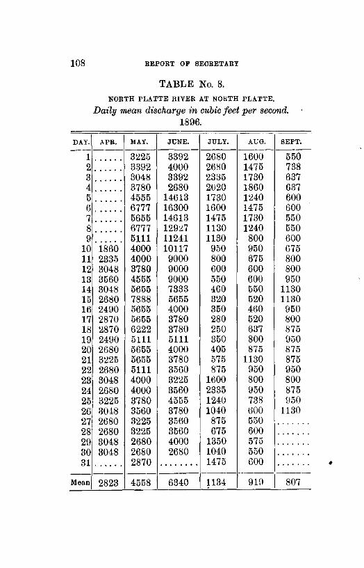
108 BEPOBT OF BEOBETARY
TABLE No.8.
NORTH PLATTE RIVER AT NOHTH PLATTE.
Daily mean discharge in cubic feet per second. 1896.
--
DAY. APR. MAY. JUNE. JULY. AUG. SEPT. -------------
1 ...... 3\!25 3392 2680 1600 550 2 ...... 3392 4000 2680 1475 738 3 ...... 3048 3392 2335 1730 637 4 ...... 3780 2680 2020 1860 637 5 ...... 4555 14613 1730 1240 600 6 ...... 6777 16300 1600 1475 600 7 ...... 5655 14613 1475 1730 550 8 ...... 6777 129:!.7 1130 1240 550 9 ...... 5111 11241 1130 800 600
10 1860 4000 10117 950 950 675 11 2335 4000 9000 800 675 800 12 3048 3780 9000 600 600 800 13 3560 4555 9000 550 600 950 14 3048 5655 7333 460 550 1130 15 2680 7888 5655 320 520 1130 16 2490 5655 4000 350 460 950 17 2870 5655 3780 280 520 800 18 2870 6222 3780 250 637 875 19 2490 5111 5111 350 800 950 20 2680 5655 4000 405 875 875 21 3~25 5655 3780 575 1130 875 22 2680 5111 3560 875 950 950 23 3048 4000 3225 1!300 800 800 24 2680 4000 3560 2335 950 875 25 3225 3780 4555 1240 738 950 26 l3048 3560 3780 1040 600 1130 27 2680 3225 3560 875 550 ....... 28 2680 3225 35!30 675 600 ....... 29 3048 2680 4000 1350 575 ••• 0 •••
30 3048 2680 2680 1040 550 ....... 31 . . . . . . 2870 • • • 0 0 ••• 1475 600 . ......
--------------------~---Mean 2823 4558 6340 1134 9Hl 807
•
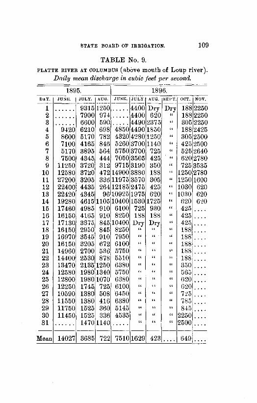
STATE BOARD OF IRRIGATION. 109
TABLE No.9. PLATTE RIVER AT COLUMBUS (above mouth of Loup river).
Daily mean discharge in cubic feet per second.
1895. 1896. ----
DAY. JU~K JULY. AUG. JUNE. JULY. AUG. SEI"f. OCT. NOV. --------- ----- ----- --- ------
1 • • • 0 0. 9315 1250 ••• 0 • 4400 Dry Dry 188 2250 2 7900 974 4400 620 " 188 2250 • • • • • 0 ..... 3 6600 590 4490 2375 " 305 2250 . . . . . . ..... 4 9420 6210 6U8 4850 4490 1850 " 188 2425 5 8600 5170 782 4320 4280 1250 " 305 2500 6 7100 4165 846 5260 3700 1140 " 425 2500 7 5170 3895 564 5750 3700 725 " 525 2640 8 7500 4345 444 7050 3505 425 " 620 2780 9 11250 3720 312 9715 3190 350 " 725 3535
10 12580 37~0 472 14900 3880 188 " 1250 2780 11 27200 3205 336 11975 3570 305 " 1250 1600 12 22400 4435 264 12185 2475 425 " 1030 !)20 13 22420 4345 9610925 1975 6'20 " 1030 620 14 19280 4615 1105110400 1530 1725 " 620 6:W 15 17460 4985 910 6100 725 930 " 425 .... 16 16150 4165 910 8250 188 188 " 425 0 •••
17 17130 3375 845 10400 Dry Dry " 425 •• 0 0
18 16150 2950 845 8250 " " " 188 .... 19 16970 3545 910 7950 " " " 188 •. 0. 20 16150 3205 672 6100 " " " 188 .... 21 14960 2700 536 5750 " " " 188 • 0. 0
22 14400 2530 878 5510 " " " 188 • 0. 0
23 13470 2135 1250 6380 " " " 350 .... 24 12580 1980 1340 5750 " " " 565 0 •••
25 12800 1980 1070 6380 " " " 620 • 0 0.
26 12250 1745 725 6100 " " " fl20 • 0 ••
27 10590 1380 508 6450 " .. " 725 . ... 28 11550 1380 416 6380 " " " 785 .... 29 11750 1525 360 5145 " " " 845 •• 0.
30 11450 1525 336 4535 " " " 2250 0 •••
31 1470 1140 " " " 25001= • • 0 0 •• ••• 0 •
4231~~ --Mean 14027 3685 722 7510 1629 649 ....

110 REPORT OF SECRETARY
TABLE No. 10. NORTH LOUP RIVER AT ST. PAUL.
Daily mean discharge in cubic feet per second. 1895.
DAY. MAY. JUNE. JULY. AUGUST SEPT. OCT. NOV.
-- ------1 •••• 0 1453 1017 702 987 1137 987 2 ..... 1456 958 842 987 1137 1857 3 ..... 3766 1107 900 8-!2 1231 1293 4 ..... 1952 958 1293 648 1293 1293 5 1520 1787 900 1047 702 1293 1293 6 1486 1357 842 987 758 1453 1200 7 1421 U53 10-!7 900 702 1293 1262 8 1293 1453 958 702 987 1262 1200 9 1137 1618 987 1618 702 1231 1137
10 1293 1453 987 1453 900 1293 1047 11 16H< 1618 987 900 871 1293 987 12 1421 1618 958 702 702 1293 987 13 1293 1357 1077 1618 702 1293 900 14 1293 1387 1107 1137 648 1325 758 15 1293 1293 1107 987 1077 1293 842 16 1137 13f)7 987 1077 1351 1351 842 17 1137 1787 900 987 1047 1389 702 18 1168 1618 842 758 1107 1293 758 19 987 987 814 702 92U 1293 702 20 1047 1137 842 675 1137 1047 702 21 987 987 702 702 1047 958 566 22 842 987 842 702 3U91 987 •• 0 •••
23 871 1047 842 1787 1787 987 ...... 24 842 1077 842 1389 1293 900 0 0 0 0 0
25 929 987 702 702 1293 928 ...• 0.
26 842 1047 675 648 1262 928 ...... 27 871 1230 620 593 1200 842 •••• 0.
28 929 1325 437 842 1137 900100 0000 29 871 1137 566 702 1017 842 0 0 0 0 0 0
30 1962 1200 566 1453 987 900 0 0 0 0 0 0
31 HH8 620 987 84) . . . . . •••• 0 • -]oo 0000 --- --------- I
Mean 1189 1531 864 984 1094 1146[. 0 0 0 0 0

BTA'rE BOARD OF IBBIGATION. 111
TABLE No. 11. NORTH LOUP RIVER AT ST. PAUL.
Daily mean discharge in cubic feet per second. 1896.
DAY. APRIL. MAY. JUNE. JULY. AUG. SEPT. OCT.
-------1 1078 1521 1698 1138 1072 860 949 2 1139 1455 1455 1110 992 843 965 3 930 1233 1139 1120 957 835 915 4 1078 1263 1139 1080 992 883 932 5 844 1263 1170 1080 974 890 932 6 987 1139 4100 1072 949 908 923 7 1139 1078 2825 1100 915 932 923 8 987 987 1540 1128 932 883 940 9 909 1139 1340 1460 957 851 940
10 844 987 1260 1350 860 883 940 11 844 901 1337 1200 850 860 940 12 2519 958 1290 1128 890 908 965 13 1962 901 1270 1120 900 932 983 14 1455 930 1230 1128 883 1016 949 15 1553 901 1200 1090 900 1000 949 16 1263 0 1078 1165 1048 867 883 949 17 1455 1203 1155 1032 875 908 923 18 3767 987 1147 1056 900 957 915 19 1962 873 1257 1072 843 1016 965 20 1293 987 1330 1064 835 983 965 21 958 844 154o I 1032 867 9-!0 949 22 958 901 1930 1008 890 890 923 23 1048 958 1590 1016 875 867 940 24 958 930 1530 1056 890 932 923 25 901 901 1560 991 867 923 888 26 844 702 1370 1184 867 9!9 837 27 779 2327 1370 983 867 \!23 880 28 1139 759 1300 1056 890 923 940 29 1962 570 1212 923 900 890 1220 30 1618 702 1184 1184 883 923 1220 31 • • • 0 •• 873 • ••• 0 • 1155 890 ..... 1120
------Mean .. 1305 1040 1494 1102 904 913 958
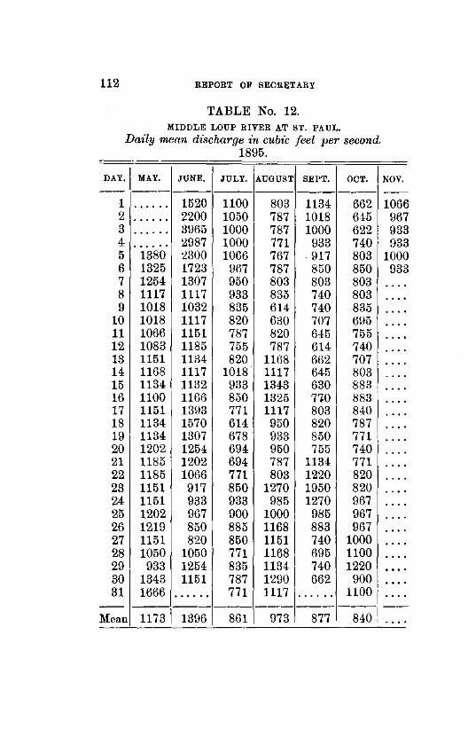
112 REPORT OF SECRETARY
TABLE No. 12. MIDDLE LOUP RIVER AT ST. PAUL.
Daily mean discharge in cubic feet per second. 1895.
!!._AY.~~AY:_ JUNE. JULY. AUGUST SEPT. OCT. NOV.
--- --- --1 • 0 ••• 0 1520 1100 803 1134 662 1066 2 0 •• 0. 0 2200 1050 787 1018 645 967 3 0 0. 0 0. 3965 1000 787 1000 622 933 4 ... 0 ••• 2987 1000 771 933 740 933 5 1380 ~300 1066 767 917 803 1000 6 1325 1723 967 787 850 850 933 7 1254 1307 950 803 803 803 .... 8 1117 1117 933 835 740 803 ..... 9 1018 1032 835 614 740 835 ....
10 1018 1117 820 630 707 695 • 0 ••
11 1066 1151 787 820 645 755 .... 12 1083 1185 755 787 614 740 .... 13 1151 1134 820 1168 662 707 .... 14 1168 1117 1018 1117 645 803 • 0. 0
15 1134 1132 933 134-3 630 883 ••• 0
16 1100 1166 850 1325 710 883 • 0 ••
17 1151 13\:l3 771 1117 803 840 0 0 ••
18 1134 1570 614 950 820 787 • 0. 0
19 1134 1307 678 933 850 771 •. 0. 20 1202 1254 694 950 755 740
'. 0.
21 1185 1202 694 787 1134 771 • 0 ••
22 1185 1066 771 803 1220 820 .... 23 1151 917 850 1270 1950 820 0 •••
24 1151 933 933 985 1270 967 .... 25 1202 967 900 1000 985 967 ••• 0
26 1219 850 885 1168 883 967 0. 0.
27 1151 820 850 1151 740 1000 0 •••
28 1050 1050 771 1168 695 1100 .... 29 933 1254 835 1134 740 1220 ••• 0
30 1343 1151 787 1290 662 900 ••• 0
31 1666 •••• 0 0 771 1117 • • • 0 0. 1100 • 0 ••
-- ------------------~--Mean 1173 1396 861 973 877 84-0 I , , .,

DAY. --
1 2 3 4 5 6 7 8 9
10 11 12 13 14 15 16 17 18 19 20 21 22 23 24 25 26 27 28 29 30 31
--
STATE BOARD OF IRRIGATION. 113
TABLE No. 13. MIDDLE LOUP RIVER AT ST. PAUL.
Daily mean dischm·ge in cubic feet per second. 1896.
APRIL. MAY. JUNE. JULY. AUG. SEPT, OCT. --------- --- ------ ---1490 1440 1720 1315 1685 806 970 1360 1300 1550 1240 1550 806 102~ 1060 1150 1430 1270 1450 854 914 1020 1230 1460 1270 1200. 914 880 1030 1050 1~90 1270 1210 818 985 900 900 1215 1195 1125 962 1010
1020 1015 ••• 0 1080 955 782 938 1170 870 2250 960 942 794 1000 1310 1360 1774 1332 900 806 914 1200 1015 1515 1770 955 974 1046 1050 890 1400 1420 980 1058 1082 1800 1030 1465 1270 942 1010 1010 1700 1060 1300 1200 840 1034 974 1230 1150 1300 1100 885 1190 1034 1310 1080· 1560 1040 870 1142 1110 1330 1440 1590 1050 890 1070 962 1060 1300 1540 1110 810 1058 974 2000 1260 1485 1170 890 1000 1000 2430 1165 1560 1160 870 1058 1070 1730 1210 1470 1170 955 1118 1106 1070 1310 1660 1260 9R4 1130 1010
910 1080 1650 1220 1000 1046 1082 1170 1170 1580 1210 880 1015 1000 1~10 1080 1795 1300 840 926 1070 1340 1170 1820 1300 880 985 985 1000 1210 1645 1440 820 1034 109 4 1190 1200 1505 1540 760 1034 1070 1300 1000 1417 1480 820 1106 1010 1860 1215 1315 1320 855 1154 137 0 1860 1070 1455 1280 746 1094- 1478 .... 1345 •• 0 0 1670 722 . ... 1106 --- --- --- ------ ---
Mean. 1364 1154 11342 1271 975 993 104
•

114 REPORT OF SECRETARY
TABLE No. 14.
LOUP RIVER AT COLUMBUS.
Daily mean discharge in cubic feet per second. 1895.
DAY MAR. APR. MAY. JUNE. JULY. AUG. SEPT. OCT. NOV.
1 .... 3070 2840 4330 2822 1525 BOLl 2239 2562 2 .... ~000 4360 4000 2849 1546 2875 2144 2613 3 .... 2670 4420 9080 2613 1546 2410 2004 2664 4 .... 2660 3590 7190 2562 4104 2191 1913 2822 5 .... 2700 3290 5580 2088 1588 2191 2312 2928 6 .... 2520 3180 4775 2562 2264 1957 2288 2822 7 .... 2675 ~930 3800 2434 1957 1913 2433 2875 8 .... 3675 2850 3420 2~40 1891 1935 2337 2955 9 .... 3450 2750 3010 2288 1846 2027 2288 3011
10 .... 33201 2675 2780 2027 2074 1913 2433 3011 11 .... 3150 2690 2900 2074 2562 1891 2485 3067 12 .... 2950 2800 2835 2031 2408 1758 2434 3L22 13 .... 2780 2740 3176 1980 189L 1736 2485 3178 14 .... 2840 2700 3384 2361 1!l80 1fi73 2485 32U2 15 .... 2625 2600 3205 2562 2743 173() 2562 3378 16 .... 2650 2620 28~2 Y337 2796 1715 2690 3523 17 .... 2875 2710 3205 2191 2288 1957 2536 3643 18 .... 2890 2770 4264 2074 2288 2074 2460 3378 19 .... 2725 2820 4296 2004 2191 2121 2485 3095 20 .... 2650 2830 3350 1980 2240 2121 2536 2928 21 .... 2303 2730 3039 1824 2191 282212485 2822 22 .... 2400 2820 2562 1736 2097 3793 2562 2875 23 .... 2500 2850 3011 1708 2434 3465 2613] 2690 241 2520 2800 2850 1846 2743 4264 2H39 ... . 25:::: 2450 2880 2337 1957 290214995 2H90 ... . 2611 .... 2440 2740 2361 1935 2664[2849 2690 ... . 27 .... 2440 2750 2337 2004 22641 2536 2613 ... . 28'.... 2490 2750 2588 1588 253612337 2511 ... . 292790 2640 2650 2562 1567 2460 2239 2434 ... . so:;-750 2550 3350 2690 152~ 2313\2312 2536 ... . 31
1
27:?. ~ 34 70 .:.._:_~ 144o 2613 .:.._:_~ 2613 .:.._:_~
I... . 2753 2966 3591 2122 22891, 2427 2450 .... Mean
•
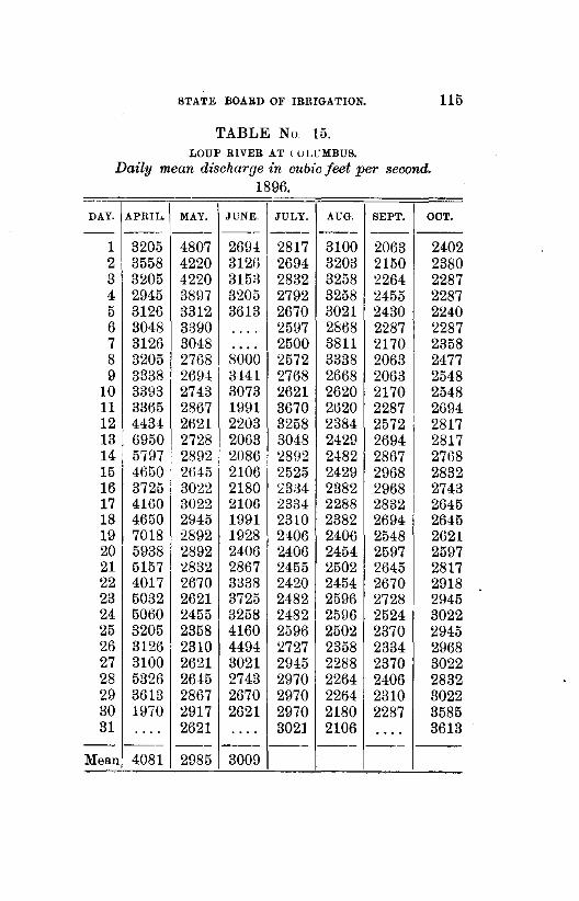
STATE BOARD OF IRRIGATION. 115
TABLE No. 15. LOUP RIVER AT l ULUMBUS.
Daily mean discharge in cubic feet per second. 1896.
DAY. APRIL. MAY. JUNE. JULY. AUG. SEPT. OOT.
-- --- --- --- --- -- ---1 3205 4807 269.1. 2817 3100 2063 2402 2 3558 4220 312U 2694 32013 2150 2380 3 3205 4220 315;3 2832 3258 2264 2287 4 2945 3897 3205 2792 3258 2455 2287 5 3126 3312 3613 2670 3021 2430 2240 6 3048 3390 .... 2597 2868 2287 2287 7 3126 3048 .... 2500 3811 2170 2358 8 3205 2768 8000 2572 3338 2063 2477 9 3338 2694 3.1.41 2768 2668 2063 2548
10 3393 2743 3073 2621 2620 2170 2548 11 3365 2867 1991 3670 2tl20 2287 2694 12 443! 2621 2203 3258 2384 2572 2817 13 6950 2728 2063 3048 2429 2694 2817 14 5797 2892 2086 2892 2482 2867 2768 15 4650 2tl45 2106 2525 2429 2968 2832 16 3725 3022 2180 23M 2382 2968 2743 17 4160 3022 2106 2334 2288 2832 2645 18 4650 2945 1991 2310 2382 2694 2645 19 7018 2892 1928 2406 2406 2548 2621 20 5938 2892 2406 2406 2454 2597 2597 21 5157 2832 2867 2455 2502 2645 2817 22 4017 2670 3338 2420 2454 2670 2918 23 5032 2621 3725 2482 2596 2728 2945 24 5060 2455 3258 2482 2596 2524 3022 25 3205 2358 4160 2596 2502 2370 2945 26 3126 2310 4494 2727 2358 2334 2968 27 3100 2621 3021 2945 2288 2370 3022 28 5326 26i5 2743 2970 2264 2406 2832 29 3613 2867 2670 2970 2264 2310 3022 30 1970 2917 2621 2970 2180 2287 3585 31 . . . . 2621 .... 3021 2106 • • 0 0 3613
-- --- -- --- --- --- --Mean 4081 2985 3009
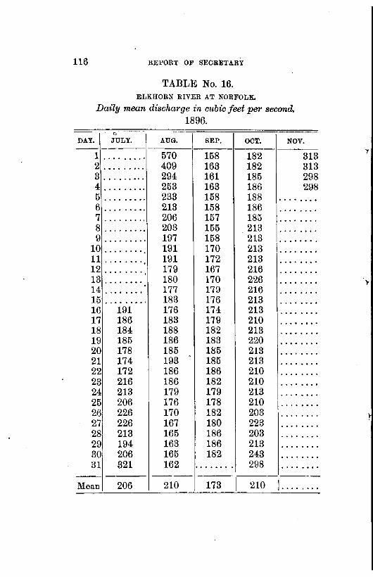
116 REPORT OF SECRETARY
TABLE No. 16. ELKHORN RIVER AT NORFOLK.
Dm:ly mean discharge in cubic feet per second. 1896.
0
DAY. JULY. AUG. SEP. OCT. NOV. ------- -------1 ......... 570 158 182 313 2 ......... 409 163 182 313 3 ......... 294 161 185 298 4 ......... 253 163 186 298 5 ......... 233 158 188 • 0 •• 0. 0.
6 ......... 213 158 186 0 0 ••• 0. 0
7 ......... 206 157 185 0 •••••••
8 ......... 203 155 213 . ....... 9 ......... 197 158 213 • 0 • 0 •• 0 •
10 ....... ·. 191 170 213 • 0 •• 0 •• 0
11 ........ 191 172 213 0. 0. 0 0. 0
12 ••• 0. 0. 0 179 167 216 • 0. 0 0 •• 0
13 • 0 ••••• 0 180 170 226 •• 0 • • •• 0
14 . . . . . ... 177 179 216 • • 0 0 0 •••
15 • 0 ••• 0 ••• 183 176 213 • ••• 0 •• 0
16 191 176 174 213 ••••• 0 ••
17 186 183 179 210 • 0 •• 0 • 0 •
18 184 188 182 213 •••••• 0 0
19 185 186 183 220 0 ••• 0 0 0 0
20 178 185 185 213 0 ••••• 0.
21 174 193 185 213 • 0 ••• 0 ••
22 172 186 186 210 ••• 0 ••• 0
23 216 186 182 210 • 0 0 •••••
24 213 179 179 213 ••• 0 ••••
25 206 176 178 210 ••• 0 ••••
26 226 170 182 203 ........ 27 226 167 180 223 ........ 28 213 165 186 203 • 0 ••••• 0
29 194 163 186 213 •• 0 ••• 0.
30 206 165 182 243 • 0 •••• 0.
31 321 162 ........ 298 • ••• 0 0 ••
--- ---- --------Mean 206 210 173 210 ••••• 0 ••
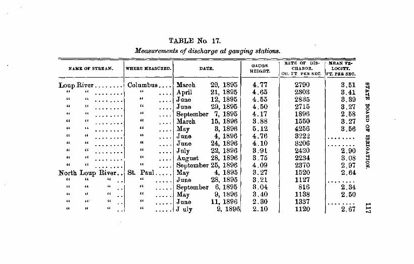
TABLE No. 17.
Measurements of discharge at gauging stations.
GAUGE BATE OF DIS- MEAN VE-
NAME OF STREAM. WHERE MEASURED. DATE. HEIGHT.
CHARGE. LOOITY. CU. FT PER SEC. FT. PER SEC.
LoupRiver ........ Columbus .... March 29, 1895 4.77 2790 3.51 " " " April 21, 1895 4.65 2303 3.41 •••• 0 0 • 0 .... " " " June 12, 1895 4.55 2835 3.39 ••••• 0 •• • 0 ••
" " " June 29, 1895 4.50 2715 3.27 • 0 ••••• 0 • 0 ••
" " " September 7, 1895 4.17 1896 2.58 0 •• 0 •••• . ... " " " March 15, 1896 3.88 1550 3.27 • 0 ••• 0 •• •• 0 •
" " " May 3, 1896 5.12 4256 3.56 • • • • 0 ••• .... " " " June 4, 1896 4.76 3222 • 0 0 • • ••• . . . . . ....... " " " June 24, 1896 4.10 3206 • 0 •• 0 ••• . ... . ....... " " " July 22, 1896 3.91 2420 2.90 ••••••• 0 • 0 ••
" " " August 28, 1896 3.75 2234 3.08 . . . . . ... 0 • 0 0
" " " September 25, 1896 4.09 2370 2.97 ••• 0 •••• . ... North Loup River .. St. Paul ..... May 4, 1895 3.27 1520 2.64
" " " " June 28, 1895 3.21 1127 .. • •• 0 0 ........ " " " " September 6, 1895 3.04 816 2.34 . . • 0 •••
" " " " May 9, 1896 3.40 1138 2.50 . . ..... " "' " " June 11, 1896 2.30 1337 .. 0 •• 0 • 0 •••••• 0
" " " " July 9, 1896 2.10 1120 2.67 .. •••• 0

NAME OF STREAM.
North Loup ....... " " • 0 •• 0. 0
Middle Loup ....... " " ••• 0. 0.
" " 0 •• 0. 0 0
" " •••••• 0
" " ••• 0 •••
" " ....... " " .......
N. Fork Republican " " " ... " " " ... " " " ... " " " . . . " " " ...
S. Fork Republican. " " " " " "
TABLE No. 17-Continued.
Measurements of discharge at gauging stations.
GAUGE WHERE MEASURED. DATE,
HEIGHr.
St. Paul ..... August 21, 1896 2.05 " " September 23, 1896 2.15 •• 0 ••
" " June 28, 1895 1..83 0 ••••
" " September 7, 1895 1.62 0 ••••
" " May 8, 1896 1.36 •• 0 ••
" " June 11, 1896 1.24 0 •• 0 •
" " July 9, 1896 1.42 • ••• 0
" " August 21, 1896 1.42 . .... " " t:leptember 23, 1886 1.53 0 0 • • •
Benkleman ... December 9, 1894 1. 74 " March 22, 1895 1.89 . .. " June 4, 1895 1.68 . .. " June 24, 1895 1.06 . .. " August 7, 1895 0.96 ... " September 11, 1895 . .. • • • • 0 •••••
" December 9, 1894 ... • • 0 •••• 0. 0
" March 23, 1895 ... 0 0 •• 0 •••••
" June 4, 1895 ... 0 ........ 0.
RATE OF DIS· CHARGE.
CU. FT. PER. SEC.
880 935
1046 863 940
1400 1332
984 1015
75.0 71.5
141.7 35.6 64.2 0.0 0.5
41.0 348.0
MEAN VE· LOOITY.
FT. PER SEC.
::!.03 2.06
. ........ 1.81 2.02 2.95 2.19 1.92 1.81 2.81 2.01 2.83 1.45 2.02
. ....... ••••••• 0
1. 70 2.90
..... ..... 00

S. Fork Republican. Benkelman ... June 24, 1895 • 0 • 0 ••• 0 • 0 75.4 1. 79 " " " " July 3, 1895 278.0 2.48 ••••••• 0 ••
" " " " August 7, 1895 22.3 0 0 •••• 0 ••• • 0 ••••••
" " " " September 11, 1895 0.0 0 ••• 0 0 ••• 0 0 • • • • 0 ••
Frenchman River .. Palisade ..... December 8, 1894 1.87 116.0 1.41 " " " March 22, 1895 1.52 100.4 1.87 " " " June 5, 1895 1. 76 154.3 1.55 "' ~ " " " July 4, 1895 1.61 74.2 1.58 "" ~ " " " August 9, 1895 1.50 70.9 1.23 1<1
" " " May 15, 1896 1.55 103.1 tot ........ 0
" " " June 18, 1896 1.35 50.54 1.56 "" to " " " July 15, 1896 1.46 92.72 1. 72 1:1
" " " August 13, 1896 1.36 64.1 1.39 0 loj
" " " September 16, 1896 1.51 84.8 1.57 .... !:"
" " " October 17, 1896 1.50 82.47 tot • 0 •• 0. 0 0 ....
" " Wauneta ..... August 9, 1895 1.38 61.5 Q 0 0 •••••• "" " " " September 10, 1895 0.92 56.4 >-3 • • • • • 0 •• ....
" " " May 15, 1896 2.20 84.88 0 0 ........ l'l
" " " June 18, 1896 1.84 47.7 1.52 ,, " " July 14, 1896 2.15 91.26 3.08
" " " August 12, 1896 1.90 46.2 • • • • • 0 • 0
" c' '·- " September 16, 1896 2.07 84.7 2.71 " " " October 17, 1896 2.00 62.46 • 0 •••••• ....
Platte River ....... Columbus .... March 29, 1895 0.40 2'531. 2.47 .... eo

TABLE No. 17.-Continued.
Measurements of discharge at gauging stations.
GAUGE RATE OF DIS· MEAN VE-
NAME OF STREAM. WHERE MEASURED. DATE, HEIGHT.
CHARGE. LOOITY ou. Fr. PER SEO FT. PER SEC,
Platte River •• '"0 •• Columbus .... May 3, 1895 • • • • 0 ••••• 5550. 2.56 " " " May 22, 1895 5896. • 0 •• 0 0 • .. 0 • 0 0 • 0 0 ••••• •••• 0 •••
" " " June 11, 1895 2.28 27214. 4.01 ...... . ... " " " June 25, 1895 1.42 12430. 3.20 . . . . . . .... " " " July 15, 1895 0. 72 5338. 2.57 ....... . ... " " ·" May 2, 1896 4550. 2.26 . . . . . .. 0 ••• . . . . . ..... " " " June 5, 1896 3.19 4320. 2.44 ...... . ... " " " June 14, 1896 4.11 10307. 2.88 ...... • •• 0
" " ...... 1 " June 30, 1896 3.35 4450. 2.30 .... " •• " July 22, 1896 14.4 1.40 . . . . . . • •• 0 . . . . . ..... " " " August 26, 1896 1.06 1.0 • • • 0 •• . . . . ........ " " .. August 28, 1896 0.0 • • • 0 •• • 0 •• • 0 • • • •••• ' •••• 0 •••
" " " September 6, 1896 0.0 • • • 0 •• • • • 0 . . . . . . . ... 0 0 ..... 0 •
" " " September 25, 1896 1. 70 188. 1.39 • 0 •••• .... North Platte River. North Platte. October 5, 1894 .......... 620. 1.58
" " " " " November 6, 1894 1227. 1.72 •••• 0 •••••
" " " " " March 27, 1895 2329. 1.88 ••••••• 0 ••
" " ... " " A ril 29, 1895 5695. 2.16 • 0 ••• 0 • 0 • 0 p

North Platte River. North Platte .. May 28, 1895 .......... 6320. 2.43 " " " " " June 8, 1895 4.00 16261. 2.85 0 0
" " " " " September 14, 1895 1.30 200. 1.64 • 0
" " " " " June 13, 1896 3.35 9000. • 0 ........ " " " " " June 29, 1896 2.90 4000. 2.51 • 0
" " " " " July 25, 1896 2.05 1260. 0 0 ••••• 0 ••
" " " " " September 8, 1896 1.50 547. 0 0 ........ " " " Camp Clarke. June 27, 1896 3.18 3600. 2.55 " " " " " August 10, 1896 2.41 812. 1.63 0.
" .. " " " ~ovember 21, 1896 2. 70 931. 1.36 . . South Fork Elkhorn. Norfolk ...... July 16, 1896 0.98 191. • •••••• 0
" " " " August 27, 1896 0.89 175. 1.52 ...... " " " " September 12, 1896 0.86 176. 1.50 ......
Republican River .. Superior ..... June 20, 1896 0.92 69!. 1.49 " " " July 17, 1896 0.78 585. 1.31 0 0 • 0 •••
" " " August 24, 1896 0.89 684. 1.40 0 0 •••• 0
" " " September 21, 1896 0.42 227.5 0.64 0 0 ••• 0.
" " " October 25, 1896 0.45 72. 0 0 ...... • ••• 0 •••
To compare 1895 gauge heights at Wauneta with those of 1896 at same place, add one foot.
To compare 1895 gauge heights on the Platte river at Columbus with those of 1896 at same place, add 2.88 feet.
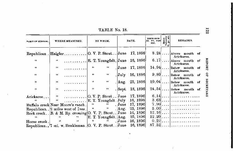
TABLE No. 18.
DISCHARGE =~~ NAME OF 8TRBAJ&, WHERE MEASURED. BY WHOM. DATE. CU. FT. PER :5~..: REMARKS.
BEC. ;:e:-; ~ >i
Republican . Haigler ........... 0. V. P. Stout ... .June 17, 1896 8.24 .. 0. Above mouth of Arickaree.
" " E. T. Youngfelt. June 16, 1896 6.17 Above mouth of . . . . . . . . . . . .... Arickaree.
" " " " . June 17, 1896 14.94 Below mouth of ........... • 0 ••
Arickaree.
" " " " . July 16, 1896 9.80 Below mouth of ........... . . 0. Arickaree.
" " " " .Aug. 25, 1896 1.0.04 Below mouth of 0. 0 •• 0 •••••
.... Arickaree .
" " " " . Sept. 18, 1896 24.54 Below mouth of • 0 ••• 0 0. 0 0 0
.... Arickaree.
Arickaree ... " 0. V. P. Stout ... June 17,1896 6.14 • • • • 0 ••••••
. . . . . ... .......... " " E. T. Youngfelt. July 16, 1896 3.63 ............ •• 0 0 •• 0 • 0 •• 0 ••••• 0
Buffalo creek Near Moore's ranch. " " . June 17, 1896 7.90 .. 0. • • • • • •• 0 ••• 0 ••
Republican .. 2 miles west of I ves. " " . Aug. 25, 1896 5.00 .. 0. • • • • • 0 ••• 0 ••••
Rock creek .. B. & M. Ry. crossing 0. v. P. Stout .. June 16, 1896 12.16 . ... . . . . . . . . . . . . . . " " " E. T. Youngfelt. Aug. 25, 1896 12.20 • 0 •• . . . . . . . . . • . . 0.
Horse creek. " ,, " " . June 16, 1896 0.22 .... • 0. 0 •• 0 •••• 0 ••
Republican .•. 7 mi. w. Benkleman. 0. v. P. Stout .. June 16, 1896 87.52 .... ••••• 0 •••••• 0 0

Dundy Co. At headgate ........ 0. V. P. Stout .. June 16, 1896 Irr. ditch.
Neighbor ditch •....
" " .. " .. June 16, 1896
Republican .. Benkelman . . . . . . . . " " .. June " " ........ E. T. Youngfelt. Aug.
So. Fork Rep. " . . . . . . . . " " . June " 3000 ft. w. of above. " " . June
Republican .. Culbertson ........ 0. V. P. Stout .. June
16, 1896 25, 1896 16, 1896 16, 1R96 19, 1896
" " "
"
"
"
........ C. E. Crownover. May 16, 1896
........ 0. V. P. Stout .. Sept. 10, 1896
........ U. S. Geo. Sur .. Nov. 25, 1892 Stinking .
Water ..... Pahsade .......... 0. V. P. Stout .. June 19, 1896
" " .......... E. T. Youngfelt. Sept. 17, 1896
Frenchman .. Sec. 33 T. 4 R. 32 .. 0. V. P. Stout ... June 19, 1896 " Culbertson ........ E. T. Youngfelt .. June 19, 1896 " " ........ U. S. Gaol. Sur .. Nov. 25, 1892 " " ........ 0. V. P. Stout .. March 22, 1895
Culbertson At headgate. . . . . . . " June 19, 189t3 canal.
6.19 ... .
1.12 ... .
29.30 .. .. 0.00 .. .. 3.25 .. .. 1.39 .. .. 6. 48 .... Above mouth of
Frenchman. 78 . 37 .... Above mouth of
Frenchman. 0. 00 .... Above mouth of
Frenchman. 209.00 1. 81 Above mouth of
Frenchman. 12.24 ... , Above mill at Palis
ade. 20 . 00 . . . . Below mill at Palis·
ad e. 26.30 ................. . 13.40 ................ ..
1'17 .001.68 ............. . 120.00 .................•
60. 80 .... Total discharge of li'renchman river was about 1.25 sec ft. more thau this.

TABLE No. 18-0ontinued.
>,0 DISCHARGE c::: ~
NAME OF BTBJU.W: WHERE MEASURED. BY WHOM. DATE. CU, FT. PER •"· oOo REMARKS. SEC. :a 'ii g.
>~
Culbt'son cnl At flume No.4 ...•. E. T. Youngfelt. June 19, 1896 22.90 • 0 0. •• 0 •• 0 0 •••• 0 • 0
" " No.1 ..... " Sept. 17, 1896 62.60 . . . . 0 • • • • • • • • • • ....
" At flume " " Sept. 17, 1896 17.92 Waste water flow-• 0 ••
into stinking water.
Farmers cn'l. ~t headgate .....•. " June 19, 1896 2.28 . . . . •••••• 0 • • • • •••
Riverside cnl " E. T. Youngfelt . June 19, 1896 15.92 .... 0 •• 0 •••• 0 • • 0 • 0
Republican .. Oxford 0 ••• 0 •••• 0 0 0. V. P. Stout. ... June 3, 1895 16000.0 7.67 • • • • • • • • • • • • 0 •
" " " Sept. 12, 1895 55.0 1.09 • • • 0 ••••••• •• 0 •••••••••••
" " C. E. Crownover May 17, 1896 254.5 ••• 0 ••• 0 0 •• . . . . • • 0. 0 0 •••••• 0 •
" " 0. V. P. Stout .. June 20, 1896 109.4 ••••••• 0 •• 0 • • • 0 •• 0. 0 •• 0 0 •••••
North Platte. Douglas, Wyoming. State Engr. Wyo. June 3, 1891 10130.0 . . . . 0. 0 •••••• 0 •• 0 • .. Fairbanks, Wyoming " Oct. 13, 1891 579 . 0 ••• •••••••• 0. 0 •••
" Douglas, Wyoming. " Nov. 5, 1892 595. . . . . •• 0 ••• 0 ••••• 0 •
" Douglas, Wyoming. " Dec. 4, 1891 807. .... ••• 0 0 •• 0 ...... 0
" North Platte, Neb .•. U. S. Geol. Sur. Sept. 14, 1892 770. • 0. 0 0 0 ••••••••••••
" " " Nov. 2, 1892 1070. . . 0 0 •• •••••••• 0 ••••• ,, " " Nov. 22, 1892 1370. . . . ... ••• 0 •• 0 ••• 0 ••• ,, Camp Clarke, Neb .. " May 29, 1891 8075. • 0 •• • 0 • 0 •• 0 • 0 •••• 0
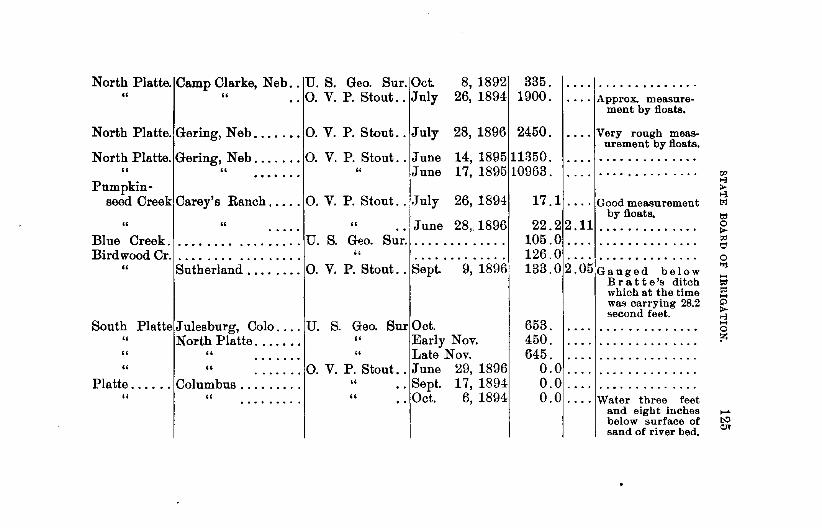
North Platte. Camp Clarke, Neb .. U. S. Geo. Sur. Oct. " " .. 0. V. P. Stout .. July
8, 1892 335. 26, 1894 1900 0 .... Approx. measure
ment by floats.
North Platte. Gering, Neb ....... 0. V. P. Stout .. July 28, 1896 2450. .... Very rough measurement by floats.
North Platte. Gering, Neb ....... 0. V. P. Stout .. June 14, 189511850. " " ..• . . . . " June 17, 189510963.
Pumpkin-seed Creek Carey's Ranch ..... 0. V. P. Stout .. July 26, 1894
" " " .. June 28,. 1896 Blue Creek .................. U. S. Geo. Sur ............. . Bird wood Cr. . . . . . . . . . . . . . . . . . " ............ .
" Sutherland ........ 0. V. P. Stout .. Sept. 9, 1896
South Platte Julesburg, Colo .... U. S. Geo. Sur Oct. " North Platte....... " Early Nov. " " .. .. .. . " Late Nov. " " ....... 0. V. P. Stout .. June 29, 1896
Platte . ..... Columbus . . . . . . . . . " .. Sept. 17, 1894 " " . . . . . . . . . " .. Oct. 6, 1894
17 . 1 . . . . Good measurement by floats.
22.2 2.11 ..•....... 0 •••
105 0 0 ... 0 • 0 •••••••• 0 0 0 0
126 0 0 0 •••• 0 •••••••• 0 0 0 0
133.02.05Gauged below Bratte's ditch which at the time was carrying 28.2 second feet.
653. 450. 645.
0.0 .. .. 0.0 .. .. 0. 0 .... Water three feet
and eight inches below surface of sand of river bed.

TABLE No. 18-Cantinued. ..~
DISCHARGE =~ il N .UIIC OF BTBBAM, WHERE MEASURED. BY WHOM. DATE. CU. FT. PER ~~~ REMARKS.
SEC. :o~-"' ~i
Platte ...... Fremont .......... 0. V. P. Stout .. Aug. 14, 1894 1420. 0 ••• Good measurement by meter.
" " A. Rosewater ... Late Aug, 1894 1209. . . . . . . . . . . .... • ••••••• 0 •••••
North Loup. Moulton ....•...... G. H. Lawrence Nov. 2, 1894 460.0 . ... • •• 0 ••••• 0 ••••
" Burwell ........... 0. V. P. Stout .. July 9, 1896 625. 2.87 River about three inches higher than on following morning. Said to be about four inches above nor-maL Rise due to rain on night of July 8.
" Ord .............. " May 5, 1895 1367. .. .... 0 •• 0 • 0 0 • • • • 0 • 0
Calamus .... Burwell " July 10, 1896 368. 2.94 • • • • • • 0 ••• .. • ••• 0 ••• 0 • • •••
Middle Loup At forks 8! miles above Mullen .... " Aug. 20, 1895 41.8 .. . . . . • •• 0 •••••• 0 •••
" Mullen ..•........ " Aug. 20, 1895 120.0 0 0 0 ••• • 0 0 ••• 0 •••••••
" Seneca " Aug. 21, 1895 216.2 .... 1 ......... 0 .... • • • • • •••• 0 • 0 0
" " " Aug. 30, 1896 212. 2.45 ••• 0 • 0 ••••• 0 0 • 0 0 • 0 0 0 ..... 0 • 0 •
" Thedford " .. Aug. 22, 1895 284.3 •• 0 • 0 • • • • 0 ••• 0 ••• 0. 0 ••••• 0 0
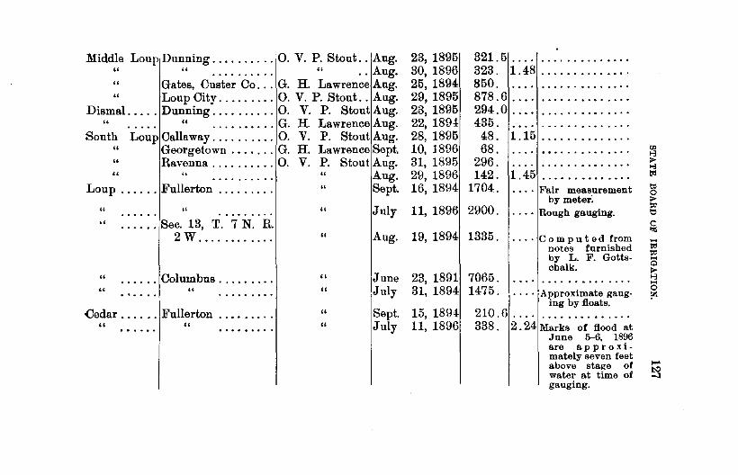
Middle Loup Dunning .......... 0. V. P. Stout .. Aug. '' '' . .. . . . . . . . '' .. Aug. " Gates, Custer Co ... G. H. Lawrence Aug. " Loup City ..... .... 0. V. P. Stout .. Aug.
Dismal ..... Dunning .......... 0. V. P. Stout Aug. " " .......... G. H. Lawrence Aug.
South Loup Callaway .......... 0. V. P. Stout Aug. " Georgetown ....... G. H. Lawrence Sept. " Ravenna .... ...... 0. V. P. Stout Aug. '' u • • • • • • • • • • " Aug.
Loup ...... Fullerton . . . . . . . . . '' Sept.
" " ,, .. .. .. Sec. 13, T. 7 N. R. 2W .......... ..
" . . . . . . Columbus ........ . " "
Cedar ...... !Fullerton ...•..... " "
"
"
" " " "
Jnly
Aug.
June !July
Sept. July
23, 1895 30, 1896 25, 1894 29, 1895 23, 1895 22, 1894 28, 1895 10, 1896 31, 1895 29, 1896 16, 1894
321.5 .... 323. 1.48 850. 878.6 .. .. 294.0 ... . 435.
48. 1.15 68.
296.
• • • • 0 •••• 0 0 0 ••
142. 1.45 1704. . .•. Fair measurement
by meter. 11, 1896 2900. . · • · Rough gauging .
19, 1894 1335. . ... Co m put e d from notes furnished by L. F. Gottschalk .
23, 1891 7065. 31, 1894 1475. . ... Approximate gaug
ing by floats. 15, 1894 210.6 . . . . . ............ . 11, 1896 338. 2. 24 Marks of flood at
June 5-6, 1896 are approximately seven feet above stage of water at time of gauging.

TABLE No. 18-Continued.
,.,.; DISCRARGE =;:: i
NA..Mlt OF STREAM. WHERE MEASURED. BY WHOM. DATE. CU. FT, PER ~ g ~ .KEMARKS. SEC. ::S~ p.
>~
Cedar River. Cedar Rapids ...•.. 0. V. P. Stout .. July 21, 1896 212. 1. 79 • • • • • 0 • 0 ••• 0 ••
" Ericson ..•........ W. J. McEathron March 16, 1895 152. 2.66 0 •• 0 ••••••• 0 ••
" " " June ..... 0 ••• 0 ••
1, 1895 214. • • • 0 • ••• 0 •••••• 0 0 •
" " " Aug. 1895 112.1 . . . . . ...... . ... • • • • • •••••• 0 • 0
Beaver Creek Genoa. .••......... 0. v. P. Stout Sept. 17, 1894 71.0 . ... • ••••••• 0 •• 0 • 0
" " " July 14, 1896 110.0 1.71 . . . . . ....... • ••••••• 0 0 .. 0 ••
" " W. J. McEathron Aug. 14, 1896 112.2 • 0 • • 0 ••••• 0 •
. ... 0 ••••• 0 •••••••
" Albion 0. v. P. Stout July 21, 1896 47.4 1.13 •• 0 0 ••• 0 0 ••
• 0 •••••• 0 0 ••• 0
Shell Creek. Platte Center ...... " July 23, 1896 15.3 0.94 •• 0 •••••••••••
" Schuyler .......... " July 24, 1896 26.3 1.20 • • • • • •• 0 ••••••
Looking-glass Creek Near mouth ....... W. J. McEathron July 1896 15.0 • •• 0 ••• 0 •• 0. 0 •••••
N. Fk.Elkh'n Norfolk ........... 0. V. P. Stout .. July 16, 1896 70.0 1.39 •••••••••• 0 •••
Elkhorn .... Atkinson .......... Adna Dobson ... Oct. 2, 1896 11.1 .... • • • • • • • • 0 0 ••••
" Arlington ......... And. Rosewater . Late Aug. 1894 214. 0 •• 0
.... • • • 0 0 ••••• 0 •••
" Waterloo .......... 0. V.P. Stout .. Aug. 15, 1896 280. ••• 0
.... 0 •• 0 ••••• 0 0 •••
" " 0. V. P. Stout .. July 17, 1896 495. 1.64 • 0 •• ......... . .............
Union Creek Madison .......... 0. V. P. Stout.. July 23, 1896 38.3 1.42 ••• 0 0 •• 0 0 •••••

Niobrara 0 0 0 Dawes county ...... Prof. L. E. Hicks Sept. 4, 1887 98.0 • • • • • • 0 • • •••••
" Marsland, Dawes Co. E. T. Youngfelt. June 23, 1896 4.0 0 0 .......... 0 ••• 0 ,, Valentine .......... Adua Dobson ... Oct. 4, 1896 712. 0 0 •••••• 0. 0 0. 0. 0
Minachaduza Fort Niobrara " Oct. 4, 1896 45.2 . . . . . ..... •• 0 0. 0. 0 ••••• 0
Pine. Long Pine ......... " Oct. 3, 1896 47.1 • 0 •••• 0 0. ••••• 0 ••••••••
White 0 •••• Sec. :23 T. 31 N. R. r:JJ
53 w ........ 00 E. T. Youngfelt. June 24, 1896 23.3 >-3 • 0 •••• 0 ••••• 0. ~
" Crawford .......... " . June 24, 1896 30.7 >-3 0 0. 0. • • • • • 0 • 0 • 0 •••• to
" Whitney ...•...... " . June 25, 1896 27.2 ..... 0 ••• 0 •••••••• 0 to " Chadron ........... June 1, 1891 123. 0 . . . . . .. • • • • • • 0 0 •• 0 •• 0 ••••••• 0 • 0 0 0 • ~
Soldier Creek Fort Robinson ..... E. T. Youngfelt. June 24, 1896 3.23 :0 .. 0. • • 0 • • ••• 0 • 0 •• 0 tl :Ft. Robinson 0
ditch Fort Robinson ..... " . June 24, 1896 0.79 '" . . . . .... • ••••• 0 0 ••• 0 • 0 .... White Clay t<l
t<l • Creek .... N.lineSec.1,T.31,R. ....
Q
52, w .......... " . June 24, 1896 4.0 ~ .... 0 ••••••••••• 0 • >-3 Squaw Creek N. line Sec. 1, T. 31, ....
0
R. 52, w. 000 ••• 0 " • June 24, 1896 0.66 tz .... • •••• 0 • 0 • 0 ••••
West Ash Creek .... N. line Sec. 25, T.
32 R. 51. 00 00 00 0 " . June 25, 1896 1.73 .... • •••••• 0 • 0 ••••
East Ash One-half mile above Creek .... mouth. " . June 25, 1896 1.09 """ • • • • • • • 0 0 .... 0 •• 0 ••• 0 •• 0. 0 0 "" co

TABLE No. 18-Continued.
~d DIBCRABGE ~1.1 ~
NAME 01" BTRI:.A.M. WHERE MEASURED. BY WHOM. DATE. Cu. FT. PER oO" REMARKS. SEC. ~~~
>~
Little Cotton-wood Cr'k. In Sec. 7, T. 32, N.,
R. 51, w ........ E. T. Youngfelt. June 25, 1896 0.1 . . . . ............... Big Cotton- . . . . ...............
wood Cr'k. Six miles west Whit-ney ............. " . June 25, 1896 0.2
Indian Creek Near mouth ........ " . June 25, 1896 0.06 • 0. 0 • 0 0 •• 0 ••••••••
Clear Creek. Sec. 29, T. 16 N., R. R. 41 w ........ A dna Dobson. .. Nov. 23, 1896 12.8 • • • 0 0 • .. • • 0 ••••••••
Lodge Pole Creek .... Kimball ........... " May 26, 1896 4.5 .. .... • •••• 0. 0 0 •••• 0
Victoria Cr'k. Sec. 1, T. 19 N., R. R. 21 w ........ " July 28, 1896 5.2 .. . . . . • •••••• 0 ••••••

STATE BOARD OF IRRIGATION. 131
FLOW OF WATER THROUGH VERTIOAL OPENINGS AND OVER
WEIRS.
The state law on irrigation determines that a cubic foot of water per second of time shall be the legal standard of measurement. But the law also recognizes the miner's ~nch where water has been appropriated or sold by that standard prior to the act of April 4, 1895, and prescribes how it shall be measured in section 32 of said act.
Section 32. "A cubic foot of water per second of time shall be the legal standard of the measurement of water in this state, both for the purpose of determining the flow of water in the natural streams and for the purpose of distributing therefrom. Provided, however, that water heretofore sold by the miner's inch shall continue to be delivered in that way, and all water sold by the miner's inch by any person, company, or corporation shall be measured as follows, to-wit: Every inch shall be considered to be one inch square orifice under a four inch pressure and a four inch pressure shall be from the top of the orifice in the measuring box to the surface of the water; said measuring box or any slot or aperture through which said water is measured shall in all cases be six inches in pe1·pendicular height inside measurement, except boxes delivering less than twelve inches, which orifice may be square. And all boxes for the purpose of measuring water shall have a descending slope of not less than one-eighth of an inch to the foot, and shall not be less than fourteen feet in length. Fifty miner's inches under a four inch pressure shall be deemed equivalent to a cubic foot per second of time."
By a four inch pressure is meant that the surface of the water on the upper side of the aperture of the measuring

132 REPORT OF SECRETARY
box shall be four inches above the top of the opening. This is generally termed the head of water, pressure referring to the weight of water and is commonly expressed in pounds per square inch of surface. A depth or head of one foot of water produces a pressure of 0.43 pounds per square inch, and a head of 2.31 feet is equivalent to a pressure of one pound per square inch, or 144 pounds per square foot. The law is contradictory in stating that fifty miner's inches shall be deemed equivalent to one cubic foot per second, for under the conditions that the law stipulates with regard to what shall constitute a miner's inch, one cubic foot per second is equal to very nearly forty miner's inches. Table No. 19. has been calculated to show the discharge both in cubic feet per second and in miner's inches through a statutory measuring box for various breadths of the opening, the height of the opening being in all cases six inches, and the head of water remaining constant at four inches.
No device has yet been invented whereby the head of water on a measuring box can be kept constantly at the same height. The nearest approach to this, as far as the writer knows, is A. D. Foote's measuring box, a description of which can be found in P. J. Flynn's treatise on "Irrigation Canals and Other Irrigation Works." The chief merit of this measuring box consists in the fact that it renders it possible to maintain very nearly the statutory head. In order to deliver a constant quantity of water through an opening with varying head, the opening must be so constructed that it can either be bodily raised or lowered, or its dimensions altered as the head of water fluctuates. Table No. 20 bas been computed to show the variations of discharge through an opening six inches in height and one foot in width under different heads. By the assistance of this table the correct width of the open-

STATE BOARD OF IRRIGATION. 133
ing is found for a given discharge and head, by dividing the quantity of water it is desired to deliver by the amount in the table found opposite the given head, and the quotient is width of opening in feet. If the unit of measurement is the cubic foot per second, divide by the amount in the column headed second feet; if the unit is the miner's inch, take the figures in the column headed miner's inches for a divisor. Example: It is desired to deliver 100 miner's inches of water through an opening 6 inches high with a head of 6i inches above top of opening; how wide should the opening be made? In the table in the column headed miner's inches and opposite to 6i inches we find 83.80, which is the discharge for a width of one foot. Dividing 100 by 83.80 we get l.193 feet, or 14 5-16 inches, which is the correct width to deliver 100 miner's inches under the above conditions. Example: Required the width of opening to deliver two cubic feet of water per second, the height of the opening being 6 inches and the head above its top being 8 inches. Here we have the quantity to be delivered equal to two second feet to be divided by 2.305 found in the column headed second feet opposite 8 inches in the first column, and the quotient is 0.8676 feet or 10~ inches (very nearly), which is the required width.
A measuring weir is a structure in the form of notch over which the water flows and affords a very convenient and accurate means for gauging the flow of small streams. The rectangular weir is the one most commonly used, and the remarks that follow apply to this form. Table No. 21 gives the discharge over a weir one foot long for different heads from one inch up to thirty inches. The inch has been taken as the unit of measurement for the head, and the table has been calculated for differences of oneeighth of an inch, this being considered as the most con-
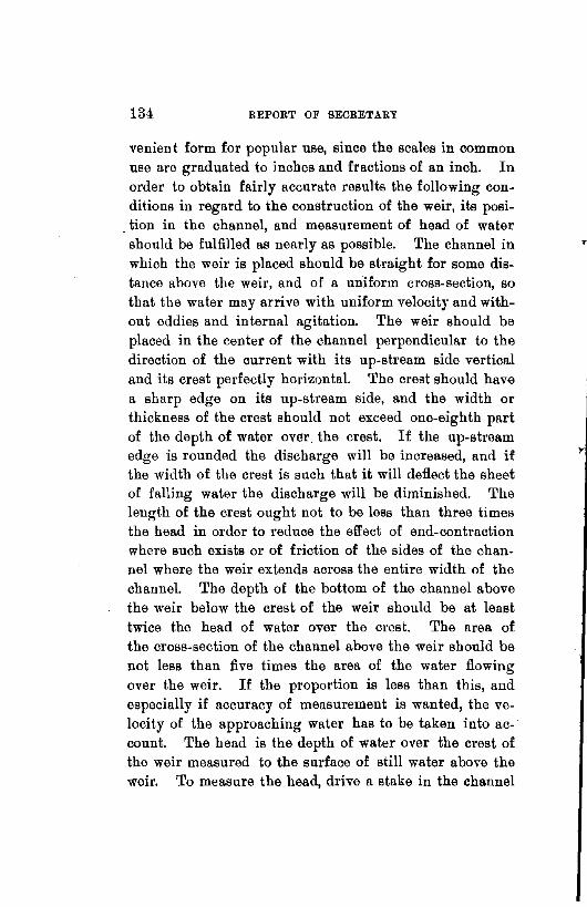
134 REPORT OF SECRETARY
venien t form for popular use, since the scales in common use are graduated to inches and fractions of an inch. In order to obtain fairly accurate results the following conditions in regard to the construction of the weir, its posi-
. tion in the channel, and measurement of head of water should be fulfilled as nearly as possible. The channel in which the weir is placed should be straight for some distance above the weir, and of a uniform cross-section, so that the water may arrive with uniform velocity and without eddies and internal agitation. The weir should be placed in the center of the channel perpendicular to the direction of the current with its up-stream side vertical and its crest perfectly horizontal. The crest should have a sharp edge on its up-stream side, and the width or thickness of the crest should not exceed one-eighth part of the depth of water over. the crest. If the up-stream edge is rounded the discharge will be increased, and if the width of the crest is such that it will deflect the sheet of falling water the discharge will be diminished. The length of the crest ought not to be less than three times the head in order to reduce the effect of end-contraction where such exists or of friction of the sides of the channel where the weir extends across the entire width of the channel. The depth of the bottom of the channel above the weir below the crest of the weir should be at least twice the head of water over the crest. The area of the cross-section of the channel above the weir should be not less than five times the area of the water flowing over the weir. If the proportion is less than this, and especially if accuracy of measurement is wanted, the velocity of the approaching water has to be taken into ac- · count. The head is the depth of water over the crest of the weir measured to the surface of still water above the weir. To measure the head, drive a stake in the channel
T
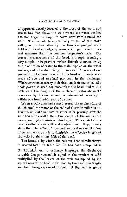
STATE BOARD OF IRRIGATION. 135
of approach exactly level with the crest of the weir, and two to five feet above the weir where the water surface has not begun to slope or curve downward toward the weir. Then a rule held vertically on top of this stake will give the head directly. A thin, sharp-edged scale held with its sharp edge up stream will give a more correct measure than the common carpenter's rule. The correct measurement of the head, although seemingly very simple, is in practice rather difficult to make, owing to the adhesion of water to the scale, ripples on the water surface, and other disturbing influences. An error of one per cent in the measurement of the head will produce an error of one and one-half per cent in the discharge. Where extreme accuracy is desired, an instrument called a hook gauge is used for measuring the head, and with a little care the height of the surface of water above the crest can by this instrument be determined correctly to within one-hundredth part of an inch.
When a weir does not extend across the entire width of the channel the water at the ends of the weir suffers a deflection, so that the sheet of water after passing over the weir has a less width than the length of the weir and a correspondingly diminished discharge. This kind of structure is called a weir with end contractions. Experiments show that the effect of two end contractions on the flow of water over a weir is to diminish the effective length of the weir by about one-fifth of the bead.
The formula by which the column headed "discharge in second feet" in table No. 21 has been computed is
3
Q=3.33LHY, or, in ordinary language, the discharge in cubic feet per second is equal to the product of 3.33 multiplied by the length of the weir multiplied by the square root of t:he head multiplied· by the head, the length and head being expressed in feet. If the head is given

Ulti REPORT OF SECRETARY
s in inches the above formula becomes Q=0.0801LH~. For the discharge over a weir with two end contractions
3
the formula is: Q=3.33(L-!!.)Hlr, Land H being in feet. 5 s
This last formula may be written: Q=-3.33LHlT-3
3.33¥H~, and comparing this with the first formula above we see that the decrease in discharge due to end contraction is independent of the length of the weir and depending on the head only. The column headed end contraction in Table No. 21 has been computed from the formula
3 3.33.!.'_H1r, and gives the amount to be subtracted after the
" column preceding it has been multiplied by the length of the weir. Of course the caution given above that the length of the weir should not be less than three times the head must be observed. If the length of the weir exceeds ten times the head, no correction need be applied for end contraction.
Example: What is the discharge over a weir 3i' feet long with two end contractions when the head is 10 inches? Opposite to 10 inches we find 2.533, which is the discharge for a weir one foot long, and multiplying this by 3~ we get 8.8655. From this subtract 0.422, the amount due to end contraction and found in the second column opposite to 10 inches, and the remainder 8.4435 is the required quantity in cubic feet per second. For intermediate heads not given in the table it will be near enough for all practical purposes to get the corresponding discharge by interpolation. Example: A weir 4 feet 9 inches long has a bead of 12"f'6 inches of water flowing over it; what is the discharge? From the table we find the discharge for 12k inches to be 3.382 second feet, and for 12i inches 3.434 second feet, an increase of 0.052 second feet for ~ of an inch, and for -{11 of an inch the

STATE BOARD OF IRRIGATION. 137
increase is i of 0.052, or 0.026. Adding 0.026 to 3.382 and then multiplying by 4. 75 (which is 4 feet and 9 inches expressed in feet), we obtain 16.188 second feet, which is the correct amount. If end contractions exist from 16.188, subtract 0.692, which is the mean between 0.683 and 0. 701, corresponding to 12i inches and 12! inches respectively, and the answer is 15.496 second feet.

Width of open-
0 0 0 0 0 0 0 0
ing in feet and Inches.
ft. 2 in .. 3 4 5 6 7 8 9
-------
TABLE No. 19.
DISCHARGE THROUGH RECTANGULAR VERTICAL OPENING.
Height of opening, 6 inches,· head above top of opening, 4 inches.
Discharge in Discharge in Width of open- Discharge in Discharge in Width of open- Discharge in Discharge in statutory ing in ft. and eta tutory tng In teet and statutory second feet. inches, inches. second feet. inches. inches. second teet. inches.
--. 0.306 12 0 ft. 10 in. 1.533 60 1 ft. 6 in. 2.760 108 0.460 18 0 11 1.686 66 1 8 3.066 120 0.613 24 1 0 1.840 72
I 1 10 3.337 132
0 .766 30 1 1 1.993 78 2 0 3.680 144 0.920 36 1 2 2.146 84 2 6 4.600 180 1.073 42 1 3 2.300 90 3 0 5.520 216 1.226 48 1 4 2.453 96 3 6 6.440 252 1.380 -54 1 5 2.606 102 4 0 7.360 288

TABLE No. 20.
DISCHARGE THROUGH RECTANGULAR VERTICAL OPENING WITH VARYING HEAD.
Height of opening, 6 inches>· width of opening, 1 foot.
Hearl above Discharge in Discharge in Head above Discharge in Discharge in Head above Discharge in Discharge in top of open- statutory top of open- statutory top of open- ~tatutory
ing. second feet, inches. ing in inches. second feet. inches. ingln inches. second feet. inches.
---------- --------------- ------------
~inch:: 1.234 48.25 3iinch. 1. 760 68.81 7 inch 2.197 85.96 1.280 50.05 4 1.840 7~.00 7! 2.251 88.07
1 .. 1.343 52.55 4! 1.903 74.46 8 2.305 90.18 1! .. 1.445 56.54 5 1.966 76.93 9 2.409 94.26 2 .. 1.528 59.78 5i 2.025 79.23 10 2.505 98.00 2! .. 1.610 63.00 6 2.085 81.58 11 2.601 101.76 3 .. 1.687 66.00 6i 2.142 83.80 12 2.694 105.33

="" ~ -$ ~ ·-..
~ "'"' 0 ~.
" " •o f. .E -"o
0~
"" " " 1 0.080 q 0.147 2 0.226 2! o.:no 2t 0.316 2i 0.365 3 0.416 3~ 0.442 31 0.469 3li
H 0.496 3! 0.5241 39
H 0.553 3ll.
4 0.582 31. 0.611 8 4 0.641 4l 0.671
TABLE No. 21. DISCHARGE OVER WEIR O;'i;E FOOT LONG IN CUBIC FEET PER SECOND.
..!> 6 =.; o...:.. 6 "" o..:-. 6 =i "o• ..... e)- d oo ..... ~o= 0 ~~~ ~ ;] =~~!: " -:e. =i:::.t!:: ~ -~~ ~ ~ :o = . 11:"' :'0 = . ......... = =• ~= :3 ~;.: § . o+> ... =
""' .0 ... 0 • 0 ·- ~ 0 .p- ~ ~- ~-g;g~ ~-;;::! -= ~ ,; =o~l() ·- (.)!::! 0 <:,Ill •o .s lll .... 'C' = ;; "" .,o Col (ll-"'0 = ~~~g (ljlll-'CCl •o • ~~ '£% -~~ .!~ t:c..>-oc::-2: ~~ ... 'll'Q=.3 ~b~.~
-"o ~ " "~ ;: • O.O<l.>a::+> ~(.l~- o.c<l>a::~ ~Ill
" " " " i5 " "' -------------------------------0.001; 7! 1.564 0.189 12i 3.434 0.701 17! 5.7391 1.650 0.00± 7li 1.604 0.197 12~ 3.487 0.719 17~ 5.802 1.680 8 0.007 7i 1.645 0.206, 12i 3.540 0.738 n~ 5.864 1.711 0.010 75 1.687 0.214 12~ 3.593 0.756 17* 5.927 1.741 0.013 71 1.728 0.223 121f 3.G47 0.775 17:1; 5.9901 1. 772 0.017 7~ 1. 770 0.232 12~ 3.701 0. 794 17~ 6.054; 1.803 0.020 8 1.8131 0.242 13 0.755 0.813 18 6.1181 1.835 0.022 8k 1. 8551 0.251 13~ 3.809 0.833 18~ 6. 182 1. 867 0.025 8! 1.808 0.2GO 13:1- 3.h64 0.850 18i 6.246 1.899 0.028 8.:3. 1. 941~ 0.270 13~ d.918 0.873 18~ 6.310 1.932 8
1. 9851 0.030 8t 0.281 13t 3.973 0.804 1St 6.374 1.965 0.033 85 2.029 0.291 135 4.0:29 0.915 18'a 6.439 1.998
si 13li 0.036 2.073 0.302 4.085 0.936 lSi 6.50-! 2.032 4 0.039 8i 2.118 0.313 13~ 4.140 0.957 18~ 6.569 2.066 0.0±3 9 2.H53 0.324 14 4. 1\:lU 0.979 19 6.6M 2.101 0.046! 91. 2.208 0.335 141.
8 4.253 1.001 19 1 6.700 2.136
,_. .... 0

4± 0. 7021 0.049 91 2.254 0.347 ~!t 4.309 1.023 19! 6.766 2.171
4li 0.733 0.053 9~ 2.1l00 0.359 4.366 1.046 19 6.832 2.206 8 4n 0. 7t)5 0.057 9t 2.346 0 .1l71 14~ 4.423 1.069 19! 6.898 2.242 45 0. 797 0.061 9~ 2.392 0.383 14§- 4.480 1.092 195 6.964 2.278 4 0.830 0.065 9.3. 2.439 0.396 14£ 4.538 1.115 19l 7.031 2.314 4~ 0.863 0.070 9i 2.486 0.409 14~ 4.596 1.140 19~ 7.098 2.351 5 0.896 0.075 10 2.533 0.422 15 4.654 1.163 20 7.165 2.388 "' ~ 5~ 0.929 0.079 lOt 2.581 0.435 15t 4.712 1.187 20k 7.232 2.426 >-
~ -~ 0.964 0.084 10± 2.629 0.449 15 4.771 1.212 20! 7.300 2.4G4 l:<j 04 5.:i 0.998 0.089 10~ 2.677 0.463 15~ 4.829 1.237 208 7.367 2.502 tl:j 8 0 5~ 1.033 0.095 10! 2.726 0.477 15~ 4.888 1.263 20! 7.435 2.540 ...
=<! 5·Q_ 1.069 0.100 10~ 2. 774 0.491 155 4.948 1.288 20~ 7.503 2.579 lj 8 r~ 0 5-<! 1.105 0.105 10£ 2.823 0.506 5.007 1.314 20.3. 7.572 2.618 4 04
2oi "" -3_ 1.141 0.112 10~ 2.873 0.521 ~~~ 5.067 1.340 7.640 2.658 ;; Os 6 1.177 0.118 11 2.922 0.536 5.127 1.367 21 7.709 2.698 =<!
6k 1.214 0.124 11f 2.972 0.551 lui 5.187 1.394 21k 7.778 2.738 Q ... 6± 1.252 0.130 3.023 0.567 16± 5.2-!7 1.421 211 7.8-!7 2.779 ~ 114 0 6.:i 1.289: 0.137 11* 3.073 0.583 16~ 5.308 1.448 21~ 7.916 2.820 :z: 8
6~ 1.327) 0.144 u~ 3.124 0.599 16! 5.369 1.476 21! 7.986 2.862 65 1.3661 0.150 11~ 3.175 0.615 16~ 5.430 1.504 21 5 8.056 2.904 >r
21li 6Ji 1.405 0.158 11£ 3.226 0.632 16£ 5.491 1.533 8.126 2.946 4 4 6* 1.4441 0.165 tq 3.278 0.649 16~ 5.553 1.562 21~ 8.196 2.988 7 1.484, 0.173 12 3.330 0.666 17 5.615 1.591 22 8.266 3.031 ...... 7-J- 1.524 0.181 12k 3.382 0.683 17k 5.677 1.6.;.0 22k 8.337 3.074 .... ,_

TABLE No. 21-Continued.
DISCHARGE OVER WEIR ONE FOOT LONG IN CUBIC FEET PER SECOND. -
.s~ • 0 • =.:
• 0 • =.; 0. 0 ' •"" o+o o 6 . t~~ . -· t~~ . -~ ..... ~It~ . -* -c:.JSt:a3 . !l,~ ·~. ~- •-'~ ~....,~ • .- §~:~ • .- =f+>~ >
. ~ ·- ·-• ~ .. oo.=!ii ""' ~ ..
c ;.:: ~ ""' 0 0.;:: ~ ""' 0""' = 0 :.;'g .0 0 0 . .g_sg~ :;:;~ ~ 0 .
" -=~-;::~ •• •• ~.g.2g,.; •• .d .g ~8
=- t.> ~ ~0 t~-~~ ~0 .::1~!:::-= ~B f lll-~ ~
fr :'0-g_E ~r;.5 ~~ . "'. "'• ~:~-g-~ ~~ ;.~ .E ~il al";; =2 .. ~~ C1!"g~~ .c Q.l Q)...., .0 CP CP +" ~ "-' ~-- $• .... .::l <lJ Q.l _.
" "' "' " 0 " "' "' u
-- ~-----22! 8.408 3.118 23i 8.980 3.41<0 24f 9.5661 3.866 26 10.620 4.602 22-jt 8.478 3.162 23~ 9.053 3.527 2~ 9.6401 3.916 26! 10.928 4.826 22! 8.550 3.206
231 9.126 3.574 24i 9. 7141 3.967 27 11.\:'39 5.057
22ft 8.621 3.251 23 9.199 3.622 24.[ 9. 7891 4.018 27! 11.552 5.~95
22:i 8.693 3.296 234 9.272 3.670 244 9.864- 4.069 28 11.869 5.539 22~ 8.764 3.34i 23~ 9.345 3. 718 24~ 9.938 4.120 28! 12.188 5.789 23 8.836 3.387 24 9.419 3.767 25 10.013 4.172 29 12.510 6.047 23~ 8.908 3.433: 2q 9.·192 3.816 25! 10.315 4.384 30 13.163 ti.581

STATE BOARD OF IRRIGATION. 143
CHARACTER OF THE PRINCIPAL STREAMS IN
NEBRASKA.
0, V. P. STOUT.
Whether considered in the light of impressiveness on account of size or channel, volume of discharge, or of their availability as sources of water supply for power or irrigation, the two principal rivers of Nebraska are the Platte river, with its north branch, and the Loup river. The importance of these streams to the future development of the state is sufficient to warrant at least a brief special and comparative discussion. The Platte river derives the major portion of its supply from melting snows in the mountains to the west. Hence, it has a regularly recurring season of extensive floods, which is quickly succeeded by a period of greatly diminished flow.
The Loup river furnishes an example of the opposite extreme in this respect. Its main source of supply is the water which falls in the form of rain and snow in the sand hills. A rain, whether it be light or heavy, so long as it is anything short of a waterspout, passes at once into the soil, and is delivered gradually in the form of springs to the river. Great floods in this river are therefore a rarity. Its distinguishing characteristic is a remarkably uniform rate of discharge from one end of the year to the other.
The following comparative statement of mean monthly
rates of discharge of the North Platte and of the Loup
River at Columbus during the seasons of 1895 and 1896
will illustrate the statement that has just been made.
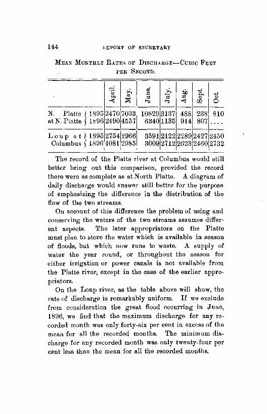
144 HEPORT OF SECRETARY
MEAN MONTHLY RA'l'ES OF DISCHARGE-CUBIC FEET
PER SECOND.
·~ !>. <Ii !>. lliJ .... .... ~ 0.. .... 0.. "' "'i3 = :::>1 = <ll "' ~ "":> "":> ~ w 0
-- ------N. Platte } 1893 3470 7033 10829 3137 488 238 810 at N. Platte 1i:i96 24-90 4557 6340 1135 914 807 ....
-- ------Lou p a t } 1895 2754 2966 3591 2122 2289 2427 2450
Columbus 1896 4081 2985 3009 2712 2623 2460 2732
The record of the Platte river at Columbus would still better bring out this comparison, provided the record there were as complete as at North Platte. A diagram of daily discharge would answer still better for the purpose of emphasizing the difference in the distribution of the How of the two streams.
On account of this difference the problem of using and conserving the waters of the two streams assumes different aspects. The later appropriators on the Platte must plan to store the water which is available in season of Hoods, but which now runs to waste. A supply of water the year round, or throughout the season for either irrigation or power canals is not available from the Platte river, except in the case of the earlier appropriators.
On the Loup river, as the table above will show, the rate of discharge is remarkably uniform. If we exclude from consideration the great Hood occurring in June, 1896, we find that the maximum discharge for any recorded month was only forty-six per cent in excess of the mean for all the recorded months. The minimum discharge for any recorded month was only twenty-four p~r cent less than the mean for all the recorded months.

STATE BOARD OF IRRIGATION. 145
Storage of the waters of such a stream would be of value only when the demand became so great in the aggregate as to consume the entire annual supply. Then storage of the winter flow would become desirable. In such a case the storage would be made necessary by variations in the demand rather than in the supply.
The North and the Middle branches of the Loup river unite a short distance below St. Paul. The following table shows the proportion of the discharge into the Platte river at Columbus, which comes from these branches.
Percentage of discharge of the Loup river at Columbus which is contributed by the North and Middle Loup rivers at St. Paul.
MAY. JUNE. JULY. AUG. SEPI'. OCT. -----------------------1895 ...... 83.1 81.5 81.3 85.5 81.2 81.1 1896 ...... 73.4 ...... 87.5 69.4 77.5 73.2
The distance from St. Paul to Columbus is about sixtyfive miles. The only considerable tributaries which enter the river below the confluence of the two branches are the Cedar river at Fullerton and Cedar creek at Genoa. From the above table it will be seen that these two streams together with underground sources have contributed from 14.5 to 18.9 per cent of the discharge at Columbus during 1895, and from 12.5 to 30.6 per cent in 1896, during the months of which we have a record. That a comparatively small portion of this discharge arises from springs in the sixty-five miles below St. Paul is shown by the gaugings of the Cedar and B!o'aver creeks and of the Loup at Fullerton, which are recorded in table number eighteen.
In a previous paragraph it was stated in explanation of the uniformity in the rate of discharge on the Loup river,

146 REPORT OF SECRETARY
that the principal supply was from underground sources in the sand hill region. Evidence of this is furnished by the series of measurements tabulated below.
MEASUREMENTS SHOWING INCREASE OF DISCHARGE OF MID
DLE Loup RrvER FROM UNDER GROUND SouRcEs.
DISTANCE INCREAS>: I' FLOW. - --------
DATE. LOCALITY. BETWEEN DISCHARGE. BETWEEN POINTS. POINTS.
PER MILE.
--------- ------------18''5. Miles. Second ft. Second [t Second ft.
Aug. 20 At forks .. () 42. ........ • • • 0 0 ••
Aug. 20 Mullen ... 8 120 78 9.7 Aug. 21 Seneca ... 11 2Hi 96 8.7 Aug. 22 Thedford. 15 284 68 4.5 Aug. 23 Dunning .. 27 322 38 1.4 Aug. 23 Dunning .. 0 615 ........ • • • • • 0.
Aug. 29 Loup City. 70 879 2G4 3.8 1896.
Aug. 30 Seneca ... 0 230 . ....... • • • 0 •••
Aug. 30 Dunning . 42 323 93 2.2
No surface tributaries except the Dismal river were received in the distance of 131 miles above considered. The measurement at Loup City in 1895, six days after the one at Dunning, is not strictly comparable with those preceding because of the length of time intervening. Two measurements are given for the flow at Dunning; the first, 322 second feet, being the flow of the Middle Loup, and the second, 615 second feet, the combined flow of that stream with the Dismal river which enters at that place. This affords a comparison with the discharge at Loup City, further down the stream.
Referring again to the comparative table of mean monthly discharges of the North Platte river at North Platte, and the Loup river at Columbus, it is seen that in the case of the North Platte, the maximum recorded

STATE BOARD uF IRRIGATION. 147
discharge for any recorded month was 233 per cent in excess of the mean for all recorded months, while the minimum for any recorded month was 93 per cent less than this mean.
Those who have the knowledge and experience which would enable them to judge in such a matter seem to be unanimously of the opinion that, with the increase of irrigation in this valley, the flow in the latter part of the season will be greatly and materially increased by the seepage or return of waters which have been once applied in irrigation, but have been absorbed by the soil, to drain away again and form springs. That this effect does follow extensive irrigation is proved by numerous observations which have been made. The most notable records and discussions of such observations which have come to the knowledge of the writer are those which are set forth in bulletins No. 33 of the Colorado, and No. 38 of the Utah agricultural· experiment stations. It is believed that the great benefit which has been found to accrue to late irrigation from return or seepage waters in Colorado and Utah will be more than equaled under the natural conditions of a porous soil and a pre-existing supply of ground water, which obtain in the valleys of Nebraska rivers. There can be no doubt that the combined results of return or seepage waters, the storage of water in reservoirs and in a properly prepared subsoil, will remove whatever discouragement there may seem to be to extensive irrigation development in the Platte and North Platte valleys on account of the unevenness in the seasonal distribution of its discharge.
148
Thi~ . , .. 1 '. 'I"'
• ..

--~' !-.
Report of Under Secretary.
LINCOLN, NEB., December, 10, 1896.
Hon. W. R. Akers, Slate Engineer, Secretary: DEAR SIR-I submit herewith a report of the work
done by me as Under Secretary since May 1'8, 1896, the date of my appointment.
The first work undertr1ken was an examination and survey of Lodge Pole creek from the point where it enters the state from Wyoming on the west to the point where it crosses the south line and flows into Colorado. A similar examination was made of the Frenchman river and its principal tributary, the Stinking Water, during July and August, and measurements were made of all ditches taken from these streams. During August there was a shortage of water in the Republican and Frenchman rivers.
The Republican river was completely d1·y at Culbertson on July 19, 1895, and remained dry during the remainder of the season.
The Meeker ditch, which heads just below the mouth of the Frenchman river, claims the water of both streams, and there were times, when the water was being used above on the Frenchman river, when this ditch was not able to get the amount of water it was entitled to by reason of its priority. Mr. H. H. Pickens, the Under Assistant for this district, was called out for several days during the irrigating season, but we were able to get through the season without having recourse to the courts. This trouble, however, demonstrates the necessity of the
•
149

150 REPORT OF SECRETARY
enforcement for the law relating to the construction of headgates and measuring flumes upon all ditches. Many ditches have no headgates, and others have very crude ones which cannot be set and fastened so as to regulate the flow of the water in the ditch and enable the Under Assistant to perform his duties. As it now is the work of the Under Assistant is rendered very arduous and the results are extremely unsatisfactory. Many ditch owners complain of the "expense of the construction of these works, and· others question the authority of the Under Secretary to compel their construction. In July a survey was made of the ditches on Victoria Creek, and a map was filed showing the location of ditches, measurement of water flowing in the ditches and stream, the land under ditch, etc.
During the season I have also made gaugings of the Ft·enchman, Stinking Water, Lodge Pole, Elkhorn, Pine Miuuechaduza, and Niobrara rivers, the reports of which are on file.
The amount of water available in many of the streams, such as the Republican and Frenchman rivers, is so limited that the utmost economy in the use of water should be insisted upon. 'fhe general practice of the farmers now is to wait until the crops show signs of suffering for want of water, and then every one wishes to use the water at the same time, and thtl quantity so required is so great that as a natural consequence there is sure to be a shortage and trouble will ensue.
I am Ratisfied that very much could be accomplished in this territory by use of water upon the laud during the season when there is plenty of water for all, and then in a season of drouth so much less water would be needed that all could be supplied with what was really necessary. A great deal could also be accomplished by the storage

STATE BOARD OF IRRIGATION. 151
of water when it is plentiful, either by means of reservoirs or by deep plowing and thoroughly soaking the subsoil when water is to be had.
There have been instances during the last season where the land was prepared by deep plowing and thoroughly irrigated before the crop was put in and no water put on afterward. The difference in the crop raised on this land and that raised on land not irrigated was enough to convince the most skeptical of the advantage to be gained by irrigation, even on streams which were dry during July and August.
Reference is had to the detailed reports for more complete information in regard to the work done.
All of which is respectfully submitted. ADNA DoBSON,
Under Secretary.
LODGE rOLE CREEK,
OFFICE OF STATE BOARD OF IRRIGATION } LINCOLN, August 10, 1895.
Hon. W. R. Akers, State Engineer, Secretary: DEAR Sm-In accordance with your direction I have
made a complete survey and examination of Lodge Pole Creek through this state, and all the irrigation works along said stream, and I submit herewith a detailed report, giving a complete description of all irrigation works with a map of each ditch and the location of the stream through all sections where there are any ditches, the location of headworks and description of the same.
There are a number of peculiar conditions to be found on this stream. It is made up of springs, and where a tight dam is put across the stream and all the water diverted into a ditch, within a distance of less than one mile the stream may be flowing a greater quantity of water

.152 REPORT OF SECRETARY
than there was above the dam. Commencing with the point where the stream enters the state on the west, we find that it is flowing about 3i cubic feet per second.
The first ditch is the Hoover, covering about fifty acres. Then the ditches of Stillman A. Pierce and L. C. Kinney follow in a distance of five miles. These ditches cover about 575 acres, and about 400 acres of this is well watered. It ia mostly native hay, as shown by detailed report. At the east line of section 2, township 14, range 58, immediately below the land covered by L. C. Kinney's ditch, the creek is flowing about 4 cubic feet per second. Below L. C. Kinney's ditch there is no more water taken out for a distance of four miles, and then comes the head of the Young ditch, covering only about thirty acres, but taking all the water in the creek, being 4.3 second feet. This ditch does not get far from the creek, and at the nol'th and south center line of section 34, township 15, range 57, at the terminus of the ditch the creek is again flowing four second feet.
The next ditch is that of Carl Ruttner, five miles lower down, covering about forty acres. Here a ditch is taken out on each side of the creek, taking the whole flow of the creek, 4. 9 second feet.
One mile lower down is the head of J. J. Kinney's south ditch, taking all the water in the creek, being 3.6 second feet. This ditch covers about 140 acres. One half mile below this is the head of J. J. Kinney's north ditch, covering 190 acres. At the head of this ditch is a dam across the creek with no opening, the whole flow of the creek being turned into the ditch, which was taking 2.1 second feet. Mr. Kinney says that he usually waters one side of the creek at a time, thereby getting a better volume of water. The volume of water in the creek increases rapidly below the head of Kinney's north ditch,

STATE BOARD OF IRRIGATION. 153
and at the east line of section 34; about a mile and onehalf below the head of this ditch the creek is . running about six second feet.
Next is the Hurley, Lilley, and Polley ditch, three miles lower down, covering about 160 acres and taking four and one-half second feet at the time of observation. Two miles below this is the head of the Hurley and Polley ditch. Gate was closed and taking no water. This ditch covers about 125 acres. One-half mile lower down is the head of the Bay State ditch, covering 100 acres and taking two and one-half second feet.
In the .next seven miles comes the Mcintosh, Circle Arrow, and Brady ditches, none of them getting enough water to do much good, the creek being perfectly dry above Brady's headgate in section 28, township 15, range 54. It is then dry for about twelve miles to a point about on the south line of section 4, township 14, range 52, when the water again appears, and at the head of the Adams' ditches in section 3, township 14, range 52, it is running two and one-fourth second feet, and at dam onehalf mile below this it is running four second feet. Adams' ditch covers about 245 acres, mostly native hay.
Next below is Adam Gunderson's ditch, which covers about 100 acres and furnishes power to run grist mill; ditch is taking about five second feet.
Next is Hans Christenson's ditch in section 7, township 14, range 51, covering about seventy acres, and taking about one second foot. One and one-half miles below this is the head of J as. Mitchell's ditch, covering sixty acres and taking three and one-half second feet, and one-half mile below this is the bead of John Andersori's diMh No. 1; this covers 200 acres, taking no water at time of observation. Mr. Anderson says that this ditch is used alternately with the Mitchell ditch above.
154 llEPORT OF SEORETAIIY
Next comes J. S. Shanahan, whose ditch is a very small affair covering only two or three acres.
The next below is M. Urhack, whose ditch covers about sixty acres, but whose dam is washed out and taking no water at the present time. N. P. Lingholm's ditch heads in the southeast quarter of section 14, township 14, range 51, and covers about thirty acres. It was taking one and one-half feet at the time of observation. The creek is entirely dry below this dam and continues dry through section 13 and nearly through section 19. Near the east line of section 19 the water rises again, and at the head of Couch ditches on southwest quarter of section 20, township 14, range 50, it is flowing about two second feet. These ditches cover about forty acres, and were using no water at time of examination.
Runge's Ditches Nos. 1 and 2 in sections 28 and 29, township 14, range 50, cover about 105 acres. Ickes' ditch comes next, covering 200 acres, but only one-half of this is ever watered, on account of scarcity of water. About onehalf second foot passes this dam and fills a small pond at head of Adams' and Tobin ditch, but water has not raised enough to flow into their ditches, which cover 180 acres, for several years, and the creek is entirely dry for about one mile below the Adams' and Tobin dam and here the springs rise again, and at head of the Trognitz ditch in section 36, township 14, range 50, there is about one-half second foot flowing in the ditch. This ditch covers about thirty-four acres and is the old ditch made by the U. S. government to supply water to Fort Sidney; but since the abandonment of the fort the water has been diverted by Mr. Ttognftz and is used to irrigate his land. There is an old dam built by the government near Fort Sidney on the southwest quarter of section 32, township 14, range 49, which forms a pond of two or three acres, but very

STATE BOARD OF IRRIGATION. 155
little water passes the dam and the creek is practically dry for nearly two miles below this dam when the springs again appear and at head of the Borquist ditch on southwest quarter of section 34, township 14, range 49, there is about three second feet flowing in ditch and creek, and for the next five miles there is a good flow of water, and the Bordwell, Hale, Whitney, and Kruger ditches are taken out covering in all about 1250 acres. Below the Kruger dam near east line of section 29, township 14, range 48, the creek is nearly dry, and at one-half mile farther down it is entirely dry and there is no water to be seen in the creek for about five miles. On section 25, township 14, range 48, is the McLaughlin dam and ditches covering seventy or eighty acres, but creek is perfectly dry for a long distance -above and below this dam. At H. Newman's dam near the west line of section 31, township 14, range 47, there is about one second foot flowing, and at Howard dam near east line of section three there is one and one-half second feet.
In the next two miles the Booth, Tobin, and Dickinson ditches are taken out, covering 620 acres, and taking four and one-fourth second feet. The next ditch is that of Mrs. Crist, covering about 100 acres, but with only enough water to irrigate a small portion of it. The ditch was taking about one .second foot. Below ·this dam the creek is dry for about two miles. On section 26, township 14, range 47, is F. Dickinson's dam and ditch, covering about eighty acres, but he has had no water for irrigation since 1894. The next water is being taken out by H. H. Libby on section 36, township 14, range 47, who has ditches covering 200 acres, but only water to irrigate a small percentage of this amount. The next is the Oberfelder ditches, on section 31, township 14, range 46, which take water from both Lodge Pole and Spring
156 REPORT OF SECHETARY
creek. The ditches cover about 350 acres, but there is not enough water for all of it. The creek is running about one second foot through section 32, and the next water taken out is by F. 8. Isenburger, who irrigates about ten acres.
A. B. Persinger's ditches, in section 33, township 14, range 46, and section 4, township 13, range 46, cover about 110 acres, about one second foot flowing ditch, and none passing. Next is Ed. Harrington's ditches in sections 2 and 3, which cover about 100 acres, but only have water enough for about ten acres this year. The ditch was taking about one-half second foot, and the creek is dry from below Harrington's dam to a point near the center of section 12, and here there is water standing in a pond above A. Treat's dam, but no water in his ditches. About one mile below this is the head of H. D. Wolf's ditch, covering about 120 acres. The ditch was running two second feet and no water passing dam. 'fhis is the last ditch taking water except Albert Bruner's ditch, in section 2, township 12, range 45, west, which irrigates about five acres, and Newman's ditch in southeast quarter, section 36, township 13, range 45, which irrigates about thirty acres. The creek is about dry from below H. D. Wolf's dam for four miles, and then there is water in ponds above the dams of Newman Bros., Albert Bruner, and Ira Brashear, with no water in any of the ditches, except as above noted. Below Ira Brashear's dam in section 12, township 12, range 45, the creek is again dry. There is a total of 7,228 acres under ditches supplied from Lodge Pole creek, of which 4,000 acres has sufficient water to irrigate. This is a remarkably large area when we consider that when the stream enters the state it is only flowing three and one-half cubic feet per second, and is dry for about twenty-five miles of its
•
STATE BOARD OF IRRIGATION. 157
length in Nebraska. It is a question whether the water would flow over these dry stretches or not, even if none were taken out for irrigation. The notes of the government survey, made in July, 1869, show the bed of Lodge Pole creek as being dry in several places in ranges 52 and 53, and this was prior to the use of water for irrigation. The detailed report submitted herewith gives a table showing the amount of land under each ditch and the crops raised for the season of 1896. In the list showing lands irrigated, everything is given upon which water was used at all this season, and m~ch of this had not sufficient water for a satisfactory irrigation, and, as stated above, the amount of land actually well irrigated is about 4,000 acres. Reference is had to detailed report for more complete description of each planl
All of which is respectfully submitted. ADNA DoBSON,
Under Secretary.

158 REPORT OF SECRETARY
TABLE SaowrNG CROPS UNDER DrTOHEs ON LoDGE PoLE
CREEK FOR THE YEAR 1896.
~~ --:; " ...,
'" "" .5 "' . .,; "' """ .....
~ "' " ... NAME OF DITCH OR a; ... -" OWNER. ..... w ..., ;ad a; .d
"' ri ... " "' ..; ,_; 0 "' ..:,
"' .~ ci w .. ~ "il "" ~ "..., "' "' ,; .,o ... ..., ... "';! .d 0 ... ...
" .. 0 ::: ~ ~ .. "' d d
~ z Q 0 ~ ~ 0 ~ p ------ -- --~- - - - - --
Hoover 0. 0 ••••• ... 27 . .. 15 51 .. 3 . . • • • 0
s. A. Pierce ... ,. 40 120 10 4 5'30 15 .. . . . . s. A. Kinney ... . . . 100 . . . ... . .. . . . . . . . . . . . ... L. C. Kinney ... . . . 170 ... . . . . . . . . . . . . . . . . • 0 ••
W.T. Young ... 7 2::l . . . . . . . . . . . . . . . 1 .. • 0 ••
Karl Ruttner ... . . . 52 . . . 4 12110 . . 2 .. . . . ... J. J. Kinney, S. 50 60 . . . 7 6 .. 512 .. . ... J. J. Kinney, N. 20 154 ... . . . .. 5 . . 5 6 .. . ... Hurley,Lilly and
Polly ........ 28 123 ... . . . 8 . . . . . . 1 .. . ... Hurley & Polly. 19 60 30 ... 12 . . . . 4 .. . . 0 •••
Bay State ...... 60 40 . . . . . . . . . . . . . . . . . .. . ... Mcintosh ...... . . . 180 ... . . . . . . . . . . .. . . . . • •• 0
Circle Arrow ... . . . 260 ... . . . . . . . . . . . . . . . . . ... J. v. Brady .... 3 37 . . . . . . . . . . . . . . . . . .. . ... ,John Adams .... 40 200 4 ... . . . . . . . . . 1 .. 0 •••
Johanna Meyer. . . . • • 0 • . . . . . . . . . . . . . . . 1 .. . ... A. Gunderson ... 20 80 . . . . . . . . . . . . . . . 1 .. . ... H. Christianson. . . . GO . .. . . . . . . . . . . . . . . .. . ... Jas. Mitchell ... . . . GO ... . . . . . . . . . . . . . . . . . ... J no. Anderson .. 7 190 ... 15 . .. . . . . . . . . 5 .... M. Ur·bach ..... . . . • • 0 • . . . . . . . . . . . . . . . . . .. 60 N. P. Ling holm. ... . . . . 15 4 ... 3 . . 2 .. 5 . ... A. Couch ....... 15 20 . . . . . . . . . . . . . 2 .. . . 100 G. Runge ...... ... 80 . .. 5 15 2 .. 1 1 . . . . . . c. S. Ickes ..... 4 60 16 5 ... . . . . . . 110 100 Adams & Tobin . ... . . . . . . . . .. . .. . . . . . . . . . . 180 C. E. Trognitz .. 4 5 5 7 7 " 3 1 . . . . . .... P. E. Berquist .. 14 90 . . . 6 5t .. . . (i 5 . . ....
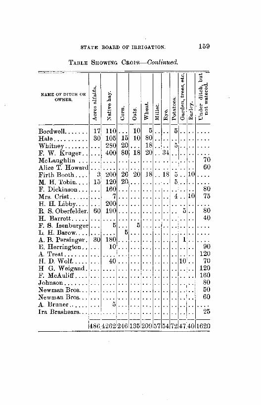
STATE BOARD OF IRRIGATION. 159
TABLE SHOWING CROPs-Continued.
0 :; .., " ..0
,; "' . ..,; " ..00)
::: .,:, " 0 ... NAME OF DITCH OR
~ ... ..,,
" 00 .., -~ ...
OWNER. "il ..0 ::i '0"
"" " .,:, ... il: " "" 0 " "' .!= ci tti " ~ ..,
'0 ~ ,..,
" " ,; "' '00 ... .., ... .., ..0 .., ... ... " "' 0 "' ::: ~ '"' 0 " " <=I <=I
< z 0 0 ;.:: p,. 0 Ill p ---- - ---- - - - - - --
Bordwell ..... . . 17 110 ... 10 5 . . . . 5 . . . . . ... Hale .... . . . . . . 30 105 15 10 80 . . . . . . . . . . . ... Whitney ..... . . . . . 280 20 ... 18 . . . . 5 . . . . . . . . F. w. Kruger .. . .. 400 80 18 20 . . 34 . . . . . . . ... McLaughlin . . . . . . . 0. . . . . . . . . . . . . ' . 70 Alice T. Howard . . • 0 0. . . . . .. . . . . . . . . 60 Firth Booth .... H 200 26 20 18 . . 18 5 . . 10 .... M. H. Tobin .... 15 120 20 . . . . . . . . . 5 . . .. . ... F. Dickinson ... . . . 160 . . . . .. ... . . . . . . . . . . 80 Mrs. Crist .. ' ... . . . 7 . .. . .. .. . . . . 4 .. 10 75 H. H. Libby ... . . 200 . .. . .. . . . . .. . . . . . . 0 •• 0
R. 8. Oberfelder. 60 190 . . . . . . ... . . . . . . 5 . . 80 H. Barrett. . . . . ... . . 0. . . . . .. . . . . . . . . . . . . 40 F. s. Isenburger .. 5 . . . 5 . . . . .. . . :l: . ... L. H. Barow .. . . . . • •• 0 5 . . . .. . . .. . . . ... A. B. Persinger. 30 180
... 1 ... . . . . . . . . 1j .. . . . .
E. Herrington .. . . . 10 . . . . . . . . . . . . . . .. I .. 90 A. 'freat .... . . . ... • 0 •• . . . . . . . . . . . . . ... 120 H. D. Wolf ..... . . 40 .. . .. . . . . . . . . 10 .. 70 H G. Weigand. . . . . . . . . . . .. .. . . . . . . . . . . 120 F. McAuliff .... . . . . . . ... . . . . .. . . 'l' . . 160 Johnson .... .. . ... . . . . . . . . . . . ... . . 80 Newman Bros ... I 50 .. • • • 0 . . . . . . . . . . . . . . .. . . Newman Bros ... ... . . . . . . . . . . .. . . . . . . . . . . 60 A. Bruner ...... . . 5 ... . .. . . . . . . . . . . . . . . ... Ira Brashears ... .. . . . . . . . . . .. . . . . . . . . . . 25
---~------ ------486[4262 1 246135 209 57 54 nl47l4o 1020
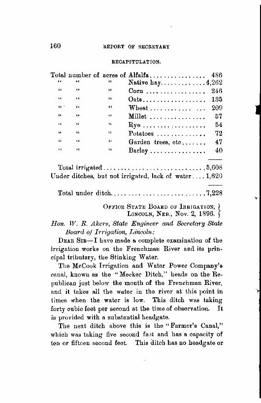
160 REPORT OF SECRETARY
RECAPITULATION.
Total number of acres of Alfalfa .... .... • • • 0 .... 486 " " " Native hay ..... .... 4,262 • 0 ••
" .. " Corn 246 0 • 0 ••••• . . . . . . . . . " " " Oats .... 135 • 0 •• • • • 0 ...... ... " II Wheat .... 209 ••• 0 ••• 0 ... " " " Millet 57 • 0 •• • • • 0 . ... •• 0 •
" " " Rye 54 • 0 •• . . . . . . . . • 0 ••••
" " " Potatoes 72 • • • 0 .... ...... "
,, " Garden trees, etc .... 47 ...
" " " Barley .... 40 0 ••• . . . . . . . . Total irrigated ............................. 5,608
Under ditches, but not irrigated, lack of water .... 1,620
Total under ditch ........................... 7,228
OFFICE STATE BOARD OF IRRIGATION, } LINCOLN, NEB., Nov. 2, 1896.
Han. W. R. Akers, State Engineer and Secretary state Board of Irrigation, Lincoln:
DEAR SIR-I have made a complete examination of the irrigation works on the Frenchman River and its principal tributary, the Stinking Water.
The McCook Irrigation and Water Power Company's canal, known as the "Meeker Ditch," heads on the Republican just below the mouth of the Frenchman River, and it takes all the water in the river at this point in times when the water is low. This ditch was taking forty cubic feet per second at the time of observation. It is provided with a substantial headgate.
'fhe next ditch above this is the "Farmer's Canal," which was taking five second feat and has a capacity of ten or fifteen second feet. This ditch has no headgate or
STATE BOARD OF IRRIGATION. 161
measuring flume, the fiow of water being regulated by a waste gate ten or twelve feet wide near the head of the ditch. Very little water has been used from this ditch during the season of 1896.
Next above this is the "Riverside Canal," which has a capacity of about twenty second feet, and was taking ten second feet at the time of the observation. There is a gate in this ditch about three-fourths of a mile below the head, and a waste gate which regulates the flow of water in the ditch. The next ditch above this is the " Frenchman Valley Canal." At the bead of this ditch the water was raised eight or ten feet by a dam across the river, and during the heavy rains early in the season this dam and the headgate of the ditch were washed out, and for this reason no water bas been used during the past season. The next ditch is the "Culbertson Canal," which is thirty-five feet wide, and was taking seventy-five second feet on July 19, 1896. This ditch takes nearly the whole flow of the Frenchman River. The water from Stinking Water Creek can also be taken up by this ditch when it is not used by the Palisade Mills, but the water used by the mill is discharged too low to be taken up by the Culbertson ditch, and it flows under flume No. 1 at about four feet below the floor of flume.
The J. W. Hagerman canal is the next above this. At the point of diversion there is a dam four feet high. 'Ibis dam is badly washed out and ditch is taking no water this season.
Next above is the J. A. Wise canal, at the head of which is a d.am of brush and stone ten feet high. The ditch is three feet wide at the headgate. Water has only been used on five or six acres this season. The ditch was taking about one second foot when examined.
Next is the Fuller ditch, with a dam hen feet high of

162 BEPORT OF SECRETARY
stone and brush with box 41x6 1 through it. The ditch is four feet wide at the head, and was taking 2.9 second feet. This ditch has only watered twenty-fiYe or thirty acres this season.
Dudeck and Summers have a ditch which heads about one mile above the Fuller ditch. The headgate is two and one-half feet widfl. No water has been taken by this ditch this season.
The Guemsey ditches next above have not used nny water this year, as dams nre washed out. Next is the Harlem Canal with dam five or six feet high. Ditch is three feet wide at headgate, and was taking about two second feet.
The Aberdeen Canal comes next; dam is five feet high built of stone; ditch is four feet wide at head, and is running three and one-half second feet.
Next above comes the James ditch, which covers abont 250 acres of land. This ditch was built this season and has watered about 100 acres.
Above this is the Champion ditch, covering a large tract of land, but no water has been used this season, as the head of the ditch was badly washed qut by the early rains and most of the crops lying under the ditch were ruined by hail so that the ditch was not repaired.
Above this is the Inman ditch and the North and South Maranville ditches; these were not examined, as it was reported that very little water was being used above Champion. On the Stinking Water the Chase County Land and Live· Stock Company have five small ditches, each about three feet wide and covering only the low bottom lands on each side of the stream. Nearly all the land covered by these ditches is hay land, and the ditch being located on the low bottom land and only a short distance from the stream, they probably do not lesRen

r
STATE BOARD OF IRRIGATION. 163
the flow of the stream very materially. The next ditch below these is Frank McLain's. At the head of this ditch there is a dam 120 feet long and five feet high; the ditch is four feet wide, with an opening of three feet at the headgate, and it was taking about one and eight-tenths second feet at the time of the observation. Below this comes the Chase County Land and Live Stock Company's lower ditch, which is five feet wide, and it was taking four second feet at the time of observation. This is a complete list of the ditches taking water from the Frenchman river, and, as will be seen by the detailed report filed herewith, the sum of the filings on this stream is greatly in excess of the average flow of the stream, but by strict economy in the use of the water, and using it as much as possible during the periods when it is plenty, I believe that the supply will be sufficient for all the ditches now constructed.
All of which is respectfully submitted. AnNA DoBsoN,
Under Secretary.

ALPHABETICAL INDEX OF CLAIMS AND APPLICATIONS BY STREAMS.
NAME OF CLAIMAN'l'.
Abitz Creek, Div. 2 c. Fullerton, J. B., Atkinson .....
Antelope Creek, Div. 2 c. Julian, A. R., Chadron .......
Antelope Creek, Div. 2 E. Turner, S. A., Harrison .......
Antelope Creek (North) Div. 2 E. Story, S. R., Story ...........
Ash Cre<?k, Div. 2 D. Compton, w. L., Whitney ••• 0
Ash Creek (West), Div. 2 D. Broadhurst, N., et al., Crawford Broadhurst, N., et al., Crawford Halbert, W. R., Leroy, N.Y ...
Ash Creek (East), Div. 2 D. Cline, c. A .. Whitney ........ Tomlin, H. B., Whitney • • • • 0 0
Tomlin, H. B., Whitney ......
I CLAIM I APP.I DATE OF PRIOR· I
NO. NO. ITY. COUNTY.
. . . . . 278 Pending ..... Holt ........
119 " Cherry ...... • 0 0 •• • • 0 ••
137 " Sioux ....... 0 ••• 0 ••••
168 " " •• 0 •• • 0 0 •• . ......
40 " Dawes 0 ••• . .... • .... 0 •
9 .... " " . . . . . • • • • 0.
\94 " " • 0. 0 . . . . . • • • 0 ••
49 " " . . . . . . . . . 0 0. 0 0 • . 128 " " . . . . . . . . . 0 •••••
43 " " .... . . . . . ...... 298 " " . . .. . . . . . . . ......
I LOCATIO:>! OF I ACRES
HEADGATE. COVERED
s. T. R. 18 30 13 40
20 32 40 200
. .. . . . . . . • 0. 0 ••
8 34 56 560
. . . . . ·I· .. • 0 ••••
. .. . .. . . . •• 0 •••
... . .. . . . ......
. .. . . . . .. ......
. . . . .. ... • • • 0 ••
... . . . . . . • •••• 0
30 3:! 50 160
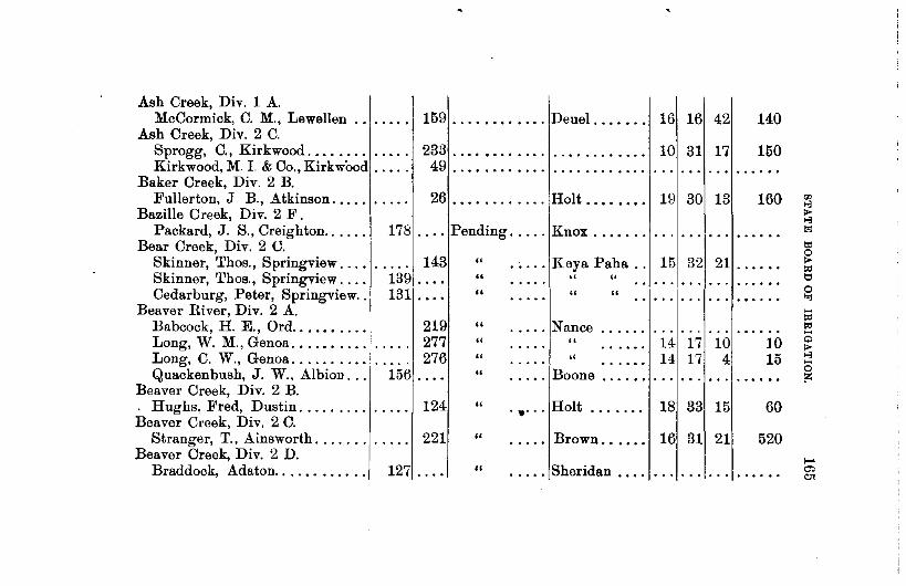
Ash Creek, Div. 1 A. McCormick, C. M., Lewellen 159 ....•.••.... Deuel . . . . . . . 16 16 42
Ash Creek, Div. 2 C. Sprogg, C., Kirkwood. . . . . . . . 233 ....••...... Kirkwood, M. I. & Co., Kirkwood . . . . . 49 ......•.....
10 31 17
Baker Creek, Div. 2 B. Fullerton, J B., Atkinson .•... 26 ............ Holt . . • . • • • • 19 30 13
Bazille Creek, Div. 2 F. Packard, J. S., Creighton ..... . 178 .... Pending ..... Knox ....•..
Bear Creek, Div. 2 U.
140
150
160
Skinner, Thos., Springview ... . . .... 143 139 ..•. 131 ...•
" . .... Keya Paha . . 15 32 21 ....•. Skinner, Thos., Springview ... . Cedarburg, Peter, Springview ..
Beaver River, Div. 2 A. Babcock, H. E., Ord ......... . Long, W. M., Genoa .....•.... Long, C. W., Genoa ......... . Quackenbush, J. W., Albion .. .
Beaver Creek, Div. 2 B . . Hughs, Fred, Dustin ........ . Beaver Creek, Div. 2 C.
Stranger, T., Ainsworth ...... . Beaver Creek, Div. 2 D.
219 277 276
156 ....
124
221
Braddock, Adaton. . . . . . . . . . . . 127 ....
" "
" " " "
"
"
"
" " " "
..... Nance " "
. .... Boone ....••
.•... Holt • •• 0 •••
..... Brown •....•
•••• 0 Sheridan ....
14 17 10 14 17 4
18 33 15
16 31 21
. . . . . . . ..
10 15
60
520
• • 0 0 ••
1-" cr-. C}t

ALPHABETICAL INDEX OF CLAIMS AND APPLICATIONS BY STREAMS-Continued.
NAME OF CLAIMANT.
Beaver Creek, Div. 2 C. Hyser, F. B., Adaton ........ . Stastny, F., Chadron ........ .
Beaver Creek, Div. 1 D. Wright, G. D., York ........ .
Beeman Creek, Div. 2 C. Barnard, C. 0., Springview ... . Rickman, A. S., Springview ... .
Benner Creek, Div. 2 C. Gillespie, B. S., O'Neill ..... .
Birdwood Creek, Div. 1 A. Eq. F. & S. I. Co., North Platte Eq. F. & S. I. Co., North Platte Eq. F. & S. I. Co., North Platte
Black Bird Creek, Div. 2 C. . Mullen, A. F., O'Neill ....... . Robertson, J. A., Joy ........ .
Blue River (west), Div. 1 D. Blue Vale C. Co., Cordova ....
I CLAIM I APP., D .. TE OF PRIOR· I OOONTY. I LOCATIO" OF I ACRES
NO. NO. ITY. HEADGATE. COVERED
. . . . . 303,Pending ..... Sheridan .... S. T. R. 20 34 4o 23
116 .... " "
258 " York. ....... .....
11 " Keya Paha . . . . ..... . . 173 " " " ....
213 " Holt ....•... 31 33 11 305 .....
204 " Lincoln 35 15 33 ..... . ..... 181 " " .... 166 .. " ....
3 .... Aug. 18, 1894 Holt . . . . . . . . 20 31 11 70 4 .... Aug. 28, 1894 " . . . . . . . . 32 31 11 14
. . . . . 188 Oct. 7, 1895 Seward.. . . . . 28 9 3 3000

Blue Rjver (west), Div. 1 D . . Kersenbrock, John ......... . Kersenbrock, John .......•..
Blue River (Little), Div. 1 C. Meyer, E. & S, Oak ........ . Nelson, C. W., Hastings ..... . Philleo, E. A., Ayer ........ .
Blue Bird Creek, Div. 2 C. Brandt, Ella, O'Neill ....•.... Murphy, Patrick, O'Neill. .....
Blue Creek, Div. 1 A. Bergerson, Nels, et al., Ramsey Eq. F. & S. I. Co., North Platte Graf, Robert, Lewellen ...•... Hooper, D. C., Ramsey ...... . Ramsev, A. F., et al., Lewellen. Union ·I. & W. P. Co., Ramsey. Winterer, 0. H., Lewellen ....
Boardman Creek, Div. 2 C. Gillespie, B S., O'Neill. ..... . Lee, j, S., Kennedy ........ .
Boggy Creek, Div 2 E. Smith, J. W., Bodarc ........ .
-
. .. . . 211 Dec. 20, 1895 Seward.. . .. • 32 9
. . . • . 214 Dec. 20, 1895 " 32 9
140 .... Pending ..... Nuckolls ... . 129 . . . • " .... Adams ..... . 214 . . . . " "
3 500 3Power.
. . . . . 195 Dec. 14, 1895 Holt . . . . . . . . 261 30 11 163 .... Sept. 7, 1894 " .. • • . .. . 2ol 30 11
320 70
171 .... Pending ..... I Deuel . . . . • . . . . ·I· .. 174.... " ..... " ·••···· ..... . 191. .. . " " ............... ·I· .... . 176 .... " "······················ 193 . . . . " " ...... . 184 . . . . " " ..................... . 159 . . . . " " . . . . . . . . . . . . . . . . . .... .
. . . . . 146 '' ..... Cherry .... . . 13 30 31 ......
. . . . . 27 5 . . . . . . . . . . . . ,, 6 29 33 480
187 ..... Pending ..... Sioux.. . .......... 1 •••••••••

ALPHABETICAL INDEX OF CLAIMS AND APPLICATIONS BY S'l'REAMS-Continued.
NAME OF CLAIMANT.
B oggy Creek (Middle), Div. 2 E. Bannon, J. F., Bodarc ........
B one Creek, Div. 2 c. Ferguson, J. J., Ainsworth .... McAndrew, W.D., Ainsworth ..
B ordeaux Creek, Div. 2 D. Adams, S. L., Chadron ..••.... Bacon, J.D., Chadron ........ Hall, A. W., Chadron ......... McAvoy, J. H., Chadron ......
B ordeaux (Big) Creek, Div. 2 D. Bryant, S. A., Chadron ....... Locket, T.E., Chadron ........ Morrisey, l\1., Chadron ........ Richards, H. B. J., Chadron ... Richards, H. B.J., Chadron ...
B onlt>aux Creek (Little), Div. 2 D. Butler, z. A., Chadron ........ Hartzell, S. and C., Chadron ...
' CLAn! 1\ ~PP -~! DATE OF PRIOR·\
I NO. NO. ITY. COUNTY.
192 • 0 0. Pending ..... Sioux. .......
87 0 .... Pending ..... Brown ....... 121 " " ..... . ....
15 . . . . Pending ..... Dawes ....... 52 .. .. • 0. 0 0 •••• • • • •• 0 •
63 .. .. • 0 ~ • • • 0 0 0 . ......
61 .. .. • 0 •• . . . . . . ......
62 0 ••• Pending ..... Dawes ....... 188 . ..
" • • 0 0. • 0 • .....
176 .. " • 0 •• ..... • ••••• 0
71 .. .. . . . . . . . . . . ...... 72 .. " 0 0 •• 0 ••• 0 . ......
641 .... Pending .•... Dawes . . . . . . .. 16.... .. ••••• 0
I LOCATION OF I ACRES
HEADGATE. COVERED
s. T. R. . . . . . . . .. • • 0 •••
. . . . . . . . . • 0 ••••
27 30 22 240
. . . . . . . . . • • 0 0 ••
. . . . . . . . . 0 •••••
. . . . . . . .. ......
. . . . . . ... • •• 0. 0
. . . . . . . .. 0 •• 0 0 •
. . . . . . . .. • ••• 0 •
. . . . .. . . . • 0 ••••
. . . . . . . .. • •• 0 ••
. . . . . . . .. ••• 0 ••
... . . . . . . . ......
... . . . . . . • •• 0 ••

Brush Creek, Div. 2 A. Rouche, P. S., Brownlee ...... 67 Pending ..... Cherry ....... 27 27 29 840
Brush Creek, Div. 1 B. Miller, Jno., Maywood ........ 131 . . . . Pending ..... Frontier ..... 33 8 29 . .....
Brush (West) Creek, Div. 2 C. Johnson, J. V., Celia ......... 272 " Holt ........ 26 32 14 50 ..... . .... McCartney,W.H. &M.H. O'Neill 158 July 1, 1894 .. " 26 32 14 35 ....
Brush Creek (East), Div. 2 C. 14 McCartney, W. A. & M. H., O'Neill 157 July 1, 1894 .. Holt ........ 24 32 35 "' .... "' Buffalo Creek, Div. 1 B. >
"' Larned, F. G., et al., Haigler ... 32 Oct. 16, 1890. Dundy .....• 18 1 40 420 Oj . . . . Moore, F. B. & E. A., Haigler. 268 Dismissed ... " 22 2 41 t,; . . . . ...... 0
Porter, J. R. & Sons, Haigler . 260 Nov. 26, 1890. " 1 1 41 200 > .... ~
Moore, Eliza A., Haigler ...... 170 Pending ..... " 26 2 41 tj ...... Moore, Eliza A., Haigler ...... 171 " " 26 2 41 60 c
'<I
Buffalo Creek, Div. 2 B. .... ~
Hale, J. F., Battle Creek ...... 270 " Madison ..... 24 24 4 500 ~ . . . . . .... Bull Creek, Div. 2 D.
0 >
Johnson, W. S., Glen ......... · 44 " Sioux "' . . . . 0 0 ••• . . . . . . . .. . . . ... 8 Burton Creek, Div. 2 C. ;.:
Mutz, Otto, Springview ....... 136 " Keya Paha . . . . . . . .. . . .. . . . ... "Wiley, Jas., Lutes ........... 239 " " " ... . . . . . . Mutz, Otto, Springview ....... 142 " " " .. 8 34 19 160 .... Compton, C. T., Lutes ........ 150 " " " 5 34 19 35 0>
<0

ALPHABETICAL INDEX OF CLAIMS AND APPLICATIONS BY STREAMS-Continued.
NAME OF CLAIMAN'I'. I OLAIM I APP., DATE OF PRIOR·! NO. NO. ITY.
OOUNTY.
Calamus River, Div. 2 A. I Brumback, N. T., Beatrice, Neb . . . . . 111 Pending ..... Loup ....... . Hesselgesser, Robt., Prime. . . . . . . . • 202 " " ....... . Starke, A. B., Taylor. . . . . . . . . . . . . . 164 " " ....... . Shoemaker, A. E., Burwell. . . • . . . . . 226 " " ....... . Willow Springs I. Co., Burwell . . . . . 228 " ...... Garfield . ... .
Calf Creek, Div. 2 A. Cady, W. E., Compton ...... . 286 "
Camp Creek, Div. 1 A. Stillwell, W., Lisco.. . . . . . . . . . 187 ..•• " . .... Cheyenne ....
Canvon Creek, Div. 1 A. McCarthy, J. J.,Keystone ..... . 15 " ..... Keith ••.....
Cedar River, Div. 2 A.
I LOCATION OF I ACRES
HEADG.\TE. COVERED
S. T. R. 27 23 18 4000 16 23 18 ..... .
7 :14 19 ..... . 16 21:! 18 ..... . 31 23 17 ..... .
1 25 27 ..... .
Nebraska I. & P. Co., Ord ..... 160 .... Sept. 14, 1894 Valley . . . . . . 22 21 12 12250 Cedar Creek, Div. 2 E.
Schilt, Chas. E., Harrison .... . Valdez, M., Harrison ........ .
Center Creek, Div. 1 B. Bishop & Conkling, Franklin ..
36 .... Feb. 21, 1895. Sioux . . . . . . . 35 33 28 Pending . . . . . " . . . . . • . 3 32 ~~, ... ~~~
196 Pending ..... Franklin .... . ........ I ..... .
/

Center Creek, Div. 1 B. Barber, F. W., Franklin ...... .
Chadron Creek. Dorrington, F. M., Alliance .... Gallup, W. S., Chadron ...•.•. Mann, Chas., Chadron ......•. Record, A. A., Chadron ...... . Wilson, H. M .. Chadron ..... . Wilson, W. W., Chadron ..... .
Cherry Creek, Div. 2 E. Ruffing, M .. Bod arc ......... .
Clear Creek, Div. 1 B. Green, A. L., Beatrice ....... .
Clear Creek, Div. 1 A. Barber and Marsh, Lewellen .. . Hooper, D. C., Ramsey ...... . Green, N. A., Lewellen ....... . Currum, T. P., Lewellen ..... . Scott and Williams, Lewellen ..
Cold Water Creek, Div. 1 A. Brown, H., Oshkosh ......... .
Coon Creek, Div. 1 A. Winterer, W. H., Keystone .....
285 Pending ..... Franklin ....
75 " ..... Dawes ...... . 179 " .... "
299 " ..... " 45 " . . . . ... 54- " .... " 55 " • 0 ••
.. 66 . . . . Pending ..... Sioux .•.....
22 Pending ..... Chase ...... .
303 .... Pending ..... Deuel ...... . 164- • . • . " " ..•....
34 . . . . " ..... Keith ...... . 36 . . . . .. " ...... . 39 . . . . " .. . ..•...
127 .. ; . " . .... Deuel ...... .
69 ............ Keith ...... .
36f 33 4D 1 ••••••
........ ·f· .... .
. ............. . .. ·f .. ·· ..
:: l::::: . . . I ... 0 •• •••
0 0 l •••
..... -.J .....

ALPHABETICAL INDEX OF CLAIMS AND APPLICATIONSBY STREAMS-Continued.
NAME 0~' CI,AIMANT. I CLAIM I APP ·I DA.TE OF PRIOR-I
NO. NO. ITY. COUNTY.
Cook Creek, Div. 1 B. Sharpnac, W. A., Alma ............ 251 Pending ..•.. Harlan .•....
Cottonwood Creek, Div. 2 C. Morrissy, T., Dunlap ........ . 13 .. .. " . •.•. Dawes ..... . Mirage I. Co., Mirage ....... . 28 .. .. " • •.•. Sheridan. ... .
I LOCATION OF I ACRES HEADGATE. COVERED
Cottonwood Creek, Div. 2 C. I Vifquain, E. T., Marbank ..... ..... 293 " ..... KeyaPaha ... ..... .
Cottonwood (Big )Creek, Div. 1 B Hansberry, J. T., Bloomington. 280 .... Dec. 31, 1881.1Franklin . . . . 25
Cottonwood (Little), Div. 2 D. Hall, Leroy, Crawford.... . . . . . . . . . 90 Pending ..... Dawes . . . . . . 8 32 51
2 16 . 35
6000 Litttle Cot. I. Co., Crawford. . . 6 " " Penney, B. L., et al., Alliance. . 68 " " 8 3l! 51 ..... . Stewart, J. T., Crawford.... . . 3U . . . . " ... Stewart, J. G. & J. T., Crawford. . . . . . 8 " " 8 32 52 1900
Cottonwood (Little), Div. 2 D. Kusel Ditch Co., Hooper . . . . . . . . . . 183 " . . . . . Dodge 9 32 51 ..... .
Cow Creek, Div. 2 A. I Calond, F., Brownlee. . . . . . . . . . . . . . 273 " ..... Cherry ...•.. 7 26 27 ..... .

Cow Creek, Div. 2 A. Edgar, H. R., Brownlee ...... . Earley, J., Brownlae ........ . Walker, M. L., Brownlee
154 .... July 4, 1894 Cherry ..... . . . . . . 175 Pending. . . . . ,.
98 " " Crooked Creek, Div. 2 C.
Mutz, Otto, Div. 2 C. 136 .... Cub Creek, Div. 2 C.
" . .... KeyaPaha ...
McCumber, S. S., Meadville... 142 .... " " Cypiot Creek, Div. 2 C.
Cypiot, F. A., Lutes . . . . . . . . . . . . . . 295 Pending ..... Keya Paha .. Dead Horse Creek, Div. 2 D.
Harley, Jas., Chadron.... . . . . 8 ... . Goff, L. A., Chadron. . . . . . . . . 7 ... . Kemery, Jno., Chadron... . . . . 181 ... . Norton, I. W., Chadron . . . . . . . 56 ... . Norton, I. W. & 0. S., Chadron 57 ... . Slattery, E. M., Chadron. . . . . . . . . . . 32 Woodruff, E. T. & F. B,Chadron 5 .... Woodruff, E. T. & F. B.,Chadron 21 ...•
Deep Creek, Div. 2 D. Green, M. H., Glen.... . . . . . . . . . . . . 203 Green, l\f. H., Glen . . . . . . . . . . 151 ....
Dismal River, Div. 2 A. Stodont, May B., Chicago, Ill ..
" Dawes .•.... ..... " .. " " .. " .. " " " " " " " .. ..... Sioux ...... . " .. .. ..... Blaine ..... .
7 26 27 160 18 26 27 ..... .
7 26 27 ..... .
32 33 49 80
9 30 53 40 . . . . . . . . . . .....
3 21 25 ..... .
"' 1-3 1>-.., o;
t,; 0 1>-:;>; t1 0
"" ; :;>; .... "' 1>-.., 0 :>:
.... -1 co.

ALPHABETICAL INDEX OF CLAIMS AND APPLICATIONS BY STREAMS-Continued.
NAME OF CLAIMAN'l'. I
OLAIM 'I APP.I DATE OF PRIOR-I NO, NO. ITY.
COCNTY.
Driftwood Creek, Div. 1 B ...... Walsh, Patrick, McCook ....... 11 ••• 0 April 20, 1894 Red Willow ..
Dry Creek, Div. 2 B. Carlon, Thos., O'Neill ........ . . . . . 33!Pending • • 0 0 Holt ........ Benedict, E. H., O'Neill ...... 225 " " ..... 0 •••• 0 •••••••
Kinkaid, M. P., O'Neill ....... 223 " " ..... . . . . . • 0 ••••••
Dry Creek, Div. 2 D. Antrim, Jno., Whitney ....... 155 " Dawes ...... ..... 0 •• 0.
Dry Creek (East), Div. 2C. Burt, A., Springview ......... 133 " Keya Paha .. 0 •••• . ....
Eagle Creek, Div. 2 C. Alfs, J. D., Roy ............. 29 . ... [Sept. 11, 189-l-[Holt ...•.... Bokhof, Wm., Atkinson ....... 146 .... Sept. 18, 1894
1
" ........ Mann, Jno., O'Neill .......... 37,Pending. . . . . " ........ Robertson, J. A., Atkinson .... 149 .... IMar. 15, 1895 " ' .......
Eagle Creek (branch), Div. 2 C. I
Bruder, J., Atkinson ......... 227;Pending ..... " ..... • 0 ••••• 0
Eagle Creek (North), Div. 2 c. 1621 " ..... Tisch, Fred, Ra " 0 •••• 0 • • • ••• . .... . ....... y
I LOCATION OF I ACRES
HEADGATE. COVERED
s. T. R. 1 2 30 120
18 28 11 6280 18 28 11 14000
8 28 11 160
1 35 52 50
... . . . . . . • • 0 •••
301 2 13 25 6 301 13 200
. . . . .. . .. . . . . . . 1 30i 14 160
'
. . . ... 1 ... . .....
... ...I. .. . ....
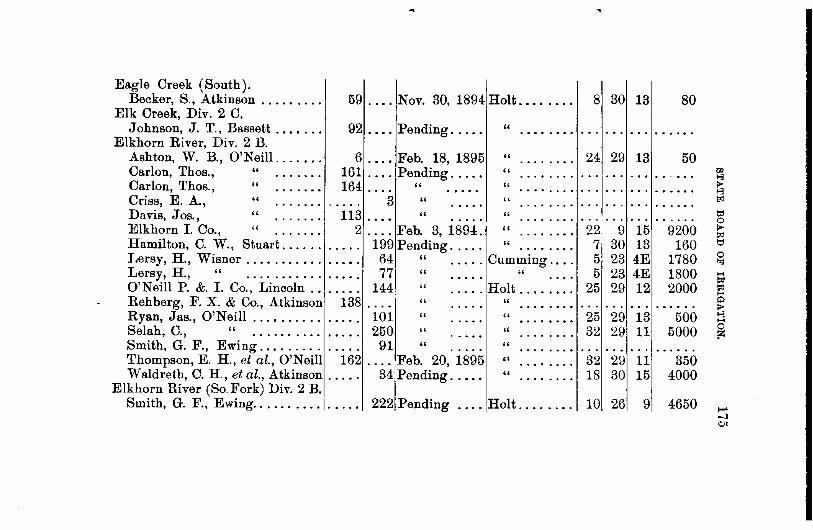
Eagle Creek (South). Becker, S., Atkinson ........ . 59 .... Nov. 30, 1894 Holt ....... . 8 30 13 80
Elk Creek, Div. 2 C. Johnson, J. T., Bassett ...... .
Elkhorn River, Div. 2 B. 92 .... Pending ..... " ... . . . . . . . .....
Ashton, W. B., O'Neill. . . . . . . 6 .... Feb. 18, 1895 " ....... . 24 29 13 50 Carlon, Thos., " . . . . . . . 161 .... Pending. . . . . " ....... . Carlon, Thos., " . . . . . . . 164 . . . . " " ....... .
"' >-3 I> ... 0 ••••• >-3
Criss, E. A., " . . . . . . . 3 " " ....... . 1>1 . .. . . . . . . Davis, Jos., " .. .. .. . 113 . . • • " " ....... . Elkhorn I. Co., " . . . . . . . 2 .... Feb. 3, 1894. " ....... .
l::j ... • • • • 0 0 0 22 9 15 9200 >
"' Hamilton, C. W., Stuart.... . . 199 Pending. . . . . " ....... . Lersy, H., Wisner . . . . . . . . . . . 64 " ..... Cumming ... . Lersy, H., " . . . . . . . . . . . 771 " " O'Neill P. &. I. Co., Lincoln . . 144 " ..... Holt .... ... .
7 30 13 160 tj
5 23 4E 1780 0 ,. 5 23 4E 1800 ;;;
25 29 12 2000 "' H
Rehberg, F. X. & Co., Atkinson 138 . . . . " " ....... . Q ... . . . . . . . ..... > Ryan, Jas., O'Neill . . . . . . . . . . . . . . . 101 " " ....... . Selah, C., " . . . . . . . . . . . . . . . 250 " " ....... .
25 29 13 500 >-3 H
32 29 11 5000 0 lZ
Smith, G. F., Ewing. . . . . . . . . . . . . . 91 " " ....... . . . . . . . . . . 0 •••••
Thompson, E. H., et al., O'Neill 162 .... Feb. 20, 1895 " ....... . 32 29 11 350 W aldreth, C. H., et al., Atkinson . . . . . 34 Pending .....
1
" ....... .
Elkhorn River (So. Fork) Div. 2 B. Smith, G. F., Ewing.. . . . . . . . . . . . . . 222 Pending .... Holt ....... .
18 30 15 4000
10 26 9 4650 ,... -J
~·

ALPHABETICAL INDEX OF CLAIMS AND APPLICATIONS BY STREAMS-Continued.
NAME OF CLAIMANT. I
CLAIM I APP.I DATE OF PRIOR· I NO. NO. ITY.
OOUNTY.
Evergreen Creek, Div. 2 C. Hafes, G. & Son, Wood Lake. . . . . . . 145
Fairfield Creek, Div. 2 C. Kuhre, W. M., Norden . • . • • . . 153 ....
Fox Creek, Div. 1 B. Phoenix Ins. Co., Hartford, Conn . . . • . 234
Fremont Creek, Div. 1 A. Equitable F. & I. Co., No. Platte 109 .... Steenhausen, A., North Platte. . . . . . 260
Frenchman River, Div. 1 B.
" .•... Brown ..... .
" • .... Keya Paha ..
" •.... Lincoln .....
" " " "
Carrington,L.J., etal,Culbertson 16 .... Dismissed .. Hayes ...•.. Carrington,L.J., etal,Culbertson 16a .... Aug. 23, 1894. " ..... . Culberts'ni.&W.P.Co., " 136 ... ·iMay 16, 1890 " ..... . Cunningham, A., ImperiaL . . . • 13:Pending .... Chase ...... . Farmers' M. I. Ass'n., Champion 207 " . . . . . " ...... . Farmers' Canal Co., Culbertson. 24 .... Dec. 19, 1893 Hitchcock .. . Fisher Polly & Co., Wauneta.. 238 .... ,July 31, 1896 Chase ..... . Fuller, J. C., Imperial. . . . . . . . 2 .... June 12, 1894 " ..... . Grant, J. S., Imperial. . . . . . . . . 229 .... Pending . . . . " ..... .
I LOCATION OF I ACRES HEADGATE. COVERED
s. T. R. . . . . . . . . . ...... . . . . . . . . . •• 0 •••
. . . . . . . . . ......
. . . . . . . . . ......
... ... . . . . .....
. . . . . . ... 0. 0 •••
32 5 53 700 31 5 33 15120 . . . . . . . .. • 0 ••• 0
. . . . . . . . . • 0 •• 0.
11 3 33 700 11 5 36,Power
4 5 -~~1 .. ~:~~ . . . . ..
:.; t<l 't1 0 :.; >-3
0
"' "' t<l a 1:0 t<l >-3 1>-:.; ><I
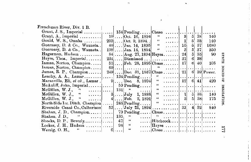
Frenchman River, Div. 1 B. I Grant,J. S., Imperial ............. 154Pending ..... Chase ..
3. ··
5·
1
•
3·8· ···
1·4·0·
Grant, ~\..,Imperial . . . . . . . . . . 10 .... Oct. 16, 1894 " Gould, W. S., Omaha . . . . . . . . 203 .... Oct. 9, 1894.. " 1 5, 38 140 Guernsey, D. & Co., Wauneta.. 40 .. 0. Jau. 14, 1895 " 10 5\ 37 1680 Guernsey, D. & Co., Wauneta.. 198 . 0 0. Jan. 14, 1894 " 3 5, 37 350 Hagerman, Hudson . . . . . . . . . . 84 .. 0. Aug. 27, 1894 Hayes....... 24 5 35 90 Hayes, Thos., Imperial. . . . . . . 234 .... Dismissed . . . . . . . . . . . . . . . 31 6 38 Inman, Norton, Champion..... 52 .... Feb. 28, 1895 Chase.... . . . 17 6 40 105 Inman, Norton, Champion. . . . . 60 ....... , . . . . . . . . " .............. . James, R. P., Champion...... 249 .... Dec. 31, 1887 Chase....... 21 6 39 Power. Leachy, A. A., Lamar.... . . . . . . . . . 134 Pending..... " ..................... . Maranville, Eli, et al·., Lamar . 9 .... Dec. 8, 1894 " . . . . . . . 12 6 41 420 McAuliff, John, Imperial...... 59 Pending..... " .................... .. McGillen, W. J., '' ... , . 131 " " ..................... . McGillen, W. J., " 3 .... July 1, 1888 " . . . . . . . 1 5 38 140 McGillen, W. J., " 4 .... Feb. 2, 1891 " . . . . . . . 3 5 38 175 North Side lrr. Ditch, Champion .. .. . 246 Pending.. .. . " .. .. .. . .. . .. . .. . .. .... Riverside Canal Co., Culbertson 53 .... July 21, 1894 . . . • . . . . . . . . 33 4 32 840 Shahan, J. D., Champion..... . 79 Pending ...•. Chase .....•. Shahan, J. D., " 135 " " ....•.. Sheeks, D. P., Beverly.. . . . . . . 4 7 " ..... Hitchcock .. . . Locker, J. H., Hudson . . . . . . . 98 " ..... Hayes ..... . W ersig, 0. H., " . . . . . . . 6 " ..... Chase ...... .

ALPHABETICAL INDEX OF CLAIMS AND APPLICATIONS BY STREAMS-Continued.
NAME OF CLAIMANT. I
<JLAIM I APP-1 DATE OF PRIOR·I NO. NO. ITY.
<JOUNTY. I LOCATIO~ OF I ACRES HEADGATE. COVERED
l!'renchman River, Div. 1 B. s. T. R. Wise, J.D., " 85 Dec. 28, 1896 Hayes 15 r. 35 140 • 0 ...... • 0 •• • •• 0 0.
Young, Fremont, Lamar ...... 334 .... Dismissed .... Chase ....... 11 6 41 • ••• 0 •
Young, Fremont, " 251 " ...... . . 0. 0 ..... 0 ••••• 0 • •• 0 ••• . . . . . . . . . • • 0 •••
Gracie Creek, Div. 2 A. Burns & Dobson, Lincoln ..... ..... 66 Pending ..... Loup • •••• 0 • 31 23 17 • •••• 0
Willow Springs I. Dis., Burwell 228 " " 31 231 17 •• 0. 0 ..... • 0 •••• 0 • •••• 0
Golden Creek, Div. 1 A. Theis, W. J., Ogalalla ........ • 0 •• 0 160 Pending ..... Keith ....... . . . . . . ... . .....
Goose Creek, Div. 2 A. . ... JJ an. 6, 1895 Giles G., et al., Purdum ....... 25 Cherry ...... 2 25 25 700
Crook, Fred " 106 .... Pending ..... Blaine ...... ••• 0 0 •• . . . . .. . .. . . . . . . Erickson,P. C. & J. M., Brewster 166 " Blaine .. ". . .... • •• 0 •• . . . . . . . .. • 0 ••••
Gordon Creek, Div. 2 c. Gillispie, B. S., O'Neill ....... 147 " Cherry ...... .... . .... . . . . .. . .. • 0. 0 0.
Greenwood Creek, Div. 1 A. Capron and Lamb, Midway .... 192 . ... !Pending ..... Cheyenne . .. . . . . . . . . . . ..... Coulter, D. M. & H. M., Redington 216 " " • • • • • 0 ••• . .. . . . . . . . .. . ..... Nelson and Trennier, Midway 217 " " • • • • • 0 ••• . . . . .. . . . . .. 0 •••••

Greenwood Creek, Div. 1 A. Trennier, J. E., ~fidway ..... . Geis, Fred'k, Midway ........ .
218 .... Pending ..... Cheyenne 73 " "
Meglemre, S. A., Lapier ..... . 294 " " Hat Creek, Div. 2 E.
Antrim, J. F., Bodarc ... , ... . 25 " ..... Sioux ...... . Brewster, B. E., Harrison .... . 126 .. .. " " Coffee, C. F., Bod arc ........ . 33 ... . " "
Hay Creek, Div. 2 D. Batch, T. C., Chadron ....... .
Holt Creek, Div. 2 C. Carnahan & Webster, Enterprise ..... Schortzer, F. J., Enterprise. . . 135
Holt Creek (East), Div. ~C. Akers, J. W., Springview..... 147 Mountford. Thos., Springview .
Horse Creek, Div. 1 B.
110 Pending .....
1
Dawes ..... .
116 " •.... Keya Paha .. . " "
" " 230 " "
... ! ......
''']'"'" ......... 3 32 240
11 32 40 80
Nesbit and Davenport, Ives . . . ~ ~ ~ Horse Head 0r~k, Div. 2 C.
.... Aug. 31, 1895 Dundy . . . . . . 23 1 39 130
Bruce, Andrew, Pembrook ...•• Horse Shoe Lake, Div. 2 C.
Kortz, A., Gordon .......... . Indian Creek, Div. 2 D.
Flood, M. F., Whitney ...... .
149 Pending . . . . . Keya Paha ...
287 " . .... Cherry ..... .
76 .... " . .... Dawes ..... .

ALPHABETICAL INDEX OF CLAIMS AND APPLICATIONS BY STREAMS-Continued.
NAME OF CLAIMANT.
Indian Creek, Div. 2 D. Seeq uist, Isaac, Whitney ....•.
Indian Creek, Div. 1 B. Chamberlain, J. C., Max ......
" " " " . . . . . . " " " " . . . . . . " " " " . . . . . . " " " " • • 0 •••
" " " " • • • • • 0
Cannon, H., Max ............ Kimsey T. C. & J. W.,Benkelman
" " .. " Thorn pson& Vansickle, "
" " " " Wilson, Ed., Stratton. ...•....
" " " ........ Vansickle, A., Benkleman .....
Jewett Creek, Div. 2 C. Jewett, c. P., Meadville .•...•
I CLAIY I APP.I DATE OF PRIOR·\
NO. NO. IT¥. COUNTY.
119 0. 0. Pending ..... Dawes 0 0 ••••
. . . . 185 Pending ..... Dundy ...... 240 Pending ..... " . . . . . 0 0 0 •••
31 Dismissed .... " .... • 0 ••• 0
207 Pending ..... " .... . . . . . . 263 Dismissed " .... . .. . . . . . . 265 " " .... . . . .. ·-· ..
8 " " .... . . . . ..... 2~ .. " .. -. . .. . . . . . .
261 Pending •.... " . . . . . . . . . . . 27 Dismissed " .... . .. . . . . . .
237 Pending ..... " •••• 0 . . . . . . 43 Dismissed " .... . .. . . .. . . .
268 Pending ..... " . .... . . . . . . 26 Dismissed " .... . .. . .....
144 .... Pending ..... Key a Paha .•.
I LOCATION OF I ACRES
HEADGATE. COVERED
s. T. R. . . . . . . . .. . ..... . .. . . . . . . . ..... .. ·I· .. . .. • 0. 0 ••
13 2 37
· isi · ·2 . ..... 36 • • 0 0 0 •
18 2 36 . ..... 18 2 36 . ..... 10 2 37 . ..... . .. . . . . .. • 0 ••••
8 2 37 . ..... ... . . . . . . . ..... 23 2 36 . .....
. . . . .. . .. . ..... 5 1 37 . .....
. . . . . . . . . • 0 ••••
..... 00 0

Jim Creek, Div. 2 E. Anderson, Nels., Harrison ..... Slattery,. Wm., ''
31 .... Pending . . . . . Sioux . . . . . . . . . . • • . . ..
Woodruff, W. B., '' 14 " " . . . . . . . 13 33 37
" 114 . . . . " " ...... .
" " 115 • . . . " " ...... . Keya Paha River, Div. 2 C.
" ..... Keya Paha ... "
Anderson, H. S. & Co., McClain . . . • . 167 Donason, Jack, Mills. . . • . . . . . 166 Lewis, S. A., Lutes........... 127 Rhodes, F. J., Springview. . . . . 206 State Line I. Co., Mills. . . • . . . 259
Kiowa Creek, Div. 1 A.
" " " " " " "
Currie, E. A., Mitchell.... . . . . 215 .... Kyle Creek, Div. 2 D.
" • .... Scott's Bluff ..
Colville, D., Glen ......••.... Lawrence Fork, Div. 1 A.
42 ..•. Pending •...• Sioux •......
Creigler, E. S., Redington ..... Gilman & Creigler, Redington . Harper. J. W., Higgins ...... . Redington, H. V., Redington ..
Lincoln Creek, Div. 1 D.
44 ... . 49 .. .. 91 .. ..
206 ... .
Smith, Jennie A., York ............ 269 Lodge Pole Creek, Div. 1 E.
Adams, J. M., Potter. . . . . . . . . 288 ....
" " " "
"
"
. . . . . Cheyenne ... " " "
. . . . . York .......
. . . . . Cheyenne ... 21 12 1
"' ...... ":l
40
1>>-:l t<l
to 0 > t<:l t;j
0 ., ;.;; 1:1:0
~ ":l
~

ALPHABETICAL INDEX OF CLAIMS AND APPLICATIONS BY STREAMS-Continued.
NAME OF CLAIMANT. I CL-AIM I APP.I DATE OF PRIOR-I COUNTY. I LOCATION OF I ACRES
NO. NO. ITY. HEADGATE. COVERED
-7--------~~~---L----
Lodge Pole Creek, Div. 1 E. S. T. R. Adams, J. M., Potter ........ . 290 .... Pending ..... Cheyenne ... Adams, J. M., Potter ........ . 291 .... 0 " "
Adams & Tobin, Sidney ..... . 292 . . . . " " Anderson, J no., Sidney ...... . 293 . . . . " " Anderson, J no., Sidney ...... . 296 . . . . "· " Bav State L. S. Co., Kimball .. Bo~quist, C. E., Sidney ...... . Borquist, C. E., Sidney ...... . Brady, J. V., Dix ........... .
201.... '' ..... Kimball .... . 287 . . . . " ..... Cheyenne ......
1
.. · ·
289 . . . . " . . . . . " . . . . . . . . .. 204 . . . . " .... . !Kimball .... .
. . •'
Booth, Frith, Lodge, Pole .... . Couch, Arabella, Sidney ..... .
102 . . . . " ...... Cheyenne ... . 89 " "
Christianson, H. L., Sidney .. . 211 . . . . " " Christianson, H. L., Sidney .. . 212 . . . . " " Goss, C. J., Pine Bluffs, Wyo .. Gunderson, Adam, Potter .... . Hall, Lewis H., Sidney ...... . Hall, Lewis H., Sidney ...... . Hall, Lewis H., Sidney ...... .
159 . . . . " ..... Kimball . .... 89 . . . . " ..... Cheyenne . . . . . . . . ·I· ..
111 .... "····· " .... [ ...... , .. . 112. .. . " .. . . . " ... ·[· .... -!- .. 114 .... " ..... "··•·'·········

Lodge Pole Creek, Div. 1 E. Hall, Lewis H., Sidney ...... . Hall, Lewis H., Sidney ...... . Hurley, J. W., Kimball ....•.. Hurley, J. W., Kimball ...... . Herrington, Ed., Chappell. ... . Howard, Alice T., Lodge Pole.
116 .... Pending ..... Cheyenne •.. 208 . . . . " " 224 . . . . '' ..... Kimball ... . 225 . . . . " . . . . . Kim ball . . .. . 113 . . . . " ..... Deuel ...... . 156 . . . . " ..... Cheyenne ... .
Ickes, C. S., Lincoln ........ . 147 .... " " Jones, B. A., Sidney ........ . Jones, B. A., " ........ .
70 " " 143 . . . . " "
Jones, B. A., " ........ . Kinney, J. J., Kimball ...... . Kinney, J. J., " ...... . Kinney, L. 0, Pine Bluffs, Wyo. Kinney, S. A., " " Kruger, F. W., Sidney ...... . Kruger, F. W., Sidney ......•• Kruger, F. ,V., " ....... . Kruger, Richard, " ....... . Libby, H. A., Lodge Pole .... . Lyngholm, N. P., Sidney .... . Mcintosh, J. M., Melrose .... . McLaughlin, M., Sidney ..... . Mitchell, Jas., "
144 . . . • " " 157 . . . . " ..... Kimball . .... 282 . . . . " " 150 . . . . " " 151 . . . . " " 137 . . . . " ...... Cheyenne 138 . . . . " " 139. .. . " " 295 . . . . " " 154 . . . . " " 223 . . . . " " 213 . . .. . '' ..... Kimball . .... 298 . . . . " ..... Cheyenne 148 . . . . " "
.. ·t· .. • 0 • •••
.. •t• ..
. ..... ···["" ....

ALPHABETICAL INDEX OF CLAIMS AND APPLICATIONS BY STREAMS-Continued.
NAME OF CLAIMANT.
Lodge Pole Creek, Div. 1 E. Newman, H., Lodge Pole .... . Oberfelder, R. S., Sidney .... . Oberfelder, R. S., " Persinger, A. B., Lodge Pole .. Pierce, S. A.,Pine Bluffs, Wyo. Ruttner, C., Kimball ........ . Runge, G., Sidney .......... . Runge, G., " .......... . Tobin, M. H., Sidney ...•..... Trognitz, C. E., " ....... . Urback, M., " ....... . Whitney, W. T., " ....... . Whitney, W. T., " ....... . Young, W. T., Kimball ...... .
Lonergan Creek, Div. 1 A. Haney, A. C., Ogalalla .....•. Soehl, Herman, Omalia ...•...
I CLAIM I APP.I DATE OF PRIOR-I COUNTY.
NO. NO. ITY.
48 Pending ..... !Cheyenne 58 " " 59 " " ....
146 " " 152 " Kimball ..... .... . .... 142 " " .... 247 " Cheyenne .... . ..... 248 " " .... 199 " " .... 210 " " .... 149 " " .... 145 " " .... 155 " " 0 0 ••
141 " Kimball ..... .... . .... 35 .... Pending ...•. Keith ...... .
219 0 0.. " " ••• 0 • 0 •
I LOCATION OF I ACRES HEADGATE. COVERED
S. T. R.

Lonergan Creek (east), Div. 1 A. Jacobs, L., Ogalalla ......... .
Looking Glass Creek, Div. 2 A. 189 .... Pending. . . . . . .......... .
Babcock, H. E., Ord. . . . . . . . . . . . . . . 219 " ..... Platte . ..... . Gerrard, E. A. & F. H., Monroe 22 .... June 12, 189! " . . . . . . . 1 17 3 Gerrard, E. A. & F. H., Monroe 1 •.•• June 12, 1894 " ............ .
Loup River, Div. 2 A.
200
Babcock, H. E., Ord ......... . Babcock, H. E., Ord ......... . Craig. Lynch & Co.,Platte Cen .. Harv:ey, Robert, St. Paul ..... . Murdock, D. et al., Oconee ... . Nelson & Gates, Richland .... .
Loup (South), Div. 2 A.
219 Pending ..... " 129 " 312 "
35 " 289 " 291 "
" . . . . . Platte. . . . . . . 13 . . . . . Howard ..... 25 . . . . . Platte....... 27
" 13
17 2 ..... . 13 12 ..... . 17 4 .... .. 15 8 ..... .
Boblets, E. J., Tuckerville..... 140 . . . . " ..... Custer ...... . • • • 0 • • • • • • •••••
Callaway Milling Co., Callaway. 177 Edwards, S., Arnold ........ .
" " ••• 0 •• •• 0 •••• 0.
Halladay, C. T., Broken Bow .. . South Loup I. Co., Callaway ... Tillson, W. Z., Sidney ....... .
Loup (Middle), Div. 2 A. Butcher & Greebe, Gates .... . Grier, Peter, Seneca ......... . Grier, Peter, " ......... .
245 62
229 78 ....
" " " "
" 21 17 25 ..... . " 25 17 25 ..... . " 6 16 ~4 ..... .
. .... Buffalo ..... .
134 .... Feb. 17, 1895 Custer..... . . 36 20 21 1280 . . . . . 10 Pending ..... Thomas ................... . . . . . . 2911 " . . . . . " . . . . . 21 24i 30 ..... .

ALPHABETICAL INDEX OF CLAIMS AND APPLICATIONS BY STREAMS-Continued.
NAME OF CLAIMAN1.'. I CLAIM I APP., DATE OF PRIOR· I
NO. NO. ITY. COUNTY.
Loup (Middle), Div. 2 A. Harris, L. H., Dunning ...•... • 0 ••• 263 Pending ..... Blaine • 0 ••••
Harris, L. H., " 248 " " • 0 0 •••• 0 ••• 0 • 0 ••• 0 ••• 0 •
Jewett, L. H., Broken Bow .... 113 " " ..... • ••• 0 0 •••••
Kenyon, C. T., Boelus ........ 200 " Howard ..... •••• 0 ••• 0.
Lillian Precinct I. Dist., Gates. 118 " Custer ....... 0 ••• . .... Mira Valley I. Dist., Ord ...... 220 " " ••• 0. . .... . ...... Mathews, G. L., 'fhedford ..... 103 .... Dismissed ... Thomas ...... Middle Loup I. & C. Co. Sargent 130 .... June 6, 1894. Blaine ....... Patton, J. A., Ord ............ • 0 0 0. 2ti2 Pending ..... Valley ...... Posten, D. M., Seneca ........ 197 " Thomas ..... 0 •••• ..... Purdum, J. W., Thedford ..... 102 Sept. 8, 1894. " .. 0. • •• 0 •
Sherman Co. Irr. Co., Loup City 80 .... Aug. 13, 1894 Sherman . ... Thedford I.&W.P.Co., Thedford 89 .... Aug. 25, 1894 Thomas ...... Wescott I. & Canal Co., Wescott 166 .... Aug. 8, 1894. Custer . .....
" " " " " 172 Pending ..... " • 0. 0. • 0 •• 0 •
Loup (North), Div. 2A. Almeria I. & Canal Co., Almeria ••• 0. 117 Pending ..... Loup ••• 0 0 0 0
Body, Wm., Compton ........ 169 " . .... Cherry ...... 0. 0 0.
I LOCATION OF I ACRES HEADG\T~. COVERED
s. T. R. 3 22 26 • 0 ••••
16 22 25 • 0 • 0 •
30 22 24, ...... 30 13 12 . ......
. .. . . . . . . • • 0 •• 0
3~1 13 12 67360 23 2/:l ••• 0 ••
15 21 ~~1. ~~~~~ 16 17 14 24 31 • •• 0. 0
31 24 29 200 30 14 13 17000
4 23 29 3900 15 19 18 6200
. . . . . . . .. 0 ••• 0.
24 22 20 • •• 0 • 0
. .. . . . . . . • • 0 •••

Loup (North), Div. 2 A. Brewster I. & P Co., Brewster . • 0 0 •• 153 Pending ..... Cherry . ..... . . . . . . ... . ..... Burwell I. Co., Burwell ....... 117 • 0. 0 Sept . 7,1894. Garfield 0 •••• 27 21 11 7700 Corey, A. L. St. Paul. ........ 165 Pending ..... Valley • • • 0 •• 25 19 14 ...... Compton I. & P. Co., Compton. 190 " Cherry ... . .. . . . . . . . . 0. 0 ••• 0 • 0 •••
Cox, G. H., Purdum .......... 108 " Blaine 8 24 251 ...... • 0 ••• 0 0 0 ....
Edgar, H. R., Brownlee ....... 105 " Cherry ...... 27 27 28 .....• 00 ..... 8 Edwards, H. B., Valentine ..... 104 " " 27 27 28 > • 0 ••••
'"" Erickson, P. C., Brewster ..... 244 " Blaine 28 24 24 l>l • • 0 •• • 0 •• 0 • • 0 ••••
Farmers I. &M. Co., Brewster. 114 " " 15 22 23 1:0 •••••• 0 ...... 0 Firkins, A. J., Ord ............ 161 " Valley 5 20 10 > . . . . . . ..... ...... 1:0 Forks I. Dist., Burwell ....... 181 " Loup 22 21 18 t:;
• 0. 0 0 •••••• 0 • 0 ••••
Gard, D. A., Ord ............ 14 " Valley 0 . . . . 0 0 ••• . ..• 0. . . . ... . .. • • 0 ••• b;t Getter, M. E., Ord .......... 122 " Loup . . . ... !;l . . . . . .... 0 •••••• . . . • 0 0 •••
" " " 99 " " 30 22 19 ~ 0. 0 •••• 0 •• • 0 ••••• •••• 0 • ....
" " " 279 " " Q . . . . . . . . 0. • ••••• 0 . . . ... . .. • ••• 0 • >
" " " 201 " " 35 24 24 .., • • • 0 ••••••
• ••• 0 •• • 0 • 0 •• 0 Johnson, M., Elba ............ 238 " Howard ..... 1 16 12 ;z: • • • • 0 ...... Johns & Wilson, Burwell. ..... 202 " Garfield ..... 19 21 16 . . . . . ...... Keller, G. w. &0. J., Compton 187 " Cherry ...... 21 26 27 • • • • 0 ..... ...... Keller & Co , Compton ....... 326 " " 16 26 27 500 Lee, J. R., Brownlee ......... 26 " " ... • 0 •• . .. . . . • • 0 •••
Lee, J. R., Brownlee ......... 170 Aug. 7, 1894. " 25 27 29 2800 • 0 •• ..... Lee, J. s., Brownlee 177 Pending " 26 27 2\:l 00
••••••• 0 • . . . . . . . 0. • 0 •••• -~

ALPHABETICAL INDEX OF CLAIMS AND APPLICATIONS BY STREAMS-Continued. ,_. 00 00
NAME OF CLAIMAN'.r. II CLAIM I APP.I DATE OF PRIOR-I NO. I NO. ITY.
Loup (North), Div. 2 A. Newton I. Co., Almeria ....... 82 . . . . Pending ..... North Loup I. Co., North Loup 23 0. 0 0 Sept. 30, 1893 Northrup, H. A., Hawley •• 0 •• . . . . . 51 Pending 0 •••
Northrup, T. 8., et al., Hawley. 107 " ..... • •• 0 •
Ord lrr. Dist., Ord 136 " •••••• 0 ••• •• 0 •• • ••• 0
Roneche, P. 8., Brownlee ..... 18 " • 0 ••• • • • • 0
Roneche, P. S., et al., Brownlee 177 " • 0 ••• • 0 0 ••
Sanderson, M., ef al., Hawley .. 107 " :::::1152
• 0 •••
Smith, E. B., Brewster ........ " . . . . . Stevens, Wm., Taylor " •• 0. 0 ••• 143 .... 0 0 •• 0
Tzschuk Canal Co., Ord 301 " ...... . . . 0. • 0 •••
Vandergriff, E. R., Brownlee .. 16 " . . . . . ..... Vandergriff. E. R., Brownlee .. 103 " . . . . . 0 ••••
Walker, M. L., Brownlee ..... 96 " 0 •••• 0 0 •• 0
Mathew's Creek, Div. 1 A. Mathew's, B. G., Keystone .... 182 " • 0 •• • • 0 ••
Medicine Creek, Div. 1 B. Philli B, R. A. Lincoln ....... 302 .... " 0 •••• p
COVNTY,
Loup .•..••. Valley •• 0 •••
Blaine ...... " 0 ••• 0 •
Valley ...... Cherry ......
" • • • 0 ••
Blaine ...... " .
• •• 0 0.
Loup ....... Valley ...... Cherry . ....
" • •••• 0
" •• 0 •••
Keith .......
Frontier . ...
I
LOCATION OF I ACRES HEADGATE. COVERED
s. T. R. . . . . .. . .. . ..... 27 19 14 10000 29 24 24 6000 23 24 25 • 0 .....
25 21 17 . .....
. iif 27 ... • • 0 ....
29 . ..... 23 24 25 . ..... 27 23 21 • 0 0 •• 0
. . . . . . . . . ••• 0 ••
. .. . . . . . . • •• 0 ••
25 27 28 2000 33 27 23 27 27 28
. . . "l" ...... ... ... 1 .. . . .

Medicine Creek, Div. 1 B. Rodwell & Brown, Cambridge. Rodwell & Brown, Cambridge. Sanders, J. L., Stockville .....
Minnechaduza Creek, Div. 2 C. Bristol, D. S., Valentine ..... .
Middle Creek, Div. 2 B. Abbott, W. N., Lincoln ....... . Judge, Peter, Lincoln ....... . Jansen, May, Lincoln ....... .
Middle Creek, Div. 2 C. Bartling, H., Sidney ........ . Bartling, H., " ........ .
Middle Creek (North), Div. 2 C. McGuire, May W., Norden ....
Middle Creek (East), Div. 2 C. Poitevin, Antrim, Norden .....
Middle Creek (West), Div. 2 C. Allen, M. N., Norden ....... .
Monroe Creek, Div. 2 D. Brumbaugh, Sam'!, Harrison .. Schilt, Chas., ~'
Monroe Creek (Little), Div. 2 C. Schilt, Chas., Harrison ....... :
13 .... Pending ..... Furnas .................... . 56 .... Dec. 31, 1878 " 29 4 25 Power.
130 .... Feb. 8, 1895 . Frontier. . . . . 27 7 27 100
87 Pending .... Cherry ..... : • • 0 . . . •• 0 ...... "' ~
210 " Lancaster 29 10 6e p.. . . . . . 0 •• ...... ~
212 " " 28 10 6 80 t<l
215 " " 28 10 6 210 ttl 0 > "' 177 " Cheyenne t:t . . . . . .... 0 ••
178 " " 0 .... b;j
; 121 " Keya Paha ~ . . . . . ....
0 >
92 " " .., .... 0 ?I
95 " "
112 " Sioux ....... 22 33 56 300 ..... 38 " " . . . . .......
...-38 " " 00 . . . . ....... <:0

ALPHABETICAL INDEX OF CLAIMS AND APPLICATIONS BY STREAMS-Continued.
NAME OF CLAIMANT. I
CLAIM I APP.I D~TE OF PRIOB.-1 NO. NO. ITY.
COUNTY. I LOCATIO~ OF I ACRES HE.-\DGATE. COVERED
Monroe Creek (Big), Div. 2 c. s. T. R. Wilcox, E J., Harrison ...... 34 . ... Pending ..... Sioux ....... . . . . .. . . . • - 0 •••
Muddy Creek, Div. 1 B. Phillips, F. C., Max .... ...... 18 • 0 0 0 Dismissed ... Dundy ...... 2 2 36 . ..... Phillips, F. C., Max .... 235 Pending ..... " ...... . . . . . • •• 0 •• . . . . . . . . . . .....
Muddy Creek, Div. 2 A. Conley, J. W., Broken Bow .... . 0. 0. 236 ........ • 0 •• Custer . ....... 32 17 20 . ..... Penn, Chas., " 159 .... Aug. 14, 1894 " 35 • 0 •• • •• 0 •• . . . . . . . ..
Nemaha River, Div. 1 F. Christy, H. R., Palmyra ...... 0 0 ••• 115 Pending ..... Otoe ........ . .. . . . . . . . ......
Niobrara River, Div. 2 c. I I Allen, M. v. & T., Sargent .... . .• 0. 126 Pending ..... Keya Paha ... . . . . .. . . . • ••• 0 •
Balch, T. c., Chadron .... 109 " Dawes . . . . • • 0 •• •••• 0 0. 0 ••• . . . . .. . .. • • • 0 ••
Barrett, William, Harrison .... 4 " Sioux • • • • 0 ..... • • 0 •••• .. •' . . . ... . ..... Barrett, P., " 5 " " . . . . ..... . .... • • 0 •••• . . . . . . . .. 0 ••• 0.
Brown, J. E., Hay Springs .... 125 " Sheridan ..... ..... . .... . . . . .. . .. • • 0 •••
Bruce, Andrew, Pembrook ..... 141 " Keya Paha ... . . 0. • 0. 0 • . . . , . . . . .. •• 0 •••
Cornell, C. H., Valentine ...... 100 " Cherry ..... :: :i::: • -. 0 ..... ... • • • • • 0
Earnest, J. W., Harrison ...... 19 " . .... Sioux ....... ••• 0 ... . . . . . .

Niobrara River, Div. 2 C. Earnest, J \V., " ....... . Furman, H. J., Marsland ..... . Gillespie, B. S., O'Neill ...... . Golden Irr. District ......... . Grable, C. J., Crawford ...... . Hatch, G. W. ef al.,Hemingf'd .. Harris, A., Belle ............ . Harris & Neece, Belle ....... . Hughes, John, Marsland ..... . Irion Bros, " Johnson, B . .!<'., Harrison ....•. Johnson, B. F., " Johnson, A., Dunlap ........ . Jackson, M. et al., Belle ..... . Jackson, W. S., Valentine .... . Jackson, W. S., " Lear, C. E., Springview ...... . Lichte. H., Dunlap .......... . Mirage Irr. Co., Mirage ...... . Moore, B. F., Marsland ...... . Mcl\Iannis,J. F.et al., Hemingf'd McGinley & 8tover, Rayville ...
~' h
20 .... Pending ..... Sioux ....... . 88 " ..... Dawes ..... .
74 " ..... Holt .... ... . 205 " " ....... . 102 " ..... Dawes ..... . 1'24 "
60 " 24 . . . . "
53 " 257 "
27 . . . . " 199 "
255 " 292 " 191 " 192 " 151 "
185 " 28 "
88 " 98 . 0.. " 93 . . .. . " 9l .. 0 0 "
" ..... -Bioux ...... .
" ..... Box Butte ... . ..... 8ioux ...... .
"
I "
. .... Dawes ..... .
. .... Sioux ...... . Cherry ..... .
" KeyaPaha .. . Dawes ..... . Sheridan ... . 8ioux ...... . Dawes ..... .
. .... Sioux ...... . "
..-\- .. "l" • •• 0 ••

ALPHABETICAL INDEX OF CLAIMS AND APPLICATIONS BY STREAMS-Continued.
NAME OF CLAIMANT. I CLAD! I APP.I DATE OF PRIOR·! NO. NO. ITY. COUNTY.
Niobrara River, Div. 2 C. I 1\icGinley & Stover, Rayville... 95 .... Pending ..... Sioux ...... . 1\icConaugh, A. N., Mirage.... . . . . . 128
1
" ••••• Sheridan ... . McConaugh . .A.. N., " . . . . . 137 " " McGuire: May W., Norden.... . . . . . 138 '' ..... Keya Paha .. McCully, S. J., Carnes . . . . . . . 175.... " " " McLaughlin, A. H., Marsland. . 105 . . . . " ..... Box Butte . . . Nollkamper, Wm., Turner..... 122 " ..... Holt ...... . Pa1mer, A. J. & Co., Marsland. ~3.... " ..... Dawes .... . Palmer, A. J. & Co., Marsland. 90 . . . . " " Palmer, A. J. & Co., Marsland. 91 " " Peters, H. A., et al., Hay Springs . . . . . 173 " ..... Sheridan .... Peters, H. A., et al., Hay Springs . . . . . 296 " " Richurds, B., Chadron. . . . . . . . 108 . . . . " ..... Dawes ..... Richards, B., Chadron.... . . . . 168 . . . . " " Snow, L., Marsland . . . . . . . . . . 85 . . . . " " Seymour & Bigelow. . . . . . . . . . 30 . . . . '' ..... Sioux . ..... . Usher, H. C., Hay Springs. . . . 82 " ..... Sheridan ... . Van Alstyne, J .. S., Long Pine.. . . . . . 134 " .... . IBrown .... .
I LOCATIO:N OF I ACRES
HEADGATE. COVERED
S. T. R.
• • • i •••

Nioorara River, Div. 2 C. Vincent, D. C., Marsland .... . 107 .... Pending ..... Dawes ..... . Warnecke, H., Harrison ..... . 60 . ... . " ...... Sioux . ...... . Wilson, J. A., Springview .... . 129 . . . . " ...... Key a Paha . . Wood, J. C., Marsland ....... . 89 . .. . . " ..... Dawes ...... .
Pawnee Creek, Div. 1 A. Plummer, "\Y. H., Maxwell .... Holcomb, M. N., Brady Island. Murphy, H. D., Brady Island ..
Pino Creek, Div. 2 C. Clark, James, Rushville ..... .
Plum Creek, Div. 2 C Plum Creek P.&I.Co.,Johnstown
Pole Creek, Div. 2 C.
69 .. .. 100 ... . 117 ... .
99 ....
84 ....
Julian, A. R., Chadron . . . . . . . . . . . . 120 Peppermint Creek, Div. 1 B.
Betts, N. 0., Bloomington..... 259 .... Prairie Dog Creek.
Schilt, C. E., Harrison ....... . 37 .... Platte River, Div. 1 A.
Appleford, H. M., Maxwell ... . 65 .. .. Brooks, H. C., Gothenburg ... . 125 .. .. Bernhard, J., Hastings ...... . Clark's Island Ditch Co., Gibbon .....
11 86
" . .... Lincoln " " " "
" . .... Sheridan ....
" Brown ..... .
" Dawes ..... .
" . . . . . Franklin . . . . 28
" . .... Sioux ...... .
" . .... Lincoln ..... " . .... Dawson ..•.. " ..... Adams ..... .
" ..... Buffalo ..... .
.. .1. .....
I ••• I •••• 0.
2 15 ..... .
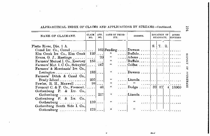
ALPHABETICAL INDEX OF CLAIMS AND APPLICATIONS BY STREAMS-Continued.
NAME OF CLAIMANT.
Platte River, Div. 1 A. Cozad Irr. Co., Cozad ........ Elm Creek Irr. Co., Elm Creek Evans, G. J., Hastings ....... Farmers' Mutual I. Co., Kearney Farmers' Mut. I. C. Co., Schuyler Farmers' & Merchants' Irr. Co.,
Lexington .... • 0 0. 0 ••• • 0 ••
Farmers' Ditch & Canal Co., Brady Island .... . . 0. 0 0 ••••
Fowler, R. H., Maxwell • 0 ••••
Fremont C. & P. Co., Fremont. Gothenburg P. & Irr. Co.,
Gothenburg • • 0 0. 0 •• . . . . . . Gothenburg P. & Irr. Co.,
Gothenburg • • • 0 . . . . . . . . . . Gothenburg South Side I. Co.,
Gothenburg . . . . • • • 0 • • • • • 0
I C~AIM I APP.I
NO. NO.
• 0. 0. 162 120 ....
..... 20 165 .. 0.
0 0 .... 247
183 . ... 205 • 0 ••
98 .... ..... 40
. . . . . 217
110 .... 173 • 0 ••
DATE OF PRIORITY.
Pending ..... " • 0 0 ••
" 0 ••••
" . .... " • 0 • 0
" • 0 0 ••
CODNTY.
Dawson • 0 •• 0
Buffalo ...... Adams ...... Buffalo ...... Colfax ......
Dawson . ....
" . .... Lincoln • 0 •••
" I " • • • 0 0 . .... " . .... Dodge . .....
" ..... Lincoln .....
" " • 0 ••• • 0 •••
" " • • 0 •• .....
I LOCATION OF I ACRES
HEADGATE. )cOVERED
s. T. n. . .. . . . . . . • • 0 •••
. .. . . . . . . 0 •••••
. . . ... . .. • •••• 0
. .. . . . . .. 0 •••••
. . . . . . . . . • • • • • 0
. . . . . . . .. . ... -.
. .. ... I ... . ..... I ... • • •I• • • • ••• 0 0
33 17 1 4 16960
. .. . . . . .. . .....
. .. ... . . . . .....
... .. ·I· .. • •• 0 ••
0 "1
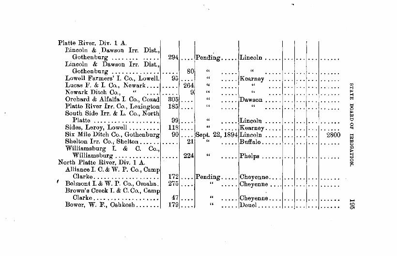
Platte River, Div. 1 A. Lincoln & Dawson Irr. Dist.,
Gothenbtirg ....... . Lincoln & Dawson Irr. Dist.,
294 .... Pending. . . • . Lincoln .....
Gothenburg . . . . . . . . . . . . . . 80 " " Lowell Farmers' I. Co., Lowell. 95 .... Lucas F. & I. Co., Newark ......... 264
" . .... Kearney
" " Newark Ditch Co., " . . . . . . . . . 9 " " Orchard & Alfalfa I. Co., Cozad 305 ... . " . .... Dawson ..... Platte River Irr. Co., Lexington 185 ... . " " South Side Irr. & L. Co., North
Platte . . . . . . . .. . . .. . . . . . . . . 99 . . . . " ••.•. Lincoln Sides, Leroy, Lowell . . . .. . . . . . 118 . . . . " ....... Kearney .... . Six Mile Ditch Co., Gothenburg 90 .... Sept. 22, 1894 Lincoln .... . Shelton lrr. Co., Shelton. . . . . . . . . . . 21 " ..... Buffalo .. .... . Williamsburg I. & C. Co.,
Williamsburg . . . . . . . . . . . . . . . . . . 224 North Platte River, Div. 1 A.
Alliance I. C. & W. P. Co., Camp
" ..... Phelps ..... .
Clarke .................. . t Belmont I. & W. P. Co., Omaha.
172 .... Pending ..... Cheyenne ...... .
Brown's Creek I. & C. Co., Camp 275 . . . . " ..... Cheyenne ...... .
Clarke.... . . . . . . . . . . . . . . . 47 ... . Bower, W. F., Oshkosh. . . . . . . 179 ... .
" • .... Cheyenne ... . . .... Deuel ...... . "
... I ......
2800

ALPHABE1ICAL INDEX OF CLAIMS AND APPLICATIO~S BY STREAMS-Continued.
:-lAME OF CLAIMANT. I
CLAIM I APP.I_DA.TE OF PRIOH-1 NO. NO. ITY.
COUNTY.
North Platte River, Div. 1 A. Bnrrett. N., North Platte.. . . . . . . . . . 118 Pending ..... Lincoln. .... . Bushnell, H. J. & E.N., Oshkosh 160 . . . . . .... DeueL ..... . Castle Rock,I.C.&P.Co.,Wilford 119.... " ..... Scott's Bluff. Central I. C. & \V. P.Co., Gering 246 . . . . " " " Chimney Rock I. C. & W. P. Co.,
Camp Clarke ............. . Clarke. H. T., Omaha ........ . Cody &Dillon I.&C.Co. N Platte Dickerman, S. F., North Platte. Daugherty, M. A., Ogalalla .... Enterprise Ditch Co., Gering .. Empire Canal Co., Camp Clarke Far. & Mer. I. & L. Co., N. Platte Fox, B. M., Oskosh ......... . Gumaer & Robinson, Oskosh .. . Gyger, J. C., Oskosh ........ . Hale, W. A., Gering ........ .
81 ... . 1 244 .. .. 169 .. .. 194 .. .. 281 .. .. 270 ... .
54 ... . 14 .. ..
197 .. .. 168 .. .. 121 ... . 200 ... .
" . .... Cheyenne .... " " " . .... Lincoln ..... . " " " . . . . . Keith ...... . " . .... Scott's Bluff. " . .... Cheyenne ... . " . .... Lincoln .... . " . .... Deuel ...... . " " " " " . .... Scott's Bluff.
I LOCATIO~ OF I ACRES HEADGATE. COVERED
S. T.! R. 0 ••. 0 ••
...i ...
I
:::1:::
... j ...
Hanna Irr. Co., Lisco ....... . 240 .. .. " . .... Cheyenne ...... .

North Platte River, Div. 1 A. Holcomb, G. J., Ogalalla. . . . . . 1 Pending ..... Keith ...•••. Hubartt, E., North Platte.... . 15 . . • . " ..•.. Lincoln ..•••. Jacobs, Lee, Ogallala. . . . . . . • .. 226 . . . • " ..... Keith ...•.•. Johnson, E. A., Brady Island.. 106 . . • . " ..... Lincoln ....•. Lamore, F. E., LaPeer........ • • • . . 279 " ..... Cheyenne .••. Lisco, R., Chappell. . . . . . . • • • • 158 . . . . " ..... Deuel ..•..•• Logan, C. S., Camp Clarke. . . • 48 . . • . " ..... Cheyenne ..•. Logan I. & C. Co., Camp Clarke 50 . . • • " " Lyons I. C. & W.P. Co. Oshkosh 188 . . . . " ..... Deuel ...... . Maycock, J., Collins. . . . . . . . . . 105 . . . . " ..... Scott's Bluff. Meyers, T. A. et al., Oga.lalla. . 273 . . . . " ..... Keith ...... . Nichols, Y. and C., Collins. . . . 276 . . . . " ..... Scott's Bluff. Nine Mile C. & R. Co., Bayard. 221 . . . . " " " Nissen & Fernstrom, Ogalalla. . 227 . . . . '' ..... Keith . ...... . No.Riv.I.C.&W.P.Co.,Oshkosh ..... 243 " ..... Deuel ...... . No. Platte I. & L. Co., No. Platte 101 . . . . " ..... Lincoln ... . Orr & Vance, Lewellen . . . . . . . 78 . . .. . " ..... Deuel ..... . Paxton & Hershey, Omaha.... 104 . . . . " ..... Lincoln .... . Reimers, H., Paxton . . . . . . . . . . . . . . 258 " ..... Keith . ..... . Roberts, C. F., Oshkosh. . . . . . . 232 . . . . " ..... Deuel ..... .
. ......
Rush Creek I.&C.Co.,LodgePole 122 . . • • " '' Sheridan, J. W. Ogalalla. . . . . . 285 . . . . " ..... Keith . ..... . Short Line I. Co., Bayard..... 96 . . . . " ..... Cheyenne .. .

ALPHABETICAL INDEX OF CLAIMS AND APPLICATIONS BY STREAMS-Continued.
NAME OF CLAIMAN1'. I
CLAIM l APP., DATE OF PRIOR-I NO. NO. ITY.
N orth Platte River, Div. 1 A. Smith, A., North Platte ....... 51 .... Pending ..... Smith, A. H. etal., Camp Clarke 55 " .... . .... Sutherland & Paxton, Sutherland 271 " .... • • 0 • 0
Spohn, Wm., Oshkosh ...•.... 180 " . . . . . . . . . Steamboat Ditch Co., Gering .. 186 " 0 •••• • ••• 0
Stubb SupplyDitchCo.,Lewellen 267 " • 0 •• 0 ..... Stebbins, L., North Platte ..... 62 " • 0 •• . . . . . Wendt, H. H., et al., Oshkosh. 243 " .... . .... Wilcox, J. A., Oshkosh ....... 126 " .... • 0 •••
Winter's Creek I. Co., Gering .. 253 " .... . .... s outh Platte River, Div. 1 c.
Abbott, J. H., etal., Big Springs 19 " .... . .... Appleford, H. M., North Platte 64 " .... . .... Armstrong, J. H., Ogalalla .... 233 " .... . . . . . Hollingsworth & Son, Ogalalla. 299 " .... . .... Hall & Allen, Ogalalla ........ 284 " ' ... . .... Lawler, D. A., et al., Paxton ... 232 " •••• 0 ..... Lute & Sheridan Oa-alalla 231 " 0 ••• . . . . . . ....
COUNTY.
Lincoln ..... Cheyenne . .. Lincoln ..... Deuel ....... Scott's Bluff. Deuel ....... Lincoln . .... Deuel ......•
" . ...... Scott's Bluff.
Deuel ..•.... Lincoln . ' ... Keith . .....
" • ••• 0 ••
" . ...... " . ...... " . ......
I LOCATION OF I ACRES HEADGATE. COVERED
s. T. R. . .. . . . . .. . ..... . . . . . . . .. . ..... ... . . . . .. 0 0 •••
. .. . . . . .. . .....
. . . ... . .. . ..... - .. . . . . .. • • 0 •••
. . . . .. . .. . .....
. . . . .. . .. • 0 •• 0.
. . . . .. . .. . . . . . .
. .. . . . . .. 0 •• 0 ••
. . . . .. . .. . . . . . .
. . . . . . . .. . .....
. .. . . . . .. . ......
. . . . . . . .. . .....
. . . . . . . . . . .....
. . . . .. . .. • • 0 •••
. . .

South Platte River Div. 1 C. Mason, E. P., Paxton ........ . Meyer, H., Brule ........... . Miller, F. S., Big Springs ..•• Ogalalla P. & L Co., Ogalalla .. Reed, 0., Ogalalla .......... . J. T. Ryan, Brule ........... . Searle & Blackburn, Ogalalla .. Sherman, W. H., '' Stafford, D., Paxton ........ . Stebbins, L., North Platte ... .
Pumpkin Seed Creek, Div. 1 A. Brown & Essig, Redington ... . Cary, L. B., La Peer ........ . Campbell, S. D., et al., Freeport Court House Rock I. Co., Mid-
way ...•................. Dunlap, J.P., Dwight ....... . Finn & Dean, La Peer ....... . Hampton, R. R. & W. D.,
Harrisburg .............. . Heard, H. L., Freeport ...... . Kelley, W. J., Ashford ....... . Logan, J. E., Gering ........ .
. . . . . 1301Pending ..... Keith ...•... 0 0 0 • 0 283 " " •• 0 0 0 • 0
186 . . . . " ..... Deuel ..... . 300 . . . . '' ..... Keith .... .. . 28B . . • • " " •••.••• :l69 .... Pending ..... Keith ...... . 299 0 0. • " " •••• 0 0 0
235 0 0 0 0 " " 0 ••• 0 0 0
0 0 • 0 0 184 " " .... 0 • 0
63 . . . . " ..... Lincoln .... . ...
1
..... .
0 •• ••••• 0
82 " Cheyenne .... .... . .... 123 " " • 0 • 0
108 " Banner ...... • 0 • 0 • 0 •••
67 " Cheyenne .... • 0 • 0 ..... 175 " " ·• ...
93 " " ....
236 " Banner ...... ••• 0 ..... 163 " " ••• 0
161 " " .... B04 " Scott's Bluff .. .. 0. . .....

ALPHABETICAL INDEX OF CLAIMS AND APPLICATIONS BY STREAMS-Continued.
NAME OF CLAIMANT.
Pumpkin Seed Creek, Div. 1 A. Maxwell, J. J., Redington ..... Mutual Ditch Co., Redington .• Nunn, L., " Peters, J. F., Harrisburg ..... Smith & Wheeler, Sidney ...• Thompson, R. S. et al., Red-
ington. . ............... . Waitman, P. P., Redington .. . Wilson, T. H., Freeport. ..... . Wilson, T. H., " ...... . Wisner & Skinner, " .•..... Willard, W. M., Midway ...•.. Wright, J. S., Ashford ....... . Wright, J. S., Ashford ...... .
Red Bird Creek, Div. 2 C. Brennan, J. A., O'Neill ...... .
Red Creek (Little), Div. 2, E. Zerbst, R., Harrison ........ .
I C~AIM I APP., DATE OF PRIOR-I
NO. NO. ITY. COUNTY.
72 " Cheyenne .... . . . . ..... 45 " " ••• 0
115 " " • 0 ••
170 " Banner ...... . . . . ...... 34 " Cheyenne .... • 0. 0 • 0 •••
46 " " .... 66 " " ....
45 " Banner ...... 0 ••••
46 " " 190 " " •• 0.
107 " Cheyenne .... 0 ••• ••• 0.
195 " Banner ...... •• 0. . .... 196 " " •• 0.
. .. . . 284 Pending ..... Holt
68 .... Pending ...•. Sioux ...... .
I LOCATION OF I ACRES
HEADGATE. COVERED
S. T .. ~J .....
...
1:-:) 0 0
111 1;1 ":1 0
"" ,., 0 ":!
"' ~ a
"" 1;1 ,., 1>-~
"'

Red Willow Creek, Div. 1 B. Brown, M. L., Osborn ....... . Helm, John F., Indianola .... . Holland, T. J., Indianola ..... . Moore, W. H., Indianola ..•... Osborn, D. M. J., Osborn .....
Red Willow Lake, Div. 1 B. Cooper, Jas., Dickens ....... .
" " "
132 .... Pending ..... Frontier ..... 266 .... Feb. 18, 1895 Red Willow ..
35 17
79 .... Jan. 23, 1891 " " 16 279 .... Pending. . . . . " "
86 . . . . " . . . . . Fran tier . . ... . . . 34
245 .... Dismissed .... Lincoln ..... 36 . . . . . 249 Pending. . . . . " . . .
5 30 . ..... 3 28 140 3 28 2450
. . . . .. ...... 5 30 . ..... 9 33 • 0 ••••
... . .. . . . . . . Republican River, Div. 1 B.
Allen, E. N. & H. P., Arapahoe 88 .... June 9, 1894. Furnas. . . . . . 2 3 26 980 Anderson, A., Benkleman. . . . • 264 .... Jan. 26, 1894 Dundy . . . . . . 1 1 37 140 Anderson, A. & C., Benkleman. . . . . . 193 . . . . . . . . . . . . " .............. . Ballard, H. L., Oxford. . . . . . . . 39 .... June 6, 1894. Furnas . . . . . . 8 3 21 560 Babcock, H A, Lincoln. . . . . . . . • . . 176 Pending. . . . . " .............. . Bartley Canal Co., Bartley. . . . . 135 . . . . " ..... Red Willow ................ . Benedict, I., Culbertson.. . . . . . 43 " ..... Hitchcock ................. . Byfield, Wm., McCook..... . . . 133 .... June 11, 1894 Red Willow.. 23 3 29 840 Cambridge & Arapahoe L & C.
Co., Arapahoe ............ . Carson, A., McCook ......... . Carson, A., McCook ......... . Delaware Hickman Ditch. Co.
Benkleman .............. .
71 .... Aug. 26, 1891 Furnas . . . . . . 28 254 .... Julv 1, 1888. Red Willow.. 2'i 255 .... Pe~ding. . . . . " "
21 .... ,Jan. 7, 1895 .. Dundy .... 17
4 25 11900 3 30 100
1 37. 1400 10-:> 0 -

ALPHABETICAL INDEX OF CLAIMS AND APPLICATIONS BY STREAMS-Continued.
NAME OF CLAIMANT. I CLAIM I APP ., DATE OF PRIOR·!
NO. NO. ITY. OOUNTY. I LOOATION OF I ACRES
HEADGATE. COVERED
Republican River, Div. 1 B. S. T. R. Groesbeck, M., Max . . . . . . . . . . 17 .... Mar. 27, 1894 Dundy . . . . . . 10 1 37 700 Groverts, H. & F., Trenton . . . . 277 .... Jan. 29, 1894 Hitchcock . . . 2 2 33 70 Larned, W. H., et al., Haigler. 68 .... April 29, 1893 Dundy . . . . . . 22 1 40 210 Mann, L., Culbertson..... . . . . 25 .... Jan. 22, 1894 Hitchcock . . . 16 3 31 300 McCook I. & W. P. Co., McCook 1 .... Feb. 1, 1891 " 15 3 31 10000 Nelson, A. F., Stratton.... . . . . . . . . . 241 Pending. . . . . " .............. . Nelson, A. F., " . . . . . . . . 278 .... Dismissed . . . " 19 2 34 ..... . Pickering, J os., Trenton . . . . . . . . . . . 266 Pending. . . . . '' . . . . . . . . . . .... . Republican R. I. Co., Benkleman 7 .... May 2, 1892 Dundy . . . . . . 29 1 38 2100 Thomas, A. J., Haigler....... 23 .... June 5, 1894 " 24 1 40 140 Trenton Farmers' Irr. Company,
Trenton ................. . Trites & Davenport, Culbertson. Wilcox, F. S., McCook ...... .
RepublicanRiver(N.fork),Div.1 B Brown, W. A., Haigler ...... . Brown, W. A., " ...... . Dundy Co. lrr. Co., Benkelman
83 ... Dec. 12 .... Dec. 87 .... Oct.
24, 1890 Hitchcock . . . 10 18, 1890 " 21
4, 1894 Red Willow. . 32
41 .... Sept. 25, 1890 Dundy . . . . . . 11 42 .... Dismissed . . . " 11 20 .... Nov. 22, 1890 " 24
..
2 34 3 31 3 29
2240 430 315
1 42 780 1 . 42 ..... . 1 39 3150

Republican River(N.fork ),Div.1 B Neighbor, E. G., Benkelman ...
RepublicanRiver(S.fork ),Div.1 B. Karr, J. W., Benkelman ..... . Riverside Ditch Co., Benkelman
Richard's Branch, Div. 2 D. Woodruff, H. S., Adelia ..... .
Rickman Creek, Div. 2 C. Byington, W. W., Springview.
Rock Creek. Div. 2 C. Springer, J. N., Springview .. . Springer, J. N., Springview .. . Eastlick, B. J., Carnes ...... .
Rock Creek, Div. 2 C. Rock Ck. P. & I. Co., Maria ville
Rock Creek (Branch), Div. 2 C. Wiles, H., Maria ville ........ .
Rock Creek, Div. 2 B.
267 .... Mar. 18, 1891 Dundy ..... .
39 .... July 28, 1894 38 .... Aug. 5, 1894
" "
52 June 25, 1895 Sioux ...... .
17 .... Pending ..... Keya Paha ...
97 112 ... .
" . ..•. Keya Paha .. " " "
183 ... . " " " 96 .... " . .... Rock ...... .
86 .... "
Woodward, T. H., Lincoln . . . . . . . . . 157 " ..... Lancaster .. ·. Rock Creek, Div. 1 B.
Highland,E.F.,etal., Denver, Col 30 ... :[Dec. ~1, 1883 Du~dy ..... . Owens, J. S. and E. E., lves... . . . . . 26o Pendmg ..... . Owens, E. E., Ives. . . . . . . . . . . 28 .... !Dismissed... " Owen,J.S.&Son,Ives ....... 29 .... " ... "
24 1 39 200
20 1 37 140 29 1 37 910
7 33 53 160 rn 8 1>-8 to o:t 0 1>-~ lj
0 bj
H ~ ~ H
<+> 1>-8
8 ;>:
17 1 39 300 . . . . .. . .. . .....
8 1 39 • 0 •• 0.
~ 31 2 39 0 ••••• w

ALPHABETICAL INDEX OF CLAIMS AND APPLICATIONS BY STREAMS-Continued.
NAME OF CLAIMANT.
Rock Springs Creek, Div. 2 c. w.s. Moore, Meadville .•...•.
Sand Creek, Div. 2D. Bendix, Fred, Crawford .......
Sand Creek, Div. 1 A. Holcomb, G. J. and F. M. Smith,
Ogalalla . . . . . . . . . . . . . . . . . Patrick, H. A., Ogalalla .......
Sandy Creek (Big). Morrow, J. C., Atkinson ......
Sheep Creek, Div. 1 A. Sturdivant, Jas., Collins .•....
Shell Creek, Civ. 2 A. Gottberg, M., Columbus ...... Hill, J. N., Schuyler ......... Hill, J. N., Schuyler ......... Schmidt Peter, Columbus .....
" " " • • • • 0
I CLAIM I APP.I DATE OF PBIOB·I NO. NO. ITY.
COUNTY.
171 . . . . Pending .. ... Key a Paha ..
189 " Dawes ...... ..... . ....
103 " Keith .•..••. .... . .. 0. 272 " " .... • • 0 ... . ......
61 " Holt .••••••• . . . . . 0 0 •••
..... 182 Pending ..... Scott's Bluff . .
..... 2Pending ..... Platte ..• , ••. 156 " Colfax • 0 •• 0 0 0 ••• . ..... 288 " " • 0. 0. • • • • 0 ......
81 .• 0. 0 0 •••••• 0 •• 0 . . . . . ....... 77 • 0 0 • Dec. 17, 1894 Colfax ......
I
LOCATION OF I ACRES HEADGATE. COVERED
s. T. R. . . . . .. . . . . ..... 35 33 53 200
. . . . .. . . . . .....
. . . . .. . . . . .....
. .. . . . . . . . .....
. .. . . . . . . '· .....
. . . . .. . . . . .....
... . . . . . . . .....
. .. . . . . . . . .....
. . . . .. . .. . . . . . . 19 18 1 200

Sheridan Creek, Div. 2 D. Getchell, G. C., Pine Ridge ...
Skunk Creek, Div. 1 A. Miller, A., Keystone ........ . . , " "
Snake River, Div. 2 C. Golden Irr. Dist., O'Neill .....
Snake Creek, Div. 1 A. Elmore, Mike, Alliance ...... . Oasis Ditch Co., Alliance .... .
Snyder Creek, Div. 2 C. Pickler, W. S., Springview ....
Soldier Creek, Div. 2 D. Rodgers, J. J., Crawford ..... .
Sow Belly Creek, Div. 2 E. Burke, J. B., Bodarc ........ . Jordan, Sarah, Harrison ..... . Montgomery, Sarah, Bodarc .. . Schaefer, Peter, "
Spring Brook, Div. 2 A. Hendrix, H. J., Monroe ..... .
Spring Branch, Div. 2 E. Biehle, Chas., Harrison Garton, 0. A., ''
69 . . . . . ........... Sheridan . . . . . ..
128 ..•. Pending ..... Keith • , ••••. 286 . . . . " " ...•...
. . . • . 205 Pending . . . . . Cherry .•.•..
41 Pending •.... Box Butte ... 97 . . . . '' . " "
132 .... Pending ...•. Key a Paha ...
195 .... Pending ..... Sioux ...•...
63 Pending . . . . . Sioux ...... . 184 " " 190 ... . " " 152 ... . " "
40
104 .... June 25, 1894 Platte.... . . . 2 17 3 93
65 .... Pending ..... Sioux . . . . . . . . . . . . . . . . . ..... 2June 17, 1895 " .••.... 31 33 56 100
1Zl 8 p. ..., to;~·
tl:l 0 p. !;d 1::1 0
"' ... !;d !;d ... ~ 8 0 ,.:

ALPHABETICAL INDEX OF CLAIMS AND APPLICATIONS BY STREAMS-Continued.
NAME OF CLAIMANT.
Spring Branch, Div. 2 E. Garton, 0. A., Harrison Harrison, Robt., " Nouish, Wm., "
Spring Branch, Div. 2 D. Tucker, J. S., Glen ......... .
Spring Branch, Div. 1 A. Lang, G. A., Redington ...... .
Spring Creek, Div. 1 A. Holcomb, G. J., Ogalalla ..... . Halloway, D. P., Keystone ... .
Spring Creek, Div. 1 B. Hatcher, Minnie E., Imperial.. McLean, Frank, "
Spring Creek, Div. 1 E. Oberfelder, R. S., Sidney ..... .
Spring Creek, Div. 2 A. Donne! & Griffith, Ryno ..... .
II CLAIM I .APP.I DATE OF PRIOR- I
NO. NO. ITY. COUNTY.
I
32 .... Pending ..... I Sioux ...... . 191 . . . . " " ...... .
83 " " ...... .
186 " " ••••• 0 0
80 " Cheyenne •• 0 0 • 0 0. . .. 228 " Keith ....... ••• 0 0 •••
237 " " . . . . • •••• 0 •
. . . . . 148 " ..... Chase .... .. .
I LOCATION OF I ACRES
HEADGATE. OOVERED
I S. T. R.
33 33 56 ..... .
... , ......
o o olo o o o 0 o
5 .... Sept. 24, l894 " . • • . . . . 28 7 37 135
57 .... Pending ..... Cheyenne ..•.
.. ... 252 " . .... Custer ...... .
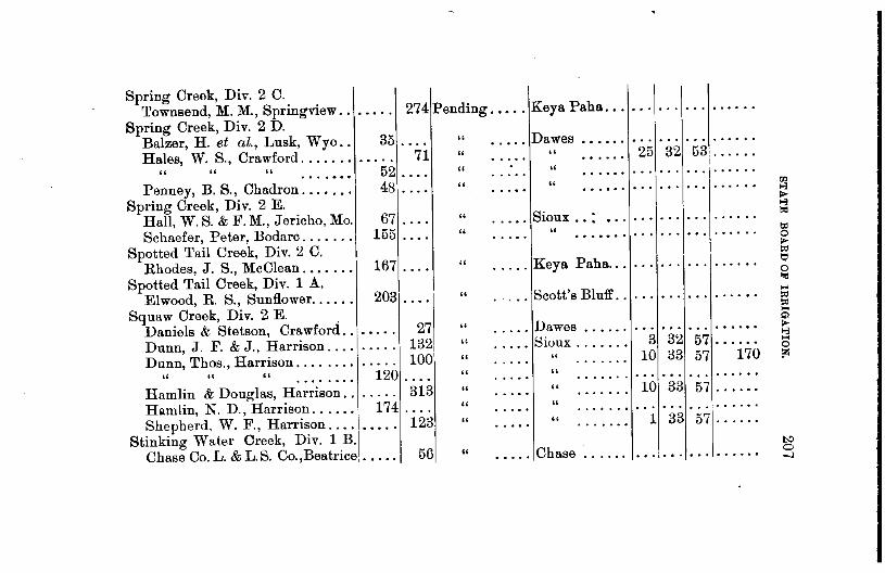
Spring Creek, Div. 2 C. Townsend, M. M., Springview .. 0 ••• 0 274 Pending .•••. Keya Paha ...
Spring Creek, Div. 2 D. Balzer, H. et al., Lusk, Wyo .. 35 " Dawes
0 ••• 0 ••••
Hales, W. S., Crawford ....•.. 71 " " 25 32 53 • 0 0. 0.
" " " 52 " " . . . . . . . 0 •••
Penney, B. S., Chadron ...•.•. 48 " " "' .... .., Spring Creek, Div. 2 E.
II-.., Hall, W. S. & F. M., Jericho, Mo. 67 " Sioux .• :
t<l .... 0 •••• . .. Schaefer, Peter, Bodarc ....... 155 " "
~ 0 •••
. ...... 0 II-
Spotted Tail Creek, Div. 2 C. ~
Rhodes, J. S., McClean ....... 167 " Keya Paha ... t:;1 .... . .... 0
Spotted Tail Creek, Div. 1 A.. ,.
Elwood, R. S., Sunflower ...... 203 " Scott's Bluff .. ...
0 ••• 0 '' 0. ~
Squaw Creek, Div. 2 E. ~ ... "' Daniels & Stetson, Crawford .. 27 " Dawes II-
0 ••• 0 ••••• 0 .., Dunn, J. F. & J., Harrison .... 132 " Sioux ....... 3 32 57 . . . . . . ... ..... 0
Dunn, Thos., Harrison ........ 100 " " 10 33 57 170 t>: •• 0 ••••
" " " 120 " " ...... • 0 •••• 0 .. . . . . • •• 0 •••
. . . . . . . .. Hamlin & Douglas, Harrison .. 313 " " 10 33 57 0 •••••
• • • 0. • 0 •••••
Hamlin, N.D., Harrison ...... 174 " " ...... • 0 0.
0 0 ••••• . . . . . . . .. Shepherd, W. F., Harrison .... 123 " " 1 33 57 •• 0 ••• . . . . . . .
Stinking Water Creek, Div. lB. 1':)
Chase Co. L. & L.S. Co.,Beatrice, ..... 56 " Chase 0 0 •• 0 •• . . . . . . ... -J

ALPHABETICAL INDEX OF CLAIMS AND APPLICATIONS BY STREAMS-Continued.
NAME OF CLAIMANT. I CLAIM I APP-1 DATE 011' PRIOR· I NO. NO. ITY,
Stinking Water Creek, Div. 1 B. Chase Co. L. & L.S. Co.,Beatrice 0 0 ••• 57 Pending ..... Chase Co. L. & L.S. Co.,Beatrice 76 • • • 0 Dec. 21, 1894 Chase Co. L. & L.S. Co.,Beatrice 77 ..... Jan. 21, 1895 Chase Co. L. & L.S. Co.,Beatrice 73 .... Jan. 29, 1895 Chase Co. L. & L.S. Co., Beatrice 74 • 0 •• Jan. 28, 1895 Chase Co. L. & L.S. Co.,Beatrice 75 .... Mar. 10, 1894 Cummings, W. R., Palisade .... 250 ••• 0 Dismissed .... Culbertson!. & W.P. Co.,Culb'ts'n 136 • • • 0 May 16, 1890
Sweeney Canyon, Div. 2 C. Hornback, J. N., Sparks ...... 145 0 ••• Pending .•••.
Thompson Creek, Div. 1 B. Johnson, Theo., Fairfield ...... 174 " •• 0 • 0 .....
Trunk Butte Creek, Div. 2 D. . Smock, Marcus, Whitney ...... 50 " ....
Turkey Creek, Div. 1 D. Lane, J. K., Pleasant Hill .... 239 " •• 0 0 ..... Lane, J. K., Pleasant Hill .... 81 " . . • 0. 0. 0 ••
Lakin, W. H., Dorchester ..... 218 " • 0 0 • 0 .....
OOUNTY.
Chase . ..... .. ••• 0 ••
" • •••• 0
" . ...... " . .....
• •••• 0 ••••••
Hayes 0 ••••• .. • 0 ••••
Cherry ......
Webster . ... Dawes •.....
Saline ...... " . ..... " 0 0 0 •••
I LOCATION 011' I ACRES HEADGATE. COVERED
s. T. R. . . . . . . . . . • • 0 •••
26 7 37 320 14 7 38 105 14 7 38 130 13 7 38 140 10 7 38 200 . . . ... . .. . ..... 31 5 33 0 0 ••••
. . . . .. . .. 0 •••••
. . . . . . . . . . .....
. .. . .. . . . • ••• 0 •
. .. . . . . . . • •• 0 ••
4 7 3 ...... 34 8 2 ......
!>:> 0 00
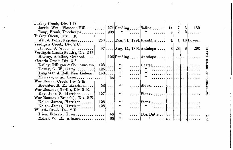
Turkey Creek, Div. 1 D. Jarvis, Wm., Pleasant Hill .... Roop, Frank, Dorchester .•....
Turkey Creek, Div. 1 B. Wilt & Polly, Naponee ....... .
Verdigris Creek, Div. 2 C. Hanson, J. W .............. .
Verdigris Creek (South), Div. 2 C. Harvey, Adeline, Orchard .....
Victoria Creek, Div. 2 A.. Dailey, Gilligan & Co., Anselmo Dewey, G. W., Gates ........ . Langhran & Bell, New Helena.. McGraw, et al., Gates ...•...•
War Bonnet Creek, Div. 2 E. Brewster, B. E., Harrison .....
War Bonnet (North), Div. 2 E. Kay, John S., Harrison ...... .
War Bonnet (Branch), Div. 2 E. Nolan, James, Hardson .....•. Nolan, James, Harrison .....•.
Whistle Creek, Div. 2 E. Irion, Ed ward, Town ........ . Miller, W. R., Alliance ...... .
271 Pending ..... Saline 208 " "
256 ...• Dec. 31, 1891 Franklin .•..
97 ...• A.ug. 11, 1894 Antelope
. . . . . 106 Pending ..... Antelope
123 " Custer ..... . . . . .. ~ .. 0 0
125 " " .... ..... • 0
150 " " ..... ..... 0 0
44 " " ..... 0 0
58 " Sioux.. . . . . ..... .... • 0
197 " Sioux ........ . . . . ..... 196 " Sioux .... 00 •• . . . . .... 198 " " ....
58 " Box Butte .... 0 0 0
65 " "
14 7 3 160 5 7 3 .... 00
4 1 16 Power.
8 28 8 290 "' Jo3 > Jo3 l>l
to 0 > "' t::l 0 '<I .... "' !;<1 .... 0 > Jo3 .... 0 !<:

ALPHABETICAL INDEX OF CLAIMS AND APPLICATIONS BY STREAMS-Continued.
NAME OF CLAIMANT.
White Tail Creek, Div. 1 A. Foster, Frank, Keystone ...... Foster, Frank, " . . . . . . Holloway & Phelps, Ogalalla .. Keystone lrr. Co., " . . Reed, Fred, Keystone .... . . . . Leonard Bros., Keystone . . . . . Ogalalla L. & c. Co., Ogalalla. McCarthy, J. M., Keystone . . .
White Clay Creek, Div. 2 D. Brockway, D. 8., Crawford .... Cooper, Wm., " . . . . Hazelton, w. 8., " ' ... Hutzell, Levi, Rushville ...... Thornton & Pomery, Crawford. White River lrr. Co., "
White Clay Creek, Div. 2 D. Ball, R. M., Rushville ........ Brooks, L. A., " • • • • • 0 ••
•
I CLAIM I APP., DATE OF PRIOR· I
NO. NO. ITY. COUNTY.
33 • 0 •• Pending ..... Keith ....... 230 " " .... • 0 0 •• . ...... 274 " " ... 0. • • 0. 0 •• 0 0 •••
17 " " ..... . .... . ...... 231 " " .... . .... • • 0 .....
257 " " .... . .... . ...... 252 .... " " ..... . ...... 167 " " .... • • 0 •• . .....
256 " Dawes 0. 0 •• 0 •••• • 0 ••••
42 " " ..... . .... . ..... 41 " " .... . .... . .....
306 " " • 0 ••• 0 • 0 •• . ..... 30 " " •••• 0 •• 0 •• . .....
111 " .. .... . .... • •••• 0
305 " Sheridan ..... . . . . . ..... 198 " " . . . . . 0 0 ••• . ....
I LOCATION OF I ACRES
HEADGATE. COVERED
s. T. R. . .. . . . 0,. . ..... . . . . .. . . . . ..... . . . . . . . . . • 0. 0 ••
. . . . . . . . . . . . . . .
. . . . .. . .. 0 •••••
. . . . . . . . . 0 •••••
. . . . .. . .. . .....
. .. . . . . .. . ..... 36 31 22 250
.. ~1-~~ 52 . .....
14: 33 45 160 1 30 52 460
... . .. . . . 0 •••••
23 33 45 160 2] 33 45 80

White Clay Creek, Div. 2 D. Pine Ridge Agency, Pine Ridge
White Horse Creek, Div. 1 A. 73 .... Pending ..... Sheridan .....
Lampl ugh, I., North Platte.... 242 .... White River, Div. 2 D. " . .... Lincoln .....
Bartlett, A. M.,Chadron . . . . . . . . . . . 290 Pending ..... Dawes Butterworth, J. H., Crawford.. 172.... " " Carpenter, E. J. & Co., Whitney 75 . . . . " " Cooper, P. S. et al., Crawford.. 76 " " Crawford Co., Crawford . . . . . . 165 . . . . " " Diedrichson, Nels., Glen...... . . . . . 302 " " Dorington, F. M .. et al., Alliance . . . . . 72 " " Force, F., Harrison ......... ·r· . . . . 50 " " Hall, Leroy, Crawford. . . . . . . . 70 . . . . " " Harrison & Cooper Co., Crawf'd' 46 . . . . " " Harris, A. V., Whitney. . . . . . . 18 . . . . " " Jacobson, M., Glen . . . . . . . . . . 193 . . . . " " Jensen, J., Lead City, S.D.... . 199 . . . . " " Rasher, Charles, Crawford . . . • 110 . . . . " " Seeley, Charles, Ravenna.... . . 109 . . . . " " Welling, N., Crawford.... . . . . 10 . . . . " " White River I. Co., Crawford.. 111.... " "
Willow Creek, Div. 1 A.
.. .1. .. I ......
4 33 44 140 ••••••• 0 •• 0 ••• 0
• • • • • 0 •• 0 • 0 0 • 0 0
2tl 33 50 ..... . ... 1 .......... ..
11 30 54 15 0 •• ••••••• 0 0 0 0 0
31 31 54 80
Stewart & Zink, Stewart ..... . 101 .... Dismissed ... Holt . . . . . . . . 19 31 15 ..... .

ALPHABETICAL INDEX OF CLAIMS AND APPLICATIONS BY STREAMS-Continued.
NAME OF CLAIMANT.
Winter Creek, Div. 1 A. Bouton, C. A, Gering ....... .
Wind Springs, Div. 1 A. Maycock, J no., GE>ring ....... .
Wood River, Div. 1 A. Hanky, A. B., Alda. _ ....... . Lindlage, H. W., Alda. _ .... .
Wood River (North), Div. 1 A. Edmiston, J. H., Eddyville .. _.
Wood River (Middle), Div. 1 A. Edmiston, J. H., Eddyville .. _.
" " " Wyman Creek, Div. 2 C.
Horton, Isaac, Carns .......•. McCully, R. A., Carns .......•
Springs, not named, Div. 2 C. Conger, C. K, Norden ....... . Grant, C. S., Winfield. , ..... . Hutchinson, W. H., Pembrook .
I. CLAD! I' APP.I1
DATE OF PRIOR- I I NO. NO. ITY.
COU~TL
61 .... Pending .. _ .. !Scott's Bluff.
921 .... Pending ..... \Sioux ...... .
12 216
178
178 180
148 .. .. 12 .. ..
. . . . . 158 133 ....
... . . 141
./
.. "
"
" "
" "
" " "
. .... Holt "
. .... Dawson ......
. .... Dawson ..... . "
. .... iKeya Paha ... " "
..... KeyaPaha ... " " " "
I LOCATION OF I ACRES
HEADGATE. COVERED
S. T. R.

Springs, not named, Div. 2 c. Lewis, Ralph, Lutes ......... . . . . . 139 Pending ..... KeyaPaha ..• . .. . . . . .. . ..... Newman, P., Pembrook ....... 163 " " " . . . . . . . . . . . . . ... . . . . .. . ..... Opperman, L. B., Springview .. 94 " " " . . . . . . . . . . . . . ... . . . . .. . .....
Springs not named. Div. 1 .A. Cooper, E . .A., Camp Clarke ... 262 " Cheyenne .... . . . . ..... . .. . . . . .. . ..... Finn Bros., La Peer ........•. 124 " ,, . . . . ..... . . . . . . . .. . .. . ..... Newbury H., North Platte ..... 85 " Lincoln ..... . . . . . ..... . .. . .. . .. . ..... Newbury, H., North Platte .... 241 " Lincoln ..... . . . . ..... . .. . . . . .. . ..... Springs not named. Div. 2 B. Newton Land Co., Omaha ...•• 29 " Douglas 13 14 14 160 ..... . .... . ...
Springs not named. Div. 1 B. Cooper, James, Dickens ...... 245 " Lincoln .... . .... . . . . . .. . . . . .. . .....
Springs not named. Div. 2 D. Goff, T. L., Chadron ......•... 182 " Dawes ...... . . . . ..... . .. . . . . .. . ..... Mann, Chas., Chadron ...•.... 299 " Cheyenne . . . . . ..... . . . . . . .. . .. . ..... Uhlig, Max, Crawford 180 " Dawes ...... ........ . . . . . .... . . . . .. . .. . .....
Springs not named. Div. 1 E. Gunder, G. B., Sidney ........ 222 " ..... Cheyenne . . . . . . . . . . .. . .. . .....

214 REPORT OF SECRETARY
ABSTRACT OF CLAIMS FOR WATER IN THE STATE OF BOARD OF
DIVISION
CLAIMANT. NAME OF DITCH. STREAM.
McCook I. & W. P. Co. Meeker ......... Republican. 1 Cash D. Fuller ...... Fuller .......... Frenchman. 2 W. J. McGillen , • , , . Harlam . . . . . . . . . " 3 W. J. McGillen •.••. Aberdeen. . . . . . . . " 4 Frank McLain ...... McLain ......... Spring Ck. 5 0. H. Wissig ....... Champion W.P.&I. Frenchman. 6 Republican Riv. I. Co. Republican R.I. Co. Republican. 7 H. Cannon ......... Cannon ......... Indian Ck. 8 Eli Maranville ...... Maranville ....... Frenchman. () Allen Grant ........ Harlam . . . . . . . . . " 10 Patrick Walsh ...... Driftwood ....... Driftwood . 11 W. H. Trites, W. H. Davenport .... Trites & Davenport
E. C. Rodwell, C. M. Brown,
Canal ......... Republican. 12
Crawford Milling Co. Mill Power ...... MedicineCk 13 F. & M. lrr. Land Co. F. & M. Canal .... North Platte 14 E. Hubartt ......... Hubartt & Hall Ir.
& Land Co . . . . . " 15 L. J. Carrington ..... Frenchman Val. C. Frenchman. 16 Groesbeck, M. H., Cannon . . . . . . . . ... Groesbeck &Cannon Republican. 17 F. C. Phillips ....... Phillips ......... Muddy Ck. 11< John H. Abott, Walter Kimball, Gorden E. Thompson. Big Springs Canal. South Platte 19 Dundy Co. Irr. Co ... Dundy County .... N. F. Rep . 20 Del. Hickman D. Co. Del. Hickman D ..
1
Republican. 21 Thomas C. Kimsey, John W. Kimsey .... Kimsey .......... Indian Ck. 22

STATE BOARD OF IRRIGATION. 215
NEBRASKA FILED IN THE OFFICE OF THE STATE IRRIGATION.
NO. I.
a ~ a . 0
~ . .c O'C ~-g ~ . COUNTY. Q~
~i ~~ ::$ o- ""'' ="' z :>1 :>1
1 170 Hitchcock . 22.5 3.5 2 12 Chase ..... 6.5 0 •••
3 28 " 4 •••• 0 .... 0
4 21 " 1.1 ..... • 0 • 0
5 4 " 2 1.5 • 0 •••
6 65 " 13 0 •••• . .... 7 25 Dundy .... 8 .... 8 5 " 2.2 1.3 • 0. 0
9 16 Chase ..... 3 3.2 10 15 " 1.7 0 ••• • • 0.
11 500 Red Willow 1.5 1.5
12 14 Hitchcock. 2.1 3.2
13 130 Furnas .... • • • 0 .... 14 183 Lincoln ... 16.5 3.5
15 100 " 5.1 ... . ... 16 30 Hayes ••• 0 3.2 2.8
17 1382 Dundy .... 6.5 3.5 18 2 " 1 1 •• 0 0
19 10 Deuel ..... 2 2 20 6912 Dundy ••.. 11 .... 21 27 " 8 .... 0. 0.
22 1 " 2 . . . . ....
.; ~
,_ ~0 s ... . s~~ :s ~a~ 0
'" ~
26 0 ••• 0 0
6.5 0 •••••
4 $ 4650 1.1 3750 3.5 880
13 6500 8 3000 3.5 300 6.2 2435 1.7 535 3 1050
5.3 675
• • 0. . ..... 20 9455
5.1 1621 6 2600
10 12000 2 175
4 600 11 8000 8 2400
2 326
.$ ~
"" 0 ., ., ~ 0 0
$50000 . .....
4500 ..... ~
630 6000 2500 300
2300 427
1050
......
• • 0 •• 0
5019
800 1200
10200 100
400 • • 0 •••
2400
326
~.o ~~
~~ ·• 0 oo z
1200 0 0 0 0 0 0 0 0 0 0 0
196 56 25 30
454 238 24 46 30 12
159 0
••• 0 •
1430
460 160
2
0 0
2190 15
62 450 16:::
8
0
5 0 0
0

BEPOBT OP BEOBETARY
ABSTRACT OF CLAIMS
CLAIMANT. NAME OF DITCH. STREAM.
A. J. Thomas ....... \Thomas ......... Republican. 1 Farmers' Canal Co ... ! Farmers' Canal ... Frenchman. 2 Lounzo Marr ....... \Marr ............ Republican. 3 A. Van Sickle ....... Van Sickle ....... Indian Ck . 4
Thompson & VanSicklalTh~:~fen. ~ ~a-~ . . " . 5 E. E. Owens ........ Highland ........ Rock Creek 6 J. S. Owens & Son .... !owens ........... Rock Creek 7 E. F. Highland, A. P. Brown, J. R. Phelan, R. Williams ......... 'Phelan ..•....... Rock Creek 8 J. E. Chamberlain ... 'Chamberlain ..... Indiau Ck.. 9 ''-.-N. J. Allen, Sr. 1
N. J. Allen, Jr. J. F. Allen Frederick G. Larnerd. Allen & Larnerd .. Buffalo .... 10 Frank Foster ........ Foster Keystone .. White City. 11 Nelson A. Green ...... Green ........... 1Clear Creek 12 August C. Haney .... Haney .......... Lonergan
Creek ... 13 Thomas B. Curram ... Curram .•••..... Clear Creek 14 Gary T. Scott, Edwin C. Williams ... Scott & Williams .. Clear Creek 15 Riverside Ditch Co ... Riverside ........ S.Fork Rep.16 John W. Karr ....... Karr's .......... S. Fork Rep. 17 D. Gurnsey & Co .... South Gurnsey ... ·!Frenchman. 18 William A. Brown ... Sand Point D. Co .. N.ForkRep. 19 William A. Brown ... Brown .......... IN. ForkRep. 20 Ed. Wilson ......... Wilson .......... !Indian Ck .. 21 Edwin S. Crigler .... E. S. Crigler ..... 'LawrenceF.]22 Mutual Ditch Co .... Mutual ..•....... P. Seed Ck.l23
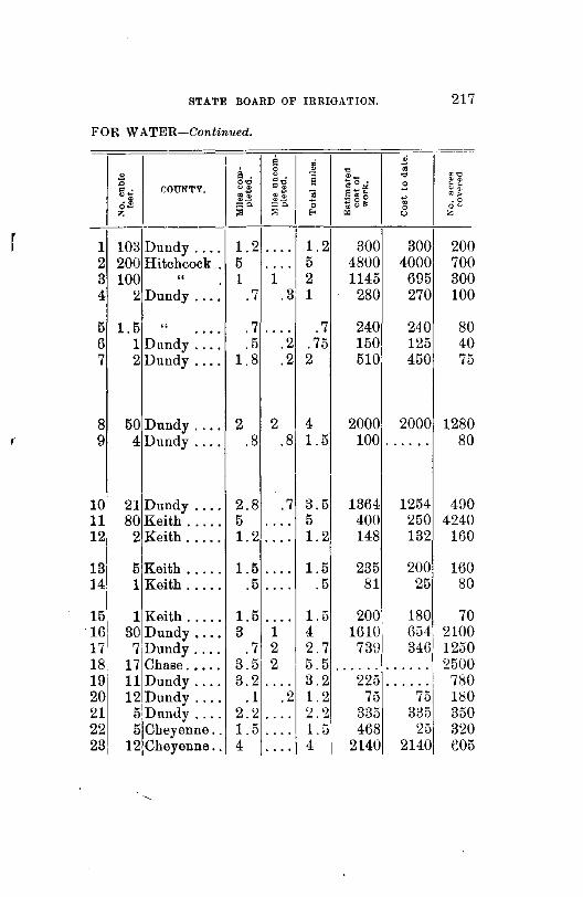
r
STATE BOARD OF IRRIGATION. 217
FOR WATER-Continued.
I s i!. g
~
:0 0'0 c . •ii .. COUNTY. ~· ~~ ~~ .~ . ~ •-" o- ="- ~~ z ::a
-
1 103 Dundy .... 1.2 .. 0. 2 200 Hitchcock . 5 .... 3 100 " 1 1 4 2 Dundy .... .7 .3
5 1.5 " .7 . -.. .... 6 1 Dundy .... .5 .2 7 2 Dundy .... 1.8 .2
8 50 Dundy .... 2 2 9 4Dundy .... .8 .8
101 21 Dundy ... , 2.8 .7 ul 80 Keith ..... 5 .... 121 2 Keith ..... 1.2 0 ••• I
131
5 Keith ..... 1.5 •• 0.
14 1 Keith ..... .5 0 •••
151 1 Keith ..... 1.5 0 •••
16 30 Dundy .... 3 1 17 7 Dundy .... .7 2 18 17 Chase ..... 3.5 2 19 11 Dundy .... 3.2 . . . . 20 12 Dundy .... .1 .2 21 5 Dnndy .... 2.2 .... 22 5 Cheyenne .. 1.5 .... 231 12 Cheyenne .. 4 • 0 0.
~ I
" il ~-~o.!oi
~ s~" ~gg
I 0
I E'< "' 1.2 300 5 4800 2 1145 1 280
.7 240 .75 150 2 510
4 2000 1.5 100
3.5 1364 5 400 1.2 148
1.5 235 .5 81
1.5 2001 4 16101
2.7 73ul 5.5 • 0 ••••
3.2 22i3 1.2 75 ~.2 335 l.ri 468 4 2140
.'i • "' .s ~ . 0 u
300 4000 695 270
240 125 450
2000 ......
1254 250 132
200 25
180 6i34 346
...... ••• 0 ••
75 335
25 2140
<oo . . "" 0, •• • 0 oo z
20 70 30 10
0 0 0 0
80 4 0 75
128 0 80
490 4240
160
160 80
70 2100 1250 2500 780 180 350 320 605
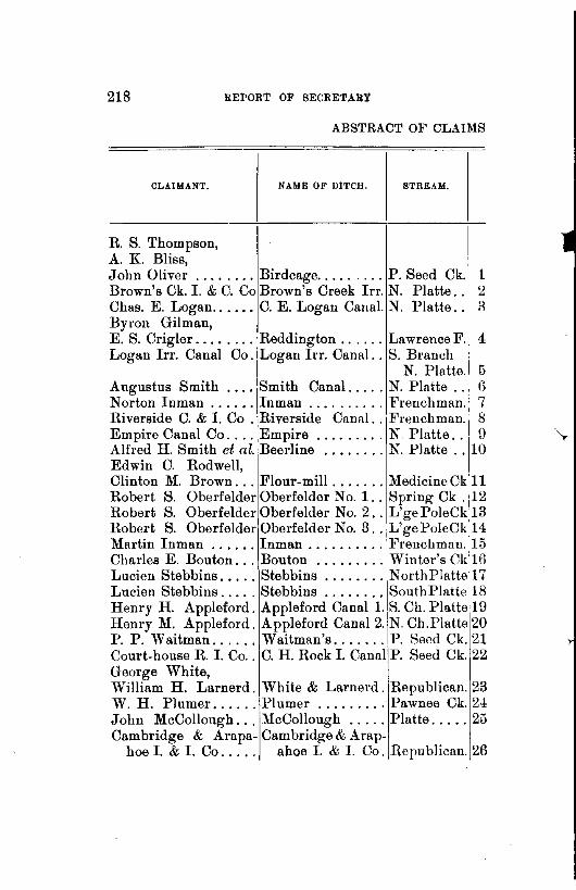
218 REPORT OF SECRETARY
ABSTRACT OF CLAIMS
CLAIMANT.
R. S. Thompson, A. K. Bliss,
NAME OF DITCH. STREAM.
John Oliver ........ Birdcage ......... P. Seed Ck.' 1 Brown's Ck. I. & C. Co Brown's Creek Irr. N. Platte .. · 2 Chas. E. Logan ...... C. E. Logan Canal. N. Platte. . R Byron Gilman, E. S. Crigler ........ Reddington ...... Lawrence F. 4 Logan Irr. Canal Co. Logan hr. Canal .. S. Branch
N. Platte. 5 Augustus Smith .... Smith Canal ..... N. Platte . . 6 Norton Inman ...... Inman .......... Frenchman. 7 Riverside C. & I. Co . Riverside Canal.. Frenchman.j 8 Empire Canal Co .... Empire ......... N Platte ..
1
U Alfred H. Smith et al. Beerline ........ N. Platte .. 10 Edwin C. Rodwell, Clinton M. Brown ... Flour-mill ....... Medicine Ckll Robert S. Oberfelder Oberfelder No. 1 .. Spring Ck . :12 Robert S. OberfelderOberfelder No.2 .. L'gePoleCk:l3 Robert S. Oberfelder Oberfelder No. 3 .. L'gePoleCkl4 Martin Inman ...... Inman .......... l<'rencbmnn. 15 Charles E. Bouton ... Bouton ......... Winter's Ck'16 Lucien Stebbins ..... Stebbins ........ NorthPlattei17 Lucien Stebbins ..... Stebbins ........ SouthPlntte 18 Henry H. Appleford. Appleford Canal 1.
1
8. Ch. Platte 19 Henry M. Appleford. A ppleford Canal 2.
1
N. Ch.Platte 20 P. P. Waitman ...... Waitman's ....... P. Seed Ck. 21 Court-house R. I. Co .. C. H. Rock I. Canal P. Seed Ck. 22 George White, William H. Larnerd. White & Larnerd. Republican. 23 W. H. Plumer ...... Plumer ......... Pawnee Ck. 2± John McCollough ... McCollough ..... Platte ..... 25 Cambridge & Arapa- Cambridge & A rap-
hoe I. & I. Co..... ahoe I. & I. Co. Republican. 26

STATE BOARD OF IRRIGATION. 219
FOR WATER-Continued.
8 ~ 0 il. g ,_
•<5 :a 0'0 c . s $0 .. =~ . "' .. = . COUNTY. "21 "• C+' gJ,! ] S"' • •• ..
~g~ o! ·- .0 :;::~ :o. 0 oo
z :>! :>! .. "' z
r 1 1 Cheyenne .. 1.4 .... 1.4 102 102 160 2 270 Cheyenne .. . . . . 23 23 34000 13900 13500 3 100 Cheyenne .. 1.5 .... 1.5 • • 0 •• • • • • • 0 400
4 8 Cheyenne .. 1 ••• 0 1 130 130 80
5 100 Cheyenne., 1.5 . . . . 1.5 • 0 •••• . . . . . . 400 6 50 Lincoln ... 2 2 4 1400 1000 3000 7 1 Chase ..... 1.5 .... 1.5 5891 47U 110 8 25 Hitchcock . 5.8 .5 6.3 .. ~~~~1 .. ~~~~ 1700 9 150 Cheyenne .. 6 •• 0 0 6 2560
10 58 Cheyenne .. 4.6 1.4 6 1795 1145 2000
11 • 0 0 0 Furnas .... . . . . 0 0 •• . . . . 20000 20000 • 0 •••
12 1 Cheyenne .. 1.2 • •• 0 1.2 1500 1500 250 13 5 Cheyenne . .7 .... .7 1000 1000 160 14 2 Cheyenne . .5 .... .5 1000 1000 220 15 4 Chase ..... 1.5 3.1 4.6 1443 479 280 16 61Scott's Bluff 1.5 .5 2 270 270 50 17 53 Lincoln .... . . . . 2.5 2.5 1250 50 0. 0 0 •
18 53 Lincoln .... .5 8.2 8.7 2400 335 UOGO 19 8 Lincoln .... 1.3 • 0 •• 1.3 2609 2609 :2560 20 76 Lincoln .... 3 .3 6 2U71 1275 3840 21 12 Cheyenne .. 4 .5 4.5 950 950 400 22 36 Cheyenne .. 5.1 .... 5.1 4050 4050 3H40
23 12 Dundy .... 2 1.2 3.2 590 315 350 24 31 Lincoln .... 1.1 .... 1.1 115 • • 0 0 0. 1600 25 50 Lii:J.Coln .... 2.5 4 6.5 2250 1250 4000
26 440 Furnas .... 15.8 15 30.8, 30000 30000 22000
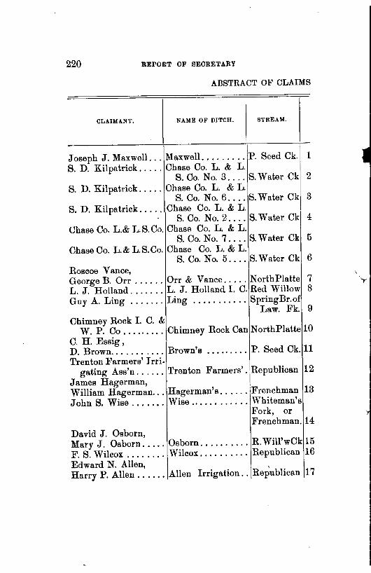
220 REPORT OF SECRETARY
ABSTRACT OF CLAIMS
CLAIMANT. NAME OF DITCH. STRE.\M.
Joseph J. Maxwell ... Maxwell. ........ P. Seed Ck. 1 S. D. Kilpatrick ..... Chase Co. L. & L.
S. Co. No.3 .... S.Water Ck 2 S. D. Kilpatrick ..... Chase Co. L. & L.
S. Co. No.6 .... S.Water Ck 3 S.D. Kilpatrick ..... Chase Co. L. & L.
S. Co. No.2 .... S.Water Ck 4 Chase Co. L.& Jj. S. Co. Chase Co. L. & L.
S. Co. No.7 .... S. Water Ck 5 Chase Co. L.& L.S.Co. Chase Co. L. & L.
S. Co. No.5 .... S.Water Ck 6 Roscoe Vance, George B. Orr ...... Orr & Vance ..... NorthPlatte 7 L. J. Holland ....... L. J. Holland I. C. Red Willow 8 Guy A. Ling ....... Ling ........... SpringBr.of
Law. Fk. 9 Chimney Rock I. C. &
W. P. Co ......... Chimney Rock Can NorthPlatte 10 C. H. Essig, D. Brown ........... Brown's ......... P. Seed Ck. 11 Trenton Farmers' J rri.
gating Ass'n ...... Trenton Farmers' .. Republican 12 James Hagerman, William Hagerman ... Hagerman's ...... Frenchman 13 JohnS. Wise ....••. Wise ............ Whiteman's
Fork, or Frenchman. 14
David J. Osborn, Mary J. Osborn ..... Osborn .......... R. Will'wCk 15 F. S. Wilcox ........ Wilcox .......... Republican 16 Edward N. Allen, , Harry P. Allen ...... Allen Irrigation .. Republican 17

STATE BOARD OF IRRIGA'l'ION. 221
FOR WATER-Continued,
- -- . a ~ $
:8 e . 8 .,- ~ . ..; ~0 "" O'C ~-g 8 ~ ~ 0 ~.
a ' COUNTY. ~· .. ~: ~ .. ~~ lli 'i 9"'-.$ ~g~ .. .. "
.o o- =g. =o. 0 0 ou z ::0 ::0 .. ~ c z
r 1 .... Cheyenne . 2 0 ••• 2 425 425 50
2 12 Chase ..... 1 .... 1 330 330 130
3 24 Chase ..... .9 .... .9 650 650 150
4 12 Chase ..... 1.6 .... 1.6 527 527 200
5 18 Chase .... , 2.4 .8 3.2 1003 1003 320
6 6 Chase ..... 1.1 .... 1. 220 220 150
7 3 Deuel ..... 2.5 .... 2.5 356 350 205 8 40 Red Willow 5 .... 5 5000 5000 2656
9 120 Cheyenne .. .3 .2 .5 145 80 80
10 840 Cheyenne .. 5.8 11 16.8 12587 3000 6770
11 6Cheyenne .. 1.5 1.5 3 300 212 200
12 100 Hitchcock. 7.5 7.5 15 10117 4523 7510
13 5 Hayes .... .2 .8 1 681 140 90
14 2 Hayes .... 1.2 .... 1.2 390 340 150
15 1 Frontier ... 1 1.5 2.5 215 215 150 16 40 Red Willow 1.2 5
:·21 1000 1000 5120
17 100 Furnas .... 3 2 1500 1204 1200

222 REPORT OF SECRETARY
ABSTRACT OF CLAIMS
CLAIMANT. NAME OF DITCH. STREAM.
Adam Gunderson . . . . Adam Gunderson. Irr. and Mill .... L' gePoleCk 1
Six Mile Ditch Co .... Six Mile Ditch .... Platte. . . . . 2 John W. Harper .... Spring Branch ... Lawrence F. 3 John Maycock ...... Wind Spring Canal Wind Spr.. 4 James L. Finn, Henry T. Dean ...•.. Last Chance ..... P. Seed Ck. 5 Eliza C. Smith, Charles G. Wheeler .. Smith & Wheeler . P. Seed Ck. 6 Lowell Farmers' I. C. Lowell Irrigation. S.Ch. Platte 7 Short Line I. & C. Co. Short Line Irr. 0 . North Platte 8 Oasis Ditch Co ...... Oasis ........... Snake Ck. . 9 Russel H. Fowles .... Maxwell Canal ... Platte ..... 10 South Side I. & L. Co South Side Irr .... N.&S.Platte 11 M. N. Holcombe ..... Holcombe ....... PawneeCk.12 N. Platte I. & L. Co .. North Platte Canal NorthPlatte 13 Firth Booth ......... Booth Canal ..... L'gePoleCkl4 G. J. Holcomb, F. M. Smith ........ Holcomb & Smith. Sand Ck ... 15 Paxton & Herstey lrr.
& Land Co ....... Paxton & Hershey Irrigating Canal NorthPlatte 116
Joseph Maycock ..... Booster . . . . . . . . . " 17 E. A. Johnson ...... Johnson. . . . . . . . . '' 18 William W. Willard .. William Willard .. P. Seed Ck. 19 Charles 0. Endernd, Silas D. Campbell ... Endernd ....... . " 20 Equitable F. & S. Im.
Co. S. of Neb., Lim Fremont Creek ... Fremont Ck 21 Gothenburg R. & I. Co Gothenb'g P.& I. C. Platte ..... ~2 Lewis H. Hale ...... Hale ............ L'gePoleCk 23 Lewis H. Hale ...... Hale No. 2....... " 24 Ed. Herrington . ..... Herrington . . . . . . " 25

r
STATE BOARD OF IRRIGATION. 223
~'OR WATER-Continued.
li. 0
:0 2~ . . COUNTY . 0~ f~ • o.s:; ::;c. z ;;;
1 2 Cheyenne . .7 2 40 Dawson ... 7.5 3 1 Cheyenne . 1 4 2 Sioux ..... 1.7
5 160 Cheyenne . .3
6 8 Cheyenne . 1 7 200 Kearney .. 4.5 8 107 Cheyenne . 1.8 9 12 Box Butte. 5
10 240 Lincoln ... 3.5 11 1000 " 28 ... 12 8 " 3.2 . . . 13 320 " 21.5 ... 14 2 Cheyenne . 1.5
15 7 Keith .•... 2
16 160 Lincoln .. ·Ill 17 50 Scott's Bluff 1 18 1 Lincoln ... .2 19 6 Cheyenne . ....
2 0 6 Banner .... 1
1 25 Lincoln ... 3.4 2 2 2 2 2
2 2800 " ... 17.5 3 2 Cheyenne . • • • 0
4 1 " • 0 ••
5 5 Deuel ..... 1.5
li ~ 0 .,~
~ . ~ $0 me .. ='l1 d .... "" "• ~$ ] s~" •• ~g~ .o =o. 0 oo :>1 .. " z
.... .7 995 995 160 2 9.5 5000 3600 2800 .... 1 250 250 1:!80
.5 2.2 234 219 100
3 3.3 2000 700 1100
.... 1 275 200 240 2.5 7 6350 4445 9020 iLl 4.9 2825 1542 4590 6.5 11.5 7075 4675 3840 3.71 7.2 7100 2600 14720
14 42 74370 36500 8U60 0 ••• 3.2 2000 2000 U60 0 ••• 21.5 • 0 0 0 •• • • 0. 0 • 40000 ••• 0 1.5 997 997 320
.... 2 157 157 480
6 17 15200 15200 7400 10 11 5130 166 2920
.5 .7 300 225 100 1.1 1.1 1435 185 240
.... 1 120 120 85
.... 3.4 592 592 610 14 31.5 300000 300000 32000 .... .... 310 310 50 • • 0 • • 0 0. 225 225 80 .... 1.5 10 10 640

2~4 BEPOBT OF BECBETABY
ABSTRACT OF CLAIMS
CLAIMANT, NAME OF DITCH. STREAM.
Lewis H. Hale ...... Hale No. 3 ...... L'ge PoleCk 1 Lee Munn .......... Round House Rock P. Seed Ck. 2 Lewis H. Hale ...... Hale No.4 ....... L'gePoleCk 3 E. D. Murphy ....... Murphy's Canal .. Pawnee Ck. 4 Leroy Sides ........ Leroy Sides' ..... S. Ch. Platte 5 Castle Rock lrr., C. &
Water Power Co ... Castle Rock Irr. C. N orthPlatte 6 Elm Creek lrr. Co ... Elm Creek Canal . Platte. . . . . 7 J. C. Gyger ... , .... Gyger .......... NorthPlatte 8 Rush Cret'k Irr. C. Co. Rush Creek lrr. C. " 9 L. B. Cary ......... Meradith & Am mer. P. Seed Ck. 10 Finn Bros . . . . . ..... Finn Bros ....... Spring on se
i 28-18-4911 A. C. Booker ....... Booker Canal .... N. Ch.Platte 12 John A. Wilcox ..... Wilcox & Brown .. North Platte 13 Harvey Brown ....•. Cold Water ...... Cold Water 14 Adam Miller ....•.•. Miller Ditch ..... Skunk Ck . 15 Charles W. Wilson .. Wilson .......... Little Blue. 16 John S. Saunders .... Saunders I. Plant. MedicineCk 17 John Miller ......... Brush Creek Res .. Brush Ck .. 18 Marcus S. Brown .... M. L. Brown Irr .. R. Will'wCk 19 William Byfield ..... Byfield Irrigation. Republican. 20 Fremont Young ...... Young's Private ... Frenchman. 21 Bartley Canal Co ..... Bartley Canal. .... Republican. 22 Culbertson 1.& W.P. Co Culbertson!. W. P.C Frenchman
& S. Water 23 Frederick W. Kreuger Kreuger's No.3 ... L'gePoleCk 24 Frederick W. KrAuger Kreuger's No. 2... " 25 Frederick W. Kreuger Kreuger. . . . . . . . . " 26 Ernest Meyer ....... Oak Mill Race .... IJittle Blue. 27 William T. Young .... Young's ......... L'gePoleCk 28 Carl Ruttner ........ Ruttner . . . . . . . . . " 29 B. A. Jones . . . . . . . . . Bordwell . . . . . . . . " 30

STATE BOARD OF IRRIGATION. 225
FOR WATER-Continued.
il ~ ~
il. 0 • " " .li ~ . 8 .Be; • " .,
.Q 0'0 p"g 0 ~· g~ COUNTY. "$ ~~"' ~ ~~ g)~ ~~ Oj ~~~ 1il .. ;; .o o- :;:::;:~. ""' •" 0 oo z ::; ::; ... ~ " z
1 I .
.. .. $ 55$ 55 40 !Cheyenne .. .... . . . . 2 41 " . 1.3 .7 2 300 225 300 3 . 5 " . • 0 •• . . . . • 0 •• 85 85 40 4 36Lincoln ... 1.5 3.5 5 2192 615 1800 5 40! Kearney ... 4.1 .4 4.5 1400 1040 2170
6 594 Scott's Bluff 18.7 .5 19.2 27466 19948 5780 7 300 Buffalo .... 11.2 8.8 20 23100 13816 14000 8 10 Deuel ..... .2 1.3 1.5 323 61 760 9 27 " 1.7 2.3 4 1400 383 675 . . . ~
10 30 Cheyenne 5 • • • 0 5 2500 ...... 1320
11 1£ " 1 1 110 110 160 .... 12 50 Dawson ... . ... . . . . 0 ••• 1920 200 3500 13 2l Deuel ..... 4 1 5 • •••• 0 ...... 1040 14 6 " 1.5 1.5 445 445 350 • 0 ••• .... 15 4 Keith ..... 1.3 . ... 1.3 261 45 320 16 10 Adams .... .... • 0 •• . . . . 1000 1000 120 17 2 Frontier ... .5 .... .5 490 490 100 18 1 Frontier .. , .5 .... .5 1005 1005 70 19 1 Frontier .. , .1 .1 .2 228 134 15 20 120 Red Willow 2 5 7 6950 1875 2000 21 4 Chase ..... .2 2.2 2.5 46 46 60 22 64 Red Willow 5.5 0 ••• 5,5 10100 10100 3200
23 560 Hitchcock .. 35.3 66.2 101! 204467 146881 3£1260 24 <1, Cheyenne .. 1 0 ••• 1 610 610 160 25 4 Cheyenne .. 1 .... 1 610 610 125 26 7 Cheyenne .. 2 • 0 •• 2 715 715 480 27 170 Nuckolls ... 1 .... 1 5400 5400 320 28 11 Kimball ... 1.5 .... 1.5 210 47 80 29 4 Kimball ... 1.2 .... 1.2 690 690 320 30 10 Cheyenne .. 1 .5 1.5 600 500 100

226 REPORT OF SECRETARY
ABSTRACT OF CLAIMS
CLAIMANT. DITCH. STREAM.
B. A. Jones .......•. Bordwell No. 2 .... L' ge PoleCk 1 Wm. T. Whitney ..... Whitney . . . . . . . . " 2 A. B. Persinger ...... Persinger. . . . . . . . " 3 C. S. Ickes .......... Ickes . . . . . . . . . . . " 4 James Mitchell ...... Mitchell . . . .. . . . . " 5 Mortz Urback ....... Urback . ·......... '' {) Lambert C. Kinney ... Premier . . . . . . . . . " 7 Sarah A. Kinney . .... Smeed. . . . . . . . . . . " 8 Stillman A. Pierce . .. Independent . . . . . " 9 Chas. J. Gross . ...... Hoover . . . . . . . . . . '' 10 Henry H. Libby . .... Libby . . . . . . . . . . . " 11 Wm. T. Whitney ..... Whitney No. 2.. . . " 12 Alice T. Howard . .... Howard.. . . . . . . . . " 13 James J. Kinney . .... Kinney No. 2. . . . . " 14 Reuben Lisco ....... Lisco ............ North Platte 15 Jacob H. Winterer ... High Line ....... Blue Creek. 16 H. J. Bushnell, E. N. Bushnell ...... Bushnell Bros .... North Platte 17 William J. Kelley .... William J. Kelley. P. Seed Ck .. 18 Cozad Irrigation Co .. Cozad Irr. Canal .. Platte ..... 19 Henry L. Heard ..... Heard's No. 1 & 2. P. Seed Ck. 20 David C. Hooper .... Clear Creek ...... Clear Creek 21 Farmers' M. Irr. Co .. Farmers' Canal ... N. Ch. Platte 22 Eq. Farm & I. Co. of
Neb., Limited ..... West Side Birdw'd Birdwo'dCk 23 John M. McCarthy ... JohnM. McCarthyiWh.TailCk. 24 John Robinson, Henry Gumaer ...... Oshkosh Canal ... N orthPlatte 25 Cody & Dillon Irr. &1 Cody & Dillon Irr.
Canal Co..... . . . . Canal ......... 1NorthPlatte 26 John F. Peters ...... Peters •......... P. Seed Ck. 27 Nels Berguson, Ira Peasley, A. F. Ramsay ....... West Side .. , .... ,Blue Creek. 28

STATJ! BOARD OF IRRIGATION. 227
FOR WATER-Continued.
il. il .; .s 0 ~ "' " m.,; ~ . 8 $0. "' 0'0 •"' s ~~ COUNTY. "$ ii .. a~~ O&
~ •& .. "~ .; &- ..., ~g~ .o =o. :;;o. 0 ~ oo :!1 :>! Eo< ~ 0 z
1 10 Cheyenne .. 1 .... 1 $ 1025 $ 1025 150 2 6 " 600 600 200 ...... . . . . . . . . 3 5 " 2.5 2.5 35 25 320 . . .... 4 23 " 1.2 .8 2 474 474 400 .. 5 23 " 1 1 500 500 60 . . .... 6 5 " .7 .3 1 500 500 100 .. 7 6 Kimball ... 4 • 0 •• 4 1250 1250 480 8 6 " 3 3 2050 1300 320 ... 0. 0 0
9 10 " 2.5 2.5 1200 1200 300 . . . • 0 ••
10 6 " 1.5 1.5 300 300 100 . . . .... 11 12 Cheyenne .. 3 .... 3 0 •• 0 •• • •• 0 • 0 640 12 6 Cheyenne ...... 0 ••• • 0 •• 500 500 150 13 2Cheyenne .. . 5 .5 1 325 325 160 14 4Kimball ... 2.2 .... 2.2 455 445 200 15 50 Deuel ..... 6.7 2.5 9.2 2150 1150 5280 16 20 Deuel ..... 1.2 5.8 7 2075 850 1400
17 10 Deuel ..... 2 .... 2 247 230 500 18 2 Banner .... .3 .... .3 168 168 140 19 1000 Dawson ... 23 16 39 94375 .~~~~r3o~g 20 21 Banner .... 1.4 •• 0. 1.4 149 21 2 Deuel. .... 2 2 4 35 35 200 22 40 Buffalo .... 2.4 21.7 24.1 12346 224012800
23 12 Lincoln .... 2 1 3 1069 682 650 24 5 Keith ..... 1.2 0 ••• 1.2 275 275 172
25 40 Deuel ..... 4.3 ••• 0 4.3 1700 17000 3850
26 12000 Lincoln .... 13 3 16 10000 10000 12000 27 5 Banner .... 1 1 2 205 205 200
28 40Deuel. .... • 0 •• 6 6 3000 525 .
•
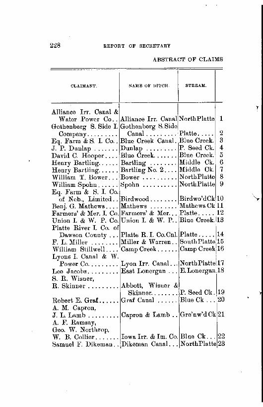
228 REPORT OF SECRETARY
ABSTRACT OF CLAIMS
CLAIMANT. NAME OF DITCH. STREAM.
Alliance Irr. Canal & Water Power Co .. Alliance Irr. Canal N orthPiatte 1
Gothenberg S. Side I. Gothenberg S.Side Company. . . . . . . . . Canal ......... Platte. . . . . 2
Eq. Farm & S. I. Co .. Blue Creek Canal. Blue Creek. 3 J. P. Dunlap ....... Dunlap ......... P. Seed Ck. 4 David C. Hooper .... Blue Creek. ...... Blue Creek. 5 Henry Bartling ...... Bartling ........ Middle Ck. 6 Henry Bartling ...... Bartling No. 2 .... Middle Ck. 7 William T. Bower ... Bower .......... NorthPlatte 8 William Spohn ...... Spohn .......... NorthPlatte 9 Eq. Farm & S. I. Co.
of Neb., Limited .. Bird wood ........ Birdwo'dCklO 'T Benj. G. Mathews .... Mathews ........ Mathews Ckj11 Farmers' & Mer. I. Co. Farmers' & Mer ... Platte ..... ~12 Union I. & W. P. Co. Union I. & W. P .. Blue Creek.l13 Platte River I. Co. of ··~
Daws?n County ... Pl~ttfo, R.I. Co.Cnl. Platte ..... 1~ F. L. Mrller ........ Mrller & Warren .. South Platte 1o William Stillwell .... Camp Creek ...... Camp Creek[16 Lyons I. Canal & W. I
Power Co ......... Lyon Irr. Canal. .. NorthPlatte 17 Lee Jacobs ......... East Lonergan ... E. Lonergan 18 S. R. Wisner, R. Skinner ......... Abbott, Wisner &
Skinner ........ P. Seed Ck. 19 Robert E. Graf •..... Graf Canal ...... Blue Ck ... 20 A. M. Capron, J. L. Lamb ......... Capron & Lamb .. Gre'nw'd Ck 21 A. F. Ramsay, Geo. W. Northrop, W. B. Collier ....... Iowa Irr. & Im. Co. Blue Ck ... 22 Samuel F. Dikeman .. Dikeman Canal ... NorthPlatte 23

STATE BOARD OF IRRIGATION. 229
FOR WATER-Continued.
a ~ ~ ~ a . 0 ,_
e.,; ~
"ii ~0 " :a 0'0
0 • ~ . f~ 0 • COUNTY. ~$
o'g . .. ~ ~~ ~~ g;,! ~ s~" .~ ~.! ~g~ ~ . 0 o- :::~ ="' 0 0 0~
z ;:; ;:; .. " 0 z
1 375 Cheyenne .. 9 5.4 14.4 $18449 $ 5969 14151
2 .... Lincoln .... • 6 •• 27.3 27.3 65000 • •••• 0 •• 0 • 0
3 300 Deuel ..... 9.2 8.8 18 17748 9160 13206 4 .5 Cheyenne .. .... • • 0 • . . . . 60 60 55 5 20 Deuel. .... 2.1 4 G.1 540 300 900 6 2 Cheyenne .. .5 .... .5 200 200 40 7 2 Cheyenne .. .4 .... .4 125 125 20 8 200 Deuel. .... 4.5 .5 5 2312 2262 14096 9 40 Deuel. .... .5 2 2.5 1135 500 920
10 lOOILincoln .... 20 5 25 20:204 17804 14810 11 1 Keith ..... .4 .... ' .4 84 55 80 12 592 Dawson ... 43.8 18.2 62 10ti340 84045 83980 13 60 Deuel ..... 4 1 5 3050 1676 1794
14 442 Dawson ... 16 .... 16 26092 3668 28440 15 53 Deuel ..... 0 •• 0 5.6 5.6 1092 175 3768 16 2 Cheyenne .. 1 ,5 1.5 315 215 225
17 75 Deuel. .... 5 1.7 6.7 2502 2170 2950 18 10 Keith ..... 2 .. 0. 2 675 675 800
19 141Banner .... 2.5 .... 2.5 265 265 200 20 100 Deuel. .... 5 3 8 3905 1743 4340
21 6 Cheyenne . 1.7 .... 1.7 550 550 160
22 34.Deuel. .... 3.5 • 0 •• 3.5 1550 1455 1000 23 70]Lincoln ... 1.7 13.2 15 950 950 5600

230 REPORT OF SECRETARY
ABSTRACT OF CLAIMS
CLAIMANT. NAME OF DITCH. STREAM.
JohnS. Wright. ... ·\1John S. Wright 2. P. Seed Ck. 1
JohnS. Wright ...... JohnS. Wright 2. P. Seed Ck. 2 B. M. Fox .. 0 ••••••• Overland Irr. Co .. NorthPlatte 0 J. Gurnsey & Co ..... North Gurnsey ... Frenchman 4 Michael H. Tobin .... 'fobin ........... L'gePoleCk 5 Will A. Hale ....... Homestead ...... NortbPlatte 6 Bay State L. S. Co ... Bay State ....... L'gePoleCk 7 Wilson S. Gould ..... Gould or Hamlin . Frenchman 8 J. V. Brady ......... Brady ........... L'gePoleCk 9 Farmers' D. & C. Co . .Farmers' Canal ... IPlatte ..... 10 Henry V. Redington .. H. V. Redington .. Lawr'nceFk 11 John C. Chamberlain. Chamberlain .... Indian Ck. 12 Lewis H. Hale ....... Hale ............ L' gePoleCk 13 Robert L. Ellwood ... Spotted Tail ..... Spot. TailCk 14 Chas. E. Trognitz ... Trognitz Canal ... 1 L'gePoleCk 15 Hans L. Christenson. Christenson No. 2. " 16 Hans L. Christenson. Christenson No. 1 . " 17 John M. Mcintosh ... John Mcintosh... " 18 Edgar A. Ph ill eo .... Philleo's ........
1
Little Blue. 19 Edwin A. Currie .... Currie ........... 1 Kiowa Ck. 20 David M. Coulter, H. M. Coulter ...... Coulter ......... Greenwood. 21 C. C. Nelson, J. E. Trinnier ...... Nelson Canal.... . " 22 J. E. Trinnier .... ... Trinnier Canal.. . '' 23 Herman Soehl ...... Soehl Canal ...... Lonerganck 24 James Nesbitt, H. W. Davenport .. 0 • Horse Creek ..... Horse Creek 25 Nine Mile C. & R. Co. Nine Mile Canal. . NorthPlatte 26 Geo. B. Gunder ..... Gunder Ditch .... Spring, not
named .. 27 N. P. Lyngholm ..... Lyngholm ....... L'gePoleCk 28
·John W. Hurley .... Polley . . . . . . . . . . " 29

STATE BOARD OF IRRIGATION. 231
FOR WATER-Continued,
-- -- -il ~
0 s. g ~ "'- ~ •od ~0 "' :0 0'0 ~-g s ~ .!oi .s ~f
g..,; COUNTY. 00 ~.
~~ '§ "~" •• • % .. .:: ~ 0 ~ ·- . -0 o- :::;C. :::c. 0 ~(,l!:t 0 oo z :;; ::; E-< 01 " z
1 3 Banner .... 2.5 • 0 •• 2.5$ 321$ 321 200 2 2 " 2 2 205 205 150 .... 0 0 0 0
3 100 Deuel. .... .... 5 5 3625 1565 2000 4 10 Chase ..... 3 2 5 ...... • 0. 0 •• 1440 5 11 Cheyenne . 1.7 .... 1.7 500 500 200 6 25 Scott's Bluff . . . . ••• 0 .... 1485 635 2300 7 7 Kimball ... 1.5 .... 1.5 610 610 125 8 2 Chase ..... 1.2 .... 1.2 690 690 140 9 17 Kimball ... .7 . . . . .7 • • 0 ••• . . . . . . .....
10 800 Lincoln. .. 26 4 30 53000 9127 • ••• 0
11 2 Cheyenne . .1 .... .1 3() 36 140 12 71 Dundy .... .8 1.2 2 285 ••••• 0 ..... 13, 1 Cheyenne . .2 .2 110 110 30 14 6 Scott's Bluff 1.2 .... 1.2 390 390 300 15 3 Cheyenne 1.2 .... 1.2 200 200 200 16 3 " .2 .2 40 40 50 .... 17 2 " .4 .4 40 40 30 •• 0 0
18 16 Kimball ... 2 .... 2 453 453 480 19 10 Adams .... .5 • 0 •• .5 250 250 70 20 11 Scott's Bluff 1 .... 1 580 580 640
21 40 Cheyenne 2 0 0 •• 2 - 150 150 800
22 12 " 2.2 2.2 1720 1720 720 ••• 0
23 12 " 2.5 2.5 1400 1400 600 0 •••
24 8 Keith ..... 2 .... 2 300 300 480
25 5 Dundy .... .7 .8 1.5 380 380 200 26 239 Scott's Bluff, 12 . 7 9.7 22.5 13697 10197 11960
27 .5 Cheyenne .. .2 • 0 •• .2 58 58 3 28 .5 .. 1 1 190 25 • <;• 0 • •• 0 ••
29 11 Kimball ... 1.5 0 •• 0 1.5 405 405 80

232 REPORT OF SECRETARY
ABSTRACT OF CLAIMS
CLAIMANT. DITCH. STREAM.
,John W. Hurley .... Hurl'y,Lily&Polley L'gePoleCk 1 Lee Jacobs ......... Rayland Canal. .. North Platte 2 Alfred Fernstrom, Peter N isson . . . . . . . Fernstrom & N isson " 3 G. J. Holcomb ...... Spring Creek .... Spring Ck. 4 John S. Grant ...... Harlan Cattle Co's Frenchman. 5 Frank Foster ....... Foster's Keystone. W. Tail Ck. 6 Fred Reed .... ...... Reed . . . . . . . . . . . '' 7 C. F. Roberts ....... Midland ......... North Platte 8 John W. Armstrong, Geo. W. Armstrong .. Armstrong ...... South Platte 9 Thomas Hayes ...... Thomas Hayes' ... Frenchman. 10 W. H. Shireman .... South Side Plano. South Platte 11 Russell R. Hampton, William D. Hampton. Hampton ........ P. Seed Ck. 12 D. P. Holloway ..... Spring Creek ..... Spring Ck. 13 Fisher, Polly & Co ................... Frenchman. 14 James K. Lane ...... Roller Mill ...... Turkey Ck. 15 Hannah Irr. Canal Co. Hannah Irr. Canal NorthPlatte 16 H. Newberry ........ Newberry ........ Ravine nw
cor. swl of s22-14-32. 17
Isaac Lampl ugh ..... Lamplugh ..•.... W.HorseCk 18 Geo. M. Simpson, Crook S. Banghart, Hugo H. Wendt ..... Signal Bluff ...... NorthPlatte 19 Henry T. Clark ...... H. T. Clark Canal. North Platte 20 .James Cooper ....... Cooper . . . . . . . .. RedW.Lake 21 Centrall.C.&W.P.Co. Central Irr. Canal. NorthPlatte22 Gustave Runge ...... Runge No. 2 ...... L'gePoleCk 23 Gustave Runge ...... Hunge No. 1 ...... L'gePoleCk 24 R. P. James ......... Flour & Grist Mill. Ft·enchman. 25 William R. Cummins. Cummins ....... Stinking W. 26
T

• STATE BOARD OF IRRIGATION. 233
FOR WATER-Continued.
e . e ~ ~ ~
0 "' ~.a ~ . ·~ "' :a 0-o ="' s -;; 0 • s ~f e.J COUNTY, ~$ ~~ E s~~ ~. .. ~~ .$ ·- -0 0 ~ .o
o~ ~0. "'"' 0 -;;~:.~It ~ 0~ 0 z ::; :; E-< r.1 " z
1 11 Kimball ... 2.1 .6 2. 7$ 677$ 677 270 2 11 Keith ..... 1 .5 1.5 750 500 920
3 43 " .2 5.8 6 1960 111 3000 •• 0 ••
4 1 " 1 1 GO 50 160 0. 0 •• • •• 0
5 2.2 Chase ..... 1.2 .... 1.2 : l 703 160 6 141Keith ..... 5.7 0 ••• 5.7 GUO 400 3840 7 . 5 " ..... .7 . 7 48 48 40 8 5 Deuel ..... 4 0 0 •• 4 750 750 1100
9 1!Keith ..... .2 .2 95 53 70 10 4]Chase ..... .1 .2 .3 45 45 20 11 1 Keith ..... .2 .8 1 191 50 100
12 9 Banner .... 1.2 1.3 2.5 120 120 160 13 1 Keith ..... 1 • 0. 0 1 100 100 110 14 . . . . • 0 •••••••• . . . . . . . . ••• 0 ....... • •• 0 •• . . . . . 15 . . . . Saline ..... • • • 0 .... .... 25000 25000 • • 0 ••
16 600 Cheyenne .. 2.5 .2 2.7 940 785 420
17 . . . . Lincoln .... .7 .... .7 35 35 320 18 all Lincoln .... .... . . . . 0 •• 0 • •••• 0 5000 640
19 40 Deuel ..... 1.5 2.5 4 2616 911 2109 20 35 Cheyenne .. 3 .. 0. 3 1720 1720 2500 21 2 Lincoln .... 1.5 .... 1.5 575 575 120 22 120 Scott's Bluff 4 3 7 8000 5000 2500 23 9 Cheyenne .. . 7 0. 0. .7 240 240 70 24 2 Cheyenne .. 1 .... 1 2!35 265 150 25 . . . . Chase ..... 0 ••• . ... ..... 6200
.. ~~~~~::::: 26 all Hayes ..... .... . . . . . ... . .....

234 REPORT OF SEORETABY
ABS'rRACT OF CLAIMS
CLAIMANT. NAME OF DITCH.
Fremont Young ...... Young's ......... Ogalalla Land & C. Co. White Tail. ...... Winters Creek Irr. Co. Winter Ck. Canal. . Andrew Carson ...... Carson No. 1. .... Andrew Carson ...... Carson No. 2 ..... Wilt & Polly ........ Wilt & Polly ..... Leonard Bros ....... Little Dandy ..... Gene D. Wright ..... Wright Mill ...... N. 0. Betts ......... Bett's .. • 0 •••••••
J. R. Porter & Sons .. J. R. Porter & Sons James M. Nesbitt, H. W. Davenport .... Horse Creek ...... Eliza A. Cooper ...... Cooper .......... John C. Chamberlain. Chamberlain ..... Anders Anderson .... Anderson's ....... John C. Chamberlain. Chamberlain DNol John F. Helm ....... Helm's .......... E. G. Neighbor ...... Neighbor ........ Frances B. Moore, Eliza A. Moore ...... Moore'sP.I.&M.P.C J. T. Ryan .......... Home Irrigation .. Enterprise Ditch Co .. Enterprise ...... Sutherland& PaxtonL.
& Irr. Co ......... Sutherland & Pax-ton L. & I. Co ..
Herman A. Patrick ... Patrick .......... T. A. Meyers, AI Phelps, F. P. Dickerson ..... Meyers & Phelps .. D. P. Holloway, AI Phelps .......... Holloway & Phelps Belmont I.C.&W.P. Co Bel.I.C.&W.P.Co.'s
I Canal ........
STREAM.
Frenchman. 1 W. Tail Ck. 2 North Platte 3 Republican. 4 Republican. 5 Turkay Ck. 6 W. Tail Ck. 7 Beaver Ck. 8 Peppermint 9 Buffalo Ck. 10
Horse Ck .. 11 Sw.L.D.Out 12 Indian Ck .. 13 Republican. 14 Indian Ck .. 15 R.Will'wCk 16 N. Fk. Rep. 17
Buffalo Ck. 18 South Platte 19 N orthPlatte 20
NorthPlatte 21 Sand Ck ... 2 2
NorthPlatte 2
Wh. Tail Ck 2
NorthP!atte 2
3
4
5
•
T
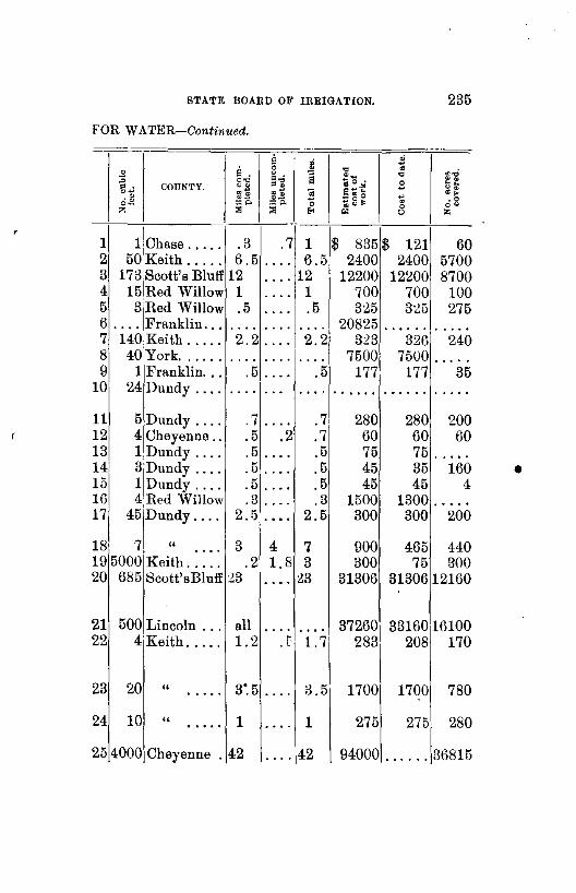
STATE BOARD OF IRRIGATION. 235
FOR WATER-Continued.
a a . 0
~ " 0'0 = . ="' = . COUNTY. ".11 ~~ "'<: ~.! . ~ =~ :o. o-z :>l :>l
1 I . 3 .7 11
Chase ..... 2 50 Keith ..... 6.5 .... 3 173 Scott's Bluff 12 .... 4 15IRed Willow 1 .... 5 31Red Willow .5 0 •••
6 .... Franklin ... 7 140Keith ..... 2.2 8 40,York ...... . . . . . . . . 9 1 Franklin ... .5 •• 0 0
10 24 Dundy .... .... . ...
11 5 Dundy .... .7 .... 12 4 Cheyenne .. .5 .2 13 1Dundy .... .5 • 0 ••
14 3Dundy .... .5 • • • 0
15 1 Dundy .... .5 .... 16 4Red Willow .3 • 0 ...
17 45 Dundy .... 2.5 0 •• 0
18 7 " 3 4 • 0 ••
19 5000 Keith ..... .2 1.8 20 685 Scott'sBluff :23 ....
21 500 Lincoln ... all .... 22 4 Keith ..... 1.2 r
23 20 " 3". 5 •••• 0 0 •••
24 10 " 1 •• 0 • 0 .... 25 4000 Cheyenne . 42 • 0 ••
~ "' ] ~-~ 0 •
:§ s~'f ~8~ 0
"' 01
1 $ 835 6.5 2400
12 12200 1 700 .5 325
• • 0. 20825 2.2 3:23 . . . . 7500
.5 177 . . . } 0 0 •• 0 0
.7 280
.7 60
.5 75
.5 45
.5 45
.3 1500 2.5 300
7 900 3 300
23 31306
• •• 0 37260 1.7 283
3.5 1700
1 275
42 94000
~ "' s ~ 0 0
$ 1211 2400 12~00
700 325
• • 0 •••
326 7500
177 0. 0 0. 0
280 60 75 35 45
1300 300
465 75
31306
33160 208
1700
275
• ... 0.
. .,; ·~ "" "• ·~ • 0 oo z
60 5700 8700
100 275
• • 0 ••
240 .....
35 •• 0. 0
200 60
..... 160
4 • 0 •••
200
440 300
12160
16100 170
78
28
3681
0
0
5
•

•
236 REPORT OF SECRETARY
ABSTRACT OF CLAIMS
CLAIMANT. NAME OF DITCH. STRE.\M.
Yorick Nichols, CaroB Nicholls ...... Ram's Horn ..... North Platte 1 Henry Grovert, J. W. Frey .......... Grovert & Frey ... Republican 2 Oscar F. Nelson .... Nelson . . . . . . . . . " 3 Wllliam H. Moore ... Rfld Willow Mill .. R. Will'wCk 4 J. T. Hansberry ..... Bloomington Mil!R Big C. W. Ck r. Mathew A. Daugherty Alfalfa Ir. Dist. Cnl NorthPlatte 6 J. J. Kinney ........ Kinney Ditch,No.2 L'gePoleCk 7 Orin Reed .......... Cereal Irrigation .. SouthPlatte 8 Adam Hull .. ........ Allen Hull. . . . . . . " " 9 J. Wai;,e Sheridan .... Sheridan & Wilson NorthPlatte 10 Adam Miller ........ Extension of Miller Skunk Ck .. l1 Carl E. Borquist ..... BorquistCana!No.1 L'gePoleCk 12 John M. Adams ...... Adams . . . . . . . . . . " " 13 Carl E. Borquist. .... BorquistCanalNo.2 " " 14 John 1\f. Adams ..... Adams No. 2. . . . . " " 15 John M. Adams ..... Adams No. 3. . . . . " " 16 Adams & Tobin ..... Adams & Tobin. . . " 17 John Anderson ...... Anderson No. 2 ... L'gePole Ck 18 Lincoln & Dawson Co.
Irr. District ....... Lin. & Daw. Co. I. Dist. Canal. .... Platte ..... 19
Richard Krueger .... Krueger ......... L'gePoleCk 20 John Antlerson ...... Anderson No. 1 ... L'gePoleCk 21 E. M. Searle, Thomas Blackburn ... Ogalalla F. & M. C. SouthPlatte 22 Michael McLaughlin. McLaughlin I. W. L'gePoleCk 23 Hollingsworth & Son. Hollingsworth Irr. South Platte 24 Ogalalla P. & I. Co .. Ogalalla P. & I. Co. SonthPlatte 25 Henry L. Ballard .... Ballard ......... Republican. 2(1 R. 0. Phillips ....... Curtis Lake ...... Rock S. Ck. 27 F. H. Barber, W. F. Marsh ........ Clear Creek Canal. Clear Creek 28
T
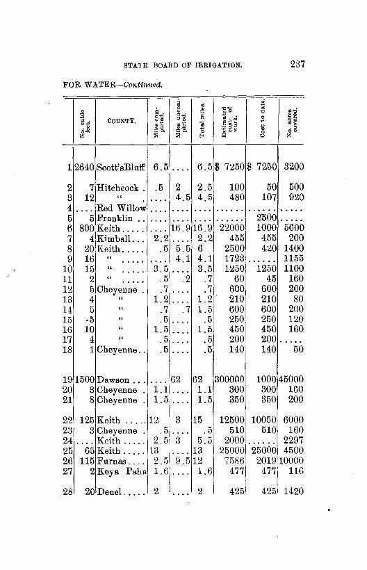
STA1 E BOARD OF IRRIGATION. 237
FOR WATER-Continued,
- -li $
0 ~.0 2 ~ ,_ • ~..; .o "" :a g~ § ~ ~ 0 ~· g.., COUNTY. "! [;~ " s"'- ., ~: . ~ gj~ ... ~ g g ~ .o
o- ;;:::::~ =o. 0 0 oo z ::a ::a E< '" 0 z
12640 Scott' sBl uff 6.5 .... 6.5 $ 7~50 $ 7250 3200
2 7 Hitchcock . .5 2 2.5 100 50 500 3 12 " 4.5 4.5 480 107 920 ••• 0
4 .... Red Willow . . . . • 0. 0 .... 0 0. 0 0 • • • 0 0 •• 0. 0 ••
5 5 Franklin .. .... • 0 •• • 0 0. 0 0 •••• 2'500 • ••• 0
6 800 Keith ..... • 0 •• 16.9 16.9 22000 1000 5600 7 4 Kimball ... 2.2 •• 0. 2.2 455 455 200 8 20 Keith ..... .5 5.5 6 2500 420 1400 9 16 " 4.1 4.1 1723 1155 •• 0. 0 • 0 •• ......
10 15 " 3.5 3.5 1250 1250 1100 • • 0 •• ....
11 2 " .5 .2 .7 60 45 160 0 ••• 0
12 5 Cheyenne . .7 •• 0. .7 600 600 200 13 4 " 1.2 1.2 210 210 80 .... 14 5 " .7 .7 1.5 600 600 200 15 ·5 " .5 .5 250 250 120 .... 16 10 " 1.5 1.5 450 450 160 .... 17 4 " .5 .5 200 200 . . 0. • 0 •••
18 1 Cheyenne .. .5 .... .5 140 140 50
19 1500 Dawson ... .... 62 62 300000 1000 45000 20 3 Cheyenne 1.1 .... 1.1 300 300 160 21 8 Cheyenne 1.5 0. 0. 1.5 350 350 200
22 125 Keith ..... 12 3 15 12500 10050 6000 23 3 Cheyenne .5 .• 0. .5 510 510 160 24 0 ••• Keith ..... 2.5 3 5.5 2000 ••• 0 •• 2297 25 65 Keith ..... 13 0 ••• 13 25000 25000 4500 26 115 Furnas .... 2.5 9.5 12 7586 20Hl 10000 27 2Keya Paha 1.6 ••• 0 1.6 477 477 116
28 20 Deuel .. .. 2 . ... 2 425 425 1420

238 REPORT OF SECRETARY
ABSTRACT OF CLAIMS
CLAIMANT. NAME OF DITCH. STREAM.
John E. Logan ...... ,Logan .......... P. Seed Ck. 1 Orchard & Alfalfa Irr.
Co ............... Orchard & Alfalfa. Platte. . . . . 2 H. D. Wolf .. , , , , , .. Private Ditch of H.
D. Wolf. ...... L'gePoleCk 3 Morrell C. Keith ..... Keith Canal ...... Wh. Horse. 4 Frank McAuliffe .... McAuliffe Ditch ... L'gePoleCk 5 Friend Dickinson .................... L'gePoleCk 6 Friend Dickinson ... , ................ L'gePoleCk 7 A. B. Gregory, P. C. Garrett ........ Gregory ......... Center Ck. . 8 John J. Eaton ....... Eaton & McCrath. SouthPlatte 9 Nelson A. Green .... Clear Creek Ditch. Clear Creek 10 ·walter Beauchamp .. Beauchamp Canal. Birdwo'dCk 11 Lewis Schuetz ....... Schuetz Spring Cnl Schuetz Sp. 12 George Gillard ...... Gilliard Ditch .... Ash Creek. 13 Roscoe Vance ....... Vance Ditch ...... Ash Creek. 14 James Cooper ....... R. Willow Lake On Ill. WillowL 15 E. C. Williams, Harry Robbins ...... Robbins & Williams
Canal ......... NorthPlatte 16 The MinitareMut.Can.
& Irr. Co ......... Mini tare .....•... NorthPlatte 17 Edmund Doran ..... Doran Canal. ..... LawrenceF. 18 Farmers Irr. Co ..... Farmers' lrr ..... Platte ..... 11) Farmers Canal Co ... Farmers' Canal. .. NorthPlatte20 David Kah .......•. Kah Ditch ....... North Platte 21 H. M. Finch ........ Finch Ditch ...... Clear Creek 22 Edgar A. Philleo .... Philleo W P. & I
Plant ......... Little Blue. 23

STATE BOARD OF IRRIGATION. 239
FOR W ATER-Gontinued.
li ~ i 0 il. 0 "'- c.C 0 oO "' :a 0'0
.. a '" . t2: = . COU~TY. 00 .og ] s~~ jl "• ... $~ .~ .. ·~ . $ 0~ ~g~ . • 0
o- :::A ::o. 0 0 co z :>1 :>1 E-< "' " z
1 .... Scott's Bl riff 1 .71 1. 7$ 1841$ 142 400
2 500 Dawson .... 9.7 11 ~0.7 8000 12800 22710
3 1 Deuel ..... .5 • • • 0 .5 0 ••••• • • 0 ••
4 .... Lincoln ... 9 .... 9 5400 5400 5 4 Deuel. .... 1 .... 1 100 120 300 6 .... Cheyenne 1 0 ••• 1 300 300 160 7 5 Cheyenne 1.5 .. 0. 1.5 600 600 320
8 5 Franklin .. .2 .2 .4 300 300 280 9 20 Keith ..... 3.8 .... 3.8 1450 1425 1400
( 10 1 Keith ..... : .7 .... .7 160 160 80 11 18 Lincoln ... 2.5 2 4.5 1350 1350 1200 12 .6 Cheyenne • 0 •• . . . . ...... . . . . . . . 15 13 • • • 0 .......... 1 .... 1 :142 242 100 14 17 Deuel. .... .5 .... .5 30 30 80 15 2 Lincoln ... 1.5 .... 1.5 665 665 150
16 100 Keith ..... 6.5 . . . . 6.5 745 745 0 ••••
17 500 Scott's Bluff 14 10 24 39000 26500 17460 18 40heyenne all ... ' .... 375 375 140 19 115 Dawson ... 10 .... 10 4500 4500 8000 20 5500 Scott'sBlufU9 62 81 350000 98000 70000 21 15 Scott's Bluff 1.5 .... 1.5 500 500 320 22 1 Keith ..... · .7 • 0 0 0 .7 • 0 0 ••• 0 ••••• . . . . . 23 36Adams .... 4 .7 4.7 1744 14801 2:25
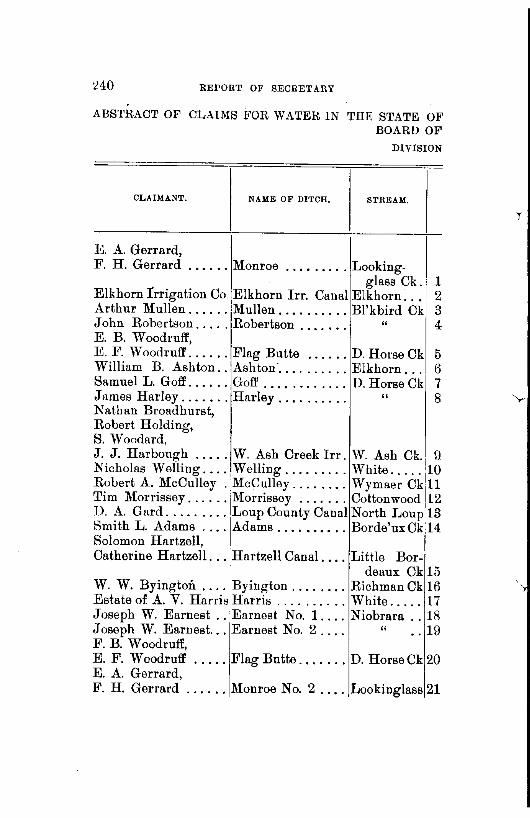
:240 BEPORT OF SECRETARY
ABS1'RACT OF CLAIMS FOR WATER IN THE STATE 01<, BOARD OF
DIVISION
CLAIMANT. NAME OF DITCH. STREAM.
E. A. Gerrard, F. H. Gerrard ...... Monroe ......... Looking.
glass Ck. 1 Elkhorn !rrigation Co. Elkhorn lrr. Canal Elkhorn. . . 2 Arthur Mullen ...... Mullen .......... Bl'kbird Ck! 3 John Robertson ..... Robertson . . . . . . . " 4 E. B. Woodruff, E. F. Woodruff ...... Flag Butte ...... D. Horse Ck 5 William B. Ashton .. Ashton· .......... Elkhorn ... 6 Samuel L. Goff ...... Goff ............ D. Horse Ck 1 7 James Harley ....... Harley . . . . . . . . . . " 8 Nathan Broadhurst, Robert Holding, S. Woodard, J. J. Harbaugh ..... W. Ash Creek lrr. W. Ash Ck.
1
!l Nicholas Welling .... ,Welling ......... White ..... '10 Robert A. McCulley . McCulley ........ Wymaer Ck 11 Tim Morrissey ......
1
Morrissey ....... Cottonwood 12 D. A. Gard ......... Loup County Canal North Loup 13 Smith L. Adams ... ·IAdams ......•... Borde'uxCk 14 Solomon Hartzell, Catherine Hartzell ... !Hartzell Canal .... Little Bor-
'1 deaux Ck 15 W. W. Byington .... Byington ........ Richman Ck 16 Estate of A. V. Harris Harris .......... White ..... 17 Joseph W. Earnest .. 'Earnest No. 1. ... Niobrara .. 18 Joseph W. Earnest ... Earnest No. 2.... " .. 19 F. B. Woodruff, E. F. Woodruff ..... Flag Butte ....... D. Horse Ck 20 E. A. Gerrard, F. H. Gerrard ...... Monroe No. 2 .... Lookinglass 21
T

STATE BOARD OF IRRIGATION. 241
NEBRASKA FILED IN THE OFFICE OF THE STATE IRRIGA'l'ION.
NO. II.
0 :c g.; COUNTY,
·* o-z
1 6 Platte ..... .5 .5 1$ 500$ 250 200 2 160 Holt ...... 12.4 .... 12.4 20000 20000 9200 3 2 " 1.7 1.7 29 75 ...... • • • 0 ...... 4 .5 " .5 .5 60 15 15 . . . . . . ....
5 .5 Dawes .... .2 . ... .2 10 10 2 6 1 Holt ...... . . . . • 0 •• . ... 165 10 50 7 .3Dawes .... .6 . ... .6 131 131 10 8 1 " .2 .1 .3 175 .85 100 ....
9 7 " 3.5 3.5 355 355 420 .... . ... 10 20 " .5 .5 1 400 400 80 • 0 ••
11 4KeyaPaha. . . . . • 0 •• . . . . 60 60 80 12 6Dawes .... . 4 • • 0. .4 65 65 320 13 300 Valley .... '. 0. • 0 •• . . . . ••• 0 •• . . . . . . 17000 14 1 Dawes .... .2 .3 .5 116 65 25
15 2 " 1 .... 1 220 220 60 .... 16 4Keya Paha. 1.2 .... 1.2 85 85 80 17 50 Dawes .... 3.5 • • 0. 3.5 1210 100 480 18 160 Sioux., ... 3.2 • 0. 0 3.2 1300 1300 200 19 160 " 3 .... 3 1625 1625 150 ..... 20 1 Dawes .... .2 .... .2 10 10 25
21 6 Platte ..... .5 .7 1.2 500 250 300

242 REPORT OF SECRETARY
ABSTRACT OF CLAIMS
CLAIMANT. DITCH. STREAM.
I
N. Louplrr. &1m. Co. North Loup ...... North Loup 1 Octave Harris, i Robert Neece ....... Harris & Neece ... Niobran ... 2 George Giles, P.R. Giles, Lawrence Giles, Richard Giles .....•. Giles' ........... ,GooseCreek 3 J. L. Lee ........... Lee ............. iNorth Loup 4 Benjamin F. J ohuson. Johnson ......... Niobrara . . 5 Mirage lrr. Co ...... Mirage Canal. .... Niobrara R.
& Cottonwood Ck. o
John D. Alfs ........ One Hundred ft ... Eagle..... 7 ',..-William A. Bigelow, William W. Seymour. Bigelow & Seymour Niobrara. . . 8 Nels Anderson ....... Jim Creek ....... Jim Creek. . 9 0. A. Garton ........ Garton .......... Spring Br .. 10 Chas. F. Coffee ...... C. F. Coffee ...... Hat Creek .. 11 Eli J. Wilcox ........ Big Monroe Ck. D. B. Monroe. 12 Orsom J. Demmon, Henry Balzer ....... Spring Creek No. 1 Spring Ck. 13 Charles Schilt ....... Schilt Cedar Creek Cedar Ck .. 14 Charles Schilt ....... Schilt Prairie Dog. Prairie Dog 15 Charles Schilt .•..... Schilt's Monroe ... Monroe Ck. 16 John T. Stuart. ..... Thomas J. Stuart's L. Cotton-
wood Ck. 17 W. S. Compton ...... Compton ......... Ash Creek .. 18 S. Hazelton ......... Hazelton Irrigation White Clay. 19 David Colville ....... Kyle Creek ..•... Kyle Creek. 20 Harrison B. Tomlin .. Oxyoke .......... E. Ash Ck .. 21 Warren S. Johnson ... Johnson No.1 .... Bull Creek. 22 A. A. Record ........ Half Diamond E .. Chadron ... 23 Harris & Cooper ..... Harris & Cooper I. White ..... 24

STATE BOARD OF IRRIGATION. 243
FOR WATER-Continued.
il ~ .;i
0 il. c "' • ~.a ~ . s ~0. "' :;;; o., ~~
~al 0 .. ~ . COUNTY. 0$ s~~ ., oo 0~
~.! g;~ :§ ~ ·~ . ~ ~2~ .o o- ::::o. ""' 0 ~ oo z :;: ::; .. '" 0 z
T
11600 Valley .... 13.2 .5 18:2 $33680 $26853 10000
2 140 Sioux ..... 5.5 2.2 7.7 5527 2527 700
3 7 Blaine .... 3.7 0 ••• 3.7 575 575 1000 4 .... Cherry .... 2 . . 0. 2 22000 850 ..... 5 60 Sioux .. · ... 2 .5 2.5 590 590 200
6 300 Sheridan ... 0. 0. 32 32 44525 9025 H8Es0 7 4 Holt ...... 100. .... 100 110 uo 25
8 .... Sioux ..... 2.5 .7 3.2 835 835 168 9 1 " .3 .3 50 50 50 . . • 0. ....
10 1 " .7 .7 235 235 100 . . . . . 0 •••
11 6 " 5 5 1322 1322 300 . • • 0. .... 12 1 " 2 2 815 815 360 • • 0 •• •• 0 •
13 1 Dawes .... .7 .8 1.5 115 • 0 0 0. 0 140 14 4 Sioux ... ,. 1.5 0 0 •• 1.5 125 125 250 15 4 " .1 .1 45 45 250 • • 0 •• .... 16 1.5 Sioux ..... .7 .2 1 205 145 100
17 10 Dawes .... 1 0. 0. 1 90 • 0 •••• 160 18 1 " .... .... • 0 •• • • 0 0 0 ••••• • •• 0 •• . .... 19 4 " 1 1 342 160 .... 0 •• 0 0. 0 0 ••
20 5 Sioux ..... .2 • 0 •• .2 45 • •• 0 0. 80 21 5 Dawes .... 1.5 0. 0. 1.5 ••••• 0 •• 0 •• 0 680 22 .5 Sioux ..... .3 .... .3 345 345 20 23 10 Dawes .... .... 1.2 1.2 712 642 420 24 59 " 7 15 22 27000 4800 0. 0. • •. 0.

244 BEPORT OF SECRETARY
ABSTRACT OF CLAIMS
CLAIMANT, NAME OF DITCH. STREAM.
Bailey G. Pinney .... Spring Creek ..•.. Spring Ck. . 1 William R. Halbert .. Mace ........ , •.. W. Ash Ck. 2 Marcus Smock ....... Smock's ......... Trunk Butte
Creek ... 3 Elkhorn Irrigation Co Elkhorn Irrig. Cnl. Elkhorn. . . 4 J. D. Bacon ........ Bacon .......... Bord'auxCk 5 William S. Hales. . . Spring Creek Irrig Spring Ck. 6 Henry M. Wilson .... 'rug Wilson ...... Chadron Ck 7 Wallace W. Wilson .. Wallace Wilson... " 8 I. W. Norton ........ Norton ......••. D. Horse Ck 9 I. W. Norton, Orlando S. Norton ... Norton No.2..... " 10 Benjamin. E. Brewster Warbonnet ...... Warb'n'tCk 11 Samuel Becker ...... Becker ......... S. Br. Eagle 12 Henry Warneke ..... Warnecke's ...... Running Wt 13 John H. McAvoy ....
1
John H. McAvoy. Bord'auxCk 14 Samuel A. Bryant .... S. A. Bryan't Irri. Big " 15 Oscar W. Hall ...... iHall's .......... Bord'auxCk 16 John A. Butler ...... Butler ....••.... Ltl. " 17 Charles Biehle ...... Biehle .......... Spring Br .. 18 Michael Ruffing ..... Cherry Creek ..... Cherry Ck. 19 William S. Hall, Francis M. Hall ..... Hall's Spring Ok. Spring Ck. 20 Richard Zerbst ...... Zerbst's ......... LittleRed .. 21 Geo. C. Getchell ..... Getchell ......... Sheridan ... 22 Leroy Hall.. ........ Hall's No.2 ...... White ..... 23 HarriettBartlett Jarvis
Richards ..••.... Richard's ........ Big Bor-deaux Ck 24
HarriettBartlettJ arvis Richards ....... ·I Richard's No. 2... " 25
PineRidgeindianAg'yjPine Ridge Ir;ig .. 1 Wh~teClay. 2~ E. J. Carpenter ...... Carpenter Img ... Wh1te .... 21
r

STATE BOARD OF IRRIGATION. 215
FOR WATER-Continued.
8 ~ ~ 0 .,~
~..; .s s . ~ . s .o "' .0 ~~ 0~ ~ .t.i s ~f 0 • COUN'l'Y. ""I: .~ .~ :s E~" ..: • .s • .s ~gg ~ .o .. ::::o. ,.,. o- 0 oo z ;:;; );I 8 "' " z
T 1 20 Dawes .... 1 15.5 16.5 $ 4600$ 600 • •• 0 •
2 .7 " .7 .7 127 127 40 • • 0. • 0 ••
3 10 " .5 .5 155 155 20 . . . . 0 •••
4 .... Holt • • 0 0. . . . . • • 0 • . ... . . . . . . ...... , ..... 5 5Dawes .... .5 ••• 0 .5 200 2001 40 6 20 " .1 .6 .7 390 92i 80 ... '
7 2 " .7 .7 575 5751 1ti0 . ... . • 0 ••
8 1 " .4 .4 300 3001 80 . . . . .... 9 1 " .5 .. 5 102 10 .... ••• 0 1021
10 1 " .5 .5 376 30 . . . . .... 253. 11 13 Sioux ..... •• 0 0 • • 0 0 .. 0. • • • 0 • 0 ...... 600 12 4Holt ..... . 5 1 1.5 350 195 80 13 2 Sioux ..... 2.5 • 0 •• 2.5 480 480 1187 .. 14 1 Dawes .... .2 . ... .2 220 220· 100 15 2 " .8 • 0 •• .8 235 235 20 • 0. 0
16 3 " .3 .1 .4 100 100 10 .... 1'7 1 " .2 .3 .5 80 35 40 .... 18 1 Sioux ..... .5 1. 5· 2 745 245 80 19 1 " .5 .5 115 115 80 • 0 •• ••• 0
20 2 " 1.2 .8 2 600 200 240 • 0 ••
21 1 " .3 .3 45 45 10 ••• 0 • 0. 0
22 2 Sheridan .. .5 .5 1 70 20 160 23 100 Dawes .... 6.5 4 10.5 10800 4850 6500
24 4 " 2 2 65 22 15 • 0 •• • 0 ••
25 4 " .7 .5 1.2 264 264 40 .... 26 4 Sheridan .. 2.6 •• 0. 2.6 4154 4154 500 27 8 Dawes .... 2 1.5 3.5 528 528 620

246 REPORT OF SECRETARY
ABSTRACT OF CLAIMS
CLAIMANT. NAME OF DITCH. STRE.\M.
Millard F. Flood ..... Flood .......... Indian Ck. . 1 Peter Schmitt ....... Schmitt's Irrig ... Shell Creek 2 W. Z. Tillson ....... Tillson .......... South Loup 3 Thedfordl.P. Co. (Lim) Thedford ........ MiddleLoup 4 Sherman Co.Ir.W.P.&
Im. Co ........... Sherman Co. Canal MiddleLoup 5 Peter Schmitt ....... Schmitt ......... Shell Ck. . . 6 Newton!. Co. & W. P. Newton Irrigation. North Loup 7 A. J. Palmer & Co ... Pioneer ......... Niobrara. . . 8 Plum Ck. Canal & I. C. Johnstown Canal .. Plum Ck.. . 9 Lorenzo Snow ....... Snow ........... Niobrara ... 10 H. Wile ............ Wile's ........... Br.Rock Ck 11 J. G. Ferguson ...... Ferguson ........ Bone Ck ... 12 Howard G. Furman .. Furman ........ Niobrara ... 13 J. C. Wood, R. B. Pierce, Lena Palmer . ....... Enterprise. . . . . . . " 14 A. J. Palmer & Co ... North Pioneer.... " 15 A. J. Palmer & Co . .. South Pioneer. . . . " 16 J. T. Johnson ....... Johnson & Miller. Elk Ck .... 17 McGinley & Stovor ... McGinley & Stover Running W 18 McGinley & Stover ... McGinley& Stover's
Upper ....... . " 19 McGinley & Stover ... McGinley & Stover
North Side . . . . . " 20 Rock Creek I. & P. Co Copeland ........ Rock Ck ... 21 John W. Hanson ..... Drayton Irrigation V'rdigrisCk 22 Joseph T. McManus, J. F. Neeland ....... McManus&Neeland
Irrigation ...... Niobrara ... 23 James Clark ......... Pine Ck. R. Mill .. Pine Ck ... ~4 Charles H. Cornell ... C. H. Cornell. .... Niobrara ... 25 James E. Stewart, N athamel Zmk ...... Stewart & Zmk ... W1llow Ck. 26
r

STATE BOARD OF IRRIGATION. 241
FOR WATER-Continued,
..
i; $ .s L g ~ .,_
~ . .,; .o "' "' O'tl . . 8 <;; • .. •ii 3 --. . COUNTY • "S s~~ -· ~i .. ~~ :5 ...
~0. ·- 0 0 'oi .o o- ::o. 0 ~CJ~ 0 oo z ::a ::a E-< 01 "' "' 1 .2 Dawes .... • 0. 0 .5 .5$ 85$ 85 8 2 12 Platte ..... .6 2.2 2.8 776 600 725 3 10 Buffalo .... 3 4.5 7.5 7971 2982 1090 4 30 Thomas .... 4.2 34.7 39 11350 2625 3000
5 503 Sherman ... 15.2 1 26 46000 31000 17590 6 30 Platte ..... . . . . . . . . .... • 0 •••• 0 •• 0 •• . .... 7 200 Loup ...... .. 0. 15 15 20684 12384 8062 8 150 Dawes ..... 4.5 2.5 7 22585 2123 1030 9 12 Brown .... .2 10 10.2 2360 390 3580
10 11 Dawes ..... 1.1 1 2.1 300 300 400 11 11Rock ..... 1 1.5 2.5 ...... • • • • 0. 480 12 5 Brown .... • 0 •• 3 3 2000 100 1000 13 10 Dawes ..... .2 1.5 1.7 5402 259 255
14 22 .. 1 8.5 9.5 1512 565 720 . ... 15 22 " 4.7 .6 5.ll 1033 964 500 .... 16 128 " 2.4 2.5 4.9 1552 1294 530 .... 17 ••• 0 Rock ..... . . . . 3.5 3.5 ••••• 0 ...... 110 18 3 Sioux ..... 2 • 0 0. 2 575 575 240
19 7 " 1.7 1.3 3 560 225 500 ....
20 8 " 4 4 1675 1675 560 0 ••• .... 21 BRock ..... .... 5 5 662 662 500 22 5 Antelope ... 1.7 .4 2.1 1050 750 250
23 10 Dawes ..... 1.2 ••• 0 1.2 255 255 89 2i 20 Sheridan ... .5 0 ••• .5 600 600 . .... 25 1209,Cherry .... ••• 0 4.9 4.9 67000 362 .....
I 2 1 3 2000 1200 240 26 12Holt ....

•
nEPORT OF SEORETABY
ABSTRACT OF CLUMS
CLAIMANT. DITCH. STREAM.
I John W. Purdum .... Norway Irrigation.:MiddleLoup 1 G. L. Mathews ...... Homestead ...... \ '' 2 Horatio J. Hendryx .. Hendryx ......... Spr. Brook. 3 A. H. McLaughlin ... McLaughlin's .... ·Niobrara ... 4 Frederick Crook ..... Crook ........... Goose Ck. . 5 David C. Vincent ... Excelsior ........ 'Niobrara.. . 6 Bartlett Richards .... Richard's. . . . . . . . " 7 Charles Seeley ...... Seeley Power ....
1
White . . . . 8 Charles Rasher ...... Rasher .......... White . . . . 9 White River Irr. Co. White Riv. Irr. C. WhiteRiver
W. Clay Ck. 10 Jesse N. Springer ... Springer ........ Rock Creek 11 Joseph Davis ....... Davis ........... Elkhorn ... 12 Walter B. Woodruff .. Woodruff North .. Jim Creek. 13 Walter B. Woodruff .. Woodruff South.. " . 14 Frank Stastny ....... Stastny .......... Beaver .... 15 Burwell Irrigation Co. Burwell Irrigation. North Loup 16 Lillian Precinct I. D.
& Power Co ....... Lillian Pre. I. & P. Mid'le Loup 17 Isaac Seegrist ....... Seegrist ......... Indian Ck. 18 Thomas Dunn ....... Dunn's .......... Squaw Ck. 19 Mary W. McGuire ... McGuire ........ N.Mid'le Ck 20 M. E. Getter ........ Hofatcong ....... North Loup ~1 Charles 0. Barnard .. Barnard ......... Beeanon Ck 22 Dailey, Gilligan & Co. Victoria Irr. Plant. Victoria Ck. 23 G. W. Hatch, William D. Cross .... l'l1eridian ........ Niobrara .. 24 G. W. Dewey ....... Victoria ......... Victoria Uk. 25 Benjamin E. Brewster West Hat Creek .. W. Hat Ck. 26 W m. Braddock ...... Braddock's ...... Beaver Ck. 27 Chas. A. Cline ...... East Ash Creek .. E. Ash Ck. 28 John A. Wilson ..... Wilson Canal .... Niobrara .. 29 Middle Loup Valley
Irr. & Canal Co ... Mid.Loup.Val.I.C. Mid'leLoup30
r
r

•
STATE BOARD OF IRRIGATION. 24!1
FOR WATER-Continued.
~ a . .0 0'0 .. COUNTY. ~.!I
~% ~Q ~-
o- 8" z "'
1 10 Thomas ... .7 2 10 " .5 ... 3 1 Platte ..... .2 4 10 Box Butte. 3.5 5 7 Blaine .... .9 6 8Dawes ..... 1.7 7 40 Sioux ..... 4 8 50 Dawes ..... 9 4 Dawes .... .8
10 41 " 5.3 .... 11 .5 KeyaPaha. .4 12 3 Holt ...... .2 13 .3 Sioux ..... .4 14 .6 " . 5 •••• 0
15 2 Sheridan .. .1 16 110 Garfield ... 8
17 300 Custer ..... 18.5 18 2Dawes .... .7 19 4 Sioux ..... .2 20 1 Keya Paha. .5 21 200 Valley .... .... 22 1 Keya Paha. . 5 23 11 Custer ..... ....
24 18 Dawes .... 7.3 5 32 Custer .... 3 6 8 Sioux ..... 1 7 1 Sheridan .. .5 8 1 Dawes .. 0. 2 9 8 Keya Paha. 10.5
2 2 2 2 2
30 5oolcuster ..•. 12
s ~ . o'll ~~ ~p.
1.2 .5
.... 1
2.2 •• 0.
....
.2
5 .2 .2 .2 .5 .7
1.7
2.9 ....
. 3 • 0 ••
• • • 0
.. 0.
....
2 • 0 ••
.... .5
• • 0.
3.5
3
i "" ~.;
"8 ~o.:.S "" •:. 9"" 0" :s ~2g
. '" .o 0 0 0
'"' ~ z -----
2 $ 305$ 100 200 1 250 100 30
.2 5 5 93 3.5 680 680 800 3.1 995 325 450 1.7 330 3301 280 4 • • 0 0 0. .. .... ] .. ···
•• 0 0. 0 •••••
1.0 650 5251 160
10.3 5800 3600 0 0 0 0.
.6 150 125 30
.5 147 147 120
.6 85 75 23 1 135 95 47
.8 125 • 0 0 ••• 80 9.7 19000 15653 7700
21.4 28141 15005 • 0 •••
.7 0. 0 0 •• . . . . . . 20
.5 735 325 120
.5 84 84 85 • 0 0 • 14000 . ..... 15000
.5 110 110 70 0. 0 0 122 122 430
9.3 567 261 200 3 785 785 1365 1 110 110 80 1 \JO 80 70 2 135 • 0 •• 0 • • 0 •••
14 1100 500 585
55 ~ 9u576 41625 4 7000

250 REPORT OF SECRETARY
ABSTRACT OF CL.-UMS .
CLAIMANT. NAME OF DITCH. STREAM.
Peter Cedarberg ..... Cedar berg ....... Bear Creek. 1 T Wilfred S. Pickler ... Old's ........... Snyder Ck. 2 C. G. Grant ......... Grant ........... Two streams
not named. 3 Abner Butcher, Ben Griebel. ........ Butcher & Griebel. Mid'le Loup 4 F. J. Bchoettger ..... Schoett.ger ....... Holt Creek. 5 Otto Mutz .......... Burton .......... Crooked Ck.
&BurtonCk 6 George H. Turner .... George Turner .... Antelope Ck 7 F. X. Rehberg ...... Atkinson M.&I.C .. Elkhorn ... 8 Thomas Skinner ..... Skinner ......... Bear. . . . . . 9 Eugene J. Boblets .... Boblets ......... South Loup 10
\
Andrew Bruce ....... Bruce's Mill Dam. Niobrara ... 11 S. S. McCumber ..... McCumber ....... Cub Creek.l12 William Stevens ..... Loup City I. Canal North Lcoupll3 Charles P. Jewett .... Big Little ........ Jewett Ck.. 14 Joseph A. Hornbeck .. Canon Canal. ..... Sweeney Ck 15 William Bokhof ..... Bokhof .......... .Main Br. of
Engle Ck. 16 Joseph W. Akers .... Akers ........... E. Holt Ck. 17 Isaac Horton ........ Horton .......... Wyman Ck. 18 J. A. Robertson ...... Eagle Valley ..... Eagle Ck .. 19 Thomas Laughran, I. P. Bell ........... Laughran & Bell .. Victoria Ck. 20 M. H. Green ........ Deep Creek ...... Deep Creek 21 Peter Schaefer ...... Old Sow Belly .... S. Belly Ck. 22 William M. Kuhre ... Kuhre's Pond .... Fail'field Ck 23 H. R. Edgar ........ Homestead ....... Cow Creek. ~4 Peter Schaefer ...... Spring Creek .... ·!Spring Ck. 25 J. W. Quackenbush ... PioneerD.BooneCollleaver .... 26 M.H,&W.A.McCarthy McCarthy No. 1. ..
1
East Br. of Brush Ck. ~7

STATE BOARD OF IRRIGATION. 251
l<'OR WATER-Continued. 4
il ~ il. g "' . .,; 0
~ ·-:a 0'0 ~.g ~ 0 • .. "" gt COUNTY. oo ;<;;~ o.
~:; ~~ :;§ ·~ .. "'"' "'" 0 ~ g ~ .o
o- oo z :>1 :>1 E-< r.1 z
1 1 KeyaPaha. .1 .... .1$ 30$ 15 3.5 2 .3 " .1 .1 1 •• 0. • • 0 ••• 0 •• 0 0 0
3 1 Brown .... .2 •• 0. .2 60 30 20
4 40 Custer .... 3.8 3.2 7 2037 1424 1280 5 1 Key a Paha. .2 .3 .p 46 31 10
6 3 KeyaPaha. 2 3 5 1350 900 250 7 20 Sioux ..... .0 .... .5 270 270 80 8 150 Holt ...... .2 .2 .4 3900 lluO 2500 9 .2 KeyaPaha. .1 .1 .2 49 24 16
' 10 302 Custer ..... .2 .... .2 3000 3000 300 11 200 KeyaPaha. .... 0 ••• . . . . 1500 1500 0 0 •• 0
12 .1 KeyaPaha. .3 .... .3 20 20 • 0 • 0 •
13 160 Loup ...... .... 30 30 37500 200 11000 14 3KeyaPaha. .4 1.1 1.5 496 245 100 15 1 Cherry .. · .. . . . . .. " . . ... 100 65 40
16 2 Holt ...... 0. 0. 2.2 2.2 450 • 0 •••• 200 17 1.5 Keya Paha. .5 .... .5 62 62 10 18 .5 Keya Paha. . 2 .... .2 ·11 . ..... 25 19 4Holt ...... 1.2 1 2.2 460 352 160
20 8 Custer .... 2 .... 2 772 772 460 21 60 Sioux ..... .2 0 ••• .2 50 50 40 22 40 Sioux ..... 1.5 ••• 0 1.5 2025 1475 640 23 15 KeyaPaha. .2 .... .2 200 200 15 24 3 Cherry .... 2
• 0 •• 2 285 285 160 25 40 Sioux ..... .5 .• 0. .5 52 52 50 26 60Boone ..... • 0 •• ' .. .... 0. 0 0 •• 1400 • ••• 0
27 1 Holt ...... .2 .. 0. .2 150 150 40

252 REPORT OF SECRETARY
ABSTRACT OF CLAIMS
CLAIMANT. NAME OF DITCH. STREAM.
T

STATE BOARD OF lBRIGATION. 253
FOR WATER-Continued.
• d 0 "' :c = . COU:S'l'Yo ~~ o-z
~ ~ 0
"
1 1 Holt .. . . . . . 5 . 2 . 7 $ 100$ 75 2 1 Custer. . . . . 0 5 . . . . . 5 385 3 160 Valley. 0 .. 0 35 0 3 .... 35. 3 52000 4 3 Holt . . . . . . 2. 5 . 5 3 330
5 6 Holt ...... 07 .3 1 736 6 1 Holt ...... .5 .2 .7 .JOO 7 3 Holt ...... .7 2 2.7 310
8 200 Dawes .... 13 13 26 56990
9 7 Blaine .... 3.1 1.9 5 750 1 0 2KeyaPaha. .4 .4 .8 66 11 200:Dawes .... 405 ....
0
4o5 4441 12 140 Custer ..... 10.5 2.5 13 20000 13 50 Cherry .... 2.51 6 8.5 ••••• 0
1 4 2Keya Paha. 1.6 0 0 0 0 106 477 1 5 1 Dawes ..... 22 • 0 •• 22 200 1 6 3 Keya Pahao 1.5 .... 1.5 75 1 7 5 Sioux ..... .6 05 1.1 12:l 1 8 9Keya Paha. 6.2 .• 0. 6.2 694 1 9 1 Dawes ..... o) .2 35 0 ~ ....
385 52000
200
696 400 155
29511
500 66
4441 12500
••••• 0
477 2001
75 57!
6941
35
2 0 .... !Custer. : ... • 0 •• ••• 0 . . . . • • 0 •••• 0 ••••
I •o
I
"" "" 0" d:-oO c :,..0
z
45 3:>
1217ti 4:W
680 100 600
19280
GOO 160
1000 6200 3000 116
8 200 HO 660
10
. •. 0.

254 REPORT OF SECRETARY
ABSTRACT OF CLAIMS
CLAIMANT. NAME OF DITCH. STREAM.
Judson L. Packard ... Creighton Mill Ra. Bazile Ck. . 1 W. L Gallup ....... Gallup's Ditch .... Chadron Ck 2 Max Uhlig .......... McManus Ditch ... A spring... 3 John Kemery ....... Kemery Ditch .... D.Horse Ck 4 Theodore L. Goff .... Goff Ditch ....... Five Spr's.. 3 Benjamin J. Eastlick. Necessity Ditch ... Rock Ck. . . G Sarah Jordon ....... ,Jordon's Ditch .... S. Belly Ck 7 Henry Lichte ....... Lichte lrri. Ditch. Niobrara.. . 8
T
John S. Tucker ...... Tucker's Ditch .... Spring Br. 9 J. W. Smith ........ Smith's Irri. Ditch Boggy Ck .. 10 Thomas E. Locket ... Locket Ditch ..... Big Bor-
deaux Ck 11 Julius Jensen ....... Jensen's Mill Race White ..... 12 Sara Montgomery ... Montgomery Ditch S. Belly Ck 13 Robert Harrison ..... Harrison's Ditch .. Spr. Br. of
Whitehead. 14 James F. Bannon .... Bannon's Ditch ... M. BoggyCk 13 Martin Jacobsen ..... Jacobsen Ditch ... White ..... 16 Nathan Broadhurst, R. Holding, Sidney D Woodard, J. J. Harbaugh ..... West Ash Ck I. Co WestAshCk,17 John J. Rodgers .... Rodger's Ditch ... Soldier Ck. 118 James Nolan ........ Nolan No.1. ..... Br. of War-1
bonnet Ck19 John L. Kav ........ Kay's Ditch, ..... N. Br. War- I
• bonnet Ck'20 James Nolan ........ Nolan Ditch No. 2 Br. of War-1
bonnet Ckl21 Benjamin F. Johnson. Johnson Ditch ... Niobrara.. .. 22 William Slattery ..... Slattery Ditch .... Jim Ck ... ,23 Octave Harris ....... La Belle Ditch ... Rng. Water· 24 Yocum, J. C ........ Yocum's Pri. lr. D Keya Paha I
Riv ..... 25

r
STA 1 E BOARD OF IRRIGATION.
FOR WATER-Continued,
I
i;
I
~ 0 8 . g .,-.o :8 0'0
0 • 8 ~ toi = . COUNTY. oo -~ 0~ ~$ ~2 3 s~" . ~ I
I ~8~ o- :;::::0. ~0. 0 z
I ;;; ... "' ~
1 all. Knox ..... 0 ••• . . . . " .. $ 600$ 2 1 Dawes ..... .1 .1 3 1 " 1 • • 0- •• 0 •
4 .. " " . . . . .... 0 •••
5 1 " .1 . . . . •• 0 •
6, .... Rock •• 0 •• . . . . 5 7' 2 Sioux .... • • 0. 1 8 200 Dawes ..... .... . . . . 9 1 Sioux • • 0. .2 .1
10 50 " • • 0 0 .. 0. ....
11 1 Dawes ..... .2 ••• 0
12 2 Sioux ..... .2 .. 0. 13 1 " 1.5 .... . ...
14 10 " .1 .1 .... 15 .5 " .1 .2 . . . . 16 1 " .... • 0 •• 0 •••
17 18
10Dawes ..... 3 .... 10 Sioux..... . 2 .5
.2 1
• •• 0
.1 5 1
• • 0 0
.3 • •• 0
.2
.2 1.5
.2
.3 . ...
3 .7
100 300
...... 265 514 342 215 48
.... 0.
16 325 165
75 • • 0 ••
. .....
2\JO 150
19
2J
.5 " .2 .... .2 ..... .
.5
21 1 22 60 23 500 24 70
"
" " " "
.5 .2 .7
.5.... .5 1.7 .... 1.7
. 7.... .7 1.7 3 4.7
25 2± Boyd... . . . 3. 5 3. 5 7
145
30 305 145
1145
925
255
2SOO • • 0 ••
100 30 300 70 160 2 265 25
62 70 147 HO 215 100 2! •• 0 ••
250 .....
16 325 165
5 100 190
290 42
5
53
5 7
75
40 ..... 0 ••••
475 80
35
30
30 70 305 20 145 . " .. 660 480
900 100
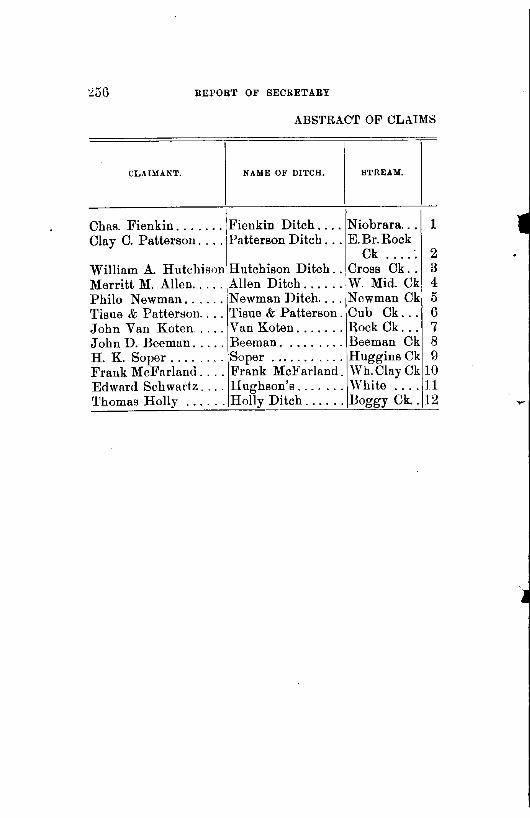
REPORT OF SECRETARY
ABSTRACT OF CLAIMS
I
CLAIMANT. NAME OF DITCH. STI\EAM.
Chas. Fienkin ....... 1Fienkin Ditch .... Niobrara ... 1 Clay C. Patterson .... \Patterson Ditch ... E.Br.Rock
Ck .... : 2 William A. HutchisoniHutchison Ditch .. Cross Ck .. 3 Merritt M. Allen ..... Allen Ditch ...... W. Mid. Ck 4 Philo Newman ...... Newman Ditch .... Newman Ck 5 Tisue & Patterson .... Tisue & Patterson. Cub Ck ... 6 John Van Koten .... Van Koten ....... Hock Ck ... 7 John D. Beeman ..... Beeman ......... Beeman Ck 8 H. K. Soper ........ Soper ........... HugginsCk 9 Frank McFarland .... Frank McFarland. Wh.ClayCk 10 Edward Schwartz .... Hughson's ....... White .... 11 'l'homas Holly . . . . . . Holly Ditch ...... Boggy Ck .. 12

STATE BOARD OF IRRIGATION. 257
~'OR WATER-Concluded.
s ~ ti 8 . 0 "' • g . 'ii ~'0.:.: "' .., 0'0 ..
~~ s "" COUNTY. o_s "• ~ .. ~:! ~ e~~ ~ ·~ ·- ~g~ • 0 ::o. ="- 0 . co
:>! :>! 0 .. "' Q z
.
r 1 6 Holt ...... 1.2 .5 1. 7$ 1025$ 675 150
2 .3 KeyaPaha. .5 .... .5 30 30 10 3 .2 " " .1 .1 .2 30 18 15 4 1 " .. .5 .21 .7 195 137 70 5 1 " " .2 .2 200 175 40 6 .2 " " .2 1.2 1.5 67 15 12 7 .2 " " .3 .3 15 .... . .... . . . . . . 8 1 " " .8 .8 250 250 100 .... 9 1 " " .3 .4 .7 109 80 70
10 1 Dawe~ ..... 1 .... 1 2fi5 265 . .... 11 .2 Sioux. . . 0. .2 0 ••• .2 GO 60 5 12 1 Dawes ..... .5 .5 .5 ••• 0 •• . . . . . . • • 0 ••

258 REPORT OF SECRETARY
APPLICATIONS FOR WATER OF THE STATE OF
BOARD OF IRRIGATION, BETWE.EN THE DATES
APPLICANT. NHI~ OF DITCH.
!~General J. Holcomb .... Holcomb Irrigation.... 1 2 Max Gottberg ........ ; Gottberg Irrigation Plant 2 3~Eugene H. Cress ....... Gratton Canal . . . . . . . . . 3 4iWilliam Bourrett ...... Bourrett . . . . . . . . . . . . . 4 5
1
Peter Bourrett ........ Bourrett, Sr . . . . . . . . . . 5 6
1
Little Cottonwood I. Co. Little Cottonwood.... . . 5 8 James Stewart,
IJ ohn Stewart .......... Stewart Bros. . . . . . . . . . 7
9 Newark Ditch Co ...... Newark . . . . . . . . . . . . . . 8 10iPeter Grier ........... Grier Irrigation. . . . . . . U 11 Jacob Bernhard ....... Bernhard Canal. ...... tO 12 Arthur B. Hankey ..... Hankey Irrigation Caualll 13 Alonzo Cunningham .... Gilley ............... 12 14 William Slattery ....... Slattery .............. 13 15 John J. McCarthy ..... McCarthy ............ 14 16 Evans R. Vandergrift ... Delano Irrigation Canal. 15 17 Keystone Irrigation Co . Keystone Irrigation Co's 15 18 Peter Roneche ........ Minnie Roneche ....... 17 20 Griffith J. Evans ....... Adams County Irr. Caual18 21 Shelton Irrigation Co ... Shelton .............. 19 22 A. L. Green ........... S. S. Ditch ........... 20 24 Oscar A. Garton ....... Garton ...........•... 21 25 F. Austin. . . . . . . . . . . . Austin ............... 22 26 James B. Fullerton ..... James B. Fullerton .... 23 27 Daniels & Stetson ...... Daniels & Stetson ..... 24 28 Marcus Valdez ........ Marcus Valdez ........ 25 29 Newton Land Co ('rhe). Spring Brook Aqueduct. 2ti 30 W; A. Thornton.
Robert Pomery ~ ....... White Clay ........... 27 32 Ernest M. Slattery ..... Slattery .............. 28 33 Thomas Carlon ........ Carlon ............... 29 34 C. H. Walrath ......... Atkinson ............. 30 37 John Mann ........... John Mann ........... 31 38 Mats Johnson ............ , ................. 132

STATE BOARD OF IRRIGATION. 259
NEBRASKA, FILED IN THE OFFICE OF THE STATE
OF APRIL 4, 1895, AND NOVEMBER 30, 1896.
NAME OF STREAM.I COUNTY.
1 North Platte .. Keith ..... 2 Shell Creek ... Platte ..... 3Elkhorn ...... Holt, ..... 4Niohrara ..... Sioux ..... 5 " " • • • 0. ••• 0 •
6 Lit. Cottonwood Dawes ....
7 " " 0. 0. 0 • ~ 0 ••
8 Platte ....... Kearney . . 9 Middle Loup .. Thomas ...
10 Platte • 0 ••• 0. Adams .... 11 Wood ........ Hall ...... 12 Frenchman ... Chase ..... 13 Jim ......... Sioux ..... 14 Canyon ...... Keith ..... 15 North Loup .. Cherry .... 16 White Tail. .. Keith ..... 17 North Loup .. Cherry .... 18 Platte ••• 0 •• 0 Adams .... 19 " Buffalo .... 0 •• 0 •••
20 Clear ........ Gage ..... 21 Spring ....... Sioux ..... 221Hat ......... " ..... 23 Baker ....... Holt ...... 24Squaw ....... Dawes .... 25 Cedar Branch. Sioux ..... 26 Springs ...... Douglas ...
27 White Clay ... Dawes .... 28 Dead Horse .. " 0 •••
29 Dry ......... Holt ...... 30 Elkhorn " 0 •••• 0 0 ••••
31 Eagle ........ " •• 0 •••
32North Lou p ... Howard ...
I No. of I Total I Estimated I No. aeres cu. ft. mtlee. cost. covered,
75 $ 10$ 1 ....
25 4 75 1 75 5 20 10
10 4 268 11
5 4 30 4
1 1 4 2
10 1 .5 .75 30 6 55 7 15 4
644 47 175 17
3 1 1 .8 4 2 1 1
.... 1 1 .75
10 .5
2 4 1 2
100 5 40 10
.75 1 5 3
5800 300
2320 115 125
2875
850 7000 1390 2700
317 725 160
25 1800 2500 2640
160000 10000
400 140
• 150 3501 100 147 800
1200 345 310
8000 100 400
5000 80
1750 HiO 100
5500
190 1472
50 208
7 30
6 4
200 384 120
21568 1404
0 0 0 0 0 0 0 0 0 0 0 0 0
0 ••• 0.
10 24 16
7 7
16
0 0 0 0 5 0
46 0 0 0 0 0 0
8 628 400
6 40

260 BEPOBT OF BECBETABY
APPLICATIONS FOR WATER OF THE STATE OF NE
OF IRRIGATION BETWEEN THE DATES APRIL
APPLICANT.
-I NAME OF DITCH.
39 Henry L. Ballard ....... The H. L. Ballard. . . . . . 1 40 Fremont Canal & P. Co. Fremont Canal ... _ . ~ . . . 2 41 Mike Elmore .......... Elmore Canal.. , . . • . . . . 3 42 William Cooper ........ Cooper. . . . . . . . . . . . . . . 4 43 Issac Benedict , . . . . •... Benedict . . . . . . . . . . . . . 5
- 44 James f\:lcGrew ........ McGrew & Dailey . . . . . . 6 45 Thomas H. Wilson ..... Freeport Canal. . . . . . . . 7 46 Thomas H. Wilson ..... Cowen Canal. . • . . . . . . . 8 4 7 D. P. Shicks ........... Gorker. . . . . . . • . . . • . . . 9 48 Henry Newman ........ Newman ............. 10 49 Kirkwood Mutual!. S.Co .........•............ 11 50 Franklin Force ..•..... Force's ............... 12 51 H. A. Northup ......... Northup Canal ........ 13 52 H. S. Woodruff ........ Woodruff ............. 14 53 John Hughes ......... Hughes .............. 15 56 Chase Co. L & L. S. Co. No.4 ................. 16 57 Chase Co. L & L. S. Co. No.1 ................. 17 58 Edward Irion .......... Whistle Creek ......... 18 59 John McAuliffe ........ John McAuliffe ........ 19 60 Octave Harris .......... LaBelle .............. 20 61 John C. Morrow ........ Sand Creek ............ 21 62 C. T. Holliday ......... Holliday Canal. ........ 22 63 J. B. Btfrke ........... Burke ................ 23 64 Henry Leisy ........... Elkhorn Ranch Canal ... 24 65 William K. Miller ...... Home ................ 25
Joseph Burns, 66 Adna Dobson .... , ..... Gracie Canal .......... 26 67 Peter S. Rouecbe ....... P. S. Roueche ......... 27 68 Bailey G. Pinney ....... Cottonwood Canal ...... 28 69 William H. Winterer .... Coon Creek ............ 29 70 B. A. Jones ........... Jones Irrigation Plant .. 30 71 WilliamS. Hales ....... Spring Creek Irr. Canal31 72 F. M. Darrington ...... Darrington Canal ..•... 32 73 Frederick Geis ........ Geis Canal. ........... 33

STATE BOARD Clli' IRRIGATION. 261
BRASKA: FILED IN THE OFFICE OF THE STATE BOARD
4, 1895, AND NOVEMBER 30, 1896-Continued.
1
:-IAME OF STREAM., COUNTY, /No. oi,Totall ~:stlmated I No. acres cu. ft. miles. cost. covered,
I 1 Republican ... Furnas .... ! 100 2 Platte ........ Dodge ..... 2500 3 Snake Creek ... Box Butte. . 40 4 White Clay Ck. Dawes . . . . 4 5 Republican ... Hitchcock.. 3 6 Victoria Creek. Custer. . . . . 6 7 P. Seed Ck .... Banner . . . . 2 8 P. Seed Ck .... Banner . . . . 1 9 Frenchman ... Hitchcock. . 8
10 Lodge Polk Ck. Cheyenne.. 2 11 Ash Creek . . . . Rock . . . . . 7 12 White ....... Sioux . . . . . 1 13 North Loup ... Blaine. . . . . 20 14 Richards Br ... Sioux . . . . . 5 Hi Niobrara ..... ,Box Butte. . 500 16StinkingWater
1
Chase. .... 6 17 Stinking Water Chase..... 9 18 Whistle Creek. Box Butte.. 12 19 Frenchman ... Chase. . . . . 2 20 Niobrara ..... Sioux . . . . . 100 21 Big Sandy Ck. Holt . . . . . . 14 22 South Loup ... Custer. . . . . 3 23 Sow Belly Ck. Sioux . . . . . 40 24 Elkhorn ...... Cuming . . . 25 25 Whistle Creek. Box Butte. . 10
26 Gracie Creek .. Loup ..... 50 27 Brush Creek. .. Cherry .... 28 L.Cottonw'dCk Dawes .... 40 29 Coon Creek ... Keith.· .... 2 30 Lodge Pole Ck. Cheyenne .. 2 31 Spring Creek .. Dawes .... 20 32 White ....... Dawes .... 15 33 Greenwood Ck. Cheyenne .. 2
12 9000 10000 28 1460000 16960
3 3000 .... .. 5 1250 ..... . 2 115 200 2 ........... .. 2 175 160 1 80 50 3 815 350
. 7 350 160 8 2598 1200 1 125 80 4 10350 6000
.3 330 160 2 1050 640 1 502 225
.7 233 100 1 140 120 1 175 120 3 689 640 7 8000 5320 1 600 160
.5 93 40 5 11334 1780 2 1000 320
16 10700 4000 3 675 840
10 5000 0 0. 0 0 0
.5 145 160
.5 250 70
.7 600 80 20 2500 ...... .5 27 20
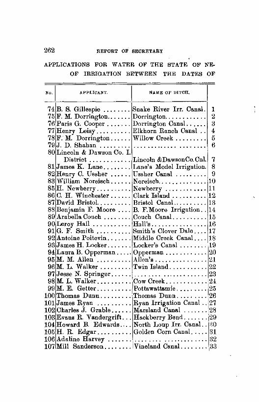
262 REPORT OF SECRETARY
APPLICATIONS FOR WATER OF THE STATE OF NE
OF IRRIGATION BETWEEN THE DATES OF
AP P LICAN'l'. N.A.ME OF DITCH.
74 B. S. Gillespie ........ Snake River Irr. Canal. 1 75 F. M. Dorrington ....... Dorrington.. . . . . . . . . . . 2 76 Paris G. Cooper ....... Dorrington Canal. . . • . . 3 77 Henry Leisy .......... Elkhorn Ranch Canal . . 4 78 F: M. Dorrington ...... Willow Creek . . . . . . . . . 5 79 J. D. Shahan . . . . . . . . . . . . . . . . . . . . . . . . . . . . . . 6 80 Lincoln & Dawson Co. I.
District ............ Lincoln &Dawson Co. Cnl. 7 81 James K. Lane ........ Lane's Model Irrigation. 8 82 Henry C. Ussher .•••.. Ussher Canal . . . . • . . . . 9 83 William Noreisch ...... Noreisch .............. 10 85 H. Newberry .......... Newberry .........••. 11 86 C. H. Winchester ...... Clark Island .......... 12 87 Da"l'id Bristol. ......... Bristol Canal .......... 13 88 Benjamin F. Moore .... B. F.Moore Irrigation .. 14 89 Arabella Couch ........ Couch Canal .......... 15 90 Leroy Hall ........... Hall's ................ 16 91 G. F. Smith .......... Smith's Clover Dale .... 17 92 Antoine Poitevin ....... Middle Creek Canal .... 18 93 James H. Locker ....... Locker's Canal ........ 19 94 Laura B. Opperman ..... Opperman ............ 20 95 M. M. Allen .......... Allen's ............... 21 96 M. L. Walker . . . . . . . . . Twin Island ........... 22 97 Jesse N. Springer ........................... 23 98 M. L. Walker ..••.•.... Cow Creek ............ 24 99 M. E. Getter .......... Pottawattamie ......... 25
100 Thomas Dunn ......... Thomas Dunn ......... 26 101 James Ryan .......... Ryan Irrigation Canal .. 27 102 Charles J. Grable ..•... Marsland Canal ....... 28 103 Evans R. Vandergrift ... Hackberry Bend ....... 29 104Howard B. Edwards .... North Loup lrr. Canal .. :JO 105 H. R. Edgar .......... Golden Corn Canal ..... 31 106 Adaline Harvey . . . . . . . . . . . . . . . . ............ 32 107 Mill Sanderson ........ Vineland Canal ........ 33

STATE BOARD OF IRRIGATION. 263
BRASKA, FILED IN THE OFFICE OF THE STATE BOARD
APRIL 4, 1895, AND NOVEMBER 30, 1896-:---Continued.
!NAME OF STREAM., CO~TY.
1 Niobrara ..... Holt ..... . 2 Chadron ..... Dawes ... . 3 White ....... Dawes ... . 4 Elkhorn ..... Cuming .. . 5 Willow ...... Dawes .... . 6 Frenchman . . . Chase .•...
I No. ofl Tota11 Estimated I No, Heres cu. ft miles. cost. covered.
800 250 1422300 500000 10 5 2000 ..... .
150 20 24000 ..... . 50 5 11334 1800 14 4 2000 ..... . 2.... . . . . . . . 80
7 Platte ....... Lincoln .... 1500 70 . . . . . . . 40000 8 Turkey ...... Saline . . . . 1 1 350 85 9 Niobrara ..... Sheridan. . . 10 3 328 130
10 Spring ....... Sioux . . . . . 1 . 2 353 4 11 No name ..... Lincoln . . . .6 . 75 47 320 12 Platte ....... Buffalo. . . . 15 4 1000 890 13 Minnechaduza. Cherry.... 1 . . . . 250 70 14 Niobrara ..... Sioux..... 20 3 1000 1120 15 Lodge Pole ... Cheyenne. . 2 . 5 30 80 16 Lit. Cottonw'd. Dawes . . . . 50 4 12950 6000 17Elkhorn ..... Holt ...... 12 2 475 160 18 East Middle .. Keya Paha. all . 5 165 30 19 Frenchman ... Hayes . . . . 1 1 1092 160 20 Not named ... Key a Paha. 10 .1 25 20 21 West Middle .. KeyaPaha. 10 1 135 65 22 North Loup .. Cherry.... 6 7 900 440 23Rock .... .. :. KeyaPaha. .5 .5 125 25 24 Cow ......... Cherry. . . . all . . . . 10 ..... . 25 Loup ........ Valley. . . . . 240 27 21800 26240 26 Squaw ....... Sioux .. .. . 4 2 2425 170 27 Elkhorn ..... Holt . . . . . . 6 2 1375 500 28 Niobrara ..... Dawes . . . . 30 30 22000 6840 29 North Loup .. Cherry.... 9 6 1125 800 30 North Loup .. Cherry.... 30 8 2850 2100 31 NOI'th Loup .. Cherry.... 24 9 6050 2990 32 Verdigris .... Antelope . . . 5 . . . . 100 15 33 North Loup .. Blaine . . . . 12 6 4400 2000

264 REPORT OF SECRETARY
APPLICATIONS FOR WATER OF THE STATE OF NE
OF IRRIGATION BETWEEN THE DATES OF
No., APPLICANT. I • NAME OF DITCH.
108 G. H. Cox ............ Velvet Chaff Canal. . . . . 1 109 T. C. Balch ........... Lavacca Irrigation Canal ·~ 110 T. C. Balch ........... Balch Ditch . . . . . . . . . . i3 111 N. T. Brumback ....... Calamus No. 1 . . . . . . . . 4 112 Samuel Brumbaugh .... Brumbaugh. . . . . . . . . . . iJ 113 L. H. Jewett .......... The Jewett ........... j G 114 Farmers' I. & Milling Co. Far. Irr. & Milling Co's. 7 115 H. R. Christy ......... Christy Canal. . _ . . . .. . 8 116 Carnahan & Webster ... Carnahan & Webster . . . 9 117 Almeria I. & Canal Co .. Almeria Irrigation Canal10 118 Newell B?rritt ....... ·\Burritt & George Canal. 11 119 Allen Juhan .... · ...... Antelope ............. 12 120 Allen R. Julian ........ Julian ............... 13 121 William D. McAndrew .. McAndrew ...... _ .... 14 122 William Nollkamper ........................ 13 123 Wilbur F. Shepherd .... Shepherd Canal ....... Hl 124 Fred Aughes .......... Aughes' Canal ........ 17 125 J. E. Brown .......... Niobrara & Box Butte .. 18 126M. N. Allen, W.J. Thomas Glencoe ...... _ ....... 19 127
1
Stillman 0. Lewis ...... KeyaPahaR. W.E.& I.Co.1
20 128 A. N. McConaughey .... McConaughey Canal ... 21 129,H. E. Babcock ........ Nebraska Central Irr. Co 22 130Elmer P Mason ....... Paxton Irrigation ...•.. 23 131 1 Wm. J. McGillen ...... McGillen ...........•. 24 U2'J. F. Dunn, John Dunn. Joseph &John Dunn's .. 25 133 Anderson Burt ........ Burt Anderson ........ 26 134 A. A. Leachey ......... Russell's Mill ......... 27 135 J. D. Shahan .......... Shahan .............. 28 136 Ord Irrigation District .. Ord Irrigation ......... 29 137 A. N. McConaughey .... No. 1 .... .......... _. 30 138 Mary W. McGuire ..... McConaughey ......... 31 139 Ralph Lewis .......... Lewis ................ 32 140 James Wiley .......... Wiley ................ 33 141 W. H. Hutchison ...... Hutchison _ ........... 34

STATE BOARD 011' IRRIGATION. 265
BRASKA, FILED IN THE OFFICE OF THE STATE BOARD
APRIL 4, 1895, AND NOVEMBER 30, 1896-Continued.
NAME OF STREAM., COUNTY. I No. oil Total' Eotlmated I No. acroo cu. ft. mtlea. cost. covered.
1 North Loup ... Blaine .... 12 9$ 4900 3000 r 2Niobrara ..... Dawes .... 50 22 15000 3500
3 Hay ......... " 1 1 60 80 4Calamus ..... Loup ..... 60 12 6800 4000 5 Monroe ...... Sioux ..... 4 1 350 300 6 Middle Loup .. Custer .... 10 3 1075 300 7NorthLoup ... Blaine .... 30 9 3660 2000 8 Nemaha ...... Otoe •••... 1 .... 222 40 1!Holt ......... KeyaPaha. 1 6 385 70
10 North Loup ... Loup ..... 30 15 10000 3000 11 North Platte .. Lincoln ... 120 9 1800 3600 12 Antelope ..... Dawes ..•. 1 3 260 200 13 Pole ...•...•. " 1 2 515 150 14 Bone ........ Brown .... 14 1 520 240 15 Niobrara .•... Holt ...... 2500 .... 6500 . ..... 16 Squaw ..•.... Sioux ...•. 6 2 285 . ..... 17 Beaver ....... Holt ...... l 2 293 60 18 Niobrara ..... Sheridan .. 3 3 500 240 19 " ~ KeyaPaha. 3 1 400 240 ..... 20 Keya Paha ... •••• 0 0 ••• 0 5 3 750 300 21 Niobrara .••.. Sheridan .. 2 4 175 100 22 Loup ........ Valley .... 800 35 140000 120000 23 South Platte .. Keith ..... 16 8 2014 1140 24 Frenchman ... Chase ..... 28 3 1080 550 25 Squaw ....•.. Sioux ..... 4 2 14250 300 26 East Dry ..... Keya Paha. 1 .5 85 120 27 Frenchman ... Chase ..... all .... 6000 0 •••••
28 " " 3 2 300 160 29 North Loup .. Valley .... 130 25 43500 12400 30 Running Water Sheridan .. 3 4 165 240 31 Niobrara ..... Keya Paha. 10 3 1000 560 32 Lewis' Spring. " 1 .5 226 100 33 Burton " 1 .5 75 160 ...... 34 Spring,noname " .5 .7 40 30

266 BEPOBT OF SEOBETABY
APPLICATIONS FOR WATER OF THE STATE OF NE·
OF IRRIGATION BETWEEN THE DATES OF
APPLICANT. NAME OF DITCH.
142 Otto Mutz ............. Our Trip Irrigation. . . . . 1 143 Thomas Skinner ........ Skinner's . . . . . . . . • . . . . 2 144 O'Neill Power & lrr. Co. O'Neill P. & I. Co. Canal 3 145 Gustif Hoefs & Son ..... Hoef's...... . . . . . . . . . . 4 146 B. S. Gillespie ......... Snake River lrr. Canal .. 5 14 7 B. S. Gillespie ......... Snake River Irr. Canal. . 6 148 Minnie E. Hatcher ..... Hatcher.... . . . . . . . . . . 7 149 Andrew Bruce ......... Bl'Uce. . . . . . . . . . . . . . . . 8 150 Chas. T. Crampton ..... Burton Creek Canal. .... ,9 151 Chas. E. Lear .......... Union ............... 10 152 E. B. Smith ................................ 11 153 Brewster I. & W. P. Co. Brewster Irr. Power ..... 12 154John S. Grant ......... John Grant's .......... 13 155 John An tram .......... An tram Canal. ......... 14 156 James N. Hill ......... Colfax Canal. .......... 15 157 Thaddeus H. Woodward. Woodward Canal. ...... 16 158 C. K. Conger .......... Conger Dam .......... 17 159 Catherine McCormick. .. McCormick ........... 18 160 Michael J. Thies ....... Thies ........ : ....... 19 161 A. J. Firkins .......... Spring Dale Canal. ..... 20 162 Fred Fesch ............ Fesch ................ 21 163 Philo Newman ......... Newman Canal. ........ 22 164 A. B. Stark ............ Jackson .............. 23 165 A. L. Corey ........... Scotia I. & W. P. Canal. 24 166 Jack Do nason . . . . . . . . . . North Side ............ 25 167 H. D. Anderson & Co .... Keya Paha Canal. ...... 26 168 Solomon R. Story ....... Story's Irrigating ...... 27 169 William Body ......... Little J onnie .......... 28 170 Eliza A. Moore ......... Moore No. 1 ........... 29 171 Eliza A. Moore ......... Moore No. 2 ........... 30 172 Wescott Irr. & Canal Co. Wescott Irr. & Canal.. .. 31 173 H. A. Peters, C. A. Water-
man, J. S. Brown ....... Hay Springs Irr. Canal. . 32 17 4 Theodore Johnson ...... Springdale Farm ....... 33

STATE BOARD OF IRRIGATION. 267
BRASKA, FILED IN THE OFFICE OF THE STATE BOARD
APRIL 4, 1895, AND NOVEMBER 30, 1896-0ontinued.
NAME OF STREAM.!
1 Burton ....... 2 Bear ......... 3 Elkhorn ...... 4 Evergreen .... 5 Boardman .... 6Gorden ...... 7 Spring ....... 8 Horse Head ... 9 Burton .......
10 Niobrara ..... 11 North Lonp ... 121North Loup ... 13 Frenchman ... 14 Dry .......... 151Shell ........ 16 Rock ......... 17 Not named .... 18 Ash ......... 19 Golden ....... 20 North Loup ... 21 N. Br. of Eagle 22 Has no name .. 23 Calamus ..... 24 North Loup ... 25 Keys Paha .... 26 Keya Paha .... 7 North Antelope 2
2 2 3 3
8 North Loup ... 9:Buffalo . ; .... 0 Buffalo ...... 1 Middle Loup ..
2,Niobrara .....
COUNTY.
Keya Paha. Key a Paha. Holt ...... Brown ..... Holt ...... Holt ...... Chase ..... KeyaPaha. KeyaPaha. KeyaPaha. Blaine ..... Blaine ..... Chase ..... Dawes •... Colfax ..... Lancaster .. Keya Paha. Deuel ..... Keith ..... Valley .... Holt ...... Keya Paha. Loup ..... Howard ... KeyaPaha. Keys Paha. Sioux ..... Cherry .... Dundy .... Dundy .... Custer ....
Sheridan ... 3 3 · 3•Thompson .... Webster ...
I No. of I Total I Estimated I No. acres cu. ft. mllea. cost, covered.
3 8$ 1250 2000 .2 .2 26 10 35 5 9500 2000 10 . . . . 400 . ......
100 250 . ...... . . . . . . 100 250 . ...... • • • • • 0
1 .7 110 80 1 1 50 25
.5 .7 310 35 1500 100 570000i400000
60 10 5350 4200 100 17 12500 6000
1 .5 650 90 50 1 687 50 20 6 2500 2000 75 .5
I 2000 . ......
. 5 .. 0. 200 10 2 .7 110 140 3 .7 150 240
194 20 30000• 21320 3 .5 25 5 1 .2 50 60
120 20 500 12000 225 26 59166 16000
8 7 5055 500 5 4 625 400 8 2 700 560 1l 2 725 400 2 1 225 140 2 1 205 60
140 131 17800 6000
72 11 4635 15700 2 .12 75 60

268 REPORT OF SECRETARY
APPLICATIONS FOR WATER OF THE STATE OF NE
OF IRRIGATION BETWEEN THE DATES 0~' APRIL
No.I APPLICANT. NAME OF Dl'l'CH.
175 Julius Erler ........... Cabbage Head. . . . . . . . . 1 176 A. A. Babcock ......... Oxford Canal. . . . . . . . . 2 177 P.S.Roueche, Robt.S.Lee Roueche & Lee ........ 3 178J. H. Edmiston ........ Eddyville ............. 4 179 J. H. Edmiston ........ Edmiston Land & Lake. 5 180 J. H. Edmiston ........ Edmiston Land & Lake. 6 181 The Forks Irr. District .. Forks. . . . . . . . . . . . . . . . 7 182 Joseph Sturdivandt ..... Sturdivandt. . . . . . . . . . . 8 183 The Kusel Ditch Co .... Kusel. . . . . . . . . . . . . . . . 9 184 David Stafford ......... Paxton Southern ....... 10 185 John C. Chamberlain ... Last Resort ....•...... 11 186 Steamboat Ditch Co .... Steamboat Ditch ....... 12 187 G. W. Keller, 0. J. Keller Keller Canal .......... 13 188 Blue Vale Canal Co .... Blue Vale Canal ....... 14 189 Fred Bendix ........... Bendix Irrigation ...... 15 190 Comptonlrr.P.Co. (Lim.) Compton .............. 16 191 W. S. Jackson ......... Jackson .............. 17 192 W. 8. Jackson ......... Jackson .............. 18 193 A. Anderson, C. Anderson Anderson Bros ......... 19 194 J. S. Van Alstyne ...... Riverside Farm Irr. Canal 20 195 Ella Bradt ............ Bradt Irr. Canal. ...... 21 196 D. L. Bishop, J. Conkling Center Creek No. 1 .... 22 197 D. M. Posten .......... Posten ............... 23 198 L. A. Brooks .......... L. A. Brooks .......... 24 199 C. W. Hamilton ........ The Hamilton ....... :. 25 200 Chas. F. Kenyon ....... Howard City W.P.&Irr.C 26 201M. E. Getter ........... Hoafatcong Canal ...... 27 202 Robert Hessellgesser .... Calamus Valley Irr. Cnl. 28 203 W. H. Green .......... Green ................. 29 204 Equitable F. & 8. Im. Co Bird wood Canal ........ 30 205 Golden Irr. District ..... Golden Irrigation ...... 31 206 Frank Rhodes .......... Key a Paba River Canal. 32 207 Farmers'Mutuallrr.Ass'n Farmers' Mut. Irr ..... 33 208 Frank Roop. • . • • . . . . . . . . . . . . . . . . . . . . . . . . . . . 34

r
STATE BOARD OF IRRIGATION. 269
BRASKA, FILED IN THE OFFICE OF THE STATE BOARD
4, 189:\, AND NOVEMBER 30, 1896-Continued.
IZlAME OF STIIEAM.I COUNTY.
1Cow ......... Cherry .... 2 Republican ... Furnas .... 3 North Loup ... Cherry .... 4 North Br. Wood Dawson ... 5 Mid. Br. Wood. " ... 6 " " ... 7 North Loup ... Garfield .. 8 Sheep ....... Scott's Bluff 9 Lit. Cottonwood Dodge ....
10 South Platte .. Keith • 0 ••
11 Indian •... 0. Dundy . .. 12 North Platte .. Scott's Bluff
!No. o! I Totnl I Estimated I No. acres cu. ft. miles. cost. covered.
I
7 .7 70 55 100 15 25250 9800
15 4 2900 4700 100 6 9500 3000
50 4 8500 960 50 20 10000 10000 75 19 10000 5240 60 .2 30 20
5 2 300 300 4 3 2323 300 2 2 250 80
35 6 1750 750 13 North Loup ... Cherry ... ·I . 20 8 3250 2000 14 West Blue .... Seward ... 350 12 50000 3000 15 Sand ........ Dawes ..... 20 2 150 200 16 North Loup ... !Cherry .... 35 10 10740 3500 17 Niobrara " 3 1 400 210 .... . ... 18 " " 5 4 820 370 .. 0. . ... 19 Republican ... Dundy .... 25 5 235 350 20 Niobrara ..... Brown .... 3 1 ....... 200 21 Blue Bird .... Holt ...... 15 2 700 320 22 Center 0 ••••• Franklin ... 8 .5 320 240 23 Middle Loup .. Thomas .. 20 1 550 RO 24 White Clay ... Sheridan ... 1 .5 100 80 25 Elkhorn ...... Holt ...... 1 2 450 160 26 Middle Loup .. Howard ... 200 6 6000 800 27 North Loup ... Valley ..... 200 30 15100 15000 28 Calamus ..... Loup ...... 70 12 3480 2080 29 Deep ........ Sioux .... 60 .5 210 40 30 Birdwood ..... Lincoln ... 0. 0 • . . . . . . . . . . . • • 0 •••
31 Snake ........ Cherry .... 800 175 1431000 500000 32 Keya Paha .... Keya Paha. 12 9 878G\ 800 33 Frenchman ... Chase ..... 450 34Turkey ...... Saline 0 •••
1~ ... ~ .... ~~~ 0. 0 0 ••

270 REPORT OF SECRETARY
APPLICATIONS FOR WATER OF THE STATE OF NE
OF IRRIGATION, BE'TWEElN THE DATES OF APRIL
APPLICANT. NAME OF DITCH.
I 209 Mary B. Stondout ...... Stondout . . . . . . . . . . . . . 1 210 W. N. Abbott. . . . . . . . . . . . . . . . . . . . . . . . . . . . . . . 2 211 John Kersenbrock ..... Kersenbrock... . . . . . . . . 3 212 Peter Judge........... .. .. ... .. .. .. .. .. .. .. 4 213 B. S. Gillespie ........ Benner Creek Irrigation. 5 214John H. Kersenbrock ... KersenbrockPowerPlant 6 215 Mary Jansen .......... Jansen Canal. . . . . . . . . . 7 216 Henry W. Lindlage .... Lindlage Res. & Ditch. . 8 217 Gothenburg Pow'r &1 Co Gothenburg Power . . . . . 9 218 W. H. Lakin .......... Lakin ................ 10 219 H. E. Babcock ........ Great Eastern Canal .... 11 220 Mira Valley Irr. District Mira Valley I. Dist. Cnl.. 12 2211Theodore Strenger ...... Strenger .............. 13 222 G. F. Smith ........... Clover Dale .....•..... 14 223 Moses P. Kinkaid ..... Kinkaid .............. lu 2241Williamsburg I. Cnl. Co. Williamsburg Irr. Canal. Hi 225 E. H. Benedict ......... Benedict ............. 17 226iJames J. Collopy ....... Home Supply Canal .... 18 2271Joseph Bruder ......... Bruder Canal ......... h) 228iWillow Springs Irr. Dist Willow Springs Irr ..... 20 229 South Loup Irr. Co ..... South Loup Canal ..... 21 230 Thomas Mountford ..... Mountford ............ 22 231 Lute & Sheridan ....... Lute & Sheridan ....... 23 232 D. A. Lawlor, Reuben
Ellsworth R. Willis ... Lawlor, Ellsw. & Record 24 233 C. Spragg ............. Ash Creek ........... ·125 234 Phoenix Insurance Co ........................ 26 235 Frank C. Phillips ...... Phillips .............. 27 236 John W. Conley ....... J. W. Conley Irr. Plant. 28 237 Thomson & Vansickle ... Thompson & Vansickle . 29 238 This application was filed to take the place of appli- 30 239 This application was filed to take the place of J as. 31 240 John C. Chamberlin .... Chamberlin ........... 32 241 Oscar F. Nelson ....... Nelson Irrigation ...... 33

•
STATE BOARD OF IRRIGATION. 271
BRASKA, FILED IN THE OFl•'ICE OF THE STATE BOARD
4, 1895, AND NOVEMBER 30, 1896-Continued.
\
NAME OF STREAM.! COUNTY. I No. ofl Total I Estimated I No. acres cu. ft miles. cost. covered,
1 Dismal. ...... Blaine..... 48 14 14800 2800 2 Middle ....... Lancaster . . . . . . . . . 200 ..... . 3 W. Fk.BigBlue Seward . . . 6 . . . . . . . . . . . 500 4 Middle ....... Lancaster . . 1 . 25 185 SO 5 Benner ....... Holt . . . . . . 3 2 510 305 6 W. Fk.BigBlue Seward.. . . 105 ................ . 7 Middle ....... Lancaster . 3 1 700 210 8 Wood ........ Hall...... 1 .5 5000 ..... . 9 Platte ........ Lincoln. . . . . . . . . . . . . ........... .
10 Turkey ...... Saline . . . . 2 . . . . . . . . . . . 120 11 Looking Glass Platte.... . 30 36 190000 204800 12 Middle Loup .. Valley . . . . 345 79 230000 67360 13 Bone ........ Brown . . . . 20 3 590 510 14 S. Fk. Elkhorn Holt . . . . . . 12 2 890 640 15 Dry .......... Holt . . . . . . 8 3 730 160 16 Platte ........ Phelps.... 286 25 54750 19960 17 Dry ......... Holt . . . . . . 300 7 25000 14000 18 Calamus ......
1
Custer..... 75 21 7502 3500 19Eagle ........ Holt...... 4 .3 135 160 20 Calamus ...... Garfield... 130 35 29800 9135 21 South Loup ... Custer . . . . 55 15 19500 5000 22 East Holt .... Key a Paha. . 3 .12 25 23 23 South Platte .. Keith . . . . . 13 5 1100 940
24 South Platte .. Keith . . . . . 100 19 18001 7000 25 A.sh .......... Rock . . . . . 1 2 170 150 26 Fox ......... Lincoln. . . . 2 2 1000 140 27 Muddy ....... Dundy .. . . 3 2 295 150 28 Muddv ....... Custer..... . 5 . 25 1000 35 29 India~ ....... Dundy . . . . 4 1 517 100 30 cation No. 38, by M. John son. . .......... , .... . 31 Wiley's appli-cation No. 140 ................. . 32 Indian ....... Dundy . . . . 1 . 3 65 4 33 Republican .... Hitchcock.. 16 4 980 967

272 BEPOBT OF SECRETARY
Al'PLICATIONS FOR WATER OF THE STATE OF !OJ
OF IRRIGATION BETWEEN THE DATES OF
No.I APPLICANT. NAME OF DITCH,
2421
This application was filed to take the place of appli- 1 243 NorthRiver I.C.&W.P.Co North River I. & W. P. C. 2 244 P. C. Erickson ......... Blaine County Canal. . . . 3 245 Sylvester Edwards ...... Edwards . . . . . . . . . . . . . 4 246 North Side Irr. Ditch ... North Side Irr. Ditch.. . 5 24 7 Parmers Mutual Irr. Co .. Farmers Mut. Irr. Uanal.,6 248 L. H. Harris ........... Harris Canal.. . . . . . • . . 7 249 James Cooper .......... Red Willow Lake Canal. 8 250 Clarence Selah ......... Progress I. Col. Society. 9 251 W. A. Sharpnac ........ Sharpnac ............. 10 252 Griffith,G.A.Donnel,H.G Griffith & Donne!, I. D ... 11 253 This application was filed to take the place of appli- 12 25! This application was filed to take the place of appli- 13 255 Alfred Johnson ........ Jo'mson .............. 14 256 D. S. Brockway .... : ... Brockway Irrigation .... 15 257 Irion Bros ............ Irion Irrigation ....... 16 258 Henry Reimers ........ Reimers Canal. ........ 17 259 t-ltate Line J rr. Co ...... State Line Irr. Canal ... 18 260 Albert Steinhausen ..... Steinhausen ........... 19 261 Kimsey,J. W.Kimsey,C.C Kimsey ............... 20 262 James A. Patton ........ Arcadia Canal ......... 21 263 L. H. Harris ........... Dura Canal ........... 22 264 Lucas & Ft. Kearney Irr.
Co ................ Lucas & Ft. Kearney ... 23 265 Owens, J. S. Owens, E. E Owens ............... 24 266 Joseph Pickering ....... North Side Pioneer I. ... 25 267 Stubb Supply Ditch Co ·i'rhe Stubb Supply ...... 26 268 Ed. Wilson ............ Wilson ............... 27 269 J annie A. Smith ....... Private Ditch & D. & Res. 28 !:!70 F. J. Hale ............. Hale Irrigating ........ 29 271 William James ............................. 30 272 J. Victor Johnson ...... Brush ................ 31 273 Frank Caloned ......... Big Hill Ditch ......... 32 274M. M. Townsend ....... Townsend ............ 33
•
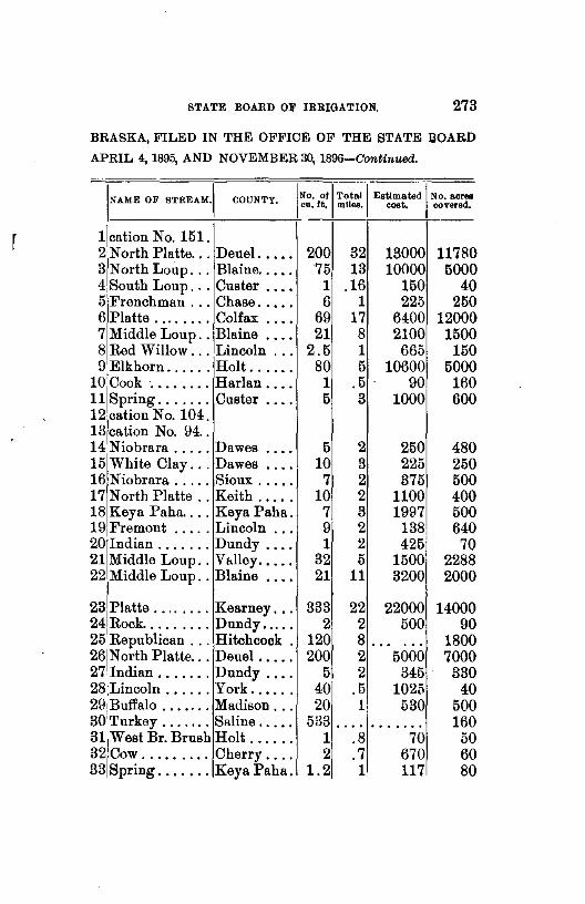
STATE BOARD OF IRRIGATION. 273
BRASKA, FILED IN THE OFFICE OF THE STATE !WARD
APRIL 4, 1895, AND NOVEMBER 30, 1896-Continued.
!NAME OF STREAM.I COUNTY. I No. or I Total I Estimated I No. acrea cu. ft. miles. cost. covered.
1 cation No. 151. 2 North Platte ... Deuel. .••. 200 32 13000 11780 3NorthLoup ... Blaine ..... 75 13 10000 5000 4 South Loup ... Custer .... 1 .16 150 40 5 Frenchman ... Chase ..... 6 1 225 250 6 Platte ........ Colfax .... 69 17 6400 12000 7 Middle Loup .. Blaine .... 21 8 2100 1500 8 Red Willow ... Lincoln ... 2.5 1 665 150 9 Elkhorn ...... Holt ...... 80 5 10600 5000
10 Cook ........ Harlan .... 1 .5 . 90 160 11 Spring ....... Custer .... 5 3 1000 600 12 cation No. 104. 13 cation No. 94 .. 14 Niobrara ..... Dawes .... 5 2 250 480 15 White Clay ... Dawes .... 10 3 225 250 16 Niobrara ..... Sioux ..... 7 2 375 500 17 North Platte .. Keith ..... 10 2 1100 400 18 Keya Paha .... Keya Paha. 7 3 1997 500 19 Fremont ..... Lincoln ... 9 2 138 640 20 Indian ....... Dundy .... 1 2 425 70 21 Middle Loup .. V~>lley ..... 32 5 1500 2288 22 Middle Loup .. Blaine •... 21 11 3200 2000
23 Platte ........ Kearney ... 333 22 22000 14000 24 Rock ......... Dundy ..... 2 2 500 90 25 Republican ... Hitchcock . 120 8 ... ... 1800 26 North Platte ... Deuel ..... 200 2 5000 7000 27 Indian ....... Dundy .... 5 2 345 330 28 Lincoln ...... York ..••.. 40 .5 1025 40 29 Buffalo ....... Madison ... 20 1 530 500 30 Turkey ....... Saline ..... 533 . ... . . . . . . . 160 31 West Br. Brush Holt ...... 1 .8 70 50 32 Cow ......... Cherry .... 2 .7 670 60 33 Spring ....... Keya Paha. 1.2 1 117 80
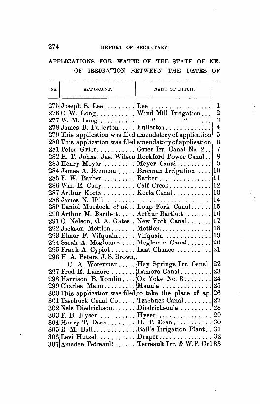
274 REPORT OF SEORETABY
APPLICATIONS FOR WATER OF THE STATE OF NE
OF IRRIGATION BETWEEN THE DATES OJ<'
-~=o.~_I======A=P=P=L=IC=A=NT~.====~=====N=A=M=E=O=F=D=I=TC=H=.====~
275 Joseph S. Lee ......... Lee . . . . . . . . . . . . . . . . . 1 276 C. W. Long ........... Wind Mill Irrigation. . . 2 277 W. M. Long . . . . . . . . . . " " 3 278 James B. Fullerton .... Fullerton . . . . . . . . . . . . . 4 279 This application was filed amendatory of application 5 280 This application was filed amendatoryofapplication 6 281 Peter Grier ........... Grier lrr. Canal No. 2. . 7 282H. T. Johns, Jas. Wilson Rockford Power Canal.. 8 283 Henry Meyer ......... Meyer Canal . . . . . . . . . . 9 284 James A. Brennan ..... Brennan Irrigation .... 10 285 F. W. Barber ......•.. Barber ............... 11 286 Wm. E. Cady ....•.... Calf Creek ........ " .. 12 287 Arthur Kortz ......... Kortz Canal ........... 13 288 James N. Hill.... . . . . . . . . . . . . . . . . . . . . . . . . . 14 28£1 Daniel Murdock, et al ... Loup Fork Canal ...... 15 290 Arthur M. Bartlett ..... Arthur Bartlett ........ 16 2910. Nelson, C. A. Gates . New York Canal. ...... 17 292 Jackson Mettlen ....... Mettlen ............... 18 293 Elmer F. Vifquain ..... Vifquain ............. 19 294 Sarah A. Meglemre .... Meglemre Canal ....... 20 295 Frank A. Cypiot ....... Last Chance . . . . . . . . . 21 296 H. A. Peters, J. S. Brown,
C. A. Waterman ..... Hay Springs lrr. Canal. 22 297 Fred E. Lamore ....... Lamore Canal ......... 23 298 Harrison B. Tomlin .... Ox Yoke No. 3 ........ 24 299 Charles Mann ......... Mann's .............. 25 300 This application was filed to take the place of ap- 26 301 Tzschuck Canal Co ..... Tzschuck Canal ........ 27 302 Nels Diedrichson ....... Diedrichson's ......... 28 303 F. B. Hyser .......... Hyser ............... 29 304 Henry T. Dean ........ H. T. Dean ........... 30 305 R. M. Ball ............ Ball's Irrigation Plant .. 31 306 Levi Hutzel ........... Draper ............... 32 307 Amedee Tetreault ...... Tetreault lrr. & W. P. Cnl33

STATE BOARD OF IRRIGATION. 275
BRASKA, FILED IN THE OFFICE OF THE STATE BOARD
APRIL 4, 1895, AND NOVEMBER 30, 1896-Continued.
NAME OF STitEAM.I COUN1'Y. I No. of I Total I Estimated I No. acres cu. ft. miles. cost. covered.
1 Bordman ..... Cherry .... 1U 4 1245 480 2 Beaver ....... Nance . . . . .25 .... 200 15 3/Beaver ....... Nance .... .25 .... 200 10 4 Abitz ........ Holt ...... 1 1 45 40 5 No. 9U, Division No.2 A ... . . . . • 0 •• . . . . . . . . . . . . . 6No. 13U, Divi- sion No.2 C . . . . .... . . . . . . . . . . . . . 7 Middle Loup .. Thomas ... 35 12 2675 2600 8 North Loup ... Garfield ... 250 4 10000 0 •••••
9 South Platte .. Keith ..... 3 1 312 200 10 Red Bird ..... Holt ...... 3 .1 60 160 11 Center ....... Franklin .. 2 1 300 140 12 Calf ......... Cherry .... 2 2 120 140 13 Horse Shoe Lke Cherry .... 3 3 600 210 14 Shell Creek, .. Colfax .... 5 .... . . . . . . . 520 15 Loup ........ Platte ..... 1417 78 149400 99200 16/White ....... Dawes .... 2 1 220 140 17jLoup ........ Colfax .... 850 65 140000 164800 18 Niobrara ..... Sioux ..... 10 3 500 700 1UjCottonwood ... Keya Paha. 1 1 150 100 20 Greenwood ... Cheyenne .. 6 1 115 320 21 Cypiot ....... Keya Paha. .1 .5 154 15
22 Niobrara ..... Sheridan .. 72 3 ( suppl.) ...... 23 North Platte .. Cheyenne .. 10 2 808 700 24 East Ash ..... Dawes .... 1 .5 150 100 25 Chadron ..... Dawes . ... 1 1 500 30 26 plication No. ::!B2 ....... • • 0 ,, .... • • • 0 ••• . ..... 27 North Loup ... Valley .... 300 36 4COO 17000 28 White ....... Sioux ..... .25 .... 43 15 29 Beaver ....... Sheridan .. ••• 0 .... 50 23 30 Greenwood ... Cheyenne .. 4 2 500 300 31 White Clay ... Sheridan .. .5 1 1050 35 32 White Clay ... Sheridan .. .25 .75 200 16 33 North Platte .. Che enne .. y 2 .... 500 250

276 REPORT OF SECRETARY
APPLICATIONS FOR WATER OF THE STATE OF NE
OF IRRIGATION BETWEEN THE DATES OF APRIL
No.) APPLICANT. NAME OF DITCH.
308 E. M. Searle .......... River Side Canal. . . . . . . 1 309 John Van Koten . . .. . . . Van Koten . . . . . . . . . . . . 2 310Henry M. Opperman ... Opperman Ditch No.2 .. 3 311 Andrew J. Lamb ....... Harvey & Lamb ....... 4 312 Carrig Lynch & Co. . . . . . . . . . . . . . . . . . . . . . . . . 5 313 N. Douglas Hamlin ..... Hamlin's Ditch. . . . . . . . 6 314 G. W. Whitehorse ..... Rochester . . . . . . . . . . . . 7 315 Theodore Wheeler ...... Wheeler Ditch No. 3. . . 8 316 Theodore Wheeler ...... Wheeler Ditch No. 1... 9 317 Theodore Wheeler ...... Wheeler Ditch No. 2 ... 10 818 E. F. Roberts .......... E. F. Roberts . . . . . . . . 11 319 L. G. Gillespie ........ Chelsea Irr. Canal. ..... 12 820 Progress Irr. & Col. Soc. Progress Irr. & Col. Soc. 13 321 A. Rickman, A. Wentworth Rickman & Wentworth .. 14 822 Andrew J. Lamb. . . . . . . . . . . . . . . . . . . . ....... 15 823 Bohemian Nurseries .... Bohemian Nursery Ditch 16 824 Bohemian Nurseries .... Bohemian Nursery Canal 17 325 Adam Miller .......... Miller Ditch .......... 18 326 Keller & Co ........... Oliver ............... 19 827 Fred E. Lamore ....... La More ............. 20 828 R. S. McConnell ....... Twist .......•....•.. 21 329 Robert Wilbert ........ Wilbert .............. 22 830 Frank Stastny ......... Stastny .............. 23 381 Francis Novak ......... Novak's Canal ......... 24 332 Anthony Serbousek .... Serbousek's Canal ..... 25 333 William Cooper ....... Cooper ......•........ 26 334 H. G. Stewart ... ~. . . . . . . . . . . . . . . • . . . . . . ... 27 335 A. N. McConaughey .... A. N. McConaughey .... 28 336 B.Frendrick,H.Lichter .. Frendrick-Licbter .... 29 337 James T. Mason .. . . . . . . Mason ............... 30 338 S. L. Ellis ..•......... S. L. Ellis ...•........ 31 339 R. T. Ellis ........••.. R. T. Ellis ............
1
32 340 L. C. Lewis . . . . . . . . . . . Lewis . . . . . . . . . . . . . . . . 33 341 William Miller ........ Miller ••••........... 34

STATE BOARD OF IRRIGATION. 277
BRASKA, FILED IN THE OFFICE OF THE STATE BOARD
4, 1895, AND NOVEMBER 30, 1896-Continued.
'NAME OF STltEAM.I COUNTY. 'No. of I Total I Estimated I No. acres cu. ft. mllea. cost. covered.
1 South Platte .. Keith .... l51 4$ 1000 1030 2Rock ......... KeyaPaha. .2 5 46 15 3 Spr. (no name) " .1 .7 300 80 4 Young ...... Holt ...... 3 1 200 100 5Loup ........ Platte ..... 1 480 273 6 Squaw ....... Sioux ... 2 .7 195 140 7 Niobrara ..... Boyd ..... 1000 .7 3500 1500 8 Big Sandy .... Holt ...... 3 1 200 80 9 Spring Br .... " . 5 1 50 35
10 " " 1 1 75 40 11 Blackbird ..... " 1 .5: 100 30 12 Spring ....... " 3 2 330 400 13 Benner " 6 il 260 100 ••• 0. 0
r 14 Niobrara ..... KeyaPaha. ~ 75 140 15 Shobe Br ...... Holt •••• 0 0 ••• .51 75 140 16 Rose ........ Thayer ... 10 .1 210 16 17 " " 1 .11 210 16 •• 0 ••••
18 Skunk ....... Keith • 0 •• 4 2' 65 320 19 NorthLoup ... Cherry .... 7 71 1586 500 20 North Platte .. Cheyenne . 20 5! 1625 1400 21 Springs ...... " 3 . 71 270 160 22 Plum ........ Brown ..... 1 1 2511 230 23 Beaver ....... Dawes ..... 2 .... 2301 25 24 " Sheridan ... 1 .5 175 70 ....... 25 Branch ...... " .5 .2 1501 10 26 Squaw . . . . . . Dawes ..... 4 1 3001 300 27 Deadman ..... " .5 2501 80 28 Pepper ...... Sheridan ... 5 5 5001 600 29 Cottonwood ... Dawes ..... 2 1 145 75 30 Seepage •••... Sioux 1 .2 2801 10 31 Antelope ..... " 1 .5 70 70 32 N.Br.Warbor:et Sioux .5 .7 901 35 33 White ....... " 10 .a 87 15 34 Hat .......... " 1 . 3 62 ...••.
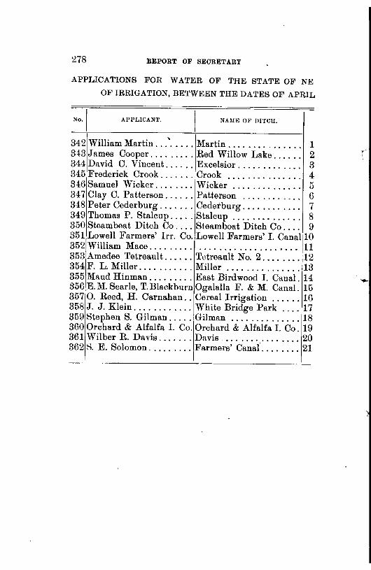
278 REPORT OF SECRETARY
APPLICATIONS FOR WATER OF THE STATE OF NE
OF IRRIGATION, BETWEEN THE DATES OF APRIL
APPLICANl'. NAME 0~' DITCH,
34-2 William Martin ... ' ..... Martin.... . . . . . . . . . . . 1 343 James Cooper ......... Red Willow Lake.... . . 2 344 David C. Vincent ...... Excelsior. . . . . . . . . . . . . 3 345 Frederick Crook ....... Crook . . . . . . . . . . . . . . . 4 346 Samuel Wicker ........ Wicker . . . . . . . . . . . . . . 5 347 Clay C. Patterson ...... Patterson . . . . . . . . . . . . 6 348 Peter Ceder burg ....... Cederburg. . . . . . . . . . . . 7 349 Thomas P. Stalcup ..... Stalcup . . . . . . . . . . . . . . 8 350 Steam beat Ditch Co .... Steamboat Ditch Co.... 9 351 Lowell Farmers' Irr. Co. Lowell Farmers' I. Canall10 352,William Mace. . . . . . . . . . . . . . . . . . . . . . . . . . . . . l! 353 Amedee Tetreault ...... Tetreault No. 2 ........ 12 354 F. L. Miller ........... Miller ............... 13 355 Maud Hinman ......... East Birdwood I. Canal. 14 356 E. M. Searle, T.Blackburn Ogalalla F. & M. Canal. 15 357 0. Reed, H. Carnahan .. Cereal Irrigation ...... 16 358 .J. J. Klein ............ White Bridge Park .... 17 359 Stephen S. Gilman ..... Gilman .............. 18 360 Orchard & Alfalfa I. Co. Orchard & Alfalfa I. Co. 19 361 Wilber R. Davis ....... Davis ................ 20 362 8. E. Solomon ......... Farmers' Canal ........ 21
' '

STATE BOARD OF lRl!IGATlON. 279
BRASKA, FILED IN THE OJ<,l•'ICE OF THE STATE BOARD
4, 1895, AND NOVEMBER 30, 1896-Concluded.
INAME OF STREAM. I COUNTY. I No. ofl Total I Estimated j No. acres cu. ft mlleR. coat. covered,
1 East Boggy ... Sioux ..... 2Red Willow L. Lincoln ... 3 Niobrara ..... Dawes .... 4Goose . . . . . . . Brown .... 5 Rock ........ Keya Paha. 6 E. Branch Rock " 7 Bear " 0 0 ••••••
8 Burton " ...... 9 North Platte .. Scott's Bluff1
10 S. Ch. Platte .. Kearney .. ·I 111West Ash .... Dawes .... 12North Platte .. Cheyenne . 13 South Platte .. DeuPI ..... 141East Birdwood. Lincoln ... 15 South Platte .. Keith ..... 16,South Platte .. " ..... 171Wood ....... Bnfl'alo .... 18 Minnecadusa .. Cherry .... 19 Platte ....... Dawson ... 20 Larabee ...... Sheridan .. 21 Frenchman ... Hitchcock .
1 . 75$ 25 2 1 485
32 2 110 8 3 995 1 .3 24
.3 .5 30 .25 1 133
1 .... 62 40 . ... • • • • . 0.
11-± 7 4769
-~1 .75 505 <J .5 275
161 3 575
25 14 9700 125 15 12500 20 8 4150
. . . . . ... 125 40000 20 . . . . . . . 500 21 26600
2 ·.7 60 1001 12 6000
2 15 28 82
5 0 0 0 5
10 5
40 0 •••••
8000 700 320
1120 2000 6000 2000
4 •• 0 0 ••
......
...... 7000

280 REPORT OF SECRETARY
ABSTRACTS OF NOTICI!:S OF CLAIMS FILED IN THE OFFICES OF THE VAHIOUS COUNTY CLERKS, ALPHABET!·
CALLY ARRANGED BY COUNTIES.
CLAIMANT. I STREAM.
ADAMS-
Chas. W. Wilson ...... Little Blue .. . E. A. Phil! eo ......... Little Blue .. . E. A. Philleo ......... Little Blue .. . ANTELOPE-
FILED. [s.[T./R.
4-23-94 18 5 10 o-8-94 4 5 10
9-2u-ll4 4 5 10
B. C. Buxton ......... Verdigris. . . . 7-13-9411 28 8 B. C. Buxton ......... Verdigris . . . . 7-13-94 11 28 8 B. C. Buxton ......... Verdigris .... 7-13-941128 8 B. C. Buxton ......... Verdigris .... 7-13-941128 8 John W. Hanson . . . . . . Verdigris . . . . 8-11-94 8 28 8 William Ferris ....... Elkhorn. . . . . 9-11-94 31 26 7 S. C. Fairchild ........ Elkhorn . . . . . 9-27-94 3 24 6 Neleigh lrr. P. & :M. Co. Elkhorn ..... 10-20-9417 2(l 8 John Maybury ........ Elkhorn ..... 12-19-941726 8 Nelson D. Jackson .... Elkhorn..... 4-u-ll517 2(l 8 J. E. Buxton ......... Verdigris. . . . 5-29-95 11 28 8 J. E. Buxton ......... Verdigris.... 5-29-95 11 28 8 J. E. Buxton ......... Verdigris. . . . 5-29-95 11 28 8 B. C. Buxton ......... Verdigris. . . . 5-2\J-95 1 1 28 8 BANNER-
T. Eggleston, J. Wilcox Pumpkin Seed Ban'r Co.Joint Stock Co. Pumpkin Seed Ban'r Co. Joint StockUo. Pumpkin Seed T. C. Eggleston ....... Pumpkin Seed W. S. Langmaid . . . . . . . .......... . J. C. Walter .......... Pumpkin Seed John E. Logan ....... Pumpkin Seed C. Endernd, 8. Campbell Pumpkin Seed John S. Wright ....... Pumpkin Seed John S. Wright ....... Pumpkin Seed R. R. & W. D. Hampton Pumpkin Seed G. Lee Shumway ...... Pumpkin Seed J obn F. Peters ....... Pumpkin Seed Lewis Utter ..•....... Pumpkin Seed John F. Peters ........ Pumpkin Seed
6-19-89 119 55 9-24-89 7 19 55 9-24-89 5 19 55 4-7-90 11955
7-11-90 1418 56 7-14-90 41!) 55 7-18-BO 711l55
fJ-4-91 211\J 55 fl-12-91 519 54 6-12-91 51954
5-fJ-93 23120 57 3-12-94 5 lll 55 4-10-94 3412U 56 4-24-94 31 20 56 6-12-96134 20 56
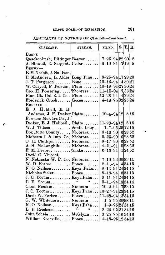
STATE BOARD OF IRRIGATION. 281
ABSTRACTS OF NOTICES OF CLAIMS-Continued.
CLAIMANT. STREAM.
BooNE-
Quackenbush, Pittinger Beaver ..... . A. Stowell, E. Sargent. Cedar ...... . BROWN-
R.M.Nesbit, J. Sullivan,
7-25-94 22 201 6 8-10-94 7 19 8
P. McAndrew, L. Alder. Long Pine. . . 8-25-9417 29 20 J. T. Ferguson ........ Bone ....... 10-13-94 4 30 21 W. Coryell, F. Pelster .. Plum ....... 10-19-94 27 30 24 Geo. H. Bowering ..... Niobrara ..... 11-10-94 7 33 24 Plum Ck. Cnl. & I. Co .. Plum ....... 12-26-94 4 29 24 Frederick Crook ...... Goose. • . . . . . 4-19-95 32 25 24 BUFFALO-
E. J. Hubbell, E. H. Andrews, J. E. Decker Platte. • . . . . . 10-4-94 12 8 16
Farmers Mut. Irr.Co., J. Decker, E. J. Hubbell.. Platte ....... 11-23-9412 8 16 W. J. Tillson ......... South Loup. . 1-7-95 29 12 15 Box Butte County ..... Niobrara..... 9-13-90 6 28 52 Niobrara I. & Imp. Co. Niobrara. . . . . 9-25-90 6 28 52 0. H. Phillips ........ Niobrara ..... 9-17-90 8 28 52 A. H. McLaughlin ..... Niobrara. . . . . 4-21-91 9 28 52 F. M. Devore ......... Snake. . . . . . . 6-13-94 1 24 52 David C. Vincent, N. Nebraska W. P. Co. Niobrara..... 7-10-93 30 3311 W. D. Forbes ......... Ponca....... 8-11-9-i 4 3413 N. 0. Neilson ......... Keya Paha. . . 8-13-94 24 34 15 Nicholas Sieler ........ Ponca. . . . . . . 8-18-94 6 34 13 J. C. Yocum .......... Keya Paha... 9-11-94 24 3415 C. E. Yocum..... . . . . " " 9-11-9419 3414 Chas. Fienkin ........ Niobrara . . . . 10-9-94 7 33 15 J. C. Yocum .......... Keya Paha ... 10-27-94 23 3415 Davis W. Forbes ...... Ponca ....... 11-28-9413 3413 G. W. Whitehorn ...•. Niobrara . . . . 1-5-95 30 3311 N. 0. Neilson ......... Key a Paha. . . 1-9-95 24 3415 L. E. Erickson..... . . . " " 2-·23-95 213416 John Scheie .......... McGlynn.... 3-25-9516 3416 William Kearville ..... Ponca.... . . . 4-18-95 12 3413
•
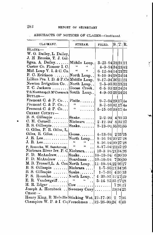
•
2.82 REPORT OF SECRETARY
ABSTRACTS OF NOTICES OF CLAIMS--'-Continued.
CLAIMANT. STREAM.
BLAINE
W. G. Dailey, L. Dailey, J. H Brooks, T. J. Gil-ligan, A. Dailey ....... Middle Loup. Custer Co. Pioneer I. 0. " " Mid. Loup V. I. & U. Co. " " . P. C. Erickson ....... North Loup .. Lillian Pre. I. D. & P. Co Middle Loup. Newton Irrigation Co .. North Loup .. T. C. Jackson ........ Goose Creek. TS.Northrop,O.M'Cormack South Loup .. BUTLER-
I is 'T IR 1
FILED. 1
•
1
.
1
•
3-23-9i 32 21 21 4-9-94 34 21 42
6-12-Hi 14 21 22 8-10-94 28 24 24 9-17-94 30 21,21
2-5-95 35 23 21 6-5-95 23 24 24 4-9-95 29 24 24
Fremont C. & P. Co ... Platte. . . . . . . 9-7-94 29 17 4e Fremont C. & P. Co... " . . . . . . . 3-7-95 3017 4e Fremont C. & P. Co... " ....... 5-15-1:15 3017 4e CHERRY CouNTY-
B. S. Gillespie ....... Snake. . . . . . . 2-2-94 4 '30133 C. H. Cornell. ........ Niobrara . . . . 2-12-94 8 33;27 B. S. Gillespie ........ Snake....... 2-13-H4 35 31135 G. Giles, P. R. Giles, L. Giles, R. Giles ........ Goose. . . . . . . 4-13-04 2 25,25 J. R. Lee ............ North Loup. . 8-Hl-9{.30 27128 J. R. Lee . . . . . . . . . . . . " " 8-W-IJ413o 27 l:l8 P. Roneche, W. Sanderson. " " . . 8-17-H4 23 27•29 Niobrara River Irr. P. C Niobrara.. . . . 10-3-()4 21 34i26 P. D. McAndrew ...... Snake ....... 10-10-94 6 3030 P. D. McAndrew ..... Boardman ... 10-10-U4 7 30'30 M. B. T:ussel!,L. A. Cox N?rth Loup .. ll-19-u; 1~2 26 27 B.S. Gillespie ....... Nwbrara .... 1-7-9n213426 B. S. Gillespie ....... Snake. . . . . . . 1-7-95 4 30 33 P. S. Honeche ........ North Loup.. 4-30-H5 2:!•27 29 E. R. Vandergriff ..... " " .. 5-14-H535
1
2728 H. R. Edgar ......... Cow . . . . . . . . . . . . . . . . 7 2() 27 Joseph A. Hornback .. Sweeney Cany ........ :W/1 34 25 CHASE--
Henry King, R Melville Stinking Wat.12-17-90 2 7 3() Champion W. P. & I. Co/Frenchman .. 12-2G-90 24[ G 40

S'l'ATE BOARD OF Il\RIGATION. 283
ABSTRACTS OF NOTICES OF CLAIMS-Continued.
CLAIMANT. II FILED.. IS.\ T. iR I . I
STREAM.
CHASE-Continued. I I I'
T.B. 'fay lor, D.T. Wowns M. F. Person, L Lowman Frenchman .. 12-31-90 24 6!40 Ough Land & Irr. Co.. " . . 1-2-91 21 6
1
39 W. J. McGillen. . . . . . . " . . ~-3-91 3 5 38 D. Gurnsey, F. Munson, Alexander McCargar . . " 2-11-91 3 5 37 Champ.V.W. P. & I. Co. " 2-21-9120 639 George Hoc knell ...... S. F. Stink. W. 3-3-91 2\J 7 37 Bussell & Funk ....... Frenchman 3-20-H118 6 40 Bussell & Funk. . . . . . . " 3-·20-9118 6 40 William J. McGillen . . " 2-4-94 1 5 38 Chase Co. L. & L. S Co. Stinking Wat. 3-12-9410 7 38 Van L. Wilson ....... Frenchman 3-23-9418 6 40 Van L. Wilson . . . . . . . " 3-23-9418 6 40 J. D. Shahan ...... _ . " 3-~4-94 23 6 39 Van L. Wilson . . . . . . . " 6-7-94 23 6 39 Cash D. Fuller..... . . " 6-18-94 4 5 36 0. H. Wirsig, J. Foster, I M. H. Yaw, B. F. Fuller " . . 6~28-85 23 0. H. Wirsig. . . . . . . . . " . . 8-31-94,22 Frank McLain ........ Stinking Wat. 9-26-94128 A. L. Green.... . . . . . . " 9-28-941H Wilson S. Gould ...... Frenchman .. 10-10-94 1 Allen Grant.. . . . . . . . . " .. 10-16-94 3 Fremont Young . . . . . . " . . 12-4:-9! 11 Eli Maranville, Martin Overtree, B. Beard. . . . " .. 12-15-94112 Maranville, Overtree, Beard " •. 12-15-94 11 Robert B. Wright .... Stinking Wat. 12-2\J-94:2;-, Dudeck & Sommers ... Frenchman .. 12-26-941 8 D. Gurnsey & Co. . . . . " 1-21-95 3 D. Gurnsey & Co. . . . . " 1-21-95 10 Chase Co. L. & L. S. Co. Stinking Wat. 2-2-9513 Chase Co. L. & L. S. Co. " 2-2-95 14 Chase Co. L. & L. S. Co. " 2-2--95 14 Norton Inman . . . . . .. Frenchman 3-7-95 17
640 640 7 37 7 37 5 38 5 38 641
641 641
~~~~ 5 37 5 37 7 38 7 38 7 38 640

284 BEPOBT OF SECRETARY
ABSTRACTS OF NOTICES OF CLAIMS-Continued.
CLAIMANT. STREAM.
CUSTER-
Dailey, Gilligan & Co .. Victoria ..... Thomas Laugh ran..... " Dailey, Gilligan & Co . . " J.S.McGraw, E.N.Bish-op, S. Gates, J.McGraw,
3-19-94 119,21 4-5-94 219 21
3-31-94 119 21
G.W.Dewey,J.E.Ash " ..... 7-24-94 11921 Wescott lrr. & Cnl Co. Middle Loup. 8-8-9! 15 L918 Chas. Penn ........... Muddy . . . . . . 8-24-94 3217 20 LillianP'ct. lrr. & P. Co Middle Loup. 10-19-9!30 2121 I. P. Bell, T. Langham. Victoria . . . . . 9-27-94 2 19 21 Abner & Matilda Brown South Loup.. 11-1-94 3117 24 Eugene Boblits....... " 1-17-951014 21 B. Greible, A. Butcher .. Middle Loup. 2-19-95 36 20 21 CHEYENNE-
N. Plattelrr. Cnl.&L.Co North Platte .. 7-29-912814 30 Chas. E. Schilt ........ Monroe.. . . . . 5-31-86 33 33 56 N. G. Fix ............ Pumpkin Seed 10-18-88 3319 52 Ogalalla&NW lrr. & WP North Platte. . 4-4-89 13 20 52 Carl E. Borgquist ..... Lodge Pole.. 4-15-89 3414 49 CarlE. Borgquist. .... " 4-15-89341449 ChRocklrr.Cnl&WPCoNorth Platte. 4-17--8\J 62052 L. H. Bordwell ....... Lodge Pole. . 5-7 -8\J 33 14149 L. H. Bordwell....... " 5-7-8\J 3514 49 Ch Rocklrr.Cnl&WPCo North Platte. 5-ltl-8\J 6 20 52 S. Walsh, Jas. Mitchell. Lodge Pole .. 5-11-89 814
151
Adam Gunderson,. .. .. " 5-17-89 114152
RobertS. Oberfelder... " 6-10-8\113114:46
Robert S. Oberfelder ... Spring . . . . . . 6-10-i:\U 3114146 Morritz Urbach .•..... Lodge Pole .. 6-11-8\) 1114 51 • Firth Booth.... . . . . . . '' ........ 2U 14 47 Firth Booth.... . . . . . . '' ........ ~U 14 47 Ch,.~ocklrr.&W.P. Co. Nor.th Platte. 6-~7-8? {:20 1 5~ Wilham C. ~ullock .... Sprmg . . . . . . ~-;"0-Sll. b 13146 Henry H. L1bby ..... Lodge Pole . . 6-24-89 3614 47 Henry H. Libby...... " 6-24-89136:1447 Henry H. Libby...... " 6-24-89 36[14~47

STATE BOARD OF IRRIGATION. 285
ABSTRACTS OF NOTICES OF CLAIMS-Continued.
I I ' =---c_L_A_IM_A=N-T--:. -:-----,:-':--s_T_R_E_A_M_. _..,_F_ILED. 1 S .. T.l R CHEYENNE-Continued. I Henry H. Libby ...... Lodge Pole. . 6-2 !-89 3614 4 7 William T. Whitney ... Lodge Pole. . 6-19-89 36 14 49 William T. Whitney ... Lodge Pole. . 6-19-89 3114 48 Lewis H. Hale ....... Lodge Pole. . fl-24-89 36 14 49 Lewis H. Hale ....... Lodge Pole. . 6-24-89 36 14 49 Lewis H. Hale ....... Lodge Pole. . 6-24-89 36 14 49 Lewis H. Hale ....... Lodge Pole. . 6-24-8!JI36 14 49 Lewis H. Hale ....... Lodge Pole .. 6-24-89!361449 Frederick W. Krueger .[Lodge Pole. . 7 -6-89
1
2!) 14 48 Frederick W. Krueger. Lodge Pole. . 7-6-89 29 14 48 Frederick W. Krueger. 1Lodge Pole. . 7-6-89 29 14 48 Elijah B. Rodgers .... Lodge Pole.. 7-5-89,271448 Elijah B. Rodgers .... Lodge Pole.. 7-6-89:271448 B. Gilman, J. D. Staf- I
ford, J. J. M:axwell,F. Beasley, C. Lafferty.LR.wrence Fk.10-17-893o1952
Charles E. Logan ..... North Platte. 10-26-891() 20 50 T. Brown, C. B.Pic~erell,
G. W. Seward, W. G. Pickerell, E. S. Crigler Pumpkin Seed 11-4-89 2319 52
John T. Lafferty ...... Pumpkin Seed ll-1-891
2H lU 52 L. P. Hendricks ...... Pumpkin Seed 11-9-89129 19 51 S P. Laing,G.A. Laing. Lawrence Fk. 12-18-89 28 18 52 Charles A. Perkins .... Pumpkin Seed 12-23-89
1
24.19 52 Leonard Hoppen ...... Pumpkin Seed 12-23-8!) 2419 52 Belmont I. C. & W. P .. North Platte. 12-27-8923·2051 G. Seward,E. S. Crigler,
F.D.Hayes,T.Brown, , G.Pickerell,S.Gersten Pumpkin Seed 12-30-8913319,52
D. Coulter, H. Coulter .. Greenwood . . 2-4-901518 50 Levi Miller .......... Cedar . . . . . . . 2-26-90127 18 48 J. C. Wolf ........... Lodge Pole.. 3-5-80321446 Belmont I. C.&. W. P.North Platte. 3-10-90232051 C. Schrader, M.Stewart. Pumpkin Seed 4-18-90 25 19 51 Mac Radcliff .......... Cedar. . . . . . . 4-23-IJO 27 18 48 Oliver Miller ......... Cedar. . . . . . . 4-28-90 25 18 48

286 REPORT OF SECRETARY
ABSTRACTS OF NOTICES OF CLAIMS-Continued.
cLAIMANT. 1 sTREAM. FILED. 1s. IT. JR. CHEYENNE-Continued. I Finn Bros ............ Spring . . . . . . 6-4-90 2818
1
49 William H. Stones ..... North Platte. 8-4-90 18 21
1
53 P. E.&W. J. VanGorder " " . 8-27-90 31950 John D. Wagoner ..... Pumpkin Seed 0-10-90 2419:52 J. E. Holloway, A. Neely · " " 10-10-90 3019
1
50 W. M. Willard... . . . . . " " 10-10-90 3019,50 J. E. Holloway, A. Neely, W. M. Willard. . . . . . . . " " 10-14-90 30 19 50 C.F.Schrader,MStewart " " 10-22-90 2519 51 E. C. Smith C. G. Wheeler " " 10-25-90 26 19 51 C. B. Pickerill, L. Hop- I
pen, CharlesPerkins... " " 11-7-90 3419,52 Charles E. Logan ..... North Platte. 12-11-90 .. 20
1
50 ChRocklrr. Cnl.& WPCo " " . 12-10-90 1 20
1
53 C. C. Nelson, B. F. Mc-Kinney, J. E. Trinnier. Greenwood.. . 1-17-·9113318 50 W. S. Court, F. Borgas, Gerd Henricks ........ Cedar ........ 1-23-91
114 18 48
P. P. Waitman ....... Pumpkin Seed 3-17-911
3019
1
52 Thomas Brown. . . . . . . " " 3-17-91,2D 19 52 C. S. Ickes ........... Lodge Pole. . 3-28-\)113414 50 J. E. Trinnier ........ Greenwood... 4-16-9!'2218 50 Edmund Doran ....... LawrenceFork 4-24-Dt'15 18 52 M. H. Tobin ......... Lodge Pole ... 4-23-D1281447 G. Meridith, J. Ammer. Pumpkin Seed 5-4-\Jll3 19 50 S.O.Fowler 0. W.Fowler LawrenceFork 5-18-911118 52 S.O.FowlerO.W.Fowler " " 5-18-9111 U\52 Edwin S. Crigler.. . . . . " " 5-'2.7-\Jl1118 52 L. B. Cary ........... Pumpkin Seed 6-17-\Jl23 19 50 Wm. W. Lisco ........ North Platte. 6-20-91141847 Brown'sCk. Irr.&Cnl Co " " 7-6-9128 20 50 T. W. 0. Wolfe, H. F. : Etches, George Soward. " " 7-6-91' 18 20 51 .T. T. Clarkson ........ Lodge Pole .. 7-21-9113614 50 W. D. Watkins, C. Wag-ner,W.Stones, T. WolfeNorth Platte. 7-28-91191948
\

STATE BOARD OF IRRIGATION. 287
ABSTRACTS OF NOTICES Ol<, CLAIMS-Continued.
. CLAIMANT. sTREAM. 1 FrLEo. I s.j T./ R.
CHEYENNE-Continued. E. T. Smith, P. Seaback, W. H. Stone, M. G. Fix, A. Henline, McCracken. North Platte .. Edwin S. Crigler ...... Lawrence ... . George F. Berry. . . . . . " Thos. Brown, C. Essig. Pumpkin Seed John Halloway.... . . . . " " Brown's Ck.Irr.&Cnl. Co North Platte .. Asa Remsburg ........ Deep Hole .. . William Stillwell ...... Camp ...... . Empire Canal Company North Platte .. C. G. Laing, C. G. Laing Brown's ..... W. S. Court, J. W. Mc-Mahan, E. A. Yelton ... Cedar ...... . B. F. McKinney ....... Greenwood .. Henry Earthing ...... Middle ..... . Calvin P. Rice ........ Spring ..... . Eliza A. Cooper ....... Spring Branch Court House Rock I. Co Pumpkin Seed F. Bourner, J. Thalkem. Greenwood .. Alliance I. C. & W.P. Co North Platte .. Henry T. Clark. . . . . . . " " Logan Irr. Canal Co. . . ·' " J. P. Ammer, Geo. R. Meraditb .. : .......... Pumpkin Seed J. Ammer, G. Mradith. . " " L. Gerdton, L. Hop pen. " " Wagoner Cnl. & Irr. Co. North Platte .. George H. Haxby. . . . . " " Short Line Irr. Cnl. Co. " " H. M. Coulter .... : . .. Greenwood D. M. Coulter. .. . . . . . . " " Louis Schentz ... · ..... Springs ..... . Robert S. Oberfelder ... Lodge Pole .. . Harry Barrett. . . . . . . . " " Carl A. Wagoner ...... North Platte..
7-31-91 5 20 52 9-18-91 118 52 11-2-911118152
11-14-91 29 19152 12-31-912819 50 . . .. .. .. 29 2050 .. .. . . .. 31849
3-16-92 1318 49 5-7-92 18 20 51
5-20-92 38 20 49
6-27-92 1418 48 7-28-92 33 18 50 8-16-92 33 18,51 8-16-92 27 20 48 8-23-92 419 50
12-15-92 30 19 51 12-27-92 28 18 50 12-31-92 5 20 52
2-7-93222051 2-17-9319 20 50
2-28-93 23 19 50 2-25-93 23 19 50 3-13-93 3419 52 3-B0-93 14 19 49 4-10-93 32 19 48 5-11-93 30 21 52 6-2-93 10 18 50 6-7-931518 50
6-14-93 28 18 50 12-21-93 3114 46
1-15-94 32 14 46 3-24-94 1319 49

288 REPORT OF SECRETARY
ABSTRACTS OF NOTICES 01~ CLAIMS-Continued.
I ' I CLAIMANT. STREAM. I FILED. IS.[T. R.
CHEYENN ll-Conlinued.l I J. Finn, H. T. Dean ... Pumpkin Seed 4-21-94 27 19 50 Lee N unn .. .. .. .. .. . " " 5-31-94 28 19 51 Joseph J. Maxwell.... " " 7-3-94241952 Hannah Irr. Canal Co .. North Platte . 9-28-94 2418 47 A. H, Smith, G. W.Beer-line, John Beorline, E. Smith, Morton B. Smith, " " . George P. Gunder .... Springs ..... William M. Willard ... Pumpkin Seed J. P. Dunlap. . . . . . . . . '' A.M. Capron, J. S.Lamb Greenwood DAWES-
J. Hathaway, J. H. Craig H. B. Austin, J. P. Ar-
10-16-94 24 19 49 n-23-95 1413 51 4-4-95 25 19 51
5-14-95241951 1-13-92 15 1S 50
nott, C. C. Hunt .... White 9-29-90 25 32 52 J. T. Stewart ......... L. Cottonwood 12-26-90 8 32 52 Wallace S. Gallup .....
1
Chadron ..... 12-26-9015133 49 F. _B: & E. F. W oodrutf.
1
Dead Horse. . . ..... ; . 32 32 49 W1lham Mace ........ W. Br. Ash .. 12-31-90 2 3151 J. J. Harbaugh ....... West Ash .... 12-31-90 24 32 51 Harriet B. J. Richards. Big Bordeaux. 1-7 -Ul 36 33 48 Pres. Wilson ......... White . . . . . . 1-23-9132 33 50 W. M. Gillespie ...... L. Bordeaux . 1-29-91 33 34-48 Alfred Williams ...... Bordeaux. . . . 2-14-9133 34 48 S. A. Bryant ......... Big Bordeaux. 2-3-9114 33 48 Edwin Vasey ......... Second. . . . . . 2-3-91 3 32 48 John H. McAvoy ..... Bordeaux.... 3-6-9128 34 48 Oscar W. Hall.... . . . . " 2-28-9115 33 48 E. Barron ........... East Ash. . . . 3-6-9132 32 50 I. W. & 0. S. Norton .. Dead Horse. . 3-3-91 4 3149 I. W. & 0. S. Norton. . " 9-4-93 4 31 49 Theodore L. Goff ..... Br. of Butte. . 4-11-9130 3:! 49 A. J. Palmer & Co .... Niobrara . . . . 5-2fi-9131 29 50 John A. Butler ....... L. Bordeaux . 6-3-9133:33 47 Cbas J. Grable ....... White . . . . . . 6-17 -Ul ~3[!31 53 J. D. Ba~on .......... Bordeaux... . 6-24-91 2134 48
\ ...

STATE BOARD OF IRRIGATION. 289
ABSTRACTS OF NOTICES OF CLAIMS-Continued.
CLAIMANT. STREAM. l FILED. 18.\T·IR. DAWEs-Continued. I
Harriet B. J. Richards. Big Bordeaux 9-9-92 36 33 48 Harrison B. Tomlin ... East Ash. . . . 10-17-92 32 32150 S. and C. Hartzell ..... Lit. Bordeaux 11-8-93 13 33 48 City of Chadron ...... Chadron . . . . 12-26-92 18 32 48 Hmith L. Adams ...... Bordeaux . . . 3-4-93 2 32 48 H. J. Ingersoll, Reuben Sewell, W. S. Gallup .. Chadron ... . N. Broadhurst ........ West Ash ... . Henry M. Wilson ..... Chadron ... , Wallace W. Wilson . . . " William •r. Compton .. Ash ....... . E. Pearson ........... Dead Horse .. H. A. Goff . . . . . . . . . . . " " Geo. Brost ........... Chadron .... . G.W.Hatch, W. D. Cross Niobrara ... . J. C. Wood, R. B. Pierce " Howard G. Furnam. . . " J. T. McManis,J. N eeland " Harris & Cooper ..... White H.&Cooperi.C.,A Harris P.Cooper, E.Hutchings, B.Pinney,N.Welling,W.
6-3-93 26 33 49 7-3-93 3ti 32 51
7-15-93 12 32149 7-15-9312 32149 7-25-9312 32 51 8-19-93 7 32 49 9-2-93 9 3149 9-9-93 6 3148
1-25-94 25 '29 50 2-1-94 28 29 50 2-2-94 29 29 50 2-9-94 29 29 49
3-13-94 25 32 52
Peterson, W m. Smelze. " . . . . . . . 7-32-94 25 32 52 F. B. and E. F. Woodruff Dead Horse. . 3-20-94 32 32 49 Marcus L. Smock ..... Trunk Butte. 4-19-94 26 33 50 Bailey G. Pinney ..... Spring . . . . . 5-10-9413 32 52 Charles Rascher ...... White .. _ . . . 6-20-9! 19 32 51 A. A. Record ......... Chadron , . _ . 6-26-94 1 32 49 Nicholas Welling ..... White ...... 7-21-94173251 J. Noleman, M. Darrington Niobrara . . . . 9-7-94 28 47 47 A. V. Harris ......... White . . . . . . 12-11-9417 32 51 Mary M. Harris ...... Spring ..... 12-11-94 8 32 51 0. J. Demmon, Balser . " 12-3-94 7 32151 Mirage Irrigation Co .. Niobrara.... 12-7-94262948 William S Hazelton .. White Clay .. 12-13-9413 31152 Herman Kroesing ..... Niobrara ..... U-20-94 25 29 48

2UO REPOHT OF SECHETARY
ABSTRACTS OJ<' NOTIC!<;S 01<' CLAIMS-Continued.
CLAIMANT. FILED. [S. [T.[R.
1-9-95 34 32 52 1-11-95 22 29 48 1-18-U5 ..... . 1-19-95 34 32 52 1-25-95 26 29 48 1-28-95 27 29 48 2-11-95 26 29 48 2-20-95 17 29 48 2-~5-9510 33 52
3-8-95 10 32 51 13-22-95 27 32 48 ;3.28-95 35 29 51
4-2-95 25 32 513
6-14-94 3610 23 6-26-941810 23 8-17-U4 6 819 il-22-U4 18 10 23
11-10-\H 1G 11 25 U-15-114 13 9 22
12-28-!).! 15 11 25 1-9-95 15 11 25
1-23-9:i ..... .
6-25·89 3 13 46 H-25-89 33 14 46 11-5-89 30 Uil42 2-12-90 61642 2-13-90 30 16142
3-8-90 30 16:42 5-20-90 10 16 43 5-19-90 1412143 5-26-90 18 16 42 1-23-90 33 17 42 6-23-90 6 17 45 7-28-90 617 45
(

J
STATE BOARD OF IRRIGATION. 291
ABSTRACTS OF NOTICES OF CLAIMS-Continued.
CLAIMANT. STREAM.
DEUEL-Continued. North River P. & I. Co. North Platte. Union Irrigation Co ... Blue ....... . Enterprise Irr. Co. . . . . " ....... . Blue Creek Cnl.& I. Co. " ....... . Blue Creek Milling Co. " ....... . E. H. Stevens, S. Hinkle South Platte . Thomas J. Maguire .... North Platte . E.H.Stevens, S. Hinkle.
1
South Platte . D. C. Bower ......... North Platte . F. J. Mason .......... South Platte . Thomas R. Liddle .... Lodge Pole .. Henry G. Weigand .... Lodge Pole .. Union I. & W. P. Co .. Blue ....... . Henry R. Fox ........ Lost ..... , .. M. A. Daugherty ..... Blue ....... . John A. Wilcox ....... North Platte. Matt. A. Daugherty ... Blue ....... . David C. Hooper . . . . . " ....... . G. B. Orr & R. Vance . North Platte .
FILED. 1 s.jT. 1 R.
8-6-90 6 17 45 10-8-90 18 16 42
1 q9-90 3317 42 11-17-90 8164), 3-25-9119 16 42 4-13-911412 43 6-13-91 1417 45 6-18-911412 43 7-10-91 917 45 8-14-911412 43
12-11-9119 12 44 3-7-92171345
5. 25-92 7 16 42 7-21-92 8 Hl43
4-4-93 33 17 42 5-1-93 6 17 45 6-1-93 3217 42 6-8-93 28 17 42
. .. . . .. . 291642 Walter Kimball ................................ . G. 'rhompson, J.Abbott South Platte .. D. C. Hooper ........ Blue ....... . S. P. Delatour ........ Blue ....... . Blue Creek I. Co. (Lim.) Blue ....... . Isaa.c Coe ............ North Platte. FrankL. Emerson .... Blue ....... . A. F. Ramsey,G. W. Nor-
throp, W. B. Collier .. Blue ....... . Willia.m T. Bower .... North Platte. Robert E. Graff ....... Blue ....... . C. F. Roberts ........ North Platte. C. F. Roberts, B. M. Fox,
H. R. Fox ......... N ortb Platte. B. M. Fox ........... N ortb Platte. Fair Play Irrigation Co. Blue ........ , James W. Van Newkirk North Platte.
.. . . .. .. 351342 9-16-93 6 16 42 9-'22-93 2418 43 9-21-93 33 17 42
12-23-93 24 17 45 1-4-9± 33 17 42
3-7-94 71642 3-27-94 6 17 40 4-11-94 1916 42
6-9-94 216 44
6-22-94 116 44 8-14-94 116 44 8-27-94281i 42
9-4-94 6 16 43
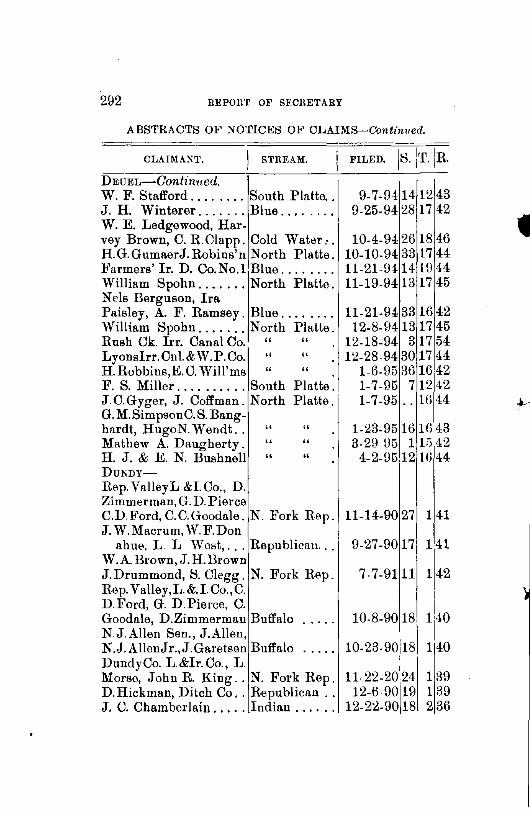
292 REPOltT OF SEOliETABY
ABSTRACTS OF NOTIC~:<;S OF CLAIMS-Continued.
CLAIMANT. I STREAM. FILED. 1s. \T.\R. DEUEL-Gontinued. W. F. Stafford ........ South Platte .. 9-7-94 14 12 43 J. H. Winterer ....... Blue ........ 9-25-94 28 17 42 W. E. Ledgewood, Har-vey Brown, C. R.Clapp. Cold Water,. . 10-4-94 26 18 46 H.G.GumaerJ.Robins'n North Platte. 10-10-94 33 17 44 Farmers' Ir. D. Co.No.l Blue ..... - .. 11-21-94 14- 1() 4-4 William Spohn ....... North Platte. 11-19-94 13 17 45 Nels Berguson, Ira Paisley, A. F. Ramsey. Blue ........ 11-21-94 33 16 42 William Spohn ....... North Platte. 12-8-94 13 17 45 Rush Ck. Irr. Canal Co. " " 12-18-94 317 54 Lyonslrr.Cnl.&W.P.Co. " " 12-28-94 30 17 44 H. Robbins,E. C. Will'ms " " 1-6-95 36 16 42 F. S. Miller. _ ........ South Platte_ 1-7-95 7 12 42 J.C.Gyger, J. Coffman. North Platte. 1-7-95 . - w 44 ~ G. M. Simpson C. S. Bang-hardt, HugoN.Wendt .. " " 1-23-95 16 Hi 43 Mathew A. Daugherty. " " 3-29 95 1 lii 42 H. J. & E. N. Bushnell " " 4-2-95 12 Ui 44 DUNDY-Rep.ValleyL &LCo., D. Zimmerman, G. D. Pierce C.D.Ford, C. C. Goodale. N. Fork Rep. 11-14-90 27 141 J. W. Macrum, W. F. Don
ahut>, L L West, ... Republican ... 9-27-90 17 141 W.A.Brown,J.H.Brown J.Drummond, S. Clegg. N. Fork Rep. 7-7-91 11 142 Rep. Valley,L.&.l.Co.,C. D.Ford, G. D.Pierce, C. Goodale, D.Zimmerman Buffalo 10-8-90 18 140 N J.Allen Sen., J.Allen, N.J. AllenJ r.,J.Garetsen Buffalo 10-23-90 18 140 DundyCo. L.&lr.Co., L. Morse, John R. King .. N. Fork Rep. 1122-20 24 139 D. Hickman, Ditch Co .. Republican .. 12-6 90 19 1 39 J. C. Chamberlain ..... Indian ...... 12-22-90 18 236

STATE BOARD OF IRIUGATION. 293
ABSTRACTS OF NOTICES OF CLAIMS-Continued.
CLAIMANT. STREAM. 1 FILED. 1 s.JT.j n. DUNDY-Gonlinued. H. Cannon ........... Indian ...... . Indian Creek Ditch Co. " ...... .
" " " " " " " " " "
John W. Karr ........ Republican .. . John W. Karr ........ S. Fk. Rep .. . C. H. Peck ........... Republican .. C. Jones, Geo. Young .. N. Fk. Rep .. . C. Jones, Geo. Young .. S. Fk. Rep .. . C. Jones, Geo. Young .. Republican .. A. J. Thomas ......... N. Fk. Rep .. . E. G. Neighbor. . . . . . . " " G. A. Rose, W. R.Bagrer, J. James, J. Robidoux, J. D. Graves, G. Pierce. " " Haigler Land & Onl. Co. " " .. W. Brown, R. Burns. . . " " . ·I J. R. Phelan .......... Rock ....... . Geo. W. Young ....... ~- Fk. Rep .. · John Dunning ........ Spring ..... . C. H. Peck ........... S. Fk. Rep .. . C. H. Peck .. , ........ N. Fk. Rep .. N. Allen, Sr·., N. Allen. N. Allen, Jr., F. Larned Buffalo ..... . C. H. Peck ........... N. Fk. Rep .. H. J Cox............ " " H. J. Cox . . . . . . . . . . . . " " -Paul Benson. . . . . . . . . . " " G. White, W. Lamed. . " " Anders Anderson ...... Republican .. . 1\f. H. Groesbeck. . . . . . " M. Groesbeck, H. Cannon " A. J. Thomas ......... N. Fk. Rep .. . John W. Karr ........ S. Fk. Rep .. . Riverside D. Co. J.Karr, S. Forsythe, Geo. King. S. Fk. Rep ...
12-1'7 -90 13 12-Hl-90 9 12-19-90 10 12-19-9012
1-9-9117 1-9-91 32
2-28-9117 2-23-91 28 2.2!3.9132 2-25-9132 3-18-91 24 3-23-9124
4-7-91 27 4-20-91 10 5-20-91 11 5-23-91 17 6-16-91 28 9-29-91 35
11-11-91 29 11-11-91 22
11-17-92 18 3-14-92 22 3-11-92 29
5-o-92 29 2-23-93 26
5-2-93 22 2-3-94 1 2-5 94 1
3-27-94 10 6-9-9! 24
7-28-94 20
8-15-94 29
~'37 237 237 3 37 137 237 137 1 38 1 37 1 37 140 1 39
141 142 142 1 39 138 238 137 139
140 139 138 138 141 140 137 137 137 140 137
137

294 REPORT OF SECRETARY
ABSTRAC'l'S OJ<' NO'l'ICES OF CL,\1MS-~'7onlinued.
CLAIMANT. sTREAM. 1 FILED. [ s.[T.[R. DUND'i-Continued. I Del. Hickman D. Co., I. J. Childs, pres., J. Karr. Republican .. T., F. B., & E. A. Moore Buffalo ..... . Ed. Wilson .......... Indian ..... . J. S. Owens & Sons ... Rock ...... . E. E. Owens . . . . . . . . . " ...... . Thompson & Van Sickle Indian ..... . A. Van Sickle . . . . . . . . " T. C. and J. ,V, Kinsev. " F. C. Phillips ...... .". Muddy ..... . J. C. Chamberlin ..... Indian ..... . James Nesbit ......... Horse ...... . PRONTIER-
G. W. Warner ........ Brush ..... . J obn l.Vliller. . . . . . . . . . " James F. Penton ...... Spring ..... . John L. Sanders ...... Medicine ... . D. J. & Mary J. Osborn. Red Willow .. Marcus L. Brown . . . . . " · " .. FunNAS-
Cambridge & Arapahoe Irr. & Water Power Co. Republican .. C. H. Peck . . . . . . . . . . " Henry L. Ballard . . . . . " Cambridge Milling Co. Medicine ..... FnANKLIN-
P.C. Garrett, A. Gregory Center ..... . Theodore Johnson .... Thompson .. . GARFIELD-
W. Drever, L. E Fiekins, J. Doran, W. D. Lash-
met, J. H. Harlan ... North Loup .. GREELEY-
North Loup Irrigation & Improvement Co. . . . " "
Daniel L. Johnson . . . . " "
1-12-U:J 171137 3-28- U3 22 2 41 u. 30-!)3 23 2 36 4-2ii- \!4 31 2 39 5-12-!lii 8 1 3G fi-1.\l-! 8 2 37
4-BO-!l-! 5 2 37 1-11-!l-! 10 2 37 1-lfi-\l-! 2 2i3fj
8-1-\10 12 2 37 8-30-8G 23 1 3\J
8-15-!l+ 34 !l-l!l-!l4 33
2-8-!1011 33 2-8-\lG 27
U-18-8!J1
34 7-1G-U-i
1
3G
Q-3-!ll 33 12-31-!Jl 28 fi-11-UJ 8
12-31-78 2\J
8 29 8 29 7 27 7 "2.7 5:30 5.30
J25 ~~~~ 4'25
8-21-!J+ 1 115 5-28-!J5 4 213
7-21-94 U:l211fi
8-7-9+271914 12-22-!lJt30 18[12
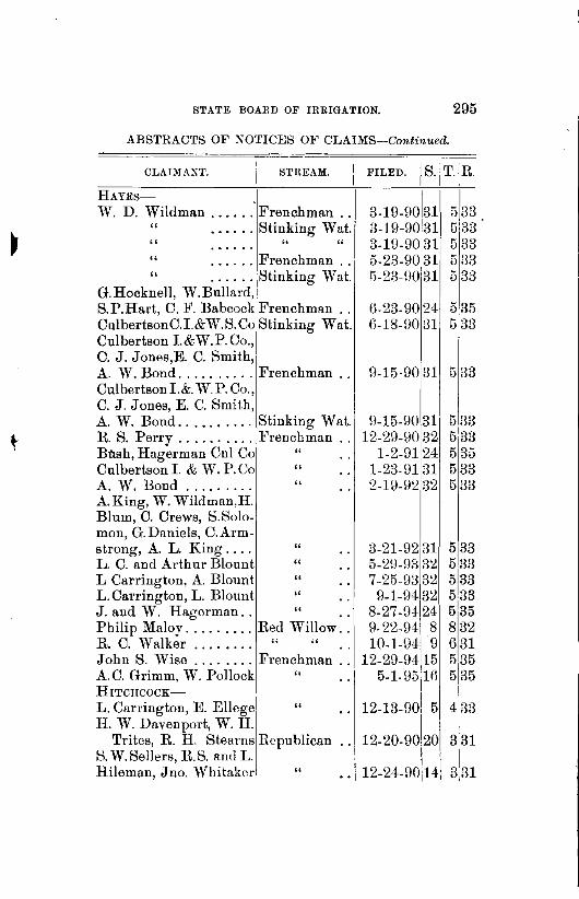
STATE BOARD OF IRRIGATION. 295
ABSTRAC'.rS OF NOTICES OF CLAIMS-Continued.
CLAIMANT. STREAM. I I ' FILED. 1s. T (R
HAYES- .
W. D. Wildman ...... Frenchman .. " a ••••• Stinking Wat. " " " " ...... Frenchman .. " ••••••
1Stinking 'Vat. G.Hocknell, W.Bullard,
3-19-90 31 3-19-90 31 3-19-90 31 5-23-90 31 5-23-90 31
533 5 B3 5 33 533 5 33
S.P.Hart, C. F. Babcock Frenchman . . 6-23-90 24 5 35 CulbertsonC.I.& W. S. Co Stinking W at. 6-18-90 31 5 33 Culbertson I.&W.P.Co., C. J. Jones,E. C. Smith, A. W. Bond .......... Frenchman . . 9-15-90 31 5 33 Culbertson 1.&. W. P. Co., C. J. Jones, E. C. Smith, A. W. Bond .......... Stinking Wat. R S. Perry .......... Frenchman .. Bo.sh, Hagerman Cnl Co " Culbertsonl.&W.P.Co " A. W. Bond . . . . . . . . . " A.King, W. Wildman,H. Blum, C. Crews, S.Solo-mon, G. Daniels, C.Arrn-
9-15-9031 12-29-9. o[32
1-2-91 24 1-23-81 B1 2-19-92 32
strong, A. L. King... . " 3-21-92 31 L. C. and Arthur Blount " 5-\W-93 B2 L Carrington, A. Blount " 7-25-98 B2 L.Carrington, L. Blount " 9-1-94 3~ J. and W. Hagerman.. " 8-27-94 24 Philip Maloy ......... Red Willow. -~ 9-22-94 8 R C. Walker . . . . . . . . " " . . 10-1-\J.!\9 John S. Wise ........ Frenchman .. 12-29-94 15 A. C. Grimm, W. Pollock " . . 5-1- 951lfi HrTCHCOCK-
L. Carrington, E. Ellege " 12-13-90, 5 H. W. Davenport, W. H.
Trites, R. H. Stearns Republican . . 12-20-90 20 S. W.Sellers, R.S. and L. Hileman, Jno. Whitaker " 12-24-9014
533 5133 5 35 533 533
5 33 533 533 533 5 35 8 32 631 5135 5 35
I
4133
331
31
31 I
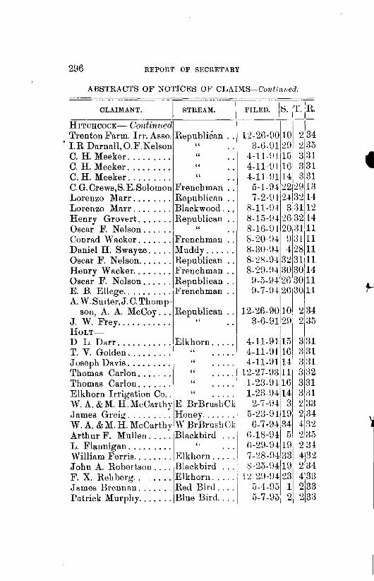
296 REPORT OF SECRETARY
ABSTRACTS OF NOTIC~S OJ<' CLAIMS-Conlilwed.
=---0-LA_I_M_A--cN~T_. ~-~·1!----s_T_n_E_A_M_. _ _'c-_F_·ILED. 18. :T.IR. HITCHCOCK- Continued I
, Trenton Farm. Irr. Asso. Republican . . 1 ~-2(Hl0 10 2 34 l.R Darnall,O.F.Nelson " . . 3-G-0120 2 35 C. H. Meeker .. 00 .. 00. " 4-ll-\IJ15i 331 C. H. Meeker .. 00 .. 00. " 4-11·0llG
1
331 C. H. Meeker. . . . . . . . . " 4-11-0114 3 31 C.G.Crews,S.E.Solomon Frenchman . . 5-1-04 22 29 13 Lorenzo Marr ........ Republican . . 7 -2-\J I 24 32 14 Lorenzo Marr ........ Blackwood. . . 8-11-D1 3 :3112 Henry Grovert ....... Republican . . 8-15-\!4 :W 32 14 Oscar F. Nelson.... . . " 8-1G-D4 20,3111 Conrad Wacker ....... Frenchman.. 8-20-\14 \! 13111 Daniel H. Swayze ..... Muddy. . . . . . 8-30-\J-! -! 28 11 Oscar F. Nelson ....... Republican . . 8- 2S-D-132 3111 Henry Wacker ........ Frenchman . . 8-2!l-!l4 30 30 14 Oscar F. Nelson ...... Republican . . 9-5-9412G]30 11 E. B. Ellege .......... Frenchman . . D-7-\JJ 26 3011 A. W.Suiter,J.C. Thorup- I
son, A. A. McCoy ... Republican .. 12-26-90 10 2 34 J. W. Frey .. 00. 00 00 00 " 3-6-912\J 2 35 HoLT-- ] D L. Darr ........... Elkhorn .... . T. V. Golden. . . . . . . . . ,. Joseph Davis. . . . . . . . . ., rrhomas Carlon. . . . . . . '' 1,homas Carlon. . . . . . . " Elkhorn Irrigation Co.. " .... ·1 W. A. &l\f. ~.MeCarthyiE BrBrushCk James Greig ......... Honey ....... ' W. A. & M. H. McCartin· 'V BrBrushCk Arthur F. Mullen .... ~ Blackbird L. Flannigan . . . . . . . . . " William Ferris ........ Elkhorn ..... , John A. Robertson .... Blackbird ... · F. X. Rehberg ....... Elkhorn .... . ,James Brenn~n ...... _ Red Bird ... . Patrick Murphy ....... Blue Bird ... .
4-11-9115 4-11-\!1 lG 4-11-91 14
12-27-D3 11 1-23-D+i16 1-23-D414
2-7-\H 3 5-23-D4 1\J 6-7-94 34
li-18-D! 5 !i-29-D419 7 -28-H-! 33 t-:·25-D-!19
12- 2\J·D4 23 :i-4-!)5 1 5-7-95 2
3 31 3 31 3 81 3 32 331 3 31 2 33 2 34 4 32 2 35 23-! 432 2 34 433 2 33 233
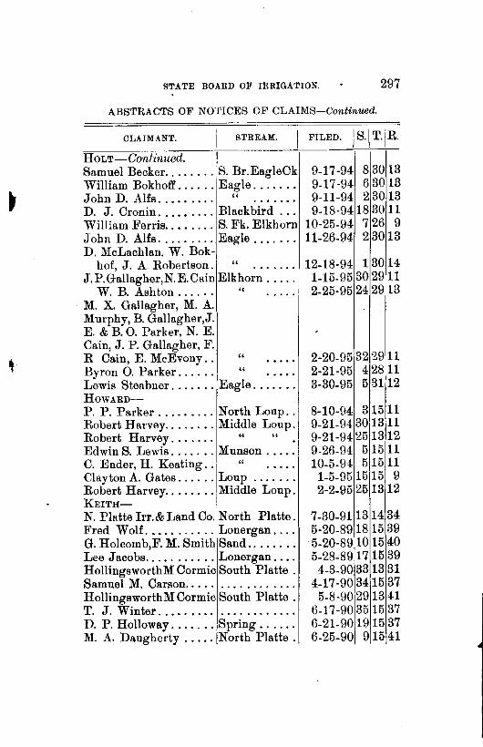
STATE BOARD OF IRRIGATION. 297
ABSTRACTS OF NO'l'ICES OF CLAIMS-Continued.
CLAIMANT. STREAM.
HoLT-Continued. Samuel Becker ........ S. Br.EagleCk William Bokhofl' ...... Eagle ...... . John D. Alfs. . . . . . . . . " ...... . D. J. Cronin ..•.•.... Blackbird .. . William Ferris ..•..... S. Fk. Elkhorn John D. Alfs ......... Eagle ...... . D. McLachlan, W. Bok-
hof, J. A. Robertson. " ...... . J.P.Gallagher,N.E.Cain Elkhorn .... .
W. B. Ashton . . . . . . " M. X. Gallagher, M. A. Murphy, B. Gallagher,J. E. & B. 0. Parker, N. E. Cain, J. P. Gallagher, F. R Cain, E. Mc.Evony. . " Byron 0. Parker. . . . . . '' Lewis Steabner ....... Eagle ...... . HowARD-
P. P. Parker ......... North Loup .. Robert Harvey ........ Middle Loup. Robert Harvey. . . . . . . " " .
1 Edwin S. Lewis ....... Munson ..... 1
C. Ender, H. Keating ..
1
" .... .
Clayton A. Gates ...... Loup ...... . Robert Harvey ........ Middle Loup. KEITH-
N. Platte Irr. & Land Co. North Platte. Fred Wolf. . . . . . . . . . . Lonergan ... . G. Holcomb,F. M. Smith Sand ....... . Lee Jacobs ........... Lonergan ... . HollingsworthM Cormic South Platte . Samuel M. Carson. . . . . . .......... . HollingsworthM Cormic South Platte . T. J. Winter .................... . D. P. Holloway ....... Spring ..... . M. A. Daugherty ..... North Platte .
9-17-94 83013 9-17-94 6 30 13 9-11-94 2 30 13 9-18-9418 30 11
10-25-94 7 26 9 11-26-94 2 30 13
12-18-94 13014 1-15-95 30 29 11 2-25-95 24 29 13
2-20-95 32 2911 2-21-95 4 2811 3-30-95 5 3112
8-10-94 31511 9-21-94 3013 11 9-21-94 25 13 12 9-26-94 5 15 11 10-5-94 5 15 11
1-5-95 15 15 9 2-2-95 25 13 12
7-30-911314 34 5-20-89 18 15 39 5-20-89 10 15 40 5-28-89 17 15 39
4-3-90 33 13 31 4-17-90 3415 37
5-8-90129 13 41 6-17-90 35 15 37 6-21-9011915 37 6-25-90 9 15 41

298 REPORT OF SECRETARY
ABSTRACTS OF NOTICES OF CLAIMS-Continued.
CLAIMANT. STREAM.
KEITH-Continued. F. Q. Feltz ........... North Platte. R. D. Harris . . . . . . . • . " " . L. F. Waugh ......... WhiteTail .. . Al Phelps, T. A. Mey-
ers, F. P. Dickerson. North Platte. G. F. Copper, J.Sheridan " R. D. Harris . . . . . . . . . " Lee Jacobs . . . . . . . . . . " M. A. Daugherty . . . . . " Aleck Harris, R. Major, T.
J. Miller, L. F. Waugh, A. W. Arnett, J. C.
" " " "
Culver, C. Fenwick .. White Tail ... James Ware .......... North Platte. The Ogalalla L. & C. Co. White Tail ... D.P.Holloway,A.Phelps " " Herman H. Soehl ..... Lonergan ... . Nelson A. Green ...... Clear ...... . Gary T. Scott . . . . . . . . " ...... . Thomas P. Curram. . . . " ...... . John M. McCarthy .... White Tail .. . Benjamin G. Matthews. Matthews ... . M. A. Daugherty ..... Blue ....... . Fred Wolf ........... Lonergan ... . John Bratt .......... North Platte. A. Neilson, D. Hunter,
John H. Conway.... " " A. Neilson, D. Hunter,
John H. Conway.... " " Hollingsworth & Son .. South Platte. G. J. Holcomb ....... Spring ..... .
·'H. A. Patrick ........ Sand ...... . G. W.& J.W.Armstrong. South Platte. Leonard Bros ......... White Tail .. . M. S. Collins ......... North Platte. J. C. Palmer. . . . . . . . . " "
8-4-90 61
14,37 8-20- \JO 18 14136 8-26-90 26,15 38
9-12-90 3415 39 10-9-\:JO 20:14
135
11-1-\:JO 1814136 12-27-90 9
1
14!37 3-6-90 0 -1- 0 0 0
3-13-91 26 15 38 5-1\J-!Jl 2615 38 7-18-91 26115138 3-27 -\J3 36 15'38
4-14-93 BBi17 48 5-2-\J317!15 3\:J
12-11-93 9'15 40
12-30-93 231114 36
2-3-94 18.14 36 6-5- \!4 16' 13 39
6-19-9412115 40 7-14-94 31540
9-4-94 5 13 37 10-11-94 22:15 38
9-15-9-! 9'15 Jl 10-25-94 22!14 36

STATE DOARD OF IRRIGATION. 299
ABSTRACTS OF NOTICES OF CLAIMS-Continued.
CLAIMANT. STREAM. I FILED. I s. jT.j R.
KEITH-Continued. Frank Foster ......... White Tail .. . Hollingsworth & Son .. South Platte . w·. T. Vail........... ,; " Lee Jacobs .......... North Platte . W. A. Sherman ...... South Platte . Louis Aufdengarten ... North Platte . G. J. Holcomb,R. Lewis " " James T. Ryan ....... South Platte. A. Fernstrom,P. Nissen. North Platte. M. A. Daugherty. . . . . . " " A. W Arnett ......... Spring ..... . Adam Miller . . . . . . . . . " 0. Reed, R. H. Austin. South Platte. I W. H. Winterer ....... Uoon ...... . W. Winterer,J. Sillasen.
A.Arnett,C.Fenwick .. White Tail .. KIMBALL-
Lambert C. Kinney ... Lodge Pole .. Sarah A. Kinney. . . . . . " E. B. Polley.. . . . . . . . . " Stil1man A. Pierce. . . . " James H. Gridley . . . . " James J. Kinney... . . . " BayState Live Stock Co. " BayState Live Stock Co. " James J. Kinney . . . . . " William T. Young. . . . . " Carl Ruttner. . . . . . . . . " John Mcintosh. . . . . . . " J. B. Brady. . . . . . . . . . '' John W. Hoover. . . . . . " John W. Hur·ley, L. H. Lilley,
" " " .. " " " . -1. " " " " " "
10-29-94 36 15!38 1-4-95 7 13 39
1-10-95 26 13 41 1-28-95 29 15 39 1-21-95 17 13 39 2-23-95 13 14 37
3-7-951615 40 3-11-95 30 13 40 3-23-Ui'i 2fi 15 39 3-27-95 115 42 4-16-95 19 15 37 4-22-95 114 37 4-22-95 16 B:39 4-23-95 3415137
5-4-95 36 15 38
4-20-89 3 14 58 4-20-89 814 58 5-10-89 30 15 55 5-15-89 7 14 58 5-13-89 30115 55 5-16-89 3215 56 5-29-89130 15 54 5-29-89 2915 55 5-25-89 33 15 56 6-12-89 33 15 57
6-8-89 3115 56 6-17-89 2315155 8-19-89 2815 54 9-13-891214 59
Edward B. Polley ..... Lodge Pole. . 10-12-91 26 15 56 KEYA PAHA-
w. W. Byington ...... Rickman . . . . 2-13-94 4 32120

300 BEPOBT OF SECRETARY
ABSTRACTS OF NOTICES OF CLAIMS-Continued.
CLAIMANT. STREAM. I FILED. I S./T./R.
KEYA PARA-Continued S.McCulley, C. McCulley
R. McCulley, A. Kro-nig, C. Honnen ..... Niobrara .... .
Boyd Co. I. P. & lm. C. Key a Paha .. . H. Millay, Otto Mutz .. Burton ..... . WilliamS. Justice .... Keya Paha .. . Isaac Horton ......... Wyman .... . Boyd Co., lrr. Company Keya Paha .. . Solomon S. McCumber. Cub ....... . Charles P. Jewett ..... Jewett. ..... . J. A. Wilson .......... Niobrara ... . H. K. Soper .......... Huggins ... . William S. Moore ..... Rock ...... . J. H. Irwin, Ed. Monroe. Niobrara ... . F. J. Schoettger ...... Holt . . . . .. . H. D. Anderson ....... Key a Paha .. . Thos. G. Wilson. P. L.
Hammons, W.Farmer " " Peter M. Peterson ..... Alkali ...... . F.McConaha, W.Kuhre. Niobrara .... . Peter Cederburg ...... Dry ....... . J. L. Rhodes· ......... Spotted Tail. . Anderson Burt ....... Creek ...... . KEARNEY-
Leroy Sides .......... Platte ...... . Lowell Farmers lrr. Co. " ...... . G. H. Pratt. . . . . . . . . . . " ...... . William R. Burton. . . . " ...... . John E. Decker ....... N. Ch. Platte. LouP-Burwell Irrigation Co .. North Loup .. F. :Mallory, Jas. Wilson, E. P. Clements ........ North Loup .. Burwell Irrigation Co. . " " Hiram A. Akins, A. B.
Starke, Morgan Crane.Calamus .....
8-7-94 24:32.20 8-8-94 101134117
8-18-9417 3419 9-1-94 35 35 19
9-10-9417]32 19 9-12-94 28'35]19 9-26-94 28b332
10-26-94 5132121 10-27-9418 321:n 11-6-9± 21135120 11-fi-9412 32 22 1-11-95 16132 21 2-27-Hii 32 Bu 12o
I I
3-5-95 3I3J
1
1s
3-8-95 24•3±117 3-12-9513 34,17 4-25-IJ5 26 33 24 5-:30-\!5 3 32 21 G-14-95 4 34]17 7-13-95113 32·121
7-25-9413 8 14 9-24-9415 814
12-26-94 21 8 15 2-19-\Jl'i 21 8 15 5-30-95 20 816
8-13-94 26 2118
8-15-94 25 21 17 9-15-94 27 2117
1-22-95 1 24 20

STATE BOARD OF IRRIGATION. 301
ABSTRACTS OF NOTICES OF CLAIMS-Continued.
CLAIMANT. STREAM.
LINCOLN_:_
N. Platte lrr. & L Co., I. Dillon Pre ,]'.FoleySec. North Platte. M. N. Holcomb ....... Pawnee .... . Eq. F. & S.Imp.Co.Lim. Birdwood ... . Eq. F. & S.Imp Co. Lim Fremont 81 ... . S. L. Wiley .......... Birdwood .. . Walter Wiley.... . . . . " S. T. Wiley. . . . . . . . . . " L. R. Britton ......... Platte ...... . L. R. Britton. . . . . . . . . " ...... . J. H. McColl. . . . . . . . . " ...... . Gothenburg Canal Co., A. H. Had ford, Pres ... Platte ...... . William Roberts ...... Bird wood .. . James Cooper ........ Bra ugh Lake. A. L. McNeeL ........ Birdwood . , . C & D Irr.Canal.Co., W. F. Cody, Isaac Dillion .. North Platte. Birdwood Irr. Co., P..O. Buchanan, E. Speiling. E. Bird wood. A. L. McNeel. ....... Birdwood .. . William Roberts. . . . . . " J.A.Hershey, W.Paxtou North Platte. E. A. Johnson. . . . . . . " " D. B. McNeal. . . . . . . . " " Isaac Coe ............ W. Birdwood. M. C. Keith .......... White Horse. Isaac Lamplugh...... " " . James 13 McKee . . . . . . . .......... . James B. McKee. . . . . . . .......... . E. Hubart ........... Slough ..... . W. L. Park .......... North Platte. I. A. Young .......... Platte ...... . E. Hubart. . . . . . . . . . . " ...... . M. C. Keith, .... , .... North Platte. D. A. Baker .......... Slough , .... .
FILED. ls.]T.IR.
7-28-9113 14 34 10-27-90131328
3-5-9115 16 03 3-6-911513 30
3-27-91 2715 13 3-27-91 27 Hi d3
5-8-91 34 lf> :l3 5-21-9113 12 28 5-21-91 26 12 27 7-31-912612 27
9-18-912912 26 10-31 \)3.3514 33 12 20-93 3fl u 33
1-2-94 10 l(j 33
12-30-93 9114 31 i
1-3-941011() 33 1-22-94 3 11G 33 1-Hl-U4 22115 33 2-20-U-! 18 14 33 2-24-9410/12 ~7 2-24-94 ll 14 32 3-lU-94 101()134
4-7-94 361
14 30. 4-9 94 5114 30
4-23-94 22 14 02 4 23-94 21j14 32 4-24-U4 1li 14 30 5-2\J-94 12
1
14 33 I 5-31-9-J. 41112()
5-24-UJ 17114 30 6-5-H-! ~5 14 13
6-12-94 23:14 31

302 REPORT OF SECRETARY
ABSTRACTS OF NOTICffiS OF CLAIMS-Continued.
~---o-LA_r~M_A_N_T_. -~-'----s-·T_n_E_A_M_. _I FILED. Is. [T.J~· LINCOLN-Conf1nued. l::\. W. Clark, Fred Peck
ham, J.J.O'Rourke,P. B. Bloom, Geo. Swift, S.L.Clapp, L.D. Rich Platte ...... .
I. A Fort ........... South Platte .. I. A. Fort ........... North Platte. W. Findley, W. E. Young,
E. Moore, L. Homer, E. M. Young ....... Platte ...... .
E. D. Murphy ........ Pawnee .... . I. A. Young .......... Platte ...... . W. K. Beauchamp ..... Bird wood ... . W. H. Plumer ........ Pawnee .... . R. H. Fowles, T. Roherts Platte ...... . S. W. Clark, Fred Peckham, J. J. ORourke, P. B. Bloom, Geo. Swift, S. L. Clapp, L. D. Rich " ...... . Henry M. Appleford... " ...... . M. C. Keith ........... North Platte. David A. Baker ...... Slough ..... . A. Smit.h, J. H. Moran. North Platte. W. K. Beauchamp ..... Bird wood ... . William C. Ritnor .... Platte ...... . Henry Herman. . . . . . . " ...... .
• John McCullough.... . " ...... . Fred Hecox . . . . . . . . . . " ...... . Edwin Moore ....... ·I " ...... . Benjamin A. Layton. . . " ...... . J. W. Hiles.......... " ...... . Lucien Stebbins ....... South Platte. S. F. Dickman ........ North Platte. J. W. Hiles .......... Platte ...... . Equitable Farm & Stock I and Improvement Co., (Lim.), John Bmtt. Sec. ,Fremont ....
6-5-94 17 13129 G-12-94 34 14 33 G-1:.!-941414 34
6-15-94 :30 12 26 6-9-04 29 13 27
G-14-94 411 09 fl-12-U415 15 33 fi-16-94 19 13 27 7 -11-9± 29 13 28
7-7-941613 29 7-7-\!4115 1:.!1:29
7-17-94251430 7-25.l)4231331 8-13-\J4 36 14 30 H-22-U4.]15 15 33 !1-20-!H 114 33 \J-22-U.J-,29 12 26 •
10-2il- \)4 !3() 13 28 10-29-!l.J-
1
1111 26 11-3-U.J-.ilO 12 :26 11-5-94~30 12 26
12-19-\J4f27 12127 12-17-941341432
1-24--95 9 14 32 1-2\J-U5 29 12 26

STATE BOARD OF IRRIGATION. 303
ABSTRAC'.rS OF NOTICES OF CLAIMS-Continued.
CLAIMANT. STREAM. I FILED. l s. iT. JR. LINCOLN-Continued. Lincoln & Dawson Co. I. Co.,J. T. Karr, C. Morrell Platte ...... . Heber Newberry ...... From a ravine Heber Newberry...... '' " J.D. Kelliher, P. F.Dolan G. W. Snvder, W. Plumer North Platte. Henry Appleford ..... Platte ...... . Emanuel Hubartt ..... North Platte. W. K. Beauchamp .... Bird wood .... Lucien Stebbins ...... South Platte. H. M. Knoll ......... Platte ...... . D. G. Potter ......... East Bird wood H. 1\f. Appleford ...... Platte ...... . Gothenburg S. S. I. Co. North Platte. PHELPS-
Manlius Lucus ....... Platte ...... . PLATTE-E. A. & F. H. Gerrard. Looking-glass H. J. Hendryx . . . . . . . . .......... . Orlando Nelson ....... Loup ...... . Peter Schmitt ........ Shell ...... . Fannie Rice . . . . . . . . . " ...... . Max Gottberg. . . . . . . . " ...... . Daniel Murdock ...... Loup ...... . RocK-Ed. L. Peters . . . . . . . . Sand . . . . . .. . Geo. H. Bowering ..... Niobrara ... . J. T. Johnson ........ Elk ........ . H. Wile ............. Rock ...... . Joseph Copeland . . . . . . " ...... . J. & J. H. Copeland, H.
C. Hall.... . . . . . . . . " ...... . B. J. Eastlick ....... ·. " ...... . H. Wile............. " ...... . H. Wile, J as. Coc•per. . " ...... . C. G. Grant .......... Two streams .
I 3-1-\J5 9 13 29
2. 23-95 :!1 14 32 2-25-95 22 14 32
2-27-95 24 13 29 3-1-95 15 13 29 3-2-95 20 14 30
3-26-95 22 15 33 3-21-95 3214 32
4-5-95 30 12 26 4-4-95 10 16 33
4-17-9515'13 29
12-22-94 13 8 18
6-12-94 117 3 H-26-94 2 17 3
10-24-9417 17 3 12-17-94 19 18 1
3-23-95 22 18. 1 . 3-23-95 2418 1
4-3-95 617 3
10-5-94 26 32 18 10-24-942913219 •
10-1-94 8 3119 10-27-94 4 3118
12-1-94283218
1-8-95 32 32 18 1-17-95 28 3218 1-18-95 4 3118
4-3-95 9 3118 .... .. .. 43120

304 REPORT OF SEORETABY
ABSTRACTS OF NOTICI!:S OF CLAIMS-Continued.
=---0---:L::-A-IM~AN_T~. ~-L STREAM.
RocK-Continued. J. M. Gordon ........ Oak ....... . Jacob Martin. . . . . . . . . " ....... . RED WILLOW-
,J. Whittaker, S. W. Sel-lers, R.J.&R.S.Hileman Republican .. L. J. Holland ........ Red Willow .. C. J. Jones........... " " C. J. Jones ........... Republican .. C. J. Jones ........... Red Willow .. C. J. Jones.. .. .. .. .. . " " C. J. Jones ........... Republican .. Andrew Carson. . . . . . . " L. J. Holland . . . . . . . . " W.P.Grimes,W.S.Fitch. Driftwood ... Patrick Walsh . . . . . . . " William Byfield ....... Republican .. F. S. Wilcox . . . . . . . . . " E. N. Allen, H. P. Allen\ " .. J. F. Helm ........... Red Willow .. F. S. Wilcox ......... Republican .. Bartley Canal Co. . . . . " .. Swux-J. W. Long, Geo. Todd,
R. T. Walker. W. T. Long, R. A. Walker. Sheep ...... .
0. H. Phillips ........ Niobrara ... . 0. JI. Phillips. . . . . . . . " Marsland lrr. & lm p. Co. " Chas. J. Grable ....... White ...... . John Maycock ........ Wind Springs Nels Anderson ........ Jim ........ . 0. A. Garton ......... Spring Branch G. W. Nation ......... Springs ..•... L. W. Parrott ........ Niobrara ... . James Felch ......... White ...... . Henry W arneche ...... Running Wat.
4-13-95 31 32 17 5-24-95 13 32 18
12-30-90 14 3 31 1-30-9116 3 28 2-16-lll 16 3 28 i!-16-!H 19, 3 28 2-16-Ul 7 3 28 4-15-U116 3 28 4-15-U 1 26 3 29
5-7-Ul27 3 30 6-20-u l 17 3 28
11-10-1!'3 12 2 30 4-24-H! 4 20 94 fl-21-!J± 23 3 29 10-5-U4 32 3 29
2-l-!)5 2 326 2-1U-U517 3 28 5-~-\!5 32 n'29
11-S0-88 U 3!27
6-3-89 27 25 58 9-17-UU 12 28 54 H-17 .UU 7 28 5! 4-14-911028 53 6-17-Ul 233153 2-20-9212 24 54 7 -28-U:~ 8 33 56
10-16-B3i31 33 56 9-24-94 1 31 24 li3 2-12-95 7 28 53 2-14-95 23 31 53 2-23-95 27 31 57
~I
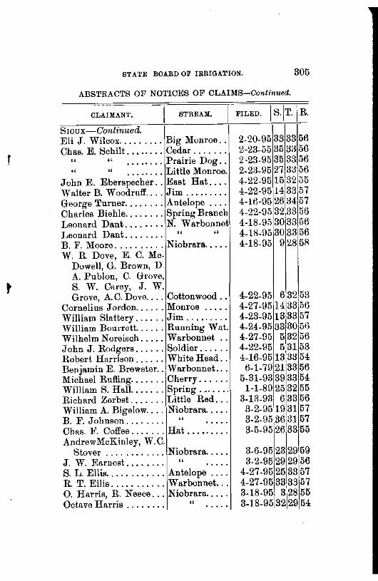
t
STATE BOARD OF IRRIGATION. 305
ABSTRACTS OF NOTICES OF CLAIMS-Continued.
OLAIMANT. STREAM.
Sroux-Continued. Eli J. Wilcox ......... Big Monroe .. Chas. E. Schilt ........ Cedar ...... .
" " . . . .. . . . Prairie Dog .. " " ........ Little Monroe.
John E. Eberspecher .. East Hat ... . Walter B. W oodrufl' .... Jim ........ . George Turner ........ Antelope ... . Charles Biehle ........ Spring Branch Leonard Dant ........ N. Warbonnet JJeonard Dant. . . . . . . . " " B. F. Moore .......... Niobrara .... . W. R. Dove, E. C. Mc-
Dowell, G. Brown, D. A. Publon, C. Grove, S. W. Carey, J. W. Grove, A. C. Dove .... Cottonwood ..
Cornelius Jordon ...... Monroe .... . William Slattery ...... Jim ........ . William Bourrett ...... Running Wnt. Wilhelm Noreisch ..... Warbonnet .. John J. Rodgers ...... Soldier ..... . Robert Harrison ...... White Head .. Benjamin E. Brewster .. Warbonnet .. . Michael Ruffing ....... Cherry ..... . William 8. Hall ....... Spring ...... . Richard Zerbst ....... Little Red .. . William A. Bigelow .... Niobrara .... . B. F. Johnson.... . . . . " Chas. F. Coffee ....... Hat ..••..... AndrewMcKinley, W.O.
Stover ............ Niobrara .... . J. W. Earnest. . . . . . . . " 8. L. Ellis ............ Antelope ... . R. T. Ellis ........... Warbonnet .. . 0. Harris, R. Neece ... Niobrara .... . Octave Harris . . . . . . . . "
FILED. j s.jT.j R.
2-20-95 33 33 56 2-23-55 35 33 56 2-23-95 35 33 56 2-23-95 27 33 56 4-22-9515 32 55 4-22-95 14 33 57 4-16-95 26 34 57 4-22-95 32 33 56 4-18-95 30 33 56 4-18-95 30 33 56 4-18-95 9 28 5R
4-22-95 6 32 53 4-27-9514 33 56 4-23-95 13 33 57 4-24-95 33 30,56 4-27-95 5 32 56 4-22-95 5 31 53 4-16-95 13 33 54
6-1-79 21 33 56 5-31-93 39 33 54
1-1-89 25 32 55 3-13-93 6 33 56
3-2-9519 31 57 3-2-95 36 3157 3-5-95 26 33 55
3-6-95 23 29 59 3-2-95 29 29 56
4-27-95 25 33 57 4-27-95 33 33 57 3-18-95 3 28 55 3-18-95 32 29 54

306 REPORT OF SECRETARY
ABSTRACTS OF NOTICES OF CLAIMS-Continued.
CLAIMANT. sTREAM. 1 FILED. j s.jT.jR. Sioux-Continued. Warren S. Johnson ... Bull ....... . A. T. Hughson ....... White ..... . W. Stover, A. McKinley Niobrara ... . David Colville ........ Kyle ....... . W m. S. Hales ........ Spring ..... . S.Jordon,S.Montgom'ry Sow Belly .. . M. H. Green ........ Deep ...... . J. W. Smith ......... Boggy ..... . W. T. Forbes ......... White ..... . Julius B. Burke ...... Sow Belly .. . James McCann ....... Warbonnet .. 0. A. Garton .......... Spring Bmncb Peter Bourrett ....... Hunning ·w at. H. F. Zerbe .......... Hat ........ . William Miller. . . . . . . . " ....... . Peter Schaefer ....... Spring ..... . Peter Schaefer ....... ~ow Belly .. . William Martin ....... East Boggy .. ScoTT's BLUFF-
Farmers' Canal Co ..... North Platte. Mini tare Cnl & Irr. Co. " "
" " Enterprise Ditch Co ... OastleR' ckl. C. & W. P. Co
" " "
" " " " " " " "
Bayard Irr. D.&W.P.Co " " Charles A. Bouton .... Winter's Sprs Samuel & Eytchison ... Horse ...... . Mutual Irr. & Water Co North Platte. 'William H. Stone. . . . . " " Bayardlrr. C.&W.P.Co " " C. 'N. Ford . . . . . . . . . . " " Farmers' Canal Co. . . . " " Bayard Irr. C. &W.P.Co " " ChimneyR'ckl&W.P.Co " " Herman Mott ......... Pole Canyon.
3-23-95 7 30 53 3-25-!J5 26 41 55
4-2-95 25 2!J !J6 3-30-!J5 3 30 54 4-2-95 25 32 53 4-5-95 21 3B 55
4-18-95 91
30 53 4-9-!J5 3li3H 5-! 4-!J- U5 23 1 31 53
4-11-95 5 32 55 4-13-95 12 3B 56 4-15-!J5 313il56 4-15-!J5 29 30 56 4-13-95 35 3B 55 4-13-!JG 23 33 55 4-13-95 7 32 55 4-1B-!J5 7 32 55 4-20-!J5 7 32 54
9-19-87 10 23 58 1-14-88 32 22 54 1-14-88 32 22 54 3-30-89 27 23 57 4-25-89 4 n 54 5-14-89 4 21 54 8-14-UO 25 2158 8-21.8!) 312. 54 6-11-90 34123 58 fl-23-90,2722155
8-2-90 18 21 53 11-30-90 ..... . 11-18-90 10·23 58 ........ 10 2B:58 11-30-1!0 18 21 53 12-10-90 1 20 53 12-19-90 4 20 55

STATE BOARD OF IRRIGATION. 307
ABSTRACTS OF NOTICES OF CLAIMS-Continued.
CLAlMANT. STREAM.
ScoTT's BLUFF-Con.
R. L. Elwood ......... Spotted Tail.. Belmont & Froid Canal
& Reservoir Co ..... North Platte. Samuel D. Daniels .... Horse Creek. Alfred Eytchison. . . . . " " John Emery ......... North Platte. Theodore G. Conkling. Spring ..... . Theodore G. Conkling. " ..... . James .E. Beach ..... ·!Kiowa ..... . Edwin A. Currie. . . . . . " ..... . William E. Bullock ... Owl ....... . Robert l\f. DeLaMatter,i
Allen Lowry ... , ... !Kiowa William A. Hale ...... 1North Platte. W. H. Walker ....... ·r " " Central Irr. Canal Co. . " " Mid Way Ditch Co ... 'I " " David Kale. . . . . . . . . . " " Yorick & Carroll Nichols " " Short Line Irr. Cnl Co. " " Enterprise Ditch Co . . . " " John H. Kellums ..... Kiowa John H. Kellums ..... ,Owl .... , ... Nine Mile On!. & R. Co North Platte. Right Hand Irr. Co ... 1
" "
Joseph l\iaycock. . . . . . " " W. H. ·walker. . . . . . . . " " Farmers Canal Co. . . . . " " Short Line Irr. Cnl. Co " " Robert J. Harshman.. . " " SHERIDAN-
James Clark. ......... Pine ....... . B. S. Gillespie ........ Niobrara ... . B. S. Gillespie. . . . . . . . " Geo. C. Getchell . . . . . . . .......... . U. ti. o£ America ...... White Clay .. .
1-17-911023156
7-7-91 .. 2358 7-16-9123 23 58 9-5-91 34 23 58
12-31-91 21 22 55 1-15-92 62255 3-17-92362356 3-14-92 24 21 57 3-25-92 Vl 21 57 4-16-92 21 22 57
5-17-92 2122 57 !3-25-92 31 22 57 9-22-9~ 21 22 55 2-9-93 27 22 55
3-22-93 21 21 53 3-20-93 12 21 54 3-:L4-93 18 23 57
5-9-93 30 21 52 8-18-93 27 23 57
12-11-9311 22 58 12-11-93 12 22 58
12-9-93 18 :u 53 4-5-94 21 21 53 8-8-9-! 13 23 58
11-30-94 21122 55 3-14-9510
1
23 58 3-Hl-95 12:21 53
0. 0 0 0 0-0 17 22 55
6-12-93 33 30 44 2-2-9419 30 43
2-13-94 19 30 43 4-11-94 27 34 45
8-7-94 Res.
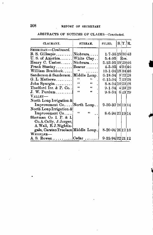
308 REPORT OF SECRETARY
ABSTRACTS OF NOTICES OF CLAIMS-Concluded.
CLAIMANT. sTREAM. 1 FILED. 1 s.1T.IR.
SHERIDAN-Continued. B. S. Gillespie ........ Niobrara. ... . U. S. of America ...... White Clay .. Henry C. Ussher. , .... Niobrara .... . Frank Stastny ........ Beaver ..... . William Braddock. . . . . " Sanderson & Sanderson. Middle Loup. G. L. Mathews . . . . . . . . " " John Spurgin. . . . . . . . . " " Thedford lrr. & P. Co. . " " J. W. Purdum . . . . . . . . " " VALLEY-
North Louplrrigation & Improvement Co ..... North Loup ..
North Louplrrigation & Improvement Co. . . . . "
Sherman Co. I. P. & I. Co.A.Cully, J.Jorger, A. Wall, R.J.Nightin-
"
gale, CarstenTruelson Middle Loup. WHEELER-
A. S. Rowan .......... Cedar ...... .
1-7-951913ol43 5-4-95 Res.
5-23-95 19 29 46 4-5-95 4 3J 4ti
10-1-94 18 34 46 6-18-94 9 23128 6-15-94 7 23<28
8-8-9410 231
28 9-1-94 4 23 29 9-8-94 6 ~3 29
9-30-93 2o 19
1
14
8-6-94 27 19 14
8-20-94 26 17 16
9-22-9412212112

\
State Irrigation Association.
In the fall of 189!, the organization known as the "State Irrigation Association" was formed in the city of North Platte. Ron. I. A. Forte was elected president at its first meeting. A committee on irrigation legislation was appointed, consisting of Ron. J. S. Hoagland, of North Platte; Ron. R. B. Howell, of Omaha; and W. R. Akers, of Gering, Neb. This committee, in the fall of 1895, drafted the present irrigation law, both the district law and the law creating the State Board of Irrigation, and had the same presented to the legislature, which in due time became the law of our state.
This association has held four regular meetings. The first being held at North Platte; second, at Kearney; third, at Sidney; and fourth, at Lexington. It has grown to be a wonderful power in the state. The meetings have been very interesting and highly profitable, among which are notably the one at Sidney and the one at Lexington. The meeting at Sidney was held in 1895, at which Mr. A. G. Wolfenbarger, of Lincoln, was elected president, after having served one year as secretary. James McIntosh was elected secretary. There were very many valuable discussions held at this meeting, and immediately after its adjournment, Mr. Wolfenbarger, the new president, published the" Irrigation Annual," the first work of the kind published in the United States. This publication proved to be of very great interest and was very much thought of, by not only the people in the state, but by the people in all· parte of the country, and the first edition was exhausted long before the demand was sup-
310 REPORT OF SECRETARY
plied. Mr. Wolfenbarger so thoroughly demonstrated, not only his ability, but his enthusiasm in the cause of irrigation, that at the meeting in Lexington in 1896 he was unanimously chosen president for the second term, and is now engaged in preparing the "Irrigation Annual" for 1897, which is expected to contain a great amount of very valuable information, and its publication is looked foward to with great interest. The meeting at Lexington in 1896 was a great success, and at its close the association was regularly incorporated under the laws of the state of Nebraska, and will hereafter be known as the "Nebraska Irrigation Association," and it is confidently believed that in the very near future this association will become a great power in educating the people along the lines of irrigation. It is confidently expected and earnestly hoped that all who are interested in irrigation will come to the support of this new organization and assist in making it what it should be, an important factor in the spreading of the gospel of irrigation in our young state.
One of the things most needed in the publication of this annual, and in making this association a great success in the future, is liberal financial support of the people of the state. Let every Nebraskan whu desires to see his state stand in the very front rank of irrigation states come to its assistance and contribute, not only his time, his energy, and his brain, but also his means. It is believed that the right men are at the hea:l of the association, and their sympathies are enlisted in the cause, and if they only have the proper support of the people, that great good will be done in the state of Nebraska by and through its influence.
I cannot think of closing this report without making favorable mention of the people who have been so closely
STATE BOAHD OF IRRIGATION. 311
connected with me in this office during the time of my incumbency.
At the time Mr. Howell resigned, and I was advanced to the position of secretary, l\Ir. E. T. Y oungfelt was appointed assistant secretary, and he has proven himself a valuable acquisition to the office. He was first assigned the task of making large maps of the different water-sheds of the state, which he accomplished in a very credible manner, some of them being very large. Blue prints of these maps may be seen on the walls of the office. He was then in connection with Prof. 0. V. P. Stout, of the State University of Nebraska; assigned the measurement of. the different streams of the state, and between these two able engineers a large amount of work along that line, for the amount of time and means they have had at their command, has been accomplished.
Owing to the limited appropriation for extra help in the office, under secretary, Frank Bacon, was retained in the office by Mr. Howell during his incumbency, and I have done the same. Much important work has been assigned him, and his efficiency has been demonstrated by the excellence and volume of work performed. He is conscientious, pains-taking, and industrious.
Adna Dobson, of Lincoln, was appointed under secretary for Division No. 2 shortly after I advanced to my present position, ami has proven a very valuable man to the office. Besides being a competent engineer, he is an honest and industrions worker, having the interest of the state always at heart. Besides the routine business of the office, of which he has done much, he has been entrusted with some very important investigations, which he has faithfully performed, as will be seen by referenctl to his reports to me.
I have retained the same clerk and reporter employed
312 REPORT OF SEORETAHY
by Mr. Howell. Harry A. Scott has acted as clerk and reporter in all the hearings, and has traveled with me in almost every part of the state, and has been employed constantly while in the office as clerk and reporter. I have always found him industrious, quick, and accurate, and possessing the very best qualifications for his business.
Miss Fannie Steinmetz has acted in the capacity of stenographer and typewriter in the office, and has accomplished a great deal of work. She has always been faithful, honest and pains-taking and rarely makes a mistake.
Both these stenographers have worked for less money than is paid for like work in other offices in the building, for the simple reason that there was no money to pay them except as collected from the people for whom the work was done.
And last, but not least, I desire to mention the Board, GovernorS. A. Holcomb, H. C. Russell, Commissioner of Public Lands and Buildings, and A. S. Churchill, Attorney General. Our relations have been most pleasant and agreeable. We have had many important cases to settle, and some very vexatious contests and knotty legal q uestions to wrestle with, and in every case have the Board affirmed my findings, and in every case has the affirmation been unanimous, save one, in which one member of the Board dissented, an<i I have, and do now believe, that a better acquaintance with the testimony and circumstances in that case would haYe made that unanimous likewise.
The people wherever we have gone in our official work have treated us with great respect. On the whole, our connection with the State Board of Irrigation has been very pleasant, and I sincerely hope it has not been without profit to the people who are interested in irrigation
~ '

STATE BOARD OF IRRIGATION. 313
and to the state in general; and I also hope that the people and the legislature will continue to extend their best wishes and assistance to the Board' and its secretaries and officers in the future, and that time may prove that the establishing of this Board was a move in the right dirac-
' tion and a great step in advance in irrigation matters, and that the most sanguine hope of the supporters of this law may be fully realized, and Nebraska take first rank among the irrigating states of the country.
W. R. AKERS,
Secretary.

TABLE OF CONTENTS
Applications filed in office of State Board of Irrigation ....... 258 Alphabetical list of claims and applications arranged by
streams. .. .. .. .. .. .. .. . . . . .. .. . . . .. . . ...................... 164 Character of principal streams of Nebraska-0. V. P. Stout. .143 Claims filed in office of State Board of Irrigation, Div. 1 ...... 214 Claims filed in office of State Board of Irrigation, Div. 2 ...... 240 Claims filed in the several counties ........................... 280 Dawson county, History of irrigation in-H. 0. Smith ........ 27 Daugherty, M.A., "The Struggle and 'l'riumph of Irrigation
in Nebraska." ............................................... 50 Development of the Underfiow-W. R. Akers ................. 81 Description of gaging stations-0. V. P. Stout ................ 93 Discharge table of
Elkhorn river at Norfolk ................................. 116 Frenchman river at Wauneta ............................. 101 Frenchman at Palisade ................................... 102 Loup, North, at St. Paul. .................................. 110 Loup, Middle, at St. Paul.. ................................ 112 Loup river at Columbus .................................. 114 Platte river at Columbus ................................. 109 Platte, North, at Camp Clarke ............................ 106 Platte, North, at North Platte ............................. 107 Republican River at Superior ............................. 105 Republican, North Fork, at Benkelman ................... 104
Discharge at gauging stations, measurement of ............... 117 Discharge of various streams ................................. 122 Discharge through rectangular and vertical openings-E. T.
Youngfelt .................................................. 138 Duty of Water-W. R. Akers .................................. 71 Flow of water through vertical openings and over weirs-E. T.
Youngfelt .................................................. 131 Frenchman river, Report on-Adna Dobson. .................. 160 Howell, R. B., Report of. . . . . . .. . . . . . . . . .. .. .. . . .. .. . . . . . . . . . . 23 Lincoln county, History of irrigation in-E. F. Suberger.. . . . . 43 Lodge Pole creek, Description of-Adna Dobson .............. 151 Reminiscences and Realization of Neb.-Edward McLeruon .. 58 Report of W. R. Akers, secretary.... . .. . .. .. . . . . .. . . . . . . . . . . . . 9 Report of R. B. Howell, ex-secret.iry .......................... 23 Report of E. 'f. Youngfelt, assistant secretary. . . . . . . . . . . . . . . . . 87 Report of Adna Dobson, under secretary ...................... 149 State Irrigation Association ................................... :l09