Stages 1-3 Archaeological Assessment of · and Guidelines for Consultant Archaeologists (‘2011...
39
Stage 2 Archaeological Assessment for the: Proposed Rezoning of Parts 1 to 4 of Block O Registered Plan 6864 Within Part of Lot 17, Concession A Fronting the Humber In the Geographic Township of Etobicoke Historical County of York Now the City of Toronto Ontario Project #: 233-TO955-13 Licensee (#): Kim Slocki (P029) PIF#: P029-0906-2015 Original Report December 9 th , 2015 Presented to: Shannex Ontario Developments 155 Chain Lake Drive Halifax, Nova Scotia B3S 1B3 T: 902.406.8264 F: 902.404.3377 Prepared by: Archeoworks Inc. 16715-12 Yonge Street, Suite 1029 Newmarket, Ontario L3X 1X4 T: 416.676.5597 F: 647.436.1938 ARCHEOWORKS INC.
Transcript of Stages 1-3 Archaeological Assessment of · and Guidelines for Consultant Archaeologists (‘2011...

Stage 2 Archaeological Assessment for the: Proposed Rezoning of Parts 1 to 4 of Block O Registered Plan 6864
Within Part of Lot 17, Concession A Fronting the Humber In the Geographic Township of Etobicoke
Historical County of York Now the City of Toronto
Ontario
Project #: 233-TO955-13 Licensee (#): Kim Slocki (P029)
PIF#: P029-0906-2015
Original Report
December 9th, 2015
Presented to: Shannex Ontario Developments
155 Chain Lake Drive Halifax, Nova Scotia
B3S 1B3 T: 902.406.8264 F: 902.404.3377
Prepared by: Archeoworks Inc.
16715-12 Yonge Street, Suite 1029 Newmarket, Ontario
L3X 1X4 T: 416.676.5597 F: 647.436.1938
AR
CH
EOW
OR
KS
INC
.

STAGE 2 AA FOR THE PROPOSED REZONING OF PARTS 1 TO 4 OF BLOCK O REGISTERED PLAN 6864
CITY OF TORONTO, ONTARIO
ARCHEOWORKS INC. i
EXECUTIVE SUMMARY Archeoworks Inc. was retained by Shannex Ontario Developments to conduct a Stage 2 Archaeological Assessment (AA) in support of the proposed rezoning of Parts 1 to 4 of Block O Registered Plan 6864, herein referred to as the “study area”. The study area is located within part of Lot 17, Concession A Fronting the Humber, in the Geographic Township of Etobicoke, historical County of York, now the City of Toronto, Ontario. Previous Stage 1 background research determined the study area to have elevated archaeological potential based on the City of Toronto’s archaeological management plan (AMP) and its spatial proximity (within 300 metres) to: a historic transportation route and a historic structure; therefore a Stage 2 AA was recommended. During the Stage 2 AA, disturbances were noted within the study area, consisting of: a paved roadway bisecting the study area, fill/gravel, asphalt, concrete, and underground utilities. The remaining balance of the study area was subjected to a test pit form of survey. Upon excavation of the first test pit, disturbed ground conditions were encountered. Therefore, survey intervals were conducted at 10 metres to confirm the extent of this disturbance. This activity confirmed the entire study area to be disturbed. Despite careful scrutiny, no archaeological resources were encountered. In light of the entirety of the study area exhibiting disturbed conditions and testing negative for archaeological resources, the study area may be considered free of further archaeological concern.
No excavation activities shall take place within the study area prior to the Ministry of Tourism, Culture and Sport (Archaeology Program Unit) and the City of Toronto’s Heritage Preservation Services confirming in writing that all archaeological licensing and technical review requirements have been satisfied.

STAGE 2 AA FOR THE PROPOSED REZONING OF PARTS 1 TO 4 OF BLOCK O REGISTERED PLAN 6864
CITY OF TORONTO, ONTARIO
ARCHEOWORKS INC. ii
TABLE OF CONTENTS EXECUTIVE SUMMARY ............................................................................................................ I
TABLE OF CONTENTS ............................................................................................................. II
PROJECT PERSONNEL ............................................................................................................ III
1.0 PROJECT CONTEXT ........................................................................................................... 1
1.1 OBJECTIVE ................................................................................................................................. 1 1.2 DEVELOPMENT CONTEXT .............................................................................................................. 1 1.3 HISTORICAL CONTEXT .................................................................................................................. 1 1.4 ARCHAEOLOGICAL CONTEXT .......................................................................................................... 8
2.0 FIELD METHODS ............................................................................................................. 12
2.1 DEEP AND EXTENSIVE DISTURBANCES ............................................................................................ 12 2.2 TEST PIT SURVEY ....................................................................................................................... 12
3.0 RECORD OF FINDS .......................................................................................................... 13
4.0 ANALYSIS AND CONCLUSIONS ........................................................................................ 13
5.0 RECOMMENDATIONS ..................................................................................................... 13
6.0 ADVICE ON COMPLIANCE WITH LEGISLATION ................................................................. 14
7.0 BIBLIOGRAPHY AND SOURCES ........................................................................................ 15
APPENDICES ........................................................................................................................ 20
APPENDIX A: MAPS .................................................................................................................... 21 APPENDIX B: ARCHIVAL DATA .................................................................................................... 29 APPENDIX C: IMAGES ................................................................................................................. 33 APPENDIX D: INVENTORY OF DOCUMENTARY AND MATERIAL RECORD ................................... 35

STAGE 2 AA FOR THE PROPOSED REZONING OF PARTS 1 TO 4 OF BLOCK O REGISTERED PLAN 6864
CITY OF TORONTO, ONTARIO
ARCHEOWORKS INC. iii
PROJECT PERSONNEL
Project Director ............................................................................... Kim Slocki – MTCS licence P029 Field Director ..................................................................... Kassandra Aldridge - MTCS licence R439 Field ArchaeologistS .................................................................Kaye Boucher - MTCS licence P1004
Sabrina Moffat Luka Sijakovic
Report Preparation ..................................................................... Alvina Tam – MTCS licence P1016 Report Review ............................................................ Nimal Nithiyanantham – MTCS licence P390
Kim Slocki – MTCS licence P029
Historical and Archival Research ............................................. Lee Templeton – MTCS licence R454 Graphics ...................................................................................... Alvina Tam – MTCS licence P1016
Lee Templeton – MTCS licence R454

STAGE 2 AA FOR THE PROPOSED REZONING OF PARTS 1 TO 4 OF BLOCK O REGISTERED PLAN 6864 CITY OF TORONTO, ONTARIO
ARCHEOWORKS INC. 1
1.0 PROJECT CONTEXT
1.1 Objective The objectives of a Stage 2 Archaeological Assessment (AA), as outlined in the 2011 Standards and Guidelines for Consultant Archaeologists (‘2011 S&G’) (MTCS, 2011), are as follows:
To document all archaeological resources on the property
To determine whether the property contains archaeological resources requiring further assessment
To recommend appropriate Stage 3 assessment strategies for archaeological sites identified
1.2 Development Context Archeoworks Inc. was initially retained by Shannex Ontario Developments to conduct a Stage 1 AA in support of the proposed rezoning of Parts 1 to 4 of Block O Registered Plan 6864, a 1.82 hectare parcel of land situated within part of Lot 17, Concession A Fronting the Humber, in the Geographic Township of Etobicoke, historical County of York, now the City of Toronto, Ontario (herein referred to as the ‘study area’) (see Appendix A – Map 1). The Stage 1 AA identified elevated archaeological potential within the study area based on the City of Toronto’s archaeological management plan (AMP) and its spatial proximity (within 300 metres) to a historic transportation route and a historic structure. A Stage 2 AA was recommended, for which Archeoworks Inc. was further retained and documented herein. This Stage 2 AA was triggered by the Ontario Planning Act in support of a rezoning application submitted to the City of Toronto and conducted pre-submission under the project direction of Ms. Kim Slocki, under the archaeological consultant licence number P029, in accordance with the Ontario Heritage Act (2009). Permission to investigate the study area and to collect any archaeological remains was granted by Shannex Ontario Developments on April 17th, 2015.
1.3 Historical Context To establish the archaeological and historical potential of the study area, Archeoworks Inc. previously conducted a Stage 1 AA (Archeoworks Inc., 2015). This report included an examination of the study area’s settlement history, a review of historical mapping, a review of designated and listed heritage resources, physiography, proximity to significant water sources, a review of previous AAs within proximity to the study area, and a summary of registered archaeological sites within proximity to the study area. The results of this background research are summarized below.

STAGE 2 AA FOR THE PROPOSED REZONING OF PARTS 1 TO 4 OF BLOCK O REGISTERED PLAN 6864 CITY OF TORONTO, ONTARIO
ARCHEOWORKS INC. 2
1.3.1 Pre-Contact Period
1.3.1.1 The Paleoindian Period (ca. 11,500 to 7,500 B.C.) The region in which the study area is situated was first inhabited after the final retreat of the North American Laurentide ice sheet approximately 15,000 years ago (or 13,000 B.C.) (Stewart, 2013, p.24). As the average climatic temperature warmed, Paleoindians entered Southern Ontario (Karrow and Warner, 1990, p.22; Stewart, 2013, p.28). Paleoindians are thought to have been small groups of nomadic hunter-gatherers who depended on naturally available foodstuff such as game or wild plants (Ellis and Deller, 1990, p.38). For much of the year, Paleoindians “hunted in small family groups; these would periodically gather into a larger grouping or bands during a favourable period in their hunting cycle, such as the annual caribou migration” (Wright, 1994, p.25). Paleoindian sites are extraordinarily rare and consist of “stone tools clustered in an area of less than 200-300 metres” (Ellis, 2013, p.35). Artifact assemblages from this period are characterized by fluted and lanceolate stone points, scrapers, and small projectile points produced from specific chert types (Ellis and Deller, 1990). Distinctive dart heads were used to kill game, and knives for butchering and other tasks (Wright, 1994, p.24).
1.3.1.2 The Archaic Period (ca. 7,800 to 500 B.C.) As the climate continued to warm, deciduous trees slowly began to permeate throughout Southern Ontario, creating mixed deciduous and coniferous forests (Karrow and Warner, 1990, p.30). The “Archaic peoples are the direct descendants of Paleoindian ancestors” having adapted to meet new environmental and social conditions (Ellis, 2013, p.41; Wright, 1994, p.25). Few Archaic sites have faunal and floral preservation, thus lithic scatters are often the most common Archaic Aboriginal site type (Ellis et al., 1990, p.123). Burial, grave goods and ritual items appear, although very rarely. Stone points were reformed from the fluted and lanceolate points to stone points with notched bases to be attached to a wooden shaft (Ellis, 2013, p.41). The artifact assemblages from this period are characterized by a reliance on a wide range of raw lithic materials to make stone artifacts, the presence of stone tools shaped by grinding and polishing, and an increase in the use of polished stone axes and adzes as wood-working tools (Ellis et al., 1990, p.65; Wright, 1994, p.26).
1.3.1.3. The Woodland Period (ca. 800 B.C to 1600 A.D.) Early Woodland cultures evolved out of the Late Archaic period (Ferris and Spence, 1995, p.89; Spence et al., 1990, p.168). The distinguishing characteristic of the Woodland period is the introduction of pottery (ceramics). The earliest forms were coil-formed, “thick, friable and often under fired, and must have been only limited to utility usage” (Ferris and Spence, 1995, p.89; Williamson, 2013, p.48). The Woodland Period has been divided into multiple phases and stages of cultural development indicating increasing complexity. The material culture, particularly that of pottery decoration and manufacturing, became more ornate; burials gradually evolved into ossuaries and burial offerings became more significant; and settlement-subsistence systems included the construction of longhouses and the farming of maize, squash, and beans, which was supplemented by fishing, hunting, and gathering (Spence et al., 1990; Ferris and Spence, 1995; Williamson, 2013; Dodd et al., 1990). These phases and stages are divided chronologically and spatially (Fox, 1990; Williamson, 1990; Dodd et al., 1990). During

STAGE 2 AA FOR THE PROPOSED REZONING OF PARTS 1 TO 4 OF BLOCK O REGISTERED PLAN 6864 CITY OF TORONTO, ONTARIO
ARCHEOWORKS INC. 3
the Late Woodland Period, the Ontario Iroquoian-speaking linguistic and cultural groups developed. Although several migration theories have been suggested explaining the Iroquoian origins, an “available date from southern Ontario strongly suggests continuity (in situ) from the Middle-Late Woodland Transitional Princess Point complex and Late Woodland cultural groups” (Ferris and Spence, 1995, p. 105; Smith, 1990, p. 283). Gradually the Ontario Iroquois progressed into the Huron (Huron-Wendat), Neutral (called Attiewandaron by the Wendat), Petun (Tionnontaté or Khionontateronon) in Ontario, and the Five Nations of the Iroquois (Haudenosaunee) of upper New York State, which were distinct but shared a similar pattern of life already established by European contact in 16th century (Birch, 2010, p.31; Warrick, 2013, p.71; Trigger, 1994, p.42). The geographic distribution of ancestral Ontario Iroquoian sites describes two major groups east and west of the Niagara Escarpment: the ancestral Attiewandaron to the west, and the ancestral Huron-Wendat to the east (Warrick, 2000, p.446). Ancestral Huron-Wendat villages have been located as far east as the Trent River watershed, where “concentrations of sites occur in the areas of the Humber River valley, the Rouge and Duffin Creek valleys, the lower Trent valley, Lake Scugog, the upper Trent River and Simcoe County” (Ramsden, 1990, p.363). As horticulture became the primary mode of subsistence, ancestral Huron-Wendat native groups gradually relocated from the northern shores of Lake Ontario to further inland, likely as a result of depleting resources and growing aggression between native communities
1.3.2 Contact Period (ca. 1600 to 1650 A.D.) At the time of European Contact, the area “south of Lake Simcoe and along the north shore of Lake Ontario remained a no-man’s land during this period, with no permanent settlements and traversed only by raiding parties from the north or from the south” (Robinson, 1965, p.11). The Huron-Wendat villages were located north of Lake Simcoe, but their territorial hunting grounds stretched roughly between the Canadian Shield, Lake Ontario, and the Niagara Escarpment (Warrick, 2008, p.12). The Haudenosaunee were primarily located south of Lake Ontario but hunted in the lands north of Lake Ontario. Detailed historical records left by explorers, Jesuit missionaries, and fur traders provide a history of Euro-Canadian involvement in Huron-Wendat territory. By 1609, Samuel de Champlain encountered the Huron-Wendat and desiring greater quantities of furs, began a trading relationship with the Huron-Wendat (Trigger, 1994, p.68; Heidenreich, 1978, p.386). By 1645, having grown dependent on European goods and with their territory no longer yielding enough animal pelts, the Haudenosaunee became increasingly aggressive towards the Huron-Wendat Confederacy (Trigger, 1994, p.53). Armed with Dutch guns and ammunition, the Haudenosaunee engaged in warfare with the Huron-Wendat Confederacy and brutally attacked and destroyed several Huron-Wendat villages throughout Southern Ontario (Trigger, 1994, p.53). After the massacres of 1649-50, the small groups that remained of the Huron-Wendat Confederacy became widely dispersed throughout the Great Lakes region, ultimately resettling in Quebec (Schmalz, 1991, p.17).

STAGE 2 AA FOR THE PROPOSED REZONING OF PARTS 1 TO 4 OF BLOCK O REGISTERED PLAN 6864 CITY OF TORONTO, ONTARIO
ARCHEOWORKS INC. 4
1.3.3 Post Contact Period (ca.1650 to 1800 A.D.) Although their homeland was located south of the lower Great Lakes, the Haudenosaunee controlled most of Southern Ontario after the 1660s, occupying at “least half a dozen villages along the north shore of Lake Ontario and into the interior” (Schmalz, 1991, p.17; Williamson, 2013, p.60). The Haudenosaunee established “settlements at strategic locations along the trade routes inland from the north shore of Lake Ontario. Their settlements were on canoe-and-portage routes that linked Lake Ontario to Georgian Bay and the upper Great Lakes” (Williamson, 2013, p.60). Groups within the Haudenosaunee had established a village named Ganatsekwyagon at the mouth of the Rouge River and Teiaiagon at a bend near the mouth of the Humber River to exploit both branches of the Toronto Carrying Place Trail (Robinson, 1965, pp.15-16). As a consequence of the French being allies of the Huron-Wendat, the Haudenosaunee prevented French explorers and missionaries from utilizing the St. Lawrence River and traveling within their territory north of Lake Ontario (Lajeunesse, 1960, p.xxix).
At this time, several Algonquin-speaking (or Algonkin) linguistic and cultural groups within the Anishinaabeg (or Anishinaabe) began to challenge the Haudenosaunee dominance in the region (Johnston, 2004, pp.9-10; Gibson, 2006, p.36). The Anishinaabeg were originally located primarily in Northern Ontario. Before contact with the Europeans, the Ojibwa territorial homeland was situated inland from the north shore of Lake Huron (MNCFN, ND, p.3). The English referred to those Algonquin-speaking linguistic and cultural groups that settled in the area bounded by Lakes Ontario, Erie, and Huron as Chippewas or Ojibwas (Smith, 2002, p.107). In 1640, the Jesuit fathers had recorded the name “oumisagai, or Mississaugas, as the name of an Algonquin group near the Mississagi River on the northwestern shore of Lake Huron. The French, and later English, applied this same designation to all Algonquian [-speaking groups] settling on the north shore of Lake Ontario” (Smith, 2002, p.107; Smith, 2013, pp.19-20). “The term ‘Mississauga’ perplexed the Algonquins, or Ojibwas, on the north shore of Lake Ontario, who knew themselves as the Anishinaabeg” (Smith, 2013, p.20). A major smallpox epidemic combined with the capture of New Netherland by the English, resulted in increasingly restricted access to guns and powder for the Haudenosaunee. After a series of successful attacks against the Haudenosaunee by groups within the Anishinaabeg from 1653 to 1662, the Haudenosaunee dominance in the region began to fail (Warrick, 2008, p.242; Schmalz, 1991, p.20). By the 1690s, Haudenosaunee settlements along the northern shores of Lake Ontario were abandoned (Williamson, 2013, p.60). Following a series of successful battles throughout Ontario, the Haudenosaunee were defeated and expelled from Ontario (Gibson, 2006, p.37; Schmalz, 1991, p.27; Coyne, 1895, p.28). In 1701, representatives of several groups within the Anishinaabeg and the Haudenosaunee, collectively known as the First Nations, assembled in Montreal to participate in Great Peace negotiations, sponsored by the French (Johnston, 2004, p.10; Trigger, 2004, p.58). The Mississaugas were granted sole possession of the territory along and extending northward of Lake Ontario and Lake Erie (Hathaway, 1930, p.433). The Mississauga villages extended from the Rouge River to the Niagara River, and they likely "established themselves on the site of Teieiagon, but there [were] also indications that their principal village, called Toronto, was

STAGE 2 AA FOR THE PROPOSED REZONING OF PARTS 1 TO 4 OF BLOCK O REGISTERED PLAN 6864 CITY OF TORONTO, ONTARIO
ARCHEOWORKS INC. 5
located on the west side of the Humber River. Both Teieiagon and Toronto commanded the Toronto Carrying Place" (Heyes, 1974, p.8). Until the fall of New France in 1759, the fur trade continued in Ontario with the Anishinaabeg trading with both the English and the French. Subsistence patterns include a primary focus on hunting, fishing and gathering with little emphasis on agriculture (McMillian and Yellowhorn, 2004, p.110). Temporary and moveable house structures, known as a wigwam, were utilized which were easy to construct and disassemble, allowing swift travel throughout their territory (McMillian and Yellowhorn, 2004, p.111). Consequently, little archaeological material was left behind. The Seven Years War brought warfare between the French and British in North America. In 1763, the Royal Proclamation declared the Seven Years War over, giving the British control of New France, and created a western boundary for British colonization. The British did not earn the respect of the Anishinaabeg, as the British did not honour fair trade nor the Anishinaabeg occupancy of the land as the French had, and the Pontiac Uprising, also known as the Beaver Wars, began that same year (Schmalz, 1991, p.70; Johnston, 2004, pp.13-14). This uprising involved groups within both the Haudenosaunee and Anishinaabeg. After numerous attacks on the British, by 1766, the Pontiac Uprising was over when a peace agreement was concluded with Sir William Johnson, the Superintendent of Indian Affairs, which depended mostly on the integrity of the British (Schmalz, 1991, p.81). The fur-trade continued throughout Southern Ontario until the beginning of formal British colonization. 1.3.4 Euro-Canadian Settlement Period (1800 A.D. to present) By the end of the 1700s, the Mississaugas claimed portions of the County of York, along with the majority of Ontario (Surtees, 1994, p.94). After the American War of Independence in the late 1700s, a large number of United Empire Loyalists and American immigrants began to move into Southern Ontario. This put greater demand on the amount of available lands for European and American immigrant settlement within Upper Canada. A large tract of land stretching between Etobicoke Creek, Trent River and fronting Lake Ontario to Lake Simcoe was surrendered without formal provisions. In 1787, senior officials from the Indian Department met with the Native bands of the Carrying Place on the Bay of Quinte and Toronto to acquire land along the northern shores of Lake Ontario extending northward to Lake Simcoe. As a result of these negotiations, Sir John Johnson of the Indian Department and Lord Dorchester believed they had successfully purchased a large portion of land on the north shore of Lake Ontario. However, the documentation which formalized the 1787 transaction did not include a description of the area surrendered and these irregularities resulted in Lieutenant-Governor John Graves Simcoe to invalidate the surrender, despite the assurances by the Ojibwa of Lake Simcoe that the land had been surrendered to the British. In 1805, William Claus, the Deputy Superintendent of Indian Affairs, entered into negotiations with the Mississaugas to purchase a greater tract of land consisting of 100,000 hectares in and around the Town of York. This confirmatory surrender included the northern limits of the Township of Etobicoke (Surtees, 1994, p.107; N.A., 1891, p.xxi).

STAGE 2 AA FOR THE PROPOSED REZONING OF PARTS 1 TO 4 OF BLOCK O REGISTERED PLAN 6864 CITY OF TORONTO, ONTARIO
ARCHEOWORKS INC. 6
The 1787 surrender was contested into the 20th century. The William’s Treaty was signed by several First Nation groups and provided for the last surrender of the last substantial portion of the territory that had not been given up to government (Surtees, 1986, p.19). The Township of Etobicoke is irregular in shape and laid out in a fragmentary and unsystematic fashion resulting from numerous surveys beginning in 1795 and ending in 1838, as a means to obtain lots with frontage upon a water way (Mulvany and Adams, 1885, p.98; Miles & Co., 1878, p.xxi; Heyes, 1974, p.15). Roughly bounded by the Humber River to the east, the Etobicoke Creek to the west, Lake Ontario to the south and Steeles Avenue to the north, the Township of Etobicoke is comprised of 29,540 acres that is divided into a northern and southern portion with major concessions running both north to south and west to east (Mulvany and Adams, 1885, p.98). The first survey was laid out by Surveyor Abraham Iredell in 1795 to denote 4,150 acres designated ‘Militia Lands’ bounded by Lake Ontario, Royal York Road, Bloor Street and the Etobicoke Creek (Heyes, 1974, p.17). The Queen’s Rangers, soldiers with special qualifications who fought for the British in the American War of Independence, were granted these lands by Lieutenant-Governor John Graves Simcoe as a means to “settle the veteran soldiers on the outlying colonial frontiers to establish communities of loyal able and valiant citizens” (Heyes, 1974, p.17; Locke ,1923, p.14). Of these 4,150 acres, 1,530 acres were granted to Samuel Bois Smith, the Major-in-Command of the second corps of the Queen’s Rangers, for his services for the crown during the American Civil War (Heyes, 1974, p.17). These lands became known as the Colonel Smith Tract. Other officers were granted the remaining unpatented lands but many quickly sold their privately held militia lands to other individuals (Heyes, 1974, p.20). The remaining lands within the Township of Etobicoke were subjected to continual surveys by Hambly, Messrs, Wilmot, Ridout, Hawkins and Castle until the entire township was completed in 1838 (Mulvany and Adams, 1885, p.98). By 1824, about 24,801 acres were occupied and 12,516 acres had been cleared of forest and were under cultivation (Heyes, 1974, p.56). Timber resources were abundant in Etobicoke Township along the Humber River and much of the forest was clear cut to create cultivatable farmland for new settlers. By 1850, Etobicoke forests had been depleted by 65 percent (Heyes, 1974, p.27). Early settlers in the northern portion of the township focused on wheat cultivation, while those in the south adapted to fruit growing. Etobicoke quickly became a profitable township with many farmers only having to travel short, safe distances to have their flour ground down (Miles & Co., 1878, p.xxi; Heyes, 1974, p.33). The 1850s were a period of prosperity for Canadian farmers with the Crimean War preventing Russian wheat from entering British markets and Britain relaying on its colonies to cultivate wheat (Heyes, 1974, p.57). By 1857, all arable land in Etobicoke was occupied as the second wave of settlers from the British Isle immigrated to Canada to start anew, as an economic depression in Britain worsened and the potato famine in Ireland continued (Heyes, 1974, p.56). Between 1855 and 1879, the Grand Trunk Railway, the Credit Valley Railway, and the Great Western Railway, which built a 1,500 foot viaduct across the Humber River as it enters Lake Ontario, were constructed. These railways passed through Etobicoke as a means to provide

STAGE 2 AA FOR THE PROPOSED REZONING OF PARTS 1 TO 4 OF BLOCK O REGISTERED PLAN 6864 CITY OF TORONTO, ONTARIO
ARCHEOWORKS INC. 7
freight and commuter trails to northern destinations (Heyes, 1974, p.57). Farms still covered most of Etobicoke into the early years of the 20th century (Heyes, 1974, p.138). 1.3.5 Archival Review of Lot 17, Concession A Fronting the Humber, Township of Etobicoke A review of available archival data pertaining to the study area and its immediate surroundings was conducted at the Archives of Ontario. The Abstract Land Indexes, Township Paper’s, Assessment and Collector’s Rolls, City Directories and Census Records for the Township of Etobicoke were consulted for information, from the earliest available records up to 1899 (see Appendix B, Tables B1-B2). According to the Abstract Land Index, John Gamble, a United Empire loyalist and Chief Surgeon of the Queen’s Rangers, was granted the patent of Lot 17, Concession A, Etobicoke Township on November 25th, 1808 (Archives of Ontario, 2009; Dyster, 2000; Files, 2000; Heyes, 1974, p.18). In 1811, John Gamble sold Lot 17 to Patrick Smyth. Smyth is not listed at that address, or any additional residents, in the Walton’s 1837 Toronto & Home District Commercial Directory and in Brown’s 1846-7 Toronto-City and Home District Directory. In 1848, the Honourable George H. Marlands of the City of Kingston, the only surviving executor named in the last will and testament of Patrick Smyth, sold Lot 17 to John Scarlett for £75.00 [AO, Township of Etobicoke; Instrument and Deed no.30974, GS5787]. That same day, John Scarlett sold all of Lot 17 to Andrew Coulter. No individuals are listed on Lot 17, Concession A in Rowsell’s 1850-1 City of Toronto and County of York Directory. However, Andrew Coulter is listed on Lot 14, Concession 2. Andrew Coulter is listed in the 1851 Census Record on a total of 400 acres which includes lands within Lots 13-14, Concession 2; Lots 13 and 17, Concession A; and Lot 16, Concession 1. He owned a total of 100 acres of Lot 17, Concession A. Given that the first property listed is Lot 14, Concession 2, he likely resided within this lot. Andrew Coulter is listed as a 58-year old farmer from Ireland who lived with his wife Martha and their seven children in a two-storey brick house. Of the total 400 acres held, 250 acres were wooded or wild and 150 acres were under cultivation; 82 acres were under crops, 66 acres were under pasture, and two acres were under gardens or orchards [AO, 1851 Census Record, Etobicoke Township, c-11761]. Review of the 1856 Unwin’s Map of the Township of Etobicoke in the County of York (see Map 2) depicts the study area as falling within lands owned by Andrew Coulter. No structures are depicted in the study area and it is assumed the study area had been cleared of overgrowth vegetation. From 1854 to 1857, the Assessment and Collectors Rolls list Andrew Coulter Sr. as the freeholder of all 100 acres of Lot 17, but also the freeholder of several additional lots, and he lived on Lot 14, Concession 2. The value of the property gradually increased from $600.00 to $750.00. Beginning in 1860, Andrew Coulter Jr. was assessed as freeholder on Lot 17 in the Assessment and Collectors Rolls where the property value increased to $2,800, which suggests the presence of a new structure on the lot. By 1861, Andrew Coulter Sr. had passed away and his wife Martha was assessed in the 1861 Census Record on Lot 14, Concession 2 as the head of household. Andrew Coulter Jr., was assessed with his mother, Martha Coulter and may have been in the process of moving into a newly constructed homestead on Lot 17, Concession A.

STAGE 2 AA FOR THE PROPOSED REZONING OF PARTS 1 TO 4 OF BLOCK O REGISTERED PLAN 6864 CITY OF TORONTO, ONTARIO
ARCHEOWORKS INC. 8
The agricultural portion of the 1861 Census Record does not list any individuals on Lot 17, Concession A [AO, Census Record, Etobicoke Township, c-1087/91]. Review of the 1860 Tremaine Map of the County of York (see Map 3) depicts the study area as falling within the Estate of the Late Andrew Coulter’s property. No structures are depicted within Lot 17. When Andrew Coulter Sr. died, he left his family as beneficiaries to his estate. In 1863, they briefly sold all of Lot 17 to Matthew Canning, who immediately sold Lot 17 to Andrew Coulter Jr. [AO, Etobicoke Township; Instrument and Deed no. 85826, GS5792]. From 1864 to 1892, Andrew Coulter Jr., a farmer was the freeholder and assessed on Lot 17. By 1867, Andrew Coulter Jr. had married and owned a farm on Lot 17. Andrew Coulter Jr. is enumerated in the 1871 Census Record as a farmer born in Ontario, of Irish heritage and lived with his wife and two young children. Andrew owned 150 acres where 90 acres were improved, 10 acres were in pasture, and two acres were in orchard [AO, 1871 Census Records, Etobicoke Township, c-9966]. Review of the 1878 Illustrated Historical Atlas of the County of York (see Map 4) depicts the study area within Andrew Coulter’s property. A homestead had been constructed within 50 metres northeast of the study area, while the study area falls within part of the orchard. The personal portion of the 1881 and 1891 Census Records list Andrew Coulter as an aging farmer, living with his wife and children [AO, 1881 and 1891 Census Records, Etobicoke Township, c-13248, t-6380]. From 1893 to 1899, Andrew Coulter Jr. rented the 100 acres of Lot 17 to Arthur Watson, with an average listed value of $5,300. In summary, archival research indicates that the study area, where it is situated within Lot 17, Concession A, was owned by Andrew Coulter Sr. from 1808 to 1860, although he mainly resided on Lot 14, Concession 2. When Andrew Coulter Sr. died, his son Andrew Coulter Jr. obtained ownership of Lot 17, and constructed a homestead there ca. 1860. He resided on Lot 17 until 1893, when he began to rent the property to Arthur Watson until 1899. In addition to the study area’s documented proximity to and the presence of Euro-Canadian historic structures, the study area abuts one historic settlement roads, present-day Eglinton Avenue, which was originally laid out during the survey of Township of Etobicoke. 1.3.6 Present Land Use The study area includes a parcel of land located between Kipling Avenue and Wincott Drive north of Eglinton Avenue West. The study area consists of two open manicured grass spaces, which are bisected by a paved roadway that leads to a plaza located north of the study area.
1.4 Archaeological Context 1.4.1 Registered Archaeological Sites In order provide a summary of registered or known archaeological sites within a minimum one-kilometre distance from the study area limits, as per Section 1.1 and Section 7.5.8, Standard 1 of the 2011 S&G, the Ontario Archaeological Sites Database (OASD) maintained by the MTCS was consulted (MTCS, 2015). Every archaeological site is registered according to the Borden

STAGE 2 AA FOR THE PROPOSED REZONING OF PARTS 1 TO 4 OF BLOCK O REGISTERED PLAN 6864 CITY OF TORONTO, ONTARIO
ARCHEOWORKS INC. 9
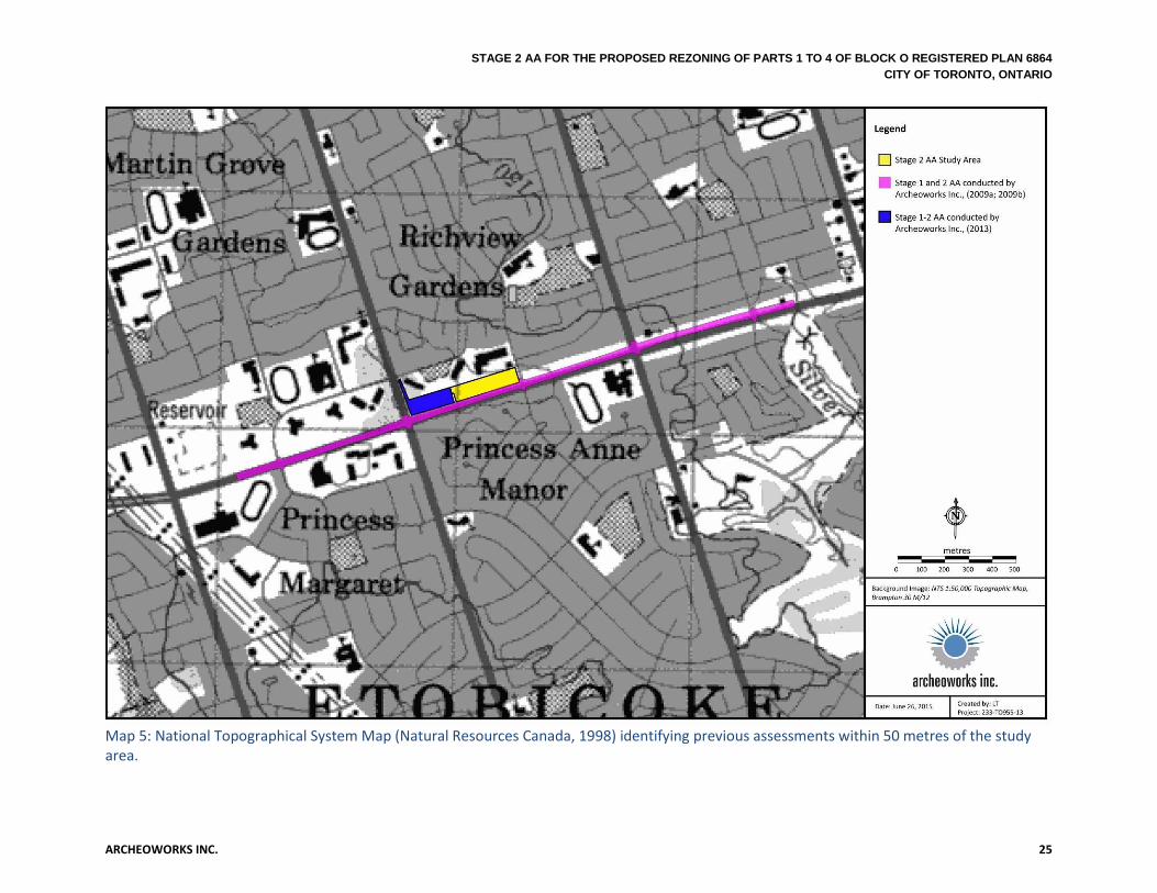
System, which is a numbering system used throughout Canada to track archaeological sites and their artifacts. The study area is located within Borden block AkGv. According to the MTCS, no archaeological sites have been registered within one-kilometre of the study area (MTCS, 2015). It must be noted, however, that the paucity of archaeological sites in proximity to the study area is not necessarily reflective of the scale of previous inhabitation, but more likely a lack of detailed archaeological surveys within the immediate area. 1.4.2 Previous Archaeological Assessments In order to further establish the archaeological context of the project area, reports documenting previous archaeological fieldwork carried out within the limits of, or immediately adjacent (i.e., within 50 metres) of the project area were consulted. A map of the limits and results of these assessments is provided within Maps 5-6. Four reports were identified:
Previous Assessment(s) associated with current development project:
1. Stage 1 Archaeological Assessment for the: Proposed Rezoning of Parts 1 to 4 of Block O Registered Plan 6864, Within Part of Lot 17, Concession A Fronting the Humber, in the former Geographic Township of Etobicoke, Historical County of York, Now the City of Toronto, Ontario (Archeoworks Inc., 2015)
Archeoworks Inc. undertook a Stage 1 AA of a parcel of land at associated with the proposed rezoning of Parts 1 to 4 of Block O Registered Plan 6864, a 1.8186 hectare parcel of land situated within part of Lot 17, Concession A Fronting the Humber, in the former Geographic Township of Etobicoke. The Stage 1 AA included a review of the historic and archaeological context of the study area which discussed the City of Toronto’s AMP, First Nations and Euro-Canadian settlement history; review of historical mapping and archival history of the Lot; close proximity (within 300 metres of) designated, listed heritage properties and conservation districts; commemorative markers; registered archaeological sites within one-kilometre; and previous assessments conducted within 50 metres. Several assessments by other archaeological consulting firms had been conducted within 50 metres of the study area. Areas identified as having archaeological potential were recommended to proceed to a Stage 2.
Previous assessment(s) associated with other development project:
2. Stage 1 Archaeological Assessment (AA) of: Proposed Eglinton Crosstown Light Rail Transit Corridor & Pearson Airport Surface Connection Study Area, City of Toronto, Ontario (Archeoworks Inc., 2009a)
Archeoworks Inc. conducted a Stage 1 AA in 2009 for the proposed Eglinton Crosstown Light Rail Transit (ECLRT) running along Eglinton Avenue to Pearson International Airport. This subject area falls within 50 metres of the current study area limits. High potential for the recovery of both Aboriginal and Euro-Canadian archaeological remains within undisturbed portions of the study corridor were established given the presence of historical structures and

STAGE 2 AA FOR THE PROPOSED REZONING OF PARTS 1 TO 4 OF BLOCK O REGISTERED PLAN 6864 CITY OF TORONTO, ONTARIO
ARCHEOWORKS INC. 10
watercourses along the length of the LRT corridor. A Stage 2 archaeological field assessment of undisturbed areas with elevated archaeological potential within the route was recommended prior to construction activities.
3. Stage 2 Archaeological Assessment (AA) Report for: Proposed Eglinton Crosstown Light Rail Transit Corridor & Pearson Airport Surface Connection Study Area, City of Toronto, Ontario (Archeoworks Inc., 2009b)
In the fall of 2009, Archeoworks Inc. conducted a Stage 2 AA of the ECLRT route within and beyond the existing Eglinton Avenue road right-of-way (ROW) limits, varying in width from less than a metre to 20 metres. Despite careful scrutiny, no archaeological resources were encountered and the subject corridor was considered free of further archaeological concern.
4. Stage 1-2 Archaeological Assessment (AA) for the: Proposed Development of 4650 Eglinton Avenue West, within Part of Lot 17, Concession A Fronting the Humber, Geographic Township of Etobicoke, City of Toronto, Ontario (Archeoworks Inc., 2013).
Archeoworks Inc. conducted a Stage 1-2 AA of a 1.37 hectare parcel of land with the municipal address of 4650 Eglinton Avenue. This subject area is located immediately west of the current study area. The Stage 1 AA determined there was potential for the recovery of archaeological resources within the limits of the subject area. However, during the Stage 2 AA no archaeological resources were encountered, and the subject area was considered free of further archaeological concern. 1.4.3 Physical Features The study area is located in the South Slope physiographic region of Southern Ontario. It is the southern slope of the Oak Ridges Moraine, but also includes a strip south of the Peel Plain. This region covers approximately 2,400 square kilometres from the Niagara Escarpment to the Trent River. The study area is in the strip of the South Slope south of the Peel Plain, characterized by a gently rolling till plain with fluting and low drumlins, and consisting of mainly Woburn loam, however this fine farmland is now largely urbanized. Portions of the South Slope region that lay in the interior, away from the lakeshore, were mainly colonized by the “second wave” of largely British immigrants after the Napoleonic Wars. Early settlers practiced mixed subsistence agriculture, although grain exportation did confer a measure of prosperity across the region, as evidenced by the construction of many fine fieldstone houses, the building of railroads and the improvement of main haulage roads. The decline of wheat growing, however, resulted in its replacement with commercial mixed farming, in which beef cattle, hogs and dairy butter were the primary income sources. The western portion of the South Slope region has preserved less of its rural character compared to the eastern portion, as large areas around Toronto have become more urbanized (Chapman & Putnam, 1984: pp. 172-174).

STAGE 2 AA FOR THE PROPOSED REZONING OF PARTS 1 TO 4 OF BLOCK O REGISTERED PLAN 6864 CITY OF TORONTO, ONTARIO
ARCHEOWORKS INC. 11
The primary soil type of the study area consists of Chinguacousey clay loam1, a grey-brown podzolic soil with good drainage. It is dark yellowish brown, shaly calcareous clay till with few stones, and a smooth gently sloping topography (Ontario Agricultural College, 1954). The study area resides on the southwestern edge of the Humber River watershed, where urbanization has left little undeveloped land, and sits between the Humber River to the east and Mimico Creek to the west. These water sources would have helped supply plant and food resources to the surrounding area, and subsequently support elevated potential for locating archaeological resources within portions of the study area that lie within 300 metres of their limits. 1.4.4 Current Land Conditions and Use The study area includes a parcel of land located between Kipling Avenue and Wincott Drive north of Eglinton Avenue West. The study area consists of two open manicured grass spaces, which are bisected by a paved roadway that leads to a plaza located north of the study area (see Map 7). The topography within the study area is fairly level, with the elevation averaging 150 metres above sea level throughout the study area. 1.4.5 Date(s) of Fieldwork The Stage 2 AA of the study area was undertaken on June 29th, 2015. The weather during the Stage 2 investigation was sunny to slightly overcast with a temperature high of 24.2°Celsius. The weather and lighting conditions during the Stage 2 investigation permitted good visibility of all parts of the study area and were conducive to the identification and recovery of archaeological resources (per 2011 S&G, Section 2.1, Standard 3).
1It should be noted that due urban expansion, soil information for the Metropolitan of Toronto is considered
unreliable since 1954 (Ontario Agricultural College, 1954).

STAGE 2 AA FOR THE PROPOSED REZONING OF PARTS 1 TO 4 OF BLOCK O REGISTERED PLAN 6864 CITY OF TORONTO, ONTARIO
ARCHEOWORKS INC. 12
2.0 FIELD METHODS
This field assessment was conducted in compliance with the 2011 S&G, published by the MTCS. Photographic images of the study area are presented within Appendix C. The results of the Stage 2 AA are provided within Map 8.
2.1 Deep and Extensive Disturbances The study area was evaluated for extensive disturbances that have removed archaeological potential. Disturbances may include but are not limited to: grading below topsoil, quarrying, building footprints, or sewage and infrastructure development. Section 1.3.2 of the 2011 S&G considers infrastructure development among those “features indicating that archaeological potential has been removed.” Disturbances encountered during the Stage 2 AA included: a paved roadway bisecting the study area, fill/gravel, asphalt, concrete, and underground utilities (see Map 8; Images 1-3, 7-8). Disturbances amounted to approximately 0.05 hectares or 2.86% of the study area.
2.2 Test Pit Survey Due to the urban nature and location of the study area, ploughing was not viable. Therefore, the remaining balance of the study area was subjected to a test pit form of survey (see Map 8; Images 4-8). A test pit form of survey involves the systematic walking of an area, excavating 30-centimetre diameter pits by hand, and examining their contents. The test pit survey was performed in a grid pattern and the topsoil was screened through six-millimetre wire mesh in order to facilitate the recovery of artifacts. Upon excavation of the first test pit, disturbed ground conditions were encountered. Therefore, test pit survey intervals were conducted at 10 metre intervals to confirm the extent of disturbance within these areas (see Map 8; Images 4-8). The entirety of the study area was found to be disturbed. All test pits were examined for stratigraphy, cultural features, and evidence of fill. All test pits were excavated as far as the level of disturbed fills allowed. Test pits were dug to depths ranging from 10-40 centimetres within disturbed soil. All test pits were backfilled. Approximately 1.76 hectares or 97.14% of the study area was subjected to shovel test-pit survey at 10 metre intervals. Approximately 176 test pits were excavated during the Stage 2 AA.

STAGE 2 AA FOR THE PROPOSED REZONING OF PARTS 1 TO 4 OF BLOCK O REGISTERED PLAN 6864 CITY OF TORONTO, ONTARIO
ARCHEOWORKS INC. 13
3.0 RECORD OF FINDS Despite careful scrutiny, no archaeological resources were encountered during the Stage 2 AA of the study area.
4.0 ANALYSIS AND CONCLUSIONS
The entirety of the study area was found to be disturbed. No archaeological sites were identified during the Stage 2 AA. The study area may be considered free of further archaeological concern.
5.0 RECOMMENDATIONS In light of the study area testing negative for archaeological resources, the following recommendation is presented to the MTCS:
1. No further archaeological investigation is required for the study area.
No excavation activities shall take place within the study area prior to the Ministry of Tourism, Culture and Sport (Archaeology Program Unit) and the City of Toronto’s Heritage Preservation Services confirming in writing that all archaeological licensing and technical review requirements have been satisfied.

STAGE 2 AA FOR THE PROPOSED REZONING OF PARTS 1 TO 4 OF BLOCK O REGISTERED PLAN 6864 CITY OF TORONTO, ONTARIO
ARCHEOWORKS INC. 14
6.0 ADVICE ON COMPLIANCE WITH LEGISLATION
1. This report is submitted to the MTCS as a condition of licensing in accordance with Part VI of the Ontario Heritage Act, R.S.O. 1990, c 0.18. The report is reviewed to ensure that it complies with the standards and guidelines that are issued by the Minister, and that the archaeological fieldwork and report recommendations ensure the conservation, protection and preservation of the cultural heritage of Ontario. When all matters relating to archaeological sites within the project area of a development proposal have been addressed to the satisfaction of the MTCS, a letter will be issued by the ministry stating that there are no further concerns with regard to alterations to archaeological sites by the proposed development.
2. It is an offence under Sections 48 and 69 of the Ontario Heritage Act for any party other than a licensed archaeologist to make any alteration to a known archaeological site or to remove any artifact or other physical evidence of past human use or activity from the site, until such time as a licensed archaeologist has completed archaeological fieldwork on the site, submitted a report to the Minister stating that the site has no further cultural heritage value or interest, and the report has been filed in the Ontario Public Register of Archaeology Reports referred to in Section 65.1 of the Ontario Heritage Act.
3. Should previously undocumented archaeological resources be discovered, they may be a new archaeological site and therefore subject to Section 48 (1) of the Ontario Heritage Act. The proponent or person discovering the archaeological resources must cease alteration of the site immediately and engage a licensed consultant archaeologist to carry out archaeological fieldwork, in compliance with Section 48 (1) of the Ontario Heritage Act.
4. The Cemeteries Act, R.S.O. 1990 c. C.4 and the Funeral, Burial and Cremation Services Act, 2002, S.O. 2002, c.33 require that any person discovering human remains must notify the police or coroner and the Registrar of Cemeteries at the Ministry of Consumer Services.

STAGE 2 AA FOR THE PROPOSED REZONING OF PARTS 1 TO 4 OF BLOCK O REGISTERED PLAN 6864 CITY OF TORONTO, ONTARIO
ARCHEOWORKS INC. 15
7.0 BIBLIOGRAPHY AND SOURCES
Archeoworks Inc., (2009a). Stage 1 Archaeological Assessment (AA) of: Proposed Eglinton Crosstown Light Rail Transit Corridor & Pearson Airport Surface Connection Study Area, City of Toronto, Ontario (CIF#: P029-661-2009). Archeoworks Inc., (2009b). Stage 2 Archaeological Assessment (AA) Report for: Proposed Eglinton Crosstown Light Rail Transit Corridor & Pearson Airport Surface Connection Study Area, City of Toronto, Ontario (PIF#: P029-660-2009). Archeoworks Inc. (2013). Stage 1-2 Archaeological Assessment for the: Proposed Development of 4650 Eglinton Avenue West, within Part of Lot 17, Concession A Fronting the Humber, Geographic Township of Etobicoke, City of Toronto, Ontario (PIF#: P390-019-2013). Archeoworks Inc. (2015). Stage 1 Archaeological Assessment for the: Proposed Rezoning of Parts 1 to 4 of Block O Registered Plan 6864, Within Part of Lot 17, Concession A Fronting the Humber , In the former Geographic Township of Etobicoke, Historical County of York, Now the City of Toronto, Ontario (PIF# P390-0080-2013). Archives of Ontario. (2009). Using the Ontario Land Records Index ca. 1780 – ca. 1920. [Online]. Available at: http://www.archives.gov.on.ca/english/guides/rg_205_land-records.aspx [14 January 2014]. Birch, J. (2010). Coalescence and Conflict in Iroquoian Ontario. [Online]. Available at: http://uga.academia.edu/JenniferBirch/Papers/183903/Coalescence_and_Conflict_in_Iroquoian_Ontario [Accessed 21July 2015]. Brown. G. (1846-7). Toronto-City and Home District Directory. Toronto: George Brown Chapman, L. J. and Putnam, D. F. (1984). Physiography of Southern Ontario. 3rd ed. Ontario Geological Survey, Special Volume 2. Toronto: Ministry of Natural Resources. Coyne, J.H. (1895). The Country of the Neutrals (as far as comprised in the County of Elgin) From Champlain to Talbot. [Online]. Available at: https://archive.org/stream/cihm_03619#page/n7/mode/2up [Accessed 21 July 2015]. Dodd, C.F., Poulton, D. R., Lennox, P.A., Smith, D.G., and Warrick, G.A. (1990). The Middle Ontario Iroquoian Stage. In Ellis, C.J. and N. Ferris (Eds.) The Archaeology of Southern Ontario to A.D. 1650. London, Ontario: Occasional Publication of the London Chapter, OAS, pp. 321-359. Ellis, C.J. and Deller, D.B. (1990). Paleo-Indians. In C.J. Ellis, and N. Ferris, (Eds.). The Archaeology of Southern Ontario to A.D. 1650. London, Ontario: Occasional Publication of the London Chapter, OAS, pp. 37-64.

STAGE 2 AA FOR THE PROPOSED REZONING OF PARTS 1 TO 4 OF BLOCK O REGISTERED PLAN 6864 CITY OF TORONTO, ONTARIO
ARCHEOWORKS INC. 16
Ellis, C.J., Kenyon, I.T., and Spence, M.W. (1990). The Archaic. In C.J. Ellis, and N. Ferris, (Eds.). The Archaeology of Southern Ontario to A.D. 1650. London, Ontario: Occasional Publication of the London Chapter, OAS, pp. 65-124. Ellis, C. J. (2013). Before Pottery: Paleoindian and Archaic Hunter-Gathers. In Munson, M.K. and Jamieson, S.M (Eds.) Before Archaeology: The Archaeology of a Province. Montreal & Kingston, Ontario: McGill Queen’s University Press. Energy, Mines and Resources. (1994). National Topographic Survey of Canada, Series A 751, Map 30 M/12. 7th ed. Ottawa. Ferris, N. (2013). Seeing Ontario’s Past Archaeologically. In Munson, M.K. and Jamieson, S.M (Eds.) Before Ontario: The Archaeology of a Province. Montreal & Kingston, Ontario: McGill Queen’s University Press, p.3-20. Ferris, N. and Spence, M.W. (1995). The Woodland Traditions in Southern Ontario. Revista de Arquologia Americana (9), 83-138. Fox, W. A. (1990). The Middle Woodland to Late Woodland Transition. In C.J. Ellis, and N. Ferris, (Eds.). The Archaeology of Southern Ontario to A.D. 1650. London, Ontario: Occasional Publication of the London Chapter, OAS, pp. 171-188. Gibson, M. M. (2006). In the Footsteps of the Mississaugas. Mississauga, Ontario: Mississauga Heritage Foundation. Hathaway, E, the Late (1930). The River Credit and the Mississaugas. In Ontario Historical Society Papers and Records Vol. xxvi. Toronto: Ontario Historical Society. Heidenreich, C.E. (1978). Huron. In B.G. Trigger (Ed.). Volume 15: Northeast. Washington: Smithsonian Institution, pp.368-388. Heyes, E. (1974). Etobicoke – From Furrow to Borough. Canada: Web Offset Publications Limited. Johnston, D. (2004). Connecting People to Place: Great Lakes Aboriginal History in Cultural Context. [Online]. Available at: http://www.attorneygeneral.jus.gov.on.ca/inquiries/ipper wash/transcripts/pdf/P1_Tab_1.pdf [Accessed 21 July 2015]. Karrow, P.F. and Warner, B.G. (1990). The Geological and Biological Environment for Human Occupation in Southern Ontario. In C.J. Ellis, and N. Ferris (Eds.). The Archaeology of Southern Ontario to A.D. 1650. London, Ontario: Occasional Publication of the London Chapter, OAS, pp. 5-35.

STAGE 2 AA FOR THE PROPOSED REZONING OF PARTS 1 TO 4 OF BLOCK O REGISTERED PLAN 6864 CITY OF TORONTO, ONTARIO
ARCHEOWORKS INC. 17
Lajeunesse, E. J. (1960). The Windsor Border Region: Canada’s Southernmost Frontier. Toronto: The Champlain Society. Locke, G.H. (1923). The Queen’s Rangers. [Online]. Available at: http://static.torontopubliclibrary.ca/da/pdfs/230953.pdf [Accessed 14 January 2014]. McMillan, A. D. and Yellowhorn, E. (2004). First People in Canada. Vancouver, B.C.: Douglas & McIntyre. Miles & Co. (1878). Illustrated Historical Atlas of the County of York. Toronto Mississauga of the New Credit First Nation (MNCFN). (N.D.a.). The History of the Mississauga of the New Credit First Nation. Ottawa, Ontario: Praxis Research Associates. Mulvany, C. P. and Adam, G. M. (1885). History of Toronto and County of York, Ontario: containing an outline of the history of the Dominion of Canada, a history of the city of Toronto and the county of York, with the townships, towns, villages, churches, schools; general and local statistics; biographical sketches, etc., etc. Volume 1. [Online]. Available at: http://www.ourroots.ca/toc.aspx?id=3668&qryID=9420b906-028b-49f4-85ad-c5f70662bcf2 [Accessed 14 January 2014]. No Author. (1891). Indian Treaties and Surrenders from 1680 to 1890. Ottawa: Browns Chamberlin Printers. Ontario Agricultural College (1954). Soil Map of York County, Soil Survey Report No. 19. Guelph: Soil Research Institute. Ontario Ministry of Tourism, Culture and Sport. (2011). Standards and Guidelines for Consultant Archaeologists. Toronto: Ministry of Tourism, Culture and Sport. Ontario Ministry of Tourism, Culture and Sport (2012). Sites within a One Kilometre Radius of the Project Area, provided from the Ontario Archaeological Sites Database, 15 July 2015. Ramsden, P.G. (1990). The Hurons: Archaeology and Culture History. In Ellis, C.J. and N. Ferris (Eds.). The Archaeology of Southern Ontario to A.D. 1650. London, Ontario: Occasional Publication of the London Chapter, OAS, pp. 361-384. Robinson, P.J. (1965). Toronto during the French Regime: 1615-1793. Toronto: University of Toronto Press. Rowsell, H. (1850). City of Toronto and County of York Directory for 1850-1; Being the 14th and 15th year of her Reign of Her Majesty Queen Victoria. Toronto: Henry Rowsell.

STAGE 2 AA FOR THE PROPOSED REZONING OF PARTS 1 TO 4 OF BLOCK O REGISTERED PLAN 6864 CITY OF TORONTO, ONTARIO
ARCHEOWORKS INC. 18
Schmalz, P.S. (1991). The Ojibwa of Southern Ontario. Toronto, Canada: University of Toronto Press. Smith, D.A. (1990). Iroquois Research. In C.J. Ellis, and N. Ferris, (Eds.). The Archaeology of Southern Ontario to A.D. 1650. London, Ontario: Occasional Publication of the London Chapter, OAS, pp. 279-290. Smith, D.B. (2013). Sacred Feathers: The Reverend Peter Jones (Kahkewaquonaby) and the Mississauga Indians. Toronto: University of Toronto Press. Smith, D.G. (2002). Their Century and a Half on the Credit: The Mississaugas in Mississauga. In Mississauga: The First 10,000 Years. Toronto, Ontario: The Mississauga Heritage Foundation Inc., 123-138. Spence, M.W., Pihl, R.H., and Murphy, C.R. (1990). Cultural Complexes of the Early and Middle Woodland Periods. In Ellis, C.J. and N. Ferris (Eds.) The Archaeology of Southern Ontario to A.D. 1650. London, Ontario: Occasional Publication of the London Chapter, OAS, pp. 125-169. Stewart, A.M. (2013). Water and Land. In Munson, M.K. and Jamieson, S.M (Eds.) Before Archaeology: The Archaeology of a Province. Montreal & Kingston, Ontario: McGill Queen’s University Press Surtees, R. J. (1986). Treaty Research Report: The Williams Treaties. [Online]. Available at http://www.aadnc-aandc.gc.ca/DAM/DAM-INTER-HQ/STAGING/texte-text/traw_1100100029001_eng.pdf [Accessed 21 July 2015]. Surtees, R.J. (1994). Land Cessions, 1763-1830. In Rogers, E.S. (Ed.) Aboriginal Ontario: Historical Perspectives on the First Nations. Toronto, Ontario: Dundurn Press Limited, pp. 92-121 Tremaine, G. C. (1860). Tremaine’s Map of the County of York. Canada West. Toronto. Trigger, B. G. (1994).The Original Iroquoians: Huron, Petun and Neutral. In Edward S. Rogers (Eds.). Aboriginal Ontario: Historical Perspectives on the First Nations. Toronto, Ontario: Dundurn Press Limited, pp 41-63. Unwin, C. (1856). Map of the Township of Etobicoke in the County of York. J. Ellis, Toronto. Walton, G. (1837). The City of Toronto and the Home District Commercial Directory and Register with Almanack and Calendar for 1837. Toronto, U.C.; T.Dalton and W.J. Coates. Warrick, G.A. (2000). The Precontact Iroquoian Occupation of Southern Ontario. In Journal of World Prehistory, Vol.14, No.4, pp. 415-466.

STAGE 2 AA FOR THE PROPOSED REZONING OF PARTS 1 TO 4 OF BLOCK O REGISTERED PLAN 6864 CITY OF TORONTO, ONTARIO
ARCHEOWORKS INC. 19
Warrick, G. (2008). A Population History of the Huron-Petun, A.D. 500-1650. New York: Cambridge University Press. Warrick, G. (2013). The Aboriginal Population of Ontario in Late Prehistory. In Munson, M.K. and Jamieson, S.M (Eds.) Before Archaeology: The Archaeology of a Province. Montreal & Kingston, Ontario: McGill Queen’s University Press. Williamson, R. F. (1990). The Early Iroquoian Period of Southern Ontario. In Ellis, C.J. and N. Ferris (Eds.) The Archaeology of Southern Ontario to A.D. 1650. London, Ontario: Occasional Publication of the London Chapter, OAS, pp. 291-320. Williamson, R.F. (2013). The Woodland Period, 900 BCE to 1700 CE. In Munson, M.K. and Jamieson, S.M (Eds.) Before Archaeology: The Archaeology of a Province. Montreal & Kingston, Ontario: McGill Queen’s University Press. Wright, J.V. (1994).Before European Contact. In Edward S. Rogers (Eds.). Aboriginal Ontario: Historical Perspectives on the First Nations. Toronto, Ontario: Dundurn Press Limited, pp 21-40 ARCHIVAL SOURCES: York County Land Registry Office Records; Abstract Index Books ca. 1800-1959 Etobicoke Township: GSU179596, Archives of Ontario. Township of Etobicoke Diffusion Material, York County, Ontario; Assessment Rolls 1850-1899: D182-GS5794-99, Archives of Ontario.
Township of Etobicoke, Instruments & Deeds: GS 5787-90, Archives of Ontario.

STAGE 2 AA FOR THE PROPOSED REZONING OF PARTS 1 TO 4 OF BLOCK O REGISTERED PLAN 6864 CITY OF TORONTO, ONTARIO
ARCHEOWORKS INC. 20
APPENDICES

STAGE 2 AA FOR THE PROPOSED REZONING OF PARTS 1 TO 4 OF BLOCK O REGISTERED PLAN 6864
CITY OF TORONTO, ONTARIO
ARCHEOWORKS INC. 21
APPENDIX A: MAPS
MAP 1 National Topographical System Map (Natural Resources Canada, 1998) identifying the Stage 2 AA study area.

STAGE 2 AA FOR THE PROPOSED REZONING OF PARTS 1 TO 4 OF BLOCK O REGISTERED PLAN 6864
CITY OF TORONTO, ONTARIO
ARCHEOWORKS INC. 22
Map 2: Study area within Unwin’s Map of the Township of Etobicoke in the County of York (Unwin, 1856).

STAGE 2 AA FOR THE PROPOSED REZONING OF PARTS 1 TO 4 OF BLOCK O REGISTERED PLAN 6864
CITY OF TORONTO, ONTARIO
ARCHEOWORKS INC. 23
Map 3: Study area within the Tremaine’s Map of the County of York (Tremaine, 1860).

STAGE 2 AA FOR THE PROPOSED REZONING OF PARTS 1 TO 4 OF BLOCK O REGISTERED PLAN 6864
CITY OF TORONTO, ONTARIO
ARCHEOWORKS INC. 24
Map 4: Study Area within the Illustrated Historical Atlas of the County of York (Miles & Co., 1878).
STAGE 2 AA FOR THE PROPOSED REZONING OF PARTS 1 TO 4 OF BLOCK O REGISTERED PLAN 6864
CITY OF TORONTO, ONTARIO
ARCHEOWORKS INC. 25
Map 5: National Topographical System Map (Natural Resources Canada, 1998) identifying previous assessments within 50 metres of the study area.

STAGE 2 AA FOR THE PROPOSED REZONING OF PARTS 1 TO 4 OF BLOCK O REGISTERED PLAN 6864
CITY OF TORONTO, ONTARIO
ARCHEOWORKS INC. 26
Map 6: National Topographical System Map (Natural Resources Canada, 1998) identifying results of previous assessments within 50 metres of the study area.

STAGE 2 AA FOR THE PROPOSED REZONING OF PARTS 1 TO 4 OF BLOCK O REGISTERED PLAN 6864
CITY OF TORONTO, ONTARIO
ARCHEOWORKS INC. 27
Map 7: Study area within a 2013 satellite image (Google Earth, 2015).

STAGE 2 AA FOR THE PROPOSED REZONING OF PARTS 1 TO 4 OF BLOCK O REGISTERED PLAN 6864
CITY OF TORONTO, ONTARIO
ARCHEOWORKS INC. 28
Map 8: Stage 2 AA results of the study area, with photo locations indicated.

STAGE 2 AA FOR THE PROPOSED REZONING OF PARTS 1 TO 4 OF BLOCK O REGISTERED PLAN 6864
CITY OF TORONTO, ONTARIO
ARCHEOWORKS INC. 29
APPENDIX B: ARCHIVAL DATA
Table B1: Abstract Index Books, 1800 to 1959 – Lot 17, Concession A Fronting the Humber, Township of Etobicoke, County of York
No. of Instrument
Instrument It's Date Date Registered Grantor Grantee Quantity of Land
Amount/ Consideration
Remarks
Patent 25 Nov 1808 Crown John Gamble all
1834 B.S 6 July 1811 21 Sept 1811 John Gamble Patrick Smyth £ 250.00 alluvial
30974 B.S 24 Feb 1848 2 Mar 1848 Hon. Geo M Marlands, Exec of Patrick Smyth John Scarlett all in al £ 75.00
31452 Bargain Sales 17 Mar 1848 17 Mar 1848 John Scarlett Andrew Coulter All in al ?
31152 Mtg 17 Mar 1848 17 Mar 1848 Andrew Coulter John Scarlett All in al £350.00
35469 Dis Mtg 9 Nov 1849 9 Nov 1849 John Scarlett Andrew Coulter £350.00 mg 31152
85826 Bargain Sales July 1862 1 April 1863
Robert Coulter, James Coulter, Abigail his wife, Andrew Coulter, John Coulter, and J Coulter, Martha Coulter, Henry Coulter, Jane Coulter, Mary Jane & Joseph Coulter, Rebecca Coulter, M Coulter & George Coulter Matthew Canning all in al 5/a
8584? Release 16 July 1862 1 April 1863
Robert Coulter, James Coulter, Andrew Coulter, John Coulter,Henry Coulter, Jon Coulter,M Coulter & George A Coulter & Isablella Price Matthew Canning all in al £
85830 Bargain Sales 16 July 1862 1 April 1863 Matthew Canning & Jannett his wife Andrew Coulter all in al £ pa

STAGE 2 AA FOR THE PROPOSED REZONING OF PARTS 1 TO 4 OF BLOCK O REGISTERED PLAN 6864
CITY OF TORONTO, ONTARIO
ARCHEOWORKS INC. 30
Table B2: Tax Assessment Rolls, 1850 to 1899 - Lot 17, Concession A Fronting the Humber, Township of Etobicoke, County of York
Date Occupant Occupation Age F/FS/T Owner/Address Acres Cleared (Cultivated)
Total Acres
Total Value of Real Property
Remarks
1854 Andrew Coulter Farmer 60 F 100 $600.00 Also owns L13&14, C2 and L16, C1
1855 Andrew Coulter Farmer 61 F 100 $600.00 also owns L14 C2 and L16 C1 , listed on lot 14
1856 Andrew Coulter Farmer 63 F 100 $700.00 also owns L14 C2 and L16 C1 , listed on lot 14
1857 Andrew Coulter Farmer 64 F 100 $750.00 also owns L14 C2 and L16 C1 , listed on lot 14
1860 Andrew Coulter Farmer 37 F 100 $2,800.00 also owns L14 C2 and L16 C1 , listed on lot 14
1864 Andrew Coulter Farmer 39 F George Coulter 100 $3,000.00 also owns L16 C1; 1 dog
1865 Andrew Coulter Farmer 41 F 100 $2,900.00 also owns L16 C1
1867 Andrew Coulter Farmer 41 F 30 100 $2,900.00 also owns L16 C1; 2 in family; 5cattle; 20sheep; 6hog; 3horse
1868 Andrew Coulter Farmer 42 F George Coulter 30 100 $2,900.00 also owns L16 C1; 2 in family; 4cattle; 10sheep; 7hog; 3horse
M. Comb. John Labourer 65 T 5 in the family; 1cattle; 1dog
1870 Andrew Coulter Farmer 44 F 35 100 $3,000.00 4 in family; PM
M. Comb. Jane widow F
Andrew Coulter F
1871 Andrew Coulter Farmer 45 F Islington 35 100 $3,000.00 4 in family; PM(M); 10cattle; 25sheep; 5hogs; 4horse
1872 Andrew Coulter Farmer 46 F Islington 35 100 $3,000.00 5 in family; PM(M); 9cattle; 16sheep; 2hogs; 6horse
1873 Andrew Coulter Farmer 47 F Islington 35 100 $3,000.00 7 in family; PM; 9cattle; 11sheep; 5hogs; 4horse. (also owns the N1/2 of L16 CA and is a tenant on the S1/2 of L16C1
1874 Andrew Coulter Farmer 48 F Islington 40 100 $3,000.00 6 in family; PM; 8cattle; 18sheep; 5hog; 4horse (also F on Nof CA L16)
1875 Andrew Coulter Farmer 49 F Islington 40 100 $3,200.00 7 in family; PM; 8cattle; 18sheep; 2hog; 5horse (also F on N1/2 L16CA and T on L16C1)
1876 Andrew Coulter Farmer 50 F Islington 40 100 $4,500.00 8 in family; PM; 7cattle; 10sheep; 3hogs; 5horse (also F on N1/2 of L16CA & T on L16C1)
1877 Andrew Coulter Farmer 51 F Islington 40 100 $4,600.00 6 in family; PM; 8cattle; 8sheep; 3hogs; 4horses (also F on N1/2 of L16CA& T on L16C1)
1878 Andrew Coulter Farmer 52 F Islington 60 1000 $5,000.00 5 in family; PM; 6cattle; 12sheep; 6hogs; 6horses (also F on N1/2 of L16CA & T on L16C1)

STAGE 2 AA FOR THE PROPOSED REZONING OF PARTS 1 TO 4 OF BLOCK O REGISTERED PLAN 6864
CITY OF TORONTO, ONTARIO
ARCHEOWORKS INC. 31
Date Occupant Occupation Age F/FS/T Owner/Address Acres Cleared (Cultivated)
Total Acres
Total Value of Real Property
Remarks
1879 Andrew Coulter Farmer 53 F Islington 60 100 $5,000.00 7 in family; PM; 7cattle; 10sheep; 2hogs; 5horses (also F on N1/2 of L16CA & F on L16C1)
1880 Andrew Coulter Farmer 54 F Islington 40 100 $5,000.00 5 in family; PM; 8cattle; 11sheep; 4hogs; 5horses (also F on N1/2 of L16CA & F on L16C1)
1881 Andrew Coulter Farmer 55 F Islington 60 100 $5,000.00 6 in family; PM; 4cattle; 8sheep; 2hogs; 5horses (also F on N1/2 of L16CA & F on L16C1)
1883 Andrew Coulter Farmer 57 F Islington 60 100 $5,000.00 6 in family; PM; 8cattle; 8sheep; 2hogs; 3horses (also F on N1/2 of L16CA & F on L16C1)
1884 M Comb Miss H 1 in family
Andrew Coulter Farmer 58 F Islington 60 100 $5,000.00 7 in family; PM; 5cattle; 11sheep; 7hog; 4horse (also F on N1/2 of L16CA & F on L16C1)
1885 Andrew Coulter Farmer 60 F Islington 60 100 $5,000.00 8 in family; PM; 8cattle; 8sheep; 10hogs; 4horse (also F on N1/2 of L16CA & F on L16C1)
1886 Andrew Coulter Farmer 61 F Islington 60 100 $5,000.00 9 in family PM; 7cattle; 8sheep; 12hogs; 6horse (also F on N1/2 of L16CA & F on L16C1)
1887 Andrew Coulter Farmer 62 F 60 100 $5,100.00 8 in family; PM; 8cattle; 8sheep; 2hog; 6horse; (also F on N1/2 of L16CA)
M Comb Miss H 1 in family
1888 Andrew Coulter Farmer 63 F Islington 60 100 $5,200.00 5 in family; PM; 10cattle; 12sheep; 1hog; 4horse (also F on N1/2 of L16CA)
M Comb Miss H 1 in family
1889 Andrew Coulter Farmer 64 f Islington 60 100 $5,300.00 6 in family; PM(M); 8cattle; 6sheep; 1hog; 6horse (also F on N1/2 of L16CA)
1890 Andrew Coulter Farmer 65 F Islington 60 100 $5,300.00 6 in family; PM(M); 6cattle; 2hog; 4horse(also F on N1/2 of L16CA)
1891 John Coutler Farmer 66 F Islington 22 22 $3,000.00 6 in family; M
1892 Andrew Coulter Farmer 67 F Islington 60 100 $5,300.00 9 in family; PM(M); 8cattle; 4sheep; 5hog; 6horse(also F on N1/2 of L16CA)
1893 Arthur Watson Farmer 27 T Islington (Andrew Coulter 78)
100 $5,300.00 6 in family; M; 20cattle; 30sheep; 11hog; 16horse

STAGE 2 AA FOR THE PROPOSED REZONING OF PARTS 1 TO 4 OF BLOCK O REGISTERED PLAN 6864
CITY OF TORONTO, ONTARIO
ARCHEOWORKS INC. 32
Date Occupant Occupation Age F/FS/T Owner/Address Acres Cleared (Cultivated)
Total Acres
Total Value of Real Property
Remarks
1894 Arthur Watson Farmer 28 T Islington (Andrew Coulter 79)
50 100 $5,300.00 7 in family; M; 10cattle; 40sheep; 6hog; 6horse (also T on N1/2 L16CA and T on L16C1)
1895 Arthur Watson Farmer 30 T Islington (Andrew Coulter 80)
100 100 $5,300.00 7 in family; M; 10cattle; 40sheep; 6hog; 6horse (also T on N1/2 L16CA and T on L16C1)
1896 Sloan unreadable Labourer 60 T
Arthur Watson Farmer 30 T Islington (Andrew Coulter 81)
100 100 $5,200.00 4 in family; M; 12cattle; 8sheep; 9hog; 9horse (also T on N1/2 L16CA and T on L16C1)
1897 Arthur Watson Farmer 31 T Islington (Andrew Coulter 82)
100 100 $5,300.00 6 in family; M; 8cattle; 7sheep; 6hog; 8horse (also T on N1/2 L16CA and T on L16C1)
1898 Arthur Watson Farmer 32 T Islington (Andrew Coulter, 83, Toronto)
100 100 $5,200.00 3 in family; M; 5cattle; 7sheep; 8hog; 5horse (also T on N1/2 L16CA and T on L16C1)
1899 Arthur Watson Farmer 33 T Islington (Andrew Coulter, Toronto)
100 100 $5,200.00 8 in family; M; 5cattle; 14sheep; 5hog; 5horse (also T on N1/2 L16CA and T on L16C1)

STAGE 2 AA FOR THE PROPOSED REZONING OF PARTS 1 TO 4 OF BLOCK O REGISTERED PLAN 6864
CITY OF TORONTO, ONTARIO
ARCHEOWORKS INC. 33
APPENDIX C: IMAGES
Image 1: View of disturbances associated with gravel fill and utilities.
Image 2: View of disturbances associated with gravel fill and utilities.
Image 3: View of disturbances associated with gravel fill and paved driveway.
Image 4: View of test pit survey at 10 metre intervals.

STAGE 2 AA FOR THE PROPOSED REZONING OF PARTS 1 TO 4 OF BLOCK O REGISTERED PLAN 6864
CITY OF TORONTO, ONTARIO
ARCHEOWORKS INC. 34
Image 5: View of test pit survey at 10 metre intervals.
Image 6: View of test pit survey at 10 metre intervals.
Image 7: View of disturbed gravel fill from test pit survey.
Image 8: View of disturbed gravel fill from test pit survey.

STAGE 2 AA FOR THE PROPOSED REZONING OF PARTS 1 TO 4 OF BLOCK O REGISTERED PLAN 6864
CITY OF TORONTO, ONTARIO
ARCHEOWORKS INC. 35
APPENDIX D: INVENTORY OF DOCUMENTARY AND MATERIAL RECORD
Project Information:
Project Number: 233-TO955-13
Licensee: Alvina Tam (P1016)
MTCS PIF: P029-0906-2015
Document/ Material Location Comments
1. Research/ Analysis/ Reporting Material
Digital files stored in: /2013/233-TO955-13 - Shannex - Toronto/Stage 2
Archeoworks Inc., 16715-12 Yonge Street, Suite 1029, Newmarket, ON, Canada, L3X 1X4
Stored on Archeoworks network servers
2.. Annotated Field Notes/Maps
Field Notes: One (1) page Field Maps: One (1) map
Archeoworks Inc., 16715-12 Yonge Street, Suite 1029, Newmarket, ON, Canada, L3X 1X4
Scanned and stored on Archeoworks network servers
3. Fieldwork Photographs
Digital Images: 88 Images Archeoworks Inc., 16715-12 Yonge Street, Suite 1029, Newmarket, ON, Canada, L3X 1X4
Stored on Archeoworks network servers
Under Section 6 of Regulation 881 of the Ontario Heritage Act, Archeoworks Inc. will, “keep in safekeeping all objects of archaeological significance that are found under the authority of the licence and all field records that are made in the course of the work authorized by the licence, except where the objects and records are donated to Her Majesty the Queen in right of Ontario or are directed to be deposited in a public institution under subsection 66 (1) of the Act.