Spete - Spate Irrigation · Spete arngratíom rrr.t nne Yemen Areb R.epubÏac by FhÍÏíp The...
6
Transcript of Spete - Spate Irrigation · Spete arngratíom rrr.t nne Yemen Areb R.epubÏac by FhÍÏíp The...

Spete arngratíom rrr.t nne Yemen Areb R.epubÏacby FhÍÏíp
The traditional spate irrigation systems of theTihama coastal plain'in the Yemen Arab Republieare undergoing radical change as they aredeveloped and improved. The ODU has testeddiversion structures utilising a unique spate flowtest facility. Field measurêments in two wadis havealso been undertaken. In this aÍicle the problemsof diverting water from steep rivers subject toflash floods are outlined, and some of theengineering solutions that have been adopted aredescribed.
Jr&1MKêffie €
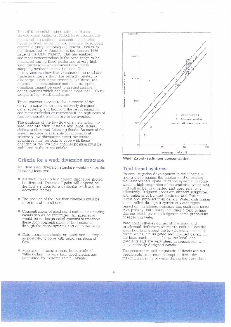
shown, exhibit,a very short rising limb and a 4 to 6hour recession. Wadi flows are seasonal withabout B0% of the iotal annual discharge occurringhetrnreen Anril anj NOvember. Base flOws in ther ryrrr eIr
drv season are oÍten less than I mts'r.
Althougth most of the runoff occurs during the floodseason, a surprisingly small percentage of the totalannual discharge occuiÈ at very high flow rates, asshown in the data from the Wadi Rima.
%o of AverageAnnual Discharge
in Flow Range
5321,1174Z
I,5
Clearly in this case a high diversion efficiency canbe achieved if all the wadi flows, up to say 20m3s-r, can be abstracted. A similar distribution hasbeen found in the other Tihama wadis.
Wadi bed widths vary from I00 to 300 m atpotential diversion sites where the wadis flow fromthe mountains onto the Tihama. Gradients aretypically steep, 0.4 to l0lo and when not in flood thewadi bed is occupied by small, meandering, oftenbraided, low flow channels. Bed material is poorlysorted ranging in size from silt to boulders. Duringfloods very large quantities of sediment in the sandsize range are transpoïted, Until recently verylittle rellable sedÍment tïansport data wasavailable, particulariy for high flows.
Flow Rangem3s-l
Less than 2.02.0to50
5.0 to 10.010.0 to 20.020.0 to 50.0
50.0 to 100.0100.0 to 500.0
Larger than500 1.5
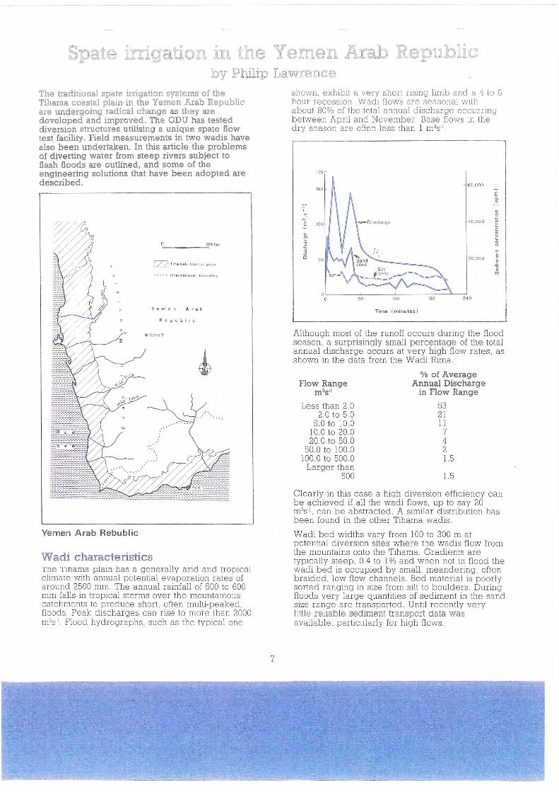
Yemen Arab Rebublic
'ltrfadi characteristics'l'ne'l'mama plarn has a generally arid and tropicalclimate with annual potential evaporation rates ofaround 2500 mm. The annual rainfall of 500 to 600mm falls in tropical storms over the mountainouscatchments to produce short, often multr-peaked,floods. Peak discharges can rise to more than 2000m3s'r. Flood hydrographs, such as the typical one
60,ooo
E
4o.ooo ËE
2o.ooo It
E
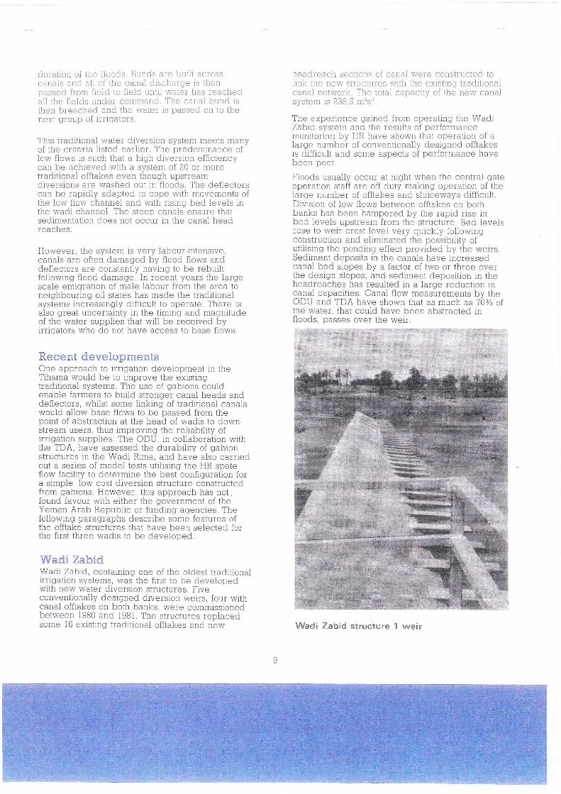
T'he ODU, in collaboration with the TrhamaDeveiopment Àuihority, gDA), have successfuliymeasured the sediment concentrations durlngfloods in Wadi Zabid utlilsing specially developedautomatic pump samplinq equipment, (similar tothat described by Amphlett in the January i986issue of the ODU Bulletin). This has enabledsediment concentratrons in the sand range to bemeasured during flood peaks and at very hrqrhwadi discharges \Mhen conventional bottlesampling methods cannot be used. Themeasurements show that variation of the sand sizefractions during a flood are sensibly related todischarge. Fieid measuïements, Iike these, areimportant as conventional sediment transportequations cannot be used to predict sedimentconcentrations which can rise to more than 10% byweight at high wadi discharge.
These concentrations are far in excess of thecarrying capacity for conventionally-designedcanal systems, and highhght the requirement forsediment exclusion or extraction if the high costs offrequent canal de-silting are to be avoided.
The positions of the low flow channels within thewadi bed are often unstable and large, lateral,shifts are observed following floods. Às most of thewater resource rs available for diversion atrelatively low discharges either the intakestructuïes must be built to cope with thesechanges or the low flow channel position must bestabilised at the canal offtake.
Criteria for a wadi diversion structureAn ideal wadi diversion structure would exhibit thefollowingr features:
a AII wadi flows up to a certain discharge shouldbe diverted. The cut-off point will depend onthe flow statistics for a particular wadi and oneconomic factors.
o The position of the low flow channels must bestabilised at the offtake.
o Concentrations of sand sized sediments enteringcanals should be minimized. An alternativewould be to design canal systems to transportthese high concentrations of bed materialthrough the canal systems and on to the fields.
o Gate operations should be quick and as simpleas possible, to cope with rapid variations offlow.
a Permanent stÍuctuïes must be capable ofwithstanding the very hiqh flood dischargesgenerated by extreme rainfall events,
o
ocoo
x Mailual sampllng
o Automatic sampling
-.- HalÍ to twice eÍÍor band
Wadi Zabid - sediment concentration
Traditional systemsPresent irrigation development in the Tihama rstaking place against the background of existing,well-established, spate irrigation systems, In somewadis a high proportion of the available lÍ/ateï was,and still is, being diverted and used relativelyeffectively, Irrigated areas are already sculpturedwith patterns of bunded fields set at differenrlevels and supplied from canals, Water distributionis controlled through a system of water rights,based on the Islamic principle that upstream useïstake priority, but usually including a form of time-sharing which gives all irrigators some probabilityoI ïecelvrng water,
Traditional offtakes consist of low stone andbrushwood deflectors which are built out into thewadi bed to intercept the low flow channels anddivert water into un-gated and unlined canals, Inthe headreach, canals follow the local landgradients and are very steep in comparison withconventionally designed canals,
The occurrence and magnitude oí floods are notpredictable so farmels attempt to divert themaximum quantity of water during the very short
du.raiion of tiie floods, Bu.nds are buili acrosscanals and all of the canal discharge rs thenpassed from field to lield until water has ieacheda.ll the fields under command. The canal bund lsthen breached and the waier is passed on to thenext group of trrlgators.
This traditional water diversion system meets manyof the criteria listed earlier. The predominance oflow flows is such that a high diversion efficrencycan be achreved with a system of 20 or moretraditional offtakes even though upstreamdiversions are washed out in floods, The deflectorscan be rapidly adapted to cope with movements ofthe low flow channei and with rÍsrng bed levels inthe wadi channel. The steep canals ensure thatsedlmentation does not occur in the canal headreaches.
However, the system is very labour-intensive,canals are often damaged by flood flows anddeflectors are constantly havrng to be rebuiltfollowing flood damage. In recent years the Iargescale emigration of male labour from the area toneighbouring oil states has made the traditionalqvctêms inr-rcasiní-Ílv diffir:rrlt tn nnêï^tê There isuj vLvrrrv
also great uncertainty in the timing and magnitudeof the water supplies that will be received byirrigators who do not have access to base flows.
Recent developmentsOne approach to irrigation development in theTihama would be to improve the existingtraditional systems, The use of gabions couldenable farmers to build stronger canal heads anddeflectors, whilst some linking of traditional canalswould allow base flows to be passed from thepoint of abstraction at the head of wadis to down-stream users, thus improving the reliability ofirrigation suppiies, The ODU, in collaboration withthe TDA, have assessed the durability of gabionstructures in the Wadi Rima, and have also carriedout a series of model tests utilising the HR spateflow facility to determine the best configuration fora srmple, low cost diversion structure constructedfrom gabions, However, this approach has not.found favour with either the government of theYemen Arab Republic or funding agencies. Thefollowrng paragraphs describe some features ofthe offtake structures that have been selected forthe first three wadrs to be developed.
ï/Vadi ZabidWadi Zabid, containing one of the oldest traditionalirrigation systems, was the first to be developedwith new water diversion structures, Fiveconventionally desiqned diversion weirs, four withcanal offtakes on both banks, weïe commlssionedbetween 1980 and 1981. The structures replacedsome l6 existing traditional offtakes and new
headreach sections ol canal were constru.c,teo tolink the nevrr structures wrth the existrnq tradrtronalcanal network. The total canacitv of the new canale\relah ic 2?R 4 mSc IuJ u!urrr
The exnerience r-iained from oneratino the WadiZabid system and the results of performancemonitoring by HR have shown that operation of alarge number of conventionally designed offtakesis difficult and some aspects of performance havebeen poor,
Floods usually occuï at nlght when the central gateoperation staff are off duty making operation of thelarge number of offtakes and sluiceways difficult.Division of low flows between offtakes on bothbanks has been hampered by the rapid rise inbed levels upstream from the structure. Bed levelsrose to werr crest level very quickly followingconstruction and eliminated the possibilitv ofutilising the ponding effect provrded by the weirs,Sediment deposits in the canals have increasedcanal bed slopes by a factor of two or three overthe design slopes, and sediment deposition in theheadreaches has resulted in a large reduction incanal capacities. Canal flow measurements by theODU and TDA have shown that as much as 700/o of.the water, that could have been abstracted rnfloods, passes over the weir.
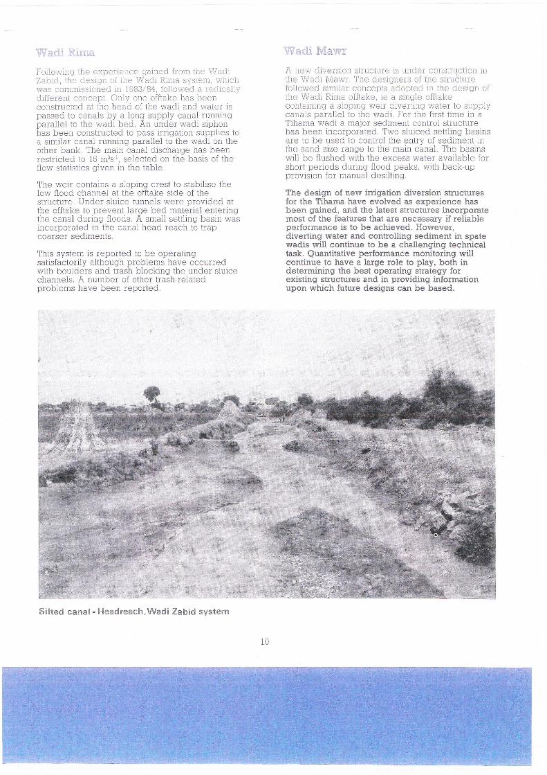
Wadi Zabid structure 1 weir
ilVare,ri Sillna
Following ihe experience gained from the WadiZabic-l ihe cl.esiqin oi ilie \lVadt RLtrra systen, whichrRias commissicned. in 1983/84, follor,ved a radrcallydifferent corrcept. Onlli ens offtake has beenconstructed at the head of the wad.i and water rs^^^^^! r^ ^-^-l^ k-. ^ l^-^ -',^^1" ^---l -"-passeo to canars Dy a roilg supply uilr.rdr ruirningparallel to the wadi bed. An under-wadl siphonhas been constructed to pass irrigation supplies to^ ^;-;l^,- ^^-^1 -,,--i-- ^^--ll^l '^ +L^ '-'^l; On thed )lllIIldI UqIlOl I Urrlrrllg pororrEl tu trru vvoulother bank, The main canal discharge has beenrestricted to 15 m3s'r, selected on the basis of theflow statistics given in the table.
The werr contains a sloping crest to stabrlise thelow flood channel at the offtake side of thestructure. Under-sluice tunnels were provided attho nff+alaa tn nïêr/ênt l:vao 1-'aÀ m:tavirl ontorinclOi 9g UgU lIIOlgIlol glrLvrrrrVtho r-anal drrrino floods A small settlincr hasin wasuqrtrrv uvlrrrrrv lurinnnvnnyriod in tha nrnrl harÀ vnral.. tn trrrrrruvayvru,es .,, .,,- -JIldr lleilu ledull tU tlilp
coarser seolmen{s,
Thic crrctam iq rcnnriad tn l-ra nnoratinaafrrv u/
satisfactorily although problems have occurredwÍth boulders and trash blocking the undeï sluicechannels, A number of other trash-relatedproblems have been ïeported.
Silted canal' F{eadreach,Wadi Zabid system
v{íactl '.[Viarrv'1.'
A uevrl cliversion structu.re is u.nder construcLron inthe V\Iad.i \4avrir. The desigireis oi the struCiu.refoilowed similar concepts adopted in the design ofthe Wadi Rima offtal<e, re a sing'le offtaken rnf :in:rn : clnnrn^ rnrpjy 6l j17pat16Í t^/Atêr fn strnnlrrUUlJLqlIlIllV o -luyllrv Vvutl u. rL I tlt^9 rvurLr (v JJyy-fcanals paraliel to the wadi, For the first tlme rn aTihama wadi a major sediment control structurehas hccn inr.nrnnrated Two slrrjcecl selllino basinsuv, rlrrrY
are to be used to control the entïy of sediment rnïhe sand size range to the main canal. The basrnswill be flushed with the excess water available forshort periods during flood peaks, with back-upprovision for manual desÍlting.
The design of new irrigation diversion structuresfor the Tihama have evolved as experience hasbeen gained, and the latest structures incorporatemost of the features that are necessary if reliableperformance is to be achieved. However,diverting water and controlling sediment in spatewadis will continue to be a challenging technicaltask. Quantitative peÍformance monitoring willcontinue to have a large role to play, both indetermining the best operating strategy forexisting structures and in providing informationupon which future designs can be based.
10
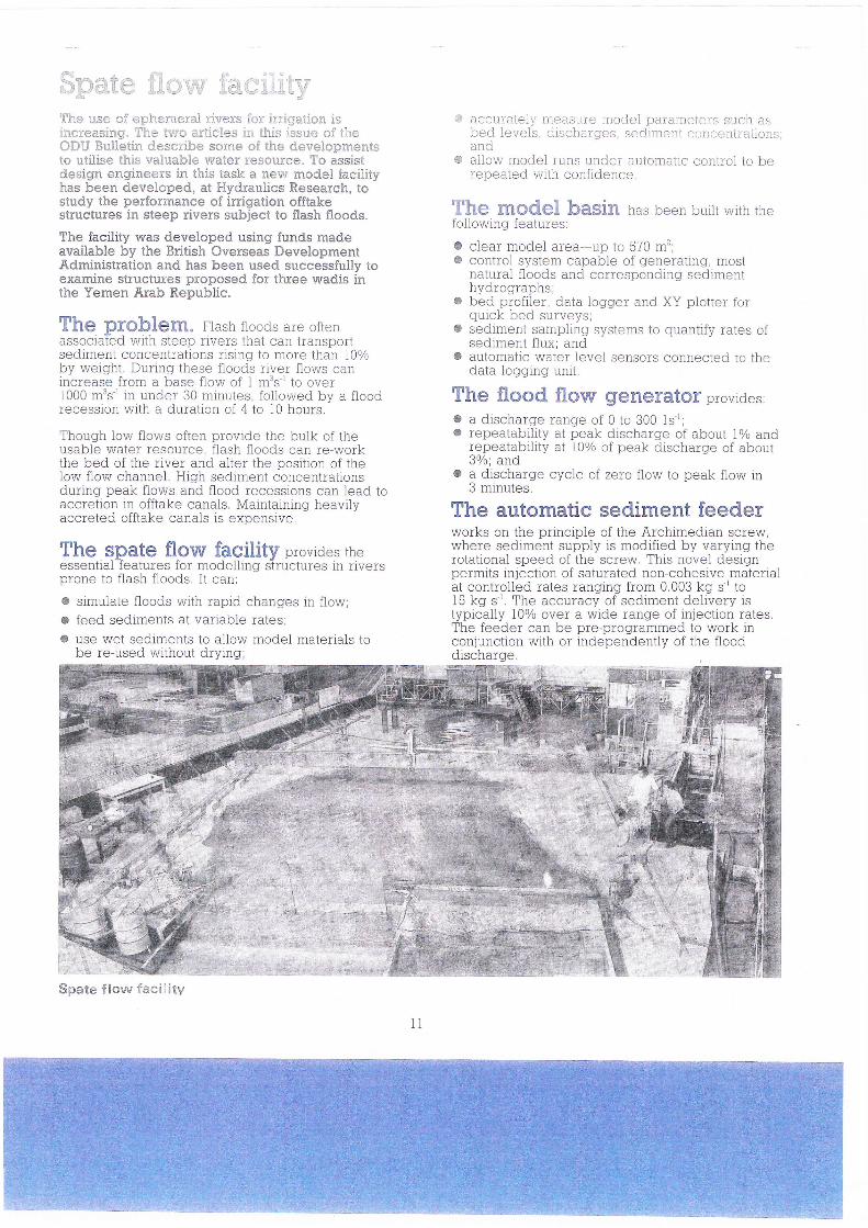
$pa:'ue fiorry iier<-;íiÍr5r
'il}le use of epherneral rivers Íor ÍrriqatÍon isincreasing" lfhe tisio artieles Írr this issue of theODïJ Bulletin desaribe some of the developmentsto utilise this valuable niater resouree" To assistdesiEn engíneers in this task a new model facilityhas been developed, at ï{ydraulics Researeh, tostudy the performance of irrigation offtakestructures in steep rivers subject to flash floods.
The facility was developed using funds madeavailable by the British Overseas DevelopmentAdministration and has been used successfully toexamine structures proposed for three wadis inthe Yernen Arab Republic.
The prohlem. Flash floods are oftenassociated wtth steep rivers that can transportsediment concentrations nsing to moïe than I0%by weiqht. During these floods river flows canincrease from a base flow of I mts-r to overl0O0 m3s-'in under 30 minutes, followed bv a floodrecession wrth a duration of 4 to lO hours,-
Though low flows often provide the bulk of theusable water resource, flash floods can re-workthe bed of the river and alter the position of thelow flow channel. Hrgh sediment concentrationsduring peak flows and flood recessions can lead toaccretion in offtake canals, Maintaining heavilyaccreted offtake canals is exnensive
The qPale flow facility provides theessentral realuïes ioï mooelllngr slrucïules rn nverspïone to flash floods, It can:
o simulate floods with rapid changes in flow;o feed sediments at variable rates;o use wet sedrments to allow model materials to
be re-used without drying;
G accuíe.t-oly measuíe irrodel pat ameters s.uch asbed levels, discharges, sed.iment conccntraiionsland
€ allow model runs under automattc control to berepeated vuith confidence
The mOdgl baSiR has been builr wrth rhefollowing features:
o clear model area-up to 570 m'z'c control system capable of generatlng, most
natural floods and corresponding sedimenthrrd rnavenhc
c bed profiler, data logger and XY plotter fornnicle hod arrrr/ê\ra'
c sediment sampilng systems to quantify rates ofsediment flux; and
3 automatic water level sensors connected to thedata loggíng unit.
The flood flow generatof provides:
a a dtscharge range of 0 to 300 1s-';o repeatability at peak discharge of about I% and
repeatability at 10% of peak discharge of about3%; and
r a discharge cycle of zero flow to peak flow tn3 minutes.
The automatic sediment feederworks on the principle of the Àrchimedian scÍew,where sediment supply is modified by varying therotational speed of the screw. This novei designpermits injection of saturated non-cohesive materiala+ n^-+-nll^À v^+^^ v-h^ih^ {*^* n nnQ l'^ ^ Idt UUlltIUllCLl tdLuij Id.lrVrrrv rrvrrr.,.r. ^9 o tO15 kg s'. The accuracy of sediment delivery istypically l0% over a wide range of injection rates.The feeder can be pïe-progïammed to work inconjunction with or independently of the fioodd iccharnavrvvrrsr Yv,
ll