Spanish Fort Causeway Master Plancityofspanishfort.com/Portals/spanishfort/documents/Spanish...
31
Spanish Fort Causeway Master Plan
Transcript of Spanish Fort Causeway Master Plancityofspanishfort.com/Portals/spanishfort/documents/Spanish...
Spanish Fort Causeway Master Plan

2 | SPANISH FORT CAUSEWAY MASTER PLAN — DRAFT [APR. 5, 2018]
Page Intentionally Left Blank.
[APR. 5, 2018] DRAFT | 3
Plan Outline1 CAUSEWAY PLAN ................................................................................. 5
» OVERALL CAUSEWAY ...........................................................................................5 » EASTERN SEGMENT ............................................................................................. 8 » PINEDA ISLAND .................................................................................................. 10 » CENTRAL SEGMENT ............................................................................................ 14 » WESTERN SEGMENT ........................................................................................... 18
2 IMPLEMENTATION .............................................................................. 23
» FUNDING ............................................................................................................. 23 » REGULATORY TOOLS ......................................................................................... 23 » ACTION PLAN ..................................................................................................... 23
3 APPENDIX ......................................................................................... 30
» WAYFINDING SIGNAGE ..................................................................................... 30 » ZONING ................................................................................................................ 30

4 | SPANISH FORT CAUSEWAY MASTER PLAN — DRAFT [APR. 5, 2018]
Page Intentionally Left Blank.
[APR. 5, 2018] DRAFT | 5
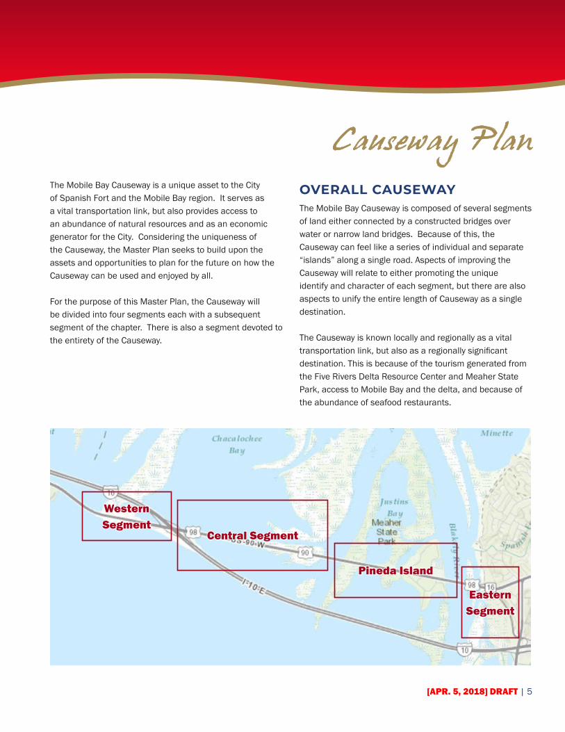
Causeway PlanThe Mobile Bay Causeway is a unique asset to the City of Spanish Fort and the Mobile Bay region. It serves as a vital transportation link, but also provides access to an abundance of natural resources and as an economic generator for the City. Considering the uniqueness of the Causeway, the Master Plan seeks to build upon the assets and opportunities to plan for the future on how the Causeway can be used and enjoyed by all.
For the purpose of this Master Plan, the Causeway will be divided into four segments each with a subsequent segment of the chapter. There is also a segment devoted to the entirety of the Causeway.
OVERALL CAUSEWAYThe Mobile Bay Causeway is composed of several segments of land either connected by a constructed bridges over water or narrow land bridges. Because of this, the Causeway can feel like a series of individual and separate “islands” along a single road. Aspects of improving the Causeway will relate to either promoting the unique identify and character of each segment, but there are also aspects to unify the entire length of Causeway as a single destination.
The Causeway is known locally and regionally as a vital transportation link, but also as a regionally significant destination. This is because of the tourism generated from the Five Rivers Delta Resource Center and Meaher State Park, access to Mobile Bay and the delta, and because of the abundance of seafood restaurants.
Western Segment
Pineda Island
Central Segment
Eastern Segment
6 | SPANISH FORT CAUSEWAY MASTER PLAN — DRAFT [APR. 5, 2018]
BarriersAlong the Causeway, one of the most significant barriers is the right-of-way and road and itself. This is because of the constraints from the location and the limited amount of space between the road and the edge of water. For the length of the Causeway, there are several different conditions exist between the road and water such as solid terrain, marsh/wetlands, or bulkheads. These conditions also result in limited development opportunities along the Causeway because of the lack of solid terrain. As it is currently developed, there are few undeveloped parcels, or parcels for redevelopment potential. Also, included as another similar barrier is the extensive floodplain that must be taken into account.
Opportunities
» Unify the experience of the Causeway with elements that are consistent.
» Take advantage of the Causeway being a regional destination.
» Improve connectivity between each segment. » Enhance use of
Proposed Improvements
» Wayfinding » Signage should be consistent across the Causeway and integrate with the City’s branding.
» Directional signage with distances to other segments and destinations. (See examples in Appendix A.)
» Branding and Marketing » Use the wayfinding system as a way to establish a brand for the Causeway as a unique destination.
» Incorporate the Causeway brand into City marketing and promotion materials.
» Encourage development of a website to promote tourism opportunities and businesses along the Causeway.
» Multi-Use Trail » Link segments of the Causeway with a multi-use trail. (See Case Study on pg. 24) » Total Trail Length: 5.6 miles » Number of Bridges: 3 » Total Length of Bridges: 4,060 feet
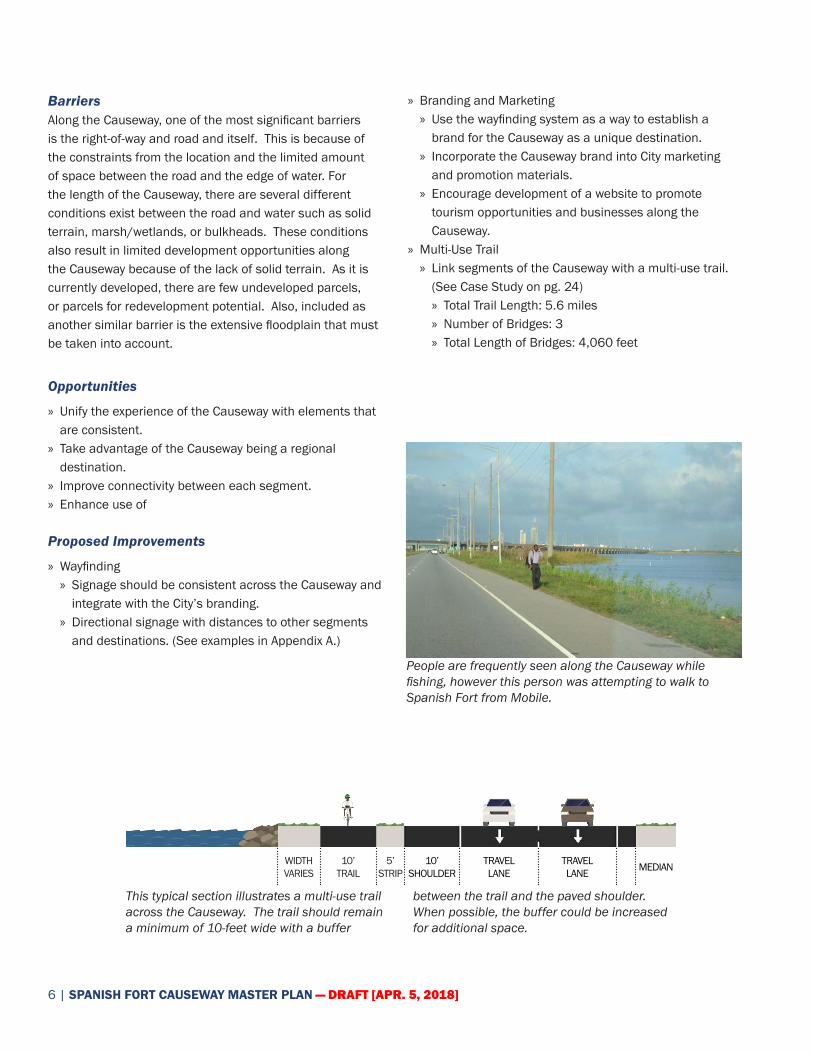
People are frequently seen along the Causeway while fishing, however this person was attempting to walk to Spanish Fort from Mobile.
This typical section illustrates a multi-use trail across the Causeway. The trail should remain a minimum of 10-feet wide with a buffer
between the trail and the paved shoulder. When possible, the buffer could be increased for additional space.
WIDTH VARIES
10’ TRAIL
TRAVEL LANE
TRAVEL LANE
10’ SHOULDER
5’ STRIP MEDIAN

[APR. 5, 2018] DRAFT | 7
Trail between Central Segment and Western Segment. Because of constraints between the water and road, a
barrier should be included. This photosimulation depicts how the trail could be designed for safe use.
This is an example of a dedicated mixed-use bridge separate from an adjacent road. This condition is similar
to the Causeway and an example of how mixed-use bridges should be considered.
» Vehicular Access » Add right turn lanes, or access roads, to improve access and traffic flow along the Causeway.
» Residential Development » Work with property owners to re-zoning all undeveloped residential property to other appropriate use. (See zoning map in the Appendix).
» Provide access to the trail at multiple locations with parking, lighting, etc.
» Use trail to improve safety for fishing, provide ability to walk to fishing locations.
» Include multi-use trail as part of the Eastern Shore MPO Bicycle and Pedestrian Plan.
» Trail crossings along the Causeway should be limited.
credit: swagroup.com

8 | SPANISH FORT CAUSEWAY MASTER PLAN — DRAFT [APR. 5, 2018]
EASTERN SEGMENT
Character
The eastern segment of the Causeway is characterized from the bluffs of the eastern shore as the road transitions down closer to water level. Particularly coming down Spanish Fort Boulevard, the views of Mobile Bay, the delta, the Causeway and the Mobile skyline can be seen very prominently.
Uses
Uses in this segment of the Causeway are very limited due to difficulty in accessing the adjacent property. Scott’s Landing on the northern side of the Causeway is the only full-service marina along the Causeway offering a boat launch and selling fishing supplies. On the southern side of the Causeway is Tropics Bar and Grill, which also hosts a volleyball league that is grown in recent popularity. Access to these properties is difficult because of the US-90/98 access roads.
Barriers
The most significant barrier in this segment of the Causeway is access to properties from the US-90/98
access roads. The access roads, which connects the Causeway/Spanish Fort Boulevard with the I-10/US-90/98 intersection to the south causes difficult turning motions to adjunct properties.
Opportunities
» Develop a gateway entrance to the Causeway from the Eastern Shore.
» Expand character of Eastern Segment with access to potential Forever Wild land.
» Create a connection between the Eastern Shore and the Causeway by improve bicycle and pedestrian access.
Multi -Use Bridge Street-based Connection
Wayfinding: WB-1
MA
TCH
PG
. 1
1
[APR. 5, 2018] DRAFT | 9
Proposed Improvements
» Brand the Causeway with an eastern gateway sign coming from the Eastern Shore. This sign should be similar to branding on the western gateway.
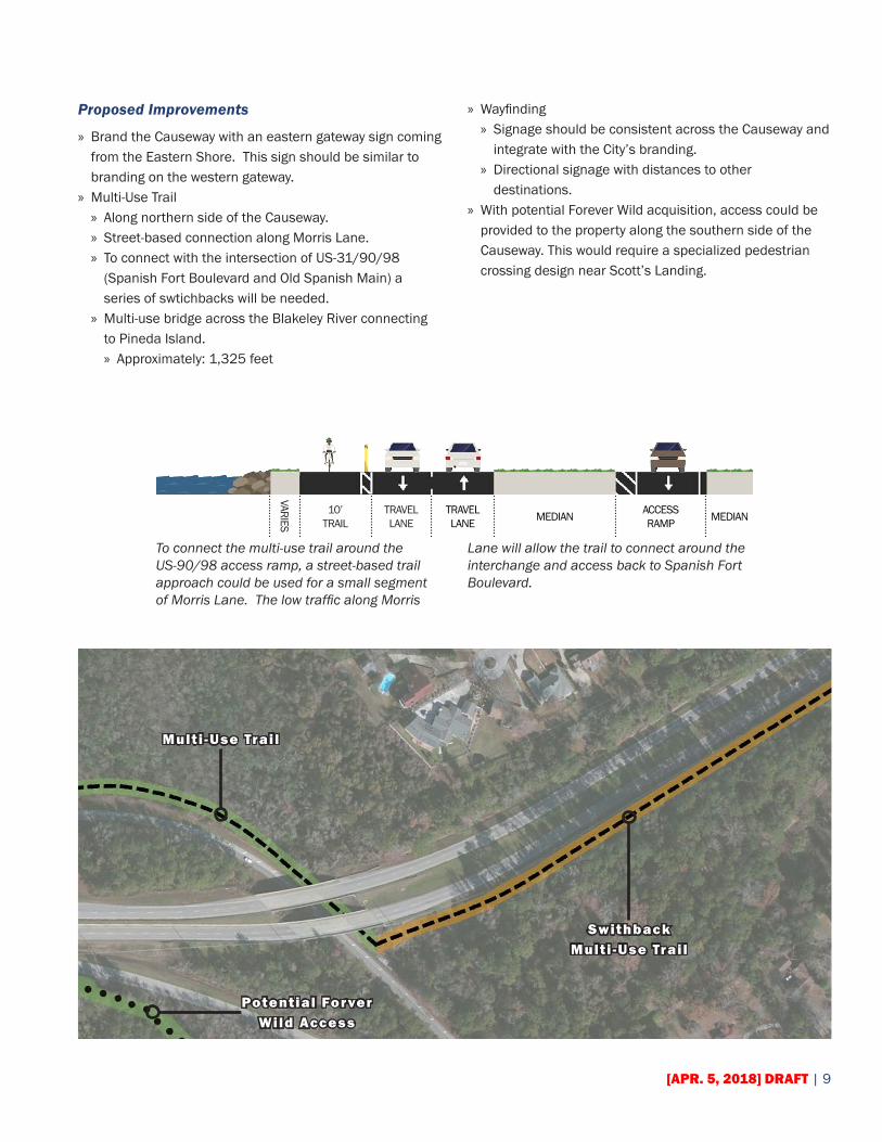
» Multi-Use Trail » Along northern side of the Causeway. » Street-based connection along Morris Lane. » To connect with the intersection of US-31/90/98 (Spanish Fort Boulevard and Old Spanish Main) a series of swtichbacks will be needed.
» Multi-use bridge across the Blakeley River connecting to Pineda Island. » Approximately: 1,325 feet
» Wayfinding » Signage should be consistent across the Causeway and integrate with the City’s branding.
» Directional signage with distances to other destinations.
» With potential Forever Wild acquisition, access could be provided to the property along the southern side of the Causeway. This would require a specialized pedestrian crossing design near Scott’s Landing.
To connect the multi-use trail around the US-90/98 access ramp, a street-based trail approach could be used for a small segment of Morris Lane. The low traffic along Morris
Lane will allow the trail to connect around the interchange and access back to Spanish Fort Boulevard.
VARIES
10’ TRAIL MEDIAN ACCESS
RAMPTRAVEL LANE
TRAVEL LANE MEDIAN
Potential Forver Wild Access
Multi -Use Trail
Swithback Multi -Use Trail

10 | SPANISH FORT CAUSEWAY MASTER PLAN — DRAFT [APR. 5, 2018]
PINEDA ISLAND
Character
The character of Pineda Island is unique across the Causeway, as well as the lower Mobile-Tensaw Delta, because of the soil used to create the island. A large segment of Pineda Island was built up from soil that was removed from Mobile Bay during the construction of Interstate-10. As a result of the soil placed on Pineda Island, the island has a dense tree canopy that is very rare. Because of the uses on Pineda Island, access natural recreation and eco-tourism are very popular users.
Uses
The Five Rivers Delta Resource Center is a state facility for the promotion of outdoor recreation, conservation and land stewardship for the five river delta that flows into Mobile Bay. The center features an exhibit hall, theater, Delta boat tours, canoe and kayak rentals, hiking trails and picnic area. There are also special events weekends and after-hours recreational opportunities.
Meaher State Park is a 1,327-acre park situated on wetlands along the southern side of the Causeway and is a day-use, picnicking and scenic park with recreational vehicle hook-ups for overnight visitors. The park was formed in 1989 on land that was given to the state from the Meaher Family. This is one of the most popular State Parks in Alabama based on used, and is used extensively for access to Mobile Bay and by recreational vehicles. During the 1960s a residential development was considered for Pineda Island. The beginning of the development is still seen today with the residential development that occurs on the eastern end of the island. This is the only concentration of residential uses on the Causeway, and the City has placed a moratorium on future residential development.
5 RIVERS DELTA RESOURCE CENTER
Right Turn Lane
Improved Landscaped
Entrance
MEAHER STATE PARK
MA
TCH
PG
. 1
3
Multi -Use Trail
[APR. 5, 2018] DRAFT | 11
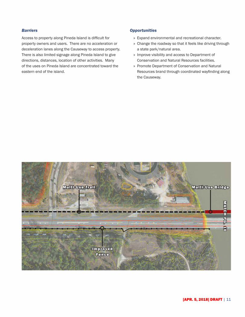
Barriers
Access to property along Pineda Island is difficult for property owners and users. There are no acceleration or deceleration lanes along the Causeway to access property. There is also limited signage along Pineda Island to give directions, distances, location of other activities. Many of the uses on Pineda Island are concentrated toward the eastern end of the island.
Opportunities
» Expand environmental and recreational character. » Change the roadway so that it feels like driving through a state park/natural area.
» Improve visibility and access to Department of Conservation and Natural Resources facilities.
» Promote Department of Conservation and Natural Resources brand through coordinated wayfinding along the Causeway.
Multi -Use Trail Multi -Use Bridge
Improved Fence
MA
TCH
PG
. 10

12 | SPANISH FORT CAUSEWAY MASTER PLAN — DRAFT [APR. 5, 2018]
Proposed Improvements
» Fiver Rivers Delta Resource Center/ Meaher State Park » Redesign entrance to Meaher to improve access and visibility along the Causeway.
» Promote higher day use of Meaher by residents and tourist.
» Property Access » Add right turn lanes for Five Rivers Delta Resource Center and Meaher State Park.
» Add right turn lane for Blakeley Road.
» Multi-Use Trail » Along northern side of the Causeway. » Separated from Causeway with connections to Five Rivers.
» Potential alternative connection under the Apalachee River Bridge and along the southern side of the Causeway connecting to Meaher State Park.
» Lighted crosswalk to Meaher State Park. » Multi-use bridge across the Blakely River connecting to Pineda Island. » Approximately: 1,325 feet
Multi -Use Trail
SCENIC OVERLOOKWayfinding: EB-4
Multi -Use BridgeM
ATC
H P
G. 1
5M
ATC
H ‘A
’ BE
LOW
[APR. 5, 2018] DRAFT | 13
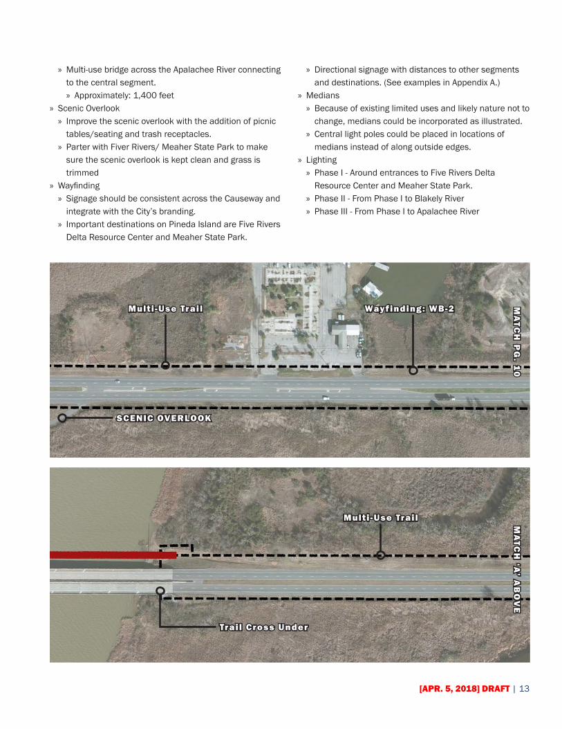
» Multi-use bridge across the Apalachee River connecting to the central segment. » Approximately: 1,400 feet
» Scenic Overlook » Improve the scenic overlook with the addition of picnic tables/seating and trash receptacles.
» Parter with Fiver Rivers/ Meaher State Park to make sure the scenic overlook is kept clean and grass is trimmed
» Wayfinding » Signage should be consistent across the Causeway and integrate with the City’s branding.
» Important destinations on Pineda Island are Five Rivers Delta Resource Center and Meaher State Park.
» Directional signage with distances to other segments and destinations. (See examples in Appendix A.)
» Medians » Because of existing limited uses and likely nature not to change, medians could be incorporated as illustrated.
» Central light poles could be placed in locations of medians instead of along outside edges.
» Lighting » Phase I - Around entrances to Five Rivers Delta Resource Center and Meaher State Park.
» Phase II - From Phase I to Blakely River » Phase III - From Phase I to Apalachee River
Multi -Use Trail
SCENIC OVERLOOK
MA
TCH
PG
. 10
Wayfinding: WB-2
Multi -Use Trail
Trail Cross Under
MA
TCH
‘A’ A
BO
VE
14 | SPANISH FORT CAUSEWAY MASTER PLAN — DRAFT [APR. 5, 2018]
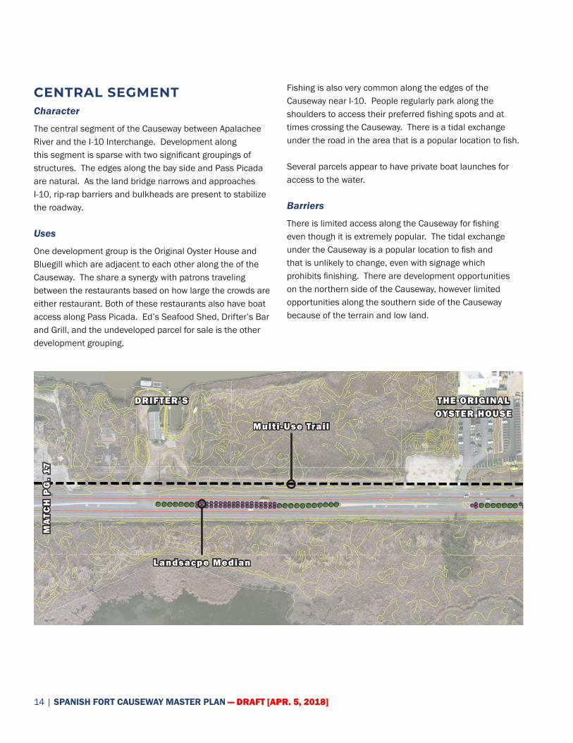
CENTRAL SEGMENTCharacter
The central segment of the Causeway between Apalachee River and the I-10 Interchange. Development along this segment is sparse with two significant groupings of structures. The edges along the bay side and Pass Picada are natural. As the land bridge narrows and approaches I-10, rip-rap barriers and bulkheads are present to stabilize the roadway.
Uses
One development group is the Original Oyster House and Bluegill which are adjacent to each other along the of the Causeway. The share a synergy with patrons traveling between the restaurants based on how large the crowds are either restaurant. Both of these restaurants also have boat access along Pass Picada. Ed’s Seafood Shed, Drifter’s Bar and Grill, and the undeveloped parcel for sale is the other development grouping.
Fishing is also very common along the edges of the Causeway near I-10. People regularly park along the shoulders to access their preferred fishing spots and at times crossing the Causeway. There is a tidal exchange under the road in the area that is a popular location to fish.
Several parcels appear to have private boat launches for access to the water.
Barriers
There is limited access along the Causeway for fishing even though it is extremely popular. The tidal exchange under the Causeway is a popular location to fish and that is unlikely to change, even with signage which prohibits finishing. There are development opportunities on the northern side of the Causeway, however limited opportunities along the southern side of the Causeway because of the terrain and low land.
THE ORIGINAL OYSTER HOUSE
DRIFTER’S
Multi -Use Trail
Landsacpe Median
MA
TCH
PG
. 17

[APR. 5, 2018] DRAFT | 15
Opportunities
» Develop better and safer public access for fishing and educational opportunities.
» Existing state-owned property in this segment could be developed for other uses.
Recommendations
» Former River Docks site state owned parcel along northern edge of the Causeway. » Provide an educational opportunity/ fishing with piers along the edge with Pass Picada.
» Include parking for park and multi-use trail. » Centrally located canoe/kayak access point along Causeway.
» Improved boat launch at park based on existing launch on site.
» Multi-Use Trail » Along northern side of the Causeway. » Separated from Causeway and could be improved for safe access to the tidal exchange for fishing.
» Multi-use bridge across the Apalchee River connecting to the central segment. » Approximately: 1,400 feet
» Along the narrow land bridge, a protective barrier will need to be used to protect the multi-use trail. (See illustration on Pg. 9.)
» Wayfinding » Signage should be consistent across the Causeway and integrate with the City’s branding.
» Important destinations on the central segment include are the two restaurant groupings, boardwalk, parking and water access.
» Directional signage with distances to other destinations.
Multi -Use Trail Multi -Use Bridge
BLUEGILL
Natural Grasses

16 | SPANISH FORT CAUSEWAY MASTER PLAN — DRAFT [APR. 5, 2018]
Wayfinding: EB-3
Multi -Use Trailwith Protective
Barrier*
Wayfinding: WB-3
Pier
MA
TCH
BE
LOW
MA
TCH
AB
OV
EMA
TCH
PG
. 1
9
credit: divergingdiamond.com

[APR. 5, 2018] DRAFT | 17
Along the narrow land bridge between the central segment and western segment, the multi-use trail will be much closer to the roadway. In this situation, to provide
protection to trail users, a protective barrier should be used between the trail and the roadway shoulder.
» Lighting » New lighting should be standard across the Causeway. » Phase I - From Apalachee River to west of Ed’s Seafood Shed.
» Phase II - From Phase I to existing lighting at I-10 Interchange.
» I-10 Interchange » Careful consideration should happen where a multi-use trail would cross on/off-ramps from I-10.
VARIES
10’ TRAIL
TRAVEL LANE
TRAVEL LANE
10’ SHOULDER MEDIAN
Piers Multi -Use Trail
Parking
ED’S SEAFOOD
SHEDRight Turn Lane
Boat Launch MA
TCH
PG
. 14
BARRIER
SHLDR
18 | SPANISH FORT CAUSEWAY MASTER PLAN — DRAFT [APR. 5, 2018]
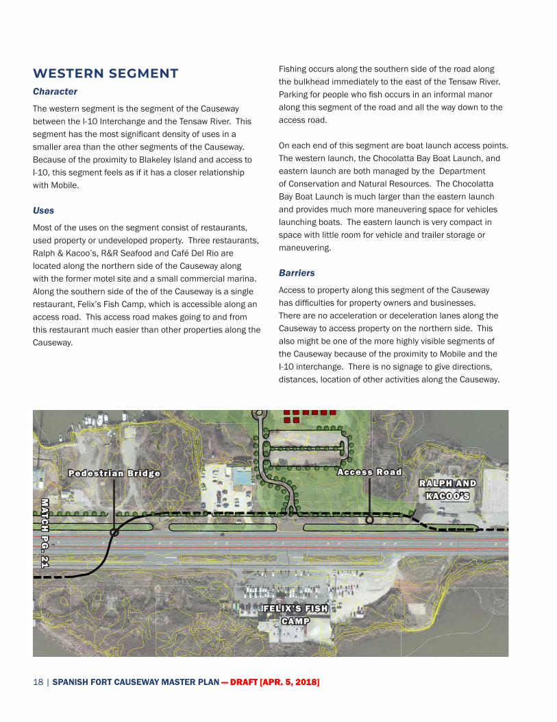
WESTERN SEGMENTCharacter
The western segment is the segment of the Causeway between the I-10 Interchange and the Tensaw River. This segment has the most significant density of uses in a smaller area than the other segments of the Causeway. Because of the proximity to Blakeley Island and access to I-10, this segment feels as if it has a closer relationship with Mobile.
Uses
Most of the uses on the segment consist of restaurants, used property or undeveloped property. Three restaurants, Ralph & Kacoo’s, R&R Seafood and Café Del Rio are located along the northern side of the Causeway along with the former motel site and a small commercial marina. Along the southern side of the of the Causeway is a single restaurant, Felix’s Fish Camp, which is accessible along an access road. This access road makes going to and from this restaurant much easier than other properties along the Causeway.
Fishing occurs along the southern side of the road along the bulkhead immediately to the east of the Tensaw River. Parking for people who fish occurs in an informal manor along this segment of the road and all the way down to the access road.
On each end of this segment are boat launch access points. The western launch, the Chocolatta Bay Boat Launch, and eastern launch are both managed by the Department of Conservation and Natural Resources. The Chocolatta Bay Boat Launch is much larger than the eastern launch and provides much more maneuvering space for vehicles launching boats. The eastern launch is very compact in space with little room for vehicle and trailer storage or maneuvering.
Barriers
Access to property along this segment of the Causeway has difficulties for property owners and businesses. There are no acceleration or deceleration lanes along the Causeway to access property on the northern side. This also might be one of the more highly visible segments of the Causeway because of the proximity to Mobile and the I-10 interchange. There is no signage to give directions, distances, location of other activities along the Causeway.
Access RoadPedestrian BridgeRALPH AND
KACOO’S
FELIX’S FISH CAMP
MA
TCH
PG
. 21
[APR. 5, 2018] DRAFT | 19
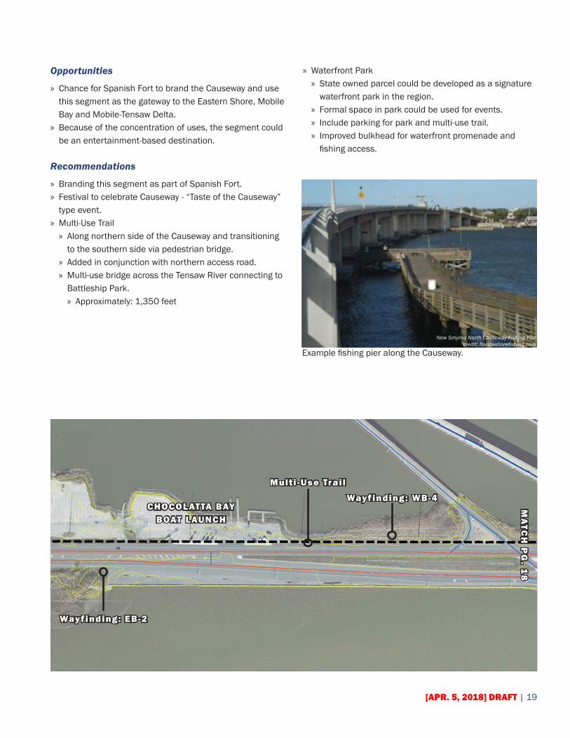
Opportunities
» Chance for Spanish Fort to brand the Causeway and use this segment as the gateway to the Eastern Shore, Mobile Bay and Mobile-Tensaw Delta.
» Because of the concentration of uses, the segment could be an entertainment-based destination.
Recommendations
» Branding this segment as part of Spanish Fort. » Festival to celebrate Causeway - “Taste of the Causeway” type event.
» Multi-Use Trail » Along northern side of the Causeway and transitioning to the southern side via pedestrian bridge.
» Added in conjunction with northern access road. » Multi-use bridge across the Tensaw River connecting to Battleship Park. » Approximately: 1,350 feet
» Waterfront Park » State owned parcel could be developed as a signature waterfront park in the region.
» Formal space in park could be used for events. » Include parking for park and multi-use trail. » Improved bulkhead for waterfront promenade and fishing access.
Example fishing pier along the Causeway.
New Smyrna North Causeway Fishing Piercredit: floridashorefishing.com
CHOCOLATTA BAYBOAT LAUNCH
Multi -Use Trail
Wayfinding: WB-4
Wayfinding: EB-2
MA
TCH
PG
. 18
20 | SPANISH FORT CAUSEWAY MASTER PLAN — DRAFT [APR. 5, 2018]
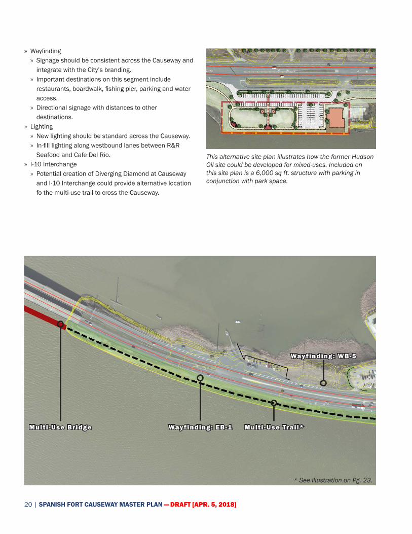
» Wayfinding » Signage should be consistent across the Causeway and integrate with the City’s branding.
» Important destinations on this segment include restaurants, boardwalk, fishing pier, parking and water access.
» Directional signage with distances to other destinations.
» Lighting » New lighting should be standard across the Causeway. » In-fill lighting along westbound lanes between R&R Seafood and Cafe Del Rio.
» I-10 Interchange » Potential creation of Diverging Diamond at Causeway and I-10 Interchange could provide alternative location fo the multi-use trail to cross the Causeway.
This alternative site plan illustrates how the former Hudson Oil site could be developed for mixed-uses. Included on this site plan is a 6,000 sq ft. structure with parking in conjunction with park space.
Multi -Use Trail*Multi -Use Bridge Wayfinding: EB-1
* See illustration on Pg. 23.
Wayfinding: WB-5
[APR. 5, 2018] DRAFT | 21
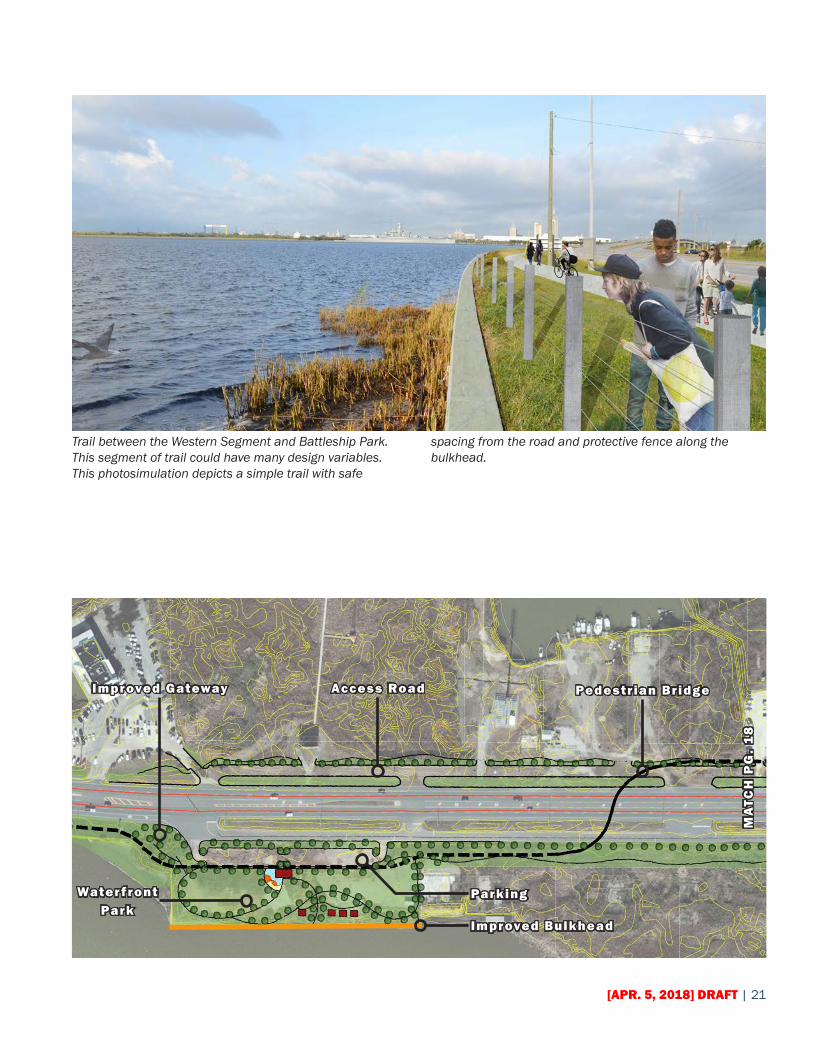
Trail between the Western Segment and Battleship Park. This segment of trail could have many design variables. This photosimulation depicts a simple trail with safe
spacing from the road and protective fence along the bulkhead.
Access Road Pedestrian Bridge
Improved Bulkhead
Waterfront Park
Parking
Improved Gateway
MA
TCH
PG
. 1
8
22 | SPANISH FORT CAUSEWAY MASTER PLAN — DRAFT [APR. 5, 2018]
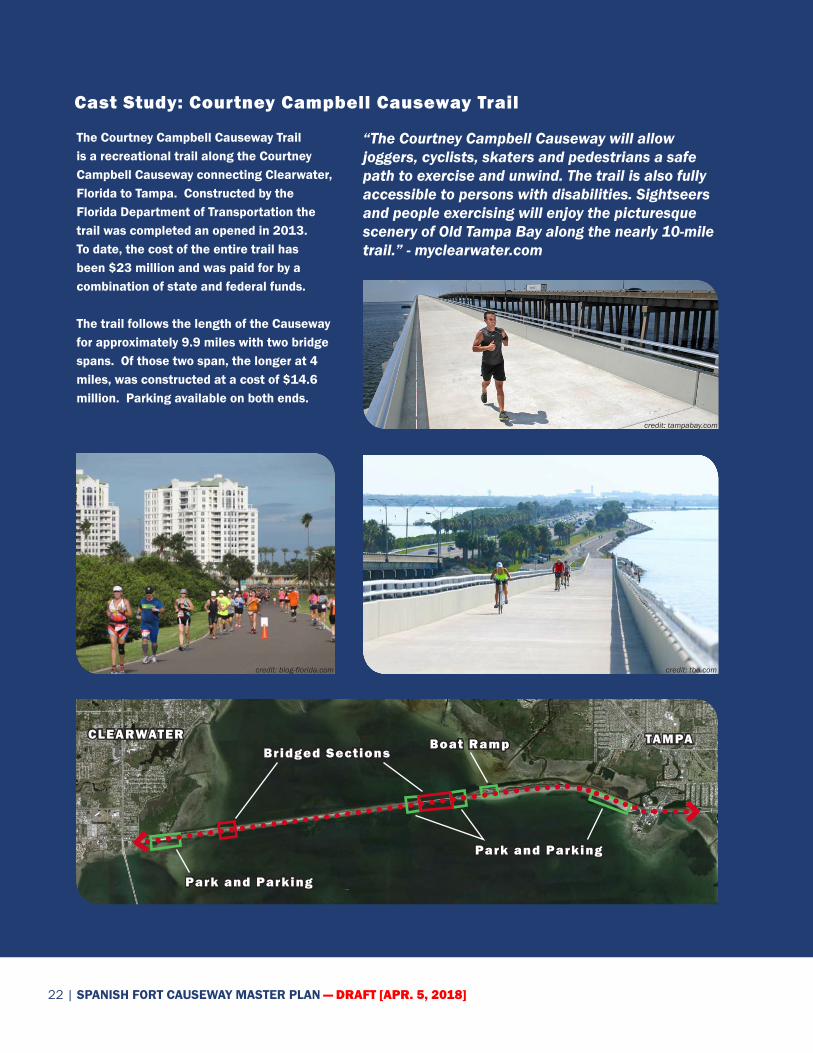
Cast Study: Courtney Campbell Causeway Trail
The Courtney Campbell Causeway Trail is a recreational trail along the Courtney Campbell Causeway connecting Clearwater, Florida to Tampa. Constructed by the Florida Department of Transportation the trail was completed an opened in 2013. To date, the cost of the entire trail has been $23 million and was paid for by a combination of state and federal funds.
The trail follows the length of the Causeway for approximately 9.9 miles with two bridge spans. Of those two span, the longer at 4 miles, was constructed at a cost of $14.6 million. Parking available on both ends.
“The Courtney Campbell Causeway will allow joggers, cyclists, skaters and pedestrians a safe path to exercise and unwind. The trail is also fully accessible to persons with disabilities. Sightseers and people exercising will enjoy the picturesque scenery of Old Tampa Bay along the nearly 10-mile trail.” - myclearwater.com
TAMPACLEARWATERBridged Sections
credit: tampabay.com
credit: tbo.comcredit: blog-florida.com
Park and Parking
Park and Parking
Boat Ramp
[APR. 5, 2018] DRAFT | 23
Implementation
FUNDINGImplementation should be considered as a public/private partnership initiative, with organizations, businesses and the City working together. For the Causeway Plan to be successful, this Plan cannot be implemented strictly by City resources. Plan implementation should be considered as an investment strategy by leveraging capital funding, grants, loans, and incentives. Direct participation could also be considered through fund-raising and business donations for targeted initiatives or specific areas in the traditional centers or along the corridor.
Major funding sources to be considered to implement the Causeway Plan include Alabama Department of Transportation: Transportation Alternatives Program (ALDOT TAP), US Department of Transprotation: Transportation Investment Generating Economic Recovery Grant (USDOT TIGER Grant), and/or Federal Highway Administration Recreational Trails Program (FHWA RTP). A comprehensive list of federal programs for consideration is included at: https://www.fhwa.dot.gov/environment/bicycle_pedestrian/funding/funding_opportunities.cfm
REGULATORY TOOLSRegulatory tools are an important aspect to the implementation of the Causeway Master Plan. These tools include updates to the zoning ordinances, subdivision regulations, and/or other design guidelines. The Causeway Master Plan intends to inform these regulatory as consistent with the City’s Comprehensive Plan.
ACTION PLANFor the Spanish Fort Causeway Master Plan there is an associated Action Plan which contains items that should be considered in order to implement the vision of the plan. Over time the priorities of the Action Plan could change, however it is important to identify these steps. Action items are prioritized as short-term, mid-term and long-term and as the corridor evolves, they should be reviewed and updated to ensure results take advantage of momentum.
The City of Spanish Fort maintains the Causeway Action Plan as a separate implementation document than from this plan document. The purpose of maintaining the Action Plan separate is to provide flexibility for the organization based upon the on-going development environment of the corridor. Being a separate document will also allow the organization to keep the Action Plan accurate and reflective of on-going initiatives.
The Causeway Action is also included as part of this document to demonstrate steps as of publication, as well as serve as a baseline for future decisions.
24 | SPANISH FORT CAUSEWAY MASTER PLAN — DRAFT [APR. 5, 2018]
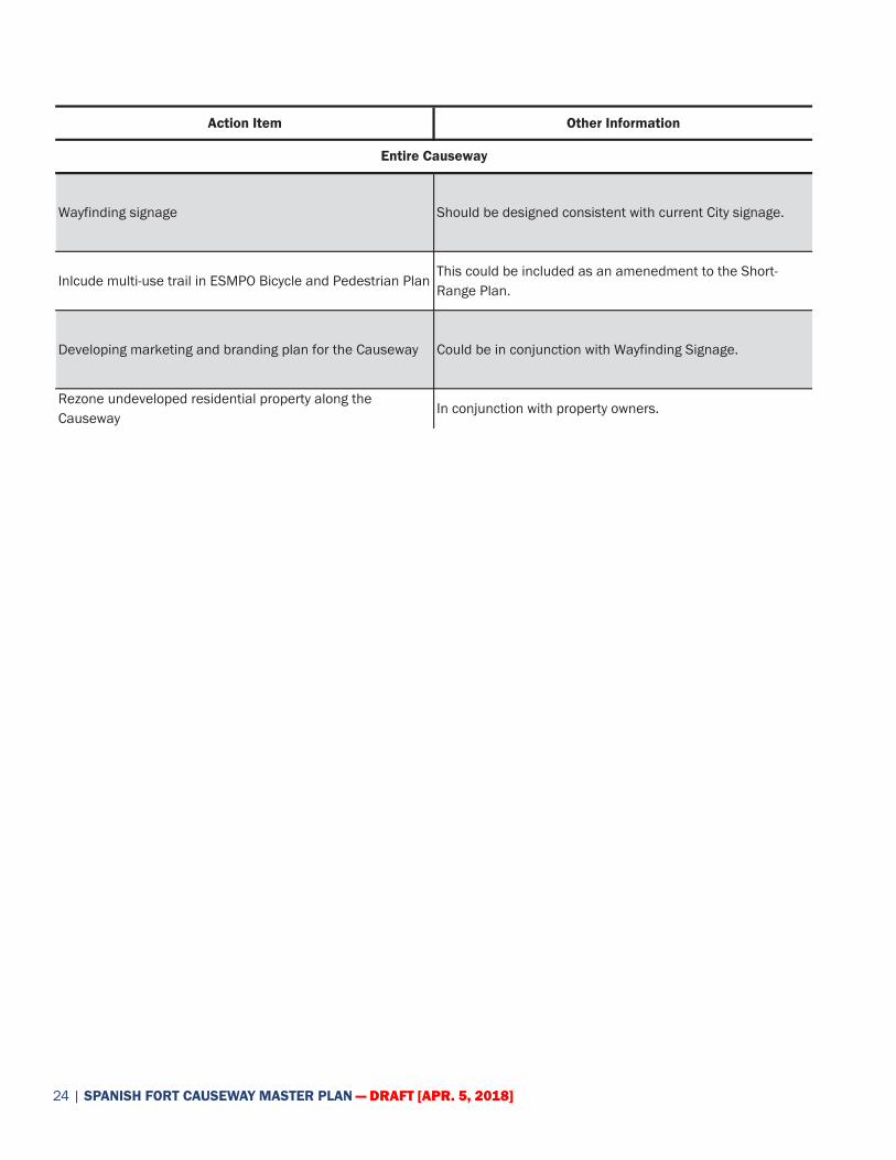
Action Item Other Information
Wayfinding signage Should be designed consistent with current City signage.
Inlcude multi-use trail in ESMPO Bicycle and Pedestrian PlanThis could be included as an amenedment to the Short-Range Plan.
Developing marketing and branding plan for the Causeway Could be in conjunction with Wayfinding Signage.
Rezone undeveloped residential property along the Causeway
In conjunction with property owners.
Entire Causeway
Page 1 of 5

[APR. 5, 2018] DRAFT | 25
Action Item Other Information
Trail segment from Blakely River to the intersection of US-31/90/98 (Spanish Fort Boulevard and Old Spanish Main)
Consideration of this as the last segment following the completion of all previous segments; segment length, approximately 4,400 ft.
Lighting between US-31/90/98 (Spanish Fort Boulevard/Old Spanish Trail) intersection and Blakely River
Phase I for this segment; segment road length, approximately 3,800 ft.
Lighting between Causeway and I-10 'slip lane'Phase II for this segment; segment road length, approximately 3,800 ft.
Gateway signage entering the Causeway the Eastern Shore Should be place in proximity to Blakely River.
Wayfind signage for access at intersection with Morris Lane and In-10 'slip lane'
Signage should clearly delinate safe access to Scott's Landing and Tropics Bar & Grill.
Bridge between Eastern Segment and Pineda Island across Blakely River.
Bridge length, approximately 1,400 ft.
Eastern Segment
Page 2 of 5
26 | SPANISH FORT CAUSEWAY MASTER PLAN — DRAFT [APR. 5, 2018]
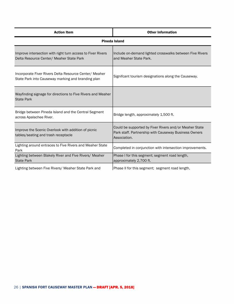
Action Item Other Information
Improve intersection with right turn access to Fiver Rivers Delta Resource Center/ Meaher State Park
Include on-demand lighted crosswalks between Five Rivers and Meaher State Park.
Incorporate Fiver Rivers Delta Resource Center/ Meaher State Park into Causeway marking and branding plan
Signifcant tourism designations along the Causeway.
Wayfinding signage for directions to Five Rivers and Meaher State Park
Bridge between Pineda Island and the Central Segment across Apalachee River.
Bridge length, approximately 1,500 ft.
Improve the Scenic Overlook with addition of picnic tables/seating and trash receptacle
Could be supported by Fiver Rivers and/or Meaher State Park staff. Partnership with Causeway Business Owners Association.
Lighting around entraces to Five Rivers and Meaher State Park
Completed in conjunction with intersection improvements.
Lighting between Blakely River and Five Rivers/ Meaher State Park
Phase I for this segment; segment road length, approximately 2,700 ft.
Lighting between Five Rivers/ Meaher State Park and Apalachee River
Phase II for this segment; segment road length, approximately 4,600 ft.
Trail segement from Blakely River to Apalachee River along the northside of the Causeway with lighted crossing at Meaher State Park
Segment length, approximately 7,300 ft. This should be the first segment undertaken in overall development.
Pineda Island
Page 3 of 5

[APR. 5, 2018] DRAFT | 27
Action Item Other Information
Aquire control of former River Docks site from State Lands
Develop former River Docks site into an educational waterfront park with piers, parking and improvement small boat launch
Consider options to limit boat launch to smaller crafts such as canoes and kayaks.
Wayfinding signage should include distances and directions to other Causeway segments and distinations
Inlcude in overall
Lighting between Apalachee River to Ed's Seafood Shed.Phase I for this segment; segment road length, approximately 3,200 ft.
Lighting between Ed's Seafood Shed to I-10 interchange.Phase II for this segment; segment road length, approximately 5,000 ft.
Trail segement from Apalachee River to I-10 interchange along the north side of the Causeway
Segment length, approximately 10,500 ft.
Central Segment
Page 4 of 5
28 | SPANISH FORT CAUSEWAY MASTER PLAN — DRAFT [APR. 5, 2018]
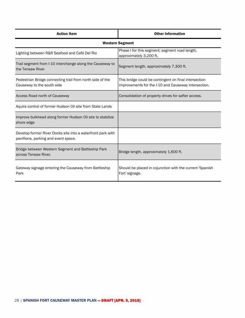
Action Item Other Information
Lighting between R&R Seafood and Café Del RioPhase I for this segment; segment road length, approximately 3,200 ft.
Trail segment from I-10 interchange along the Causeway to the Tensaw River
Segment length, approximately 7,300 ft.
Pedestrian Bridge connecting trail from north side of the Causeway to the south side
This bridge could be contingent on final intersection improvements for the I-10 and Causeway intersection.
Access Road north of Causeway Consolidation of property drives for safter access.
Aquire control of former Hudson Oil site from State Lands
Improve bulkhead along former Hudson Oil site to stabilize shore edge
Develop former River Docks site into a waterfront park with pavillions, parking and event space.
Bridge between Western Segment and Battleship Park across Tensaw River.
Bridge length, approximately 1,600 ft.
Gateway signage entering the Causeway from Battleship Park
Should be placed in cojunction with the current 'Spanish Fort' signage.
Western Segment
Page 5 of 5

[APR. 5, 2018] DRAFT | 29
Page Intentionally Left Blank.

30 | SPANISH FORT CAUSEWAY MASTER PLAN — DRAFT [APR. 5, 2018]
WAYFINDING SIGNAGE
Proposal Signage
Included is an example of signage proposed throughout Spanish Fort. The wayfinding signage along the Causeway should be similar in character, but should reflect the uniqueness of the Causeway.
Projected Signage
The following list of signs is keyed to match the illustrative drawings included in the Causeway Master Plan. This list is not intended to be all inclusive, but to include the major destinations which should be emphasized in a wayfinding package.
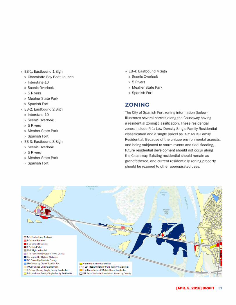
» WB-1: Westbound 1 Sign » 5 Rivers » Meaher State Park » Scenic Overlook » Interstate-10 » Chocolatta Bay Boat Launch » (Fisheries) Boat Launch » USS Alabama
» WB-2: Westbound 2 Sign » Scenic Overlook » Interstate-10 » Chocolatta Bay Boat Launch » (Fisheries) Boat Launch » USS Alabama
» WB-3: Westbound 3 Sign » Interstate-10 » Chocolatta Bay Boat Launch » (Fisheries) Boat Launch » USS Alabama
» WB-4: Westbound 4 Sign » Chocolatta Bay Boat Launch » (Fisheries) Boat Launch » USS Alabama
» WB-5: Westbound 5 Sign » (Fisheries) Boat Launch » USS Alabama
Appendix
[APR. 5, 2018] DRAFT | 31
» EB-1: Eastbound 1 Sign » Chocolatta Bay Boat Launch » Interstate-10 » Scenic Overlook » 5 Rivers » Meaher State Park » Spanish Fort
» EB-2: Eastbound 2 Sign » Interstate-10 » Scenic Overlook » 5 Rivers » Meaher State Park » Spanish Fort
» EB-3: Eastbound 3 Sign » Scenic Overlook » 5 Rivers » Meaher State Park » Spanish Fort
» EB-4: Eastbound 4 Sign » Scenic Overlook » 5 Rivers » Meaher State Park » Spanish Fort
ZONINGThe City of Spanish Fort zoning information (below) illustrates several parcels along the Causeway having a residential zoning classification. These residential zones include R-1: Low-Density Single-Family Residential classification and a single parcel as R-3: Multi-Family Residential. Because of the unique environmental aspects, and being subjected to storm events and tidal flooding, future residential development should not occur along the Causeway. Existing residential should remain as grandfathered, and current residentially zoning property should be rezoned to other appropirated uses.