South€West€Yarragadee Water€Supply Development…€¦ · Ch€10: €Consolidated ......
69
South West Yarragadee Water Supply Development: Sustainability Evaluation/Environmental Review & Management Programme Executive Summary February 2006 Prepared for Water Corporation by Strategen
Transcript of South€West€Yarragadee Water€Supply Development…€¦ · Ch€10: €Consolidated ......

South West YarragadeeWater SupplyDevelopment:SustainabilityEvaluation/EnvironmentalReview & ManagementProgrammeExecutive Summary
February 2006
Prepared forWater Corporationby Strategen


South West YarragadeeWater Supply Development:SustainabilityEvaluation/EnvironmentalReview & ManagementProgrammeExecutive Summary
Strategen is a trading name ofGlenwood Nominees Pty LtdSuite 7, 643 Newcastle Street Leederville WAACN: 056 190 419
18 February 2006

Disclaimer and Limitation
This report has been prepared for the exclusive use of the Client, in accordance with the agreementbetween the Client and Strategen (“Agreement”).
Strategen accepts no liability or responsibility whatsoever for it in respect of any use of or relianceupon this report by any person who is not a party to the Agreement.
In particular, it should be noted that this report is a qualitative assessment only, based on the scope ofservices defined by the Client, budgetary and time constraints imposed by the Client, the informationsupplied by the Client (and its agents), and the method consistent with the preceding.
Strategen has not attempted to verify the accuracy or completeness of the information supplied by theClient.
Client: Water Corporation
Report Version Prepared by Reviewed by Submitted to Client
Copies Date
Preliminary Draft Report V1 HV/LC WC 1 Electronic 7 Dec 2005
Review Draft Report V2 HV/LC EPASU 1 Electronic 14 Dec 2005
Final Report to EPASU V3 HV/LC EPASU 2 bound, 1 CD 30 Jan 2006
Final Draft V4 HV/LC HV 1 Electronic 2 Feb 2006
Final Final HV/LC HV 1 Electronic 20 Feb 2006

INVITATION
The Environmental Protection Authority (EPA) and Sustainability Panel1 invite people to make a submission on this proposal.
The Water Corporation proposes to abstract 45 GL/yr of groundwater from the South West Yarragadee aquifer in the Southern Perth Basin in the south west of Western Australia to supply the Integrated Water Supply Scheme (including potential demand in the South West).
In accordance with the Environmental Protection Act 1986, the Environmental Protection and Biodiversity Act 1999 and the State Sustainability Strategy, an Environmental Review and Management Programme (ERMP) and a Sustainability Evaluation have been prepared which describes this proposal and its likely environmental, social and economic impacts and how they are proposed to be managed. The document is also intended to provide information supporting the Water Corporation application to the Department of Water for a licence for groundwater abstraction under the Rights in Water and Irrigation Act 1914 (RWI Act). The Sustainability Evaluation / ERMP is available for a public review period of twelve weeks from Monday 27 February 2006, closing on Monday, 22 May 2006.
Comments on all aspects of the proposal are invited for consideration by the EPA, Department of Water and Sustainability Panel. All comments will be responded to and a Response to Submissions document prepared and made publicly available on the Water Corporation and EPA websites. The Response to Submissions will be submitted to the EPA, Department of Water and Sustainability Panel.
Comments from Government agencies and from the public will assist the EPA and Sustainability Panel to prepare assessment reports in which recommendations will be made to Government. Electronic submissions are preferred, emailed to the project assessment officer or via the EPA Website (see address below).
Where to get copies of this document
Printed copies of this document may be obtained from Nick Churchill at the Water Corporation, 629 Newcastle St, LEEDERVILLE WA 6007, Ph (08) 9420 2420 at a cost of $10.00 per copy. CD versions and printed copies of the Executive Summary are also available free of charge from the same address.
Copies may also be obtained from the Water Corporation website at: www.watercorporation.com.au/water/water_sources_sw_yarragadee.cfm
1 A Sustainability Panel has been established under the auspices of the Government’s State Water Strategy as an
independent body to provide advice to the Government and, as appropriate, to decision-making authorities at various stages of the sustainability assessment process. The Sustainability Panel will report to Government through the State Water Council and Cabinet. The Sustainability Panel provides transparent and independent advice on the proposal and provides a mechanism for integrated evaluation of social, economic and environmental factors. In preparing its advice, the Panel will assess the Sustainability Evaluation and will consider all the public submissions made during the 12-week public comment period, together with the Water Corporation response to those submissions, as well as the EPA report and recommendations. All Sustainability Panel advice is made publicly available. The Sustainability Panel may advise on all sustainability factors. Such advice is separate and additional to formal State or Commonwealth agency assessment procedures. The Sustainability Panel will maintain confidentiality on the authorship of all individual public submissions and on any organisation submissions that request such confidentiality.

Why write a submission?
A submission is a way to provide information, express your opinion and put forward your suggestedcourse of action including any alternative approach. It is useful if you indicate any suggestions youhave to improve the proposal.
All submissions received will be acknowledged. Submissions will be treated as public documentsunless provided and received in confidence subject to the requirements of the Freedom of InformationAct, and may be quoted in full or in part in each report.
Why not join a group?
If you prefer not to write your own comments, it may be worthwhile joining with a group or othergroups interested in making a submission on similar issues. Joint submissions may help to reduce theworkload for an individual or group, as well as increase the pool of ideas and information. If you forma small group (up to 10 people), please indicate all the names of the participants. If your group islarger, please indicate how many people your submission represents.
Developing a submission
You may agree or disagree with, or comment on, the general issues discussed in the SustainabilityEvaluation / ERMP or the specific proposals. It helps if you give reasons for your conclusions,supported by relevant data. You may make an important contribution by suggesting ways to make theproposal environmentally more acceptable. When making comments on specific proposals in theSustainability Evaluation / ERMP:
o clearly state your point of viewo indicate the source of your information or argument if this is applicableo suggest recommendations, safeguards or alternatives.
Points to keep in mind
By keeping the following points in mind, you will make it easier for your submission to be analysed:
o attempt to list points so that issues raised are clear. A summary of your submission is helpfulo refer each point to the appropriate Volume, chapter or recommendation in the ERMP /
Sustainability Evaluationo if you discuss different sections of the Sustainability Evaluation / ERMP, keep them distinct and
separate, so there is no confusion as to which section you are consideringo attach any factual information you may wish to provide and give details of the source. Make sure
your information is accurate.
Remember to include:
o your nameo addresso dateo whether you want your submission to be confidential.
The closing date for submissions is: Monday 22 May 2006.

Where to send your submission
You can either email the submission to the project officer at the following address:
OR use the submission form on the EPA website:
www.epa.gov.au/submissions.asp and click on the EIA Assessment Submission option
OR if you do not have access to email then please post your submission to:
The ChairmanEnvironmental Protection AuthorityPO Box K822PERTH WA 6842Attention: Colin Murray
SOUTH WEST YARRAGADEE WATER SUPPLY DEVELOPMENTWATER CORPORATION PROPOSAL


st rategen
WCO0412 Executive Summary Final.doc
Sustainability Evaluation/ERMP DocumentStructureThis Sustainability Evaluation and ERMP is presented in three volumes as shown diagrammaticallybelow. The Executive Summary is presented in a separate standalone document.
Chapter 11
Chapter 9
Chapter 8
Chapter 10
Chapter 9
Chapter 8
Chapter 7
Chapter 6
Chapter 5
Chapter 4Chapter 3
Chapter 2
Chapter 1
Volume 2Socioeconomic
and environmentalreviews
Hydrogeology &modelling
EnvironmentalManagement Program
Ch 1: Introduction
Ch 2: Assessment framework and policycontext
Ch 3: Socioeconomic sustainability principles
Ch 4: Community well being and heritageprinciples
Ch 5: South West Yarragadee aquiferhydrogeology and modelling
Ch 6: Environmental overview and generalresponses to watertable drawdown
Ch 7: Effects of the proposal on groundwaterdependent ecosystems
Ch 1: Introduction, the proposal andregional overview
Ch 3: Sustainability evaluation approach andmethodology
Ch 6: Assessment against State sustainabilityprinciples and Gibson tradeoff rules
Ch 8: Process sustainability principles
Ch 7: Strategic sustainability principles
Ch 2: Administrative process for sustainabilityassessment
Chapter 7
Chapter 6
Chapter 5
Chapter 4
Chapter 3
Chapter 2
Chapter 1
Volume 1
Introduction,Sustainability
Overview,Methodology and
Conclusions
Ch 5: Sustainability outcomes and consolidatedcommitments
Ch 8: Environmental review of proposalinfrastructure
Ch 9: Environmental management program
Ch 10: Consolidated proposal commitments
Ch 4: Environmental impact assessmentframework
Ch 9: References and abbreviations
SustainabilityEvaluation
ExecutiveSummary
SustainabilityEvaluation
ExecutiveSummary
SustainabilityEvaluation
ExecutiveSummary
SustainabilityEvaluation
ExecutiveSummary
SustainabilityEvaluation
ExecutiveSummary
ExecutiveSummary
SustainabilityEvaluation
ExecutiveSummary
SustainabilityEvaluation
ExecutiveSummary
SustainabilityEvaluation
ExecutiveSummary
SustainabilityEvaluation
ExecutiveSummary
SustainabilityEvaluation
ExecutiveSummary
Volume 3
Appendices
Ch 11: References and abbreviations


st rategen Table of contents
WCO0412 Executive Summary Final.doc
EXECUTIVE SUMMARY
TABLE OF CONTENTS
SUSTAINABILITY EVALUATION/ERMP DOCUMENT STRUCTURE I1. INTRODUCTION 12. THE PROPOSAL 13. PROPOSAL DEVELOPMENT AND ASSESSMENT PROCESS 3
3.1 STAKEHOLDER CONSULTATION 33.2 SCOPING REPORT 43.3 ASSESSMENT AND APPROVALS 5
4. HYDROGEOLOGY AND GROUNDWATER ABSTRACTION EFFECTS 64.1 HYDROGEOLOGICAL INVESTIGATIONS 64.2 SOUTHERN PERTH BASIN 64.3 GROUNDWATER MODELLING 94.4 INTERPRETED MODEL RESULTS 10
4.4.1 Watertable drawdowns 104.4.2 Drawdown interference 134.4.3 Seawater intrusion 14
4.5 PEER REVIEW 14
5. SOCIOECONOMIC AND STRATEGIC PRINCIPLES 145.1 STRATEGIC PRINCIPLES 15
5.1.1 Government policy 155.1.2 Climate change 155.1.3 International and national competitiveness 165.1.4 Improved knowledge and skills 16
5.2 PROCESS PRINCIPLES 175.2.1 Precautionary principle 175.2.2 Stakeholder engagement 175.2.3 Accountability 17
5.3 SOCIOECONOMIC PRINCIPLES 195.3.1 Longterm economic health 195.3.2 Public water supply for existing and future generations 195.3.3 Regional needs 205.3.4 Community well being and heritage 20
6. ENVIRONMENTAL PRINCIPLES 216.1 ABSTRACTION EFFECTS 216.2 INFRASTRUCTURE IMPACTS 246.3 ENVIRONMENTAL MANAGEMENT PROGRAM 27
6.3.1 Uncertainty 27

st rategen Table of contents
WCO0412 Executive Summary Final.doc
6.3.2 Groundwater Abstraction Management Plan 28
7. SUSTAINABILITY CONCLUSIONS 308. DOCUMENT STRUCTURE 309. COMMITMENTS 53
9.1 LEGAL REQUIREMENTS TO BE FULFILLED UNDER OTHER LEGISLATION 539.2 GENERAL COMMITMENTS 539.3 ENVIRONMENTAL COMMITMENTS 55
LIST OF TABLES
1. Key characteristics table 3
2. Sustainability principles and factors relevant to the evaluation 4
3. Summary of relevant sustainability factors, proposed management andexpected outcomes 32
4. Consolidated environmental commitments 55
LIST OF FIGURES
1. Locality plan of the South West Yarragadee Water Supply Development 2
2. Structural geology of the Southern Perth Basin 6
3. Diagrammatic NorthSouth crosssection of Southern Perth Basin (BunburyTrough) 7
4. Surface geology 8
5. Natural water balance of the Southern Perth Basin 9
6. Interpreted watertable drawdowns from Water Corporation wellfield alone 11
7. Interpreted watertable drawdowns from Water Corporation wellfield andregional groundwater use 12
8. Drawdowns in Yarragadee Unit 3 layer from Water Corporation proposalalone 13
9. Diagrammatic representation of freshwater/saltwater interface 14
10. Proposed roles and responsibilities for the implementation of WaterCorporation commitments 19
11. Flow charts showing action process for responding to hydrological orbiological monitoring triggers 29
12. Key sustainability commitments and outcomes 31

st rategen Executive Summary
WCO0412 Executive Summary Final.doc 1
EXECUTIVE SUMMARY
1. INTRODUCTION
The South West Yarragadee Water Supply Development proposal involves the abstraction, treatmentand conveyance of 45 GL/yr of groundwater from a wellfield on the eastern Blackwood Plateau in thesouthwest of Western Australia. The proposal is intended to provide the next major water source forthe Integrated Water Supply Scheme2 (IWSS).
Assessment of the sustainability of the next major IWSS water source is a requirement of the StateSustainability Strategy.
A Sustainability Evaluation of the proposal has been prepared for assessment by Government inaccordance with the requirements of the State Sustainability Strategy. The overall intention of theevaluation has been to develop a proposal that will result in net positive environmental, social andeconomic outcomes. The Sustainability Evaluation includes an Environmental Review andManagement Programme (ERMP) prepared pursuant to Part IV of the Environmental Protection Act1986 (EP Act) and the Environmental Protection and Biodiversity Conservation Act 1999(EPBC Act). The document is also intended to provide information supporting the Water Corporationapplication to the Water and Rivers Commission for a licence under the Rights in Water and IrrigationAct 1914 (RWI Act) to permit the abstraction of 45 GL/yr from the South West Yarragadee aquifer.
The proponent is the Water Corporation, a corporatised government trading enterprise that provideswater services across Western Australia. The Corporation has the role of providing water supplyservices to operating areas within Western Australia for which it has a licence under the WaterServices Licensing Act 1995.
2. THE PROPOSAL
The South West Yarragadee Water Supply Development proposal includes the construction andoperation of a wellfield to abstract 45 GL/yr from the South West Yarragadee aquifer to meet growingdemand in the IWSS (including potential public water supply demand in the South West). The waterwill be treated and pumped via a new pipeline to Harvey to connect with the existing Stirling TrunkMain (Figure 1). This proposal includes up to ten production wells at five sites in the Jarrahwoodarea. Additional sites for production wells that may be necessary to modify pumping regimes as anadaptive management response have also been selected. The proposal effectively involves extensionof the IWSS into the South West. In time, this will allow the region to access the benefits of a majorintegrated water supply scheme in meeting a proportion of future regional public water supply needs.
The proposed wellfield configuration has been selected as the preferred layout after considering thedrawdown effects of several alternative layouts in environmentally sensitive areas.
2 The Integrated Water Supply System (IWSS) is the integrated combination of surface and groundwater sources and their
distribution system that services Perth, Pinjarra, Mandurah, Harvey, Waroona and the Goldfields and Agricultural WaterSupply. Sources supplying this system currently extend as far south as the Harris Dam, and through this, the system isconnected to the Great Southern Towns Water Scheme.

st rategen Executive Summary
WCO0412 Executive Summary Final.doc 2
Figure 1 Locality plan of the South West Yarragadee Water Supply Development

st rategen Executive Summary
WCO0412 Executive Summary Final.doc 3
The proposal includes a water treatment plant to be located in a pine plantation to the north of thesource works and transfer main to take water from the treatment plant to the existing IWSS StirlingTrunk Main at Harvey mostly along roadsides and through cleared land (Figure 1 and Table 1).
Table 1 Key characteristics table
Element Description
WellfieldSource South West Yarragadee aquifer
Rate of abstraction 45 GL/yr
Location of wells Refer Figure 1 for indicative location
Well type Conventional up to 20 ML/day capacity
No. of wells Up to 10
PipelineWater transfer mains Shown as Route Option N5A in Figure 1 from Storage Tank to Harvey.
Final alignment subject to detailed studies, engineering considerationsand landowner consultation.
Length 105 km
Diameter 1400 mm
Wellfield collector main Shown in Figure 1
Length 7.5 km
Diameter 1400 mm
Water treatment plantLocation Goodwood Road on the Whicher Scarp near Jarrahwood
Facilities Filtration, chlorination, pH adjustment, sludge drying beds
Capacity 135 ML/day
Storage tank 25 ML
Energy useWells 600 kW each (35 GWhr/yr)
Treatment plant 600 kW each (5 GWhr/yr)
Pump stations None*
* A proposed pump station at Ravenswood is not specific to the South West Yarragadee Water Supply Development project.
Construction of the project infrastructure will take two years and is planned to commence in late 2007with commissioning in late 2009. Construction of the pipeline will be carried out during two summerperiods (2007/08 and 2008/09) to minimise impacts when the watertable is close to or at the groundsurface.
3. PROPOSAL DEVELOPMENT AND ASSESSMENT PROCESS
3.1 STAKEHOLDER CONSULTATION
Extensive stakeholder consultation was undertaken during the development of this proposal, includingthe formation of a Community Reference Group, public forums, and public release of technicalinformation summaries and distribution of newsletters.

st rategen Executive Summary
WCO0412 Executive Summary Final.doc 4
3.2 SCOPING REPORT
An ERMP level of assessment was set following referral of the proposal to the EnvironmentalProtection Authority (EPA) in 2005. In 2004, the Water and Rivers Commission advised of theinformation required to be submitted to support the application by the Water Corporation for a licencefor groundwater abstraction under the RWI Act.
A Scoping Report was prepared and subsequently approved by the Sustainability Panel, EPA,Department of Environment and Heritage (Commonwealth) and the Water and Rivers Commission.The Scoping Report documents the sustainability principles and environmental, social and economicfactors and proposed investigations relevant to the proposal and defines the scope of the matters to beaddressed in the Sustainability Evaluation/ERMP (Table 2). The report was developed throughextensive consultation with the community, including all key stakeholders.
Table 2 Sustainability principles and factors relevant to the evaluation
Number and topic Principle Key factorsEnvironmental1. Biodiversity and
ecologicalintegrity
The proposal will result in a net increase in ecologicalfunction or biological diversity in the region
Flora and faunaPriority and Rare FloraThreatened FaunaThreatened ecological communitiesBlackwood River and tributariesWetlandsOther groundwater dependentecosystemsDevelopment footprint (frominfrastructure)
2. Energy efficiency The proposal will be designed and operated at a level whichis best practice in Australia
Greenhouse gas emissions
Socioeconomic3. Longterm
economic healthThe proposal will assist current and future economic growth,generate government revenue, business development andinvestment opportunities within IWSS and South WestRegion
Economic growthEconomic efficiencyEconomic diversityBusiness development
4. Public watersupply for existingand futuregenerations
The Water Corporation in conjunction with other watersupply authorities, will supply water of appropriate quality tomeet existing and future public demand in the IWSS andSouth West Region.
Water use efficiencyQuality of supplyExisting and future needsSouth West town suppliesDrinking water source protection
5. Regional needs The proposal will be developed such that reasonableregional needs for water, including social, recreational andprojected future development needs are not compromised bythe proposal.
Regional needs for private watersuppliesCurrent key water users
6. Community wellbeing andheritage
The proposal will maintain or improve the quality of life forthe Western Australian community.
Lifestyle, amenity and recreationaluse and accessDirect and indirect job generationSense of placeIndigenous communitiesDevelopment footprint

st rategen Executive Summary
WCO0412 Executive Summary Final.doc 5
Number and topic Principle Key factorsStrategic7. Government
policyThe proposal will facilitate the implementation of relevantgovernment policies in a local, regional and State context.
Equitable access to waterGovernment plansRegional development
8. Climate change The current low rainfall period and possibility of futureclimate change should be taken into account in decisionmaking about the development of the Yarragadee aquifer asa water source.
Climate change
9. International andnationalcompetitivenessof water users
The proposal will facilitate the competitiveness of local andregional industries in the national and international context.
Cost of water
10. Improvedknowledge andskills
The proposal will enhance the knowledge of the resource toenable optimal use of the resource by selfsuppliers.
Environmental riskSupply security
Process11. Precautionary
principleWhere there are threats of serious or irreversible damage,lack of full scientific certainty should not be used as a reasonfor postponing measures to prevent environmentaldegradation.In the application of the precautionary principle, decisionsshould be guided by• a careful evaluation to avoid, where practicable, serious
or irreversible damage to the environment• an assessment of the riskweighted consequences of
the optionsThis definition from the EP Act 1986 (amended 2004).
Precautionary approach whichincludes
− Risk management− Further knowledge− Environmental monitoring− Adaptive management− Precautionary project design− Contingency planning− Future legacy
12. Stakeholderengagement
The Water Corporation will seek the participation and viewsof stakeholders and take them into account in thedevelopment, construction and operation of the proposal.
Comprehensive and regularcommunicationRelevant, balanced and inclusiveconsultationOpenness and transparencyClosed loop process (listen andrespond)
13. Accountability The Water Corporation will report publicly on itssustainability performance and provide public access toinformation on the proposal.
Define performance targetsReport on achievement ofperformance targets
3.3 ASSESSMENT AND APPROVALS
Assessment of the sustainability of the South West Yarragadee Water Supply Development involvesthe following statutory and administrative processes.
1. Environmental impact assessment by the Western Australian EPA and decision making by theMinister for the Environment (or Cabinet) on the implementation of the proposal under theEP Act. The decision by the Minister would be made after consideration of the EPA assessmentreport, advice from the Water and Rivers Commission on licensing aspects, and advice from theSustainability Panel (a combination of statutory and administrative processes).
2. Environmental impact assessment and decision making by the Commonwealth on whether theaction may proceed under the Environmental Protection and Biodiversity Conservation Act 1999.
3. Groundwater licence application assessment by the Water and Rivers Commission under theRWI Act.
4. Assessment and advice to Government from the Sustainability Panel.

st rategen Executive Summary
WCO0412 Executive Summary Final.doc 6
In addition, a “water removal permit” will be required from the Department of Conservation and LandManagement (CALM) to allow the proposed activity to be undertaken within the CALM estate.
This Sustainability Evaluation/ERMP is intended to provide information to allow assessment by therelevant agencies, the Sustainability Panel, and by Government, and is based on consideration of theproposal against the social, economic and environmental factors identified in the Scoping Report.
4. HYDROGEOLOGY AND GROUNDWATER ABSTRACTION EFFECTS
4.1 HYDROGEOLOGICAL INVESTIGATIONS
An extensive hydrogeologicalinvestigation program was undertakenduring 2002 – 2005 to quantify theextent of the South West Yarragadeeaquifer. The investigation is one of thelargest groundwater investigationscarried out in Western Australia,consisting of a suite of geophysicalsurveys, exploratory drilling at 48 sites,test pumping, measurement andestimation of groundwater recharge anddischarge, stream flow, groundwaterflow and response to pumping.
4.2 SOUTHERN PERTH BASIN
The Yarragadee aquifer is a majorgroundwater resource within theBunbury Trough structure of theSouthern Perth Basin in the South Westof Western Australia (Figure 2). Thebasin extends to depths up to over12 000 m, with the upper 1000 to2000 m containing fresh water.
Resource and recharge
The basin contains about 1200 000 GLof water in storage. The basin isrecharged at a rate of about 374 GL/yrthrough infiltration of rainfall over theregion, of which about 151 GL/yr isrecharged to the Yarragadee aquifer.The volume of freshwater held instorage equates to about 3200 times theannual recharge.
Figure 2 Structural geology of the Southern PerthBasin

st rategen Executive Summary
WCO0412 Executive Summary Final.doc 7
The Yarragadee aquifer varies between 1000 – 2000 m in thickness and is variably overlain by theParmelia Formation, Bunbury Basalt, Leederville Formation and the superficial formations. Itoutcrops over an extensive area beneath and south of the Blackwood River. About 1000 000 GL ofwater is stored within the Yarragadee aquifer (Figure 3), most of which is fresh.
Recharge from rainfall enters the groundwater system by downward infiltration over the region, anddischarges into the local rivers and constructed drainage systems, into the ocean (Indian Ocean atGeographe Bay and the Southern Ocean off the south coast). A small proportion of the recharge to theYarragadee and Leederville aquifers discharges directly into the Blackwood River.
The Yarragadee aquifer is recharged by direct infiltration of rainfall in those areas where it directlyoutcrops at the surface, and by leakage from overlying formations in other areas. The MowenMember is the predominant surface geology over the Blackwood Plateau, particularly in the higherparts of the landscape (Figure 4). In the southern parts of the plateau, the Mowen Member has beeneroded away and the Vasse Member and upper Yarragadee Formation outcrop directly at the surface.
The Yarragadee outcrops at the surface near the Blackwood River (Figure 4). In the more elevatedpart of this outcrop area to the south of the river, rainfall directly infiltrates into the YarragadeeFormation at the surface at much higher rates than through the areas where it is overlain by otherformations.
The Vasse member of the Leederville Formation is also recharged directly by rainfall where itoutcrops at the surface. Although the rate of recharge is less than for the Yarragadee Formation, itoutcrops over a larger area and contributes a significant quantity of water to the regional groundwatersystem.
The Mowen Member allows some downward leakage into the underlying aquifers whereas theBunbury Basalt does not allow downward leakage. The Mowen Member and Bunbury Basalt not onlyinhibit downward leakage of water to the Yarragadee Formation, they also inhibit the transmittal ofwater level or pressure drawdown effects to the surface formations..
Figure 3 Diagrammatic NorthSouth crosssection of Southern Perth Basin (Bunbury Trough)

st rategen Executive Summary
WCO0412 Executive Summary Final.doc 8
Water balance
The natural water balance of the Southern Perth Basin and the relative magnitude of the various waterfluxes are influenced by a number of factors including rainfall, evapotranspiration, direct drainage andrecharge to the groundwater system (Figure 5).
Figure 4 Surface geology

st rategen Executive Summary
WCO0412 Executive Summary Final.doc 9
Current groundwater use from the Southern Perth Basin and water fluxes is about 72 GL/yr of whichabout half is taken from the Yarragadee aquifer. Estimates of future growth in groundwater usesuggest that total use of this source in the region could increase to about 175 GL/yr by 2033(220 GL/yr with the Water Corporation proposal for 45 GL/yr).
Groundwater quality
The quality of groundwater in the upper Southern Perth Basin is generally fresh, with brackish wateroccurring in some areas, particularly in the superficial formations and the Leederville Formationunderlying the Swan Coastal Plain. The Yarragadee aquifer groundwater is fresh to very fresh water(being generally less than 500 mg/L TDS).
4.3 GROUNDWATER MODELLING
The South West Aquifer Modelling System (SWAMS) was developed for this project using theinternational industrystandard, groundwater modelling software package, MODFLOW. The regionalscale model was used to identify areas where future groundwater pumping might affect groundwaterdependent ecosystems (GDEs) under a range of possible future pumping scenarios. The scenariosincluded regional growth with and without the Water Corporation proposal. The base modellingscenarios used a sequence with rainfalls 9% lower than the longterm historical average. Progressiveadditional reductions in recharge of 5% and 10% over the next 30 years was also modelled todemonstrate the potential effects of a further drying climate in the region. This range of climatescenarios is consistent with the range of CSIRO climate predictions for the period to 2030. TheCSIRO research suggests prognoses for the southwest ranging from 5% increases to 20% declines inannual rainfall by 2030. Therefore, the 9% decrease included in the base modelling is in the centre ofthe prediction range and a further 10% represents the worstcase scenario.
To minimise risk to sensitive groundwater dependent ecosystems, several different Water Corporationwellfield configurations were tested using the model to determine a preferred location.
Regional growth in groundwater use was based on 30year growth projections by EconomicsConsulting Services, for which a straightline rate of growth was assumed.
Figure 5 Natural water balance of the Southern Perth Basin

st rategen Executive Summary
WCO0412 Executive Summary Final.doc 10
4.4 INTERPRETED MODEL RESULTS
The raw model drawdowns required further interpretation at the local scale as the regional model tendsto overpredict drawdowns due to the highly conservative nature of the model, as confirmed by peerreview, (Section 4.5), and because local scale hydrogeological information could not be fully takeninto account in the regional model.
A key limitation of the regional model is the inability to account for increased recharge in response todrawdown (recovery of rejected recharge). On the coastal plains, the shallow watertables result in thethin soil profile becoming saturated during winter, with watertables rising to or above the surface.Additional recharge from rainfall is then effectively rejected. As there is no space for the water to bestored it flows away as surface drainage either to the river drainage systems, or, in the case of theeastern Scott Coastal Plain, towards the dune systems fringing the southern edge of the plain. Anylowering of the watertable in these areas would result in increased recharge during the winter, whichhas the effect of partially offsetting the drawdown effect. Within the limits of the amount of waterbeing rejected as recharge, the system effectively resets to a “full” condition each year, and winterwater levels are maintained. The summer drawdown effects are consequently significantly limited bythis resetting effect. The inability of the model to simulate the recovery of rejected recharge is a majorcontributor to overprediction of drawdowns on the coastal plains.
The interpretation process took account of the local hydrogeology, including the complex relationshipbetween the watertable and surface physical processes, known local hydraulic properties and localwater level observations, and the recovery of rejected recharge. The interpreted model results are stillexpected to be conservative, as recharge through irrigation return water and seepage from theYarragadee clays have not been quantified for the interpretation and would act to minimise thedrawdowns. The interpreted results were used in the assessment of risk to groundwater dependentecosystems and other water users.
The regional scale model results were examined at the local scale and interpreted to consider:
1. Watertable drawdowns in areas containing potential or known GDEs to allow assessment of thepotential environmental, and any associated social impacts.
2. Drawdowns in formations used by existing private and public groundwater users to determine thepotential for drawdown interference and loss of well yield by those users.
3. Changes to groundwater discharge to the ocean and potential for seawater intrusion.
4.4.1 Watertable drawdowns
The interpretation of the model was used to create groundwater drawdown maps consideredrepresentative of the likely watertable responses to the abstraction in areas with potentially GDEs,under a scenario that accounts for a drier climate than has been experienced over the last century or so(Figure 6 and Figure 7).
The anticipated effect of the preferred wellfield configuration on summer minimum watertable levelsafter 30 years was determined after the effects of perched watertables, depths to watertables, aquitardsand rejected recharge were taken into account (Figure 6). The 30year drawdowns resulting from theproposal together with estimated future regional groundwater use are also shown (Figure 7). Thedrawdowns of cumulative use are substantially greater than the Water Corporation only impacts.

st rategen Executive Summary
WCO0412 Executive Summary Final.doc 11
Figure 6 Interpreted watertable drawdowns from Water Corporation wellfield alone

st rategen Executive Summary
WCO0412 Executive Summary Final.doc 12
Figure 7 Interpreted watertable drawdowns from Water Corporation wellfield and regionalgroundwater use

st rategen Executive Summary
WCO0412 Executive Summary Final.doc 13
The key areas of potential impact based on the hydrogeological understanding of the Basin and themodelling results are:
• Blackwood River
• Blackwood River tributaries (Poison Gully, Milyeannup Brook, St John Brook and Rosa Brook)
• Scott Coastal Plain
• Swan Coastal Plain.
The environmental consequences of drawdowns in these areas are discussed in Section 6.1.Discussion of impacts on the Scott Coastal Plain is limited to the eastern parts of the plain as theWater Corporation proposal does not affect the western portion. Regional groundwater use isexpected to have some effect on the western portion, however, these effects are beyond the scope ofthis evaluation.
Actual drawdowns may be less than thoseconsidered in the evaluation because of theresidual conservatism in the interpretedmodel outputs. The conservative approachwas considered appropriate as a basis fordecisionmaking on this project.
4.4.2 Drawdown interferenceModelled drawdowns in the deeper layer ofthe Yarragadee Formation (Unit 3), for theWater Corporation proposal alone, wouldpropagate regionally (Figure 8) and mayresult in drawdown interference with someexisting Yarragadee Formation wells. Theinterference on the Swan Coastal Plainwould be 3 m at the most, occurring in thesouthern portion of the eastern SwanCoastal Plain and diminishing to the northand to the west.
Interference effects with YarragadeeFormation wells on the Scott Coastal Plainwould be generally less than one metre,with the area of maximum interferencebeing in the northern portion of the easternScott Coastal Plain.
Interference effects on shallow superficialaquifer wells would be less than 1 manywhere within the region (Figure 6).
Figure 8 Drawdowns in Yarragadee Unit 3 layerfrom Water Corporation proposal alone

st rategen Executive Summary
WCO0412 Executive Summary Final.doc 14
It is anticipated that this extent of drawdown will not cause detrimental impacts to any othergroundwater users, provided those users have not constructed their wells to a marginal design that failsto recognise that other users may reasonably utilise the same groundwater resource.
4.4.3 Seawater intrusionGroundwater discharging into the ocean does sothrough a freshwater/saltwater interface, theposition of which is determined principally by theamount of water flowing towards the ocean. Theinterface tends to be wedge shaped, with the toe ofthe saline wedge extending inland (Figure 9). Theface of the wedge moves inland in proportion toany reduction in flow.
From an interpretation of modelled changes ingroundwater outflows, the seawater interface in theYarragadee Formation is expected to move inlandby up to 400 m in the Bunbury area in response toboth regional and Water Corporation pumping.This movement is expected to be extremely slowand the full movement is likely to occur some considerable time beyond 2033. This will allowconsiderable time to plan any required modifications to existing wells with potential to be affected.
4.5 PEER REVIEW
The conceptual groundwater model, the numerical computer model and the modelling results werepeer reviewed by a panel of independent expert hydrogeologists. The Panel reported that the model isa useful management tool for future allocation of licensed abstractions. The Panel considered themodel to be conservative and that drawdowns would be less than projected by the model. The Panelalso commented:
“Model v.2.0 is unsuitable for determining groundwaterlevel changes to the accuracy required fordetermining the impacts of abstraction on groundwaterdependent ecosystems (GDEs). The modelcan be used to show areas that could be at risk, so that further interpretation can be made andmeans of overcoming any impacts can be designed.”
This was clearly understood in interpreting the model results to consideration of potential groundwaterdrawdown impacts on GDEs (Section 4.4).
5. SOCIOECONOMIC AND STRATEGIC PRINCIPLES
The proposal was evaluated against the individual objectives of each of the sustainability factors underthe suite of principles set out in Table 2. This process resulted in modification of the proposal tominimise adverse impacts, and the development of a range of commitments (Section 9). Themodifications and commitments are intended to mitigate adverse effects and enhance positive aspectsof the proposal to achieve the sustainability objectives of a net positive benefit for each of theenvironmental, social and economic accounts. The key aspects of the overall evaluation are set out inthe following sections.
Figure 9 Diagrammatic representation offreshwater/saltwater interface

st rategen Executive Summary
WCO0412 Executive Summary Final.doc 15
5.1 STRATEGIC PRINCIPLES
5.1.1 Government policy
The sustainability objective for the Government policy principle is:
The proposal will facilitate the implementation of relevant government policies in a local, regionaland State context.
The proposal is demonstrated as being consistent with a range of Government plans and policies, inparticular the State Water Strategy and State Sustainability Strategy. The project specificsustainability principles developed for this proposal are based on the State Sustainability Strategy.The proposal is consistent with both the foundation and process principles of the strategy and is anexample of the application of these principles in a major public project.
The proposal is demonstrated as providing for regional development in consideration of the Strategicprinciple of Improved knowledge and skills and the Socioeconomic principle of Regional needs.
Equitable access to public water supply schemes will be maintained through continued implementationof both the Government Policy on uniform tariff policy and the Water Corporation Customer Charter.Equitable access will be enhanced through the preparation and implementation of a South West PublicWater Supply Future Plan (Section 5.2.3).
5.1.2 Climate change
The sustainability objective for the Climate change principle is:
The current low rainfall period and possibility of future climate change should be taken into accountin decision making about the development of the Yarragadee aquifer as a water source.
The groundwater modelling used for the evaluation of impacts (Section 4.3) included consideration ofa drying climate, and assumed rainfalls 9% lower than the historical average as the base case. Theimplications of a further drying climate (an additional 5% and 10% reduction in recharge) have beenconsidered and the key issue is the uncertainty of the climate prognosis and the environmentalbenchmarks that might be used to assess acceptability of proposals that may cause further change. Aframework for assessment of the proposal in the context of the uncertainty of climate change is putforward, that may have wider application as a policy approach.
It is proposed that the response to climate change should:
• be adaptive
• be based on monitoring and research
• recognise that there could be significant change to groundwater dependent ecosystems andassociated values from climate change alone
• seek to manage the detected changes induced by the proposal within acceptable parameters.

st rategen Executive Summary
WCO0412 Executive Summary Final.doc 16
5.1.3 International and national competitiveness
The sustainability objective for the International and national competitiveness principle is:
The proposal will facilitate the competitiveness of local and regional industries in the national andinternational context.
The proposal is a costcompetitive option to provide water to the IWSS. Extension of the IWSS intothe South West will provide the region with access to this low cost and secure water supply, and assistin the development of highvalue regional enterprises. It will consequently make a positivecontribution to competitiveness of South West industries, and to the State and national economies.
5.1.4 Improved knowledge and skills
The sustainability objective for the Improved knowledge and skills principle is:
The proposal will enhance the knowledge of the resource to enable optimal use of the resources byselfsuppliers.
This objective is demonstrated as being met through the information provided by the extensive social,economic and environmental investigation program undertaken to support the proposal and itsevaluation. The proponent has committed to implementing a South West Yarragadee SustainabilityInitiative, intended to further enhance the information base. This initiative will provide information onkey social and ecological aspects, and risk areas, to complement the information already madeavailable through the proposal.
South West Yarragadee Sustainability Initiative
The South West Yarragadee Sustainability Initiative will be an element of the proposed adaptivemanagement framework through the following activities:
1. A major biodiversity study of GDEs of the Scott and Swan Coastal Plains, and the BlackwoodRiver area potentially affected by the development, to enhance the baseline against whichchanges can be assessed.
2. Supporting investigations into the potential for acidification from acid sulphate soils, andpotential means of management in areas on the Scott and Swan Coastal plains.
3. Research into the magnitude and possible means of management of irrigation return water.
4. Investigations into the effects of changing land use on water demand, availability and quality.
The initiative will be funded through a capital investment of $2M with the capital and any earnedinterest made available to the initiative over a period of ten years.

st rategen Executive Summary
WCO0412 Executive Summary Final.doc 17
5.2 PROCESS PRINCIPLES
5.2.1 Precautionary principle
The sustainability objective for the Precautionary principle is3:
Where there are threats of serious or irreversible damage, lack of full scientific certainty should notbe used as a reason for postponing measures to prevent environmental degradation.
In the application of the precautionary principle, decisions should be guided by:
• a careful evaluation to avoid, where practicable, serious or irreversible damage to theenvironment
• an assessment of the riskweighted consequences of the options.
This objective is demonstrated as being satisfied through:
• the gathering of information through the extensive investigation programs undertaken to supportthe proposal and identification of the potential risk areas
• design and proposed implementation of the proposal to minimise risks
• development of mitigation and enhancement actions, including identified contingency actions, toaddress identified risks
• commitment to an adaptive management approach based on research, monitoring and stakeholderengagement, to provide material responses to unexpected significant adverse outcomes.
5.2.2 Stakeholder engagement
The sustainability objective for the Stakeholder engagement principle is:
The Water Corporation will seek the participation and views of stakeholders and take them intoaccount in the development, construction and operation of the proposal.
This principle is demonstrated as being met through the extensive stakeholder consultation processundertaken to develop the proposal as presented, and the commitments to ongoing engagement duringimplementation, including commitments under the Accountability principle.
5.2.3 Accountability
The sustainability objective for the Accountability principle is:
The Water Corporation will report publicly on its sustainability performance and provide publicaccess to information on the proposal.
This principle is demonstrated as being met through the following range of commitments.
3 The Precautionary principle as adopted is taken directly from the Environmental Protection Act 1986.

st rategen Executive Summary
WCO0412 Executive Summary Final.doc 18
South West Yarragadee Monitoring Review Group
The proponent commits to forming and resourcing a stakeholderbased South West YarragadeeMonitoring Review Group to independently review the project and provide public advice andrecommendations to the Water Corporation and other relevant Government agencies on:
• regular review and advice to the Water Corporation on monitoring programs, monitoringobjectives and performance measures for the operation of the proposal
• review and provide public advice to the Water Corporation on monitoring results and providecomment on adaptive management measures
• review any changes to management of groundwater abstraction from the Yarragadee aquifer bythe Water Corporation and provide advice on the acceptability of these changes.
The Water Corporation response to the Monitoring Review Group will form part of its annualSustainability Report to Government.
The proponent also commits to establish a South West Yarragadee Interpretive Centre in the SouthWest to provide information to the community and visitors about development of the aquifer. Thiscentre could be utilised by the Monitoring Review Group as one of several avenues to make its advicepublic.
South West Public Water Supply Future Planning study
A South West Public Water Supply Future Planning study is proposed as the means of establishing aplan and development program to meet future public water supply needs in the South West. The planwould provide certainty to the South West, and would help to resolve some of the concerns relating tofutures foregone, benefit and equity, and accommodating reasonable regional needs for water.
Sustainability Report
The Water Corporation will prepare and publish an annual Sustainability Report outlining:
• compliance with conditions of environmental approval and the water abstraction licence
• assessment of performance against key performance indicators
• implementation of commitments
• summary of environmental and socioeconomic monitoring information.
The implementation of the proposal involves a number of organisations with differing roles,responsibilities and processes for reporting to the community and Government (Figure 10).

st rategen Executive Summary
WCO0412 Executive Summary Final.doc 19
Figure 10 Proposed roles and responsibilities for the implementation of Water Corporationcommitments
Community monitoring ofperformance and adaptive
managementRegional public water supply
planning
South West YarragadeeMonitoring Review Groupreviews environmental, social
and economic monitoringresults and resource
performancereviews compliance
reports publicly on findings
Community input
SW Public Water SupplyFuture Planning study to develop a water source
development plan for the SouthWest
RWI Act: Rights in Water and Irrigation Act 1914
Water Corporation reports on responseto Monitoring Review Group findings
(public report)
Advice
Water Corporation reports on South WestWater Supply Future Planning study
(public report)
Water Corporation reportson compliance with RWIAct licence conditions
(public report)
Water Corporation reportson compliance with
environmental approvalconditions
(public report)
Managed bycommunity
Public Report
Water Corporationundertakes
implementation of projectand commitments
State Water Council Minister for Water& Department of Water
Government(Cabinet Subcommittee on
Water) Minister for theEnvironment
& EnvironmentalProtection Authority
5.3 SOCIOECONOMIC PRINCIPLES
5.3.1 Longterm economic health
The sustainability objective for the Longterm economic health principle is:
The proposal will assist current and future economic growth, and generate government revenue,business development and investment opportunities within IWSS and South West Region.
The proposal meets this objective by providing a costcompetitive water supply source and anintegrated extension of the IWSS into the South West. Water will be available from the scheme forhigh economic value uses within the IWSS and the region.
5.3.2 Public water supply for existing and future generations
The sustainability objective for the Public water supply for existing and future generations principleis:
The Water Corporation in conjunction with other water supply authorities will supply water ofappropriate quality to meet existing and future public demand in the IWSS and South West Region.
Through extension of the IWSS into the South West Region, the proposal will directly contribute toachievement of this objective. Commitments to support catchment protection will ensure a highquality of supply.

st rategen Executive Summary
WCO0412 Executive Summary Final.doc 20
5.3.3 Regional needs
The sustainability objective for the Regional needs principle is:
The proposal will be developed such that reasonable regional needs for water, including social,recreational and projected future development needs are not compromised by the proposal.
The proposal provides considerable opportunity for additional water to be made available to the regionfrom the groundwater resources of the Southern Perth Basin through the extension of the IWSS intothe area and the increased knowledge of the capacity of the aquifer for water supply. The wateravailable from the Southern Perth Basin is expected to exceed current and mediumterm future waterdemands by a significant margin and the Yarragadee aquifer system will be significantly underutilised in the short to medium term. Based on current demand projections and expected wateravailability, any competition between the various demands is not expected to occur for severaldecades. This provides an opportunity to adaptively develop the resource and learn more about itsbehaviour under higher levels of abstraction than it is now experiencing. The information gained willbe invaluable in making future management decisions about limits on use.
The preferred approach to addressing reasonable regional needs is based on the following sequence ofevents:
1. 45 GL/yr will be provided to the IWSS servicing the areas north of Harvey in the first instance.
2. As regional public water supply demands grow, regional use of water from the extended IWSSmay also contribute to meeting those needs.
3. By 2033, it is expected that a proportion of the 45 GL/yr provided to the extended IWSS from theYarragadee aquifer will be used locally to meet some of public water supply, or high value needs,of the South West, and only the remaining portion would be transferred out of the region.
Any future competition between the extended IWSS and other regional demands would be addressedon the specific merits and impacts of the competing uses, under the circumstances that apply at thetime and in accordance with the reasonable regional needs principles developed as part of thisevaluation. This approach will ensure that the opportunities for regional development will bemaximised, particularly in terms of job creation, and in a manner that is beneficial to both the Stateand the South West Region.
5.3.4 Community well being and heritage
The sustainability objective for the Community well being and heritage principle is:
The proposal will maintain or improve the quality of life for the Western Australian community
This objective is demonstrated as having been satisfied in that no direct changes to amenity, lifestyleand recreational use in the area will occur as a result of the proposal. No changes to “sense of place”will result from the proposal. A benefit will come from increased community involvement inmonitoring and reporting of results, leading to better safeguards of community amenity.
The proponent has undertaken the preliminary infrastructure design to minimise any disturbance toAboriginal heritage sites, which includes avoiding all sites on the current Department of IndigenousAffairs register, except in the case of linear features such as listed rivers. Further consultation willestablish the protocols for future field surveys to identify any sites not currently on the register.

st rategen Executive Summary
WCO0412 Executive Summary Final.doc 21
Where possible, opportunities will be provided for Aboriginal people to be employed on aspects of theproject.
The Water Corporation will engage in a program of direct dialogue with those affected by theproposal, including landholders on the proposed pipeline route. Compensation for the disturbance ofany agricultural land will be negotiated. Construction impacts will be largely minimised through theWater Corporation standard procedures, which include discussion with landholders to planconstruction activities to minimise disruption.
The potential benefits of employment and economic activity will be enhanced through the WaterCorporation “buy local” policy. The potential impacts on smaller communities from the influx ofconstruction workers will be managed through discussion with the potentially affected shires.
6. ENVIRONMENTAL PRINCIPLES
The sustainability objective for the Biological and ecological integrity principle is:
The proposal will result in a net increase in ecological function or biological diversity in the region
The aspects of the proposal that relate to this principle are:
• drawdown impacts from the abstraction on groundwater dependent ecosystems
• footprint of the infrastructure and construction impacts.
6.1 ABSTRACTION EFFECTS
The areas potentially affected by groundwater drawdown from the proposal are:
• the Blackwood River
• Blackwood River tributaries (Poison Gully, Milyeannup Brook, Rosa Brook and St John Brook)
• the Swan and Scott Coastal Plains.
The Reedia wetlands are not expected to be affected, as there is very little hydraulic connectionbetween the Lesueur aquifer that underlies the Reedia wetlands and the Yarragadee aquifer.
Blackwood River
Approximately 10 GL/yr of Yarragadee aquifer groundwater discharges directly into the BlackwoodRiver in the stretch from 25 km southwest of Nannup to Darradup. The drop in pressure in theYarragadee aquifer caused by the Water Corporation proposal is expected to reduce this discharge.
Impacts on the vegetation along the Blackwood River are not anticipated, as the Blackwood Rivervalley slopes are steep with artesian pressure maintaining the watertable at the valley floor. Most ofthe potential drawdown occurs in mid – upslope areas with deep watertables (greater than 10 m) wherevegetation is unlikely to be groundwater dependent.
The predicted drawdown from the proposal is expected to result in a 6% reduction in the summerbaseflow of the Blackwood River in the driest years (those years with no summer surface runoff). Thecumulative impact from estimated future regional use and the proposal is expected to result in a 13%

st rategen Executive Summary
WCO0412 Executive Summary Final.doc 22
reduction in the minimum summer flows. In most years, there is some summer rainfall in thecatchment and the reduction in flow would be substantially less than 10%. The cumulative reducedbaseflow will continue to meet all the ecological water requirements defined for the Blackwood River.
The proposal alone would cause a less than 10% increase in salinity during January and February.This change in salinity is not expected to have a significant impact on the ecological values of thealready altered Blackwood River. A 13% reduction in groundwater discharge to the Blackwood River(cumulative impact) is expected to cause a 14% increase in the summer salinity of the river duringJanuary and February but salinity will still be much lower than during the rest of the year. Thesignificance of the change to salinity in the Blackwood River should also be viewed in the context thatthe salinity of the Blackwood River is highly variable and expected to double over the next 50 years.
Proposed mitigation includes supplementation of summer flows in the Blackwood River if unexpectedand unacceptable impacts occur.
The commitment to support the management of threatening processes within the area will enhanceecological values currently affected or under threat, and enhance biodiversity in the area. Theknowledge and data obtained from the proposed biodiversity study and comprehensive monitoringprogram will improve the natural understanding of the area and provide for adaptive management toensure the area is cautiously managed into the future, even in the context of climate change.
Blackwood River tributaries
The Yarragadee aquifer discharges directly to Milyeannup Brook and Poison Gully within StateForest. The potential watertable drawdowns after 30 years from the proposal are anticipated to begreatest in these two valleys, with up to 1 – 2 m in Poison Gully and up to 2 – 3 m in MilyeannupBrook. The total predicted watertable drawdown resulting from the proposal together with estimatedfuture regional use in both Poison Gully and Milyeannup Brook after 30 years is up to 3 – 5 m.
In the proposed St John Brook Conservation Park, the total predicted watertable drawdown from theproposal and estimated future regional use upstream of Barrabup Pool after 30 years is 1 – 2 m withmost of this drawdown attributable to the proposal. St John Brook is underlain by the Leedervilleaquifer so this may be an overprediction of the drawdowns that will occur.
In Rosa Brook within the proposed Blackwood National Park, the drawdowns from the proposal after30 years are mostly less than 0.25 m and mostly less than 0.50 m from the combined abstractions.These drawdowns are unlikely to result in measurable changes in the valley ecosystem.
The drawdowns from the combined abstractions are predicted to occur at a gradual and steady rateover the 30 years, with total drawdown rates in all areas expected to be less than 0.10 m/yr. Thegradual change minimises the potential impact on vegetation as the system has time to adapt.
The area of vegetation in Poison Gully, Milyeannup Brook and St John Brook potentially affected bydrawdown to varying degrees, is anticipated to be approximately 177 ha, 52 ha and 700 harespectively, based on drawdowns and the area of each valley with a less than 10 m depth towatertable. The vegetation within these areas most likely to be affected occurs on the lower slopes ofPoison Gully. Milyeannup Brook and St John Brook are more dissected and have heavier soils so boththe extent and the amount of change is expected to be substantially less. In these valleys, the range ofsite vegetation types is expected to be maintained; however, the extent of their occurrence may shiftdown slope.

st rategen Executive Summary
WCO0412 Executive Summary Final.doc 23
Poison Gully, Milyeannup Brook and St John Brook are all perennial streams with a small summerbaseflow in their lower reaches that is maintained by groundwater discharge. Poison Gully andMilyeannup Brook are connected directly to the Yarragadee aquifer and there is expected to be a 30%reduction in groundwater discharge to these streams due to both the proposal and other estimatedfuture abstraction in the area.
The length of permanent streamflow in these streams may reduce. The distance of the retreat is likelyto be of the order of several hundred metres in Poison Gully from the current position 3500 mupstream from the confluence with the Blackwood River. The source of summer flow in theMilyeannup Brook is likely to retreat downstream by up to 1500 m from the current location, which is2500 m from the Blackwood River. As the summer flows in St John Brook are already very low, thereis potential that the groundwater discharge will cease in the upper section of the brook within the firstorder stream section.
The potential contraction of the perennial stream length in Milyeannup Brook and Poison Gully willresult in a “compression” of the aquatic fauna into the lower reaches. However, these lower reachesare the most diverse and extensive areas of fauna habitat. Milyeannup Brook is a significant habitatfor the Priority 4 Balston’s pygmy perch.
A contingency of supplementing flows in Milyeannup Brook and/or St John Brook is proposed. Thecontingency of supplementing flows in Milyeannup Brook would be triggered if hydrologicalmonitoring indicated that the permanent aquatic habitat extent (based on habitat area not streamlength) of the Balston’s pygmy perch is likely to reduce significantly. In St John Brook, thecontingency would be triggered if hydrological monitoring indicates that the permanence of the brookat the start of the second order stream section is at risk.
If supplementation is required, the rates of flow will be designed to mimic natural flows and waterquality conditions.
Offsetting the potential impacts on these areas will focus on supporting the management of threateningprocesses (feral animals, weeds, and dieback) in the area to improve the condition and restore diversityof the ecosystems. There will also be a major biodiversity study in the region including theBlackwood Plateau. This will improve the knowledge available on these ecosystems and enable moreinformed decision making on their management and adaptive management of the proposal.
Coastal Plains
The Yarragadee Formation underlies the superficial formations in areas of both the Swan and ScottCoastal Plains. Therefore, there are large areas that have the potential to be affected by the proposal.However, the coastal plains are a long way from the wellfield and the potential drawdowns are smallat such distances.
Over the Scott Coastal Plain where GDEs may be at risk within the area of potential drawdown fromthe proposal, the watertable drawdown from the proposal alone after 30 years is expected to be lessthan 0.25 m. The potentially affected area of the Swan Coastal Plain will experience drawdowns lessthan 0.5 m after 30 years, with drawdowns being less than 0.25 m to the east of Busselton. Thewatertable on the coastal plains has high seasonal fluctuations and the water level is expected torecover fully each winter in areas where the watertable is near the surface.

st rategen Executive Summary
WCO0412 Executive Summary Final.doc 24
In most areas, there is not expected to be measurable changes to the ecosystem. In the northern part ofthe eastern Scott Coastal Plain and the Swan Coastal Plain south of Bunbury, there may be some localchanges in the composition of site vegetation types. However, these are not expected to affect theconservation status of any flora or fauna species or occurrence of vegetation complexes.
Given the small drawdowns, very low rate of drawdown and the expectation of full recovery of coastalplain watertable levels each year, the risks of exposure of any existing acid sulphate soils are expectedto be minimal and temporary.
The total predicted drawdowns on both coastal plains from estimated future regional use and theproposal after 30 years, are more widespread with total drawdowns mostly less than 1 m and smallareas of drawdown in the 1 – 2 m range. Estimated future regional abstraction has the potential forsignificant impact over a substantial area, irrespective of the impact of the proposal, and will requiremanagement in its own right.
No drawdown is expected at either Lake Quitjup or Lake Jasper from the proposal; however thecumulative drawdown from the proposal and estimated future regional use is 0.1 – 0.25 m near boththese lakes. The water levels in the Vasse Wonnerup Wetlands on the Swan Coastal Plain areconnected through the superficial aquifer with the ocean so will not be affected by the proposal.
The ironstone Threatened Ecological Communities (TECs) and the significant Scott (Swi) vegetationcomplex on the western Scott Coastal Plain are not within the area affected by the proposal. There arethree TECs on the Swan Coastal Plain within the area of potential drawdown from the proposal. Thepredicted drawdown at all sites is less than 0.25 m after 30 years and there is not expected to be ameasurable or significant ecological impact at any of these sites.
Proposed offset commitments to reduce threatening processes within these areas will also help protectand restore ecological values currently affected or under threat and enhance biodiversity in the area.The knowledge and data obtained from the proposed Sustainability Initiative and comprehensivemonitoring program will improve the natural understanding of the area. This will provide for adaptivemanagement to ensure the area is cautiously managed into the future, particularly in the context ofclimate change.
6.2 INFRASTRUCTURE IMPACTS
The development footprint for this proposal includes the wellfield, treatment plant, storage tank andthe pipeline to join with the Stirling Trunk Main at Harvey (Figure 1). The general location of theinfrastructure was decided through a detailed planning process to avoid and minimise environmentalimpacts, disturbance to landholders and project costs.
The following environmental values were considered as constraints for proposed infrastructure andwere considered as follows:
• clearing of native vegetation – the pipeline and treatment plant could not be constructed through asignificant area of remnant vegetation unless no viable alternative existed
• wetlands – infrastructure could not be constructed within 50 m of Environmental Protection PolicyLakes or conservation / resource enhancement categorised wetlands unless no viable alternativeexisted
• TECs and Declared Rare Flora – there was a requirement to avoid areas where TECs or DeclaredRare Flora occur

st rategen Executive Summary
WCO0412 Executive Summary Final.doc 25
• Aboriginal heritage sites should be avoided wherever possible.
Further to the requirements to avoid the above areas, preference was given to pipeline routes based onthe following environmental and social considerations:
• use cleared corridors with the widest current clearing where possible
• minimise the loss of remnant vegetation
• maintain a buffer distance of at least 50 m (absolute constraint), and preferably greater than 200 mbetween the pipeline and significant wetlands
• minimise impacts on wetlands and waterways
• minimise the disturbance or removal of any structures or plantings that are considered to havevalue to the local community
• avoid where possible or minimise the disturbance of any European heritage sites
• avoid where possible or minimise the disturbance of any archaeological and ethnographicAboriginal heritage sites
• minimise long term disturbance to land uses
• minimise the nuisance to residents that may be associated with construction activities such asnoise, dust and vibration from machinery
• minimise the chances of encountering areas of high risk of acid sulphate soils
• avoid spreading dieback through construction of the infrastructure.
Pipeline
The indicative pipeline route (subject to detailed studies and landowner consultation) is anticipated toresult in:
• clearing of 50 ha of native vegetation (including the wellfield, treatment plant and storage tank)with associated impacts on local terrestrial flora and fauna
• five river crossings with associated impacts on riparian vegetation, flora and habitat
• risk of encountering acid sulphate soils at some locations along the route of the excavation trench.
Some clearing of mostly degraded remnant vegetation will be required on the Swan Coastal Plainalong roadsides in vegetation complexes that have less than 10% of their preEuropean extentremaining. This may reduce the remaining area of these vegetation complexes by a maximum of0.06%.
All construction activities will be carried out in summer to minimise the requirements for dewatering.The occurrence of acid sulphate soils along the pipeline route will only be an issue if they occur within2.5 m of the soil surface in an area where dewatering of the pipeline trench is required. In general,management will consist of lime dosing if and where acid generation occurs. No significant impact isexpected as excavation and dewatering activities will be of relatively short duration.
The pipeline route crosses the Capel, Ferguson, Preston, Collie and Brunswick Rivers. These riversare all registered as Aboriginal heritage sites. The pipeline may need to be installed under or over therivers without disturbance depending on the outcome of the heritage surveys to be carried out before
st rategen Executive Summary
WCO0412 Executive Summary Final.doc 26
construction. If disturbance is unavoidable, an application for permission to disturb sites will besubmitted under Section 18 of the Aboriginal Heritage Act 1972.
All disturbances at the river crossings will be rehabilitated to ensure bank stabilisation andrevegetation of the disturbed area. All crossings will be subject to the approval of the Department ofWater.
The Water Corporation has committed (Table 4: Commitment 5a) to avoid the disturbance of TECs,declared rare flora (unless the disturbance is approved under the Wildlife Conservation Act 1950) andsignificant habitat for Threatened or Priority listed fauna.
A flora and fauna survey of the proposed pipeline route will be undertaken before construction. Inmost cases where Declared Rare or Priority flora is present in the vicinity, the pipeline route will bemodified in consultation with CALM to avoid direct impacts, otherwise approval may be sought fordisturbance under the Wildlife Conservation Act 1950). Habitat trees will also be avoided wherepossible along the pipeline route.
The nominal pipeline route does not pass through any known TECs. Should the flora survey identifyany TECs along the pipeline route, the route will be modified to avoid disturbance. The alignment ofthe pipeline in agricultural areas will be determined in consultation with local landholders.
The impact of the pipeline has been minimised as far as possible through the selection of a route basedon practicable use of existing infrastructure corridors.
Wellfield
The wellfield will be located in State forest around Jarrahwood and within the Nannup Shire andBusselton Shire. There will be ten wells installed at five sites. An additional three sites have beenidentified as contingency sites for possible use as part of the adaptive management process.
Construction of a well requires a clearing of 80 x 40 m but the maintenance area required is only20 x 20 m, therefore the unused area will be rehabilitated following construction. The total clearingrequired for the five well sites will be about 2 ha. Access to the wells will be along existing roads orlogging tracks so no clearing will be required for access routes.
Treatment plant and storage tank
The treatment plant will require the clearing of 20 ha of pine plantations in State forest. The storagetank site will require a clearing of approximately 5 ha and is near the treatment plant within nativevegetation. A detailed flora survey of all areas to be cleared will be carried out prior to clearing.
The Water Corporation is committed to provide an offset for clearing native vegetation in State Forestthrough the contribution of land to the conservation estate using a loss/gain ratio of 1:1.5 and theprinciple of “like for like or better”.

st rategen Executive Summary
WCO0412 Executive Summary Final.doc 27
6.3 ENVIRONMENTAL MANAGEMENT PROGRAM
The overall purpose of the Environmental Management Program (EMP) is to describe measures toprotect significant environmental features that may be affected by the construction and operation ofthe proposal. This program covers the following component phases of the project:
• pipeline, wellfield, and treatment plant construction and operation
• groundwater abstraction of 45 GL/yr from the Yarragadee aquifer.
The main objective of the EMP is to ensure that incidents of significant and potentially significantenvironmental impacts are appropriately managed.
The EMP has been prepared for the purpose of the environmental assessment and approval process.The infrastructure construction related plans contained within the EMP will be further developed toprovide detail suitable for use by construction personnel. These more detailed management plans willform a Construction Environmental Management System.
Each component management plan:
• defines EPA objectives and decisionmaking criteria for the factors it addresses
• describes the potential impacts of the proposal
• describes management measures required to give effect to the environmental commitments and toachieve environmental objectives related to the environmental factor
• provides a description of monitoring and review for meeting environmental commitments andobjectives related to the environmental management plans as outlined below
• provides a description of the contingencies for unexpected adverse outcomes.
Most of the plans detail management during the construction phase. Two operational plans detail themanagement of the groundwater abstraction and treatment plant operation.
6.3.1 Uncertainty
There is some uncertainty inherent in a groundwater abstraction proposal as it is impossible to have aperfect understanding of a below ground dynamic threedimensional flow system. The uncertainty hasbeen minimised as far as practicable through extensive hydrogeological investigations, modelling andpeer review. The residual uncertainty is addressed through an adaptive management approach thatincorporates the key elements of extensive monitoring, reporting, stakeholder engagement, a processfor determining the need to trigger contingency actions and a hierarchy of contingencies. Specificcontingencies have been developed where a low risk of an unacceptable impact has been identified(e.g. change to the flow permanence of Blackwood River tributaries) and a decision making processhas been developed to allow other appropriate contingencies to be developed in a timely manner if theneed arises. The monitoring program will effectively monitor changes in the system at three levels:
• the pressure in the Yarragadee aquifer will provide information on whether the aquifer isresponding to the abstraction as expected and effectively provide an early warning system ofunexpected responses before they affect the surface
• watertable levels will be monitored (within and outside of potentially affected areas) to observewhether any Yarragadee pressure changes are affecting shallower aquifers

st rategen Executive Summary
WCO0412 Executive Summary Final.doc 28
• biological monitoring to observe any unexpected or unusual trends in ecosystem health.
An unexpected change in any one of these levels of monitoring would trigger further investigation andan appropriate management response (Figure 11) as detailed in the Groundwater AbstractionManagement Plan.
6.3.2 Groundwater Abstraction Management Plan
The Groundwater Abstraction Management Plan sets out how implementation of the proposal will bemanaged through the adaptive management process. Key elements of the adaptive managementapproach that will be applied in the operation of the South West Yarragadee Water SupplyDevelopment are:
1. Management objectives and performance measures will be regularly revisited and revised ifnecessary, in agreement with the regulatory agencies following consultation with the South WestYarragadee Monitoring Review Group.
2. The system model(s) will be used to explain responses to management actions and help identifygaps and the limits of scientific and other knowledge.
3. The range of possible response choices would be developed and evaluated in terms of the extentto which each choice would be likely to achieve the management objectives and the extent towhich it will generate new information or foreclose future choices.
4. Monitoring will focus on significant and detectable indicators of progress toward managementobjectives. Monitoring will also help distinguish between natural perturbations and perturbationscaused by management actions. The proposed South West Yarragadee Monitoring Review Groupwill be involved in the assessment of monitoring programs and their results.
5. A mechanism(s) for incorporating learning into future decisions.
6. A collaborative structure for stakeholder participation and learning. The Water Corporationintends to achieve meaningful stakeholder involvement that will enable active learning.
The proposed contingencies are hierarchical in order of responding to impacts of increasing severity asfollows:
1. Sitespecific contingencies. These contingencies include supplementation of flows in theBlackwood River, St John Brook and Milyeannup Brook if unacceptable flow reductions arerecorded in any of these systems.
2. Adjustment of the abstraction regime by altering the proportion of water abstracted from thedifferent units of the Yarragadee Formation. If major adjustment of abstraction is required,additional wells will be drilled at identified contingency well sites.
3. Contingencies developed in consultation with the Monitoring Review Group and the regulatoryagencies in response to environmental monitoring suggesting unacceptable impacts may occur.
4. Temporary reduction in abstraction rates while further investigations into potentiallyunacceptable and unexpected occurrences are undertaken.
5. Permanent reduction in abstraction rates where determined appropriate by either the Water andRivers Commission or the Water Corporation.
6. Cease abstraction and investigate alternative sources.

st rategen Executive Summary
WCO0412 Executive Summary Final.doc 29
Figure 11 Flow charts showing action process for responding to hydrological or biological monitoring triggers
Biological monitoring indicates changes inexcess of expectations
Advice of event immediately provided toDoW and EPA
Biological monitoring results investigatedand compared with monitoring of control
areas to assess extent and rates of change
Are biologicalmonitoring results
consistent withcontrol area results?
Advise DoW and EPA
Investigate groundwater responses todetermine if groundwater drawdown may be
causeNo
BIOLOGICAL RESPONSE PROCESS
Groundwater monitoring indicates modelledrates of change being exceeded or
streamflow monitoring indicates reductionin base flows in excess of expectations
Advice of event immediately provided toDoW and EPA
Biological monitoring results examined todetermine if there any unexpected adverse
ecological impacts being concurrentlyobserved, with comparisons of monitoring
with control areas
Are biologicalmonitoring results
consistent withcontrol area results?
Investigate reasons for hydrologic response
Yes (no apparent biological response)
Is hydrologicresponse attributable
to proposal?
Advise DoW and EPA
No
Investigate prognosis for hydrologic andenvironmental outcomes and biological risk
No
Yes
GROUNDWATER OR STREAMFLOW(HYDROLOGICAL) RESPONSE PROCESS
Is groundwaterresponse attributable
to proposal?
Investigate prognosis for groundwater andenvironmental outcomes and implement
contingency actions if considered necessary
No
YesYes (biologicalresponse is notconsequence of
proposal)
Is there adequatebiological monitoring inthe area of hydrologic
response?
Implement biological monitoring in responsearea
YesNo
Implement contingency actions if considerednecessary

st rategen Executive Summary
WCO0412 Executive Summary Final.doc 30
7. SUSTAINABILITY CONCLUSIONS
The process of evaluating and modifying the proposal against the environmental, strategic, process,socioeconomic and social principles and objectives developed to achieve a sustainable outcome, hasresulted in a proposal considered as meeting all objectives and satisfying all the principles.
As a result of groundwater abstraction by the proposal, there will be gradual drawdown that may effectthe composition of vegetation complexes in several small areas (Poison Gully, Milyeannup Brook, StJohn Brook, parts of the eastern Scott Coastal Plain and on the ironstone communities on the easternSwan Coastal Plain). Some clearing of native vegetation will be necessary, but the infrastructure willbe located to ensure the areas cleared are minimised, rehabilitated to the extent possible after allowingfor operational requirements, and located in areas avoiding Declared Rare or Priority Flora and fauna.The impact on vegetation is considered insignificant as there will not be any loss of rare vegetationtypes and the types affected are well represented elsewhere in the region. Impacts on faunal habitatwill be limited to small areas. No Threatened or Priority fauna will be adversely affected. Thedrawdowngenerated vegetation changes are expected to be gradual, with downslope migration ofdrier environment vegetation types replacing more groundwater dependent vegetation types alongsome valley floors.
The fundamental approach of the Water Corporation to managing the cumulative drawdown impactsin the potentially affected areas is to take full responsibility for offsetting and management in thoseareas where the Water Corporation is the major contributor to the drawdown effect. In those areaswhere the Water Corporation is a minor contributor to drawdowns, involvement will be limited tomonitoring and reporting, and only offsetting to the extent of the impacts of the Water Corporationproposal. This effectively means the Water Corporation will be responsible for offsetting allgroundwater drawdown impacts on the eastern Blackwood Plateau. The Water Corporation does notpropose to take responsibility for managing the drawdown impacts attributable to regionalgroundwater users on the coastal plains, or on the Blackwood Plateau west of the Busselton Fault.
Figure 12 presents a diagrammatic representation of the relationship between the proposal, thesustainability principles and key commitments and outcomes. Table 3 sets out a summarised view ofthe evaluation of the proposal with respect to all sustainability factors.
8. DOCUMENT STRUCTURE
The Sustainability Evaluation / Environmental Review and Management Programme (ERMP) ispresented in three volumes. Volume 1 describes the proposal, the sustainability evaluation process,the assessment of the proposal outcomes against a range of sustainability principles and rules,consolidated commitments and overall sustainability conclusions. Volume 1 also includes thediscussion of the strategic and process principles that are relevant as both context for the proposal,(e.g. Government policy and climate change) and in relation to the proposal itself (e.g. extension of theIWSS into the South West and inclusion of climate change in the modelling).
Volume 2 contains a description of the aquifer hydrogeology and groundwater `modelling, theevaluation against the full range of sustainability factors established through the project scopingprocess, together with the environmental management program. Volume 3 (Compact Disc) containsthe Appendices.

st rategen Executive Summary
WCO0412 Executive Summary Final.doc 31
Figure 12 Key sustainability commitments and outcomes
South West PublicWater Supply Future
Planning study
The Proposal
45 GL/yr groundwater abstractionTreatment plant and storage tank
105 km Pipeline
Process sustainabilityprinciples
Socioeconomicsustainability
principles
Environmentalsustainability
principles
Strategicsustainability
principles
No significant adverseimpact
Sustainability Initiative
Stakeholderengagement:
Monitoring ReviewGroup
Accountability:Annual Sustainability
Report
Extension of IWSSinto South West
Wellfield configured tominimise impacts
Comprehensivemonitoring of all
potentially affectedassets
Addition of specificland with high qualityvegetation to CALM
estate
Support themanagement of
threatening processes
Provision of improvedinformation
Diversion of waterfrom scheme to
regional public watersupply needs as
required
Local employmentpreferences inconstruction
contracts
Employment ofIndigenous people inmonitoring programs
Commitment torespond to significantunexpected adverse
impacts
Wellfield configurationto maximise wateravailability within
environmentalconstraints
Adaptivemanagement
Assessment frameworkfor climate change
EnvironmentalManagement Program
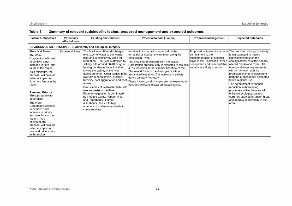
st rategen Executive Summary
WCO0412 Executive Summary Final.doc 32
Table 3 Summary of relevant sustainability factors, proposed management and expected outcomes
Factor & objectives Potentiallyaffected area
Existing environment Potential impact (+ve/ve) Proposed management Expected outcomes
ENVIRONMENTAL PRINCIPLE – Biodiversity and ecological integrityFlora and faunaThe WaterCorporation will seekto achieve a netincrease in flora andfauna in the regionAs a minimum, theproposal will have noadverse impact onflora and fauna in theregion
Rare and PriorityFlora (groundwaterdependent)The WaterCorporation will seekto achieve a netincrease in priorityand rare flora in theregion. As aminimum, theproposal will have noadverse impact onrare and priority florain the region
Blackwood River The Blackwood River discharges940 GL/yr of water to the HardyInlet and is extensively used forrecreation. The river is affected bysalinity with around 3040 GL/yr offresh groundwater baseflow thatlowers the salinity of the riverduring summer. Other issues in theriver are nutrient levels, erosion,turbidity, pool aggradation and poolanoxia.Five species of freshwater fish (salttolerant) exist in the River.Riparian vegetation is dominatedby Flooded Gums, Peppermintsand Paperbarks. Humandisturbance has led to highnumbers of understorey weeds insome sections.
No significant impact is expected on theterrestrial or riparian environment along theBlackwood River.The predicted drawdown from the WaterCorporation proposal only is expected to result ina 6% reduction in the summer baseflow of theBlackwood River in the driest years with anassociated less than 10% increase in salinityduring JanuaryFebruaryThese hydrological changes are not expected tohave a significant impact on aquatic fauna.
Proposed mitigation includes acommitment to thesupplementation of summerflows in the Blackwood River ifunexpected and unacceptableimpacts are likely to occur.
The predicted change in salinityis not expected to have asignificant impact on theecological values of the alreadyaltered Blackwood River. Allecological water requirementswill be met even with thepredicted change in flows fromboth the proposal and estimatedfuture regional use.The commitment to supportreduction in threateningprocesses within the area willenhance ecological valuescurrently affected or under threatand improve biodiversity in thearea.

st rategen Executive Summary
WCO0412 Executive Summary Final.doc 33
Factor & objectives Potentiallyaffected area
Existing environment Potential impact (+ve/ve) Proposed management Expected outcomes
Threatened FaunaThe WaterCorporation will seekto achieve a netincrease in theviability of threatenedfauna populations inthe regionAs a minimum, theproposal will have noadverse impact on thedistribution andviability of threatenedfauna populations inthe region
Threatenedecologicalcommunities(groundwaterdependent)The WaterCorporation will seekto achieve a netincrease in theviability of threatenedecologicalcommunities in theregionAs a minimum, theproposal will have noadverse impact on thedistribution andviability of threatenedecologicalcommunities in theregion
Poison Gully andMilyeannup Brook
Poison Gully and Milyeannup Brookare permanent tributaries of theBlackwood River that contributeapproximately 0.1 GL/month ofYarragadee Formation discharge tothe Blackwood River.Milyeannup Brook is a narrowtributary with Jarrah, SheOak,Marri with Peppermints and denseundergrowth. Poison Gully is morediverse with a greater range of soiland moisture conditions.Five species of endemic freshwaterfish were recorded in MilyeannupBrook and four in Poison Gully.Two of these, the mud minnow andBalston’s pygmy perch are Priority4 species. Both species wererecorded in Milyeannup Brook andonly the mud minnow was recordedin Poison Gully.
The predicted watertable drawdown resultingfrom the proposal is up to 12 m in Poison Gullyand up to 23 m in Milyeannup Brook after 30years of pumping. The total predicted watertabledrawdown resulting from the proposal togetherwith estimated future regional use in both valleysafter 30 years is up to 35 m.There are approximately 177 ha of vegetation inPoison Gully and 52 ha of vegetation inMilyeannup Brook that has a depth to watertableof <10m and may be affected by groundwaterdrawdowns. Within this area, there may be ashift in some vegetation types in the lower slopesof the valleys; however the full range ofvegetation types will still exist, only their extentsmay change.The current spring in Poison Gully may migrateseveral hundred metres downstream from itscurrent position 3.5 km upstream from theBlackwood River and the permanent streamlength of Milyeannup Brook flow may contractfrom 2.5 km to 1 km from the proposal andestimated future regional use. There is expectedto be an approximate 30% reduction in summerbaseflow.
An extensive monitoringprogram will be undertaken inPoison Gully and MilyeannupBrook. If unexpected andunacceptable impacts arelikely to occur, contingencieswill be implemented.A specific contingency isproposed to supplement flowsin Milyeannup Brook ifhydrological changes are likelyto significantly reduce thehabitat available for theBalston’s pygmy perch inMilyeannup Brook. Ifsupplementation is required,the rates of flow will bedesigned to mimic naturalflows and water qualityconditions.
Watertable drawdowns in PoisonGully are expected within alocalised area. Some localchanges in vegetationcomposition are expected.This change in vegetationcomposition will not significantlyaffect any significant flora orfauna species or local or regionaloccurrence of any vegetationcomplex or sitevegetation types.The composition of some sitetypes may change in a smallsection of Milyeannup Brook andPoison Gully but there will be nosignificant loss of keystonespecies, ecosystem function(including fauna habitat) orresilience.The tributaries are importantrefugia for significant freshwaterfish species but all definedecological water requirementsare predicted to be met andinstream ecology is not expectedto be significantly affected.Proposed mitigation includes acommitment to thesupplementation of summerflows in Milyeannup Brook if theBalston’s pygmy perch habitat issubstantially affected.Commitments to reducethreatening processes within thearea will enhance ecologicalvalues currently affected orunder threat and improvebiodiversity in the area.

st rategen Executive Summary
WCO0412 Executive Summary Final.doc 34
Factor & objectives Potentiallyaffected area
Existing environment Potential impact (+ve/ve) Proposed management Expected outcomes
Blackwood river andits tributariesThe WaterCorporation will seekto increase theecological integrity ofthe Blackwood Riverand its tributaries.As a minimum, theproposal will have nosignificant adverseimpact on theBlackwood River andits tributaries
Rosa Brook Rosa Brook is not perennial andgenerally flows for six months fromearly winter to late spring.Localised pools persist in the brookthroughout the yearThe valley is entirely within StateForest and has similar vegetation toMilyeannup Brook; forests andwoodlands of Jarrah, Marri andPeppermints with denseundergrowth. No DRF species butthree Priority 3 species wererecorded in Rosa Brook.Four species of freshwater crayfishand five species of freshwater fishoccur including the Priority 4 mudminnow.
The predicted drawdown likely to occur after 30years as a result of the proposal is between0.1 m and 0.25 m with small areas of drawdownin the 0.25 – 0.5 m range near Crouch Road.This drawdown over 30 years is not expected tohave a measurable effect on vegetation orhabitat values.The total predicted watertable drawdownresulting from the proposal together withestimated future regional use in Rosa Brook after30 years is up to 0.5 m (with a few very smallareas with a drawdown in the 0.5 – 1 m range).The Yarragadee Formation does not outcrop atthe surface in Rosa Brook and the stream is notpermanent so the proposal will have nodiscernible impact on the hydrology of thestream.
No measurable changes inRosa Brook are expected.The groundwater levels will bemonitored to ensure that thesystem responds as expected.If unexpected water levelchanges occur, contingencymeasures will be developeddepending on the extent ofimpact.
The predicted groundwaterdrawdowns in Rosa Brook aresmall and the proposal is likely toresult in a “low – no measurablechange” impact through most ofthe potentially affected areawithin the valley. Any vegetationchange that occurs will not affectthe conservation status of anysignificant flora or fauna speciesor the local or regionaloccurrence of any vegetationcomplex. Small changes mayoccur in some sitevegetationtypes but regional occurrencewill not be significantly affected.Rosa Brook flows will not beaffected by the proposal.

st rategen Executive Summary
WCO0412 Executive Summary Final.doc 35
Factor & objectives Potentiallyaffected area
Existing environment Potential impact (+ve/ve) Proposed management Expected outcomes
WetlandsThe WaterCorporation will seekto increase theecological integrity ofwetlands in theregion.As a minimum, theproposal will have nosignificant adverseimpact on wetlands
Other GroundwaterDependentEcosystems (GDEs)The WaterCorporation will seekto increase theecological integrity ofother groundwaterdependentecosystems in theregion.As a minimum, theproposal will have nosignificant adverseimpact on othergroundwaterdependentecosystems
St John Brook St John Brook is the largesttributary of the Blackwood Riverand has a number of largepermanent pools includingBarrabup Pool and WorkmansPool. The brook has a smallsummer baseflow from theLeederville Formation ofapproximately 0.3 GL/yr (10 L/s),which is approximately 0.6% of themean annual flow in the brook.Most of the St John valley isincluded within proposedconservation reserves and 16% ofthe St John Brook catchment hasbeen cleared. The vegetation of StJohn Brook is dominated by openforest with an overstorey of Marriand Jarrah in the valleys and jarrahon the lateritic slopes.Three species of freshwatercrayfish and four species offreshwater fish occur in St JohnBrook including the Priority 4 mudminnow.
The total predicted watertable drawdownresulting from the proposal together withestimated future regional use upstream ofBarrabup Pool after 30 years is 12 m with mostof this drawdown attributable to the proposal.There are approximately 700 ha of vegetation inSt John Brook within the general area that maybe affected by groundwater drawdowns. Withinthis area, the lower slopes are most likely toshow change, with a small downslope shift inthe vegetation types. The scale of the modeland the accuracy of the depth to groundwatercontours is not sufficient to refine the area ofactual expected impact further, however St JohnBrook is highly dissected and the lower slopesthat may show some change would make uponly a small proportion of the 700 ha.Drawdown above (not including) Barrabup Poolis expected to cause a small reduction insummer water levels in permanent pools andreduce summer streamflow. As the summerflows are already very low, there is potential thatthe groundwater discharge will cease in theupper section of the brook.
An extensive monitoringprogram will be undertaken inSt John Brook. If unexpectedand unacceptable impacts arelikely to occur, contingencymeasures will be developeddepending on the type andextent of impact.One proposed specificcontingency is to supplementflows in St John Brook ifhydrological monitoringindicates that the permanenceof the stream is at risk. Ifsupplementation is required,the rates of flow will bedesigned to mimic naturalflows and water qualityconditions.
The proposal has the potential tocause some groundwaterdrawdown within a general 700ha area along St John Brook.There may be an effect on somevegetation on the lower slopes ofthe valley within this broad area.This will not significantly affectthe conservation status of anysignificant flora or fauna speciesor the occurrence of anyvegetation complex, but mayaffect the local occurrence ofsome sitevegetation types in asmall section of the brook.Reduction in artesian pressuresin the Yarragadee Formationbelow some sections of thebrook also has the potential toreduce summer baseflow fromgroundwater discharge and poollevels above Barrabup Pool.Barrabup Pool itself and otherpools below it are not expectedto be affected.A contingency to supplementflows is proposed to ensure thatthis does not result in anunacceptable impact on thebrook.

st rategen Executive Summary
WCO0412 Executive Summary Final.doc 36
Factor & objectives Potentiallyaffected area
Existing environment Potential impact (+ve/ve) Proposed management Expected outcomes
Reedia Wetlands The Reedia wetlands occur bothnorth and south of the BlackwoodRiver between Hut Pool andAdelaide Brook within the Stateforest. The wetlands consist ofnarrow channels of creekline flowand small permanent pools that aremaintained by groundwater flowsfrom the Leederville Formationsupported by artesian heads fromthe underlying Lesueur Sandstone.The Reedia wetlands are namedafter the Priority 4 Reediaspathacea species that is foundwithin the wetlands. The significantcomponents of the Reediawetlands are the valley floors withsmall permanent pools that supporta proposed threatened ecologicalcommunity and a habitat for acritical frog species.
The investigations undertaken by the WaterCorporation have shown that groundwaterabstraction from the Yarragadee aquifer will nottransfer across the Busselton Fault and affectwater table levels in the Reedia wetlands.Therefore, the Water Corporation proposal isexpected to have no impact on the ReediaWetlands.
Monitoring will be undertakento ensure that no unexpectedimpacts occur on the ReediaWetlands.
No impact from the WaterCorporation proposal is expectedon the Reedia Wetlands.Groundwater monitoring will becarried out to ensure that nounexpected changes in waterlevels occur as a result of theproject. This will provide anearly warning system if theaquifers do not perform aspredicted.The investigations to date andthe proposed ongoinghydrological monitoring of theReedia wetlands will provideincreased knowledge of otherthreats to the wetlands that willhelp inform managementdecisions that reduce the risk tothe environment and maycontribute to a net improvement.

st rategen Executive Summary
WCO0412 Executive Summary Final.doc 37
Factor & objectives Potentiallyaffected area
Existing environment Potential impact (+ve/ve) Proposed management Expected outcomes
Scott CoastalPlain
The Scott Coastal Plain occurssouth of the Blackwood Plateauand north of the coastal dunessystem. The eastern Scott CoastalPlain is internally draining andcharacterised by swamps andlakes. The surface geologycomprises largely sandy deposits.The D’Entrecasteaux National Parkincludes a large area of the southeastern Scott Coastal Plain andincludes Lake Jasper, Lake Quitjupand the lower parts of Barlee Brookand the Donnelly River.The Scott Coastal Plain is partiallycleared for agriculture with largeareas of remnant native vegetation.The flora and vegetation on theplain are highly diverse andspecialised, and many specieshave a restricted range. The “ScottRiver Ironstone Association”vegetation community is listed asEndangered by CALM but thecommunity has not yet beenformally listed by the State Ministerfor Environment and is not listed asa TEC under the EPBC Act.
The watertable drawdowns (based on a 9% reduction inlong term rainfall) from the proposal on the easternScott Coastal Plain are expected to be mostly less than0.25 m in the summer minimum after 30 years, with upto 1m drawdowns in small areas in the northern part ofthe coastal plain. Drawdowns from the proposalcombined with future regional use abstractions areexpected to be more widespread with drawdowns of upto 1 – 2 m.Drawdowns on the western Scott Coastal Plain areexpected to be minor (less than 0.25 m) from theproposal and up to 1 m from the combined abstractions.Drawdowns will occur very gradually over the 30 yearperiod providing the opportunity for groundwaterdependent ecosystems to adapt.Lake Jasper and Lake Quitjup are not expected to beaffected by drawdowns from the proposal. Most otherwetlands on the Scott Coastal Plains are seasonal andwill not be affected by a drop in summer minima ofwater levels.There are 7150 ha of vegetation within the eastern ScottCoastal Plain and 110 ha on the western Scott CoastalPlain where the watertable is likely to be within 10 m ofthe surface and may potentially be affected bydrawdowns from the proposal. No drawdown isexpected under the Scott Coastal Plain IronstoneAssociation.The estimated drawdown in the majority (about 90%) ofthis area is expected to be 0.25 m or less resulting in a“low – no measurable change” potential impact ongroundwater dependent ecosystems. Some smallareas (north eastern part of the plain) where drawdownmay be as much as 1 m, there may possibly be a“moderate” to “high” potential impact on groundwaterecosystems. Any adverse impact on these systems islikely to be mitigated by soil conditions and the recoveryof the watertable during winter where inundation of thelandscape occurs.There is not expected to be a measurable change invegetation (except in small areas where there ispotential for changes in site vegetation types in thenorth eastern part of the plain) given the anticipated fullrecovery in the watertable each year, soil characteristicsand that drawdowns are much smaller than theobserved seasonal watertable variation.Similarly, the effect of drawdowns on acid sulphate soils(acid generation) is expected to be minor.
The Water Corporation willdevelop and implement anextensive biological,hydrological and physicalmonitoring program for theregion including the ScottCoastal Plain to assist in theadaptive management of theproposal. If unexpected andunacceptable impacts arelikely to occur, appropriateresponses will be developedand submitted to theMonitoring Review Group andthe Department of Water forassessment.The Water Corporation is alsocommitted to undertaking acomprehensive biodiversitystudy (within the proposedSustainability Initiative) whichwill include the Scott CoastalPlain and investigate therelationship betweenecosystems and groundwater.This study is proposed as aresearch offset and to assistwith the adaptive managementof the proposal.The Water Corporation willcontribute to a program for themanagement of threateningprocesses (weeds, feralanimals, etc) in area ofconservation significance andareas of potential impact.
Over the majority of the area ofpotential impact (areas where thewatertable is within 10 m and adrawdown is expected) no detectablechanges in groundwater dependentecosystems are anticipated for theWater Corporation proposal. In thenorthern part of the eastern ScottCoastal Plain there may be graduallocal changes to some sitevegetationtypes but this will not adversely affectfauna habitat or the conservationstatus of any significant flora or faunaspecies or occurrence of vegetationcomplexes.The Scott River Ironstone Associationis not expected to be adverselyaffected.Given the expected small predicteddrawdowns and recovery ofwatertables each year, the effects ofacid sulphate soils are expected to beminimal on the Scott Coastal Plain.Similarly, no significant adverseimpact on wetland functions isexpected.Proposed mitigation commitments toreduce threatening processes withinpotential areas of impact will helpprotect and restore ecological valuescurrently affected or under threat andenhance biodiversity in the area. Theknowledge and data obtained fromthe proposed biodiversity study(within the proposed SustainabilityInitiative) and comprehensivemonitoring program will improve thenatural understanding of the area andprovide for adaptive management toensure the area is cautiouslymanaged into the future, particularlyin the context of climate change.The proposal combined withestimated future regional abstractionis expected to result in a muchgreater area and amount ofdrawdown.

st rategen Executive Summary
WCO0412 Executive Summary Final.doc 38
Factor & objectives Potentiallyaffected area
Existing environment Potential impact (+ve/ve) Proposed management Expected outcomes
Swan CoastalPlain
The portion of the Swan CoastalPlain considered in this report isfrom Busselton to Bunbury. Theplain is relatively flat with shallow,highly seasonal watertables andthe plain is prone to seasonalflooding and waterlogging. Much ofthis area has been cleared anddrained for agriculture. Remnantvegetation in this area is highlysignificant and contains severallisted TECs.The Vasse–Wonnerup Wetlandsystem (Ramsar wetland) occurs ina linear system along much of thiscoastline.
The predicted drawdowns in summer watertableminimums from the proposal alone after 30 yearsare all less than 0.5 m south of Bunbury and lessthan 0.25 m east of Busselton. Combineddrawdowns are mostly less than 1 m with smallareas of drawdown in the 1 – 2 m range.A total of 2270 ha of remnant vegetation on theSwan Coastal Plain is within areas of potentialdrawdown from the proposal where thewatertable is within 10 m of the surface.Predicted proposal drawdowns of 0.25 m in thisarea may possibly result in “low” potential impactwhere there is likely to be “no measurablechange” in ecological processes and speciescomposition and abundance. Therefore, theproposal is not expected to have any significantimpact on the vegetation of the Swan CoastalPlain in these areas. “Moderate – small change”in groundwater dependent ecosystems maypossibly occur in small areas where drawdownmay be up to 0.5 m after 30 years (south ofBunbury). Given the full recovery of thewatertable each winter, the natural seasonalvariation is greater than predicted drawdowns,no significant adverse impact on vegetation isanticipated.Three TECs occur in areas where the predicteddrawdown from the proposal is less than 0.25 mafter 30 years. There is not expected to be ameasurable or significant adverse impact at anyof these sites given the full recovery of thewatertable in winter, presence of clay pans andironstones and moisture holding capacity of soilsin these areas.The potential for drawdown to adversely affectacid sulphate soil (acid generation) are expectedto be minimal as the drawdowns are small andfull recovery of water level is expected eachyear.
As for the Scott Coastal Plain. The proposal alone is notexpected to have any significantimpact on the vegetation orTECs of the Swan Coastal Plain.The risk of effects of drawdownon acid sulphate soils (acidgeneration) is expected to beminimal.No impact is expected on theVasse–Wonnerup Wetlandsystem from groundwaterabstraction as the water levelsare connected to the ocean. Theproposal will result in nosignificant impact on theseasonal wetlands of the SwanCoastal Plain, as surface waterlevels will recover fully eachwinter.Knowledge and data obtainedfrom the proposed South WestYarragadee SustainabilityInitiative biodiversity study andcomprehensive monitoringprogram will improve theunderstanding of the area andprovide for adaptivemanagement to ensure cautiousmanagement into the future,particularly in the context ofclimate change.

st rategen Executive Summary
WCO0412 Executive Summary Final.doc 39
Factor Objective Existing environment Potential impact (+ve/ve) Proposed management Expected outcomes
ENVIRONMENTAL PRINCIPLE – Biodiversity and ecological integrityDevelopment footprint The construction of the
proposal will cause minimalpermanent disturbance
The development footprint forthis proposal includes thewellfield, treatment plant,storage tank and the pipelineto join with the Stirling TrunkMain at Harvey.The pipeline route crosses theCapel, Ferguson, Preston,Collie and Brunswick Rivers.
Clearing of 50 ha of nativevegetation.Clearing of pine plantation forthe treatment plant.Five river crossings that areAboriginal heritage sites.Dewatering may be required insome areas for installation ofthe buried pipeline. Thisintroduces the risk oftemporary exposure of acidsulphate soils.
A flora and fauna survey willbe undertaken of all areas tobe cleared.The method of installing thepipeline across the rivers willbe determined through theheritage survey.All crossings will be stabilisedand rehabilitated to minimiseerosion and water qualityimpacts.The Water Corporationproposes to provide an offsetfor clearing through thecontribution of land to theconservation estate using aloss/gain ratio of 1:1.5 and theprinciple of “like for like orbetter”.
The impacts of the proposalinfrastructure have beenminimised through avoidingareas of environmentalsignificance as far aspossible. The 50 ha ofvegetation clearing requiredwill be offset through landcontribution to theconservation estate.
ENVIRONMENTAL PRINCIPLE – Energy efficiencyGreenhouse gasemissions
The proposal will bedesigned and operatedaccording to Australia bestpractice regardinggreenhouse gas emissions
Groundwater will be extractedfrom each well and pumped toa treatment plant and holdingtank for treatment. Thetreated water will then begravity fed from the holdingtank to Harvey and on to Perthfor use. Power will berequired for each well and atthe treatment plant, and will besourced from the South WestInterconnected System.
Energy consumption forpumping and operation of thetreatment plant will amount toapproximately 4.6 MW. Theincrease in emissions isestimated to be 41 000 t/yrCO2e based on an assumedindicative carbon intensity ofthe Western Power SouthWest Integrated System of1032 kg CO2/MWhr.
The Corporation has set anaspirational target of beingcarbonneutral by 2030.As part of the GHGmanagement portfolioapproach, a GreenhouseEmissions Reduction Plan willbe developed to manage GHGemissions consistent with theWater Corporation purpose of“sustainable management ofwater services to makeWestern Australia a greatplace to live”.
Implementation of theproposal will indirectlycontribute to increasedenergy use in WesternAustralia. The Corporationwill utilise best practice inthe design and operation ofthe infrastructure tominimise energy use andwill pursue its carbon neutralpolicy with the expectedlongerterm outcome of noincrease in greenhouse gasemissions.

st rategen Executive Summary
WCO0412 Executive Summary Final.doc 40
Factor Objective Existing environment Potential impact (+ve/ve) Proposed management Expected outcomes
SOCIOECONOMIC PRINCIPLE – Longterm economic healthEconomic growth The proposal will facilitate
economic growth in theIWSS and South Westregions.
Communities with a diversityof economic enterprises tendto be more stable and lesssubject to economic cycles.They offer a wider range ofemployment opportunitiesleading to a more diversebusiness culture and richersociety. This diversitymaintains population levelsand reduces outwardmigration. It may even attractinward migration.Approximately 36 GL/yr iscurrently drawn from thisaquifer to service many of thetown supplies as well as selfsupplied enterprises, includingagriculture.
Development of the proposedwellfield and allocation of45 GL/yr to the WaterCorporation does not precludefuture use by the local waterboards and other privateusers. The transfer pipelinebrings a substantial sourceinto the system and transportsit across the region. This willfacilitate local access ratherthan inhibit it for anyoneseeking a public water supplyof good quality water.Improved access to water willencourage businessdevelopment, economicgrowth and economicdiversity.
The Water Corporation has aresponsibility to supply waterto all customers on termsagreed by the Government.The Water Corporationcommits to making wateravailable from the newinfrastructure to any consumerprepared to enter into thestandard accessarrangements that apply towater users in the State. Newcustomers in the region will beeligible to apply for access tothe proposed pipeline on thestandard terms.
The proposal will contributeto the maximisation ofeconomic output for theState. The proposal willenhance economic diversityand provide opportunities foreconomic growth throughincreased business activityin the South West regionand areas served by theIWSS.
Economic diversity The proposal will enhanceeconomic diversity in theIWSS and South West
As above As above As above As above
Business and industrydevelopment
The proposal will provideopportunities for increasedbusiness activity
As above As above As above As above
Economic efficiency The proposal will providethe most costeffectivewater supply source for theState.
Economic (allocative)efficiency relates tomaximising the economicoutput by selection of the mostefficient water supply option.
The South West Yarragadeewater development is the mostcost effective approach tomeet the forecast need of45 GL/yr within a practicallyachievable timeframe.Public water supply is one ofthe highest value water uses,which maximises theeconomic output from theresource.
As above The proposal will providecosteffective water suppliesto those communitiesserviced by the IWSS.

st rategen Executive Summary
WCO0412 Executive Summary Final.doc 41
Factor Objective Existing environment Potential impact (+ve/ve) Proposed management Expected outcomes
SOCIOECONOMIC PRINCIPLE – Public water supplyWater use efficiency The Water Corporation will
encourage the efficientusage of water.
The State Water Strategyrequires efficiency targets as acondition of water allocationlicences.The Water Corporation hasimplemented severalmeasures to encourage theefficient use of water including:• Rebate Scheme for water
efficient items and practices• Higher prices for high water
consumers• Education program.
The proposal will meetincreasing demand in theIWSS that is due to expansionof the system and populationgrowth. The proposal will notaffect the Water Corporationcommitment to reducing percapita water use.
The Government has set atarget of reducing per capitawater use from the currentunrestricted level of180 kL/person/yr to155 kL/person/yr by 2012.The Water Corporation hascommitted to the achievementof that strategic objective.
Increasing efficiency inwater use in the IWSSthrough progressiveimplementation of a demandmanagement program.
Existing and future needs The proposal will contributeto meeting the existing andforecasted demand forpublic water supply in theIWSS and the South Westunder a range of possiblefuture climate scenarios.Water will be available tomeet reasonable regionalpublic water supply needs.
The Water Corporationsupplies water to most SouthWest towns with the exceptionof Busselton and Bunbury,which are supplied byseparate independentstatutory water boards.Harvey, Waroona, Binningup,Myalup and Hamel are alreadyconnected to and suppliedfrom the IWSS.
As a result of the internalsustainability evaluationprocess, the proposal toabstract water from the SouthWest Yarragadee aquifer forthe IWSS has developed intoa plan to extend the IWSS intothe South West region. Theproposal will contribute directlyto achievement of the publicwater supply sustainabilityobjective of meeting existingand forecasted demand forpublic water supply in theIWSS through extension of theIWSS into the region.
The proposed South WestPublic Water Supply FuturePlanning study will develop aplan for future public watersupply needs in the SouthWest and how they will bemet. The plan would providecertainty to the South West,and would help to resolvesome of the concernsassociated with futuresforegone, benefit and equity,and accommodatingreasonable regional needs.
The proposal will:• provide a major increase
in the supply capabilityand reliability of the IWSS
• provide majorinfrastructure to supportthe development of highvalue economicdevelopment in the regionthrough the provision ofan integrated public watersupply system
• result in a comprehensiveplan to provide for thefuture development ofregional public watersupplies.
South West town supplies This proposal will increasesupply security for SouthWest towns
As above As above As above As above

st rategen Executive Summary
WCO0412 Executive Summary Final.doc 42
Factor Objective Existing environment Potential impact (+ve/ve) Proposed management Expected outcomesQuality of supply To supply high quality water
to consumersThrough its Customer Charterthe Water Corporation hascommitted to provide thecommunity with water that issafe to drink and that complieswith directions on drinkingwater quality made by theMinister for Health.
The South West Yarragadeeaquifer is of a quality highlysuited for public drinking watersupplies. The water is wellwithin guideline values for allconstituents, with theexception of iron, which willneed to be treated for removal.The Yarragadee aquiferoccurs at depth and isconfined over most of its areaby overlying formations. Landuse over the majority of therecharge zone is State forest.This results in a water sourcewith a high degree ofprotection against potentiallycontaminating activities thatmay be carried out on the landsurface.
The proposal for developmentof the South West Yarragadeeaquifer includes a filtrationbased treatment plant. Thewater will also be chlorinatedto remove any pathogens thatmay enter the water afterpumping from the aquifer, andfluoridated in accordance withGovernment policy.The Water Corporationcommits to working with therelevant agencies to arrangedeclaration of a public watersupply catchment area overthe relevant portions of theYarragadee aquifer rechargezones.
The outcome of use of theYarragadee aquifer asproposed, is expected to bea high quality water supplysuitable for use as a publicwater supply with minimaltreatment. Theadministration of catchmentprotection under the CountryAreas Water Supply Act1947 will assist in ensuringthe quality of water ismaintained for the future.
Drinking water sourceprotection
The Water Corporation willwork with the Water andRivers Commission,Conservation Commissionand CALM to protectrecharge areas.
As above As above As above As above

st rategen Executive Summary
WCO0412 Executive Summary Final.doc 43
Factor Objective Existing environment Potential impact (+ve/ve) Proposed management Expected outcomes
SOCIOECONOMIC PRINCIPLE – Regional needsRegional needs for privatewater supplies
The proposal will bedeveloped such thatreasonable regional needsfor water, including social,recreational and projectedfuture development needsare not compromised by theproposal.
The State Water Strategyrequires that all reasonableregional needs for water,including social, recreational,projected future developmentand environmental waterprovisions will be satisfiedbefore transfers can takeplace.The State Water Strategy alsoindicates that the South WestYarragadee source should bedeveloped “for the benefit ofcommunities in the SouthWest and those serviced bythe Integrated Water SupplyScheme”.
While the source is beinginvestigated at this time tomeet strong growth in theexisting IWSS, onceconnected these new assetswould also be available todeliver water to high valueuses in the South West.Based on current information,it is not anticipated thatcompetition between theproposal and regional needswill occur in the near futureand may be up to severaldecades away. However, it isapparent that expansion ofusage in localised areas of theScott and Swan Coastal Plainsmay be limited byenvironmental constraints,even in the absence of theIWSS abstraction.
The Water Corporationproposes to monitor the trendsin water usage from theYarragadee aquifer andpotential future reasonableregional needs for water fromthis aquifer and report toGovernment.
The proposal is notanticipated to significantlyconstrain water availabilityfrom the Yarragadee aquiferto meet reasonable regionalneeds.The proposal has thepotential to enhance overallwater availability from theaquifer
Impact on current keywater users
The Water Corporation willseek to understand andarticulate the impact of theproposal on current keywater users, to ensure thatexisting water users arerecognised and protectedfrom unreasonable impact.
The requirements of theRWI Act are that existingwater users are recognisedand protected fromunreasonable impact.
The Water Corporationproposal has been deliberatelylocated in the State forest areaof the Blackwood Plateau tominimise impact on wateravailability to other users, andto maximise overall wateravailability from the resource.The proposal will not result inany reduction in wateravailability to existing users inthe region, in terms of existingwater allocations and levels ofuse. However, there is somepotential for drawdowninterference or seawaterintrusion.
The freshwater/saltwaterinterface will be monitored toensure that appropriateplanning can be in place ifsaltwater intrusion is likely tooccur.The Water Corporation hascommitted to directly makegood any impacts of seawaterintrusion on public watersupply wells (unless suchimpacts can be clearlyattributable to abstraction by athird party).
The proposal will not resultin any reduction in wateravailability to existing usersin the region, in terms ofexisting water allocationsand levels of use.Any impact due to seawaterintrusion will be mitigated.

st rategen Executive Summary
WCO0412 Executive Summary Final.doc 44
Factor Objective Existing environment Potential impact (+ve/ve) Proposed management Expected outcomes
SOCIOECONOMIC PRINCIPLE – Community well being and heritageLifestyle, amenity andrecreational use andaccess
The Water Corporation willdetermine, throughcommunity consultation,whether communitymembers anticipatechanges to lifestyle,amenity, or recreational useand access as a result ofthe proposal, to ensure thatnegative impacts do notoccur from this project andto explore potential positiveoutcomes.
The dominant social values ofthe Blackwood Plateau and itssurrounds are:• Aboriginal sites of cultural
significance (dealt withunder Indigenous issuesfactor)
• historic features and culturalsites of early settlement(dealt with under Sense ofplace factor)
• tourism and recreationvalues
• areas of high scenic quality.Collectively these contribute toa strong “sense of place”, andthe latter two particularly relateto lifestyle, amenity, andrecreational use and access.
All communities included inthe scoping phase of thesocial impact assessmentstudy were concerned aboutpotential changes to theirenjoyment of the area as aresult of the proposal.Concerns related to potentialchanges to the environment,especially the BlackwoodRiver.No significant impact isexpected on the environmentof the Blackwood Plateau.There will be a small reductionin summer baseflow of theBlackwood River. Thischange is minor and is notexpected to affect the socialvalues of enjoyment oramenity in the river.
The Water Corporationproposes to establish a SouthWest Yarragadee MonitoringReview Group composed ofpeople from the South West toparticipate in the assessmentof monitoring programs.
No changes to amenity,lifestyle and recreational usein the area will occur. Thebenefit will come fromincreased communityinvolvement in monitoringand reporting of results,leading to better safeguardsof community amenity.
Direct and indirect jobcreation
The proposal will createemployment opportunities
The project would createemployment directly in thebuilding and maintenance ofthe infrastructure. Reliablewater supply would alsostimulate economic growthand industry with indirectbenefits for employment.
Job creation both in the SouthWest and the IWSS regions
Local employment preferencesin construction contracts inaccordance with WaterCorporation contract andemployment policy andpractice.Employment of Indigenouspeople in monitoring programsin accordance with the WaterCorporation Involvement andIndigenous EmploymentOpportunities Policy
Some employmentopportunities through directinvolvement in the projectconstruction and operation.Increased regional jobcreation potential throughprovision of integrated watersupply to support high valueeconomic development withassociated employmentopportunities.

st rategen Executive Summary
WCO0412 Executive Summary Final.doc 45
Factor Objective Existing environment Potential impact (+ve/ve) Proposed management Expected outcomesSense of place The Water Corporation will
determine, throughcommunity consultation,whether communitymembers with strongattachments to places andheritage values anticipatechanges to those placesand values as a result ofthe proposal, to ensure thatnegative impacts do notoccur from this project andto explore potential positiveoutcomes.
Landscapes, people, andcultural or environmental‘icons’ (such as the BlackwoodRiver or a National Park) cancontribute to ‘sense of place’.
The South West communitiesexpressed concerns related topotential changes to theenvironment. Sense of placein the South West is stronglylinked to the Blackwood River.As the changes expected inthe Blackwood River areminor, they are not expectedto have a significant impact onsense of place.
The Water Corporationproposes to establish a SouthWest Yarragadee MonitoringReview Group composed ofpeople from the South West toparticipate in the assessmentof monitoring programs. Thiswill allow the community to beinvolved in decision makingabout the project and itsimpact on sense of place.
No change in the sense ofplace values of the SouthWest is expected to occur.
Indigenous communities The Water Corporation willundertake to protect andavoid disturbance ofAboriginal heritage sites.The Corporation will explorepotential positive outcomesfor and with the Indigenouscommunities.
The Blackwood River retainssignificant heritage andcultural value for theAboriginal community. Thereare numerous sites near theBlackwood River on theDepartment of IndigenousAffairs (DIA) Register ofAboriginal Sites. This includessites such as the Hardy Inlet(archaeological deposit,camp), Blackwood RiverOchre Deposit, Sues Bridge(meeting place, camp, huntingplace), Blackwood Riverbank(mythological), and BarrabupPool (mythological) ), as wellas the Blackwood River itself.
Some heritage sites may beaffected by the proposal. Theimplications of these effectsneed to be discussed with theIndigenous communities, andwill be the subject of aseparate extensiveconsultation process that willbe reported separately.The Water Corporation willdiscuss opportunities foremployment of Aboriginalpeople on aspects of theproject with representativegroups.
Monitoring, management andreporting of impacts onheritage sites will beundertaken within therequirements of the AH Act.
The Water Corporation hasundertaken the preliminaryinfrastructure design tominimise any disturbance toAboriginal heritage sites,which includes avoiding allsites on the currentDepartment of IndigenousAffairs register, except in thecase of linear features suchas listed rivers. Furtherconsultation will establishthe protocols for further fieldsurveys to identify any sitesnot currently on the register.Where possible,opportunities will beprovided for Aboriginalpeople to be employed onaspects of the project.

st rategen Executive Summary
WCO0412 Executive Summary Final.doc 46
Factor Objective Existing environment Potential impact (+ve/ve) Proposed management Expected outcomesDevelopment footprint The construction and
maintenance ofinfrastructure will causeminimal permanentdisturbance to thecommunity
The final pipeline alignmentthrough agricultural land is yetto be determined. A notionalroute has been identified butan intensive engagementprocess with potentiallyaffected landholders will needto be undertaken.
The wellfield and treatmentplant are not near residencesand are unlikely to cause animpact.Impacts on individuallandholders whose land is onthe pipeline route. Impactsinclude disturbance to summercropping, access, dust, noise,increased traffic on site, andthe effects of a work team ofup to 20 people on site.
Access to private land andappropriate compensation willbe negotiated with eachlandholder beforecommencement ofconstruction.
The outcome will be positiveoverall, but may be negativein the short term for farmerswhose properties are alongthe pipeline route.The potential benefits ofemployment and economicactivity will be enhancedthrough the Corporation“buy local” policy.

st rategen Executive Summary
WCO0412 Executive Summary Final.doc 47
Factor Objective Existing environment Potential impact (+ve/ve) Proposed management Expected outcomes
STRATEGIC PRINCIPLE – Government policyEquitable access to water The Water Corporation will
ensure fair and equitableaccess to water fordomestic use for all WaterCorporation customers.
Water is a shared resourcethat should be available to allthrough equitable distribution.To ensure this, the cost ofreasonable domestic waterrequirements should beaffordable to all.
The Government uniformpricing policy will ensure thatthere is equity in the watersupply costs.The Water Corporationcommitment to prepare aSouth West Public WaterSupply Future Plan wouldfacilitate connection of centresto the IWSS or directly to theYarragadee aquifer.
Through the South WestPublic Water Supply FuturePlanning Study, the WaterCorporation will determine thefuture public water demand inthose towns and centres in theSouth West that may be ableto connect to the IWSS or bedirectly supplied from othersources.
Equitable access to publicwater supply schemes willbe maintained throughcontinued implementation ofboth Government Policy onuniform tariff policy andWater CorporationCustomer Charter.Equitable access will beenhanced through thepreparation andimplementation of the SouthWest Public Water SupplyFuture Plan.
Government plans The proposal will beconsistent with the followingGovernment agency plansand policies where they areappropriate and congruent:• Environmental protection• Regional development• Forest management• Regional planning• Allocation planning and
licensing
The State Water Strategymakes specific reference todevelopment of the SouthWest Yarragadee resource“for the benefit of communitiesin the South West and thoseserved by the IntegratedWater Supply Scheme”.The State SustainabilityStrategy (Government ofWestern Australia 2003b)indicated that the next newmajor source for meetingfuture water supply needs forPerth should be subject to asustainability assessment.The South West Yarragadeeproject is being subjected tosuch an assessment, incompliance with the strategy.
The development of thisproposal has identified a rangeof gaps in Governmentpolicies and proposed ways ofaddressing those gaps.
Two key policies that theproposal draws from are theState Water Strategy and theState Sustainability Strategy.The project specificsustainability principlesdeveloped for this proposalare based on the StateSustainability Strategy. Theproposal is consistent withboth the foundation andprocess principles of thestrategy, and is an example ofhow these principles havebeen applied in a major publicproject
The proposal will complywith relevant Governmentplans and policies.Proposals to address policygaps will enhance thedevelopment of Governmentpolicy to facilitate theconsideration of thisproposal and proposals forgroundwater abstraction inother areas of the State.
Regional development The proposal will provideopportunities for regionaldevelopment
As for Regional needs factorand Business developmentfactor.

st rategen Executive Summary
WCO0412 Executive Summary Final.doc 48
Factor Objective Existing environment Potential impact (+ve/ve) Proposed management Expected outcomes
STRATEGIC PRINCIPLE – Climate changeClimate change Determine the impact of
likely climate changescenarios on thesustainability of theproposal.
Winter rainfall in the SouthWest of Western Australia hasdecreased substantially sincethe mid20th century, with aseries of years of lower thanaverage rainfall since the mid1970s. The decrease inrainfall appears to be partlythe result of changes in largescale global atmosphericcirculation associated with anenhanced greenhouse effect.
Climate change will have animpact on recharge to theYarragadee aquifer, whichmay result in changes to thewatertable in areas wherethere are groundwaterdependent ecosystems. Thechange in the watertable may,in time, induce changes withinthat system. Under thescenario where climate in thesouthwest of WesternAustralia will become drier, theproposal may cause a furtherlowering of the watertable inareas where the drawdowns inthe Yarragadee aquifer aretransmitted to the watertable.
The issue of climate changehas been recognisedthroughout the proposaldevelopment and a 9%reduction in the longtermrainfall average has beenincluded in the base modellingscenario.The Water Corporation willconduct a major biodiversitystudy of the groundwaterdependent ecosystems of theScott and Swan Coastal plainsand the Blackwood River areathat will potentially be affectedby the proposal, and otherselected areas not affected, toestablish a baseline againstwhich climateand proposalinduced changes may beassessed.The acceptability of thedevelopment impacts in thecontext of climate change willbe judged against a set ofdefined principles.
The proposed key principlesfor determining theacceptability of changeinduced by the proposal inthe context of climatechange, and the proposedadaptive managementframework, will ensure thatthe effects of climate will becomprehensively consideredin the environmentalmanagement of theproposal.
STRATEGIC PRINCIPLE – International and national competitiveness of water usersCost of water The proposal will facilitate
the competitiveness of localand regional industries inthe national andinternational context.
The cost of the various sourceoptions is an importantconsideration in progressivelydeveloping the water sourcesthat form the basis of theIWSS as it expands to meetgrowing demand, and toprovide higher levels ofsecurity. Overall, the IWSShas been built up within aprogram primarily based ondeveloping the viable andenvironmentally acceptablesources in order of cost.
The South West Yarragadeeaquifer is the most economicallarge scale source of wateravailable to the IWSS in therequired timeframe.Preferentially developing lowercost water sources for theIWSS maintains the lowestpossible water pricing tocustomers. This in turnsupports the national andinternational competitivenessof water users taking waterfrom the system.
The Water Corporation willcontinue to execute allcomponents of its SecurityThrough Diversity strategy andupdate its source developmentplan based on the latestinformation available.The Water Corporation willundertake a review of publicwater supply planning in theSouth West that examinesexpected growth in the needfor public water supplies andthe potential options formeeting those demands.
A rational planning base forthe future development ofpublic water supplies thatwill support the developmentof highvalue regionalenterprises and,consequently, thecompetitive contribution ofthe region to the State andnational economies.

st rategen Executive Summary
WCO0412 Executive Summary Final.doc 49
Factor Objective Existing environment Potential impact (+ve/ve) Proposed management Expected outcomes
STRATEGIC PRINCIPLE – Improved knowledge and skillsEnvironmental risk Reduce environmental risk
by Improving the scientificcertainty of the South WestYarragadee characteristicsand the ecosystems that itinteracts with.
As for the Precautionaryprinciple.
– – –
Supply security Increase supply security byimproving the scientificbasis for decision makingand planning regarding theuse of the South WestYarragadee as a watersource.
The groundwater investigationprogram undertaken tosupport this proposal is one ofthe largest such programsundertaken in WesternAustralia. Approximately $12million has been expendedsince 2002 in improving ourknowledge of the groundwaterresources of the region andtheir relationships withenvironmental and socialvalues.
The increased knowledge fromthe proposal will assist inmaximising water availabilityfrom the Southern PerthBasin.The model developed hasbeen made available to theDepartment of Water for use inthe management of waterresources in the region.This should reduce theamount of information requiredto be supplied by applicantsfor water licences.
The Water Corporation isproposing to implement aSouth West YarragadeeSustainability Initiative,intended to enhance theinformation base to provide formaximisation of wateravailability in the region. Thisinitiative will provideinformation on key social andecological aspects, and riskareas, to complement theinformation already madeavailable through the proposaland monitoring programs.
Information on thegroundwater resource, itshydrogeology,environmentaldependencies and socialvalues will assist inmaximising water availabilityfrom the Southern PerthBasin. This information willbe enhanced through theproposed SustainabilityInitiative.

st rategen Executive Summary
WCO0412 Executive Summary Final.doc 50
Factor Objective Existing environment Potential impact (+ve/ve) Proposed management Expected outcomes
PROCESS PRINCIPLE – Precautionary principlePrecautionary approach Where there are threats of
serious or irreversibledamage, lack of fullscientific certainty shouldnot be used as a reason forpostponing measures toprevent environmentaldegradation.In the application of thePrecautionary principle,decisions should be guidedby:• a careful evaluation to
avoid, where practicable,serious or irreversibledamage to theenvironment; and
• an assessment of theriskweightedconsequences of theoptions.
This definition is takendirectly from the EP Act.
The nature of groundwater issuch that there is always anelement of uncertainty whenmaking decisions about wateravailability, and predicting thedrawdown impacts ofparticular developments.Under these circumstancesthe options are: to makeconservative decisions thatlimit the stress and allow aknowledge base to bedeveloped as the stress isprogressively allowed toincrease under monitoredconditions or, where thepotential benefits of theproposal might be high, toadopt an approach thataddresses risk and uncertaintythrough adaptive managementand contingencies.
The Precautionary principlehas been applied in thisproposal through improvingthe knowledge of the resource,risk assessment, design andimplementation of the proposalto minimise risk, mitigation,adaptive management andcontingencies.
The project will be managedthrough an adaptivemanagement process thatconsists of:• management objectives and
performance measures• management response
choices• monitoring and evaluation of
outcomes• feedback of new information
into the decision makingprocess
• stakeholder engagement,specifically through theMonitoring Review Group.
The South West YarragadeeSustainability Initiative is a keyelement of the proposedadaptive managementframework for improving theknowledge of water availabilityin the region for all users.
The application of anapproach of adaptivemanagement and ongoingrisk assessment will ensurea precautionary approachwill be applied inimplementation of theproposal. This approach willsubstantially reduce the riskof serious or irreversibleimpacts on social andenvironmental valuesdependent on theYarragadee aquifer.

st rategen Executive Summary
WCO0412 Executive Summary Final.doc 51
Factor Objective Existing environment Potential impact (+ve/ve) Proposed management Expected outcomes
PROCESS PRINCIPLE – Stakeholder EngagementComprehensive andregular communication
Water Corporation willmaintain a comprehensiveand regular information flowto the community about theproject and the processthroughout the sustainabilityassessment process.
Stakeholder engagementprovided the foundation forcommunity input to the designand implementation frameworkfor the proposal.Stakeholder engagement wasstrongly focused on localcommunities in the SouthWest Region includingNannup, Augusta, MargaretRiver, Busselton, Capel,Bunbury, and farmers on theScott Coastal Plain. Waterconsumers in the Perth regionalso formed a key stakeholdergroup that was consulted inthe evaluation process.
Stakeholder engagementthrough the development ofthe proposal has consisted of:• Community Reference
Group from the SW that metregularly to provide inputinto the proposal
• two sets of publicinformation sessions and“walkins”
• market research• focus group in the Perth
region• technical information
progressively made publiclyavailable
• public review of the draftScoping report
• interviews with stakeholdersfor the social impactassessment.
The stakeholder engagementphases yet to be completedare:− the public review of the
Sustainability Evaluation/ERMP
− the continued involvementof stakeholders in theadaptive management ofthe resource through theSouth West YarragadeeMonitoring Review Group.
The stakeholderengagement process hasresulted in changes to thedesign and intent of theSouth West YarragadeeWater Supply Development.This process has also:• identified issues of
concern• influenced the mitigation
measures andenhancements of theproposal
• influenced the extent andcontent of formalsustainabilitycommitments
• enhanced communityawareness of theproposal and its potentialconsequences.
• provided a social baselinefor the implementation ofthe development.
Relevant, balanced andinclusive consultation
The Water Corporation willengage with keystakeholders and thebroader community todiscuss issues, andpotential impacts andbenefits of the project.
As above As above As above As above
Openness andtransparency
The Water Corporation willconduct investigations andproposal developmentprocesses in an open andtransparent manner
As above As above As above As above

st rategen Executive Summary
WCO0412 Executive Summary Final.doc 52
Factor Objective Existing environment Potential impact (+ve/ve) Proposed management Expected outcomesClosed loop process The Water Corporation will
respond to issues andqueries raised by thecommunity and will providefeedback about how thoseissues have been dealt withand how they haveinfluenced the process.
As above As above As above As above
PROCESS PRINCIPLE – AccountabilityDefine performancetargets
The Water Corporation willdefine economic, social andenvironmental performancetargets that reflectachievement of theobjectives set out herein
The Water Corporation hasimplemented a comprehensivestakeholder engagementprogram and social impactassessment during thepreparation of thisSustainability Evaluation. Thisengagement has led tochanges to the proposal andthe development of theaccountability framework.
Key stakeholders, includingthe community will be involvedin the setting of managementobjectives, performancemeasures and targets for thedevelopment. The WaterCorporation will be heldaccountable for achievementof these objectives andperformance measuresthrough an open andtransparent process.
A South West YarragadeeMonitoring Review Group willbe formed to assistimplementation of the adaptivemanagement framework
The proposed accountabilityframework and WaterCorporation commitmentsfor an open, transparent andaccountable process duringthe implementation of theproposal will continue topromote and enhancestakeholder engagement.This engagement willenhance the empowermentof stakeholders in theimplementation andmanagement of theproposal.
Reporting performance onachievement of targets
The Water Corporation willreport regularly and publiclyon performance ofsustainability measures
As above Public reporting of results willprovide an informed andindependent review of themonitoring results andperformance.
An annual SustainabilityReport will be published todescribe monitoring results,any environmental incidentsand changes in management.The advice of the MonitoringReview Group and the WaterCorporation response will alsobe made publicly available.
As above

st rategen Executive Summary
WCO0412 Executive Summary Final.doc 53
9. COMMITMENTS
The following sections set out the full range of commitments made by the proponent to beimplemented in proceeding with the proposal if approved. The subset of these commitments expectedto form part of the conditions of formal environmental approval of the proposal is presented in Table 4Section 9.3.
9.1 LEGAL REQUIREMENTS TO BE FULFILLED UNDER OTHER LEGISLATION
This section outlines actions and procedures that the Water Corporation is committed to undertakingunder legislation or regulations other than Part IV of the EP Act.
Rights in Water and Irrigation Act 19141. Seek approval for the water pipeline crossings of all streams from the Department of Water
pursuant to the RWI Act.
2. Prepare, and report on the implementation of, abstraction management plans and associatedmonitoring programs for the groundwater abstraction in accordance with any licence issuedpursuant to the RWI Act and the Groundwater Abstraction Management Plan described inVolume 2 Chapter 9 Section 8.
Aboriginal Heritage Act 19723. Conduct a detailed Aboriginal heritage survey of the proposed infrastructure footprint before
construction of proposal infrastructure in consultation with the local Indigenous community andin accordance with the requirements of the DIA.
4. Seek approval for any disturbance of identified heritage sites under s18 of the AH Act.
Environmental Protection Act 1986 Part V5. Operate the treatment plant in accordance with conditions of any licence or works approval issued
pursuant to Part V the EP Act.
Environmental Protection (Noise) Regulations 19876. All construction and operational activities will comply with the Noise regulations.
9.2 GENERAL COMMITMENTS
This section outlines commitments made by the Water Corporation that are not likely to be conditionsof approval issued under Part IV of the EP Act and are not necessarily requirements under otherlegislation. These commitments will be publicly reported on and independently audited by anaccredited Environmental Auditor every five years.
1. Work with the DoW and CALM to arrange declaration of a public water supply catchment areaover the relevant portions of the Yarragadee aquifer recharge zones.

st rategen Executive Summary
WCO0412 Executive Summary Final.doc 54
2. The Water Corporation will establish and support a South West Yarragadee Monitoring ReviewGroup with the following functions:
2.1. regular review and advice to the Water Corporation on monitoring programs, monitoringobjectives and performance measures for the operation of the proposal
2.2. review and provide public advice to the Water Corporation on monitoring results and providecomment on adaptive management measures
2.3. review any changes to management of groundwater abstraction from the Yarragadee aquiferby the Water Corporation and provide advice on the acceptability of these changes.
3. Establish a South West Yarragadee Interpretive Centre in the South West to provide informationto the community and visitors about development of the aquifer.
4. If existing Aqwest (formerly Bunbury Water Board) or Busselton Water Board public watersupply wells are affected by saltwater intrusion (to the extent that they no longer meet the waterquality criteria for potable use) caused by the Water Corporation groundwater abstraction from theYarragadee aquifer, the Water Corporation will provide alternative means for accessing anequivalent amount of potable water at an equivalent cost, through either:
4.1. provision of funding to install new wells into the Yarragadee aquifer further inland
4.2. direct supply of water to the relevant company by the Water Corporation.
5. Develop and implement a landowner engagement program to finalise the pipeline alignment,management of pipeline construction and ongoing maintenance procedures.
6. Act within the provisions of the Land Administration Act 1997 for the pipeline easement interest,but wherever possible, agree on compensation for the interest in land, for loss or for compensationthrough negotiation.
7. The water from the proposal will be available to any consumer prepared to enter the standardaccess arrangements (user pays cost of connection or as otherwise supported by the Government)and the uniform tariff pricing policy that applies to other IWSS water users in the State.
8. If the groundwater abstraction is reduced by the Water Corporation in accordance with theadaptive management program, or the Water and Rivers Commission reduces the licenceallocation in the future, the Water Corporation commits to develop alternative strategies to addressany shortfall in IWSS supply to IWSS consumers including those in the south west4.
9. Undertake a South West Public Water Supply Future Planning Study to provide a plan for meetingthe future public water supply needs in the South West. This plan would be undertaken inconjunction with Aqwest and Busselton Water Board and involve extensive consultation andmarket surveys of community satisfaction with the water planning and management. The planwould investigate and address the following:
9.1. future public water supply demand
9.2. potential sources for public water supply
9.3. source development program for public supply
9.4. assessment of quality and security of existing public water supplies
4 It is understood that the development of alternative sources to meet supply shortfalls would be subject to the usual
approvals, and no approval of contingencies would be implied by approval of this proposal.

s t rategen Executive Summary
WCO0412 Executive Summary Final.doc 55
9.5. program for upgrading existing quality and security of public water supplies where required
9.6. program for new connections to the extended IWSS or other sources.
10. Undertake a South West Yarragadee Sustainability Initiative that includes:
10.1. the biodiversity and acid sulphate soils studies in Environmental Commitment 2
10.2. sponsor a research program up to the value of $0.5M on:
10.2.1. the magnitude and potential means of management of irrigation return water
10.2.2. the effects of changing land use on water demand, availability and quality.
11. Provide opportunities for indigenous people to be employed in undertaking monitoring programs.
9.3 ENVIRONMENTAL COMMITMENTS
Table 4 Consolidated environmental commitments
No Commitment Factor Timing Seek advice from
1. Implementation of the following environmental offsets: • The Water Corporation will contribute to a 5 year program
to assist the management of threatening processes in areas that may be affected by the proposal. The funding will be up to $1M with the capital and any earned interest made available to the management program over a period of five years. The program will address weeds, disease, feral animals, erosion and uncontrolled public access issues insofar as they exist within these areas: • along the Blackwood River • Poison Gully and Milyeannup Brook valleys • the proposed Blackwood National Park • the proposed St John Brook Conservation Park • the Scott Coastal Plain • Swan Coastal Plain.
• Protect the conservation value of selected land establishing conservation covenants or incorporate land into the conservation estate by the freehold transfer of land to the Executive Director of CALM to offset clearing of native vegetation in areas of State Forest for the project infrastructure using a clearing loss/gain ratio of 1:1.5 and of comparable or higher conservation value.
TECs, Rare and Priority flora, Other GDEs, Flora and fauna, Threatened fauna, Wetlands, Development footprint.
To commence prior to operation
DoE, CALM

s t rategen Executive Summary
WCO0412 Executive Summary Final.doc 56
No Commitment Factor Timing Seek advice from
2. a) Undertake a biodiversity and acid sulphate soils study in areas potentially affected by groundwater drawdown resulting from the proposal. The studies will be funded up to the value of $1.5M, with the capital and any earned interest made available to the studies over a period of ten years. The biodiversity component of the study may include but not be limited to the following (subject to the detailed scoping of the study in Commitment 3): • the occurrence, condition, spatial extent and groundwater
dependence of floristic and vegetation communities at local and regional scale
• the occurrence, condition, spatial extent and groundwater dependence of TECs
• the occurrence and spatial extent of significant aquatic fauna
• investigate the genetic diversity of significant aquatic fauna that use the tributaries as refugia
• the identification and spatial extent of terrestrial fauna habitat
• the occurrence and abundance of vertebrate fauna, including specifically, threatened fauna as defined in the Wildlife Conservation Act 1950 and the EPBC Act, Priority fauna as defined and listed by CALM
b) The acid sulphate soils component of the study will be restricted to vulnerable areas on the Scott and southern Swan Coastal Plain to determine the occurrence, spatial extent and depth of acid sulphate soils. The studies will be scoped in consultation with CALM, any biodiversity and acid sulphate soils study technical steering committee, DoE and DoW and will be documented and made publicly available.
Blackwood River and tributaries, TECs, Rare and Priority flora, Other GDEs, Flora and fauna, Threatened fauna, wetlands
This commitment will be completed within 10 years of the commencement of construction
Send finalised reports to CALM, DoE & DoW
3. Prepare and publish in a Water Corporation Sustainability Report on the following relating to the South West Yarragadee Water Supply Development: • compliance with environmental conditions and
commitments • assessment of environmental performance and
environmental management response • implementation of environmental management plans • summary of environmental monitoring information • summary of progressive results from the proposed
biodiversity and acid sulphate soils studies • stakeholder engagement • Water Corporation response to the advice and
recommendations on environmental issues from the Monitoring Review Group.
Blackwood River and tributaries, TECs, Rare and Priority flora, Other GDEs, Flora and fauna, Threatened fauna, wetlands
Annually during construction and for the first five years of operation. The frequency of reporting will then be reviewed.
DoE, DoW

s t rategen Executive Summary
WCO0412 Executive Summary Final.doc 57
No Commitment Factor Timing Seek advice from
4. a) The Water Corporation will not, unless otherwise approved by the Minister for the Environment on advice of the Environmental Protection Authority, construct the proposed infrastructure so as to cause or contribute to the direct or indirect disturbance of the following: • TECs (including candidate TECs) • Declared Rare Flora unless the disturbance is approved
under the Wildlife Conservation Act 1950 • significant habitat for Threatened or Priority listed fauna b) The Water Corporation will ensure that the proposal construction activities do not cause or contribute to the following: • acidification of land or surface water through the
exposure of acid sulphate soils to the extent that it adversely affects native vegetation or streams
• an increase in severity status of weeds or pests in State Forest
• the spread of dieback disease to previously unaffected areas
• placing any species or ecological community into a higher category of threat
• visible dust at sensitive premises. • breach of noise regulations
As above Prior to and during construction
CALM, DoE
5. Undertake the following surveys along the pipeline route: • a soil sampling program to further define the risk of
exposure of acid sulphate soils • a detailed flora and fauna habitat survey to identify
species and communities of conservation significance.
As above Prior to construction
CALM, DoE
6 Ensure independent third party audit of compliance of with commitment 5b above at quarterly intervals. Auditor reports will be made publicly available and submitted to DoE.
As above During construction
DoE
7. Finalise the suite of environmental management plans required for the proposal, as outlined in Volume 2 Chapter 9, and implement those plans.
As above Plans to be finalised prior to construction. Implementation to be undertaken during construction and operation, as appropriate.
DoE, DoW