SOP for Assessing Bank Erosion Vulnerability · Procedure (SOP) for assessing bank erosion...
20
Standard Operating Procedure EAP112, Version 1.1 Assessing Bank Erosion Vulnerability April 2019 Publication 19-03-215 [Approved 2017]
Transcript of SOP for Assessing Bank Erosion Vulnerability · Procedure (SOP) for assessing bank erosion...

Standard Operating Procedure
EAP112, Version 1.1
Assessing Bank Erosion
Vulnerability
April 2019
Publication 19-03-215
[Approved 2017]


Purpose of this document
The Washington State Department of Ecology develops Standard Operating Procedures (SOPs) to
document agency practices related to sampling, field and laboratory analysis, and other aspects of the
agency’s technical operations.
Publication Information
This SOP is available on the Department of Ecology’s website at
https://fortress.wa.gov/ecy/publications/SummaryPages/1903215.html.
Ecology’s Activity Tracker Code for this SOP is 18-040.
Recommended citation:
Hartman, C. 2019. Standard Operating Procedure EAP112, Version 1.1: Assessing Bank Erosion
Vulnerability. Publication No. 19-03-215. Washington State Department of Ecology, Olympia.
https://fortress.wa.gov/ecy/publications/SummaryPages/1903215.html. [Approved 2017.]
Contact Information
For more information contact:
Publications Coordinator
Environmental Assessment Program
P.O. Box 47600, Olympia, WA 98504-7600
Phone: (360) 407-6764
Washington State Department of Ecology – https://ecology.wa.gov
Headquarters, Olympia 360-407-6000
Northwest Regional Office, Bellevue 425-649-7000
Southwest Regional Office, Olympia 360-407-6300
Central Regional Office, Union Gap 509-575-2490
Eastern Regional Office, Spokane 509-329-3400
Any use of product or firm names in this publication is for descriptive purposes only
and does not imply endorsement by the author or the Department of Ecology.
To request ADA accommodation for disabilities, or printed materials in a format for the visually impaired,
call Ecology at 360-407-6764 or visit https://ecology.wa.gov/accessibility. People with impaired hearing
may call Washington Relay Service at 711. People with speech disability may call TTY at 877-833-6341.


EAP112: Assessing Bank Erosion Vulnerability, Version 1.1 1
Uncontrolled copy when printed
Environmental Assessment Program
Standard Operating Procedure EAP112
Version 1.1
Author – Chris Hartman
Date – 2/24/17
Reviewer – Stephanie Estrella, George Onwumere, Glenn Merritt and Meghan Rosewood-Thurman
Date – 5/7/17
QA Approval – William R. Kammin, Ecology Quality Assurance Officer
APPROVED – 5/7/17
SIGNATURES AVAILABLE UPON REQUEST
Please note that the Washington State Department of Ecology’s Standard Operating Procedures
(SOPs) are adapted from published methods, or developed by in-house technical and administrative
experts. Their primary purpose is for internal Ecology use, although sampling and administrative
SOPs may have a wider utility. Our SOPs do not supplant official published methods. Distribution of
these SOPs does not constitute an endorsement of a particular procedure or method.
Any reference to specific equipment, manufacturer, or supplies is for descriptive purposes only
and does not constitute an endorsement of a particular product or service by the author or by
the Department of Ecology.
Although Ecology follows the SOP in most instances, there may be instances in which the Ecology uses
an alternative methodology, procedure, or process.

2 QA Approval – 5/7/2017
Uncontrolled copy when printed.
SOP Revision History
Revision Date Rev
number
Summary of changes Sections Reviser(s)
3/2/15 1.0 Draft Release Throughout Chris Hartman
1/26/17 1.1 Title, footers, general edits, references All Meghan
Rosewood-
Thurman
2/8/17 1.1 Updated glossary terms, edited and
added references,
All Meghan
Rosewood-
Thurman
2/22/17 1.1
“from portions of Platts, et al.
(1987).”
2017a
Added language for when no terrace is
present.
Removed period
Removed repeat “Index Station”
“See SOP EAP121 (Wolfe, 2017)”
2017b
“… most-frequently longer than 500
m.”
2017a
2017b
Replace top 25% with full station
EAP105 or EAP106
Cited Hartman
Cited JNRC
Re-arranged by SOP# (now a)
Re-arranged by SOP# (now b)
Spaces after initials
Added Wolfe SOP EAP121
1.3
2.3
3.1
3.11
3.12
3.13
3.18
3.21
4.4
4.5
6.6
6.11
10.5
10.7
10.8
10.9
10.10
10.13
Glenn Merritt
2/24/17 1.1 Removed Draft Dates, added
reviewers names
Signature
Page
Meghan
Rosewood-
Thurman
5/17/17 1.1 Changed wording to reflect true
methods
2.2.4 Meghan
Rosewood-
Thurman

EAP112: Assessing Bank Erosion Vulnerability, Version 1.1 3
Uncontrolled copy when printed
1.0 Purpose and Scope
1.1 This document is the Environmental Assessment Program (EAP) Standard Operating
Procedure (SOP) for assessing bank erosion vulnerability in rivers and streams for the
Watershed Health Monitoring program (WHM). It was largely adapted from pages 70–
78 of Archer et al. (2012) and from portions of Platts et al. (1987).
2.0 Applicability
2.1 This SOP contributes to both WHM protocols: Narrow and Wide.
2.2 This method is applied to right and left banks of the main channel at all 11 major
transects.
2.2.1 Bank angle estimates are applied to a line on each bank per major transect.
2.2.2 Bank location estimates are applied to the same line as for angle.
2.2.3 Bank cover estimates are applied to a zone that extends across the top 25% of a bank
station area:
2.2.4 Bank failure estimates are applied to the entire bank at the same length of the station.
2.3 This SOP requires that the procedures outlined in the WHM Site Verification and
Layout SOP EAP106 (Merritt, 2017) have already been performed for the Data
Collection Event (DCE).
3.0 Definitions
3.1 AOB-Top: Top angle observation boundary. This is the upper observation boundary at
each bank of a major transect. Normally, this occurs at the first terrace at or above the
bankfull stage. Exceptions are described within this SOP (Figures 2, 3, 4, and 5). Where
no terrace is present, the AOB-Top is at 50 cm above the bankfull channel.
3.2 AOB-Bottom: Bottom angle observation boundary. This is the lower observation
boundary at each bank of a major transect. Normally this occurs at the junction of the
streambed and streambank. Exceptions are described within this SOP (Figures 2, 3, 4,
and 5).
3.3 Bankfull margin: A term used to describe the limit of the stream channel. It is a line on
the bank that coincides with the water’s elevation during bankfull flow.
3.4 Bankfull stage: This stage is delineated by the elevation point of incipient flooding,
indicated by deposits of sand or silt at the active scour mark, break in stream bank
slope, perennial vegetation limit, rock discoloration, and root hair exposure (Endreny
2003).
3.5 Bank station: For this SOP, we are describing an area of the bank that is centered on
each major transect at each bank. It extends vertically from the AOB-Top to the AOB-
Bottom. For the Narrow Protocol, it extends horizontally 5 meters upstream and
downstream of the transect. For the Wide Protocol, it extends 10 meters upstream and
downstream from the transect (Figure 7 and 9).
3.6 Bedrock: For WHM, bedrock as any rock greater than 4 m diameter.

4 QA Approval – 5/7/2017
Uncontrolled copy when printed.
3.7 Cobble: Rocks of diameter size >64 mm – 250 mm.
3.8 Depositional banks: Banks with fresh fluvial deposits such as point bars. For this SOP,
depositional banks are treated differently depending upon the size. When below the
bankfull margin, the deposits are treated as part of the streambed. When deposits cover
the terrace at or above bankfull margin, they are treated as part of the streambank
(Figure 4).
3.9 DCE: The Data Collection Event is the sampling event for the given protocol. Data for
a DCE are indexed using a code that includes the site ID followed by the year, month,
day, and the time (military) for the start time of the sampling event. For example:
WAM06600-000222-DCE-YYYY-MMDD-HH:MM. One DCE should be completed
within one working day, lasting 4–6 hours, on average.
3.10 EAP: Environmental Assessment Program
3.11 Hardpan: A layer of earth that has become relatively hard and impermeable usually
through mineral deposits. A chemically-hardened layer where soil particles are
cemented together with organic matter of SiO2, sesquioxides, or CaCO3 (Armantrout,
1998).
3.12 Index station: The distinct point location mapped by the site coordinates obtained from
the Washington Master Sample List. The index station is called “X” and is generally
located at major transect F; however the point may occur at any elevation in the stream
between transects A and K.
3.13 Large Woody Debris (LWD): Dead fallen wood of at least 10 cm diameter and at least 1
m long (eastern regions) or at least 2 m long (western regions). See SOP EAP121
(Wolfe, 2019). Some tree species may still remain partly alive, while the majority of the
fallen trunk lies dead in or over the stream (e.g., crack willow, Salix fragilis). If the only
living features of the fallen tree are small re-sprouted stems (<minimum LWD size
class), these "live" nurse trees should still be considered LWD.
3.14 Left bank: For WHM, a person facing downstream will have the left bank on their left
side.
3.15 Main channel: Channels in a stream are divided by islands (dry ground that rises above
bankfull stage). Main channels contain the greatest proportion of flow.
3.16 Major transect: One of 11 equidistant transects across the length of a site. These
transects run perpendicular to the thalweg and are labeled as follows: A (furthest
downstream), B, C, D, E, F, G, H, I, J, and K (furthest upstream).
3.17 Narrow protocol: The set of Watershed Health Monitoring SOPs that describe data
collection at wadeable sites with an average bankfull width of less than 25 m at the
index station.
3.18 Pool: For WHM, this is a habitat unit that has a maximum depth at least 1.5 times its
crest depth. Pools include dammed pools, plunge pools, and scour pools. For details,
refer to SOP EAP120 (Merritt, 2018).
3.19 QAMP: Quality Assurance Monitoring Plan. The QAMP for WHM is Cusimano et al
(2006). An updated version is in early stages of development.
EAP112: Assessing Bank Erosion Vulnerability, Version 1.1 5
Uncontrolled copy when printed
3.20 Right bank: For WHM, a person facing downstream will have the right bank on their
right side.
3.21 Site: A site is defined by the coordinates provided to a sampling crew and the
boundaries established by the protocol’s site layout method (Hartman, 2017 (SOP
EAP105) for the Wide Protocol; Merritt, 2017 (SOP EAP106) for the Narrow Protocol).
Typically, a site is centered on the index station and equal in length to 20 times the
average of 5 bankfull width measurements. Sites cannot be longer than 2 km nor shorter
than 150 m. Narrow protocol sites range from 150 m to 500 m long. Wide Protocol sites
are up to 2 km long, and most frequently longer than 500 m. The most downstream end
of a site coincides with major transect A; the most upstream end coincides with major
transect K.
3.22 Streambed: Substrate plane, bounded by banks. Also called the stream bottom
(Armantrout, 1998).
3.23 Streambank: Ground bordering a channel above the streambed and below the level of
rooted vegetation that often has a steep gradient and exhibits a distinct brake in slope
from the stream bottom. The portion of the channel that restricts lateral movement of
water during normal streamflow (Armantrout, 1998).
3.24 STR: Status and Trends Regions (STRs) are based on Salmon Recovery Regions
(SRRs) that were described by the Governor’s Salmon Recovery Office (JNRC, 1999).
Membership is as follows:
3.25 Puget STR: Puget Sound, & Hood Canal/Puget Sound SRRs.
3.26 Coastal STR: Coastal SRR.
3.27 Lower Columbia STR: Lower Columbia SRR.
3.28 Mid Columbia STR: Mid Columbia SRR.
3.29 Upper Columbia STR: Upper Columbia SRR.
3.30 Snake STR: Snake SRR.
3.31 Northeast WA STR: Northeast Washington SRR.
3.32 Unlisted STR: No SRR identified.
3.33 Thalweg: Path of a stream that follows the deepest part of the channel (Armantrout,
1998). For WHM, we emphasize Armantrout’s use of the word “path” because the
thalweg longitudinal profile excludes (sometimes deeper) side pools that are not part of
the dominant flow path.

6 QA Approval – 5/7/2017
Uncontrolled copy when printed.
3.34 Thalweg station or transect: One of one hundred (100) equidistant measurement
locations in the thalweg, across the length of a site. For example, the thalweg stations
at/above each major transect are named as follows:
A0, A1, A2, A3, A4, A5, A6, A7, A8, A9,
B0. B1, B2, B3, B4, B5, B6, B7, B8, B9,
C0, C1, C2, C3, C4, C5, C6, C7, C8, C9,
…
J0, J1, J2, J3, J4, J5, J6, J7, J8, J9, and
K0.
3.35 Undercut bank: Bank with a cavity below the [bankfull] waterline. It is maintained by
scour from substrates and high water velocities (Armantrout, 1998).
3.36 WHM: Watershed Health Monitoring, a status and trends monitoring program within
the Environmental Assessment Program at the Washington State Department of
Ecology.
3.37 Wide protocol: The set of WHM SOPs that describes the sample and data collection at
non-wadeable sites or sites wider than 25 m bankfull width. It is an abbreviated version
of the Narrow Protocol and is typically accomplished by use of rafts.
3.38 Woody vegetation: Perennials, such as trees and shrubs, which have persistent woody
stems and branches. We exclude vines and sub-shrubs as listed in USDA (2013).

EAP112: Assessing Bank Erosion Vulnerability, Version 1.1 7
Uncontrolled copy when printed
4.0 Personnel Qualifications/Responsibilities
4.1 This SOP pertains to trained field staff in Ecology’s Environmental Assessment
Program.
4.2 All field staff must comply with the requirements of the EAP Safety Manual (Ecology,
2019).
4.3 All field staff must have completed the annual WHM field training session. This
includes a briefing on project objectives, details of the project Quality Assurance
Monitoring Plan (QAMP), and both field protocols.
4.4 Locating stations for estimating bank erosion vulnerability requires first performing Site
Verification and Layout, SOPEAP106 (Merritt, 2017).
4.5 Estimating bank positions requires knowledge of Quantifying Habitat Units, SOP
EAP120 (Merritt, 2018).
4.6 All field staff must be familiar with the electronic data recording tablet and web-based
field forms that are required to record and submit data for the WHM program, SOP
EAP125 (Janisch, 2017).
4.7 Field staff must be annually trained to minimize the spread of invasive species.
See SOP EAP070 (Parsons, et al., 2018).
5.0 Equipment and Supplies
5.1 Field tablet (charged), loaded with the electronic field forms.
5.2 Binoculars (Wide Protocol), for observing the opposite banks.
5.3 Pre-cleaned gear for wading or boating. Prior to arrival, the gear will be disinfected to
minimize the spread of invasive species from site to site. See SOP EAP070 (Parsons, et
al., 2018).
6.0 Summary of Activity
6.1 Pre-observation
6.1.1 Establish the 11 major transects using SOP EAP106 (Merritt, 2017) or SOP EAP 105
(Hartman, 2017).
6.2 General Considerations
6.2.1 Make categorical estimates of four bank features: angle, location, cover, and failure.
Make these estimates at both banks of all 11 major transects (22 stations total).
Electronically record the estimates on the tablet. Use the Transect page under the
Channel tab of the WHM electronic field forms. Figure 1 highlights the location of the
“Bank Angle”, “Bank Location”, “Bank Cover”, and “Bank Failure” fields for both the
right and left banks.

8 QA Approval – 5/7/2017
Uncontrolled copy when printed.
Figure 1. Location of the “Bank Angle,” “Bank Location,” “Bank Cover,” and “Bank Failure” fields within the WHM electronic field forms.
6.3 Bank Angle
6.3.1 Identify the AOB-Top on each bank. This will vary with bank type (see Figures 2, 3,
and 4).
6.3.1.1 Where terraces occur within 50 cm of the bankfull margin: set the AOB-Top at the first
flat depositional feature at or above the bankfull margin.
6.3.1.2 Where no terrace is present, set the AOB-Top at 50 cm above the bankfull channel.
6.3.1.3 Where there is an undercut bank (overhung bank), position the AOB-Top at the most
streamward edge of the bank.
6.3.1.4 On depositional banks (e.g., point bars) where unconsolidated sediment obscures the
terrace or bankfull margin, set the AOB-Top at the estimated bankfull margin, on the
sediment pile (Figure 4, right side).
6.3.1.5 For depositional banks without an obscured bankfull margin (Figure 4, left side), set the
AOB-Top normally (as in 6.3.1.1 and 6.3.1.2)
6.3.2 Identify the AOB-Bottom on each bank (Figures 2, 3, and 4). It will always be below
the bankfull margin.
6.3.3 For most banks, The AOB-Bottom will normally be where the streambed meets the
streambank. Use available clues such as:
6.3.3.1 Change in slope from relatively flat (streambed) to relatively vertical (streambank)
6.3.3.2 Change in substrate from relatively coarse (streambed) to relatively fine (streambank).
6.3.4 On depositional banks, where deposited sediment obscures the streambed/streambank
transition (Figure 4), either
6.3.4.1 Set the AOB-Bottom on top of the deposition pile (if the pile is fully below the bankfull
margin), or

EAP112: Assessing Bank Erosion Vulnerability, Version 1.1 9
Uncontrolled copy when printed
6.3.4.2 Set the AOB-Bottom on the streambed, adjacent to the pile (if pile extends above the
bankfull margin or first terrace).
6.3.5 Draw an imaginary line from AOB-Top to AOB-Bottom, on each bank. Then
imagine how each line intersects a horizontal plane.
6.3.6 Estimate the angle of this line relative to a horizontal plane. Record the bank angle
(Figures 2, 3, and 5) according to the following categories:
6.3.6.1 Low (0–45°),
6.3.6.2 Moderate (46–80°),
6.3.6.3 Vertical (81–100°),
6.3.6.4 Overhung (>100°).
Figure 2. An example of a vertical bank angle (left) and of an overhung bank (right).
Figure 3. An example of a moderate bank (left) and a low bank (right).

10 QA Approval – 5/7/2017
Uncontrolled copy when printed.
Figure 4. AOB-Top and AOB-Bottom for depositional banks.
Figure 5. Bank angle categories.

EAP112: Assessing Bank Erosion Vulnerability, Version 1.1 11
Uncontrolled copy when printed
6.4 Bank Location: In, Out, or Run
6.4.1 Determine whether or not each major transect crosses a pool of any type.
6.4.2 If the transect does not cross a pool, record Run for both banks
6.4.3 If the transect crosses a pool, then determine which bank is closer to the thalweg.
6.4.3.1 The bank that is closer to the thalweg should be marked as Out, meaning the outside
(erosional) part of a river bend (Figure 6).
6.4.3.2 The bank that is further from the thalweg should be marked as In, meaning the inside
(depositional) part of a river bend (Figure 6).
Figure 6. Hypothetical bank locations for six transects (A–F).
12 QA Approval – 5/7/2017
Uncontrolled copy when printed.
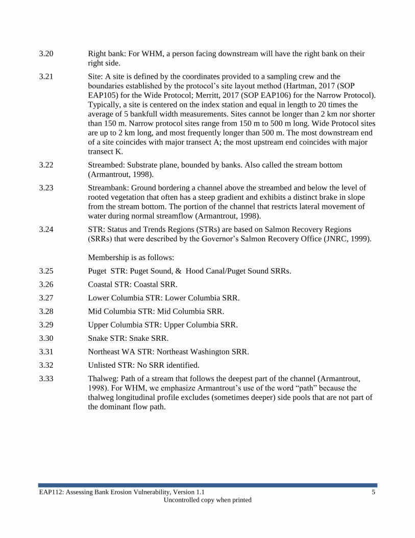
6.5 Bank Cover Assessment at top 25% of bank station.
6.5.1 At each bank, first establish the limits of the bank station (Figure 7). For the Narrow
Protocol, it extends horizontally 5 meters upstream and downstream of the transect. For
the Wide Protocol, it extends 10 meters upstream and downstream from the transect.
Figure 7. The bank station for assessing bank cover: cross-section view and view facing bank.
6.5.2 At each bank along the top 25% of the station, estimate the cumulative percent bank
cover (Figure 8) provided by any of the following cover types:
6.5.2.1 Large rocks: Cobble or larger rocks. Include bedrock and hardpan.
6.5.2.2 Large woody debris: Pieces should be at least 10 cm diameter and 1 m long (in eastern
STRs) or 2 m long (western STRs).
6.5.2.3 Live roots or rooted, woody vegetation
6.5.3 Record YES for bank cover if the cover estimate is greater than 50%.
6.5.4 Record NO otherwise.

EAP112: Assessing Bank Erosion Vulnerability, Version 1.1 13
Uncontrolled copy when printed
Figure 8. Comparison chart for 10%, 40%, and 75% cover.
6.6 Bank Failure Assessment at full bank station.
6.6.1 Refer to the same bank station used for assessing bank cover.
6.6.2 Assess the entire station (Figure 9) for signs of bank failure. If you observe that the
bank is cracking, fracturing, or slumping record YES. Otherwise, record NO.
Figure 9. The bank station for assessing bank failure: cross-section view and view facing bank.
14 QA Approval – 5/7/2017
Uncontrolled copy when printed.
7.0 Records Management
7.1 Refer to the WHM SOP EAP125 (Janisch, 2017). This describes the process for
validating, loading, and committing completed WHM electronic field forms to the
WHM database.
8.0 Quality Control and Quality Assurance Section
8.1 QA/QC procedures are addressed in the QAMP for this project.
9.0 Safety
9.1 All field staff must comply with the requirements of the EAP Safety Manual (Ecology
2019).

EAP112: Assessing Bank Erosion Vulnerability, Version 1.1 15
Uncontrolled copy when printed
10.0 References
10.1 Archer, E. K., R. A. Scully, R. Henderson, B. B. Roper, and J.D. Heitke. 2012.
Effectiveness monitoring for streams and riparian areas: sampling protocol for stream
channel attributes. Unpublished paper on file at:
http://www.fs.fed.us/biology/resources/pubs/feu/pibo/pibo_stream_sampling_protocol_
2012.pdf [02-14-2013].
10.2 Armantrout, N. B., Compiler. 1998. Glossary of Aquatic Habitat Inventory
Terminology. American Fisheries Society, Bethesda, Maryland.
10.3 Ecology, 2019. Environmental Assessment Program Safety Manual. Washington State
Department of Ecology. Olympia.
10.4 Endreny, T.A. 2003. Fluvial Geomorphology Module, UCAR COMET Program and
NOAA River Forecast Center, Syracuse, NY. http://www.fgmorph.com
10.5 Hartman, C. 2017. Watershed Health Monitoring: Standard Operating Procedures for
GIS-Based Verification, Layout, and Data Collection (Wide Protocol). SOP EAP105.
Washington State Department of Ecology, Environmental Assessment Program,
Olympia. http://www.ecology.wa.gov/programs/eap/quality.html
10.6 Janisch, J. 2017. Watershed Health Monitoring: Standard Operating Procedures for
Managing Electronic Data Forms with a Mobile Data-Collection Device. SOP EAP125.
Washington State Department of Ecology, Environmental Assessment Program,
Olympia. http://www.ecology.wa.gov/programs/eap/quality.html
10.7 JNRC. 1999. Statewide Strategy to Recover Salmon – Extinction is Not an Option,
Chapter III: A Road Map To Recovery. Governor’s Salmon Recovery Office, Olympia,
WA.
http://www.digitalarchives.wa.gov/governorlocke/gsro/strategy/summary/roadmap.htm
10.8 Merritt, G. 2017. Watershed Health Monitoring: Standard Operating Procedures for
Verification and Layout of Sites (Narrow Protocol) SOP EAP106. Washington State
Department of Ecology, Environmental Assessment Program, Olympia.
http://www.ecology.wa.gov/programs/eap/quality.html
10.9 Merritt, G. 2018. Watershed Health Monitoring: Standard Operating Procedure
EAP120, Version 1.3: Quantifying Habitat Units. Washington State Department of
Ecology, Environmental Assessment Program, Olympia.
https://fortress.wa.gov/ecy/publications/SummaryPages/1803225.html
10.10 Parsons, J., D. Hallock, K. Seiders, B. Ward, C. Coffin, E. Newell, C. Deligeannis, and
K. Welch. 2018. Standard Operating Procedure EAP070, Version 2.2: Minimize the
Spread of Invasive Species. Washington State Department of Ecology, Environmental
Assessment Program, Olympia.
https://fortress.wa.gov/ecy/publications/SummaryPages/1803201.html

16 QA Approval – 5/7/2017
Uncontrolled copy when printed.
10.11 Platts, W.S., C. Armour, G.D. Booth, M. Bryant, J.L. Bufford, P. Cuplin, S. Jensen,
G.W. Lienkaemper, G.W. Minshall, S.B. Monson, J.R. Sedell, and J.S. Tuhy. 1987.
Methods for evaluating riparian habitats with applications to management. U.S.
Department of Agriculture, Forest Service, Intermountain Research Station, General
Technical Report INT-221. Ogden, UT.
http://www.fort.usgs.gov/Products/Publications/pub_abstract.asp?PubID=3581
10.12 USDA. 2013. PLANTS Database. United States Department of Agriculture, Natural
Resources Conservation Service. Internet page, last modified: 06/17/2013.
http://plants.usda.gov
10.13 Wolfe, J. 2019. Standard Operating Procedures EAP121, Version 1.1: Counting Large
Woody Debris. Washington State Department of Ecology, Environmental Assessment
Program, Olympia.
https://fortress.wa.gov/ecy/publications/SummaryPages/1903214.html