Sonoma County Seismic Report
60
FINAL TECHNICAL REPORT Project Title: Assessment of Seismogenic Sources between the Rodgers Creek and San Andreas Faults, Northwestern San Francisco Bay Region, Sonoma County, California Recipient: William Lettis & Associates, Inc. 1777 Botelho Drive, Suite 262 Walnut Creek, California 94596 (925) 256-6070 Principal Investigators: Christopher S. Hitchcock William Lettis & Associates, Inc., 1777 Botelho Dr., Suite 262, Walnut Creek, CA 94596 (phone: 925-256-6070; email: [email protected] ) Keith I. Kelson William Lettis & Associates, Inc., 1777 Botelho Dr., Suite 262, Walnut Creek, CA 94596 (phone: 925-256-6070; email: [email protected] ) Program Elements: I U. S. Geological Survey National Earthquake Hazards Reduction Program Award 1434-HQ-97-GR-03153 November 1998 Research supported by the U.S. Geological Survey (USGS), Department of the Interior, under USGS award number 1434-HQ-97-GR-03153. The views and conclusions contained in this document are those of the authors and should not be interpreted as necessarily representing the official policies, either expressed or implied, of the U.S. Government.
-
Upload
robert-di-jorio -
Category
Documents
-
view
122 -
download
5
Transcript of Sonoma County Seismic Report

FINAL TECHNICAL REPORT
Project Title:
Assessment of Seismogenic Sources between the Rodgers Creek and San AndreasFaults, Northwestern San Francisco Bay Region,
Sonoma County, California
Recipient:
William Lettis & Associates, Inc.1777 Botelho Drive, Suite 262
Walnut Creek, California 94596(925) 256-6070
Principal Investigators:
Christopher S. Hitchcock William Lettis & Associates, Inc., 1777 Botelho Dr., Suite 262,Walnut Creek, CA 94596 (phone: 925-256-6070; email: [email protected] )
Keith I. Kelson William Lettis & Associates, Inc., 1777 Botelho Dr., Suite 262,Walnut Creek, CA 94596 (phone: 925-256-6070; email: [email protected] )
Program Elements:
I
U. S. Geological SurveyNational Earthquake Hazards Reduction Program
Award 1434-HQ-97-GR-03153
November 1998
Research supported by the U.S. Geological Survey (USGS), Department of the Interior, underUSGS award number 1434-HQ-97-GR-03153. The views and conclusions contained in thisdocument are those of the authors and should not be interpreted as necessarily representing theofficial policies, either expressed or implied, of the U.S. Government.

ii
ABSTRACT
Detailed geomorphic mapping and analyses provide constraints on the distribution of lateQuaternary strain in the region between the Rodgers Creek and San Andreas fault zones in thenorthern San Francisco Bay Area, south of the Russian River. The regionally extensive, 4-6 MaWilson Grove Formation provides a datum for identifying and characterizing locations of long-term tectonic deformation. Deposition of the Wilson Grove Formation occurred on a surface oflow to moderate relief beveled across Franciscan basement rock, likely within a shallow marineembayment. The base of the Wilson Grove Formation is offset across the northwest-trendingAmericano Creek, Bloomfield, Joy Woods, Dunham, Tolay, Salmon Creek, and Burdell Mountainfaults. Contours on the base of the Wilson Grove Formation document uplift and regionaleastward tilting of the Sebastopol structural block, with maximum uplift within the western andcentral portions of the block. Uplift of the structural block is accommodated locally by discretereverse faulting and associated anticlinal folds that extend between the northwestern end ofPetaluma Valley and the mouth of the Russian River near Jenner, and along a narrow coastal zoneeast of the San Andreas fault.
Localized tectonic uplift along late Cenozoic faults and associated folds is expressedgeomorphically within the study area as two distinct series of northwest-trending hills that rise 30to 150 m (100 to 500 feet) above accordant hilltops underlain by the Wilson Grove Formation.The linear hills appear to be the axes of folds underlain by and/or bounded by thrust or reversefaults. The easternmost of these linear hills, typified by the prominent English Hill locatedapproximately 3 km (2 miles) north of Bloomfield, is underlain by resistant rock of the FranciscanComplex. The hills [and associated folds] are bounded on the southwest by the Tolay, DunhamBloomfield, and Joy Woods faults. For convenience, we refer to this zone of crustal shortening asthe Bloomfield fold-and-thrust belt. The second topographically distinct fold belt consists of lowrugged hills 3 to 5 km (2 to 3 miles) wide that border the Sonoma Coast adjacent to the SanAndreas fault. These hills, and associated deeply incised stream valleys and steep sea cliffs alongthe coast, are developed entirely within resistant Mesozoic rocks of the Franciscan Complex.
Several southwest-flowing drainages cross the northwest-trending structural grain of the studyarea. Longitudinal profiles of Pleistocene and younger stream terraces within these drainagesshow localized warping and uplift coincident with the loci of deformation within the Wilson GroveFormation. Additionally, valley height to valley-floor width ratios reveal changes in stream valleymorphology along Salmon, Americano, Stemple, and Walker creeks across the Bloomfield faultand near the San Andreas fault. The observed changes in morphology are consistent with aresponse of these fluvial systems to localized late Quaternary uplift. Similarly, profiles of marineterraces along the coast show progressive tilting of older terraces and warping of the entire terracesequence consistent with localized folding adjacent to the San Andreas fault. These upliftsrepresent localized strain between the San Andreas and Rodgers Creek faults, and likely are theresult of large-scale interactions between these two major faults.
The results of this study document northeast-southwest directed shortening between the SanAndreas and Rodgers Creek fault. Deformation of both the Wilson Grove Formation and youngerQuaternary fluvial and marine terraces indicate progressive, continuing deformation along a seriesof anticlinal folds underlain by and/or bounded by Quaternary active reverse or thrust faults.Structural relief on the base of the Wilson Grove Formation suggests uplift rates between 0.03 to0.15 m/ka. We obtain an average slip rate between approximately 0.07 + .03 m/ka and 0.13 + .04m/ka for the Bloomfield fault. These rates are consistent with stream incision of upliftedQuaternary fluvial terraces. Marine terrace elevations along the coast suggest maximum uplift ratesof approximately 0.14 m/ka for the Sonoma fold-and-thrust belt adjacent to the San Andreas fault.
iii
TABLE OF CONTENTSSection Page Abstract .. . . . . . . . . . . . . . . . . . . . . . . . . . . . . . . . . . . . . . . . . . . . . . . . . . . . . . . . . . . . . . . . . . . . . . . . . . . . . . . . . . . . . . . . . . . . . . . . . . . . . . . iiTable of Contents............................................................................................iv
1.0 INTRODUCTION...................................................................................1
1.1 Significance and Purpose......................................................................11.2 Summary of Results .. . . . . . . . . . . . . . . . . . . . . . . . . . . . . . . . . . . . . . . . . . . . . . . . . . . . . . . . . . . . . . . . . . . . . . . . . .11.3 Acknowledgements .. . . . . . . . . . . . . . . . . . . . . . . . . . . . . . . . . . . . . . . . . . . . . . . . . . . . . . . . . . . . . . . . . . . . . . . . . . .4
2.0 REGIONAL GEOLOGIC SETTING .... . . . . . . . . . . . . . . . . . . . . . . . . . . . . . . . . . . . . . . . . . . . . . . . . . . . . . . . .5
2.1 Structural Setting...............................................................................52.1.1 Major strike-slip faults in the study region.......................................72.1.2 Major folds in the study region....................................................72.1.3 Major late Cenozoic thrust faults in the study region...........................8
2.2 Stratigraphy.....................................................................................82.2.1 Franciscan Complex................................................................82.2.2 Petaluma Formation ... . . . . . . . . . . . . . . . . . . . . . . . . . . . . . . . . . . . . . . . . . . . . . . . . . . . . . . . . . . . . .92.2.3 Wilson Grove ("Merced") Formation ... . . . . . . . . . . . . . . . . . . . . . . . . . . . . . . . . . . . . . . . . .92.2.4 Glen Ellen Formation.............................................................102.2.5 Sand and Gravel of Cotati . . . . . . . . . . . . . . . . . . . . . . . . . . . . . . . . . . . . . . . . . . . . . . . . . . . . . . .10
2.3 Regional Geomorphic Setting...............................................................102.3.1 “Mendocino Plateau”.............................................................15
3.0 TECHNICAL APPROACH......................................................................18
4.0 RESULTS.... . . . . . . . . . . . . . . . . . . . . . . . . . . . . . . . . . . . . . . . . . . . . . . . . . . . . . . . . . . . . . . . . . . . . . . . . . . . . . . . . . . . . . .23
4.1 Quaternary Stratigraphy ... . . . . . . . . . . . . . . . . . . . . . . . . . . . . . . . . . . . . . . . . . . . . . . . . . . . . . . . . . . . . . . . . . .234.1.1 Marine Terraces...................................................................234.1.2 Fluvial Terraces...................................................................284.1.3 Correlation and Age of Map Units..............................................28
4.2 Geomorphic Analyses .. . . . . . . . . . . . . . . . . . . . . . . . . . . . . . . . . . . . . . . . . . . . . . . . . . . . . . . . . . . . . . . . . . . . . .324.2.1 Contours on the base of the Wilson Grove Formation.......................334.2.2 Fluvial Terrace Longitudinal Profiles..........................................36
4.2.2.1 Americano Creek...................................................364.2.2.2 Stemple Creek .. . . . . . . . . . . . . . . . . . . . . . . . . . . . . . . . . . . . . . . . . . . . . . . . . . . . .36
4.2.3 Marine Terrace Profiles .. . . . . . . . . . . . . . . . . . . . . . . . . . . . . . . . . . . . . . . . . . . . . . . . . . . . . . . . .374.2.4 Fluvial Channel Profiles .. . . . . . . . . . . . . . . . . . . . . . . . . . . . . . . . . . . . . . . . . . . . . . . . . . . . . . .37
4.2.4.1 Salmon Creek.......................................................404.2.4.2 Americano Creek...................................................404.2.4.3 Stemple Creek .. . . . . . . . . . . . . . . . . . . . . . . . . . . . . . . . . . . . . . . . . . . . . . . . . . . . .404.2.4.4 Discussion...........................................................40
4.2.5 Stream Valley Morphology......................................................40

iv
TABLE OF CONTENTS (CONTINUED)
Section Page
4.3 Stream Development and Landscape Evolution...........................................43
5.0 DISCUSSION ... . . . . . . . . . . . . . . . . . . . . . . . . . . . . . . . . . . . . . . . . . . . . . . . . . . . . . . . . . . . . . . . . . . . . . . . . . . . . . . . . . .46
5.1 Rates of Quaternary Deformation ..........................................................465.2 Hazard Assessment of Seismogenic Sources.............................................47
6.0 CONCLUSIONS........ . . . . . . . . . . . . . . . . . . . . . . . . . . . . . . . . . . . . . . . . . . . . . . . . . . . . . . . . . . . . . . . . . . . . . . . . . .51
7.0 REFERENCES ... . . . . . . . . . . . . . . . . . . . . . . . . . . . . . . . . . . . . . . . . . . . . . . . . . . . . . . . . . . . . . . . . . . . . . . . . . . . . . . . . .52
List of Tables
1 List of aerial photography used in reconnaissance geologic mapping.......................172 Estimated ages and correlation of marine and fluvial terraces .. . . . . . . . . . . . . . . . . . . . . . . . . . . . . . .32
List of Photographs
1 Photo of rolling hills developed within the Wilson Grove Formation, lookingnortheast from Sugarloaf Hill, above Dillon Beach, toward English Hill...................12
2 Photo looking northeast toward English Hill from Highway 1, showing typicaltopography associated with outcrops of rock of the Franciscan Complex..................12
3 Photo looking southwest showing the lower reach of Stemple incised across the SonomaCoast fold-and-thrust belt along the coast.......................................................14
4 Photo looking southwest toward the Pacific Ocean showing the lower reach ofAmericano Creek incised across the Sonoma Coast fold-and-thrust belt....................14
5 Photo looking southeast, near Dillon Beach, of the exhumed erosional contactbetween the Wilson Grove Formation and underlying Franciscan Complex...............16
6 Photo of marine terrace deposits exposed at Dillon Beach ...................................277 Photo looking northeast across Estero Americano showing stream terraces east of the
coastal hill zone .. . . . . . . . . . . . . . . . . . . . . . . . . . . . . . . . . . . . . . . . . . . . . . . . . . . . . . . . . . . . . . . . . . . . . . . . . . . . . . . . . . .298 Photo looking east at exposure of bedding within the Wilson Grove Formation
showing how bedrock bedding can mimic a fluvial terrace surface..........................299 Photo of fluvial terrace deposits near Valley Ford.............................................3010 Photo of fluvial terrace deposits with closeup view of sub-rounded terrace
gravels.... . . . . . . . . . . . . . . . . . . . . . . . . . . . . . . . . . . . . . . . . . . . . . . . . . . . . . . . . . . . . . . . . . . . . . . . . . . . . . . . . . . . . . . . . . . .30
List of Figures
1 Regional map of the San Andreas and Rodgers Creek faults and other major lateCenozoic structural features in the northwestern San Francisco Bay Area....................2
2 Map of major late Cenozoic structural features between the San Andreas andRodgers Creek faults with major streams.........................................................3
3 Shaded relief map of major late Cenozoic structural features showing theoutcrop limits of the Wilson Grove Formation...................................................6
4 Regional drainage pattern showing major stream and drainage basins, drainagedivides, and major wind gaps....................................................................13

v
5 Conceptual model of stream changes across an idealized uplift..............................206 Generalized photogeologic and reconnaissance map of marine terraces between
Russian River and Bodega Bay..................................................................247 Detailed photogeologic and reconnaissance map of lower Americano Creek...............258 Detailed photogeologic and reconnaissance map of lower Stemple Creek..................269 Diagram showing tentative correlations and general uplift history of terraces
along the Sonoma Coast between the Russian River and Dillon Beach.....................3110 Map showing contours on the base of the 4-6 Ma Wilson Grove Formation...............3411 Regional southwest-northeast cross-section A-A’ showing folding and faulting
of the base of the Wilson Grove Formation. . . . . . . . . . . . . . . . . . . . . . . . . . . . . . . . . . . . . . . . . . . . . . . . . . . .3512 Longitudinal profile of terraces along Stemple Creek .. . . . . . . . . . . . . . . . . . . . . . . . . . . . . . . . . . . . . . . .3813 Profile B-B’ of marine terraces between Russian River and Bodega Bay ... . . . . . . . . . . . . . . .3914 Stream channel profile of Salmon creek shown on semilogarithmic plot . . . . . . . . . . . . . . . . . . .4115 Stream channel profile of Americano and Stemple creeks shown on
semilogarithmic plots..............................................................................4216 Plots of the ratio of valley floor width to valley height for Salmon, Americano,
and Stemple Creeks................................................................................4417 Detailed photogeologic and reconnaissance map of the Bloomfield area,
showing the Bloomfield and Americano Creek faults.........................................4918 Structural cross-section C-C’ through the Bloomfield area, across the
Americano Creek and Bloomfield faults . . . . . . . . . . . . . . . . . . . . . . . . . . . . . . . . . . . . . . . . . . . . . . . . . . . . . . . .50

1
1.0INTRODUCTION
The San Andreas and the Rodgers Creek faults exhibit geologic, seismologic, and geodeticevidence of activity within the northern San Francisco Bay region. However, the style andamount of strain transfer between these major faults is poorly constrained as the origin andkinematic significance of contractional structures between the faults generally is undefined(Brocher and Furlong, 1994). The presence of potentially active thrust faults and folds(Pampeyan, 1979; Wagner and Bortugno, 1982), associated microseismicity (Wong,1991), and deformed Quaternary geomorphic surfaces (Holway, 1914; Weaver, 1949;Higgins, 1952) provide evidence of Quaternary deformation within the region bounded bythe San Andreas and Rodgers Creek fault zones. In addition, stream patterns reflectincision, diversion, and capture that may reflect regional and local late Quaternary uplift(Holway, 1914; Dickerson, 1922; Gealey, 1951; Higgins, 1952).
1.1 Significance and Purpose
This study investigates the origin, deformation rates, and seismic potential of late Cenozoicfaults and folds between the San Andreas and Rodgers Creek faults in the northwesternSan Francisco Bay region, California (Figures 1 and 2). Currently, the seismic potential ofthese potentially active structures has not been fully incorporated into assessments ofseismic hazards in the San Francisco Bay region. Information on the style and rates ofdeformation in this area, therefore, is important for two fundamental purposes: (1) toassess the origin of crustal shortening and nature of strain interaction between the SanAndreas and Rodgers Creek faults; and (2) to improve our understanding of potentialseismic sources in the north Bay area. To address these issues, we employ severalgeologic and geomorphic techniques to identify and characterize late Cenozoic structures inthe region. Initially, we contoured the base of the 4-6 Ma Wilson Grove Formation, aregionally extensive unit that was deposited on a surface of low relief in a shallow marineembayment. Previous studies in the area used the outcrop pattern and orientation ofbedding within the Wilson Grove Formation to map and characterize faults and folds in theregion.
Because the Rodgers Creek fault system likely developed within the last 2-4 Ma (Helleyand Herd, 1977), the late Quaternary distribution of strain within the region may not beaccurately reflected by deformation of the 4-6 Ma Wilson Grove Formation. Therefore, wehave identified and evaluated other strain indicators in the late Quaternary geologic andgeomorphic record within the region. This report provides longitudinal profiles of streamchannels and geomorphic surfaces, and stream-channel gradient changes along streamreaches, that cross potentially active contractional structures identified via contouring of theWilson Grove Formation. These data, combined with the application of correlative datingtechniques, allow interpretation of the locations, styles, and approximate amounts of lateCenozoic deformation, and provide an initial characterization of potential seismic sourcesbetween the San Andreas and Rodgers Creek faults.
1.2 Summary of Results
The major results of this study include the following:
1) A belt of late Cenozoic folds and active faults extends between the Rodgers Creek faultto the San Andreas fault, from northern Petaluma Valley to the mouth of Salmon Creek,south of the Russian River (Figure 2). This fold belt is expressed as a series ofnorthwest-trending hills, eroded into resistant bedrock of the Franciscan Complex, that

N
39°
38°
37°
124° 123° 122°
N
0 100 km
San Andreas
Maacam
a
Fault
Concord
Calaveras
Fault
Hayward Fault
Fault
Healdsburg–R
odgers Creek Fault
Figure 1. Regional map showing the study area, major faults inthe northern San Francisco Bay area, and major structuralblocks after Fox (1983).
STUDY AREA(Figure 2)
SALINIAN BLOCK
SEBASTOPO
L BLOCK
SANTA ROSA BLO
CK
NORTH AM
ERICAN PLATE
PACIFIC PLATE
39 mm
/yr


4
rise 30 to 150 m (100 to 500 feet) above rounded accordant hilltops underlain by theWilson Grove west of the Santa Rosa Valley. The folds are bounded on the southwestby the Tolay, Bloomfield, and Joy Woods faults. English Hill, the most prominent ofthese hills, has over 150 m (500 feet) of topographic relief and is capped by a thinuplifted remnant of Wilson Grove deposits that has been vertically offset a minimum of183 m (600 feet) across the Bloomfield fault. Therefore, for convenience, we refer tothis zone of crustal shortening as the Bloomfield fold-and-thrust belt.
2) A second belt of late Cenozoic folds is expressed as a narrow belt of low rugged hills 3to 5 km (2 to 3 miles) wide bordering the Sonoma Coast adjacent to the San Andreasfault (Figure 2). These hills are developed within resistant bedrock of the FranciscanComplex. These folds locally warp the base of the Wilson Grove Formation, resultingin erosional stripping of deposits within the Wilson Grove Formation adjacent to thecoast, and locally uplift and tilt marine terraces along the coast. For convenience, werefer to this zone of fault-parallel shortening as the Sonoma Coast fold-and-thrust belt.Profiles of marine terraces along the coast suggest uplift rates of approximately 0.14mm/yr for the Sonoma fold-and-thrust belt.
3) Longitudinal profiles of Pleistocene and younger stream terraces show localizedwarping and uplift coincident with the two identified fold belts within the study areaand with loci of deformation within the Wilson Grove Formation. Additionally,changes in stream valley morphology along major streams that cross the Bloomfieldfold-and-thrust belt and the Sonoma Coast fold-and-thrust belt are consistent with aresponse of these fluvial systems to localized Quaternary uplift.
4) Development of the modern drainage systems in the region, as documented herein, isconsistent with localized folding as part of regional uplift. Active folding and upliftappears to disrupt the flow patterns of stream developed on the Wilson GroveFormation. Specifically, major streams that cross the study area, with the exception ofthe Russian River, appear to have been beheaded from their ancestral drainage basins,likely located east of Santa Rosa Valley. This change in regional drainage patterns mayreflect the post-Wilson Grove development of the ancestral Santa Rosa basin andinitiation of faulting along the Healdsburg-Rodgers Creek fault.
5) Our geomorphic analyses provide evidence that the loci of Quaternary deformationroughly coincide with the loci of past Wilson Grove Formation Pliocene deformation.Documented offset of the base of the Wilson Grove Formation and localized uplift offluvial terraces derived from longitudinal terrace profiles provide a basis for estimatingpreliminary uplift rates and maximum earthquakes associated with the thrust faultsbeneath the folds. Structural relief on the base of the Wilson Grove Formationsuggests uplift rates between 0.02 to 0.2 m/ka. These rates are consistent with streamincision of uplifted Quaternary fluvial terraces. However, additional age dates onQuaternary stratigraphic units are necessary to constrain horizontal shortening rates andslip rates on these faults.
1.3 Acknowledgements
Support for this research was provided to William Lettis & Associates, Inc., by a grantfrom the Department of Interior, U.S. Geological Survey (National Earthquake HazardsReduction Program, contract 1434-HQ-97-GR-03153). The contents of this report do notnecessarily represent the policy of the U.S. Geological Survey, however, and theendorsement of the federal government should not be assumed. We appreciateconversations with Robert McLaughlin, of the USGS, Jeffrey Unruh and William Lettis,of William Lettis & Associates, Inc., and review of this report by William Lettis.

5
2.0REGIONAL GEOLOGIC SETTING
2.1 Structural Setting
The location and characteristics of late Cenozoic deformation between the Rodgers Creekfault and the San Andreas fault, south of the Russian River, is poorly understood.Numerous steeply dipping, en-echelon reverse faults and associated folds trend aboutN60°W between, and oblique to, the San Andreas and Rodgers Creek faults (Travis, 1952;Wagner and Bortugno, 1982). These potentially active faults (Wagner and Bortugno,1982; Pampeyan, 1979), include the Americano Creek, Bloomfield, Dunham, Tolay, andBurdell Mountain faults (Figure 2). Contemporary microseismicity within the region,including seismic events that coincide with the mapped traces of the Americano Creek,Bloomfield, and Dunham faults, suggests that these structures have predominately reverseslip along northwest-striking fault planes (Wong, 1991). The oblique trend of the faultsand folds suggests that crustal shortening in the region is driven by a left restrainingtransfer of strain between the San Andreas and Rodgers Creek faults.
Much of the study area is within the Sebastopol structural block defined as a semirigidcrustal block located between the Pacific and North America plates (Furlong et al., 1989;Figure 1). Movement between the tectonic plates is accommodated primarily by right-lateral, strike-slip displacement on the San Andreas fault, along the western boundary ofthe Sebastopol structural block, and on the Rodgers Creek and Healdsburg faults,separating the Sebastopol block and Santa Rosa structural block (Figures 1 and 2). Right-lateral slip of 6 to 10 mm/yr on the Rodgers Creek fault (Schwartz et al., 1992), musttransfer northward onto the southern Healdsburg and Maacama faults or stepnorthwestward, in part, onto the northern San Andreas fault. However, because theaverage dip of deposits within the 4-6 Ma Wilson Grove Formation in the Sebastopol blockis substantially less than the average dip of Quaternary deposits within the Santa Rosastructural block to the east, Fox (1983) has argued that the Sebastopol block is locatedwithin a zone of reduced compressive stress along the plate boundary.
The eastern margin of the Sebastopol block, as delineated by Fox (1983), correspondsroughly to the western margin of Santa Rosa Valley, west of the Rodgers Creek fault(Figure 2). This boundary encompasses the mapped northwestern end of the Tolay faultand several major northwest-trending folds that underlie and bound Santa Rosa Valley.Not surprisingly, the block boundary also closely coincides with the eastern margin of theexposed portion of the Wilson Grove Formation. The assumption that the Sebastopolblock has experienced relatively minor deformation during the Quaternary primarily isbased on sub-horizontal bedding in the Wilson Grove Formation (typically dips are lessthan 10°, although locally dips can exceed 20° adjacent to faults; Bedrossian, 1969), andrelatively gentle topography (Fox, 1983). However, the northwestern projection of theTolay fault coincides with the southeastern end of the Bloomfield fold-and-thrust beltdescribed in this report, suggesting that strain within the Santa Rosa block may betransferred across the inferred boundary between the two structural blocks. In addition, asdiscussed below, unique lithologic characteristics of the Wilson Grove Formation hasprofoundly influenced geomorphic development within the Sebastopol block, resulting ingentle, rolling topography upon regionally uplifted and tilted terrain (Figure 3). This upliftwithin the Sebastopol block appears to be primarily expressed as discrete block faulting(Johnson, 1934; Higgins, 1952), with localized folding occurring adjacent to mappedfaults. Below we discuss the folds and reverse faults mapped within the Sebastopol blockalong with the other major faults and folds within the region.

Burd ell Mtn fault
Rod
gersC
reekfault
Penngrove
Healdsburgfault
Win
dsorS
yncli ne
CampMeeker
Syncl ineSalmon
Creekfault
Figure 3. Shaded relief map showing major late Cenozoic structural features between the San Andreas and Rodgers Creek faults,with the limits of the Wilson Grove Formation shown in black.
PA
CI F
I C
OC
EA
N
Sebastopol
Bodega
Bay
UD
UD
SantaRosa
San Andreas
fault
SA
NT
A
RO
SA
VA
LL
EY
Petaluma
Bodega
Forestville
TolayFault
Americano CreekFault
Fault
Bloomfield
BloomfieldBodegaBay
Freestone
Joy Woods
fault
DunhamFault
Washoe
Anticline
Two Rock
Dillon Beach
N
0 5 mi
0 5 km

7
2.1.1 Major Strike-Slip Faults in the Study Region
The San Andreas fault bounds the western margin of the study area. Where exposed onshore, the right-lateral San Andreas fault juxtaposes rocks of the Salinian block on the westwith bedrock of the Mesozoic Franciscan Complex on the east. Paleoseismic studies atOlema, southwest of the study area, constrain the slip rate of the San Andreas fault to 24±3mm/yr (Niemi and Hall, 1992). Geodetic surveys between 1972 and 1989 across the 115-km wide Point Reyes network, which spans the San Andreas fault system (about 80 kmwide at Olema) measure a right-lateral displacement rate of 31±3 mm/yr (Lisowski et al,1991). Since the 1906 earthquake, the San Francisco segment of the fault from PointArena to Woodside has been largely inactive with minimal associated seismicity.
The Rodgers Creek fault is a right-lateral strike-slip fault within the regional San Andreassystem that extends approximately 40 to 50 km from San Pablo Bay to the vicinity of SantaRosa on the north. At its northern end, the Rodgers Creek fault may intersect, or stepoverto, the southern end of the Healdsburg fault or the Maacama fault (Figure 1). Significantassociated earthquakes include the ML 5.6 and 5.7 earthquakes that occurred at the northernend of the Rodgers Creek fault near Santa Rosa in October, 1969 (Wong and Bott, 1995).The Rodgers Creek and Healdsburg faults likely are part of an en-echelon fault systemtrending N35°W, approximately parallel to the San Andreas fault to the west. Evidence forright-lateral displacement on the Rodgers Creek fault includes offset streams, shutterridges, and sag ponds.
2.1.2 Major Folds in the Study Region
Several major folds have been mapped within the study area, primarily based on detailedmapping of the Wilson Grove, Petaluma, and Glen Ellen Formations. In general, mappedfolds trend northwest and occur in broad (5-10 km wide) belts (Figure 2). The largest ofthese folds underlies the northern end of Santa Rosa Valley. The Santa Rosa basin is anapproximately northwest-trending syncline named the “Windsor Syncline” by Gealey(1951). The axis of the Windor Syncline extends from Rohnert Park northwest throughWindsor toward Healdsburg. The Windsor syncline is mapped based on dips within theGlen Ellen Formation at the northern end of the valley. The syncline, as mapped, isbroadly asymmetrical with gentle dips on the southwestern limb and steeper dips on thenortheastern limb.
The western margin of the Santa Rosa basin is bounded by a range of low hills formed by aseries of northwest-trending folds identified, and mapped, by Weaver (1949), Gealey(1951), and Travis (1952). The Washoe Anticline was named by Weaver (1949) for amapped structure in the Wilson Grove Formation and Sonoma Volcanics along WashoeCreek, west of Cotati. The anticline extends from the margin of the Petaluma Valley, southof Penngrove, northwest to Gossage Creek, a distance of 10 kilometers, and forms thedivide between Santa Rosa Valley and Petaluma Valley to the south. The Washoe Anticlineis well expressed by deformed bedding within the Petaluma Formation, and in particular bythe outcrop pattern of the folded Tolay Volcanics exposed in the core of the anticline.Several unnamed, poorly defined faults and folds are mapped northwest of the WashoeAnticline (Gealey, 1951; Travis, 1952), along the western margin of Santa Rosa Valley.
Numerous poorly defined, northwest-trending anticlines and synclines are mapped withinthe central portion of the study area, based primarily on bedding orientations and themapped distribution of remnants of the Wilson Grove Formation. These folds include theCamp Meeker Syncline and other unnamed folds mapped by Travis (1952) north ofOccidental (Figure 2). These folds, and unnamed folds identified within this study, aredescribed in more detail in Section 4.

8
2.1.3 Major Late Cenozoic Thrust Faults in the Study Region
Previous workers, including Johnson (1934), Weaver (1949), and Travis (1952), havemapped several northwest-trending faults in the study region primarily based on observedoffset of units within the Wilson Grove and Petaluma Formations. These faults include theDunham, Bloomfield, Joy Woods, Americano Creek, and Salmon Creek faults (Figures 2and 3). Based on the topographic expression of these faults, localized drag foldingadjacent to the faults, vertical separation of bedding, and fault exposures (Travis, 1952),these faults have been mapped as reverse or thrust faults. The northwest-trendingBloomfield, Dunham, and Joy Woods faults juxapose Franciscan Complex rocks on thenortheast with the Wilson Grove Formation on the southwest. The Dunham fault has over91 m (300 ft) of displacement of the basal Wilson Grove formation and the Bloomfield aminimum of over 183 m (600 ft). The Joy Woods fault is over 6 km (3.5 mi) long withmaximum vertical displacement of about 91 m (300 ft).
The Tolay fault is an approximately 40-km-long fault that extends from the mouth of TolayCreek at San Pablo Bay northwestward (N50°W) to the hills south of Sebastopol. TheTolay fault has been mapped as both a strike-slip fault and a thrust fault. Morse and Bailey(1935) estimated at least 1,400 m of reverse dip-slip displacement based on oil and gas welllogs. Fault-related features along the Tolay fault include several offset streams and a largeplaya lake (Tolay Lake) that have been cited as evidence for Pleistocene or youngerdisplacement (Armstrong, 1974).
2.2 Stratigraphy
Geologic units exposed within the study area provide a record of sedimentation, erosion,and regional deformation. These units have been used by past researchers to map majorfaults and folds. In addition, the composition of geologic units exposed within the studyarea has directly influenced the geomorphic evolution of the region. Johnson (1934)provided detailed information on, and mapped the lateral extent of, the Wilson GroveFormation. Gealey (1951) mapped bedrock geology and Quaternary deposits of theHealdsburg 1:62,500-scale quadrangle. Travis (1952) mapped bedrock geology andsurficial deposits of the adjacent Sebastopol 1:62,500-scale quadrangle. Higgins (1952)mapped fluvial terraces along the lower Russian River. Dickerson (1922) publishedbedrock geologic maps of the Santa Rosa-Petaluma-Point Reyes area.
We used the bedrock mapping by Johnson (1934), Travis (1952), Gealey (1951), andDickerson (1922) as a basis for contouring the base of the Wilson Grove Formation,constructing geologic cross sections, and for evaluating stratigraphic relationships. Belowwe provide general descriptions of the major geologic formations in the area. More detaileddescriptions of individual stratigraphic units are provided in Gealey (1951), Travis (1952),and Fox (1983). Descriptions of younger, late Quaternary sediments mapped for this studyare provided in Section 4.1.
2.2.1 Franciscan Complex
Bedrock of the Franciscan Complex underlies much of the study area and forms most ofthe rugged highlands that border the coast and rise to the north of the Russian River. Asdefined by Berkland and others (1972), the Franciscan Complex consists of structurallyjuxtaposed bodies of various origins. Within the study area, the Franciscan Complexcontains complexly folded and fault-bounded slivers of graywacke, shale, sandstone,ultramafic bedrock, and mafic volcanic rocks. Sandstone is the most common sedimentaryrock type within the Franciscan Complex exposed in the study area. Where exposed,

9
sandstone within the Franciscan Complex typically is massive with little or no internalstratification (Johnson, 1934), making it difficult to trace folds and faults mapped withinthe Wilson Grove Formation into areas of the study area underlain by the FranciscanComplex.
2.2.2 Petaluma Formation
The Petaluma Formation is exposed within the southeastern portion of the study area,typically as dissected uplands along the northeast margin of Petaluma Valley. ThePetaluma Formation consists of deposits of clay, shale, and sandstone with occasionalthick beds of diatomite (Morse and Bailey, 1935). The exposed portion of the Formation isat least 915 m (3000 feet) thick and lies in contact with Francican bedrock or is covered bythe Wilson Grove Formation, as mapped by Weaver (1949). The upper part of thePetaluma Formation apparently interfingers with sediments of the lower part of the WilsonGrove Formation, thus causing confusion in mapping areas of the Petaluma Formation(Dickerson, 1922). As described below, Sarna-Wojcicki and others (1976) have correlatedthe Petaluma Formation to the Wilson Grove based on a similar 6 Ma tuff found in bothFormations.
2.2.3 Wilson Grove ("Merced") Formation
First mapped in detail as the “Merced” Formation by Johnson (1934), marine deposits ofthe Wilson Grove Formation form an undulating cover of generally uniform thickness thatrests unconformably upon complexly folded and faulted Franciscan basement rock withinthe central part of the study area (Figure 2). The Wilson Grove Formation has a maximumexposed thickness of about 150 m (500 feet) with a gentle northeast dip that rarely exceeds10 degrees. The Wilson Grove Formation consists of gray to buff, often very fine grained,and fossiliferous, sandstone with lenses of conglomerate and sandy shale. Based onpetrographic analyses, Johnson (1934) noted that the marine Wilson Grove Formationlikely was derived solely from reworking of the Franciscan Complex, with the exception ofan interbedded tuff bed near the base of the Formation.
Deposition of the Wilson Grove Formation appears to have occurred on a surface of low tomoderate relief beveled across Franciscan basement rock (Travis, 1952), likely within alarge shallow marine embayment (Johnson, 1934; Bedrossian, 1969). Marine fossilspreserved in fossiliferous sandstone beds within the Formation are representative of ashallow-water fauna assemblage consistent with deposition in a nearshore or marineembayment areas with water depths ranging from 9 to 45 m (30 to 150 feet) (Bedrossian,1974). Additionally, as noted by Johnson (1934), well-rounded pebbles withinconglomerate beds within the Wilson Grove Formation are consistent with a high-energy,near-shore environment.
The age of the Wilson Grove Formation is still a matter of considerable debate. Johnson(1934) called it Middle Pliocene, and Eaton (1943) placed it in the Lower Pleistocene.Based on over sixty species of predominately molluscan fauna recognized within theWilson Grove Formation, Bedrossian (1974) assigned the Formation to the upperPliocene, approximately 4 million years old. Sarna-Wojcicki and others (1976) correlated a6 Ma tuff in the basal section of the Wilson Grove Formation with a similar tuff in thePetaluma Formation near Sears Point and a tuff near the base of the continental TassajaraFormation. We assume an age range for the Wilson Grove Formation between 4 to 6 Ma.

10
2.2.4 Glen Ellen Formation
The Glen Ellen Formation, first identified by Weaver (1949), is exposed within the easternportion of the study area, within northeastern Santa Rosa Valley. The Formation consistsof at least 91 m (300 feet) of stratified, but poorly sorted, gravels and sands withinterbedded conglomerates typically containing cobbles of andesite (Weaver, 1949). TheGlen Ellen Formation is of continental origin, likely deposited as a sequence of coalescedalluvial fans and fluvial deposits, and contains clasts of both the Franciscan Complex andSonoma Volcanics (Cardwell, 1958). Beds mapped as the Glen Ellen Formation near GlenEllen contain very sparse pebbles of black obsidian apparently derived from the uppermember of the Sonoma Volcanics (Fox, 1983). Obsidian is not found in otherwise similarbut older gravels of the Petaluma Formation, and thus their presence in gravel is considereddefinitive of the Glen Ellen Formation. The Glen Ellen Formation is believed to bePleistocene because of stratigraphic relations (Fox, 1983), however, no fossils or other agediagnostic materials have been identified that provide absolute age for the Formation.
2.2.5 Sand and Gravel of Cotati
West and south of Cotati, stratified sand and gravel deposits are present, termed the “sandand gravel of Cotati” by Fox (1983). Dickerson (1922) described an old stream channelfull of gravel with large fragments of petrified wood within an exposure 0.4 km (0.25 mi)northwest of Penngrove. During field reconnaissance, we found similar old stream graveldeposits but were unable to find the exposure described by Dickerson (1922), possiblybecause it has been obscured by recent development, or any petrified wood within similarexposures. However, as discussed below in Section 4.2.6, the east-west direction ofstream flow in Pleistocene time inferred by Dickerson (1922) from this exposure, and insimilar stream gravels exposed near Penngrove, may provide significant clues to thePleistocene drainage pattern. We found similar gravels, likely correlative with the “sandand gravel of Cotati” within the prominent wind gap located between Lichau and StempleCreeks. In Section 4.2.6 we discuss the possibility that this unit likely was originallylaterally continuous across the study area. Vertebrate fossils collected from the "sands andgravels of Cotati" are stored under the name "Merced" Formation within the University ofCalifornia Museum of Paleontology (pers. comm., Patricia Holroyd, UCMP, July, 1998),and apparently have not been studied. The fossils include bison, horse, deer, aurock (earlycattle), camel, and two types of ground sloth similar to fossils collected in older streamgravels within the study area west of the Santa Rosa Valley.
2.3 Regional Geomorphic Setting
The coastal region south of the Russian River consists of a broad coastal plain separatedfrom the Sonoma Mountains to the east by elongate, northwest-trending valleys. Thesealluvial-filled valleys typically are oriented sub-perpendicular to the regional east-westdrainage pattern, coincide with mapped synclines and/or major faults, and may representareas of active subsidence. The largest of these valleys are Santa Rosa and PetalumaValleys, which extend northward from the San Francisco Bay.
Between Santa Rosa Valley and the Pacific Ocean to the west, is a coastal plaincharacterized by gently rolling hills, broad valleys, and rounded hilltops. However, theselow-lying hills are surrounded on the north and south by rugged, often inaccessible,mountainous terrain. The northern portion of the study area, in particular, is characterizedby rugged highland topography traversed by the Russian River. The Russian River, with adrainage area of over 3850 square km (1,485 square miles) in the California Coast Rangesnorthwest of the study area, flows within a deep sinuous canyon incised across resistant

11
bedrock of the Franciscan Complex before entering the Pacific Ocean at Jenner, northwestof Bodega Bay.
South of the Russian River, topographic relief typically decreases and slopes are moresubdued. An exception to the subdued topography is a narrow belt of low rugged hills 3 to5 km (2 to 3 miles) wide bordering the coast, and several prominent hills that rise 30 to 150m (100 to 500 feet) above regionally accordant hilltops northeast of Bloomfield. Higgins(1952) used the term “Merced Basin” for the central portion of the study area as heobserved that the limits of the rolling topography closely corresponds to the areal limits ofsoft marine sands of the "Merced" Formation, or Wilson Grove Formation as renamed byFox (1983). As illustrated in Figure 3, this area of low-lying hills is essentially restrictedto the area of outcrop of the Wilson Grove Formation. North of Bodega, near Freestoneand Occidental, where only remnants of the Wilson Grove Formation are preserved,elevations are greater, from 215 to 245 m (700 to 800 feet) and rugged highlandtopography is developed entirely within underlying Mesozoic rocks of the FranciscanComplex.
Where rocks of the Franciscan Complex crop out within the central portion of the studyarea, as they do along the coast and in the bottom of the stream valleys of the largerdrainages, slopes tend to be steeper and the hillsides much more rugged. The mostprominent topographic feature in the region of gently rolling hills west of the Santa RosaValley is English Hill, located approximately 3 km (2 miles) north of Bloomfield (Photo 1).Bounded on the southwest by the Bloomfield fault, the steep hillslopes of English Hill,underlain by bedrock of the Franciscan Complex, exhibit the gullied appearancecharacteristic of that developed within the Franciscan Complex (Photo 2).
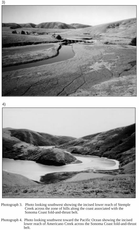
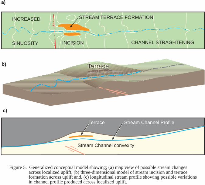
Four major streams and their tributaries flow from east to west across the study area intothe Pacific Ocean. These major streams are Salmon Creek, Americano Creek (called EsteroAmericano at the stream mouth where it enters the Pacific Ocean), Stemple Creek (calledEstero San Antonio at the mouth), and Walker Creek (Figure 4). Of the four streams,Walker Creek is the only stream that lies south of the outcrop limits of the Wilson GroveFormation and, unlike the others that drain to the Pacific Ocean, flows into Tomales Bay.The central parts of these streams have developed broad, essentially flat valleys. However,the lower parts of these streams are deeply incised across the range of hills adjacent to thecoast (Photos 3 and 4). These hills are formed within rocks of the Franciscan Complexand generally are at least 30 m (100 feet) higher than the hills developed on the WilsonGrove Formation to the east.
The upstream reaches of these streams abruptly abut, or terminate against, northwesttrending hills within the Bloomfield fold-and thrust belt, described in this report. Windgaps are present along drainage divides separating the upper stream valleys and Santa RosaValley to the east. These wind gaps generally are aligned roughly perpendicular to theregional trend of faults and associated fold axes. The significance of these windgaps to thehistory of stream development within the region, and the associated landscape evolutionwithin the study area, are discussed in more detail in Section 4.2.6.
With the exceptions noted above, ridges and hilltops within the central part of the studyarea have a generally uniform elevation of 122 to 152 m (400 to 500 feet). Flat summitareas and accordant hilltops within this area, and north of the Russian River, have beencited by previous researchers (Lawson, 1894; Osmont, 1904; Holway, 1913, Dickerson,1922; Fox, 1983) as evidence of a regional erosional surface, initially termed the“Mendocino Plateau” by Lawson (1894). The presence, or absence, of this inferredregional erosional surface, is of critical importance to evaluation of Cenozoic structureswithin the region because: (1) the surface could be used to evaluate regional post-Wilson

1)
2)
English Hill
Photograph 1. Photo of rolling hills developed within the Wilson Grove Formation,looking northeast from Sugarloaf Hill, above Dillon Beach, towardEnglish Hill.
Photograph 2. Photo looking northeast toward English Hill from Highway 1, showingtypical topography associated with outcrops of rock of the FranciscanComplex.

3)
4)
Photograph 3. Photo looking southwest showing the incised lower reach of StempleCreek across the zone of hills along the coast associated with theSonoma Coast fold-and-thrust belt.
Photograph 4. Photo looking southwest toward the Pacific Ocean showing the incised lower reach of Americano Creek across the Sonoma Coast fold-and-thrust
belt.

15
Grove uplift; and, (2) as argued by Fox (1983), the presence of a surface with minimalvertical variation implies the lack of significant deformation since late-Pliocene time.Specifically, Fox (1983) cites the presence of this inferred surface as evidence, along withgentle (<10°) dips in the Wilson Grove Formation, that minimal Quaternary deformationhas occurred within the Sebastopol structural block. However, subsequent streamdissection of the inferred erosional surface, particularly deep incision (up to 300 m) by theRussian River, is consistent with substantial late Quaternary regional uplift. Below wediscuss evidence cited in the literature for and against the "Mendocino Plateau" surface. AsHiggins (1952) noted, the belief in a regional erosional surface of minimal relief as firstsuggested by Lawson (1894), has been widespread and more or less unquestioned amongsubsequent researchers.
2.3.1 Mendocino Plateau
Previous researchers (Lawson, 1894; Osmont, 1905; Holway, 1914; Gealey, 1951; Fox,1983) have noted that accordant rounded summits of the low hills and ridges in the centralpart of the Sebastopol area appear to define an undulating surface. This surface, firsttermed the "Mendocino Plateau" by Lawson (1894), has been described as a regionallyextensive erosional surface inferred to extend northwestward from the Sebastopol region atleast as far north as Fort Bragg. As defined by Fox (1983) the Mendocino Plateau cutsequally across the Franciscan basement and the Wilson Grove Formation and, north of FortRoss, the Ohlson Ranch Formation of Higgins (1960).
However, as originally argued by Lawson (1894), the Mendocino Plateau formed as theresult of initial regional marine planation, followed by deposition and uplift of marinesediments, and subsequent planation of the uplifted sediments. As Higgins (1952) noted,this implies two distinct peneplains with the former once producing the basal surface of theWilson Grove Formation and the younger one beveling the Wilson Grove Formation.However, Lawson (1894) presented no evidence to support a post-Wilson Grove erosionsurface other than the general accordance of ridgecrests and hilltops across the region.Osmont (1905) cited evidence of phola-borings within Franciscan bedrock exposures onthe road from Bodega Bay to the town of Bodega. Higgins (1952) was unable to confirmthe presence of these borings although he noted two large outcrops of the basal WilsonGrove Formation near Bodega that he thought Osmont (1905) might have mistaken forremnants of the Mendocino Plateau. During field reconnaissance for this study we alsowere unable to locate these borings and found no evidence supporting a regionallyextensive, post-Wilson Grove erosional surface. Holway (1914), and subsequentresearchers, including Fox (1983), have primarily cited the presence of flat ridgetops andthe findings of Lawson (1894) and Osmont (1905), to support the existence of theMendocino Plateau surface.
Within the study area, the rolling lowlands within the Wilson Grove Formation have tensof meters of relief between "accordant" summits and ridge crests within rocks of theFranciscan Complex to the north locally have over 300 meters of relief. Higgins (1952)noted that the upper surfaces typically coincide with the contact between the Wilson GroveFormation and Franciscan Complex, and thus appear lithologically controlled. Forexample, based on our field reconnaissance, several broad ridge-tops south of StempleCreek are evidently resurrected remnants of the pre-Merced erosion surface cut intoFranciscan rocks (Photo 5). Only lower topographic spurs within the study area appear tobe possible post-Merced erosional surfaces. The absence of prominent sea stacks, seacliffs, and old beach deposits were cited by Higgins (1952) as evidence that these lowersurfaces may have formed by subaerial exposure rather than regional marine planation. Weexamined several of these lower surfaces for this study, and, where fluvial gravels are

Photograph 5. Photo looking southeast, near Dillon Beach, of an exhumed erosional contact between poorlyconsolidated marine sands within the Wilson Grove formation and underlying resistent beds.

17
preserved, have mapped these surfaces as older terrace remnants deposited by ancestralstreams.
The origin of the accordant hilltops within the study area thus appears to be the result of acombination of lithologic factors, primarily the contrast between erodible sands within theWilson Grove Formation and well indurated rock of the Franciscan Complex, andexhumation of a Pliocene erosional surface. We agree with Higgins’ conclusion that therolling surface in the area underlain by the Wilson Grove Formation likely was formed bysubaerial erosion via ancestral coastal streams (Higgins, 1952). Additionally, locallyexhumed, or "stripped", portions of the erosional surface cut on the Franciscan Complexprior to, or during, deposition of the basal Wilson Grove Formation are associated with flatridge and hilltops within the region. Higgins (1960) noted that the Wilson GroveFormation, and the Ohlson Ranch Formation to the north, clearly have been uplifted andinternally deformed as part of regional uplift. Most of the deformation within the OhlsonRanch Formation, documented on the basis of detailed contouring of the base of the OhlsonRanch deposits (Higgins, 1960), is associated with what he interpreted as discrete blockfaulting. Where stripped, these uplifted blocks typically have formed hills with flat tops(e.g., English Hill). It is remnants of this pre-Wilson Grove Pliocene landscape, or ratherseascape, that we contour in the area south of the Russian River to help constrain regionaltectonic deformation.

18
3.0TECHNICAL APPROACH
Quaternary mapping, field reconnaissance, and geomorphic techniques were utilized toassess the location, style, and, where possible, estimate rates of late Quaternarycontractional deformation within the region between the Rodgers Creek and San Andreasfaults. The initial phase of study involved stereoscopic interpretation of conventional aerialphotographs. Air photo interpretation was used to identify and map Quaternarygeomorphic surfaces, develop a Quaternary stratigraphic framework for the study area, andidentify sites for field reconnaissance. Four vintages of aerial photographs, flown atvarious dates and various scales, were incorporated into the mapping (Table 1).
Table 1. List of Aerial Photography Used in Reconnaissance Mapping.
Date/Series Approx.Scale
Image Type Agency USGS 7.5’ Quadrangles
6/7/42COF series
1:20,000 Black-and-white USDA Valley Ford, Sebastopol, TwoRock, Valley Ford, Cotati, SantaRosa
5/4/61CSHseries
1:22,000 Black-and-white USGS Duncan Mills, Bodega Head,Valley Ford, Tomales, CampMeeker, Sebastopol
6/27/65SONseries
1:12,000 Black-and-white USGS Duncan Mills, Bodega Head,Valley Ford, Tomales, CampMeeker, Sebastopol
6/6/74unnamed
1:20,000 Color USGS Coastal strip within Duncan Mills,Bodega Head, Valley Ford,Tomales
Geomorphic features identified on the aerial photographs were transferred to 1:24,000-scale topographic maps and supplemented by field reconnaissance. Field reconnaissancehelped verify and refine geologic contacts and collection of information on depositsassociated with mapped geomorphic surfaces in readily accessible exposures (e.g., streambanks and roadcuts). Quaternary surfaces identified on the aerial photographs wereverified in the field, where possible, and correlated using geomorphic and stratigraphicposition, relative degree of surface modification, physical continuity within drainagebasins, and, to a limited extent, relative degree of soil-profile development. Fluvial terraceages are generally constrained by vertebrate fossils collected by previous researchers anddocumented in the literature, and by correlation to marine terrace levels based on detailedmapping. Vertebrate fossils collected from terrace deposits within the study area includemammoth, mastodon, horse, and bison (Stirton, 1939).
Unfortunately, as is abundantly documented in the literature (e.g. Johnson, 1934; Travis,1952; and Higgins, 1952), exposures of Quaternary deposits associated with these mappedsurfaces are rare. Additionally, where exposed, semi-consolidated sands and gravels of thePleistocene stream terraces of interest are almost identical to deposits of the Wilson GroveFormation. This similarity is due, in large part, to these deposits typically being derivedeither from the Wilson Grove Formation itself or from similar sources (e.g. reworking ofweathered rocks of the underlying Franciscan Complex). An important exception,however, is the presence of rare clasts of volcanic rock, typically andesite. As notedabove, Johnson (1934) documented the absence of a significant volcanic component within

19
the Wilson Grove Formation. As discussed below in Section 4.2.6, the presence ofvolcanic clasts within the fluvial terrace gravels may provide information on the originalsource areas of the gravels, and thus, the original drainage areas of ancestral streams thatonce flowed across the region.
We conducted geomorphic analyses of the mapped Quaternary surfaces to: (1) evaluatepossible tectonic influences on the geomorphic development of the study area; (2) assessevidence for late Quaternary growth of folds; and (3) constrain uplift rates across folds andfaults. Analyses performed for this study include construction of a structure contour mapon the base of the Wilson Grove Formation, construction of longitudinal terrace and streamchannel profiles, analysis of stream channel morphology using stream-gradient index,evaluation of transverse stream valley morphology across the study area, and assessment ofthe late Quaternary evolution of fluvial drainages across the region. Results from thesetechniques were integrated with our review of published literature and field reconnaissanceto assess evidence for late Quaternary deformation.
First, we contoured the base of the Wilson Grove Formation based on detailed bedrockmapping by Dickerson (1922), Johnson (1934), Weaver (1949), Gealey (1951), andTravis (1952), supplemented by our air photo interpretation and field reconnaissance. Asdescribed above, the Wilson Grove Formation was deposited within a shallow marineembayment upon an erosional surface with minimal initial vertical relief (Johnson, 1934;Bedrossian, 1969; Bedrossian, 1974). We plotted elevations of the contact between theWilson Grove Formation and the underlying Franciscan Complex, where exposed, andused these points to contour the base of the Wilson Grove Formation across the study area.As part of our analysis we constructed regional cross-sections showing folding and faultingof the basal contact of the Wilson Grove Formation based on mapped exposures and,within Santa Rosa Valley, water and oil-test well data.
Second, we examined the distribution of terraces along major drainages within the studyarea including the Russian River, Salmon Creek, Americano Creek, Stemple Creek, andWalker Creek. In addition, we examined the reach of Santa Rosa River incised across thefloor of the Santa Rosa Valley. Of these drainages, we constructed longitudinal terraceprofiles along the Russian River, Americano Creek, and Stemple Creek because thesedrainages contain distinct, well-preserved sequences of fluvial terraces and flow acrosscontractional structures. Surficial geologic maps of terrace and other geomorphic surfacesconstructed for this study were used to construct the longitudinal terrace profiles.Deviations in the profile from an initially graded terrace profile were used to identify loci oftectonic deformation and, when integrated with age constraints, provide a basis forestimating rates of Quaternary deformation.
As part of our analysis of late Quaternary deformation, we also constructed longitudinalprofiles of stream channels along major drainages to help identify the location and style ofdeformation. Field studies by Burnett and Schumm (1983), Merritts and Vincent (1989),Bullard and Lettis (1993), and Marple and Talwani (1993) show that changes in streamchannel gradient may record tectonic uplift. Along streams that are unaffected by regionalor localized uplift, stream gradient generally decreases with distance downstream, typicallyin an exponential or logarithmic manner producing a characteristic convex graded profile(Hack, 1957; Schumm, 1977). Longitudinal profiles of stream channels withinhomogeneous terrain typically are convex upward across an axis of uplift (e.g. Figure 5).Thus downstream variations in channel gradient that are not logarithmic or exponential,typically expressed as a local convexity or concavity in the channel profile, may be relatedto localized uplift or subsidence.
STREAM TERRACE FORMATION
TerraceTerrace
Terrace Stream Channel Profile
Stream Channel convexity
Figure 5. Generalized conceptual model showing; (a) map view of possible stream changesacross localized uplift, (b) three-dimensional model of stream incision and terraceformation across uplift and, (c) longitudinal stream profile showing possible variationsin channel profile produced across localized uplift.
INCISION CHANNEL STRAGHTENING
INCREASED
SINUOSITY
a)
b)
c)

21
In addition, localized uplift or subsidence may change the stream channel gradient,upsetting the equilibrium between channel gradient and hydraulic properties of the stream(Ouchi, 1985). Localized disruption of these properties may be expressed as straighteningof the channel on the upstream side of an uplift and incision across the central reach of theuplift with associated development of a series of fluvial terraces (Ouchi, 1985; Figure 5).Often these terraces are absent, or poorly preserved, elsewhere along the stream channel.These terraces can be diagnostic of localized uplift and useful in evaluating the amount offolding or faulting across the uplift. Downstream of an axis of uplift, stream sinuositygenerally increases as the stream attempts to maintain a uniform stream gradient on thesteepened slope. For this study, the stream-gradient index (Hack, 1973), that relateschannel gradient to channel length is used to analyze the longitudinal stream profiles. Asdefined by Hack (1973), the stream-gradient index is equal to the product of the channelslope at a point and total stream length from the drainage divide to that point as shown:
SL (stream gradient index) = ∆H/∆L*L (1)
where ∆H/∆L is the channel slope or gradient (∆H is the change in elevation of the streamreach and ∆L is the length of the reach), and L is the total channel length from the streamdivide.
The stream-gradient index is a means of quantifying stream power, with higher indexvalues representing stream reaches with greater available power to incise and transportsediment. The stream-gradient index is very sensitive to changes in channel gradient,which generally correspond to differences in bedrock strength, particle size, and loadsupplied to the stream. Where climatic factors and lithological controls on the fluvialsystem are effectively constant, anomalously high stream-gradient values typically areinterpreted to indicate localized uplift (Keller and Pinter, 1996). Unfortunately, rockstrength varies significantly across the study area, and this technique must be used withcaution. Poorly consolidated marine Pliocene deposits of the Wilson Grove Formationunderlie the central portion of the study area (Figure 3). Based on outcrop and topographicexpression, the most resistant rocks in the study area are rocks of the Franciscan Complex.However, there is significant variability within the Franciscan Complex. For this reason,we present index data only as one line of evidence among several. Where presented, thestream-gradient index is calculated for stream reaches underlain by similar bedrock unitsand any variations between reaches are identified and discussed.
Climatic and cultural changes are an additional source of error that may have obscured or,at worst, produced changes in the channel profiles and stream-gradient index that appeartectonically controlled. For the purpose of our geomorphic analyses, climatic influencesare assumed minor. The late Pleistocene climate of the coastal areas of northern Californiawas characterized by alternating glacial and interglacial periods but variations along thecoast were of much less magnitude that of continental interior regions, based on vegetationchanges (Johnson, 1977). However, early settlers and cattle grazing have had, andcontinue to have, profound impacts on erosion within the area. For example, a smalltributary of Walker Creek was formerly the tidewater port for the town of Tomales about1860. At that time, the tributary had enough water at high tide for schooners and a smallsteamer to bring supplies. The harbor was abandoned around 1875 because cultivation ofthe former grass-covered slopes had resulted in rapid erosion and associated filling of thechannel (Holway, 1914). Where possible, we attempt to identify any climatic or culturalchanges that may influence our interpretation.
Stream valley morphology is used in the present study to describe changes in stream valleymorphology in relation to inferred Quaternary contractional structures. Specifically, theratio of valley height to valley-floor width provides a measure of geomorphic changes in

22
relation to localized Quaternary uplift. Bull and McFadden (1977) expressed transversevalley morphology as a ratio of valley-floor width to valley height (Vf), that may be definedas:
Vf = 2Vfw / ((Eld - Esc) + (Erd - Esc)) (2)
Where Vfw is the width of the valley floor, Eld and Erd are elevations of the left and rightvalley divides, and Esc is the elevation of the stream channel. For this study, the ratio wasalong Salmon, Americano, and Stemple Creeks and used to compare valley morphologyacross hills associated with uplift and between belts of hills. Channel incision typically isstrongly influenced by a relative base-level fall due to tectonic uplift. Broad-floored valleysmay be indicative of areas of subsidence or areas that are uplifting at relatively low rates.Narrow valleys typically reflect stream incision that commonly is associated with tectonicuplift.
Finally, small-scale regional topographic maps (historic 1:62,500-scale Santa Rosa andSebastopol quadrangle with 50 ft contours; and the 1:100,000-scale Napa quadrangle with50 m contours) were used to assess the geomorphic evolution of the study area. Duringour limited field reconnaissance, we examined major stream and wind gaps carefully forremnants of deposits. Relative correlation of the windgaps and stream gaps is attemptedbut such correlations are only tentative, as we uncovered no datable material during ourfield investigations.

23
4.0RESULTS
4.1 Quaternary Stratigraphy
Thirteen Quaternary map units are present within the study area based on interpretation ofaerial photographs and field reconnaissance. From oldest to youngest, map units include:(1) a sequence of five marine terraces along the coast between the mouth of the RussianRiver at Jenner and Tomales Bay; (2) older alluvial fan deposits (unit Qof) within SantaRosa Valley; (3) isolated fluvial terrace remnants (unit Qt1) on the divide separating SantaRosa Valley from streams to the west; and (5) a sequence of three to five fluvial terracesalong the Russian River, Salmon Creek, Americano Creek, Stemple Creek, and WalkerCreek (units Qt1 to Qt5). Of these mapped deposits, and associated surfaces, the marineterraces and fluvial terraces are the most important for our evaluation of tectonicdeformation and are described in more detail below.
4.1.1 Marine Terraces
The section of coastline between the Russian River and Bodega Bay contains some of thebest-developed and preserved terraces along the entire Sonoma coast (Figure 6). As part ofour mapping, we compiled mapping by Travis (1952), Bauer (1952), and unpublishedreconnaissance mapping by K. Lajoie and J. Tinsley of the USGS. Bauer (1952) mappedfive terrace levels along the coast between the Russian River and Salmon Creek. Weconducted limited field reconnaissance to delineate and correlate the major terraces.Because of the rugged terrain and lack of access, with the exception of well-exposedterraces near Bodega Bay and Dillon Beach, we primarily relied upon aerial photographicinterpretation to map discontinuous terraces along the coast south of Bodega Bay. Marineterraces located between Bodega Bay and Dillon Beach, and fluvial terraces along the lowerreaches of Americano and Stemple Creeks, are shown on Figures 7 and 8.
The lowest marine terrace (map unit Qmt5) is expressed as broad, well-preserved surfacesbetween the Russian River and Bodega Bay (Figure 6) and discontinuous remnantsbetween Bodega Bay and Dillon Beach (Figure 7 and 8). The terrace wave-cut platform isveneered by up to one meter of marine deposits based on exposures within gullies along thecoast (Photo 6). The terrace deposits consist of well-bedded sand and gravel with well-rounded pebbles that typically seldom exceed 4 cm in diameter.
We infer that the lower marine terrace (Qmt5) is associated with the stage 5e (125 ka) sealevel high stand, the highest late Pleistocene highstand formed when the sea level was atleast 6 to 8 m higher than present. This correlation is based on the geomorphic similarity ofthe broad terraces to those formed during the stage 5e elsewhere along the California coast(Kennedy et al., 1982) and to broad surfaces associated with the Millerton Formationwithin Tomales Bay, south of the study area. Samples collected from the MillertonFormation within Tomales Bay that are associated with surfaces at roughly the sameelevation as the lower marine terrace Qmt5, yielded a TL age of 134±12 ka (G.W Bergercited in Grove and others, 1995). This age is consistent with a similar aminostratigraphicage that suggests that parts of the Olema Creek and Millerton Formations were depositedsimultaneously during the 5e substage highstand of sea level (Grove and others,1995).Additionally, Dwyer and Borchardt (1994) correlated an exposure of the lower terrace atBodega Bay, location shown on Figure 6, to oxygen isotope stage 5e based on soildevelopment.


Photograph 6. Exposure of marine terace deposits (Qmt5) overlyingwave-cut platform (substage 5e, 125 ka) at Dillon Beach.
Marine terrace deposits
Franciscan bedrock

28
Older, higher marine terrace surfaces (Qmt 4 through Qmt1) are associated with wave-cutplatforms that are typically more discontinuous and poorly preserved than the lowestmarine terrace. We found no exposures of bedded gravels associated with these surfacesalthough well-rounded pebbles are occasionally present. The slopes of these surfacestypically dip westward (seaward) at about three and 1/2 percent (Bauer, 1952) and theterrace deposits locally dip westward up to 20 degrees (Travis, 1952).
4.1.2 Fluvial Terraces
Five terrace levels are present along the lower Russian River (Gealey, 1952; Higgins,1952; this study). These terraces, typically preserved as isolated remnants within ruggedand often inaccessible terrain, were first mapped in detail and correlated by Higgins (1952).During our field reconnaissance, we examined several of the localities described by Gealey(1952) in the northeastern portion of the study area and by Higgins (1952) along the lowerRussian River, but found no datable materials. As noted by Higgins (1952) the RussianRiver terraces are cut, without exception, on rocks of the Franciscan Complex and thedeposits can be differentiated from Franciscan conglomerate primarily by the presence ofpebbles derived from the Sonoma Volcanics exposed to the east.
South of the Russian River, a sequence of two to four distinct fluvial terraces are identifiedalong Salmon, Americano, Stemple, and Walker Creeks. These terraces are most poorlydeveloped, or preserved, along Salmon Creek and Walker Creek. The deposits underlyingthese terraces are designated, from oldest to youngest, mapping units Qt1 to Qt4. Unit Qt4is relatively widespread, preserved as broad surfaces along the central portions ofAmericano and Stemple Creeks. Where exposed, unit Qt4 is preserved as thin (<0.5 mthick) fluvial gravels associated with strath (fluvially cut) surfaces. In areas of poorexposure, bedding within the Wilson Grove Formation and/or the contact between the basalWilson Grove Formation and underlying rocks of the Franciscan Complex can appearsimilar to unit Qt4 (Photos 7 and 8). Units Qt2 and Qt3 locally are preserved as isolated,thin deposits of fluvial gravel and gravelly sand associated with strath surfaces cut either onbedrock of the Wilson Grove formation or on rocks of the Franciscan Complex (Photos 9and 10). Unit Qt1 forms isolated flat surfaces on topographic spurs and lower hilltops andis preserved within prominent wind gaps.
4.1.3 Correlation and Age of Map Units
The ages of marine terraces are estimated, as shown in Figure 9, by: (1) extrapolating thederived uplift rate (after Chappell, 1974) and; (2) correlating terraces with sea-level high-stands (after Pillans, 1983; Lajoie, 1986). First, the elevation of the wave-cut platform ofunit Qmt5, currently 24±2 m above sea level and assumed to be correlative with the stage5e (125 ka) sea level high stand (approximately 6 m above current sea level), was used toobtain an uplift rate of about 0.14 mm/yr. Second, the elevations of the older terraces wereplotted, along the slope of the derived uplift rate, versus inferred age. Finally, theelevations of the marine terraces above sea level were correlated to the sea level curve ofChappell (1983), as calibrated to oxygen isotope stages of Shackelton and Opdyke (1973).The slope of the correlation lines, equivalent to the derived uplift rate, are parallel asrequired by the method described by Pillans (1983) and Lajoie (1986).
Fluvial terraces in the study area were identified and correlated primarily by geomorphicand stratigraphic position within the terrace sequence, relative degree of surfacemodification, presence of fossils, and correlation to marine terrace levels. Due to the lackof good exposures, and minimal thicknesses of the terrace gravels associated with strathsurfaces, we were not able to evaluate relative soil profile development with confidence.

AREA OF PHOTO 8
Wilson Grove Formation outcrop
7)
8)
Photograph 7. Photo looking northeast across Estero Americano showing the broad alluvial valley and stream terraces east of the Sonoma Coast fold-and-thrust belt.
Photograph 8. Photo looking east at exposure of deposits within the Wilson Grove Formation showing how bedding can mimic a fluvial terrace surface.

Photograph 9. Photo of exposure of stream terrace deposits (Qt3) overlying the WilsonGrove Formation near Valley Ford.
Photograph 10. Photo of stream terrace deposits in contact with Franciscan bedrock, southof bridge crossing of Stemple Creek on Highway 1. Photo 10a is a close-upof the deposits showing the sub-rounded terrace gravels (Qt3).
9)
10)
10 a)
0 10 cm
Wilson Groveformation
Terracedeposits

100
0 100 200 300 400 500 600
500 400 300 200 100 0
Age (ka)
-10035
6
7
8
9
18O
STAGES
13 12 11
10e
ca
1
2
SEA LEVEL
-160
Ele
va
tio
n (
in m
)
Age (ka)
Qmt5
Qmt4Qmt3
Qmt2Qmt1
rate of uplift = 0.14 m/ka
Figure 9. Diagram showing tentative correlations and general uplift history of marine terraces along theSonoma coast between the Russian River and Dillon Beach. The numerals (1 through 13) areoxygen isotope stages from Shackelton and Opdyke (1973) and the sea level curve is fromChappel (1983).

32
Therefore, ages of the fluvial terraces are constrained by correlation to marine terrace levelsand vertebrate fossils previously identified within the fluvial terrace deposits.
For example, a thin fluvial terrace remnant at an elevation of 30.5 m (100 feet), located 2.4km (1.5 miles) N55°E of Dillon Beach contained Rancholabrean fauna consisting of amastodon molar, three mammoth molars, and part of a bison horn collected by R. A.Stirton (located on Figure 8 based on independent citations in Johnson, 1934; Higgins,1952). Estimates for the beginning of the Rancholabrean range from about 10 ka to 550ka. The earliest record of Bison in the conterminous United States, based on Bell (1998),is from Teichert Quarry near Sacramento where it was assigned an age of approximately130 ka (Repenning and others, 1990). Therefore, we infer that this terrace, mapped as unitQt3, likely is approximately 130 ka or older, but no older than 550 ka
Additional Rancholabrean fossil localities previously identified along major drainageswithin the study area are used to correlate fluvial terraces across the region (Figure 4).Remains of the ground sloth Mylodon harlani were found in fluvial gravels (mapped as unitQt2) approximately 11 km (7 miles) northwest of Petaluma, west of the main roadconnecting Stony Point with Cherry. Rancholabrean fossils found in fluvial gravels alongEbabias Creek (Section 18, Township 6N Range 9W), a tributary of Americano Creek,include Artiodactyla Bovidae (UCMP #V72107, specimen number 119351), and the midhumerus of Perissodactyla Equidae (UCMP #V72107, specimen number 119350). Thesegravels, and the fossils they contain, are used to correlate fluvial terrace unit Qt3, and thefluvial terrace sequence, across the study area.
Approximate ages of the fluvial terrace sequence are estimated via correlation to the marineterrace sequence along the coast (Table 2). These correlations are based on detailedmapping of fluvial and marine terraces the lower stream reaches of Americano and StempleCreeks adjacent to the coast (Figures 7 and 8). Two of the four major fluvial terraces (unitsQt2 and Qt3) grade to marine terrace levels (Qtm3 and Qtm4 respectively). Correlation andestimated age of the oldest fluvial terrace (Qt1) is based primarily on relative position withinthe terrace sequence and is uncertain as no well-preserved remnants of this terrace weremapped at or near the coast. The age of the youngest terrace (Qt4) is tentatively estimatedbetween 25 ka and 130 ka, based on relative elevation within the terrace sequence.
Table 2. Estimated ages and correlation of marine and fluvial terraces.
MarineTerrace
Elevation abovesea level (in m)
Estimatedage (in ka)
FluvialTerrace
Elevation above modernstream channel (in m)
Estimatedage (in ka)
Qmt1 79±3 516 - - -
Qmt2 73±3 472 - - -
Qmt3 61±2 385 Qt1 73 to 76 385-472
Qmt4 52±2 320 Qt2 27 to 39.5 320
Qmt5 24±2 125-130 Qt3 18.2 to 25.1 130
- - - Qt4 6 to 12.2 25-130
4.2 Geomorphic Analyses
Deformation within the Sebastopol structural block by past researchers almost exclusivelyhas been evaluated based on bedding dips and mapped offset of units within the "Merced"

33
Formation of Johnson (1934), renamed the Wilson Grove Formation by Fox (1983).Because the average dip of the Wilson Grove Formation typically is less than 10°, uplift ofthe region was thought to have occurred with minimal internal deformation of the block(Fox, 1983; Furlong et al., 1989). However, our structure contour map on the base of theWilson Grove Formation documents up to 300 meters of uplift, and minimum verticalseparation of at least 183 m (over 600 feet) across the Bloomfield fault (Figure 10). Belowwe discuss the deformation of the base of the Wilson Grove Formation, based on ourstructure map and a regional east-west cross-section showing inferred folding and faultingof the Wilson Grove Formation across the study area.
Because the Rodgers Creek fault system likely developed within the last 2-4 Ma (Helleyand Herd, 1977), the rate and distribution of late Quaternary strain within the region maynot wholly reflected by deformation of the Wilson Grove Formation. In particular, thetiming of the initiation of faulting and folding within the Wilson Grove is not wellconstrained. Therefore, we evaluate deformation of the Wilson Grove Formation inconjunction with other strain indicators in the late Quaternary geologic and geomorphicrecord.
4.2.1. Contours on the base of the Wilson Grove Formation
Contoured elevations of the base of the Wilson Grove Formation show substantial regionaluplift across the Sebastopol structural block, with maximum uplift within the centralportion of the block roughly equidistant between the San Andreas and Rodgers Creek faults(Figure 10). Across the Sebastopol block, the base of the Wilson Grove Formation has anoverall antiformal shape with maximum elevations of approximately 200 to 330 m (up to1100 ft) above sea level. Bedding dips in the Wilson Grove Formation show a generalnortheastward tilting (8° to 12°) of the formation between San Andreas fault and the SantaRosa Valley. This deformation is consistent with uplift and tilting of the base of the WilsonGrove Formation across the Sebastopol block.
Locally, the base of the Wilson Grove Formation is offset across the northwest-trendingAmericano Creek, Joy Woods, Bloomfield, Dunham, and Burdell Mountain faults (Figure11). Contours on the base of the Wilson Grove Formation are consistent with anticlinalfolding within the hanging walls of these inferred reverse faults. Specifically, a series ofnorthwest stepping anticlines are mapped within the hanging walls of the Dunham,Bloomfield, and Joy Woods faults (Figure 10). These folds have exhumed the basalWilson Grove Formation locally up to an elevation of 330 m (1100 ft). We call this seriesof folds and related faults, the ‘Bloomfield fold-and-thrust belt’. The contours on the baseof the Wilson Grove Formation show that localized contraction within the fold-and-thrustbelt progressively steps to the northwest from the Dunham and Bloomfield faults to the JoyWoods and related faults.
The Wilson Grove Formation extends beneath Santa Rosa Valley where it is covered byyounger deposits (Figure 11). The Wilson Grove has been identified in the subsurfacebeneath Santa Rosa Valley based on the presence of diagnostic fossiliferous sandstonewithin water and oil-test wells. For example, oil-test well 7/9-24ja, drilled in 1948, andlocated 4.2 km (2.6 miles) northeast of Sebastopol in Santa Rosa Valley penetrated marinedeposits of the Wilson Grove Formation from a depth of 59 m (195 feet) to the bottom ofthe well at 632 m (2,075 feet) except for an interval of continental deposits between depthsof 187 m and 251 m (615 to 826 feet) (Cardwell, 1958).
Adjacent to the Sonoma coast, the basal Wilson Grove Formation has been uplifted over150 m (500 ft) and locally stripped within a 3 to 5 km (2 to 3 miles) wide zone. Elevationsof the base of the Wilson Grove decrease inland as the contact between the Wilson Grove


B
Bloom
field fault
Twg
Laguna de Santa RosaAmericano Creek
elev
atio
n (in
feet
)
Southwest Northeast
Glen Ellen Formation
Wilson Grove Formation
Wilson Grove formation
Franciscan ComplexFranciscan Complex
V.E. =10x
Figure 11. Southwest-northeast cross-section A-A’ from the Pacific Ocean to the eastern margin of Santa Rosa Valley.
PetalumaFormation
sea level
A A’
Santa Rosa Valley
0
1,000
-1,000

36
Formation and underlying Franciscan Complex flatten to sub-horizontal. Inland of theSonoma Coast fold-and-thrust belt, the basal contact is essentially horizontal and theFranciscan Complex is exposed by lateral incision of Americano and Stemple Creeks.These ‘windows’ exposing the Franciscan Complex trend roughly southeast-northwest andcoincide with the projection of Salmon Creek fault and unnamed folds mapped within theFranciscan Complex southwest of the Burdell Mountain fault by Weaver (1949). Weinterpret this pattern as possibly reflecting synclinal folding between the Bloomfield andSonoma Coast fold-and-thrust belts. Interestingly, the inferred syncline roughly coincideswith the submerged portion of Americano Creek, occupied by Estero Americano, possiblyreflecting localized subsidence.
4.2.2 Fluvial Terrace Longitudinal Profiles
Fluvial terrace profiles provide a means of assessing both regional deformation andlocalized deformation across specific folds and faults. Detailed longitudinal profiles ofterraces along two of the four streams that cross the study area (Americano and StempleCreeks) were constructed from 1:24,000-scale USGS topographic maps (Stemple Creek isshown in Figure 12). These drainages have at least one widespread, and relatively wellpreserved, terrace extending across transverse Cenozoic structures, including theBloomfield fault. Salmon Creek, located north of the outcrop of Wilson Grove Formation,and Walker Creek, located south of the outcrop of the Wilson Grove Formation are bothdeeply incised into the Franciscan Complex. These streams do not have well-developedand/or well-preserved terrace sequences.
4.2.2.1 Americano CreekAmericano Creek has its headwaters currently within the distinctive hills northeast of theBloomfield fault. As described earlier, windgaps in the hills to the east indicate that theheadwaters of the creek at one time extended into the Santa Rosa Valley. The creek flowssouthwest across the Dunham and Bloomfield faults before abruptly turning westward,flowing sub-parallel to the Americano Creek fault to the south. With the exception ofincision across a block of uplifted Franciscan Complex within the hanging wall of theBloomfield fault, Americano Creek flows within deposits of the Wilson Grove Formationbetween Bloomfield and Valley Ford. West of Valley Ford, Americano Creek is incisedbelow the contact between the Wilson Grove Formation and underlying FranciscanComplex (Figure 7). Approximately 2 km west of Valley Ford, American Creek flows intoEstero Americano, a broad estuary formed by late Holocene sea level rise, or tectonicsubsidence, drowning the former mouth of the creek. Several terrace remnants arepreserved within the rugged range of hills formed by the Sonoma Coast fold-and-thrust beltadjacent to the San Andreas fault.
We identify a sequence of three distinct terraces and higher terrace remnants (units Qt4through Qt2, and unit Qt1) along Americano Creek. The discontinuous nature of the terracesequence along Americano Creek, presence of exhumed portions of the Wilson Grove-Franciscan contact west of Valley Ford, and the fault-parallel orientation of the stream reachwithin the fault block between the Bloomfield and American Creek faults makesinterpretation of the profile problematic. Specifically, the central reach of Americano Creeknear Valley Ford contains numerous surfaces that appear to be terraces but likely are eitherdeveloped on horizontal bedding within the Wilson Grove Formation and/or the contactbetween the Wilson Grove Formation and the underlying Franciscan Complex.
4.2.2.2 Stemple Creek Stemple Creek has its headwaters currently within the distinctive hills northeast of theBloomfield fault. Stemple Creek flows southwest across the Dunham and Bloomfield

37
faults before turning westward. Within its central reach between Two Rock and theSonoma Coast fold-and-thrust belt, Stemple Creek is incised into a broad bedrock floor.
We identify a sequence of three distinct terraces (units Qt3, Qt2, and unit Qt1) alongStemple Creek (Figure 12). The longitudinal terrace profile shows maximum elevations ofthe fluvial terraces upstream of the Bloomfield fault (within the hanging wall of the fault),and across the Sonoma fold-and-thrust belt adjacent to the coast. Fluvial terrace Qt2 is at amaximum elevation of 39.5 m and fluvial terrace Qt3 at a maximum elevation of 18.3 mwithin the hanging wall of the Bloomfield fault. The maximum elevations above sea levelfor fluvial terrace Qt2 across the Sonoma fold-and-thrust belt are 36.5 m and 30 m forfluvial terrace Qt3. These areas of locally elevated terraces coincide with localized uplift ofthe base of the Wilson Grove formation (shown on Figure 12). We therefore conclude thatthe fluvial terrace profile shows Quaternary warping across the Bloomfield fold-and-thrustbelt and the Sonoma Coast fold-and-thrust belt.
4.2.3 Marine Terrace Profile
A coast-parallel profile of marine terraces between the Russian River and Bodega Bayprovides evidence of general uplift along the coast (Figure 13). Based on the outcrop ofthe Wilson Grove Formation, maximum uplift and stripping of the Wilson Grove depositshas occurred roughly adjacent to the coast. Thus, marine terraces between Salmon Creekand Dillon Beach likely are located at, or near, the crest of the uplift along the inferredSonoma Coast fold-and-thrust belt. As described above, and illustrated in Figure 9, ourtentative correlation of these terraces suggests a relatively low uplift rate of approximately0.14 mm/yr along the Sonoma Coast fold-and-thrust belt.
South of Bodega Bay, the maximum uplift of the basal Wilson Grove Formation and, byinference the crest of the uplift associated with the Sonoma Coast fold-and-thrust belt, islocated inland approximately 0.5 to 1 km (e.g. Figure 12). West of this uplift, based oninspection of aerial photographic mapping transferred to topographic maps, several marineterraces appear to be tilted westward toward the ocean. In addition, Travis (1952) notedthat terrace deposits dip westward up to 20 degrees about 1.7 km (1 mi) north of DillonBeach. Although we were unable to obtain access to the locality mentioned by Travis(1952), the observed westward tilting of the terrace deposits suggests that the marineterraces have been progressively tilted within the western flank of folds within the Sonomafold-and-thrust belt.
4.2.4 Fluvial Channel Profiles
Detailed longitudinal profiles of the four streams that cross the study area (Salmon,Americano, Stemple, and Walker Creeks) were constructed from 1:24,000-scale USGStopographic maps. For this study, average stream-gradient index values were calculatedfor stream reaches with similar gradients, which are associated with linear slopes on semi-logarithmic stream profiles. Merritts and Vincent (1989) have shown that stream-gradientindex values can be useful in distinguishing areas with high uplift rates from areas with lowto intermediate rates. Specifically, in areas of rapid uplift, index values typically are highand stream profiles are convex on semi-logarithmic plots.
Rock resistance is closely correlated to stream-gradient index values as index valuestypically increase across hard rock and decrease against soft rock (Hack, 1973). SalmonCreek and Walker Creek are both incised within rocks of the Franciscan Complex.However, Americano and Stemple Creeks are incised within both the Wilson GroveFormation and rocks of the Franciscan Complex. Therefore, for the purpose of this study,

Wilson Grove Fm
Wilson Grove
WilsonG
roveFm
Wilson Grove Fm
Wilson
Grove
Fm
Qmt4
Qmt5
BLO
OM
FIE
LD F
AU
LT
AM
ER
ICA
NO
CR
EE
K F
AU
LT
Qt2
Qt3
Qt4
Qt2
Qt3Qt4
Figure 12. Longitudinal terrace profile along Stemple Creek.
UN
NA
ME
D F
AU
LT
UN
NA
ME
D F
AU
LT
modern stream channel
Qt2Qt3Qt4
modernstream
channel
LEGEND
Qmt4Qmt5
H H
DD
DD
DD
D
JJ
HH
JJ
HH
J J
J J
11
H H
;;JJJJJJJJ
1 1H H
66
J J
ÖÖ
ÇÅ Å
M M
â
Ö Öà à
1111
JJJ J
1 1
HH
ÑÉ É
Å Å
0
100
200
300
400
500
80000 70000 60000 50000 40000 30000 20000 10000 0
HHHHHHH
HH
JJJJ
JJ
â
J J JJJJ
Ö
H H
J JJJ J
1 1
J JH H
ââ
Ö Ö
Horizontal Distance (in feet)
Ele
vatio
n (f
t)
JJ

D
111111
3 3
3333 33
100
200
300
400
0 10000 20000 30000 40000 50000 60000 70000
Qmt5
Qmt4
Qmt5
Qmt3
Qmt3Qmt2
elev
atio
n (in
feet
)
Horizontal distance (in feet)
Figure 13. Profile B-B’ of marine terraces between the Russian River and Bodega Bay (see Figure 6 for location)
BB’
southeastnorthwest
Qmt1
Qmt2
Qmt3
Qmt4

40
the stream-gradient index primarily is used to identify anomalously high index valueswithin stream reaches underlain by a particular rock type.
4.2.4.1 Salmon Creek The average stream-gradient index values for Salmon Creek range from 136 to 523gradient-feet for eight stream segments and are illustrated on a semi-logarithmic streamprofile (Figure 14). The profile of Salmon Creek exhibits a large convexity within theupper three stream reaches. The observed convexity likely reflects the recent streamcapture of an unnamed tributary that formerly flowed into Dutch Creek toward the RussianRiver. This stream capture coincides with a prominent wind gap, located 1 km south ofOccidental, that separates Dutch Creek and upper Salmon Creek (Figure 4). Although thereis no apparent convexity across the fault blocks associated with the Joy Woods fault, thesteep gradient of Salmon Creek is suggestive of active fluvial response to broad uplift.
4.2.4.2 Americano Creek The average stream-gradient index values for Americano Creek range from 60 to 165gradient-feet for five stream segments (Figure 15a). Overall, the stream profile is convexupstream of the Bloomfield fault and essentially flat downstream. A pronounced streamconvexity is present between the Dunham and Bloomfield faults. However, this convexityalso coincides with incision of Americano Creek across resistant rock of the FranciscanComplex between these two faults.
4.2.4.3 Stemple Creek The average stream-gradient index values for Stemple Creek range from 39 to 202 gradient-feet for five stream segments (Figure 15b). A broad stream convexity is present withinrocks of the Franciscan Complex upstream of the Bloomfield fault. This convexitycoincides with the remarkably linear upper portion of Stemple Creek that is aligned with aprominent wind gap to the northeast (Figure 4). The windgap is located within thenortheast-trending Washoe Anticline that separates Stemple Creek from Lichau Creek to theeast. This linear upper portion of Stemple Creek likely represents an older stream reachbeheaded from its headwaters by uplift along the Washoe Anticline. Currently the upperdrainage basin of Stemple Creek is insufficient to explain the presence of this well-entrenched, broad stream valley. The observed convexity within the hanging-wall of theBloomfield fault therefore may represent subsequent uplift and folding of this stream reach.
4.2.4.4 Discussion Systematic variations in the stream gradient index and anomalous index values generallycorrespond with stream reaches traversing uplifted fault blocks and folds within the WilsonGrove Formation. In general, the highest index values occur at, or slightly upstream of,mapped northeast-dipping faults. These variations in stream index values suggest that thestreams have responded to late Quaternary fold growth by adjusting the gradients of theirchannels. However, these variations in the stream gradient index coincide with distinctchanges in rock type traversed by the streams. Therefore, the observed pattern, althoughindicative of tectonic uplift, may represent the influence of lithological controls on thefluvial system. Thus, although the distribution of rock types is fault controlled (i.e. blocksof rock within Franciscan Complex are bounded by major faults), the stream channelvariations in themselves may not provide as reliable an indicator of recent uplift asdemonstrated by Merritts and Vincent (1989).
4.2.5 Stream Valley Morphology
As noted previously in Section 2.3, in their middle reaches, Salmon, Americano, andStemple creeks meander through fairly broad valleys. Valley height to valley-floor widthratios reveal morphologic changes in the valleys of Salmon, Americano, and Stemple

0
100
200
300
400
500
600
700
800
100000 10000 1000
JOY
WO
OD
S F
AU
LT
ST
RE
AM
CA
PT
UR
E
136
184
523
257
140
254
180
190
Distance from stream divide (in feet)
Ele
vatio
n (in
feet
)
Figure 14. Stream channel profile of Salmon creek shown on semilogarithmic plot.Average stream-gradient index values are shown on the left of each stream reach.

0
100
200
300
100000 10000 1000
0
100
200
100000 10000 1000
DU
NH
AM
FA
ULT
BLO
OM
FIE
LD F
AU
LT
FranciscanComplex
Wilson Grove (W. G.) Fm.W. G.Fm.
FranciscanComplex
AM
ER
ICA
NO
CR
EE
KFA
ULT
W. G.Fm.
BLO
OM
FIE
LD F
AU
LT
300
FranciscanComplex
a)
b)
Figure 15. Stream channel profile of: (a) Americano Creek and, (b) Stemple CreekAverage stream-gradient index values are shown on the left of eachstream reach.
Distance from stream divide (in feet)
Ele
vatio
n (in
feet
)
Distance from stream divide (in feet)
Ele
vatio
n (in
feet
)
56
77
39
84
202
69
143
60165
88
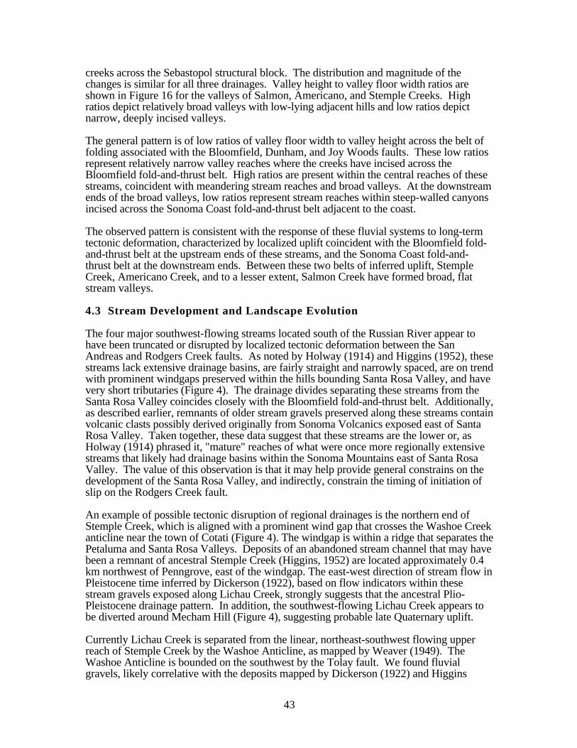
43
creeks across the Sebastopol structural block. The distribution and magnitude of thechanges is similar for all three drainages. Valley height to valley floor width ratios areshown in Figure 16 for the valleys of Salmon, Americano, and Stemple Creeks. Highratios depict relatively broad valleys with low-lying adjacent hills and low ratios depictnarrow, deeply incised valleys.
The general pattern is of low ratios of valley floor width to valley height across the belt offolding associated with the Bloomfield, Dunham, and Joy Woods faults. These low ratiosrepresent relatively narrow valley reaches where the creeks have incised across theBloomfield fold-and-thrust belt. High ratios are present within the central reaches of thesestreams, coincident with meandering stream reaches and broad valleys. At the downstreamends of the broad valleys, low ratios represent stream reaches within steep-walled canyonsincised across the Sonoma Coast fold-and-thrust belt adjacent to the coast.
The observed pattern is consistent with the response of these fluvial systems to long-termtectonic deformation, characterized by localized uplift coincident with the Bloomfield fold-and-thrust belt at the upstream ends of these streams, and the Sonoma Coast fold-and-thrust belt at the downstream ends. Between these two belts of inferred uplift, StempleCreek, Americano Creek, and to a lesser extent, Salmon Creek have formed broad, flatstream valleys.
4.3 Stream Development and Landscape Evolution
The four major southwest-flowing streams located south of the Russian River appear tohave been truncated or disrupted by localized tectonic deformation between the SanAndreas and Rodgers Creek faults. As noted by Holway (1914) and Higgins (1952), thesestreams lack extensive drainage basins, are fairly straight and narrowly spaced, are on trendwith prominent windgaps preserved within the hills bounding Santa Rosa Valley, and havevery short tributaries (Figure 4). The drainage divides separating these streams from theSanta Rosa Valley coincides closely with the Bloomfield fold-and-thrust belt. Additionally,as described earlier, remnants of older stream gravels preserved along these streams containvolcanic clasts possibly derived originally from Sonoma Volcanics exposed east of SantaRosa Valley. Taken together, these data suggest that these streams are the lower or, asHolway (1914) phrased it, "mature" reaches of what were once more regionally extensivestreams that likely had drainage basins within the Sonoma Mountains east of Santa RosaValley. The value of this observation is that it may help provide general constrains on thedevelopment of the Santa Rosa Valley, and indirectly, constrain the timing of initiation ofslip on the Rodgers Creek fault.
An example of possible tectonic disruption of regional drainages is the northern end ofStemple Creek, which is aligned with a prominent wind gap that crosses the Washoe Creekanticline near the town of Cotati (Figure 4). The windgap is within a ridge that separates thePetaluma and Santa Rosa Valleys. Deposits of an abandoned stream channel that may havebeen a remnant of ancestral Stemple Creek (Higgins, 1952) are located approximately 0.4km northwest of Penngrove, east of the windgap. The east-west direction of stream flow inPleistocene time inferred by Dickerson (1922), based on flow indicators within thesestream gravels exposed along Lichau Creek, strongly suggests that the ancestral Plio-Pleistocene drainage pattern. In addition, the southwest-flowing Lichau Creek appears tobe diverted around Mecham Hill (Figure 4), suggesting probable late Quaternary uplift.
Currently Lichau Creek is separated from the linear, northeast-southwest flowing upperreach of Stemple Creek by the Washoe Anticline, as mapped by Weaver (1949). TheWashoe Anticline is bounded on the southwest by the Tolay fault. We found fluvialgravels, likely correlative with the deposits mapped by Dickerson (1922) and Higgins

0 2 4 6 8 10 12 14 16 18 20
0
5
10
15
20
25
0 2 4 6 8 10 12 14 16 18
0
5
10
15
0 2 4 6 8 10 12 14 16 18 20 22 24
0
5
10
15
20
25
30
Distance upstream from Pacific Ocean (in km)
Distance upstream from Pacific Ocean (in km)
Distance upstream from Pacific Ocean (in km)
Figure 16. Plots of the ratio of valley floor width to valley height versus distance upstream from the Pacific Ocean for; (a) Salmon Creek, (b) Americano
Creek and, (c) Stemple Creek.
Rat
io o
f val
ley
floor
wid
th to
val
ley
heig
ht
Rat
io o
f val
ley
floor
wid
th to
val
ley
heig
ht
Rat
io o
f val
ley
floor
wid
th
to v
alle
y he
ight
c)
b)
a)
Am
eric
ano
Cre
ek fa
ult
Blo
omfie
ld fa
ult
Blo
omfie
ld fa
ult
Dun
ham
faul
t
Joy
Woo
ds fa
ult
Son
oma
Coa
stfo
ld-a
nd-t
hrus
tbe
ltt
Son
oma
Coa
stfo
ld-a
nd-t
hrus
tbe
ltt
Son
oma
Coa
stfo
ld-a
nd-t
hrus
tbe
ltt

45
(1952), and possibly with the “sand and gravel of Cotati”, within the prominent northeast-southwest trending wind gap located between Lichau and Stemple Creeks.
Additional evidence that the growth of anticlines along the southwestern margin of thevalley have beheaded the coastal streams from the upper reaches of their formerheadwaters. For example, Weaver (1949) mapped an unnamed anticline along the drainagedivide between Walker and San Antonio Creeks, 6 km southwest of Petaluma (Figures 2and 4). This anticline appears to have disrupted the regional drainage network. Previousresearchers have suggested that an ancestral stream flowing either westward from PetalumaValley (Holway, 1914; Dickerson, 1922), or eastward towards Petaluma Valley (Weaver,1949), could not keep pace with deformation of the region. This ancestral stream valley isnow occupied by San Antonio Creek, which flows eastward into Petaluma Valley, andWalker Creek, which flows westward to the Pacific Ocean (Figure 4). West-flowingtributaries enter the east-flowing San Antonio Creek at acute angles that suggest thedirection of flow in San Antonio Creek has been reversed (Higgins, 1952). Thus, theancestral stream probably originally flowed from east to west across the anticline, and hassince been disrupted by folding.
In conclusion, the Plio-Pleistocene coastal drainage pattern likely was defeated bydevelopment of the Santa Rosa Valley. If this conclusion is correct, the Santa Rosa Valleyis a young structural and geomorphic feature, as first argued by Higgins (1952). Higgins(1952) has shown that north of the Santa Rosa Valley, the Russian River probablyprograded its way to the west as the sea level dropped, maintaining its course across theuplift that developed subsequently. Ponding at Laguna de Santa Rosa at the end of SantaRosa Creek (Figure 4) suggests that subsidence along the valley margin, and/or uplift westof the valley, may be continuing.

46
5.0DISCUSSION
Our geomorphic analyses provide evidence that the loci of Quaternary deformation roughlycoincide with the loci of past Wilson Grove Formation Pliocene deformation. Evidence forQuaternary activity includes: (1) the evolution and pattern of Quaternary drainage systems;(2) anomalous stream channel profiles and stream-gradient index values; (3) changes instream valley morphology across Cenozoic structures; and (4) warped Holocene streamterrace profiles. Below we discuss estimates of uplift rates derived from cross-sections andcontouring of the basal Wilson Grove formation and from profiles of Quaternarygeomorphic surfaces. We use these preliminary estimates to evaluate the seismic hazard ofthese potential seismogenic sources.
5.1 Rates of Quaternary Deformation
We estimate rates of Quaternary deformation based on: (1) folding and offset of the base ofthe 4-6 Ma Wilson Grove Formation and, (2) analysis of marine and fluvial terraceprofiles. The range of permissible uplift rates derived from the fluvial terrace profilesincorporates the assumption that the rate of stream incision is controlled by the rate oftectonic uplift. Within the study area, channel incision rates likely reflect a combination offactors, and incision rates can therefore be used only to constrain the maximum uplift rate.Therefore, given the reconnaissance nature of this study, and the lack of absolute ages forthe fluvial deposits, these rates should be regarded as order-of-magnitude estimates only.Additional age dating studies are required to refine our estimated deformation rates.
Based on our detailed mapping of the Bloomfield area (Figure 17), and bedrock mappingby Travis (1952), we have constructed a structural cross section across the Bloomfield andAmericano Creek faults (Figure 18). We use this cross section to estimate a maximumvertical offset of 213 m (700 ft) of the base of the Wilson Grove Formation across theBloomfield fault. Assuming that the base of the Wilson Grove formation is between 6 and4 Ma, we obtain a vertical separation rate of 0.036 to 0.053 mm/yr. If the fault dipsbetween 30° and 45° northeast, then the average slip rate is approximately 0.07 + .03mm/yr. Uplift and internal deformation of the Wilson Grove Formation may not havebegun until within the last 2-4 Ma, following development of the Rodgers Creek faultsystem. If we assume that faulting initiated between 2 and 4 Ma, we obtain verticalseparation rates of 0.05 to 0.11 mm/yr and average slip rate of approximately 0.13 + .04mm/yr.
Assuming that stream incision rates are equivalent to, or less than, uplift rates, we canestimate rates of Quaternary uplift rates from the elevations of fluvial terraces above themodern stream channel. Based on elevations of 39.5 m for fluvial terrace Qt2 and 18.3 mfor fluvial terrace Qt3 within the hanging wall of the Bloomfield fault along Stemple Creek(Figure 13), and assuming ages of 320 and 130 ka respectively (Table 2), we obtain anincision rate of 0.12-0.14 mm/yr. This rate is similar to that derived from the offset base ofthe Wilson Grove Formation across the Bloomfield fault, using the assumption that faultinginitiated approximately 2 Ma.
Based on our tentative correlation of marine terraces along the Sonoma coast, we haveestimated a Quaternary uplift rate of approximately 0.14 mm/yr within the Sonoma Coastfold-and-thrust belt adjacent to the San Andreas fault. This uplift rate is similar to thatderived from the maximum elevations above sea level of 36.5 m for fluvial terrace Qt2 and30 m for fluvial terrace Qt3 along Stemple Creek (Figures 8 and 12). Assuming ages of

47
320 and 130 ka respectively (Table 2), we obtain a minimum Quaternary uplift rate ofbetween 0.1-0.2 mm/yr, roughly equivalent to that derived from the marine terraces.
5.2 Hazard Assessment of Seismogenic Sources
Our geomorphic mapping and geomorphic analyses support the interpretation that the twobelts of contractional structures identified in the study region, the Bloomfield fold-and-thrust belt and the Sonoma Coast fold-and-thrust belt, have accommodated localizedQuaternary uplift. In this section, we estimate maximum earthquakes for potentiallyseismogenic thrust faults based on fault and/or fold length, inferred fault geometry, and therates of late Cenozoic crustal shortening estimated above. Maximum earthquake estimatesare based primarily on empirical relations between rupture area and earthquake magnitude(Wells and Coppersmith, 1995).
For calculating rupture area, rupture width first is calculated based on the assumption thatthe aspect ratio for the rupture (i.e. the length: width ratio) will not be less than 1:1. Thisassumption is consistent with data from moderate to large magnitude earthquakes, whichshow that the aspect ratio for reverse and thrust earthquakes typically is 1:1 or greater(Nicol et al., 1996). Thus, for example, if the surface length of a mapped fault orassociated anticline is approximately 12 km, we assume that the maximum rupture area is12 km x 12 km (i.e., 144 km2).
Estimated maximum earthquakes for major Cenozoic structures within the study area arebased on fault and fold lengths derived from the results of our mapping, geomorphic, andgeologic analyses. For example, the maximum length of the Bloomfield fault, the longestfault segment within the Bloomfield fold-and-thrust belt, is approximately 18 km. Weassume that fault width is not likely to exceed 15 km. With these assumptions, we adopt arupture area of 18 km x 15 km for this scenario, or a total potential rupture area of 270km2. Using the empirical relationships in Wells and Coppersmith (1995), we estimate amaximum earthquake of Mw 6.5 for this scenario.
The Bloomfield fault is the best-expressed fault within the Bloomfield fold-and-thrust belt.Based on the map pattern and contours on the base of the Wilson Grove Formation (Figure10), the Dunham fault is significantly shorter than the Bloomfield fault and mayaccommodate folding within the hanging wall of the Bloomfield fault. Other possibleseismogenic sources include the northern end of the Tolay fault, the Americano Creek fault,and the Joy Woods fault. None of these structures, with the possible exception of theTolay fault, is expected to generate an earthquake greater than that estimated for theBloomfield fault of Mw 6.5.
Based on the proximity of the folds identified within the Sonoma Coast fold-and-thrust beltto the San Andreas fault, it is likely that thrust or reverse faults associated withdevelopment of these folds intersect the San Andreas fault at shallow depths. We thereforebelieve it is unlikely that these structures are capable of independent events. The relativelylow uplift rate and short (<10 km), discontinuous nature of these folds, suggest thatgrowth of the folds may occur aseismically as the result of local strain partioning duringlarge nearby earthquakes on the San Andreas fault (Lettis and Hanson, 1991).
Contemporary microseismicity between the Rodgers Creek and San Andreas fault consistsof small (<M 3.0) seismic events that coincide with the mapped traces of the AmericanoCreek, Bloomfield, and Dunham faults (Wong, 1991). These events are consistent withpredominately reverse motion along northwest-striking fault planes. The absence ofsignificant historical seismicity west of the Rodgers Creek-Healdsburg fault zone may be

48
the result of the 1906 earthquake that probably released most of the stored crustal strain inthe area.


minimumverticaloffset = 600’ (183 m)
estimatedmaximum verticaloffset = 700’ (213 m)B
LOO
MF
IELD
FAU
LT
AM
ER
ICA
NO
CR
EE
KFA
ULT
V.E. = 20x
CC’
Horizontal Distance (in feet)
Figure 18. Structural cross-section C-C’ through the Bloomfield area across the Americano Creek and Bloomfieldfaults. See Figure 18 for cross-section location.
estimatedmaximum vertical
offset = 100’ (30.5 m)
0 2000 4000 6000 8000 10000 12000 14000 16000 18000 20000 22000 24000
-800
-600
-400
-200
0
200
400
600
800
0
Southwest
Wilson Grove formation
Franciscan Complex Franciscan Complex Franciscan Complex
Wilson Grove formation
Wilson Grove formation
elev
atio
n (in
feet
)
Northeast

51
6.0CONCLUSIONS
Localized tectonic uplift above late Cenozoic faults and associated folds is expressed as twotopographically distinct series of northwest-trending hills. The Bloomfield fold-and-thrustbelt extends between the northwestern end of Petaluma Valley and the Russian River.These hills, including English Hill located approximately 3 km (2 miles) north ofBloomfield, consist of resistant rock of the Franciscan Complex that rise 30 to 150 m (100to 500 feet) above the rounded accordant hilltops underlain by the Wilson GroveFormation. The folds are bounded on the southwest by the Tolay, Bloomfield, Dunham,and Joy Woods faults.
The Sonoma Coast thrust-and-fold belt consists of low rugged hills 3 to 5 km (2 to 3 miles)that border the Sonoma Coast adjacent to the San Andreas fault. These hills, andassociated deeply incised stream mouths and steep sea cliffs, are developed entirely uponresistant Mesozoic rocks of the Franciscan Complex. Profiles of marine terraces along thecoast show progressive uplift of older terraces and warping of the entire terrace sequenceconsistent with localized folding adjacent to the San Andreas fault.
Longitudinal profiles of Pleistocene and younger stream terraces show localized warpingand uplift coincident with loci of deformation within the Wilson Grove Formation. Valleyheight to valley-floor width ratios reveal changes in stream valley morphology alongSalmon, Americano, Stemple, and Walker creeks across the Bloomfield fault and near theSan Andreas fault. The observed variations in stream valley morphology, coincident withanomalous variations in stream channel gradients, are consistent with response of thesefluvial systems to localized late Quaternary uplift. These uplifts represent localized strainbetween the San Andreas and Rodgers Creek faults, and likely are the result of large-scaleinteractions between these two major faults.

52
7.0REFERENCES
Bauer, F.H., 1952, "Marine terraces between Salmon Creek and Stewarts Point":University of California thesis.
Bedrossian, T., 1969, Paleoecological evaluation of the "Merced" Formation, SonomaCounty, California: Master's thesis, University of California, Davis.
Bedrossian, T., 1974, Fossils of the "Merced Formation, Sebastopol Region: CaliforniaGeology, August 1974, p. 175-182.
Bell, C.J., 1998, North American Quaternary land mammal ages and the biochronology ofNorth American microtine rodentsin Sowers, J.M., Noller, J.S., and Lettis, W.R., eds.,Dating and Earthquakes: Review of Quaternary Geochronology and its Application toPaleoseismology, NUREG/CR 5562, U.S. Nuclear Regulatory Commission, 6 chapters +apps.
Berkland, J.O., Raymond, L.A., Kramer, J.C., Moores, E.M., and O’Day, Michael,1972, What is Franciscan?: American Association of Petroleum Geologists Bulletin, v.56, n. 12, p. 2295-2302.
Brocher, T. M., and Furlong, K. P., 1994, Resolving the tectonic framework of the SanFrancisco Bay Area, California: A Report of the April 18-20, 1994 Workshop: USGSOpen-File-Report 94-259.
Bull, W.B., and McFadden, L.D., 1977, Tectonic geomorphology north and south of theGarlock fault, California: in Geomorphology in arid regions, Doehring, D.O., ed . ,Proceedings of Eighth annual Geomorphology Symposium, State University of New Yorkat Binghamtion, p. 115-138.
Bullard, T. F., and Lettis, W. R., 1993, Quaternary fold deformation associated with blindthrust faulting, Los Angeles Basin, California: Journal of Geophysical Research , Vol. 98,No. B5, p. 8349-8369.
Burnett, A. W., and Schumm, S. A., 1983, Active tectonics and river response in Louisianaand Mississippi: Science, v. 222, p. 49-50.
Cardwell, G.T., 1958, "Geology and groundwater in Santa Rosa and Petaluma Valleys: U.S.Geological Survey Water Supply Paper 1548.
Chappell, J.M., 1974, Geology of coral terrace, Huon Peninsular, New Guinea; A study ofQuaternary tectonic movements and sea-level changes: Geological Society of AmericaBulletin, v. 85, p. 553-570.and
Dickerson, R. E., 1922, Tertiary and Quaternary history of the Petaluma, Point Reyes, andSanta Rosa quadrangles: California Academy Science Proceedings, 4th serial, Vol. 11, No.19, p. 527-601.
Dwyer, M. J, and Borchardt , G., 1994, Paleoseismicity and liquefaction potential of aSangamon marine terrace near the San Andreas Fault, Sonoma County, California: inPrentice, C S., eds. U. S. Geological Survey Open-File Report OFR 94-0568, p. 59-61.
Fox, K., 1983, Tectonic Setting of Late Miocene, Pliocene, and Pleistocene Rocks in Part ofthe Coast Ranges North of San Francisco, California: Geological Survey ProfessionalPaper 1239, 33 p.
Furlong, K. P., Hugo W. D., and Zandt, G., 1989, Geometry and evolution of the SanAndreas fault zone in northern California, Journal of Geophysical Research, v. 94, p.31000-3110.
Gealey, W. K., 1951, Geology of the Healdsburg quadrangle, California: California Divisionof Mines and Geology Bulletin 161, 50 p.
Grove, K., Colson, K., Binkin, M., Dull, R., and C. Garrison, 1995, Stratigraphy andstructure of the late Pleistocene Olema Creek Formation, San Andreas fault zone north ofSan Francisco, California: in Sagines, E.M., Andersen, D.W., and Buising, A.B., eds,Recent Geologic Studies in the San Francisco Bay area: Pacific section SEPM, v. 76, p.55-76.
53
Hack, J.T., 1973, Stream-profile analysis and stream-gradient index: U.S. GeologicalSurvey Journal of Research, v. 1, p. 421-429.
Helley, E. J., and Herd, D. G., 1977, Map showing faults with Quaternary displacement,northeastern San Francisco Bay Area region: U.S. Geological Survey MiscellaneousField Studies Map MF-881, scale 1:125,000.
Higgins, C. G., 1952, Lower course of the Russian River, California: University of CaliforniaPublications in Geological Sciences, vol. 29, no. 5, p. 199-263.
Higgins, C.G., 1960, Ohlson Ranch Formation, Pliocene, northwestern Sonoma county,California: University of California Publications in Geological Sciences, v. 36, n. 3, p.199-231.
Hill, D.P., Eaton, J.P., and Jones, L.M., 1990, Seismicity, 1980-86, in Wallace, R.E., ed.,The San Andreas fault system, California: United States Geological Survey ProfessionalPaper 1515, p. 115-151.
Holway, R. S., 1913, The Russian River, a characteristic stream of the California CoastRanges: University of California Publications in Geography, Vol. 1, No. 1, p. 1-60.
Holway, R.S., 1914, Physiographically unfinished entrances to San Francisco Bay:University of California Publications in Geography, v. 1, n. 3, p. 81-126.
Johnson, D.L., 1977, Late Pleistocene environments of coastal California: Evidence for an iceage refugium: Quaternary Research, v. 8, p. 154-179.
Johnson, F. A., 1934, Geology of the Merced, Pliocene, Formation north of San FranciscoBay, California: Ph.D. Dissertation, University of California, Berkeley.
Keller, E.A., 1977, Adjustment of drainage to bedrock in regions of contrasting tectonicframework: Geological Society of America Abstracts with Programs, v. 9, no. 7, p.1046.
Keller, E.A., and Pinter, N., 1996, Active tectonics, earthquakes, uplift, and landscape:Prentice-Hall, Inc.
Kelson, K.I., Lettis, W.R., and Lisowski, M., 1992, Distribution of geologic slip and creepalong faults in the San Francisco Bay region, in Borchardt, G., Hirschfeld, S.E.,Lienkaemper, J.J., McClellen, P., Williams, P.L., and Wong, I.G., eds., Proceedings ofthe Second Conference on Earthquake Hazards in the Eastern San Francisco Bay Area:California Division of Mines and Geology Special Publication 113, p. 31-38.
Kennedy, G.L., Lajoie, K.R., and Wehmiller, J.F., 1982, Aminostratigraphy and faunalcorrelations of late Quaternary marine terraces, Pacific Coast, USA: Nature, v. 299, p.545-547.
Lajoie, K.R., 1986, Coastal tectonics, in Usselman, T.M., ed., Studies in geophysics: Activetectonics: Washington, D.C., National Academy Press, p. 95-124.
Lawson, A. C., 1894, The geomorphology of the coast of Northern California: University ofCalifornia Publications in Geography, Vol. 1, No. 8, p. 241-271.
Leopold, L.B., and Maddock, T., 1953, Hydraulic geometry of stream channels and somephysiographic implications: U.S. Geological Survey Professional Paper 252.
Lettis, W.R., and Hanson, K., 1991, Crustal strain partioning: implications for seismic hazardassessment in westen California: Geology, v. 19, p. 559-562.
Lisowski, M., Savage, J.C., and Prescott, W.H., 1991, The velocity field along the SanAndreas fault in central and southern California: Journal of Geophysical Research, v.96, p. 8369-8389.
Lisowski, M., and Savage, J.C., 1992, The velocity field in the San Francisco Bay Area andthe inferred depth of creep on the Hayward fault, in Borchardt, G., Hirschfeld, S.E.,Lienkaemper, J.J., McClellen, P., Williams, P.L., and Wong, I.G., eds., Proceedings ofthe Second Conference on Earthquake Hazards in the Eastern San Francisco Bay Area:California Division of Mines and Geology Special Publication 113, p. 39-44.
Marple, R. T., and Talwani, 1993, Evidence of possible tectonic upwarping along the SouthCarolina coastal plain from an examination of river morphology and elevation data:Geology, v. 21, p. 651-654.
54
Merritts, D., and Vincent, K.R., 1989, Geomorphic response of coastal streams to low,intermediate, and high rates of uplift, Mendocino triple junction region, northern California:Geological Society of America Bulletin, v. 101, p. 1373-1388.
Morse, R.R., and Bailey, T.L., 1935, Geological observations in the Petaluma district,California: Geological Society of America Bulletin, v. 46, p. 1437-1456.
Muhs, D.R., and Szabo, B.J., 1982, Uranium-series age of the Eel Point terrace, San ClementIsland, California: Geology, v. 10, p. 23-26.
Nicol, A., Watterson, J., Walsh, J.J., and Childs, C., 1996, The shapes, major axisorientations and displacement patterns of fault surfaces: Journal of Structural Geology, v.18, p. 235-248.
Niemi, T.M., and Hall, N.T., 1992, Late Holocene slip rate and recurrence of greatearthquakes on the San Andreas fault in northern California: Geology, v. 20, p. 195-198.
Osmont, V.C., 1905, A geologic section of the Coast Ranges north of the Bay of SanFrancisco: California University, Department of Geological Science Bulletin, v. 46, p.39-87.
Ouchi, S., 1985, Response of alluvial rivers to slow active tectonic movement: GeologicalSociety of America Bulletin, v. 96, p. 504-515.
Pampeyan, E. H., 1979, Preliminary map showing recency of faulting in coastal north-centralCalifornia: U. S. Geological Survey Map MF-1070, 1:250,000 scale.
Pillans, B., 1983, Upper Quaternary marine terrace chronology and deformation, SouthTaranaki, New Zealand: Geology, v. 11, p. 292-297.
Repenning, C.A., Fejfar, O., and Heinrich, W.D., 1990, Arvicolid rodent biochronolgy of thenorthern hemisphere, in Fejfar, O., and Henrich, W.D., eds., International symposium:evolution , phylogeny and biostratigraphy of arvicolids (Rodentia, Mammalia); Prague,Czeh, Geological Survey, p. 385-417.
Sarna-Wojcicki, A.M., 1976, Correlation of late Cenozoic tuffs in the central Coast Ranges ofCalifornia by means of trace element geochemistry: U.S. Geological Survey ProfessionalPaper 972, 30 p.
Schumm, S. A., 1977, The Fluvial System: John Wiley and Sons, New York, 338 p.Schwartz, D.P., Pantosti, D., Hecker, S., Okumura, K., Budding, K.E., and Powers, T.,
1992, Late Holocene behavior and seismogenic potential of the Rodgers Creek fault zone,Sonoma County, California, in Borchardt, G., and others, eds., Proceedings of theSecond Conference on Earthquake Hazards in the Eastern San Francisco Bay Area:California Division of Mines and Geology Special Publication 113, p. 393-398.
Shackleton, N.J., and Opdyke, N.D., 1973, Oxygen isotope and paleomagnetic stratigraphyof equatorial Pacific core V28-238; Oxygen isotope temperatures and ice volumes on a 105and 106 year scale: Quaternary Research, v.3, p. 39-55.
Stirton, R.A., 1939, Cenozoic mammal remains from the San Francisco Bay Region:California University, Department of Geological Science Bulletin, v. 24, p. 339-410.
Travis, R. B., 1952, Geology of the Sebastopol quadrangle, California: California Division ofMines and Geology Bulletin 162, 33 p.
Wagner, D. L., and Bortoguno, E. J., 1982, Geologic map of the Santa Rosa quadrangle:California Division of Mines and Geology Regional Geologic Map Series, Map 2A, scale1:250,000.
Weaver, C. E., 1949, Geology of the Coast Ranges immediately north of the San FranciscoBay region: California: Geological Society of America Memoir 35: 242 p.
Wells, D.L., and Coppersmith, K.J., 1994, New empirical relationships among magnitude,rupture length, rupture width, rupture area, and surface displacement: Bulletin of theSeismological Society of America, V. 84, p. 974-1002.
Williams, S.D.P., Svarc, J.L., Lisowski, M., and Prescott, W.H., 1994, GPS measured ratesof deformation in the northern San Francisco Bay Region, California, 1990-1993:Geophysical Research Letters, v. 21, p. 1511-1514.
Wong, I.G., and Bott, J.D.J, 1995, A new look back at the 1969 Santa Rosa, California,earthquake: Bulletin of the Seismological Society of American, v. 85, n. 1, p. 334-341.

55
Wong, I. G., 1991, Contemporary Seismicity, Active Faulting and Seismic Hazards of theCoast Ranges Between San Francisco Bay and Healdsburg, California: Journal ofGeophysical Research, Vol. 96, No. B12, p. 19,891-19,904.