Shrewsbury - Mass GIS
18
BioMap 2 CONSERVING THE BIODIVERSITY OF MASSACHUSETTS IN A CHANGING WORLD Shrewsbury Produced in 2012 This report and associated map provide information about important sites for biodiversity conservation in your area. This information is intended for conservation planning, and is not intended for use in state regulations.
Transcript of Shrewsbury - Mass GIS
BioMap2 CONSERVING THE BIODIVERSITY OF
MASSACHUSETTS IN A CHANGING WORLD
Shrewsbury Produced in 2012
This report and associated map provide information about
important sites for biodiversity conservation in your area.
This information is intended for conservation planning, and is
not intended for use in state regulations.
BioMap2
Conserving the Biodiversity of Massachusetts in a Changing World
Natural Heritage Massachusetts Division of Fisheries and Wildlife
1 Rabbit Hill Road, Westborough, MA 01581 & Endangered
phone: 508-389-6360 fax: 508-389-7890
Species Program
For more information on rare species and natural communities, please see our fact sheets online at www.mass.gov/nhesp.
Table of Contents
Introduction
What is BioMap2 Ȯ Purpose and applications
One plan, two components
Understanding Core Habitat and its components
Understanding Critical Natural Landscape and its components
Understanding Core Habitat and Critical Natural Landscape Summaries
Sources of Additional Information
Shrewsbury Overview
Core Habitat and Critical Natural Landscape Summaries
Elements of BioMap2 Cores
Core Habitat Summaries
Elements of BioMap2 Critical Natural Landscapes
Critical Natural Landscape Summaries

BioMap2
Conserving the Biodiversity of Massachusetts in a Changing World
Natural Heritage Massachusetts Division of Fisheries and Wildlife
1 Rabbit Hill Road, Westborough, MA 01581 & Endangered
phone: 508-389-6360 fax: 508-389-7890
Species Program
For more information on rare species and natural communities, please see our fact sheets online at www.mass.gov/nhesp.
Introduction
The Massachusetts Department of Fish & Game,
ɳɧɱɮɴɦɧ ɳɧɤ Dɨɵɨɲɨɮɭ ɮɥ Fɨɲɧɤɱɨɤɲ ɠɭɣ Wɨɫɣɫɨɥɤ˘ɲ
Natural Heritage & Endangered Species
Program (NHESP), and The Nature
Cɮɭɲɤɱɵɠɭɢɸ˘ɲ Mɠɲɲɠɢɧɴɲɤɳɳɲ Pɱɮɦɱɠɬ developed BioMap2 ɳɮ ɯɱɮɳɤɢɳ ɳɧɤ ɲɳɠɳɤ˘ɲ
biodiversity in the context of climate change.
BioMap2 ɢɮɬɡɨɭɤɲ NHESP˘ɲ ȯȬ ɸɤɠɱɲ ɮɥ rigorously documented rare species and natural
community data with spatial data identifying
wildlife species and habitats that were the focus
ɮɥ ɳɧɤ Dɨɵɨɲɨɮɭ ɮɥ Fɨɲɧɤɱɨɤɲ ɠɭɣ Wɨɫɣɫɨɥɤ˘ɲ ȮȬȬȱ State Wildlife Action Plan (SWAP). BioMap2 also
ɨɭɳɤɦɱɠɳɤɲ Tɧɤ Nɠɳɴɱɤ Cɮɭɲɤɱɵɠɭɢɸ˘ɲ ɠɲɲɤɲɲɬɤɭɳ
of large, well-connected, and intact ecosystems
and landscapes across the Commonwealth,
incorporating concepts of ecosystem resilience
to address anticipated climate change impacts.
Protection and stewardship of BioMap2 Core
Habitat and Critical Natural Landscape is
essential to safeguard the diversity of species
and their habitats, intact ecosystems, and
resilient natural landscapes across
Massachusetts.
Get your copy of the BioMap2 report! Download
from www.mass.gov/nhesp or contact Natural
Heritage at 508-389-6360 or
What Does Status Mean?
The Division of Fisheries and Wildlife
determines a status category for each rare
species listed under the Massachusetts
Endangered Species Act, M.G.L. c.131A, and its
implementing regulations 321 CMR 10.00. Rare
species are categorized as Endangered,
Threatened or of Special Concern according to
the following:
Endangered species are in danger of
extinction throughout all or a significant
portion of their range or are in danger of
extirpation from Massachusetts.
Threatened species are likely to become
Endangered in Massachusetts in the
foreseeable future throughout all or a
significant portion of their range.
Special Concern species have suffered a
decline that could threaten the species if
allowed to continue unchecked or occur in
such small numbers or with such restricted
distribution or specialized habitat
requirements that they could easily become
Threatened in Massachusetts.
In addition NHESP maintains an unofficial
watch list of plants that are tracked due to
potential conservation interest or concern, but
are not regulated under the Massachusetts
Endangered Species Act or other laws or
regulations. Likewise, described natural
communities are not regulated by any law or
regulations, but they can help to identify
BioMap2
Conserving the Biodiversity of Massachusetts in a Changing World
Natural Heritage Massachusetts Division of Fisheries and Wildlife
1 Rabbit Hill Road, Westborough, MA 01581 & Endangered
phone: 508-389-6360 fax: 508-389-7890
Species Program
For more information on rare species and natural communities, please see our fact sheets online at www.mass.gov/nhesp.
ecologically important areas that are worthy of
protection. The status of natural communities
reflects the documented number and acreages of
each community type in the state:
Critically Imperiled communities typically
have 5 or fewer documented sites or have
very few remaining acres in the state.
Imperiled communities typically have 6-20
sites or few remaining acres in the state.
Vulnerable communities typically have 21-
100 sites or limited acreage across the state.
Secure communities typically have over 100
sites or abundant acreage across the state;
however, excellent examples are identified
as Core Habit to ensure continued
protection.
In 2005 the Massachusetts Division of Fisheries
and Wildlife completed a comprehensive State
Wildlife Action Plan (SWAP) documenting the
status of Massachusetts wildlife and providing
recommendations to help guide wildlife
conservation decision-making. SWAP includes
all the wildlife species listed under the
Massachusetts Endangered Species Act (MESA),
as well as more than 80 species that need
conservation attention but do not meet the
requirements for inclusion under MESA. The
SWAP document is organized around habitat
types in need of conservation within the
Commonwealth. While the original BioMap
focused primarily on rare species protected
under MESA, BioMap2 also addresses other
Species of Conservation Concern, their habitats,
and the ecosystems that support them to create a
spatial representation of most of the elements of
SWAP.
BioMap2: One Plan, Two Components
BioMap2 identifies two complementary spatial
layers, Core Habitat and Critical Natural
Landscape.
Core Habitat identifies key areas that are critical
for the long-term persistence of rare species and
other Species of Conservation Concern, as well
as a wide diversity of natural communities and
intact ecosystems across the Commonwealth.
Protection of Core Habitats will contribute to the
conservation of specific elements of biodiversity.
Critical Natural Landscape identifies large
natural Landscape Blocks that are minimally
impacted by development. If protected, these
areas will provide habitat for wide-ranging
native species, support intact ecological
processes, maintain connectivity among
habitats, and enhance ecological resilience to
natural and anthropogenic disturbances in a
rapidly changing world. Areas delineated as
Critical Natural Landscape also include
buffering upland around wetland, coastal, and
aquatic Core Habitats to help ensure their long-
term integrity.
The long-term persistence of Massachusetts
biological resources requires a determined
commitment to land and water conservation.
Protection and stewardship of both Critical
Natural Landscapes and Core Habitats are
needed to realize the biodiversity conservation
vision of BioMap2.
Components of Core Habitat
Core Habitat identifies specific areas necessary
to promote the long-term persistence of rare
species, other Species of Conservation Concern,
exemplary natural communities, and intact
ecosystems.
Rare Species
There are 432 native plant and animal species
listed as Endangered, Threatened or Special
Concern under the Massachusetts Endangered
Species Act (MESA) based on their rarity,
population trends, and threats to survival. For
BioMap2
Conserving the Biodiversity of Massachusetts in a Changing World
Natural Heritage Massachusetts Division of Fisheries and Wildlife
1 Rabbit Hill Road, Westborough, MA 01581 & Endangered
phone: 508-389-6360 fax: 508-389-7890
Species Program
For more information on rare species and natural communities, please see our fact sheets online at www.mass.gov/nhesp.
BioMap2, NHESP staff identified the highest
quality habitat sites for each non-marine species
based on size, condition, and landscape context.
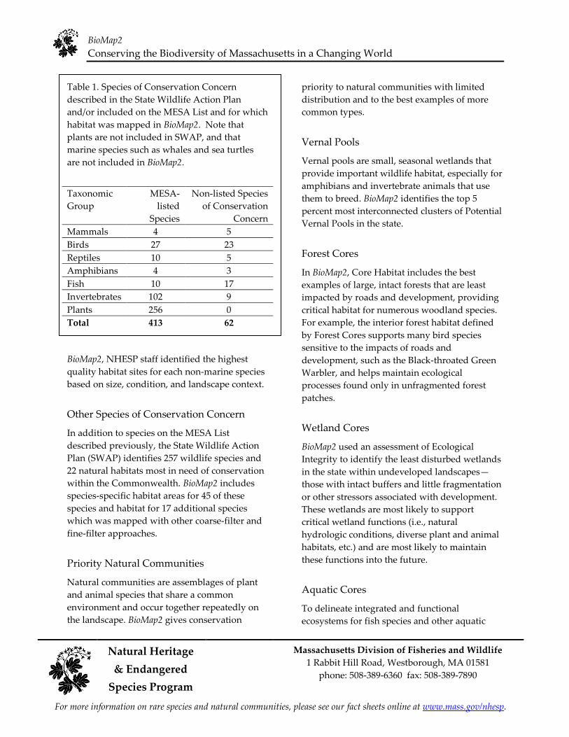
Table 1. Species of Conservation Concern
described in the State Wildlife Action Plan
and/or included on the MESA List and for which
habitat was mapped in BioMap2. Note that
plants are not included in SWAP, and that
marine species such as whales and sea turtles
are not included in BioMap2.
Taxonomic MESA- Non-listed Species
Group listed of Conservation
Species Concern
Mammals 4 5
Birds 27 23
Reptiles 10 5
Amphibians 4 3
Fish 10 17
Invertebrates 102 9
Plants 256 0
Total 413 62
Other Species of Conservation Concern
In addition to species on the MESA List
described previously, the State Wildlife Action
Plan (SWAP) identifies 257 wildlife species and
22 natural habitats most in need of conservation
within the Commonwealth. BioMap2 includes
species-specific habitat areas for 45 of these
species and habitat for 17 additional species
which was mapped with other coarse-filter and
fine-filter approaches.
Priority Natural Communities
Natural communities are assemblages of plant
and animal species that share a common
environment and occur together repeatedly on
the landscape. BioMap2 gives conservation
priority to natural communities with limited
distribution and to the best examples of more
common types.
Vernal Pools
Vernal pools are small, seasonal wetlands that
provide important wildlife habitat, especially for
amphibians and invertebrate animals that use
them to breed. BioMap2 identifies the top 5
percent most interconnected clusters of Potential
Vernal Pools in the state.
Forest Cores
In BioMap2, Core Habitat includes the best
examples of large, intact forests that are least
impacted by roads and development, providing
critical habitat for numerous woodland species.
For example, the interior forest habitat defined
by Forest Cores supports many bird species
sensitive to the impacts of roads and
development, such as the Black-throated Green
Warbler, and helps maintain ecological
processes found only in unfragmented forest
patches.
Wetland Cores
BioMap2 used an assessment of Ecological
Integrity to identify the least disturbed wetlands
in the state within undeveloped landscapesȯ those with intact buffers and little fragmentation
or other stressors associated with development.
These wetlands are most likely to support
critical wetland functions (i.e., natural
hydrologic conditions, diverse plant and animal
habitats, etc.) and are most likely to maintain
these functions into the future.
Aquatic Cores
To delineate integrated and functional
ecosystems for fish species and other aquatic
BioMap2
Conserving the Biodiversity of Massachusetts in a Changing World
Massachusetts Division of Fisheries and Wildlife Natural Heritage 1 Rabbit Hill Road, Westborough, MA 01581
& Endangered phone: 508-389-6360 fax: 508-389-7890
Species Program
For more information on rare species and natural communities, please see our fact sheets online at www.mass.gov/nhesp.
Species of Conservation Concern, beyond the
species and exemplary habitats described above,
BioMap2 identifies intact river corridors within
which important physical and ecological
processes of the river or stream occur.
Components of Critical Natural Landscape
Critical Natural Landscape identifies intact
landscapes in Massachusetts that are better able
to support ecological processes and disturbance
regimes, and a wide array of species and
habitats over long time frames.
Landscape Blocks
BioMap2 identifies the most intact large areas of
predominately natural vegetation, consisting of
contiguous forests, wetlands, rivers, lakes, and
ponds, as well as coastal habitats such as barrier
beaches and salt marshes.
Upland Buffers of Wetland and Aquatic
Cores
A variety of analyses were used to identify
protective upland buffers around wetlands and
rivers.
Upland Habitat to Support Coastal
Adaptation
BioMap2 identifies undeveloped lands adjacent
to and up to one and a half meters above
existing salt marshes as Critical Natural
Landscapes with high potential to support
inland migration of salt marsh and other coastal
habitats over the coming century.
The conservation areas identified by BioMap2
are based on breadth and depth of data,
scientific expertise, and understanding of
Mɠɲɲɠɢɧɴɲɤɳɳɲ˘ ɡɨɮɣɨɵɤɱɲɨɳɸ˅ Tɧɤ ɭɴɬɤɱɮɴɲ
sources of information and analyses used to
Legal Protection of Biodiversity
BioMap2 presents a powerful vision of what
Massachusetts would look like with full
protection of the land most important for
ɲɴɯɯɮɱɳɨɭɦ ɳɧɤ Cɮɬɬɮɭɶɤɠɫɳɧ˘ɲ ɡɨɮɣɨɵɤɱɲɨɳɸ˅
While BioMap2 is a planning tool with no
regulatory function, all state-listed species enjoy
legal protection under the Massachusetts
Endangered Species Act (M.G.L. c.131A) and its
implementing regulations (321 CMR 10.00).
Wetland habitat of state-listed wildlife is also
protected under the Wetlands Protection Act
Regulations (310 CMR 10.00). The Natural
Heritage Atlas contains maps of Priority Habitats
and Estimated Habitats, which are used,
respectively, for regulation under the
Massachusetts Endangered Species Act and the
Wetlands Protection Act. For more information
on rare species regulations, and to view Priority
and Estimated Habitat maps, please see the
Regulatory Review page at
http://www.mass.gov/eea/agencies/dfg/dfw/natur
al-heritage/regulatory-review/.
BioMap2 is a conservation planning tool that
does not, in any way, supplant the Estimated
and Priority Habitat Maps which have
regulatory significance. Unless and until the
BioMap2 vision is fully realized, we must
continue to protect our most imperiled species
and their habitats.
create Core Habitat and Critical Natural
Landscape are complementary, and outline a
comprehensive conservation vision for
Massachusetts, from rare species to intact
landscapes. In total, these robust analyses
define a suite of priority lands and waters that, if
permanently protected, will support
Mɠɲɲɠɢɧɴɲɤɳɳɲ˘ ɭɠɳɴɱɠɫ ɲɸɲɳɤɬɲ ɥɮɱ ɦɤɭɤɱɠɳɨɮɭɲ
to come.
BioMap2
Conserving the Biodiversity of Massachusetts in a Changing World
Natural Heritage Massachusetts Division of Fisheries and Wildlife
1 Rabbit Hill Road, Westborough, MA 01581 & Endangered
phone: 508-389-6360 fax: 508-389-7890
Species Program
For more information on rare species and natural communities, please see our fact sheets online at www.mass.gov/nhesp.
Understanding Core Habitat Summaries
Following the Town Overview, there is a
descriptive summary of each Core Habitat and
Critical Natural Landscape that occurs in your
city or town. These summaries highlight some
of the outstanding characteristics of each Core
Habitat and Critical Natural Landscape, and
will help you learn more about your city or
ɳɮɶɭ˘ɲ ɡɨɮɣɨɵɤɱɲɨɳɸ˅ Yɮɴ ɢɠɭ ɥɨɭɣ ɮɴɳ ɬɮɱɤ information about many of these species and
natural communities by looking at specific fact
sheets at www.mass.gov/nhesp.
Additional Information
For copies of the full BioMap2 report, the
Technical Report, and an interactive mapping
tool, visit the BioMap2 website via the Land
Protection and Planning tab at
www.mass.gov/nhesp. If you have any
questions about this report, or if you need help
protecting land for biodiversity in your
community, the Natural Heritage & Endangered
Species Program staff looks forward to working
with you.
Contact the Natural Heritage & Endangered
Species Program
By phone 508-389-6360
By fax 508-389-7890
By email [email protected]
By Mail 100 Hartwell S treet, Suite 230
West Boylston, MA 01583
The GIS datalayers of BioMap2 are available for
download from MassGIS at
www.mass.gov/mgis.
BioMap2
Conserving the Biodiversity of Massachusetts in a Changing World
Natural Heritage Massachusetts Division of Fisheries and Wildlife
1 Rabbit Hill Road, Westborough, MA 01581 & Endangered
phone: 508-389-6360 fax: 508-389-7890
Species Program
For more information on rare species and natural communities, please see our fact sheets online at www.mass.gov/nhesp.
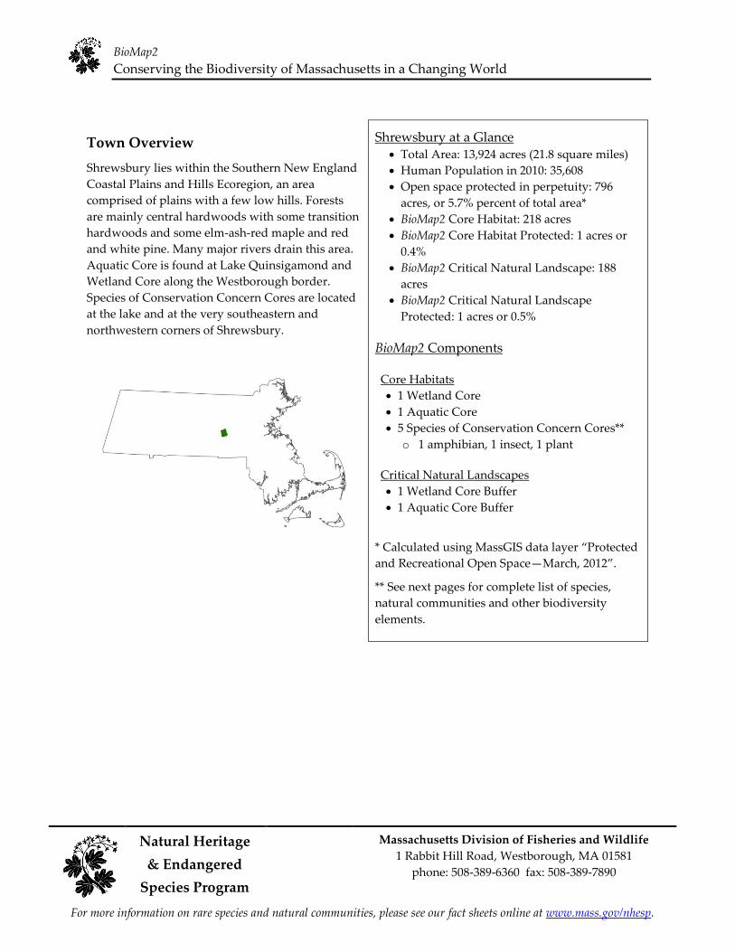
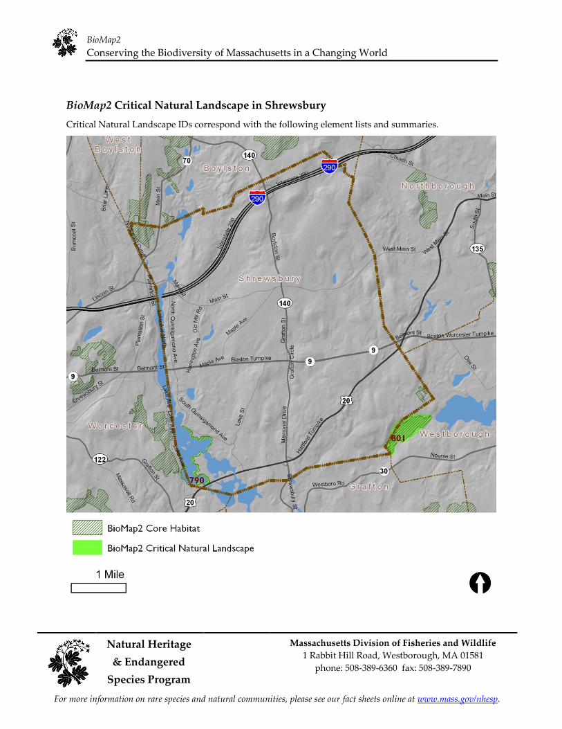
Town Overview
Shrewsbury lies within the Southern New England
Coastal Plains and Hills Ecoregion, an area
comprised of plains with a few low hills. Forests
are mainly central hardwoods with some transition
hardwoods and some elm-ash-red maple and red
and white pine. Many major rivers drain this area.
Aquatic Core is found at Lake Quinsigamond and
Wetland Core along the Westborough border.
Species of Conservation Concern Cores are located
at the lake and at the very southeastern and
northwestern corners of Shrewsbury.
Shrewsbury at a Glance Total Area: 13,924 acres (21.8 square miles)
Human Population in 2010: 35,608
Open space protected in perpetuity: 796
acres, or 5.7% percent of total area*
BioMap2 Core Habitat: 218 acres
BioMap2 Core Habitat Protected: 1 acres or
0.4%
BioMap2 Critical Natural Landscape: 188
acres
BioMap2 Critical Natural Landscape
Protected: 1 acres or 0.5%
BioMap2 Components
Core Habitats 1 Wetland Core 1 Aquatic Core 5 Species of Conservation Concern Cores**
o 1 amphibian, 1 insect, 1 plant
Critical Natural Landscapes 1 Wetland Core Buffer 1 Aquatic Core Buffer
* Calculated uɲɨɭɦ MɠɲɲGIS ɣɠɳɠ ɫɠɸɤɱ ȃPɱɮɳɤɢɳɤɣ and Recreational Open SpaceȯMarch, ȮȬȭȮȄ.
** See next pages for complete list of species,
natural communities and other biodiversity
elements.
BioMap2
Conserving the Biodiversity of Massachusetts in a Changing World
Natural Heritage Massachusetts Division of Fisheries and Wildlife
1 Rabbit Hill Road, Westborough, MA 01581 & Endangered
phone: 508-389-6360 fax: 508-389-7890
Species Program
For more information on rare species and natural communities, please see our fact sheets online at www.mass.gov/nhesp.
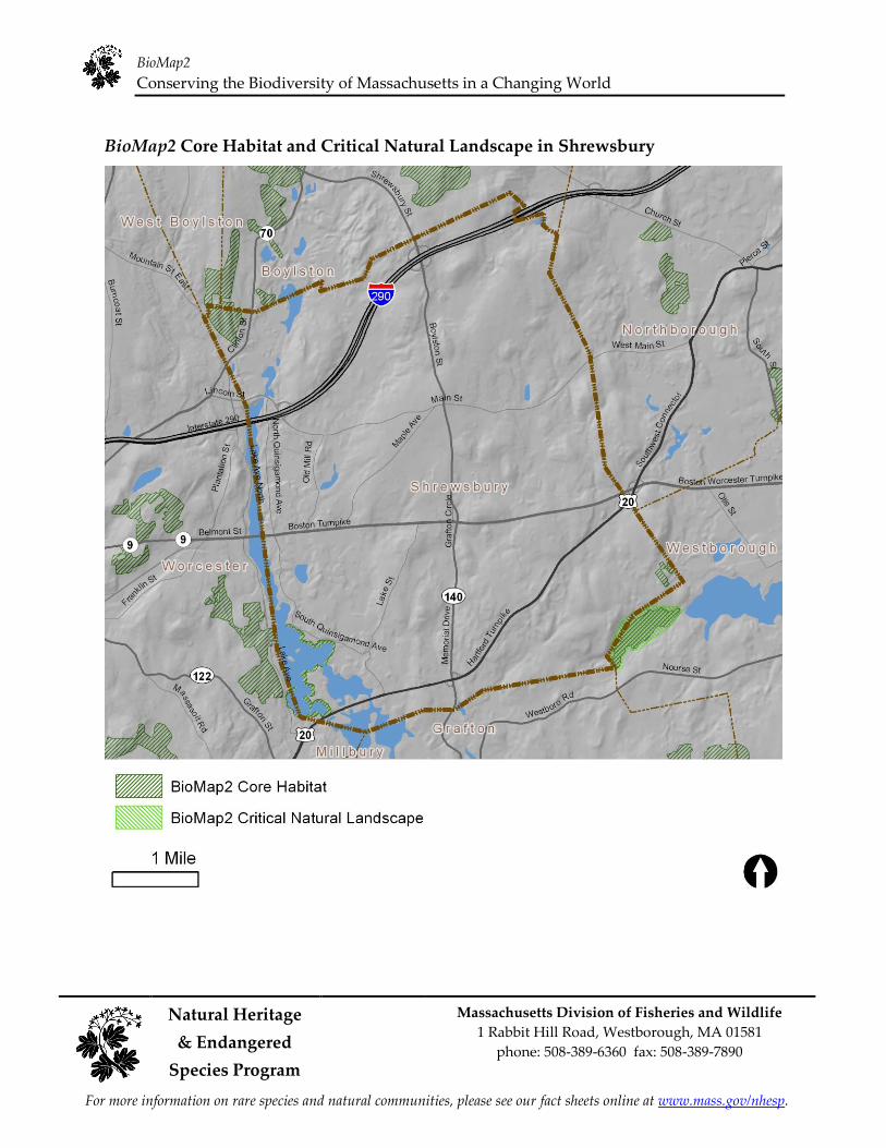
BioMap2 Core Habitat and Critical Natural Landscape in Shrewsbury
BioMap2
Conserving the Biodiversity of Massachusetts in a Changing World
Natural Heritage Massachusetts Division of Fisheries and Wildlife
& Endangered 1 Rabbit Hill Road, Westborough, MA 01581
phone: 508-389-6360 fax: 508-389-7890
Species Program
For more information on rare species and natural communities, please see our fact sheets online at www.mass.gov/nhesp.
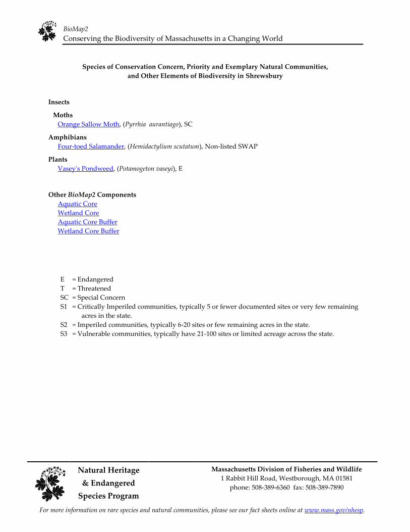
Species of Conservation Concern, Priority and Exemplary Natural Communities,
and Other Elements of Biodiversity in Shrewsbury
Insects
Moths
Orange Sallow Moth, (Pyrrhia aurantiago), SC
Amphibians
Four-toed Salamander, (Hemidactylium scutatum), Non-listed SWAP
Plants
Vasey's Pondweed, (Potamogeton vaseyi), E
Other BioMap2 Components
Aquatic Core Wetland Core Aquatic Core Buffer Wetland Core Buffer
E = Endangered
T = Threatened
SC = Special Concern
S1 = Critically Imperiled communities, typically 5 or fewer documented sites or very few remaining
acres in the state. S2 = Imperiled communities, typically 6-20 sites or few remaining acres in the state. S3 = Vulnerable communities, typically have 21-100 sites or limited acreage across the state.
BioMap2
Conserving the Biodiversity of Massachusetts in a Changing World
Natural Heritage Massachusetts Division of Fisheries and Wildlife
1 Rabbit Hill Road, Westborough, MA 01581 & Endangered
phone: 508-389-6360 fax: 508-389-7890
Species Program
For more information on rare species and natural communities, please see our fact sheets online at www.mass.gov/nhesp.
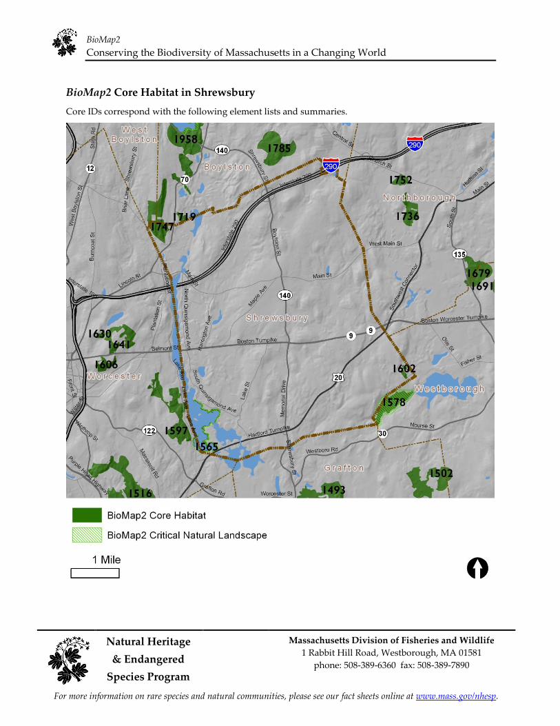
BioMap2 Core Habitat in Shrewsbury
Core IDs correspond with the following element lists and summaries.
BioMap2
Conserving the Biodiversity of Massachusetts in a Changing World
Natural Heritage Massachusetts Division of Fisheries and Wildlife
1 Rabbit Hill Road, Westborough, MA 01581 & Endangered
phone: 508-389-6360 fax: 508-389-7890
Species Program
For more information on rare species and natural communities, please see our fact sheets online at www.mass.gov/nhesp.
Elements of BioMap2 Cores
This section lists all elements of BioMap2 Cores that fall entirely or partially within Shrewsbury. The
elements listed here may not occur within the bounds of Shrewsbury.
Core 1565 Aquatic Core Species of Conservation Concern
Vasey's Pondweed Potamogeton vaseyi E
Core 1578 Wetland Core
Core 1597 Species of Conservation Concern
Orange Sallow Moth Pyrrhia aurantiago SC
Core 1602 Species of Conservation Concern
Four-toed Salamander Hemidactylium scutatum Non-listed SWAP
Core 1719 Species of Conservation Concern
Orange Sallow Moth Pyrrhia aurantiago SC
Core 1747 Species of Conservation Concern
Orange Sallow Moth Pyrrhia aurantiago SC
BioMap2
Conserving the Biodiversity of Massachusetts in a Changing World
Natural Heritage Massachusetts Division of Fisheries and Wildlife
1 Rabbit Hill Road, Westborough, MA 01581 & Endangered
phone: 508-389-6360 fax: 508-389-7890
Species Program
For more information on rare species and natural communities, please see our fact sheets online at www.mass.gov/nhesp.
Core Habitat Summaries
Core 1565
A 143-acre Core Habitat featuring Aquatic Core and a Species of Conservation Concern.
Aquatic Cores are integrated and functional ecosystems for fish species and other aquatic Species of
Conservation Concern. To delineate these, BioMap2 identified intact river corridors within which
important physical and ecological processes of the river or stream occur. To identify those areas integrally
connected to each river and stream, each river segment was buffered 30 meters. All wetlands wholly or
partially contained within this buffer were then included, and the combination of the river channel, the
adjacent buffer, and the connected wetlands make up the riverine Core Habitat.
Vasey's Pondweed is a rare aquatic plant of shallow, slow, open water. This species has floating leaves
present when in flower or fruit.
Core 1578
A 118-acre Core Habitat featuring Wetland Core.
To enhance the biodiversity value of wetlands selected as Core Habitat, BioMap2 maps the most intact
wetlands in each ecological region of the state. These intact wetlands in diverse settings may be thought
of as representing the ecological stage, and are most likely to support a diversity of wetland types over
time, even as different plant and animal species (the actors on the ecological stage) shift in response to
climate change. This Wetland Core is among the largest 20% of Wetland Cores statewide and in this
ecoregion..
Core 1597
A 244-acre Core Habitat featuring a Species of Conservation Concern.
Orange Sallow Moths inhabit dry, open oak woodlands on rocky uplands. Their eggs are laid on false
foxgloves (Aureolaria spp.) where the larvae feed on the flowers and developing seeds.
Core 1602
A 17-acre Core Habitat featuring a Species of Conservation Concern..
Four-toed Salamanders live in forested habitats surrounding swamps, bogs, marshes, vernal pools, and
other fish-free waters that are used as breeding sites. Most breeding sites in Massachusetts are
characterized by pit-and-mound topography with significant sphagnum-moss cover. Eggs are typically
laid in mounds or patches of sphagnum moss that overhang water. Upon hatching, the larvae wriggle
through the moss and drop into the water, where they will develop for several weeks prior to
metamorphosis.
BioMap2
Conserving the Biodiversity of Massachusetts in a Changing World
Natural Heritage Massachusetts Division of Fisheries and Wildlife
1 Rabbit Hill Road, Westborough, MA 01581 & Endangered
phone: 508-389-6360 fax: 508-389-7890
Species Program
For more information on rare species and natural communities, please see our fact sheets online at www.mass.gov/nhesp.
Core 1719
A 16-acre Core Habitat featuring a Species of Conservation Concern.
Orange Sallow Moths inhabit dry, open oak woodlands on rocky uplands. Their eggs are laid on false
foxgloves (Aureolaria spp.) where the larvae feed on the flowers and developing seeds.
Core 1747
An 186-acre Core Habitat featuring a Species of Conservation Concern..
Orange Sallow Moths inhabit dry, open oak woodlands on rocky uplands. Their eggs are laid on false
foxgloves (Aureolaria spp.) where the larvae feed on the flowers and developing seeds.
BioMap2
Conserving the Biodiversity of Massachusetts in a Changing World
Natural Heritage Massachusetts Division of Fisheries and Wildlife
1 Rabbit Hill Road, Westborough, MA 01581 & Endangered
phone: 508-389-6360 fax: 508-389-7890
Species Program
For more information on rare species and natural communities, please see our fact sheets online at www.mass.gov/nhesp.
BioMap2 Critical Natural Landscape in Shrewsbury
Critical Natural Landscape IDs correspond with the following element lists and summaries.
BioMap2
Conserving the Biodiversity of Massachusetts in a Changing World
Natural Heritage Massachusetts Division of Fisheries and Wildlife
1 Rabbit Hill Road, Westborough, MA 01581 & Endangered
phone: 508-389-6360 fax: 508-389-7890
Species Program
For more information on rare species and natural communities, please see our fact sheets online at www.mass.gov/nhesp.
Elements of BioMap2 Critical Natural Landscapes
This section lists all elements of BioMap2 Critical Natural Landscapes that fall entirely or partially within
Shrewsbury. The elements listed here may not occur within the bounds of Shrewsbury.
CNL 790 Aquatic Core Buffer
CNL 801 Wetland Core Buffer
BioMap2
Conserving the Biodiversity of Massachusetts in a Changing World
Natural Heritage Massachusetts Division of Fisheries and Wildlife
1 Rabbit Hill Road, Westborough, MA 01581 & Endangered
phone: 508-389-6360 fax: 508-389-7890
Species Program
For more information on rare species and natural communities, please see our fact sheets online at www.mass.gov/nhesp.
Critical Natural Landscape Summaries
CNL 790
A 186-acre Critical Natural Landscape featuring Aquatic Core Buffer.
A variety of analyses were used to identify protective upland buffers around wetlands and rivers. One,
the variable width buffers methodology, included the most intact areas around each wetland and river,
by extending deeper into surrounding unfragmented habitats than into developed areas adjacent to each
wetland. Other upland buffers were identified through the rare species habitat analysis. In this way, the
conservation of wetland buffers will support the habitats and functionality of each wetland, and also
include adjacent uplands that are important for many species that move between habitat types.
CNL 801
A 184-acre Critical Natural Landscape featuring Wetland Core Buffer.
A variety of analyses were used to identify protective upland buffers around wetlands and rivers. One,
the variable width buffers methodology, included the most intact areas around each wetland and river,
by extending deeper into surrounding unfragmented habitats than into developed areas adjacent to each
wetland. Other upland buffers were identified through the rare species habitat analysis. In this way, the
conservation of wetland buffers will support the habitats and functionality of each wetland, and also
include adjacent uplands that are important for many species that move between habitat types.
Help Save Endangered Wildlife!
Please contribute on your Massachusetts income tax form or directly to the
Natural Heritage &
Endangered Species Fund
To learn more about the Natural Heritage & Endangered Species Program ɠɭɣ ɳɧɤ Cɮɬɬɮɭɶɤɠɫɳɧ˘ɲ ɱɠɱɤ ɲɯɤɢɨɤɲˆ ɵɨɲɨɳ ɮɴɱ ɶɤɡ ɲɨɳɤ ɠɳ www.mass.gov/nhesp.