Mass Appraisal Modeling Using GIS by Josh Myers Josh Myers Valuation Solutions.

Mass Appraisal Techniques Combined with GIS
Ownership Transfer Project in the Israel Land Authority
Avi HALLEWA, Doron HAZIZA, Israel
Key words: Ownership transfer, Area Price, G.I.S , price layers, ILA
SUMMARY
Israel Land Authority (ILA) is the government institution that manages over 90% of Israel's land.
The ownership of this land is registered to one of the three following institutes: the State of Israel,
the Development Authority, and the Jewish National Fund.
Government decision number 117 decreed a reform to the state lands and to transfer a part of the
built area ownership to the currently lessee holders.
During the transition from lease to ownership, the Israel Land Authority charges the value
difference between lease to ownership, and the lessee can be registered as the owner at the Land
Registry bureau.
Before commencing this operation, it is necessary to know the value of the leased land to determine
the difference between full ownership and lease, and thus it is needed to assess each property. The
Department of Valuation and Mapping division at the Israel Lands Authority have joined efforts to
build a layer of ‘price areas’. Instead of assessing each property on its own, it was decided to set a
fixed ‘price area’ to properties in the same neighborhood that share common characteristics and
values.
After the completion of the assessment, the ‘price area’ is assimilated into the GIS as a layer, and by
intersecting the ‘price area’ layer with the ILA cadastral layers we can determine the market value
of each property. From this value we can determine the lessee holder's required payment to the ILA.
Mass Appraisal Techniques Combined with GIS - Ownership Transfer Project in the Israel Land Authority (8084)
Avi Hallewa (Israel)
FIG Working Week 2016
Recovery from Disaster
Christchurch, New Zealand, May 2–6, 2016

Mass Appraisal Techniques Combined with GIS
Ownership Transfer Project in the Israel Land Authority
Avi HALLEWA, Doron HAZIZA, Israel
ISRAEL'S LAND POLICY – ISRAEL LAND AUTHORITY
Israel Land Authority is the government institution that manages the state lands. State lands
compromise 93% of Israel's area (approximately 22 million dunam) and are owned by three bodies:
The Jewish National Fund, the Development Authority, and the state. These lands are considered
public lands and are in part leased to the public of the State of Israel. The additional 7% are
privately owned lands.
The national land ownership principle is one of the corner stone's of Israel and was set by one of
Israel's Basic Laws in 1960. This law decreed that the ownership of state lands won't by transferred
without a specific permission in the law.
This situation where the majority of lands are owned by the state is different than the situation in
most other countries. It is a result of a few unique historical characteristics of Israel. For the
collective salvation of the land and the ownership of the land by the Jewish people there is a central
place in the Zionistic ethos that stems from the biblical creed " The land shall not be sold forever"
(Lev. 25:23 KJB).
The Authority's main areas of activity are managing land registry, creating land reserves for
different applications, marketing lands, treating the lessees and residents, and regulating the
different uses of the land.
TRANSFERRING OWNERSHIP
Transferring ownership is a part of Israel Land Authority reform that was meant to better
governmental mechanisms of managing real estate. There will be ownership transfer to the lessees
in areas designated for housing and employment, as well as allocating lands by selling instead of
leasing. The reform means converting the lessee’s rights from 'lease' to 'ownership,' so the lessee
will be listed in the Land Registry as the owners of the property.
THE CURRENT SITUATION
Today, ILA must agree, being the owner of the land, to changes lessees want to be performed on the
properties they have been leasing, starting from enclosing a balcony through to transferring rights.
This situation creates a lot of friction between the public and the authority, leads to unnecessary
Mass Appraisal Techniques Combined with GIS - Ownership Transfer Project in the Israel Land Authority (8084)
Avi Hallewa (Israel)
FIG Working Week 2016
Recovery from Disaster
Christchurch, New Zealand, May 2–6, 2016

delays, and burdens ILA in a way that makes it difficult to perform the core assignments of Israel
land management.
THE SUGGESTED SOLUTION
In order to improve and make the processes in the authority more efficient and reduce the friction
between the citizens and the authority, two alternatives were examined in a committee that was
established just for that – the Gadish committee. The first alternative suggested by the committee is
leasing the full rights, current and future, on the land. The second alternative is giving full
ownership of the land. The second alternative was chosen, claiming the first alternative, 'leasing', is
like factual ownership but the land would still be managed by the authority and that wasn't the
intent.
OWNERSHIP GOALS
The option of transferring ownership will have a positive effect on both ILA and the citizens by
minimizing the bureaucracy the citizens face while wanting to perform various acts on the property,
such as: building additions, changing designation, transferring rights etc., and forgoing the
payments the citizen must pay when performing these actions.
In addition to all that has been mentioned previously, in a macro-economical view, giving
ownership to the citizen will affect the market greatly: shortening the planning processes, lowering
the price of lands and housing, and adding growth in the market. It will also encourage the private
and municipal initiative for detailed planning and development of lands.
WHAT LANDS ARE INCLUDED?
The ownership won't be transferred from all state lands. The previously mentioned regards lands
designated for housing and employment with capitalized contracts only. Transferring the ownership
is not a must, but is permissible. All in all, transfer to private ownership will be applied to 1% of the
area of the State of Israel, in such a delicate situation, most lands will still be owned by the state,
JNF, and the Development Authority.
APPRAISAL
The ILA will transfer ownership in properties where transferring ownership is exempt from
payment and in properties where the transferring of ownership requires payment. The payment for
ownership will be determined as a certain percent of the value of the property. In order to determine
the land value of the existing property, there is a need to perform land appraisals on a national
scope.
In land designated for housing there can be discerned two main types of constructions – densely
populated urban areas and low rise constructions. All the contracts in densely populated urban areas
will be transferred to private ownership without any payment, so there is no need to perform land
appraisals.
Mass Appraisal Techniques Combined with GIS - Ownership Transfer Project in the Israel Land Authority (8084)
Avi Hallewa (Israel)
FIG Working Week 2016
Recovery from Disaster
Christchurch, New Zealand, May 2–6, 2016
Low rise construction contracts are separated into several groups, each with a different payment
scheme:
The first group of properties is properties whose land area is smaller than 280 m2, ownership
in this group will be transferred without any payment and so there is no need to appraise this
land.
The second group of properties is properties whose land area is between 280 m2 and 640 m
2,
transferring these properties requires payment.
The third group of properties is those with land area of 640 m2 to 1000 m
2, transferring these
properties requires payment.
Both property groups that require payments will have a land value table prepared by the full worth
of the rights by the applicable planning data, and from it the payment for ownership transfer will be
determined, according to the rates set in the committee decision.
Another group of properties will include properties with an area of 1 dunam to 16 dunam,
ownership in these properties will be transferred for 31% of the difference between the leasing
rights and the ownership rights according to individual assessment conducted for each property. In
properties where the area is larger than 16 dunam the ownership won't be transferred, as was
decided in the principles of land ownership policy.
WORK PROCESS WITH THE AUTHORITY APPRAISERS
In order to assess the value of the properties by the appraisers, all the leasing contracts of low rise
construction that meet the required criteria will be mapped. After mapping the contracts, maps with
the properties and all the relevant information will be produced for the appraisers field work.
Maps with the areas where the properties are located will be distributed to the Authority appraisers
by the National Appraiser. The appraisers will conduct assessments of the properties, where the
value will be determined by whole areas containing the properties, and not necessarily the
properties themselves. Price areas will include the properties and will give future reference for
similar properties in the same price area. The concept is to cover built areas owned by the Authority
that in case a single property will be accidently skipped over, there will be the possibility to transfer
ownership by future geographical intersection.
THE PRINCIPLES IN PERFORMING THE APPRAISALS
1. The appraisal will be for the full ownership of the empty property and without consideration
of existing buildings.
2. The price values that will be determined will reflect the full planning potential, current and
future, that may exist in the various lots.
3. Appraising the property will include the potential planning changes, as they may exist, while
taking into consideration rejection risk and the required payments for application.
Mass Appraisal Techniques Combined with GIS - Ownership Transfer Project in the Israel Land Authority (8084)
Avi Hallewa (Israel)
FIG Working Week 2016
Recovery from Disaster
Christchurch, New Zealand, May 2–6, 2016

4. The land will be assessed by the appraiser without development expenditure, taking into
account standard normative development expenditures or the municipality's fees and taxes,
according to the custom in the area.
Every appraiser allocated a work area will conduct a preparatory meeting with the National
Appraiser of the Authority, where there will be presented to him the principles of the work, his
work areas, and also the maps of the price areas he is to determine. The final product the appraiser
must produce is a map that has been divided according to the price areas and a land value table for
the price areas marked on the map.
Upon the completion of the appraisal, the appraiser will transfer the data (the map with price areas
and the land value table) to the professional committee where the National Appraiser of the
Authority will review the assessments.
Producing the maps and constructing the price layers is done in the GIS (Geographic information
system). The GIS of the authority is used as the main platform of managing the project.
GIS as a Central Tool to Determining Price Areas for Transferring Lease to Ownership
The Engineering Challenge
After mapping all the properties where ownership transfer will be possible for payment, it appears
that about 140,000 low rise construction properties are supposed to transfer from the state
ownership to the lessee ownership. The work areas were divided to the 6 ILA regions: North, Haifa,
Center, Tel Aviv, Jerusalem, and the South, that include within them approximately 1900 municipal
regions. The main work tool of the appraiser is a map that shows the properties he needs to asses
and their immediate surroundings. In setting work guidelines, it was decided that each appraiser will
receive a range of properties belonging to one municipal region, and the maps were made according
to that.
After producing the maps for the appraisers, there is another part of the process that needs to be
taken into account: assimilating the price areas that were marked on the maps. Assimilating those
polygons (price areas) should also address the final product of the process – calculating the
ownership cost. The GIS addresses the above mentioned process, and also the automation of several
sub-processes.
When we begin to use "GIS terms", the whole picture begins to clear up. The final product we want
to receive is a geographical layer of the properties with a field of the specific land value of each
property. To get the layer that will give the value of a property and from which the future payment
for ownership transfer will be derived, there is a need of several background layers. The first layer
is properties with low rise contracts; this layer is built by an alphanumerical table of the properties
that is received from alphanumerical systems of the Authority. The second layer is the national
cadaster where each lease is determined by a whole parcel, and the third layer is the price area layer
Mass Appraisal Techniques Combined with GIS - Ownership Transfer Project in the Israel Land Authority (8084)
Avi Hallewa (Israel)
FIG Working Week 2016
Recovery from Disaster
Christchurch, New Zealand, May 2–6, 2016

that will be constructed from the appraisers’ material (polygons marked on the maps). Given these
three layers, it is possible to create a geographical intersection that gives us the land value of each
property.
Managing GIS
The final product of the process is a list of all the properties where ownership transfer is possible,
where each property has a field with its value. The GIS, on the one hand, supplied the work material
for the appraisers, and on the other hand, is used as a collecting mechanism for the assembly of the
price area data.
Constructing Properties Layer
The authority manages its property registration in an alphanumerical system called the 'Assets
Book'. The Assets Book is the database of an alphanumerical table without any geographical
relation. The Assets Book is managed on the parcel level, so each property is defined by complete
block and parcel.
In order to find all the low rise construction contracts, there are several filtering processes applied
on the alphanumerical data of the properties:
1. Filtering by contract – low rise construction contracts. Densely populated urban area
contracts are transferred without payments, so there is no need for appraisal.
2. Filtering by priority areas and areas along the border – national priority areas are determined
occasionally by the government and the payment rates there are discounted greatly.
3. Filtering by the area – according to the ownership transfer principles table that has been
determined by Israel Land Committee.
Mapping low
rise
construction
contracts
Making and
distributing of
maps for the
appraisers
work
Marking price
areas on top of the
maps by the
appraisers
Assimilating
the
assessments
Calculating
the
ownership
cost
according to
plot size
Work Layer
GIS Layer Building
property
layers
Dividing work by
settlements and
number of properties,
constructing a map
index layer
Digitizing
appraisers' maps
and constructing
price area layer
Intersecting property
and price area layers
and calculating the
ownership cost
according to plot size
Mass Appraisal Techniques Combined with GIS - Ownership Transfer Project in the Israel Land Authority (8084)
Avi Hallewa (Israel)
FIG Working Week 2016
Recovery from Disaster
Christchurch, New Zealand, May 2–6, 2016
After the production of the table, there is a merge of matching records between the table and the
national cadaster layer by combining the fields of block and parcel -
Join_Field=Block*10000+Parcel. This creates a property layer that includes all the property details
in the GIS. The merging process is a geographical mapping of the properties in a single parcel
resolution, even if the property doesn't necessarily cover the whole parcel and the exact location of
the property within the parcel is unknown. Thus, if there is no parcellation, the property's location is
uncertain.
Generally, all the properties are converted from the table database into a geographical layer whether
they cover a complete parcel or only a part of it. There are properties yet to be parceled and they are
still undefined by whole block and parcel, and as such, cannot be registered for ownership in the
Land Registry. Those kinds of properties will be dealt with at a later stage when the parcellation
will be registered. However, it may be that the appraisers will define a price area of such an area
that will be assimilated based on land registry plans in production or valid zoning plans, and when
the division will be registered, the owners will be able to pay the fee, gain ownership of the land
and register at the Land Registry as owners.
Creating a Map Indexing Layer
The maps will be central tools for the appraisers, for building the final layer will be based on the
appraisers’ marks on the map.
The GIS is used in creating all the maps according to managing principles that were determined:
1. Each map will include a single municipal area.
2. The maps are built in the GIS while showing the properties where appraising is needed. In
order to create the maps, we made the index layer which allows to manage dividing the
maps for the appraisers.
3. All municipal areas with properties were mapped, and each area will be assessed by a
different appraiser.
4. There are populated areas that because their size don’t fit in one map within a reasonable
scale. These areas will be mapped in several maps and there was set a scale of 1:5,000 for
each map – the minimal scale an appraiser can practically use in field work and all the layers
are still clearly visible.
5. The maps sheet size will vary according to scale constraints.
The map index layer is a layer of map sheets. Each sheet size has been calculated in Israel
coordinate system as a virtual polygon by forcing the 1:5,000 scale. A0, A1, A2, A3, A4 sheets
were constructed and fit to each municipal area that includes properties. Each polygon in the
map index layer is a map that will be used by a single appraiser. The index layer is used as a
managing tool to update status in the process of building the price area layer. Each appraiser is
responsible for one municipal area and has a map that matches that same municipal area.
Mass Appraisal Techniques Combined with GIS - Ownership Transfer Project in the Israel Land Authority (8084)
Avi Hallewa (Israel)
FIG Working Week 2016
Recovery from Disaster
Christchurch, New Zealand, May 2–6, 2016
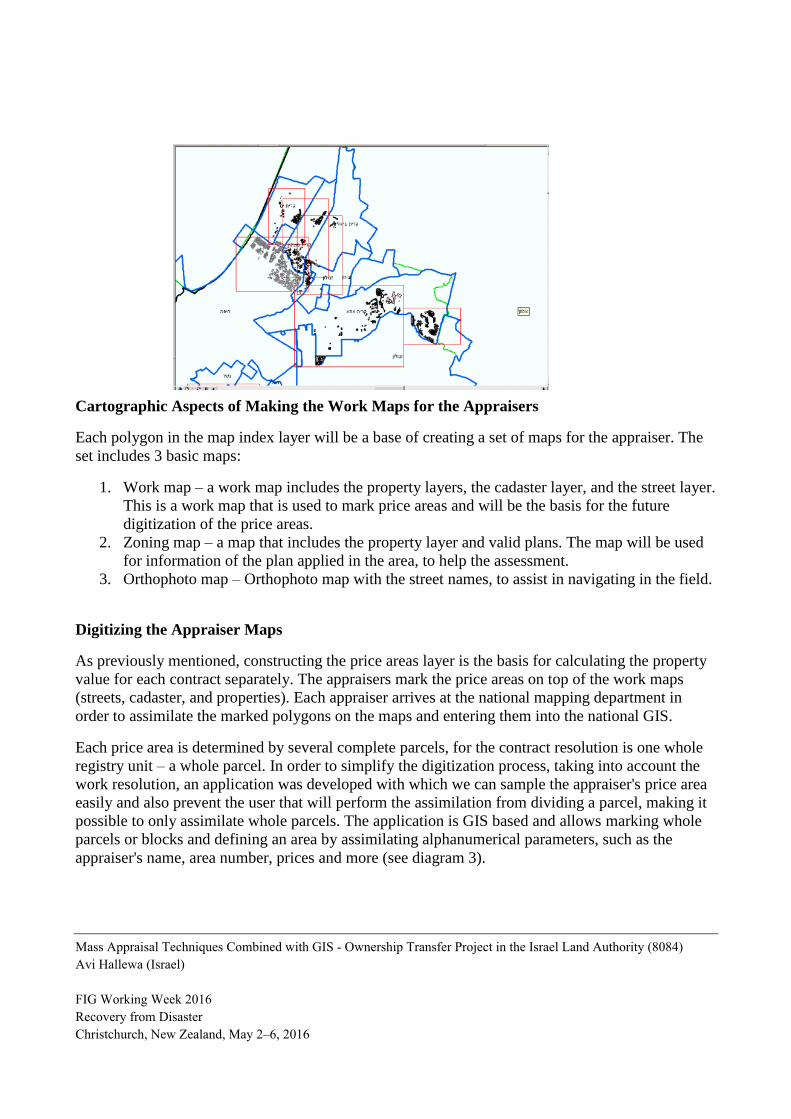
Cartographic Aspects of Making the Work Maps for the Appraisers
Each polygon in the map index layer will be a base of creating a set of maps for the appraiser. The
set includes 3 basic maps:
1. Work map – a work map includes the property layers, the cadaster layer, and the street layer.
This is a work map that is used to mark price areas and will be the basis for the future
digitization of the price areas.
2. Zoning map – a map that includes the property layer and valid plans. The map will be used
for information of the plan applied in the area, to help the assessment.
3. Orthophoto map – Orthophoto map with the street names, to assist in navigating in the field.
Digitizing the Appraiser Maps
As previously mentioned, constructing the price areas layer is the basis for calculating the property
value for each contract separately. The appraisers mark the price areas on top of the work maps
(streets, cadaster, and properties). Each appraiser arrives at the national mapping department in
order to assimilate the marked polygons on the maps and entering them into the national GIS.
Each price area is determined by several complete parcels, for the contract resolution is one whole
registry unit – a whole parcel. In order to simplify the digitization process, taking into account the
work resolution, an application was developed with which we can sample the appraiser's price area
easily and also prevent the user that will perform the assimilation from dividing a parcel, making it
possible to only assimilate whole parcels. The application is GIS based and allows marking whole
parcels or blocks and defining an area by assimilating alphanumerical parameters, such as the
appraiser's name, area number, prices and more (see diagram 3).
Mass Appraisal Techniques Combined with GIS - Ownership Transfer Project in the Israel Land Authority (8084)
Avi Hallewa (Israel)
FIG Working Week 2016
Recovery from Disaster
Christchurch, New Zealand, May 2–6, 2016
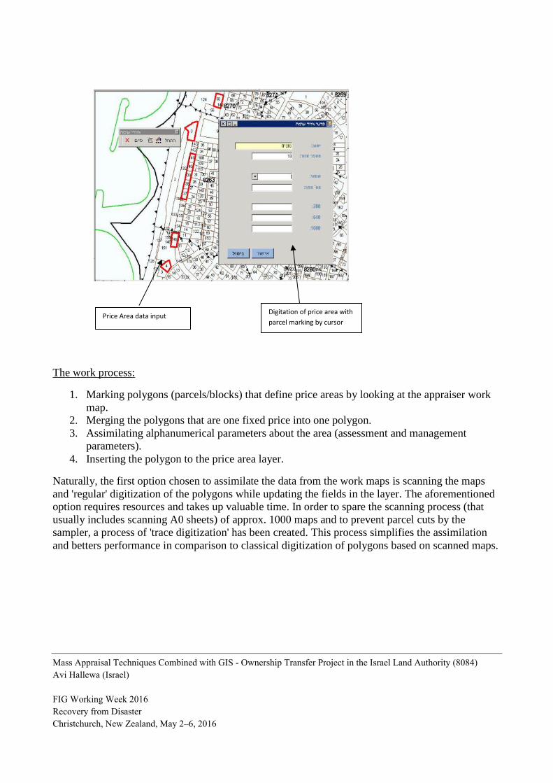
The work process:
1. Marking polygons (parcels/blocks) that define price areas by looking at the appraiser work
map.
2. Merging the polygons that are one fixed price into one polygon.
3. Assimilating alphanumerical parameters about the area (assessment and management
parameters).
4. Inserting the polygon to the price area layer.
Naturally, the first option chosen to assimilate the data from the work maps is scanning the maps
and 'regular' digitization of the polygons while updating the fields in the layer. The aforementioned
option requires resources and takes up valuable time. In order to spare the scanning process (that
usually includes scanning A0 sheets) of approx. 1000 maps and to prevent parcel cuts by the
sampler, a process of 'trace digitization' has been created. This process simplifies the assimilation
and betters performance in comparison to classical digitization of polygons based on scanned maps.
Digitation of price area with
parcel marking by cursor Price Area data input
Mass Appraisal Techniques Combined with GIS - Ownership Transfer Project in the Israel Land Authority (8084)
Avi Hallewa (Israel)
FIG Working Week 2016
Recovery from Disaster
Christchurch, New Zealand, May 2–6, 2016

North Netanya (Central District) Land Prices for 1 Dunam after digitization:
Calculating Ownership Cost
Based on property groups (see Appraisal chapter), threshold prices were determined to be
assimilated into the 'price area' polygon. The authority appraisers determined 3 prices for differently
sized properties that were predetermined: a price for a lot sized 280 m2, a price for a 640 m
2 lot, and
a price for a lot sized 1000 m2. Since the properties are heterogenic in size, there is a need to
perform a linear interpolation between the three determined prices in order to deduce a value of a
certain lot at the end of the geographical intersection between the price area layer and the property
layer.
Property num
Tenant Data
Area
280 m^2 Price
640 m^2 Price
1000 m^2 Price
Property Layer
Area Price Layer
Intersect Layer
Property num-
Area- -Interpolated Price -Ownership Price
Intersect
Mass Appraisal Techniques Combined with GIS - Ownership Transfer Project in the Israel Land Authority (8084)
Avi Hallewa (Israel)
FIG Working Week 2016
Recovery from Disaster
Christchurch, New Zealand, May 2–6, 2016

Summary and Conclusions
Creating the price area layer and saving it within the GIS is a breakthrough in real estate
management.
Building such a layer and updating it requires many financial resources and human resources that
include appraisers, cartographers, GIS specialists, computer personnel, many finance and authority
personnel and drafters. The GIS is the executing branch of the ownership transfer project and
manages all the assimilated data with constant updating.
The more price areas added, the bigger the layer will be, and it will be used more widely. As with
each GIS layer, this layer must be updated, though much more frequently – updating once a year
according to the expiration date of the assessment.
Other then Israel Land Authority, the updated price layer imparted in the GIS can be used by many
other government bodies: the Tax Authority, city and regional councils, and private bodies such as
real estate appraisers and planners.
REFERENCES
Israeli government decision No. 117 (IMI / 5) on land reform)
Council Resolution 1185 dated 28.12.09 on reform at lands of Israel , that was canceled by Council
Resolution 1299 dated 06.11. 13, that was canceled by Council Resolution 1370 dated 22.06.14.
BIOGRAPHICAL NOTES
Eng' Avi Hallewa: A licensed surveyor (since 2002) and a registered professional engineer (Since
2000) from the Technion - Institute of Technology, Haifa, Israel.
Certified Land Assessor from the Technion, Haifa, Israel.
MBA with concentration in Real Estate and Valuation - Haifa University, Israel
Senior Department Manager for Mapping, Surveying & GIS in the Israel Land Authority
(since 2013).
Head of mapping and measurement in Israel Land Administration & Head of the Municipal
registry center (2010-2013).
Director of Mapping and measurement Dept in Jerusalem District of Israel Land
Administration (2005-2010).
Worked in a private firm as a surveyor (2000-2005).
Certified real estate appraiser since 2004
Mr Doron Haziza: Certified real estate appraiser since 2003 (License no. 1122 from State of Israel)
Education: Certified Land Assessor from the College of Management, Israel.
Member of the Real Estate Appraisers Association in Israel
Mass Appraisal Techniques Combined with GIS - Ownership Transfer Project in the Israel Land Authority (8084)
Avi Hallewa (Israel)
FIG Working Week 2016
Recovery from Disaster
Christchurch, New Zealand, May 2–6, 2016
Worked in a private firm as a real estate appraiser (1998-2006).
Senior Partner in a private firm of real estate appraiser (2006-2011).
Owner of independent real estate appraiser since 2011 till today
CONTACTS
Title Given name and family name: Avi Hallewa
Institution: Israel Land Authority
Address: Menahem Begin st. 125
City: Tel Aviv
COUNTRY: ISRAEL
Tel. +972-3-7632390
Fax +972-3-7632398
Email: [email protected]
Web site: www.land.gov.il
Mass Appraisal Techniques Combined with GIS - Ownership Transfer Project in the Israel Land Authority (8084)
Avi Hallewa (Israel)
FIG Working Week 2016
Recovery from Disaster
Christchurch, New Zealand, May 2–6, 2016