
Shortest Term Forecast System for PV Plants and Distribution Grids
20
Shortest Term Forecast System for PV Plants and Distribution Grids Stefan C. Müller, Jan Remund Meteotest, Switzerland
Transcript of Shortest Term Forecast System for PV Plants and Distribution Grids

Shortest Term Forecast System for PV Plants and Distribution Grids
Stefan C. Müller, Jan Remund
Meteotest, Switzerland
EU PVSEC 2013, Paris | Page 2 | October 1 2013
Outline
Project description: Shortest term solar forecasting
Presentation results
Case studies
Overall statistics
Conclusion

EU PVSEC 2013, Paris | Page 3 | October 1 2013
Why do we need forecasts
Management of power production,
delivery and storage
Stability of the grid
Energy trading
EU PVSEC 2013, Paris | Page 4 | October 1 2013
Project: Aim and idea
Aim: Improve solar forecasting between 0.5 and 6 hours (for intra day
trading and power and grid management) on a regional basis
Idea: Nowcasting method by a simple combination of available
weather data (satellite images and numerical weather prediction
model)
EU PVSEC 2013, Paris | Page 5 | October 1 2013
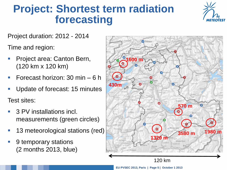
Project: Shortest term radiation forecasting
Project duration: 2012 - 2014
Time and region:
Project area: Canton Bern,
(120 km x 120 km)
Forecast horizon: 30 min – 6 h
Update of forecast: 15 minutes
Test sites:
3 PV installations incl.
measurements (green circles)
13 meteorological stations (red)
9 temporary stations
(2 months 2013, blue)
3580 m 1980 m
430m
1600 m
570 m
120 km
1320 m
EU PVSEC 2013, Paris | Page 6 | October 1 2013
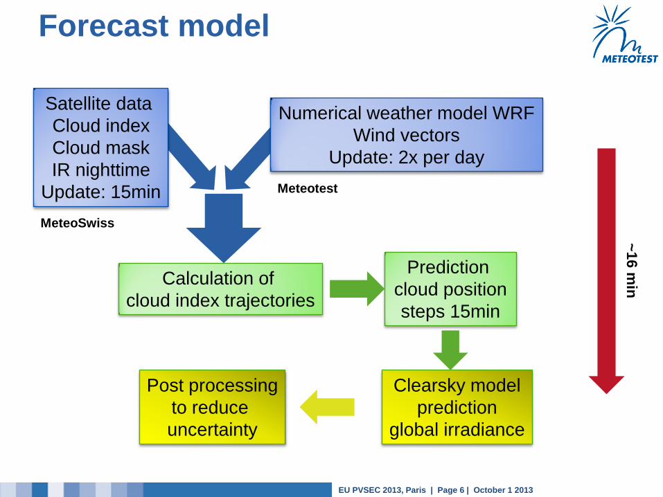
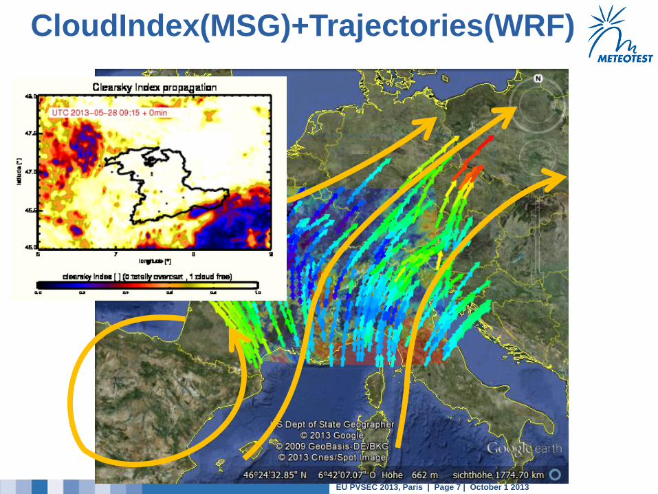
Forecast model
Satellite data
Cloud index
Cloud mask
IR nighttime
Update: 15min
Numerical weather model WRF
Wind vectors
Update: 2x per day
Prediction
cloud position
steps 15min
Clearsky model
prediction
global irradiance
Calculation of
cloud index trajectories
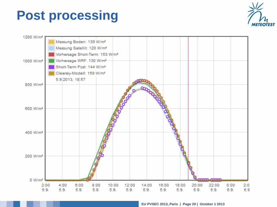
Post processing
to reduce
uncertainty
MeteoSwiss
Meteotest
~16
min
EU PVSEC 2013, Paris | Page 7 | October 1 2013
CloudIndex(MSG)+Trajectories(WRF)
EU PVSEC 2013, Paris | Page 8 | October 1 2013
Outline
Project description: Shortest term solar forecasting
Presentation results
Case studies
Overall statistics
Conclusion

EU PVSEC 2013, Paris | Page 9 | October 1 2013
Case study 26.4.2013
Bern / Zollikofen
+30 min

EU PVSEC 2013, Paris | Page 10 | October 1 2013
Statistical parameters
Measures:
Reference: SwissMetNet Stations 10 min averages
BIAS / relative BIAS
RMSE / relative RMSE
Only daytime values (xx > 10 W/m2)
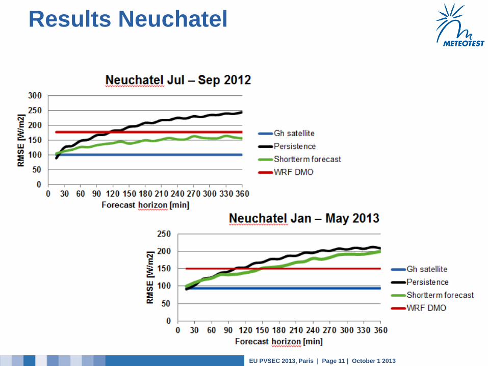
Forecast comparison to:
NWP WRF direct model output
Persistence forecast (constant clearness index)
Periods:
Jul – Sep 2012
Jan – May 2013
EU PVSEC 2013, Paris | Page 11 | October 1 2013
Results Neuchatel

EU PVSEC 2013, Paris | Page 12 | October 1 2013
Results per station (forecast)
EU PVSEC 2013, Paris | Page 13 | October 1 2013
Outline
Project description: Shortest term solar forecasting
Presentation results
Case studies
Overall statistics
Conclusion
EU PVSEC 2013, Paris | Page 14 | October 1 2013
Conclusion
Shortest term solar forecasting 0.5 - 6 hours with 15 min update
Basis: Satellite data + Wind from NWP model WRF + Post
Processing
RMSE: 0 - 6 hours over all stations: 75 – 200 W/m2 (20 - 60%*)
Improves NWP WRF DMO for 3 - 6 hours by ~40%.
Uncertainty: Flatland: low / Alps: high (increase in complex terrain)
Useful tool for forecast time between sky imaging nowcasting (0 –
30 min) and numerical weather prediction model (6 hours)
Projects lasts until summer 2014
Regionalisation (spatial aggregation) model will be added this year
(→ lower uncertainty)
* Depending on season, station and forecast horizon

EU PVSEC 2013, Paris | Page 15 | October 1 2013
Thank you
Thank you for your attention!
Stefan Müller, Meteotest, [email protected]
Jan Remund, Meteotest, [email protected] METEOTEST Fabrikstrasse 14
CH-3012 Bern
www.meteotest.ch
solarforecast.meteotest.ch
EU PVSEC 2013, Paris | Page 16 | October 1 2013
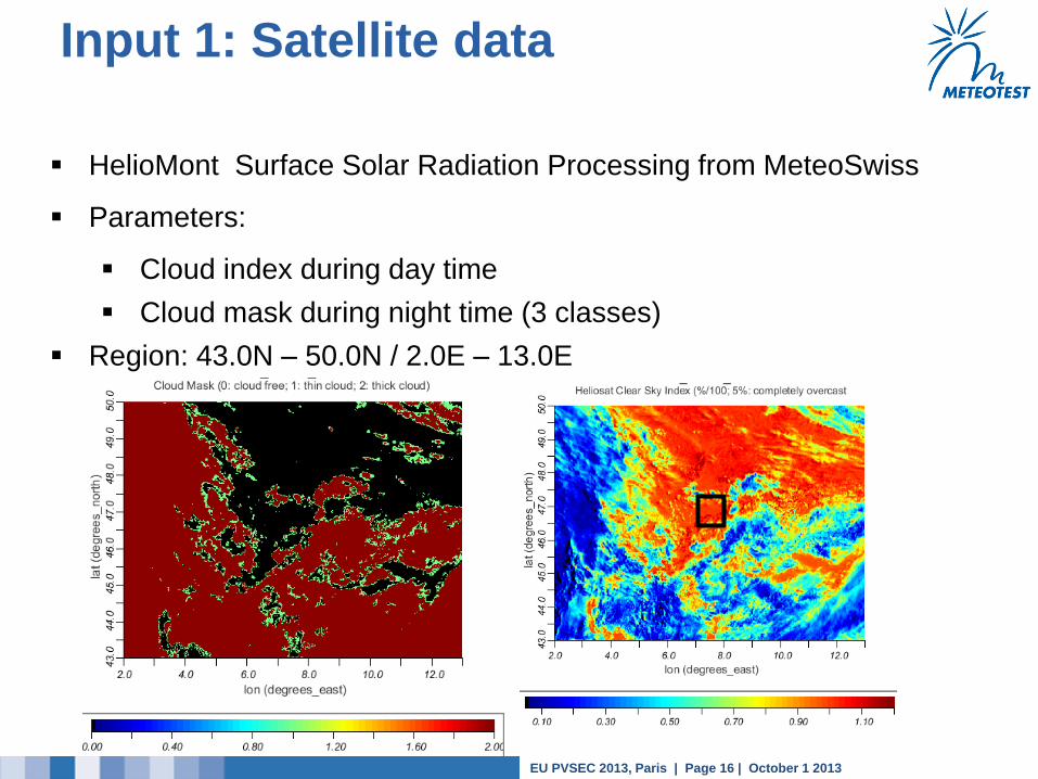
Input 1: Satellite data
HelioMont Surface Solar Radiation Processing from MeteoSwiss
Parameters:
Cloud index during day time
Cloud mask during night time (3 classes)
Region: 43.0N – 50.0N / 2.0E – 13.0E
EU PVSEC 2013, Paris | Page 17 | October 1 2013
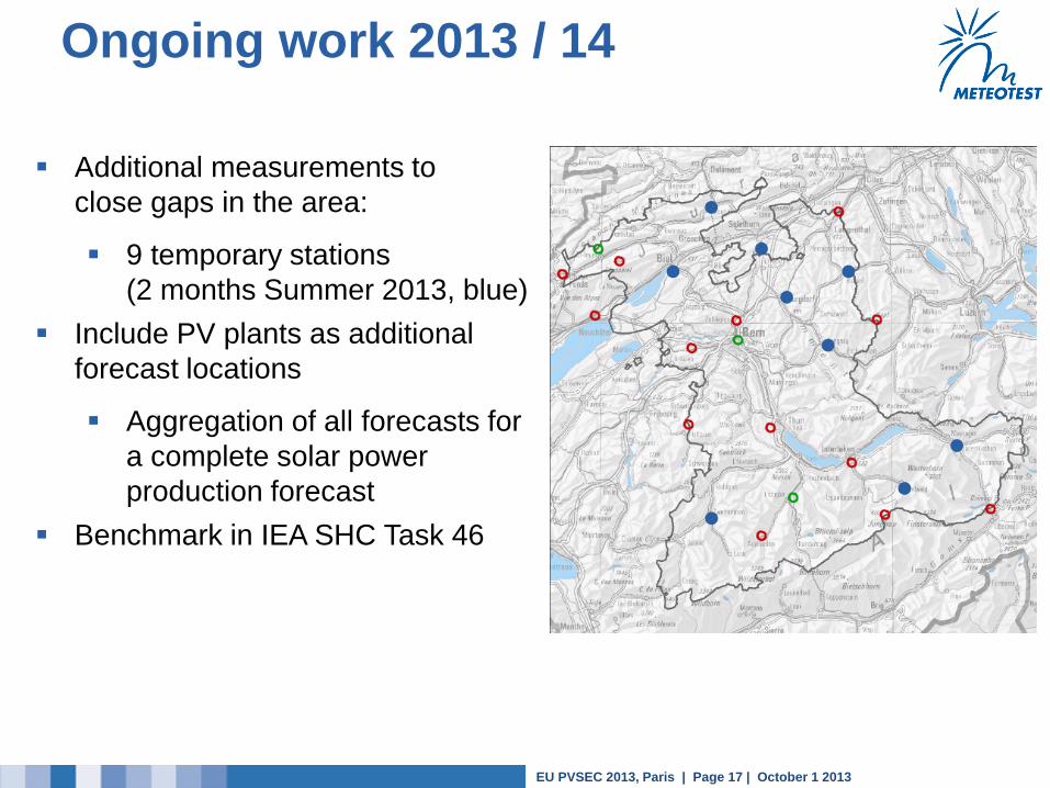
Ongoing work 2013 / 14
Additional measurements to
close gaps in the area:
9 temporary stations
(2 months Summer 2013, blue)
Include PV plants as additional
forecast locations
Aggregation of all forecasts for
a complete solar power
production forecast
Benchmark in IEA SHC Task 46
EU PVSEC 2013, Paris | Page 18 | October 1 2013
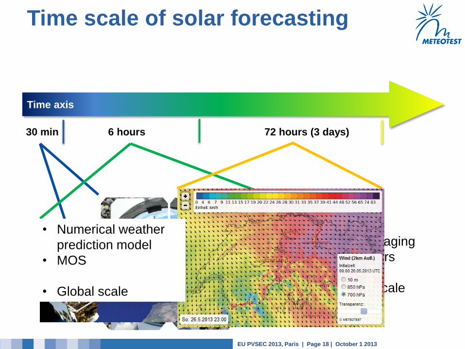
All sky imaging
Wind vectors
Local scale
Nowcasting
Time scale of solar forecasting
Time axis
30 min 6 hours 72 hours (3 days)
Satellite imaging
Wind vectors
Regional scale
• Numerical weather
prediction model
• MOS
• Global scale
EU PVSEC 2013, Paris | Page 19 | October 1 2013
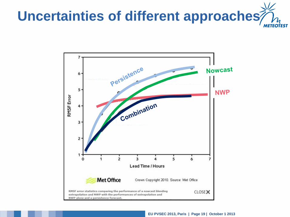
Uncertainties of different approaches
EU PVSEC 2013, Paris | Page 20 | October 1 2013
Post processing