SHELBY COUNTY, OHIO
18
SHELBY COUNTY, OHIO PROPERTY CONVEYANCE STANDARDS S . C . E . O .
Transcript of SHELBY COUNTY, OHIO

SHELBY COUNTY, OHIO
PROPERTY CONVEYANCE STANDARDS
S.C.E.O.

PROPERTY CONVEYANCE STANDARDS General Requirements
PAGE 2
GENERAL REQUIREMENTS FOR SURVEY PLATS AND DEED DESCRIPTIONS
♦ All new metes and bounds descriptions and all requirements for plats of survey shall incorporate the principles and minimum standards of good surveying, engineering and draftsmanship as defined in the “Minimum Standard for Boundary Surveys in the State of Ohio” as defined by Sections 4733-37 thru 4733-37-07 of the Administrative Code of the State Board of Registration for Professional Engineers and Surveyors of the State of Ohio. They shall also meet the requirements of the Shelby County Subdivision Regulations.
♦ All new descriptions and survey plats for boundary surveys required by Section 315.251 of the O.R.C. shall be ap-
proved by the County Engineer. ♦ When a tract of land to be transferred lies in two different sections, two different taxing parcels, or in and out of a vil-
lage or city, the acreage must be broken down accordingly. The acreage must be shown on the plat of survey and on the description.
♦ The person or persons preparing the plat of survey and the deed shall put on their “prepared by statement”. (O.R.C.
317.111) REQUIREMENTS OF PLATS OF SURVEY
♦ The surveyor shall prepare a plat of any retracement survey or any new survey which he/she originated, and shall make available a copy to the Shelby County Engineering Department and record said plat with the Shelby County Recorder.
♦ All existing right of way must be referenced to the survey such that the acreage of the existing right of way may be
determined and shown to the third decimal. The proposed right of way as shown on the Shelby County Proposed Throughfare Plan must also be shown on the survey plat.
♦ All plats of survey shall show all existing title and source of title of adjoining owners along each boundary line of the
subject survey along with the acreage or lot number of the adjacent tracts. ♦ All replats shall show the existing and proposed lot lines. ♦ For numbered lots, when a new survey or transfer will change the lot lines, a new lot number shall be assigned and the
existing lot lines vacated.

PROPERTY CONVEYANCE STANDARDS General Requirements
Page 3
REQUIREMENTS OF METES AND BOUNDS DESCRIPTIONS
♦ All new metes and bounds descriptions must give the acreage calculated to the third decimal point. The total acreage within the existing right of way must be shown to the third decimal point.
♦ Any references to roads, rivers, creeks, railroads, etc. must use current or existing names and/or numbers. The original
names may be mentioned if they would add clarity or would reference old deeds. ♦ Each course of a new meets and bounds description should be in a separate paragraph and stated in a clockwise direc-
tion from point of beginning to point of termination. ♦ Any course of a new metes and bounds description which is a curve must contain, as a minimum, the direction of the
curve (right or left), the radius, and the long chord bearing and distance of same. ♦ Any existing metes and bounds description which, since the previous conveyance, has been incorporated into a munici-
pality or other political subdivision by means of annexation must be changed to reflect its new corporate location within the situate of the subject instrument of conveyance.
♦ The number of exceptions on a deed must be limited to three (3) per tract. The person requesting deed description ap-
proval must be able to identify each exception on the tax maps and shall include the description of the exception on the deed, as well as volume and page number.
♦ Existing deed descriptions that cannot be located on the tax maps will not be approved for transfer and a new descrip-
tion will be required. ♦ Where part interests of real estate are being transferred, information regarding the remaining interests shall be furnished
with the deed description, (ex: volume and page numbers, etc.) ♦ If part of an inlot or outlot is being transferred or excepted, that part must be described by a metes and bounds descrip-
tion tied to a lot corner or intersecting street right of way lines. ♦ An exception to this will be when rectangular shaped lots are split by parallel lines, In these cases, it must be clear as
to whether the distance taken by parallel lines is the frontage distance or perpendicular distance. ♦ Descriptions prepared for Land Contracts shall meet the requirements for new metes and bounds descriptions.

PROPERTY CONVEYANCE STANDARDS General Requirements
Page 4
EXCEPTIONS TO REQUIREMENTS
♦ Descriptions of existing tracts or parcels of land for the purpose of settling an estate and descriptions for transferring land between members of immediate family when no consideration is given shall be exempt from requirements for de-scriptions. (Immediate family is grandparents, brother, sister, father, mother, spouse, child, grandchild).
♦ Deed transfers necessary to complete land contracts that were in effect prior to April 1, 1986. ♦ Scribner errors, omissions, or other obvious mistakes are permitted to be corrected in order to make the description
more accurate. PROCEDURES FOR TRANSFER OF DEEDS
♦ The deed preparer shall submit a copy of the deed to the Tax Map Office for approval at least 24 hours prior to transfer. ♦ If the deed description is not acceptable for transfer, the Tax Map Office shall notify the deed preparer. ♦ The original deed shall be presented to the Tax Map Office, if the deed description is acceptable, and shall be stamped
‘Description Approved’ in the margin of the deed. ♦ The deed can then be taken to the Auditor’s Office for transfer. ♦ The Tax Map Office will in most instances require no more than one working day for review and approval. For the
most efficient procedure and minimum delay time, a copy of the deed should be submitted immediately after the deed is prepared.
PROCEDURES FOR FORECLOSURE
♦ The deed preparer shall submit the completed “Property Description Approval Form” with a copy of the deed attached to the Tax Map Office for approval at least 24 hours prior to transfer.
♦ If the deed description is acceptable, it shall be stamped ‘Description Approved’ in the margin of the deed. ♦ The Order of Sale, The Property Description Approval Form and the original stamped deed can then be filed with the
Shelby County Clerk of Court . ♦ If the deed description is not acceptable, the deed will be stamped “Description not Satisfactory” and shall be returned
to the preparer.

PROPERTY CONVEYANCE STANDARDS Plat Approval Process
Page 5
PLAT APPROVAL PROCESS 5.00 ACRES OR LESS
♦ Plat is submitted to the Regional Planning Commission with the appropriate fee. ♦ The Planning Commission forwards plat to the Shelby County Engineer and other agencies and entities as required for
approval. ♦ The approving agencies review and then return the plat to the Regional Planning Commission (RCP) for the Director’s
approval. The RPC must have the Zoning Certificate issued by the appropriate township prior to the Director’s ap-proval.
♦ The Planning Commission sends the plat to the Shelby County Commissioners for approval. When the plat is approved
and signed it is then returned to the Planning Commission. ♦ The person responsible for the recording of said plat shall pick up the approved plat at the Tax Map office after being
notified by the Regional Planning Commission that it is approved. ♦ The plat shall be taken to the Shelby County Auditor’s Office where it will be stamped for transfer and then taken to
the Shelby County Recorder’s Office for recording. OVER 5.00 ACRES & RETRACMENT SURVEYS
♦ Plats shall be submitted to the Tax Map Office for the County Engineer’s approval. It will then be taken to the Shelby County Recorder’s Office and the Regional Planning Commission for Flood Plain review and then returned to the Tax Map Department.
♦ The plat may be picked up at the Tax Map Office, taken to the Auditor for the necessary transfer stamp, and then re-
corded in the Recorder’s Office.
RETRACEMENT SURVEYS
♦ Plats shall be submitted to the Tax Map Office or the Shelby County Engineer’s Office for the County Engineer’s ap-proval. It will then be taken to the Shelby County Recorder’s Office and the Regional Planning Commission for review and then returned to the Tax Map Department.
♦ The plat may be picked up at the Tax Map Office, taken to the Auditor for the necessary transfer stamp, and then re-
corded in the Recorder’s Office. PLATS WITHIN THE CITY OF SIDNEY AND ALL VILLAGES
♦ Plats shall be submitted to the Tax Map Office for the County Engineer’s and Recorder’s Office approval. It will then reviewed and then returned to the Tax Map Department.
♦ The plat may be picked up at the Tax Map Office and after reviewed by the Village or City, taken to the Auditor for the
necessary transfer stamp, and then recorded in the Recorder’s Office.

PROPERTY CONVEYANCE STANDARDS Minimum Standards for Boundary Surveys
Page 6
MINIMUM
STANDARDS
FOR
BOUNDARY
SURVEYS

PROPERTY CONVEYANCE STANDARDS Minimum Standards for Boundary Surveys
Page 7

PROPERTY CONVEYANCE STANDARDS Minimum Standards for Boundary Surveys
Page 8
4733-37-01 Preamble. These rules are intended to be the basis for all sur-veys relating to the establishment or retracement of property boundaries in the state of Ohio. When the case arises where one or more provisions herein must be abridged due to local condition, the abridge-ment shall be clearly indicated on plats and/or legal descriptions and reports. Where local or other pre-scribed regulations exist which are more restrictive than these rules, the survey shall conform to all local and state regulatory standards. When a client de-sires only a portion of his property surveyed, and this portion can be clearly isolated from the remain-der of the property without affecting the interests of adjoining owners, these rules shall apply to the sur-vey of only the desired portion. HISTORY: Eff 5-1-80; 11-1-03 Rule promulgated under: RC 119.03 Rule authorized by: RC 4733.07 Rule amplifies: RC 4733.20 R.C. 119.032 review dates: 05/09/2003 and 11/01/2008
4733-37-02 Research and in-vestigation. (A) The surveyor shall consult deeds and other docu-ments, including those for adjacent parcels, in order to assemble the best possible set of written evidence of every corner and line of the property being sur-veyed. (B) After all necessary written documents have been analyzed, the survey shall be based on a field inves-tigation of the property. The surveyor shall make a thorough search for physical monuments, and ana-lyze evidence of monumentation and occupation. In addition, the surveyor shall, when necessary, confer with the owner(s) of the adjoining property and the owner(s) of the property being surveyed. HISTORY: Eff 11-1-03 Rule promulgated under: RC 119.03 Rule authorized by: RC 4733.07 Rule amplifies: RC 4733.20 Replaces: Prior 4733-37-02 R.C. 119.032 review dates: 11/01/2008
4733-37-03 Monumentation. (A) The surveyor shall set boundary monuments so that, upon completion of the survey, each cor-ner of the property and each referenced control station will be physically monumented. (B) When it is impossible or impracticable to set a boundary monument on a corner, the surveyor shall set a reference monument, similar in charac-ter to the boundary monument and preferably along one of the property lines which intersect at that corner. When such a reference monument is used, it shall be clearly identified as a reference monument on the plat of the property and in any new deed description which may be written for the property. (C) Every boundary monument and/or reference monument set by the surveyor shall, when practi-cable: (1) Be composed of a durable material. (2) Have a minimum length of thirty inches. (3) Have a minimum cross-section area of material of 0.21 square inches. (4) Be identified with a durable marker bearing the surveyor’s Ohio registration number and/or name or company name. (5) Be detectable with conventional instruments for finding ferrous or magnetic objects. (D) When a case arises, due to physical obstruc-tions such as pavements, large rocks, large roots, utility cables, etc., so that neither a boundary monument nor a reference monument can be con-veniently or practicably set in accordance with paragraph (C) of this rule, then alternative monu-mentation, which is essentially as durable and identifiable (e.g., chiselled “X” in concrete, drill hole, etc.) shall be established for the particular situation. HISTORY: Eff 5-1-80; 11-1-03 Rule promulgated under: RC 119.03 Rule authorized by: RC 4733.07 Rule amplifies: RC 4733.20 R.C. 119.032 review dates: 05/09/2003 and 11/01/2008

PROPERTY CONVEYANCE STANDARDS Minimum Standards for Boundary Surveys
Page 9
4733-37-04 Measurement specifications. All measurements shall be made in accord with the following specifications: (A) The surveyor shall keep all equipment used in the performance of surveying in proper repair and adjustment. (B) Every determination of distance shall be made either directly or indirectly in such a manner that the linear error in the distance between any two points (not necessarily adjacent points) shall not exceed the reported distance divided by ten thousand (allowable linear error = reported distance divided by ten thousand) and every angular measurement shall be made in such a manner that the allowable (directional) error, in radians, shall not exceed the allowable linear error divided by the reported dis-tance (allowable (directional) error = allowable lin-ear error divided by reported distance). When the reported distance is less than two hundred feet, the linear error shall not exceed 0.02 feet. The reported distance is the distance established by the survey. (C) In all new descriptions and plats of survey, the lengths and directions of the lines shall be specified so that the mathematical error in closure of the property boundary does not exceed 0.02 feet in lati-tudes and 0.02 feet in departure. (D) Surveys performed using metric measurements shall utilize the metric equivalents based upon the U.S. survey foot conversion factor. HISTORY: Eff 5-1-80; 11-1-03 Rule promulgated under: RC 119.03 Rule authorized by: RC 4733.07 Rule amplifies: RC 4733.20 R.C. 119.032 review dates: 05/09/2003 and 11/01/2008
4733-37-05 Plat of survey. (A) The surveyor shall prepare a scale drawing of every individual survey, or drawings comprising all of the surveys when they are contiguous, in which the surveyor retraces previously established prop-erty lines or establishes new boundaries. (B) A copy of this drawing shall be given to the cli-ent. When required, another copy shall be filed with the appropriate public agencies.
(C) The surveyor shall include the following de-tails: (1) A title such that the general location of the sur-vey can be identified. The title shall include, but not be limited to: state, county, civil township or municipality, and original land subdivision descrip-tion. (2) A north arrow with a clear statement as to the basis of the reference direction used. (3) The control station(s) or line cited in the de-scription and the relationship of the property to this control must be referenced to an established monumented point of beginning such as, but not limited to: centerline intersection of streets or highways record, section or quarter section cor-ners, Virginia military survey corners or lines, or platted lot corners. The type of monuments set or found at the control stations shall be noted. (4) A notation at each corner of the property stat-ing that the boundary monument specified in the deed description was found, or that a boundary monument was set, or a legend of the symbols used to identify monumentation. In addition, there shall be a statement describing the material and size of every monument found or set. (5) A general notation describing the evidence of occupation that may be found along every bound-ary line or occupation line. (6) The length and direction of each line as speci-fied in the description of the property or as deter-mined in the actual survey if this differs from what is stated in the deed description by more than the tolerance specified in paragraph (B) of rule 4733-37-04 of the Administrative Code. The length and direction shall be stated as follows:-. (a) Bearings expressed in degrees, minutes and seconds and distances expressed in feet and deci-mal parts thereof on each course. If a metric equivalent distance is stated, it shall be stated to the third decimal place. (b) All curved lines shall indicate the radius, cen-tral angle, curve length, chord bearing and chord distance. (c) Each course shall show other common lines such as centerline of roads, rivers, streams, sec-tion lines, quarter section lines, half section lines or other pertinent common lines of record. (7) A citation of pertinent documents and sources of data used as a basis for carrying out the work. The citation shall include, but not be limited to: current deeds as of the date of the survey, prior deeds or other documents of record, and available

PROPERTY CONVEYANCE STANDARDS Minimum Standards for Boundary Surveys
Page 10
deeds of record for adjoining parcels along each boundary line of the survey. If the adjoining parcel is a recorded subdivision, only the subdivision name, recording information and lot numbers need to be shown. (8) The written and graphical scale of the drawing. (9) The date of the survey. (10) The surveyor’s printed name and Ohio registra-tion number, signature and seal (in a form which may clearly reproduce on any copies which may be made of the original drawing). (11) The area contained within the perimeter of the surveyed parcel. (12) All references to roads or railroads contiguous to the surveyed parcel shall use current names or names of record and applicable right of way widths, if available. (13) All references to rivers or streams shall use cur-rent names of record, if available. HISTORY: Eff 5-1-80; 11-1-03 Rule promulgated under: RC 119.03 Rule authorized by: RC 4733.07 Rule amplifies: RC 4733.20 R.C. 119.032 review dates: 05/09/2003 and 11/01/2008
4733-37-06 Descriptions. (A) When a surveyor is called upon to prepare a new description, either to replace an existing description which is inadequate or to create a new piece of property, said description shall include the following items: (1) Sufficient caption so that the property can be adequately identified. (2) A relationship between the property in question and clearly defined control station(s). (3) The basis of the bearings. (4) A citation to the public record of the appropriate prior deed(s). (5) The surveyor’s name, Ohio registration number and date of writing and/or survey. (B) A metes and bounds description shall include, in addition to paragraph (A) of this rule: (1) A description of the boundary monument used as the initial point of the description. (2) A series of calls for successive lines bounding the parcel, each of which specifies: (a) The intent in regards to adjoiners or other exist-ing features.
(b) The direction of the line relative to the direc-tion of the basis of bearing. (c) The length of the line. (d) A description of the boundary monument (or reference monument) and whether found or set to identify the end of the particular line. (e) All curved lines shall indicate the radius, cen-tral angle, curve length, chord bearing, chord length and direction of the curve. (f) The reported boundary data shall meet the clo-sure requirements of paragraph (C) of rule 4733-37-04 of the Administrative Code. (3) The area of the parcel. (C) Descriptions other than metes and bounds de-scriptions may be a reference to a recorded survey plat or a parcel on a recorded survey plat and shall include sufficient and adequate legal and technical wording so that the property can be definitely lo-cated and defined. (D) A statement shall appear indicating that ei-ther: the description was made in accordance with a recent survey and the date thereof, or the de-scription was made based on a previous survey, of a certain date, and date of description, or the de-scription was not based on a survey. (E) When the surveyor knows a new description is to be used for a fee transfer, the surveyor shall base the description on a current or updated sur-vey of the property. HISTORY: Eff 5-1-80; 11-1-03 Rule promulgated under: RC 119.03 Rule authorized by: RC 4733.07 Rule amplifies: RC 4733.20 R.C. 119.032 review dates: 05/09/2003 and 11/01/2008
4733-37-07 Subdivisions. When a subdivision is created from a piece of property, or several adjoining pieces, the following rules shall apply: (A) Rule 4733-37-02 of the Administrative Code shall apply to the original tract(s) of land prior to being subdivided. (B) Rule 4733-37-03 of the Administrative Code shall apply to the outside perimeter of the original tract(s) of land and to the outside perimeter of the newly created subdivisions. All newly created lots, blocks, rights of way, angle points, points of curva-ture and points of tangency shall be monumented

PROPERTY CONVEYANCE STANDARDS Minimum Standards for Boundary Surveys
Page 11
according to local regulations. Street rights of way may be monumented with monuments on the cen-terline instead of right of way monuments. Center-line or right of way monuments shall be set at all intersections, angle points, points of curvature and points of tangency. (C) All newly created subdivisions shall comply with rules 4733-37-04 and 4733-37-05 of the Administra-tive Code. (D) All easements within a newly created subdivision shall be accurately dimensioned so that each ease-ment line can be reproduced without ambiguity. HISTORY: Eff 11-1-03 Rule promulgated under: RC 119.03 Rule authorized by: RC 4733.07 Rule amplifies: RC 4733.20 R.C. 119.032 review dates: 11/01/2008 Replaces: Prior 4733-37-07

PROPERTY CONVEYANCE STANDARDS Minimum Standards for Mortgage Surveys
Page 12
MINIMUM
STANDARDS
FOR
MORTGAGE
SURVEYS

PROPERTY CONVEYANCE STANDARDS Minimum Standards for Mortgage Surveys
Page 13
PROPERTY CONVEYANCE STANDARDS Minimum Standards for Mortgage Surveys
Page 14
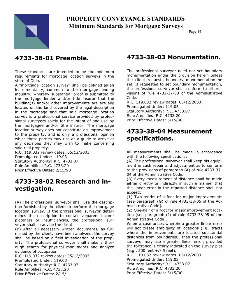
4733-38-01 Preamble. These standards are intended to be the minimum requirements for mortgage location surveys in the state of Ohio. A “mortgage location survey” shall be defined as an instrumentality, common to the mortgage lending industry, whereby substantial proof is submitted to the mortgage lender and/or title insuror that the building(s) and/or other improvements are actually located on the land covered by the legal description in the mortgage and that said mortgage location survey is a professional service provided by profes-sional surveyors solely for the intent of and use by the mortgagee and/or title insuror. The mortgage location survey does not constitute an improvement to the property, and is only a professional opinion which these parties may use as a guide to arrive at any decisions they may wish to make concerning said real property. R.C. 119.032 review dates: 05/12/2003 Promulgated Under: 119.03 Statutory Authority: R.C. 4733.07 Rule Amplifies: R.C. 4733.20 Prior Effective Dates: 2/15/90
4733-38-02 Research and in-vestigation. (A) The professional surveyor shall use the descrip-tion furnished by the client to perform the mortgage location survey. If the professional surveyor deter-mines the description to contain apparent incom-pleteness or insufficiencies, the professional sur-veyor shall so advise the client. (B) After all necessary written documents, as fur-nished by the client, have been analyzed, the survey shall be based on a field investigation of the prop-erty. The professional surveyor shall make a thor-ough search for physical monuments and analyze evidence of occupation. R.C. 119.032 review dates: 05/12/2003 Promulgated Under: 119.03 Statutory Authority: R.C. 4733.07 Rule Amplifies: R.C. 4733.20 Prior Effective Dates: 2/15/
4733-38-03 Monumentation. The professional surveyor need not set boundary monumentation under the provision herein unless the client requests boundary monumentation be set. If requested to set boundary monumentation, the professional surveyor shall conform to all pro-visions of rule 4733-37-03 of the Administrative Code. R.C. 119.032 review dates: 05/12/2003 Promulgated Under: 119.03 Statutory Authority: R.C. 4733.07 Rule Amplifies: R.C. 4733.20 Prior Effective Dates: 5/15/90
4733-38-04 Measurement specifications. All measurements shall be made in accordance with the following specifications: (A) The professional surveyor shall keep his equip-ment in such repair and adjustment as to conform to the provisions of paragraph (A) of rule 4733-37-04 of the Administrative Code. (B) Every measurement of distance shall be made either directly or indirectly in such a manner that the linear error in the reported distance shall not exceed: (1) Two-tenths of a foot for major improvements [see paragraph (G) of rule 4733-38-05 of the Ad-ministrative Code]. (2) One-half of a foot for major improvement loca-tion [see paragraph (J) of rule 4733-38-05 of the Administrative Code]. When a case arises wherein a greater linear error will not create ambiguity of locations (i.e., tracts where the improvements are located substantial distances from boundaries), then the professional surveyor may use a greater linear error, provided the tolerance is clearly indicated on the survey plat (e.g., 500 feet +/- 5 feet). R.C. 119.032 review dates: 05/12/2003 Promulgated Under: 119.03 Statutory Authority: R.C. 4733.07 Rule Amplifies: R.C. 4733.20 Prior Effective Dates: 5/15/90

PROPERTY CONVEYANCE STANDARDS Minimum Standards for Mortgage Surveys
Page 15
4733-38-05 Mortgage location survey plat. The professional surveyor shall include the following information on the mortgage location survey plat. (A) A title such that the general location of the sur-vey can be identified. (B) A north arrow. (C) The boundary lines as cited in the legal descrip-tion, including pertinent references therein. (D) The written and graphical scale of the drawing. (E) The date of survey. (F) The professional surveyor’s name, registration number, signature, and seal in accordance with paragraph (C)(10) of rule 4733-37-05 of the Admin-istrative Code. (G) Major improvements (permanent structures) shall be shown with dimensions and description (e.g., residence, garages, outbuildings with founda-tion, in-ground pools, and the like). (H) Easement limits and building set-back lines as indicated on the recorded plat or as supplied by the client. (I) Visible utility facilities requiring an easement and located outside known easements, crossing the sub-ject property and serving others, such as, though not limited to: pole lines, manholes, inlets and ped-estals and the like. (J) Major improvement locations shall be shown with dimensions to the nearest property lines, with a minimum of two dimensions shown, and shall be sufficient to locate the structure (offsets shall be shown perpendicular to straight property lines and radially to curved property lines). (K) Apparent encroachments shall be noted and shown in an obvious manner. (L) The address posted on the building(s), if avail-able. (M) Observed problems of ingress and egress and joint drive. (N) Fences or other evidence of possession when not in substantial conformance with the legal descrip-tion. (O) A statement shall appear on the plat indicating that the survey is a mortgage location survey pre-pared in accordance with Chapter 4733-38 of the Administrative Code, and is not a boundary survey pursuant to Chapter 4733-37 of the Administrative Code. (P) Number each page showing individual page num-
bers along with number of pages. R.C. 119.032 review dates: 05/12/2003 Promulgated Under: 119.03 Statutory Authority: R.C. 4733.07 Rule Amplifies: R.C. 4733.20 Prior Effective Dates: 5/15/90

PROPERTY CONVEYANCE STANDARDS Ohio Revised Code
Page 16
OHIO
REVISED
CODE
SECTIONS
315.251 &
319.203

PROPERTY CONVEYANCE STANDARDS Ohio Revised Code
Page 17
315.251 Minimum standards for boundary surveys. (A) If a deed conveying title to real property is pre-sented to the county auditor for transfer, and the deed contains a legal description for land that is a cut-up or split of the grantor’s one or more existing parcels of land as shown in the county auditor’s re-cords, or if the legal description of the land conveyed in the deed is different from the legal description shown in the prior deed to the grantor, a boundary survey plat in conformity with the new description shall be submitted with the deed. The survey plat and description shall satisfy the minimum standards for boundary surveys promulgated by the board of registration for professional engineers and surveyors pursuant to Chapter 4733. of the Revised Code. If, in the opinion of the county engineer, the survey plat and description satisfy those standards, the county auditor shall accept the deed for transfer and a copy of the survey plat shall be filed in the county engineer’s survey file for public inspection. This section applies only if the requirements of this section are included in the standards governing con-veyances of real property in the county adopted un-der section 319.203 of the Revised Code. (B) Beginning on the effective date of this amend-ment, in the counties where the county engineer elects to engage in the private practice of engineer-ing or surveying under division (B) of section 325.14 of the Revised Code the county auditor of that county shall designate another engineer who is reg-istered under Chapter 4733. of the Revised Code and who is employed in the same county engineer’s office to perform the duty of the county engineer under division (A) of this section or to exercise or perform any authority or duty of the county engineer under section 319.203 of the Revised Code if the county engineer reasonably believes that the per-formance of that duty or exercise of that authority by the county engineer would constitute a violation of Chapter 102. of the Revised Code or any other similar civil or criminal statute. Pursuant to this au-thorization, the designee engineer shall act in the place of the county engineer. Neither the county en-gineer nor the designee engineer shall discuss any matter reasonably related to this authorization. Any act in compliance with this section is not a violation of Chapter 102. of the Revised Code or any other similar statute.
Division (B) of this section applies only to a county engineer holding office on the effective date of this amendment during such time as the person contin-ues to serve that term or an immediately consecu-tive term of office as a county engineer. Effective Date: 1996 SB287 03-13-1997; 1996 SB262 03-18-
319.203 Adopting standards governing conveyances of real property in county. Subject to division (B) of section 315.251 of the Revised Code, the county auditor and the county engineer of each county, by written agreement, shall adopt standards governing conveyances of real property in the county. These standards may include the requirements specified in section 315.251 of the Revised Code. The county auditor and county engineer may modify those standards from time to time as they consider necessary or desirable. The standards shall be adopted or modi-fied only after the county auditor and county engi-neer have held two public hearings, not less than ten days apart, concerning adoption or modifica-tion of the standards. The standards shall be avail-able for public inspection during normal business hours at the offices of the county auditor and county engineer. Before the county auditor transfers any convey-ance of real property presented to the auditor un-der section 319.20 or 315.251 of the Revised Code, the county auditor shall review the convey-ance to determine whether it complies with the standards adopted under this section. The county auditor shall not transfer any conveyance that does not comply with those standards. Effective Date: 03-18-1997

SHELBY COUNTY, OHIO Property Description Approval Form
FORCLOSURE ACTION PER O.R.C. 2329.191
COURT CASE NO: ___________________________________________________________ PROPERTY ADDRESS: ___________________________________________________________ PLAINTIFF: ___________________________________________________________ DEFENDANT: ___________________________________________________________ SUBMITTED BY: ___________________________________________________________ ___________________________________________________________ ___________________________________________________________ ATTORNEY & I.D. #: ___________________________________________________________ ATTORNEY PHONE #: ___________________________________________________________ CONTACT PERSON: ___________________________________________________________ CONTACT PHONE #: ___________________________________________________________
The attached legal description has been reviewed by the Shelby County Tax Map Department. The property address, parcel number (s) and deed reference number (s) must be listed under the legal description (no exceptions). You may use a copy of the prior deed which may contain all of this information. This document along with the “stamped approved” original legal description must be attached to the order of Sale when filed with the Shelby County Clerk of Court. You will be submitting the Order of Sale, this Property Description Ap-proval Form and the “red stamped approved” legal description. Hand letter documents may be rejected if the document is not legible or will be reproduced to department standards. Machine printed or drafted documents are preferred.
* INTERNAL USE ONLY * The following information has been reviewed and verified by the Shelby County Tax Map Department. Disapproved for the following reason (s). ____ Legal description does not match information as submitted. ____ Parcel number does not match legal description information as submitted. ____ Legal name does not match information as submitted. ____ Property address does not match information as submitted. ____ Other ____________________________________________________________________________________ _______________________________________________________________________________________________.