SequenceStratigraphic Analysis of the Aptian Deposits in ... et al., 2011.pdfusing the regional and...
11
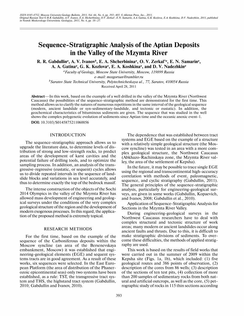
ISSN 01458752, Moscow University Geology Bulletin, 2011, Vol. 66, No. 6, pp. 393–403. © Allerton Press, Inc., 2011. Original Russian Text © R.R. Gabdullin, A.V. Ivanov, E.A. Shcherbinina, O.V. Zerkal’, E.N. Samarin, A.A. Gatina, G.K. Kozlova, E.A. Koshkina, D.V. Nadezhkin, 2011, published in Vestnik Moskovskogo Universiteta. Geologiya, 2011, No. 6, pp. 18–27. 393 INTRODUCTION The sequencestratigraphic approach allows us to upgrade the literature data, to determine levels of dis tribution of strong and lowstrength rocks, to predict areas of the development of karst cavities and the potential failure of drilling tools, and to optimize the sampling process. In addition, an analysis of the trans gressiveregressive (eustatic, or sequent) cycles allows us to divide repeated intervals in the sequence of land slide blocks and variations in sea level accurately, and thus to determine exactly the top of the bedrock massif. The intense construction of the objects of the Sochi 2014 Olympics in the valley of the Mzymta River has allowed mass development of engineering and geolog ical surveys under the conditions of the very complex geological structure of the region and the development of modern exogenous processes. In this regard, the applica tion of the proposed method is extremely topical. RESEARCH METHODS For the first time, based on the example of the sequence of the Carboniferous deposits within the Moscow syncline (an area of the Bersenevskaya embankment, Moscow) it was established that engi neeringgeological elements (EGE) and sequent sys tems tracts are in good agreement. As a result of these works, six sequences were selected. In the East Euro pean Platform (the area of distribution of the Phaner ozoic epicontinental seas) only two systems have been established, as a rule: TST, the transgressive tract sys tem and THS, the highstand tract system (Gabdullin, 2010; Gabdullin and Ivanov, 2010). The dependence that was established between tract systems and EGE based on the example of a structure with a relatively simple geological structure (the Mos cow syncline) was tested in an area with a more com plex geological structure, the Northwest Caucasus (AbkhazoRachinskaya zone, the Mzymta River val ley, the area of the settlement of Kepsha). In the future, it may be possible to trace single EGE using the regional and transcontinental highaccuracy correlation with methods of event, paleomagnetic, sequence, and cyclic stratigraphy (Gabdullin, 2011). The general principles of the sequencestratigraphic analysis, particularly for engineeringgeological sur veys, are given in some works (Gabdullin, Kopaevich, and Ivanov, 2008; Gabdullin et al., 2010). Application of SequenceStratigraphic Analysis for Sections in the Mzymta River Valley. During engineeringgeological surveys in the Northwest Caucasus researchers have to deal with complex structural and tectonic structure of work areas; many modern or ancient landslides occur along ancient faults and thrusts. Due to this, it is difficult to make stratigraphic divisions of sediments. To over come these difficulties, the methods of applied stratig raphy are used. This work is based on the results of field works that were carried out in the summer of 2009 within the Kepsha site (Figs. 1a, 1b), which included: (1) five geological routes and 386 points of observation, (2) description of the cores from 86 wells; (3) description of the sections of ten test pits, (4) collection of more than 200 samples of sedimentary rocks from both nat ural and artificial outcrops, as well as the core, (5) pet rographic study of rocks in 115 thin sections according SequenceStratigraphic Analysis of the Aptian Deposits in the Valley of the Mzymta River R. R. Gabdullin a , A. V. Ivanov b , E. A. Shcherbinina a , O. V. Zerkal’ a , E. N. Samarin a , A. A. Gatina a , G. K. Kozlova a , E. A. Koshkina a , and D. V. Nadezhkin a a Faculty of Geology, Moscow State University, Moscow, 119899 Russia email: [email protected] b Saratov State Technical University, Polytechnicheskaya ul., 77, Saratov, 410054 Russia Received April 28, 2011 Abstract—In this work, based on the example of a well drilled in the valley of the Mzymta River (Northwest Caucasus) the possibilities of the sequencestratigraphic method are demonstrated for the first time. This method allows us to clarify the natures of numerous repetitions in the same interval of the geological sequence (modern, ancient landslide or synsedimentarylandslide, and tectonic or eustatic). In addition, the geochemical characteristics of bituminous sediments are given. The sequence that was studied in the well shows the complex polygenetic evolution of sediments since Aptian time and the oceanic anoxic event1. DOI: 10.3103/S0145875211060056
Transcript of SequenceStratigraphic Analysis of the Aptian Deposits in ... et al., 2011.pdfusing the regional and...
ISSN 0145�8752, Moscow University Geology Bulletin, 2011, Vol. 66, No. 6, pp. 393–403. © Allerton Press, Inc., 2011.Original Russian Text © R.R. Gabdullin, A.V. Ivanov, E.A. Shcherbinina, O.V. Zerkal’, E.N. Samarin, A.A. Gatina, G.K. Kozlova, E.A. Koshkina, D.V. Nadezhkin, 2011, publishedin Vestnik Moskovskogo Universiteta. Geologiya, 2011, No. 6, pp. 18–27.
393
INTRODUCTION
The sequence�stratigraphic approach allows us toupgrade the literature data, to determine levels of dis�tribution of strong and low�strength rocks, to predictareas of the development of karst cavities and thepotential failure of drilling tools, and to optimize thesampling process. In addition, an analysis of the trans�gressive�regressive (eustatic, or sequent) cycles allowsus to divide repeated intervals in the sequence of land�slide blocks and variations in sea level accurately, andthus to determine exactly the top of the bedrock massif.
The intense construction of the objects of the Sochi2014 Olympics in the valley of the Mzymta River hasallowed mass development of engineering and geolog�ical surveys under the conditions of the very complexgeological structure of the region and the development ofmodern exogenous processes. In this regard, the applica�tion of the proposed method is extremely topical.
RESEARCH METHODS
For the first time, based on the example of thesequence of the Carboniferous deposits within theMoscow syncline (an area of the Bersenevskayaembankment, Moscow) it was established that engi�neering�geological elements (EGE) and sequent sys�tems tracts are in good agreement. As a result of theseworks, six sequences were selected. In the East Euro�pean Platform (the area of distribution of the Phaner�ozoic epicontinental seas) only two systems have beenestablished, as a rule: TST, the transgressive tract sys�tem and THS, the highstand tract system (Gabdullin,2010; Gabdullin and Ivanov, 2010).
The dependence that was established between tractsystems and EGE based on the example of a structurewith a relatively simple geological structure (the Mos�cow syncline) was tested in an area with a more com�plex geological structure, the Northwest Caucasus(Abkhazo�Rachinskaya zone, the Mzymta River val�ley, the area of the settlement of Kepsha).
In the future, it may be possible to trace single EGEusing the regional and transcontinental high�accuracycorrelation with methods of event, paleomagnetic,sequence, and cyclic stratigraphy (Gabdullin, 2011).The general principles of the sequence�stratigraphicanalysis, particularly for engineering�geological sur�veys, are given in some works (Gabdullin, Kopaevich,and Ivanov, 2008; Gabdullin et al., 2010).
Application of Sequence�Stratigraphic Analysis forSections in the Mzymta River Valley.
During engineering�geological surveys in theNorthwest Caucasus researchers have to deal withcomplex structural and tectonic structure of workareas; many modern or ancient landslides occur alongancient faults and thrusts. Due to this, it is difficult tomake stratigraphic divisions of sediments. To over�come these difficulties, the methods of applied stratig�raphy are used.
This work is based on the results of field works thatwere carried out in the summer of 2009 within theKepsha site (Figs. 1a, 1b), which included: (1) fivegeological routes and 386 points of observation, (2)description of the cores from 86 wells; (3) descriptionof the sections of ten test pits, (4) collection of morethan 200 samples of sedimentary rocks from both nat�ural and artificial outcrops, as well as the core, (5) pet�rographic study of rocks in 115 thin sections according
Sequence�Stratigraphic Analysis of the Aptian Deposits in the Valley of the Mzymta River
R. R. Gabdullina, A. V. Ivanovb, E. A. Shcherbininaa, O. V. Zerkal’a, E. N. Samarina,A. A. Gatinaa, G. K. Kozlovaa, E. A. Koshkinaa, and D. V. Nadezhkina
aFaculty of Geology, Moscow State University, Moscow, 119899 Russiae�mail: [email protected]
bSaratov State Technical University, Polytechnicheskaya ul., 77, Saratov, 410054 RussiaReceived April 28, 2011
Abstract—In this work, based on the example of a well drilled in the valley of the Mzymta River (NorthwestCaucasus) the possibilities of the sequence�stratigraphic method are demonstrated for the first time. Thismethod allows us to clarify the natures of numerous repetitions in the same interval of the geological sequence(modern, ancient landslide or syn�sedimentary�landslide, and tectonic or eustatic). In addition, thegeochemical characteristics of bituminous sediments are given. The sequence that was studied in the wellshows the complex polygenetic evolution of sediments since Aptian time and the oceanic anoxic event�1.
DOI: 10.3103/S0145875211060056

394
MOSCOW UNIVERSITY GEOLOGY BULLETIN Vol. 66 No. 6 2011
GABDULLIN et al.
to the modified classification by S.G. Vishnyakov,(Shvanov et al., 1998), (6) micropaleontological analy�sis: identification of Mesozoic radiolarians in 115 thinsections (V.S. Vishnevskaya, Geological Institute of the
Russian Academy of Sciences, or briefly GIN RAS),the determination of the Mesozoic foraminifera in the115 thin sections (L.F. Kopaevich, Moscow StateUniversity, or briefly MSU), the definition of theMesozoic nanoplankton in 200 samples (E.A. Scher�binina, GIN RAS), the determination of the Meso�zoic ostracods in 10 samples (E.A. Tesakova, MSU);the age dating of rocks was based on the study of thenanoplankton complex, which can be easily deter�mined in the samples. Ostracods, radiolaria and fora�minifera were not found;
(7) macropaleontological analysis: identification ofbivalves and cephalopods (E.Yu. Baraboshkin, MSU);(8) geochemical analysis of elements and oxides in85 samples using a MARC.GV X�ray�fluorescentspectroscope (Spectron NGO, St. Petersburg, analystE.N. Samarin (MSU)); and (9) the Rock Eval 6 pyrol�ysis (analyst D.V. Nadezhkin, MSU).
The main difficulties in the division and correlationof geological sections are the follows:
(b)
HI,
mg
HC
/g C
org
OI, mg CO2/g Corg
J3agK2mi
K2m
J3kcK1kp
K2pt
K2vt
J2pr
J2–3ab
J2an
J2bt
νδP?a
1
Medoveevka
Sapun Mt.
Kepsha
Kepsha
Narzan
Pikhtovaya Mt. AibgaKrasnaya Skala
Mzymta
P A R KN A T I O N A L
S O C H I
J3ag J3ag
J3ag
K2mi
K2mi
K2mi
K2pt
J3agJ3ag
K1kp
J2–3abJ2pr
J2pr
K2pt
K2pt
K1md
K2vtνδP?a
J3ag
K2vt J3ag
K1md
J2–3ab
J2–3ab
J2pr
2040
354555
40
30
20
35
35
30
30
30
J2bt
25
60
70
t
60 25
60
50
1971
1643
1675
1069
1373
32
1319
37
845700
1000
900
800
700
(a)
(c)
I
II
III
600
500
400
300
200
100
0 50 150 200 250 300 350 400 450100
IV
Fig. 1. The scheme of the Kepsha area location:(a) a fragment of the State Geological Map at the 1 : 50000 scale, (b) the position of well no 568 on the landslide slope on the leftbank of the Kepsha River, (c) the results of the pyrolysis according to the Rock�Eval method on a modified Van Krevelen’s dia�gram (HI�OI dependence graph).
Table 1. Comparative characteristics of lithotypes based onfield and petrological descriptions and results of geochemi�cal analysis
No.Result data
of field description
Result data of petrographic
description
Result data of geochemical
analysis
1 Argillite Argillite Calcareous clay2 Limestone Bioclastic algae
limestoneClay limestone
3 Micritic marl Micritic marl the same4 Micritic marl the same Micritic marl5 Clay marl '' Clay dolomitic
marl

MOSCOW UNIVERSITY GEOLOGY BULLETIN Vol. 66 No. 6 2011
SEQUENCE�STRATIGRAPHIC ANALYSIS OF THE APTIAN DEPOSITS 395
(1) Similar lithological composition of units of dif�ferent ages (mainly terrigenous, clay�dominated spe�cies);
(2) The inability to establish and trace the geologi�cal boundaries in natural and artificial outcrops andthe core.
To overcome the first problem the mineralogical�petrographic methods of applied stratigraphy havebeen used. As usual, they are applied in a limited area,in which the same geological processes occurred. Theworks carried out included petrographic study of thinsections and geochemical analysis of the elements andoxides. The lithological composition allowed us to cor�rect the initial field description of the core (Tables 1, 2).
To solve the second problem the paleontologicaland sequent methods of applied stratigraphy wereused. These methods made it possible to date sedi�ments. The age data obtained made it possible todivide and correlate the sections and to estimate levelsof beds in areas where landslide processes occur.
When describing the core it is difficult to make acorrect prediction, and sometimes to determine thedepth of distribution of untouched bed rocks. Thesampling for paleontological analysis allowed us toidentify the levels of occurrence of multilayered land�slide plates on the basis of findings of microfossils ofdifferent ages because of their displacement by gravi�tational processes. In bedrock, there is no such “con�fusion” with age datings. Analysis of overturned bed�
ding of a bed (that is, establishment of features of theirbottom or top) was carried out based on hieroglyphs(mehanogliphs and biogliphs; that is, ichnofossils).
Sequence (or eustatic) analysis makes it possible todistinguish transgressive�regressive series of beds (reg�ular shoaling or deepening of the basin) from multi�layer landslide plates. In case of deepening, the grad�ual transition from one paleo�depth facies to anotheris not observed.
Stratigraphy and Geochemical Characteristics
Cretaceous rocks in the area of the settlement ofKepsha are terrigenous carbonate sediments, whichshow alternation in the section without apparentrhythmic structure. In the area of works, located onthe landslide slope of the left bank of the Mzymta river,as well as to the west and southwest, the deposits ofAptian and Albian layers of the Lower Cretaceous, andSenomanian, Santonian and Campanian layers of theUpper Cretaceous were described in natural outcropsand wells. In general, the carbonate content in sedi�ments increases up the section: if clays and silts aredominated in the Aptian sediments, then the Albian�Senomanian part of the section consists mainly ofclays and bituminous marls interbedding with lime�stones and clays. The Santonian–Campanian depositsare represented by marls and limestones.
The lower and middle parts of the slope are made ofLower Aptian rocks. Albian deposits are characteristic
Table 2. Results of geochemical analysis of elements and oxides from seven samples (well no. 568), obtained usingMARC.GV (NPO Spektron, St. Petersburg, analyst E.N. Samarin (MSU))
Component
Depth, m
26.31
28.02
30.03
40.04
42.65
42.86
43.97
SiO2 50.1 48.6 54.5 52.5 45.7 59.1 54.4
TiO2 0.6 0.6 0.7 0.7 0.5 0.8 0.7
Al2O3 16.0 15.3 19.8 20.6 15.9 19.2 20.3
Fe2O3 4.1 4.2 5.3 6.0 4.7 5.8 5.5
MnO 0.1 0.2 0.1 0.3 0.2 0.1 0.1
CaO 14.2 15.1 10.1 11.6 15.7 6.8 9.6
MgO 1.9 1.9 2.4 3.1 1.8 2.1 2.7
K2O 2.2 2.2 2.5 2.5 2.2 2.7 2.6
P2O5 0.1 0.1 0.1 0.1 0.1 0.1 0.1
S 0.1 0.1 0.1 0.1 0.1 0.1 0.1
CaCO3 25.3 27.0 18.0 20.7 28.0 12.1 17.1
MgCO3 4.0 4.0 5.0 6.5 3.8 4.4 5.6
CaCO3 + MgCO3 29.3 30.9 23.0 27.2 31.8 16.5 22.8
name, according to the S.G. Vishnyakov’s classifi�cation (1998), modified
Clay marl Clay marl Calcareous clay
Clay dolomitic
marl
Clay marl
Calcareous clay
Calcareous clay

396
MOSCOW UNIVERSITY GEOLOGY BULLETIN Vol. 66 No. 6 2011
GABDULLIN et al.
of the upper part of the slope, where they were openedin several wells. The Senomanian deposits within thearea of works are presented only in landslide bodies; innatural outcrops they were described only in thesouthwest part, in the valley of the unnamed stream,embedded in the left side of the Mzymta River west�ward of the site of works. The Aptian�Senomaniandeposits contain layers of bituminous marls and argil�lites, which are oil�bearing rocks that formed as aresult of anoxic events under eustatic variations in sealevel (OAE�1 and 2).
According to the pyrolysis (Table 3), the content ofthe Corg (TOC, wt %) in Aptian bituminous sedimentssampled in the middle reaches of the Mzymta river is0.25–6.88; in Albian deposits, it is 4.07 and in Senom�anian deposits, 5.4–6.41. Our findings are similar tothose previously published (Afanasenkov et al., 2007):the Corg (TOC, wt %) for the Aptian–Albian unstrati�fied deposits is up to 1.25%; for Senomanian deposits,it is up to 10.2%. The Santonian and Campaniandeposits lie to the west of the site of the works.
For comparison, Table 3 shows data for the Lower�Middle Jurassic sediments of the Krasnopolyanskayazone. The content of Corg in argillites of the Middle�Upper Jurassic is 0.5–1%, on average (Afanasenkov,Nikishin, and Obukhov, 2007). The maximum Corgcontent in Lower–Middle Jurassic sediments of theKrasnopolyanskaya zone (0.78%) is noted in blacklow�strength bituminous schists. The content of min�eral carbon (cmin) in the Jurassic rocks is low (0.07–1.34%).The maximum value was obtained for graphitegray�black thick�lamelled very low�strength bitumi�nous shists, whose age is the Sinemurian Plinsbah,according to the nanoplankton complex. The sum ofthe peaks (S1 + S2) < 0.5 mg HC/g of rock points to theabsence of any oil and gas potential in the depositsstudied . According to the HI�OI dependence graph(Fig. 1C) all samples (Jurassic and Cretaceous) con�tain type IV kerogen, which contains mostly decom�posed organic matter and has no oil and gas potential.The total content of Corg is low and varies from 0.07 to0.78%. The Cmin in samples of Cretaceous rocks is0.25–6.88% where the maximum value was obtainedfor a sample of Early Aptian bituminous marl.
Due to poor exposure, the contacts between sedi�ments described and overlying and underlying strati�graphic units were studied only in a fragmentary man�ner. The material collected does not allow us to esti�mate the continuity of the stratigraphic sectioncorrectly, as well as the relationships between variousstrata that were identified and described during geo�logical surveys at the 1 : 500000, 1 : 200000 and1 : 25000 scales. Therefore, the stratigraphic descrip�tion of deposits within the site of works is based on theinternational stratigraphic scale.
As an example, let us consider the geological modelof the section of the well 568 m from the depth of 56.5(from top to bottom):
(1) Quaternary modern active landslide in theinterval of 0.0–26.5 m. Loams, high�plastic, low�plas�tic, semi�solid and solid. Low�plastic clays and detritalsoils with clay filling are rare. The fifth (upper land�slide) body in the interval of 0.0–10.0 m is recorded,the fourth, in the interval of 10.0–17.6 m, the third, inthe interval of 17.6–20.7 m, the second, in the intervalof 20.7–24.4 m, the first (the lower landslide), in theinterval of 24.4–26.5 m;
(2) The ancient alluvial terrace of the MzymtaRiver in the interval of 26.5–27.3 m, represented bypebble soil;
(3) Quaternary modern inactive landslide in theinterval of 27.3–39.0 m (Fig. 2A). Low�strength loamsand clays, highly weathered marls. The upper (the sec�ond) landslide body is in the interval of 27.3–37.2 mand the lower, in the interval of 37.2–39.0 m, are dis�tinguished;
(4) The strata of the highly fractured and weatheredmarls and low�strength argillites in the interval of 9.0–44.1 m deformed by (mechanically disintegrated)landslides (Fig. 2B);
(5) The strata of bituminous marls, argillites andschists in the interval of 44.1–47.7 m with EarlyAptian syn�sedimentary landslides (rotation land�slides) (Fig. 2B) with persistent elements of rock bed�ding;
6) Early Aptian marls, argillites and clays in theinterval of 47.7–56.5 m with persistent elements ofrock bedding (Fig. 2D).
In the elluvial deposits and landslide blocks nearthe well numerous inoceramus shells Aucellina sp.
(K1a –K2cm) were found.
Let us analyze the layer�by�layer description of wellno. 568, which is located in the drilling area.
Layer 1. The interval of 0.0�9.40 m. The thicknessis 9.4m. Brownish�gray semi�solid loam with inclu�sions of marl gravel (up to 25% of total volume), aver�age strength, from 50 to 100 mm, from the depth of 2.3m, low�plastic, from 3.4 m, close to high�plastic (up to15%), decompressed. In the interval of 8.0–9.0 mwater seepage is found.
Layer 2. The interval of 9.40–10.0 m. The thick�ness is 0.6 m. Brownish�gray detrital loam, high�plas�tic, argillite gravel (from 50 to 80 mm), low strength.
Layer 3. The interval of 10.0–13.90 m. The thick�ness is 3.9 m. Brownish�gray semisolid loam withinclusions of low�strength gravel (up to 10% of totalvolume, size of 30–50 mm), interbeds of large gravelof medium strength, with loam filling, water�saturatedfrom the depth of 12.7 m.
Layer 4. The interval of 13.90–16.40 m. The thick�ness is 2.5 m.
Gray solid loam with inclusion of low�strength argil�lite gravel (up to 10% of total volume, up to 100 mm)and landwaste (up to 20%).
l21[ ]

MOSCOW UNIVERSITY GEOLOGY BULLETIN Vol. 66 No. 6 2011
SEQUENCE�STRATIGRAPHIC ANALYSIS OF THE APTIAN DEPOSITS 397
(a) (b)
(c) (d)
Fig. 2. Images of the core and fossils from the section of the well no. 568.(a) Dense lens�shaped argillites and loams with gravel�an ancient landslide; (b) the strata of rocks deformed by landslides–brec�ciaed clay marl gravel; (c) the strata of bituminous marls, argillites and clays (OAE�1) with syn�sedimentary landslides of the LateAptian. Repeated three times, fan�like bedding, underwater landslides; (d) bituminous marls, argillites and clays of the LateAptian (OAE�1, the depth of 51.7 m).
Layer 5. The interval of 16.40–17.60 m. The thick�ness is 1.2 m. A low�plastic pale brown detrital loamwith inclusions of gravel and wasteland (up to 60 mmin size; up to 15%) and low�strength argillite blocks.
Layer 6. The interval of 17.60–18.30 m. The thick�ness is 0.7 m. Dark gray semi�solid loam with inclu�sions of gravel and landwaste of low strength (up to30%; size of 20–70 mm), single argillite boulders ofmedium strength.
Layer 7. The interval of 18.30–20.70 m. The thick�ness is 2.4 m. Brown low�plastic loam with inclusionsof wasteland (up to 15%) and gravel (size of 40 mm) ofargillite (up to 10%), as well as single large fragments(more then 140 mm), from the depth of 19.4 m, low�plastic, folded with flattened gravel.
Layer 8. The interval of 20.70–21.40 m. The thick�ness is 0.7 m. Gray low�plastic clay with inclusions oflandwaste (10%) and gravel (15%) of low strength (upto 70 mm in size).
Layer 9. The interval of 21.40–23.20 m. The thick�ness is 1.8 m. Detrital soil with loam filling (30%), palebrown, an average degree of water saturation, low�plastic filling. Gravel is large, low strength, flattened.
Layer 10. The interval of 23.20–25.20 m. Thethickness is 2 m. Pale brown detrital loam, low�plastic,interbedded with high�plastic loams, in the interval of24.1–24.4 m, low strength water�saturated gravel.
Layer 11. The interval of 25.20–25.80 m. Thethickness is 0.6 m. Pale gray detrital loam with inclu�sions of argillite gravel (up to 10%), low�plastic.
Layer 12. The interval of 25.80–26.50 m. Thethickness is 0.7 m. Gray clay with gravel (up to 15%),folded, at the depth of 26.2 m (at an angle of 60–70°),contact with dark gray clays.
Layer 13. The interval of 26.50–27.30. A thicknessof 0.8 m. Brown pebble soil with loam filling (up to15%), with boulders (up to 10%), water�saturated.
Layer 14. The interval of 27.30–28.50 m. Thethickness is 1.2 m. Brownish�gray low�plastic argillite,

398
MOSCOW UNIVERSITY GEOLOGY BULLETIN Vol. 66 No. 6 2011
GABDULLIN et al.
Tabl
e 3.
Geo
chem
ical
ch
arac
teri
stic
of
Jura
ssic
an
d C
reta
ceou
s se
dim
ents
en
rich
ed i
n o
rgan
ic m
atte
r, a
ccor
din
g to
th
e da
ta o
f R
ock
Eva
l 6
pyro
lysi
s, a
nal
yst
D.V
.Nad
ezh
kin
(M
SU
)
Num
ber
of s
ampl
eA
geof
roc
ksL
ith
olog
y
S1
S2
PI
Tm
axS
3P
CR
CC
org
HI
OI
Cm
in
Free HC to 300°C, mg HC/g rock
HC�products of the kerogen pyrolysis and resins and asphaltine components, 300–600°C, mg HC/g rock
Productivity index, S1/(S1 + S2)
Temperature of maximum HC output at the kerogen pyrolysis, °C
CO2 content, released during kerogen pyrolysis, mg CO2/g rock
Pirolised organic carbon, wt %
Residual (non�pirolused) organic carbon, wt %
Total content of organic carbon in rock, wt %
Hydrogen index,mg HC/g Corg
Oxygen index, mg CO2/g Corg
Content of mineral carbon in rock, wt %
2k/0
9K
1aB
itum
inou
s m
arls
0.01
00.
84–
0.38
0.02
0.26
0.28
013
60.
25
453/
1K
1a''
0.01
0.01
0.47
–0.
130.
010.
120.
138
100
2.37
453/
3K
1a''
0.01
0.01
0.47
–0.
190.
010.
120.
138
146
2.2
454/
5K
1a''
0.01
0.23
0.05
441
0.49
0.04
0.74
0.78
2963
2.7
454/
6K
1a''
00.
050.
06–
0.47
0.02
0.43
0.45
1110
44.
2
469/
1K
1aS
andy
mar
ls0
01
–0.
110.
010.
060.
070
157
5
470/
3K
2sB
itum
inou
s m
arls
0.04
0.38
0.1
438
0.55
0.06
0.54
0.6
6392
5.4
492/
1K
2s''
0.01
0.13
0.08
–0.
560.
030.
110.
1493
400
6.41
495A
K1a
l''
0.01
0.09
0.12
–0.
170.
020.
430.
4520
384.
07
568/
42.5
K1a
l''
0.01
0.02
0.39
–0.
110.
010.
250.
268
422.
96
684/
3aK
2s''
0.01
0.02
0.34
–0.
70.
030.
20.
239
304
3.24
728/
4K
1a1
''0.
010.
010.
58–
0.14
0.01
0.08
0.09
1115
66.
88
458/
1J
Arg
illit
es0
01
–0.
760.
020.
310.
330
230
0.08
460/
3J 1
p–t
''0.
010
1–
0.14
0.01
0.47
0.48
029
0.25
460/
6J 1
p–t
''0
01
–0.
220.
010.
230.
240
920.
08
460/
8J 1
p–t
''0.
010.
030.
22–
0.21
0.01
0.14
0.15
2014
00.
07
461/
1J 2
b''
0.01
01
–0.
110.
010.
370.
380
290.
26
462/
1J 2
a''
0.01
0.03
0.3
–0.
540.
030.
750.
784
690.
32
463/
1J 2
a''
0.01
01
–0.
360.
010.
440.
450
800.
19
464/
1J 1
p–t
''0.
020.
020.
59–
0.1
0.01
0.59
0.6
317
1.34
465/
1J 1
p–t
''0.
010
1–
0.15
0.01
0.64
0.65
023
0.29

MOSCOW UNIVERSITY GEOLOGY BULLETIN Vol. 66 No. 6 2011
SEQUENCE�STRATIGRAPHIC ANALYSIS OF THE APTIAN DEPOSITS 399
weathered, highly fractured, the core recovery is 20% as6–7 cm core semi�cylinders, 40% as small fragments,and 40% as sludge.
Layer 15. The interval of 28.50–29.30 m. Thick�ness of 0.8 m. Pale gray detrital loam, with inclusionsof argillite gravel (up to 10%), low�plastic.
Layer 16. The interval of 29.30–33.20 m. A thicknessof 3.9 m. Brown low�strength argillite, weathered, highlyfractured, the core recovery is 10% as debris with a size of6–7 cm. Fractures are oriented mainly at an angle of 60–70°, vertical fractures are partially clay�filled. From thedepth of 31.2 m argillite is water�saturated.
According to the study of thin sections, from thedepth of 29.3 m (Figs. 3A, 3B)–micritic marl, notbedded, highly clayed (30%), with lenses and spots oforganic matter (20%), with admixture of fine�grainedand aleurolitic non�rounded and subrounded calciteand quartz grains(5%), with rare silty mica, intensivelygypsified (10%); 45% of carbonates. There are a largenumber of fractures of different orientations of up to0.04 in thickness, incrusted by micritic calcite. Inaddition there are pores with a size of 1 mm, extendedin one direction and surrounded by micritic calcite.
Layer 17. The interval of 33.20–33.90 m. Thethickness is 0.7 m. Dark gray low�plastic loam withinclusion of argillite landwaste (~5%) and gravel (up to10%), interbedded with low strength marl and argillite.
Layer 18. The interval of 33.90–34.60 m. Thethickness is 0.7 m. Brown low�strength marl, highlyfractured, the boundary with an overlying layer is at anangle of 60°, water�saturated.
Layer 19. The interval of 34.60–37.20 m. Thethickness is 2.6 m. Pale gray low�plastic clay with flat�tened argillite fragments with slipping planes; the con�tent of fragments is up to 10%. Throughout a layerinterbeds of low strength argillite weathered to low�plastic clay, with inclusions of gravel are traced. Thethickness of layers is 10–15 cm. At the base of a layeris a slipping plane along an argillite interlayer.
Layer 20. The interval of 37.20–39.00 m. The thick�ness is 1.8 m. Pale gray low�plastic clay with flattenedargillite fragments with slipping planes; the content offragments of very low�strength argillite is up to 10%.
Layer 21. The interval of 39.00–40.60 m. Thethickness is 1.6 m. Gray low�plastic marl, weathered,highly fractured, interbedded with very low�strengthmarls, weathered to a state of gravel, with clay filling.
According to the study of thin sections, at the depthof 40.0 m (Figs. 3C, 3D) are clay dolomitic marl; claylimestone (micritic, polymictic, laminated) (20%)with the remnants of foraminifera shells and undeter�mined detritus (10%); dolomitic limestone (10–15%)with interclasts of organic matter as microlenses andmicrodroplets (3–9%), with large bioclasts of regener�ated crinoids, low gypsified (5%); 45% carbonates.Secondary changes are represented by iron oxides.
Layer 22. The interval of 40.60–42.00 m. Thethickness is 1.4 m.
Gray argillite, highly weathered to the state ofgravel, with clay filling (up to 40%), low�strengthgravel.
Layer 23. The interval of 42.00–44.10 m. Thethickness is 2.1 m. Dark gray average�strength argillitewith interbeds of low�strength argillite, fractured;fractures are vertical.
According to the study of thin sections, at the depthof 42.5 m (Figs. 3E, 3F) are clay marl (15–20%) withforaminifera (l0–20%), undetermined shell detritus.Thin and horizontal layers are due to microlenses andmicrodroplets of organic matter. Poorly dolomiticwith single grains of quartz. In the rock the followingnanoplankton complex was described: Watznaueriabarnesae, Rotelapillus Iafflttei, Biscutum constans,Zeugrhabdotus embergerii, Z. diplogrammus, Micran�tolithus hoschulzii, Nannoconus sp., Rhagodisus asper,Flabellites oblongus, Micrantolithus obtusus, Manivi�tella pemmatoidea.
Layer 24. The interval of 44.10–47.70 m. Thethickness is 3.6 m. Interbedding of brownish�gray, lowstrength, weathered marls with those, weathered togray low�plastic clay, calcification pockets. A thicknessof 3–5 cm. Towards the base of a layer the thickness ofsub�layers decreases to 1–3 cm. Boundaries of sublay�ers are oriented at an angle of 60–70°. Marl is sub�ver�tical�bedded.
Layer 25. The interval of 47.70–56.50 m. Thethickness is more than 8.8 m. Interbedding of brown�ish�gray, low�strength, weathered marls with those,weathered to gray semi�solid, dense clay, calcificationpockets. A thickness of 3–5 cm. In the depth intervalof 49.0–49.5 m marl is fractured, low�strength; in theinterval of 51.5–51.7 m, marl is of average strength,water saturated. The boundaries between layers are atan angle of 60–70°.
At the depth of 49.2 m (Figs. 3G, 3H) is micriticlaminated marl with an admixture of quartz grains(20%) and organic matter (about 10%), gypsified. Thebulk of the rock is made of carbonate material (60%).The secondary changes are iron oxides.
According to the study of thin sections, at the depthof 56.5 m (Figs. 3I, 3K) are micritic marl, non�beddedwith a low admixture of fine�dispersed clay compo�nent (5%), with undetermined shell detritus (15%)and single foraminifera shells, with admixture of non�rounded silty quartz. The content of organic matter is5–7%. The bulk of the rock is made of carbonatematerial (70%). The next nanoplankton complex wasdescribed: Watznaueria barnesae, Rotelapillus laffittei,Biscutum constans, Zeugrhabdotus embergerii, Z. diplo�grammus, Hayesites irregularis, Micrantholithus obtus�tus. This complex corresponds the Early Aptian zoneof NC6 and allows us to suggest the Early Aptian ageof this formation.
It should be noted that the clayey silt layers betweenthin interlayers of clay marls and micritic limestonescan be of several meters in thickness.

400
MOSCOW UNIVERSITY GEOLOGY BULLETIN Vol. 66 No. 6 2011
GABDULLIN et al.
(a) (b)
(c) (d)
(e) (f)
(g) (h)
(i) (j)

MOSCOW UNIVERSITY GEOLOGY BULLETIN Vol. 66 No. 6 2011
SEQUENCE�STRATIGRAPHIC ANALYSIS OF THE APTIAN DEPOSITS 401
The contact between Lower Aptian sediments andthe underlying rocks is not determined. The sedimentsdescribed are overlaid with an unconformity by terrig�enous–carbonate formations of the Upper Aptian�Lower Albian.
At the depth of at 23.1–23.3 meters the next nano�plankton complex was described: Watznaueria barne�sae, W. Z. diplogrammus, Rhagodisus asper, R. angus�tus, Eprolithus floralis, Flabellites oblongus.
The appearance of Eprolitus floralis allows us torefer surrounding sediments to the Upper Aptian zoneNC7.
At the depth of 32.3–32.5 m in clayed marls EarlyAptian nanoplankton complex was described:
Watznaueria barnesae, Rotelapillus laffittei, Bis�cutum constans, Zeugrhabdotus embergerii, Z. diplo�grammus, Micrantolithus hoschulzii, Nannoconus sp.,Rhagodisus asper, Flabellites oblongus, Micrantholithusobtustus, Manivitella pemmatoidea.
However, the upper 44.1 m interval of the well sec�tion is across a landslide body. Consequently, it is evi�dent that the boundary between sediments of the lowerand upper sub�stages of the Aptian stage lies higher upthe slope. Below this interval nanofossils were selectedfrom bedrock fragments in the landslide bodies. Onlyfrom this depth sedimentary rocks with the persistentelements of bedding and textural and structural fea�tures typical of the bedrocks (bedding, bioturbation,and underwater landslides at the top of the sequence,etc.) are noted.
According to the stratigraphic volume, the depositsdescribed correspond to the Kepsha suite (K1 kp),which is the age analogue of the Medoveevskaya suite.The Kepsha suite occurs in the southern subzone ofthe Chvizhepse zone, in the core of the Dagomys anti�cline. It is underlain by deposits of the Agepstinskayasuite.
The overlying deposits of the studied area areunknown. In the area of the settlement of Solokh�Aulthe sequence is represented by fukoid greenish�graymarls. In the lower part there are limestone layers (upto 50 cm); in the upper part are horizons of brownishmarls (10–15 m) and sub�layers of aleurolites andcherts (1–5 cm). The thickness is more than 380 m.Further east, in the valley of the Mzymta River it isestimated to be 460 m. An Early Cretaceous age ofthese deposits was determined based on the numerousfindings of Neohibolites minimus List., Aptychusexculptus Schurr., Berriasella cf. subrichteri Ret.,Lamellaptychus cf. angulicostafus Picf et. Lor., Duvalialata Blain and others.
DISCUSSION OF RESULTS
On the basis of field and laboratory (thin sections)description of the section of the well 568, the followinggeological and genetic model is proposed.
In the unconsolidated Quaternary sediments aseries of landslide plates (blocks) was selected. Thesleeping planes and sub�layers of low�strength andhigh�strength loams and clays sometimes with graveland landwaste of bedrocks (marls, argillites), whichalternate with beds of loams and highly weatheredsolid and semi�solid bedrocks, are considered to be theboundary between individual plates (Fig. 4). The sub�layers of low�strength and high�strength loams andclays, sometimes with gravel and landwaste of the bed�rocks, as a rule, overlie the sleeping planes. In case asleeping plane is not noted in the core (or the corerecovery is poor), the base of such layers are conven�tionally taken as this boundary. The landslide blockscontain displaced fragments of weathered bedrocks ofthe Aptian age, according to the findings of nano�plankton species, but they are enclosed in sandy loamsoils. Often in the core of wells, numerous repetitionsin the section can be observed. This is interpreted to bethe result of landslides. It is important to distinguishthe core interval with repeated elements of the sectionof the landslide massif from the tectonic repetition ofthe fragments of the section due to thrusting processes(the research area is characterized by strong tectonicdislocations and deformations) and transgressive–regressive cycles.
The sequence�stratigraphic analysis allows us toidentify transgressive (retrograde) three�element (A�C)series in the bedrocks, repeated three times in the wellsection. The first element (A) is marl, the second (B)�calcareous argillite or clay, and the third (C) is argilliteor clay with calcification pockets. As a result ofeustatic variations the cyclic structure of the sectionwith repeating fragments (cycles or cyclites) forms.The latter may have different or the same (actuallyalmost the same) thickness and structure. These dif�ferences can be observed in outcrops, but in the corethese fragments are difficult to divide. Cyclic varia�tions in sea level are also confirmed by the cyclicoccurrence of levels of bituminous sediments in thesequence.
This sequent cyclicity, which resulted from eustaticvariations in the level of sedimentation basin, is clearlymanifested in the sequence of the massif and is notassociated with modern landslide processes. Almostalways in the sequence the gradual and mainly regularnatural transition from shallow facies to deep water orvice versa is seen.
Fig. 3. Microphotographs of thin sections of the core from the well no 568. (a) The thin section 568, the depth of 29.3 m; (b) thesame with crossed nicols; (c) the thin section 568, the depth of 40.0 m; (d) the same with crossed nicols; (e) thin section 568, thedepth of 42.5 m; (f) the same with crossed nicols; (g) the thin section 568, the depth of 49.2 m; (h) the same with crossed nicols;(i) the thin section 568, the depth of 56.3 m; (j) the same with crossed nicols.

402
MOSCOW UNIVERSITY GEOLOGY BULLETIN Vol. 66 No. 6 2011
GABDULLIN et al.
In the case of the tectonic juxtaposition of thesequence fragments, the probability of gradual transi�tion is practically close to zero. At landslide processessuch probability is higher. Landslide processes in theAptian time occurred synchronously with the sedi�mentation, which is clearly recorded by underwaterlandslides, that is, underwater landslides, which areclearly different from modern landslides and tectonicdislocations.
CONCLUSIONS
1. For the first time in the area of the valley of theMzymta River, based on the example of well�sectionstudy, the sequence�stratigraphic method, whichallows one to clarify the nature of numerous repeti�tions of the same interval in the geological sequence
(modern, ancient or syn�sedimentary�landslide, andtectonic or eustatic), was tested.
2. Based on the example of the well section, thecomplex polygenetic evolution of the sequence wasshown.
3. The extensive development of artificial outcropsin the research area, which are temporarily availablefor geological survey due to the construction of theobjects of the Sochi 2014 Olympics, provides a uniqueopportunity to study the regional and historical geol�ogy of the area, as well as oil source rocks that formedduring oceanic anoxic events in the Cretaceous (andother) ages for the prediction of the oil and gas poten�tial of the Black Sea–Caspian region.
1
2
3
4
5
6
7
8
9
10
11
1226.3
42.5
44.1
47.7
49.049.5
51.551.7
56.2
56.5
B
A
A–B
C
M
56.3
C
C
B
A
49.247.7
42.5
39.0
37.2
29.330.028.0
0
26.5
24.4
20.7
17.6
10
44.1
40.0
43.9
40.0
56.5
42.6 42.8
27.326.3
5
10
15
20
25
30
35
40
45
50
56.5
Weathered
Schematicsection of the well
Geological model
Qua
tern
ary
loos
e so
ils
Lat
e A
ptia
n
Non
�wea
ther
ed
Th
ree
3�el
emen
t re
trog
rade
ser
ies
of t
he
Lat
e A
ptia
n t
ran
sgre
ssio
n
rock
mas
sif
rock massif
Fig. 4. Schematic section of the well and the geological model. 1, solid and semi�solid loams; 2, low�plastic and high�plasticloams; 3, pebble and gravel�pebble soils of ancient alluvial terraces of the Mzymta River; 4, highly fractured low�strength argillitesand marls, solid and semisolid loams; 5, active landslide (plate); 6, inactive landslide (plate); 7, the strata of rocks deformed bylandslides; 8, strata of bituminous marls, argillites and clays of the Lower Aptian of syn�sedimentary landslides; 9, marls, argillitesand clays of the Late Aptian; 10, clays and argillites with the centers of carbonation; 11, a depth of thin sections, m; 12, depth ofsampling for geochemical analysis, m.
MOSCOW UNIVERSITY GEOLOGY BULLETIN Vol. 66 No. 6 2011
SEQUENCE�STRATIGRAPHIC ANALYSIS OF THE APTIAN DEPOSITS 403
ACKNOWLEDGMENTS
We thank E.A. Voznesenskii and A.M. Nikishin forcritical review of this work.
REFERENCES
Afanasenkov, A.P., Nikishin, A.M., and Obukhov, A.N., Geo�logicheskoe stroenie i uglevodorodnyi potentsial Vos�tochno�Chernomorskogo regiona (Geological Structureand Oil�and�Gas Potential of the East Black SeaRegion), Moscow: Nauka, 2007.
Gabdullin, R.R., Ivanov, A.V., Koshelev, A.V., and Kopae�vich, L.F., Trening po sekventnoi stratigrafii: Ucheb.posobie po povysheniyu kvalifikatsii spetsialistov (Train�ing on Sequent Stratigraphy: Guidance for ContinuingEducation), Moscow: Izd�vo Mosk. Univ., 2010.
Gabdullin, R.R., Kopaevich, L.F., and Ivanov, A.V.,Sekventnaya stratigrafiya (Sequent Stratigraphy), Mos�cow: Maks�Press, 2008.
Gabdullin, R.R. and Ivanov, A.V., Sequence�StratigraphicApproach for Engeneering�Geological Works. Prob�lems of Geology, Geoecology and Rational Use ofNature. in Mat�ly Vseros. nauch. simpoz (Proc. All�Russian Sci. Conf.), Saratov: Nauka, 2010, pp. 36–37.
Gabdullin, R.R., Sequence�Stratigraphic Approach duringEngeneering�Geological Works, Moscow Univ. Geol.Bull., 2010, vol. 65, no. 6, pp. 410–414.
Gabdullin, R.R., A High�precision Planetary StratigraphicCorrelation of Sedimentary Phanerozoic SequencesUsing a Combination of Methods of Event, Paleomag�netic, Sequence and Cyclic Stratigraphy, Moscow Univ.Geol. Bull., 2011, vol. 66, no. 1, pp. 21–28.
Shvanov, V.N., Frolov, V.T., Sergeeva, E.I., et al., Sistema�tika i klassifikatsii osadochnykh porod i ikh analogov(Systematics and Classification of Sedimentary Rockasand Their Analogues), St. Petersburg: Nedra, 1998.


![Earliest Aptian Caprinidae (Bivalvia, Hippuritida) from ...Carnets de Géologie [Notebooks on Geology] - vol. 15, n° 3 Earliest Aptian Caprinidae (Bivalvia, Hippuritida) from Lebanon](https://static.fdocuments.net/doc/165x107/5fb26b1085be0d3b5e7a09de/earliest-aptian-caprinidae-bivalvia-hippuritida-from-carnets-de-gologie.jpg)