Section One Waterton Canyon to County Line Road - Denver … 1.pdf · Section One Waterton Canyon...
18
6 Section One Waterton Canyon to County Line Road Recreation districts in charge: Douglas County Parks, Trails & Buildings Grounds Metro District of Highlands Ranch Parks and Open Space General Information The segment from Waterton Canyon past Chatfield Reservoir is rural in nature and passes over both private property and Chatfield State Park land. Some 50,000 people annually use this section of the path. Akin to a sandy, country road, the trail here is difficult for road bikes but well suited for horseback riders, mountain bikers, hikers and nature lovers, who will see an abundance of wildlife. The extraordinary design and construction of the canal is evident throughout this segment. The High Line begins nearly two miles up the canyon at a diversion dam on the South Platte River that funnels the water into a 600-foot- long tunnel. The water is siphoned beneath the river at one point and carried in aqueducts (or flumes) around several gulches before it emerges into the high plains, where the trail beings. Section One
Transcript of Section One Waterton Canyon to County Line Road - Denver … 1.pdf · Section One Waterton Canyon...
6
Section OneWaterton Canyon to County Line Road
Recreation districts in charge: Douglas County Parks, Trails & Buildings Grounds
Metro District of Highlands Ranch Parks and Open Space
General Information
The segment from Waterton Canyon past Chatfield Reservoir is rural in nature and passes over both private property and Chatfield State Park land. Some 50,000 people annually use this section of the path. Akin to a sandy, country road, the trail here is difficult for road bikes but well suited for horseback riders, mountain bikers, hikers and nature lovers, who will see an abundance of wildlife. The extraordinary design and construction of the canal is evident throughout this segment.
The High Line begins nearly two miles up the canyon at a diversion dam on the South Platte River that funnels the water into a 600-foot-long tunnel. The water is siphoned beneath the river at one point and carried in aqueducts (or flumes) around several gulches before it emerges into the high plains, where the trail beings.
Sect
ion
One

• Length: 16 miles across two major segments that are not connected.
• Access: Wadsworth Boulevard (Colo. 121) and South Platte Canyon Road (Colo. 75) lead south to the Kassler Center, site of Denver Water’s old Kassler Water Treatment Plant. Trailhead parking is available in lots at the nearby Discovery Pavilion and at the Waterton Canyon parking lot. Cross the bridge over the South Platte to get to the trail.
• Regulations: Campfires, dogs, unauthorized motorized vehicles, swimming and boating are not allowed in Waterton Canyon. Hours are half-hour before sunrise to half-hour after sunset. Recreation activities in the canyon are regulated by Denver Water, Colorado Division of Wildlife and the U.S. Forest Service. Outside the canyon, the trail is maintained by Douglas County Parks, Trails & Building Grounds and Metro District of Highlands Ranch Parks and Open Space.
Mile 0 – The High Line Canal begins at 5,600 feet above sea level, 1.8 miles up Waterton Canyon. There, a wood and stone dam erected on the South Platte River in 1879 backs up water that flows into a granite tunnel, marking the beginning of the canal. The steel gates stop trash from entering the tunnel.7

Mile 0.1 – Upstream seven miles from the diversion dam is Strontia Springs Dam, which can be seen from the road. There is access to several hiking trails, including the 500-mile Colorado Trail that runs from Denver to Durango. In 1820, Major Stephen Long found the canyon impenetrable on a mission to find the source of the South Platte near Fairplay, 100 miles to the southwest in the Mosquito Range on the Continental Divide. The river joins the North Platte River in Nebraska to form the Platte, which empties into the Missouri River about 600 miles from Denver.
Mile 0.5 – The road through Waterton Canyon was constructed on an old railroad grade for the Denver, South Park and Pacific Railroad. John Evans built the railroad to Kenosha Pass to serve miners. The canyon is home to more than 40 species of birds, plus rattlesnakes and mountain lions. Rocky Mountain bighorn sheep descend the rock inclines to graze and drink from the river. Rainbow and brown trout are plentiful. Popular year-round with anglers, Waterton Canyon’s catch limit is four trout per day in the lower canyon and two per day above the diversion dam. Caution: Watch out for poison ivy along the riverbank.
Mile 1.0 – The High Line Canal emerges from the granite tunnel, and water follows in a concrete sluice. Two large pipes that cross 8
9
the river overhead carry water to the Marston Water Treatment Plant. The river here is the boundary between Douglas County, to the south and east, and Jefferson County, to the north and west. Willows are common along the riverbank while juniper, rabbitbrush and scrub oak favor the drier canyon walls. Wild flowers, including goldenrod and paintbrush, grow where they can beside the road and along the hillsides. You might notice a change in climate that becomes drier as the river emerges from the mountains and cuts through sandstone hogbacks.
Mile 1.4 – A delightful old cottonwood grove might have been the seedbed for thousands of trees downstream in both the High Line Canal and the South Platte River. Arapaho Indians camped beneath them before settlers arrived. Whitetail deer graze in them today. The narrow path to the right follows the river. Directly across the river to the south is a ditch rider’s residence. Though extensively remodeled, part of the original building is still there. Caution: Old sluices and foundations are hidden in the brush. Tread lightly.
Mile 1.7 – The historic Kassler Water Treatment Plant used sand to filter impurities from Denver’s drinking water beginning in 1907. Past Kassler, bear right (south) on the gravel path and cross Waterton Road to the parking lot. From here, you can follow the

Platte River Trail for 37 miles to downtown Denver. The High Line Canal Trail resumes a half-mile to the south, across the river. The Platte, from the French word plate, which means flat, drops 600 feet in its 22-mile trip to the central city. The High Line drops only 175 feet in its entirety. At its end, near Denver International Airport, the water in the High Line is at 5,423 feet, higher than mile-high Denver. Caution: Watch for speeding vehicles on Waterton Road. More parking is available almost a mile south on Waterton Road. Turn into the driveway for South Platte Canyon Reservoir. The High Line Canal parking lot is on the right.
Mile 2.0 – Platte Canyon Reservoir, to the north, stores water from the canal for later release into the South Platte River. It also serves as a stopover for many migratory birds in the spring and fall. Look for redhead ducks, buffalohead ducks, Canada geese, goldeneye, coots, mergansers and grebes. Golden eagles have been seen.
The first glimpse of downtown Denver is to the northeast. Flecks of gold that had washed down from the Rocky Mountains to the South Platte’s confluence with Cherry Creek led to the Colorado gold rush in 1859 and settlement of Denver. Irrigation began after the South Platte was declared non-navigable.
10

Mile 2.3 – Chatfield State Park property begins on the left but remains checkerboarded for several miles. Access is only through designated gates. Looking west, white and red sandstone hogback ridges signal the beginning of the Rocky Mountains. The red fins to the southwest are in Roxborough State Park. Houses in Roxborough Village are also visible.
11

12
Mile 3.0 – The landscape here presented High Line engineers with challenges. They had to dig with scrapers pulled by horses and pile the dirt into an elevated waterway through this lumpy landscape. You are standing on an ancient alluvial fan, rocks and dirt washed from an early version of the Rocky Mountains. Sediment from an inland ocean formed sandstone as seen in the red hogback. Erosion from the present Rocky Mountains slowly filled the Denver Basin, along with dinosaurs, trees and plants. Chatfield Park’s visitor center displays a mammoth fossil found at this site.
Mile 3.2 – The overhead power line carries electricity to Lockheed Martin, set in the foothills. In 1955, as part of an effort to disperse America’s military facilities from the coasts, the Glen L. Martin Company bought two sites totaling 8,300 acres near Waterton Canyon to build rockets for space exploration and defense. The company’s first headquarters were in the sandstone home on the 5,000-acre Atchison Ranch. The building is preserved at the Discovery Pavilion site. The company’s first rocket was the Titan 1 Intercontinental Ballistic Missile, designed to carry nuclear weapons.

13
Mile 3.5 – Titan Pond to the north is an old quarry and part of Chatfield State Park. Waterfowl can be seen year-round. To the north C-470 and South Platte Canyon Road are visible.
Mile 4.0 – Cross Rampart Range Road (County Road 5). The canal curves to the left, and crosses again, but the road is now called Titan Road. Caution: Watch for traffic. State park land zigzags among private plots. Public lands have clearly marked access gates.
High Line Canalmiles from startparking
trail access
wheelchair access
trail interruptionbridgebenchpicnic tablerestrooms
6.0
MaP LEGEnD

0.10.5
1.0
1.7
2.3
3.5
6.5
7.4
0.0
1.4
2.0
3.03.2
4.0
5.0
6.0
7.07.4
121
Waterto
n Canyon
Kassler
Center Waterton
Rd
Titan Rd
Chatfield
Reservoir
Platte Canyon
Reservoir
Rampart
Range Rd
Roxborough Park RdS Platte Canyon Rd
(from Wadsworth Blvd)
trail
begins
canalbegins
go to
p 15

6.5
7.4
9.8
12.312.5
14.5
14.9
7.0
7.4
8.0
8.6
9.0
11.0
11.2
10.0
12.013.0
14.0
15.0
85
Titan Road
Carder Court
W BrandonPlace
RedstonePark
Marcy Gulch
Highlands RanchGolf ClubChatfieldReservoir
Roxborough Park Rd
Santa Fe Drive
Plum Creek
Chatfield Trail System
fromp 14
go to
p
27
16
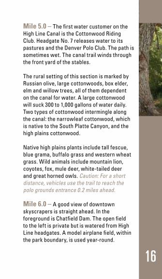
Mile 5.0 – The first water customer on the High Line Canal is the Cottonwood Riding Club. Headgate No. 7 releases water to its pastures and the Denver Polo Club. The path is sometimes wet. The canal trail winds through the front yard of the stables.
The rural setting of this section is marked by Russian olive, large cottonwoods, box elder, elm and willow trees, all of them dependent on the canal for water. A large cottonwood will suck 300 to 1,000 gallons of water daily. Two types of cottonwood intermingle along the canal: the narrowleaf cottonwood, which is native to the South Platte Canyon, and the high plains cottonwood.
Native high plains plants include tall fescue, blue grama, buffalo grass and western wheat grass. Wild animals include mountain lion, coyotes, fox, mule deer, white-tailed deer and great horned owls. Caution: For a short distance, vehicles use the trail to reach the polo grounds entrance 0.2 miles ahead.
Mile 6.0 – A good view of downtown skyscrapers is straight ahead. In the foreground is Chatfield Dam. The open field to the left is private but is watered from High Line headgates. A model airplane field, within the park boundary, is used year-round.

Mile 6.5 – There is trailhead access parking here, large enough for horse trailers. There are also sheltered picnic tables. Cross Roxborough Park Road to the High Line trail or go left to enter Chatfield Park (no fee) and pick up the Centennial Trail. This section of the High Line’s trail ends at private property along Plum Creek two miles ahead. Chatfield Park, open year-round, allows boating, fishing and camping. Wildlife includes coyotes, fox and a heron rookery. The Army Corps of Engineers built Chatfield as a flood-control
17
facility following a devastating flood in 1965 that took many lives and caused millions of dollars in damage. The reservoir also holds irrigation water.
18
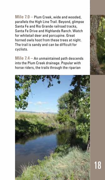
Mile 7.0 – Plum Creek, wide and wooded, parallels the High Line Trail. Beyond, glimpse Santa Fe and Rio Grande railroad tracks, Santa Fe Drive and Highlands Ranch. Watch for whitetail deer and porcupine. Great horned owls hoot from these trees at night. The trail is sandy and can be difficult for cyclists.
Mile 7.4 – An unmaintained path descends into the Plum Creek drainage. Popular with horse riders, the trails through the riparian

19
area are made of sand. To the south, across the canal, a private sand and gravel operation digs at the alluvial of ancient runoff. Castle Rock and Pikes Peak can be seen to the south.
Mile 8.6 – The trail ends temporarily where it disappears into a siphon, a pipe beneath Plum Creek, to emerge on the other side. Entrance to Titan Road via Titan Park Circle through private Stockton’s Plum Creek Stables is not welcomed. To the left, a public horse trail leads into a sandy riparian area in Chatfield State Park. Note: If you intend to pick up the trail where it resumes northeast of here, enjoy the trail until it reaches Plum Creek, then head back to your vehicle and follow either Roxborough or Waterton Road to Titan Road. Take Titan east to Santa Fe Drive (U.S. 85) and go north about two miles to Carder Court. Turn left (west) on Carder until it reaches the trail. Highlands Ranch Metropolitan District has plans to build trailhead parking at the old school. You will be at mile 12.3. You can also park at the Fly’n B Park, near mile 14.5. To get there, drive north on Santa Fe Drive. Turn east on County Line Road and then south on Erickson Boulevard. The park is at the intersection of Plaza Road and Erickson Boulevard.
Mile 9.8 – Here, the northbound trail resumes, and if you’ve followed our advice, you’ve approached this point from Carder Court or Fly’n B Park to the north. If you’re

20
northbound and merely want to see what’s down here or are confining your excursion to this short section of the trail, retrace your steps and check under Mile 12.5 for the best way to continue northward. However, if you’re southbound and want to continue toward Waterton Canyon, go back to your vehicle and drive to parking on Roxborough Park Road near Chatfield State Park or at the Kassler Center and Discovery Pavilion on Waterton Road. To reach these roads, take Santa Fe Drive (U.S. 85) south to Titan Road. Turn right (west) on Titan Road. Caution: Santa Fe Drive is an extremely busy road and should be avoided by riders, cyclists and hikers. The same goes for Titan Road.
Mile 11.2 – Chatfield Reservoir, with its popular marina, lies to the northwest. This stretch from east of Plum Creek to County Line Road is maintained by Highlands Ranch Metropolitan Districts. Caution: Watch out for the railroad crossing.
Mile 12.0 – The trail enters an industrial zone of rock and concrete producers. A small wetland and Spring Gulch Pond below, fed by Spring Gulch, hosts waterfowl, dragonflies, bullfrogs and several species of warm water fish.

Mile 12.3 – The trail runs past old Plum Creek School, which has parking, and joins a vehicular road for 0.2 miles through the old community of Blakeland. Two trails connect the trail to Spring Gulch Pond.
Mile 12.5 – The canal goes under Santa Fe Drive and the trail crosses it. Trail users should avoid crossing Santa Fe. Note: Avoid crossing Santa Fe by heading back to your car and driving to the Fly’n B Park, near mile 14.5. Drive north on Santa Fe Drive. Turn east on County Line Road and then south on Erickson Boulevard. The park is at the intersection of Plaza Road and Erickson Boulevard.
Mile 13.0 – Highlands Ranch Golf Club cuts into a bend of the High Line at Marcy Gulch. Highlands Ranch, the second user on the High Line, draws its share through Headgate No. 19. Huge cottonwoods form a natural, peaceful glade. The canal passes over a creek by way of an elevated, wooden flume. Three public bridges cross the canal here.
Mile 14.0 – Looking past the Highlands Ranch wastewater treatment plant, two of Colorado’s fourteeners are visible on clear days: Longs Peak to the northwest, named for Major Stephen Long, and Mount Evans to the west, named for Territorial Gov. John Evans, who built the railroad up the South Platte. A golf club road intersects. Stay on the trail.21

22
Mile 14.5 – The canal parallels the Fly’n B Park, a historic site that includes parking, restrooms, picnic shelters, fishing pond, trails and an orchard. The trail continues right along the waterway.
Mile 14.9 – Trail intersects with Centennial Bicycle Trail, which follows C-470 to Waterton Canyon. The High Line continues north under C-470. The 2.2 miles of trail ahead are concrete and popular with cyclists. When headed south, keep to the left at the trails’ fork and you’ll stay on the High Line.
Mile 15.0 – McLellan Reservoir is to the north. It holds some High Line water and is the raw water source for Englewood. Prepare for a very scenic portion of the trail. Redwing blackbirds are common among the cattails.

23
Mile 16.0 – Canal and trail enter tunnels beneath Highlands Ranch interchange. The canal enters a glade with giant trees, cattails and a wetlands swamp. The path is a rollercoaster for many cyclers. The Bennett Flume carries the canal across Dad Clark Gulch. There are a couple of picnic tables near the flume. A neighborhood bridge heads east, while the High Line continues north. Centennial Trail crosses the canal to the east.
Mile 17.0 – The canal runs beneath County Line Road, the boundary between Douglas and Arapahoe counties. The path crosses below County Line Road and changes to a crushed-granite trail under the auspices of the South Suburban Park and Recreation District. Note: Trailhead parking is available on the east side of the High Line Canal at the intersection of County Line Road and South Park Lane.