Section 3: Capabilities Assessment - MARC
75
Regional Multi-Hazard Mitigation Plan Section 3: Capabilities Assessment Mid-America Regional Council 3.107 June 2020 Section 3: Capabilities Assessment List of Tables Table 3.1: Adopted or Updated Plans and Policies ................................................................................... 110 Table 3.2: Local Plans and Regulations Adopted by Local Jurisdictions ................................................... 116 Table 3.3: Relevant Measures Incorporated into HMP (Plans/Regulations) ............................................ 117 Table 3.4: Building Codes Adopted by Local Jurisdictions ........................................................................ 120 Table 3.5: Codes Adequately Enforced ..................................................................................................... 122 Table 3.6: Relevant Measures Incorporated into HMP (Building Codes) ................................................. 124 Table 3.7: Ordinances and Policies Adopted by Local Jurisdictions.......................................................... 125 Table 3.8: Relevant Measures Incorporated into HMP (Ordinances/Policies) ......................................... 126 Table 3.9: Local Administrative Resources by Jurisdiction ....................................................................... 129 Table 3.10: Local Staffing Resources by Jurisdiction................................................................................. 130 Table 3.11: Local Technical Resources by Jurisdiction .............................................................................. 131 Table 3.12: Relevant Measures Incorporated into HMP (Technical Resources) ...................................... 132 Table 3.13: Types of Mitigation Activities Funded by Funding Source ..................................................... 135 Table 3.14: Access or Eligibility to Use Funding Resource by Jurisdiction ................................................ 136 Table 3.15: Useful Outreach and Awareness Programs for Mitigation Activities by Jurisdiction ............ 138 Table 3.16: Relevant Measures Incorporated into HMP (Education and Outreach Resources) .............. 141 Table 3.17: Safe Growth Audit Summary for Cass County ....................................................................... 148 Table 3.18: Safe Growth Audit Summary for Clay County ........................................................................ 150 Table 3.19: Safe Growth Audit Summary for Jackson County .................................................................. 152 Table 3.20: Safe Growth Audit Summary for Platte County, Part 1.......................................................... 154 Table 3.21: Safe Growth Audit Summary for Platte County, Part 2.......................................................... 156 Table 3.22: Safe Growth Audit Summary for Ray County ......................................................................... 158 Table 3.23: National Flood Program (NFIP) Participation ......................................................................... 160 Table 3.24: NFIP Policy Statistics as of July 2019 by Jurisdiction .............................................................. 162 Table 3.25: NFIP Loss Statistics as of 9/30/2018 by Jurisdiction .............................................................. 163 Table 3.26: Number of Repetitive Loss Properties by County and Type .................................................. 164 Table 3.27: Number of Unmitigated Severe Repetitive Loss Properties .................................................. 164 Table 3.28: NFIP Regulatory Overview by Jurisdiction ............................................................................. 165 Table 3. 29: Status of Staffing Resources for Effective NFIP Administration ............................................ 169 Table 3.30: Status of Participating Jurisdictions in the CRS Program ....................................................... 170 Table 3. 31: School Plans and Policies Inventory ...................................................................................... 171
Transcript of Section 3: Capabilities Assessment - MARC
Regional Multi-Hazard Mitigation Plan Section 3: Capabilities Assessment
Mid-America Regional Council 3.107 June 2020
Section 3: Capabilities Assessment List of Tables
Table 3.1: Adopted or Updated Plans and Policies ................................................................................... 110
Table 3.2: Local Plans and Regulations Adopted by Local Jurisdictions ................................................... 116
Table 3.3: Relevant Measures Incorporated into HMP (Plans/Regulations) ............................................ 117
Table 3.4: Building Codes Adopted by Local Jurisdictions ........................................................................ 120
Table 3.5: Codes Adequately Enforced ..................................................................................................... 122
Table 3.6: Relevant Measures Incorporated into HMP (Building Codes) ................................................. 124
Table 3.7: Ordinances and Policies Adopted by Local Jurisdictions .......................................................... 125
Table 3.8: Relevant Measures Incorporated into HMP (Ordinances/Policies) ......................................... 126
Table 3.9: Local Administrative Resources by Jurisdiction ....................................................................... 129
Table 3.10: Local Staffing Resources by Jurisdiction ................................................................................. 130
Table 3.11: Local Technical Resources by Jurisdiction .............................................................................. 131
Table 3.12: Relevant Measures Incorporated into HMP (Technical Resources) ...................................... 132
Table 3.13: Types of Mitigation Activities Funded by Funding Source ..................................................... 135
Table 3.14: Access or Eligibility to Use Funding Resource by Jurisdiction ................................................ 136
Table 3.15: Useful Outreach and Awareness Programs for Mitigation Activities by Jurisdiction ............ 138
Table 3.16: Relevant Measures Incorporated into HMP (Education and Outreach Resources) .............. 141
Table 3.17: Safe Growth Audit Summary for Cass County ....................................................................... 148
Table 3.18: Safe Growth Audit Summary for Clay County ........................................................................ 150
Table 3.19: Safe Growth Audit Summary for Jackson County .................................................................. 152
Table 3.20: Safe Growth Audit Summary for Platte County, Part 1 .......................................................... 154
Table 3.21: Safe Growth Audit Summary for Platte County, Part 2 .......................................................... 156
Table 3.22: Safe Growth Audit Summary for Ray County ......................................................................... 158
Table 3.23: National Flood Program (NFIP) Participation ......................................................................... 160
Table 3.24: NFIP Policy Statistics as of July 2019 by Jurisdiction .............................................................. 162
Table 3.25: NFIP Loss Statistics as of 9/30/2018 by Jurisdiction .............................................................. 163
Table 3.26: Number of Repetitive Loss Properties by County and Type .................................................. 164
Table 3.27: Number of Unmitigated Severe Repetitive Loss Properties .................................................. 164
Table 3.28: NFIP Regulatory Overview by Jurisdiction ............................................................................. 165
Table 3. 29: Status of Staffing Resources for Effective NFIP Administration ............................................ 169
Table 3.30: Status of Participating Jurisdictions in the CRS Program ....................................................... 170
Table 3. 31: School Plans and Policies Inventory ...................................................................................... 171

Regional Multi-Hazard Mitigation Plan Section 3: Capabilities Assessment
Mid-America Regional Council 3.108 June 2020
Section 3: Capabilities Assessment
The purpose of the capabilities’ assessment is to identify and consider each community’s unique set of
capabilities that currently reduce disaster losses or could be used to reduce losses in the future. For the
purposes of this plan “community/jurisdiction” is used interchangeably and refers to all plan participants
– cities, counties, special districts, school districts, colleges and universities. Capabilities include policies,
plans, programs, staff, funding, and other resources available to accomplish mitigation and reduce long-
term vulnerability.
3.1 Data Gathering Methods
To facilitate data gathering from the participating jurisdictions, online profile surveys were developed
for communities and school districts based on the FEMA Capabilities Worksheets 4.1-4.3.i The survey
instruments were created as online tools. Community and school profile survey instruments are
included in Appendix F.
The survey tools collected information on: the hazards communities face, their capabilities to support
development and implementation of Mitigation Strategies, (See Section 5: Mitigation Strategy), existing
planning mechanisms that were incorporated in the hazard mitigation planning process, gather
information on safe growth audit and to demonstrate continued compliance with the requirements of
the National Flood Insurance Program (NFIP).
The following subsections provide highlights from both community and school profile surveys completed
by the 2020 Plan update participants. Sections 3.3.1 through 3.3.6 apply only to cities and counties;
Section 3.3.7 applies only to school districts, colleges and universities.
3.3.1. Planning and Regulatory Capabilities 3.3.2. Administrative and Technical Capabilities 3.3.3. Financial Capabilities 3.3.4. Education and Outreach Capabilities 3.3.5. Safe Growth Audit 3.3.6. Floodplain Management and NFIP Participation 3.3.7. School District Capabilities
Key observations:
The profile represents a snapshot of a community’s mitigation capabilities and provides the foundation
for inclusive mitigation planning. The 2020 profile survey used the 2015 plan survey tools as a
foundation and was more comprehensive than prior assessments. As a result in some cases, the tools
allowed for increased overall awareness of the variety of community plans that intersect with mitigation
intent.
Planning and Regulatory: An added benefit of compiling this information into a regional plan is it allows
a jurisdiction to compare their responses to other jurisdictions. This can be especially valuable for those
jurisdictions who may not previously have considered developing or adopting the referenced plans for
their own community or school district. It may offer opportunities in the future to expand mitigation
Regional Multi-Hazard Mitigation Plan Section 3: Capabilities Assessment
Mid-America Regional Council 3.109 June 2020
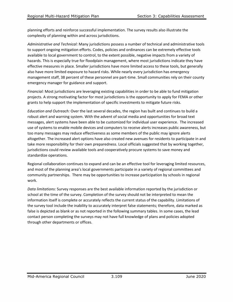
planning efforts and reinforce successful implementation. The survey results also illustrate the
complexity of planning within and across jurisdictions.
Administrative and Technical: Many jurisdictions possess a number of technical and administrative tools
to support ongoing mitigation efforts. Codes, policies and ordinances can be extremely effective tools
available to local government to control, to the extent possible, negative impacts from a variety of
hazards. This is especially true for floodplain management, where most jurisdictions indicate they have
effective measures in place. Smaller jurisdictions have more limited access to these tools, but generally
also have more limited exposure to hazard risks. While nearly every jurisdiction has emergency
management staff, 38 percent of these personnel are part-time. Small communities rely on their county
emergency manager for guidance and support.
Financial: Most jurisdictions are leveraging existing capabilities in order to be able to fund mitigation
projects. A strong motivating factor for most jurisdictions is the opportunity to apply for FEMA or other
grants to help support the implementation of specific investments to mitigate future risks.
Education and Outreach: Over the last several decades, the region has built and continues to build a
robust alert and warning system. With the advent of social media and opportunities for broad text
messages, alert systems have been able to be customized for individual user experience. The increased
use of systems to enable mobile devices and computers to receive alerts increases public awareness, but
too many messages may reduce effectiveness as some members of the public may ignore alerts
altogether. The increased alert options have also created new avenues for residents to participate in and
take more responsibility for their own preparedness. Local officials suggested that by working together,
jurisdictions could review available tools and cooperatively procure systems to save money and
standardize operations.
Regional collaboration continues to expand and can be an effective tool for leveraging limited resources,
and most of the planning area’s local governments participate in a variety of regional committees and
community partnerships. There may be opportunities to increase participation by schools in regional
work.
Data limitations: Survey responses are the best available information reported by the jurisdiction or
school at the time of the survey. Completion of the survey should not be interpreted to mean the
information itself is complete or accurately reflects the current status of the capability. Limitations of
the survey tool include the inability to accurately interpret false statements; therefore, data marked as
false is depicted as blank or as not reported in the following summary tables. In some cases, the lead
contact person completing the surveys may not have full knowledge of plans and policies adopted
through other departments or offices.

Regional Multi-Hazard Mitigation Plan Section 3: Capabilities Assessment
Mid-America Regional Council 3.110 June 2020
Table 3.1: Adopted or Updated Plans and Policies
JURISDICTION HAS AN ADOPTED OR UPDATED PLAN
Cas
s C
ou
nty
Bel
ton
Har
riso
nvi
lle
Lake
An
net
te
Lake
Win
neb
ago
Pec
ulia
r
Ple
asan
t H
ill
Ray
mo
re
Comprehensive/Master Plan 2010 1992 2002 2014 2015 2004 2014
Capital Improvement Plan 2014 2014 2014 2019 2020 2014
Local Emergency Operations Plan 2017 2014 2014 2014 2019 2012 2018
Continuity of Operations Plan 2010 2014 2014 2019 2019
Public Health Emergency Plan 2014 2014
Storm Water Management Plan 2012 2011 2014 2018 2013 2002
Community Wildfire Protection Plan or Burn Ordinance
No No No No No Burn Burn Burn
Brownfields Redevelopment No No No No No No No No
Climate Change Adaption No No No No No No No No
RELATED PLANNING ACTIVITIES:
Building Codes adequately enforced
Yes Yes Yes No Yes Yes Yes Yes
Land Use Planning utilized by community
Existing & Future
Existing & Future
Existing & Future
No Existing &
Future Existing &
Future Existing &
Future Existing &
Future Zoning Ordinance Yes yes Yes Yes Yes Yes Yes Yes
Subdivision Ordinance Yes Yes Yes No Yes Yes Yes Yes
Natural Hazard-related Ordinance(s) adopted
Stream setback Soil & erosion Floodplain 110gmt.. Stormwater runoff
Stream setback Soil & erosion Floodplain 110gmt.. Stormwater runoff; open space dedication
Soil & erosion Floodplain 110gmt.. Stormwater runoff; open space dedication
Floodplain mgmt.; open space dedication
Soil & erosion Floodplain 110gmt.. Stormwater runoff
Soil & erosion Floodplain 110gmt.. Stormwater runoff; open space dedication
Floodplain 110gmt.. Stormwater runoff; open space dedication
Stream setback Soil & erosion Floodplain 110gmt.. Stormwater runoff; open space dedication

Regional Multi-Hazard Mitigation Plan Section 3: Capabilities Assessment
Mid-America Regional Council 3.111 June 2020
JURISDICTION HAS AN ADOPTED OR UPDATED PLAN
Cla
y C
ou
nty
Exce
lsio
r Sp
rin
gs
Gla
dst
on
e
Kea
rney
Law
son
Lib
erty
Mo
sby
No
rth
Kan
sas
Cit
y
Smit
hvi
lle
Fish
ing
Riv
er F
PD
Comprehensive/Master Plan 2008 2009 2008 2016 2017 1999 2013 2016 2005 NA
Capital Improvement Plan 2019 2011 2014
Local Emergency Operations Plan 2014 2012 2018 2009 2016 2012 2018
Continuity of Operations Plan 2018 2009 2012
Public Health Emergency Preparedness Plan
2014 2018 2012
Storm Water Management Plan 2013 2018 2003 NA
Community Wildfire Protection Plan or Burn Ordinance
No Yes No Yes Yes No No Yes Yes
Brownfields Redevelopment No No No No No No No No NA
Climate Change Adaption No No No No No No No No NA
RELATED PLANNING ACTIVITIES:
Building Codes adequately enforced Yes Yes Yes Yes No Yes Yes Yes Yes NA
Land Use Planning utilized by community
Existing & Future
Existing & Future
Existing & Future
Existing & Future
Existing Existing &
Future No
Existing & Future
Existing & Future
NA
Zoning Ordinance Yes yes Yes Yes Yes Yes Yes Yes Yes NA
Subdivision Ordinance Yes Yes Yes Yes No Yes Yes NA
Natural Hazard-related Ordinance(s) adopted
Stream setback Soil & erosion Floodplain 111gmt. Stormwater runoff
Water 111gmt.111ve Stream setback Soil & erosion Floodplain 111gmt. Stormwater runoff
Floodplain 111gmt.. Stormwater runoff
Floodplain 111gmt.. Stormwater runoff
Stormwater 111gmt..; floodplain management
Stream setback Soil & erosion Floodplain 111gmt.
Floodplain 111gmt..
Soil & erosion Floodplain 111gmt.. Stormwater runoff
Soil & erosion Floodplain 111gmt.. Stormwater runoff
NA

Regional Multi-Hazard Mitigation Plan Section 3: Capabilities Assessment
Mid-America Regional Council 3.112 June 2020
JURISDICTION HAS AN ADOPTED OR UPDATED PLAN
Jack
son
Co
un
ty
Blu
e Sp
rin
gs
Gra
nd
vie
w
Gre
enw
oo
d
Ind
epen
den
ce
Kan
sas
Cit
y,
MO
Lee
s Su
mm
it
Oak
Gro
ve
Ray
tow
n
Cen
tral
Jac
kso
n
Co
un
ty F
PD
Sni V
alle
y
FPD
Comprehensive/Master Plan 2014 2015 2002 2018 1995 2005 2000 Adopted NA NA
Capital Improvement Plan 2010 2019 2019 2015 2020 2014 2018 2006
Local Emergency Operations Plan 2014 2014 2013 2007 2015 2018 2004 2007 2014 2007
Continuity of Operations Plan 2012 2015 2019
Public Health Emergency Preparedness Plan
2013 2012 2019
Storm Water Management Plan 2013 2018 2018 2019 2014 2013
Community Wildfire Protection Plan or Burn Ordinance
Yes Yes No Burn Yes No Yes Yes No Yes Yes
Brownfields Redevelopment No No No No No 2015 No No No No No
Climate Change Adaption No No No No No Yes No No No No No
RELATED PLANNING ACTIVITIES:
Building Codes adequately enforced Yes Yes Yes No Yes Yes Yes Yes Yes NA NA
Land Use Planning utilized by community
Existing Future
Existing & Future
Existing & Future
Existing & Future
Existing & Future
Existing & Future
Existing & Future
Existing & Future
Existing & Future
Existing & Future
Zoning Ordinance Yes Yes Yes Yes Yes Yes Yes Yes Yes NA NA
Subdivision Ordinance Yes Yes Yes Yes Yes Yes Yes Yes NA NA
Natural Hazard-related Ordinance(s) adopted
Stream setback Floodplain 112gmt.. Stormwater runoff Soil & erosion
Stream setback floodplain 112gmt.. stormwater runoff soil & erosion
Floodplain 112gmt..; open space dedication
Stream setback floodplain 112gmt.. stormwater runoff soil & erosion
Stream setback floodplain 112gmt.. stormwater runoff soil & erosion
Stream setback floodplain 112gmt.. stormwater runoff soil & erosion
Stream setback floodplain 112gmt.. stormwater runoff soil & erosion
Floodplain Mgmt Soil & Erosion; stormwater runoff, open space dedication
NA NA

Regional Multi-Hazard Mitigation Plan Section 3: Capabilities Assessment
Mid-America Regional Council 3.113 June 2020
JURISDICTION HAS AN ADOPTED OR UPDATED PLAN
Pla
tte
Co
un
ty
Dea
rbo
rn
Farl
ey
Ferr
elvi
ew
Ho
ust
on
Lak
e
Lake
Wau
kom
is
No
rth
mo
or
Par
kvill
e
Comprehensive/Master Plan 2010 2013 2010 2019
Capital Improvement Plan 2010 2019 2019
Local Emergency Operations Plan 2019 2019 2013 2019 2019 2010 2015
Continuity of Operations Plan 2010 2015
Public Health Emergency Preparedness Plan
2019 2012 2019 2015
Storm Water Management Plan 2004 2019 2019
Community Wildfire Protection Plan or Burn Ordinance
No Burn No No Burn Burn No No
Brownfields Redevelopment No No No No No No No No
Climate Change Adaption No No No No No No No No
RELATED PLANNING ACTIVITIES:
Building Codes adequately enforced Yes No Yes Yes Yes Yes Yes
Land Use Planning utilized by community Existing and
Future Existing Existing Existing
Existing & Future
Zoning Ordinance utilized by community Yes Yes Yes Yes Yes Yes Yes
Subdivision Ordinance utilized by community
Yes Yes
Natural Hazard-related Ordinance(s) adopted
Stormwater runoff Floodplain 113gmt.. Stream setback soil & erosion
Stormwater runoff; Floodplain 113gmt... Stream setback
Floodplain mgmt
Floodplain mgmt
Stormwater runoff Floodplain 113gmt.. Soil & erosion
Floodplain 113gmt..
Stormwater runoff; Floodplain 113gmt..
Stormwater runoff Floodplain 113gmt.. Stream setback Soil & erosion

Regional Multi-Hazard Mitigation Plan Section 3: Capabilities Assessment
Mid-America Regional Council 3.114 June 2020
JURISDICTION HAS AN ADOPTED OR UPDATED PLAN
Pla
tte
Cit
y
Pla
tte
Wo
od
s
Riv
ers
ide
Trac
y
Wea
ther
by
Lake
Wes
ton
No
rth
lan
d R
AD
Wes
t P
latt
e FP
D
Comprehensive/Master Plan 2012 2010 2003 2003 NA NA
Capital Improvement Plan 2015 2019 2014 2014
Local Emergency Operations Plan 2014 2014 2019 2010 2010
Continuity of Operations Plan 2011
Public Health Emergency Preparedness Plan 2012
Storm Water Management Plan 2012 2010 2018
Community Wildfire Protection Plan or Burn Ordinance Yes Yes Yes Yes Yes
Brownfields Redevelopment No No No No No No No
Climate Change Adaption No No No No No No No
RELATED PLANNING ACTIVITIES:
Building Codes adequately enforced Yes Yes Yes Yes Yes Yes NA NA
Land Use Planning utilized by community Existing &
Future Existing
Existing & future
Existing &
future Existing & future
Zoning Ordinance utilized by community Yes Yes Yes
Subdivision Ordinance utilized by community Yes Yes Yes
Natural Hazard-related Ordinance(s) adopted Stormwater runoff Floodplain 114gmt.. Stream setback Soil & erosion
Stormwater runoff
Stormwater runoff, floodplain Mgmt. soil & erosion
Stormwater runoff, floodplain Mgmt. soil & erosion
Stormwater runoff, floodplain Mgmt. soil & erosion water conservation

Regional Multi-Hazard Mitigation Plan Section 3: Capabilities Assessment
Mid-America Regional Council 3.115 June 2020
JURISDICTION HAS AN ADOPTED OR UPDATED PLAN:
Ray
Co
un
ty
Ric
hm
on
d
Comprehensive/Master Plan 1998 2000
Capital Improvement Plan 2014
Local Emergency Operations Plan 2017 1999
Continuity of Operations Plan
Public Health Emergency Preparedness Plan
Storm Water Management Plan 2005 1999
Community Wildfire Protection Plan Yes Yes
Brownfields Redevelopment No No
Climate Change Adaption No No
RELATED PLANNING ACTIVITIES:
Building Codes adequately enforced Yes Yes
Land Use Planning utilized by community Existing & Future Existing & Future
Zoning Ordinance utilized by community Yes Yes
Subdivision Ordinance utilized by community Yes
Natural Hazard-related Ordinance(s) adopted Floodplain 115gmt.. Stormwater runoff Soil & erosion Stream setback
Floodplain 115gmt.. Stormwater runoff Soil & erosion Stream setback
Regional Multi-Hazard Mitigation Plan Section 3: Capabilities Assessment
Mid-America Regional Council 3.116 June 2020
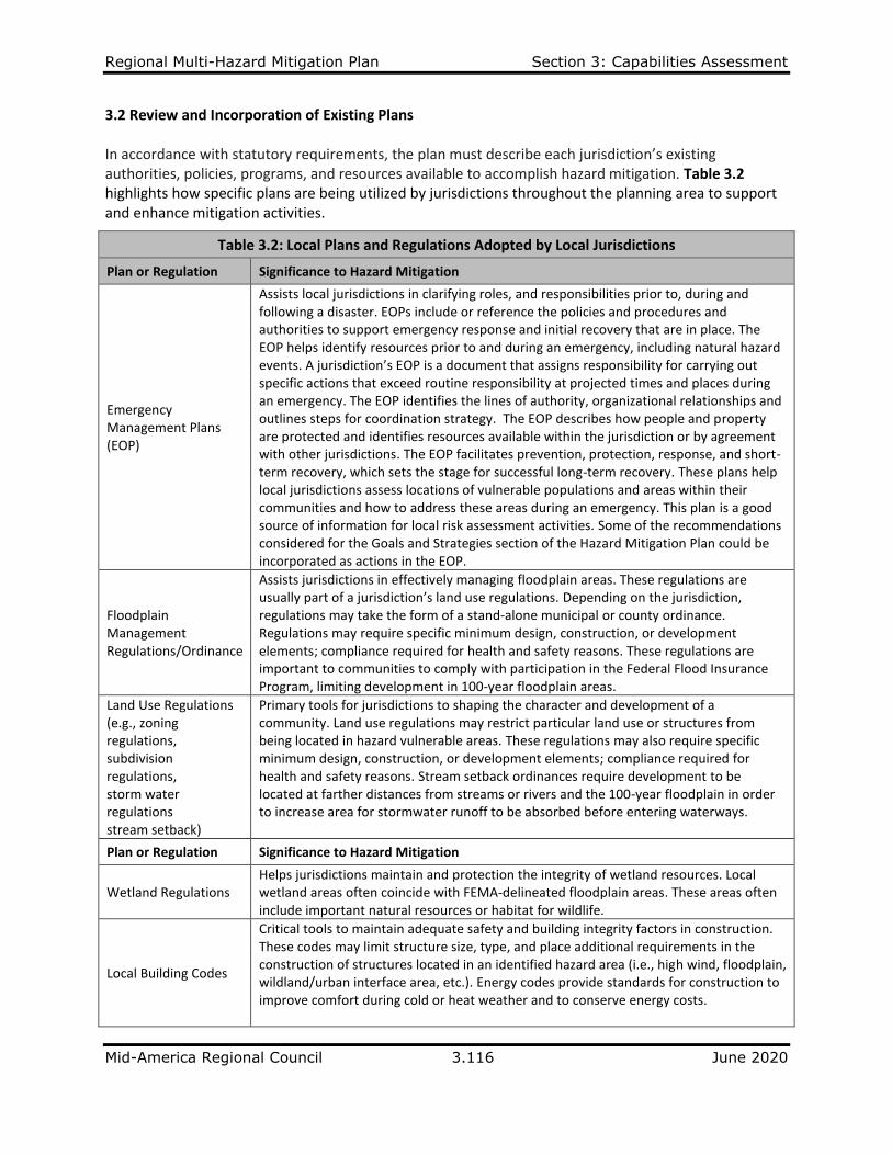
3.2 Review and Incorporation of Existing Plans In accordance with statutory requirements, the plan must describe each jurisdiction’s existing authorities, policies, programs, and resources available to accomplish hazard mitigation. Table 3.2 highlights how specific plans are being utilized by jurisdictions throughout the planning area to support and enhance mitigation activities.
Table 3.2: Local Plans and Regulations Adopted by Local Jurisdictions
Plan or Regulation Significance to Hazard Mitigation
Emergency Management Plans (EOP)
Assists local jurisdictions in clarifying roles, and responsibilities prior to, during and following a disaster. EOPs include or reference the policies and procedures and authorities to support emergency response and initial recovery that are in place. The EOP helps identify resources prior to and during an emergency, including natural hazard events. A jurisdiction’s EOP is a document that assigns responsibility for carrying out specific actions that exceed routine responsibility at projected times and places during an emergency. The EOP identifies the lines of authority, organizational relationships and outlines steps for coordination strategy. The EOP describes how people and property are protected and identifies resources available within the jurisdiction or by agreement with other jurisdictions. The EOP facilitates prevention, protection, response, and short-term recovery, which sets the stage for successful long-term recovery. These plans help local jurisdictions assess locations of vulnerable populations and areas within their communities and how to address these areas during an emergency. This plan is a good source of information for local risk assessment activities. Some of the recommendations considered for the Goals and Strategies section of the Hazard Mitigation Plan could be incorporated as actions in the EOP.
Floodplain Management Regulations/Ordinance
Assists jurisdictions in effectively managing floodplain areas. These regulations are usually part of a jurisdiction’s land use regulations. Depending on the jurisdiction, regulations may take the form of a stand‐alone municipal or county ordinance. Regulations may require specific minimum design, construction, or development elements; compliance required for health and safety reasons. These regulations are important to communities to comply with participation in the Federal Flood Insurance Program, limiting development in 100-year floodplain areas.
Land Use Regulations (e.g., zoning regulations, subdivision regulations, storm water regulations stream setback)
Primary tools for jurisdictions to shaping the character and development of a community. Land use regulations may restrict particular land use or structures from being located in hazard vulnerable areas. These regulations may also require specific minimum design, construction, or development elements; compliance required for health and safety reasons. Stream setback ordinances require development to be located at farther distances from streams or rivers and the 100-year floodplain in order to increase area for stormwater runoff to be absorbed before entering waterways.
Plan or Regulation Significance to Hazard Mitigation
Wetland Regulations Helps jurisdictions maintain and protection the integrity of wetland resources. Local wetland areas often coincide with FEMA-delineated floodplain areas. These areas often include important natural resources or habitat for wildlife.
Local Building Codes
Critical tools to maintain adequate safety and building integrity factors in construction. These codes may limit structure size, type, and place additional requirements in the construction of structures located in an identified hazard area (i.e., high wind, floodplain, wildland/urban interface area, etc.). Energy codes provide standards for construction to improve comfort during cold or heat weather and to conserve energy costs.

Regional Multi-Hazard Mitigation Plan Section 3: Capabilities Assessment
Mid-America Regional Council 3.117 June 2020
To demonstrate compliance, the following represents how jurisdictions reviewed and integrated the following topics into the 2020 Plan review process. Responses displayed in the Table 3.3 were gathered from the community profile survey relative to plans and regulations.
• Types of natural hazards that affect or concern local governments
• Plans related to natural hazard mitigation, land use or development
• Local ordinances related to natural hazard mitigation
• Building, fire and related codes
• Participation in federal hazard mitigation programs, e.g., NFIP, FMA, PDM
• Existing mitigation practices
• Use of technical documents
Table 3.3: Relevant Measures Incorporated into HMP (Plans/Regulations)
CAPABILITY CASS COUNTY
Capital Improvements Plan Peculiar: Lake Dean Project Pleasant Hill: Includes plan for community shelter (tornado mitigation) Raymore: Inflow and infiltration system improvements (drought mitigation)
Emergency Operations Plan Cass County is currently updating their LEOP Harrisonville: Updated every year (all hazards mitigation) Pleasant Hill: Includes plan for mitigation and recovery
Continuity of Operations Plan Belton: Included in Emergency Operations Plan (all hazards mitigation)
Public Health Emergency Preparedness Plan
Most public health emergency preparedness and response plans are prepared and maintained by county and city public health departments Raymore: Revisions ongoing at County Health Department
Storm Water Management Plan
Lake Winnebago: Submitted under MS4 Management Plan (flood mitigation) Raymore: Foxhaven storm water improvements; Canter Road improvements. (flood mitigation)
Burn Ordinance Pleasant Hill: adopted in 2019
CAPABILITY CLAY COUNTY
Comprehensive Plan Kearney: Recommends floodplains for open space and park land Mosby: Addresses floods and tornadoes
Emergency Operations Plan Kearney: Draft emergency operations plan is headed by Kearney Fire (all hazards mitigation)
Continuity of Operations Plan Kearney: Part of our local Emergency Operations Plan
Public Health Emergency Preparedness Plan
Most public health emergency preparedness and response plans are prepared and maintained by county and city public health departments (Clay County Public Health Center, Kansas City Health Department)
CAPABILITY JACKSON COUNTY
Comprehensive Plan Grandview: Update in progress Kansas City: The city will prepare a new comprehensive plan over the next 2-3 years
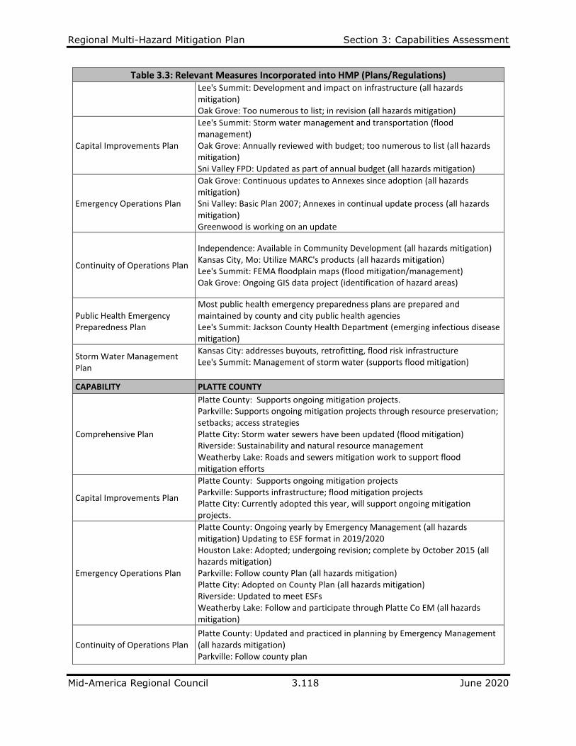
Regional Multi-Hazard Mitigation Plan Section 3: Capabilities Assessment
Mid-America Regional Council 3.118 June 2020
Table 3.3: Relevant Measures Incorporated into HMP (Plans/Regulations) Lee's Summit: Development and impact on infrastructure (all hazards mitigation) Oak Grove: Too numerous to list; in revision (all hazards mitigation)
Capital Improvements Plan
Lee's Summit: Storm water management and transportation (flood management) Oak Grove: Annually reviewed with budget; too numerous to list (all hazards mitigation) Sni Valley FPD: Updated as part of annual budget (all hazards mitigation)
Emergency Operations Plan
Oak Grove: Continuous updates to Annexes since adoption (all hazards mitigation) Sni Valley: Basic Plan 2007; Annexes in continual update process (all hazards mitigation) Greenwood is working on an update
Continuity of Operations Plan
Independence: Available in Community Development (all hazards mitigation) Kansas City, Mo: Utilize MARC's products (all hazards mitigation) Lee's Summit: FEMA floodplain maps (flood mitigation/management) Oak Grove: Ongoing GIS data project (identification of hazard areas)
Public Health Emergency Preparedness Plan
Most public health emergency preparedness plans are prepared and maintained by county and city public health agencies Lee's Summit: Jackson County Health Department (emerging infectious disease mitigation)
Storm Water Management Plan
Kansas City: addresses buyouts, retrofitting, flood risk infrastructure Lee's Summit: Management of storm water (supports flood mitigation)
CAPABILITY PLATTE COUNTY
Comprehensive Plan
Platte County: Supports ongoing mitigation projects. Parkville: Supports ongoing mitigation projects through resource preservation; setbacks; access strategies Platte City: Storm water sewers have been updated (flood mitigation) Riverside: Sustainability and natural resource management Weatherby Lake: Roads and sewers mitigation work to support flood mitigation efforts
Capital Improvements Plan
Platte County: Supports ongoing mitigation projects Parkville: Supports infrastructure; flood mitigation projects Platte City: Currently adopted this year, will support ongoing mitigation projects.
Emergency Operations Plan
Platte County: Ongoing yearly by Emergency Management (all hazards mitigation) Updating to ESF format in 2019/2020 Houston Lake: Adopted; undergoing revision; complete by October 2015 (all hazards mitigation) Parkville: Follow county Plan (all hazards mitigation) Platte City: Adopted on County Plan (all hazards mitigation) Riverside: Updated to meet ESFs Weatherby Lake: Follow and participate through Platte Co EM (all hazards mitigation)
Continuity of Operations Plan Platte County: Updated and practiced in planning by Emergency Management (all hazards mitigation) Parkville: Follow county plan
Regional Multi-Hazard Mitigation Plan Section 3: Capabilities Assessment
Mid-America Regional Council 3.119 June 2020
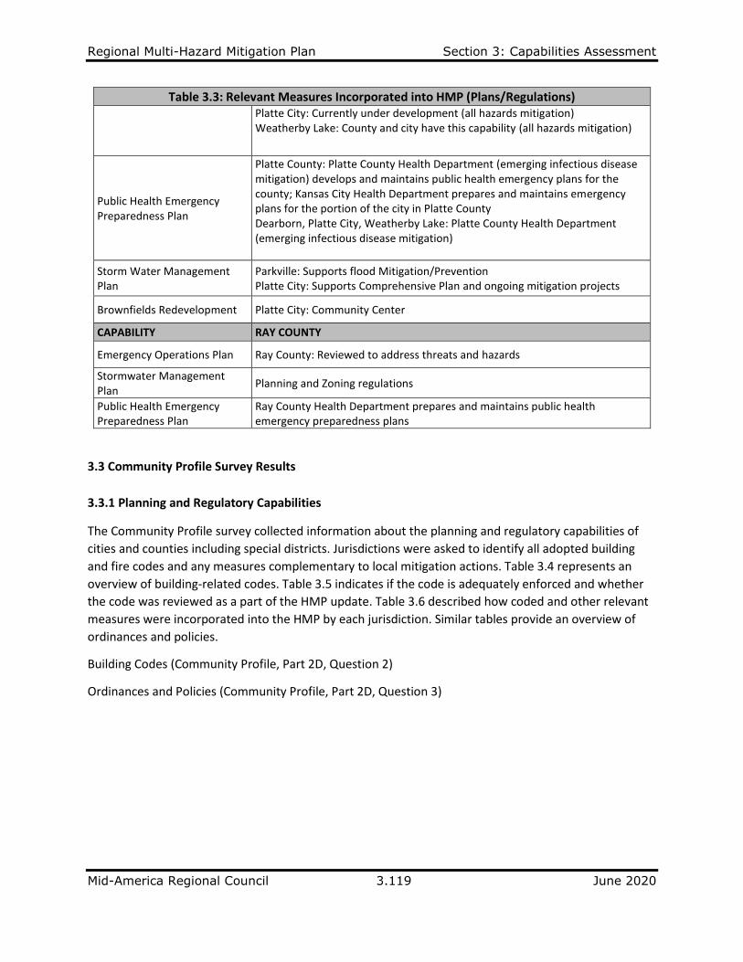
Table 3.3: Relevant Measures Incorporated into HMP (Plans/Regulations) Platte City: Currently under development (all hazards mitigation) Weatherby Lake: County and city have this capability (all hazards mitigation)
Public Health Emergency Preparedness Plan
Platte County: Platte County Health Department (emerging infectious disease mitigation) develops and maintains public health emergency plans for the county; Kansas City Health Department prepares and maintains emergency plans for the portion of the city in Platte County Dearborn, Platte City, Weatherby Lake: Platte County Health Department (emerging infectious disease mitigation)
Storm Water Management Plan
Parkville: Supports flood Mitigation/Prevention Platte City: Supports Comprehensive Plan and ongoing mitigation projects
Brownfields Redevelopment Platte City: Community Center
CAPABILITY RAY COUNTY
Emergency Operations Plan Ray County: Reviewed to address threats and hazards
Stormwater Management Plan
Planning and Zoning regulations
Public Health Emergency Preparedness Plan
Ray County Health Department prepares and maintains public health emergency preparedness plans
3.3 Community Profile Survey Results
3.3.1 Planning and Regulatory Capabilities
The Community Profile survey collected information about the planning and regulatory capabilities of
cities and counties including special districts. Jurisdictions were asked to identify all adopted building
and fire codes and any measures complementary to local mitigation actions. Table 3.4 represents an
overview of building-related codes. Table 3.5 indicates if the code is adequately enforced and whether
the code was reviewed as a part of the HMP update. Table 3.6 described how coded and other relevant
measures were incorporated into the HMP by each jurisdiction. Similar tables provide an overview of
ordinances and policies.
Building Codes (Community Profile, Part 2D, Question 2)
Ordinances and Policies (Community Profile, Part 2D, Question 3)

Regional Multi-Hazard Mitigation Plan Section 3: Capabilities Assessment
Mid-America Regional Council 3.120 June 2020
Table 3.4: Building Codes Adopted by Local Jurisdictions
Jurisdiction Building
Code Year Class Fire
Code Year Class Mechanical
Code Year Class Plumbing
Code Year Class Dangerous Buildings Year Class
Other Codes Year Class
Cass County IC 2006 IFC 2006 IMC 2006 IPC 2006 NEC 2005
Belton IBC 2012 4 IFC 2012 4 IMC 2012 4 IPC 2012 4 IBC 2012 4
Harrisonville IBC 2012 3 IFC 2012 4 IMC 2012 3 IPC 2012 3 IBC 2012 3
Lake Annette IBC
Lake Winnebago IRC 2018 IFC 2018 IMC 2018 IPC 2018 IBC 2018 NEC 2017
Peculiar IBC 2003 IFC 2006 IMC 2003 IPC 2003 IBC 2003 NEC 1999
Pleasant Hill IBC 2012 5 IFC 2012 4 IMC 2012 5 IPC 2012 5 Local
Raymore IBC 2012 IFC 2012 UMC 2012 UPC 2012 2006
Clay County IBC 2012 IFC 2011 IMC 2011 IPC 2011 IRC
Excelsior Springs IBC 2012 5 IFC 2012 5 IMC 2012 5 IPC 2012 5 1992
Gladstone IBC 2015 2 IFC 2018 2 IMC 2015 2 IPC 2015 2 IBC 2015 NEC 2015
Kearney IBC 2012 9 IFC 2012 4 IMC 2012 9 IPC 2012 9 NEC 2012 9
Lawson IBC 2006 NFC IMC IPC NEC
Liberty IBC 2012 IFC 2012 2 IMC 2012 IPC 2012
Mosby IBC
North Kansas City IBC 2018 IFC 2018 1 IMC 2018 IPC 2018 NEC 2018
Smithville IBC 2012 7 IBC 2012 IBC 2012 IPMC 2012
Fishing River FPD
Jackson County IBC 2010 5 IFC 2010 5 IMC 2010 5 IPC 2010 5
Blue Springs IBC 2012 4 IFC 2012 3 IMC 2012 4 IPC 2012 4 IBC 2012 4 IBC 2012
Grandview IBC 2012 IFC 2012 IMC 2012 IPC 2012 NEC 2010
Greenwood IBC 2012 2 IFC 1997 2 IMC 2012 IPC 2012 Independence IBC 2012 4 IFC 2012 2 IMC 2012 4 IPC 2012 4 2012
Kansas City, Mo. IBC 2018 2 IFC 2018 1 IMC 2012 2 UPC 2012 2 IBC 2014 2
Lee's Summit IBC 2012 4 IFC 2012 3 IMC 2012 4 IPC 2012 4 UCADB
Oak Grove IBC 2012 2 IFC 2012 2 IMC 2012 2 IPC 2012 2 NEC 2008
Raytown IBC 2018 5 IFC 2018 5 IMC 2018 5 IPC 2018 5 IPMC 2018 5 NEC 2017 5
Central JACO FPD
Sni Valley FPD IBC 2003 IFC 2003 IMC 2003 IPC 2003 2003 2003
Platte County IBC 2012 5 IFC 2003 2 IMC 2012 5 IPC 2012 5 1993
Dearborn IBC 2013 7 IFC 2014 5 IMC 2013
Farley IRC 2009

Regional Multi-Hazard Mitigation Plan Section 3: Capabilities Assessment
Mid-America Regional Council 3.121 June 2020
Table 3.4: Building Codes Adopted by Local Jurisdictions (Continued)
Jurisdiction Building
Code Year Class Fire
Code Year Class Mechanical
Code Year Class Plumbing
Code Year Class Dangerous Buildings Year Class
Other Codes Year Class
Ferrelview IBC 2012 IBC 2012 IBC 2012 IBC 2012
Houston Lake IRC 2005 IRC 2005 IRC 2005 IRC 2005
Lake Waukomis IBC 2012 4 IFC 2018 4 IRC 2003 IRC 2003 IBC 2003
Northmoor IBC 2012 IFC 2012 IMC 2012 IBC 2012 IBC 2012
Parkville IBC 2012 4 IFC 2012 4 IMC 2012 4 IPC 2012 4 NEC 2010 4
Platte City IBC 2013 5 IBC 2013 5 IBC 2013 5 IBC 2013 5 IBC 2013 5
Platte Woods IBC 2007 IBC 2007 IBC 2007 IBC 2007 IBC 2007
Riverside IC 2018 IC 2018 IC 2018 IC 2018 IC 2018 IC 2011
Tracy IBC 2006 4 IBC 2006 4 IBC 2006 4 IBC 2006 4 IBC 2006 4 NEC 2011 4
Weatherby Lake IRC 2009 3 IFC 2009 4 IRC 2009 3 IRC 2009 3 IRC 2009 3
Weston IBC 2000 IBC 2000 IBC 2000 IBC 2000 IBC 2000
Northland RAD
West Platte FPD
Ray County IBC 2015 IFC 2015 IMC 2015 IPC 2015 NEC 2014
Richmond IBC 2012 9 IFC 2012 9 IMC 2012 9 IPC 2012 9 IBC 2012 9 NEC 2011 9
IC – International Code IBC – International Building Code IFC – International Fire Code IMC – International Mechanical Code IPC – International Plumbing Code IPMC – International Property Maintenance Code IRC – International Residential Code NEC – National Electric Code NFC – National Fire Code UCABD – Uniform Code for Abatement of Dangerous Buildings UMC – Uniform Mechanical Code UPC – Uniform Plumbing Code

Regional Multi-Hazard Mitigation Plan Section 3: Capabilities Assessment
Mid-America Regional Council 3.122 June 2020
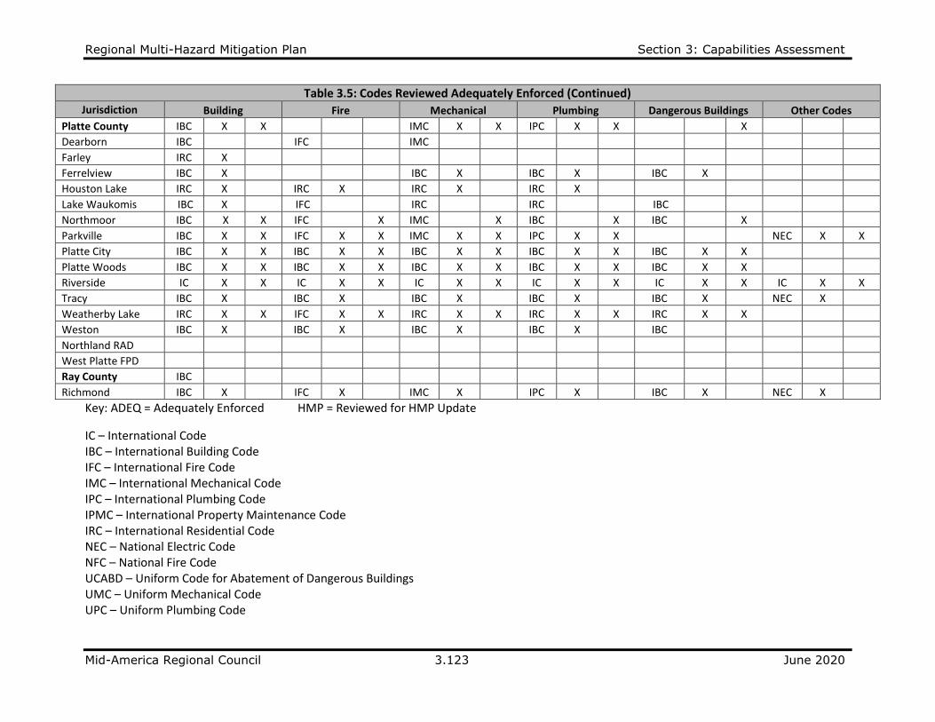
Table 3.5: Codes Adequately Enforced
Jurisdiction Building Fire Mechanical Plumbing Dangerous Buildings Other Codes
TYPE ADEQ HMP TYPE ADEQ HMP TYPE ADEQ HMP TYPE ADEQ HMP TYPE ADEQ HMP TYPE ADEQ HMP
Cass County IC X IFC X IMC X IPC X NEC X
Belton IBC X IFC X IMC X IPC X IBC X
Harrisonville IBC X X IFC X X IMC X X IPC X X IBC X X
Lake Annette IBC X
Lake Winnebago IRC X IFC X IMC X IPC X NEC X
Peculiar IBC X IFC X IMC X IPC X IBC X NEC X
Pleasant Hill IBC X IFC X IMC X IPC X Local X
Raymore IBC X X IFC X X UMC X X UPC X X X X
Clay County IBC X X IFC X X IMC X X IPC X X IRC
Excelsior Springs IBC X X IFC X X IMC X X IPC X X X X
Gladstone IBC X X IFC X X IMC X X IPC X X NEC
Kearney IBC X X IFC X X IMC X X IPC X X NEC X X
Lawson IBC X
Liberty IBC X IFC X IMC X IPC X
Mosby IBC X
North Kansas City IBC X IFC X IMC X IPC X NEC X
Smithville IBC X IBC X IBC X IPMC
Fishing River FPD
Jackson County IBC X X IFC X X IMC X X IPC X X
Blue Springs IBC X X IFC X X IMC X X IPC X X IBC X X IBC X X
Grandview IBC X IFC X IMC X IPC X NEC X
Greenwood IBC X
IFC
IMC
IPC
Independence IBC X IFC X IMC X IPC X Local X Multi
Kansas City, Mo. IBC X IFC X IMC X UPC X IBC X
Lee's Summit IBC X IFC X IMC X IPC X UCADB
Oak Grove IBC X IFC X IMC X IPC X NEC
Raytown IBC X X IFC X X IMC X X IPC X X IPMC X X NEC X X
Central JACO FPD
Sni Valley FPD IBC IFC IMC IPC
Regional Multi-Hazard Mitigation Plan Section 3: Capabilities Assessment
Mid-America Regional Council 3.123 June 2020
Table 3.5: Codes Reviewed Adequately Enforced (Continued) Jurisdiction Building Fire Mechanical Plumbing Dangerous Buildings Other Codes
Platte County IBC X X IMC X X IPC X X X
Dearborn IBC IFC IMC
Farley IRC X
Ferrelview IBC X IBC X IBC X IBC X
Houston Lake IRC X IRC X IRC X IRC X
Lake Waukomis IBC X IFC IRC IRC IBC
Northmoor IBC X X IFC X IMC X IBC X IBC X
Parkville IBC X X IFC X X IMC X X IPC X X NEC X X
Platte City IBC X X IBC X X IBC X X IBC X X IBC X X
Platte Woods IBC X X IBC X X IBC X X IBC X X IBC X X
Riverside IC X X IC X X IC X X IC X X IC X X IC X X
Tracy IBC X IBC X IBC X IBC X IBC X NEC X
Weatherby Lake IRC X X IFC X X IRC X X IRC X X IRC X X
Weston IBC X IBC X IBC X IBC X IBC
Northland RAD
West Platte FPD
Ray County IBC
Richmond IBC X IFC X IMC X IPC X IBC X NEC X
Key: ADEQ = Adequately Enforced HMP = Reviewed for HMP Update
IC – International Code IBC – International Building Code IFC – International Fire Code IMC – International Mechanical Code IPC – International Plumbing Code IPMC – International Property Maintenance Code IRC – International Residential Code NEC – National Electric Code NFC – National Fire Code UCABD – Uniform Code for Abatement of Dangerous Buildings UMC – Uniform Mechanical Code UPC – Uniform Plumbing Code

Regional Multi-Hazard Mitigation Plan Section 3: Capabilities Assessment
Mid-America Regional Council 3.124 June 2020
Table 3.6: Relevant Measures Incorporated into HMP (Building Codes)
CAPABILITY CASS COUNTY
Building Code Pleasant Hill: Additional safe room standards established
Dangerous Building Code Lake Winnebago: Does not apply to current City R-1 Zoning Raymore: Local code regulations Pleasant Hill: Local code regulations
Other Codes Lake Winnebago: NEC Peculiar: NEC
CAPABILITY CLAY COUNTY
Building Code Kearney: 2012 IRC and IBC
Fire Code Kearney: KRFPD has a Class 4
Dangerous Building Code Excelsior Springs: City has local ordinance
Other Codes Clay County: IRC Kearney: 2012 NEC; 2012 ISPSC North Kansas City: NEC
CAPABILITY JACKSON COUNTY
Building Code Grandview: Will update to 2018 by end of 2019 Kansas City: Will update by 3/1/2020
Fire Code Mechanical Code Plumbing Code
Grandview: Will update to 2018 by end of 2019
Dangerous Building Code
Blue Springs: All IBC modules Independence: City has local ordinance Lee's Summit: City has local ordinance Oak Grove: Oak Grove Municipal Ordinance
Other Codes
Jackson County: NEC Grandview: Will update NEC to 2018 by end of 2019 Independence: IFGC, IRC, NEC, IEBC Oak Grove: NEC; 2009 IFGC; Int'l Private Property
CAPABILITY PLATTE COUNTY
Building Code Platte County: Planning and Zoning
Fire Code Lake Waukomis: Contract with Kansas City, MO Fire Department
Mechanical Code Platte County: Planning and Zoning
Plumbing Code Platte County: Planning and Zoning
Dangerous Building Code Platte County: County-only code
Other Codes Riverside: IC Tracy: NEC
CAPABILITY RAY COUNTY
Other Codes Richmond: NEC
IBC – International Building Code IC – International Code IEBC – International Existing Building Code
IFGC – International Fuel Gas Code ISPSC – International Swimming Pool and Spa Code
NEC – National Electric Code

Regional Multi-Hazard Mitigation Plan Section 3: Capabilities Assessment
Mid-America Regional Council 3.125 June 2020
Table 3.7: Ordinances and Policies Adopted by Local Jurisdictions
ORDINANCES ADOPTED BY JURISDICTION
Cas
s C
ou
nty
Bel
ton
Har
riso
nvi
lle
Lake
An
net
te
Lake
Win
neb
ago
Pec
ulia
r
Ple
asan
t H
ill
Ray
mo
re
Cla
y C
ou
nty
Exce
lsio
r Sp
rin
gs
Gla
dst
on
e
Kea
rney
Law
son
Lib
erty
Mo
sby
No
rth
Kan
sas
Cit
y
Smit
hvi
lle
Fish
ing
Riv
er
FPD
Jack
son
Co
un
ty
Blu
e Sp
rin
gs
Gra
nd
view
Gre
en
wo
od
Ind
epen
den
ce
Kan
sas
Cit
y, M
O
Lee'
s Su
mm
it
Oak
Gro
ve
Ray
tow
n
Stream setback ordinances ✓ ✓ ✓ ✓ ✓ ✓ ✓ ✓ ✓ ✓ ✓ ✓ ✓
Floodplain management ordinances ✓ ✓ ✓ ✓ ✓ ✓ ✓ ✓ ✓ ✓ ✓ ✓ ✓ ✓ ✓ ✓ ✓ ✓ ✓ ✓ ✓ ✓ ✓ ✓ ✓ ✓
Soil and erosion ordinances ✓ ✓ ✓ ✓ ✓ ✓ ✓ ✓ ✓ ✓ ✓ ✓ ✓ ✓ ✓ ✓ ✓ ✓ ✓
Burn ordinances ✓ ✓ ✓ ✓ ✓ ✓ ✓ ✓ ✓ ✓ ✓ ✓ ✓ ✓ ✓ ✓ ✓ ✓ ✓
Storm water runoff ordinances ✓ ✓ ✓ ✓ ✓ ✓ ✓ ✓ ✓ ✓ ✓ ✓ ✓ ✓ ✓ ✓ ✓ ✓ ✓ ✓ ✓ ✓
Water conservation measures ✓ ✓ ✓ ✓ ✓ ✓ ✓ ✓
Open space acquisition/dedication ✓ ✓ ✓ ✓ ✓ ✓ ✓ ✓ ✓ ✓ ✓ ✓ ✓ ✓ ✓ ✓ ✓ ✓ ✓
Flood buyout ✓ ✓ ✓ ✓ ✓ ✓ ✓ ✓ ✓
Site plan review requirements ✓ ✓ ✓ ✓ ✓ ✓ ✓ ✓ ✓ ✓ ✓ ✓ ✓ ✓ ✓ ✓ ✓ ✓ ✓ ✓ ✓ ✓
Table 3.7: Ordinances and Policies Adopted by Local Jurisdictions (Continued)
ORDINANCES ADOPTED BY JURISDICTION
Cen
tral
Jac
kso
n
Co
un
ty F
PD
Sni V
alle
y FP
D
Pla
tte
Co
un
ty
Dea
rbo
rn
Farl
ey
Ferr
elv
iew
Ho
ust
on
Lak
e
Lake
Wau
kom
is
No
rth
mo
or
Par
kvill
e
Pla
tte
Cit
y
Pla
tte
Wo
od
s
Riv
ersi
de
Trac
y
Wea
ther
by
Lake
Wes
ton
No
rth
lan
d R
AD
Wes
t P
latt
e
FPD
Ray
Co
un
ty
Ric
hm
on
d
Stream setback ordinances ✓ ✓ ✓ ✓ ✓ ✓
Floodplain management ordinances ✓ ✓ ✓ ✓ ✓ ✓ ✓ ✓ ✓ ✓ ✓ ✓ ✓ ✓ ✓
Soil and erosion ordinances ✓ ✓ ✓ ✓ ✓ ✓ ✓ ✓ ✓
Burn ordinances ✓ ✓ ✓ ✓ ✓ ✓ ✓ ✓ ✓ ✓ ✓ ✓
Storm water runoff ordinances ✓ ✓ ✓ ✓ ✓ ✓ ✓ ✓ ✓ ✓ ✓
Water conservation measures ✓ ✓ ✓
Open space acquisition/dedication ✓ ✓ ✓ ✓
Flood buyout ✓ ✓ ✓
Site plan review requirements ✓ ✓ ✓ ✓ ✓ ✓ ✓ ✓ ✓ ✓ ✓ ✓

Regional Multi-Hazard Mitigation Plan Section 3: Capabilities Assessment
Mid-America Regional Council 3.126 June 2020
Table 3.8: Relevant Measures Incorporated into HMP (Ordinances/Policies) CAPABILITY CASS COUNTY
Floodplain Management Ordinance Lake Winnebago: City has adopted ordinances as part of the UDO
Soil and Erosion Ordinance Lake Winnebago: City has adopted UDO Erosion Control Ordinances
Burn Ordinance (i.e., farmland, prairie)
Cass Co. – Under local fire protection district authority Raymore: As needed through South Metro Fire Protection (wildland fire mitigation) Pleasant Hill has local burn ordinance
Storm Water Runoff Ordinance Lake Winnebago: Adopted in the current Building Codes
Flood Buyout Raymore: No structures are within the flood hazard area (Supports continued NFIP participation)
Site Plan Review Requirements Lake Winnebago: Required for all construction permit applications
CAPABILITY CLAY COUNTY
Floodplain Management Ordinance Kearney: Development required to meet floodplain ordinance (Supports continued NFIP participation)
Burn Ordinance (i.e., farmland, prairie) Kearney: burn permits required; issued by fire district
Storm Water Runoff Ordinance Kearney: Detention facilities required to minimize flooding (Supports continued NFIP participation)
Flood Buyout Kearney: No residential structures within floodplain (Supports continued NFIP participation)
CAPABILITY JACKSON COUNTY
Stream Setback Ordinance Oak Grove: Uniform Development Code (UDC) (Supports continued NFIP participation)
Floodplain Management Ordinance
Lee's Summit: Chapter 6 of the Unified Development Ordinance (Supports continued NFIP participation) Oak Grove: Uniform Development Code (UDC) (Supports continued NFIP participation) Oak Grove: Uniform Development Code (UDC) (Supports continued NFIP participation) Grandview: Update ordinance in January 2018
Soil and Erosion Ordinance Grandview: Land disturbance permit greater than 1 acre Kansas City: MS4 Program Oak Grove: Follow Federal Clean Water Act
Burn Ordinance (i.e., farmland, prairie) Oak Grove: Limited to 5 weeks in spring and 5 weeks in fall
Storm Water Runoff Ordinance
Grandview: Follows KCAPWA design standards Lee's Summit: Chapter 34 of the City Code of Ordinances (Supports continued NFIP participation) Oak Grove: UDC incorporates requirements on developers (Supports continued NFIP participation)
Water Conservation Measures
Grandview: Uses detention areas to hold runoff Lee's Summit: As needed during drought conditions Oak Grove: Emergency Powers under Emergency Management Ordinance
Regional Multi-Hazard Mitigation Plan Section 3: Capabilities Assessment
Mid-America Regional Council 3.127 June 2020
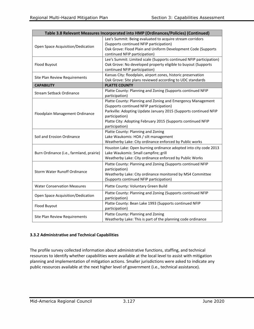
Table 3.8 Relevant Measures Incorporated into HMP (Ordinances/Policies) (Continued)
Open Space Acquisition/Dedication
Lee's Summit: Being evaluated to acquire stream corridors (Supports continued NFIP participation) Oak Grove: Flood Plain and Uniform Development Code (Supports continued NFIP participation)
Flood Buyout Lee's Summit: Limited scale (Supports continued NFIP participation) Oak Grove: No developed property eligible to buyout (Supports continued NFIP participation)
Site Plan Review Requirements Kansas City: floodplain, airport zones, historic preservation Oak Grove: Site plans reviewed according to UDC standards
CAPABILITY PLATTE COUNTY
Stream Setback Ordinance Platte County: Planning and Zoning (Supports continued NFIP participation)
Floodplain Management Ordinance
Platte County: Planning and Zoning and Emergency Management (Supports continued NFIP participation) Parkville: Adopting Update January 2015 (Supports continued NFIP participation) Platte City: Adopting February 2015 (Supports continued NFIP participation)
Soil and Erosion Ordinance Platte County: Planning and Zoning Lake Waukomis: HOA / silt management Weatherby Lake: City ordinance enforced by Public works
Burn Ordinance (i.e., farmland, prairie) Houston Lake: Open burning ordinance adopted into city code 2013 Lake Waukomis: Small campfire; grill Weatherby Lake: City ordinance enforced by Public Works
Storm Water Runoff Ordinance
Platte County: Planning and Zoning (Supports continued NFIP participation) Weatherby Lake: City ordinance monitored by MS4 Committee (Supports continued NFIP participation)
Water Conservation Measures Platte County: Voluntary Green Build
Open Space Acquisition/Dedication Platte County: Planning and Zoning (Supports continued NFIP participation)
Flood Buyout Platte County: Bean Lake 1993 (Supports continued NFIP participation)
Site Plan Review Requirements Platte County: Planning and Zoning Weatherby Lake: This is part of the planning code ordinance
3.3.2 Administrative and Technical Capabilities
The profile survey collected information about administrative functions, staffing, and technical resources to identify whether capabilities were available at the local level to assist with mitigation planning and implementation of mitigation actions. Smaller jurisdictions were asked to indicate any public resources available at the next higher level of government (i.e., technical assistance).
Regional Multi-Hazard Mitigation Plan Section 3: Capabilities Assessment
Mid-America Regional Council 3.128 June 2020
Administrative Resources (Community Profile, Part 2A, Question 1)
In Part 2A of the Community Profile Survey, jurisdictions were asked to identify administrative resources available to assist with mitigation activities. Table 3.99 provides a list of administrative functions fulfilled at the local level by each jurisdiction.
The profiles provide responses on: is assistance available at the next level of government; is coordination between governments effective for mitigation purposes; and were functions reviewed as part of the HMP update.
Staffing Resources (Community Profile, Part 2A, Question 2)
Jurisdictions were next asked to describe staffing resources available to assist with mitigation efforts. Error! Reference source not found.0 lists all relevant full- and part-time positions. Many communities have limited staff to carry out planning and building responsibilities, including floodplain management.
Technical Resources (Community Profile, Part 2A, Question 3)
Jurisdictions were asked to identify all technical resources available to assess and mitigate risk. Table 3.11 lists the tools that were useful to meet local planning needs.
Table 3.12 describes relevant measures incorporated into the HMP as stated by the jurisdiction.
Refer to the following pages for the Administrative and Technical tables referenced above.
Regional Multi-Hazard Mitigation Plan Section 3: Capabilities Assessment
Mid-America Regional Council 3.129 June 2020
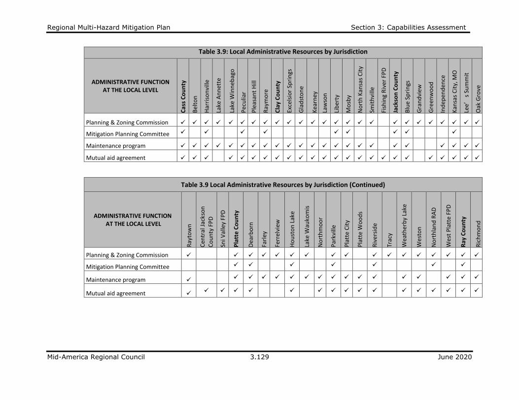
Table 3.9: Local Administrative Resources by Jurisdiction
ADMINISTRATIVE FUNCTION AT THE LOCAL LEVEL
Cas
s C
ou
nty
Bel
ton
Har
riso
nvi
lle
Lake
An
net
te
Lake
Win
neb
ago
Pec
ulia
r
Ple
asan
t H
ill
Ray
mo
re
Cla
y C
ou
nty
Exce
lsio
r Sp
rin
gs
Gla
dst
on
e
Kea
rney
Law
son
Lib
erty
Mo
sby
No
rth
Kan
sas
Cit
y
Smit
hvi
lle
Fish
ing
Riv
er F
PD
Jack
son
Co
un
ty
Blu
e Sp
rin
gs
Gra
nd
vie
w
Gre
enw
oo
d
Ind
epen
den
ce
Kan
sas
Cit
y, M
O
Lee’
s Su
mm
it
Oak
Gro
ve
Planning & Zoning Commission ✓ ✓ ✓ ✓ ✓ ✓ ✓ ✓ ✓ ✓ ✓ ✓ ✓ ✓ ✓ ✓ ✓ ✓ ✓ ✓ ✓ ✓ ✓ ✓ ✓
Mitigation Planning Committee ✓ ✓ ✓ ✓ ✓ ✓ ✓ ✓ ✓
Maintenance program ✓ ✓ ✓ ✓ ✓ ✓ ✓ ✓ ✓ ✓ ✓ ✓ ✓ ✓ ✓ ✓ ✓ ✓ ✓ ✓ ✓ ✓ ✓
Mutual aid agreement ✓ ✓ ✓ ✓ ✓ ✓ ✓ ✓ ✓ ✓ ✓ ✓ ✓ ✓ ✓ ✓ ✓ ✓ ✓ ✓ ✓ ✓ ✓ ✓
Table 3.9 Local Administrative Resources by Jurisdiction (Continued)
ADMINISTRATIVE FUNCTION AT THE LOCAL LEVEL
Ray
tow
n
Cen
tral
Jac
kso
n
Co
un
ty F
PD
Sni V
alle
y FP
D
Pla
tte
Co
un
ty
Dea
rbo
rn
Farl
ey
Ferr
elvi
ew
Ho
ust
on
Lak
e
Lake
Wau
kom
is
No
rth
mo
or
Par
kvill
e
Pla
tte
Cit
y
Pla
tte
Wo
od
s
Riv
ers
ide
Trac
y
Wea
ther
by
Lake
Wes
ton
No
rth
lan
d R
AD
Wes
t P
latt
e FP
D
Ray
Co
un
ty
Ric
hm
on
d
Planning & Zoning Commission ✓ ✓ ✓ ✓ ✓ ✓ ✓ ✓ ✓ ✓ ✓ ✓ ✓ ✓ ✓ ✓ ✓
Mitigation Planning Committee ✓ ✓ ✓ ✓ ✓ ✓ ✓
Maintenance program ✓ ✓ ✓ ✓ ✓ ✓ ✓ ✓ ✓ ✓ ✓ ✓ ✓ ✓ ✓ ✓ ✓
Mutual aid agreement ✓ ✓ ✓ ✓ ✓ ✓ ✓ ✓ ✓ ✓ ✓ ✓ ✓ ✓ ✓ ✓ ✓

Regional Multi-Hazard Mitigation Plan Section 3: Capabilities Assessment
Mid-America Regional Council 3.130 June 2020
Table 3.10: Local Staffing Resources by Jurisdiction
LOCAL STAFFING (FULL-TIME OR PART-TIME)
Cas
s C
ou
nty
Bel
ton
Har
riso
nvi
lle
Lake
An
net
te
Lake
Win
neb
ago
Pec
ulia
r
Ple
asan
t H
ill
Ray
mo
re
Cla
y C
ou
nty
Exce
lsio
r Sp
rin
gs
Gla
dst
on
e
Kea
rney
Law
son
Lib
erty
Mo
sby
No
rth
Kan
sas
Cit
y
Smit
hvi
lle
Fish
ing
Riv
er F
PD
Jack
son
Co
un
ty
Blu
e Sp
rin
gs
Gra
nd
vie
w
Gre
enw
oo
d
Ind
epen
den
ce
Kan
sas
Cit
y, M
O
Lee’
s Su
mm
it
Oak
Gro
ve
Chief Building Official FT FT FT PT PT FT FT FT FT FT FT PT FT PT FT FT FT FT FT FT PT FT FT
Floodplain Administrator FT FT PT PT PT FT PT FT FT PT FT FT PT FT PT FT FT FT FT PT PT FT FT PT PT
Emergency Manager FT PT FT PT PT FT PT FT FT PT PT PT FT FT FT FT FT PT PT PT FT FT PT FT
Community Planner FT FT FT PT PT FT PT FT FT FT FT
FT PT FT FT FT FT FT FT PT FT
Civil Engineer FT FT PT PT FT FT FT FT PT FT PT PT FT FT FT FT FT FT PT
Public Health Official FT FT FT
FT FT FT FT
IT Support FT FT FT PT PT FT PT FT FT FT PT PT FT PT FT PT FT FT FT FT FT FT PT
GIS Coordinator FT FT PT PT FT FT FT FT
FT FT FT FT PT FT FT FT PT
Table 3.10: Local Staffing Resources by Jurisdiction (Continued)
LOCAL STAFFING (FULL-TIME OR PART-TIME)
Ray
tow
n
Cen
tral
Jac
kso
n
Co
un
ty F
PD
Sni V
alle
y FP
D
Pla
tte
Co
un
ty
Dea
rbo
rn
Farl
ey
Ferr
elvi
ew
Ho
ust
on
Lak
e
Lake
Wau
kom
is
No
rth
mo
or
Par
kvill
e
Pla
tte
Cit
y
Pla
tte
Wo
od
s
Riv
ers
ide
Trac
y
Wea
ther
by
Lake
Wes
ton
No
rth
lan
d R
AD
Wes
t P
latt
e FP
D
Ray
Co
un
ty
Ric
hm
on
d
Chief Building Official FT PT FT PT PT PT FT PT PT FT PT FT PT PT PT FT
Floodplain Administrator PT FT PT PT PT PT PT PT FT FT FT PT FT FT PT FT
Emergency Manager PT FT FT PT PT PT PT FT PT FT FT FT FT FT FT FT PT PT
Community Planner FT FT FT FT FT FT
Civil Engineer FT FT PT PT PT FT PT
Public Health Official PT FT PT FT FT PT FT FT FT
IT Support FT PT FT PT PT FT PT PT PT PT FT PT PT PT PT PT
GIS Coordinator PT PT FT PT PT FT PT FT
FT = FULL TIME PT = PART TIME

Regional Multi-Hazard Mitigation Plan Section 3: Capabilities Assessment
Mid-America Regional Council 3.131 June 2020
Table 3.11: Local Technical Resources by Jurisdiction
TECHNICAL RESOURCE USEFUL TO LOCAL
PLANNING
Cas
s C
ou
nty
Bel
ton
Har
riso
nvi
lle
Lake
An
net
te
Lake
Win
neb
ago
Pec
ulia
r
Ple
asan
t H
ill
Ray
mo
re
Cla
y C
ou
nty
Exce
lsio
r Sp
rin
gs
Gla
dst
on
e
Kea
rney
Law
son
Lib
erty
Mo
sby
No
rth
Kan
sas
Cit
y
Smit
hvi
lle
Fish
ing
Riv
er F
PD
Jack
son
Co
un
ty
Blu
e Sp
rin
gs
Gra
nd
vie
w
Gre
enw
oo
d
Ind
epen
den
ce
Kan
sas
Cit
y, M
O
Lee’
s Su
mm
it
Warning system/services ✓ ✓ ✓ ✓ ✓ ✓ ✓ ✓ ✓ ✓ ✓ ✓ ✓ ✓ ✓ ✓ ✓ ✓ ✓ ✓ ✓ ✓ ✓
Hazard data and information ✓ ✓ ✓ ✓ ✓ ✓
✓ ✓
✓
✓ ✓
✓ ✓ ✓
Critical Facility Map/APRS ✓ ✓ ✓ ✓ ✓ ✓ ✓
✓ ✓
✓
✓ ✓ ✓
✓ ✓ ✓
HAZUS Analysis ✓ ✓
✓
✓
✓
✓ ✓
Existing Land Use Maps ✓ ✓
✓ ✓ ✓ ✓ ✓ ✓ ✓ ✓ ✓ ✓ ✓ ✓ ✓ ✓ ✓ ✓ ✓
Future Land Use Maps ✓ ✓ ✓ ✓ ✓ ✓ ✓ ✓ ✓ ✓ ✓
✓ ✓ ✓ ✓ ✓ ✓ ✓
State Hazard Mitigation Plan ✓ ✓ ✓ ✓ ✓ ✓
✓
✓ ✓
✓
✓ ✓
Grant Writing ✓ ✓ ✓ ✓ ✓
✓ ✓ ✓ ✓ ✓ ✓ ✓ ✓
Table 3.11: Local Technical Resources by Jurisdiction (Continued)
TECHNICAL RESOURCE USEFUL TO LOCAL
PLANNING
Oak
Gro
ve
Ray
tow
n
Cen
tral
Jac
kso
n
Co
un
ty F
PD
Sni V
alle
y FP
D
Pla
tte
Co
un
ty
Dea
rbo
rn
Farl
ey
Ferr
elvi
ew
Ho
ust
on
Lak
e
Lake
Wau
kom
is
No
rth
mo
or
Par
kvill
e
Pla
tte
Cit
y
Pla
tte
Wo
od
s
Riv
ers
ide
Trac
y
Wea
ther
by
Lake
Wes
ton
No
rth
lan
d R
AD
Wes
t P
latt
e FP
D
Ray
Co
un
ty
Ric
hm
on
d
Warning system/services ✓ ✓ ✓ ✓ ✓ ✓ ✓ ✓ ✓ ✓ ✓ ✓ ✓ ✓ ✓ ✓ ✓ ✓
Hazard data and information
✓ ✓ ✓ ✓ ✓ ✓ ✓
✓ ✓ ✓ ✓
Critical Facility Map/APRS ✓ ✓ ✓ ✓ ✓ ✓ ✓
HAZUS Analysis ✓ ✓ ✓
✓ ✓
Existing Land Use Maps ✓ ✓ ✓ ✓ ✓ ✓ ✓ ✓ ✓ ✓ ✓ ✓ ✓ ✓ ✓ ✓
Future Land Use Maps ✓ ✓ ✓ ✓ ✓ ✓ ✓ ✓ ✓ ✓ ✓ ✓
State Hazard Mitigation Plan
✓ ✓ ✓ ✓ ✓ ✓ ✓ ✓
✓ ✓ ✓ ✓
Grant Writing ✓ ✓ ✓ ✓ ✓ ✓ ✓ ✓ ✓ ✓

Regional Multi-Hazard Mitigation Plan Section 3: Capabilities Assessment
Mid-America Regional Council 3.132 June 2020
Table 3.12: Relevant Measures Incorporated into HMP (Technical Resources)
CAPABILITY CASS COUNTY
Warning Systems
Cass Co: Everbridge mass notification system, social media Belton: VOIP System and warning systems Lake Winnebago: New/Upgraded 2013 Peculiar: Emergency sirens, social media, cellular announcements Pleasant Hill: multiple options include text alerts, reverse 911, opt in to Everbridge, and storm sirens
Hazard Data
Cass County: Information on LEOP and THIRA update completed in 2019 Belton: Full access to all utility data through GIS and Rain Gauge Peculiar: Gates for low water bridge crossings Lake Winnebago: maps available hard copy and digital Pleasant Hill: mapping capabilities; lightning detectors
Grant Writing Cass County: interested in exploring HMPG and EMPG grant opportunities Raymore: Continue to explore multiple grant opportunities in addition to EMPG
Existing Land Use Map
Cass County: does not have existing land use map Belton: WebGIS and website Raymore: Local GIS specialist continues to assess and analyze land use
Critical Facilities Map
Cass County: Needs more information to collect data Belton: WebGIS Lake Winnebago: Maps are available hard copy and laptop Pleasant Hill: critical facilities identified in emergency management SOP Raymore: Need to collect more information on critical facilities
CAPABILITY CLAY COUNTY
Warning Systems Kearney: Used for tornadoes and severe weather Liberty: Warning sirens, mass texts to cell phones, email Smithville: Warning sirens
Existing Land Use Map
Kearney: Future Land Use Map identified future open space that correlates with floodplain areas (Supports continued participation in the NFIP) Liberty: Used to ensure no structures are built
Future Land Use Map
Liberty: Used to ensure no structures are built
CAPABILITY JACKSON COUNTY
Warning Systems
Independence: SMS Texting System and outdoor siren system Grandview: test sirens but not alerts Lee’s Summit: Several mass public notification systems Oak Grove: Land development fee with building permit to expand service throughout community, continue to expand system Raytown: Outdoor warning sirens, weather radios and communication equipment Sni Valley FPD: District-owned outdoor warning siren in Bates City only
Hazard Data
Independence: Participated in THIRA update Kansas City, Mo: Information is contained within LEOP Oak Grove: Ongoing planning in LEOP Raytown: Awareness of historical data helps provide hazard analysis Sni Valley FPD: Reviewed for LEOP
Grant Writing Sni Valley FPD: Using Fire Act and SAFER
HAZUS Sni Valley FPD: Available but insufficient staff time to adequately utilize
Existing Land Use Map
Independence: Available in Community Development Kansas City, Mo: Utilize MARC’s products Lee’s Summit: FEMA floodplain maps
Regional Multi-Hazard Mitigation Plan Section 3: Capabilities Assessment
Mid-America Regional Council 3.133 June 2020
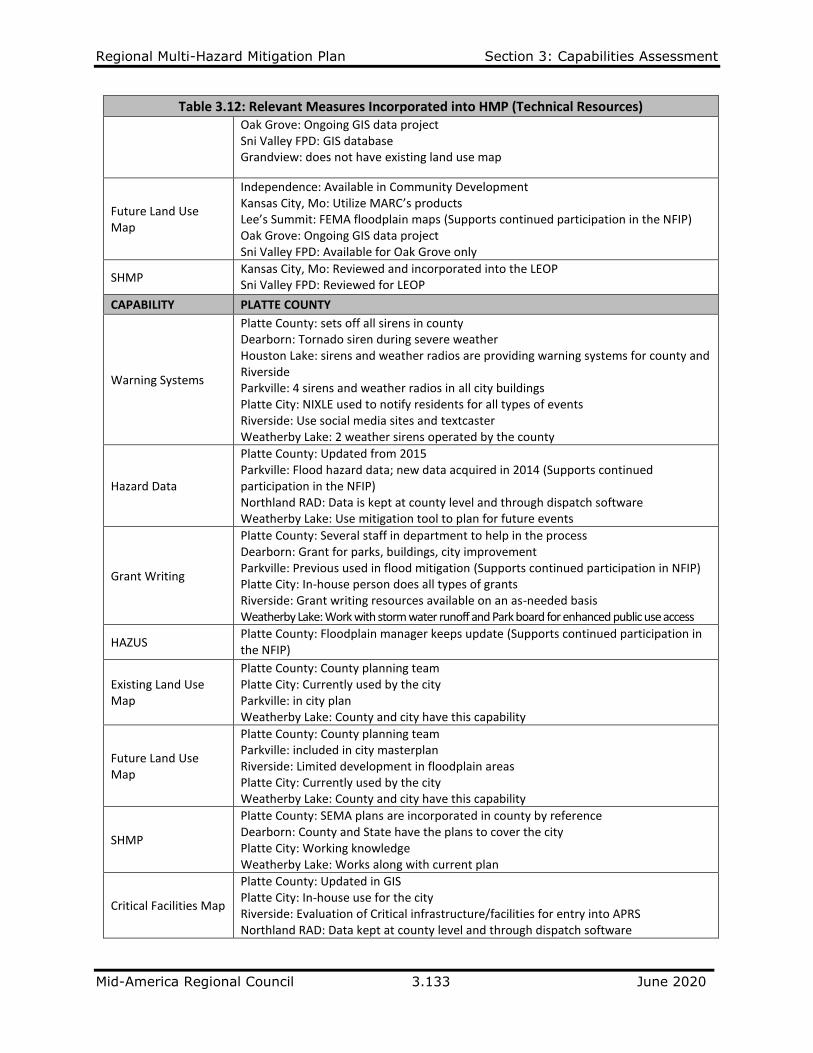
Table 3.12: Relevant Measures Incorporated into HMP (Technical Resources) Oak Grove: Ongoing GIS data project Sni Valley FPD: GIS database Grandview: does not have existing land use map
Future Land Use Map
Independence: Available in Community Development Kansas City, Mo: Utilize MARC’s products Lee’s Summit: FEMA floodplain maps (Supports continued participation in the NFIP) Oak Grove: Ongoing GIS data project Sni Valley FPD: Available for Oak Grove only
SHMP Kansas City, Mo: Reviewed and incorporated into the LEOP Sni Valley FPD: Reviewed for LEOP
CAPABILITY PLATTE COUNTY
Warning Systems
Platte County: sets off all sirens in county Dearborn: Tornado siren during severe weather Houston Lake: sirens and weather radios are providing warning systems for county and Riverside Parkville: 4 sirens and weather radios in all city buildings Platte City: NIXLE used to notify residents for all types of events Riverside: Use social media sites and textcaster Weatherby Lake: 2 weather sirens operated by the county
Hazard Data
Platte County: Updated from 2015 Parkville: Flood hazard data; new data acquired in 2014 (Supports continued participation in the NFIP) Northland RAD: Data is kept at county level and through dispatch software Weatherby Lake: Use mitigation tool to plan for future events
Grant Writing
Platte County: Several staff in department to help in the process Dearborn: Grant for parks, buildings, city improvement Parkville: Previous used in flood mitigation (Supports continued participation in NFIP) Platte City: In-house person does all types of grants Riverside: Grant writing resources available on an as-needed basis Weatherby Lake: Work with storm water runoff and Park board for enhanced public use access
HAZUS Platte County: Floodplain manager keeps update (Supports continued participation in the NFIP)
Existing Land Use Map
Platte County: County planning team Platte City: Currently used by the city Parkville: in city plan Weatherby Lake: County and city have this capability
Future Land Use Map
Platte County: County planning team Parkville: included in city masterplan Riverside: Limited development in floodplain areas Platte City: Currently used by the city Weatherby Lake: County and city have this capability
SHMP
Platte County: SEMA plans are incorporated in county by reference Dearborn: County and State have the plans to cover the city Platte City: Working knowledge Weatherby Lake: Works along with current plan
Critical Facilities Map
Platte County: Updated in GIS Platte City: In-house use for the city Riverside: Evaluation of Critical infrastructure/facilities for entry into APRS Northland RAD: Data kept at county level and through dispatch software

Regional Multi-Hazard Mitigation Plan Section 3: Capabilities Assessment
Mid-America Regional Council 3.134 June 2020
Table 3.12: Relevant Measures Incorporated into HMP (Technical Resources)
CAPABILITY RAY COUNTY
Warning Systems Ray County: NIXLE mass communication systems Richmond: Monthly testing and maintenance contract
Hazard Data Richmond: Floodplain and Storm water ordinances (Supports continued participation in the NFIP)
Grant Writing Richmond: Utilize MARC
Existing Land Use Map
Richmond: Comprehensive Plan
Future Land Use Map
Richmond: Comprehensive Plan

Regional Multi-Hazard Mitigation Plan Section 3: Capabilities Assessment
Mid-America Regional Council 3.135 June 2020
3.3.3 Financial Capabilities The profile survey collected information about financial capabilities to determine whether the
jurisdiction has existing or potential funding resources to assist with planning and implementation of
mitigation actions. Table 3.13 shows the type of mitigation actions funded in the last five years for the
entire planning area.
Table 3.13: Types of Mitigation Activities Funded by Funding Source
Funding Resource
Structure and Infrastructure
Projects
Local Plans and
Regulations
Natural Systems
Protection
Education and
Awareness Programs
Total Mitigation Activities Funded
Capital Improvement Project Funding 21 5 1 0 27
Authority to levy taxes for specific purposes 18 3 1 0 22
Fees for water, sewer, gas or electric services 16 5 0 0 21
Impact fees for new development 12 4 0 0 16
Storm water utility fee 7 3 0 0 10
Incur debt through general and/or special tax bonds 15 2 1 0 18
Incur debt through private activities 0 0 0 0 0
Community Development Block Grant 5 6 0 1 12
Flood Mitigation Assistance Program 5 3 3 1 12
Pre-Disaster Mitigation Program 3 5 0 2 10
Hazard Mitigation Grant Program 3 4 0 1 8
Other 4 0 0 0 4
Type of Mitigation Activities Total) 109 40 6 5 160
Funding Resources (Community Profile, Part 2B, Question 1)
In Part 2B of the Community Profile Survey, jurisdictions were asked to describe the types of funding
resources a jurisdiction has access to and is eligible to use funds for hazard mitigation.
Table 3.14 shows access or eligibility to use funding resources for hazard mitigation by jurisdiction.

Regional Multi-Hazard Mitigation Plan Section 3: Capabilities Assessment
Mid-America Regional Council 3.136 June 2020
Table 3.14: Access or Eligibility to Use Funding Resource by Jurisdiction
JURISDICTION HAS ABILITY TO ACCESS THESE FUNDING RESOURCES
Cass
Cou
nty
Belto
n
Har
rison
ville
Lake
Ann
ette
Lake
Win
neba
go
Pecu
liar
Plea
sant
Hill
Raym
ore
Clay
Cou
nty
Exce
lsior
Spr
ings
Gla
dsto
ne
Kear
ney
Law
son
Libe
rty
Mos
by
Nor
th K
ansa
s City
Smith
ville
Fish
ing
Rive
r FPD
Jack
son
Coun
ty
Blue
Spr
ings
Gra
ndvi
ew
Gre
enw
ood
Inde
pend
ence
Kans
as C
ity, M
O
Lee'
s Sum
mit
Capital Improvement Project Funding ✓ ✓ ✓ ✓ ✓ ✓ ✓ ✓ ✓ ✓ ✓ ✓ ✓ ✓ ✓ ✓ ✓ ✓ ✓
✓ ✓ ✓
Authority to levy taxes for specific purposes ✓ ✓ ✓ ✓ ✓ ✓ ✓ ✓ ✓ ✓ ✓ ✓ ✓ ✓ ✓ ✓ ✓ ✓ ✓ ✓
Fees for water, sewer, gas or electric services ✓ ✓ ✓ ✓ ✓ ✓ ✓ ✓ ✓ ✓ ✓ ✓ ✓ ✓ ✓
✓ ✓ ✓ ✓ ✓ ✓
Impact fees for new development ✓ ✓ ✓ ✓ ✓ ✓ ✓ ✓ ✓ ✓ ✓ ✓
✓ ✓ ✓
Storm water utility fee ✓ ✓ ✓ ✓ ✓ ✓ ✓ ✓ ✓ ✓ ✓ ✓
✓ ✓ ✓ ✓
Incur debt through general and/or special tax bonds ✓ ✓ ✓ ✓ ✓ ✓ ✓ ✓ ✓ ✓ ✓ ✓ ✓ ✓ ✓ ✓ ✓ ✓ ✓ ✓ ✓ ✓
Incur debt through private activities ✓ ✓ ✓ ✓ ✓
Community Development Block Grant ✓ ✓ ✓ ✓ ✓ ✓ ✓ ✓ ✓ ✓ ✓ ✓ ✓ ✓ ✓ ✓
Flood Mitigation Assistance Program ✓ ✓ ✓ ✓ ✓ ✓ ✓ ✓ ✓ ✓
✓ ✓ ✓ ✓ ✓
Pre-Disaster Mitigation Program ✓ ✓ ✓ ✓ ✓ ✓ ✓ ✓ ✓ ✓
✓ ✓ ✓ ✓ ✓
Hazard Mitigation Grant Program ✓ ✓ ✓ ✓ ✓ ✓ ✓ ✓ ✓ ✓ ✓
✓ ✓ ✓ ✓
JURISDICTION HAS ABILITY TO ACCESS THESE FUNDING RESOURCES
Oak
Gro
ve
Rayt
own
Cen
tral
Jac
kso
n
Co
un
ty F
PD
Sni V
alle
y FP
D
Pla
tte
Co
un
ty
Dea
rbo
rn
Farl
ey
Ferr
elvi
ew
Ho
ust
on
Lak
e
Lake
Wau
kom
is
No
rth
mo
or
Par
kvill
e
Pla
tte
Cit
y
Pla
tte
Wo
od
s
Riv
ers
ide
Trac
y
Wea
ther
by
Lake
Wes
ton
Nor
thla
nd R
AD
Wes
t P
latt
e FP
D
Ray
Co
un
ty
Ric
hm
on
d
Capital Improvement Project Funding ✓ ✓ ✓ ✓ ✓ ✓ ✓ ✓ ✓ ✓ ✓ ✓ ✓ ✓
Authority to levy taxes for specific purposes ✓ ✓ ✓ ✓ ✓ ✓ ✓ ✓ ✓ ✓ ✓ ✓ ✓ ✓ ✓
Fees for water, sewer, gas or electric services ✓ ✓ ✓ ✓ ✓ ✓ ✓ ✓ ✓ ✓ ✓ ✓ ✓ ✓
Impact fees for new development ✓ ✓ ✓ ✓ ✓ ✓ ✓ ✓ ✓
Storm water utility fee ✓ ✓
Incur debt through general and/or special tax bonds ✓ ✓ ✓ ✓ ✓ ✓ ✓ ✓ ✓ ✓ ✓
Incur debt through private activities ✓
Community Development Block Grant ✓ ✓ ✓ ✓ ✓ ✓ ✓
Flood Mitigation Assistance Program ✓ ✓ ✓ ✓ ✓ ✓ ✓ ✓
Pre-Disaster Mitigation Program ✓ ✓ ✓ ✓ ✓ ✓ ✓ ✓ ✓ ✓
Hazard Mitigation Grant Program ✓ ✓ ✓ ✓ ✓ ✓ ✓
Regional Multi-Hazard Mitigation Plan Section 3: Capabilities Assessment
Mid-America Regional Council 3.137 June 2020
3.3.4 Education and Outreach Capabilities The profile survey collected information about access to existing education and outreach programs that
could be used to implement mitigation activities.
Programs and Organizations (Community Profile, Part 2C, Question 1)
In Part 2C of the Community Profile Survey, jurisdictions were asked to state the usefulness of regional
and local outreach programs and methods to implement mitigation activities and/or communicate
hazard-related information.
Table 3.15 shows which methods were considered useful for implementation.
Table 3.16 describes relevant measures incorporated into the HMP as stated by the jurisdiction.
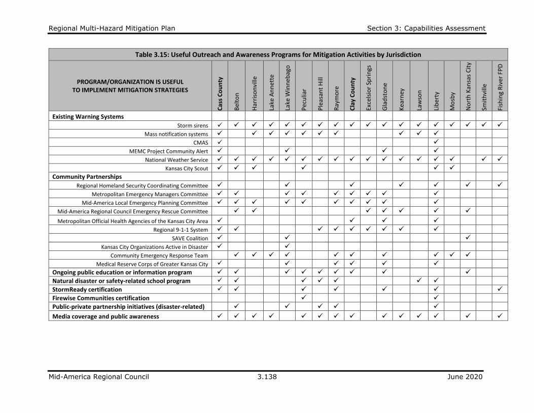
Regional Multi-Hazard Mitigation Plan Section 3: Capabilities Assessment
Mid-America Regional Council 3.138 June 2020
Table 3.15: Useful Outreach and Awareness Programs for Mitigation Activities by Jurisdiction
PROGRAM/ORGANIZATION IS USEFUL TO IMPLEMENT MITIGATION STRATEGIES
Cas
s C
ou
nty
Bel
ton
Har
riso
nvi
lle
Lake
An
net
te
Lake
Win
neb
ago
Pec
ulia
r
Ple
asan
t H
ill
Ray
mo
re
Cla
y C
ou
nty
Exce
lsio
r Sp
rin
gs
Gla
dst
on
e
Kea
rney
Law
son
Lib
erty
Mo
sby
No
rth
Kan
sas
Cit
y
Smit
hvi
lle
Fish
ing
Riv
er F
PD
Existing Warning Systems
Storm sirens ✓ ✓ ✓ ✓ ✓ ✓ ✓ ✓ ✓ ✓ ✓ ✓ ✓ ✓ ✓ ✓ ✓ ✓
Mass notification systems ✓ ✓ ✓ ✓ ✓ ✓ ✓ ✓ ✓ ✓
CMAS ✓ ✓
MEMC Project Community Alert ✓ ✓ ✓ ✓
National Weather Service ✓ ✓ ✓ ✓ ✓ ✓ ✓ ✓ ✓ ✓ ✓ ✓ ✓ ✓ ✓ ✓ ✓
Kansas City Scout ✓ ✓ ✓ ✓ ✓ ✓
Community Partnerships
Regional Homeland Security Coordinating Committee ✓ ✓ ✓ ✓ ✓ ✓ ✓
Metropolitan Emergency Managers Committee ✓ ✓ ✓ ✓ ✓ ✓ ✓ ✓ ✓
Mid-America Local Emergency Planning Committee ✓ ✓ ✓ ✓ ✓ ✓ ✓ ✓ ✓ ✓
Mid-America Regional Council Emergency Rescue Committee ✓ ✓ ✓ ✓ ✓ ✓ ✓
Metropolitan Official Health Agencies of the Kansas City Area ✓ ✓ ✓ ✓
Regional 9-1-1 System ✓ ✓ ✓ ✓ ✓ ✓ ✓ ✓ ✓
SAVE Coalition ✓ ✓ ✓
Kansas City Organizations Active in Disaster ✓ ✓
Community Emergency Response Team ✓ ✓ ✓ ✓ ✓ ✓ ✓ ✓ ✓ ✓
Medical Reserve Corps of Greater Kansas City ✓ ✓ ✓ ✓ ✓ ✓
Ongoing public education or information program ✓ ✓ ✓ ✓ ✓ ✓ ✓ ✓ ✓
Natural disaster or safety-related school program ✓ ✓ ✓ ✓ ✓ ✓ ✓
StormReady certification ✓ ✓ ✓ ✓ ✓ ✓ ✓
Firewise Communities certification ✓ ✓
Public-private partnership initiatives (disaster-related) ✓ ✓ ✓ ✓ ✓
Media coverage and public awareness ✓ ✓ ✓ ✓ ✓ ✓ ✓ ✓ ✓ ✓ ✓ ✓ ✓ ✓
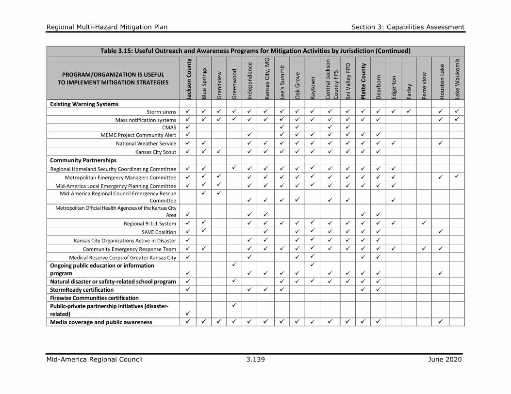
Regional Multi-Hazard Mitigation Plan Section 3: Capabilities Assessment
Mid-America Regional Council 3.139 June 2020
Table 3.15: Useful Outreach and Awareness Programs for Mitigation Activities by Jurisdiction (Continued)
PROGRAM/ORGANIZATION IS USEFUL TO IMPLEMENT MITIGATION STRATEGIES
Jack
son
Co
un
ty
Blu
e Sp
rin
gs
Gra
nd
vie
w
Gre
enw
oo
d
Ind
epen
den
ce
Kan
sas
Cit
y, M
O
Lee'
s Su
mm
it
Oak
Gro
ve
Ray
tow
n
Cen
tral
Jac
kso
n
Co
un
ty F
PS
Sni V
alle
y FP
D
Pla
tte
Co
un
ty
Dea
rbo
rn
Edge
rto
n
Farl
ey
Ferr
elvi
ew
Ho
ust
on
Lak
e
Lake
Wau
kom
is
Existing Warning Systems
Storm sirens ✓ ✓ ✓ ✓ ✓ ✓ ✓ ✓ ✓ ✓ ✓ ✓ ✓ ✓ ✓ ✓ ✓
Mass notification systems ✓ ✓ ✓ ✓ ✓ ✓ ✓ ✓ ✓ ✓ ✓ ✓ ✓ ✓ ✓
CMAS ✓ ✓ ✓ ✓ ✓
MEMC Project Community Alert ✓ ✓ ✓ ✓ ✓ ✓ ✓ ✓ ✓
National Weather Service ✓ ✓ ✓ ✓ ✓ ✓ ✓ ✓ ✓ ✓ ✓ ✓ ✓
Kansas City Scout ✓ ✓ ✓ ✓ ✓ ✓ ✓ ✓ ✓ ✓ ✓ ✓
Community Partnerships
Regional Homeland Security Coordinating Committee ✓ ✓ ✓ ✓ ✓ ✓ ✓ ✓ ✓ ✓ ✓ ✓ ✓
Metropolitan Emergency Managers Committee ✓ ✓ ✓ ✓ ✓ ✓ ✓ ✓ ✓ ✓ ✓ ✓ ✓ ✓ ✓
Mid-America Local Emergency Planning Committee ✓ ✓ ✓ ✓ ✓ ✓ ✓ ✓ ✓ ✓ ✓ ✓ ✓
Mid-America Regional Council Emergency Rescue Committee
✓ ✓
✓ ✓ ✓ ✓ ✓ ✓ ✓
Metropolitan Official Health Agencies of the Kansas City Area ✓
✓ ✓
✓ ✓
Regional 9-1-1 System ✓ ✓ ✓ ✓ ✓ ✓ ✓ ✓ ✓ ✓ ✓ ✓ ✓
SAVE Coalition ✓ ✓ ✓ ✓ ✓ ✓ ✓ ✓ ✓ ✓
Kansas City Organizations Active in Disaster ✓ ✓ ✓ ✓ ✓ ✓ ✓ ✓ ✓
Community Emergency Response Team ✓ ✓ ✓ ✓ ✓ ✓ ✓ ✓ ✓ ✓ ✓ ✓ ✓ ✓
Medical Reserve Corps of Greater Kansas City ✓ ✓ ✓ ✓ ✓ ✓
Ongoing public education or information program ✓
✓
✓ ✓ ✓ ✓
✓
✓ ✓ ✓ ✓ ✓
Natural disaster or safety-related school program ✓ ✓ ✓ ✓ ✓ ✓ ✓ ✓ ✓
StormReady certification ✓ ✓ ✓ ✓ ✓ ✓
Firewise Communities certification
Public-private partnership initiatives (disaster-related) ✓
✓
Media coverage and public awareness ✓ ✓ ✓ ✓ ✓ ✓ ✓ ✓ ✓ ✓ ✓ ✓ ✓ ✓

Regional Multi-Hazard Mitigation Plan Section 3: Capabilities Assessment
Mid-America Regional Council 3.140 June 2020
Table 3.15: Useful Outreach and Awareness Programs for Mitigation Activities by Jurisdiction (Continued)
PROGRAM/ORGANIZATION IS USEFUL TO IMPLEMENT MITIGATION STRATEGIES
No
rth
mo
or
Par
kvill
e
Pla
tte
Cit
y
Pla
tte
Wo
od
s
Riv
ers
ide
Trac
y
Wea
ther
by
Lake
Wes
ton
No
rth
lan
d R
AD
Wes
t P
latt
e FP
D
Ray
Co
un
ty
Ric
hm
on
d
Existing Warning Systems
Storm sirens ✓ ✓ ✓ ✓ ✓ ✓ ✓ ✓ ✓ ✓ ✓
Mass notification systems ✓ ✓ ✓ ✓ ✓ ✓ ✓ ✓ ✓ ✓
CMAS ✓ ✓
MEMC Project Community Alert ✓ ✓ ✓ ✓
National Weather Service ✓ ✓ ✓ ✓ ✓ ✓ ✓ ✓ ✓ ✓ ✓
Kansas City Scout ✓ ✓ ✓ ✓
Community Partnerships
Regional Homeland Security Coordinating Committee ✓ ✓ ✓ ✓ ✓
Metropolitan Emergency Managers Committee ✓ ✓ ✓ ✓ ✓ ✓
Mid-America Local Emergency Planning Committee ✓ ✓ ✓
Mid-America Regional Council Emergency Rescue Committee ✓ ✓
Metropolitan Official Health Agencies of the Kansas City Area ✓
Regional 9-1-1 System ✓ ✓ ✓ ✓ ✓
SAVE Coalition ✓ ✓ ✓ ✓ ✓
Kansas City Organizations Active in Disaster ✓ ✓ ✓ ✓ ✓
Community Emergency Response Team ✓ ✓ ✓ ✓ ✓
Medical Reserve Corps of Greater Kansas City ✓ ✓ ✓ ✓ ✓
Ongoing public education or information program ✓ ✓ ✓ ✓ ✓ ✓ ✓ ✓ ✓✓ ✓
Natural disaster or safety-related school program ✓ ✓ ✓ ✓
StormReady certification ✓ ✓ ✓ ✓ ✓ ✓ ✓
Firewise Communities certification
Public-private partnership initiatives (disaster-related) ✓ ✓ ✓ ✓
Media coverage and public awareness ✓ ✓ ✓ ✓ ✓ ✓ ✓ ✓ ✓ ✓

Regional Multi-Hazard Mitigation Plan Section 3: Capabilities Assessment
Mid-America Regional Council 3.141 June 2020
Table 3.16: Relevant Measures Incorporated into HMP (Education and Outreach Resources)
Outreach Resource Cass County
Storm Sirens
Cass Co: all sirens in county maintained by either a city or fire protection district Lake Annette: Working to install appropriate early warning system/siren Lake Winnebago: New warning system in place Peculiar: Emergency sirens are maintained by city and fire district Raymore: Uses Everbridge and social media
Mass Notification Systems
Cass Co: Everbridge; social media Harrisonville: CodeRed program Peculiar: Mass email and cell phone notification available Raymore: Internal CodeRed; Mass CodeRed; and Social Media
SAVE Coalition Raymore: City could request SAVE if needed
National Weather Service Pleasant Hill: city has personnel in NWS office during emergency events
Water Natural Resources Protection (NRI, WRP3) Raymore: Part of city's illicit elimination and detection program
Storm Shelter Model Ordinance Belton: Review with Planning Commission
Natural Disaster or Safety-Related School Program Peculiar: School Resource Officer Raymore: Full-time community and school outreach officer
StormReady Certification Harrisonville: Have applied in the past Peculiar: Chief of Police is certified
Firewise Certification Peculiar: West Peculiar Fire District Chief is certified
Public-Private Partnership Initiatives (disaster-related) Raymore: Local churches and businesses are routine mitigation partners Pleasant Hill: Partnership for disaster shelter
Media Coverage and Public Awareness Raymore: Local media, social media, and community outreach all used to raise public awareness
Outreach Resource Clay County
Storm Sirens Kearney: Used to communicate tornado warnings and other severe weather Liberty: utilized for outdoor notification for tornadic activity
Mass Notification Systems
Kearney: Kearney Police Department (KPD) participates in NIXEL and has an active Facebook page Lawson: text messaging and social media Liberty: Send mass texts and emails Clay County: NIXEL
CMAS Kearney: KPD participates in NIXEL
National Weather Service Kearney: MERS is received on KPD radios
Kansas City Scout Kearney: Infrastructure being installed by MoDOT and expect availability of system in 2020 or 2021
Regional Homeland Security Coordinating Committee Kearney Fire & Rescue Protection District (KFRPD) & KPD receive their notices
Mid-America Regional Council Emergency Rescue Kearney: KFRPD participates in this organization and implements their activities

Regional Multi-Hazard Mitigation Plan Section 3: Capabilities Assessment
Mid-America Regional Council 3.142 June 2020
Table 3.16: Relevant Measures Incorporated into HMP (Education and Outreach Resources) (Continued)
Outreach Resource Clay County
Community Emergency Response Team Kearney: No such team in Kearney, though the KFRPD is considering
Storm Shelter Model Ordinance Kearney: Building Code includes provisions for constructing safe rooms
Natural Disaster or Safety-Related School Program
Kearney: KPD participates in the school districts fire/disaster/intruder safety drills Liberty: Teach fire safety in the schools
Media Coverage and Public Awareness Kearney: Local channel 2 is made available by Fairport
Outreach Resource Jackson County
Storm Sirens
Jackson County: County addition to Lake Jacomo and Blue Springs Lake Blue Springs: Weather warning Oak Grove: Emergency Management uses Outdoor Warning Sirens with voice public address for numerous other emergency messages and hazards other than weather Independence: Contract with Blue Valley Public Safety to maintain 31 sirens Grandview: some sirens not available Kansas City: goals and actions include adding sirens to increase coverage Sni Valley FPD: Outdoor warning siren in Bates City only; Oak Grove Voice System
Mass Notification Systems
Blue Springs: CodeRed reverse 911 Grandview: NIXLE Kansas City: Alert KC is utilized, goal and action to improve system Independence: EP uses Readytohelp.org for SMS-Currently do not have a comprehensive mass notification system that can be used for contact with the general public. Oak Grove: Emergency Management uses NIXLE.com for emergency messaging Raytown: Nixle is used to broadcast critical information to large audiences Sni Valley FPD: NIXLE.com use for mass notification
CMAS
Oak Grove: WEA will be used through Jackson County for emergency messaging in addition to NIXLE when all end user capability is in place. Sni Valley FPD: Available through Jackson County EMA Kansas City: iPAWS is utilized, action is to increase usage
MEMC Project Community Alert
Independence: EP staff participated in Weather Radio programming event in May 2014 Oak Grove: This is not a warning system-public education/community partnership to educate about and sell NOAA radios Sni Valley FPD: This is not a warning system-public education/community partnership to educate about and sell NOAA radios Lee’s Summit: recommend use of weather radios for indoor notification
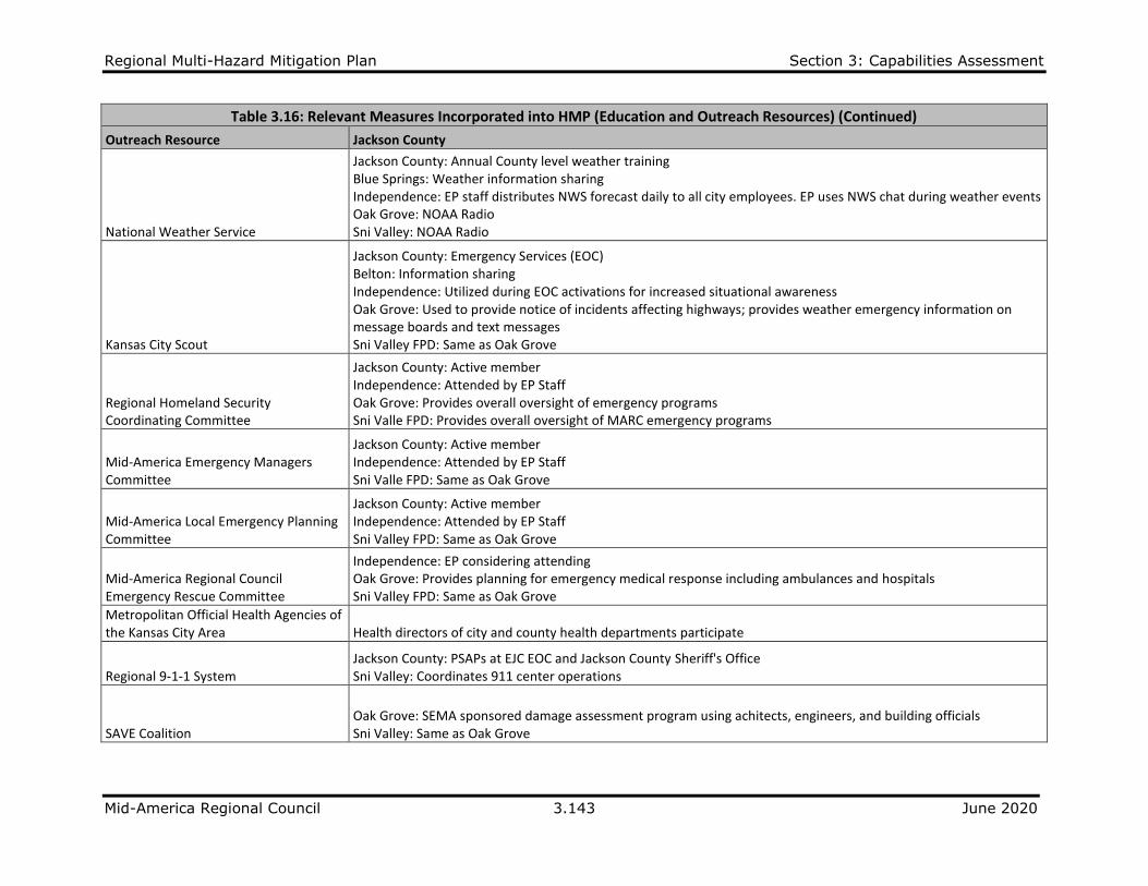
Regional Multi-Hazard Mitigation Plan Section 3: Capabilities Assessment
Mid-America Regional Council 3.143 June 2020
Table 3.16: Relevant Measures Incorporated into HMP (Education and Outreach Resources) (Continued)
Outreach Resource Jackson County
National Weather Service
Jackson County: Annual County level weather training Blue Springs: Weather information sharing Independence: EP staff distributes NWS forecast daily to all city employees. EP uses NWS chat during weather events Oak Grove: NOAA Radio Sni Valley: NOAA Radio
Kansas City Scout
Jackson County: Emergency Services (EOC) Belton: Information sharing Independence: Utilized during EOC activations for increased situational awareness Oak Grove: Used to provide notice of incidents affecting highways; provides weather emergency information on message boards and text messages Sni Valley FPD: Same as Oak Grove
Regional Homeland Security Coordinating Committee
Jackson County: Active member Independence: Attended by EP Staff Oak Grove: Provides overall oversight of emergency programs Sni Valle FPD: Provides overall oversight of MARC emergency programs
Mid-America Emergency Managers Committee
Jackson County: Active member Independence: Attended by EP Staff Sni Valle FPD: Same as Oak Grove
Mid-America Local Emergency Planning Committee
Jackson County: Active member Independence: Attended by EP Staff Sni Valley FPD: Same as Oak Grove
Mid-America Regional Council Emergency Rescue Committee
Independence: EP considering attending Oak Grove: Provides planning for emergency medical response including ambulances and hospitals Sni Valley FPD: Same as Oak Grove
Metropolitan Official Health Agencies of the Kansas City Area Health directors of city and county health departments participate
Regional 9-1-1 System Jackson County: PSAPs at EJC EOC and Jackson County Sheriff's Office Sni Valley: Coordinates 911 center operations
SAVE Coalition Oak Grove: SEMA sponsored damage assessment program using achitects, engineers, and building officials Sni Valley: Same as Oak Grove

Regional Multi-Hazard Mitigation Plan Section 3: Capabilities Assessment
Mid-America Regional Council 3.144 June 2020
Table 3.16: Relevant Measures Incorporated into HMP (Education and Outreach Resources) (Continued)
Outreach Resource Jackson County
Kansas City Organizations Active in Disaster
Jackson County: KC VOAD Independence: Attended by EP Staff Oak Grove: Coordinates community and voluntary organizations Sni Valley FPD: Same as Oak Grove Grandview: works with American Red Cross
Community Emergency Response Team
Independence: EP has a team in place-Two classes scheduled each year, one in Spring, one in the fall. Oak Grove: Trains citizens to become basic level emergency responders Sni Valley: Same as Oak Grove
Medical Reserve Corps of Greater Kansas City
Independence: EP currently meeting with MRC to try and house program here Oak Grove: Provides organized group of medical personnel available for disasters Sni Valley: Same as Oak Grove
Ongoing Public Education or Information Program
Independence: EP distributes information at several events throughout the year Oak Grove: Oak Grove EMA Safety Information Program Sni Valley FPD: Same as Oak Grove Greenwood: Beginning work
Natural Disaster or Safety-Related School Program
Oak Grove: 4th Grade Safety Education at Oak Grove R-VI Schools by Sni Valley FPD Sni Valley: Same as Oak Grove Greenwood: Beginning work
StormReady Certification
Jackson County: County level StormReady Certification Independence: EP Staff renewed in November 2014 Oak Grove: Not applicable for Oak Grove-Sni Valley due to program requirements Greenwood: Reviewing information
Firewise Certification Kansas City: Do not have this certification
Media Coverage and Public Awareness
Independence: City recently hired PIO; Public awareness campaign is under development Sni Valley: EMA uses combination for pamphlets, Local Access TV, Websites, print media, and public events

Regional Multi-Hazard Mitigation Plan Section 3: Capabilities Assessment
Mid-America Regional Council 3.145 June 2020
Table 3.16: Relevant Measures Incorporated into HMP (Education and Outreach Resources (Continued)
Outreach Resource Platte County
Storm Sirens
Platte County: Monthly tests and statewide testing Dearborn: Used in severe weather Houston Lake: Sirens from surrounding close communities are used to alert this community Platte City: New siren by city hall and recently upgraded and integrated Emmy Lane siren to the county activation Parkville: 4 sirens overlap with the county’s system Platte Woods: Siren system activated by KCMO Tracy: Platte County sirens heard throughout city Weatherby Lake: Storm sirens tested every month on the first Wednesday
Mass Notification Systems
Platte County: Numerous forms (Textcaster, Nixle, Nextdoor, facebok, twitter) Dearborn: School sends periodic notifications Houston Lake: Web, TextCaster, social media Lake Waukomis: Nixle, facebook Parkville: TextCaster Platte City: NIXLE Platte Wood: NIXLE Weatherby Lake: TextCaster; NIXLE
CMAS Dearborn: City does not have its own CMAS and relies on the county Weatherby Lake: Available within the city limits and surrounding areas
MEMC Project Community Alert
Platte County: promote every year during storm seasons Dearborn: County provides this service Platte City: Annual severe weather week at local Price Chopper Weatherby Lake: Done yearly at the local Price Chopper and local events Lake Waukomis, Platte Woods: work with the county
National Weather Service
Platte County: work with local NWS in Pleasant Hill Dearborn: County works with this organization Houston Lake: Member of NWS Weather Ambassador Lake Waukomis: Television; Internet Parkville: use Event service and work closely with their team Tracy: Get Alert Emails through City Hall Internet Weatherby Lake: Have this group in MEMC meetings and online with NWS Chat

Regional Multi-Hazard Mitigation Plan Section 3: Capabilities Assessment
Mid-America Regional Council 3.146 June 2020
Table 3.16: Relevant Measures Incorporated into HMP (Education and Outreach Resources (Continued)
Outreach Resource Platte County
Kansas City Scout
Platte County: Platte County uses message boards and cameras to view traffic Dearborn: County works with this service Parkville: monitor for highway traffic incidents Platte City: In the last five year this has incorporated I29 in Platte City Weatherby Lake: In use on the major highways (I29, I635)
Regional Homeland Security Coordinating Committee
Platte County: Emergency Management is part of this organization Dearborn: Through the county Parkville: Through the county Weatherby Lake: Attend meetings on regular basis Platte City: Through the county
Mid-America Emergency Managers Committee
Platte County: Emergency Management team are members Dearborn: Through the county Platte City: Through the county Weatherby Lake: Attend meetings on a regular basis
Mid-America Local Emergency Planning Committee
Platte County: Emergency Management is part of this Dearborn: Through the county Houston Lake: Open communication avenues and liaisons Platte City: Through the county Weatherby Lake: Attend meetings on a regular basis
Metropolitan Official Health Agencies of the Kansas City Area Platte County Health Department is a member
Regional 9-1-1 System Platte County: Platte County is a PSAP
SAVE Coalition
Platte County: Emergency Management specialist are members Dearborn: Through the county Platte City: Through the State of Missouri Weatherby Lake: Several CERT members are part of this group
Kansas City Organizations Active in Disaster
Platte County: Emergency Management is a member Dearborn: Through the county Platte City: Through the county Weatherby Lake: Attend meetings on a regular basis
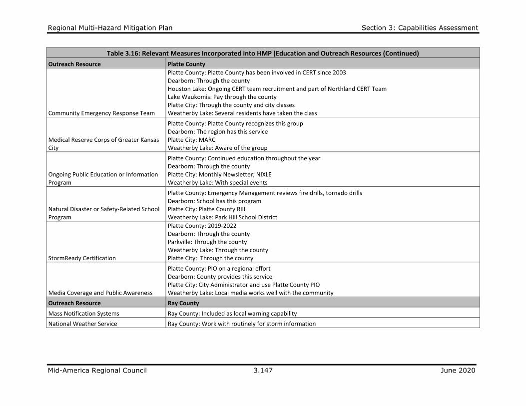
Regional Multi-Hazard Mitigation Plan Section 3: Capabilities Assessment
Mid-America Regional Council 3.147 June 2020
Table 3.16: Relevant Measures Incorporated into HMP (Education and Outreach Resources (Continued)
Outreach Resource Platte County
Community Emergency Response Team
Platte County: Platte County has been involved in CERT since 2003 Dearborn: Through the county Houston Lake: Ongoing CERT team recruitment and part of Northland CERT Team Lake Waukomis: Pay through the county Platte City: Through the county and city classes Weatherby Lake: Several residents have taken the class
Medical Reserve Corps of Greater Kansas City
Platte County: Platte County recognizes this group Dearborn: The region has this service Platte City: MARC Weatherby Lake: Aware of the group
Ongoing Public Education or Information Program
Platte County: Continued education throughout the year Dearborn: Through the county Platte City: Monthly Newsletter; NIXLE Weatherby Lake: With special events
Natural Disaster or Safety-Related School Program
Platte County: Emergency Management reviews fire drills, tornado drills Dearborn: School has this program Platte City: Platte County RIII Weatherby Lake: Park Hill School District
StormReady Certification
Platte County: 2019-2022 Dearborn: Through the county Parkville: Through the county Weatherby Lake: Through the county Platte City: Through the county
Media Coverage and Public Awareness
Platte County: PIO on a regional effort Dearborn: County provides this service Platte City: City Administrator and use Platte County PIO Weatherby Lake: Local media works well with the community
Outreach Resource Ray County
Mass Notification Systems Ray County: Included as local warning capability
National Weather Service Ray County: Work with routinely for storm information

Regional Multi-Hazard Mitigation Plan Section 3: Capabilities Assessment
Mid-America Regional Council 3.148 June 2020
3.3.5 Safe Growth Audit Data Limitation: The Safe Growth Audit Tables are presented for Cass, Clay, Jackson, Platte and Ray Counties and their respective jurisdictions.
Responses are based on data received from the community profile survey.
Table 3.17: Safe Growth Audit Summary for Cass County
Cas
s C
ou
nty
Bel
ton
Har
riso
nvi
lle
Lake
An
net
te
Lake
Win
neb
ago
Pec
ulia
r
Ple
asan
t H
ill
Ray
mo
re
Land Use
Land use policies define an urban services area. ✓ ✓ ✓
Land use policies contain provisions for hazard zone identification. ✓ ✓
Land use policies discourage development and/or redevelopment within natural hazard areas. ✓ ✓ ✓ ✓ ✓
The future land use map in the comprehensive plan clearly identifies natural hazard areas. ✓ ✓
The comprehensive plan provides adequate space for expected future growth in areas located outside of natural hazard areas.
✓
✓
✓ ✓
Land use policies require storm water engineering studies prior to development. ✓ ✓ ✓ ✓ ✓
Transportation
The transportation plan limits access to hazard areas.
Transportation policy is used to guide future growth to safe locations. ✓ ✓ ✓
Movement systems are designed to function under disaster conditions (e.g., evacuation). ✓ ✓ ✓
Environmental Management
Environmental systems that protect development from hazards are identified and mapped. ✓ ✓
Environmental policies maintain and restore protective ecosystems. ✓ ✓ ✓
Environmental policies provide incentives to development located outside protective ecosystems. ✓ ✓
Public Safety
The goals and policies of the comprehensive plan are related to those of the Hazard Mitigation Plan. ✓ ✓ ✓
Safety is explicitly included in the plan’s growth and development policies. ✓
The monitoring and implementation section of the plan covers safe growth objectives. ✓ ✓
Building Codes
The building code contains provisions to elevate construction to withstand hazard forces. ✓ ✓ ✓ ✓ ✓ ✓
The code contains wind resistance provisions to strengthen construction to withstand hazard forces. ✓ ✓ ✓ ✓ ✓ ✓
The code contains safe room or storm shelter requirements. ✓ ✓ ✓ ✓

Regional Multi-Hazard Mitigation Plan Section 3: Capabilities Assessment
Mid-America Regional Council 3.149 June 2020
Table 3.17: Safe Growth Audit Summary for Cass County (Continued)
Cas
s C
ou
nty
Bel
ton
Har
riso
nvi
lle
Lake
An
net
te
Lake
Win
neb
ago
Pec
ulia
r
Ple
asan
t H
ill
Ray
mo
re
Zoning Ordinance
The zoning ordinance conforms to the comprehensive plan in terms of discouraging development or redevelopment within natural hazard areas.
✓ ✓ ✓ ✓
The ordinance contains natural hazard overlay zones or districts that set conditions for land use within such zones.
✓ ✓ ✓ ✓
The zoning ordinance contains mitigation performance standards. ✓ ✓ ✓
The ordinance prohibits development within, or filling of, wetlands, floodways, and floodplains. ✓ ✓ ✓ ✓ ✓
Rezoning procedures recognize natural hazard areas as limits on zoning changes that allow greater intensity or density of use.
✓ ✓
✓
Subdivision Regulations
Subdivision regulations contain an adopted hazard disclosure. ✓
The regulations contain a provision for soil report evaluations. ✓
The regulations restrict the subdivision of land within or adjacent to natural hazard areas. ✓ ✓ ✓ ✓
The regulations provide for conservation subdivisions or cluster subdivisions in order to conserve environmental resources.
✓ ✓
The regulations allow density transfers where hazard exist.
Capital Improvement Program and Infrastructure Policies
The capital improvements program limits expenditures on projects that would encourage development and/or redevelopment in areas vulnerable to natural hazards.
✓
Infrastructure policies limit extension of existing facilities and services that would encourage development in areas vulnerable to natural hazards.
✓
The capital improvements program provides funding for hazard mitigation projects. ✓ ✓ ✓ ✓ ✓
Other
Small area or corridor plans recognize the need to avoid or mitigate natural hazards. ✓ ✓ ✓ ✓ ✓
An evacuation and shelter plan is adopted to deal with emergencies from natural hazards. ✓ ✓ ✓ ✓ ✓ ✓ ✓
Economic development and/or redevelopment strategies include provisions for mitigating natural hazards.
✓ ✓ ✓ ✓ ✓
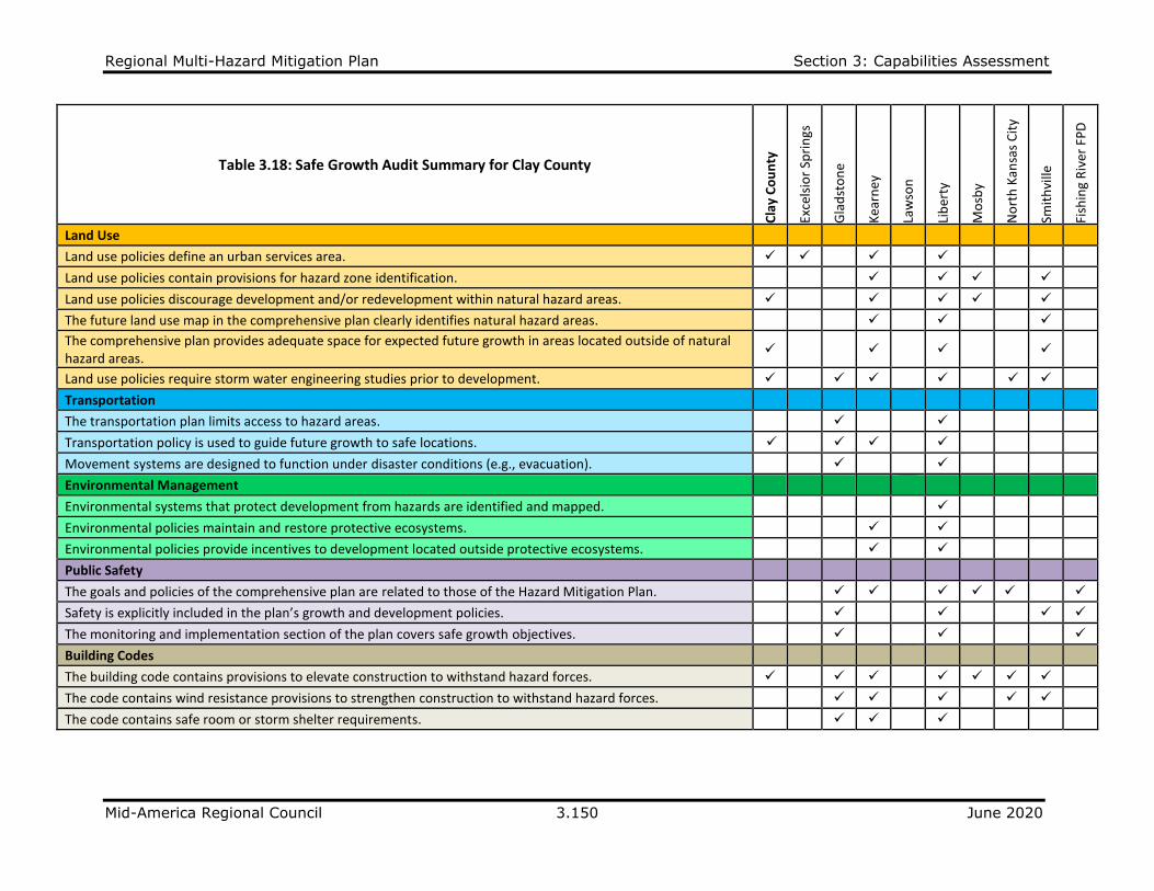
Regional Multi-Hazard Mitigation Plan Section 3: Capabilities Assessment
Mid-America Regional Council 3.150 June 2020
Table 3.18: Safe Growth Audit Summary for Clay County
Cla
y C
ou
nty
Exce
lsio
r Sp
rin
gs
Gla
dst
on
e
Kea
rney
Law
son
Lib
erty
Mo
sby
No
rth
Kan
sas
Cit
y
Smit
hvi
lle
Fish
ing
Riv
er F
PD
Land Use
Land use policies define an urban services area. ✓ ✓ ✓ ✓
Land use policies contain provisions for hazard zone identification. ✓ ✓ ✓ ✓
Land use policies discourage development and/or redevelopment within natural hazard areas. ✓ ✓ ✓ ✓ ✓
The future land use map in the comprehensive plan clearly identifies natural hazard areas. ✓ ✓ ✓
The comprehensive plan provides adequate space for expected future growth in areas located outside of natural hazard areas.
✓ ✓ ✓ ✓
Land use policies require storm water engineering studies prior to development. ✓ ✓ ✓ ✓ ✓ ✓
Transportation
The transportation plan limits access to hazard areas. ✓ ✓
Transportation policy is used to guide future growth to safe locations. ✓ ✓ ✓ ✓
Movement systems are designed to function under disaster conditions (e.g., evacuation). ✓ ✓
Environmental Management
Environmental systems that protect development from hazards are identified and mapped. ✓
Environmental policies maintain and restore protective ecosystems. ✓ ✓
Environmental policies provide incentives to development located outside protective ecosystems. ✓ ✓
Public Safety
The goals and policies of the comprehensive plan are related to those of the Hazard Mitigation Plan. ✓ ✓ ✓ ✓ ✓ ✓
Safety is explicitly included in the plan’s growth and development policies. ✓ ✓ ✓ ✓
The monitoring and implementation section of the plan covers safe growth objectives. ✓ ✓ ✓
Building Codes
The building code contains provisions to elevate construction to withstand hazard forces. ✓ ✓ ✓ ✓ ✓ ✓ ✓
The code contains wind resistance provisions to strengthen construction to withstand hazard forces. ✓ ✓ ✓ ✓ ✓
The code contains safe room or storm shelter requirements. ✓ ✓ ✓

Regional Multi-Hazard Mitigation Plan Section 3: Capabilities Assessment
Mid-America Regional Council 3.151 June 2020
Table 3.18: Safe Growth Audit Summary for Clay County (Continued)
Cla
y C
ou
nty
Exce
lsio
r Sp
rin
gs
Gla
dst
on
e
Kea
rney
Law
son
Lib
erty
Mo
sby
No
rth
Kan
sas
Cit
y
Smit
hvi
lle
Fish
ing
Riv
er F
PD
Zoning Ordinance
The zoning ordinance conforms to the comprehensive plan in terms of discouraging development or redevelopment within natural hazard areas.
✓ ✓ ✓
✓ ✓ ✓ ✓
The ordinance contains natural hazard overlay zones or districts that set conditions for land use within such zones. ✓ ✓ ✓ ✓ ✓
The zoning ordinance contains mitigation performance standards. ✓ ✓ ✓ ✓ ✓
The ordinance prohibits development within, or filling of, wetlands, floodways, and floodplains. ✓ ✓ ✓ ✓ ✓
Rezoning procedures recognize natural hazard areas as limits on zoning changes that allow greater intensity or density of use.
✓ ✓ ✓ ✓ ✓
Subdivision Regulations
Subdivision regulations contain an adopted hazard disclosure. ✓ ✓
The regulations contain a provision for soil report evaluations. ✓
The regulations restrict the subdivision of land within or adjacent to natural hazard areas. ✓ ✓ ✓ ✓ ✓
The regulations provide for conservation subdivisions or cluster subdivisions in order to conserve environmental resources.
✓ ✓ ✓
The regulations allow density transfers where hazard exist. ✓
Capital Improvement Program and Infrastructure Policies
The capital improvements program limits expenditures on projects that would encourage development and/or redevelopment in areas vulnerable to natural hazards.
✓ ✓
✓ ✓
Infrastructure policies limit extension of existing facilities and services that would encourage development in areas vulnerable to natural hazards.
✓ ✓
✓ ✓ ✓
The capital improvements program provides funding for hazard mitigation projects. ✓ ✓
Other
Small area or corridor plans recognize the need to avoid or mitigate natural hazards. ✓ ✓
An evacuation and shelter plan is adopted to deal with emergencies from natural hazards. ✓ ✓ ✓
Economic development and/or redevelopment strategies include provisions for mitigating natural hazards. ✓ ✓

Regional Multi-Hazard Mitigation Plan Section 3: Capabilities Assessment
Mid-America Regional Council 3.152 June 2020
Table 3.19: Safe Growth Audit Summary for Jackson County
Jack
son
Co
un
ty
Blu
e Sp
rin
gs
Gra
nd
vie
w
Gre
enw
oo
d
Ind
epen
den
ce
Kan
sas
Cit
y, M
O
Lee'
s Su
mm
it
Oak
Gro
ve
Ray
tow
n
Cen
tral
JA
CO
FP
D
Sni V
alle
y FP
D
Land Use
Land use policies define an urban services area. ✓ ✓ ✓ ✓
Land use policies contain provisions for hazard zone identification. ✓ ✓ ✓ ✓ ✓
Land use policies discourage development and/or redevelopment within natural hazard areas. ✓ ✓ ✓ ✓ ✓ ✓ ✓ ✓
The future land use map in the comprehensive plan clearly identifies natural hazard areas. ✓ ✓ ✓ ✓ ✓ ✓ ✓ ✓
The comprehensive plan provides adequate space for expected future growth in areas located outside of natural hazard areas.
✓ ✓ ✓ ✓
✓ ✓
Land use policies require storm water engineering studies prior to development. ✓ ✓ ✓ ✓ ✓ ✓ ✓ ✓
Transportation
The transportation plan limits access to hazard areas. ✓ ✓
Transportation policy is used to guide future growth to safe locations. ✓ ✓ ✓ ✓ ✓
Movement systems are designed to function under disaster conditions (e.g., evacuation). ✓ ✓ ✓ ✓
Environmental Management
Environmental systems that protect development from hazards are identified and mapped. ✓ ✓ ✓ ✓
Environmental policies maintain and restore protective ecosystems. ✓ ✓ ✓ ✓ ✓ ✓
Environmental policies provide incentives to development located outside protective ecosystems. ✓ ✓ ✓
Public Safety
The goals and policies of the comprehensive plan are related to those of the Hazard Mitigation Plan. ✓ ✓ ✓
Safety is explicitly included in the plan’s growth and development policies. ✓ ✓ ✓
The monitoring and implementation section of the plan covers safe growth objectives. ✓ ✓
Building Codes
The building code contains provisions to elevate construction to withstand hazard forces. ✓ ✓ ✓ ✓ ✓ ✓ ✓
The code contains wind resistance provisions to strengthen construction to withstand hazard forces. ✓ ✓ ✓ ✓ ✓ ✓ ✓ ✓
The code contains safe room or storm shelter requirements. ✓ ✓ ✓ ✓ ✓ ✓ ✓

Regional Multi-Hazard Mitigation Plan Section 3: Capabilities Assessment
Mid-America Regional Council 3.153 June 2020
Table 3.19: Safe Growth Audit Summary for Jackson County (Continued)
Jack
son
Co
un
ty
Blu
e Sp
rin
gs
Gra
nd
vie
w
Gre
enw
oo
d
Ind
epen
den
ce
Kan
sas
Cit
y, M
O
Lee'
s Su
mm
it
Oak
Gro
ve
Ray
tow
n
Cen
tral
JA
CO
FP
D
Sni V
alle
y FP
D
Zoning Ordinance
The zoning ordinance conforms to the comprehensive plan in terms of discouraging development or redevelopment within natural hazard areas.
✓ ✓
✓ ✓ ✓ ✓ ✓
The ordinance contains natural hazard overlay zones or districts that set conditions for land use within such zones.
✓ ✓
✓ ✓ ✓ ✓ ✓
The zoning ordinance contains mitigation performance standards. ✓ ✓ ✓
The ordinance prohibits development within, or filling of, wetlands, floodways, and floodplains. ✓ ✓ ✓ ✓ ✓ ✓ ✓ ✓
Rezoning procedures recognize natural hazard areas as limits on zoning changes that allow greater intensity or density of use.
✓ ✓ ✓
✓ ✓
✓ ✓
Subdivision Regulations
Subdivision regulations contain an adopted hazard disclosure. ✓ ✓ ✓ ✓
The regulations contain a provision for soil report evaluations. ✓ ✓ ✓ ✓
The regulations restrict the subdivision of land within or adjacent to natural hazard areas. ✓ ✓ ✓ ✓ ✓ ✓
The regulations provide for conservation subdivisions or cluster subdivisions in order to conserve environmental resources.
✓ ✓
✓ ✓ ✓ ✓
The regulations allow density transfers where hazard exist. ✓ ✓ ✓ ✓ ✓
Capital Improvement Program and Infrastructure Policies
The capital improvements program limits expenditures on projects that would encourage development and/or redevelopment in areas vulnerable to natural hazards.
✓
✓
✓
Infrastructure policies limit extension of existing facilities and services that would encourage development in areas vulnerable to natural hazards.
✓
✓
✓
✓
The capital improvements program provides funding for hazard mitigation projects. ✓ ✓ ✓ ✓ ✓
Other
Small area or corridor plans recognize the need to avoid or mitigate natural hazards. ✓ ✓ ✓ ✓ ✓
An evacuation and shelter plan is adopted to deal with emergencies from natural hazards. ✓ ✓ ✓ ✓ ✓ ✓
Economic development and/or redevelopment strategies include provisions for mitigating natural hazards.
✓
✓
✓ ✓ ✓
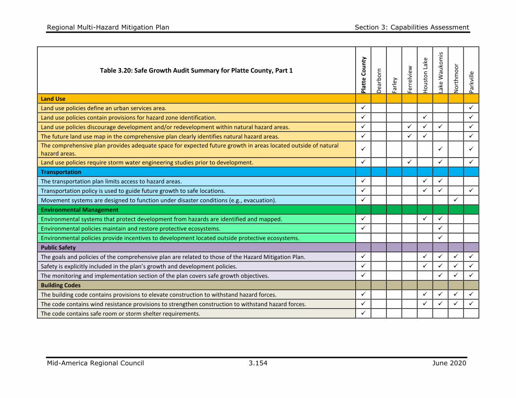
Regional Multi-Hazard Mitigation Plan Section 3: Capabilities Assessment
Mid-America Regional Council 3.154 June 2020
Table 3.20: Safe Growth Audit Summary for Platte County, Part 1
Pla
tte
Co
un
ty
Dea
rbo
rn
Farl
ey
Ferr
elvi
ew
Ho
ust
on
Lak
e
Lake
Wau
kom
is
No
rth
mo
or
Par
kvill
e
Land Use
Land use policies define an urban services area. ✓ ✓
Land use policies contain provisions for hazard zone identification. ✓ ✓ ✓
Land use policies discourage development and/or redevelopment within natural hazard areas. ✓ ✓ ✓ ✓ ✓
The future land use map in the comprehensive plan clearly identifies natural hazard areas. ✓ ✓ ✓ ✓
The comprehensive plan provides adequate space for expected future growth in areas located outside of natural hazard areas.
✓ ✓ ✓
Land use policies require storm water engineering studies prior to development. ✓ ✓ ✓ ✓
Transportation
The transportation plan limits access to hazard areas. ✓ ✓ ✓
Transportation policy is used to guide future growth to safe locations. ✓ ✓ ✓ ✓
Movement systems are designed to function under disaster conditions (e.g., evacuation). ✓ ✓
Environmental Management
Environmental systems that protect development from hazards are identified and mapped. ✓ ✓ ✓
Environmental policies maintain and restore protective ecosystems. ✓ ✓
Environmental policies provide incentives to development located outside protective ecosystems. ✓
Public Safety
The goals and policies of the comprehensive plan are related to those of the Hazard Mitigation Plan. ✓ ✓ ✓ ✓ ✓
Safety is explicitly included in the plan’s growth and development policies. ✓ ✓ ✓ ✓ ✓
The monitoring and implementation section of the plan covers safe growth objectives. ✓ ✓ ✓ ✓
Building Codes
The building code contains provisions to elevate construction to withstand hazard forces. ✓ ✓ ✓ ✓ ✓
The code contains wind resistance provisions to strengthen construction to withstand hazard forces. ✓ ✓ ✓ ✓ ✓
The code contains safe room or storm shelter requirements. ✓
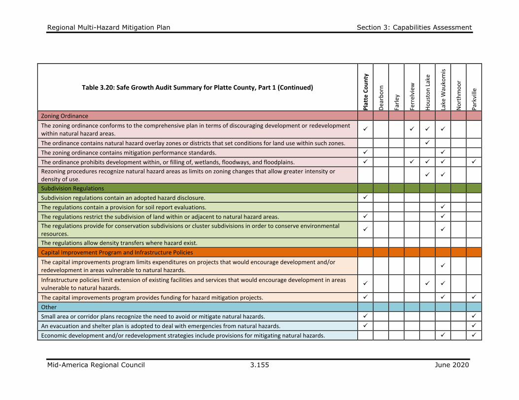
Regional Multi-Hazard Mitigation Plan Section 3: Capabilities Assessment
Mid-America Regional Council 3.155 June 2020
Table 3.20: Safe Growth Audit Summary for Platte County, Part 1 (Continued)
Pla
tte
Co
un
ty
Dea
rbo
rn
Farl
ey
Ferr
elvi
ew
Ho
ust
on
Lak
e
Lake
Wau
kom
is
No
rth
mo
or
Par
kvill
e
Zoning Ordinance
The zoning ordinance conforms to the comprehensive plan in terms of discouraging development or redevelopment within natural hazard areas.
✓ ✓ ✓ ✓
The ordinance contains natural hazard overlay zones or districts that set conditions for land use within such zones. ✓
The zoning ordinance contains mitigation performance standards. ✓ ✓
The ordinance prohibits development within, or filling of, wetlands, floodways, and floodplains. ✓ ✓ ✓ ✓ ✓
Rezoning procedures recognize natural hazard areas as limits on zoning changes that allow greater intensity or density of use.
✓ ✓
Subdivision Regulations
Subdivision regulations contain an adopted hazard disclosure. ✓
The regulations contain a provision for soil report evaluations. ✓
The regulations restrict the subdivision of land within or adjacent to natural hazard areas. ✓ ✓
The regulations provide for conservation subdivisions or cluster subdivisions in order to conserve environmental resources.
✓ ✓
The regulations allow density transfers where hazard exist.
Capital Improvement Program and Infrastructure Policies
The capital improvements program limits expenditures on projects that would encourage development and/or redevelopment in areas vulnerable to natural hazards.
✓
Infrastructure policies limit extension of existing facilities and services that would encourage development in areas vulnerable to natural hazards.
✓ ✓ ✓
The capital improvements program provides funding for hazard mitigation projects. ✓ ✓ ✓
Other
Small area or corridor plans recognize the need to avoid or mitigate natural hazards. ✓ ✓
An evacuation and shelter plan is adopted to deal with emergencies from natural hazards. ✓ ✓
Economic development and/or redevelopment strategies include provisions for mitigating natural hazards. ✓ ✓
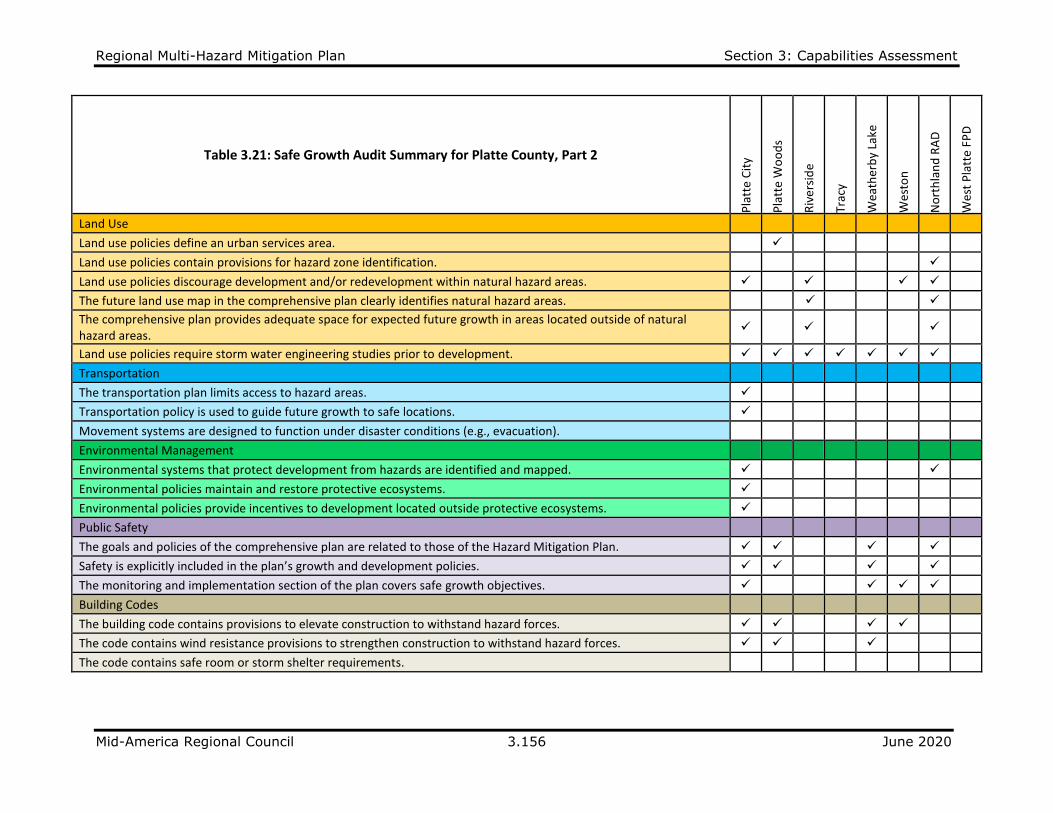
Regional Multi-Hazard Mitigation Plan Section 3: Capabilities Assessment
Mid-America Regional Council 3.156 June 2020
Table 3.21: Safe Growth Audit Summary for Platte County, Part 2
Pla
tte
Cit
y
Pla
tte
Wo
od
s
Riv
ers
ide
Trac
y
Wea
ther
by
Lake
Wes
ton
No
rth
lan
d R
AD
Wes
t P
latt
e FP
D
Land Use
Land use policies define an urban services area. ✓
Land use policies contain provisions for hazard zone identification. ✓
Land use policies discourage development and/or redevelopment within natural hazard areas. ✓ ✓ ✓ ✓
The future land use map in the comprehensive plan clearly identifies natural hazard areas. ✓ ✓
The comprehensive plan provides adequate space for expected future growth in areas located outside of natural hazard areas.
✓ ✓ ✓
Land use policies require storm water engineering studies prior to development. ✓ ✓ ✓ ✓ ✓ ✓ ✓
Transportation
The transportation plan limits access to hazard areas. ✓
Transportation policy is used to guide future growth to safe locations. ✓
Movement systems are designed to function under disaster conditions (e.g., evacuation).
Environmental Management
Environmental systems that protect development from hazards are identified and mapped. ✓ ✓
Environmental policies maintain and restore protective ecosystems. ✓
Environmental policies provide incentives to development located outside protective ecosystems. ✓
Public Safety
The goals and policies of the comprehensive plan are related to those of the Hazard Mitigation Plan. ✓ ✓ ✓ ✓
Safety is explicitly included in the plan’s growth and development policies. ✓ ✓ ✓ ✓
The monitoring and implementation section of the plan covers safe growth objectives. ✓ ✓ ✓ ✓
Building Codes
The building code contains provisions to elevate construction to withstand hazard forces. ✓ ✓ ✓ ✓
The code contains wind resistance provisions to strengthen construction to withstand hazard forces. ✓ ✓ ✓
The code contains safe room or storm shelter requirements.
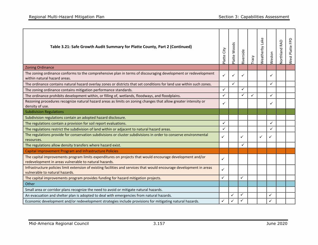
Regional Multi-Hazard Mitigation Plan Section 3: Capabilities Assessment
Mid-America Regional Council 3.157 June 2020
Table 3.21: Safe Growth Audit Summary for Platte County, Part 2 (Continued)
Pla
tte
Cit
y
Pla
tte
Wo
od
s
Riv
ers
ide
Trac
y
Wea
ther
by
Lake
Wes
ton
No
rth
lan
d R
AD
Wes
t P
latt
e FP
D
Zoning Ordinance
The zoning ordinance conforms to the comprehensive plan in terms of discouraging development or redevelopment within natural hazard areas.
✓ ✓ ✓ ✓
The ordinance contains natural hazard overlay zones or districts that set conditions for land use within such zones. ✓ ✓
The zoning ordinance contains mitigation performance standards. ✓ ✓
The ordinance prohibits development within, or filling of, wetlands, floodways, and floodplains. ✓ ✓ ✓ ✓
Rezoning procedures recognize natural hazard areas as limits on zoning changes that allow greater intensity or density of use.
✓ ✓
Subdivision Regulations
Subdivision regulations contain an adopted hazard disclosure.
The regulations contain a provision for soil report evaluations. ✓ ✓
The regulations restrict the subdivision of land within or adjacent to natural hazard areas. ✓ ✓
The regulations provide for conservation subdivisions or cluster subdivisions in order to conserve environmental resources.
✓ ✓
✓ ✓
The regulations allow density transfers where hazard exist. ✓
Capital Improvement Program and Infrastructure Policies
The capital improvements program limits expenditures on projects that would encourage development and/or redevelopment in areas vulnerable to natural hazards.
✓
Infrastructure policies limit extension of existing facilities and services that would encourage development in areas vulnerable to natural hazards.
✓
The capital improvements program provides funding for hazard mitigation projects. ✓ ✓
Other
Small area or corridor plans recognize the need to avoid or mitigate natural hazards.
An evacuation and shelter plan is adopted to deal with emergencies from natural hazards. ✓ ✓ ✓
Economic development and/or redevelopment strategies include provisions for mitigating natural hazards. ✓ ✓ ✓ ✓

Regional Multi-Hazard Mitigation Plan Section 3: Capabilities Assessment
Mid-America Regional Council 3.158 June 2020
Table 3.22: Safe Growth Audit Summary for Ray County
Ray
Co
un
ty
Ric
hm
on
d
Land Use
Land use policies define an urban services area. ✓
Land use policies contain provisions for hazard zone identification. ✓
Land use policies discourage development and/or redevelopment within natural hazard areas. ✓
The future land use map in the comprehensive plan clearly identifies natural hazard areas. ✓ ✓
The comprehensive plan provides adequate space for expected future growth in areas located outside of natural hazard areas. ✓
Land use policies require storm water engineering studies prior to development. ✓ ✓
Transportation
The transportation plan limits access to hazard areas.
Transportation policy is used to guide future growth to safe locations.
Movement systems are designed to function under disaster conditions (e.g., evacuation).
Environmental Management
Environmental systems that protect development from hazards are identified and mapped.
Environmental policies maintain and restore protective ecosystems.
Environmental policies provide incentives to development located outside protective ecosystems.
Public Safety
The goals and policies of the comprehensive plan are related to those of the Hazard Mitigation Plan.
Safety is explicitly included in the plan’s growth and development policies.
The monitoring and implementation section of the plan covers safe growth objectives.
Building Codes
The building code contains provisions to elevate construction to withstand hazard forces. ✓ ✓
The code contains wind resistance provisions to strengthen construction to withstand hazard forces. ✓ ✓
The code contains safe room or storm shelter requirements. ✓
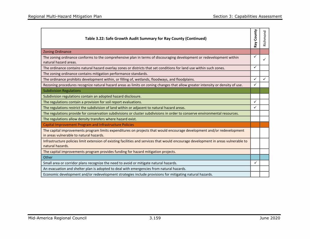
Regional Multi-Hazard Mitigation Plan Section 3: Capabilities Assessment
Mid-America Regional Council 3.159 June 2020
Table 3.22: Safe Growth Audit Summary for Ray County (Continued)
Ray
Co
un
ty
Ric
hm
on
d
Zoning Ordinance
The zoning ordinance conforms to the comprehensive plan in terms of discouraging development or redevelopment within natural hazard areas.
✓ ✓
The ordinance contains natural hazard overlay zones or districts that set conditions for land use within such zones. ✓
The zoning ordinance contains mitigation performance standards.
The ordinance prohibits development within, or filling of, wetlands, floodways, and floodplains. ✓ ✓
Rezoning procedures recognize natural hazard areas as limits on zoning changes that allow greater intensity or density of use. ✓
Subdivision Regulations
Subdivision regulations contain an adopted hazard disclosure.
The regulations contain a provision for soil report evaluations. ✓
The regulations restrict the subdivision of land within or adjacent to natural hazard areas. ✓
The regulations provide for conservation subdivisions or cluster subdivisions in order to conserve environmental resources.
The regulations allow density transfers where hazard exist.
Capital Improvement Program and Infrastructure Policies
The capital improvements program limits expenditures on projects that would encourage development and/or redevelopment in areas vulnerable to natural hazards.
Infrastructure policies limit extension of existing facilities and services that would encourage development in areas vulnerable to natural hazards.
The capital improvements program provides funding for hazard mitigation projects.
Other
Small area or corridor plans recognize the need to avoid or mitigate natural hazards. ✓
An evacuation and shelter plan is adopted to deal with emergencies from natural hazards.
Economic development and/or redevelopment strategies include provisions for mitigating natural hazards.
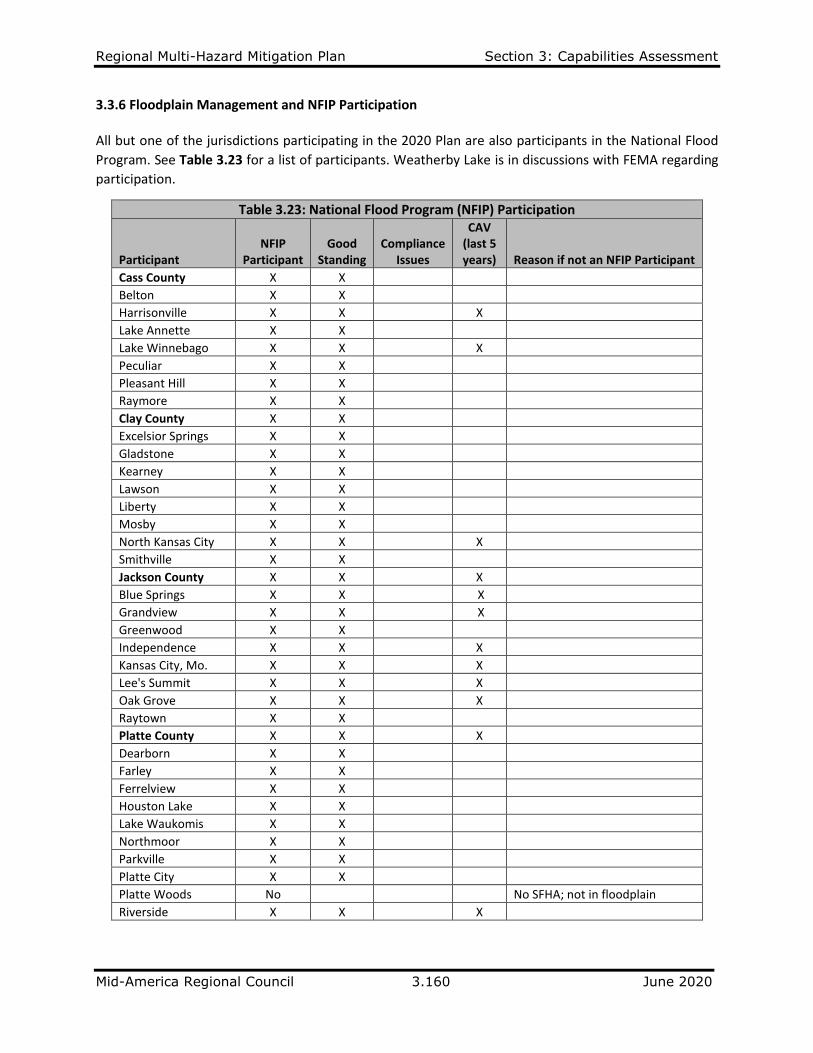
Regional Multi-Hazard Mitigation Plan Section 3: Capabilities Assessment
Mid-America Regional Council 3.160 June 2020
3.3.6 Floodplain Management and NFIP Participation All but one of the jurisdictions participating in the 2020 Plan are also participants in the National Flood
Program. See Table 3.23 for a list of participants. Weatherby Lake is in discussions with FEMA regarding
participation.
Table 3.23: National Flood Program (NFIP) Participation
Participant NFIP
Participant Good
Standing Compliance
Issues
CAV (last 5 years) Reason if not an NFIP Participant
Cass County X X
Belton X X
Harrisonville X X X
Lake Annette X X
Lake Winnebago X X X
Peculiar X X
Pleasant Hill X X
Raymore X X
Clay County X X
Excelsior Springs X X Gladstone X X
Kearney X X
Lawson X X
Liberty X X
Mosby X X
North Kansas City X X X
Smithville X X
Jackson County X X X
Blue Springs X X X
Grandview X X X
Greenwood X X
Independence X X X
Kansas City, Mo. X X X
Lee's Summit X X X
Oak Grove X X X
Raytown X X
Platte County X X X
Dearborn X X Farley X X
Ferrelview X X
Houston Lake X X
Lake Waukomis X X
Northmoor X X
Parkville X X
Platte City X X
Platte Woods No No SFHA; not in floodplain
Riverside X X X
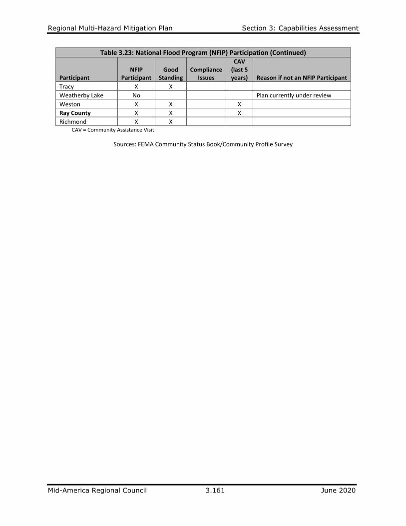
Regional Multi-Hazard Mitigation Plan Section 3: Capabilities Assessment
Mid-America Regional Council 3.161 June 2020
Table 3.23: National Flood Program (NFIP) Participation (Continued)
Participant NFIP
Participant Good
Standing Compliance
Issues
CAV (last 5 years) Reason if not an NFIP Participant
Tracy X X
Weatherby Lake No Plan currently under review
Weston X X X
Ray County X X X
Richmond X X CAV = Community Assistance Visit
Sources: FEMA Community Status Book/Community Profile Survey
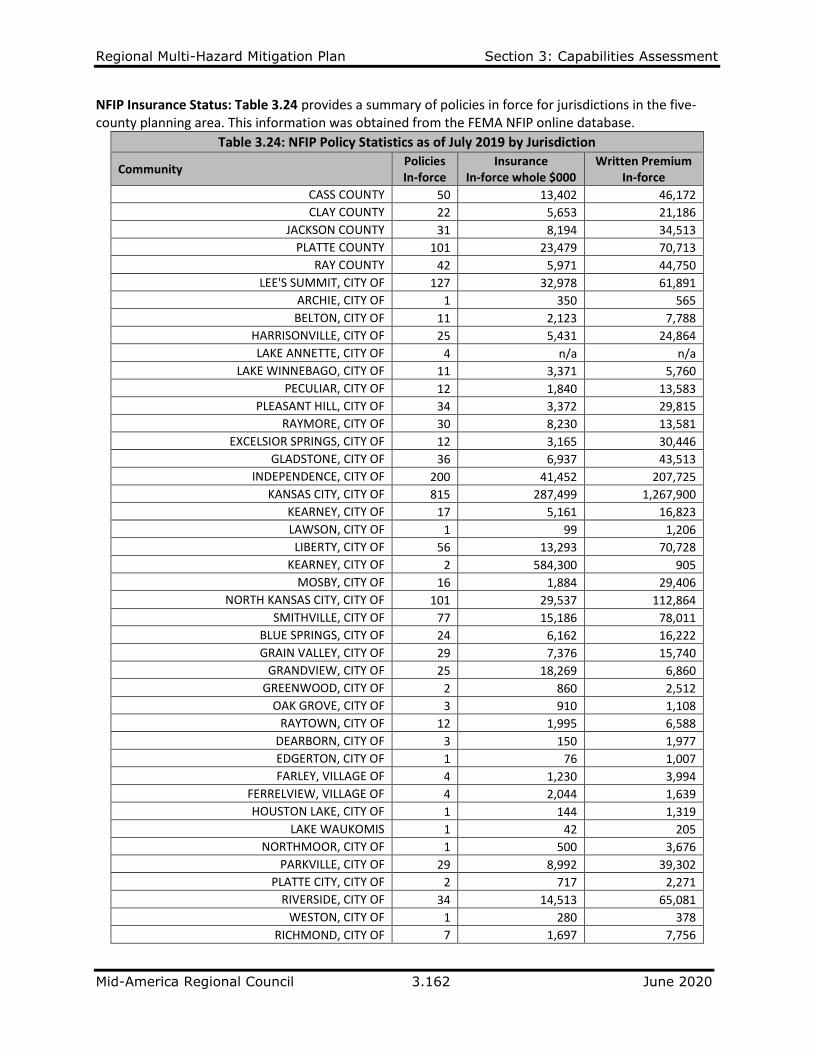
Regional Multi-Hazard Mitigation Plan Section 3: Capabilities Assessment
Mid-America Regional Council 3.162 June 2020
NFIP Insurance Status: Table 3.24 provides a summary of policies in force for jurisdictions in the five-county planning area. This information was obtained from the FEMA NFIP online database.
Table 3.24: NFIP Policy Statistics as of July 2019 by Jurisdiction
Community Policies In-force
Insurance In-force whole $000
Written Premium In-force
CASS COUNTY 50 13,402 46,172
CLAY COUNTY 22 5,653 21,186
JACKSON COUNTY 31 8,194 34,513
PLATTE COUNTY 101 23,479 70,713
RAY COUNTY 42 5,971 44,750
LEE'S SUMMIT, CITY OF 127 32,978 61,891
ARCHIE, CITY OF 1 350 565
BELTON, CITY OF 11 2,123 7,788
HARRISONVILLE, CITY OF 25 5,431 24,864
LAKE ANNETTE, CITY OF 4 n/a n/a
LAKE WINNEBAGO, CITY OF 11 3,371 5,760
PECULIAR, CITY OF 12 1,840 13,583
PLEASANT HILL, CITY OF 34 3,372 29,815
RAYMORE, CITY OF 30 8,230 13,581
EXCELSIOR SPRINGS, CITY OF 12 3,165 30,446
GLADSTONE, CITY OF 36 6,937 43,513
INDEPENDENCE, CITY OF 200 41,452 207,725
KANSAS CITY, CITY OF 815 287,499 1,267,900
KEARNEY, CITY OF 17 5,161 16,823
LAWSON, CITY OF 1 99 1,206
LIBERTY, CITY OF 56 13,293 70,728
KEARNEY, CITY OF 2 584,300 905
MOSBY, CITY OF 16 1,884 29,406
NORTH KANSAS CITY, CITY OF 101 29,537 112,864
SMITHVILLE, CITY OF 77 15,186 78,011
BLUE SPRINGS, CITY OF 24 6,162 16,222
GRAIN VALLEY, CITY OF 29 7,376 15,740
GRANDVIEW, CITY OF 25 18,269 6,860
GREENWOOD, CITY OF 2 860 2,512
OAK GROVE, CITY OF 3 910 1,108
RAYTOWN, CITY OF 12 1,995 6,588
DEARBORN, CITY OF 3 150 1,977
EDGERTON, CITY OF 1 76 1,007
FARLEY, VILLAGE OF 4 1,230 3,994
FERRELVIEW, VILLAGE OF 4 2,044 1,639
HOUSTON LAKE, CITY OF 1 144 1,319
LAKE WAUKOMIS 1 42 205
NORTHMOOR, CITY OF 1 500 3,676
PARKVILLE, CITY OF 29 8,992 39,302
PLATTE CITY, CITY OF 2 717 2,271
RIVERSIDE, CITY OF 34 14,513 65,081
WESTON, CITY OF 1 280 378
RICHMOND, CITY OF 7 1,697 7,756

Regional Multi-Hazard Mitigation Plan Section 3: Capabilities Assessment
Mid-America Regional Council 3.163 June 2020
Table 3.25 provides a summary of loss statistics in the five-county planning area. This information was
obtained from the FEMA NFIP online database.
Table 3.25: NFIP Loss Statistics as of 9/30/2018 by Jurisdiction
Community Total
Losses Closed Losses
Open Losses
CWOP Losses
Total Payments
CASS COUNTY 76 60 0 16 938,013.01
CLAY COUNTY 46 41 0 5 723,954.62
JACKSON COUNTY 42 35 0 7 367,738.00
PLATTE COUNTY 218 192 0 26 5,809,669.29
RAY COUNTY 49 42 0 7 659,427.76
LEE'S SUMMIT, CITY OF 79 63 0 16 849,467.78
BELTON, CITY OF 14 12 0 2 63,896.30
HARRISONVILLE, CITY OF 12 9 0 3 270,616.44
LAKE ANNETTE, CITY OF 3 * * * *
LAKE WINNEBAGO, CITY OF 10 7 0 3 241,913.95
PECULIAR, CITY OF 33 28 0 5 390,557.47
PLEASANT HILL, CITY OF 62 54 0 8 352,940.94
RAYMORE, CITY OF 9 7 0 2 63,505.26
EXCELSIOR SPRINGS, CITY OF 98 81 0 17 1,406,477.31
GLADSTONE, CITY OF 54 40 0 14 284,504.83
INDEPENDENCE, CITY OF 344 285 0 59 2,312,933.34
KANSAS CITY, CITY OF 1384 1102 1 281 33,401,674.12
KEARNEY, CITY OF 1 0 0 1 0
LAWSON, CITY OF 1 1 0 0 452.73
LIBERTY, CITY OF 15 12 0 3 349,945.28
MOSBY, CITY OF 62 51 0 11 767,966.75
NORTH KANSAS CITY, CITY OF 11 6 0 5 82,264.82
SMITHVILLE, CITY OF 94 89 0 5 609,376.83
BLUE SPRINGS, CITY OF 13 12 0 1 44,745.14
GRAIN VALLEY, CITY OF 3 2 0 1 8,973.06
GRANDVIEW, CITY OF 32 24 0 8 166,870.45
GREENWOOD, CITY OF 1 1 0 0 55,303.51
OAK GROVE, CITY OF 10 7 0 3 5,116.06
RAYTOWN, CITY OF 119 94 0 25 561,863.62
DEARBORN, CITY OF 2 2 0 0 7,427.44
EDGERTON, CITY OF 17 14 0 3 78,250.08
FARLEY, VILLAGE OF * * * * *
FERRELVIEW, VILLAGE OF * * * * *
HOUSTON LAKE, CITY OF * * * * *
LAKE WAUKOMIS, CITY OF 1 1 0 0 320
NORTHMOOR, CITY OF 1 1 0 0 80,143.13
PARKVILLE, CITY OF 18 12 0 6 146,500.76
PLATTE CITY, CITY OF 14 13 0 1 107,952.06
RIVERSIDE, CITY OF 81 68 0 13 7,372,561.33
TRACY, CITY OF 9 6 0 3 40,032.91
WESTON, CITY OF 11 8 0 3 105,662.86
RICHMOND, CITY OF 3 2 0 1 31,197.29
TOTAL 2991 2439 2 550 54,943,965.79 CWOP = Closed Without Payment *Source: Online FEMA no longer available
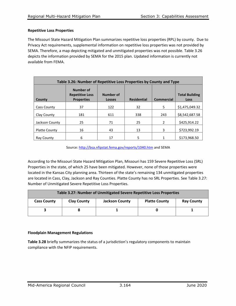
Regional Multi-Hazard Mitigation Plan Section 3: Capabilities Assessment
Mid-America Regional Council 3.164 June 2020
Repetitive Loss Properties
The Missouri State Hazard Mitigation Plan summarizes repetitive loss properties (RPL) by county. Due to
Privacy Act requirements, supplemental information on repetitive loss properties was not provided by
SEMA. Therefore, a map depicting mitigated and unmitigated properties was not possible. Table 3.26
depicts the information provided by SEMA for the 2015 plan. Updated information is currently not
available from FEMA.
Table 3.26: Number of Repetitive Loss Properties by County and Type
County
Number of Repetitive Loss
Properties Number of
Losses Residential Commercial Total Building
Loss
Cass County 37 122 32 5 $1,475,049.32
Clay County 181 611 338 243 $8,542,687.58
Jackson County 25 71 25 2 $425,914.22
Platte County 16 43 13 3 $723,992.19
Ray County 6 17 5 1 $173,968.50
Source: http://bsa.nfipstat.fema.gov/reports/1040.htm and SEMA
According to the Missouri State Hazard Mitigation Plan, Missouri has 159 Severe Repetitive Loss (SRL)
Properties in the state, of which 25 have been mitigated. However, none of those properties were
located in the Kansas City planning area. Thirteen of the state’s remaining 134 unmitigated properties
are located in Cass, Clay, Jackson and Ray Counties. Platte County has no SRL Properties. See Table 3.27:
Number of Unmitigated Severe Repetitive Loss Properties.
Table 3.27: Number of Unmitigated Severe Repetitive Loss Properties
Cass County Clay County Jackson County Platte County Ray County
3 8 1 0 1
Floodplain Management Regulations
Table 3.28 briefly summarizes the status of a jurisdiction’s regulatory components to maintain
compliance with the NFIP requirements.
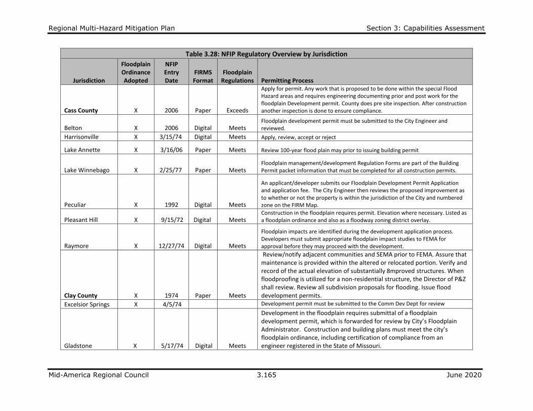
Regional Multi-Hazard Mitigation Plan Section 3: Capabilities Assessment
Mid-America Regional Council 3.165 June 2020
Table 3.28: NFIP Regulatory Overview by Jurisdiction
Jurisdiction
Floodplain Ordinance Adopted
NFIP Entry Date
FIRMS Format
Floodplain Regulations Permitting Process
Cass County X 2006 Paper Exceeds
Apply for permit. Any work that is proposed to be done within the special Flood Hazard areas and requires engineering documenting prior and post work for the floodplain Development permit. County does pre site inspection. After construction another inspection is done to ensure compliance.
Belton X 2006 Digital Meets Floodplain development permit must be submitted to the City Engineer and reviewed.
Harrisonville X 3/15/74 Digital Meets Apply, review, accept or reject
Lake Annette X 3/16/06 Paper Meets Review 100-year flood plain may prior to issuing building permit
Lake Winnebago X 2/25/77 Paper Meets Floodplain management/development Regulation Forms are part of the Building Permit packet information that must be completed for all construction permits.
Peculiar X 1992 Digital Meets
An applicant/developer submits our Floodplain Development Permit Application and application fee. The City Engineer then reviews the proposed improvement as to whether or not the property is within the jurisdiction of the City and numbered zone on the FIRM Map.
Pleasant Hill X 9/15/72 Digital Meets Construction in the floodplain requires permit. Elevation where necessary. Listed as a floodplain ordinance and also as a floodway zoning district overlay.
Raymore X 12/27/74 Digital Meets
Floodplain impacts are identified during the development application process. Developers must submit appropriate floodplain impact studies to FEMA for approval before they may proceed with the development.
Clay County X 1974 Paper Meets
Review/notify adjacent communities and SEMA prior to FEMA. Assure that maintenance is provided within the altered or relocated portion. Verify and record of the actual elevation of substantially 8mproved structures. When floodproofing is utilized for a non-residential structure, the Director of P&Z shall review. Review all subdivision proposals for flooding. Issue flood development permits.
Excelsior Springs X 4/5/74 Development permit must be submitted to the Comm Dev Dept for review
Gladstone X 5/17/74 Digital Meets
Development in the floodplain requires submittal of a floodplain development permit, which is forwarded for review by City’s Floodplain Administrator. Construction and building plans must meet the city’s floodplain ordinance, including certification of compliance from an engineer registered in the State of Missouri.
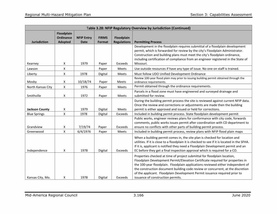
Regional Multi-Hazard Mitigation Plan Section 3: Capabilities Assessment
Mid-America Regional Council 3.166 June 2020
Table 3.28: NFIP Regulatory Overview by Jurisdiction (Continued)
Jurisdiction
Floodplain Ordinance Adopted
NFIP Entry Date
FIRMS Format
Floodplain Regulations Permitting Process
Kearney X 1979 Paper Exceeds
Development in the floodplain requires submittal of a floodplain development permit, which is forwarded for review by the city’s Floodplain Administrator. Construction and building plans must meet the city’s floodplain ordinance, including certification of compliance from an engineer registered in the State of Missouri.
Lawson X Paper Meets Use outside resources if have any type of issue. No one on staff is trained.
Liberty X 1978 Digital Meets Must follow UDO Unified Development Ordinance
Mosby X 10/18/74 Paper Meets Review 100-year flood plain may prior to issuing building permit obtained through the ordinance requirements.
North Kansas City X 1976 Paper Meets Permit obtained through the ordinance requirements.
Smithville X 1972 Paper Meets Parcels in a flood zone must have engineered and surveyed drainage and submitted for review.
Jackson County X 1979 Digital Meets
During the building permit process the site is reviewed against current NFIP data. Once the review and corrections or adjustments are made then the building permit is either approved and issued or held for corrections.
Blue Springs X 1978 Digital Exceeds Included in building permit process. State floodplain development permit
Grandview X 7/19/74 Paper Exceeds
Public works, engineer reviews plans for conformance with city code, forwards comments, public works issues permit after coordination with CD department to ensure no conflicts with other parts of building permit process.
Greenwood X 6/4/1976 Paper Meets Included in building permit process, review plans with NFIP flood plain maps
Independence X 1978 Digital Exceeds
When a building permit comes in, the site plan is checked for location and utilities. If it is close to a floodplain it is checked to see if it is located in the SFHA. If it is, applicant is notified they need a Floodplain Development permit and an EC before they get a final inspection approval which is required for a CO.
Kansas City, Mo. X 1978 Digital Exceeds
Properties checked at time of project submittal for floodplain location, Floodplain Development Permit/Elevation Certificate required for properties in the 100-year floodplain. Floodplain applications reviewed either independent of the construction document building code review or concurrent, at the discretion of the applicant. Floodplain Development Permit issuance required prior to issuance of construction permits.

Regional Multi-Hazard Mitigation Plan Section 3: Capabilities Assessment
Mid-America Regional Council 3.167 June 2020
Table 3.28: NFIP Regulatory Overview by Jurisdiction (Continued)
Jurisdiction
Floodplain Ordinance Adopted
NFIP Entry Date
FIRMS Format
Floodplain Regulations Permitting Process
Lee's Summit X 6/21/74 Paper Meets
A floodplain development permit from the City is required for all work within a floodplain as defined on the Flood Insurance Rate Maps (FIRM) issued by FEMA. If work which places fill within the designated floodplain is hydraulically modeled by a registered Professional Engineer, a City of Lee’s Summit “No Rise Certification” may be obtained if and only if the work had no impact to the Base Flood Elevation, in addition to the FEMA-requirements for work or placement of fill within a floodplain.
Oak Grove X 2004 Paper Meets Permit application with plot plan showing location. Permit issued depending on compliance with regulations.
Raytown X 12/21/73 Paper Meets Permit obtained through the ordinance requirements
Platte County X 1982 Paper Exceeds FIRMs will be adopted by April 2015 and digital available afterwards.
Dearborn X 9/19/75 Paper Meets
Farley X December
2014 Paper Meets Permits can only be obtained following the ordinance requirements.
Ferrelview X 2010 Digital Meets
Houston Lake X 2014 Paper Meets
Lake Waukomis X 1976 Paper Meets
Northmoor X 1974 Paper Meets
Parkville X 1973 Digital Meets Floodplain applications, no-rise certification.
Platte City X 1990 Paper Meets
Platte Woods X 1973 Paper Meets Not an NFIP member; not in a floodplain
Riverside X 9/30/1977 Digital Meets
Each project within the floodplain is also required to obtain a floodplain permit recommended by the Planning and Zoning Commission and approved by the Board of Aldermen. The City requires projects in the floodplain to provide an elevation certificate indicating that the lowest finished floor is located at least 1 foot above base flood elevation or that the structure is flood-proofed in accordance with the City’s adopted floodplain ordinance which is based on the FEMA model ordinance.
Tracy X 11/22/74 Paper Meets
Weatherby Lake Under Review

Regional Multi-Hazard Mitigation Plan Section 3: Capabilities Assessment
Mid-America Regional Council 3.168 June 2020
Table 3.28: NFIP Regulatory Overview by Jurisdiction (Continued)
Weston X 1979 Paper Meets
No development shall be permitted except through the issuance of a floodplain development permit, granted by the Board of Aldermen or its duly designated representative under such safeguards and restrictions as the Board of Aldermen or the designated representative may reasonably impose for the promotion and maintenance of the general welfare, health of the inhabitants of the community. All floodplain development permits will follow the Weston Code Chapter 415 on Floodplain Management.
Ray County X 01-19-83 Paper Meets
Richmond X 10/22/76 Digital Exceeds Plan review committee reviews all plans. Engineering and storm water studies are required to be submitted.

Regional Multi-Hazard Mitigation Plan Section 3: Capabilities Assessment
Mid-America Regional Council 3.169 June 2020
Floodplain Management Staffing Most NFIP participants have effective programs with regards to staffing levels.
Table 3. 29: Status of Staffing Resources for Effective NFIP Administration
Jurisdiction Dedicated
Staff Auxiliary Function
Permit Review GIS
Education Outreach Inspections Enforcement Engineering
Cass County Part time E E E E E E
Belton Full time X E E E E E E
Harrisonville Part time E NI NI E E E
Lake Annette Part time X NI E NI E E
Lake Winnebago Part time X E E E E E
Peculiar Full time NI NI NI NI NI NI
Pleasant Hill Part time X E E NI E E E
Raymore Part time X E E E E E E
Clay County Full time X E E NI E E NI
Excelsior Springs Part-time X E E NI E E NI
Gladstone Full-time X E E E E E E
Kearney Full time X E NI E E E E
Lawson Part-time X NI NI NI NI NI NI
Liberty Full time X E E E E E E
Mosby Part time E NI NI NI NI NI
N. Kansas City Full time X E E E E E E
Smithville Full time E NI NI E E E
Jackson County Full time E E E E E E
Blue Springs Full time X E E E E E E
Grandview Part time X E E NI E E E
Greenwood Part time
Independence Full time X E E NI E E E
Kansas City, Mo. Part time X E E NI E E E
Lee's Summit Part time X E E NI NI E E
Oak Grove Part time X E E NI E E E
Raytown Part-time X E NI NI E E E
Platte County Full time X E E/NI E E E E
Dearborn Part time
Farley Part time X NI NI NI
Ferrelview Part time E E E E E E
Houston Lake Part time E E E E E E
Lake Waukomis Full time X NI NI
Northmoor Part time
Parkville Full time X E E E E E E
Platte City Full time X E E E/NI E E E
Platte Woods
Riverside Full time X E E E E E E
Tracy Part time X NI
Weatherby Lake Full time
Weston Full time E E E E E E
Ray County Part time X NI NI NI NI NI NI
Richmond Part time X E/NI E/NI E/NI E/NI E/NI E/NI E = Effective NI = Needs Improvement E/NI = Effective and Needs Improvement
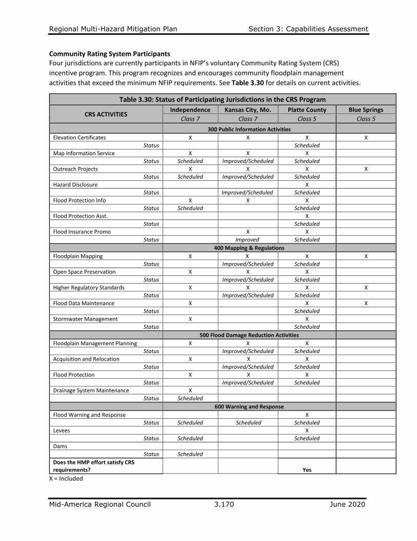
Regional Multi-Hazard Mitigation Plan Section 3: Capabilities Assessment
Mid-America Regional Council 3.170 June 2020
Community Rating System Participants Four jurisdictions are currently participants in NFIP’s voluntary Community Rating System (CRS)
incentive program. This program recognizes and encourages community floodplain management
activities that exceed the minimum NFIP requirements. See Table 3.30 for details on current activities.
Table 3.30: Status of Participating Jurisdictions in the CRS Program
CRS ACTIVITIES Independence Kansas City, Mo. Platte County Blue Springs
Class 7 Class 7 Class 5 Class 5
300 Public Information Activities
Elevation Certificates X X X X
Status Scheduled
Map Information Service X X X
Status Scheduled Improved/Scheduled Scheduled
Outreach Projects X X X X
Status Scheduled Improved/Scheduled Scheduled
Hazard Disclosure X
Status Improved/Scheduled Scheduled
Flood Protection Info X X X
Status Scheduled Scheduled
Flood Protection Asst. X
Status Scheduled
Flood Insurance Promo X X
Status Improved Scheduled
400 Mapping & Regulations
Floodplain Mapping X X X X
Status Improved/Scheduled Scheduled
Open Space Preservation X X X
Status Improved/Scheduled Scheduled
Higher Regulatory Standards X X X X
Status Improved/Scheduled Scheduled
Flood Data Maintenance X X X
Status Scheduled
Stormwater Management X X
Status Scheduled
500 Flood Damage Reduction Activities
Floodplain Management Planning X X X
Status Improved/Scheduled Scheduled
Acquisition and Relocation X X X
Status Improved/Scheduled Scheduled
Flood Protection X X X
Status Improved/Scheduled Scheduled
Drainage System Maintenance X
Status Scheduled
600 Warning and Response
Flood Warning and Response X
Status Scheduled Scheduled Scheduled
Levees X
Status Scheduled Scheduled
Dams
Status Scheduled
Does the HMP effort satisfy CRS requirements? Yes
X = Included
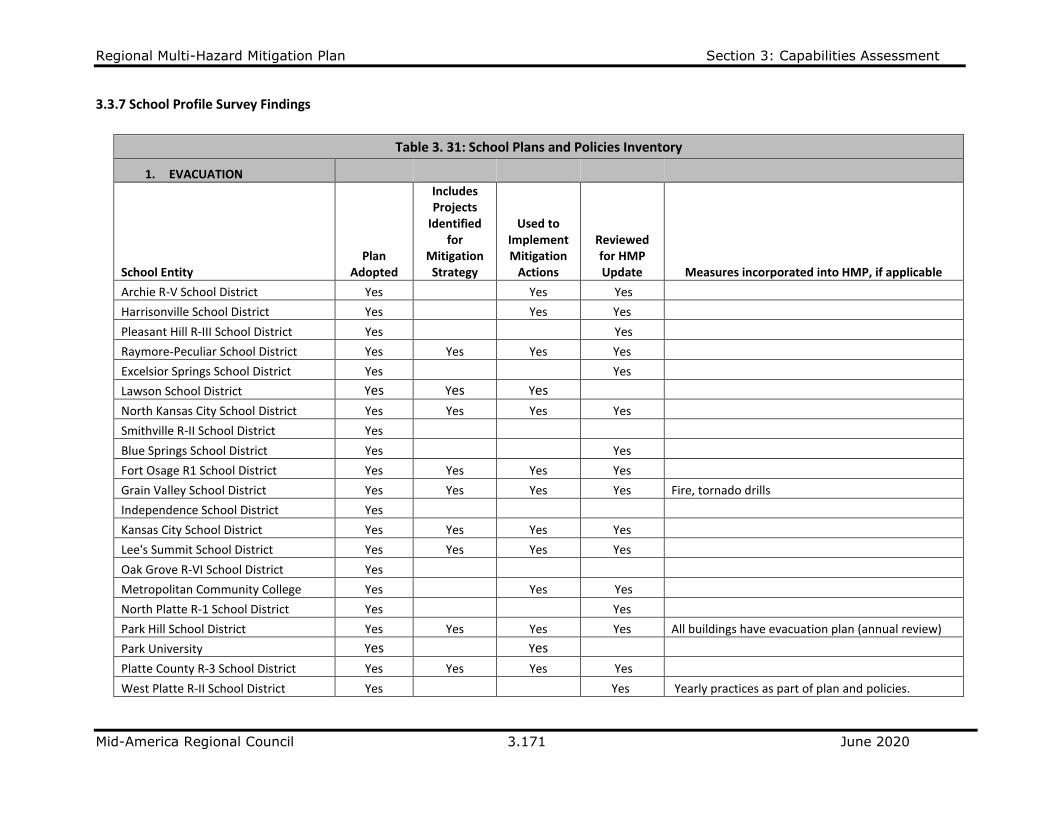
Regional Multi-Hazard Mitigation Plan Section 3: Capabilities Assessment
Mid-America Regional Council 3.171 June 2020
3.3.7 School Profile Survey Findings
Table 3. 31: School Plans and Policies Inventory
1. EVACUATION
School Entity Plan
Adopted
Includes Projects
Identified for
Mitigation Strategy
Used to Implement Mitigation
Actions
Reviewed for HMP Update Measures incorporated into HMP, if applicable
Archie R-V School District Yes Yes Yes
Harrisonville School District Yes Yes Yes
Pleasant Hill R-III School District Yes Yes
Raymore-Peculiar School District Yes Yes Yes Yes
Excelsior Springs School District Yes Yes
Lawson School District Yes Yes Yes
North Kansas City School District Yes Yes Yes Yes
Smithville R-II School District Yes
Blue Springs School District Yes Yes
Fort Osage R1 School District Yes Yes Yes Yes
Grain Valley School District Yes Yes Yes Yes Fire, tornado drills
Independence School District Yes
Kansas City School District Yes Yes Yes Yes Lee's Summit School District Yes Yes Yes Yes
Oak Grove R-VI School District Yes
Metropolitan Community College Yes Yes Yes
North Platte R-1 School District Yes Yes
Park Hill School District Yes Yes Yes Yes All buildings have evacuation plan (annual review)
Park University Yes Yes
Platte County R-3 School District Yes Yes Yes Yes
West Platte R-II School District Yes Yes Yearly practices as part of plan and policies.
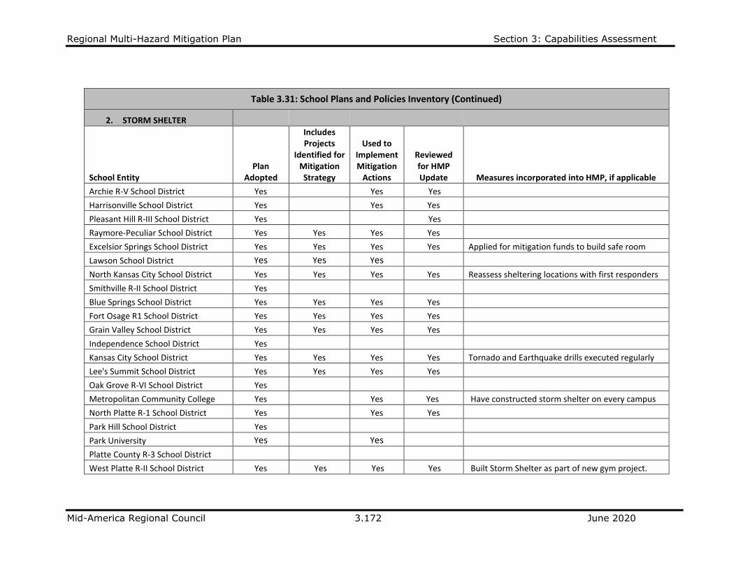
Regional Multi-Hazard Mitigation Plan Section 3: Capabilities Assessment
Mid-America Regional Council 3.172 June 2020
Table 3.31: School Plans and Policies Inventory (Continued)
2. STORM SHELTER
School Entity Plan
Adopted
Includes Projects
Identified for Mitigation Strategy
Used to Implement Mitigation
Actions
Reviewed for HMP Update Measures incorporated into HMP, if applicable
Archie R-V School District Yes Yes Yes
Harrisonville School District Yes Yes Yes
Pleasant Hill R-III School District Yes Yes
Raymore-Peculiar School District Yes Yes Yes Yes
Excelsior Springs School District Yes Yes Yes Yes Applied for mitigation funds to build safe room
Lawson School District Yes Yes Yes
North Kansas City School District Yes Yes Yes Yes Reassess sheltering locations with first responders
Smithville R-II School District Yes
Blue Springs School District Yes Yes Yes Yes
Fort Osage R1 School District Yes Yes Yes Yes
Grain Valley School District Yes Yes Yes Yes
Independence School District Yes
Kansas City School District Yes Yes Yes Yes Tornado and Earthquake drills executed regularly
Lee's Summit School District Yes Yes Yes Yes
Oak Grove R-VI School District Yes
Metropolitan Community College Yes Yes Yes Have constructed storm shelter on every campus
North Platte R-1 School District Yes Yes Yes
Park Hill School District Yes
Park University Yes Yes
Platte County R-3 School District
West Platte R-II School District Yes Yes Yes Yes Built Storm Shelter as part of new gym project.
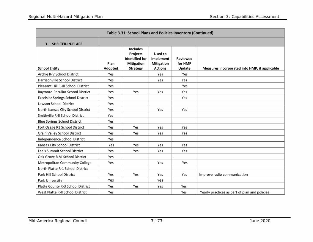
Regional Multi-Hazard Mitigation Plan Section 3: Capabilities Assessment
Mid-America Regional Council 3.173 June 2020
Table 3.31: School Plans and Policies Inventory (Continued)
3. SHELTER-IN-PLACE
School Entity Plan
Adopted
Includes Projects
Identified for Mitigation Strategy
Used to Implement Mitigation
Actions
Reviewed for HMP Update Measures incorporated into HMP, if applicable
Archie R-V School District Yes Yes Yes
Harrisonville School District Yes Yes Yes
Pleasant Hill R-III School District Yes Yes
Raymore-Peculiar School District Yes Yes Yes Yes
Excelsior Springs School District Yes Yes
Lawson School District Yes
North Kansas City School District Yes Yes Yes
Smithville R-II School District Yes
Blue Springs School District Yes
Fort Osage R1 School District Yes Yes Yes Yes
Grain Valley School District Yes Yes Yes Yes
Independence School District Yes
Kansas City School District Yes Yes Yes Yes Lee's Summit School District Yes Yes Yes Yes
Oak Grove R-VI School District Yes
Metropolitan Community College Yes Yes Yes
North Platte R-1 School District
Park Hill School District Yes Yes Yes Yes Improve radio communication
Park University Yes Yes
Platte County R-3 School District Yes Yes Yes Yes
West Platte R-II School District Yes Yes Yearly practices as part of plan and policies
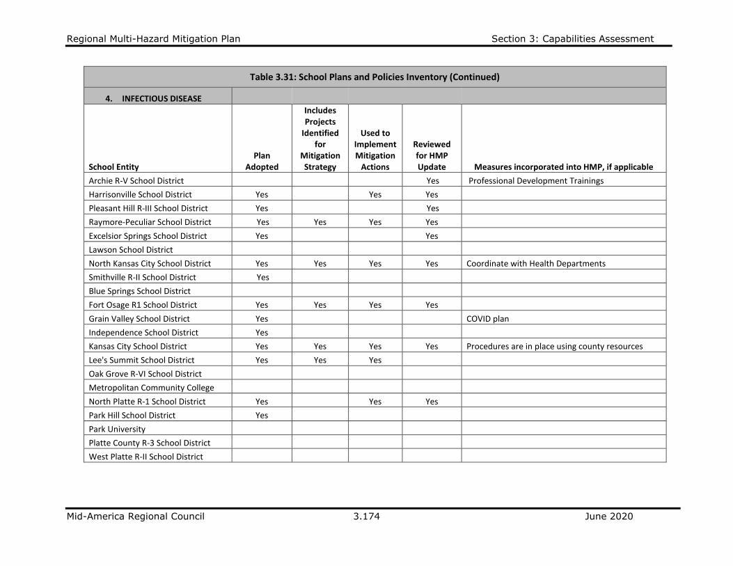
Regional Multi-Hazard Mitigation Plan Section 3: Capabilities Assessment
Mid-America Regional Council 3.174 June 2020
Table 3.31: School Plans and Policies Inventory (Continued)
4. INFECTIOUS DISEASE
School Entity Plan
Adopted
Includes Projects
Identified for
Mitigation Strategy
Used to Implement Mitigation
Actions
Reviewed for HMP Update Measures incorporated into HMP, if applicable
Archie R-V School District Yes Professional Development Trainings
Harrisonville School District Yes Yes Yes
Pleasant Hill R-III School District Yes Yes
Raymore-Peculiar School District Yes Yes Yes Yes
Excelsior Springs School District Yes Yes
Lawson School District
North Kansas City School District Yes Yes Yes Yes Coordinate with Health Departments
Smithville R-II School District Yes
Blue Springs School District
Fort Osage R1 School District Yes Yes Yes Yes
Grain Valley School District Yes COVID plan
Independence School District Yes
Kansas City School District Yes Yes Yes Yes Procedures are in place using county resources
Lee's Summit School District Yes Yes Yes
Oak Grove R-VI School District
Metropolitan Community College
North Platte R-1 School District Yes Yes Yes
Park Hill School District Yes
Park University
Platte County R-3 School District
West Platte R-II School District
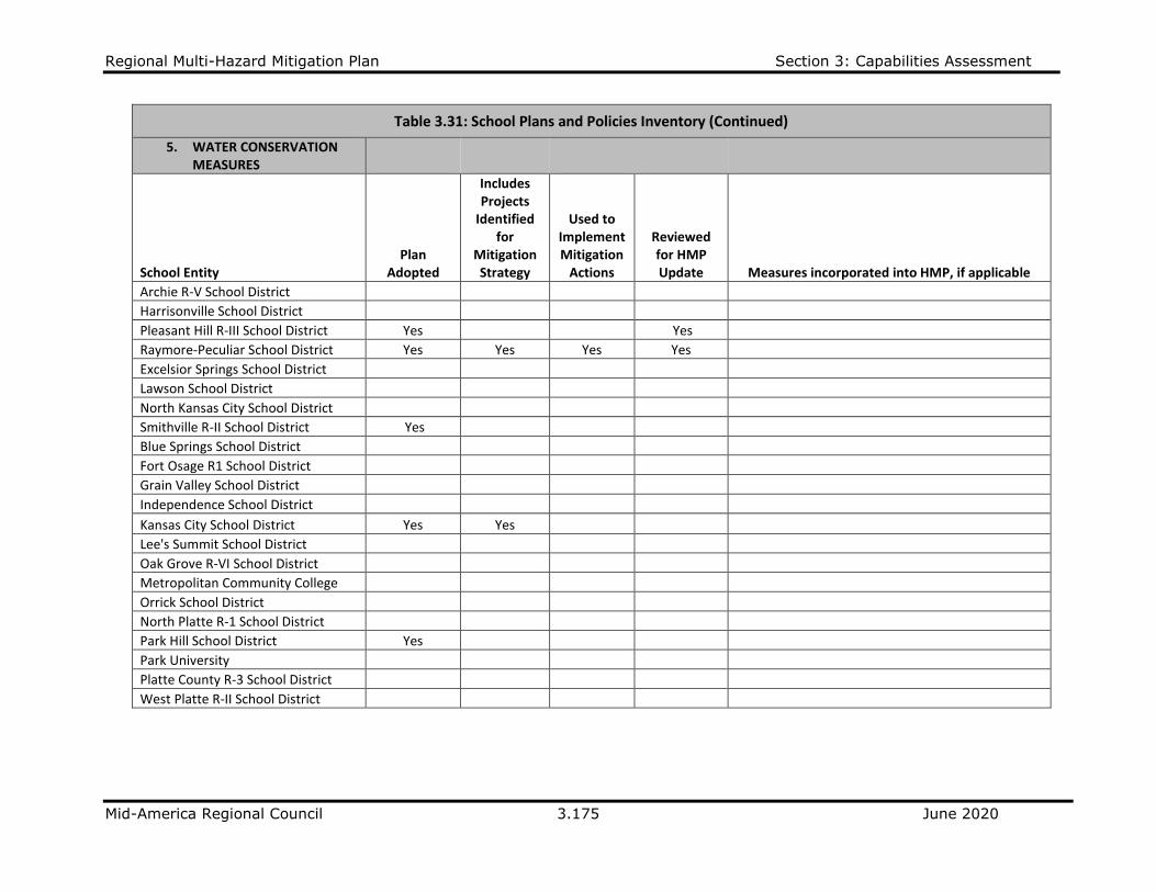
Regional Multi-Hazard Mitigation Plan Section 3: Capabilities Assessment
Mid-America Regional Council 3.175 June 2020
Table 3.31: School Plans and Policies Inventory (Continued)
5. WATER CONSERVATION MEASURES
School Entity Plan
Adopted
Includes Projects
Identified for
Mitigation Strategy
Used to Implement Mitigation
Actions
Reviewed for HMP Update Measures incorporated into HMP, if applicable
Archie R-V School District
Harrisonville School District
Pleasant Hill R-III School District Yes Yes
Raymore-Peculiar School District Yes Yes Yes Yes
Excelsior Springs School District
Lawson School District
North Kansas City School District
Smithville R-II School District Yes
Blue Springs School District
Fort Osage R1 School District
Grain Valley School District
Independence School District
Kansas City School District Yes Yes Lee's Summit School District
Oak Grove R-VI School District
Metropolitan Community College
Orrick School District
North Platte R-1 School District
Park Hill School District Yes
Park University
Platte County R-3 School District
West Platte R-II School District

Regional Multi-Hazard Mitigation Plan Section 3: Capabilities Assessment
Mid-America Regional Council 3.176 June 2020
Table 3.31: School Plans and Policies Inventory (Continued)
6. SECURITY PLAN (Intruder, Lockdown)
School Entity Plan
Adopted
Includes Projects Identified for
Mitigation Strategy
Used to Implement Mitigation
Actions
Reviewed for HMP Update Measures incorporated into HMP, if applicable
Archie R-V School District Yes Yes Yes
Harrisonville School District Yes Yes Yes
Pleasant Hill R-III School District Yes Yes
Raymore-Peculiar School District Yes Yes Yes Yes
Excelsior Springs School District Yes Yes Yes Yes
Lawson School District Yes
North Kansas City School District Yes Yes Yes Yes Smithville R-II School District Yes
Blue Springs School District Yes
Fort Osage R1 School District Yes Yes Yes Yes
Grain Valley School District Yes Yes Yes Yes Intruder drills; trained/certified staff members
Independence School District Yes
Kansas City School District Yes Yes Yes Yes Lee's Summit School District Yes Yes Yes Yes
Oak Grove R-VI School District Yes
Metropolitan Community College Yes Yes Installed intrusion detection systems
North Platte R-1 School District Yes Yes Yes
Park Hill School District Yes Yes Yes Yes Park University Yes
Platte County R-3 School District Yes Yes Yes Yes
West Platte R-II School District Yes Yes Yearly practices as part of plan and policies

Regional Multi-Hazard Mitigation Plan Section 3: Capabilities Assessment
Mid-America Regional Council 3.177 June 2020
Table 3.31: School Plans and Policies Inventory (Continued)
7. OTHER PLANS
School Entity Plan Type Plan
Adopted
Includes Projects Identified for
Mitigation Strategy
Used to Implement Mitigation
Actions
Reviewed for HMP Update
Measures incorporated into HMP, if applicable
Excelsior Springs School District
Active Shooter/Schoolwide Crisis Management Plan Guide Yes Yes Yes Yes
Install cameras as needed; all building lobbies secured to prevent visitors beyond the access point; evaluate and improve security and safety of buildings and access; all visitors must submit to background check; adopted plan at Nov 2019 Board of Education meeting.
Kansas City School District Bullying and Individual Assaults Yes
Added curriculum to raise awareness
Kansas City School District Vandalism Yes Yes Yes Yes Implementing integrated security system
Kansas City School District Active Shooter and/or Intruder Yes Yes Yes Yes
Bids out for Visitor Management System for 2015
Park Hill School District
Active Shooter Training and Crisis Plan Yes Yes Yes Yes
Security camera and communication
Metropolitan Community College Local EOP Yes Yes Yes Yes
Specifies action for tornadoes to direct staff, students and others to safe rooms. Hold drills on regular basis to help with training. Inclement weather policy was updated in Nov 2019 with phone call to relevant parties to make decisions regarding campus closings. Priority transportation routes have been identified by facilities department.
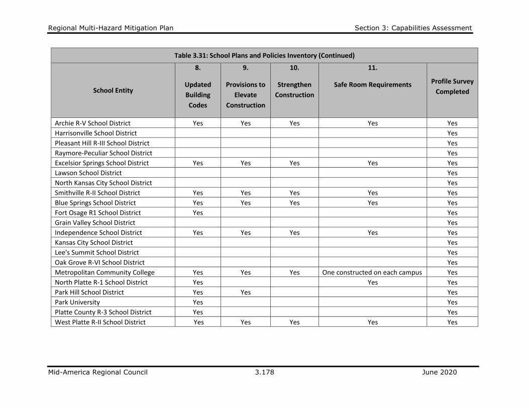
Regional Multi-Hazard Mitigation Plan Section 3: Capabilities Assessment
Mid-America Regional Council 3.178 June 2020
Table 3.31: School Plans and Policies Inventory (Continued)
School Entity
8.
Updated
Building
Codes
9.
Provisions to
Elevate
Construction
10.
Strengthen
Construction
11.
Safe Room Requirements Profile Survey
Completed
Archie R-V School District Yes Yes Yes Yes Yes
Harrisonville School District Yes
Pleasant Hill R-III School District Yes
Raymore-Peculiar School District Yes
Excelsior Springs School District Yes Yes Yes Yes Yes
Lawson School District Yes
North Kansas City School District Yes
Smithville R-II School District Yes Yes Yes Yes Yes
Blue Springs School District Yes Yes Yes Yes Yes
Fort Osage R1 School District Yes Yes
Grain Valley School District Yes
Independence School District Yes Yes Yes Yes Yes
Kansas City School District Yes
Lee's Summit School District Yes
Oak Grove R-VI School District Yes
Metropolitan Community College Yes Yes Yes One constructed on each campus Yes
North Platte R-1 School District Yes Yes Yes
Park Hill School District Yes Yes Yes
Park University Yes Yes
Platte County R-3 School District Yes Yes
West Platte R-II School District Yes Yes Yes Yes Yes

Regional Multi-Hazard Mitigation Plan Section 3: Capabilities Assessment
Mid-America Regional Council 3.179 June 2020
Mitigation Projects Awarded Funding The state of Missouri reported on Mitigation grants awarded to local jurisdictions since 1993. The
following school districts have received grants primarily for safe room projects to mitigate the impacts
from tornadoes.
CASS COUNTY Archie R-V School District Safe Room Structure – Awarded 4/30/2013; Federal $1,087,661 Non-federal $362,554 Belton School District Multi-Purpose Safe Room – Awarded (date); Federal $1,626,664 Non-federal $542,222 (Belton School District applied for a grant in 2011, but was not warded a Safe Room grant) CLAY COUNTY Smithville School District Safe Room Structure – Awarded 12/13/2010; Federal $1,191,237 Non-federal $397.079 Metropolitan Community Colleges District Maple Woods Community Safe Room – Awarded 8/31/2005; Federal $2,398,603 Non-federal $799,534 JACKSON COUNTY Oak Grove School District Community Safe Room – Awarded 12/07/2012; Federal $2,098,627 Non-federal $699,543 Blue Springs School District James Lewis Elementary School Safe Room – Awarded 5/3/2016; Federal $1,417,317 Non-federal $472,439 Metropolitan Community Colleges District Mitigation Planning – Awarded 3/30/2004; Federal $100,000 Non-federal $33,334 Blue River Community Safe Room – Awarded 8/31/2005; Federal $1,273,631 Non-federal $419,101 Longview Community Safe Room – Awarded 8/31/2005; Federal $2,553,286 Non-federal $851,095 Pioneer Campus Safe Room – Awarded 7/10/2005; Federal $566,360 Non-federal $188,787 Penn Valley Community Safe Room – Awarded 8/31/2005; Federal $3,000,000 Non-federal $1,384,811 BTC Community Safe Room – Awarded 8/31/2005; Federal $993,853 Non-federal $331,284 PLATTE COUNTY North Platte R-I School District Safe Room – Awarded 7/10/2014; Federal $362,293 Non-federal $120,765 Safe room project applications for Park Hill and West Platte School Districts were not awarded. RAY COUNTY Richmond R-XVI School District Safe Room – Awarded 6/11/2013; Federal $587,322 Non-federal $195,774 Lawson R-XIV School District Safe Room application – Pending
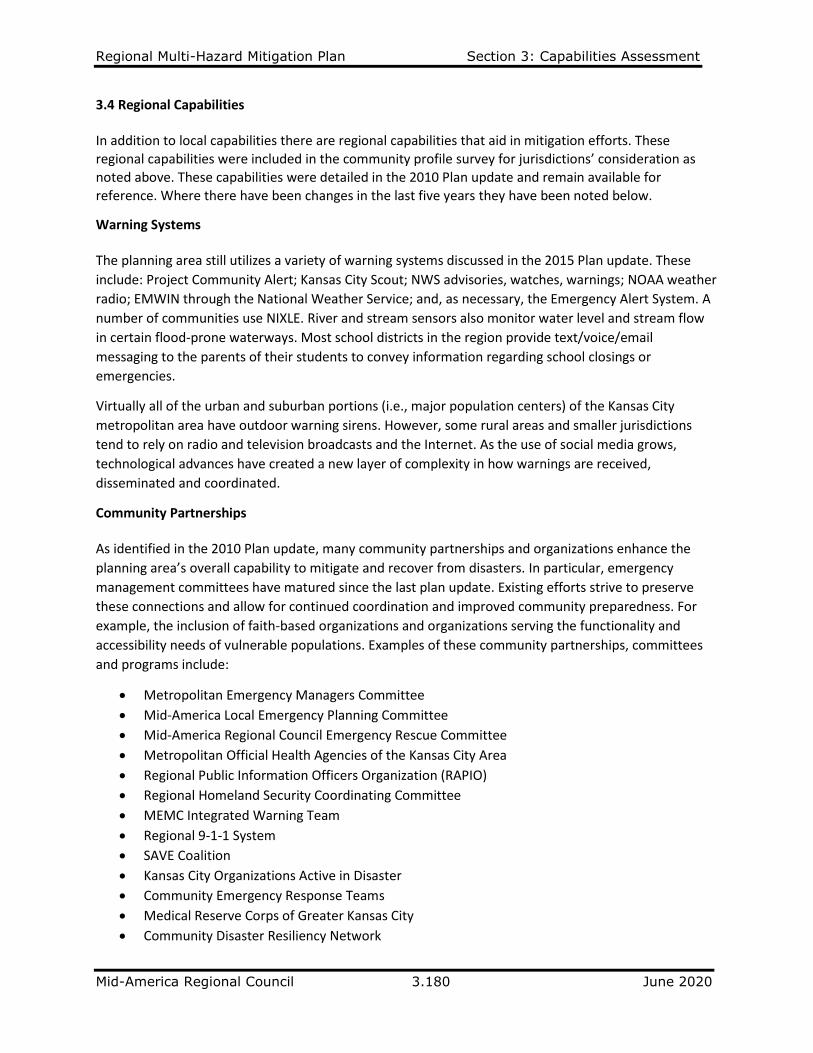
Regional Multi-Hazard Mitigation Plan Section 3: Capabilities Assessment
Mid-America Regional Council 3.180 June 2020
3.4 Regional Capabilities In addition to local capabilities there are regional capabilities that aid in mitigation efforts. These regional capabilities were included in the community profile survey for jurisdictions’ consideration as noted above. These capabilities were detailed in the 2010 Plan update and remain available for reference. Where there have been changes in the last five years they have been noted below.
Warning Systems The planning area still utilizes a variety of warning systems discussed in the 2015 Plan update. These
include: Project Community Alert; Kansas City Scout; NWS advisories, watches, warnings; NOAA weather
radio; EMWIN through the National Weather Service; and, as necessary, the Emergency Alert System. A
number of communities use NIXLE. River and stream sensors also monitor water level and stream flow
in certain flood-prone waterways. Most school districts in the region provide text/voice/email
messaging to the parents of their students to convey information regarding school closings or
emergencies.
Virtually all of the urban and suburban portions (i.e., major population centers) of the Kansas City
metropolitan area have outdoor warning sirens. However, some rural areas and smaller jurisdictions
tend to rely on radio and television broadcasts and the Internet. As the use of social media grows,
technological advances have created a new layer of complexity in how warnings are received,
disseminated and coordinated.
Community Partnerships As identified in the 2010 Plan update, many community partnerships and organizations enhance the
planning area’s overall capability to mitigate and recover from disasters. In particular, emergency
management committees have matured since the last plan update. Existing efforts strive to preserve
these connections and allow for continued coordination and improved community preparedness. For
example, the inclusion of faith-based organizations and organizations serving the functionality and
accessibility needs of vulnerable populations. Examples of these community partnerships, committees
and programs include:
• Metropolitan Emergency Managers Committee
• Mid-America Local Emergency Planning Committee
• Mid-America Regional Council Emergency Rescue Committee
• Metropolitan Official Health Agencies of the Kansas City Area
• Regional Public Information Officers Organization (RAPIO)
• Regional Homeland Security Coordinating Committee
• MEMC Integrated Warning Team
• Regional 9-1-1 System
• SAVE Coalition
• Kansas City Organizations Active in Disaster
• Community Emergency Response Teams
• Medical Reserve Corps of Greater Kansas City
• Community Disaster Resiliency Network
Regional Multi-Hazard Mitigation Plan Section 3: Capabilities Assessment
Mid-America Regional Council 3.181 June 2020
Climate Action Coalition formed by local elected officials in 2018 has held several convenings, the largest
in September 2019 with over 700 elected and appointed local government officials and members of the
public learning about the impacts of a changing climate and steps that could be taken to mitigate
impacts. A Climate Action Playbook was released in late fall 2019, and work is underway in early 2020 to
complete a greenhouse gas inventory and reduction plan for the region.
Safe Shelter Partnership, advanced by the Eastern Jackson County Emergency Management group
(Jackson County/Independence), continues to work in conjunction with the Faith-Based Organization
Initiative. Efforts have increased the capability of local faith-based organizations to ready congregations,
church facilities and surrounding community to be prepared in advance of a crisis or disaster.
Community Disaster Resiliency Network established by MARC in 2018 brings local emergency managers,
representatives of nonprofit organizations serving vulnerable populations together to work toward
increasing the resiliency of the agencies and the clients they serve during and after disaster events.
Special groups focusing on older adults, young children and faith-based organizations meet on a regular
basis.
Core 4 is a collaborative effort between four of the region’s largest jurisdictions: City of Kansas City and
Jackson County in Missouri and Johnson and Wyandotte Counties in Kansas. This initiative brings
together department directors with city/county managers and department heads on a regular basis to
collaborate on specific issues and increase communications. This collaboration was used successfully to
increase coordination during winter weather events in the past several years. Eastern Jackson County
communities, particularly Lee’s Summit, Independence and Blue Springs, are also working together.
MARC is pursuing additional opportunities for shared services.
The Storm Shelter Model Ordinance included in the 2010 Plan update has not been pursued due to
limited resources and other priorities. Although the ordinance has been removed from this plan update,
the reference still exists for future consideration.
Media Coverage and Public Awareness A wide variety of broadcast and print media outlets serve the region. A list of the Kansas City area’s television stations, radio stations and newspapers were provided in the 2010 Plan. The media coverage remains an important venue for information dissemination. Additionally, local governments and other stakeholders involved in hazard mitigation conduct outreach and awareness through the Internet and social media communication methods. The Metropolitan Emergency Managers Committee and Regional Association of Public Information Officers work together on a website for the public on emergency preparedness, www.preparemetrokc.org and on other promotion regarding preparedness for natural hazards.
i FEMA. Worksheets 4.1- 4.3 Capability Assessment Worksheet, Safe Growth Audit, National Flood Insurance Program Worksheet. Local Mitigation Planning Handbook, March 2013.