SECTION 1SECTION1 - NCIG · SECTION 1SECTION1 INTRODUCTION. Newcastle Coal Infrastructure Group...
12
NEWCASTLE COAL INFRASTRUCTURE GROUP COAL EXPORT TERMINAL NEWCASTLE COAL INFRASTRUCTURE GROUP COAL EXPORT TERMINAL SECTION 1 SECTION 1 INTRODUCTION
Transcript of SECTION 1SECTION1 - NCIG · SECTION 1SECTION1 INTRODUCTION. Newcastle Coal Infrastructure Group...
NEWCASTLE COAL INFRASTRUCTURE GROUP
COAL EXPORT TERMINAL
NEWCASTLE COAL INFRASTRUCTURE GROUP
COAL EXPORT TERMINAL
SECTION 1SECTION 1
INTRODUCTION
Newcastle Coal Infrastructure Group Coal Export Terminal – Environmental Assessment
1-i
TABLE OF CONTENTS Section Page
1 INTRODUCTION 1-1
1.1 PROJECT OVERVIEW 1-1
1.1.1 Purpose of this Report 1-1
1.1.2 Background 1-1
1.1.3 Project Summary 1-1
1.1.4 Site Location, Tenure and Past Land Use 1-5
1.1.5 Project Snapshot 1-5
1.1.6 Proponent 1-5
1.2 ENVIRONMENTAL ASSESSMENT REQUIREMENTS 1-5
1.3 DOCUMENT STRUCTURE 1-9
1.4 PROJECT CONSULTANTS 1-9
LIST OF TABLES Table 1-1 Land Tenure Summary Table 1-2 Project Snapshot Table 1-3 Director-General’s Environmental
Assessment Requirements – Reference Summary
LIST OF FIGURES
Figure 1-1 Regional Location Figure 1-2 Project Location Figure 1-3 Aerial Photograph Showing Project General
Arrangement Figure 1-4 Newcastle Local Environmental Plan Zoning
Newcastle Coal Infrastructure Group Coal Export Terminal – Environmental Assessment
1-1
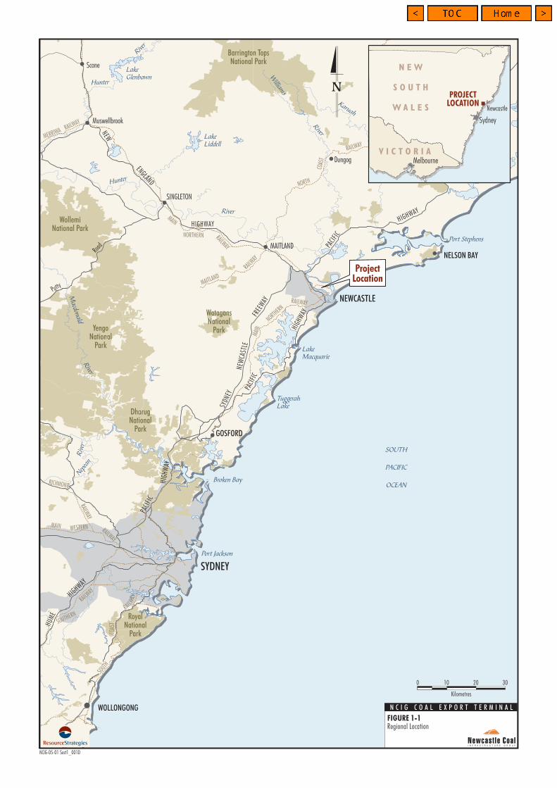
1 INTRODUCTION This document is an Environmental Assessment (EA) for the proposed development of a Coal Export Terminal (CET) (the Project) by Newcastle Coal Infrastructure Group Pty Limited (NCIG). The Project is located on Kooragang Island in Newcastle, New South Wales (NSW), within the Newcastle local government area (Newcastle LGA) (Figures 1-1 and 1-2). The Project includes the construction and operation of a 66 million tonnes per annum (Mtpa) CET, including associated rail and coal handling infrastructure and wharf/shiploading facilities on the south arm of the Hunter River. NCIG is the proponent of the Project. NCIG is a consortium of the following six companies: • Hunter Valley Energy Coal Limited;
• Centennial Coal Company Limited;
• Donaldson Coal Pty Limited;
• Excel Coal Limited;
• Felix Resources Limited (formerly White Mining Limited); and
• Whitehaven Coal Mining Pty Ltd.
1.1 PROJECT OVERVIEW
1.1.1 Purpose of this Report This EA has been prepared to accompany the Project Application, in accordance with Part 3A of the Environmental Planning and Assessment Act, 1979 (EP&A Act). This EA assesses the environmental impacts of the Project in accordance with the Environmental Assessment Requirements (EARs) issued by the Director-General of the Department of Planning (DoP) on 26 April 2006 (Attachment 1). The EARs were issued in accordance with the requirements of Part 3A of the EP&A Act and Part 1A of the Environmental Planning and Assessment Regulation, 2000 (EP&A Regulation). Further detail on the EARs is provided in Section 1.2.
1.1.2 Background The ability for NSW coal producers to export coal through Newcastle is constrained by the capacity of the Hunter Valley coal supply chain. Since August 2003, there is evidence that some coal export growth might have been lost as a result of constraints in the system (ABARE, 2005).
Projected future coal export demand cannot be met by the existing coal loading facilities in Newcastle that are located at Carrington and Kooragang Island (Section 3.9). In September 2004, the NSW Government placed out to tender a 35 year lease for nominated portions of land on Kooragang Island for general use (including possible use as a CET). The NSW Government named NCIG as the successful tenderer for the lease of the Project site on 25 August 2005. NCIG signed the Kooragang Island Coal Loader Terminal Deed of Agreement for Lease (Agreement for Lease) for the Project site on 26 August 2005.
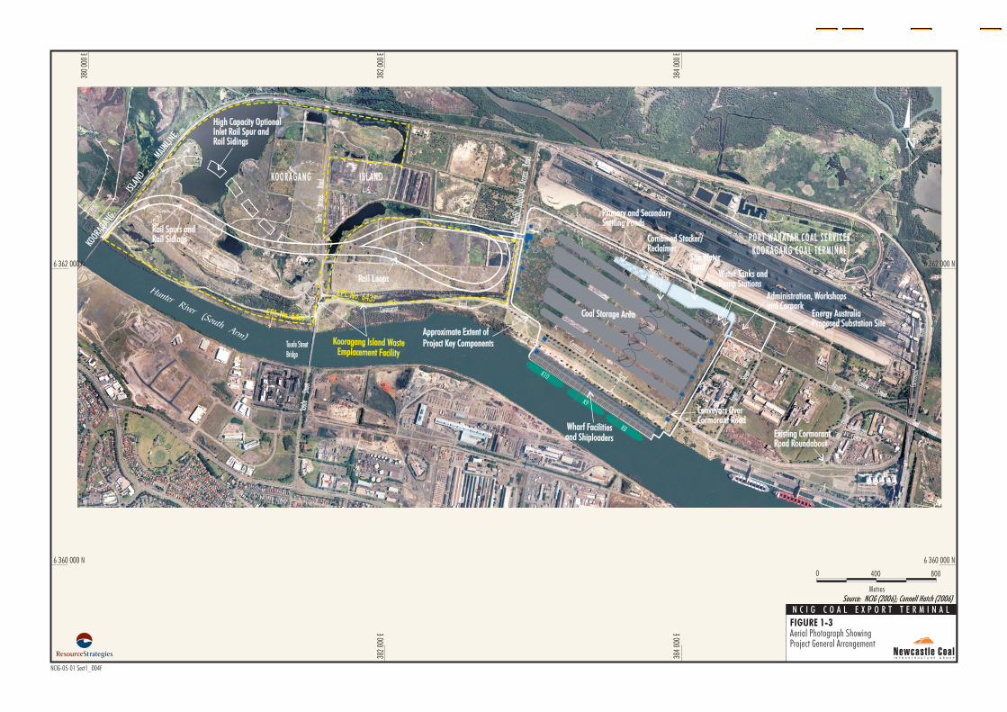
1.1.3 Project Summary NCIG proposes to commence construction of the CET in the first quarter of 2007. The Project comprises the following key components (Figure 1-3): • foundation preparation/capping of a rail
corridor traversing the existing Kooragang Island Waste Emplacement Facility (KIWEF) for the development of the rail spurs, rail sidings and rail loops;
• construction of rail spurs, rail sidings and rail loops, rail overpass, train unloading stations and connecting conveyors;
• re-use of dredged materials from the south arm of the Hunter River as preload and engineering fill for construction of the coal storage area, rail corridor and wharf facilities;
• construction of a coal storage area including coal stockpiles, conveyors, transfer points and combined stacker/reclaimers;
• construction of wharf facilities, shiploaders, conveyors and buffer bins;
• development of water management infrastructure including site drainage works, stormwater settlement ponds, primary and secondary settling ponds, site water pond, water tanks and stockpile spray system;
• installation of electricity reticulation and control systems;
• development of access roads and internal roads;
• construction of administration and workshop buildings;
WollemiNational Park
Barrington TopsNational Park
YengoNational
Park
DharugNational
Park
WatagansNational
Park
NEW
MAIN
Hunter
River
Hunter
River
Macdonald
River
William
s
River
Karuah
River
TuggerahLake
LakeMacquarie
Port Jackson
Broken Bay
LakeGlenbawn
LakeLiddell
Port Stephens
Riv
erNep
ean
WOLLONGONG
SYDNEY
NEWCASTLE
SINGLETON
GOSFORD
MAITLAND
Scone
NELSON BAY
Dungog
Muswellbrook
RAILWAY
COAS
T
NORTH
ENGLAND
HIGHWAY
Putty
Road
FREE
WAY
SYDN
EY
NEW
CAST
LE
HIGHWAY
PACI
FIC
PACI
FIC
HIGH
WAY
HIGHWAY
HUM
EHU
ME
PACI
FIC
PACI
FIC
HIGH
WAY
MAITLAND
RAILW
AY
MAIN
NORTHERN
RAILWAY
MAI
N
NORTHERN
RAILW
AY
SOUTHERN
COAS
T
RAILWAY
RAILWAY
WESTERN
RAILWAY
RICHMOND
RAILWAY
MERRIWA
RAILWAY
SOUT
H
SOUTH
PACIFIC
OCEAN
RoyalNational
Park
PROJECTLOCATION
Newcastle
Melbourne
N E W
S O U T H
W A L E S
V I C T O R I A
Sydney
ProjectLocation
0 3010
Kilometres
Regional LocationFIGURE 1-1
NCIG-05-01 Sect1_001D
20
N C I G C O A L E X P O R T T E R M I N A L
MAINNORTHERN
RAILWAY
PacificHighway
PacificHighway
PacificHighway
PacificHighway
CormorantRoad
TomagoRoad
Industrial
Drive
NEWCASTLENEWCASTLE
LAKE
MACQUARIE
LAKE
MACQUARIE
PORT STEPHENSPORT STEPHENS
MAITLAND
HEXHAMHEXHAM
TOMAGOTOMAGO
SHORTLANDSHORTLAND SANDGATESANDGATE
MAYFIELDWEST
MAYFIELDWEST MAYFIELD
NORTHMAYFIELD
NORTH
MAYFIELDEAST
MAYFIELDEAST
TIGHES HILLTIGHES HILL
WARATAHWARATAH
GEORGETOWNGEORGETOWN
HAMILTONNORTH
HAMILTONNORTH
HAMILTONHAMILTON
ISLINGTONISLINGTON
WARATAH WESTWARATAH WEST
CALLAGHAN
NORTH LAMBTONNORTH LAMBTON
BIRMINGHAMGARDENS
BIRMINGHAMGARDENS
JESMONDJESMOND
RANKIN PARKRANKIN PARK
NEW LAMBTONNEW LAMBTON
NEW LAMBTONHEIGHTS
NEW LAMBTONHEIGHTS
LAMBTONLAMBTON
BROADMEADOWBROADMEADOW
ADAMSTOWNADAMSTOWN
HAMILTON SOUTHHAMILTON SOUTH
WARABROOKWARABROOK
MARYVILLEMARYVILLE
KOORAGANG ISLANDKOORAGANG ISLAND
NEWCASTLECBD
NEWCASTLECBD
NEWCASTLE EASTNEWCASTLE EAST
STOCKTONSTOCKTON
THE HILLTHE HILL
COOKS HILLCOOKS HILL
HAMILTONEAST
HAMILTONEAST
NEWCASTLEWEST
NEWCASTLEWEST
THE JUNCTIONTHE JUNCTIONBAR BEACHBAR BEACH
CARRINGTONCARRINGTON
MAYFIELDMAYFIELD
FERN BAYFERN BAY
Fullerton Cove
StocktonBightSt
ockt
onCh
anne
l
Hunter
RiverHunter
River
PortHunter
Hunter River (North Arm)
HunterRiver
(SouthArm)
380
000
E
6 370 000 N382
000
E
384
000
E
386
000
E
6 366 000 N
6 358 000 N
378
000
E
380
000
E
382
000
E
384
000
E
386
000
E
378
000
E
6 370 000 N
6 368 000 N
6 366 000 N
6 362 000 N
6 360 000 N
6 358 000 N
6 356 000 N
6 364 000 N
6 368 000 N
6 360 000 N
6 362 000 N
6 356 000 N
6 364 000 N
PORT WARATAH COAL SERV ICESKOORAGANG COAL TERMINAL
(A t Fu l l Deve lopmen t )
BLACKBUTTRESERVE
STOCKTON SANDSPIT
KOORAGANG WETLANDREHABILITATION PROJECT
ASH ISLAND
KOORAGANG NATURE RESERVE
PORT WARATAHCOAL SERV ICES
CARRINGTON COAL TERMINAL
PORT WARATAHCOAL SERV ICES
CARRINGTON COAL TERMINAL
HexhamSwamp
University ofNewcastle
TomagoIndustrial
Estate
NCIG Coal Export Terminal
SHORTLANDWETLANDS
BHP Closure Area
Steel River
OneSteel
HEXHAMSWAMPNATURERESERVE
KOORAGANGNATURERESERVE
LEGEND
Nature Reserve
Mangrove Area
South Arm Dredging DA-134-3-2003-i (approved)Proponent: NSW Waterways Authority
Approximate Extent of Project Key Components
High Capacity Optional Inlet Rail Spur and RailSidings
Local Government Area Boundary
Source: NCIG (2006); Connell Hatch (2006); RLMC (2006); UBD (2002)
Project LocationFIGURE 1-2
NCIG-05-01 Sect1_002M
N C I G C O A L E X P O R T T E R M I N A L
0 21
Kilometres
Delta
Access
Road
Delta
Access
Road
Tourle
Street
Tourle
Street
Cormorant
Road
Cormo
rant
Road
Egret
Street
Egret
Street
Heron
Road
Heron
Road
Cormorant Road
Industrial DriveIndustrial Drive
Pacific
Highway
Pacific
Highway
Raven
Teal
Street
SandpiperClose
TealStreet
TealStreet
CurlewStreet
CurlewStreet
Street
Pacifi
cNa
tiona
lAcc
essRo
adPa
cific
Natio
nal
Access
Road
Tourle StreetBridgeTourle StreetBridge
EPL No. 6437
EPL No. 6437
Existing CormorantRoad RoundaboutExisting CormorantRoad Roundabout
KOORAGANG ISLANDKOORAGANG ISLAND
PORT WARATAH COAL SERV ICES
KO O R AGANG CO AL TER MINAL
PO R T WARATAH COAL SERV ICES
KO O R AGANG COAL TERMINAL
Wharf Facilitiesand Shiploaders
Wharf Facilitiesand Shiploaders
BHP Closure Area
Rail LoopsRail Loops
K10
K9
K8
K4
Hunter River (South Arm)
Coal Storage AreaCoal Storage Area
Kooragang Island WasteEmplacement Facility
Kooragang Island WasteEmplacement Facility
Conveyors OverCormorant RoadConveyors OverCormorant Road
Combined Stacker/ReclaimerCombined Stacker/Reclaimer
Rail Spurs andRail SidingsRail Spurs andRail Sidings
ISLA
ND
MAINLIN
E
KOORA
GANG
Approximate Extent of
Project Key Components
Approximate Extent of
Project Key Components
High Capacity OptionalInlet Rail Spur andRail Sidings
High Capacity OptionalInlet Rail Spur andRail Sidings
384
000
E
6 362 000 N
382
000
E
380
000
E
6 360 000 N6 360 000 N
384
000
E
382
000
E
380
000
E
6 362 000 N
NCIG-05-01 Sect1_004F
Source: NCIG (2006); Connell Hatch (2006)
N C I G C O A L E X P O R T T E R M I N A L
FIGURE 1-3Aerial Photograph ShowingProject General Arrangement
Source: NCIG (2006); Connell Hatch (2006)Metres
8000 400
Water Tanks andPump StationsWater Tanks andPump Stations
Administration, Workshopsand CarparkAdministration, Workshopsand Carpark
Primary and SecondarySettling PondsPrimary and SecondarySettling Ponds
Site WaterPondSite WaterPond
Energy AustraliaProposed Substation SiteEnergy AustraliaProposed Substation Site
Newcastle Coal Infrastructure Group Coal Export Terminal – Environmental Assessment
1-5
• other associated minor infrastructure, plant, equipment and activities; and
• operation of the CET up to a capacity of 66 Mtpa, including the unloading of coal trains, the stockpiling of coal, and the loading of coal to ships via the wharf facilities and shiploaders.
Upgrading of electricity transmission infrastructure to supply the existing and future industrial requirements of Kooragang Island industrial facilities (including the Project) is being undertaken by Energy Australia and is not included as part of the Project or assessed in this EA. Dredged material from the approved Extension of Shipping Channels within the Port of Newcastle (DA-134-3-2003-i) would be used as construction material for the Project. Further detail of the interaction between this Project and DA-134-3-2003-i is provided in Sections 2.5.1 and 3.6.1. A description of the construction and operation of the Project, including a provisional development schedule, is provided in Section 2. An assessment of the potential environmental impacts of the Project and the proposed environmental mitigation, management and monitoring measures is provided in Section 4. Supporting appendices upon which the assessment is based are attached to this EA.
1.1.4 Site Location, Tenure and Past Land Use
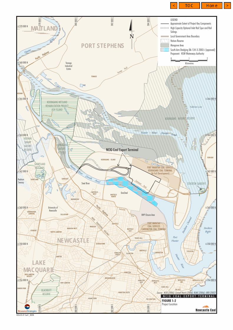
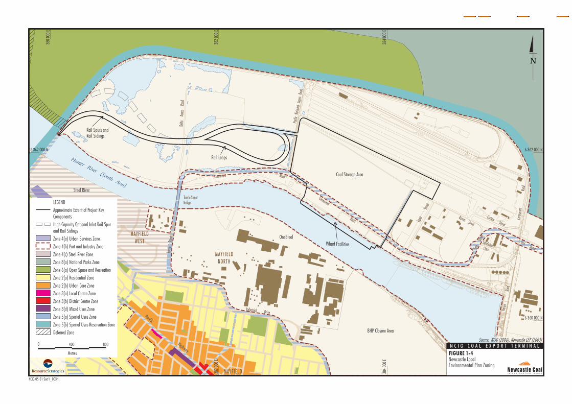
The Project is located on Kooragang Island, which lies near the mouth of the Hunter River, approximately 6 kilometres (km) north-west of the Newcastle Central Business District. Kooragang Island is characterised by a combination of port and industrial land uses in the south and the Kooragang Nature Reserve in the north (Figures 1-2 and 1-3). The Project is located on lands administered by the Regional Land Management Corporation (RLMC), the Maritime Services Board of NSW and the Minister for Public Works and Services (Table 1-1). The Project is located on lands designated Zone 4(b) (Port and Industry), Zone 5(a) (Special Uses Zone – Arterial Road) and an unzoned area (Hunter River) under the Newcastle Local Environmental Plan, 2003 (Newcastle LEP) (Figure 1-4).
Kooragang Island was originally a series of deltaic islands (including Ash Island, Dempsey Island and Moscheto Island) near the mouth of the Hunter River. Europeans initially used the islands for agriculture upon settling in the area in the 1830s (Dames & Moore, 1999; Umwelt, 2003a). The islands were sporadically used for dredge spoil disposal associated with early harbour works, and from 1953, reclamation of the deltaic islands for industrial use was legislated. In 1972, BHP commenced operating a landfill on Kooragang Island (i.e. the KIWEF) (Figure 1-3). Industrial waste materials (e.g. coal washery rejects, steel manufacturing waste and construction waste) were used to reclaim land in addition to the deposition of dredged material from the Hunter River estuary and its tributaries. The Project site comprises part of the KIWEF and reclaimed land situated between the south arm of the Hunter River and existing industrial development on the island (Figure 1-3).
1.1.5 Project Snapshot Key Project information is summarised in Table 1-2.
1.1.6 Proponent The Project is being developed by NCIG (Table 1-2). The address of NCIG is:
Newcastle Coal Infrastructure Group Pty Limited Post Office Box H287 Australia Square SYDNEY NSW 1215 Telephone: (02) 4929 3479
1.2 ENVIRONMENTAL ASSESSMENT REQUIREMENTS
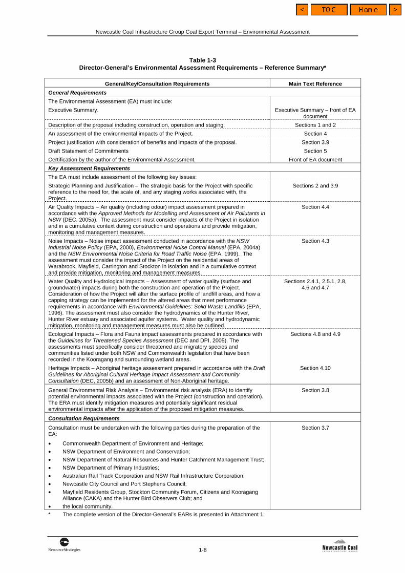
A Planning Focus Meeting (PFM) for the Project was held on 8 March 2006. The objective of the PFM was to familiarise government stakeholders with the development proposal and to facilitate identification and consideration of environmental and other issues relevant to the Project. From this consultation, DoP developed the EARs for the EA (Attachment 1). A summary of the EARs is provided in Table 1-3. Table 1-3 also provides the relevant section of the EA where each issue raised in the EARs is addressed.
Newcastle Coal Infrastructure Group Coal Export Terminal – Environmental Assessment
1-6
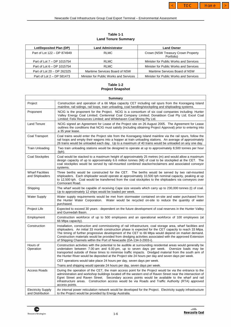
Table 1-1 Land Tenure Summary
Lot/Deposited Plan (DP) Land Administrator Land Owner
Part of Lot 122 – DP 874949 RLMC Crown (NSW Treasury Crown Property Portfolio)
Part of Lot 7 – DP 1015754 RLMC Minister for Public Works and Services
Part of Lot 6 – DP 1015754 RLMC Minister for Public Works and Services
Part of Lot 20 – DP 262325 Maritime Services Board of NSW Maritime Services Board of NSW
Part of Lot 2 – DP 581473 Minister for Public Works and Services Minister for Public Works and Services
Table 1-2 Project Snapshot
Summary
Project Construction and operation of a 66 Mtpa capacity CET including rail spurs from the Kooragang Island mainline, rail sidings, rail loops, train unloading, coal handling/stockpiling and shiploading systems.
Proponent NCIG is the proponent for the Project. NCIG is a consortium of six coal companies including: Hunter Valley Energy Coal Limited; Centennial Coal Company Limited; Donaldson Coal Pty Ltd; Excel Coal Limited; Felix Resources Limited; and Whitehaven Coal Mining Pty Ltd.
Land Tenure NCIG signed an Agreement for Lease of the Project site on 26 August 2005. The Agreement for Lease outlines the conditions that NCIG must satisfy (including obtaining Project Approval) prior to entering into a 35 year lease.
Coal Transport Coal trains would enter the Project site from the Kooragang Island mainline via the rail spurs, follow the rail loops and empty their wagons into a hopper at train unloading stations. An average of approximately 26 trains would be unloaded each day. Up to a maximum of 40 trains would be unloaded on any one day.
Train Unloading Two train unloading stations would be designed to operate at up to approximately 8,500 tonnes per hour (tph).
Coal Stockpiles Coal would be stacked to a maximum height of approximately 25 metres (m) and would allow a maximum design capacity of up to approximately 6.6 million tonnes (Mt) of coal to be stockpiled at the CET. The coal stockpiles would be served by rail-mounted combined stacker/reclaimers and associated conveyor systems.
Wharf Facilities and Shiploaders
Three berths would be constructed for the CET. The berths would be served by two rail-mounted shiploaders. Each shiploader would operate at approximately 10,500 tph nominal capacity, peaking at up to 12,500 tph. Coal would be transferred from the coal stockpiles to the shiploaders via conveyors over Cormorant Road.
Shipping The wharf would be capable of receiving Cape size vessels which carry up to 230,000 tonnes (t) of coal. Up to approximately 12 ships would be loaded per week.
Water Supply Water supply requirements would be met from stormwater contained on-site and water purchased from the Hunter Water Corporation. Water would be recycled on-site to reduce the quantity of water purchased.
Project Life Expected to exceed 30 years - dependent on the future development of coal reserves in the Hunter Valley and Gunnedah Basin.
Employment Construction workforce of up to 500 employees and an operational workforce of 100 employees (at 66 Mtpa capacity).
Construction Installation, construction and commissioning of rail infrastructure, coal storage area, wharf facilities and shiploaders. An initial 33 month construction phase is expected for the CET capacity to reach 33 Mtpa. The timing of further progressive development of the CET to 66 Mtpa would depend on market demand. Construction materials would be provided from dredging activities associated with the approved Extension of Shipping Channels within the Port of Newcastle (DA-134-3-2003-i).
Hours of Operation
Construction activities with the potential to be audible at surrounding residential areas would generally be undertaken between 7.00 am and 6.00 pm, up to seven days per week. Oversize loads may be transported outside of these times to minimise traffic impacts. Dredged material from the south arm of the Hunter River would be deposited at the Project site 24 hours per day and seven days per week.
CET operations would take place 24 hours per day, seven days per week.
Trains and shipping would operate 24 hours per day, seven days per week.
Access Roads During the operation of the CET, the main access point for the Project would be via the entrance to the administration and workshop buildings located off the western end of Raven Street near the intersection of Egret Street and Raven Street. Secondary access points would be available to the wharf and rail infrastructure areas. Construction access would be via Roads and Traffic Authority (RTA) approved access points.
Electricity Supply and Distribution
An internal power reticulation network would be developed for the Project. Electricity supply infrastructure to the Project would be provided by Energy Australia.
Hunter River (South Arm)
Hunter River (North Arm)
\
\
\
\
\
\
\
\
\
\\
/
\
\
\
\
\
\
\
\
\
\ \
\
\
\
\
\\
\
\
\
\
\
//
//
//
//
/ / /
/
\ \
\
\\
\
\
/
/
/
/
\
\
/
L.P.L.P.
/
/
/
/
/
/
/
/
/ / /
/
/
/
/
/
/
/
/
/
/
/
/
//
///
/
/
/
//
/
/
/
/
/
/
/
/
/
//
//
/
///
// //
//
/
/
/
/
//
/
/
/
/
/
/
/
/
/
//
/
/
/
/
/
/
/
/
/
/
/
/
/
/
/
X-ING
X-ING
384
000
E
6 362 000 N
382
000
E
380
000
E
6 360 000 N6 360 000 N
384
000
E
382
000
E
6 362 000 N
BHP Closure Area
SandpiperClose
Delta
Acces
sRo
ad
Tour
leStr
eet
Cormorant
Road Corm
oran
tRo
ad
Egret
Stree
t
Egret
Stree
t
Hero
nRo
ad
Cormorant RoadRoad
Industrial DrivePacific
Highway
Raven Street
Raven Street
Teal
Stree
t
SandpiperSandpiperCloseClose
TealStreet
CurlewStreet
CurlewStreet
Pacif
icNa
tiona
lAc
cess
Road
Pacif
icNa
tiona
lAc
cess
Road
Tourle StreetBridge
Coal Storage Area
Steel River
OneSteel
Rail Spurs andRail Sidings
Rail Loops
MAYF IELD
MAYF IELD
WEST
MAYF IELD
NORTH
Wharf Facilities
Approximatets
Zone 4(b) Port and Industry Zone
8 a National Parks Zone
Urban Core Zone
LEGEND
Extent of Project KeyComponen
High Capacity Optional Inlet Rail Spurand Rail Sidings
Zone 4(a) Urban Services Zone
Zone 4(c) Steel River Zone
Zone ( )
Zone 6(a) Open Space and Recreation
Zone 2(a) Residential Zone
Zone 2(b)
Zone 3(a) Local Centre Zone
Zone 3(b) District Centre Zone
Zone 3(d) Mixed Uses Zone
Zone 5(a) Special Uses Zone
Zone 5(b) Special Uses Reservation Zone
Deferred Zone
Metres
8000 400Source: NCIG (2006); Newcastle LEP (2003)
N C I G C O A L E X P O R T T E R M I N A L
NCIG-05-01 Sect1_003H
FIGURE 1-4Newcastle LocalEnvironmental Plan Zoning
Newcastle Coal Infrastructure Group Coal Export Terminal – Environmental Assessment
1-8
Table 1-3 Director-General’s Environmental Assessment Requirements – Reference Summary*
General/Key/Consultation Requirements Main Text Reference
General Requirements
The Environmental Assessment (EA) must include:
Executive Summary. Executive Summary – front of EA document
Description of the proposal including construction, operation and staging. Sections 1 and 2
An assessment of the environmental impacts of the Project. Section 4
Project justification with consideration of benefits and impacts of the proposal. Section 3.9
Draft Statement of Commitments Section 5
Certification by the author of the Environmental Assessment. Front of EA document
Key Assessment Requirements
The EA must include assessment of the following key issues:
Strategic Planning and Justification – The strategic basis for the Project with specific reference to the need for, the scale of, and any staging works associated with, the Project.
Sections 2 and 3.9
Air Quality Impacts – Air quality (including odour) impact assessment prepared in accordance with the Approved Methods for Modelling and Assessment of Air Pollutants in NSW (DEC, 2005a). The assessment must consider impacts of the Project in isolation and in a cumulative context during construction and operations and provide mitigation, monitoring and management measures.
Section 4.4
Noise Impacts – Noise impact assessment conducted in accordance with the NSW Industrial Noise Policy (EPA, 2000), Environmental Noise Control Manual (EPA, 2004a) and the NSW Environmental Noise Criteria for Road Traffic Noise (EPA, 1999). The assessment must consider the impact of the Project on the residential areas of Warabrook, Mayfield, Carrington and Stockton in isolation and in a cumulative context and provide mitigation, monitoring and management measures.
Section 4.3
Water Quality and Hydrological Impacts – Assessment of water quality (surface and groundwater) impacts during both the construction and operation of the Project. Consideration of how the Project will alter the surface profile of landfill areas, and how a capping strategy can be implemented for the altered areas that meet performance requirements in accordance with Environmental Guidelines: Solid Waste Landfills (EPA, 1996). The assessment must also consider the hydrodynamics of the Hunter River, Hunter River estuary and associated aquifer systems. Water quality and hydrodynamic mitigation, monitoring and management measures must also be outlined.
Sections 2.4.1, 2.5.1, 2.8, 4.6 and 4.7
Ecological Impacts – Flora and Fauna impact assessments prepared in accordance with the Guidelines for Threatened Species Assessment (DEC and DPI, 2005). The assessments must specifically consider threatened and migratory species and communities listed under both NSW and Commonwealth legislation that have been recorded in the Kooragang and surrounding wetland areas.
Sections 4.8 and 4.9
Heritage Impacts – Aboriginal heritage assessment prepared in accordance with the Draft Guidelines for Aboriginal Cultural Heritage Impact Assessment and Community Consultation (DEC, 2005b) and an assessment of Non-Aboriginal heritage.
Section 4.10
General Environmental Risk Analysis – Environmental risk analysis (ERA) to identify potential environmental impacts associated with the Project (construction and operation). The ERA must identify mitigation measures and potentially significant residual environmental impacts after the application of the proposed mitigation measures.
Section 3.8
Consultation Requirements
Consultation must be undertaken with the following parties during the preparation of the EA:
• Commonwealth Department of Environment and Heritage;
• NSW Department of Environment and Conservation;
• NSW Department of Natural Resources and Hunter Catchment Management Trust;
• NSW Department of Primary Industries;
• Australian Rail Track Corporation and NSW Rail Infrastructure Corporation;
• Newcastle City Council and Port Stephens Council;
• Mayfield Residents Group, Stockton Community Forum, Citizens and Kooragang Alliance (CAKA) and the Hunter Bird Observers Club; and
• the local community.
Section 3.7
* The complete version of the Director-General’s EARs is presented in Attachment 1.
Newcastle Coal Infrastructure Group Coal Export Terminal – Environmental Assessment
1-9
The Project will be assessed in accordance with the framework established by the EP&A Act and the EP&A Regulation. Approval for the Project is sought under Part 3A of the EP&A Act. The development approval process is outlined in further detail in Sections 3.1 to 3.6.
1.3 DOCUMENT STRUCTURE The EA comprises a main text component and supporting study components, which include Appendices A to J. An overview of the main text is presented below.
Section 1 Provides background information on the Project including an overview of the Project and EA document.
Section 2 Describes the Project, including construction and operational activities.
Section 3 Outlines the statutory context for the Project, describes the consultation undertaken, summarises the outcomes of the ERA and provides a justification for the Project having regard to the principles of ecologically sustainable development (ESD).
Section 4 Details the environmental assessment for the Project including a description of the existing environment, an assessment of potential impacts and a description of environmental mitigation and management measures.
Section 5 Provides NCIG’s Draft Statement of Commitments detailing measures for environmental mitigation, management and monitoring for the Project.
Section 6 Lists documents referenced in Sections 1 to 5 of the EA.
Section 7 Defines abbreviations, acronyms and terms used in Sections 1 to 5 of the EA.
Attachments to the main text are also provided as follows: Attachment 1 Director-General’s Environmental
Assessment Requirements
Attachment 2 Record of Aboriginal Consultation
Attachment 3 Peer Review Letters
Appendices A to J contain supporting documentation, including a number of independent specialist reports: Appendix A Construction, Operation and Road
Transport Noise Impact Assessment
Appendix B Air Quality Impact Assessment
Appendix C Road Transport Assessment
Appendix D Land Contamination and Groundwater Assessment
Appendix E Flora Assessment
Appendix F Fauna Assessment
Appendix G Socio-Economic Assessment
Appendix H Visual Assessment
Appendix I Preliminary Hazard Analysis
Appendix J Environmental Risk Analysis
1.4 PROJECT CONSULTANTS This EA was prepared by Resource Strategies Pty Ltd with specialist input provided by the following organisations/specialists: • NCIG Project Team and Connell-Hatch
(Project Description, Mitigation Measures, Environmental Management and Monitoring Programmes);
• Holmes Air Sciences (Air Quality Impact Assessment);
• Heggies Australia (Construction, Operation and Road Transport Noise Impact Assessment);
• EDAW Australia (Visual Assessment);
• Masson Wilson Twiney (Road Transport Assessment);
• Gillespie Economics (Socio-Economic Assessment);
• RCA Australia (Land Contamination and Groundwater Assessment);
• Safe Production Solutions (Environmental Risk Analysis);
• Connell-Hatch (Flora and Fauna Baseline Surveys and Water Management Report); and
• Professor David Goldney (BSc Dip Ed PhD DSc MEIA); Principal Consulting Ecologist, Western Research Institute Ltd; Adjunct Professor, Charles Sturt University; and Visiting Professor, University of Sydney, Orange Campus (Flora and Fauna Assessments).
Newcastle Coal Infrastructure Group Coal Export Terminal – Environmental Assessment
1-10
In addition, the following specialists were commissioned as peer reviewers: • Fauna Assessment (Frogs) – Associate
Professor Michael Tyler (MSc DSc); Visiting Research Fellow, Department of Environmental Biology, University of Adelaide.
• Fauna Assessment (Frogs) – Doctor Arthur White (BSc PhD Dip Ed); Director Biosphere Consultants Pty Ltd.