Rail Flyover Modification - NCIG · construction and operation of a CET up to 66 million tonnes per...
36
RailFlyoverModification Environmental Assessment NEWCASTLE COAL INFRASTRUCTURE GROUP COAL EXPORT TERMINAL NEWCASTLE COAL INFRASTRUCTURE GROUP COAL EXPORT TERMINAL June2012
Transcript of Rail Flyover Modification - NCIG · construction and operation of a CET up to 66 million tonnes per...
R a i l F l y o v e r M o d i f i c a t i o n
Environmental Assessment
NEWCASTLE COAL INFRASTRUCTURE GROUP
COAL EXPORT TERMINAL
NEWCASTLE COAL INFRASTRUCTURE GROUP
COAL EXPORT TERMINAL
J u n e 2 0 1 2
NEWCASTLE COAL INFRASTRUCTURE GROUP COAL EXPORT TERMINAL
PROJECT APPROVAL (06_0009) RAIL FLYOVER MODIFICATION
ENVIRONMENTAL ASSESSMENT
JUNE 2012 Project No. NCIG-12
Document No. 00451026.doc
NCIG CET - Rail Flyover Modification Environmental Assessment
00451026.doc i Newcastle Coal Infrastructure Group
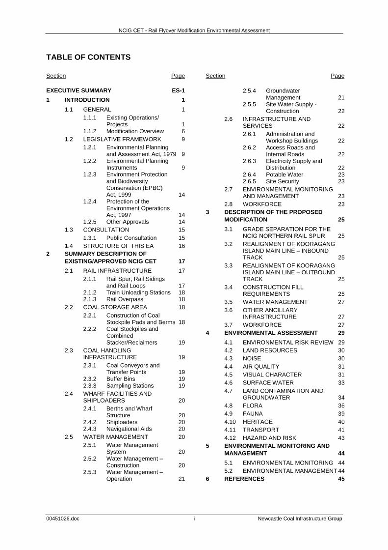
TABLE OF CONTENTS Section Page Section Page EXECUTIVE SUMMARY ES-1 1 INTRODUCTION 1
1.1 GENERAL 1 1.1.1 Existing Operations/
Projects 1 1.1.2 Modification Overview 6
1.2 LEGISLATIVE FRAMEWORK 9 1.2.1 Environmental Planning
and Assessment Act, 1979 9 1.2.2 Environmental Planning
Instruments 9 1.2.3 Environment Protection
and Biodiversity Conservation (EPBC) Act, 1999 14
1.2.4 Protection of the Environment Operations Act, 1997 14
1.2.5 Other Approvals 14 1.3 CONSULTATION 15
1.3.1 Public Consultation 15 1.4 STRUCTURE OF THIS EA 16
2 SUMMARY DESCRIPTION OF EXISTING/APPROVED NCIG CET 17 2.1 RAIL INFRASTRUCTURE 17
2.1.1 Rail Spur, Rail Sidings and Rail Loops 17
2.1.2 Train Unloading Stations 18 2.1.3 Rail Overpass 18
2.2 COAL STORAGE AREA 18 2.2.1 Construction of Coal
Stockpile Pads and Berms 18 2.2.2 Coal Stockpiles and
Combined Stacker/Reclaimers 19
2.3 COAL HANDLING INFRASTRUCTURE 19 2.3.1 Coal Conveyors and
Transfer Points 19 2.3.2 Buffer Bins 19 2.3.3 Sampling Stations 19
2.4 WHARF FACILITIES AND SHIPLOADERS 20 2.4.1 Berths and Wharf
Structure 20 2.4.2 Shiploaders 20 2.4.3 Navigational Aids 20
2.5 WATER MANAGEMENT 20 2.5.1 Water Management
System 20 2.5.2 Water Management –
Construction 20 2.5.3 Water Management –
Operation 21
2.5.4 Groundwater Management 21
2.5.5 Site Water Supply - Construction 22
2.6 INFRASTRUCTURE AND SERVICES 22 2.6.1 Administration and
Workshop Buildings 22 2.6.2 Access Roads and
Internal Roads 22 2.6.3 Electricity Supply and
Distribution 22 2.6.4 Potable Water 23 2.6.5 Site Security 23
2.7 ENVIRONMENTAL MONITORING AND MANAGEMENT 23
2.8 WORKFORCE 23 3 DESCRIPTION OF THE PROPOSED
MODIFICATION 25 3.1 GRADE SEPARATION FOR THE
NCIG NORTHERN RAIL SPUR 25 3.2 REALIGNMENT OF KOORAGANG
ISLAND MAIN LINE – INBOUND TRACK 25
3.3 REALIGNMENT OF KOORAGANG ISLAND MAIN LINE – OUTBOUND TRACK 25
3.4 CONSTRUCTION FILL REQUIREMENTS 25
3.5 WATER MANAGEMENT 27 3.6 OTHER ANCILLARY
INFRASTRUCTURE 27 3.7 WORKFORCE 27
4 ENVIRONMENTAL ASSESSMENT 29 4.1 ENVIRONMENTAL RISK REVIEW 29 4.2 LAND RESOURCES 30 4.3 NOISE 30 4.4 AIR QUALITY 31 4.5 VISUAL CHARACTER 31 4.6 SURFACE WATER 33 4.7 LAND CONTAMINATION AND
GROUNDWATER 34 4.8 FLORA 36 4.9 FAUNA 39 4.10 HERITAGE 40 4.11 TRANSPORT 41 4.12 HAZARD AND RISK 43
5 ENVIRONMENTAL MONITORING AND MANAGEMENT 44 5.1 ENVIRONMENTAL MONITORING 44 5.2 ENVIRONMENTAL MANAGEMENT 44
6 REFERENCES 45
NCIG CET - Rail Flyover Modification Environmental Assessment
TABLE OF CONTENTS (Continued)
00451026.doc ii Newcastle Coal Infrastructure Group
LIST OF FIGURES
Figure 1 Regional Location
Figure 2 Aerial Photo of NCIG CET Site (February 2012)
Figure 3 Approved Project and Rail Flyover Modification – General Arrangement
Figure 4 Project Interactions
Figure 5 Additional Land Required for Rail Flyover Modification
Figure 6 Newcastle Port Site – SP1 Special Activities Zone
Figure 7 Grade Separation Design Drawing
Figure 8 Surface Water Management Layout
Figure 9 Sensitive Viewpoints
Figure 10 Conceptual Typical Cross-Section of the Rail Infrastructure Corridor
Figure 11 Vegetation Mapping
Figure 12 Construction Fill Transport Route
LIST OF TABLES
Table 1 Summary Comparison of Approved and Modified NCIG CET
Table 2 Environmental Risk Review
Table 3 Sediment Control Structures – General Capacity Requirements
Table 4 Vegetation Communities
Table 5 Broad Fauna Habitat Types
LIST OF PLATES
Plate 1 NCIG Sustainable Development Policy
LIST OF ATTACHMENTS
Attachment 1 NCIG CET Project Approval (06_0009)
Attachment 2 NCIG CET Modification of Minister’s Approval and Plan of Subdivision
Attachment 3 NCIG CET EPBC Act Particular Manner Decision 2006/2987
Attachment 4 NCIG CET EPL 12693
Attachment 5 Notice 1111840 for Approval of Surrender of EPL 6437
LIST OF APPENDICES
Appendix A Detailed Design Drawings
Appendix B Noise Assessment Review
Appendix C Visual Assessment Review
Appendix D Threatened Species Assessment
Appendix E Construction Fill Transport Assessment
NCIG CET - Rail Flyover Modification Environmental Assessment
00451026.doc ES-1 Newcastle Coal Infrastructure Group
EXECUTIVE SUMMARY
ES1 BACKGROUND The Newcastle Coal Infrastructure Group (NCIG) Coal Export Terminal (CET) (the Project) is located on Kooragang Island in Newcastle, New South Wales (NSW). The overall Project includes the construction and operation of a CET up to 66 million tonnes per annum (Mtpa), including associated rail and coal handling infrastructure and wharf/shiploading facilities on the south arm of the Hunter River. NCIG is the proponent of the Project and is a consortium of the following six companies: • Hunter Valley Energy Coal Limited;
• Centennial Coal Company Limited;
• Gloucester Coal Limited;
• Peabody Energy Australia Coal Pty Limited;
• Yancoal Australia Limited; and
• Whitehaven Coal Limited. NCIG was granted Project Approval (06_0009) on 13 April 2007. Construction of the NCIG CET commenced in February 2008 with the 1st Stage (up to 30 Mtpa) completed and officially opened on 3 May 2010. Construction of Stage Two is well underway and will increase the capacity to 53 Mtpa once completed. The next stage, referred to as ‘Stage 2F’, is scheduled to commence shortly and will further increase the NCIG CET to the approved maximum capacity of 66 Mtpa.
ES2 REASON FOR THE MODIFICATION Condition 2.40 of Project Approval (06_0009) states:
Prior to the commencement of construction of the infrastructure marked as “High Capacity Optional Inlet Rail Spur and Rail Sidings” in Figure 2-1 of the document referred to under condition 1.1b) of this approval, the Proponent shall undertake, in consultation with ARTC and the owner/operator of the existing Kooragang Coal Loader, a review of the need for that infrastructure. The purpose of this review shall be to confirm the need for the infrastructure in light of the circumstances and operational requirements existing at the time of implementing this component of the project. The Proponent shall notify the Director-General of the outcomes of the review as soon as practicable after its completion.
In accordance with Condition 2.40 of Project Approval (06_0009), NCIG conducted a review of the need for the high capacity optional inlet rail spur and rail sidings in consultation with the Australian Rail Track Corporation Ltd (ARTC) and Port Waratah Coal Services Limited (PWCS) and the Director-General of the Department of Planning and Infrastructure (DP&I) was notified of the outcomes of the review. Specifically, the review concluded that a flyover (i.e. grade separation) would be necessary to meet the requirements of the ARTC. In response, the DP&I requested in a letter dated 20 January 2012 that NCIG take the necessary steps to modify Project Approval (06_0009) under Section 75W of the Environmental Planning and Assessment Act, 1979. This Environmental Assessment has been prepared by NCIG to support an application to modify Project Approval (06_0009) for the Rail Flyover Modification.
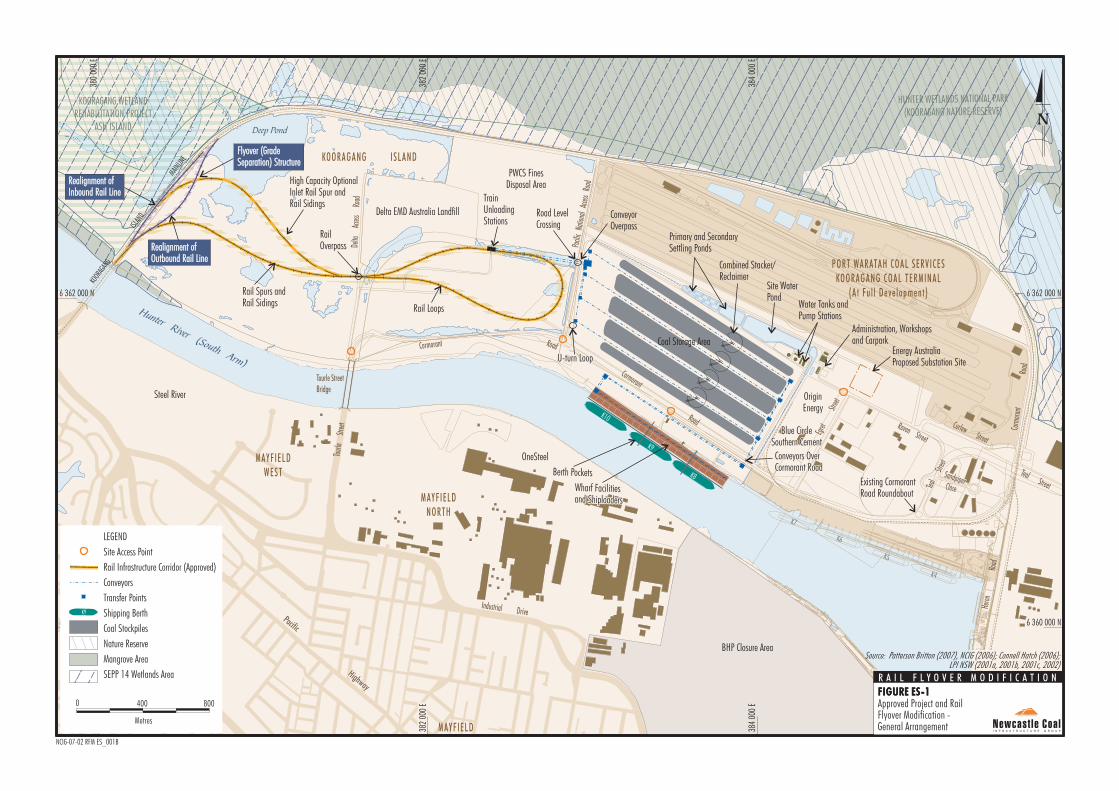
ES3 DESCRIPTION OF THE MODIFICATION The Rail Flyover Modification (Figure ES-1) includes the following components: • grade separation of the inbound track for the
NCIG Northern Rail Spur (also referred as the ‘high capacity optional inlet rail spur and rail sidings’);
• minor realignment of the inbound (western) track of the Kooragang Island Main Line;
• minor realignment and lowering of the outbound (eastern) track of the Kooragang Island Main Line; and
• other associated ancillary infrastructure. To allow for construction of the grade separation, the realignments of the Kooragang Island Main Line include additional parcels of land not previously listed in the schedule of lands for the original Project Approval (06_0009).
ES4 ENVIRONMENTAL REVIEW An environmental review has been conducted to evaluate the proposed Rail Flyover Modification and has concluded the following: • Land Resources: Given the existing industrial
land uses associated with the Project site, impacts on land use from the Rail Flyover Modification would be negligible. The total area of additional land required for the Rail Flyover Modification is less than 2.6 hectares.
HunterRiver
(South Arm)
Hunter River (North Arm)
\
\
\
\
\
\
\
\
\
\\
/
\
\
\
\
\
\
\
\
\
\ \
\
\
\
\
\\
\
\
\
\
\
/
/
/
/
/ / /
/
\ \
\
\\
\
\
/
/
/
/
\
\
/
L.P.L.P.
/
/
/
/
/
/
/
/
/ / /
/
/
/
/
/
/
/
/
/
/
/
/
//
///
/
/
/
//
/
/
/
/
/
/
/
/
/
//
//
/
///
/ /
//
/
/
/
/
//
/
/
/
/
/
/
/
/
/
//
/
/
/
/
/
/
/
/
/
/
/
/
/
/
/
X-ING
X-ING
KOOR
AGAN
G
384
000
E
6 362 000 N
382
000
E
380
000
E
6 360 000 N6 360 000 N
384
000
E
382
000
E
380
000
E
6 362 000 N
Delta
A
ccess
Ro
ad
Tourl
e
Stree
t
Cormorant
Road
Corm
orant
Road
Egret
Str
eet
Egret
Str
eet
Heron
Roa
d
Cormorant RoadRoad
Industrial DrivePacific Highway
Pacific Highway
Raven Street
Raven Street
Teal
Teal
Street
Street
SandpiperSandpiperCloseClose
Teal Street
Teal Street
Curlew Street
Curlew Street
Pacifi
c Na
tiona
l Ac
cess
Road
Tourle StreetBridge
ISLAN
D
MAINLIN
E KO O RAG AN G I SLAN D
MAYF IELD
Water Tanks andPump Stations
Energy AustraliaProposed Substation Site
Coal Storage Area
MAYF IELDWEST
MAYF IELDNORTH
WAR ABROOK
TrainUnloadingStations
PORT WARATAH COAL SERV ICESKOORAGANG COAL TERMINAL
(A t Fu l l Deve lo pmen t )
Wharf Facilitiesand ShiploadersWharf Facilitiesand Shiploaders
Rail Spurs andRail Sidings
BHP Closure Area
KOORAGANG WETLANDREHABILITATION PROJECT
ASH ISLAND
Combined Stacker/Reclaimer
Administration, Workshopsand Carpark
Primary and SecondarySettling Ponds
Conveyors OverCormorant RoadConveyors OverCormorant Road
Rail Loops
RailOverpass
K10
K9
K8
K7
K6
K5
K4
ConveyorOverpass
Existing CormorantRoad RoundaboutExisting CormorantRoad Roundabout
U-turn LoopU-turn Loop
Steel River
OneSteel
High Capacity OptionalInlet Rail Spur andRail Sidings
Site WaterPond
Road LevelCrossing
Blue CircleSouthern Cement
Blue CircleSouthern Cement
Delta EMD Australia Landfill
PWCS FinesDisposal Area
OriginEnergyOriginEnergy
Berth Pockets
Realignment ofInbound Rail LineRealignment ofInbound Rail Line
Realignment ofOutbound Rail LineRealignment ofOutbound Rail Line
HUNTER WETLANDS NATIONAL PARK
(KOORAGANG NATURE RESERVE)
Flyover (GradeSeparation) StructureFlyover (GradeSeparation) Structure
Deep Pond
Nature Reserve
Mangrove Area
SEPP 14 Wetlands Area
LEGEND
Site Access Point
Rail Infrastructure Corridor (Approved)
Conveyors
Transfer Points
Shipping Berth
Coal Stockpiles
Metres
8000 400
K9
Approved Project and RailFlyover Modification -General Arrangement
Source: Patterson Britton (2007), NCIG (2006); Connell Hatch (2006);LPI NSW (2001a, 2001b, 2001c, 2002)
R A I L F L Y O V E R M O D I F I C A T I O N
FIGURE ES-1
NCIG-07-02 RFM ES_001B
FIGURE ES-1
NCIG CET - Rail Flyover Modification Environmental Assessment
00451026.doc ES-3 Newcastle Coal Infrastructure Group
• Noise: No additional operational plant or equipment would be introduced as a result of the Rail Flyover Modification, and the on-site operating sound powers levels would remain unaltered. Therefore any potential variation in the off-site intrusive noise levels at the nearest receivers would be negligible as a result of the Rail Flyover Modification. These conclusions were confirmed by the prediction results from the updated CET noise model.
• Air Quality: Dust emissions during construction of the NCIG CET including the Rail Flyover Modification would continue to be controlled in accordance with the requirements of Project Approval (06_0009).
• Visual Character: While the Rail Flyover Modification would result in a slight change of visibility of infrastructure elements at some viewpoints, the Rail Flyover Modification would not change the level of visual impact described in the NCIG CET EA.
• Surface Water: Erosion and sediment control measures would be implemented for the Rail Flyover Modification consistent with the Construction Surface Water Management Plan and Operation Management Plan. All elements of the site drainage network will include appropriately-sized stormwater controls, in accordance with Managing Urban Stormwater: Soils and Construction – Volume 1 (Landcom, 2004).
• Land Contamination: Limited excavations would be required during the construction of the Rail Flyover Modification components. Notwithstanding, sampling and analysis of soil prior to any excavations and subsequent handling of contaminated materials (if identified) would be undertaken in accordance with SEPP 55 and the procedures described in the Construction Environment Management Plan. The rail infrastructure corridors would also continue to be designed and constructed such that it meets the goals of benchmark techniques 28 and 29 in Environmental Guidelines: Solid Waste Landfills.
• Groundwater: The presence of fill materials within the Kooragang Island Waste Emplacement Facility (KIWEF) would assist in dissipating the groundwater pressure from the placement of fill for the rail embankments, and therefore any increases in flow rate is expected to be only minor.
It is expected that some short-term localised increases in the groundwater table would occur in areas of consolidation within the KIWEF, but such increases are expected to have negligible impact on surrounding groundwater systems due to the elevated water table present in the area.
• Flora: The additional lands associated with the Rail Flyover Modification area cover less than 2.6 ha, comprising approximately 1.5 ha of native vegetation and approximately 1.1 ha of disturbed land. No threatened flora species listed under the NSW Threatened Species Conservation Act, 1995 (TSC Act) or Commonwealth Environment Protection and Biodiversity Conservation Act 1999 have been recorded within the additional lands associated with the Rail Flyover Modification. The additional endangered ecological communities (EECs) proposed to be removed for the Rail Flyover Modification is only a small incremental disturbance (<3 percent [%]) additional to the area of EECs already approved for clearance at the NCIG CET site.
• Fauna: Various threatened birds and bats under the TSC Act are known to occur on Kooragang Island (e.g. water birds associated with permanent waterbodies and foraging areas for bats), however, only one threatened fauna species has the potential to be directly adversely impacted by the Rail Flyover Modification, namely the Green and Golden Bell Frog (Litoria aurea). Dr Arthur White, an independent qualified ecologist approved by the Director-General in accordance with the Project Approval, has concluded that the flyover is unlikely to have a significant impact on the Green and Golden Bell Frog. Nevertheless, NCIG would continue to implement the Green and Golden Bell Frog Management Plan. To compensate for the additional clearance of approximately 1.45 ha of potential habitat for the Green and Golden Bell Frog, NCIG would establish additional compensatory habitat in a location agreed by the Director-General equivalent to or no less than twice the area of habitat to be removed (i.e. 2.9 ha), in accordance with the existing NCIG Compensatory Habitat and Ecological Monitoring Program.
NCIG CET - Rail Flyover Modification Environmental Assessment
00451026.doc ES-4 Newcastle Coal Infrastructure Group
The realignment of the outbound track has been specifically designed to avoid Deep Pond beyond that for the approved NCIG CET. The biodiversity values in the region are likely to be maintained for a number of reasons such as:
- the small scale of land disturbance required the Rail Flyover Modification (2.6 ha);
- the proportion of proposed land disturbance which is already disturbed (42% or 1.1 ha);
- the Rail Flyover Modification area is a linear disturbance located adjacent to the existing rail (infrastructure would therefore be streamlined);
- the works would be undertaken in accordance with a number of approved environmental management plans, including controls for weeds, animal pests, lighting, etc.
- NCIG would establish additional compensatory habitat for the Green and Golden Bell Frog in accordance with the existing NCIG Compensatory Habitat and Ecological Monitoring Program; and
- NCIG would undertake the works in accordance with the modified conditions of approval.
• Heritage: No known Aboriginal or non-Aboriginal heritage items of significance have been identified within the NCIG CET site including the Rail Flyover Modification. Notwithstanding the fact that no Aboriginal sites have been identified within the NCIG CET site including the Rail Flyover Modification, NCIG would continue to implement the management measures described in the Construction Environment Management Plan in accordance with the requirements of Project Approval (06_0009).
• Transport: Vehicles would access the rail flyover construction site consistent with the approved access routes. Traffic movements associated with the construction of the rail flyover can be adequately and appropriately mitigated and managed in accordance with the Construction Traffic Management Protocol as required under Project Approval (06_0009).
• Hazard and Risk: The Rail Flyover Modification would not introduce any new hazardous materials to the NCIG CET during construction, nor would it increase the risks beyond those already ranked and assessed in the Preliminary Hazard Analysis in the NCIG CET EA. Therefore, the Rail Flyover Modification would not significantly alter the consequences or likelihood of a hazardous event occurring at the NCIG CET.
The existing environmental management measures and monitoring programs at the NCIG CET would be applied to the Rail Flyover Modification with updates as required.
NCIG CET - Rail Flyover Modification Environmental Assessment
00451026.doc 1 Newcastle Coal Infrastructure Group
1 INTRODUCTION
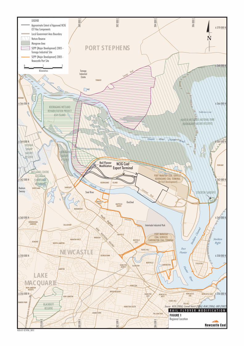
1.1 GENERAL The Newcastle Coal Infrastructure Group (NCIG) Coal Export Terminal (CET) (the Project) is located on Kooragang Island in Newcastle, New South Wales (NSW) (Figure 1). NCIG was granted Project Approval (06_0009) on 13 April 2007. The overall Project includes the construction and operation of a CET up to 66 million tonnes per annum (Mtpa), including associated rail and coal handling infrastructure and wharf/shiploading facilities on the south arm of the Hunter River. NCIG is the proponent of the approved Project and is a consortium of the following six companies: • Hunter Valley Energy Coal Limited;
• Centennial Coal Company Limited;
• Gloucester Coal Limited;
• Peabody Energy Australia Coal Pty Limited;
• Yancoal Australia Limited; and
• Whitehaven Coal Limited. This Environmental Assessment (EA) has been prepared by NCIG to support a request to modify the Project Approval (06_0009) under Section 75W of the NSW Environmental Planning and Assessment Act, 1979 (EP&A Act) (the Rail Flyover Modification). The Rail Flyover Modification includes a grade separation of the approved northern rail spur, minor realignments of the Kooragang Island Main Line and other associated ancillary infrastructure. A copy of the NCIG CET Project Approval (06_0009) is provided as Attachment 1.
1.1.1 Existing Operations/Projects NCIG Development History The Project was assessed in the Newcastle Coal Infrastructure Group Coal Export Terminal Environmental Assessment (NCIG, 2006a) (NCIG CET EA) and was approved by the NSW Minister for Planning on 13 April 2007. A modification to Project Approval (06_0009) was subsequently sought and approved on 27 November 2007 for subdivision of land to facilitate registration of leasehold over the land area by the State Property Authority to allow NCIG to lease the land for the construction and operation of the NCIG CET. A copy of the Modification of Minister’s Approval and Plan of Subdivision is provided in Attachment 2.
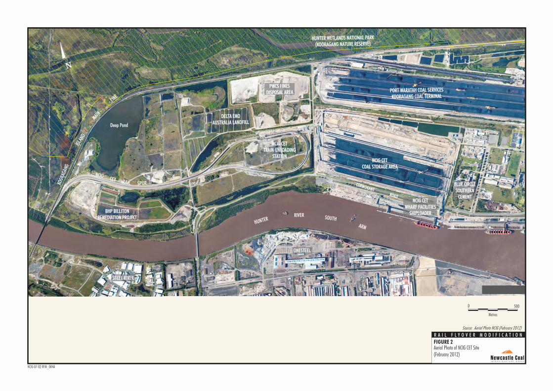
Construction of the NCIG CET commenced in February 2008 with the 1st Stage (up to 30 Mtpa) completed and officially opened on 3 May 2010. Construction of Stage Two (2AA) is well underway and will increase the capacity to 53 Mtpa once completed. An aerial photo of the NCIG CET site in February 2012 is shown on Figure 2. The next stage, referred to as ‘Stage 2F’, is scheduled to commence shortly and will further increase the NCIG CET to the approved maximum capacity of 66 Mtpa. A summary description of the existing/approved NCIG CET is provided in Section 2. The general arrangement of the existing/approved NCIG CET and the Rail Flyover Modification components are shown on Figure 3. PWCS Kooragang Coal Terminal The NCIG CET site is located adjacent to and south/west of the Kooragang Coal Terminal operated by Port Waratah Coal Services Limited (PWCS). Operations at the Kooragang Coal Terminal are undertaken in accordance with Project Approval (06_0189) which was modified in April 2012 for the Stage 4 Project to construct a fourth rail loop and fourth dump station. The Kooragang Coal Terminal is approved to operate up to a maximum throughput capacity of 120 Mtpa. The Kooragang Coal Terminal and modification components (approved in April 2012) are shown on Figure 4. Trains arrive and depart the Kooragang Coal Terminal on Kooragang Island via the Kooragang Island Main Line (Figure 3). PWCS does not propose any increase in throughput capacity associated with the modification and the number of trains servicing Kooragang Coal Terminal will remain within approved levels (PWCS, 2011). While the potential temporary interactions with the Kooragang Coal Terminal during construction of the rail flyover have been considered in this EA (Section 4.11), an objective of the rail flyover is to reduce potential future scheduling issues for train movements on Kooragang Island.
MAINNORTHERN
RAILWAY
Pacific H
ighway
Pacific H
ighway
Pacific Highway
Pacific Highway
Cormorant Road
Tomago Road
Industrial
Drive
NEWCASTLENEWCASTLE
LAKE
MACQUARIE
LAKE
MACQUARIE
PORT STEPHENSPORT STEPHENS
MAITLAND
HEXHAMHEXHAM
TOMAGOTOMAGO
SHORTLANDSHORTLAND SANDGATESANDGATE
MAYFIELDWEST
MAYFIELDWEST MAYFIELD
NORTHMAYFIELD
NORTH
MAYFIELDEAST
MAYFIELDEAST
TIGHES HILLTIGHES HILL
WARATAHWARATAH
GEORGETOWNGEORGETOWN
HAMILTONNORTH
HAMILTONNORTH
HAMILTONHAMILTON
ISLINGTONISLINGTON
WARATAH WESTWARATAH WEST
CALLAGHAN
NORTH LAMBTONNORTH LAMBTON
BIRMINGHAMGARDENS
BIRMINGHAMGARDENS
JESMONDJESMOND
RANKIN PARKRANKIN PARK
NEW LAMBTONNEW LAMBTON
NEW LAMBTONHEIGHTS
NEW LAMBTONHEIGHTS
LAMBTONLAMBTON
BROADMEADOWBROADMEADOW
ADAMSTOWNADAMSTOWN
HAMILTON SOUTHHAMILTON SOUTH
WARABROOKWARABROOK
MARYVILLEMARYVILLE
KOORAGANG ISLANDKOORAGANG ISLAND
NEWCASTLECBD
NEWCASTLECBD
NEWCASTLE EASTNEWCASTLE EAST
STOCKTONSTOCKTON
THE HILLTHE HILL
COOKS HILLCOOKS HILL
HAMILTONEAST
HAMILTONEAST
NEWCASTLEWEST
NEWCASTLEWEST
THE JUNCTIONTHE JUNCTIONBAR BEACHBAR BEACH
CARRINGTONCARRINGTON
MAYFIELDMAYFIELD
FERN BAYFERN BAY
Fullerton Cove
StocktonBightSt
ockt
on C
hann
el
Hunter
RiverHunter
River
PortHunter
Hunter River (North Arm)
HunterRiver
(SouthArm)
380
000
E
6 370 000 N382
000
E
384
000
E
386
000
E
6 366 000 N
6 358 000 N
378
000
E
380
000
E
382
000
E
384
000
E
386
000
E
378
000
E
6 370 000 N
6 368 000 N
6 366 000 N
6 362 000 N
6 360 000 N
6 358 000 N
6 356 000 N
6 364 000 N
6 368 000 N
6 360 000 N
6 362 000 N
6 356 000 N
6 364 000 N
PORT WARATAH COAL SERV ICESKOORAGANG COAL TERMINAL
(A t Fu l l Deve lopmen t )
BLACKBUTTRESERVE
STOCKTON SANDSPIT
HUNTER WETLANDS NATIONAL PARK
(KOORAGANG NATURE RESERVE)
PORT WARATAHCOAL SERV ICES
CARRINGTON COAL TERMINAL
PORT WARATAHCOAL SERV ICES
CARRINGTON COAL TERMINAL
HexhamSwamp
WETLANDS CENTREAUSTRALIA
(SHORTLANDWETLANDS)
Steel River
OneSteel
HEXHAMSWAMPNATURERESERVE
KOORAGANGNATURERESERVE
Intertrade Industrial Park
KOORAGANG WETLANDREHABILITATION PROJECT
ASH ISLAND
TomagoIndustrial
Estate
NCIG CoalExport Terminal
Rail FlyoverModification
LEGEND
Approximate Extent of Approved NCIGCET Key Components
Local Government Area Boundary
SEPP (Major Development) 2005 -Newcastle Port Site
Nature Reserve
Mangrove Area
SEPP (Major Development) 2005 -Tomago Industrial Site
Source: NCIG (2006); Connell Hatch (2006); RLMC (2006); UBD (2002)
Regional LocationFIGURE 1
0 21
Kilometres
NCIG-07-02 RFM_001E
R A I L F L Y O V E R M O D I F I C A T I O N
ISLA
ND
MAIN
NCIG CETCOAL STORAGE AREA
NCIG CETCOAL STORAGE AREA
OneSteel
HUNTER WETLANDS NATIONAL PARK
(KOORAGANG NATURE RESERVE)HUNTER WETLANDS NATIONAL PARK
(KOORAGANG NATURE RESERVE)
KOOR
AGAN
G
NCIGRAIL
PORT WARATAH COAL SERVICES
KOORAGANG COAL TERMINALPORT WARATAH COAL SERVICES
KOORAGANG COAL TERMINAL
PWCS FINES
DISPOSAL AREAPWCS FINES
DISPOSAL AREA
DELTA EMD
AUSTRALIA LANDFILLDELTA EMD
AUSTRALIA LANDFILL
LINE
CORMORANT ROAD
CORMORANT ROAD
ONESTEEL
BHP BILLITONREMEDIATION PROJECT
BHP BILLITONREMEDIATION PROJECT
STEEL RIVER
NCIG CETTRAIN UNLOADING
STATION
NCIG CETTRAIN UNLOADING
STATION
BLUE CIRCLESOUTHERN
CEMENT
BLUE CIRCLESOUTHERN
CEMENTNCIG CET
WHARF FACILITIESSHIPLOADER
NCIG CETWHARF FACILITIES
SHIPLOADER
HUNTERRIVER SOUTH
ARM
CETSPUR
Deep Pond
FIGURE 2
Aerial Photo of NCIG CET Site(February 2012)
Source: Aerial Photo NCIG (February 2012)
Metres
0 500
NCIG-07-02 RFM_004A
R A I L F L Y O V E R M O D I F I C A T I O N
HunterRiver
(South Arm)
Hunter River (North Arm)
\
\
\
\
\
\
\
\
\
\\
/
\
\
\
\
\
\
\
\
\
\ \
\
\
\
\
\\
\
\
\
\
\
/
/
/
/
/ / /
/
\ \
\
\\
\
\
/
/
/
/
\
\
/
L.P.L.P.
/
/
/
/
/
/
/
/
/ / /
/
/
/
/
/
/
/
/
/
/
/
/
/
//
/
/
/
/
/
/
/
/
/
/
/
/
/
//
//
/
///
/ /
//
/
/
/
/
//
/
/
/
/
/
/
/
/
/
//
/
/
/
/
/
/
/
/
/
/
/
/
/
/
/
X-ING
X-ING
KOOR
AGAN
G
384
000
E
6 362 000 N
382
000
E
380
000
E
6 360 000 N6 360 000 N
384
000
E
382
000
E
380
000
E
6 362 000 N
Delta
A
ccess
Ro
ad
Tourl
e
Stree
t
Cormorant
Road
Corm
orant
Road
Egret
Str
eet
Egret
Str
eet
Heron
Roa
d
Cormorant RoadRoad
Industrial DrivePacific Highway
Pacific Highway
Raven Street
Raven Street
Teal
Teal
Street
Street
SandpiperSandpiperCloseClose
Teal Street
Teal Street
Curlew Street
Curlew Street
Pacifi
c Na
tiona
l Ac
cess
Road
Tourle StreetBridge
ISLAN
D
MAINLIN
E
MAYF IELD
Water Tanks andPump Stations
Energy AustraliaProposed Substation Site
Coal Storage Area
MAYF IELDWEST
MAYF IELDNORTH
WAR ABROOK
TrainUnloadingStations
PORT WARATAH COAL SERV ICESKOORAGANG COAL TERMINAL
(A t Fu l l Deve lo pmen t )
Wharf Facilitiesand ShiploadersWharf Facilitiesand Shiploaders
Rail Spurs andRail Sidings
BHP Closure Area
KOORAGANG WETLANDREHABILITATION PROJECT
ASH ISLAND
Combined Stacker/Reclaimer
Administration, Workshopsand Carpark
Primary and SecondarySettling Ponds
Conveyors OverCormorant RoadConveyors OverCormorant Road
Rail Loops
RailOverpass
K10
K9
K8
K7
K6
K5
K4
ConveyorOverpass
Existing CormorantRoad RoundaboutExisting CormorantRoad Roundabout
U-turn LoopU-turn Loop
Steel River
OneSteel
High Capacity OptionalInlet Rail Spur andRail Sidings
Site WaterPond
Road LevelCrossing
Blue CircleSouthern Cement
Blue CircleSouthern Cement
Delta EMD Australia Landfill
PWCS FinesDisposal Area
OriginEnergyOriginEnergy
Berth Pockets
Realignment ofInbound Rail LineRealignment ofInbound Rail Line
Flyover (GradeSeparation) StructureFlyover (GradeSeparation) Structure
Realignment ofOutbound Rail LineRealignment ofOutbound Rail Line
HUNTER WETLANDS NATIONAL PARK
(KOORAGANG NATURE RESERVE)
Deep Pond
Nature Reserve
Mangrove Area
SEPP 14 Wetlands Area
LEGEND
Site Access Point
Rail Infrastructure Corridor (Approved)
Conveyors
Transfer Points
Shipping Berth
Coal Stockpiles
Metres
8000 400
K9
FIGURE 3
Approved Project and RailFlyover Modification -General Arrangement
Source: Patterson Britton (2007), NCIG (2006); Connell Hatch (2006);LPI NSW (2001a, 2001b, 2001c, 2002)
NCIG-07-02 RFM_003E
R A I L F L Y O V E R M O D I F I C A T I O N
KO O RAG AN G I SLAN D
HunterRiver
(South Arm)
Hunter River (North Arm)
\
\
\
\
\
\
\
\
\
\\
/
\
\
\
\
\
\
\
\
\
\ \
\
\
\
\
\\
\
\
\
\
\
//
//
//
//
/ / /
/
\ \
\
\\
\
\
/
/
/
/
\
\
/
L.P.L.P.
/
/
/
/
/
/
/
/
/ / /
/
/
/
/
/
/
/
/
/
/
/
/
//
///
/
/
/
//
/
/
/
/
/
/
/
/
/
//
//
/
///
// //
//
/
/
/
/
//
/
/
/
/
/
/
/
/
/
//
/
/
/
/
/
/
/
/
/
/
/
/
/
/
/
X-ING
X-ING
KOOR
AGAN
G
384
000
E
6 362 000 N
382
000
E
380
000
E
6 360 000 N6 360 000 N
384
000
E
382
000
E
380
000
E
6 362 000 N
Delta
A
ccess
Ro
ad
Tourl
e
Stree
t
Cormorant
Road
Corm
orant
Road
Egret
Str
eet
Egret
Str
eet
Heron
Roa
d
Cormorant RoadRoad
Industrial DrivePacific Highway
Pacific Highway
Raven Street
Raven Street
Teal
Teal
Street
Street
SandpiperSandpiperCloseClose
Teal Street
Teal Street
Curlew Street
Curlew Street
Pacifi
c Na
tiona
l Ac
cess
Road
Tourle StreetBridge
ISLAN
D
MAINLIN
E
MAYF IELD
Water Tanks andPump Stations
Energy AustraliaProposed Substation Site
Coal Storage Area
MAYF IELDWEST
MAYF IELDNORTH
WAR ABROOK
TrainUnloadingStations
PORT WARATAH COAL SERV ICESKOORAGANG COAL TERMINAL
(A t Fu l l Deve lo pmen t )
Wharf Facilitiesand ShiploadersWharf Facilitiesand Shiploaders
Rail Spurs andRail Sidings
BHP Closure Area
KOORAGANG WETLANDREHABILITATION PROJECT
ASH ISLAND
Combined Stacker/Reclaimer
Administration, Workshopsand Carpark
Primary and SecondarySettling Ponds
Conveyors OverCormorant RoadConveyors OverCormorant Road
Rail Loops
RailOverpass
K10
K9
K8
K7
K6
K5
K4
ConveyorOverpass
Existing CormorantRoad RoundaboutExisting CormorantRoad Roundabout
Steel River
OneSteel
High Capacity OptionalInlet Rail Spur andRail Sidings
Site WaterPond
Road LevelCrossing
Blue CircleSouthern Cement
Blue CircleSouthern Cement
Delta EMD Australia Landfill
PWCS FinesDisposal Area
OriginEnergyOriginEnergy
Berth Pockets
Realignment ofInbound Rail LineRealignment ofInbound Rail Line
Realignment ofOutbound Rail LineRealignment ofOutbound Rail Line
U-turn LoopU-turn Loop
KO O RAG AN G I SLAN D
HUNTER WETLANDS NATIONAL PARK
(KOORAGANG NATURE RESERVE)
Nature Reserve
Mangrove Area
SEPP 14 Wetlands Area
PWCS Kooragang Coal Terminal -
LEGEND
Site Access Point
Rail Infrastructure Corridor (Approved)
Conveyors
Transfer Points
Shipping Berth
Coal Stockpiles
Metres
8000 400
K9
FIGURE 4
Project Interactions
Source: Patterson Britton (2007), NCIG (2006); Connell Hatch (2006);LPI NSW (2001a, 2001b, 2001c, 2002)
NCIG-07-02 RFM_005D
R A I L F L Y O V E R M O D I F I C A T I O NProposed Fourth Rail Loop Realignment
PWCS Terminal 4 Project
Flyover (GradeSeparation) StructureFlyover (GradeSeparation) Structure
Deep Pond
NCIG CET - Rail Flyover Modification Environmental Assessment
00451026.doc 6 Newcastle Coal Infrastructure Group
PWCS Terminal 4 Project While neither an existing operation nor currently approved project, the PWCS Terminal 4 Project has been considered in this EA. The additional parcels of land the subject of this Rail Flyover Modification are located wholly within the extent of the proposed PWCS Terminal 4 Project site.
The T4 Project Environmental Assessment (PWCS, 2012) was made available for the public exhibition period commencing 8 March 2012. The proposed Terminal 4 Project would be an extension of the existing Kooragang Coal Terminal and would include some sharing of existing infrastructure and systems. The proposed Terminal 4 Project site extent is shown on Figure 4. Construction of the PWCS Terminal 4 Project is not anticipated to be underway when the rail flyover would be constructed. As such, potential cumulative impacts from the construction of Terminal 4 Project have not been considered in this EA. BHP Billiton Remediation Project The landfill activities associated with the BHP Billiton Remediation Project on Kooragang Island (Figure 2) have been completed. The Rail Flyover Modification has been designed to avoid the remediation areas, including associated compensatory habitat/offsets, and therefore has not been considered any further in this EA. Other Industrial Facilities on Kooragang Island The Kooragang Island Main Line services a number of other industrial facilities’ on Kooragang Island, albeit at comparatively low volumes, including Boral Cement and facilities on Walsh Point. While the potential temporary interactions with other industrial facilities on Kooragang Island during construction of the rail flyover are considered in this EA (Section 4.11), the ultimate objective of the rail flyover is to reduce potential future scheduling issues for train movements on Kooragang Island.
1.1.2 Modification Overview The Rail Flyover Modification includes the following key components: • grade separation of the inbound track for the
NCIG Northern Rail Spur (also referred as the ‘high capacity optional inlet rail spur and rail sidings’);
• minor realignment of the inbound (western) track of the Kooragang Island Main Line; and
• minor realignment of the outbound (eastern) track of the Kooragang Island Main Line.
To allow for construction of the grade separation, the realignments of the Kooragang Island Main Line include additional parcels of land not previously listed in the schedule of lands for the original Project Approval (06_0009). The proposed changes to the existing/approved NCIG CET are shown on Figure 3. The additional parcels of land required for the realignments of the Kooragang Island Main Line are currently owned by the NSW Office of Environment and Heritage (OEH)1, Country Rail Infrastructure Authority and State Property Authority (Figure 5). Table 1 provides a summary comparison of the currently approved NCIG CET and the NCIG CET including the Rail Flyover Modification. As shown in Table 1, the modification does not involve any change to the NCIG CET for the following development components: • train unloading;
• coal stockpiles;
• wharf facilities and shiploaders;
• shipping;
• water supply;
• project life; and
• hours of operation. A detailed description of the proposed Rail Flyover Modification is provided in Section 3. Section 4 describes the potential environmental impacts of the Rail Flyover Modification and discusses how existing environmental management and monitoring programs at the NCIG CET would be applied to manage potential environmental impacts.
1 The portion of the land parcel owned by OEH is located wholly within land mapped as ‘NPWS managed land (part 11)’ presented on the Hunter Wetlands National Park figure dated 25 May 2012.
Additional Land Required forRail Flyover Modification
0 500
Metres
Source: Aurecon Hatch (2012) and EMM (2012)
FIGURE 5
NCIG-07-02 RFM_014B
R A I L F L Y O V E R M O D I F I C A T I O N
222DP 1013964
Ownership (Rail Flyover Modification) Including Additional Land
Lot 1; DP 126347 - Office of Environment and Heritage
1; DP 590032 - Country Rail Infrastructure Authority
1, Pt.7, 9, 10, 11; DP 1119752 - State Property Authority
Lot
Lot
NCIG CET - Rail Flyover Modification Environmental Assessment
00451026.doc 8 Newcastle Coal Infrastructure Group
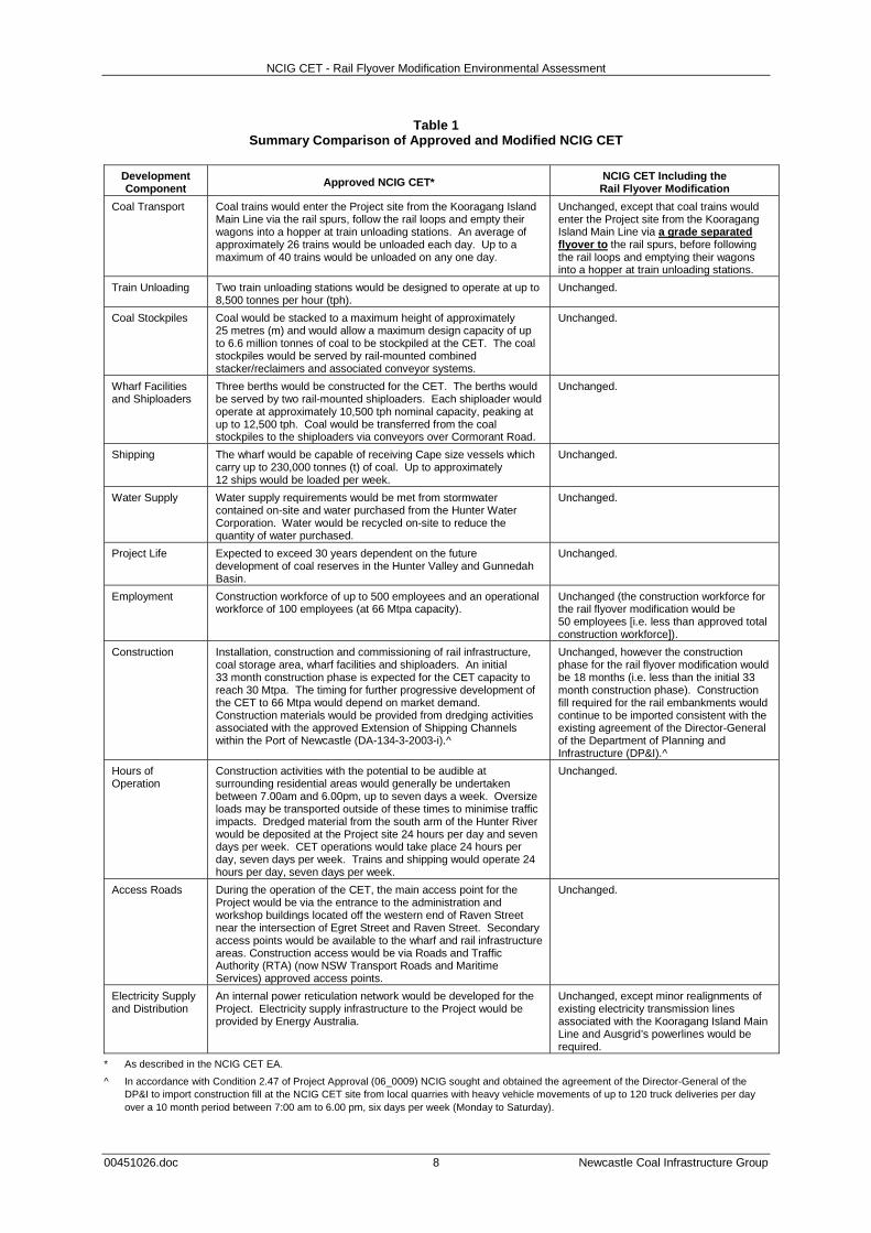
Table 1 Summary Comparison of Approved and Modified NCIG CET
Development Component Approved NCIG CET* NCIG CET Including the
Rail Flyover Modification
Coal Transport Coal trains would enter the Project site from the Kooragang Island Main Line via the rail spurs, follow the rail loops and empty their wagons into a hopper at train unloading stations. An average of approximately 26 trains would be unloaded each day. Up to a maximum of 40 trains would be unloaded on any one day.
Unchanged, except that coal trains would enter the Project site from the Kooragang Island Main Line via a grade separated flyover to the rail spurs, before following the rail loops and emptying their wagons into a hopper at train unloading stations.
Train Unloading Two train unloading stations would be designed to operate at up to 8,500 tonnes per hour (tph).
Unchanged.
Coal Stockpiles Coal would be stacked to a maximum height of approximately 25 metres (m) and would allow a maximum design capacity of up to 6.6 million tonnes of coal to be stockpiled at the CET. The coal stockpiles would be served by rail-mounted combined stacker/reclaimers and associated conveyor systems.
Unchanged.
Wharf Facilities and Shiploaders
Three berths would be constructed for the CET. The berths would be served by two rail-mounted shiploaders. Each shiploader would operate at approximately 10,500 tph nominal capacity, peaking at up to 12,500 tph. Coal would be transferred from the coal stockpiles to the shiploaders via conveyors over Cormorant Road.
Unchanged.
Shipping The wharf would be capable of receiving Cape size vessels which carry up to 230,000 tonnes (t) of coal. Up to approximately 12 ships would be loaded per week.
Unchanged.
Water Supply Water supply requirements would be met from stormwater contained on-site and water purchased from the Hunter Water Corporation. Water would be recycled on-site to reduce the quantity of water purchased.
Unchanged.
Project Life Expected to exceed 30 years dependent on the future development of coal reserves in the Hunter Valley and Gunnedah Basin.
Unchanged.
Employment Construction workforce of up to 500 employees and an operational workforce of 100 employees (at 66 Mtpa capacity).
Unchanged (the construction workforce for the rail flyover modification would be 50 employees [i.e. less than approved total construction workforce]).
Construction Installation, construction and commissioning of rail infrastructure, coal storage area, wharf facilities and shiploaders. An initial 33 month construction phase is expected for the CET capacity to reach 30 Mtpa. The timing for further progressive development of the CET to 66 Mtpa would depend on market demand. Construction materials would be provided from dredging activities associated with the approved Extension of Shipping Channels within the Port of Newcastle (DA-134-3-2003-i).^
Unchanged, however the construction phase for the rail flyover modification would be 18 months (i.e. less than the initial 33 month construction phase). Construction fill required for the rail embankments would continue to be imported consistent with the existing agreement of the Director-General of the Department of Planning and Infrastructure (DP&I).^
Hours of Operation
Construction activities with the potential to be audible at surrounding residential areas would generally be undertaken between 7.00am and 6.00pm, up to seven days a week. Oversize loads may be transported outside of these times to minimise traffic impacts. Dredged material from the south arm of the Hunter River would be deposited at the Project site 24 hours per day and seven days per week. CET operations would take place 24 hours per day, seven days per week. Trains and shipping would operate 24 hours per day, seven days per week.
Unchanged.
Access Roads During the operation of the CET, the main access point for the Project would be via the entrance to the administration and workshop buildings located off the western end of Raven Street near the intersection of Egret Street and Raven Street. Secondary access points would be available to the wharf and rail infrastructure areas. Construction access would be via Roads and Traffic Authority (RTA) (now NSW Transport Roads and Maritime Services) approved access points.
Unchanged.
Electricity Supply and Distribution
An internal power reticulation network would be developed for the Project. Electricity supply infrastructure to the Project would be provided by Energy Australia.
Unchanged, except minor realignments of existing electricity transmission lines associated with the Kooragang Island Main Line and Ausgrid’s powerlines would be required.
* As described in the NCIG CET EA.
^ In accordance with Condition 2.47 of Project Approval (06_0009) NCIG sought and obtained the agreement of the Director-General of the DP&I to import construction fill at the NCIG CET site from local quarries with heavy vehicle movements of up to 120 truck deliveries per day over a 10 month period between 7:00 am to 6.00 pm, six days per week (Monday to Saturday).

NCIG CET - Rail Flyover Modification Environmental Assessment
00451026.doc 9 Newcastle Coal Infrastructure Group
1.2 LEGISLATIVE FRAMEWORK
1.2.1 Environmental Planning and Assessment Act, 1979
The EP&A Act and NSW Environmental Planning and Assessment Regulation, 2000 set the framework for planning and environmental assessment in NSW. Modification of the NCIG CET Project Approval (06_0009) is sought under Section 75W of Part 3A of the EP&A Act. Section 75W of the EP&A Act states:
75W Modification of Minister’s Approval (1) In this section:
Minister’s approval means an approval to carry out a project under this Part, and includes an approval of a concept plan.
Modification of approval means changing the terms of a Minister’s approval, including:
(a) revoking or varying a condition of the approval or imposing an additional condition of the approval, and
(b) changing the terms of any determination made by the Minister under Division 3 in connection with the approval.
(2) The proponent may request the Minister to modify the Minister’s approval for a project. The Minister’s approval for a modification is not required if the project as modified will be consistent with the existing approval under this Part.
(3) The request for the Minister’s approval is to be lodged with the Director-General. The Director-General may notify the proponent of environmental assessment requirements with respect to the proposed modification that the proponent must comply with before the matter will be considered by the Minister.
(4) The Minister may modify the approval (with or without conditions) or disapprove of the modification.
…
Although Part 3A was repealed by the Environmental Planning and Assessment Amendment (Part 3A Repeal) Act 2011, Section 75W continues to be the applicable modification provision for an approval such as the NCIG CET Project Approval. This is because Schedule 6A of the EP&A Act, which has the effect of making the NCIG CET Project Approval a "transitional Part 3A Project", states that provisions in the repealed Part 3A, such as Section 75W, continue to apply to and in respect of a "transitional Part 3A Project".
Further, the DP&I requested in a letter dated 20 January 2012 that NCIG take the necessary steps to modify Project Approval (06_0009) under Section 75W of Part 3A of the EP&A Act.
1.2.2 Environmental Planning Instruments State Environmental Planning Policy (Major Development) 2005 In July 2009, the State Environmental Planning Policy (Major Projects) Amendment (Three Ports) 2009 identified the ‘Three Ports Site’ including the three major ports in NSW, namely Newcastle Port, Port Botany and Port Kembla. As a consequence, the NCIG CET site including the Rail Flyover Modification is now located wholly within land zoned as SP1 Special Activities within the Newcastle Port site under the State Environmental Planning Policy (Major Development) 2005 (Figure 6). The objectives of land zoned as SP1 Special Activities within the ‘Three Ports Site’ are as follows:
(a) to provide for special land uses that are not provided for in other zones,
(b) to provide for sites with special natural characteristics that are not provided for in other zones,
(c) to facilitate development that is in keeping with the special characteristics of the site or its existing or intended special use, and that minimises any adverse impacts on surrounding land,
(d) to maximise the use of waterfront areas to accommodate port facilities and industrial, maritime industrial and bulk storage premises that benefit from being located close to port facilities,
(e) to enable the efficient movement and operation of commercial shipping, and to provide for the efficient handling and distribution of freight from port areas through the provision of transport infrastructure,
(f) to facilitate development that by its nature or scale requires separation from residential areas and other sensitive land uses,
(g) to encourage employment opportunities. Port facilities are defined in the State Environmental Planning Policy (Major Development) 2005 as including:
… any of the following facilities at or in the vicinity of a designated port within the meaning of section 47 of the Ports and Maritime Administration Act 1995:
(a) facilities for the embarkation or disembarkation of passengers onto or from any vessels, including public ferry wharves,
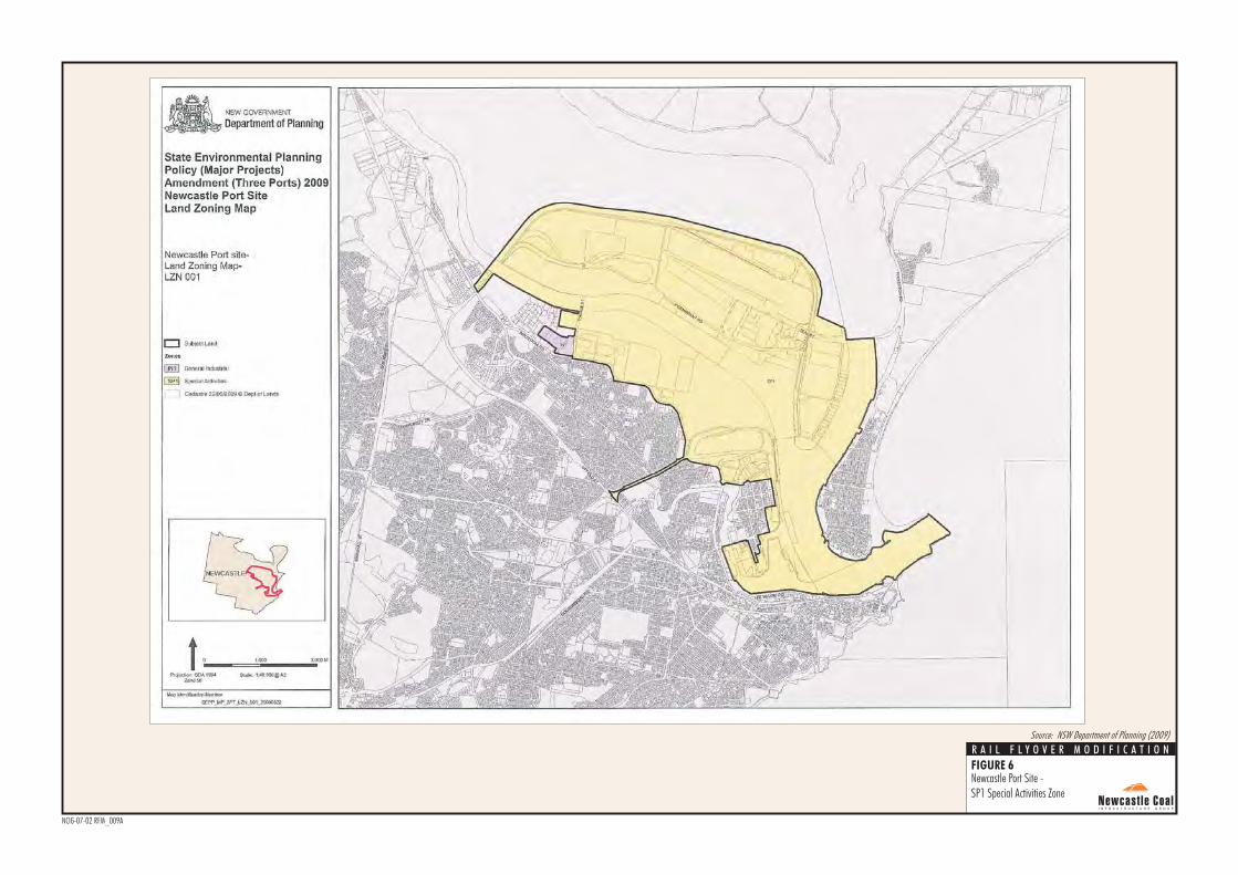
FIGURE 6
Newcastle Port Site -SP1 Special Activities Zone
NCIG-07-02 RFM_009A
R A I L F L Y O V E R M O D I F I C A T I O N
Source: NSW Department of Planning (2009)
NCIG CET - Rail Flyover Modification Environmental Assessment
00451026.doc 11 Newcastle Coal Infrastructure Group
(b) facilities for the loading or unloading of freight onto or from vessels and associated receival, land transport and storage facilities,
(c) wharves for commercial fishing operations,
(d) refuelling, launching, berthing, mooring, storage or maintenance facilities for any vessel,
(e) sea walls or training walls,
(f) administration buildings, communication, security and power supply facilities, roads, rail lines, pipelines, fencing, lighting or car parks.
Port facilities are a permissible land use within land zoned SP1 Special Activities. The NCIG CET including the Rail Flyover Modification falls within the definition of port facilities. Accordingly, the Rail Flyover Modification may be carried out with consent and the Minister can be satisfied as to these matters. Relevantly, Clause 4, Part 20 of Schedule 3 of the State Environmental Planning Policy (Major Development) 2005 stipulates that no other environmental planning instruments apply other than State Environmental Planning Policies (except for State Environmental Planning Policy No 1 – Development Standards). Therefore, the following local environmental plans and development control plans are no longer applicable to the NCIG CET including the Rail Flyover Modification: • Newcastle Local Environmental Plan 2003;
• Newcastle Development Control Plan 2005;
• Draft Newcastle Local Environmental Plan 2011;
• Draft Newcastle Development Control Plan 2011; and
• Hunter Regional Environmental Plan, 1989.
The following State Environmental Planning Policies are considered relevant and are discussed further below: • State Environmental Planning Policy
(Infrastructure) 2007;
• State Environmental Planning Policy No.11 (Traffic Generating Developments);
• State Environmental Planning Policy No.14 (Coastal Wetlands);
• State Environmental Planning Policy No.26 (Littoral Rainforests);
• State Environmental Planning Policy No. 33 (Hazardous and Offensive Development);
• State Environmental Planning Policy No. 55 (Remediation of Land); and
• State Environmental Planning Policy No.71 (Coastal Protection).
State Environmental Planning Policy (Infrastructure) 2007 State Environmental Planning Policy (Infrastructure) 2007 aims to ensure effective delivery of infrastructure across the state. Divisions 13 and 15, outline the provisions for development port facilities and railways respectively permitted with consent. Accordingly, the Rail Flyover Modification may be carried out with consent and the Minister can be satisfied as to these matters. State Environmental Planning Policy No.11 (Traffic Generating Developments) State Environmental Planning Policy No. 11 (Traffic Generating Developments) (SEPP 11) requires the approval authority to refer a copy of the application and accompanying EA to the NSW Transport Roads and Maritime Services (RMS) (formerly the RTA) for it to make a representation in relation to the development. In accordance with Project Approval (06_0009) NCIG is required to consult with the RMS in relation to several matters, including development of management plans. Accordingly, the Minister can be satisfied as to these matters. State Environmental Planning Policy No.14 (Coastal Wetlands) State Environmental Planning Policy No. 14 (Coastal Wetlands) (SEPP 14) aims to ensure the preservation and protection of coastal wetlands in the environmental and economic interests of the State. The mapped extent of the wetlands to which SEPP 14 applies proximal to the Rail Flyover Modification is shown on Figure 3. The inbound (western) track would encroach upon the mapped extent of the wetlands by approximately 15 m, with a total disturbance of 0.56 hectares (ha) of SEPP 14 wetland. Clause 7 of SEPP 14 outlines the restriction on development of certain land:
(1) In respect of land to which this policy applies, a person shall not:
(a) clear that land,
(b) construct a levee on that land,
(c) drain that land, or
(d) fill that land,
except with the consent of the council and the concurrence of the Director.
NCIG CET - Rail Flyover Modification Environmental Assessment
00451026.doc 12 Newcastle Coal Infrastructure Group
Clause 6 of SEPP 14 provides that:
…
(2) If development that requires consent under this Policy is declared to be a project to which Part 3A of the Act applies, the concurrence of the Director-General is not required, despite anything to the contrary in this Policy.
It is understood the Director-General of the DP&I would forward a copy of this application to the Director of National Parks and Wildlife within 7 days of its receipt. State Environmental Planning Policy No. 26 (Littoral Rainforests) There are no littoral rainforests located on or near the NCIG CET site including the Rail Flyover Modification. State Environmental Planning Policy No. 33 (Hazardous and Offensive Development) Clause 13 of State Environmental Planning Policy No. 33 (Hazardous and Offensive Development) (SEPP 33) requires the consent authority, in considering a development application for a potentially hazardous or a potentially offensive industry, to take into account:
…
(c) in the case of development for the purpose of a potentially hazardous industry—a preliminary hazard analysis prepared by or on behalf of the applicant, and
(d) any feasible alternatives to the carrying out of the development and the reasons for choosing the development the subject of the application (including any feasible alternatives for the location of the development and the reasons for choosing the location the subject of the application)…
As part of the NCIG CET EA, a Preliminary Hazard Analysis (PHA) was conducted in accordance with SEPP 33. The NCIG CET operates in accordance with the environmental management plans and management procedures required by the existing Project Approval (06_0009). These plans and procedures have been developed to minimise the environmental risks associated with construction and operation of the CET. The Rail Flyover Modification does not significantly alter the consequences or likelihood of a hazardous event occurring at the NCIG CET, as the operational activities on-site would be generally unchanged.
Notwithstanding, environmental management plans and procedures would be updated to include the Rail Flyover Modification, where relevant. Accordingly, the Minister can be satisfied as to these matters. State Environmental Planning Policy No. 55 (Remediation of Land) State Environmental Planning Policy No. 55 (Remediation of Land) (SEPP 55) aims to provide a State-wide planning approach to the remediation of contaminated land. Under SEPP 55, planning authorities are required to consider the potential adverse affects of contamination on suitability of the site for its proposed use. Clause 7(1) states that a consent authority must not consent to the carrying out of any development on land unless:
(a) it has considered whether land is contaminated, and
(b) if the land is contaminated, it is satisfied that the land is suitable in its contaminated state (or will be suitable, after remediation) for the purpose for which the development is proposed to be carried out, and
(c) if the land requires remediation to be made suitable for the purpose for which the development is proposed to be carried out, it is satisfied that the land will be remediated before the land is used for that purpose.
Further under Clause 7(2), before determining an application for consent to carry out development that would involve a change of use on any of the land, the consent authority must consider a report specifying the findings of a preliminary investigation of the land concerned carried out in accordance with the contaminated land planning guidelines (Managing Land Contamination – Planning Guidelines SEPP 55 – Remediation of Land [DUAP and EPA, 1998]). A Land Contamination and Groundwater Assessment (RCA Australia, 2006) (satisfying the requirements for a preliminary investigation under Clause 7[2]) was conducted as part of the NCIG CET EA in accordance with Managing Land Contamination – Planning Guidelines SEPP 55 – Remediation of Land. The assessment identified a range of fill materials (including contaminated material) within the Kooragang Island Waste Emplacement Facility (KIWEF): • blast furnace slag;
• coal washery fine and coarse rejects;

NCIG CET - Rail Flyover Modification Environmental Assessment
00451026.doc 13 Newcastle Coal Infrastructure Group
• brecketts material and slag;
• refuse;
• BOS dust;
• dredge material;
• unknown fill status (water and marshes);
• miscellaneous fill (majority dredge material); and
• unknown fill. As part of the Construction Environment Management Plan required in accordance with Project Approval (06_0009), procedures are included for the sampling and analysis of soil prior to any excavations and subsequent handling of contaminated materials, if identified. The assessment review undertaken for the Rail Flyover Modification (Section 4.7) has concluded that with continued implementation of the management measures for the NCIG CET site for the additional lands associated with the Rail Flyover Modification in accordance with SEPP 55, the development site would be suitable. Accordingly, the Minister can be satisfied as to these matters. State Environmental Planning Policy No.71 (Coastal Protection) State Environmental Planning Policy No. 71 (Coastal Protection) has a number of aims:
(a) to protect and manage the natural, cultural,
recreational and economic attributes of the New South Wales coast, and
...
(e) to ensure that the visual amenity of the coast is protected, and
...
(g) to protect and preserve native coastal vegetation, and
(h) to protect and preserve the marine environment of New South Wales, and
...
(j) to manage the coastal zone in accordance with the principles of ecologically sustainable development (within the meaning of section 6 (2) of the Protection of the Environment Administration Act 1991), and
(k) to ensure that the type, bulk, scale and size of development is appropriate for the location and protects and improves the natural scenic quality of the surrounding area, and
(l) to encourage a strategic approach to coastal management.
Clause 7(b) requires approval authorities to consider the matters outlined in Clause 8. The following matters are of relevance to the Modification:
(a) the aims of this Policy set out in clause 2,
...
(d) the suitability of development given its type, location and design and its relationship with the surrounding area,
(e) any detrimental impact that development may have on the amenity of the coastal foreshore, including any significant overshadowing of the coastal foreshore and any significant loss of views from a public place to the coastal foreshore,
(f) the scenic qualities of the New South Wales coast, and means to protect and improve these qualities,
(g) measures to conserve animals (within the meaning of the Threatened Species Conservation Act 1995) and plants (within the meaning of that Act), and their habitats,
...
(i) existing wildlife corridors and the impact of development on these corridors,
(j) the likely impact of coastal processes and coastal hazards on development and any likely impacts of development on coastal processes and coastal hazards,
...
(m) likely impacts of development on the water quality of coastal waterbodies,
...
(p) only in cases in which a development application in relation to proposed development is determined:
(i) the cumulative impacts of the proposed development on the environment, and
(ii) measures to ensure that water and energy usage by the proposed development is efficient.
The NCIG CET including the Rail Flyover Modification is located in land zoned SP1 Special Activities and is consistent with the relevant land use objectives (discussed above). The NCIG CET including the Rail Flyover Modification is being developed with consideration to ecologically sustainable development principles, and impact mitigation and environmental management measures are discussed in Section 4. Accordingly, the Minister can be satisfied as to these matters.

NCIG CET - Rail Flyover Modification Environmental Assessment
00451026.doc 14 Newcastle Coal Infrastructure Group
1.2.3 Environment Protection and Biodiversity Conservation (EPBC) Act, 1999
The primary objective of the Commonwealth EPBC Act is to provide for the protection of those aspects of the environment that are of “national environmental significance”. The EPBC Act establishes a scheme requiring environmental assessment and approval of proposals likely to impact significantly upon such matters, which in the EPBC Act are termed “protected matters”. The construction and operation of the NCIG CET is carried out in accordance with EPBC Particular Manner Decision 2006/2987 (Attachment 3). The grade separation component of the Rail Flyover Modification would not require any additional vegetation clearance activities outside of the approved corridor width and general alignment for the NCIG Northern Rail Spur. In accordance with Condition 7 of EPBC Particular Manner Decision 2006/2987, NCIG would continue to place screens, comprising timber paling fences or similar structures, at intervals along the rail infrastructure to minimise lighting impacts from trains and rail corridor lighting. The minor realignment of the outbound (eastern) track of the Kooragang Island Main Line would disturb approximately 1.2 ha of land outside of the approved corridor width and general alignment within the KIWEF (i.e. previously licensed and used as a Solid Waste Class 2 landfill). The realignment of the outbound (eastern) track of the Kooragang Island Main Line has also been specifically designed to avoid any additional disturbance of Deep Pond beyond that for the approved NCIG CET (Figure 3). The minor realignment of the inbound (western) track of the Kooragang Island Main Line would disturb approximately 1.4 ha of land adjacent the existing Kooragang Island Main Line Embankment. In accordance with Conditions 3 and 4 of EPBC Particular Manner Decision 2006/2987, NCIG would design and construct rail culverts to act as frog underpasses, and establish habitat at the frog underpasses. Management and monitoring of Green and Golden Bell Frogs would continue to be undertaken in accordance with the existing approved Green and Golden Bell Frog Management Plan (GGBFMP) (NCIG, 2007a), cognisant of the other relevant conditions (1, 2 ,5 and 6) of EPBC Particular Manner Decision 2006/2987.
The surface water monitoring program included in the existing Construction Surface Water Management Plan (CWSMP) (part of the Construction Environmental Management Plan [CEMP]) would also be augmented to include additional monitoring sites to the west of the Kooragang Island Main Line embankment for works proximal to the Hunter Estuary Ramsar Wetlands. Based on the above, it is concluded that the Rail Flyover Modification would not have a significant impact on any threatened flora or fauna species or communities listed under the Schedules of the EPBC Act. The Rail Flyover Modification has therefore not been referred to the Commonwealth Minister for Sustainability, Environment, Water, Population and Communities (SEWPAC) for consideration under the EPBC Act, as the ‘Action’ would continue to be conducted in a manner consistent with that described in the NCIG Kooragang Island Coal Export Terminal Referral (NCIG, 2006b) and in accordance with the conditions of EPBC Particular Manner Decision 2006/2987 (Attachment 3).
1.2.4 Protection of the Environment Operations Act, 1997
Construction and operations at the NCIG CET site are currently undertaken in accordance with an existing Environment Protection Licence (EPL 12693) issued under the Protection of the Environment Operations Act, 1997 (Attachment 4). If required, any variations to existing EPL 12693 for the Rail Flyover Modification would be undertaken in consultation with the OEH.
1.2.5 Other Approvals A number of construction and operational management plans and programs for the NCIG CET are required to be approved and implemented under Project Approval (06_0009) and consistent with the relevant conditions of EPBC Particular Manner Decision 2006/2987 and EPL 12693. The existing management plans and programs are described in Section 2.7. The existing environmental management plans would be updated where relevant to reflect the Rail Flyover Modification (Section 5.2).
NCIG CET - Rail Flyover Modification Environmental Assessment
00451026.doc 15 Newcastle Coal Infrastructure Group
1.3 CONSULTATION NCIG has developed and continues to implement a consultation program for the construction and operation of the NCIG CET. The key objectives of the program are to: • inform government and public stakeholders of
the nature and status of the Project;
• present information to stakeholders to facilitate a clear understanding of the Project;
• identify issues of concern to stakeholders for consideration; and
• establish dialogue between NCIG and government and community stakeholders that would be ongoing.
A comprehensive summary of the consultation undertaken for the NCIG CET is provided in Section 3 of the NCIG CET EA. The requirement for this Rail Flyover Modification EA came as a result of ongoing consultation undertaken by NCIG with the DP&I, ARTC and PWCS in accordance with Condition 2.40 of Project Approval (06_0009) viz.:
Prior to the commencement of construction of the infrastructure marked as “High Capacity Optional Inlet Rail Spur and Rail Sidings” in Figure 2-1 of the document referred to under condition 1.1b) of this approval, the Proponent shall undertake, in consultation with ARTC and the owner/operator of the existing Kooragang Coal Loader, a review of the need for that infrastructure. The purpose of this review shall be to confirm the need for the infrastructure in light of the circumstances and operational requirements existing at the time of implementing this component of the project. The Proponent shall notify the Director-General of the outcomes of the review as soon as practicable after its completion.
In accordance with Condition 2.40 of Project Approval (06_0009), NCIG conducted a review of the need for the high capacity optional inlet rail spur and rail sidings in consultation with ARTC and PWCS, and the Director-General of the DP&I was notified of the outcomes of the review. Specifically, the review concluded that a flyover (i.e. grade separation) would be necessary to meet the requirements of ARTC. In response, the DP&I requested in a letter dated 20 January 2012 that NCIG take the necessary steps to modify Project Approval (06_0009) under Section 75W of the EP&A Act.
NCIG will continue to consult with relevant government agencies (including land owners described in Section 1.1.2 and shown on Figure 5) during the assessment of the Rail Flyover Modification. The detailed design and operational aspects of the rail infrastructure components of the Project within the KIWEF and connecting to existing rail infrastructure assets (i.e. Kooragang Island Main Line) will also continue to be undertaken in consultation with the Hunter Development Corporation (previously the Regional Land Management Corporation [RLMC]) and ARTC respectively in accordance with Conditions 2.38 and 2.39 of Project Approval (06_0009).
1.3.1 Public Consultation Website and Community Call Line NCIG’s website (www.ncig.com.au) provides regular updates on the Project and provides access to relevant environment and community information, including EA documents, compliance reports and approval documents. A community enquiry phone line (02 4920 3900) and email ([email protected]) allow members of the public to contact NCIG with enquiries or complaints. A copy of this EA will be made available on the NCIG website. Sponsorships and Community Funding The NCIG Community Support Program has been established to provide community groups within the Newcastle area with sponsorship support to help meet their objectives. The Community Support Program is operated via the following: • The Community Support Program has an
allocation of funding which is reviewed on an annual basis.
• A committee consisting of community and NCIG representatives assess applications and provide advice on the allocation of funds.
• The committee meets twice a year to consider applications from community organisations for financial assistance.
• Submissions are called for in March and September of each year.
NCIG CET - Rail Flyover Modification Environmental Assessment
00451026.doc 16 Newcastle Coal Infrastructure Group
1.4 STRUCTURE OF THIS EA This EA is structured as follows: Section 1 Provides an overview of the
existing/approved NCIG CET, the nature of the Rail Flyover Modification, the statutory context and the consultation undertaken in relation to the Modification.
Section 2 Provides a description of the existing/approved NCIG CET.
Section 3 Provides a description of the Rail Flyover Modification.
Section 4 Provides a review of the existing environment, assesses the Rail Flyover Modification and describes the existing NCIG environmental management systems and measures in place to manage and monitor any potential impacts.
Section 5 Describes the proposed environmental monitoring and management systems for the Rail Flyover Modification.
Section 6 References. Attachments 1 to 5 and Appendices A to E provide supporting information as follows: Attachment 1 NCIG CET Project Approval
(06_0009)
Attachment 2 NCIG CET Modification of Minister’s Approval and Plan of Subdivision
Attachment 3 NCIG CET EPBC Act Particular Manner Decision 2006/2987
Attachment 4 NCIG CET EPL 12693
Attachment 5 Notice 1111840 for Approval of Surrender of EPL 6437
Appendix A Detailed Design Drawings
Appendix B Noise Assessment Review
Appendix C Visual Assessment Review
Appendix D Threatened Species Assessment
Appendix E Construction Fill Transport Assessment
NCIG CET - Rail Flyover Modification Environmental Assessment
00451026.doc 17 Newcastle Coal Infrastructure Group
2 SUMMARY DESCRIPTION OF EXISTING/APPROVED NCIG CET
This Section provides a description of the existing/approved NCIG CET. A development history of the NCIG CET is provided in Section 1.1.1. The approved NCIG CET general arrangement is shown on Figure 3. The main activities associated with the construction of the full 66 Mtpa development of the NCIG CET include: • foundation preparation/capping of a rail
corridor traversing the existing KIWEF for the development of the rail spurs, rail sidings and rail loops;
• construction of rail spurs, rail sidings and rail loops, rail overpass, train unloading stations and connecting conveyors;
• re-use of dredged materials from the south arm of the Hunter River as preload and engineering fill for construction of the coal storage area, rail corridor and wharf facilities;
• construction of a coal storage area including coal stockpiles, conveyors, transfer points and combined stacker/reclaimers;
• construction of wharf facilities, shiploaders, conveyors and buffer bins;
• development of water management infrastructure including site drainage works, stormwater settlement ponds, primary and secondary settling ponds, site water pond, water tanks and stockpile spray system;
• installation of electricity reticulation and control systems;
• development of access roads and internal roads;
• construction of administration and workshop buildings; and
• other associated minor infrastructure, plant, equipment and activities.
A comprehensive description of the construction activities to be undertaken as part of the development of the NCIG CET is provided in Sections 2.3 to 2.9 of the NCIG CET EA (NCIG, 2006a), a summary of which is provided in the following sub-sections.
In accordance with Condition 2.47 of Project Approval (06_0009) NCIG sought and obtained approval of the Director-General of the DP&I to import construction fill at the NCIG CET site from local quarries with heavy vehicle movements of up to 120 truck deliveries per day over a 10 month period between 7:00 am to 6.00 pm, six days per week (Monday to Saturday) during Stage 2AA construction works.
2.1 RAIL INFRASTRUCTURE
2.1.1 Rail Spur, Rail Sidings and Rail Loops A rail spur and associated rail sidings and rail loop from the Kooragang Island Main Line were constructed during Stage 1 of construction of the NCIG CET. Additional rail sidings were constructed during Stage 2AA in order to service the second train unloading station (also conducted during Stage 2AA). The approved NCIG rail infrastructure corridors traverse portions of the existing KIWEF. EPL 6437 was held by the Hunter Development Corporation (HDC) for the KIWEF, but was surrendered on 8 December 2010 and is currently subject to the Conditions of Notice 1111840. A copy of the Notice is provided in Attachment 5. The rail infrastructure corridor constructed during Stages 1 and 2AA of the NCIG CET construction has been designed and constructed such that it meets the goals of benchmark techniques 28 and 29 in Environmental Guidelines: Solid Waste Landfills (EPA, 1996) where it traverses the KIWEF. This has been achieved by the inclusion of the following aspects in the rail infrastructure corridor design: • A seal-bearing surface (i.e. prepared sub-
grade).
• A 0.5 m thick sealing layer with an effective permeability of not greater than 1x10⁻⁸ metres per second (m/s) (unless otherwise agreed by the OEH).
• Incorporation of a drainage system along the rail infrastructure corridor to maximise rainfall runoff and minimise infiltration. The drainage system includes table drains along the length of the corridor to collect and divert runoff to the existing site drainage system via sediment control structures. The rail embankment includes culverts where it traverses low points in the existing topography to allow drainage across its alignment.
NCIG CET - Rail Flyover Modification Environmental Assessment
00451026.doc 18 Newcastle Coal Infrastructure Group
• An infiltration drainage layer with an effective permeability not less than 1x10⁻⁵ m/s and a revegetation layer will be placed across the capping layer as part of closure and rehabilitation works.
• The capping layer and drainage layout will be designed such that they can be readily integrated with the HDCs ultimate capping strategy for the whole KIWEF.
The capping and drainage works undertaken during construction of Stages 1 and 2AA were completed to the necessary standard, and the works were verified by an independent auditor in accordance with Condition 2.53, Schedule 2 of the Project Approval (06_0009). The design and construction of the NCIG CET rail infrastructure has been undertaken in accordance with the requirements of the ARTC who manage the Hunter Valley Coal Rail Network. Dredged material sourced from the south arm of the Hunter River was used for the construction of rail embankments during Stage 1 of the NCIG CET construction. Validation sampling and testing of the dredged material was progressively undertaken during its initial deposition in the coal storage area and during its rehandling for construction of the rail embankments to confirm its suitability for use. Testing during Stage 1 and Stage 2AA construction activities found that material excavated during rail infrastructure works was generally not acid forming, as described in the NCIG Acid Sulfate Soil Management Plan. Some 60 samples of dredged and excavated material have been tested since April 2008 and of these only five samples were classified as acid sulfate soils (ASS). Those materials classified as ASS were all from samples taken from dredged material used as fill. No ASS was identified in material excavated during Stage 1 or Stage 2AA of the NCIG CET construction. The dredged material identified as ASS was subsequently monitored and managed as follows: • materials tested and determined to be self-
buffering;
• materials mixed with shell grit sand and allowed to self-buffer; and
• materials remained in a non-oxidising environment.
2.1.2 Train Unloading Stations One train unloading station was constructed on the northern side of the rail loop during Stage 1 of the NCIG CET construction program to meet its initial operational capacity of 30 Mtpa. The second train unloading station was constructed as a component of the Stage 2AA works. 2.1.3 Rail Overpass A rail overpass has been constructed over the Delta access road. The rail overpass was designed and constructed for the development of the Stage 2AA rail infrastructure and to meet the applicable vehicle height clearance requirements.
2.2 COAL STORAGE AREA 2.2.1 Construction of Coal Stockpile Pads
and Berms In accordance with the NCIG CET design, each coal stockpile within the coal storage area sits on a pad (i.e. prepared foundation). These pads have been designed to be between approximately 1,100 m and 1,300 m long and up to 120 m wide. Berms are constructed between the coal stockpile pads to a height of approximately 4.5 m above the finished level of the pads. Each berm is approximately 25 m wide and forms the foundation for a combined stacker/reclaimer and coal conveyor, as well as providing for separation between each coal stockpile. Stage 1 of the NCIG CET included the construction of the two southern stockpile pads, a portion of the third southern stockpile pad and the two southern berms (Figure 2). Dredged material was pumped via a dedicated pipe from the dredging operations in the south arm of the Hunter River to the coal storage area. The pipe crossed Cormorant Road via the existing concrete-lined channel on the eastern edge of the NCIG CET site. The dredged material was progressively built up into stacks in this manner and left to drain until dry enough to rehandle with earthmoving equipment. Stage 2AA of the NCIG CET involved the construction of a third berm, completion of the third southern stockpile pad and development of a portion of the fourth southern stockpile pad. No dredged material was used for the construction of the berm and pads during Stage 2AA due to the suitability of the dredged material. Virgin Excavated Native Material (VENM) was transported from local quarries to the NCIG CET by road in accordance with Condition 2.47 of the Project Approval (06_0009) for Stage 2AA construction works.
NCIG CET - Rail Flyover Modification Environmental Assessment
00451026.doc 19 Newcastle Coal Infrastructure Group
Stage 2F will involve the construction of the fourth berm, completion of the fourth stockpile pad and construction of the final stockpile pad in the north of the coal storage area. As with Stage 2AA, no reclaim activities will be conducted during construction of Stage 2F of the NCIG CET. As such, clean engineering fill material sourced from local quarries is required for the preloading and construction of coal stockpile pads and berms during Stage 2F. In accordance with Condition 2.46, Schedule 2 of the Project Approval (06_0009) VENM certificates are obtained for all fill material transported to, and used on-site. The existing soils on which the coal stockpile pads and berms were constructed during Stage 1 were compacted so the NCIG CET infrastructure could be supported in the future without excessive settlement. This was achieved using dynamic replacement whereby a 25 t weight was dropped onto the ground from mobile cranes in a defined pattern. This process will also be implemented in during Stage 2F works in the coal storage area. A sub-grade drainage system integrated into the coal stockpile pads during construction of Stage 1 of the NCIG CET intercepts water that infiltrates through the coal stockpiles during operations. The sub-grade drainage system then returns the water to the site water management system. The water management system will be further developed during construction and operation of Stage 2F.
2.2.2 Coal Stockpiles and Combined Stacker/Reclaimers
The coal stockpiles comprise a series of parallel coal stockpile pads and intermediate berms. The coal stockpiles will be progressively established from south to north as the throughput capacity of the NCIG CET is increased up to 66 Mtpa. Coal is stacked to a maximum height of approximately 21 m above the pads. A dozer is used during daytime operations to assist with coal stockpile management as required. The coal stockpiles are served by rail-mounted combined stacker/reclaimers and associated stacking/reclaiming conveyors. Two combined stacker/reclaimers constructed during Stage 1 allow the CET to operate up to the initial 30 Mtpa capacity. A third combined stacker/reclaimer was constructed during Stage 2AA to increase the operational throughput of the CET to 53 Mtpa capacity.
A fourth combined stacker/reclaimer will be constructed during Stage 2F to increase the operational throughput of the CET to 66 Mtpa. The major components of the fourth combined stacker/reclaimer will be transported to site via ship and unloaded at the wharf facilities.
2.3 COAL HANDLING INFRASTRUCTURE
2.3.1 Coal Conveyors and Transfer Points A series of belt conveyors and transfer points facilitate the transport of coal from the train unloading stations to the coal storage area and to the wharf facilities and shiploaders. Two conveyor overpasses have been constructed over the Pacific National access road and Cormorant Road. The overall length of the conveyor overpass structure across Cormorant Road is approximately 120 m and the structure is up to 16 m wide. The structure was designed and constructed in accordance with the Newcastle City Council and RMS requirements. Conveyor belts are up to 2.5 m wide. Conveyors are roofed or partially enclosed except for the stacking/reclaiming conveyors in the coal storage area and the shiploading conveyor at the wharf facilities. Transfer points allow transfer of coal from one conveyor to another.
2.3.2 Buffer Bins One buffer bin was installed adjacent the wharf facilities during Stage 1 and the second during construction of Stage 2AA of the NCIG CET. The buffer bins allow coal conveyed from the coal storage area to be temporarily stored during hatch changes when loading ships. The buffer bins are approximately 30 m high, and are capable of storing up to 2,000 t of coal each.
2.3.3 Sampling Stations Four sampling stations (two inbound and two outbound) provide samples for the measurement and recording of coal grade and quality (e.g. moisture, chemical assay and ash content).
NCIG CET - Rail Flyover Modification Environmental Assessment
00451026.doc 20 Newcastle Coal Infrastructure Group
2.4 WHARF FACILITIES AND SHIPLOADERS
2.4.1 Berths and Wharf Structure The overall NCIG CET development will include the construction of three shipping berths. The first two berths (K8 and K9) were constructed for the initial capacity of 30 Mtpa during Stage 1. The third berth will be constructed during Stage 2F as the throughput capacity of the NCIG CET is progressively increased to 66 Mtpa. The fully developed wharf structure will be approximately 75 m wide and up to 1 kilometre long and comprise a precast concrete deck supported on steel piles driven into the underlying substrate. The wharf will be capable of receiving Cape sized ships up to 320 m long that can carry up to 230,000 t of coal. Stage 1 dredging activities in the south arm of the Hunter River formed an approximate 1 vertical (V): 6 horizontal (H) batter slope from the bottom of the dredged channel. Select fill material (the majority of which is rock fill) sourced from the south arm of the Hunter River has been used to form a 1V:4H batter slope and compacted as a base for construction of the wharf structure. Validation sampling and testing of the dredged material was progressively undertaken during the construction of the berths and wharf structure to confirm its suitability for use, and is described in the Acid Sulfate Soil Management Plan (ASSMP) as part of the CEMP (NCIG, 2010a). Dredging activities to develop the third berth will also form a 1V:4H batter slope from the bottom of the dredged channel. A silt curtain is used to control turbidity during construction of the shipping berth batters, wharf structure and during piling operations (in the Hunter River). Appropriate batter protection measures (e.g. riprap, grout treatment or geo-textile blanket) have been installed to provide for long-term bank stability.
2.4.2 Shiploaders The shipping berths are served by two rail-mounted shiploaders. The first shiploader was constructed during Stage 1 for the initial 30 Mtpa capacity. The second shiploader is under construction as a component of Stage 2AA works.
Each shiploader consists of a large travelling structural steel portal, shuttle and boom fed by a dedicated shiploading conveyor from the wharf. Each shiploader will operate at approximately 10,500 tph nominal capacity, with a peak capacity of up to 12,500 tph when drawing coal from the buffer bins.
2.4.3 Navigational Aids Navigational aids have been constructed as a component of the Stage 1 development to promote safe navigation of the shipping channel in the south arm of the Hunter River in accordance with the requirements of the Newcastle Port Corporation. Fixed position shore navigation beacons have been installed and existing markers adjusted where necessary. 2.5 WATER MANAGEMENT The water management strategy for the NCIG CET is based on: • the separation of surface water runoff
generated from within the operational areas from that generated from surrounding areas;
• containment and re-use of water on-site; and
• the implementation of water management controls to minimise the potential for impacts to off-site water resources.
The primary design goal of the site water management system is that of no discharge to the Hunter River during operation of the NCIG CET.
2.5.1 Water Management System The NCIG CET site water management system is progressively developed as water management requirements change over time.
2.5.2 Water Management – Construction Temporary erosion and sediment controls (e.g. silt fences and construction settling ponds) are installed prior to the commencement of construction activities. Silt curtains are installed adjacent to disturbance areas that may create excessive disturbance during construction works in the wharf facilities and shiploader area. The NCIG CET site drainage network was established at the commencement of Stage 1 construction activities to capture site runoff.

NCIG CET - Rail Flyover Modification Environmental Assessment
00451026.doc 21 Newcastle Coal Infrastructure Group
Runoff captured from the coal storage area is treated by way of sediment control structures and re-used on-site.
2.5.3 Water Management – Operation A network of water management structures are used to manage runoff on and around the NCIG CET site. All long-term site water management structures have been lined to minimise the potential for leakage. Stormwater runoff from areas external to the NCIG CET site are directed around the infrastructure areas by table drains and culverts to the existing stormwater drainage system on Kooragang Island. Stormwater runoff collected on the NCIG CET infrastructure areas are diverted through sediment control structures and/or to construction settling ponds. Lined sumps have been installed where necessary at the end of the open drains to act as pollutant traps. The coal storage area has been sloped with dedicated drains located along the pads and berms. A sub-grade drainage system has been incorporated into the coal stockpile pads to capture water infiltrating through the coal stockpiles. The sub-grade drainage system comprises of a series of underground drains, pits/sumps and transfer pumps to control drainage from the coal storage area. The primary and secondary settling ponds and overflow pond have been constructed to the north of the coal storage area. The settling ponds capture sediments not trapped in the construction settling ponds at the end of open drains. Water in the overflow pond is pumped to a raw water tank with a capacity of 4 mega litres (ML). The raw water tank stores water for re-use on-site for purposes such as dust suppression, fire protection, plant washdown, and landscape management. A 2 ML tank has been installed for potable usage and emergency fire fighting situations. Pumping stations are located adjacent to the water tanks for water reticulation on-site. Stormwater runoff from the areas adjacent to the NCIG CET rail infrastructure area is diverted via table drains parallel to the rail infrastructure corridor and into the existing drainage system across the KIWEF. Sediment control structures/settlement ponds have also be installed at the train unloading stations and the wharf facilities and shiploader area. Water collected in these ponds is transferred via pump and pipeline to the primary and secondary settling ponds.
Consistent with the design goal of no discharge to the Hunter River during operations, the construction settling ponds, primary and secondary settling ponds and the overflow pond are designed and constructed with sufficient capacity to contain a 1 in 100 year average recurrence interval (ARI) rainfall event. All water management structures are operated in accordance with the requirements of the NCIG CET EPL12693.
2.5.4 Groundwater Management The NCIG site includes a relatively shallow groundwater table in areas of fill from previous land use activities. Consequently, any interception of the groundwater table during construction activities or effect on the groundwater system as a result of operations needs to be managed. NCIG has incorporated into the design of the CET a comprehensive suite of construction methods and design systems (including contingency measures) (NCIG, 2006b). Groundwater management measures for specific NCIG CET elements include: • Any groundwater that is dewatered from the
excavations and is not considered suitable for re-use may be temporarily stored in dedicated cells with low permeability liners (e.g. compacted clay or geo-membrane), before being treated for re-use and/or removed from site by an appropriately licensed contractor. The treatment and storage requirements of any groundwater are dependant upon water quality.
• The use of piled foundations together with diaphragm sub-surface perimeter walls for construction of the train unloading stations and adjacent conveyors to minimise groundwater inflow or connection.
• Incorporation of a low permeability capping layer into the rail embankment formation to minimise infiltration.
• Groundwater monitoring in accordance with the requirements of EPL 12693.
• If the groundwater monitoring program indicates the need, the implementation of groundwater management contingency measures such as:
o localised temporary pumping of groundwater for subsequent detention, dilution, evaporation, treatment and/or disposal by an appropriately licensed contractor (depending on water quality and quantity); and/or
NCIG CET - Rail Flyover Modification Environmental Assessment
00451026.doc 22 Newcastle Coal Infrastructure Group
o the construction of localised sub-surface groundwater barriers (e.g. bentonite filled trench or geo-membrane) to control groundwater migration.
2.5.5 Site Water Supply - Construction Only minor quantities of water are required during construction activities. Construction water (e.g. water used for dust suppression and moisture conditioning of earthworks) is supplied from stormwater contained on-site, or if necessary, purchased from the Hunter Water Corporation.
2.6 INFRASTRUCTURE AND SERVICES
2.6.1 Administration and Workshop Buildings
The administration building is a single storey structure containing a reception area, offices, meeting rooms, general workstation areas, lunchroom, kitchen, first aid room, restrooms and lockers for up to 80 people (i.e. allowance made for visitors, short-term contractors and latent capacity). The workshop building contains a stores section, chemical storage, fuel storage, general maintenance bay, unloading area and outdoor secure storage area. A vehicle washdown facility is also located adjacent to the workshop. The building is fitted with an electric crane to facilitate work on equipment and the unloading of trucks. The store area is suitable for forklift access and adjacent unloading of heavy/oversize vehicles. The administration and workshop areas are landscaped with selective tree planting, formal gardens and grassed areas in keeping with the “shop front” location on the public road.
2.6.2 Access Roads and Internal Roads During construction of the NCIG CET, access to the main construction facilities is via an entry and exit point at the intersection of Egret Street and Raven Street. Construction traffic is required to turn left when departing Egret Street to Cormorant Road (i.e. no right turn movements are permitted). For Newcastle bound traffic, a U-turn is required at the existing Cormorant Road roundabout. Alternatively, construction traffic could exit the site via Raven Street.
Construction access to the rail infrastructure area is via the Pacific National access road. The Pacific National access road will also provide supplementary access to the coal storage area. Consistent with that described above for Egret Street, no right turn movements from the Pacific National access road is permitted. Construction access to the wharf facilities and shiploaders is via a construction road off Cormorant Road. No right turn movements from the wharf facilities onto Cormorant Road are permitted. A U-turn loop has been constructed along the Pacific National access road for use by vehicles exiting the wharf area to travel toward Stockton (i.e. vehicles leaving the wharf area are required to travel west before turning right into the Pacific National access road off Cormorant Road and performing a U-turn). During the operation of the NCIG CET, the main access point is via the entrance to the administration and workshop buildings located off the western end of Raven Street near the intersection of Egret Street and Raven Street. A series of dedicated internal roads connect the administration and workshop area to the train unloading stations and coal storage area. Access to the wharf facilities and shiploaders from the coal storage area is via Cormorant Road. No right turn movements (i.e. across oncoming traffic) from any of the access points onto Cormorant Road are permitted.
2.6.3 Electricity Supply and Distribution Energy Australia supplies electricity to the NCIG CET from a 132 kilovolt (kV)/33 kV zone substation located to the east of the administration and workshop area (Figure 3). The substation has been developed to provide a power supply to existing and future industrial development on Kooragang Island (i.e. the substation does not supply power exclusively to the NCIG CET). The estimated maximum power supply requirement for the NCIG CET when fully developed is 25 megavolt amps.
NCIG CET - Rail Flyover Modification Environmental Assessment
00451026.doc 23 Newcastle Coal Infrastructure Group
2.6.4 Potable Water Potable water and fire protection water at the NCIG CET is supplied by the Hunter Water Corporation’s local water supply system. The Hunter Water Corporation’s local water supply system may also supply water for dust suppression during extreme weather periods (e.g. drought) to supplement water captured on-site.
2.6.5 Site Security Site security fencing on Kooragang Island will be maintained and security patrols undertaken for the life of the NCIG CET. Site security meets the requirements of the Maritime Transport and Offshore Facilities Security Act, 2003.
2.7 ENVIRONMENTAL MONITORING AND MANAGEMENT
Environmental management during the construction and operation of the NCIG CET has included the development and implementation of a range of environmental management plans, procedures and environmental monitoring programs. Examples of relevant NCIG CET environmental management plans, protocols and programs include: • CEMP (NCIG, 2010a), including the following
plans required as part of the CEMP:
o ASSMP;
o CSWMP;
o Construction Noise Management Plan (CNMP); and
o Construction Traffic Management Protocol (CTMP);
• Operation Environmental Management Plan (OEMP) (NCIG, 2010b), including the following plans required as part of the OEMP:
o Operation Dust Management Plan (ODMP);
o Operation Noise Management Plan (ONMP);
o Operation Water Management Plan (OWMP); and
o Spontaneous Combustion Management Plan;
• GGBFMP (NCIG, 2007a);
• Compensatory Habitat and Ecological Monitoring Program (CHEMP) (NCIG, 2010c); and
• Coordinated Works Program (NCIG, 2007b). NCIG maintains an extensive environmental monitoring network for the NCIG CET, including meteorological, ambient dust, noise, and water. The NCIG CET environmental monitoring programs are conducted in a co-ordinated manner with the PWCS Kooragang Coal Terminal in accordance with the existing Co-ordinated Environmental Monitoring and Management Protocol, included as part of the OEMP. NCIG tracks compliance with the requirements of Project Approval (06_0009) in accordance with a Compliance Tracking Program (NCIG, 2011). Compliance status reviews, including independent environmental audits, are conducted periodically and reported to the Director-General of the DP&I. An overview of environmental management actions and environmental monitoring results, including review of the NCIG’s performance against the requirements of the environmental management plans, protocols and programs, is presented each year in an Annual Environmental Management Report (AEMR) and distributed to government agencies, stakeholders and interested parties. NCIG also continues to implement the requirements of its Sustainable Development Policy (Plate 1).
2.8 WORKFORCE The approved workforce assessed in the NCIG CET EA was up to 500 people during construction and up to 100 people (NCIG employees and contractors) when operating at the maximum throughput of 66 Mtpa. The combined workforce (construction and operation) at the NCIG CET (i.e. NCIG staff and contractors) is currently approximately 580 people.

NCIG CET - Rail Flyover Modification Environmental Assessment
00451026.doc 24 Newcastle Coal Infrastructure Group
Plate 1 - NCIG Sustainable Development Policy
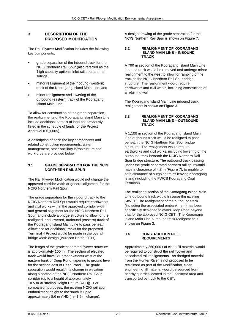
NCIG CET - Rail Flyover Modification Environmental Assessment
00451026.doc 25 Newcastle Coal Infrastructure Group
3 DESCRIPTION OF THE PROPOSED MODIFICATION
The Rail Flyover Modification includes the following key components: • grade separation of the inbound track for the
NCIG Northern Rail Spur (also referred as the ‘high capacity optional inlet rail spur and rail sidings’);
• minor realignment of the inbound (western) track of the Kooragang Island Main Line; and
• minor realignment and lowering of the outbound (eastern) track of the Kooragang Island Main Line.
To allow for construction of the grade separation, the realignments of the Kooragang Island Main Line include additional parcels of land not previously listed in the schedule of lands for the Project Approval (06_0009). A description of each the key components and related construction requirements, water management, other ancillary infrastructure and workforce are provided below.
3.1 GRADE SEPARATION FOR THE NCIG NORTHERN RAIL SPUR
The Rail Flyover Modification would not change the approved corridor width or general alignment for the NCIG Northern Rail Spur. The grade separation for the inbound track to the NCIG Northern Rail Spur would require earthworks and civil works within the approved corridor width and general alignment for the NCIG Northern Rail Spur, and include a bridge structure to allow for the realigned, and lowered, outbound (eastern) track of the Kooragang Island Main Line to pass beneath. Allowance for additional tracks for the proposed Terminal 4 Project would be made in the overall bridge width design (Aurecon Hatch, 2011). The length of the grade separated flyover structure is approximately 100 m. The section of elevated track would have 3:1 embankments west of the eastern bank of Deep Pond, tapering to ground level for the section east of Deep Pond. The grade separation would result in a change in elevation along a portion of the NCIG Northern Rail Spur corridor (up to a height of approximately 10.5 m Australian Height Datum [AHD]). For comparison purposes, the existing NCIG rail spur embankment height to the south is up to approximately 8.6 m AHD (i.e. 1.9 m change).
A design drawing of the grade separation for the NCIG Northern Rail Spur is shown on Figure 7.
3.2 REALIGNMENT OF KOORAGANG ISLAND MAIN LINE – INBOUND TRACK
A 790 m section of the Kooragang Island Main Line inbound track would be removed and undergo minor realignment to the west to allow for ramping of the track to the NCIG Northern Rail Spur bridge structure. The realignment would require earthworks and civil works, including construction of a retaining wall. The Kooragang Island Main Line inbound track realignment is shown on Figure 3.
3.3 REALIGNMENT OF KOORAGANG ISLAND MAIN LINE – OUTBOUND TRACK
A 1,100 m section of the Kooragang Island Main Line outbound track would be realigned to pass beneath the NCIG Northern Rail Spur bridge structure. The realignment would require earthworks and civil works, including lowering of the outbound track beneath the NCIG Northern Rail Spur bridge structure. The outbound track passing under the grade separated northern rail spur would have a clearance of 4.8 m (Figure 7), to enable to safe clearance of outgoing trains leaving Kooragang Island (including the PWCS Kooragang Coal Terminal). The realigned section of the Kooragang Island Main Line outbound track would traverse the existing KIWEF. The realignment of the outbound track (including the associated embankment) has been specifically designed to avoid Deep Pond beyond that for the approved NCIG CET. The Kooragang Island Main Line outbound track realignment is shown on Figure 3.
3.4 CONSTRUCTION FILL REQUIREMENTS
Approximately 360,000 t of clean fill material would be required to construct the rail flyover and associated rail realignments. As dredged material from the Hunter River is not proposed to be reclaimed as part of the Modification, clean engineering fill material would be sourced from nearby quarries located in the Lochinvar area and transported by truck to the CET.
0 250
Metres
A
A1
Scale - 1 : 1250 H1 : 125 V
Section - AA1
4.8
m
Deep Pond
FIGURE 7
Grade SeparationDesign Drawing
Source: Aurecon Hatch (2012)
NCIG-07-02 RFM_010C
R A I L F L Y O V E R M O D I F I C A T I O N

NCIG CET - Rail Flyover Modification Environmental Assessment
00451026.doc 27 Newcastle Coal Infrastructure Group
In accordance with Condition 2.46, Schedule 2 of the Project Approval (06_0009) VENM certificates would be obtained for all fill material transported to, and used on-site. The fill material would be transported from the quarries to the New England Highway, and to the CET via the Pacific Highway, Industrial Drive, Tourle Street Bridge and Cormorant Road. It is anticipated that up to 48 deliveries of clean fill material per day would be required over an 18 month period. This is less than half the 120 truck deliveries per day undertaken during the Stage 2AA construction works. The material would be transported to the CET between 7.00 am and 6.00 pm Monday to Friday, and between 7.00 am and 1.00 pm on Saturdays. A description of the construction fill transport requirements and an assessment of the predicted traffic impacts are presented in Appendix E and summarised in Section 4.11.
3.5 WATER MANAGEMENT Consistent with the surface water management system for the existing rail infrastructure (as described in the OWMP and CSWMP), stormwater runoff from areas adjacent to the Northern Rail Spur would be diverted via table drains which would run parallel to the rail infrastructure corridor and into the existing drainage system across the KIWEF. The rail embankment would include culverts where it traverses low points in the existing topography to allow drainage across its alignment and prevent ponding in adjacent areas. During construction, runoff from the western embankment would be captured via a series of drains and collection sumps in accordance with NCIG’s existing erosion and sediment control plan (as described in the CSWMP). Waterbodies adjacent to the construction works to the west of the Kooragang Island Main Line embankment would be monitored during construction works, as described in Section 5.1. The surface water management layout for the NCIG CET including the Rail Flyover Modification is shown on Figure 8.
3.6 OTHER ANCILLARY INFRASTRUCTURE
Existing power poles, wiring, lighting and signalling equipment and other minor infrastructure associated with realigned sections of the Kooragang Island Main Line, would be relocated and installed within the proposed rail realignment corridors or re-connected to existing/realigned linear infrastructure components (e.g. adjacent Ausgrid powerlines). Relocation of any sections of Ausgrid’s 33 kV electricity transmission lines outside of the proposed realignment corridor for the Kooragang Island Main Line inbound track assessed in this EA, would be subject to separate assessment and approvals. To allow for connection of the approved NCIG Northern Rail Spur, the existing rail overpass constructed over the Delta Access Road (Figure 3) would also be augmented to incorporate the additional inbound track. These works would however not change the original approved corridor width or general alignment assessed in the NCIG CET EA.
3.7 WORKFORCE Works associated with the Rail Flyover Modification would be conducted during Stage 2F construction of the NCIG CET, over a period of approximately 18 months. Approximately 50 additional people would be employed during this time. No changes to the NCIG operational workforce would be required for the Rail Flyover Modification.
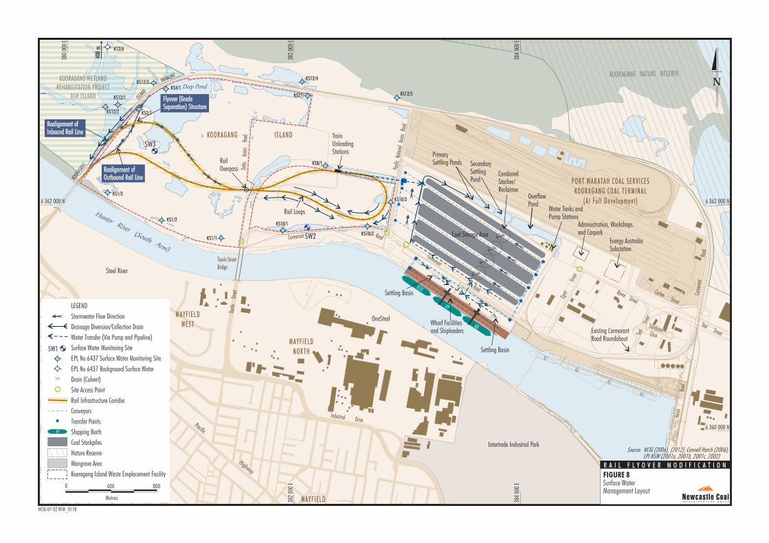
HunterRiver
(South Arm)
Hunter River (North Arm)
\
\
\
\
\
\
\
\
\
\\
/
\
\
\
\
\
\
\
\
\
\ \
\
\
\
\
\\
\
\
\
\
\
/
/
/
/
/ / /
/
\ \
\
\\
\
\
/
/
/
/
\
\
/
L.P.L.P.
/
/
/
/
/
/
/
/
/ / /
/
/
/
/
/
/
/
/
/
/
/
/
/
//
/
/
/
/
/
/
/
/
/
/
/
/
/
//
//
/
///
/ /
//
/
/
/
/
//
/
/
/
/
/
/
/
/
/
//
/
/
/
/
/
/
/
/
/
/
/
/
/
/
/
X-ING
X-ING
KOOR
AGAN
G
384
000
E
6 362 000 N
382
000
E
380
000
E
6 360 000 N6 360 000 N
384
000
E
382
000
E
380
000
E
6 362 000 N
Delta
A
ccess
Ro
ad
Tourl
e
Stree
t
Cormorant
Road
Corm
orant
Road
Egret
Str
eet
Egret
Str
eet
Heron
Roa
d
Cormorant RoadRoad
Industrial DrivePacific Highway
Pacific Highway
Raven Street
Raven Street
Teal
Teal
Street
Street
SandpiperSandpiperCloseClose
Teal Street
Teal Street
Curlew Street
Curlew Street
Pacifi
c Na
tiona
l Ac
cess
Road
Tourle StreetBridge
PrimarySettling Ponds
Energy AustraliaSubstation
Administration, Workshopsand Carpark
SecondarySettlingPond
OverflowPond
Realignment ofInbound Rail LineRealignment ofInbound Rail Line
Realignment ofOutbound Rail LineRealignment ofOutbound Rail Line
Settling BasinSettling Basin
Settling BasinSettling Basin
MAINLINE KOORAGANG NATURE RESERVE
KO O RAG AN G I SLAN D
MAYF IELD
Water Tanks andPump Stations
Coal Storage Area
MAYF IELDWEST
MAYF IELDNORTH
WAR ABROOK
TrainUnloadingStations
PORT WARATAH COAL SERV ICESKOORAGANG COAL TERMINAL
(A t Fu l l Deve lo pmen t )
Wharf Facilitiesand ShiploadersWharf Facilitiesand Shiploaders
Intertrade Industrial Park
KOORAGANG WETLANDREHABILITATION PROJECT
ASH ISLAND
CombinedStacker/Reclaimer
Rail Loops
RailOverpass
K10
K9
K8
K7
K6
K5
K4
Existing CormorantRoad RoundaboutExisting CormorantRoad Roundabout
Steel River
OneSteel
ISLAN
D
Flyover (GradeSeparation) StructureFlyover (GradeSeparation) Structure
Nature Reserve
Mangrove Area
Kooragang Island Waste Emplacement Facility
LEGEND
Stormwater Flow Direction
Drainage Diversion/Collection Drain
Water Transfer (Via Pump and Pipeline)
Surface Water Monitoring Site
EPL No 6437 Surface Water Monitoring Site
EPL No 6437 Background Surface Water
Drain (Culvert)
Site Access Point
Rail Infrastructure Corridor
Conveyors
Transfer Points
Shipping Berth
Coal Stockpiles
Metres
8000 400
K9
SW1
FIGURE 8
Surface WaterManagement Layout
Source: NCIG (2006), (2012); Connell Hatch (2006);LPI NSW (2001a, 2001b, 2001c, 2002)
Deep Pond
NCIG-07-02 RFM_011B
R A I L F L Y O V E R M O D I F I C A T I O N
SW3
SW2
KS12/3KS4/1
KS2/1
KS12/1
KS12/2
KS1/3
KS1/2
KS1/1
KS10/1
KS10/3KS10/3
KS10/2
KS8/1
KS7/1
KS12/4
KS12/5
K12/6
400
m