SeaWiFS Views Long Plume of High-Chlorophyll Water 970.2/Gene Feldman, SeaWiFS Project Office,...
9
SeaWiFS Views Long Plume of High-Chlorophyll Water 970.2/Gene Feldman, SeaWiFS Project Office, Laboratory for Hydrospheric Processes, NASA GSFC (gene.c. feldman @ nasa . gov ) These SeaWiFS images—collected on December 9, 2003—show a long plume of high-chlorophyll water stretching out into the Pacific Ocean from the Gulf of Tehuantepec. The image on the left is a “true-color image.” The cause of this plume is the Tehuano winds, which blow through the Chivela Pass in Mexico over the Gulf of Tehuantepec. When the Tehuano wind blows, there is an effect on the sea. The wind mixes the normally warm surface waters with colder, nutrient-rich water that lies beneath the shallow thermocline near the coast. Algal blooms propagate in the path of the Tehuano, fueled by the banquet of nutrients. An entire food chain depends on the episodic Tehuano events. To the south of the plume stretching across the image from west to east, a band of clouds marks the location of the Intertropical Convergence Zone (ITCZ).
-
Upload
regina-mcdonald -
Category
Documents
-
view
220 -
download
1
Transcript of SeaWiFS Views Long Plume of High-Chlorophyll Water 970.2/Gene Feldman, SeaWiFS Project Office,...

SeaWiFS Views Long Plume of High-Chlorophyll Water
970.2/Gene Feldman, SeaWiFS Project Office, Laboratory for Hydrospheric Processes, NASA GSFC ([email protected])
These SeaWiFS images—collected on December 9, 2003—show a long plume of high-chlorophyll water stretching out into the Pacific Ocean from the Gulf of Tehuantepec. The image on the left is a “true-color image.”
The cause of this plume is the Tehuano winds, which blow through the Chivela Pass in Mexico over the Gulf of Tehuantepec. When the Tehuano wind blows, there is an effect on the sea. The wind mixes the normally warm surface waters with colder, nutrient-rich water that lies beneath the shallow thermocline near the coast. Algal blooms propagate in the path of the Tehuano, fueled by the banquet of nutrients. An entire food chain depends on the episodic Tehuano events.
To the south of the plume stretching across the image from west to east, a band of clouds marks the location of the Intertropical Convergence Zone (ITCZ).
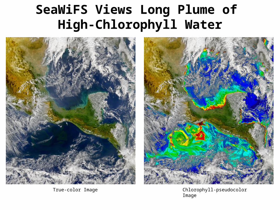
SeaWiFS Views Long Plume of High-Chlorophyll Water
True-color Image Chlorophyll-pseudocolor Image

New Land Parameter Retrieval Model Applied to AMSR ObservationsManfred Owe*
Richard de Jeu***Hydrological Sciences Branch, NASA/GSFC, Greenbelt, MD 20771
**Faculty of Earth Sciences, Vrije Universiteit, Amsterdam, NL
A new radiative transfer-based land parameter retrieval model has been used to derive surface parameters from satellite microwave observations at both regional and global scales. The model has been applied to historical databases such as the Scanning Multi-channel Microwave Radiometer (SMMR) to derive daily maps of surface soil moisture, vegetation optical depth, and surface temperature. These parameter retrievals have compared well with observational databases of soil moisture and continental snow cover, and satellite databases such as NDVI.
The model is unique, in that it requires no local calibration and can be applied at any microwave frequency. This makes the model especially useful for application to different historical sensors (e.g. SMMR, SSM/I, TRMM) as well as to current ((AMSR-E) and future (HYDROS, SMOS) sensing systems.
These land surface parameters may be useful for a variety of research areas, such as the initialization climate models and numerical weather prediction models, independent validation data sets, long term climate trend research, etc.
The retrieval model was recently applied to AMSR-E observations. The data were from an ascending orbit (~1100 hours local time) acquired on 14Dec 2003 over Europe. Optical depth (Figure1), soil moisture (Figure 2), and surface temperature (Figure 3) maps were created from the model-derived parameters. Data appear to be consistent with expected values for the region and time of year.

New Land Parameter Retrieval Model Applied to AMSR Observations
Manfred Owe* and Richard de Jeu** ([email protected])
Figure 2. AMSR-E soil moisture retrievals for Europe on 14 December 2003.
Figure 3. AMSR-E surface temperature retrievals for Europe on 14 December 2003.
Figure 1. AMSR-E optical depth retrievals for Europe on 14 December 2003.

Seasonal to Interannual Soil Moisture and Climate Feedback over Eurasia
Jiarui Dong1,2, Wenge Ni-Meister1,2, Paul R. Houser1, and Randal D. Koster1
1. Hydrological Sciences Branch, NASA Goddard Space Flight Center, Greenbelt, MD 20771
2. Goddard Earth Sciences and Technology Center, University of Maryland, Baltimore County, Baltimore, MD 20771
Soil has the ability to store the precipitated water from the periods of excess for later evaporation during the periods of shortage. Subsurface moisture stores exhibit persistence on seasonal to interannual time scales and this persistence of soil moisture anomalies MAY have tremendous impact on the seasonal cycle of the atmosphere. Understanding the control and the influence of soil moisture on regional climate has profound implications for improving seasonal to interannual climate predictions. The purpose of this study is to investigate the relations between soil moisture and near-surface climate at seasonal to interannual scales and emphasizes the influences of cold season processes and vegetation types on these relations.
We used the following data sets for our analysis: (1) Observed plant available soil moisture data at the top 1-m layer from Global Soil Moisture Data Bank for the former Soviet Union (130 stations with temporal resolution at 10-11 days); (2) Monthly half-degree gridded climate data, air surface temperature and precipitation. (3) Remote sensing land cover map at a spatial resolution 11 km and with 14 land cover types from University of Maryland. Soil moisture measured at sites with forest as a dominant cover type, averaged over growing season and total eight years, is persistently larger than soil moisture measured at grassland dominant sites, because of the continuously large precipitation and relative low air temperature at the sites with forest as a dominant type (Figure 1).
At an interannual scale, the strong positive/negative correlation between soil moisture and precipitation/temperature is found over grassland, but is weak over forest regions (Figure 2). Grassland will maintain the precipitation information due to the less evaporation from its weak root system, but the strong root system over forest regions tapping deeper soil water substantially reduces the near temporal link between soil moisture and precipitation.
At seasonal scale, our analysis over the former Soviet Union data suggests that soil can remember spring soil moisture to enhance the subsequent precipitation in summer at the regions with forest as dominant land cover (Figure 3). Also, the cumulative snow in previous winter is used to build spring soil moisture bank (Figure 4).
Forest dominant sites show strong abilities in memorizing spring soil moisture to enhance summer precipitation because the extensive root system can utilize the deep soil water, contrasting with the weak performance from grassland and cropland in tapping deep layer soil moisture. Snow accumulation in winter is an important reservoir to wet spring soil, and leaves soil water in deep layers undisturbed at the early stage of growing season. High temperature and the extensive forest root system will evaporate soil water back to the atmosphere in summer. This work may contribute to NASA Seasonal-to-Interannual Prediction Project (NSIPP) in providing the facts that can be used to validate model prediction on a relative longer time scale.

Interannual
Interannual
Figure 1. Comparison of soil moisture (left), precipitation (middle) and temperature (right) averaged over sub-samples with the fraction of forest or grassland greater than a pre-defined threshold.
Figure 2. Comparison of the interannual variability between soil moisture and climate among stations in the former Soviet Union averaged over growing season for forest (up row) and grassland (bottom row) dominant sites.
0
5
10
15
20
40 50 60 70 80 90
Landcover Fraction (%)
Soil M
oistu
re (c
m)
ForestGrassland
10
20
30
40
50
60
40 50 60 70 80 90
Landcover Fraction (%)
Prec
ipita
tion
(mm
)
ForestGrassland
0
5
10
15
20
25
30
40 50 60 70 80 90
Landcover Fraction (%)
Tem
pera
ture
(C)
ForestGrassland
12
14
16
18
78 79 80 81 82 83 84 85YEAR
Soi
l Moi
stur
e (c
m)
42
48
54
60
Pre
cipi
tatio
n (m
m)Soil moisture
Precipitation
12
14
16
18
78 79 80 81 82 83 84 85YEAR
Soi
l Moi
stur
e (c
m)
6
7
8
9
10
Tem
pera
ture
(C)
Soil moistureTemperature
8
10
12
78 79 80 81 82 83 84 85YEAR
Soi
l Moi
stur
e (c
m)
36
42
48
Pre
cipi
tatio
n (m
m)Soil moisture
Precipitation
8
10
12
78 79 80 81 82 83 84 85YEAR
Soi
l Moi
stu
re (
cm)
13.5
14.5
15.5
Te
mp
era
ture
(C)
Soil moistureTemperature
R=0.298 R=-0.14
R=0.81 R=-0.48
Forest dominant sites Forest dominant sites
Grassland dominant sites Grassland dominant sites

Seasonal
Snow
Precipitation
Seasonal
Figure 4. (Left panel) Correlation between mean soil moisture in spring (March and April) and snowfall during previous winter with the former Soviet Union data, and (Right panel) The correlation coefficients between previous winter snowfall and soil moisture in the following months.
12
3
6
9
1
2
4
57
8
10
11
Figure 3. Correlation between soil moisture in early spring (March and April) and precipitation in summer (July & August) for the stations with forest fraction above 50% (left) and with grassland fraction above 50% (right).
MONTHSS
oil m
oist
ure
11
12
13
14
15
16
17
78 79 80 81 82 83 84 85
YEAR
Soil M
oist
ure
(cm
)
24
25
26
27
28
29
30
Prec
ipita
tion
(mm
)
Spring soil moistureWinter snow fall
R=0.97 -0.5
0
0.5
1
1 2 3 4 5 6 7 8 9 10 11 12
Month
Corre
lation
Coe
fficien
ts
14
16
18
20
22
78 79 80 81 82 83 84 85
YEAR
Soil M
oist
ure
(cm
)
66
72
78
84
90
Prec
ipita
tion
(mm
)
Spring soil moistureSummer rainfall
6
8
10
12
14
16
78 79 80 81 82 83 84 85
YEAR
Soil M
oistu
re (c
m)
24
30
36
42
48
54
Prec
ipita
tion
(mm
)
Spring soil moistureSummer rainfall
Forest Grassland
R=0.67 R=0.34

Millimeter-wave Radiometric Measurements of Snowfall
James R. Wang/Code 975, Microwave Sensors Branch, Laboratory for Hydrospheric Processes, NASA GSFC ([email protected])
∙ Remote measurements of snowfall have not been systematically studied in the past. Reliable snowfall measurements are important in hydrological applications. Taking advantage of the Wakasa Bay field campaign in Japan for the Aqua validation during January 2003, we have installed the GSFC Millimeter-wave Imaging Radiometer (MIR) in the NASA P-3 aircraft to measure snowfall over both land and ocean surfaces. Besides the MIR, there were a few more instruments on board the same aircraft, including the Colorado State University/University of Massachusetts Airborne Cloud Radar (ACR).
∙ On January 28 and 29, 2003, the aircraft flew over systems of snowfalls both over land and ocean surfaces. A typical data set obtained concurrently by the MIR and ACR was displayed in the figure above; the top two panels give radar reflectivity profiles and total column integrated radar reflectivities, and the two bottom panels provide the 7-channel MIR brightness temperatures along nadir.
∙ Clearly, there is a close correspondence between the MIR brightness depression at frequencies ≥183 GHz and the ACR reflectivity. Analyses of the MIR and ACR measurements will provide the critical parameters of these snowfall events, such as ice water path (IWP) and medium particle size.
∙ Results from these analyses will help define an optimal satellite radiometer system near 183 GHz for measurements of snowfall, a possibility concurrently being considered by the Global Precipitation Mission (GPM).

MIR-ACR Observations of Snowfall in Japan