Sea Cliff Erosion within an Oregon Coast Littoral Cell
14
Journal of Coastal Research Fort Lauderdale, Florida Winter 1994 Sediments, Beach Morphology and Sea Cliff Erosion within an Oregon Coast Littoral Cell Shyuer-Ming Shih and Paul D. Komar College of Oceanic and Atmospheric Sciences Oregon State University Corvallis, OR U.S.A. ABSTRACT _ .tllllllll:. euus it'" --+; 4&JIU SHIH, S.-M and KOMAR. P.D.. 1994. Sediments, beach morphology and sea cliff erosion within an Oregon coastal littoral cell. .l ournu] of Coa .. «tal Rrsrnrch, 10(1),144 157. Fort Lauderdale (Florida). ISSN 0749-0208. The :Z·1-km ]nng beach of t he I .iucoln Cit v lit t oral cell on t he j '{->1\1 ral Oreg-on coast is bound hv pronounced headlands that prevent h.\"passing of be.uh sands. in etrpct making t hi- a large pocket beach. There is a seasonal reversal III t.h« <and transport along t hi-. emhayed shore hne. hut the net littoral drift is zero. ThE' wave energy is ext re me. with st orm« gt'lH'rating i-meter significant wave breaker heights. ThIS wave energy esse nt iallv uniform alonj; the Lincoln Cit v littoral cell; in spite of t his uniforrnitv there is a marked longshore variat ion in grai 11 ""It'S of t he beach sediment and an accompanying change ill beach morp hologv from dr-sipnt ive to relied iv« Iwadles. These variations in the beac-h sediment grain sizes .lound ill t he cliffs which of Plt>islocent' beach ami dune deposits apparently formed 111 onvironment s snrular to those found \oday. Gravel and coarve-sand layers art> exposed in the sea dill' a!(lIlg the sout h-cent rn! portion of t he littoral cel l, and these con-t rtut e the major source of coarser sizes in t he modern bear-h. By dist-('d,illg the muh imodnl grain-sizp dist rihut ions of beach sediment!' into individual having log-normal di-t rrbut ions, WP haw' been able to tract' t he coarse modes bark to t heir spa eli If sourrt-s. The proport itlIb of t hese modes with in t lw heach rapid I:.' der rease away from their sources indicating <l rr-lat ivelv "mall degree (If longshore dispersal In spit« of the high-energy wave en- vironme nt. The perststeuce of t he dispersal pat tern suggests a period of t irne that has heen insllthcient to produce t h« longshore homoueurzat.ion ot t.he ,,;pdiments. It is suggested \ hat t he sea cliff erosion which introduce» tho coQrSP mode- Into t he beac-h sednne nt s dId not begin or was mxig nificant until about :100 years ago. at which time a major subduct ion earthquake caused subsidence of this portion of the coast and rapid clitl The longshore varrat ions in twa!'h "and grain sizes and accompanying beach morphologv play ill/!:!tn Important roll' in tilt' cont inumg !-leadill' with clilf-, hacking the coarse- grained reflective IW;lcht's eroding more rapidly than t he cliffs butlr-red by the nne-grained dissipative beache-s. ADDITIONAL lNDEX WORDS: Reach «eduncnt «, beach mor phulrn;», cru .... u m, 'iea ('lilf ..... Oregon INTRODUCTION The erosion of sea cliffs is highly complex in that it involves processes of wave attack, buffered to varying degrees by the fronting beach, affected by rainfall and groundwater seepage, and is con- trolled in large part by the cliff materials and structures such as bedding (SUNAMUH.A, 1992). The processes and factors can differ from one site to another resulting in a considerable spatial and temporal variability in sea cliff erosion rates. This is the situation along the Oregon coast where the large range in experienced bluff retreat has re- sulted in management problems. This induced us to undertake a comprehensive investigation of sea cliff erosion along the length of the Oregon coast, one of our chief objectives being to understand the factors causing the observed variability. On a coast-wide scale, much of the difference in the degree of bluff erosion reflects the pattern of 9J048 received and accepted in revision :JO April 1993. coastal tectonic uplift versus the global rise in sea level (KOMAR and SHIH, 199;1). On the south- ern half of the coast, the tectonic uplift presently exceeds t.he global rise in sea level, and cliff ero- sion there has been minimal within historic times, although there is evidence for substantial bluff retreat in the not too-distant past. Along the north-central coast, global sea level rise exceeds t.he tectonic uplift (KOMAR and SHIH, 199:3); sea cliff' erosion in that area has been more signifi- cant. On the whole, the bluff erosion has been relatively slow, hut there has been considerable spatial and temporal variability apparently due to local beach processes and site-specific clitf conditions. The purpose of this paper is to report on an investigation of the beach factors important to the local sea cliff erosion within the Lincoln City littoral cell. Although the main objectives of our research have been concerned with the processes of cliff erosion, in this particular littoral cell there
Transcript of Sea Cliff Erosion within an Oregon Coast Littoral Cell

Journal of Coastal Research Fort Lauderdale, Florida Winter 1994
Sediments, Beach Morphology and Sea Cliff Erosion within anOregon Coast Littoral Cell
Shyuer-Ming Shih and Paul D. Komar
College of Oceanic and Atmospheric Sciences
Oregon State University
Corvallis, OR 97;~:H, U.S.A.
ABSTRACT _
.tllllllll:.~euus'--~ ~ it'"
--+; 4&JIU
SHIH, S.-M and KOMAR. P.D.. 1994. Sediments, beach morphology and sea cliff erosion within anOregon coastal littoral cell. .l ournu] of Coa ..«tal Rrsrnrch, 10(1),144 157. Fort Lauderdale (Florida). ISSN0749-0208.
The :Z·1-km ]nng beach of t he I.iucoln Cit v lit t oral cell on t he j '{->1\1ral Oreg-on coast is bound hv pronouncedheadlands that prevent h.\"passing of be.uh sands. in etrpct making t hi- a large pocket beach. There is aseasonal reversal III t.h« <and transport along t hi-. emhayed shorehne. hut the net littoral drift is zero.ThE' wave energy is ext re me. with st orm« gt'lH'rating i-meter significant wave breaker heights. ThIS waveenergy l~ essent iallv uniform alonj; the Lincoln Cit v littoral cell; in spite of t his uniforrnitv there is amarked longshore variat ion in grai 11 ""It'S of t he beach sediment ~ and an accompanying change ill beachmorphologv from dr-sipnt ive to relied iv« Iwadles. These variations in the beac-h sediment grain sizes~arallel.thosp .lound ill t he ~{'a cliffs which COI\~lst of Plt>islocent' beach ami dune deposits apparentlyformed 111 onvironment s snrular to those found \oday. Gravel and coarve-sand layers art> exposed in thesea dill' a!(lIlg the sout h-cent rn! portion of t he littoral cel l, and these con-t rtut e the major source of coarsersizes in t he modern bear-h. By dist-('d,illg the muh imodnl grain-sizp dist rihut ions of beach sediment!' intoindividual m()de~ having log-normal di-t rrbut ions, WP haw' been able to tract' the coarse modes bark tot heir spa eli If sourrt-s. The proport itlIb of t hese modes with in tlw heach rapid I:.' der rease away from theirsources indicating <l rr-lat ivelv "mall degree (If longshore dispersal In spit« of the high-energy wave environment. The perststeuce of t he dispersal pat tern suggests a period of t irne that has heen insllthcientto produce t h« longshore homoueurzat.ion ot t.he ,,;pdiments. It is suggested \ hat t he sea cliff erosion whichintroduce» tho coQrSP mode- Into t he beac-h sednnent s dId not begin or was mxig nificant until about :100years ago. at which time a major subduct ion earthquake caused subsidence of this portion of the coastand rapid clitl reCe~~I()II. The longshore varrat ions in twa!'h "and grain sizes and accompanying beachmorphologv ar~ play ill/!:!tn Important roll' in tilt' cont inumg !-leadill' ('ro~l(m with clilf-, hacking the coarsegrained reflective IW;lcht's eroding more rapidly than t he cliffs butlr-red by the nne-grained dissipativebeache-s.
ADDITIONAL lNDEX WORDS: Reach «eduncnt «, beach mor phulrn;», cru .... u m, 'iea ('lilf ..... Oregon
INTRODUCTION
The erosion of sea cliffs is highly complex inthat it involves processes of wave attack, bufferedto varying degrees by the fronting beach, affectedby rainfall and groundwater seepage, and is controlled in large part by the cliff materials andstructures such as bedding (SUNAMUH.A, 1992). Theprocesses and factors can differ from one site toanother resulting in a considerable spatial andtemporal variability in sea cliff erosion rates. Thisis the situation along the Oregon coast where thelarge range in experienced bluff retreat has resulted in management problems. This induced usto undertake a comprehensive investigation of seacliff erosion along the length of the Oregon coast,one of our chief objectives being to understandthe factors causing the observed variability. On acoast-wide scale, much of the difference in thedegree of bluff erosion reflects the pattern of
9J048 received and accepted in revision :JO April 1993.
coastal tectonic uplift versus the global rise insea level (KOMAR and SHIH, 199;1). On the southern half of the coast, the tectonic uplift presentlyexceeds t.he global rise in sea level, and cliff erosion there has been minimal within historic times,although there is evidence for substantial bluffretreat in the not too-distant past. Along thenorth-central coast, global sea level rise exceedst.he tectonic uplift (KOMAR and SHIH, 199:3); seacliff' erosion in that area has been more significant. On the whole, the bluff erosion has beenrelatively slow, hut there has been considerablespatial and temporal variability apparently dueto local beach processes and site-specific clitfconditions.
The purpose of this paper is to report on aninvestigation of the beach factors important tothe local sea cliff erosion within the Lincoln Citylittoral cell. Although the main objectives of ourresearch have been concerned with the processesof cliff erosion, in this particular littoral cell there
Sea Cliff Erosion
LINCOLN CITY CELL
•
•
•••
l~m•• ~
•••
• (1.60)
L .~I
0.25 0.30 0.35 0.40 0.45 0.50
MEDIAN DIAM. (rnrn)
145
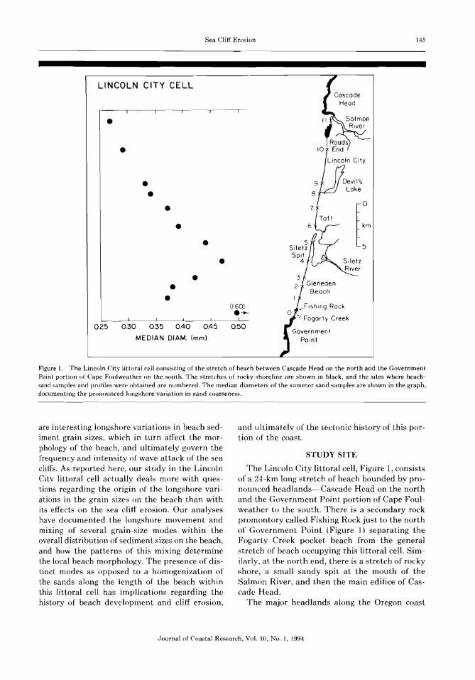
Figure 1. The Lincoln City littoral cell consisting of the stretch of beach between Cascade Head on the north and the GovernmentPoint portion of Cape Foulweather on the south. The stretches of rocky shoreline are shown in black, and the sites where heachsand samples and profiles were obtained are numbered. The median diameters of the summer sand samples are shown in the graph,documenting the pronounced longshore variat ion in sand coarseness.
are interesting longshore variations in beach sediment grain sizes, which in turn affect the morphology of the beach, and ultimately govern thefrequency and intensity of wave attack of the seacliffs. As reported here, our study in the LincolnCity littoral cell actually deals more with questions regarding the origin of the longshore variations in the grain sizes on the beach than withits effects on the sea cliff erosion. Our analyseshave documented the longshore movement andmixing of several grain-size modes within theoverall distribution of sediment sizes on the beach,and how the patterns of this mixing determinethe local beach morphology, The presence of distinct modes as opposed to a homogenization ofthe sands along the length of the beach withinthis littoral cell has implications regarding thehistory of beach development and cli1f erosion,
and ultimately of the tectonic history of this portion of the coast.
STUDY SITE
The Lincoln City littoral cell, Figure 1, consistsof a 24- km long stretch of beach bounded by pronounced headlands-Cascade Head on the northand the Governnlent Point portion of Cape Foulweather to the south. There is a secondary rockpromontory called Fishing Rock just to the northof Government. Point (Figure 1) separating theFogarty Creek pocket beach from the genera)stretch of beach occupying this littoral cell. Similarly, at the north end, there is a stretch of rockyshore, a small sandy spit at the mouth of theSalmon River ~ and then the main edifice of Cascade Head.
'The major headlands along the Oregon coast
Journal of Coastal Research, Vol. 10, No.1, 1994
146 Shih and Komar
extend into deep water and confine the beach sandsto within the littoral-cell embayments with littleor no bypassing (CLEMENS and KOMAR, 1988). Thishas been established by documenting beach sandcompositions and grain rounding differences onopposite sides of headlands. This, in effect, makesthe Lincoln City littoral cell an extended pocketbeach and implies that the long-term net littoraldrift must be close to zero. There is a seasonalreversal in the directions of sand transport alongthe beach, predominantly south during the summer months and to the north during the winter,but with a zero net littoral drift when averagedover several years. Direct evidence for this zeronet littoral drift has come from analyses of sandaccumulation patterns adjacent to jetties that havebeen constructed on Oregon coast inlets with sanddepositing to both the immediate north and southof the jetties (KOMAR et. al., 1976).
The Oregon coast is characterized by high waveenergies. A microseismometer wave measurementsystem at the Oregon State University MarineScience Center in Newport on the central coasthas obtained daily measurements of significantwave heights and periods over the past 20 years.Compilations of the measurements show that thebreakers are on average about 2 meters high during the summer months, nearly doubling to about4 meters on average in the winter (KOMAR et.. al..1976). Individual winter storms generate breakershaving significant wave heights of 6 to 7 meters.
There is a complex pattern of relative sea-levelchange on the Oregon coast due to its tectonicsetting on a convergent margin which producesaseismic uplift. Tide gauges are present at Astoriaon the Columbia River, the northern border ofOregon with Washington, and at Crescent City inCalifornia just south of Oregon. Both gauges showsmall negative relative sea-level trends, --0.15 mrn/yr at Astoria and -0.7 mm/yr at Crescent City(HICKS ei al., 198~3). demonstrating thai the tectonic rise of the land is presently exceeding theglobal eustatic rise in sea level. However, this pattern does not hold for the entire length of theOregon coast and specifically not in the area ofthe Lincoln City littoral cell where the relativesea-level rise is on the order of 1 to 2 mm/yr; thatis, the eustatic rise exceeds the tectonic uplift.This is shown by the analysis of VINCENT (1989)of geodetic bench-mark leveling along the Oregoncoast, the results establishing that the north-central coast is not rising as rapidly as the south coast,including Crescent City, or to the same degree as
Astoria in the far north. KOMAR and SHIH (1993)have shown that this nort.h-south pattern of coastal uplift and relative sea-level rise parallels a general trend in the degree of sea cliff erosion. Cliffrecession within littoral cells is minor or absentalong the south coast and in the far north nearAstoria, but is more active on the north-centralcoast where the eustatic rise exceeds the tectonicuplift. This pattern is further confirmed by thetide gauge in Yaquina Bay some ~35 km south ofthe Lincoln City cell with a measured rate of 1.3+ 0.9 mrn/yr determined from a record length of21 years (SHIH. 1992). This general uplift of thecoast is associated with the accumulation of strainproduced by the aseismic subduction of the oceanic ~J uan de Fuca plate beneath the continentalNorth American plate. No subduction earthquakes have occurred in the Northwest duringhistoric times, but investigations of marsh deposits and other lines of evidence demonstratethat every few hundred years there is a majorsubduction earthquake (ATWATER, 1987: ATWA
TEH and \TAMACUCHI, 1991; DARIENZO and PETER
SON. ] 990). The release of accumulated strain byan earthquake results in an abrupt drop by up toI to 2 meters of much of the Northwest coast.This would account for areas of the coast wherehighly vegetated sea cliffs are found, indicatingthat there has been significant cliff recession inthe past, probably following the last subductionearthquake and subsidence that took place about;100 years ago, but that subsequent aseismic uplifthas resulted in a progressive decrease in the clifferosion, and in places where the uplift is high atotal cessation of wave- induced recession (KOMAR
ct al., 199] ~ KOMAR and SHIH, 199:H. This is probably the pattern in the Lincoln City littoral cell,except that the uplift since the last earthquakehas not been sufficient to completely halt the waveattack and cliff recession.
Sea cliffs back the beach over most of the lengthof the Lincoln City cell. These cliffs are composedentirely of Pleistocene marine terrace sands, including ancient beach and dune sands. The sedimentary units within the cliff have a componentof dip toward the north, so there are systematicchanges in the cliff stratigraphy north-south alongthe length of the cell. In the far north, the cliff iscomposed entirely of ancient dune sands. a wellsorted medium to fine quartz-rich sand. Thesedune sands dominate the sea cliff from Roads Endin the north to Taft, just north of the inlet toSiletz Bay, midway along the cell (Figure 1). In
Journal of Coastal Research. Vol. 10, No.1. 1994
Sea Cliff Erosion 147
the Gleneden Beach area in the southern half ofthe cell, the cliff sediments become much coarser,coarse sands through gravels, representing ancient beach and shallow marine sediments. In theFogarty Creek suhcell at the far south end (Figure1), the Pleistocene terrace sediments are dominantly gravels. Here the terrace sediments formonly the upper half of the sea cliff, the lower halfbeing Tertiary marine mudstones, rocks that areexposed in most of the sea cliffs along the Oregoncoast (l(OMAR and SHIH, 199:1).
Due to the high-relief sea cliffs composed ofPleistocene sands through gravels, cliff recessionrepresents a particularly significant source of sandto the beach of the Lincoln City littoral cell, moreso than in other littoral cells along the Oregoncoast (CLEMENS and l~oMAH, 1988). It is uncertainhow much sand is heing contributed to the beachby the Siletz River. Studies of other rivers on theOregon coast that have large estuaries indicatethat most of the riverine sands end up in theestuaries, and thai the estuaries are actually sinksof marine sands carried by tidal currents throughinlets (I(ULM and BYHNE, 1966; PETEHSON ei al.,1984). This is also likely the case for the SiletzRiver. suggested by the contrasting heavy mineralassemblages found in the river versus the beach(CLEMENS and }(OMAH. 19S8). It is more probablethat the Salmon H.iver at the north end of the cellcontributes sand to the beach in that the Salmonhas only a small estuary which is less likely totrap the riverine sand. However, the potentialsediment contribution would be minor for thissmall stream. Budgets of littoral sediments forthe Lincoln Cit» cell have been developed byKOMAR (198~-n and SHIH (1992). The estimates arevery approximate due to uncertainties of rivercontributions and also because of uncertaintiesregarding cliff recession rates. SHIH (1992) hasshown that likely cliff recession rates would supplyjust about the right amount of sand and gravel,which if distributed over the length and width ofthe littoral zone, would result in an average vertical accretion of the beach that is on the orderof 1 to 2 mm/yr. Therefore, the estimated verticalaccretion of the beach would just about balancethe local relative rise in sea level in the area ofthe Lincoln City littoral cell.
METHODS
The twelve beach sites identified in Figure 1,spaced at roughly equal intervals along the celllength, were chosen for sediment sampling and
beach morphology investigations. Areas wereavoided where structures such as seawalls or revetments are present, or where streams cross thebeach. The sites are numbered 0 through 11 fromsouth to north (Figure 1), with site ttO being within the Fogarty Creek subcell south of Fisherman'sRock and site tt11 being on the small sand spitnear the Salmon River.
Beach sand samples were collected from sitesno through 10 during July 1987 and January 1988,months that respectively represent summer andwinter heach conditions. A summer sample fromsite :ttll near the Salmon River was later obtainedduring June 1991. In all cases. the samples represent composites of sub-samples collected alongthe beach-profile length during low tide; composite samples were used in order to eliminate theeffects of local cross-shore sorting and to obtaina sample that is representative of the beach as awhole. Composite samples were also obtained ofsea cliff sediments, combining sub-samples fromindividual depositional units observed in the cliff.
All of the samples were washed and dried, andthen sieved using standard 20-cm diameter sieveshaving 1 1 -(P intervals. T'he samples were sievedfor If) minutes on a Ro-Tap shaker. Due to thepresence of coarse grains (> 1 em) in many samples, large samples were employed following theCoates curve presented in LEWIS (1984). Repeatedsieving of one sample with different weights ofsand yielded essentially the same size distribution, demonstrating that the large sample sizesdid not adversely affect the results.
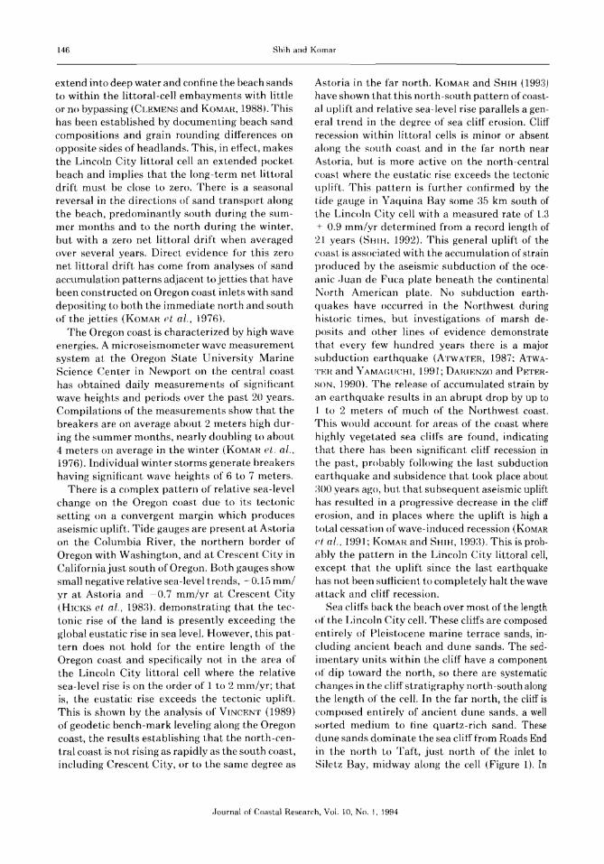
In addition to the computation of the standardstatistics (median, standard deviation, etc.) of thegrain-size distributions, each total distribution wasdissected into a series of modes with each modeassumed to be log-normally distributed. A numerical computer program was employed that involves entering an initial guess for the proportions, means and standard deviations of Ncomponent distributions; iteration by the program adjusts the parameters until the differencebetween the observed total distribution and thecomputed summation of the modes is minimized.An example analysis of one of the beach sedimentsamples is shown in Figure 2, where the observedgrain-size distribution is accounted for by thesummation of five modes.
Beach profiles at the sites were obtained witha laser-bearn total station OMNl. Surveys weretypically undertaken during low tides and extended as far offshore as possible by wading. Each
{Journal of Coastal Research, Vol. 10, No.1, 1994
148 Shih and Komar
120 __------------------,
RESULTS
Siletz South (5)90 summer
iment , as reflected in the medians, is found at thesouth end of Siletz Spit. From that maximum, themedians of the grain-size distributions systematically decrease both 10 the north and south.'I'here is an abrupt discontinuity in the medianson opposite sides of Fishing Rock, with mediumsand to the north within the main stretch of beachof the littoral eel], and coarse sand and gravel inthe subcell pocket beach at Fogarty Creek. Thisdifference reflects the input of coarse sedimentsfrom sea cliff erosion within the Fogarty Creeksubcell, and also demonstrates that. there must belittle if any exchange of sand between that subcelland the main cell to the north. This is surprisingin that Fishing Rock is a rather minor headland,hut it is clear that this obstacle plus its underwater rock platform are able to prevent significantlongshore exchanges of beach sands. On the otherhand, the median size of the sand on the smallspit adjacent to the Salmon River at the northcontinues the trend established by the mediansof samples collected within the main part of thecell. This suggests that the fine sand on that stretchof shoreline is able to bypass the area of rockycoast south of the river, but the evidence is notabsolutely clear since the beach sediments on bothsides could be derived from basically the samesource without there being an exchange.
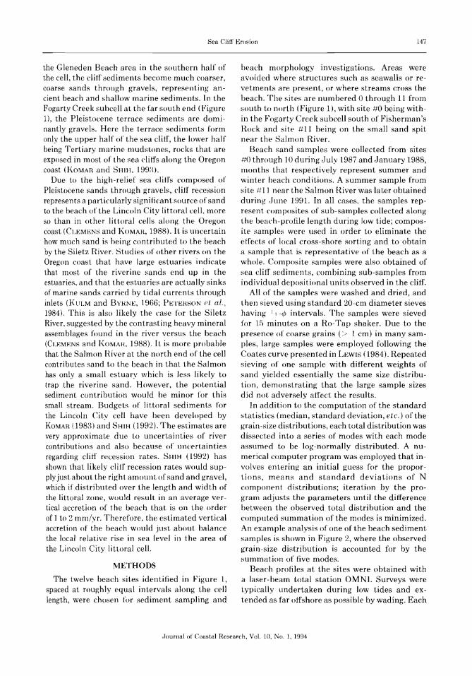
The frequency curves of the individual grainsize distributions are plotted in the left-handcolumn of Figure :~. These are derived from thesieving analyses of the summer samples with thehistograms first summed to form cumulativecurves, the derivative of which yields the smoothfrequency curves (SHIH, 1992). There is a dominate peak centered at about 1.5 ¢ (0.:35 mm), amode that is found in every sample along thelength of the littoral cell (the sample from theFogarty Creek subcell is not included in theseanalyses). In addition to that dominant mode,there are subsidiary grain-size modes that yielda multirnodal distribution with the modes represented in different proportions within the series of samples. There is a minor fine-grainedmode centered at about 2.4 ¢ (0.2 mrn), one whichis rich in heavy minerals; its maximum development is at the north end of the cell (samples-1+9 and #10) and progressively decreases in significance toward the south to sample #5 (northSiletz Spit), and then reappears at the far southin sample +:tl. More important are the series ofcoarse modes, which strongly affect samples #2through tt6 and have a minor presence in samples
120
90observed
fitted
60
30
0
-2 -1 0 3
%/4l
60
30
Sediments
The medians of the beach sediment grain-sizedistributions are graphed in Figure L, demonstrating the pronounced longshore variationswithin the Lincoln City littoral cell. These resultsare for the samples collected during the summer;the winter samples show similar trends, but withmore scatter (SHIH,1992). The coarsest beach sed-
Figure 2. The division of a frequency curve for a grain-size
dis t.rihution in to five log-normally dist ributed rmides, which when
summed, closely correspond to t he observed distribution.
site was marked by a wooden stake located at thebase of the cliff, the top of which served as a localbench mark. These local references were tied into the National Geodetic Vertical Datum (NGVD)so that the profile elevations could be comparedwith mean sea level. All sites were surveyed on asemi-annual basis to document the profile differences between summer and winter. In addition,Gleneden Beach (site #~i) and 21st Street (.f+<J) inLincoln City were surveyed monthly for two yearsin order to contrast the beach morphologies respectively of a coarse-grained reflective beach anda fine-grained dissipative beach. In the first year,only one cross-shore profile was obtained at eachof these two beaches; in the second year, six profiles spaced at 30-meter longshore intervals weresurveyed so that 3-dimensional changes could becompared.
.Iournal of Coastal Research, Vol. 10, No.1, 1994

Sea Cliff Erosion 149
180 10 sRoads End (10)
%/tP120
60
0
21slSt (9) 9s
D-nver (8) 8s
35th St. (7) 75
Taft Beach (6)6s
Siletz N. (5) 55
Siletz S. (4)45
Gleneden Beach (3)35
Sea and Sand (2)2s
100 F==::c:=====I.__J.....-_......L..__
WillowSt.(1)
OI:::::===z:===:L__..L.-_.....L__
O/D 501 5
3 2
MODE
4543o-1-2
Figure 3. (Left) The frequency curves for the beach-sand samples collected at the eleven sites in Figure 1 along the length of theLincoln City littoral cell. (Right) Histograms of the proportions of the five modes found within the corresponding series of frequencycurves.
-lournal of Coastal Research, Vol. 10. No.1, 1994

150 Shih and Komar
1--)(---1 ~ ....-.-.l .-.t 7
t----+---l ...--x-------AP-l ~ ~ 6Siletz
I--------+------l I--x---tl--A--l ~ ~ 5 Spit
8
-.- mode 4 (0.8 mm)-0- mode 5 (1.3 mm) -
5 6 7
site431 2
~F1 --sumOfmOde4&5~
0- ~I
30 - coarsest cliff sand
20 f--
30
°/010
0125
t.-t 8
1-+--4 10
(mm)
0.5 0.25
l-)(~
I----...--=I==-'=~~
l-)(-l
• mode 1• mods 2
• mode 3'X mode 4
• mode 5
20
o 10 15 20 25
Distance Along Shoreline (km)
o L-....l -.L..- .L..- ----L- ----l
• q)(---4~ I------+--t
f-------.-----=~=r' t---*---1~
-1 o 3
Figure 5. The percentages of the two coarse modes 4 and 5along the shoreline of Lhe Lincoln City littoral cell, indicatinga pattern of longshore advection and diffusion as these modesare dispersed after introduction onto the beach by sea cliff erosion in the area of Cleneden Reach (site tt:~).
Journal of Coastal Research, Vol. 10. No.1, 1994
Figure 4. The medians and standard deviations of the modesfound within the frequency curves of Figure 3 for the series ofsand samples north-south along the Lincoln City littoral cell.
tt7 and #8. From this it is apparent that theoverall coarseness of the beach sands in the southcentral part of the cell, as reflected by the medians plotted in Figure I, result from the addition of these coarse modes to the 1.5 4> mode thatis otherwise dominant along the full length ofthe cell.
As described in the preceding section and illustrated in Figure 2, these individual grain-sizedistributions have been dissected into series ofdiscrete modes that are individually log-normallydistrihuted but have different medians and standard deviations (sorting). In total, five rnodes couldbe identified in the series of samples, modes thatvaried little over the length of the cell in termsof their medians and standard deviations. Theright-hand column in Figure ~~ shows histogramsfor the proportions of the modes in the series ofsamples with the modes numbered in sequencefrom the finest to the coarsest. Mode 2 is thedominant 1.5-4> size found in all of the samples.Modes ~~, 4 and 5 are the coarse fractions thatwhen taken together account for the coarseness
of the beach sediments along the south-centralstretch of shoreline (Figure 1). The medians andstandard deviations of the modes in the series ofsamples are graphed in Figure 4. From this, it isseen that there is some variation from one sampleto the next, but on the whole the medians andstandard deviations of the individual modes areconsistent along the north-south length of the littoral cell, Mode 5 has its median cent.ered at approximately - 0.5 (~ (1.;1 mrn): mode 4 is centeredat 0.4 </) (0.8 mrn).
Of particular interest are the longshore distributions of the coarse modes 4 and 5, shown inFigure 5. fraken together, these modes form amaximum in sample #4 at the south end of SiletzSpit. It is apparent that these modes are not derived from erosion of the spit, hut instead enterthe beach system from sea cliff erosion to thesouth along Gleneden Beach. Grain-size analysesof samples of cliff sediments from Gleneden Beachshow that the sizes represented by these modesare abundant in the cliffs cent.ered at approximately site -tt:1. Gleneden Beach State Park (SHIH,1992). However, the median grain size of the beachsand as a whole is a maximum at site #4 on SiletzSpit (Figure 1) caused by the maximum percentage of modes 4 and 5 (Figure 5). It would appear
IJ
digitstaff
Text Box

Sea Cliff Erosion 151
from this that these coarse modes entered thebeach system at about site #~3, but have had a netadvection toward the north such that the maximum percentage is presently found at site tt4 about3 km north of the sea cliff source. From this, it isapparent that the longshore percentage distribution of modes 4 plus 5 shown in Figure 5 represents a pattern of longshore advection and diffusion of those modes following their input intothe beach with the net advection being to thenorth and diffusion accounting for the progressivewidening and flattening of the observed percentage distribution. The set of beach-sand sampleshas captured the existing longshore pattern ofadvection and diffusion that must be evolving withtime. This interpretation is further supported bythe lower graph in Figure 5 where t.he longshorepercentages of modes 4 and 5 are graphed separately. Both show patterns retiecting advectionand diffusion with mode 4 having advected agreater longshore distance frorn the sea cliff sourcethan the still coarser mode 5.
These documented patterns of longshore dispersal of modes 4 and [) and t he overall patternsof variable grain sizes within this littoral cell arerather enigmatic. The immediate question is whythe extreme wave-energy conditions of the Oregoncoast have not been able to homogenize the beachsediments. dispersing the coarse modes originallyintroduced at Gleneden Beach so that they arefound along t he full length of the pocket beach.With high wave energy and sutlicien l time, thesemodes should be present all the way north to RoadsEnd (sample tt10), not just to sample -tt7 at Taft.The logical answer is that there has not been sufficient time, that is, these coarse modes have beenintroduced into the beach sediments only withinthe past hundreds of years. Our tentative interpretation is t hat this introduction began or atleast became significant at the time of the mostrecent subduction earthquake about :~oo years ago.This would fit in with evidence discussed earlierthat a subduction earthquake resulted in theabrupt subsidence of much of the coast which, int,urn. resulted in large-scale sea cliff erosion.
It has been seen in Figure 5 that modes 4 and5 have advected roughly 5 krn and 2.5 km, respectively, alongshore from their clilf sources inGleneden Beach. If we accept ~)oo years as thetime period, the corresponding advection rates arerespectively 1.7 and 0.8:1 meters per year. Theserates cannot he viewed as necessarily associatedwith a net longshore movement or transport of
beach sediments to the north; it they were, thenet transport would at any rate be extremely low.As discussed earlier, the evidence suggests thatthe Lincoln City littoral cell and others on theOregon coast are in effect pocket beaches, contained and isolated between the large rocky headlands. The apparent northward advection of thecoarse modes likely results from the asymmetryof the wave energies arriving from the northwestversus the southwest. The highest waves arrivefrom the southwest during winter storms withmore moderate waves but of longer duration arriving from the northwest during the summer. Itis probable that this asymmetry in wave intensities accounts for the slow net movement of thecoarse fractions to the north. while at the sametime producing an overall net zero longshore sediment transport which includes the finer-grainedsands as 'Nell as these coarse modes.
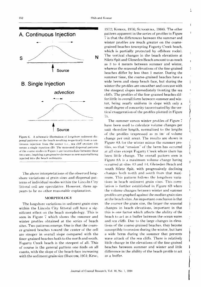
The advection/diffusion distributions of modes4 and f1, Figure 5, have further implications regarding cliff erosion rates and sediment inputs tothe beach. [f clitf erosion has continued since thelast su bduction earthquake with little or no decrease in time, then the input of the coarse modesshould also have been approximately constant for:~oo years. Such a continuous input from year toyear would result in a mode dispersal pattern having its maximum at the source position, shownschematically in Figure GA. The decrease in themode percentage from that source position reflects the processes of diffusion. which could differbetween the north and south directions due to theasymmetry of the wave energies as discussed above.However, the observed distribution is more akinto that shown schematically in Figure 6B generated by a single injection of the mode into theheach sediments followed by its advection anddiffusion alongshore. In reality, the observed distributions of Figure 5 are somewhere betweenthese two extremes, but closer to the single injection than to the continuous injection. The implication is that there was a massive injection atthe t.ime of the last subduction earthquake, butthat cliff erosion and sediment input have progressively declined during the past ;300 years. Thisdecrease could have resulted from the cliff havingheen cut back by the waves and the progressiveg-rowth of the fronting beach that buffers the clifffrom wave attack. Aseismic uplift which wouldhave reduced the relative sea-level rise could alsohe an important factor in diminishing the coarsemode input from cliff erosion.
.lournal of Coastal Research. Vol. IO, No. 1. 1994
152 Shih and Komar
Journal of Coastal Research, Vo1. 10, No.1, 1994
NIORPH()L()(;Y
The above interpretations of t he observed longshore variations of grai n sizes and dispersal patterns of individual modes wi thin the Lincoln Cit.ylittoral cell are speculative. However, t here appears to bp no other reasona hle- explanation.
Figure 6. A schematic illustration of lonpdlOrf' sediment dispersal patterns on the beach resulting respectively from a continuous injection from the source (1.('., sea chtf erosion) (A)
versus a single mject.ion \8). Toe measured dispersal pat ternsof the coarse modes in Figure ;) are int.ermediate between thesetwo cases. implying a progressive decrease llJ new mat.er ia! beinginjected into the beach sediments.
I,I
1972; KOMAH, 1976; SUNAMURA, 1984). The otherpattern apparent in the series of profiles in Figure7 is that the differences between the summer andwinter profiles are much greater on the coarsegrained beaches (excepting Fogarty Creek beach,which is part.ially protected by offshore rocks),'The vertical changes in the beach elevations atSiletz Spit and Gleneden Beach amount to as rnuchas :-3 to 4 meters between summer and winter,whereas the seasonal elevations of the fine-grainedbeaches differ by less than 1 meter. During thesummer time, the coarse-grained beaches have awide berm and steep beach face, but during thewinter the profiles are smoother and concave withthe steepest slopes immediately fronting the seacliff's. The profiles of the fine-grained beaches differ little in overall form between summer and winter. being nearly uniform in slope with only asmall degree of concavity (accent uated by the vertical exaggeration of the profiles plotted in Figure7).
The summer versus winter profiles of Figure 7have been used to calculate volume changes perunit shore] ine length, nonnalized to the lengthsof the profiles (expressed as rn /m' of volumechange per unit area). The results are shown inFigure HA for the winter minus the summer profiles. so t ha t ..erosion" of the berm has occurredat all sites except Fogarty Creek where there hasbeen litt le change. The overall pattern seen inFigure 8J\ is a maximum volume change havingoccurred at sites t+:~ and t:L-L C~leneden Reach andsouth Siletz Spit, with progressively decliningchanaes bot h north and sout h from that maximum. Th is pattern follows the longshore variations in bflach sediment grain sizes. Thi« correlation i~ t'urt her established in Figure HB wherethe volume changes between winter and summerprof les are graphed against the median grain sizesat the beach sites. An important conclusion is thatthe coarser the grain size, the larger the seasonalchanges in beach elevations, important in thatthis is one factor which atfects the ability of thebeach to act as a hull'er between the ocean wavesand sea cliffs. Due to the large changes in elevations of the coarse-grained beaches, they becomesusceptible to erosion during the winter, but havea wide berm during the summer that preventswave attack of the sea cliffs. There is relativelylittle change in the elevations of the fine-grainedbeaches between summer and winter and littledifference in the ability of the beach profile to actas a buffer.
N
t Source
f Source
I, ////)/)))))/ /) ; /»9 /0))r.; //)7//))1 )/))) 0) y/)/ 9, 0? '///)/#)) W
B. Single Injection
advection:~
s
A. Continuous Injection
The longshore variations in sediment grain sizeswithin the Lincoln City littoral cell have a significant effect on the beach morphology. This isseen in Figure '7 which shows the summer andwinter profiles obtained at the series of beachsites. Two patterns emerge. One is that the coarser-grained beaches toward the center of the cellare steeper in overall slope compared with thefiner-grained beaches both to the north and south.Fogarty Creek beach is the steepest of all. Thisof course is the general pattern one finds on allcoasts, with the slope of the beach face increasingwith the sediment grain size (BASCOM, 1951; KIN(;,
digitstaff
Text Box

Sea Cliff Erosion
Roads End
o
153
I
200I
140!
120 80OFFSHORE DISTANCE (M)
-------~----
40 2
E O[5(M)
A -.TIoN -8
-- summer
---- winter
Taft... --"'"---
Siletz spit
---
Gleneden Beach
Fogarty Creek
---
-----_...-
3
4
5
6
7
8
9
10
II
Figure 7. The summer and winter beach profiles obtained at the eleven sites identified in Figure 1, demonstrating that the profilesare steepest in the central part of the cell where the beach sand is coarsest, and undergo greater vertical changes between summerand winter.
Journal of Coastal Research, Vol. 10, No.1. 1994

154 Shih and Komar
Journal of Coastal Research, Vol. 10. No.1, 1994
I
Ii
dimensionality of that coarse-grained beach. Thisthree dimensionality generally takes the form oflarge cusps on the beach face and still larger emhayrnents cut into the benn by rip currents whichcan also leave cusps between adjacent embaymerits. These ern bayments and cusps are particularly significant on the coarse-grained beachesas found a t Gleneden Beach, significant in thedegree to which the rip-current embayments cuthorizontally through the berm and reduce its elevation. As a result, the rip embayrnents are amajor factor in determining the occurrence ofproperty erosion, whether the property is on seacliffs as at (~leneden Beach or on foredunes asalong Siletz Spit. The studies by KOMAR and REA
(1976) and KOMAH (198;)) have particularly document.ed the importance of rip embayments ingoverning erosion on Siletz Spit; we have similarlynoted examples of localized cliff-erosion episodesin Gleneden Beach controlled by rip emhaymentsthat cut away the protective beach berm (KOMAR
and SHIH, 199:~)' The finer-grained beaches as at21st Street can also be three dimensional with thedevelopment of rip-current embayments. However, the embayment s tend to be broader and donot cut back through the berm to the same extentas on the coarse-grained beaches and, accordingly,have not been as significant a factor in detennining property erosion.
The fine- and coarse-grained beaches within theLincoln City littoral cell can be placed in the classification scheme developed by WRIGHT and SHORT
(19H:), 1984), wherein beaches range from dissipative to reflective. The fine-grained beaches likethose at Roads End and 21st Street in the northern part of the cell are purely dissipative. Due totheir low slopes, these beaches cause the oceanwaves to break far offshore and dissipate most oftheir energy as they cross the wide surf zone. Whena s t.or m occurs producing increased breakerheights. the waves break further offshore in deeper water and have a still wider surf zone to crossbefore reaching t he shoreline. Measurements ofwave fun-up on dissipative beaches show essent.ially no increase in incident wave energy withinthe swash during storms, but there is an increasein the energy of infragravity motions, that is, inswash having periods greater than 20 seconds(iUZA and IHOHNTON, 1982; HOLMAN and SAL
LEN(;J<~H, 198;)). In contrast, coarser-grainedbeaches tend to be reflective, their steeper slopesallowing the incident waves to break closer to shoreso that the run-up on the beach face is dominated
0.6
20
108 9
•
•
rL =0.75
• •
5 6 7
..•
10 15
Longshore Distance (km)
Vc =-1 96 + 6.92 DIY'
1 2
o
01
15.....---------------------.
N- 15E
ME;" 1 0CJ)ccos:<.) 05Q)
E'.::J(5> 0.0
Q)C)ccos:oQ)
E.::J~ -05 L-....<. ----l. ----' ----' I.......I
{ , 0 /-----"",
o5 ~ _/- -y-"" -j Erosion "'.----
00 ~.-------~~~~~----------------------
02 0.3 04 05
Median Grain Size (mm)
Figure 8. (Top) Longshore variations in volumetric changes of
sand within the berm of the profile series given in Figure 7,illustrating that there is a systematic north-south variation inberm erosion from summer to winter along the length of thelittoral-cell shoreline. (Lower) The relationship of the volumechange to the median grain size of the beach sand, demonstrating that the coarser sand beaches undergo larger volume changesbet.ween summer and winter.
2.0 r---------------------.
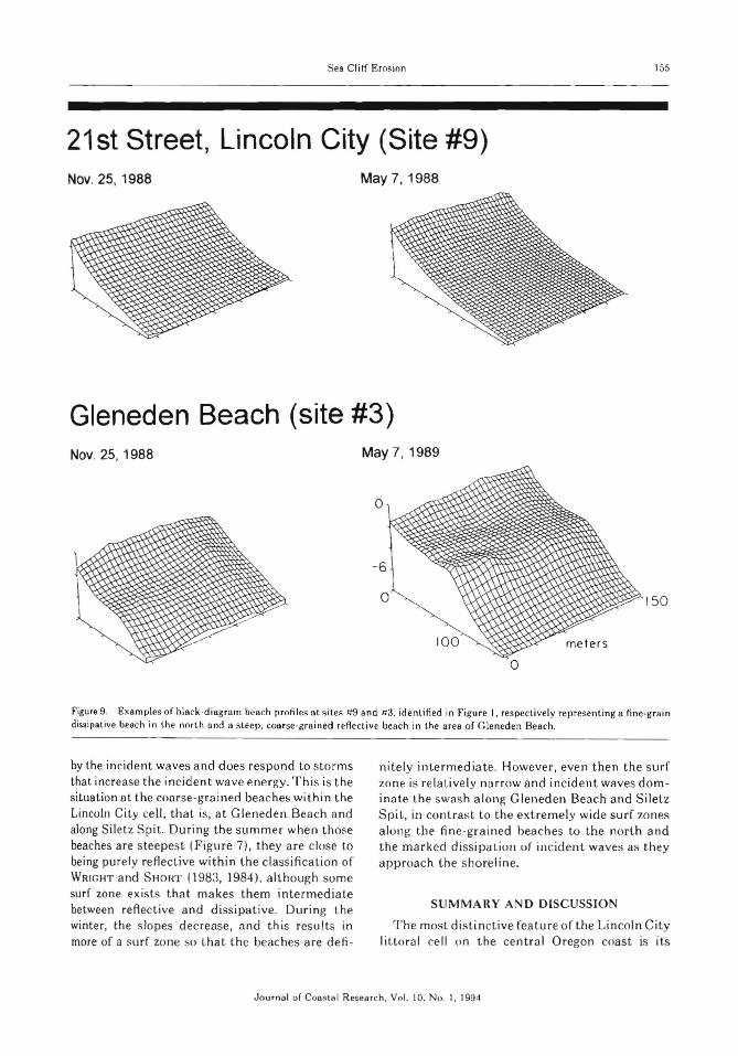
The contrast in beach profile changes notedabove between coarse- and fine-sand beaches isreaffirmed by the approximate monthly profilesobtained at Gleneden Beach (site #~i) and at 2] stStreet Beach (site #9) in Lincoln City, selectedto represent the t\VO contrasting beach types. Blockdiagrams obtained by multiple profiles spaced ~30
meters apart are shown in Figure 9; example results for the winter and summer have been chosenfrom the complete series contained in SHIH (1992).As noted above, little seasonal change is seen inthe fine-grained beach at 21st Street. the beachbeing smooth and slightly concave (again accentuated hy the vertical exaggeration). In contrast,marked changes are seen in the seasonal profilesfrom Gleneden Beach. As discussed above, thesummer beach has a wide berrn and steep beachface, while the winter beach has a lower elevationand slopes more uniformly toward the sea. Alsoshown in the block profile diagrams from (~len
eden Beach is the strong tendency toward three
digitstaff
Text Box
Sea Clitf Er osion
21 st Street, Lincoln City (Site #9)
ISS
Nov. 25, 1988 May 7,1 988
Gleneden Beach (site #3)Nov. 25, 1988 May 7 ,1 989
o
150
Figure 9. Exa mples of hlsck-diag rnrn beac h pr ofiles a t s ites It9 a nd a3. identified in Figure I . respectively rep resenti ng a fine-g rai ndissipat ive beach in the north an d a Sleep , coarse-gra ined reflecti ve beach in the a rea of G leneden Beach.
by the incide nt waves a nd does respon d to stormsthat increase t he incid en twa ve ene rgy. Th is is th esituat ion a t th e course -grai ned beaches with in th eLincoln Ci ty ce ll. that is, a t G lene de n Beach andalong Siletz Spit. Duri ng the sli mme r when t hosebeaches a re s tee pes t (F igur e 7), they are close tobeing pu re ly reflec tiv e wit hi n the classification ofWRIG HT and SH ORT (1983, 1984) . although somesurf zone exists that mak es them intermediatebetween reAect ive and di ssipat ive. Dur ing th ewinter, th e slopes de crease , and this results inmore of a surf zone so that th e beaches are dell -
nite ly in termed iate. However , eve n t hen the surfzo ne is rela tively nar row and incide nt wave s dom ina te th e swa sh a long G leneden Beach and SiletzSpit, in contrast to t he ext remely wide su rf zonesa long the fine -gra ined beaches to the north andt he marked dissipa t ion of incident wave s as theyapp roa ch th e sho re line.
SU MMA HY AN D DI SC USSI O N
The most distinctive feature o f t he Lincoln Citylit toral ce ll on the cen t ra l Ore gon coast is its
J ourna l of Consral Resear ch , Vol. 10. No. 1. 1994

156 Shih and Komar
marked longshore variation in beach sedimentgrain sizes. This variation is systematic with thecoarsest median grain size being found at thesouth-central part of the beach and decreasingprogressively both to the north and south (Figure1). This variation cannot be accounted for by parallel changes in the wave energy which is generallyuniform along the length of this 24- km long beachbounded by head lands. Detailed analyses of thegrain-size distributions (Figures 2 and :3) haveshown that they consist of mixtures of five modesin varying proportions. The coarseness of the central stretch of beach is accounted for by the addition of three coarse modes to an otherwise medium-grained mode that dominates the beachsediments the full length of the cell. 'These coarsemodes have been traced back to a source that isassociated with sea cliff erosion in the GlenedenBeach area south of Siletz Spit.
The longshore distributions of the percentagesof the coarse modes (Figure 5) have been interpreted as reflecting a pattern of advection anddiffusion of the coarse modes within the otherwisemedium-sand beach. [1. was concluded that thenet longshore advection toward the north has resulted from the asymmetry of the wave energiesfrom the southwest storm waves versus the northwest summer waves, while at the same time maintaining a zero net drift of the complete beach sandwithin this pocket-beach littoral cell. Of specialinterest is the fact that these coarse-sand modeshave not spread along the entire length of thelittoral cell, surprising in light of the extreme waveenergy that should yield high rates of mode dispersal. It was concluded that the time interval hasbeen too short to permit complete dispersal, aconclusion which led to the in terpretation thatthe coarse modes were first introduced into thebeach following a subduction earthquake that occurred about 300 years ago, an event that likelyresulted in land subsidence and t he initiation ofmassive cliff erosion. The longshore dispersal patterns of the coarse modes further led to the interpretation that the input of those modes fromcliff erosion was initially large, but has diminishedwith time probably due to the cliff being cut backand a wider beach buffer being established, andpossibly also due to some aseismic uplift. Theinference is that the beach along the length of theLincoln City littoral cell is out of equilibrium withrespect to its sediment distributions due to thatextreme event some 300 years ago, and that thesystem is continuing to evolve with the further
longshore dispersal or the coarse-sand modes. Research underway involves the computer simulation of sediment dispersal patterns and the comhined advection and diffusion of certain modalsizes. The complicating factor of such simulationsis our poor understanding of the selective longshore transport of different grain-size fractionswithin the beach, and the fact that the diffusionprocess in part involves waves approaching thebeach from different directions. We expect to apply the models to examine the observed dispersalpatterns in the Lincoln City littoral cell, and alsoto apply them to examples where the dispersalinvolves compositional variations, including heavymineral percentages, rather than the movementof grain-size modes.
The longshore variations in sediment grain sizesresult in parallel variations in the beach morphology. The coarse-grained beaches along Gleneden Beach and Siletz Spit have steep slopes andare reflective to intermediate in the classificationscheme of ~Vl{IGHT and SHORT (198:3, 1984), whilethe fine-sand beaches within the cell are purelydissipative due to their very low slopes. These twoheach types react very differently to the oceanwaves, and in particular to extreme storms. Thefine-g-rained dissipative beaches effectively reduce the energy of the incident waves before theyreach the sea cliffs; the swash is dominated bylong-period infragravity motions that act mainlyto remove the accumulated talus at the base ofthe cliffs rather than directly attacking the cliffitself. In contrast, the coarse-grained more reflective beaches are dominated by strong swash of theincident waves that can attack and undermine thesea cliffs and also the toredunes along Siletz Spit.Jmportant to the resulting erosion is the presenceof rip currents, which cut deep ernhayments intothese more reflective beaches and largely controlthe localized areas where the incident waves canreach the coas tal properties.
From this it is apparent that the longshore variations in beach sediment grain sizes within theLincoln City lit toral cell determine the longshorepatterns of beach morphology and the nature ofthe processes responsible for property erosion.Erosion is certainly 1110re act.ive along GlenedenBeach and Silet.z Spit fronted by coarse-grainedreflective beaches. than along coastal propertiesfronted by fine-grained dissipative beaches as innorth Lincoln City. This implies that there is along-term reorientation of the bluff line along thelength of t his littoral cell suggesting a continued
Journal of Coastal Research, Vol. 10, No.1, 1994

Sea Cliff Erosion 157
disequilibrium in its overall geometry as well asthe continued presence of the longshore variations in beach sediment grain sizes.
ACKN()WLEDGEMEN1~S
This work is a result of research supported bythe l\TOAA Office of Sea Grant, Department ofCommerce. under grant N
TASIAA-D000086,
Project R/CP-24. 'Iv!e would like to thank .Iames Tait,Michael Zhenlin Li, and Mark Lorang for theirassistance in undertaking the field program of thisstudy.
LITERATURE (:lTED
ATWATEH. B.F., 1987. Evidence for great Holoceneearthquakes along the outer coast of Washington state.Science. 2~~6, 942-944.
ATWATEH, R.F. and YAMA(~{JCHI. D.K .. 1991. Sudden,probably coseismic submergence of Holocene treesand grass in coastal Washington state. (;('olo!-J)', 19.706-709.
BASCOM, \V.H .. 1951. The relat ionship between sand sizeand beach face slope. Transactions of the AmericanCcoph.ysical l 'nion . :)2, H()(-5--874.
CLEf\l~:NS, K.E. and KOMAH. P.D., 1988. Oregon beachsand compositions produced by t he mixing of sediment s under a transgressing sea. .lou rna I u[ Sedimentary Petrologv, [)8. f)Hl--;-)~9.
DA({IENZO. !\tE. and PETEHS()N. C.D .. I ~)90. Episodictectonic subsidence of late Holocene salt marshes,northern Oregon cent ral C'ascad ia rnargin. Tectonics,9. 1-:.22.
GUZA. R.T. and THOI{NTON, E.H., 19H2. Swash oscillations on a nat ural beach . -luurn al o] G(-'ophy,"ucal Research, 87 (C' 1i. ·t8;~ 491.
HICKS, S.D.; DEHAll(a;, H.A .. and Hf('KMAN. t.E.. IHH:LSea I~e['C1 \'or{otinn .... fur the L'rtit ed Stales, l~f);}
1980. Rockville, Maryland: l i .S. Dept. of Commerce.NOAA, National Ocean Sf'fvice. liOp.
HOLMAN. B.A. and SAI.LEN(;EIC A.H., 19K;). Set -up andswash on a natural beach. Journa! 0/ (;('nphy .....icalResearch, 9()(cn. 94!)-B;);~.
KING. C.A.M., 197~. Beach».... and Coa«!«. New Yor k. St.Martin's. ;)70p.
KOMAH. P.D.. 197H. Boac}: Pr()('('sses lind ~~'edi"u'nla
tion, Englewood Cliffs, New .lersey: Prentice-Hall.-l29p.
KOMAI{, P.D., 198~t The erosion of Siletz Spit, Oregon.In: Handboon of Coastal Processes and Erosion. BocaRaton, Florida: cr«: Press, pp. 65-76.
KOMAR, P .D. and REA, C.C., 1976. Erosion of Siletz Spit,Oregon. Shore and Reach, 44, 9-15.
KOMAH, P.D.; LIZAHHA(;A-AHCINUX:A, ~J.R., and TgI{ICH,
'T.A .. 1976. Oreg-on coast shoreline changes due tojetties. Journal of Waterways, Harbors and CoastalEnginecring, ASCE, 102, WW1, 13-:~O.
KOMAR. P.O.: QlllNN, W.; CREECH, C.; 1{~A, c.c., andLIZAHHAGA-AHCINEIGA, .i.n., 1976. Wave conditionsand beach erosion on the Oregon coast. Th(J Ore Bin,~)8, l o;~- 1I 2.
KOMAH, P.D. and SHlH. S.-M., 199:1. Cliff erosion alongthe Oregon coast: A tectonic-sea level imprint pluslocal controls by beach processes. Journol of Cuast.a]
Research, 9, 747-765.KOMAR, P.O.; TORSTl<:NSON, R.W., and SHIH, S.-M., 1991.
Bandon, Oregon: Coastal development and the potential for extreme ocean hazards. Shore and Reach,59. 14-22.
KULM, L.n. and BVRNg, fJ.H., 1966. Sedimentary response to hydrography in an Oregon estuary. MarineGeoloJ!Y. 4, 85- lIB.
LEWIS, D.\V., 1984. Practical Sedimentology. Stroudsburg, Pennsylvania: Hutchinson Ross. 229p.
PETJ<:RSON. C.D.; SCHEIDE(aa':R, K.F., and KOMAR, P.D.,1984. Sediment composit.ion and hydrography in sixhigh-gradient estuaries of the nort hwestern UnitedSt at.es. -lourn.al of Sedimcnt arv Pet ru [O!J)', 54 l 86-97.
SHIH, S.-~1., 1992. Processes of Sea Cliff Erosion on theOregon Coast: Neotectonics tu Wave Run-Up. Ph.D.Thesis. Oregoll State Univcrsitv: College of Oceanograph y , l ;);)p.
~lINAMlrH>\. '1'., IH84. quantitative predictions of beachfan:' slopes. (;e()I()~i('al SOCii>!.\ of America Bulletin,9;). :}.·t2- 24;).
~llNAMt 'HA. T .. 1D92. (J'rnnlorph%g\ of Rock» ('uasts.
:"Jew York: wu-« :H)2p.\'INCI·:NT. P .. 19B9. (~e()delic Deformat.ion of the Oregon
(~ascadia Margin. I\1.~. Dissertation. Eugene: University of Oregon, H6p.
\VH1CIlT. L.D. and SHOHT. A.D .. H)H:L Morphodynamicsof beaches and surf zones in Aust.rulia. In. KOMAH.
P.D. (ed.), eRC Han dbooh oj CnastaL Processes andE,.o......ion. Boca Raton, Florida: Cl{(' Press. pp. ;tS-64.
vVHHarr. i.n. and SHOHT. A.D., 1984. Mnrphodynarnicvariabilitv of surf zones and beaches: A synthesis.Marin,' (,'eologv, St). n:\-IIB.
Journal of Coastal Research. Vol. 10, No. 1. 1994