
ROYAL NETHERLANDS EMBASSY – DHAKA BANGLADESH WATER ...
94
ROYAL NETHERLANDS EMBASSY – DHAKA BANGLADESH WATER DEVELOPMENT BOARD Technical Mission EVALUATION AND RECOMMENDATIONS FOR RIVER BANK PROTECTION AT FARIDPUR DISTRICT TOWN – PADMA RIVER Technical Assistance funded by the Royal Netherlands Government MISSION REPORT DECEMBER 2005 Barbarossastraat 35 P.O Box 151 6500 AD Nijmegen The Netherlands Telephone + 31 24 3284284 Telefax: +31 24 3239346 HASKONING NEDERLAND B.V IS A COMPANY OF ROYAL HASKONING
Transcript of ROYAL NETHERLANDS EMBASSY – DHAKA BANGLADESH WATER ...

ROYAL NETHERLANDS EMBASSY – DHAKA BANGLADESH WATER DEVELOPMENT BOARD
Technical Mission EVALUATION AND RECOMMENDATIONS FOR RIVER BANK PROTECTION AT FARIDPUR DISTRICT TOWN – PADMA RIVER Technical Assistance funded by the Royal Netherlands Government
MISSION REPORT
DECEMBER 2005
Barbarossastraat 35 P.O Box 151 6500 AD Nijmegen The Netherlands Telephone + 31 24 3284284 Telefax: +31 24 3239346
HASKONING NEDERLAND B.V IS A COMPANY OF ROYAL HASKONING

Member ONRI
The First Secretary Water Sector
Dr Armand Evers Royal Netherlands Embassy Rd 90, House 49, Gulshan Dhaka
Barbarossastraat 35
P.O. Box 151
Nijmegen 6500 AD The Netherlands
+31 (0)24 328 42 84 Telephone +31 (0)24 360 96 34 Fax
[email protected] E-mail www.royalhaskoning.com Internet
Arnhem 09122561 CoC
BANGLADESH
Your reference : Our reference : 9R4649.21/L003/FCM/fcm/dac Direct line : +31 (0) 24 328 464 E-mail : [email protected]
GOVERNMENT SECTOR CONSULTANCY SERVICES
ASIA REGION
HASKONING NEDERLAND BV
Date : 8 December 2005 Enclosure(s) : Draft Final Report
Subject : Final Report Technical Mission Evaluation and Recommendations for
river bank protection at Faridpur District Padma River - Bangladesh
Dear Sir,
We now have pleasure in submitting herewith 5 (five) copies of the Final Report on the Evaluation and Recommendations for river bank protection at Faridpur District Padma River. The document is presented in the form of a Main Report with eight Appendices and an Executive Summary.
The Main Report presents the substance of the tasks of the technical Mission which we commenced in the first week of November 2005, and covers all of the objectives in the terms of reference. Furthermore, it also includes an approach towards integrated river bank erosion management in the major river system of Bangladesh, supported by approved policy documents (NWP, NWMP and PRSP).
Our recommendation is that the urgent river bank protection works at Faridpur requires at least an uninterrupted stretch of bank protection works of 4.4 km. Bearing in mind that it is planned to construct, during the year 2005-2006, 464 m of protection, the Mission’s recommendation is to construct instead 2000 m during that year and 2400 m (approx.) during the year 2006-2007.
In view of the importance of an economical and flexible design, flexible contract procedures and a smooth and efficient organization, timely availability of suitable marine equipment and the special character of these marine operations it is strongly recommended to RNE to provide Technical Assistance to BWDB.
We remain,
Yours sincerely,
Fortunato Carvajal M Mission Leader

Faridpur Town ProtectionPadma River Bangladesh
Royal Netherlands Embassy
30 November 2005 Final Report 9R4649.21

A COMPANY OF
Document title Faridpur Town Protection Padma River Bangladesh
Document short title Technical Mission Status Final Report
Date 30 November 2005 Project name Technical Mission Evaluation and
Recommendations for River Bank Protection at Faridpur District Padma River
Project number 9R4649.21 Client Royal Netherlands Embassy
Dr Armand Evers Reference 9R4649.21/R01/FCM/JVD/GJK/Nijm
Barbarossastraat 35
P.O. Box 151
Nijmegen 6500 AD The Netherlands
+31 (0)24 328 42 84 Telephone +31-(0)26 3609634 Fax
[email protected] E-mail www.royalhaskoning.com Internet
Arnhem 09122561 CoC
HASKONING NEDERLAND B.V.
COASTAL & RIVERS
Drafted by Fortunato Carvajal Monar
Checked by F. Carvajal Monar
Date/initials check 8/12/05
Approved by J H Laboyrie
Date/initials approval 8/12/05.
403020
sign FCM

Technical Mission - i - 9R4649.21/R01/FCM/JVD/GJK/Nijm Final Report 30 November 2005
EXECUTIVE SUMMARY Background In view of the severity of erosion around Faridpur Town, and based on one of the decisions laid down in the ECNEC meeting held on 11 November 2004, i.e, that the MOWR would continue for seeking foreign assistance simultaneously with project execution of river bank protection works, a technical assistance mission for Faridpur Town protection was initiated by BWDB via ERD/MOWR. The technical assistance mission was approved by the RNE (Royal Netherlands Embassy) in September 2005. The Mission arrived in Dhaka and started their work on the 6th of November 2005. Objective of the Mission is the following: To update and evaluate present and potential future developments in the planform
of the Padma River, between Aricha and Mawa. To forecast the short, medium and long-term bank line development along specific critical areas (special area of interest is Faridpur District and Faridpur Town).To evaluate the stability of the banks and presence of control points in relation to the alignment of the river channels, future flood and currents and the risk of further development of the southern channel and attack to Faridpur Town.
To make a forecast of potential future planform changes (medium and long-term) and bank erosion trends. Scenarios of right bank line alignment in future if nothing is done in short time. This will include the analysis of works done by the BWDB in the last year. Identify priority areas that will be threatened in short time and where control of erosion is urgently needed
To recommend urgent measures to control erosion and stop possible immediate attack of the Padma River on Faridpur Town.
To advice the BWDB on the type of works to be constructed (temporary and/or permanent), monitoring and maintenance required to ensure sustainability.
Problem description and overview of important aspects Major rivers in Bangladesh are characterised by having rapidly shifting river channels creating deep scour holes. Scour holes are filled by rapid deposition of sand after the floods. River banks can be under attack in a given year and or be remote from eroding currents in the next year or even for the next decade. Attempts to stop locally bank erosion in major rivers have completely or partially failed at several locations. Failure is due to physical factors like high currents, waves, scouring and instability of the banks, but also to poor construction and maintenance. In other cases the structures appear to function good but they might not yet been exposed to the full environmental design loads. River bank protection requires answering the following questions: Where, When and What to

Technical Mission - ii - 9R4649.21/R01/FCM/JVD/GJK/Nijm Final Report 30 November 2005
protect and How. • WHERE is related to threat in short-time by currents or waves • WHEN is a matter of morphological predictions of river channels, making good use
of low river stages and the urgency to stop the threat • WHAT, is a matter of economics and strategic considerations • HOW to protect which is first a technical problem to be solved
Bank erosion near Faridpur between 1993 and 2005: • 1993 – 2005: About 8,000 ha were eroded adjacent to Faridpur Town • 1993: Nearest distance from Faridpur Town to the River was about 4 km. • 2005: Nearest distance from the River to Faridpur Town is now about 0.5 km. Future planform developments of the Padma River between Aricha and Mawa and short and medium term bank erosion without bank protection works at Faridpur Town area Summary for conditions without bank protection works: • No natural hard points around Faridpur (right bank of the Padma River) • Initially continued erosion expected of Faridpur Channel; rate about 500 m/year; • Increasing scour depth and velocities and subsequent failure of Haziganj Bazar (in
2003 -19.5m PWD and, in 2005 is -27.0m PWD)

Technical Mission - iii - 9R4649.21/R01/FCM/JVD/GJK/Nijm Final Report 30 November 2005
• Over the coming years an increasing possibility of silting up of Faridpur Channel and/or cutoff channel through char. Resulting in a reduction or even stopping of the bank erosion at Faridpur, but only after a number of years.
Urgent measures to control river bank erosion at Faridpur Town (areas to be protected) and their sequence Bank protection works as carried out in Faridpur District in recent years have failed and as now foreseen for the year 2005-2006 will continue to fail unless works are done in a different manner. Hence: • To arrest the present threat of erosion of Faridpur town it is firmly recommended to
construct during the current year 2005-2006 at least 2000 m of bank protection downstream from Dhalarmore.
• All efforts should be concentrated to protect Faridpur Town. • After monsoon 2006 additional works to be carried out as per plan (their location to
be determined based on updated erosion prediction and monitoring). • Design and construction (with emphasis on the latter) must from now on be done in
a manner similar to the works carried out in the context of JMREMP. • When one does not adopt such a change in approach the works will continue to
have a high probability of failure. • Long revetment works rather than groyne type hard points must be constructed. The
protection of isolated spots, without proper planning, over short distances has no merit.

Technical Mission - iv - 9R4649.21/R01/FCM/JVD/GJK/Nijm Final Report 30 November 2005
Recommended bank erosion protection works (type, construction aspects, phasing, monitoring and maintenance) It is recalled that the present approach in Bangladesh to bank erosion problems has been in many cases far from successful. It is the firm opinion of the Mission that only a completely different approach will stand a fair chance of arriving at a satisfactory solution, i.e. a protection which cannot disappear overnight, which has a technical life of at least 30 years and requires limited maintenance. Some typical features of a new approach to bank protection works are: • one large contract for actual construction of bank protection over 4 to 5 km length;
first year to construct minimal 2 km; • one large contract for supply of geotextile bags and/or CC-blocks; • locations which are finally to be defended to be decided upon locally, based on day
to day observations and pre-determined prioritisation criteria; • construction to start at the latest on the 1st January of a given year; and underwater
protection shall be completed before May; • contractor to be on stand-by during monsoon to carry out monitoring and urgent
repairs; • same contractor to continue the work in the next dry season and to carry out
maintenance on completed under water protection works during following years. Some aspects regarding planning, design and construction Preferably, all protection works to be done (initial construction and subsequent maintenance) should be in one large construction contract to be awarded to a capable marine contractor and this would be for all the work (4000 m of protection works or more) in category (b) for the full period of 6 years (2005-2010). The location of the work (2000 m) to be done during a full dry season starting in November should be determined just before start of the work on the basis of recent bathymetry (max one week before) to identify locations under threat of erosion. The work should be limited in first instance to dumping of gunny bags filled with brick (or polyethylene line gunny bags filled with sand) and covered with geo-bags for rectification of the slope (2 layers). Subsequently, geo-bags (3 layers) can be placed in the falling apron. The bathymetry must be updated regularly and the construction schedule adapted accordingly. During the wet season the contractor must be on stand-by to take emergency measures as and when required. In the following year another 2400 m of underwater protection is to be done while maintenance, if any, must be carried out to the underwater protection of the preceding year and the revetment works above water added to this section (land acquisition is supposed to have been completed at that time).
Technical Mission - v - 9R4649.21/R01/FCM/JVD/GJK/Nijm Final Report 30 November 2005
At all times sufficient stockpiles of sand-filled geo-bags, gunny bags filled with bricks (or polyethylene bags filled with sand) and CC-blocks must be available The Executive Engineer must have full authority to take emergency measures. Staff member(s) of the Design Circle-V must be present during construction to assist him in his technical decisions. In view of the importance of a smooth and efficient organization, timely availability of suitable marine equipment and the special character of these marine operations it is strongly recommended to make an expatriate specialist in marine works available to the contractor to advise him during the early stages of the work. Technical Assistance In view of the importance of an economical and flexible design, flexible contract procedures and a smooth and efficient organization, timely availability of suitable marine equipment and the special character of these marine operations it is strongly recommended to RNE to provide Technical Assistance to BWDB. An outline of the required expatriate input is the following: - to assist in preparing economical and flexible designs - to assist in drawing up flexible type tender documents and assist in tender
procedures - to make an expatriate specialist in marine works available to the supervisory
staff and the contractor during the dry season construction period for supervision, quality control and training
Developing an integrated river bank erosion management plan for major rivers in Bangladesh Bangladesh’ National Water Policy (1999) mentions under heading 4.2 ‘Planning and Management of Water Resources’: “Through it responsible agencies, the Government will undertake survey and investigation of the problem of river bank erosion and develop and implement master plans for river training and erosion control works for preservation of scarce land and prevention of landlessness and pauperisation” Contrary to Flood Management, which, in the nineties, received an enormous boost from the execution of the Flood Action Plan, erosion management up till now has not got the attention it should have. The problems, which until now, have prevented a systematic and strategic approach to erosion management in Bangladesh, are of a morphological, economic and technical nature:

Technical Mission - vi - 9R4649.21/R01/FCM/JVD/GJK/Nijm Final Report 30 November 2005
• morphological in the sense that in the past the forecast of bank line shifting due to channel migration was difficult; however, this situation has improved considerably in recent years
• from an economic point of view it was, in most cases in the past, not considered justified to carry out expensive bank protection works
• technically it was difficult and costly to construct sustainable bank protection works: in most cases they failed after a number of years, due to no maintenance or unfavourable planform development.
The increase in population, the investment in infra-structure in the rural areas (irrigation and drainage projects), the river training works already carried out in the recent past for various major bridges, as well as improved techniques in arresting bank erosion, are all reasons for a new study into the technical, economic and socio-economic feasibility of protection works against bank erosion. The aim of such a study should be the formulation of an overall erosion management strategy for Bangladesh’ major rivers Jamuna, Ganges, Padma, Upper and Lower Meghna. It is felt that such a study is a first step towards a future control of the erosion of the banks of these major rivers. The formulation of an overall erosion management strategy is also considered essential to reach the aforementioned goal presented in Bangladesh’ National Water Policy. The strategy should be aimed at sustainable long-term planning of river training (including bank protection at vulnerable reaches) to reduce the total width of the river system and thus safeguard valuable land.
The National Water Management Plan (approved 30/04/2004) states that bank erosion is a major problem in all main rivers. Section 3.7.2 clearly refers to erosion control, river bank maintenance, and recommends the approach to be followed, particularly with focus on formulating an updated strategy dealing with the problem for sustaining people’s livelihoods and halting erosion. The PRSP of Bangladesh approved in October 2005 includes the need for erosion control in many parts of the document and in the section 5>B.1 on ‘Water Resources and Management’ states that: River erosion creates poverty by making people homeless overnight. The poor are affected most.

Technical Mission - vii - 9R4649.21/R01/FCM/JVD/GJK/Nijm Final Report 30 November 2005
CONTENTS Page
1 INTRODUCTION 1
2 PADMA BANK EROSION IN FARIDPUR DISTRICT 2 2.1 Introduction 2 2.2 Padma River near Faridpur and recent history 2 2.2.1 Characteristics of the Padma River 2 2.3 Historical development of the Padma River 3 2.3.1 History of the bank erosion at and around Faridpur 8 2.4 Development without bank protection works 9 2.4.1 Natural controls on bank erosion 9 2.4.2 Future planform development between Aricha and Mawa 11 2.4.3 Short-term bank erosion without bank protection works 13 2.4.4 Medium and long-term bank erosion without bank protection
works 14 2.5 Bank line development with bank protection works 15 2.5.1 Bank line development with protection works 15
3 BANK PROTECTION WORKS 18 3.1 Introduction 18 3.2 Bank protection works along rivers in Bangladesh: An overview of
important aspects 18 3.2.1 Some general observations 18 3.2.2 Parameters in the design and construction of bank protection
measures. 19 3.2.3 Layout of bank protection works 24 3.2.4 Cross-section of bank protection works 25 3.3 Bank protection works in Faridpur District 26 3.3.1 Areas to protect 26 3.3.2 Review of recently constructed bank protection works 26 3.3.3 Proposed bank protection works 2006-2010 27 3.3.4 Some comments regarding planning, design and construction 28 3.4 Technical Assistance 29
4 NEED FOR A RIVER BANK PROTECTION MANAGEMENT PROJECT 30 4.1 Introduction 30 4.2 Faridpur as an example 32 4.3 Earlier proposals for an integrated approach to river bank erosion
management 34 4.4 Elements to be included in an integrated approach to river bank
erosion management 39 4.5 Outline of a River Bank Erosion Management Project 41
APPENDICES

Technical Mission 9R4649.21/R01/FCM/JVD/GJK/Nijm Final Report - 1 - 30 November 2005
1 INTRODUCTION
Faridpur District (Dhaka division) has an area of 2072.72 sq km. Faridpur Town is a district administrative centre, a railway terminal, and a market town for jute and rice. The main river bordering the District is the Padma. Faridpur (Town) stands on both sides of the Kumar River. Faridpur was named after the famous Sufi saint Shah Sheikh Fariduddin. Faridpur municipality was established in 1869 which makes this Town one of the oldest in Bangladesh. The Town has a high density of population of more than 4300 per sq km. Archaeological heritage is the Garoda Mosque (1013 AH), Pathrail Mosque and dighi (1493-1519 AD), Satoir Mosque (1519 AD), Fatehabad Taksal (1519-32), Mathurapur Wall, Zila Judge Court building (1889 AD) and Bhanga Munsif Court Building (1889), Basudeva Mandir and Jagabandhu Angina. Faridpur town has been under ongoing threat of erosion of the River Padma over the last four years. The town protection work carried out by the Water Development Board was damaged and washed away during the monsoon 2005. The severe river erosion in the last season caused havoc in the area rendering about thousands of people homeless. Several, bazars, cropland, roads, government offices, health centres and infrastructures were eroded in the river. Erosion along the Faridpur Town generally extents along a 15 to 20 km long reach of the right bank. In most of the cases, the rate of the lateral extension varies within a narrow range of 410 to 460 m/year. The average annual erosion rates can generally vary from 1000 to 1600 ha/year except in the period from 1989 to 2000 (Figure 2.5). During the latter period the river was widening at a very high rate. Average annual erosion rate was about 2500 ha/year. One of the most important conclusions from recent the study by CEGIS (2004) is that near Faridpur no natural controls are present that might limit further bank erosion. Hence bank erosion might stop only when developments in the river itself cause the bank erosion to stop or river bank protection works are implemented to stop erosion. Without sustainable river bank protection the probable location of the bankline can be indicated that within next one or two years the river will start to erode the settlement and important instalments and heritage places of the town. The river may penetrate several hundred meters into the town. The Padma River is now only about 500 meters away from the town and therefore, at present the protection of Faridpur Town is considered a national issue. In view of the severity of erosion around Faridpur Town, and based on one of the decisions laid down in the ECNEC meeting held on 11 November 2004, that the MOWR would continue for seeking foreign assistance simultaneously with project execution of river bank protection works, a technical assistance mission for Faridpur Town protection, sponsored by the RNE, was initiated by BWDB via MOWR/ERD. The technical assistance mission was approved by the RNE in September 2005. The mission mobilized to Dhaka and started their work on the 6th of November 2005

Technical Mission 9R4649.21/R01/FCM/JVD/GJK/Nijm Final Report - 2 - 30 November 2005
2 PADMA BANK EROSION IN FARIDPUR DISTRICT
2.1 Introduction
According to the Terms of Reference of this Mission the first step to be taken is to assess past, present and future bank erosion of the Padma River near Faridpur. Literally the following activities are requested: To update and evaluate present and potential future developments in the planform
of the Padma River, between Aricha and Mawa. To forecast the short-term bank line development along specific critical areas (special area of interest is Faridpur District and Faridpur Town).
To evaluate the stability of the banks and presence of control points in relation to the alignment of the river channels, future flood and currents and the risk of development of the southern channel and attack to Faridpur Town.
To make a forecast of potential future planform changes (medium and long-term) and bank erosion trends. Scenarios of right bank line alignment in future if nothing is done in short time.
The present Chapter addresses these issues. For this part of the Mission’s activities use could be made of results of recent studies carried out in particular by CEGIS under different contracts and by JICA (2005). Under the JICA (2005) feasibility study of the Padma Bridge a study was carried out into different types of bank materials along the Padma River (CEGIS, 2004). Under the Jamuna-Meghna River Erosion Mitigation Project various studies were carried out to develop prediction methods for bank erosion, sometimes with additional funding from other projects. Relevant results are available in CEGIS (2005a) and CEGIS (2005b). In this Chapter use is made of these results, in particular for the prediction of short-term developments.
2.2 Padma River near Faridpur and recent history
2.2.1 Characteristics of the Padma River
Before discussing in more detail bank erosion problems of the Padma River near Faridpur, first some general characteristics of the river are given. The below data are based on older studies like the FAP9B and FAP24 final reports and the EGIS charland study , and more recent ones like JICA (2005)1, CEGIS (2004)2 and CEGIS (2005b)4. The Padma River carries the combined flow of the Ganges and the Jamuna from Aricha to the confluence with the Upper Meghna River. The river is about 100 km long with a highly variable width ranging from 5.5 to 20 km. At present the length-averaged width of the river is 10.3 km. The planform of the river can be considered as wandering – it varies between straight and braided. The braiding index (average number of parallel channels) of the Padma River is about 2, while it varies between 4 and 5 for the Jamuna River. The Padma River is extremely dynamic in nature and the rate of bank erosion, at places where the river is eroding, generally exceeds several hundred meters per year.
Technical Mission 9R4649.21/R01/FCM/JVD/GJK/Nijm Final Report - 3 - 30 November 2005
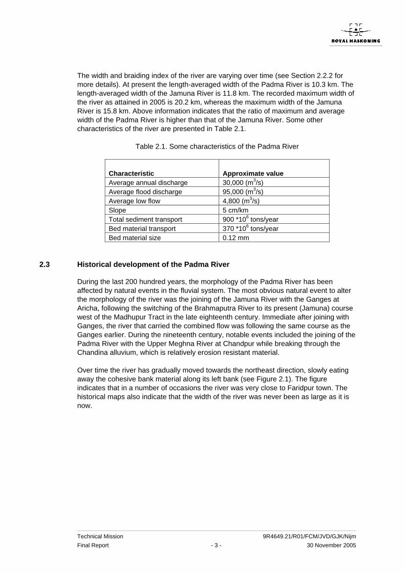
The width and braiding index of the river are varying over time (see Section 2.2.2 for more details). At present the length-averaged width of the Padma River is 10.3 km. The length-averaged width of the Jamuna River is 11.8 km. The recorded maximum width of the river as attained in 2005 is 20.2 km, whereas the maximum width of the Jamuna River is 15.8 km. Above information indicates that the ratio of maximum and average width of the Padma River is higher than that of the Jamuna River. Some other characteristics of the river are presented in Table 2.1.
Table 2.1. Some characteristics of the Padma River
Characteristic
Approximate value
Average annual discharge 30,000 (m3/s) Average flood discharge 95,000 (m3/s) Average low flow 4,800 (m3/s) Slope 5 cm/km Total sediment transport 900 *106 tons/year Bed material transport 370 *106 tons/year Bed material size 0.12 mm
2.3 Historical development of the Padma River
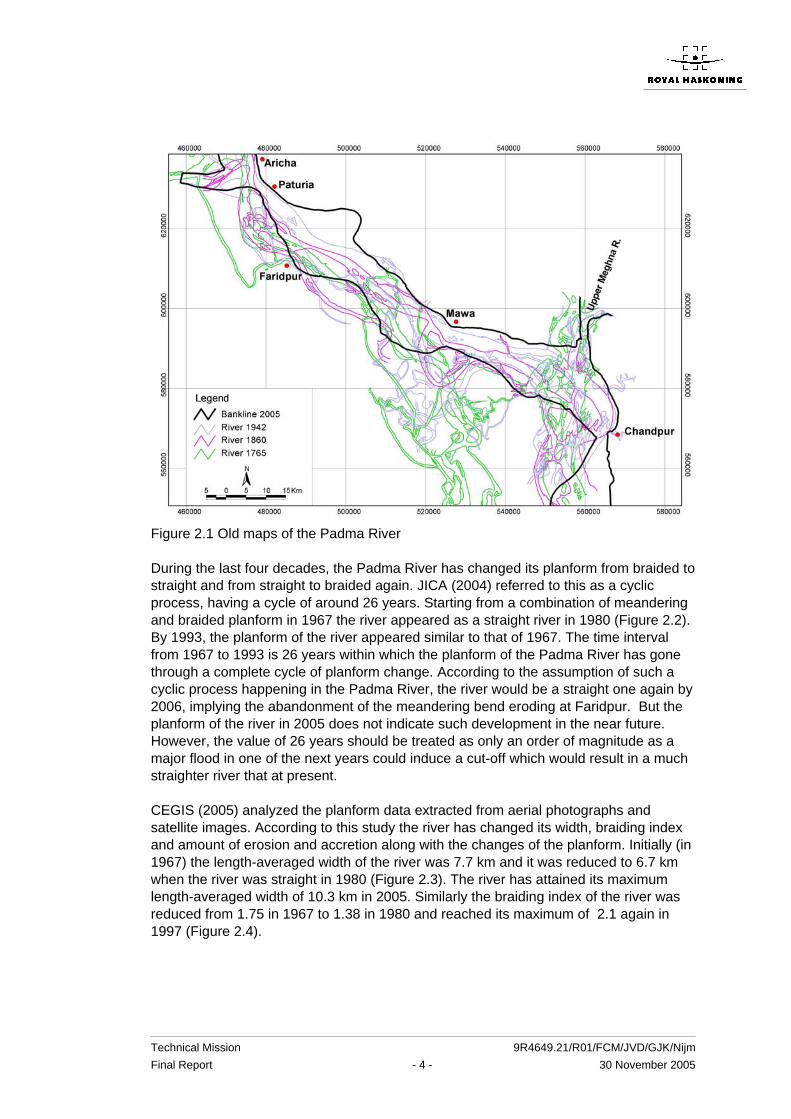
During the last 200 hundred years, the morphology of the Padma River has been affected by natural events in the fluvial system. The most obvious natural event to alter the morphology of the river was the joining of the Jamuna River with the Ganges at Aricha, following the switching of the Brahmaputra River to its present (Jamuna) course west of the Madhupur Tract in the late eighteenth century. Immediate after joining with Ganges, the river that carried the combined flow was following the same course as the Ganges earlier. During the nineteenth century, notable events included the joining of the Padma River with the Upper Meghna River at Chandpur while breaking through the Chandina alluvium, which is relatively erosion resistant material. Over time the river has gradually moved towards the northeast direction, slowly eating away the cohesive bank material along its left bank (see Figure 2.1). The figure indicates that in a number of occasions the river was very close to Faridpur town. The historical maps also indicate that the width of the river was never been as large as it is now.
Technical Mission 9R4649.21/R01/FCM/JVD/GJK/Nijm Final Report - 4 - 30 November 2005
Figure 2.1 Old maps of the Padma River During the last four decades, the Padma River has changed its planform from braided to straight and from straight to braided again. JICA (2004) referred to this as a cyclic process, having a cycle of around 26 years. Starting from a combination of meandering and braided planform in 1967 the river appeared as a straight river in 1980 (Figure 2.2). By 1993, the planform of the river appeared similar to that of 1967. The time interval from 1967 to 1993 is 26 years within which the planform of the Padma River has gone through a complete cycle of planform change. According to the assumption of such a cyclic process happening in the Padma River, the river would be a straight one again by 2006, implying the abandonment of the meandering bend eroding at Faridpur. But the planform of the river in 2005 does not indicate such development in the near future. However, the value of 26 years should be treated as only an order of magnitude as a major flood in one of the next years could induce a cut-off which would result in a much straighter river that at present. CEGIS (2005) analyzed the planform data extracted from aerial photographs and satellite images. According to this study the river has changed its width, braiding index and amount of erosion and accretion along with the changes of the planform. Initially (in 1967) the length-averaged width of the river was 7.7 km and it was reduced to 6.7 km when the river was straight in 1980 (Figure 2.3). The river has attained its maximum length-averaged width of 10.3 km in 2005. Similarly the braiding index of the river was reduced from 1.75 in 1967 to 1.38 in 1980 and reached its maximum of 2.1 again in 1997 (Figure 2.4).

Technical Mission 9R4649.21/R01/FCM/JVD/GJK/Nijm Final Report - 5 - 30 November 2005
Figure 2.2 Time series satellite images are showing the changes in planform of the Padma River
B-1
B-2
B-3B-4
196
198
1993
200

Technical Mission 9R4649.21/R01/FCM/JVD/GJK/Nijm Final Report - 6 - 30 November 2005
Figure 2.3 Changes of the length-averaged width of the Padma River over time
Figure 2.4. Changes of the braiding index of the Padma River over time
Figure 2.5. Erosion and accretion along the Padma over time Average annual erosion rates generally vary from 1000 to 1600 ha/year except in the period from 1989 to 2000 (Figure 2.5). During the latter period the river was widening at
5
6
7
8
9
10
11
1965 1970 1975 1980 1985 1990 1995 2000 2005
Year
Wid
th (k
m)
1.0
1.5
2.0
2.5
1965 1970 1975 1980 1985 1990 1995 2000 2005
Year
Brai
ding
Inde
x
0
500
1000
1500
2000
2500
3000
3500
1967-73
1973-76
1976-80
1980-84
1984-89
1989-92
1992-96
1996-00
2000-04
Period
Ero
sion
/acc
retio
n (h
a/y)
Erosion Accretion

Technical Mission 9R4649.21/R01/FCM/JVD/GJK/Nijm Final Report - 7 - 30 November 2005
a very high rate. Average annual erosion rate was about 2500 ha/year. Later the average annual erosion rate dropped again to below 1500 ha/year, which very close to that was in 1960s, 1970s and 1980s. This suggests that, except for the case of rapid planform changes during the indicated period, the average annual rate of erosion along the Padma River is around 1500 ha/year. CEGIS (2005) also has analyzed the erosion along four numbers of bends (Figure 2.6). These bends dominated the erosion process in the Padma River during the last decades. The result of the analysis provides the understanding on the magnitude and direction of erosion in an eroding bend and the life-span of such bends. The lifespan of these bends in the Padma River vary from 16 to 37 years. Erosion generally continued along a 15 to 20 km long reach of the bends. In most of the cases, the rate of the lateral extension varies within a narrow range of 410 to 460 m/year. Figure 2.6. Meandering bend development along the Padma River over time
Technical Mission 9R4649.21/R01/FCM/JVD/GJK/Nijm Final Report - 8 - 30 November 2005
2.3.1 History of the bank erosion at and around Faridpur
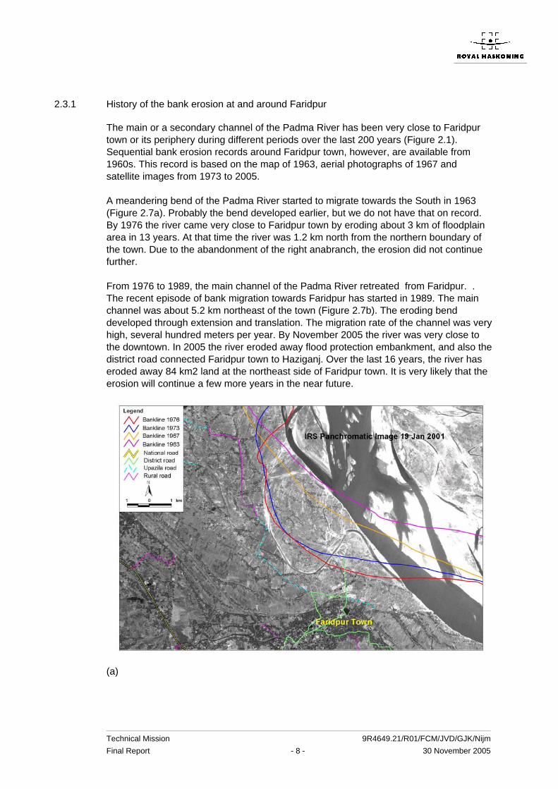
The main or a secondary channel of the Padma River has been very close to Faridpur town or its periphery during different periods over the last 200 years (Figure 2.1). Sequential bank erosion records around Faridpur town, however, are available from 1960s. This record is based on the map of 1963, aerial photographs of 1967 and satellite images from 1973 to 2005. A meandering bend of the Padma River started to migrate towards the South in 1963 (Figure 2.7a). Probably the bend developed earlier, but we do not have that on record. By 1976 the river came very close to Faridpur town by eroding about 3 km of floodplain area in 13 years. At that time the river was 1.2 km north from the northern boundary of the town. Due to the abandonment of the right anabranch, the erosion did not continue further. From 1976 to 1989, the main channel of the Padma River retreated from Faridpur. . The recent episode of bank migration towards Faridpur has started in 1989. The main channel was about 5.2 km northeast of the town (Figure 2.7b). The eroding bend developed through extension and translation. The migration rate of the channel was very high, several hundred meters per year. By November 2005 the river was very close to the downtown. In 2005 the river eroded away flood protection embankment, and also the district road connected Faridpur town to Haziganj. Over the last 16 years, the river has eroded away 84 km2 land at the northeast side of Faridpur town. It is very likely that the erosion will continue a few more years in the near future.
(a)

Technical Mission 9R4649.21/R01/FCM/JVD/GJK/Nijm Final Report - 9 - 30 November 2005
(b) Figure 2.7 Bank erosion approaching towards Faridpur (a) during 1963 to 1976 and (b) during 1989 to 2005
2.4 Development without bank protection works
2.4.1 Natural controls on bank erosion
As the present course of the Padma River is relatively new, it is likely that until now not all of its floodplain and bank materials have been formed by its own sediment as is the case with other alluvial rivers. This is especially true for the floodplain and bank materials of the river along its left bank. According to Coleman (1969) , the left-bank floodplain of the Padma River has been formed by the Atrai-Gur and Tippera Surface sediment (Figure 2.8). Erosion resistant properties are attributed to the Atrai-Gur sediment. While the floodplain along the right bank of the Padma River is composed of recent Ganges sediment.

Technical Mission 9R4649.21/R01/FCM/JVD/GJK/Nijm Final Report - 10 - 30 November 2005
Figure 2.8 Geomorphic map (after Coleman, 1969)

Technical Mission 9R4649.21/R01/FCM/JVD/GJK/Nijm Final Report - 11 - 30 November 2005
Figure 2.9. Location and extent of less and highly erodible bank materials along the Padma River CEGIS recently analyzed historical maps, aerial photographs, satellite images, available lithological information and field verification to identify the different types of bank materials in terms of their erodability (CEGIS, 2004). The result of their analysis is presented in Figure 2.9. Their findings are in line with the geomorphologic units and their attributed characteristics as proposed by Coleman (1969). When the main flow of the Padma River attacks the floodplain along the right bank the river may erode several hundred meters per year, except a floodplain close to Chandpur formed by the Tippera Surface sediments (Figures 2.8 and 2.9). There are at least two stretches along the left bank of the river, floodplain of which has been formed by the relatively less erodible materials. When the main flow of the Padma River attacks these areas, it can hardly erode the bank. Rate of bank erosion in these areas varies from 0 to 20 m/year only. The relatively erosion resistant bank material controls the morphological development of the river including the bank erosion around its vicinity. Identification of such natural controls is very relevant for predicting the bank erosion and planform development for different time-scales. The most important conclusion from the study by CEGIS (2004) is that near Faridpur no natural controls are present that might limit further bank erosion. Hence bank erosion might stop only when developments in the river itself cause the bank erosion to stop. This will be discussed in the next Sections.
2.4.2 Future planform development between Aricha and Mawa
In order to assess future planform development of the Padma River between Aricha and Mawa, aerial photographs of 1967 and time-series satellite images since 1973 were
Dhulsunra
Sureswar

Technical Mission 9R4649.21/R01/FCM/JVD/GJK/Nijm Final Report - 12 - 30 November 2005
studied. Based on superimposing the bank lines of the period 1967-2003, the Padma River can be divided into three reaches, which are apparently separated by to nodal points – Char Bhadrasan-Dohar and Mawa – Char Janajat (Figure 2.10). In these reaches, single and/multi-channel planform have developed over the last three decades. In the upstream reach (Faridpur reach), multi-channels dominate the planform. But maximum width varies quite significantly from 9 km in 1989 to 20 km in 2005. During the last decade two anabranches of Faridpur reach have moved away from each other and increased the total width of the braid belt. A chute cut-off, however, stopped the outward movement of the left anabranch for the time being. The right anabranch has been moving outward and is approaching towards Faridpur Town for the last 16 years. This process of outward movement of the right anabranch will not continue for long. Two probable developments can be foreseen – abandonment of the right anabranch or chute-cutoff as shown in Figure 2.11. Any of these developments will stop the erosion at Faridpur. It is very difficult to predict the exact time of such occurrence. It may occur within next 5 to 10 years. In 1960s and 1970s the river was approaching towards Faridpur Town from North. Presently the river is approaching to the towns from the Northeast. After the predicted abandonment of the right anabranch or the development of chute-cutoff, the river may start to approach again towards Faridpur Town. This type of planform development may occur within the timeframe of 10 to 20 years. Uncertainty remains on the direction of attack. The river may attack from North or Northeast or East depending on the future channel development.
Figure 2.10. Banklines of the Padma River based on time-series satellite images and aerial photograph
Norisha Bazar

Technical Mission 9R4649.21/R01/FCM/JVD/GJK/Nijm Final Report - 13 - 30 November 2005
Figure 2.11. Future planform developments of the Padma River between Aricha and Mawa
2.4.3 Short-term bank erosion without bank protection works
CEGIS recently developed an empirical method for predicting bank erosion along the Padma River (CEGIS 2005a). The prediction is based on the dry season satellite images. The time-span of prediction is one and two years. CEGIS predicted the bank erosion at Faridpur for the monsoon 2005 under the framework of EMIN and JMREMP projects (Figure 12a). Erosion vulnerable area under the 50% probability line is 270 ha. By November 2005, the river has eroded about 320 ha and the river become close to the town. CEGIS erosion prediction at Faridpur for two years based on January 2005 is presented in Figure 12b. Erosion vulnerable area under the 50% probability line for two years is 450 ha. Prediction shows that during 2006 monsoon the river may come further close to the town. This prediction can be updated after getting the dry season satellite images in the coming months. The erosion at Faridpur was stretched about a 20 km long bankline. Construction of Haziganj structure however, shortened longitudinal extent of erosion. But the structure is inducing to form an embayment upstream of it. The embayment has now become a threat to the structure.
Reduction in importance (increasingly probable)
Cutoff ( possible)
Effect: reduction of bank erosion rates in due time

Technical Mission 9R4649.21/R01/FCM/JVD/GJK/Nijm Final Report - 14 - 30 November 2005
(a) one year
(b) two years Figure 12. Prediction of bank erosion of the Padma River at Faridpur for the time-span of (a) one year and (b) two years
2.4.4 Medium and long-term bank erosion without bank protection works
Erosion at Faridpur may continue in the following years. At present the river is only 500 m east of Faridpur Town. Apparently there is no natural control to reduce or stop the bank erosion near Faridpur. It is difficult to predict the probable bankline within timeframe of 5 years or more. However, it can be indicated that within few years the
Technical Mission 9R4649.21/R01/FCM/JVD/GJK/Nijm Final Report - 15 - 30 November 2005
river will start to erode the settlement and important instalments of the town. The river may penetrate several hundred meters into the town. Erosion at Faridpur will stop only when the right anabranch of the Padma River is abandoned (which will probably starting to happen over the coming years) or when a chute-cutoff develops (which might happen as well, in particular when a major flood would occur in the next years). An relevant remark in this respect is that the present total width of the Padma River near Faridpur of more than 20 km is considered as the approximate maximum the river can reach. This is based on upscaling the total width of the Jamuna River (about 15 km) with the square root of the ratio of the discharges of the Padma and the Jamuna River (bankfull) discharges. Even when the bank erosion stops in a few years time, it does not mean that Faridpur will be safe from erosion forever. Rather the river may attack Faridpur from the same or another direction within another 10 to 20 year.
2.5 Bank line development with bank protection works
2.5.1 Bank line development with protection works
The aim of bank protection works is to reduce the erosion of vulnerable floodplain area and areas behind embankments from being eroded. In this Section an assessment is made of the effect of the bank protection works proposed near Faridpur on erosion, with the purpose of quantifying the effect of investments in bank protection works. In 2005 the longitudinal extent of bank erosion along the right Padma channel near Faridpur was about 12 km. In the coming years the extent of erosion would be the same, if there were no protection works. Bank protection works may reduce both the lateral and the longitudinal extents of erosion depending on the location and length of the structures. Presently BWDB has a plan to construct a 468 m long revetment at Dhalarmore and to repair and extend the existing Haziganj structure. The Mission was also informed that BWDB is trying to get more funds for constructing bank protection works with a length of about 2 km at Dhalarmore. It is not clear what BWDB can achieve in the end in terms of funding for bank protection works. Therefore the Mission developed four scenarios to assess the future bank line development in the next year without and with different combinations of bank protection structures (Table 2.2).
Table 2.2. Different scenarios used by the Mission
No. Scenarios 1 No bank protection works 2 Construction of a 468 m long revetment at Dhalarmore and
repairing and extending of Haziganj structure 3 Construction of 2000 m long revetment at Dhalarmore and
doing nothing at Haziganj 4 Construction of 2000 m long revetment at Dhalarmore and
repairing and extending the Haziganj structure Unfortunately, there is no scientifically (e.g. on models) based method available to assess the bank line development under the mentioned scenarios. The empirical

Technical Mission 9R4649.21/R01/FCM/JVD/GJK/Nijm Final Report - 16 - 30 November 2005
method developed by CEGIS for one year ahead can be applied on the basis of channel alignment and sedimentary features as observed in the dry season satellite images. At this moment, however, no satellite image of the dry season conditions is available. Moreover the CEGIS method can only be applied where influence of the structural intervention is not prominent. So for predicting the bank line development under different scenarios, this method could not be applied directly. However, experience on the bank movement within the zone of structural interventions elsewhere in Bangladesh can be applied to predict the bank line movement under different scenarios. The basis of prediction is the bank line as assessed from the coordinates measured by hand-held GPS during the Mission’s field visit on November 10, 2005. Probable bankline at the end of 2006 under the four different scenarios are presented in Figure 2.13. Predictions are made for different uncertainty ranges, such a 70%, 50% and 30%. The predicted bank erosion within the 50% uncertainty range under different scenarios is presented Table 2.3. The proposed structure at Dhalarmore divides the erosion vulnerable area. Predicted amount of erosion upstream of Dhalarmore essentially remain the same for all structural interventions. The minimum interventions as indicated in Scenario 2 would be able to reduce the amount of erosion by 100 ha at Faridpur. Construction of 2 km long structure (Scenario 4) would be able to reduce the predicted erosion further by another 60 ha. Construction of bank protection work at Dhalarmore either 468 m or 2000 m long will not be able to stop the erosion in the vicinity of Faridpur Town completely. But it will be able to reduce the erosion significantly. Protection work at Dhalarmore will also restrict the bankline movement towards the main town. Erosion upstream of Dhalarmore structure may continue in the coming years, which might appear as a threat to outflank the structure. Hence the bank protection works to be implemented should be able to withstand such an upstream development. Essentially the curved upstream part of the guide bunds of Jamuna Bridge can be copied with some adjustments.

Technical Mission 9R4649.21/R01/FCM/JVD/GJK/Nijm Final Report - 17 - 30 November 2005
Figure 2.13: Predicted bank line for the end of 2006 under (A) Scenario 1, (B) Scenario 2, (C) Scenario 3, and (D) Scenario 4.
Table 2.3. Erosion vulnerable area within 50% uncertainty range under different scenarios
Erosion vulnerable area within 50% uncertainty range
Scenario Locations
Area (ha) Total area (ha)
Haziganj bazar damage or even
failure U/s of Dhalarmore 35 1 D/s of Dhalarmore 235
270
Likely
U/s of Dhalarmore 30 2 D/s of Dhalarmore 140
170 No (depending on quality of repairs)
U/s of Dhalarmore 30 3 D/s of Dhalarmore 90
120 Likely
U/s of Dhalarmore 30 4
D/s of Dhalarmore 80
110 No (depending on quality of repairs)
The effect of the bank protection works proposed by the BWDB is in particular noticeable downstream of Dhalarmore. Investing in respectively 0.486 and 2 km of bank protection works reduced the erosion by 95 and 145 ha and in particular the 2 km long revetment safes the centre of Faridpur. Investing in the protection of Haziganj Bazar is only beneficial for the Bazar itself but does not have a major impact on the eroded floodplain area downstream.
Faridour Town
Dhalarmore
Haziganj
A B
C D

Technical Mission 9R4649.21/R01/FCM/JVD/GJK/Nijm Final Report - 18 - 30 November 2005
3 BANK PROTECTION WORKS
3.1 Introduction
It is impossible to give a complete overview of the many aspects related to bank protection works in Bangladesh. But it is also felt that one cannot isolate the works required for the protection against erosion of Faridpur Town from protection works carried out, or being carried out, elsewhere on Bangladesh' major rivers. In this Chapter, first, the main issues at stake when contemplating bank protection works in Bangladesh are discussed. Subsequently, the findings of the Mission regarding protection works at Faridpur District are presented. Additional information can be found in Appendices A5 and A6.
3.2 Bank protection works along rivers in Bangladesh: An overview of important aspects
3.2.1 Some general observations
When one looks at the many efforts made by the people of Bangladesh since their independence to arrest (locally) bank erosion by its major rivers, one cannot but conclude that up till now these efforts have largely failed. Obviously, there are a few projects where bank protection works have been successful. ‘Successful’ in this context is deemed to mean that, through the years, repeated attacks by the currents and waves during low and high river stages did not result in serious damage to the works. The picture is distorted by the fact that in many places the bank protection works after their completion have not (yet) been exposed to the eroding forces anticipated in the design. For the reason of this phenomenon one must look at the character of Bangladesh’ major rivers which implies the presence of rapidly shifting river channels, creating deep scour holes, followed subsequently by heavy, rapid deposition of sand in scoured locations. In practice this means that a structure (e.g. groyne, revetment, spur or embankment) can be under attack in a given year and be remote from any eroding current during the next year or, even, the next decade. It stands to reason that the latter does not encourage a continuous sense of alertness to the threat of bank erosion, neither is it favourable for taking non-structural planning measures1 such as monitoring of bank lines and channel bathymetry, erosion forecasting and stockpiling of materials for emergency operations. But the river may come back at an unprotected part of the bank adjacent to the protected section or somewhere else.
1 The expression ‘non-structural planning measures’ is used in analogy to the well-known term used for a certain type of measures in the approach to flooding problems (see for instance the Manual on Non-structural Approaches to Flood Management, ICID, Delhi 1999))

Technical Mission 9R4649.21/R01/FCM/JVD/GJK/Nijm Final Report - 19 - 30 November 2005
This brings one to the two paramount questions one has to answer when the need for riverbank protection works is considered in a general sense:
- Where, when and what to protect; - how to protect.
The decision about where to protect is first of all a matter of threat in the short and/or long term of erosion by waves and currents. When a location has to be protected is, apart from many non-technical constraints2, on the one hand a matter of making good use of low river stages, low currents and, on the other, of the urgency of the aforementioned threat. What has to be protected is a matter of economics (is it worthwhile to protect), strategic considerations (in case of major consequences of erosion) and policy. How the protection is carried out is first of all a technical problem to be solved. Obviously, the already mentioned other factors play a role as well: land acquisition procedures, resettlement issues, ecological impact of measures, etc. But focus in this brief overview is on the technical issues as these are, in view of their magnitude in the case of Bangladesh, of prime importance. Below, these technical issues are discussed in some detail.
3.2.2 Parameters in the design and construction of bank protection measures.
For the design and construction of bank protection projects in Bangladesh the following ten parameters are considered to be important. :
- cost vs. benefits3 - morphology in relation to expected scour and bank line shifting - monitoring in relation to expected scour and channel shifting - skills and equipment available for construction - construction materials - working methods - maintenance to be envisaged - budgeting and tendering procedures - short-term (emergency) vs. long-term measures - vandalism.
Some of these parameters are relevant to the layout of the bank protection works, some determine the cross-section to be adopted. Others are much more a matter of planning and implementation. Obviously, other parameters (which are not mentioned) may also have an impact on design and construction but these, in our opinion will not significantly change the overall picture if ignored in this overview. 2 Non-technical constraints which may delay or even prevent protection measures from being carried out are, for instance, procedures currently in use for land acquisition, tendering and budgeting. 3 meant are the benefits in the widest sense of a durable and long-lasting bank protection

Technical Mission 9R4649.21/R01/FCM/JVD/GJK/Nijm Final Report - 20 - 30 November 2005
Each of the aforementioned parameters will now be discussed in some detail. Cost vs. benefits It is, in the context of this Mission Report, not possible to present an overview of all the aspects related to the economic and socio-economic feasibility of riverbank protection. It is only emphasized here that it is important to demonstrate such feasibility in all cases and to realize that the benefits when protecting a town are larger than those for rural areas and that the investment in irrigation and drainage projects in many cases merits bank protection works to protect the investment made (in pumping stations, regulators, irrigation and drainage networks, flood embankments). It has, however, not yet been demonstrated that rural areas under rain-fed agriculture merit a protection against erosion. Obviously, for large infra-structural works, like bridges across the major rivers in Bangladesh, the economic feasibility of protection of piers and abutments and river training (to prevent outflanking) can easily be demonstrated. River Morphology River morphology is a vital aspect of riverbank protection works as it enables the determination of design and construction features like scour in front of the structure, probability of channel and bank line shifting and depositions during and after construction. For more details reference is made to Chapter 2 of this Report. Monitoring Monitoring in relation to expected scour and channel shifting in the pre- and past construction phase and during construction enables the designer to adapt the design to prevailing bed- and bank levels and to plan mitigating measures in the case of a completed structure. During construction, the project staff will require such monitoring on a day to day basis to adapt working methods, planning, speed and sequence of operations. The lack of such monitoring (and subsequent action) in the past has been one of the main reasons for the failure of many bank protection projects in Bangladesh. Skills and equipment Obviously, the skills and equipment available for construction determine to a large extent the quality of the works to be constructed. These works are located in a marine environment (high currents, waves, rapid deposition and erosion of alluvial soils), are mostly situated under water and require meticulous planning, continuous quality control and faultless logistics. These aspects, as well as the qualities of staff and type of equipment needed, necessitate the employment of large, experienced, financially solid contractors and contracts of substantial size. Too long the construction of riverbank protection projects in Bangladesh has been done piece meal, under small contracts, entrusted to small enterprises lacking capital, skills and equipment. These enterprises (as well as the supervisory staff) were basically used to relatively simple land-borne operations in which time, logistics and equipment were of secondary importance.
Technical Mission 9R4649.21/R01/FCM/JVD/GJK/Nijm Final Report - 21 - 30 November 2005
This last approach as described has to change if one wants to end up with a good quality riverbank protection system that, in most locations, only suffers a slight damage when attacked by the river (which attacks the protection through its currents, waves, scour). Construction materials It is agreed in general by parties concerned that, preferably, locally available materials are used for construction. Apart from the employment opportunities, thus created, local construction materials tend to be cheaper than similar construction materials imported from other countries. This point of departure together with the character of the bank protection works implies that the following construction materials have to be considered:
- geo-textiles for filter mattresses and geo-bags - gravel to be used for filters and as aggregate for concrete - quarried rock - boulders from Sylhet - river sand and clay, borrowed near the construction site - concrete cubes (called CC-blocks)
Bricks in general have a too low density and are also easily damaged though, if contained in jute bags, may very well function as fill material. Gravel has to be ‘manufactured’ from boulders and is therefore relatively expensive. At present there appear to be in principle four construction materials available for flexible current-resistant structures in bank protection, i.e. (1) geo-bags filled with river sand, (2) rock, (3) boulders and (4) CC-blocks. A few comments are made about each of these materials. The application of sand-filled or clay-filled bags in marine works is already well known in Bangladesh. As early as 1975 van Duivendijk, senior river training works and bank protection expert in this Mission, proposed to use clay-filled jute bags on a large scale for tidal closures. Subsequently, between 1976 and 1982 the closures of three tidal creeks were affected4. In these closures some 2.5 million bags filled with clay were used. For the closure of the Feni river (1985) both jute and polyethylene bags were used, though the former type dominated. The total number of these 40 kg- bags filled with clay for this large tidal closure was 2.3 million5. Obviously, the jute bags are not durable but for tidal closures this does not matter as, in that particular case, their function is of a temporary nature. Going from 40 kg- jute bags to the much larger geo-bags is only one step. In both cases they are manually filled and handled, have to have sufficient mass to resist current attack during and after dumping and, at the same time, will be flexible enough to form a more or less continuous and permeable blanket. The advantage of
4 See for instance the Report 'Study of methods for closing tidal channels', Review of the Programme…etc. (June 1982), issued by BWDB in the context of EIP. 5 See for some salient details of this closure the article 'The Feni river Closure Dam' by J. van Duivendijk and G. te Slaa in 'Water Power and Dam Construction' of January 1987.

Technical Mission 9R4649.21/R01/FCM/JVD/GJK/Nijm Final Report - 22 - 30 November 2005
the geo-bags is their durability. Whether or not they will function quite in the same manner as rock in a falling apron6 has yet to be demonstrated. The model testing done for this purpose7 is not entirely convincing as a representation of the prototype situation. The resources of quarried rock in Bangladesh appear either to be limited or not (yet) (from an economic point of view that is) accessible. For the Jamuna Bridge Project 1.5 million tons of quarried rock were imported from India, Bhutan and Indonesia for a price of US$ 34 (Pakur, India) to 87 (Karimun, Indonesia) per ton. Large scale procurement of rock from neighbouring countries like India and Bhutan cannot be ruled out in future but, from a cost point of view, does not seem to be warranted for river bank protection works in rural areas or for small towns. The suitability of rock for revetments (as pitched stone or rip rap) and falling aprons (as dumped rock) is, however, beyond doubt. Boulders again are suitable for use in revetments and (to a lesser extent) in falling aprons but it will be difficult to procure enough boulders having the required mass (say 10 to 60 kg) for a project of substantial size. CC-blocks have been used extensively in riverbank protection works in Bangladesh. It is possible to apply a grading but this does not normally annihilate the disadvantages of CC-blocks: large voids (up to 43% for one size blocks), steep angle of natural repose, relatively high cost. CC-blocks are very well suited for the application in revetments but much less for falling aprons and other underwater works. Working methods As already pointed out in Section 3.2.2.4 the nature of the riverbank protection in Bangladesh requires typically marine operations. These operations can only be carried out by utilizing water-borne equipment, by having a faultless positioning system, by producing and using continuously updated bathymetric charts and by a strict but flexible planning of the work. It is known to the Mission that Bangladesh has contractors who are able to carry out such type of marine operations. But they should be given the opportunity to show it and their quality control should be beyond any doubt. Maintenance Maintenance of works in general and of submerged structures in particular has always been a problem in Bangladesh. Either the funds were not available (in time), or the magnitude and type of the problem located well below the water level in front of the bank (e.g. a shifting river channel, liquefaction due to deep scour, incomplete coverage of erosive soil by a launched or un-launched falling apron) was not known
6 In the context of this Mission Report it is assumed that the reader is acquainted with the purpose and behaviour of falling aprons. For detailed information on this type of structure, reference is made to the 'Guidelines and Design Manual for standardized Bank Protection Structures' (FAP 21, December 2001). 7 JMREMP, Part B (Special Report no. 11): Physical Model Study (Final Draft, May 2005)

Technical Mission 9R4649.21/R01/FCM/JVD/GJK/Nijm Final Report - 23 - 30 November 2005
in time to take mitigating measures. In most cases this situation resulted in a complete collapse of the protection system or serious damage beyond repair. Now, one could argue that a bank protection system not requiring any maintenance whatsoever should be the goal. But this is impossible for various reasons (e.g. river regime, cost). Even the deeply founded river training structures and bank protection works of the Jamuna Bridge are regularly monitored to check a possible need for maintenance. Given the need for economical bank protection systems on the one hand and the particular characteristics of Bangladesh’ major rivers on the other, one has to establish for each project the magnitude of desirable (and technically feasible) maintenance to be envisaged. Apart from a periodic evaluation of the river behaviour and constructed bank protection (by means of monitoring) this will involve the availability of a maintenance fund and stockpiling of materials for emergency operations and, last but not least, in some cases, a stand-by contract with a capable contractor. Budgeting and tendering procedures In a report on the sustainability of spurs8, it is admitted by BWDB-staff that, following the identification of the need for protection measures after a certain flood season, current procedures for study, design, allocation of budget, preparation of the cost estimate, tender invitation, selection of the contractor and award may take the best part of the working season. Thus, in many occasions, actual construction starts only in April of the following year and, consequently, the falling apron part is constructed during the monsoon. These delays may result in structures, which, because of changes in the morphological situation, are not any longer able to fulfil their protective function. Moreover, marine construction carried out during the monsoon (high river stages, high currents, rapidly changing bathymetry) might be of low quality. Short-term vs. long-term measures Whatever strategy is adopted for bank protection works it will always be necessary to carry out short-term measures to protect vital points along the river. So far, such short-term measures have in most cases not been very successful. Either the measures were too late to be effective (due to reasons like the ones described in Section 3.2.2.8) or were done in a haphazard way without proper planning, logistics (equipment, positioning system), monitoring and the merits of a flexible design and flexible contractual approach. Preferably, such short-term measures should fit in a long-term strategy for bank protection along a certain river reach. Given the fact that a bank line may shift towards the river in the year following the protection of a certain stretch of riverbank, one may decide to wait with additional works adjacent to this protected stretch. But this in turn will require an accurate data set (like as-built drawings saved in a data
8 Report on Utilities and Sustainability of Spur constructed in various locations (translated from the Bengal version), Chief Engineer BWDB, Design, Dhaka (2003).

Technical Mission 9R4649.21/R01/FCM/JVD/GJK/Nijm Final Report - 24 - 30 November 2005
bank) to know, when the river comes back, what in fact has been constructed in the past under water. Vandalism In none of the reports studied the Mission found any reference to vandalism. Still, it exists. Rock is removed from the slopes, bricks are stolen from stockpiles, geo-textiles, used as filter, are stolen (even after placing, ballasting and covering up) and used for many other (domestic) purposes. Geo-bags are cut open, emptied and removed. Bearing in mind that it will be difficult to stop this vandalism, it is better to use materials as mentioned at locations (e.g. under water) where such vandalism is not possible or to use other materials instead. The use of heavy pitched CC-blocks or open stone asphalt (guide bunds of Jamuna Bridge river training works) in revetments are good examples of how to cope with potential vandalism.
3.2.3 Layout of bank protection works
Within the context of this Mission report it is impossible to discuss the many features related to the design of bank protection works9. Here only the main principles applicable to the bank protection along the right bank of the Southern channel of the Padma upstream of Haziganj Bazar are discussed. First of all it is recommended to construct revetment type bank protection works rather than groynes as the latter tend to cause deep scour, eddies (attacking the unprotected shank of the groyne) and large embayments (unless spaced at small equi-distances). Secondly, the aim should be to end up (after a number of years of construction and maintenance) with a ‘streamlined’ reach of bank protection works without protrusions along this particular part of the southern Padma channel. A third aspect of such bank protection works is the relation between the alignment of the protected bank and that of the flood embankment. If there is a floodplain between the actual (protected) bank and the flood embankment, one should take care to prevent any risk of outflanking of the bank protection during high river stages (when over bank flow occurs). The presence in the flood plain10, of ditches, drainage channels, borrow pits along the embankment and the like, especially if these are more or less situated parallel to the river flow, may easily initiate the creation of new river channels behind the protected bank and, finally, result in outflanking of the protection works.
9 For general and more detailed features of bank protection works in Bangladesh reference is made to the Guidelines and Manual referred to in footnote 6. 10 Such presence may be due to the construction of a retired embankment which transfers former agricultural lands into floodplain.

Technical Mission 9R4649.21/R01/FCM/JVD/GJK/Nijm Final Report - 25 - 30 November 2005
Last but not least, it is important to provide the bank protection with a curved upstream and downstream termination in line with the principles given in the aforementioned Design Manual (Section 5.2.3, page 5.4). In case the bank protection is constructed gradually over a number of years, it will depend on the actual shape of both ends of the protection works whether or not, as an intermediate measure prior to completion; a provisional termination has to be constructed at the end of a particular working season.
3.2.4 Cross-section of bank protection works
Also in respect of the cross-section to be applied for revetment-type bank protection works in Faridpur District the comments given in this Mission Report are limited to the essential features. In line with the general principle applied for revetment-type bank protection works in Bangladesh the cross section basically comprises three distinctive parts:
- the falling apron (without geo-textile underneath) placed under water - the revetment placed above water (above LWL) - the transition zone between falling apron and revetment
The falling apron shall be placed at the end (river side) of the transition zone (see below for the latter). Its width is determined on the basis of the max. scour to be expected below the (nearly) horizontal bed level on which it is placed. The Mission recommends, in line with current practice in work done under JMREMP that 3 layers of geo-bags are placed. These could be bags of one type (mass is 78 kg dry sand), It is not expected that near-bank current velocities exceed 2.5 m/s. The revetment concerns the part above water (LWL). Present designs based on CC-blocks placed on a geotextile filter and on as slope 1V:2H do not require modification. The transition zone between falling apron and revetment is required to rectify the (partly) eroded slopes. The slopes in many places are steep (1V:2H and steeper) and these steep slopes, in the opinion of the Mission, are one of the main reasons for flow slides during or after the launching of a falling apron. In order to limit such potential for flow slides the Mission strongly recommends to rectify the slope to 1V:3.5H prior to placing of the falling apron. Such rectification cannot be achieved by dumping CC-blocks11. The Mission recommends to dump gunny bags filled with bricks (or polyethylene-lined gunny bags filled with sand) and cover these up with two layers of geo-bags. Some further details are given in Appendix A6 to this Mission Report.
11 In many places dumped CC-blocks are deemed to end up having a steep face. This has two disadvantages. Firstly, it is favourable for flow slides to develop (concentrated load at the edge of, or near, the scour hole) and secondly, such a steep face induces a deeper scour than in the case of a gentle slope.

Technical Mission 9R4649.21/R01/FCM/JVD/GJK/Nijm Final Report - 26 - 30 November 2005
3.3 Bank protection works in Faridpur District
One of the objectives of the Mission was “to recommend urgent measures to control erosion and stop possible immediate attack of the Padma river on Faridpur town” (TOR, page 4, see Appendix A1). Below, the findings, observations and suggestions of the Mission about this issue are discussed.
3.3.1 Areas to protect
From the surveys done recently and during the past years it would appear that the erosion of the riverbank in the direction of Faridpur town continues. Without a proper feasibility study (covering technical, economic and socio-economic aspects) one cannot determine a long-term strategy or the optimum extent of bank protection works. Still, it is quite obvious that short-term measures to protect the town (300,000 inhabitants) are fully justified. Such protection, preferably, should extend over a distance of some 4.4 km from the Kumar River in a south-eastern direction. At a later stage and after having made a full feasibility study it may be justified to extend the bank protection in the form of a number of isolated sections down to Haziganj Bazar. Such isolated sections should be able to remain stable during the development of embayment in between.
3.3.2 Review of recently constructed bank protection works12
In many cases riverbank erosion also implies the destruction of the local flood embankment. Though one must make a distinction between flood protection and riverbank protection the construction of retired embankments signifies the presence of bank erosion and loss of land as well as capital lost in flood embankments. In the eighties 77 km of flood embankments were constructed along the right bank of the Padma river. Since then, parts of the embankment had to be re-constructed repeatedly at a safer, retired location. This also involved the replacement of five flushing regulators (i.e. drainage sluices) out of the nine incorporated in the original embankment. Bank protection works in Bangladesh are not normally part of flood protection works. This implies that the river can erode its banks without much restraint. As discussed earlier in this Report (Chapter 2) the right bank of the southern channel of the Padma river in this case shifted its bank line by 8.5 km (max) in south-western direction over a distance of approx. 10 km in, roughly, ten years time. This shifting took place in the river reach upstream of Haziganj Bazar.
12 The contents of this Section are based on information received from BWDB-staff in Faridpur District and from members of the staff of Design Circle-V, BWDB, Dhaka.

Technical Mission 9R4649.21/R01/FCM/JVD/GJK/Nijm Final Report - 27 - 30 November 2005
Bank protection works in Faridpur District were made from 2002 onwards when certain locations were threatened by erosion and, subsequently, (for whatever reason) were considered sufficiently important to be protected. In this manner 240 m of bank protection was constructed in 2002-2003 in order to protect Haziganj Bazar. The cost of it was Tk. 84 million. Emergency repairs in July 2003 amounted to Tk. 5.9 million. During the 2005 flood CC-blocks slided down the slope and scour developed to a depth of -27 m PWD. Emergency repairs (during the flood season) again amounted to Tk 0.72 million. In the year 2003-2004 190 m of bank protection was constructed upstream (146 m) and downstream (44 m) of this location at a cost of Tk. 32.3 million. Again, repairs are required, which are estimated to cost Tk. 26.3 million, while new extensions are planned upstream (344 m) and downstream (100 m) to a total estimated cost of Tk. 67.3 million during the year 2005-2006. Apparently, Tk. 122.9 million has been spent so far and another Tk. 93.5 million is planned for disbursement. This brings the overall cost of this ‘hard point’ at Tk. 216.4 million. The overall length defended will be 874 m. Accordingly, the unit cost is Tk. 0.25 million/m.13. But the sustainability of all these works seems doubtful! In 2003-2004 also 640 m of bank protection was constructed at the eastern side of Faridpur town (from the off-take of the river Kumar in south-eastern direction). The fate of the protection last mentioned is a typical example of many such isolated stretches of bank protection constructed in recent years along Bangladesh’ major rivers:
The design was based on placing 5 layers of bags. Construction only started in the first week of March 2004, it was completed on 23rd of April 2004, it failed completely (i.e. within one month) around the 26th of May 2004. The cost was about Tk 108.7 million. It was said that from upstream a slide developed. After sliding the water depth was said to be 11 m.
3.3.3 Proposed bank protection works 2006-2010
The Mission was informed that the works undertaken during the year 2003-2004 are part of an overall bank protection project having a total length of 5300 m (of which 1200 m are situated at Haziganj Bazar and 4100 m at the eastern side of Faridpur town. After 2003-2004 no bank protection work was undertaken. The distance between the present bank line and Faridpur town is at present less than 0.5 km!
13 this cost translates into US$ 3,788/m, it should be compared to the sustainable protection of Bhuapur Hard point (part of Jamuna Bridge river training): US$ 7000/m

Technical Mission 9R4649.21/R01/FCM/JVD/GJK/Nijm Final Report - 28 - 30 November 2005
As pointed out in Section 3.3.1 the protection of Faridpur town requires at least an uninterrupted stretch of bank protection works of 4.4 km. Bearing in mind that it is planned to construct, during the year 2005-2006, 464 m it is proposed to construct instead 2000 m during that year and another 2400 m (approx.) during the year 2006-2007. During the period 2005-2010 funds should not only be available for new work (as described above) but also for the completion of the revetments above water (along the stretches where falling aprons were placed one year before) and for annual maintenance up to the year 2010.
3.3.4 Some comments regarding planning, design and construction
It is recalled that the present approach in Bangladesh to bank erosion problems is far from successful. It is the firm opinion of the Mission that only a completely different approach will stand a fair chance of giving a satisfactory solution, i.e. a protection which cannot disappear overnight, which has a technical life of 30 to 50 years and only requires limited maintenance. After having made a basic design according to the principles outlined in Sections 3.2.3. and 3.2.4. and in the Guidelines and Design Manual for Standardized Bank Protection Structures (mentioned earlier) a basic cost estimate should be made and budgeting procedures started. One could formulate separate construction contracts for (a) supply of geo-bags, and casting of CC-blocks for revetments, (b) actual construction of falling aprons and revetments. Though there could be, in principle, more than one contract in the category sub (a) such approach is not acceptable for category (b). All protection works to be done (initial construction and subsequent maintenance) should be in one large construction contract to be awarded to a capable marine contractor and this would be for all the work (4400 m of protection works or more14) in category (b) for the full period of 6 years (2005-2010). The location of the work (2000 m or more) to be done during a full dry season starting in November should be determined just before start of the work (at the latest by 1st January of any given year) on the basis of recent bathymetry (done max. one week earlier) to identify locations under threat of erosion. The work should be limited in first instance to dumping of gunny bags filled with brick (or polyethylene lined gunny bags filled with sand) and covered with geo-bags for rectification of the slope (2 layers). Subsequently, geo-bags (3 layers) can be placed in the falling apron. The works on the revetment above LWL can be carried out at the same time or later when land acquisition procedures are complete.
14 Here it is assumed that the preparations for the currently planned bank protection works for 2005-2006 (464 m) will be part of this 4400 m contract
Technical Mission 9R4649.21/R01/FCM/JVD/GJK/Nijm Final Report - 29 - 30 November 2005
Some additional comments about the design and construction of the transition zone are presented in Appendix A6. The bathymetry must be updated regularly and the construction schedule adapted accordingly. During the wet season the contractor must be on stand-by to take emergency measures as and when required. In the following year 2400 m of underwater protection is to be done while maintenance, if any, must be carried out to the underwater protection of the preceding year and (if not yet done) the revetment works above water added to this section (land acquisition is supposed to have been completed at that time). At all times sufficient stockpiles of sand-filled geo-bags, gunny bags filled with bricks (or polyethylene bags filled with sand) and CC-blocks must be available. The Executive Engineer must have full authority to take emergency measures. Staff member(s) of the Design Circle-V must be present during construction to assist him in his technical decisions.
3.4 Technical Assistance
In view of the importance of an economical and flexible design, flexible contract procedures, a smooth and efficient organization, timely availability of suitable marine equipment and, last but not least, the special character of these marine operations, it is strongly recommended to RNE to provide Technical Assistance to BWDB. An outline of the required expatriate input is the following: - to assist in preparing economical and flexible designs: 1 man month; - to assist in drawing up flexible type tender documents and assist in tender
procedures: 2 x 0.75 man month = 1.5 man months; - to make an expatriate specialist in marine works available to the supervisory
staff and the contractor during the dry season construction period for supervision, quality control and training: 6 man months.

Technical Mission 9R4649.21/R01/FCM/JVD/GJK/Nijm Final Report - 30 - 30 November 2005
4 NEED FOR A RIVER BANK PROTECTION MANAGEMENT PROJECT
4.1 Introduction
Usually bank protection works are only contemplated when the eroding channel seriously intrudes into areas which have not been eroded for a long time and where substantial development has taken place. Often these areas are located quite far from the “middle” of the river. In a number of cases the river channel retreats after some time, leaving the bank protection works lying idle for long periods. This holds only for reaches which are not subjected to continuous erosion. Cases like Sirajganj and Chandpur are different because respectively the bank lines of the Jamuna River and the Lower Meghna River have a tendency to move consistently in one direction (to the West in the case of the Jamuna River and to the East for the Lower Meghna River), and as a consequence these towns are increasingly exposed to the attack of the river. According to CEGIS (2004) the Padma River has the tendency to move slowly in North-Easterly direction. This would imply that the risk of any river bank protection works implemented near Faridpur to remain idle for longer periods in the future would not only be substantial but would even increase. In fact it would be preferably that the bank protection works would be built nearer to the middle of the river, but in the case of the bank erosion problems of Faridpur in this period it is already too late. As a consequence the proposed bank protection works will be located about 10 km from the “middle” of the river. This distance of 10 km corresponds to about half the natural total width of the river (including attached chars, channels and islands), as estimated in Section 2.2. The implication is that in the case of the Padma River a corridor of about 20 km is “given” up and cannot be used for more permanent settlement as it is subject to regular erosion. In case of the Jamuna River and for the Ganges River this ”given up” river corridor is about 15 km. See Figure 4.1 which shows for the Brahmaputra/Jamuna the braid belt over the period 1973-2000. A rough estimate of the area reserved for erosion by the main rivers in Bangladesh is: • Brahmaputra/Jamuna 200 km x 15 km = 3,000 km2 • Ganges 100 km x 15 km = 1,500 km2 • Padma 100 km x 20 km = 2,000 km2
------------- + • Total main rivers 6,500 km2 This corresponds to 4 % of Bangladesh. A more offensive strategy could be imagined which would prevent the river to erode areas too far from the “middle” of the rivers. If the total width of the rivers was to be reduced to say half of the natural total width, for about 2% of Bangladesh more secure conditions could be provided. As erosion of land is often the first step to impoverishment this would be very attractive within the overall Bangladesh context. For more background information, e.g. the number of families affected by bank erosion by the Padma River, see e.g. ISPAN (1995)15. For the link between bank erosion and impoverishment see e.g. Elahi et al (1987)16.
15 ISPAN (1995), The dynamic physical and human environment of riverine charlands: Padma River 16 Elahi (1987),

Technical Mission 9R4649.21/R01/FCM/JVD/GJK/Nijm Final Report - 31 - 30 November 2005
Figure 4.1 Area used by the Brahmaputra/ Jamuna River and part of the Padma River in the period 1973-2000, based on yearly low flow satellite images
In this respect it is relevant to cite over here from some Bangladeshi policy documents, which address bank erosion next to other water sector and poverty alleviation issues. Bangladesh’ National Water Policy (1999) mentions under heading 4.2 ‘Planning and Management of Water Resources’: “Through it responsible agencies, the Government will undertake survey and investigation of the problem of river bank erosion and develop and implement master plans for river training and erosion control works for preservation of scarce land and prevention of landlessness and pauperisation”. The National Water Management Plan (approved 30/04/2004), states that river bank erosion is a major problem in all main rivers. In section 3.7.2 clearly refers to erosion control, river bank maintenance, and recommends the approach to be followed, particularly with focus on formulating an updated strategy dealing with the problem for sustaining people’s livelihoods and halting erosion.

Technical Mission 9R4649.21/R01/FCM/JVD/GJK/Nijm Final Report - 32 - 30 November 2005
The Poverty Reduction Strategy Plan (PRSP) of Bangladesh approved in October 2005 includes the need for erosion control in many parts of the document and the section 5.B.1 on ‘ Water Resources and Management’ states that: ”River erosion creates poverty by making people homeless overnight. The poor are affected most.” Implicitly all three documents stress the need for improved management of river bank erosion. Contrary to Flood Management, which, in the nineties, received an enormous boost from the execution of the Flood Action Plan, bank erosion management until now has not got the attention it should have. The problems, which, until now, have prevented a systematic and strategic approach to erosion management in Bangladesh are of a morphological, economic and technical nature: • morphological in the sense that in the past the forecast of bank line shifting due to
channel migration was difficult; however, this situation has improved considerably in recent years
• from an economic point of view it was, in most cases in the past, not considered justified to carry out expensive bank protection works
• technically it was difficult and costly to construct sustainable bank protection works: in most cases they failed after a number of years, due to no maintenance or unfavourable planform development.
The increase in population, the investment in infrastructure in the rural areas (irrigation and drainage projects), the river training works already carried out in the recent past for various major bridges, as well as improved techniques in arresting bank erosion, are all reasons for a new study into the technical, economic and socio-economic feasibility of protection works against bank erosion. The aim of such a study should be the formulation of an overall erosion management strategy for Bangladesh’ major rivers Jamuna, Ganges, Padma, Upper and Lower Meghna. It is felt that such a study is a first step towards a future control of the erosion of the banks of these major rivers. The formulation of an overall erosion management strategy is also considered essential to reach the aforementioned goal presented in Bangladesh’ National Water Policy. The strategy should be aimed at sustainable long-term planning of river training (includng bank protection at vulnerable reaches) to reduce the total width of the river system and thus safeguard valuable land. Proposals for more rigorous river training of the main rivers in Bangladesh have been proposed earlier by China/Bangladesh joint investigation team (1991) and Masud (2000). These are discussed in more detail in Section 4.3. Before doing so, Section 4.2 describes the case of Faridpur, to illustrate how a more offensive bank erosion management strategy would look like.
4.2 Faridpur as an example
The issue of a bank erosion management strategy can be illustrated by considering the recent developments in the Padma River near Faridpur (see Figure 4.1).

Technical Mission 9R4649.21/R01/FCM/JVD/GJK/Nijm Final Report - 33 - 30 November 2005
Figure 4.2 Bankline changes Padma River near Faridpur in the period 1989- 2005 The meander which is now threatening Faridpur started to develop in 1989. Over the years the meander has been growing. The distance to the “middle” of the river increased from 4 km in 1993 to 8 km in 2005. The curvature of the channel decreased, with in 1993 a radius of curvature R of about 20 km and in 2005 a radius R of about 10 km. This decrease in radius of curvature causes increased the scour depth near the outer bend and accelerated the bank erosion rates, which are inversely proportional to R. More or less at the same time a slightly curved second channel on the left side of the river started to develop as well. The maximum distance from the middle of the river increased from about 4 km in 1993 to about 9 km in 2000. After the year 2000 a cutoff took place and the further excursion of the meander into the left bank of the Padma stopped. In 2005 the cutoff channel has developed into a major channel and the former meander is silting up. In a more offensive approach the following actions would have been appropriate: - bank protection works along the meander on the right side say in 1997 (when the
distance from the middle of the river was only about 5 km) - a closure of the cut off meander in 2005 and a number of bank protection structures
along the cutoff channel in subsequent years. - The new river alignment is schematically indicated in Figure 4.3. The width of the river would have been reduced to about 10 km, and the planform would have been stabilized.

Technical Mission 9R4649.21/R01/FCM/JVD/GJK/Nijm Final Report - 34 - 30 November 2005
What is shown here for Faridpur is applicable for other reaches of the Padma River as well. With modifications it can be applied to the Brahmaputra/Jamuna system also.
Figure 4.3 New alignment Padma River near Faridpur
under a more offensive river training strategy The difference with the present practice is that measures should be taken in a much earlier stage. This can and will only be done when a management plan for river bank erosion of the main rivers has been developed, sufficient funds are available for the required works, the agency involved has sufficient freedom and flexibility and a dedicated team of river engineers is available which is willing to spent a life time on taming the main rivers of Bangladesh on the basis of learning by doing.
4.3 Earlier proposals for an integrated approach to river bank erosion management
Until now only two proposals have been made to train the Jamuna River. One was prepared by the Joint Chinese-Bangladesh Expert Team17 and the other one by Mamun (2000)18. No studies have dealt with training of the Padma River, though the feasibility
17 China Bangladesh Joint Expert Team (1991), Study Report on Flood Control and River Training project on the Brahmaputra River in Bangladesh 18 Mamun, M.S. (2000), On training of the Jamuna River, IHE Delft, M.Sc. thesis no. HE 057

Technical Mission 9R4649.21/R01/FCM/JVD/GJK/Nijm Final Report - 35 - 30 November 2005
study of the Padma Bridge has addressed local river training. Other studies to be discussed hereafter are helpful in selecting appropriate bank protection techniques or for assessing the environmental impact of an integrated approach to river bank erosion management. In the study by the Joint Chinese-Bangladesh Expert Team (see also the summary in Zhou & Chen, 1998)19 different options for training the Jamuna River are assessed. The experience from the training of the Yellow River and the Yangtze River in China is used to come up with a proposal for training the Jamuna-Brahmaputra River. Different strategies for river training of a braided or wandering river can be applied depending on the characteristics of the river concerned. Figure 4.4 gives an overview of the three different approaches which potentially can be used, notably river stabilization by nodal points, river training by bend stabilization and river stabilization by hard points. The Lower Yellow River can be divided into three parts, each having three different types of morphological characteristics. The first reach is a wandering type river, the second reach a transitional reach and the third reach is a meandering type of river. In the development of the Yellow River, the historical course of every reach was studied to finalize the alignment of the river. The bend control concept of river training was applied to control the alignment of the Lower Yellow River. Through model experiments and field experience with river training of the Lower Yellow River, it was proven that bend have a strong capability of flow control whereas also the passage of the guided flow is more stable (China Bangladesh Joint Expert Team, 1991). In the Lower Yellow River bends usually have been protected by group of groynes. In the implementation of the plan river training works started from controlling points and proceeded in downstream direction accordingly to the rule that bends would be changed consecutively in sequence if one bend changes. In some reaches of the Lower Yellow River the advantage of nodal points were taken in the stabilization process. With these nodal points the flow was guided along the designed course. Some artificial nodal points were created for this purpose. The whole process was done with a step-by-step procedure. Firstly the flood was controlled by constructing embankments, secondly the channel wandering process was controlled, and finally further adjustment of the river with consolidation of structural works was made (Zhou and Chen, 1998). After about 40 years of river regulation in the Lower Yellow River the main flow has been harnessed, levees and flood plains are protected properly, the meandering reach is under control with stable channels and the transition reach configuration has been transformed into a stable river as well. The Yangtze River has a bank protection history of about 500 years. In order to control floods, the construction of flood embankment was started long ago (476 to 770 AD, Zhou and Chen, 1998). There was a problem of bank cavings, so bank protection works had to be built. Three types of bank protection works were used, notably revetment, groups of short spur dykes and groynes. Masonry, packed stone revetment and riprap were widely used for revetment. In concave banks, where bank protections by revetment were not sufficient, groups of short spur dykes were built. In wide and shallow reaches groynes were constructed to guide the main current. It can be noted here that there is now 2300 km length of flood embankment and the length of protection work covers 50% of the total length of embankment (Zhou and Chen, 1998). In the meandering reach of Yangtze River artificial cutoffs were made to improve the river. In the braided reach
19 Zhou, W. and Chen, J. (1998), River morphology and channel stabilization of the Brahmaputra in Bangladesh, Intern. Journal of Sediment Research, Vol. 13, no. 4

Technical Mission 9R4649.21/R01/FCM/JVD/GJK/Nijm Final Report - 36 - 30 November 2005
stabilization was done by closing secondary branches and thus strengthening the main channel. Sometime two bifurcating channels were stabilized to facilitate flood discharges. In such cases it was required to protect and stabilize the head of the island by stabilization works.
(a) River stabilization by nodal points
(b) River training by bend stabilization
(b) River stabilization by hard points
Figure 4.4 Possible river training strategies (Masud, 2000)
Prptective work
Future bankline
Present bankline
Hardpoint
Bm : extent of embaymentL : Distance between hard points
Nodal point
Bm : width at uncontrolled reachBn: Width at controlled reach
Initial bankline
Present bankline
L : Distance betwen nodal points

Technical Mission 9R4649.21/R01/FCM/JVD/GJK/Nijm Final Report - 37 - 30 November 2005
Similar experience is available from the Rhine River in Germany and The Netherlands (Masud, 2000). The approach taken for the Mississippi River (cutoffs and subsequent bank protection by revetments) is possibly less relevant for the main rivers in Bangladesh as the Mississippi was and is a meandering river. These examples show that a river bank erosion management strategy should suit the characteristics of the river and can only be selected after a careful study of these characteristics. Also other aspects like the availibility of material to be used for bank protection works play an important role. In the study of Masud (2000) the preference is for bend control and different options are elaborated. Bend stabilization should preferably lead to protection works on successive bends of opposing curvature. The principle is indicated in Figure 4.5. As can be seen Masud (2000) proposes a combination of revetments and groynes, whereby the revetments prevent outflanking of the groynes. In this study this principle of bend stabilization is elaborated for the Jamuna River.
Figure 4.5 Principle of bend stabilization as proposed by Masud (2000)
The approaches suggested in the above two studies can be used to develop a strategy to be adopted under a river bank erosion management strategy for the main rivers in Bangladesh, where probably the approach will be (slightly?) different for each of the three rivers (Brahmaputra-Jamuna, Ganges and Padma) because of their difference in characteristics. The selection of a strategy is definitely not the only issue which has to be addressed. The type of bank protection structures (revetments or groynes or a combination), the details of the proposed construction (e.g. falling apron level) and the materials to be used are all issues which have to be addressed under such a project. In addition to the above two proposals, relevant studies have been done and useful experience has been gained over the last decade during the following studies: • FAP 21 which based on extensive experience with test structures in Kamarjani and
Bahadurabad produced a design manual for bank protection works and design
GroynesR1
Revetment
R2
Bend1Bend 2
Tran
sitio
n

Technical Mission 9R4649.21/R01/FCM/JVD/GJK/Nijm Final Report - 38 - 30 November 2005
methods for revetments (including a proper upstream ending!) and permeable groynes;
• FAP 22 which gained some experience with recurrent methods and closure of channels which might be helpful while implementing a more offensive strategy;
• Jamuna Bridge project, where extensive experience was obtained in the construction of revetments and the closure of secondary channels;
• the construction of a number of groynes along the Jamuna River, which have been only partly successful (see Appendix A5), but when properly analysed can be used in improving design standards for groynes along the main rivers;
• Jamuna-Meghna River Erosion Mitigation projects, which in particular in this period is exploring the use of geo-bags as bank protection materials while at the same time improving the standards of construction of bank protection works in Bangladesh by introducing new working methods.
Another important aspect is the prediction of the environmental impact of any river bank erosion management strategy to be accepted. An assessment of this impact starts with an assessment of the morphological impact. This is fairly complicated for braided rivers like the Brahmaputra-Jamuna and Padma River systems. Studies into the environmental impact of river training on a larger scale were carried out under FAP 21. Also under FAP 24 an assessment was made of the impact of measures proposed under the different FAP projects and a similar morphological assessment was carried out using the same frame as earlier used in FAP 21. Finally a project, sometimes referred to as FAP 27 (Morphological Impact Assessment Project for the Main River System of Bangladesh), is mentioned here. Although a TAPP was prepared for this project in 1995, it never materialized for a number of reasons. The overall aim of the Morphological Impact Assessment (MIA) was to develop the capability to conduct MIA as a part of framework within which the technical, social, economic, environmental and other effects of various alternative flood management and river training projects can be assessed and evaluated in different level of details. The MIA project was to aim at producing a qualitative and quantitative evaluation of the historical development of the river to the present day, emphasizing the last 20 years. Subsequently it should have produced predictions for the future development of the river system over at least next 30 years both under natural conditions and under a range of scenarios representing phase implementation of various water resource, FCD and river training projects proposed inside and outside Bangladesh. In each case an indication should be given of the long term trend of morphological evolution, over centuries. A further aim of the project was to develop guidelines for water resource planners, flood defence engineers and river training engineers on the morphological implications of their proposed projects. The Mission feels that part of this FAP27 should be taken up under a new river bank erosion management project to consider also the long-term effects of river bank erosion management on the main river system. In line with the study of Masud (2000), the morphological impact prediction (including floodplain sedimentation and its changes) should be the basis for the assessment of other socio-economic aspects.

Technical Mission 9R4649.21/R01/FCM/JVD/GJK/Nijm Final Report - 39 - 30 November 2005
4.4 Elements to be included in an integrated approach to river bank erosion management
In the view of the Mission, the following four components should be included in a river bank erosion management project: • river training component • environmental impact component • economic analysis component • institutional component Some details of each of these components are given hereafter. (1) River training component Consisting of: • Division of the main river system in three different types: braided (B/J, P and LM),
meandering (G) and braided in transition to meandering (UM) • Review of earlier studies (like Joint China-Bangladesh Joint Expert team study and
FAP 21/22) • Selection of most desirable planform for each of the three types (e.g. for braided
rivers either bend stabilization, nodal point stabilization or control via hard points) • Development of strategy how to reach most desirable planform • Interaction with other projects (bridges, barrages) and effect of climate change and
developments upstream • Development of short-term (up to 5 years) and medium term strategy (5-15 years),
based also on socio-economic and environmental impacts and economic analysis • Review of earlier studies (Jamuna Bridge, FAP21/22, JMEPS) • Study of failures and successes with river bank protection works in Bangladesh and
elsewhere and recommendation best practice re type of protection works, including the type of material to be used and the falling apron level (see Figure 4.6)
• Recommendations for “learning by doing”

Technical Mission 9R4649.21/R01/FCM/JVD/GJK/Nijm Final Report - 40 - 30 November 2005
Figure 4.6 Falling apron levels as proposed by Masud (2000) in comparison with the FAP21 Bahadurabad test structure and the guide bunds of Jamuna Bridge (Masud,
2000) (2) Environmental impact component Consisting of: • Study of base-line conditions along main rivers (update CEGIS study) • Morphological impact study of proposed strategies, including changes in planform
and floodplain sedimentation, slope changes (experienced in many trained rivers like the Rhine River) and induced changes (river bed degradation, increase or reduction of stages),
• Socio-economic and environmental impact study of proposed strategy and alternative approaches (when needed), including aspects like char people living conditions, floodplain agriculture, fisheries, navigation, and bridges and ferries
(3) Economic analysis component Consisting of: • C/B analysis of proposed strategy • Economic analysis to help formulating short-term and medium-term strategy (4) Institutional component Consisting of: • Setting-up of River Bank Protection Management Unit (RBPMU) • Advice on future institutional embedding of RBPMU • Training of RBPMU staff and other staff (in-country and in abroad) • Advice on monitoring (how, who?)
20
Dep
th b
elow
LW
L
-14.00 m(PWD)
-20.00 m(PWD)
Bahadurabad test structure
40
30
Observed scour
Design scour
LWL
+14.50 m(PWD)+13.30 m(PWD)
10
0
Falling apron
Falling apron
-30.00 m(PWD)
Design scour
Typical revetment of this study
-18.00 m(PWD)
Design scour
Guide bund of Jamuna Bridge
+6.20 m(PWD)+13.30 m(PWD)
-2.00 m(PWD) Falling apron
-15.00 m(PWD)

Technical Mission 9R4649.21/R01/FCM/JVD/GJK/Nijm Final Report - 41 - 30 November 2005
4.5 Outline of a River Bank Erosion Management Project
Based on the above considerations an outline for a River Bank Erosion Management Project has been made. The main purpose of this project would be to develop a River Bank Erosion Management Plan for all main rivers in Bangladesh. An outline of such a project is given in Appendix A8. In the opinion of the Mission such a project should have the following characteristics: • Total costs estimated at about 7.5 Million Euro including field surveys, local input
and training • Total duration 2 years of project • Panel of Experts: consisting of both local and international experts
=o=o=o=

APPENDICES
APPENDIX A-1. Terms of Reference
APPENDIX A-2 Composition of the Team
APPENDIX A-3 Meetings and Site Visits
APPENDIX A-4 Reports Studied and Data Used
APPENDIX A-5 Experience with Bank Protection Works in Bangladesh
APPENDIX A-6 On the Slope of Bank Protection Works
APPENDIX A-7 Some Remarks on Modelling to Support Bank Protection Works
APPENDIX A-8 Outline for River Bank Erosion Management Project

APPENDIX A-1 TERMS OF REFERENCE FOR TECHNICAL MISSION:
EVALUATION AND RECOMMENDATIONS FOR RIVER BANK PROTECTION AT FARIDPUR DISTRICT PADMA RIVER
A1.1 General The Ganges is one of the largest rivers in the world. It covers an area of about 1,087,300 km2 spread over India 860,000 km2, China 33,520 km2 and Bangladesh 463,000 km2. The River rises in northern India from the southern slopes of the Himalayas through a number of tributaries enclosed between Delhi and Kathmandu. About 200 km downstream of the Indian border, near Goalundo in Bangladesh, the Ganges River joins the Jamuna and the name changes into Padma River and flows about 120 km as Padma River to meet Meghna river at Chandpur. Above its confluence with the Jamuna, the Ganges is 2200 km long and drains an area of 980,000 km2, considerably larger than the catchment area of the Brahmaputra (about 560,000 km2). The peak discharge of the Ganges River occurs between mid August and mid September. In general the peak of the Ganges flow occurs about one month later than that of the Brahmaputra. The discharge of the Ganges in Bangladesh is measured at Hardinge Bridge. The recorded maximum and minimum discharges of the Ganges at this station are 76,000 m3/s and 263 m3/s. The discharge of the Padma River is measured at Baruria Transit gauging station (91.9L), directly downstream of the confluence of Jamuna and Ganges, and at Mawa gauging station (93.5L), some 60 km further downstream of the confluence. The recorded maximum flow of Padma at Mawa is 98,100 m3/s. The average flow at this station is about 11,000 m3/s. The average water level slope of the Padma is about 4 cm/km. The Padma River, having a length of approx. 100 km (from the confluence of the rivers Ganges and Jamuna till the confluence with the Upper Meghna river) has been characterized as a ‘wandering’ river, which means it is on the transition between meandering and braiding. The Padma is a short river stretch, of which the characteristics are also influenced by a confluence at each end. The number of distinct river channels varies from one to three, with sandbanks and large chars in-between, and generally with moving banks. On successive satellite imageries it can be observed that the bars are moving in downstream direction, sometimes disappearing and sometimes merging with a riverbank. Movement of the large sand bars induces further erosion on the river bank. It is also reported1 that the Padma is geo-morphologically young and has not had sufficient time to develop a channel adjusted to accommodate its flow and sediment load. It is furthermore reported that the river channel and active corridor may still be evolving; eventually it should reach a form that is in dynamic equilibrium with the flow and sediment regimes.
1 RPT-NEDECO-BCL, Phase-I Prefeasibility Study - Padma Bridge, March 2000.
APPENDIX A-1 tor.doc
1

A1.2 Present River Bank Erosion Problem At Faridpur District, on the left bank, the Padma River carries the combined flow of the Ganges and the Jamuna Rivers. The Padma River is in this area morphologically active and presents areas of continuous shifting of its banks during the monsoon season every year. Erosion is particularly serious at some locations where the riverbank can be shifted over several hundreds of meters in a single flood season. The left river channel formed downstream of Paturia and Rajbari ghat is the result of movements of the channel and the formation of a bar system in the Padma River. This bar system is of paramount importance when considering development of erosion patterns or in order to effectively control it. Between the period 1973 and 2001, the Padma has gone through morphological changes, developed several channels and drastically modified its planform layout downstream of Rajbari. In the period 1993 to 2001, the river developed a large sand bar and left and right channels. At present, the sandbar separates the two channels and the distance between them is more than 15 km. The northern channel flows over a longer length and forces the southern channel to convey a larger percentage of the discharge which creates stronger erosion along the riverbank. The right banks of the Padma River consist of silt with very little cohesive material. At a slightly deeper level the soil consists generally of fine sand that offers also hardly any resistance to erosion. The impacts created by ongoing morphological process in the river is accompanied by bank erosion along the right (southern) channel that flows along the Faridpur District. From available satellite images, it can be seen that the sand bar is also inducing more erosion over the left bank of the Padma River. The cumulative erosion has reached at some places more than 2000m during the last six years. Due to this bank erosion process, the right Padma River is only 700m from Faridpur Town. The river also poses an immediate threat to River Research Institute. As shown in Figure 1, the lost of land account for more than 3400 hectares of agricultural land. If the morphological process of the Padma, in front of Faridpur, continues with the same characteristics, it will take not more than two-flood seasons more for the river to start eroding the Town.
APPENDIX A-1 tor.doc
2

Figure 1. Bank erosion at the right bank of the Padma – Period 1997 – 2003
APPENDIX A-1 tor.doc
3
A1.3 Rationale The ongoing erosion processes along the right bank of the Padma River in front of Faridpur District and Town has prompted the need to undertake a high technical evaluation of the present situation and the forecast of potential scenarios of development in the coming flood season. During the monsoon 2003, additional large areas of agricultural land were washed away by the river and the potential scenario of eroding Faridpur Town is of great concern for the Bangladesh Water Development Board. The present critical situation, the lack of enough funds to construct permanent river training works and the need to develop a plan for the protection of critical areas requires of urgent support from GOB and donors. In order to develop a cost-effective plan and secure funds in time, it is urgently needed to review the morphological processes and the present and potentially future planform changes in the Padma River downstream of the confluence at Aricha and Mawa. This has to be accompanied by a technical estimate of present bank stability. The understanding of the aforementioned morphological processes will allow determining which areas need to be protected first and how to control the ongoing process of increased conveyance along the southern channel of the Padma. The BWDB has been actively working in the process of protecting the right bank from erosion and made great efforts to do so within the limited budget available. Therefore, it is advisable and desirable to provide high technical support to the BWDB for formulating cost-effective measures to protect Faridpur Town from erosion. A1.4 Objective. The objective of a technical mission to assist the BWDB in the following: To update and evaluate present and potential future developments in the planform of
the Padma River, between Aricha and Mawa. To forecast the short-term bank line development along specific critical areas (special area of interest is Faridpur District and Faridpur Town).
To evaluate the stability of the banks and presence of control points in relation to the alignment of the river channels, future flood and currents and the risk of development of the southern channel and attack to Faridpur Town.
To make a forecast of potential future planform changes (medium and long-term) and bank erosion trends. Scenarios of right bank line alignment in future if nothing is done in short time. This will include the analysis of works done by the BWDB in the last year. Identify priority areas that will be threatened in short time and where control of erosion is urgently needed.
To recommend urgent measures to control erosion and stop possible immediate attack of the Padma River on Faridpur Town.
To advice the BWDB on the type of works to be constructed (temporary and/or permanent), monitoring and maintenance required to ensure sustainability.
To prepare a technical mission report.
APPENDIX A-1 tor.doc
4

Before such objectives can be achieved it is necessary to analyze the river and its sur-roundings. Apart from experience also engineering tools will be indispensable for predict-ing the development of the river bank erosion process. The principal information required comprises data on: - River hydrology and hydraulics - River morphology The mission will require for its work to collect river hydraulics and morphology data, con-sisting of: • Aerial photographs (if possible); • Topographic and bathymetric maps; • Satellite imageries; • Cross sections and longitudinal profiles of the rivers of interest; • Levels and alignments; • Data on bed material and sediment transport; • Water levels, discharges, hydrographs, slopes, frequency analysis; • Geological information. Furthermore data readily available in other reports and studies have been used. A refer-ence list is added at the end of this report. A1.5 Resources required In order to be able to fulfill the objectives of the technical mission, the following technical expertise is required: 1. Expatriate senior river geo-morphologist 2. Expatriate senior river engineer 3. Expatriate senior river training works and bank protection expert 4. Local senior river engineer/morphologist 5. Local senior design engineer Other support such as: International traveling, DSA, local transport, data acquisition, reporting, etc as shown in Table attached to this report. The technical mission will work closely with the Chief Engineer Faridpur District and the engineers from the BWDB-Design Circle in Dhaka. The total duration of the technical mission in Bangladesh is: 3 weeks. Timing of the mission: November 2005
APPENDIX A-1 tor.doc
5

APPENDIX A-2 COMPOSITION OF THE CONSULTANT’S TEAM
Mr Fortunato Carvajal M, Senior river engineer, Royal Haskoning (Mission Leader)
Mr Hans van Duivendijk, Senior RTW engineer, Royal Haskoning
Mr G J Klaassen, Senior river morphologist, Royal Haskoning
Mr Mokhlesuzzaman, Senior RTW design engineer
Mr Mominul Huq Sarkar, Senior morphologist, CEGIS
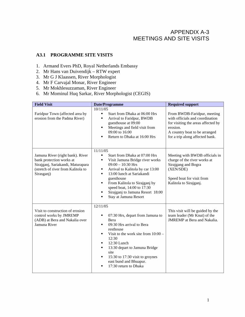
APPENDIX A-3 MEETINGS AND SITE VISITS
A3.1 PROGRAMME SITE VISITS 1. Armand Evers PhD, Royal Netherlands Embassy 2. Mr Hans van Duivendijk – RTW expert 3. Mr G J Klaassen, River Morphologist 4. Mr F Carvajal Monar, River Engineer 5. Mr Mokhlesuzzaman, River Engineer 6. Mr Mominul Huq Sarkar, River Morphologist (CEGIS)
Field Visit Date/Programme Required support Faridpur Town (affected area by erosion from the Padma River)
10/11/05 Start from Dhaka at 06:00 Hrs Arrival to Faridpur, BWDB
guesthouse at 09:00 Meetings and field visit from
09:00 to 16:00 Return to Dhaka at 16:00 Hrs
From BWDB-Faridpur, meeting with officials and coordination for visiting the areas affected by erosion. A country boat to be arranged for a trip along affected bank.
Jamuna River (right bank). River bank protection works at Sirajganj, Sariakandi, Maturapara (stretch of river from Kalitola to Sirasganj)
11/11/05 Start from Dhaka at 07:00 Hrs Visit Jamuna Bridge river works
09:00 – 10:30 Hrs Arrival to Kalitola by car 13:00 13:00 lunch at Sariakandi
guesthouse From Kalitola to Sirajganj by
speed boat, 14:00 to 17:30 Sirajganj to Jamuna Resort 18:00 Stay at Jamuna Resort
Meeting with BWDB officials in charge of the river works at Sirajgang and Bogra (XEN/SDE) Speed boat for visit from Kalitola to Sirajganj.
Visit to construction of erosion control works by JMREMP (ADB) at Bera and Nakalia over Jamuna River
12/11/05
07:30 Hrs, depart from Jamuna to Bera
09:30 Hrs arrival to Bera resthouse
Visit to the work site from 10:00 – 12:30
12:30 Lunch 13:30 depart to Jamuna Bridge
site 15:30 to 17:30 visit to groynes
east bund and Bhuapur. 17:30 return to Dhaka
This visit will be guided by the team leader (Mr Knut) of the JMREMP at Bera and Nakalia.
1

A3.2 Persons met during the site visits
Royal Netherlands Embassy: Dr Armand Evers, First Secretary Water Sector;
Mr. Peter Frerichs, Senior Administration Officer, Development Co-operation
Bangladesh Water Development Board (BWDB)-Dhaka Mr. Md. Habibur Rahman, Chief Planning, BWDB, WAPDA Building; 9.30 hrs; (08-11-05)
Faridpur:
Mr. Md. Giasuddin, Superintending Engineer, Faridpur O&M Circle, BWDB, (2) Mr. Md. A.Khair, Sub-Divisional Engineer, Faridpur O&M Sub-Division, Faridpur, (3) Mr. M.A.Aziz, DG, RRI, Faridpur, (2) Mr. Swapan K Das, PCO, RRI,
Sirajganj: (1) Mr. Tapan Kumar Saha, Executive Engineer, Sirajganj Specialised Division,
(2) Mr. Nijamul Hoque, Executive Engineer, BWDB, Sirajganj
Bera:
Mr. Sharafat Hossain, Executive Engineer, Bera O&M Division, BWDB.
JMREMP: (1) Mr.Henryk Warszko, Consultant, Site Engineer, JMREMP,
(2) Mr. Knut Oberhagemann, Team Leader, Consultant, JMREMP,
(3) Mr. Sharif Al Kamal, Project Director, JMREMP, BWDB.(12-11-05)
Ministry of Water Resources (wrap-up meeting): (1) Mr.Md. Jahrul Islam, Secretary, MoWR, GOB,
(2) Mr. habibulla Majumder, Joint Secretary, MoWR, GOB,
(3) Ms. Tajkira, Sr. Assistant Secretary, MoWR,
(4) Mr. Md. Aminul Haque, ADG, O&M-2, BWDB,
(5) Mr. Md. Habibur Rahman, Chief Planning, BWDB.
2

BWDB Dhaka (1) Mr. Sharif rafiqul Islam, DG, BWDB,
(2) Mr.Md.Aminul Haque, ADG, O&M-2, BWDB,
(3) Mr. Zulfiquar Haider, Chief engineer, Design, BWDB,
(4) Mr. Habibur Rahman, Chief Planning, BWDB, A3.3 Meetings A3.3.1 Technical meeting of team members with Knut Oberhagemann, Team Leader JMREMP on 9th November 2005 During the meeting a great number of questions were asked and topics discussed. Below the discussions are summarized. All topics were related to the bank protection works as carried out at present and in the last three years in PIRDP and MDIP. Siting Bank protection will be constructed at threatened sites. Land acquisition is avoided in first instance by only dumping bags on the foreshore, ie at the river side of the bank line. If the protection turns out to be stable the work above water up to flood embankment level will be carried out in the next dry season and after the necessary land acquisition has been done. Bags are not placed any longer at OGL (or slightly down after excavation at a level just above SLW) in view of time consuming and socially less desirable land acquisition. At present a mix of 120 kg and 78 kg bags is dumped but it is the experience that it makes no difference whether or not all bags have the same size or not. For a smooth organization and control it is better if only one size is dumped in a certain project. Cross-section Bags are dumped in such numbers that three layers are finally placed. The bags are dumped over the width of the slope plus 12 m wide over the hor. river bed. This last 12 m may act as falling apron. So far maximum depth of dumping has been at PWD – 23 m. (during flood the water level is at PWD + 11 m but this is not relevant for design). Next dry season the protection is inspected by drivers and bags supplemented if required. Above water no bags are used because of vandalism. Here a revetment is made applying CC blocks as pitching. Sofar, it would appear that the consolidated bank material1 after protection is stable at slopes of 1V: 2H or even 1V: 1.5 H.
1 Note that the bank material in the Jamuna Bridge Project was not stable because the slope of the dredged trench was in a recently deposited char which had low reltaive densities. Thus much more gentle slopes were required for stability reasons.
3

Length profile In the present protection works no special arrangements are made for the u/s and d/s ends. Additional work might be required in 10-20 years time. When and where such works are necessary is a matter of monitoring (see CEGIS reports). Method of construction Dumping is controlled by moving the barge one metre after dumping one row of bags placed at the edge of the barge. The row of bags is replaced manually from a stock of bags on the barge. The bags are regularly replenished from stocks on the banks using country boats. The dumping is done parallel to2 and in the direction of the bank (ie in the upward direction of the slope). All bags are handled manually. Bags The geo bags are already manufactured manually. The geotextile used is non-woven and has openings such that fine sand can be used. No silt or clay is accepted as fill. Max accepted silt content is 3 %. The bags are filled with relatively dry sand dredged on the foreshore (dry density ρ = 1500 kg/m3. The filling is 100% in dry condition, after dumping the sand will compact and then the filling is 85 %. After a few weeks the current has smoothed out the sand in the bags. Stitched bags at present come to Tk 60/m2 of bag. Bags cost half the price of CC blocks. On the basis of the loan US$ 3.5 million/km bank length can be spent but sofar it was less. Contracts Contracts should have a substantial size, otherwise the contractor is not able to mobilize the required fleet of equipment. Biggest contract sofar has been US$ 2 million. The contracts are tendered internationally but present contracts are handled by Bangladeshi contractors. Reports The Team Leader confirmed that no report is at yet available about the experience with bank protection works constructed during the last two dry seasons. But background information can be found in the Inception Report (Jan. 2005) and the Report on Geobag Protection (Project Concept, Experience, Future) (June 2003). A3.3.2 Wrap-up meeting at Ministry of Water Resources on 17 November at 3:30 PM. (Please refer to minutes of meeting, under preparation by MOWR)
2 It has been proposed to test a dumping carried out perpendicular to the bank.
4

1
APPENDIX A-4 REPORTS AND OTHER PUBLICATIONS
(in chronological order)
TITLE AUTHOR, CONSULTANT OR
INSTITUTE
CLIENT DATE OF ISSUE
Draft Report (Preliminary) on Feasibility Study for the Protection of Faridpur Town from Flood, Erosion and Drainage Congestion
Bureau of Consulting Engineers Ltd.
BWDB April 23, 1968
Study Report on Flood Control and River Training Project on the Brahmaputra River in Bangladesh; Ex. Summary
China-Bangladesh Joint Expert Team
Peoples Republic of China/GOB
March 1991
FAP- …, Meghna River Long-term Strategic Plan: Terms of Reference
- GOB/BWDB/FAP March 1992
Morphological Impact Assessment Project for the Main River System of Bangladesh (Project Document-I, Mission Report)
IWM /Project Formulation Mission
GOB/BWDB September 1994
The Dynamic Physical and Human Environment of Riverine Charlands: PADMA
ISPAN MoWR/Flood Plan Coordination Organization (FPCO)
April 1995
FAP (Morphological Study) Morphological Impact Assessment Project for the Main River System of Bangladesh. Technical Assistant Project Proforma (TAPP
GOB/MoWR/ FPCO October 1995
Bank Protection Pilot Project FAP – 21 Consulting Consortium FAP 21/22 Test Site II – Bahadurabad Construction of Revetment Test Structures – Implementation of Works in the Season 1996-97, Volume V-4 (as Built Drawings)
Jamuna Test works Consultants, Joint Venture, RRI-GES.MBH/CNDU RHONE/L&P/Delft /BETS/DUL
GOB/MoWR/ WARPO
June 1997
National Water Policy GOB/MoWR January 30, 1999 Bank Protection and River Training (AFPM) Pilot Project FAP 21/22 Test and Implementation Phase Reports on Sub-Water Investigations: Visual Inspection by Diving, and Side Scan Sonar Survey at Test Site II-Bahadurabad
Jamuna Test works Consultants, Joint Venture, RRI-GES.MBH/CNDU RHONE/L&P/Delft /BETS/DUL
GOB/MoWR/ WARPO
Feb and Mar 1999
On Training of the Jamuna River Mr. MD. Sohel Masud; M.Sc. Thesis H. E. 057
IHE Delft/HAM April 2000
CADP-River erosion Prevention and Morphology Study; PIRDP, Final Report (Annex – B): River Training and Bank Protection Designs,
DHV BWDB December 2000
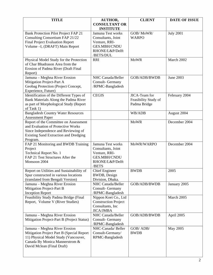
2
TITLE AUTHOR, CONSULTANT OR
INSTITUTE
CLIENT DATE OF ISSUE
Bank Protection Pilot Project FAP 21 Consulting Consortium FAP 21/22 Final Project Evaluation Report Volume –I, (DRAFT) Main Report
Jamuna Test works Consultants, Joint Venture, RRI-GES.MBH/CNDU RHONE/L&P/Delft /BETS/DUL
GOB/ MoWR/ WARPO
July 2001
Physical Model Study for the Protection of Char Bhadrason Area from the Erosion of Padma River (Draft Final Report)
RRI MoWR March 2002
Jamuna – Meghna River Erosion Mitigation Project-Part A Geobag Protection (Project Concept, Experience, Future)
NHC Canada/Beller Consult- Germany /RPMC-Bangladesh
GOB/ADB/BWDB June 2003
Identification of the Different Types of Bank Materials Along the Padma River as part of Morphological Study (Report of Task 1)
CEGIS JICA-Team for Feasibility Study of Padma Bridge
February 2004
Bangladesh Country Water Resources Assessment Paper
WB/ADB August 2004
Report of the Committee on Assessment and Evaluation of Protective Works Since Independence and Reviewing of Existing Sand Extraction and Dredging Program.
MoWR December 2004
FAP 21 Monitoring and BWDB Training Project Technical Report No. 1 FAP 21 Test Structures After the Monsoon 2004
Jamuna Test works Consultants, Joint Venture, RRI-GES.MBH/CNDU RHONE/L&P/Delft /BETS
MoWR/WARPO December 2004
Report on Utilities and Sustainability of Spur constructed in various locations (translated from Bengali Version)
Chief Engineer BWDB, Design Division, Dhaka.
BWDB 2005
Jamuna – Meghna River Erosion Mitigation Project-Part B Inception Report
NHC Canada/Beller Consult- Germany /RPMC-Bangladesh
GOB/ADB/BWDB January 2005
Feasibility Study Padma Bridge (Final Report, Volume V (River Studies)
Nippon Koei Co., Ltd Construction Project Consultants, Inc JICA/JMBA
March 2005
Jamuna – Meghna River Erosion Mitigation Project-Part B (Project Status)
NHC Canada/Beller Consult- Germany /RPMC-Bangladesh
GOB/ADB/BWDB April 2005
Jamuna – Meghna River Erosion Mitigation Project Part B (Special Report 11) Physical Model Study (Vancouver, Canada By Monica Mannerstrom & David Mclean (Final Draft)
NHC-Canada/ Beller Consult-Germany/ RPMC-Bangladesh
GOB/ ADB/ BWDB
May 2005

3
TITLE AUTHOR, CONSULTANT OR
INSTITUTE
CLIENT DATE OF ISSUE
Monitoring and Prediction of Bank Erosion along the Right Bank of Jamuna River, 2005 (EMIN Project)
CEGIS WARPO/BWDB May 2005
Statement of Completed Works of Faridpur – Barisal FCD Project (Faridpur Unit)
BWDB May 30, 2005
Jamuna – Meghna River Erosion Mitigation Project-Part B Note on Field Visit 6th June 2005
NHC Canada/Beller Consult- Germany /RPMC-Bangladesh
GOB/ADB/BWDB June 2005
Faridpur Town and Char Bhadrasan Area Protection Project (Feasibility Study-Survey Data Report)
IWM BWDB June 25, 2005
Prediction for Bank Erosion and Morphological Changes of the Jamuna and Padma Rivers 2005. (Prepared by EMIN project of WARPO and JMREM project of BWDB)
NHC-Canada/ RADAR SAT International/ CEGIS
WARPO/BWDB July 2005
Investigations regarding effectiveness of submerged spur by physical modelling to address the bank erosion problem of Bangladesh
RRI BWDB August 2005
Developing Empirical Methods for Predicting Morphological Changes in the Padma River
CEGIS September 2005
Feasibility Study for protection of Flood Embankment of Faridpur- Barisal Project (Faridpur Unit) and Faridpur Town from the Erosion of the River Padma in the Sadar and Char Bhadrasan Upazilla under Faridpur District, a sub-project of "Feasibility Study for new Projects under BWDB"; Technical Note on immediate options for erosion mitigation measures and design of recommended option
IWM GOB/BWDB October 2005

4
Table 1.1: List of Satellite Image information and corresponding water levels at Baruria, used by the mission
Year Image date Image Type Resolution WL at Baruria (m+PWD)
1973 21 February Landsat MSS 80 x 80 m 2.51 1976 10 January Landsat MSS 80 x 80 m - 1980 21 February Landsat MSS 80 x 80 m 2.00 1984 25 February Landsat MSS 80 x 80 m 1.66 1989 28 February Landsat TM 30 x 30 m 2.33 1993 11 March Landsat TM 30 x 30 m 2.14 1994 25 January Landsat TM 30 x 30 m 2.22 1995 28 January Landsat TM 30 x 30 m 1.78 1996 31 January Landsat TM 30 x 30 m 2.17 1997 18 February Landsat TM 30 x 30 m 2.06 1998 5 February Landsat TM 30 x 30 m 2.18 1999 19 January Landsat TM 30 x 30 m 2.53 2000 19 February Landsat TM 30 x 30 m 1.93 2001 28 January Landsat TM 30 x 30 m 1.77 2002 24 February Landsat TM 30 x 30 m 1.61 2003 19 January Landsat TM 30 x 30 m 1.99 2003 11 December IRS LISS 24 x 24 m 3.58 2005 8 January IRS LISS 24 x 24 m 2.33

APPENDIX A-5 EXPERIENCE WITH BANK PROTECTION WORKS IN
BANGLADESH A5.1 Background Bangladesh, a land having an area of 147,570 sq km, is located at the lower part of the basins of the three mighty rivers of the world, the Ganges, the Brahmaputra and the Meghna. The total area of the catchments of these rivers stands at 1.72 million sq. km embracing parts of China, Nepal, Bhutan, India and Bangladesh, the latter only representing 7% of the overall catchment. The history of developments of Bangladesh rivers is a history of channel switching and gradual migration and, sometimes, sudden avulsion. A fine sedimentary environment characterizes sedimentological aspects of Bangladesh. The rivers are highly mobile with continuous reworking and deformation of their beds and banks, transporting huge quantities of sediment. As a result there is active bank erosion all over the country at different reaches of the rivers and along the coastline. The rivers of Bangladesh continually erode one bank or build the other. The process of erosion has engulfed large areas of cities and towns, agricultural lands and villages. The increasing population density forces the people to live in areas prone to erosion and flooding. Bank protection plays a dominant role in this country to prevent loss of valuable floodplain land and infra-structure and thereby help alleviation of poverty. Erosion along the major river of Bangladesh may be termed as a disaster. The disaster affects only those who reside at or near the bank of a major river and, suddenly, within a few days or week, loose all their land and homestead. Even some wealthy farmers may turn into slum dwellers within a few weeks. The inhabitants, living a few kilometers away from the bank are not affected by such calamity, so it is always a localized disaster that may affect several kilometers along the riverbank within a few weeks in a year It is estimated that more than 1200 km of bank length of rivers is under active erosion of which a major portion causes a severe erosion problem. A number of cities and towns and many places of historical importance are already under active erosion. Analysis of the satellite images, performed by CEGIS, for the last three decades (1973-2004) shows that both banks of the Jamuna and Padma rivers are migrating outwards; the rivers are widening. During this period (1973-2004) erosion along the Jamuna river was 87,790 ha and accretion was 12,490 ha. Along the Padma River the erosion was 29,390 ha while accretion was 4,800 ha. During these three decades net erosion along the Jamuna and Padma rivers amounted to 75,300 ha and 24,590 ha respectively, making a total of 99,890 ha (about 1000 km2). In the same study it is observed that in 2004 erosion along the Jamuna river was 2,605 ha, out of which 426 ha comprised settlements. A5.2 Bank Protection Works Implemented Bangladesh has been struggling to cope with this river instability and a number of projects have been implemented and some are under implementation to mitigate the problems of
1

erosion. Some of these projects appeared extremely fruitful, a few were partially successful but also quite a few failed or have not yet been attacked by the river. In the past about 416 km of bank revetment and 207 groynes/spurs were constructed by BWDB at a cost of about Tk. 30,320 million of which 366 km revetment and 195 groynes/spurs (88% and 94% respectively) are still working satisfactorily. In the protection works the hard materials used are natural boulders, quarry-blasted rock, boulder/stone crates, concrete cubes, concrete slabs (slope protection), sand-cement blocks, sand-cement bags and geo-textile bags filled with sand. In some of the temporary and emergency protection works jute bags/synthetic bags filled with clay or sand, brick crates and geo-textile bags filled with sand are being used. Boulders and quarry-blasted rock are not normally available in Bangladesh in sufficient quantities. These have to be imported from neighbouring countries. The use of boulders, stones or concrete blocks as hard material does not always appear to be cost-effective. Under these conditions alternatives for the traditional hard materials are a necessity. A5.3 Performance and Sustainability of Bank Protection Works A5.3.1 General In general, a multiple of factors are hampering the development of sustainable river bank protection These are (1) abrupt and sharp changes of river behavior and morphology, (2) lack of prediction tools for channel migration and erosion attack, (3) high cost of protective works in relation to the available funds, (4) inflexible budget allocation and lengthy approval procedures, and (5) high repair and maintenance cost during and after extreme events like large floods, erosion, etc. The fast changing river conditions render it ineffective to build short lengths of bank protection. Short lengths of bank revetment at points of active river attack in major rivers of Bangladesh are usually not effective in the long-term since the attack in most cases shifts to other points and outflanks or attempt to outflank the protection. The groynes/spurs constructed in medium and minor rivers having predominantly single channels are functioning satisfactorily even without any appreciable maintenance cost. But the maintenance of those constructed in braided and wandering rivers like Brahmaputra-Jamuna and in some parts of the Ganges has become difficult and very costly though the implementation cost is much cheaper in comparison to that of revetments. The morphological changes in the rivers in most cases tend to outflank groynes/spurs or create parallel flow along the long shank establishing an extremely difficult situation for stability of the groynes/spurs. When taking account of all these considerations one may state that bank protection in major rivers by means of long stretches of revetment appears to be dependable, sustainable and economic in the long run. The revetment works undertaken at present by BWDB in Debdanga and Titporol in the Jamuna river support the statement that the river would outflank the Kalitola and Mathurapara hard points if proper measures were not taken in time. A5.3.2 Jamuna Bridge Guide bunds When designing the guide bunds (2x3200m) for the Jamuna bridge a maximum scour depth of 40 to 45 m, resulting in a bed level of (-) 30.00 m PWD, a depth averaged velocity of 2.1 to
2
4.3 m/sec, an average annual sediment transport of 600 million tons and an average grain size D50 = 0.18 mm was considered. No damage has been reported since the completion (1997) of both these guide bunds. Construction cost of these river training works amounted to about US$ 43,300/m. Bhuapur Revetment The revetment at Bhuapur Hard point (1700m), part of the river training for Jamuna Bridge, is designed to protect the bank lines up to a scour depth of (-) 20.00 m (PWD). The structure, consisting of a cellular geo-textile mattress filled with sand-asphalt, built in the dry, is designed to gradually launch following bank erosion. During the 10 years of its existence this revetment has experienced direct river attack during a number of consecutive years and, as a consequence, the revetment was partly launched. Construction cost of Bhuapur Hard point amounted to US$ 7000/m. A5.3.3 Sirajganj Hard point In Sirajganj Town Protection (2500m of revetment, also functioning as Hard point of the river training works for Jamuna Bridge) a maximum scour depth of 29.00 m for a 1:100 year flood event was used in the design, while for the upstream termination 33.00 m was used. Protection by falling apron was placed at (-) 4.2 m PWD, the revetment slope from top of embankment to the apron level was 1V:3.5H. The width of apron was determined to be 1.5 times the depth of the expected max. scour hole. Thus, the in-built reserve would be for a 33.00 m deep scour at the revetments and 44.00 m for the upstream termination and spur heads. The design was based on the expectation that a maximum scour down to (-) 30 m PWD (45m water depth) can occur, but such scour would be situated at a distance of more than 100 meters from the nose of the structures. Construction cost amounted to US$ 29,400/m Sirajganj hard point was severely damaged during the flood of 1998, scour observed at the vicinity of the upstream nose was in the order of (-) 33.00 m PWD. The cost of repair of the damage was about US$ 15 million, while the proposal for repair after 1999 flood amounted to US$ 1.9 million. The scour hole developed during the damage, the extent of damage and the requirement for maintenance exceeded the expectations made during the design. The morphological changes creating an unfavorable channel planform with deep confluence scour upstream, type of subsoil, etc. were the main reasons for the failure. The Sirajganj Hard point is at present again under a serious threat due to upstream embayment. Scour observed in the vicinity of the upstream nose during the survey made in July-August 2005 is in the order of (-) 40.00 m PWD. This is known to be the deepest scour observed so far after the construction of the Hard point. The present condition of the Hard point and the extremely high scour in the vicinity of the upstream nose might be due to the upstream embayment created after the failure of Sailabari Groyne. Timely attention aiming to arrest the westward migration of the bank line upstream of the Sirajganj Hard point might prevent the development of such extreme scour at the upstream area of the Hard point. A5.3.4 Kalitola, Sariakandi and Mathurapara Hard Points Design loads for Kalitola, Sariakandi and Mathurapara Hard points are as described for Sirajgang town protection, only water levels differ. The apron level for Kalitala and Sariakandi was at (+) 0.43 m PWD and that for Mathurapara was at (+) 0.18 m PWD. The revetment slope from apron level to top of embankment was 1V:3.5H. Construction cost for strengthening of Kalitola Groyne, Sariakandi Hard point (661m) and Mathurapara Hard point (679m) was about US$ 12,100/m.
3
After completion of construction of Sariakandi Hard point in 1998 no damage was reported. Mathurapara hard point experienced significant scour at its upstream point. During the 1999 flood scour reached a level of (-) 12.5 m PWD by the end of July. Afterwards, by the end of August, siltation took place up to (-) 7.7 m PWD. No remedial measures were taken. Kalitola spur was completed in 1998. The next year, on 6th July 1999, the first damage of the spur head occurred, which was countered by dumping CC-blocks until 25th of that month, but the dumping was resumed from mid-August onwards when the scour level reached (-) 12.00 m PWD. The last available measurement (September 2000) showed a scour level of (-) 14.50 m PWD. During the 2000 flood more than 100,000 geo-textile bags of different sizes were dumped at a cost of about Tk. 20 million. During the next low water season the revetment and falling apron were rebuilt for more than Tk. 100 million. So total repair cost of Kalitola Groyne was about Tk.120 million (US$ 20.00 million, 1 US$= Tk.60.00) after construction. The aim of Kalitola, Sariakandi and Mathurapara Hard points was to prevent the Jamuna river from breaking into the Bangali River which is supposed to carry the risk of bypassing Jamuna Bridge1. The three Hard points constructed in a series were successful for a short period in stopping the breaking of Jamuna River into the Bangali River. Given the morphological changes of Jamuna river the possibility of connection of the Jamuna river with the Bangali River has again been created in Titporol and Debdanga. In order to avoid this happening and also to save Kalitola and Mathurapara Hard points from being outflanked, revetment construction at Titporal and Debdanga along the right bank of the Jamuna has been taken up (see below). The distance between Kalitola and Sariakandi Hard point is about 2.1 km and that between Sariakandi and Mathurapara is about 2.15 km. These three structures, in addition to their function to prevent a merger of Bangali River and Jamuna River, were also protecting a bank length of about 6 km. The shifting of the point of attack due to changed morphology has created a possibility for outflanking of the protection work and, finally, a possibility of a merger of Bangali and Jamuna. To avoid such outflanking, revetment work at Titporol, 2000m upstream of Kalitola, and at Debdanga, 1273m downstream of Mathurapara, had to be undertaken in 2005 at a cost of about Tk.610 million and Tk.420 million respectively.. After the construction of a series of Hard points at Kalitola, Sariakandi and Mathurapara in 1998, it is observed that the river has changed its point of attack, with the possibility of outflanking the protection work already constructed. It is therefore concluded that this type of problem could have been handled more efficiently with an adaptive approach, applying a continuous revetment with cheaper materials and a phased approach in protecting the bank as and when needed. A5.3.5 Bahadurabad Hard Point Terms of reference for Bahadurabad Revetment Structure specified that a low safety level had to be applied in order to study failure of a part of the structure. In this manner one would be able to arrive at economical solutions without endangering the total protective work. The structure was built in 1996/97. The design concept reflected the test character by establishing eight different sections, having an overall length of 800 m, where different design alternatives and materials were tested. The launching and falling apron were constructed above water at a level of (+) 13.80 m to 15.30 m PWD. The revetment slope from apron to crest level of embankment (at + 22.00 m PWD) was 1V:3H. Cost of construction was about US$ 10,500/m. 1 For the record it is recalled that there is no general agreement among experts about the seriousness of the consequences of a direct connection between Jamuna and Bangali rivers.
4

During the 1997 flood the Hard point was exposed to full flow attack with velocities up to 4 m/sec. During the 1998 flood, after initial erosion in the area, large depositions took place and since then the structure faces normal flow attack only during monsoon. Adaptation and maintenance cost for Bahadurabad Revetment structure from 1997 until the end of 2000 (mainly concerning the strengthening of the downstream termination point) amounted to US$ 360,000. A5.3.6 Ghutail Hard Point Ghutail Revetment Structure was based on the experience gained from Bahadurabad Structure. The structure was built with a lower safety level because of fund constraints while a future extension and completion through BWDB was foreseen. The structure was built in the dry season of 1999-2000 at a cost of US$ 3.56 million. The structure is 600 m long protecting about 530 m of bank line. The upstream termination of the structure could not be constructed due to paucity of fund. The upstream part of the structure was damaged during the 2004 flood due to embayment. Dumping sand filled geo-bags in apron and slope could stop failure of the structure. Even then the structure could save a huge settlement area from erosion of the river Jamuna at the back and downstream of the revetment. After the severe erosion in 2004 and early 2005 flood the river has a tendency to shift its course away from the structure. Continuous monitoring and observation will be required to timely carry out proper repair measures. A5.3.7 Chandpur Town Protection The classical example of fighting nature with very limited resources is the protection of Chandpur Town. Located on the left bank just downstream of the confluence of Upper Meghna and Padma rivers and thus exposed to the full fury of the combined flow of the Padma and Meghna during high monsoon, the town is being protected on a contingency basis from the early seventies until now. From 1972/73 until 2005 an amount of about Tk.1,100 million has been spent to save the town and its adjacent bank line over a length of about 2.9 km. The town still remains as vulnerable to erosion as before. The deepest scour hole (at (-) 65.0 m PWD) in front of the Mole head (small protrusion just upstream of the mouth of the Dakatia river) is about 70 m measured from high water level. A5.3.8 Rajshahi Town Protection Another example is the protection of Rajshahi Town from the erosive attack of the river Ganges. The protection provided by means of 10 no. of groynes/spurs, about 3 km of brick mattress and about 4.6 km of revetment works from 1973 to 2003 could protect the town from the fury of the flood of the Ganges river. Total construction and maintenance cost from 1973 to 2003 for all the components constructed for the protection is about Tk.862 million. A5.4 JMREMP (Jamuna Meghna River Erosion Mitigation Project) ADB provided technical assistance from 2000-02 to identify and assess potential options to mitigate the impacts of riverbank protection and to analyze the feasibility of identified options for possible investment assistance. The feasibility study conducted by Halcrow Group Ltd and Associates (Final Report, May 2002 and Addendum, October 2002) recommends using a revetment incorporating a falling apron (launching) consisting of loose material. In the interest of reducing the cost, geo-bags are considered for this option. Considering the maximum expected scour below LWL (30.0 m for PIRDP and 20.0 m for MDIP), the suggested apron protection in PIRDP is 181 units of geo-bags/m, i.e. 60.8 m3/m
5

and in MDIP 121 units/m, i.e. 40.7 m3/m The volume of material2 is computed by estimating the maximum possible scour and assuming a 1V: 2H launch slope of the falling apron. In the first year (pilot phase) for a 15m launch at a launch angle of 1V:2H the launched length to be covered is 33.5m ( = 15 x √5). If the launched material thickness is taken at 0.61m, 20.45m3 (61 units/m) of material will be required to cover the slope. The feasibility study in 2001-2002 suggested an new approach: a passive and adaptive approach to manage river erosion by placing protection works parallel to the natural alignment of the river system, by installing revetments with launching sections using sand filled geo-textile bags, at a cost of about half the cost of conventional materials. It is an adaptive approach, which means that interventions are planned according to observed and predicted river behavior. The major achievement was the successful protection of the flood embankments at both sub-projects during the exceptional 2004 flood. More than 5 km of riverbank protection was built to a first major level of protection from April to July 2004 and it survived the flood season without any significant damage. Subsequently, more than 3 km of underwater protection were added after the flood season, with an additional 750 m of pilot wave protection above water level. A5.4.1 PIRDP (Pabna Irrigation and Rural Development Project) When taking into account the protection work undertaken in the pre-project stage under the phased programme (2002 to 2005) in the same reach in PIRDP, the figure attained as cost per linear meter of launching apron is Tk.106,000/m. When the provision of slope protection above (+) 2.00 m PWD with CC- blocks and a geo-textile filter is included, the total cost is estimated to be Tk.146,000/m. This additional cost and its contribution in the protective work need to be assessed in more detail. A5.4.2 MDIP (Meghna Dhonagoda Irrigation Project) Based on the 2002 feasibility study the morphological studies identified two distinct reaches of the bank from Ekhlaspur to Dasani under MDIP being under threat. A staged implementation program is considered. A reach of about 4.4 km length is recommended for implementation under Stage-I. Based on the future point of river attack, the two sub-reaches would be identified later, taking up one of the sub-reaches under Stage-II for early protection. Taking account of protection works undertaken in the pre-project stage under GOB funding and supervised by the project consultant, the cost of apron protection (2002-05) and temporary protection against wave action stands at about Tk.84,000/m.. If a provision of slope protection with CC-blocs over a geo-textile filter from (-) 2.00 m PWD to the average bank level is included, the total cost is estimated to be Tk.119,000/m. A5.5 Faridpur Town Protection From 1993 to date the river Padma eroded about 40 square miles of land adjacent to Faridpur Town. The Padma was about 3.9 km away from Faridpur in 1993, at present the distance is hardly 700m.
2 1unit = 504kg = 1bag of 126kg + 1.61bags of 78kg + 3.52bags of 36kg + 11.32bags of 11kg; = 0.336m3; the unit weigh. of sand = 1500kg/m3.
6

A model study conducted by RRI (River Research Institute) recommended the construction of a revetment along 9800 m of riverbank to protect Faridpur Town and Char Bhadrasan area from erosion by the river Padma. Meanwhile 220 m of revetment has already been constructed, the remaining 9480m is proposed to be constructed in two phases; 1st phase to be completed in 2 years and second phase to be followed immediately afterwards. The ECNEC meeting held on 3rd September 2003 suggested the formulation of a project document (PCP). Accordingly, a project document (PCP) was prepared for a total cost of Tk.3187.4 million and proposed for implementation in two phases. A meeting held by the Planning Commission on 7th January 2004 discussed rationalization of the project and recommended execution of the most vulnerable components of the project in a 1st phase. The PCP for the first phase, approved by ECNEC on 11th February 2004, was to protect 4000m of the most vulnerable parts of the bank line for a cost of Tk.1,080 million. The revetment protection undertaken in 2004 and completed in the same year in the area adjacent to Faridpur Town over a length of 640m (CC- blocks and sand filled geo-bags) costing Tk. 108.7 million completely washed away already on 26th May 2004. The plan for this year (2005-2006) is to construct 464m of revetment and 150m of end termination for a cost of Tk. 127.00 million. A5.6 Erosion Prediction and River Monitoring Erosion predictions and their proper dissemination to national and local organizations as well as to communities have a great potential to enhance water resources planning both at macro and micro levels, reducing national losses and suffering of erosion by vulnerable people. Predicting morphological changes provides an opportunity to concentrate protection efforts on immediately threatened reaches and reduces the risk of implementation failure in the time available in the low-water construction season. The identification of the potential for the riverbank erosion, and subsequent need for stabilization, is best accomplished through observation. Prediction of erosion and morphological changes one year ahead with different probabilities can be of much help for taking care of certain extreme situations that may occur during the next monsoon. Preparatory activities of the Government for facing the probable calamities through erosion can be of great help for acting at the proper time and in the right order. A5.7 Design Development The main objective of river training is to stabilize the bank line to an extent that assures the safety of the hinterland. The extent of stabilization can vary between full protection in the form of a revetment, or in creating a dynamic equilibrium by using other types of structural solutions. For that purpose the most cost-effective solutions must be selected in terms of investment as well as operation and maintenance. Local resources and techniques should be incorporated to the highest extent possible. In designing stabilization structures, it is important to consider cost and it is even more important to analyze and understand the failure mechanism that causes maintenance problems for the different parts of the structure.
7

An attempt should also be made to use locally available construction materials. An economical source of quarry-blasted rock is not available in Bangladesh; therefore a new material for ballasting and protecting erodable soils is required. In this respect it is noted that concrete cubes (CC-blocks) are also expensive. Standardized solutions for all major rivers suitable for all types of loads, with only their quantities adopted for different depth, shall be developed to allow an easy implementation during emergencies without being dependent on long planning and design procedures. A5.8 Protection Length The length of protection concerns the longitudinal and vertical extent of protection required to adequately protect the riverbank. Analysis of site-specific factors is necessary to define the actual extent of protection required. The longitudinal extent of protection required for a particular bank protection scheme is highly dependent on local site conditions. Fast changing river conditions render it ineffective to build short lengths of localized bank protection and require the protection of longer reaches. In general, the revetment should be continuous over a distance greater than the length of bank that is threatened by channel-flow forces severe enough to cause dislodging and/or transport of bank material. Bank erosion in major rivers of Bangladesh extends to several kilometers in one place, or some times in different reaches, depending on the flow pattern and morphological behavior. Protection measures taken for a short reach where attack on several kilometers is active, or where at least another upstream reach has to be protected simultaneously, may invite failure of the attempt and may harm the properties and infra-structure more severely. A5.9 Prioritization In view of the limited funds available not all the places vulnerable to erosion can be protected at the same time. Hence a prioritization of the protective works needs to be undertaken. Prioritization of the works needs to be done by combining the erosion forecast and the pre-determined prioritization criteria. The predetermined criteria may follow certain guidelines like importance of the place or structure to be protected, severity of attack and consequences of not protecting the bank immediately. A5.10 Implementation & Funding Regular monitoring of river and structures provides an early warning system, allowing the start of emergency measures when unfavorable developments are detected. To carry out such emergency measures a block allocation of fund should be maintained under the Ministry of Water Resources. The reach to be protected shall be selected at least one year ahead depending on the forecast made by CEGIS (or any expert group) through morphological studies and the approved prioritization criteria. Since an adaptive approach shall be followed at the type of design and construction, the final site selection shall be made just before start of the work and after having available the pre-work survey. The contract must contain sufficient provisions for changed situations at the sites, which could result from sudden morphological changes during the preceding flood.
8
A5.11 Stock Piling Based on the prediction, the contingent plan for protection of a certain reach is made for the next year. Provisions have to be made also in terms of materials and equipment ready for emergency works (phased implementation). There are certain areas that may need immediate attention during the flood season. To face such a situation a stockpile of material shall be made at vulnerable locations to start emergency repair/protection works at very short notice. Stockpiled materials and pre-selected contractors, having equipment on stand-by, will enable immediate action during the flood season to limit the damage. A5.12 Contracts Practically all applicable construction measures needed for bank protection must be executed during the dry season, i.e. from November until April. Every contract for construction should be made for at least two years, the second year should be for strengthening the implemented work if required after continuous monitoring of the work. The contractor should be made responsible for maintenance of the structure during construction and at least for one year after completion of the contract for rapid response to any local failure and the usual maintenance of the work. This provision can also cover any delay in the first year due to the pre-tendering and pre-awarding stages of contract. The tender documents should contain flexible specifications and locations that allow to some extent modification to the design at the site in response to changing site conditions. The size/volume of a contract in a single package should be such that the contractor is able to mobilize heavy equipment within the contract provisions and can cope with any emergency situation. A number of small contracts let in the same place or in each others vicinity act as barrier to quality control and a desired protection is then mostly not achieved. A5.13 Monitoring /River Response In order to record the response of the river to the bank protection works and also the morphological changes afterwards systematic and well documented monitoring of the river behavior is required both during the implementation and also during operation of the structure. A5.14 Implementation Monitoring/Construction Supervision Monitoring during implementation ensures that the structure is built as per design. Both quality and quantity assurance is needed to guarantee that the hard materials or geo-bags are placed as per design while any deviation from the design due to changed site condition is recorded as executed. It is essential to observe and record the behavior of the river vs. protective work under different morphological and hydrological conditions. In order to be sure that a total quantity of material (in this case geo-bags filled with sand) for a particular reach (preferably 500m for rivers like the Jamuna) shall be made ready as per design before starting the dumping work in the river,. The material stacked for a particular reach should be clearly separated from the materials of another reach. Equipment and machinery required for the execution of the work, as specified in the tender documents, must be ready at site before starting of the actual construction. Without a proper execution and the availability of suitable monitoring equipment at site no work shall be allowed to be executed.
9

Table A5-1 Cost of Different types of Revetment Works Undertaken Name of work Main Component Materials used Cost/Meter
( Tk.) Remarks
(1)Jamuna Bridge, Jamuna River
(a) Two guide bundh, 2x3200m
Rock riprap, CC blocks, Geo-textile mattress and geo-textile filter
1,738,000 (1US$=BDT 40.37)
US$ 43,045/m
(2)Jamuna Bridge, Jamuna River
(a) Bhuapur Revetment-1550m
Cellular geo-textile mattress, scour (-) 20.0m
279,656 (1US$=BDT 40.37)
US$ 6,927/m
(3) Sirajganj Town Protection, Jamuna River
(a)Sirajganj Hard Point (2500m)
CC Blocks, Geo-textile mattress, geo-textile filter and sand filled geo-bag.
1,764,000 (1US$=BDT 60)
US$ 29,400/m
(4)River Bank Protection Project, Jamuna River (1995-1998) (length protected;4500m)
(a) Sariakandi Hard Point (661m), (b) Mathurapara Hard point (679m), © Kalitala Groyne
CC Blocks in slope over geo-textile filter and CC blocks in apron, Geo-textile bags
726,000 (1US$=BDT 60)
US$ 12,100/m
(5) FAP-21,22 (a) Bahadurabad Revetment (800m)
CC blocs, Brick blocks, Brick on edge covered by GI net, Geo-textile mat, Boulders
630,000 (1US$=BDT 60)
US$ 10,500/m
(b) Ghutail Revetment (600m)
CC blocks, Boulders, Geo-textile mattress and filter
356,000 (1US$=BDT 60)
Total cost= US$ 3.56 million =US$ 5,933/m
© Kamarjani Permeable Spurs, Protected length=2000m
Concrete Piles, steel piles, Boulders, Rocks
360,000 (1US$=BDT 60)
US$ 6,000/m
(6) Chandpur Town Protection, GOB, Padma-Meghna (1972-2005)
Revetment, short spur (Mole head), 2.9km
CC blocks, CC blocks and sand filled geo-bag during emergency.
379,300 Tk.110.00 Crore
(7)Rajshahi Town Protection, Ganges (1973-2003)
Revetment (4.55km),Brick Mattress (3.0km) spur (10 nos)
Brick, Wiremesh, CC block, RCC spur head, geo-textile filter
Tk.86.23 Crore
(8) Khulna Town Protection, STIFF-I, River Rupsha
Bank Revetment, 1685m
CC blocks over geo-textile mattress as apron, Cc blocks on geo-textile filter on slope
246,111 Total Cost- Tk. 414,698,000
(9) Habiganj Town Protection, STIFF-1, River-Khowai
Bank Revetment, 3920 m
CC blocks on slope and apron over geo-textile filter
25,510 Total cost- Tk.100,000,000
(10)Moulavibazar Town Protection, STIFF-1, River-Manu
Bank Revetment, 3963 m
CC blocks on slope and apron over geo-textile filter
23,910 Total cost, Tk.94,752,000
(11) Kurigram Town Protection, STIFF-1, River- Dharla
Bank Revetment, 5080 m
CC blocks on slope and apron over geo-textile filter
14,430 Total cost, Tk.73,305,000
10

Table A5-1 continued Name of work Main Component Materials used Cost/Meter
( Tk.) Remarks
(12) Bank protection in Debdanga and Titporol, Brahmaputra-Jamuna (2004-2005)
(a) Bank Revetment work at Debdanga (1273m), (b) Bank revetment works at Titporol (2000m)
(a)CC blocks over geo-textile filter on slope and CC block apron, (b) –do-
330,000 306,000
Work in progress
(13) Bank Protection at Godagari, Rajshahi, Ganges (2003-2004, 2004-2005)
(a) Bank Revetment (3600m)
(a) CC blocks over geo-textile filter on slope, block dumping between LLW and Av. LW and Geo-bag apron; (b) with CC blocs on slope over geo-textile, CC blocks dumping between LLW and Av.LW, CC block apron
155,000 270,000
Estimated as per design Estimated as per alternate design
(14)Bhola Town Protection, Bhola, Lower Meghna River (1992-2004)
Bank Revetment (2000m)
CC blocks on embank slope and CC blocks placed on trench as falling apron
156,000
(15) Protection of Tajumuddin Upzilla from erosion of Meghna River (2003-2004) and (2004-2005)
Bank revetment (990m)
(a) Emergency protection works by geo-textile bags filled with sand in apron and slope (a) CC block in slope over geo-textile filter and geo-textile bag filled with sand as apron, (b) CC block in slope over geo-textile filter and CC blocks in apron
105,000 123,750 225,212
Estimated as per design Estimated as per design. Estimated as per alternate design
11

Table A5-2 Cost and Condition of Spurs Implemented in Bangladesh Name of spur Name of River and
Location & Constrn time Constrn. Cost (Tk), Crore
Present condition
Remarks/ Repair cost
Vendabari spur-1 Vendabari spur-2 Vendabari spur-3
Teesta River, Nilphamari; 1999-2000
2.850 2.650 1.980
Effective Effective Effective
Shailmari spur-1 Shailmari spur-2
Teesta River, Gangachhara 2001-2002
3.810 3.060
Effective Effective
Tk.2.00 lacs/ year each
Kolkanda spur-1 Kolkanda spur-2
Teesta River, Rangpur Under Construction
3.120 3.590
Not yet completed
Tk.2.00 lacs/ year each
Mahiskhocha spr Teesta River, Lalmanirhat Under Construction
4.500 Not yet completed
Mahiskhocha spur-2 Teesta River, Lalmanirhat, 2003-04
4.427 Partly damaged
Tk.95.00 lacs
Paikerchara spur-1 Paikerchara spur-2
Dudhkumar river, Kurigram; 1999-2000
2.750 0.480
Effective Effective
Burirhat spur Dudhkumar river, Kurigram; 1999-2000
1.500 Effective
Meghai spur-1 Meghai spur-2 Meghai spur-3
Jamuna River, Sirajganj, 1999-2000 2001
19.140 12.440 10.000
Effective Effective Partially damaged
Singrabari spur-1 Singrabari spur-2
Jamuna River, Sirajganj, 1999-2000
4.680 4.010
Effective Effective
Subhagacha spur-1 Subhagacha spur-2
Jamuna River, Sirajganj, 2000-2001
4.950 14.520
Damaged Damaged
Simla spur-1 Simla spur-2 Simla spur-3
Jamuna River, Sirajganj, 1999-2000 2000-2001
3.420 4.250 4.720
Effective Effective Damaged
Betil spur-1 Enayetpur spur-2
Jamuna River, Sirajganj, 2000-2001, 2001-2002
23.030 19.670
Damaged Damaged
Hasnapara spur-1 Hasnapara spur-2
Jamuna River, Bogra, 2001-2002
12.630 10.690
Partly dmgd Effective
Chandanbaisa spr-1 Chandanbaisa spr-2
Jamuna River, Bogra, 2001-2002
11.660 29.420
Damaged Damaged
Shahurabari spur Jamuna River, Sirajganj, 200102002
24.380
Damaged
Baniajan spur Jamuna River, Sirajganj, 2001-2002
10.810 Effective
Shashanghat spur Ganges River, Rajshahi 1999-2000
3.660 Effective
Pankanarayanpur spr-1 Pankanarayanpur spr-2 Pankanarayanpur spr-3 Pankanarayanpur spr-4 Pankanarayanpur spr-5 Pankanarayanpur spr-6 Pankanarayanpur spr-7 Pankanarayanpur spr-8
Ganges, C.Nawabganj, Under construction, 2001-2002 2001-2002 2001-2002 2001-2002 2001-2002 2001-2002 2001-2002
9.850 6.780 7.000 7.400 8.140 7.990 7.140 7.940
Damaged Damaged Effective Effective Effective Effective Damaged Damaged
4 spurs out of 8 damaged. Betwn spur 3&4, 900m revetment constructed to save the spurs
Notes: (1) Immediate repair cost needed for Meghai Spur 1,2,3, Simla Spur 1,2and 3, Betil Spur, Enayetpur Spur and Pankanarayanpur Spurs is about Tk. 600 million (US$ 10.00 million; 1US$=Tk.60.00); (2) The spurs constructed in Teesta, Dharla and Dudhkumar Rivers are found to be cost -effective and sustainable in respect of construction and maintenance. These are the rivers having one channel and the bed material is coarser than that of Brahmaputra-Jamuna, Lower Ganges and Lower Meghna.
12

APPENDIX A-6 ABOUT THE SLOPE OF BANK PROTECTION WORKS AND
RELATED MATTERS A6.1 Practical considerations In Section 3.2.4 of the Report it is pointed out that a transition zone is required between falling apron and revetment to rectify the (partly) eroded slopes of the riverbank to be protected. Along the southern channel of the river Padma the banks consist of loosely- packed unconsolidated fine sands. These sands have been deposited in the past after a flood, in first instance in the deeper sections of scoured channels. Later on, when the channel concerned shifted its course, further depositions took place up to flood plain level. The overall thickness of such layers can be in the order of 15 to 30 m. If the river, after a number of years, again attacks the bank, steep slopes may be formed (in many places as steep as1V:2H or steeper). The steep slopes, the presence of mica in the sand depositions together with their unconsolidated state (characterized by the low relative density of these deposits) will easily result in flow slides. Such flow slides are triggered by slight disturbances (a sudden drop in the water level, waves created by a passing speed boat). The occurrence of these flow slides is also encouraged by the deepening of the river channel in front of the bank which causes the falling apron to launch which, as a consequence, results in a steep slope over a considerable height (the greater the height the easier a flow slide will develop). The situation is further aggravated when CC-blocks are used in the zone between LWL and the landward side of the falling apron. In many places dumped CC-blocks are deemed to end up having a steep face. This has two disadvantages. Firstly, it is favourable for slides to develop (concentrated load at the edge of, or near, the scour hole) and secondly, such a steep face induces a deeper scour than in the case of a gentle slope. This last statement is based on the outcome of model tests conducted at RRI in the context of FAP 1. The model tests, inter alia, showed that reduction of a slope from 1V:3H to 1V:4H reduced the scour from 11 to 8 meters for the same initial bed level and maximum flow velocities. In both tests the falling apron was supposed to have launched already at a slope 1V:2H (downward from the same toe level for both slopes). One can safely assume that a change from a 1V:1.5H slope to a 1V:3.5H slope will have the same effect on the max. scour as the change from a 'one in three' slope to a 'one in four' slope. The construction of a more gentle slope (i.e. 1V:3.5H) in the transition zone between the bank revetment above water and the landward side of the falling apron has the following advantages:
- the maximum scour in front of the bank will be less than in the situation without a correction of the slope;
1 'Bank Protection and River Training (AFPM) Pilot Project, FAP 21/22 (Test and Implementation Phase), Technical Report No. 5 'Additional Model Tests', March 1996.
1

- the geotechnical stability of the bank will be greater than in the original situation as the transition zone acts as a kind of intermediate berm between two levels (i.e. original flood plain level and level of falling apron.;
- If the falling apron launches it is still at the toe of a relatively gentle slope (1V:3.5H) and this will lower the possibility for a (flow) slide to develop.
The volume of fill to be placed in the transition zone has been calculated for the cross sections Farid 050 to 070 on the basis of the surveys carried out in February2 and September 20053, respectively. These cross sections cover a distance of 4 km. Measured along the bank it concerns the stretch between Chainages 460 and 4460, and that is more or less the stretch to be protected in front of Faridpur Town. Below, in Table A6-1 the volumes of fill are presented for each cross section in m3/m. By multiplying this figure by 200m for a certain cross section one gets the volume of fill over a distance of 200 m (i.e. over 100 m at each side of the cross section). Moreover, the thalweg depths are given, as well as the levels of the intersections between the observed bed level and the desired slope line at 1V:3.5H. These levels give an indication of the required length of the falling apron. To avoid any misunderstandings the following example is given of the calculation of the number of geo-bags on the basis of: (a) Table A6-1; (b) a design scour depth at – 22 m PWD; (c) data on geo-bags found in the litterature4 Let us assume that a protection is required between Chainage 460 and 2460 (2000m). This is between cross sections Farid 50 and 60. According to Table A6-1 this requires a fill volume of 200x(0.5x8+42+6+12+56+0.5x7) = 24,700 m3 (the Febr 2005 survey is used as a basis5). The fill to be placed (24,700 m3) in the transition zone consists of:
- a toplayer of geo-bags, thick 1m, - 'cheap fill: gunny bags filled with brick (or polyethylene lined gunny bags
filled with sand) If the top end of the cover layer of geo- bags starts at - 0.5 m PWD, then the toe will be at the level given in the 4th column of Table A6-1. In this manner one can calculate the overall area of the cover layer:
200x [0.5x(2.6-0.5) + (7.5-0.5) + (3.1-05) + (5.2-0.5) + (10.8-0.5) +0.5x(2.0-0.5)] x√(12 + 3.52) = 200 x 26.4 x 3.64 = 19,219 m2.
As the cover layer has a thickness of 1 m, the volume of the cover layer is 19,219 m3. The remaining 'cheap' fill to be placed first is then 24,700-19,219 = 5,481 m3. The volume to be placed in the falling apron can be calculated in the usual manner. The level at the top end is again given in the 4th column of Table A6-1. The falling apron is placed on a
2 Source: 'Feasibility Study using mathematical Modelling, Survey Data Report' ( IWA June 2005) 3 Feasibility Study for protection of Flood Embankment of Faridpur- Barisal Project (Faridpur Unit) and Faridpur Town from the Erosion of the River Padma in the Sadar and Char Bhadrasan Upazilla under Faridpur District, a sub-project of "Feasibility Study for new Projects under BWDB"; IWM (Oct 2005) 4 Source: JMREMP, Part A, ‘Geo-bag Protection, Project concept, Experience, Future’ (Individual Consultants, June 2003) 5 In reality the quantity must be calculated on the basis of a survey made a few days before the bags have to be dumped.
2

gentle sloping bed as follows from the distance to and depth of the thalweg. If is assumed that the bed is horizontal and max design scour depth is reduced by 3 m to - 22.0 m PWD: then the volume of geo-bags to be placed in the falling apron is:
200x [0.5x(22-2.6) + (22-7.5) + (22-3.1) + (22-5.2) + (22-10.8) +0.5x(22-2.0)] x√(12 + 22) x 1 (= aver. thickness after launching) = 200 x 81,100 x 2.24 = 36,333 m3.
It can be argued that the new design as now proposed is more expensive than the existing design for Faridpur Town Protection6. This is checked by calculating quantities for the typical section at Farid-63 (Fig. A2 in Technical Note, copied in this Mission Report as Figure A6-1). In the original design from -0.5 m PWD downwards an overall volume of 55.0 m3/m of geo-bags is proposed for the falling apron. Also CC-blocks are placed between LWL and - 0.5 m PWD (5 m3/m). In the new design the area from - 0.5 m PWD down to bed level - 11.6 m PWD is filled up to achieve a slope 1V:3.5H. The area is 0.5 x (11.6-0.5)2 x 3.5 = 215.6 m2, or 215.6 m3/m. The cover layer will have a volume of 1 x (11.6-0.5)x√(12 + 3.52) = 40.4 m3/m and the remaining 'cheap'fill will then be 175.2 m3/m. The volume of bags to be placed in the falling apron is 1 x (22-11.6) x √(12 + 22) = 23.3 m3/m. In fact one could also skip the expensive concrete blocks by starting the 1V:3.5H slope already at LWL (+1.5 m PWD). If this is done one has the following quantities below LWL:
- old design: CC-blocks: 5 m3/m, geo-bags 55 m3/m; - new design: cheap fill 252.6 m3/m, geo-bags 47.7 m3/m (cover) + 23.30 m3/m
(falling apron). Obviously, the new design will be more expensive but also definitely more safe than the old design. A few additional notes: 1 It has nowhere been demonstrated that such large geo-bags have to be used as
proposed in the Technical Note. The Mission recommends using only one type of bag, i.e the one having a dry weight of 78 kg at 100 % fill.
2 Filling of the transition zone ('cheap' fill as well as cover layer) should start from the river side working towards the bank. This is proposed to avoid slides.
3 Filling of the falling apron should start from the landward side. This is to avoid formation of gullies between (partially completed) falling apron and the transition zone.
4 It is felt that a careful construction of the revetment without large protrusions under water could significantly reduce the design scour depth to be used for calculations.
6 All information on this design has been derived from the 'Technical Note on Immediate Options for Erosion Mitigation Measures and Design of Recommended Option', (IWM October 2005)
3
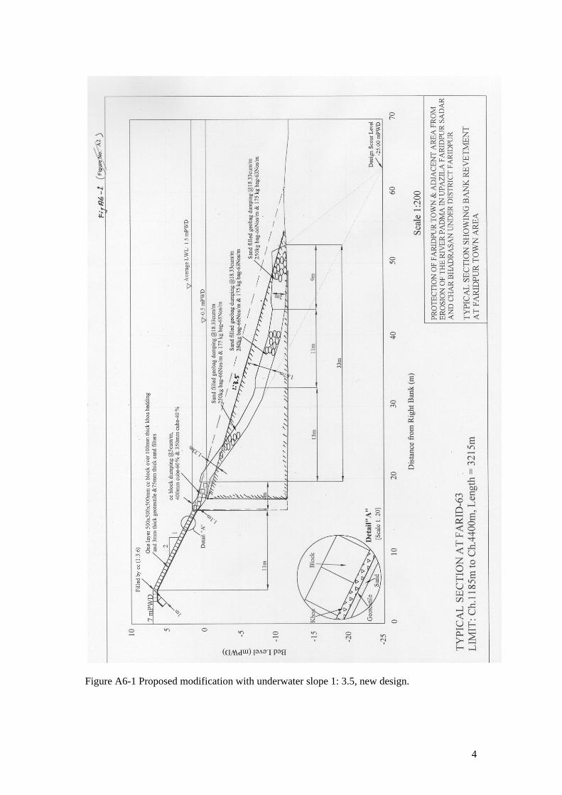
Figure A6-1 Proposed modification with underwater slope 1: 3.5, new design.
4

Table A6-1 Information on transition between bank revetment and falling apron
Survey February 2005 Survey September 2005 Cross-section (Farid)
Fill in m3/m
Thalweg ( m PWD)
Level of intersection
(PWD)
Fill in m3/m
Thalweg ( m PWD)
Level of intersection
(PWD) 50 52 54 56 58 60 62 64 66 68 70
8 42 6 12 56 7 17 0 45 19 0
-22 -19 -15 -14 -14 -16 -11 -10 -11 -10 -10
-2.6 -7.5 -3.1 -5.2
-10.8 -2.0 -4.8 +0.2 -8.6 -3.1 +0.4
Not meas. 6 0 3
92 112 91 81 69 14 41
Not meas. -5 -7
-13 -15 -16 -17 -20 -14 -12 -17
- -2.1 +0.5 -1.5
-12.2 -15.0 -12.0 -10.2 -9.8 -5.3 -7.0
average 19 51
5

APPENDIX A-7 SOME REMARKS ON MODELLING FOR BANK PROTECTION WORKS A7.1 Introduction For the prediction of bank erosion and the design of bank protection works in Bangladesh different modelling tools have been or are being used, notably mathematical modelling, physical modelling and predictions on the basis of satellite images. Also for the bank protection for the Faridpur District several studies have been carried out or are still in progress. The Mission has reviewed the available reports on these studies and in this Appendix some remarks are made based on this review. As it has been suggested that the same techniques presently applied in the Jamuna Meghna Bank Protection Project could be used for the protection of Faridpur District as well, it was also considered appropriate to study the model report, which is used to support the approach taken in this study. The following studies are reviewed in this Appendix: • RRI study (RRI, 2002)1 • IWM study (IWM (2005)2 ; no final report available) • CEGIS predictions of bank erosion along the Padma River (CEGIS, 2005)3 • JMBPS model studies carried out in Edmonton and Vancouver (Mannerstrom & McLean,
2005)4 The review includes the modelling procedure used and the relevance of the obtained results. In the following Sections the different model studies are reviewed. Section A7.6 summarizes the relevance of the different model studies and some recommendations for model studies for bank protection works are given. A7.2 RRI study The reviewed RRI study deals with the protection of Char Bhadrason and already dates back to 2002. The objectives of the model study are listed in the report as follows: • To check the effectiveness of the river training/bank protection works, • To see the flow patterns and flow concentration zones • To observe the possible bank erosion and sedimentation along the river bank • To find out design parameters such as velocity, scour depth etc
1 RRI (2002),Physical model study for the protection of Char Bhadrason area from the erosion of Padma River, Faridpur, River Research Institute, Draft Final Report 2 IWM (2005), Faridpur Town and Char Bhadrasan Area Protection Project, Note on Options for Erosion Mitigation Measures & Design of Recommended Option, Dhaka, Institute for Water Modelling 3 CEGIS (2005), Prediction of Bank Erosion and Morphological Changes of the Jamuna and Padma Rivers 2005, CEGIS, prepared for EMIN project of WARPO and JMREM project of BWDB 4 Mannerstrom, M. & McLean, D. (2005), Physical model study (Vancouver, Canada), Northwest Hydraulic Consultants, Beller Consult & RPMC. Jamuna-Meghna River Erosion Mitigation Project, Part B, Special Report 11
1

• Optimisation of the location, orientation and alignment of the river training/bank protection structure.
The model study was carried out in two phases. Phase-I includes 5 km and Phase-II includes 5 km of the study area, and it was carried out on the basis of the river bathymetry of February 2001. Different types of interventions such as solid spurs, earthen spurs and revetments were tested as proposed by Design Circle–V of BWDB. It concerns undistorted models with a geometrical scale of 100. The following scaling conditions were used: • Sufficient water depth for accurate measurement of velocity • Rough turbulent flow in the model • Sediment movement in the model. Regarding the velocity scale some ambiguity was noticed in the report. In the text and table 3.1 and 3.2 of Annex A and Table 3.1 of Annex B it is stated that the velocity scale is in accordance with the Froude condition (nu = nL
0.5), whereas in the text it is stated that the velocity is exaggerated with a factor of 1.5. This suggests that RRI is not yet fully convinced that a slight deviation of the Froude condition is acceptable. Nevertheless an increase of the velocity is needed and justified when local scour is studied. More serious is the fact that in the report, while discussing scale conditions, no attention is paid to the roughness criterion, which according to the Mission plays a crucial role when the flow pattern has to be studied. This roughness condition reads: nC
2 = nL/nh When using the appropriate values for prototype and model roughness it can be shown that the model is too rough. This implies that curved streamlines are too strongly curved. Drawing conclusions as to the flow field and how it affected by groynes and revetments has to be done carefully. Another limitation of the model study is the fact that the boundary conditions of the model study are the ones present in February 2001. As was shown in the model studies for Jamuna Bridge (Klaassen, 19905 and 19916) in large braided and untrained rivers the attack is sometimes parallel but sometimes oblique. In the RRI study only parallel attack was studied. Oblique attack, however, results in much deeper scour holes in front of groynes and revetments. The modelling approach adopted by RRI might be appropriate for one or two years ahead, but definitely does not study the attack on the structures in say 10 years from now. This is a serious limitation. It is strongly advised to re-think the modelling approach used.
5 Klaassen, G.J. (1990), On the scaling of braided sand-bed rivers, in: Shen, H.W.(Ed) Movable Bed Physical Models, Kluwer. Academic Publishers, pp. 59-71. 6 Klaassen (1992), Experience from a physical model for a bridge across a braided river with fine sand as bed material, Proc. 5th Intern. Symp. River Sedimentation, Karlsruhe (FR Germany).
2

A7.3 IWM study The Institute for Water Modelling is involved in a study related to bank erosion near Faridpur and related bank protection works. Although the Mission had no access to the terms of Reference of the study, it clearly includes: • field measurements, in particular measurement of the bathymetry of the Padma River near
Faridpur in January/February and in September 2005 • simulations of the effect of bank protection works on bank erosion with MIKE21C with
bank erosion module. The Mission could consult a note on the progress of the study prepared in October 2005, but it is understood that this note does not have an official status. No final report is available, and because IWM was apparently still calibrating the model, this final report will not be available shortly. Hence probably it cannot be used for the design of the bank protection works to be implemented in the low water season 2005-2006. A Mike21C model with bank erosion could be useful for the design of bank protection works in a number of ways: • predict the bank erosion which might occur during the monsoon 2006 when no bank
protection would be constructed; • study the effect of bank protection works to be constructed in reducing the bank erosion at
and near Faridpur in the monsoon 2006 • estimate the maximum velocity and the scour depths in front of any bank protection works
again in the year 2006. It is stressed here that the scour depth in the Mike21C model does not take into account the extra scour due to increased turbulence due to the presence of bank protection structures. This has to be added to the scour simulated in the Mike21C model. The following remarks are made regarding the modelling study of IWM: • The calibration of the applied model is probably described in an earlier report, which was
not (yet) made available to the Mission. Three aspects to calibrate on:
o Flow pattern o Bed topography o Bank erosion rates
In particular bank erosion rates seem to be underestimated in the simulations reported in the mentioned note.
• In Mike 21C the bank erosion is determined with the following equation:
bdzdn sdt dt H
α β= +
3

The value of β is a matter of judgement. It is not very logic to assume that this parameter is very dependent on the location, so it is probably preferably to keep this value constant for the whole considered river reach.
• The Faridpur channel is part of a system with another parallel channel more to the North and a bifurcation upstream. Conditions at the bifurcation now but even more importantly in the future determine whether the Faridpur channel will remain as active as it was over the last years. Conditions at the bifurcation are influenced by upstream developments, e.g. the location of a char downstream of the confluence. This should be taken into account during the study.
• Is there a limit to the time over which a prediction of future bank lines can be given? • It is preferable when the predictions are made with different assumed future discharges
and consequently the results of bank line simulations should be given with some probability of occurrence (conform the CEGIS predictions)
• Computed scour depths are average over one grid and do not include the effect of
increased local turbulence due to irregularity of the structure. Also the effect of the bank slope is not properly accounted for. Estimates of scour near structures as basis for the design should use the model results as one of the sources of information and not the sole source. Different approach directions should be considered as well.
• The same holds for the design velocities. • How are scour depths and design velocities developing when bank protection works are
implemented? Simulations should be continued for a number of years but at the same time the stochastic nature of bank erosion and overall planform development should be taken into account.
All in all it seems that the IWM study is limited in the same way as the RRI study discussed in the previous Section. Possible changes in attack in future are not properly considered and for that reason the model study does not sufficiently contribute to the generation of boundary conditions (scour depths, velocities) for the design of the revetments. A7.4 CEGIS study Predictions of bank erosion rates along the Jamuna and Padma Rivers are given in CEGIS (2005)7. The predictions are based on the CEGIS study8 into bank line changes of the Padma River, which in turn is based on the analysis for the Jamuna River given in Klaassen & Masselink (1992)9 and the later update by CEGIS (2002)10 and CEGIS (2004)11. The
7 CEGIS (2005), Prediction of Bank Erosion and Morphological Changes of the Jamuna and Padma Rivers 2005, CEGIS, prepared for EMIN project of WARPO and JMREM project of BWDB 8 Sarker, M.H. et al (2005), Developing empirical methods for predicting morphological changes in the Padma River, CEGIS, Prepared for Jamuna-Meghna River Erosion Mitigation Project 9 Klaassen, G.J. and Masselink, G. (1992), Planform changes of a braided river with fine sand as bed and bank material, Proc. 5th International Symposium on River Sedimentation, Karlsruhe, FR Germany, pp. 459-471 10 EGIS (2002), Developing and updating empirical method for predicting the morphological changes in the Jamuna River, EGIS Technical Note Series No. 29, Dhaka, Bangladesh.
4

predictions are made on the basis of empirical relations which were developed by the analysis of long series of satellite images, whereby the inclusion of features like bars and sedimentation tongues have improved the method substantially. Recently the method was extended to make it applicable for the Ganges River upstream of the confluence with the Jamuna River as well. The predictions are given for one year ahead and they are given as lines with probabilities of erosion of 30, 50 and 70%. In CEGIS (2005), Table 9 a comparison is made between predictions made and actual bank erosion. The sum of all 50% eroded areas is according to the predictions 541 ha, whereas the total actual eroded area according to the observations was about 718 ha. In 4 out of 19 cases the actual bank erosion was less than the 70% prediction, in 12 out of 19 the actual bank erosion was between 30 and 70%, whereas in 2 cases out of 19 the actual bank erosion exceeded even the 30% line. In Figure A7.1 the same data are presented but in a slightly different way. Considering the fact this was the first time that a prediction was made, the Mission feels that the results obtained are satisfactory. In particular because the bank erosion is also influenced by the particular hydrograph of the year considered, whereas the 50% predictions correspond to an average hydrograph. It is advised that cases where substantial differences between predicted and observed erosion occurred are studied extensively to understand the cause of the differences and to improve the prediction method. The predictions are essentially an extrapolation of the behaviour in previous years. Predictions over a number of years will be difficult to make and will be less accurate. The longer the period over which a prediction has to be made, the less accurate the prediction will be. This is in line with the considerations presented in Klaassen et al (1993)12, which discusses the predictability of planform changes in braided rivers like the Jamuna and the Padma River. New developments like the slow abandonment of a channel are difficult to implement in the method used.
0
1
2
3
4
5
6
1 3 5 7 9 11 13 15 17
Places with bank erosion
Rat
io e
rode
d ha
/50%
pre
dict
ed h
a
0
50
100
150
200
0 50 100 150 200
Predicted 50% erosion (ha)
Obs
erve
d er
osio
n (h
a)
(a) Ratio eroded and predicted area (b) Eroded versus predicted area
Figure A7.1 Comparison of predicted versus actually eroded areas along the Brahmaputra-Jamuna river system
11 CEGIS (2004), Identification of the Different Types of Bank Materials Along the Padma River, prepared within the framework of the Padma Bridge feasibility study 12 Klaassen, G.J., E. Mosselman and H. Brühl (1993), On the prediction of planform changes of braided sand-bed rivers, Proc. Intern-Conf. on Hydro-science and Engineering, Washington, U.S.A.
5

The CEGIS predictions are useful for predicting where bank erosion might occur. Also the amount of bank erosion is reasonable well predicted. For bank erosion structures however the predictions are of limited use, because the prediction cannot be used to predict the attack in a number of years from now and as far as boundary conditions for the design are concerned its use is limited to predicting the angle of attack over the next years. Also the area protected by bank protection can be predicted, though with limited accuracy (see Section 2.4 of this report). A7.5 JMREMP model study Within the framework of the Jamuna-Meghna River Erosion Mitigation Project model tests were carried out to study: • Mega-container tests (not further considered here) • Incipient motion tests, to determine flow velocities at which various sizes and mixtures of
geo-bags become mobile on a sloping bank • Drop tests, to study the behaviour of geo-bags when dropped from the surface • Launch tests, in which a comparison was made between the launching behaviour of rock
riprap, (mixture of) geo-bags and concrete blocks. The Mission did not have time to study the available report4 extensively, but it has some doubt on to what extend model tests at a scale of 1:20 are representative for the actual behaviour of the bags in nature. It was observed that the discussion of the scaling conditions was limited to initiation of motion and suspension of the fine sediments. More attention could have been paid to conditions related to the hydraulic behaviour of geo-bags (fall velocity?) and scaling of the geotechnical stability. Hence the Mission is not certain that e.g. the actual launching behaviour of geo-bags is as observed in the model tests. Nevertheless the Mission fells that the model tests have been useful in improving the understanding of the geo-bags. The expressed doubt on the similarity between model and actual behaviour underlines the importance of monitoring the test structures constructed under the Jamuna-Meghna River Erosion Mitigation Project carefully. When damage occurs, the cause of the damage should be known and understood. In itself the Mission feels that the experience that will be gained over the next years will be very useful for the further development of appropriate bank protection techniques in Bangladesh. Moreover it is important that the observed behaviour in nature is compared with model tests carried out previously. A7.6 Relevance of model studies for the design of bank protection works A distinction has to be made between the model studies and predictions for a particular location (like the bank protection works for Faridpur district) and the model tests carried out for the Jamuna-Meghna River Erosion Mitigation Project, which have a much wider application range. None of the three modelling tools applied produce results that can contribute to the successful design and construction of bank protection works for a particular location. The results produced help in establishing the attack on the structures in the next year, but for later years
6

(when bank lines and planform of the river has changed) the model studies are not helping in providing boundary conditions for the design. A completely different approach, like used for the Jamuna Bridge (see Klaassen, 19926) seems appropriate. Only when proper attention is paid to the boundary conditions for the structures in the further future one might hope that the bank protection structures will last longer than is common in Bangladesh. Knowing the future conditions might also lead to an approach where maintenance is used to cope with the changing conditions the bank protection structure is facing over time. The CEGIS predictions of bank erosion over the next monsoon season are considered as very useful and an institutional set-up should be provided in which these predictions can be produced on a yearly basis. It is stressed here that Mike21C simulations are not an alternative for the empirical approach used by CEGIS, as application of Mike21C on the scale of all the main rivers in Bangladesh would become too expensive. Detailed studies with Mike21C however can be used to improve the CEGIS empirical prediction method. In particular when structures are present, as the CEGIS method still has to be improved to include also the effect of bank protection works on bank erosion. The model tests for the behaviour of the geo-bags are considered as very useful, although future experience with the test structures of the Jamuna-Meghna River Erosion Mitigation Project must show how applicable the results in the model tests are for the conditions in the field.
7

APPENDIX A-8 RIVER BANK PROTECTION MANAGEMENT PROJECT
A8.1 Rationale of the project Bangladesh’ National Water Policy (1998) states under heading 4.2 ‘Planning and Management of Water Resources’: “Through it responsible agencies, the Government will undertake survey and investigation of the problem of river bank erosion and develop and implement master plans for river training and erosion control works for preservation of scarce land and prevention of landlessness and pauperisation”. The formulation of an integrated erosion management project is considered essential to reach the aforementioned goal presented in Bangladesh’ National Water Policy. Contrary to Flood Management, which, in the nineties, received an enormous boost from the execution of the Flood Action Plan, erosion management up till now has not got the attention it should have. The National Water Management Plan (approved 30/04/2004) states that bank erosion is a major problem in all main rivers. Section 3.7.2 clearly refers to erosion control, river bank maintenance, and recommends the approach to be followed, particularly with focus on formulating an updated strategy dealing with the problem for sustaining people’s livelihoods and halting erosion. The PRSP of Bangladesh (approved in October 2005) includes the need for erosion control in many parts of the document and in the section 5.B.1 on ‘Water Resources and Management’ states that: River erosion creates poverty by making people homeless overnight. The poor are affected most. The problems, which, un til now, have prevented a systematic and strategic approach to erosion management in Bangladesh are of a morphological, economic and technical nature: The increase in population, the investment in infra-structure in towns and rural areas (irrigation and drainage projects), the river training works already carried out in the recent past for various major bridges, as well as cost-effective improved techniques (JMREMP) in arresting bank erosion, are all reasons for a formulating a project with a broader view into the technical, economic and socio-economic feasibility of protection works against bank erosion. The aim of such a study should be the formulation of an overall erosion management strategy for Bangladesh’ major rivers Jamuna, Ganges, Padma, Upper and Lower Meghna. It is felt that such a study is a first step towards a future control of the erosion of the banks of these major rivers. A8.2 Objective Formulation of an overall integrated erosion management strategy project for Bangladesh’ major rivers Brahmaputra /Jamuna (B/J), Ganges (G), Padma (P), Upper Meghna (UP) and Lower Meghna (LM) aiming at a future control of the erosion of the banks of these major rivers. The RBEMP should be aimed at sustainable long-term planning of river training (including bank protection at vulnerable reaches) to reduce the total width of the river system and thus safeguard valuable land. Technically and economically feasible river bank management, short-term protection works and river training works on a sustainable scale for the major rivers in Bangladesh cannot, in general, be successfully developed unless they are incorporated within an integrated overall strategic programme.
1

Accordingly, when designing river bank erosion protection measures it is agreed that they should fit into a coherent plan (river training) to harness in optimum way the river system with the possibility of new concepts being applied in recent projects or innovative different concepts in combination with temporary protection works at key locations. The overall objective of the RBEMP is to provide a framework in which the technical, economic, social, environmental and other effects of various alternatives for river training works of the major river system in Bangladesh, can be assessed and evaluated at different levels of detail. The RBEMP will moreover, provide a systematic approach of the river training works in regard of their various aspects as design criteria, construction, sequence of implementation, monitoring and maintenance, and the institutional and organisational management requirements related to these aspects. The MLTSP will involve hydrologic, hydraulic, hydraulic engineering studies, geotechnical, morphological and geo-morphological studies. It will also require mathematical and physical modelling studies to support the preparation of the design of river training works and implementation plan. Agro-socio-economic and environmental effects of the proposed schemes are to be included. The RBEMP should be consistent with the NWP, NWMP and the PRSP. A8.3 Starting points • Based on existing knowledge and experience (FAP 24, CEGIS studies, IWM General model
studies, JMREMP) • Additional data on geotechnical, socio-economic and environmental conditions to be collected, not
on other aspects • Experience from elsewhere (Europe, China, USA) to be used • Together with IWM (mostly 1D modelling) and CEGIS (satellite images) (as nominated sub-
consultants) • Continuous interaction with MOWR and other agencies (to be specified) • Extensive use of satellite images for development of RBEM strategy • Ultimately “learning by doing”, so a flexible plan for implementation A8.4 Components of RBEMP: (1) River training component Consisting of: • Division of main river system in three different types: braided (B/J, P and LM), meandering (G)
and braided in transition to meandering (UM) • Review of earlier studies (like Joint China-Bangladesh Joint Expert team study and FAP 21/22) • Selection of most desirable planform for each of the three types (e.g. for braided rivers either
bend stabilization, nodal point stabilization or control via hard points) • Development of strategy how to reach most desirable planform • Interaction with other projects (bridges, barrages) and effect of climate change and developments
upstream • Development of short-term (up to 5 years) and medium term strategy (5-15 years), based also on
socio-economic and environmental impacts and economic analysis • Review of recent bank erosion protection experiences (JMREMP and BWDB) • Study of failures and successes with river bank protection works in Bangladesh and elsewhere and
recommendation best practice re type of protection works • Recommendations for “learning by doing”
2

(2) Environmental impact component Consisting of: • Study of base-line conditions along main rivers (update CEGIS study) • Morphological impact study of proposed strategies • Socio-economic and environmental impact study of proposed strategy and alternative approaches
(when needed) (3) Economic analysis component Consisting of: • C/B analysis of proposed strategy • Economic analysis to help formulating short-term and medium-term strategy (4) Institutional component Consisting of: • Setting-up of River Bank Erosion Management Unit (RBEMU) • Advice on future institutional embedding of RBEMU • Training of RBEMU staff and other staff (in-country and in abroad) • Advice on monitoring (how, who?) CEGIS and IWM could be considered as nominated sub-consultants for this type of project. A8.5 Characteristics of RBEMP: • Total costs estimated at about 7.5 Million Euro (2005 price) including field surveys, local input
and training • Total duration 2 years • Panel of Experts: local and international
3


