Route 522 and Route 617 Powhatan County
50
Route 522 and Route 617 Powhatan County Appropriation Act Item 455 H. (2008) Report to the Secretary of Transportation and Chairmen of House Appropriations and Senate Finance Committees Virginia Department of Transportation 1401 East Broad Street Richmond, Virginia 23219 October 2008
Transcript of Route 522 and Route 617 Powhatan County

Route 522 and Route 617 Powhatan County
Appropriation Act Item 455 H. (2008)
Report to the Secretary of Transportation and Chairmen of House Appropriations and Senate Finance Committees
Virginia Department of Transportation 1401 East Broad Street
Richmond, Virginia 23219
October 2008


ii

iii
PREFACE Item 455 H of Chapter 879 of the Acts of Assembly of 2008 requires the Virginia Department of Transportation (VDOT) to complete an assessment of the improvements needed at the intersection of U.S Route 522 and Virginia Route 617 in Powhatan County to support the proposed Powhatan State Park. This report is required to include an estimate of probable cost for the identified improvements.

iv

v
TABLE OF CONTENTS Executive Summary vii
Section 1 – Introduction and Purpose 1 Section 2 - U.S. Route 522 & State Route 617 Intersection 2
Existing Intersection Configuration and Operation 2 Traffic Projections 2
Section 3 – Identified Intersection Improvements 4 Section 4 – Other Impacts 5
Environmental Review 5 Right of Way and Utility Review 5
Section 5 – Estimate of Probable Cost 6 Appendices Appendix 1 – Legislation 7 Appendix 2 – Photograph of Intersection 9
Appendix 3 – Powhatan State Park Master Plan 11

vi

vii
EXECUTIVE SUMMARY At the request of the General Assembly, staff from the Virginia Department of Transportation’s (VDOT’s) Richmond District reviewed the intersection of U.S. Route 522 and State Route 617 in Powhatan County. The purpose of the study was to identify necessary improvements required by the development of the Powhatan State Park on State Route 617. The study identified the following necessary improvements:
• Provide a southbound right turn lane from U.S Route 522 to west bound State Route 617. • Provide a northbound left turn lane from U.S. Route 522 to west bound State Route 617. • Improve intersection sight distance from east bound State Route 617 looking to
southbound U.S. Route 522. • Improve pavement widths on U.S Route 522 to current day standards of 12’. • Improve shoulder widths on U.S Route 522 to a 4’ paved shoulder. • Improve the roadside ditch lines to current day standards.
The estimate of the probable cost for the necessary improvements is $2,750,000 (in 2008 dollars). This estimate includes the acquisition of real property from 13 affected properties and the relocation of three affected properties.

viii
1
Section 1 - Introduction & Purpose Item 455 H of Chapter 879 of the Acts of Assembly of 2008 directed the Virginia Department of Transportation (VDOT) to study the intersection of U.S. Route 522 (Maidens Road) and Virginia State Route 617 (Old River Trail) and identify roadway improvements necessary to support the proposed Powhatan State Park. A copy of the legislation is attached to this document as Appendix 1. The study of the intersection as performed by VDOT included the following:
• Review existing operating conditions at the subject intersection. • Review the Master Plan prepared for the planned state park. The Master Plan prepared by
the Virginia Department of Conservation and Recreation, Division of State Parks (DCR), is attached as Appendix 2 to this document.
• Develop traffic projections for the proposed state park based on the Master Plan. • Identify necessary improvements at the subject intersection based on traffic projections
(turn lanes, sight distance, horizontal & vertical geometry, etc). • Identify, evaluate and quantify impacts (cultural, environmental, real property, etc) of
required improvements. • Prepare a cost estimate based on impacts and proposed improvements.

2
Section 2 - U.S. Route 522 & State Route 617 Intersection Existing Intersection Configuration and Operation Currently, the existing intersection of U.S. Route 522 and State Route 617 (see Appendix 2) functions as a traditional four legged intersection. U.S. Route 522 operates in a north-south direction while State Route 617 operates in an east-west direction. Both the east and west bound approaches to U.S. Route 522 on State Route 617 are controlled by stop signs at the existing intersection. Existing intersection sight distance from the east bound approach of State Route 617 to the south bound approach on U.S. Route 522 does not meet current day standards. All four approaches to the intersection are composed of a two lane typical section. Lane widths on U.S Route 522 are approximately 10.5’ – 11’; shoulder widths range from 0-2’ in width. Lane widths on State Route 617 are approximately 9 – 10’; shoulder widths are 0-2’ in width. Both U.S. Route 522 and State Route 617 have prescriptive right of way widths of 30’. VDOT’s Central Region Traffic Engineering staff conducted peak hour traffic counts and observations at the intersection of U.S. Route 522 (Maidens Road) and State Route 617 (Old River Trail) in July 2008. The peak hour movements are summarized below:
PEAK HOUR TURNING MOVEMENTS1 Approach EB SR 617 WB SR 617 NB U.S. 522 SB U.S. 522
LT T RT LT T RT LT T RT LT T RT AM Peak Hour 5 0 16 4 0 6 2 91 0 2 281 3 PM Peak Hour 1 0 5 1 0 6 11 219 8 6 100 3 Note: LT – Left Turn Movement, T – Through Movement, RT – Right Turn Movement Traffic Projections A review of the Master Plan prepared by DCR indicates that visitation to the proposed state park is estimated to be 195,000 visitors per year at full build-out; this equates to approximately 75,000 round trip vehicles per year. The majority of the volume is anticipated to occur during the normal five month operational period between May 1 and October 1. VDOT’s design criteria are based upon daily traffic and upon peak hour traffic. To translate annual traffic to daily volumes, it is assumed that 80% of the annual traffic would occur during the summer months. This produces an average daily increase of 800 trips per day, 400 daily entries and 400 daily exits. This number is likely to be somewhat higher than actual, but results in a more conservative (worst case) figure for design purposes. Peak hour usage is used to determine auxiliary lane requirements. For this, rates found in the Institute for Traffic Engineering (ITE) Trip Generation Manual were utilized. For a 1,563 acre state park, the estimated peak hour trips are 47 total, broken into 23 entries and 24 exits per hour. It has been assumed that the park would attract clientele equally from north and south along U.S. Route 522. With the 50%/50% distribution, 12 right turns and 11 left turns can be expected during the peak hour at the operational build out of the park.
1 The peak hours are 7:00 a.m. to 9:00 a.m. and 4:00 p.m. to 6:00 p.m.

3
The traffic generated by the site was added to the background traffic collected during the July 2008 sampling conducted by VDOT staff. Currently, Powhatan County has adopted Access Management Regulations that are contained in their Subdivision Ordinance; those regulations affect the development of this intersection. By virtue of its classification of an Access Category 2 roadway by Powhatan County’s Access Management Regulations, auxiliary lane analyses for U.S. Route 522 were performed using Powhatan County's Auxiliary Lane Analysis graph. VDOT’s most recent daily traffic count (2007) of U.S. Route 522 is 4,190 vehicles per day. Combined park traffic and background traffic produces 20 southbound right turns and 17 northbound left turns during the PM peak hour. Both these volumes exceed Powhatan's Auxiliary Lane Analysis threshold values, making both lanes (north bound left and south bound right) justified on U.S. Route 522 at the intersection. The 24 exits per hour (peak hour) coming from State Route 617 approaching U.S. Route 522 can be broken into 12 right turn exits and 12 left turn exits (assuming a 50%/50% distribution of traffic). Neither are sufficient to require separate outbound turn lanes. A single approach lane should be sufficient to accommodate the outbound demand. Although not required as part of this study, an analysis was performed at the entrance to the proposed state park on State Rote 617 to determine if a west bound right turn lane from State Route 617 to the proposed state park is warranted. State Route 617 is not classified for the purposes of controlling access under Powhatan County’s Access Management Regulations and therefore has been assumed to be a “local” roadway. By virtue of its local classification, turn lane warrants are considered under VDOT criteria. Based on the peak hour projections for the state park, traffic entering the park from State Route 617 is estimated to be 23 right turns per hour. The 23 right turns per hour are insufficient to require a right turn lane or a taper on State Route 617 at the park’s entrance per VDOT’s criteria.
4
Section 3 - Identified Intersection Improvements The review of the existing intersection of U.S. Route 522 and State Route 617 identified the following necessary improvements to accommodate the proposed state park traffic.
• Provide a south bound right turn lane from U.S Route 522 to west bound State Route 617. • Provide a north bound left turn lane from U.S. Route 522 to west bound State Route 617. • Improve intersection sight distance from east bound State Route 617 looking to south
bound U.S. Route 522. • Improve pavement widths on U.S Route 522 to current day standards of 12’. • Improve shoulder widths on U.S Route 522 to a 4’ paved shoulder. • Improve the roadside ditch lines to current day standards.
Approximately 2,500 linear feet of roadway are affected by these proposed improvements; approximately 1,200 feet north of the intersection and 1,200 feet south of the intersection. These lengths are needed to allow for the requisite transitions and tapers to support the left and right turn lanes.

5
Section 4 -Other Impacts Environmental Review As this project is in the study phase, a desktop query of available data bases was conducted to identify known environmental impacts within the geographic limitations of the proposed project. Several structures in the immediate vicinity of the project will require further evaluation once the project moves forward. Should this project receive funding and begin the formal development phase, a full environmental review will be prepared in accordance with the Code of Virginia § 10.1-1188. Coordination, evaluation and review activities will identify environmental resources, programs, permits, approvals, clearances, and other related needs or issues that will need to be considered or addressed during project development and construction. This will include several structures in the immediate vicinity of the project that have not yet been evaluated for historic significance. This information will be utilized to avoid or reduce impacts to identified resources. Should the project involve federal money or require a federal permit, additional federal environmental laws and regulations will apply. Right of Way and Utility Review A review of the proposed modifications to the intersection was conducted to identify affected adjacent properties. The geographic limits of the project were matched closely with available Powhatan County Tax Map parcels. Approximately 16 parcels were identified to be impacted by the proposed intersection improvements. Of the 16 identified parcels, three appear to be candidates for relocation based on their impacts and their proximity to the intersection. A review of the existing utilities identified required relocations within the limits of the geographic scope of the project.

6
Section 5 - Estimate of Probable Project Cost Based on the identified improvements and the resultant impacts, the estimate of probable project cost is summarized below.
Estimate of Probable Cost Preliminary Engineering $200,000 Right of Way (includes relocations) $1,200,000 Utility Relocation $200,000 Construction $1,000,000 Construction Engineering & Inspection $150,000 Total $2,750,000 Estimates were generated utilizing VDOT’s Project Cost Estimating System (PCES) and are in 2008 dollars.

7
APPENDIX 1 – Legislation
Item 455 of Chapter 879 of the Acts of Assembly of 2008 H. The Department shall complete an assessment of improvements needed to the intersection of Route 522 and Route 617 in Powhatan County to support development of the Powhatan State Park. The Department shall provide a report including estimates of costs to the Secretary of Transportation and the Chairmen of the House Appropriations and Senate Finance Committees by November 1, 2008.

8

9
APPENDIX 2 – Photograph of Intersection

10

11
Appendix 3 – POWHATAN STATE PARK MASTER PLAN
MASTER PLAN: STAGE ONE I. INTRODUCTION A. Purpose of the Master Plan The purpose of this plan is to establish a picture of the desired future condition of this park and to project a phased approach for bringing the park to that condition.
B. Master Plan Development Process The state park master planning process is described in §10.1-200.1 of the Code of Virginia. The Code states that a map indicating, at a minimum, boundaries, inholdings, adjacent property holdings, and other features such as slopes, water resources, soil conditions and types, natural resources, and cultural and historic resources, be prepared. A park purpose statement and goals and objectives will also be developed. The process used to establish this desired future condition involved the participation of a master plan advisory committee comprised of representatives of area residents, local government, public schools, the tourism industry, businesses, and park user groups. The advisory committee developed goals and objectives and a purpose statement for the park and presented those to the public at a public input meeting open to all interested persons. The public was also asked to recommend changes, additions, or removals to the facilities and programs offered at the park. Following the public input session, the advisory committee developed a draft master plan. The Plan identified all of the elements of the park’s recreation delivery system and natural resources management system and recommended a desired future condition. The proposed facilities were arranged in priority order in a three-phase approach. This draft master plan was then presented to the public in another public input meeting open to all interested persons. The public was satisfied with the proposed plan with the exception of the proposed entrance road. It was requested that an alternative entrance road be developed through the correctional center property. Security concerns prevent use of the center as an entrance road corridor. Recommended developments were prioritized and a preplanning study conducted to determine costs for each element. This information is presented by phases of development in the Planning Bureau Cost Estimate report in Chapter VI of this Plan. The Powhatan State Park Resource Management Plan is a sister document to this master plan. The Resource Management Plan sets forth the desired future condition for all of the natural and physical resources of the park and a plan for attaining that condition.

12
C. Background and Context
1. Introduction Powhatan State Park was transferred from the Department of Juvenile Justice to the Department of Conservation and Recreation through the 2003 Acts of Assembly, Chapter 1042, Item 381. M, dated May 1, 2003. The exact wording in the budget bill is as follows: “On or before June 30, 2003, the Department of Conservation and Recreation shall complete the transfer of title to a minimum of 1,500 acres, to include river frontage, of property adjacent to the Beaumont Juvenile Correctional Center in Powhatan County from the Department of Juvenile Justice for the development of a state park as previously authorized by item 440 of Chapter 899 of the 2002 Acts of Assembly. The transfer shall be accomplished pursuant to the Department’s report dated December 3, 2003, to the Secretaries of Natural Resources and Public Safety and the Chairmen of the House Appropriations and Senate Finance Committees. The Department of Conservation and Recreation shall notify the Chairmen of the House Appropriations and Senate Finance Committees once the transfer is complete.” Powhatan State Park is located on the banks of the James River in Powhatan County. The park consists of 1563.5 acres and has 2.5 miles of frontage on the river. The park was once the historic 19th Century Beaumont Plantation. The land was acquired by the Department of Corrections in 1920 and became the Virginia Industrial School for Boys. It evolved over time into the Beaumont Juvenile Correctional Center. The land was managed as a farm to provide food for the inmates in the Beaumont Center as well as in the adult correctional centers nearby. The 1564 acres was transferred to DCR in 2003 and the master plan was developed during 2005. The lands that became the state park did not include any of the Beaumont Plantation buildings nor those of the Correctional Center. The remains of a collapsed barn, an old cabin in poor condition, and a pole shelter are the only facilities on the lands transferred to DCR. A Beaumont/State Park Property Division Plan was developed by the Department of Juvenile Justice (DJJ) and DCR that spelled out the specific steps that would be employed in determining which lands would be transferred to the park and the conditions under which the state park and the Beaumont Juvenile Correctional Center would operate. The plan specified that a separate access road into the park would be developed off of State Route 617, Old River Trail. Use of Route 617 would bring visitors into the park without impacting the security of the correctional facilities or the James River Detention Center. The Plan established the need for controlled access between the park and the DJJ property. Two gates will be maintained that will allow movement of farming equipment and Department of Corrections Agri-business staff and inmates and DJJ staff to move between the two properties as needed. These gates will be locked. Fencing will be maintained where needed by DJJ staff. A 100-foot setback buffer will be maintained on both sides of the property line between DJJ and the park. Signs will be installed at the edge of the buffer zone in the park and vegetation will be maintained in the buffer zone to discourage the public from wandering on to DJJ property. The plan called for continued farming of the park property by the Department of Corrections using minimum-security inmates and corrections staff. It specified that some fields would be removed from agriculture so that succession could begin. Other fields would be phased out as development funds became available.

13
The Plan called for a management agreement that would set the conditions for continued hunting on the property until such time as it was developed as a park. The management agreement was developed and adopted on September 15, 2004. Key provisions of the agreement follow. The full text is in the Appendix.
2. Security/Boundary
A buffer of fencing, signage and plantings may be installed to separate the inmate population at Beaumont Correctional Center from the general public once the park is open to the public. The following recommendations give a breakdown of the work, with some of the exact locations to be determined once the master plan has been developed.
• DCR will install signage, after July1, 2004, along State Route 617 indicating that the land is to be a future state park. In addition parks staff will install DCR boundary markers along the surveyed boundary by December 31, 2005.
• Security fencing may be constructed by DJJ based on their needs. The fence will remain within the boundaries of the Beaumont Correctional Center property and be paid for by DJJ.
• Additional fencing may be erected on the boundary by DJJ, where deemed necessary. • A minimum 200’ forested buffer, 100’ on each side of the property line, will be
maintained as undeveloped between DJJ and public activities. DCR and DJJ may enter into a mutual management agreement to enforce trespass infractions occurring within and through the buffer zone.
• DCR signage and maps will clearly designate areas that are not accessible to the public along the shared property boundary.
• Locked gates, to restrict vehicle traffic, will be maintained at identified service roads that run through both properties with only DCR staff, DOC Agribusiness and DJJ having access. Keys and locks will be issued and maintained by DJJ and the gates will be purchased and installed by DCR by December 31, 2005.
• DCR and DJJ will notify the other party when staff will be working within the buffer zone until the park is open to the public.
• The road designated “Back Road” (gravel road at southeast corner) will be maintained as an emergency exit and access for the Beaumont Correctional Center and James River Detention Center when flooding restricts the normal exit and entry off of Route 522.
• DJJ will include DCR in the emergency notification list in the event of a breach of security from the Beaumont Correctional Center. Notification will be made to the District Manager at Pocahontas State Park.
• DCR may issue special use permits to individuals or groups involved in the development of the park for activities including special events, visitation, and/or tours. All such special events or tours will have DCR staff in attendance. DJJ and DOC Agribusiness will be notified when such permits are issued.
3. Land Usage
Farming: The Department of Corrections Agribusiness Operations currently farms the open lands on the park property. As the park is developed the farming operations will be cut back and

14
possibly eliminated once build out of the park is achieved. The following guidelines will apply until the master plan is completed.
• DCR will permit fields labeled B5, B11A, B11B, B11C, and portions of B7, B8A, B9 and B12 to be farmed beyond the December 2003 deadline until such time as the master plan has been adopted.
• The remaining fields may remain in use until December 31, 2007. At that time DCR will evaluate the continuation of the farming based upon the development progress of the park. DCR will then determine which areas can successfully remain in operation and which will need to be terminated.
• Continued farming by DOC prior to park development is their option, but not required. • Any timber management activities will be coordinated and conducted by DCR staff.

15
4. Vicinity Map
16
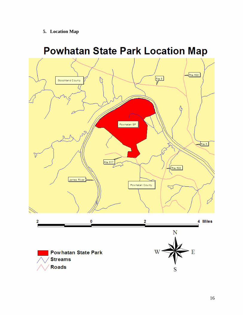
5. Location Map
17
II. GOALS AND OBJECTIVES
A. Constitution of Virginia, Article XI-Section 1 “To the end that the people have clean air, pure water, and the use and enjoyment for recreation of adequate public lands, waters, and other natural resources, it shall be the policy of the Commonwealth to conserve, develop, and utilize its natural resources, its public lands, and historic sites and buildings. Further, it shall be the Commonwealth’s policy to protect its atmosphere, lands, and waters from pollution, impairment, or destruction, for the benefit, enjoyment, and general welfare of the people of the Commonwealth.” B. Department of Conservation and Recreation Mission Statement “The mission of the Department of Conservation and Recreation is to conserve, protect, and enhance the Commonwealth’s unique natural, recreational, scenic, historic and cultural resources. Within this broad mission, the Department manages a system of strategically located properties totaling approximately 80,000 acres.” C. Virginia State Park Mission Statement “To conserve the natural, scenic, historic and cultural resources of the Commonwealth and provide recreational and educational opportunities consistent with the good stewardship of these lands, waters and facilities that leaves them unimpaired for future generations.” D. Powhatan State Park Purpose Statement The purpose of Powhatan State Park is to provide premiere water and land based outdoor recreational and educational opportunities while protecting and interpreting the unique natural, historical, and cultural resources of the storied James River and the eastern Piedmont region of Virginia.
E. Goals and Objectives
Goal 1.0 – Protect and conserve the natural and cultural resources of the Park.
Objective 1.1 – Manage the park for the benefit of native species and natural communities.
Objective 1.2 – Implement the Park Resource Management Plan.
Objective 1.3 – Encourage use of best management practices and minimum impact development on lands adjacent to the park. Objective 1.4 – Design, construct and locate facilities to complement the natural setting of the park and to avoid impacts to sensitive natural areas, cultural and historic sites.
18
Objective 1.5– Implement Best Management Practices to reduce shoreline and other erosion. Objective 1.6 – Co-manage wildlife management activities in the park with the Department of Game and Inland Fisheries. Objective 1.7 – Cooperate with the Department of Corrections in the management and maintenance of agricultural fields.
Goal 2.0 – Provide recreational opportunities for day-use visitors to the park.
Objective 2.1 – Develop a system of multi-use trails for pedestrians, bicyclists, and equestrians. Objective 2.2 – Provide access to the James River and include parking and boat launching facilities. Objective 2.3 – Develop picnic areas with shelters, restrooms, playgrounds, and parking. Objective 2.4 – Provide a parking lot for day-use horse trailer parking. Objective 2.5 – Participate as a stop on the Virginia Birding and Wildlife Trail. Construct needed wildlife observation platforms and blinds. Objective 2.6 – Provide bank fishing opportunities to the James River and to the park ponds. Construct new fishing ponds where appropriate. Objective 2.7 - - Provide dog training facilities including open fields and ponds. Objective 2.8 – Provide canoe, kayak, tube and rafting opportunities on the James River through concession or by contract.
Goal 3.0 – Provide enhanced facilities for overnight visitors to the park. Objective 3.1 – Develop a 60-site campground with a separate loop for tent campers. Objective 3.2 – Develop a group campground. Objective 3.3 – Provide canoe-in campsites by the river. Objective 3.4 – Provide an equestrian campground. Objective 3.5 – Develop housekeeping cabins and family lodges.
Goal 4.0 – Provide environmental education and cultural interpretive services to the public.
Objective 4.1 – Develop a visitor center with interpretive exhibits and an educational/classroom/field laboratory facility.

19
Objective 4.2 – Provide adequate staff to operate the educational facility and to guide interpretive and education programs in the park and on the James River. Objective 4.3 – Develop displays, brochures, and interpretive programs that tell the story of the land and people of the region. Objective 4.4 - Provide self-guided interpretive programs through signage and brochures.
Goal 5.0 – Participate in mutually beneficial efforts with partner organizations and neighbors to enhance the entire region.
Objective 5.1 – Participate in local and regional planning efforts to foster sustainable land use and development that protects the water quality and scenic beauty of the park and the region Objective 5.2 – Actively partner with other agencies near the park to promote the area and to provide information to the visiting public.
Objective 5.3 – Partner with public and private organizations and agencies, especially the public school systems, to enhance park offerings and educational opportunities.
Objective 5.4 – Foster community support and volunteerism in the park. Objective 5.5 – Partner with local governments, businesses, and organizations to market the park and the other amenities of the region.
Goal 6.0 – Administer and manage the Park in a manner that fosters the public’s trust. Objective 6.1 – Implement management plans and practices that foster good stewardship and appropriate “green” facility design in keeping with the character of Powhatan State Park.
Objective 6.2 – Provide appropriate levels of staff with the necessary skills to achieve the park’s goals and objectives.
Objective 6.3 – Provide services and facilities that meet public expectations for security, safety, and health.
Objective 6.4 – Assure proper care and maintenance of park facilities and infrastructure. Objective 6.5 – Construct staff residences for assigned permanent staff. Objective 6.6 – Construct a park office and include space for a visitor’s center with displays, a sales area, guest check in, office space and meeting facilities. Objective 6.7 – Address the need to enhance safety at the intersection of Routes 522 and 617 in Michaux.

20
Objective 6.8 – Address safety concerns on Route 617 from Route 522 to the park entrance, but retain its meandering alignment and reduce the speed limit to a safe speed. Objective 6.9 -- Construct a contact station and design the park entranceway to efficiently handle the processing of visitors on busy days. Objective 6.10—Connect to the municipal water and sewage system. Objective 6.11 – Construct a park maintenance area. Objective 6.12 -- Maintain a buffer with signing, vegetation, and, if needed, fencing to ensure park visitors do not trespass on to adjacent private or Juvenile Justice Center property. Objective 6.13—Coordinate an incident response protocol with the Department of Corrections, Department of Juvenile Justice, and law enforcement agencies to address potential prisoner escapes.
III. EXISTING CONDITIONS A. Location Lying within the eastern Piedmont of Virginia, Powhatan State Park is located on the southern shore of the James River in Powhatan County, Virginia. The Park is found on the Goochland 7.5 minute U.S.G.S. quadrangle. The Park is located upstream from the Route 522 crossing of the James River. The park is reached off of Route 522 via Route 617, Old River Trail.
B. Demographic Features and Surrounding Land-use Powhatan County is one of the fastest growing counties in Virginia. As the Richmond metropolitan area expands westward, the population of Powhatan County has expanded. The completion of Route 288 has shortened commuting times to many employment centers in the Richmond region from Powhatan County and is helping to fuel the population growth.
1. Demographic Features In 1980 the census showed that there were 12,367 people living in Powhatan County. By 1990 this number had increased to 15,328. By 2000 it had increased to 22,377 and in 2004 it was up to 25, 866 – an increase of 15.6% since 2000.
The number of households has subsequently increased between 1990 and 2000. It was reported that there were 4672 households in 1990, which increased to 7258 households in 2000.
The median age in Powhatan is 36.8 years old. The largest age bracket of people, approximately 34.7 %, are between the ages of 25 and 44 years old.

21
2. Surrounding Land Use Surrounding land uses include farming (poultry, corn, hay, soybeans, winter wheat) and pasturage for livestock. Some of the adjacent lands are leased to hunt clubs. Forested land in the area is managed for timber. Significant nearby property owners include Moyer Bros. Farming, Beaumont Learning Center, and other farms across the James River. The CSX Rail line parallels the River on the opposite shore from the park. Most of the land on the north side of the river is in farmland. C. Park Boundaries Park boundaries extend from the western edge of the Beaumont Correctional Center along the James River to the corner with the Moyer Bros. Farm, thence east to Route 617 and along the road to the corner at the southern edge of the Beaumont Juvenile Correctional Center property. The boundary with the Center property is to be marked and maintained in accordance with the Management Agreement. A 100-foot wide buffer will be maintained on each side of this line. It will be vegetated and signed on the park side to warn against trespassing on to the Correctional Center property. DJJ can fence the line if they choose.
D. Facilities Man-made facilities in Powhatan State Park consist mainly of farm roads, a pole barn, forest management trails, and a small pond. Approximately 320-acres of the property is in agricultural fields that are actively farmed by the Department of Corrections as part of their agri-business program. These fields are in row crop rotation and grow corn, beans, winter wheat, and hay.
1. Roads
The park is accessed via State Route 617, Old River Trail, from Route 522. Route 617 is a 30-foot prescriptive easement and is paved with a 20-foot wide pavement. There are no state secondary roads within the park. Farm roads provide access to most parts of the park, but they are not all-weather roads. Forest roads are not generally all-weather roads and range from good to poor condition. The forest road going through the “Big Woods” section of the property leading to the small cabin foundation on the eastern side of the property is in good to fair condition but most of the remaining forest road need to be graded with all culverts checked for size and function. If any of these roads will be need for all weather conditions, rock surfacing will be needed in many locations. Two roads lead to gates in the fence between the DJJ property and the park. The gates are locked and keys are held by DJJ, DOC, and state parks staff. The gates are located at the northeastern and southeastern edges of the property. The Southeastern gate is located on Back Road. Back Road will be used by the Beaumont Learning Center and the James River Detention Center when occasional flooding of Beaumont Road prevents access to and from the DJJ property.

22
2. Trails Powhatan State Park has several miles of farm service or logging roads within it. Those not needed for upgrade to park roads will probably be used as trails. Many of the logging roads are dead ends and will need to be connected to join them together into a system of trails. The terrace along the river provides an excellent venue for a riverside trail. The slopes and rolling terrain will favor mountain bike trails and hiking trails. Farm roads will be suitable for horseback riding.
3. Buildings The only serviceable building at Powhatan State Park is a pole barn. This building can be converted to a picnic shelter. Others are still being utilized for storage or are only foundations or small storage facilities in poor condition. There is an old cabin that is in poor condition and should probably be demolished. It is located in a part of the park designated for dispersed recreation. It should also be noted that there are several trash dumps located near many of these structures and elsewhere that will need to be examined for cleanup.
4. Recreational Facilities The only existing recreational facilities in the park are a couple of picnic tables and a sub-standard boat launch.
5. Utilities Virginia Power provides electric power to the vicinity of the park. There are no lines within the park. Electric lines can enter the park via Route 617 or by extension of the line from the Correctional Center. Phone lines are also available from either direction. Utility lines should be buried. There is no municipal water available to homeowners along Route 617. The Department of Corrections operates a water plant using James River water and they provide water to the Juvenile Correctional Center (JCC). The JCC has a pocket sewage treatment plant that will have to be evaluated to determine if it has excess capacity suitable for park purposes.
6. Fencing and Barriers
The entrance to Powhatan State Park at Route 617 is gated. A farm entrance at the northeastern edge of the park and another one on the southeastern edge of the park are also gated. Department of Corrections staff use those gates to access the farm fields. The gate at the Southeastern edge of the property will be used in the event floodwaters prevent use of Beaumont Road for access and egress of the DJJ property. Portions of an old fence still are evident along the property line with the Moyers Farm. Sound fencing defines parts of the line with the DJJ property. It is primarily livestock fencing. E. Management Authorized staff positions at Powhatan State Park are as follows:
23
Phase I: Park Manager Park Chief Ranger 2 Park Maintenance Rangers Program Support Technician Seasonal Park Rangers Seasonal Park interpretive staff With the construction of Phase II, a second chief ranger would be assigned. F. Marketing Marketing for Powhatan State Park will be primarily handled through the activities of the Richmond office and the District Visitor Services Specialist. The state tourism website, the DCR website, and the State Parks website will all provide trip planning information about the park once it is open. IV. RESOURCES A. Physical and Abiotic Features
1. Topography
Beaumont State Park is located in the Central Piedmont Physiographic Province. Its highest point is located in its southwestern corner and measures approximately 320 feet above sea level. Its lowest points lie along the banks of the James River at 150 feet. The park consists of a gently rolling central terrace (central and western part of the Big Woods and agricultural fields), framed by hillsides that slope steeply towards the James River floodplain. The latter is flat.
2. Geology Beaumont State Park is located in the Piedmont Plateau Region of Virginia. The Piedmont of Virginia extends eastward from the Blue Ridge to the Fall Line, where Paleozoic-age and older igneous and metamorphic rocks are covered by unconsolidated sediments of the Atlantic Coastal Plain. The Piedmont is characterized by deeply weathered, poorly exposed bedrock and a high degree of geological complexity. The central terrace of Beaumont State Park consists of terrace deposits overlaying Maidens Gneiss. Terrace deposits are relatively recent (Quaternary), and range from 0 to 9 feet (0 to 3 m) in thickness. They are remnant fluvial deposits consisting of rounded to subrounded cobbles and pebbles in a crudely stratified matrix of sand and silt with subrounded quartz cobbles at the base. The upper terrace deposits were formed when the James River water levels were much higher than present day. As the level receded, much of the material originally formed from the Maidens Gneiss were carried away. Note that the lower terrace deposits are younger.

24
The slopes leading from the terrace to the floodplain of the James River consists of Maidens Gneiss, which dates back to the Precambrian. This layer is several thousand feet thick. It is a heterogeneous layered sequence, dominantly biotite gneiss, augen gneiss, and migmatite gneiss. Thin discontinuous mica schist layers, hornblende-biotite-rich lenses and quartzo-feldspathic lenses are common locally. Other lithologies include feldspar gneiss with calc-silicate lenses. The James River floodplain consists of alluvium. Alluvium is recent (Quaternary), and range from 0 to 40 feet (0 to 13 m) in thickness. It is composed of unconsolidated floodplain deposits consisting of rounded pebbles and cobbles in a crudely stratified sand, silt, and clay matrix. It also overlays the Maidens Gneiss. (Source: Department of Mines, Minerals and Energy, Division of Mineral Resources. 2002. Geologic Map of the Western Portion of the Richmond 30 x 60 Minute Quadrangle, Virginia.; Michael Upchurch, Department of Mines, Minerals and Energy, Division of Mineral Resources, January 2006)
3. Soils The most common soil type at Beaumont State Park is Turbeville fine sandy loam on 2 to 7 percent slopes, eroded, occupying approximately 35 percent of the property. This soil type forms the matrix within which smaller areas of other soil types are located. Soils of the Turbeville series are very deep and well drained. They are nearly level to steep soils on high terraces bordering major streams in the Piedmont and upper Atlantic Coastal Plain. Slope gradients are commonly from 0 to 10 percent, with a range of 0 to 35 percent. These soils developed in old alluvium derived mainly from land surfaces underlain by acid igneous and metamorphic rocks of the Piedmont Plateau. According to the Natural Resources and Conservation Service (NRCS) this soil type is not limited for paths and trails, picnic areas and campgrounds, and somewhat limited for playgrounds. The potential erosion hazard from roads and trails is moderate. Stream drainages are typically found in Augusta silt loam. Soils of the Augusta soil series are found in the Piedmont and upper Atlantic Coastal Plain on stream terraces. Its parent material consists of loamy alluvial sediments. According to the NRCS this soil type is somewhat limited for paths and trails, picnic areas, campgrounds, and playgrounds. The potential erosion hazard from roads and trails is slight. On the steep slopes leading from the central terrace of the Beaumont property to the river floodplain, the most common soil type is Pacolet sandy clay loam, on 25 to 35 percent slopes, which are severely eroded. The Pacolet series consists of very deep, well drained, moderately permeable soils that formed in residuum weathered mostly from felsic igneous and metamorphic rocks of the Piedmont uplands. Slopes commonly are 15 to 25 percent but range from 2 to 60 percent. According to the NRCS this soil type is very limited for paths and trails, picnic areas, camp areas, and playgrounds. The potential erosion hazard from roads and trails is severe. The northernmost part of the property, location of the two oxbow ponds, consists mostly of Buncombe loamy sand, on 0 to 5 percent slopes. The Buncombe series consists of very deep, excessively drained sandy soils on nearly level to gently sloping flood plains in the Piedmont and Coastal Plain. They formed in sandy alluvium washed from soils formed in residuum from

25
schist, gneiss, granite, phyllite, and other metamorphic and igneous rocks of the Piedmont. Slopes range from 0 to 6 percent. According to the NRCS this soil type is somewhat limited for paths and trails, picnic areas and playgrounds, and very limited for campgrounds. The potential erosion hazard from roads and trails is slight. (Source: Natural Resources Conservation Service. NCSS Web Soil Survey. http://websoilsurvey.nrcs.usda.gov/app/ , accessed January 2006.)
4. Climate Beaumont State Park has a warm continental climate. This is characterized by short, mild winters, with occasional cold spells and snowstorms and long, hot summers. The mean annual temperature is 57.8o F. The mean January temperature is 36.6o F; the mean July temperature is 77.8o F. Rainfall is fairly well distributed throughout the year, but it varies considerable from year to year. Average annual rainfall is approximately 44 inches per year, and average annual snowfall is 3.75 inches. Prevailing winds are from the south. (Source: http://www.powhatanva.com/climate.htm )
5. Hydrology a. Watershed Beaumont State Park lies within the James River watershed. The James River forms the park’s northern and western boundaries. Several small unnamed streams originate on the property. Some drain directly west into the James River adjacent to the property. Others flow east off parkland and cross Department of Corrections and private property before draining into the James River. The park does not receive surface water from outside its boundaries, with the exception of the James River. b. Floodplain The James River floodplain varies in width, with its widest point being the northern most part of the park. The floodplain is narrowest at the Beaumont’s west central bank. Although the actual flood stage of the James River at Beaumont is not known, the flood stage at a nearby upstream gauge at Cartersville is 20.0 ft. Cartersville has a flood recurrence of less than five years (Source: http://va.water.usgs.gov/floodwatch/basins/james_sept25_03.htm). c. Ponds Former oxbows in the James River have left two ponds on the upper northern part of the Beaumont property, measuring 8.5 (western pond) and 6.5 acres (eastern pond). These ponds are described in more detail under section E, “Natural Heritage Resources.” In addition, a 0.3-acre old quarry pond is found just northeast of the western oxbow pond.
6. Water Quality and Pollution a. Groundwater Groundwater is the major source of drinking water in Powhatan County. The groundwater in Powhatan County is generally rich in iron and manganese, which is derived from the rocky
26
substrate. Many Powhatan wells need treatment for the high iron levels. In general, the groundwater is soft, low in fluoride, and low in sodium. There are no man-made pollutants in the groundwater. The groundwater is not part of a larger aquifer. However, there are local variations in groundwater quality. Groundwater quality has been tested in two wells on the old Belmead plantation just west of Beaumont. The 1990 quality of the water of the western well (west of the creek that bisects the property) was very good. It was not high in metals (not even iron and manganese), fluoride was not detected, and the water was not very hard. In contrast, the 1960 and 1984 quality of the water of the eastern well (east of the creek) was lower. It contained some iron and some manganese (although not above the limits of the time), sodium was slightly high, sulfates were high, total dissolved salts were high, alkalinity was higher than the western well, and the water of the eastern well was six times harder than that of the western well. It is conceivable that the differences in water quality between the two wells are due to differences in rock formations containing the groundwater, or due to differences in well depth. (Source: Randy Morrissette, Virginia Department of Health, 1/11/06) b. James River Water quality is regularly determined by the Department of Environmental Quality at the Cartersville monitoring station (Rte 45 bridge), upstream from Beaumont. According to the 2002 assessment, the water of the James River is generally clean, with no temperature violations, no dissolved oxygen violations, no organics in the water column or sediment violations, 4 violations out of 57 samples for fecal coliforms, 3 violations out of 55 samples for pH, and 4 violations out of 57 samples for total phosphorus. The river therefore supports swimming and boating use, and supports aquatic life. Note however, that the Department of Health has issued a fish consumption advisory for this part of the James River, advising against consuming more than two meals a month of gizzard shad, carp, American eel, flathead catfish, and quillback carpsucker. This advisory is due to elevated PCB levels in these fish. (Sources: Department of Environmental Quality, http://gisweb.deq.virginia.gov/monapp/station_results.cfm, http://www.deq.virginia.gov/wqa/305b.html; Department of Health, http://www.vdh.state.va.us/HHControl/JamesRiver.asp) B. Terrestrial and Aquatic Communities Beaumont State Park contains a diverse range of vegetative communities from upland mesic hardwood forests to emergent fresh water marsh associated with the James River to old oxbows and drainage systems, providing the basis for a variety of fish and wildlife.
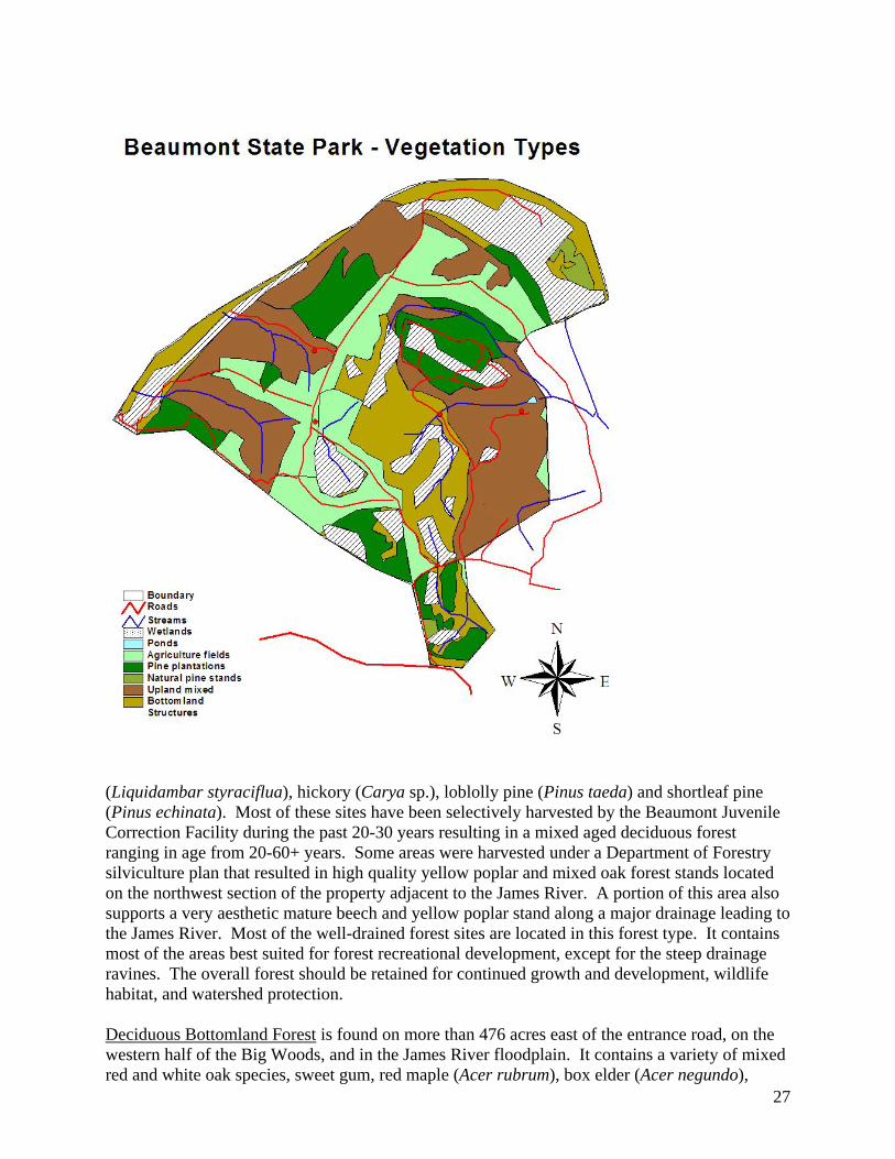
1. Terrestrial Communities a. Forests Upland Mixed Deciduous Forest is found on more than 485 acres on most of the eastern half of the Big Woods and on the ridges on the northeast side of Beaumont. It is comprised of a variety of mixed white and red oak species (Quercus sp.), American beech (Fagus grandifolia), yellow poplar (Liriodendron tulipifera), sweet gum
27
(Liquidambar styraciflua), hickory (Carya sp.), loblolly pine (Pinus taeda) and shortleaf pine (Pinus echinata). Most of these sites have been selectively harvested by the Beaumont Juvenile Correction Facility during the past 20-30 years resulting in a mixed aged deciduous forest ranging in age from 20-60+ years. Some areas were harvested under a Department of Forestry silviculture plan that resulted in high quality yellow poplar and mixed oak forest stands located on the northwest section of the property adjacent to the James River. A portion of this area also supports a very aesthetic mature beech and yellow poplar stand along a major drainage leading to the James River. Most of the well-drained forest sites are located in this forest type. It contains most of the areas best suited for forest recreational development, except for the steep drainage ravines. The overall forest should be retained for continued growth and development, wildlife habitat, and watershed protection. Deciduous Bottomland Forest is found on more than 476 acres east of the entrance road, on the western half of the Big Woods, and in the James River floodplain. It contains a variety of mixed red and white oak species, sweet gum, red maple (Acer rubrum), box elder (Acer negundo),

28
loblolly pine, sycamore (Platanus occidentalis), paw-paw (Asimina triloba), and black gum (Nyssa sylvatica). A considerable amount of this area consists of forested wetlands, riparian/floodplain and ponds along the James River; it supports a variety of plant species associated with this type of ecosystem. Even though much of this area is seasonally wet, a substantial amount of selective logging has taken place resulting in mixed age stands in some sections ranging in age from 30-60+ years. These stands should be retained for future growth and development, wildlife habitat, and watershed and wetland benefits. Pine Mixed Deciduous Forest is found on three small parcels totaling more than 31 acres. It supports loblolly pine, shortleaf pine, eastern red cedar (Juniperus virginiana) and mixed red and white oak species. The smallest parcel (three acres) is an abandoned field where natural plant succession is occurring. The thirteen acre parcel is a forested wetland surrounded by agriculture fields. The remaining sixteen acre parcel is a planted loblolly pine stand that due to its location and site conditions is very inaccessible. These forested wetland areas need to be retained and protected for wildlife, and watershed and wetland benefits. Managed Pine Stands can be found on almost 250 acres of land distributed throughout the park. These pine stands were planted and managed by the Department of Forestry under the State Lands Program, and range in age from 19-30 years. All of these stands have been commercially thinned except for stands number 3 (54 acres) and number 5 (19 acres). These two stands need to be commercially thinned within the next 1-3 years to reduce tree stocking to an acceptable level relative to age and site quality to allow for optimum growth. All stands should be evaluated within the next 3-5 years to determine if a second thinning is needed to reduce stocking levels. Thinning will help reduce natural pine mortality, will help promote hardwood and herbaceous vegetation in the understory, and provides greater protection from southern pine beetle (Dendroctonus frontalis) and ips bark beetle (Ips sp.) attacks. b. Agriculture Fields Beaumont contains fields on 311 acres that are currently in active agriculture cultivation by the Beaumont Juvenile Correctional Center. These fields are the most level and better-drained sections of the entire property. However, there are several small parcels located in low-lying areas that are not being actively cultivated due to excessive soil moisture that restricts cultivation.
2. Aquatic Communities a. James River The James River provides important habitat for a number of fish species. Smallmouth bass is the dominant game species, but spotted and largemouth bass can also be caught. Other species are also plentiful in the James River, including channel catfish, flathead catfish, and various sunfish species (redbreast, bluegill, and rock bass). (Source: Virginia Department of Game and Inland Fisheries, http://www.dgif.virginia.gov/fishing/waterbodies)

29
b. Wetlands (See also section E, Natural Heritage Resources) There are numerous wetlands throughout Beaumont State Park. The majority is palustrine and forested with broad-leaved tree species. Note however, that one of these wetlands has pines, and two have a mix of pines and deciduous species. The largest contiguous wetlands occur on the northern tip of Beaumont, encompassing the oxbow ponds. Flooding in much of that area is seasonal or temporarily. Another fairly large wetland is located in the southeastern part of the park, southeast of the old barn. This is a palustrine, forested wetland, with a mix of deciduous trees and pines, with saturated soils. On the western side of Beaumont bordering the James River, are two fairly extensive wetlands. One is a palustrine wetland, partly forested, partly shrub-scrub, that is temporarily flooded. The second, north of the first, is a riverine riparian area, that is permanently flooded and has an unconsolidated bottom. The Big Woods contain several wetlands associated with small streams, and tend to be forested with broadleaf species. C. Wildlife Many of the wildlife species associated with the forested areas of the park can be found in both the lowland and upland forests of the park. Commonly observed mammals include white-tailed deer (Odocoileus virginianus), eastern gray squirrel (Sciurus carolinensis), southeastern flying squirrel (Glaucomys volans), and raccoon (Procyon lotor). Amphibians such as the redbacked salamander (Plethodon cinereus) and slimy salamander (Plethodon glutinosis) inhabit most of the moist (but not flooded) woodland areas. The American toad (Bufo americanus) and Fowlers toad (Bufo fowleri) can be found throughout the forest as long as there are nearby shallow bodies of water and moist areas to hide. Common reptiles include the black rat snake (Elaphe obsoleta obsoleta), eastern worm snake (Carphophis amoenus amoenus), eastern king snake (Lampropeltis getula getula), and eastern box turtle (Terrapene carolina). In the summer, Red-eyed Vireos (Vireo olivaceus) and Carolina Wrens (Thryothorus ludovicianus) can be seen or heard throughout the forested areas of the park. Other common birds include the Northern Cardinal (Cardinalis cardinalis), White-breasted Nuthatch (Sitta carolinensis), American Robin (Turdus migratorius), Downy Woodpecker (Picoides pubescens), and Summer Tanager (Piranga rubra). D. Invasive, Exotic, and Pest Species Beaumont State Park has only minor invasive species problems. Southern pine bark beetle and gypsy moth (Lymantria dispar) have occurred in the past. Beetle “hot spots” have been removed by selected tree harvesting. Monitoring of gypsy moth impact is ongoing. If left unchecked and unaddressed, gypsy moth and bark beetle problems could escalate and negatively impact the quality of the woodlands, as well as change the current forest structure. Invasive plant species include Japanese stilt grass (Microstegium vimineum), ground ivy (Glechoma hederacea) and garlic mustard (Alliaria petiolata) along some of the ravines and in riparian areas, and tree-of-heaven (Ailanthus altissima) along field edges and in other disturbed areas.

30
Control of these exotic invasive species should be considered based on their impact on threatened or endangered species and long-term impacts to the general ecosystem compared to the cost and effectiveness of control. In most cases, herbicide treatments are the only practical and cost effective method of controlling these species. E. Natural Heritage Resources No rare plants or animals have been recorded from Beaumont State Park. Although there are scattered large trees, no stands of old growth have been found. However, a rare community known as a floodplain pond (http://www.dcr.virginia.gov/dnh/ncPId.thm ) has been found in two locations along the back edge of the floodplain the in the northeast part of the site. These ponds are old oxbows which support open, marsh-like wetlands. Floodplain ponds are widely scattered but uncommon along the James river and some of the other larger rivers running through the Virginia Piedmont and Coastal Plain. The ponds at Beaumont are very large compared to most other known sites. Although additional survey work is needed, it appears that the northwestern-most pond features an interior zone of nearly pure spatterdock (Nuphar advena) that grades abruptly to a marginal woodland zone with black willow (Salix nigra) and young hardwoods over dense, diverse forbs such as lizard’s-tail (Saururus cernuus), arrow-arum (Peltandra virginica), and dense-flowered knotweed (Polygonum densiflorum). In addition, the Big Woods contain a large, pristine, isolated wetland which is a high-quality example of an isolated depression wetland. Such wetlands are primarily found in the Coastal Plain, occasionally extending into the eastern Piedmont (http://www.dcr.virginia.gov/dnh/ncPIIIa.htm), and are globally rare. Additional work is needed to collect data and verify the wetland’s classification. F. Cultural Resources
1. Archaeological
Although no archaeological materials predating European settlement have been recorded from the Beaumont property, the part of the Piedmont in which Beaumont is located was home to the Monacan Indians. The Monacan Indians inhabited the Piedmont region of Virginia between the falls of the James River and the Blue Ridge Mountains. John Smith refers to the Monacans as the main enemies of the Powhatan Chiefdom; the latter controlled Virginia’s coastal areas. Based on Smith’s account of the Monacans, it appears that the Monacan had a socio-political structure similar to the Powhatan, consisting of a Monican Confederacy made up of the Monacan, Tutelo, Saponi, and Mannahoac tribes. These tribes spoke the Siouan language. The culture of the Monacan Confederacy was similar to the Powhatan culture; it included a combination of farming, hunting, fishing and gathering. The Monacan lived in villages, and buried their dead in burial mounds, at least thirteen of which have been identified in the Piedmont. In addition to other places, open settlements of huts existed up and down the James riverbank in the vicinity of what is now Maidens Bridge. Few written records exist about the Monacans. It has been estimated that the Monacan tribe at one point had 1,200 people, and the Monacan Confederay 5,200 or more. Once the English

31
colony began to expand beyond the lands of the Powhatan Confederacy, the Monacans came under increasing pressure from both the Cherokees and the colonists. Despite their past, in 1611 the Monacans and Powhatans joined together to try to drive out the English, with negative results. In 1677, Shurenough, King of the Manakins, represented the Monacans in a treaty between multiple tribes and England. By 1699, the Monacans had all but disappeared from the area around the upper James River, as well as from Monacan Town (near present day Manakin in Henrico County). (Sources: Monacan Indian Nation, http://www.monacannation.com/history.shtml, accessed 1/19/06; http://falcon.jmu.edu/~ramseyil/vaindiansmonacan.htm, accessed 1/20/06; Lexi Beauvais, Robbie Glass, Julie Malakie, Adam Vandervort, University of Virginia, http://www.vcdh.virginia.edu/lewisandclark/students/projects/monacans/ , accessed 1/20/06)
2. Historical Sites The first record of a white man being in the area known as Powhatan County was in 1608. A band of approximately 120 men led by Christopher Newport made an expedition up the James River to a point as far west as Maidens Bridge. Although the tribe was not hostile, Newport and his men took one of the Monacan leaders prisoner to ensure their safety when they left. Between the years of 1699-1705, some five to seven hundred Huguenot refugees fleeing from persecution in France settled on the James River near Manakin in the by then abandoned Monacan Indian villages. They soon scattered throughout the area, building fine homes, some of which are still standing in the county. Two of the Huguenot refugees were Abraham Michaux, a gauze weaver, and his wife Suzanne Rochet, a lace maker, who settled in Manakin Town in 1701. Both were French refugees from Sedan, France, who first fled to Amsterdam where they got married (1692) and had six children. In 1701, the family moved to London, England, followed by emigration to Virginia in 1703. In 1705, Abraham Michaux naturalized to become an English citizen, and was granted land by the Crown in the little township now known as Michaux. The last house in Michaux Grant Farms is still standing at 4066 Old River Trail; the center section of the house is the oldest, having been built about 1735. Later additions were constructed around 1810 by a Michaux descendant. In 1796, Colonel Jacob Michaux, the great-grandson of Abraham, built another house, Hunter’s Fare on an 100 acre English land grant (uncertain if this was the same land grant as the one granted to Abraham Michaux). This house is still standing at 4141 Maidens Road. Part of the Beaumont plantation became part of the Michaux family holdings in 1842. According to materials provided by the Virginia Department of Historic Resources, in 1811, the original Beaumont plantation house was erected for William Walthall. Walthall was one of the wealthiest citizens in Powhatan County, and one of its largest landholders. He built Beaumont on a 1,502-acre tract of land, valued in 1821 at $39,052. This land was bequeathed to him by his father at his wedding to Sally Michaux, daughter of Major Jacob Michaux and Mary Woodson of Powhatan County. The land originally belonged to Walthall’s mother, Frances Netherland, and Walthall took title from her in 1810. Through the 1830s, Walthall continued to acquire land in Powhatan County, and by 1837 owned over 3,000 acres. Reflecting his status as one of the largest property owners in Powhatan, he served as county sheriff in 1836-37. In 1842, the Beaumont tract was split between Walthall and his nephew and adopted son, William B. Michaux, apparently out of gratitude for the latter taking care of Walthall in old age. After

32
Walthall died in 1847 followed by his wife in 1863, the Beaumont tract was inherited by Michaux. It remained in the Michaux family until 1889, when G. H. Palmer-Morewood acquired it, follwed by P. O. Laughner in 1909 and John W. Petty in 1909. It was acquired in 1937 by “Beaumont Farms” as a reform school for boys. The Beaumont plantation house is currently building 36 at the Beaumont Juvenile Correctional Center, and is locally known as the “Old Mansion.” Although it has been standing vacant for a long time, it was placed on the Virginia Landmarks Register in 1986, and on the National Register of Historic Places in 1987. Note that according to the Department of Juvenile Justice, which owns Beaumont today, Beaumont was part of an original grant from the King of England to the Michaux family of Powhatan. They report that the 2,400 acre tract was purchased in 1920, and was then known as the Beaumont, Estranola, and Bullocks property. In 1920 the facility was named the Virginia Industrial School for Boys, which later changed to Beaumont Learning Center; it is currently known as the Beaumont Juvenile Correctional Center. The Beaumont mansion is located on Beaumont Juvenile Correctional Center property, rather than state park property. The only buildings on park property include the foundations and chimney of an old cabin the the Big Woods, a collapsed barn in the south central part of the agricultural fields, and a pole shelter. At this point, the age and historical significance of these buildings is not known. (Sources: Historic Virginia Homes and Churches, by Robert A. Lancaster, 1915; Building Inspection Report Building 36, Beaumont Learning Center, Powhatan County, by Mary Harding Sadler and Richard C. Cote, January 9, 1986; National Register of Historic Places Inventory – Nomination Form, DHL File No. 72-95, February 26, 1987; The Huguenot Society of the Founders of Manakin In the Colony of Virginia, http://manakin.addr.com/ , accessed 1/18/06; Beaumont Juvenile Correctional Center, http://www.djj.virginia.gov/Residential/facilities_residential.php?form_organization=Beaumont%20Juvenile%20Correctional%20Center&volunteer_file=bon_vol.php accessed 1/18/06)

33
MASTER PLAN: STAGE TWO V. PROPOSED DEVELOPMENTS The Virginia State Parks master plan process is described in §10.1-200.1 of the Code of Virginia. The Code states that Stage Two of the master plan shall include size, types, and locations of facilities and the associated infrastructure, including roads and utilities. The master plan needs to include a proposed plan for phased development of potential facilities and infrastructure as well as development cost and operational, maintenance, and staffing needs. The above requirements for Powhatan State Park were accomplished through the efforts of a master plan advisory committee and state and local government agency staff. Two public input meetings were held to solicit comments and ideas for the park developments. A. Site Planning Factors Powhatan State Park was created by partitioning 1600 acres off of the Beaumont Juvenile Correctional Center property. An agreement (see Appendix 1) between DCR and DJJ describes the parameters under which the park will be developed and operated given its proximity to the Beaumont Center. A clause in the agreement sets forth the conditions and a timetable for continued agricultural use of the property by the Department of Corrections. The schedule phases out agricultural use as DCR develops the park. The master plan leaves some areas as open fields and it may be appropriate to maintain them as meadows. DOC is interested in harvesting hay from those fields. Another clause in the agreement provides for a 100-foot setback buffer along the property line with the Beaumont Center. DCR will try to maintain a heavy vegetative strip along this boundary as well as appropriate signs to warn park visitors to stay in the park. Likewise, a vegetative buffer will be established and maintained along the property line with the other neighbors. Signs will be used to clearly note the park boundary. Fencing may also be installed. During the development of the master plan concern for the security of park visitors was emphasized. In response to this concern, use areas and developed facilities were specifically placed away from the Beaumont Center property line. Powhatan State Park has special characteristics that make it especially attractive as a state park. The 2.5 miles of frontage on the James River ensures that fishing and a variety of boating opportunities can be provided. The broad floodplain provides suitable locations for day use activities near the picturesque river as well as suitable sites for development of canoe-in camping. The old gravel pits and abandoned river channels (oxbows) offer unique wetland habitats for wildlife viewing and nature study. The quarry pit may support bank fishing if it is deep enough to hold fish. The upland areas of the park contain about 311 acres of open agricultural fields as well as large acreages of forestland. These forests have been carefully managed by the Department of
34
Forestry for many years and contain mixed aged stands of hardwoods as well as several pines plantations. Areas of poorly drained soils in some upland sections of the park have created vernal pools that support unique plant and animal communities. Other areas of the park have soils that drain better and are suitable for construction of roads, buildings, drain fields, and other park purposes. The Beaumont Juvenile Correctional Center has a pocket sewage treatment system and gets it water from the nearby James River Correctional Center water plant. The park may be able to link into those two systems.
1. Recreation Demand
The 2002 Virginia Outdoors Plan identified many of the activities to be offered at Powhatan State Park as some of the most popular and most needed in the state. The following list identifies the percent of households in Virginia participating in the various activities. Rank Activity Statewide Percent Participating 1. Walking for Pleasure 67.1 4. Fishing 42.0 6. Bicycling 39.7 8. Boating 34.1 9. Picnicking 28.7 10. Camping 28.2 11. Visiting Natural Areas 26.9 16. Hiking/Backpacking 18.3 The popular activities listed above are planned at Powhatan State Park. The activities and facilities programmed for development will help meet the existing and projected demand for the region. B. Management Units Powhatan State Park contains several management units.
1. Administrative management units. This unit is located near the park entrance and includes the contact station, park office, maintenance area, and ranger residence. A second ranger residence is situated at the intersection of the Phase I and Phase II roads.
2. Big Woods Management Unit. The Big Woods unit consists of the large block of woodlands that lie along the eastern border of the park to the north of the Administrative unit. This area contains a picnic area on its southwestern corner, an old cabin foundation and pond on its northeastern edge, and a series of trails. Lofted wetlands and special habitats and species occur along the western edge of the Big Woods.
3. Central Farm Fields Management Unit. The central uplands of the park are open farm fields that have been in a bean, corn, and wheat rotation for many years.

35
Equestrian parking and portions of the equestrian campground are located in the southern end of this unit. A multi-purpose field will be located in the northern end of this unit. The other fields will be restored to meadows or forest over time.
4. Upstream Riverside Management Unit. This unit is located along the James River terrace at the upstream end of the park. An access road will be constructed into this area and parking and day-use facilities constructed. Picnicking, restrooms, trails, boat launch, canoe-in camping, and bank fishing will be provided.
5. Downstream Riverside Management Unit. This unit lies at the lower end of the park and is comprised of the floodplain terrace and the quarry ponds and oxbow wetlands. Picnicking, parking, boat launch, restrooms, bank fishing, and trails will be offered in this unit. Nature study in the ephemeral pools will also be offered. The Phase II road will provide access to this area.
6. Overnight Management Unit. This unit is located on the ridge between the farm field and the river terrace. It includes a two-loop campground, a group camp, and a cabin and lodge area.
7. Visitor Center/Education Management Unit. This unit lies between the Farm Fields and the Upstream management area. It is accessed via the Phase I road. The Unit contains the visitor center, an amphitheater, gazebo, parking, and nature/interpretive trails. A ranger residence is located on the eastern end of this unit.
C. Location and Description of Proposed Facilities
1. Park entrance road. Route 617, Old River Trail, will be the park entrance road. From the intersection at Route 522 to the park entrance is approximately 1.5 miles. VDOT has been asked to do a traffic safety analysis of the intersection and determine if turn lanes will be needed. Other safety measures may also be taken like caution signs or a blinking yellow warning light. Landowners along the road are concerned about safety and would like the current 55 MPH speed limit reduced.
2. Phase I. Park Road. The first road segment constructed in the park will run from the entrance at Old River Trail and proceed approximately 2.3 miles to the James River at the upstream end of the park.
3. Phase II Park Road. The second road project will connect the Phase I road with the downstream end of the park. Separate roadways to the cabin loop, group camp, and campground will lead off of this road.
4. Entrance Sign and Gate. The existing entrance gate may be slightly re-located to accommodate landscaping and a park entrance sign. The gate should allow some room for vehicles to collect while waiting for the park to open.
5. Contact Station. The contact station will be located approximately 1800 feet from the entrance gate. This will allow storage room so visitors do not back up onto Old River Trail while waiting to come in to the park.
6. Park Office. The park office will be located in the administrative zone located to the east of the contact station. The office will consist of a public restroom, visitor orientation and sales area, storage room, visitor service desk, secretary’s office, manager’s office, chief ranger’s office, meeting room, and break room. Parking will be provided for staff and park visitors, including trailer parking in pull through spots.
7. Maintenance Area. The Park Maintenance area will be located East of the park office. It will include a three bay shop, pole shed, gas pumps, and hazardous materials storage building. The area will be enclosed within a security fence.

36
8. Ranger Residences. The park manager’s residence will be located in the Administrative Zone near the park office. The Chief Ranger’s residence will be located near the intersection of the Phase One and Phase Two access roads. Additional residences, when needed, will be located in the Administrative Zone.
9. Big Woods Picnic Area. A picnic area will be located on the western edge of the Big Woods. Two picnic shelters will be constructed as well as a rest room. The existing pole shed will be converted to a picnic shelter. A playground will be located between the shelters. Tables and grills will be dispersed throughout the area. Parking areas will be adequate to hold extra vehicles; as the trailhead for the Big Woods Trail System will be in the picnic area.
10. Big Woods Trail System. The existing forest management roads in the Big Woods should be connected into a system of multi-use non-motorized trails throughout the forest. These trails should connect to the equestrian area, the riverfront, and other trails in the park.
11. Equestrian Parking Area. The parking area for horse trailers will be located on a spur drive located south of the intersection of the Phase I and Phase II roads. The parking area will have a gravel surface and be adequate to hold 20 truck/trailer rigs. A vault toilet and potable water spigot will serve this area in phase I. A small picnic area with tables and grills will be provide nearby in the adjacent wood line. A connector trail will link the parking area with nearby multi-use trails. A manure management system will be provided.
12. Equestrian Campground. To the west of the equestrian parking area a 20-site equestrian campground will be developed. Sites will meet state park campsite standards. A bathhouse with showers will be provided. A shed with stalls for up to 40 horses and a manure management system will be provided.
13. Visitor Center. The park visitor center will provide exhibit space, learning centers, classrooms, restrooms, meeting space, offices, a laboratory, and a sales area.
14. Gazebo. A large gazebo will be constructed along the ridgeline on the western side of the park above the river. It should be positioned such that it can take advantage of significant views of the river valley and the hills beyond.
15. Amphitheater/Outdoor Classroom. A small amphitheater or outdoor classroom should be developed in an appropriate setting near the visitor center. In addition to seating for up to fifty participants, a stage and A/V equipment should be provided.
16. Riverside Picnic Area. The picnic area at the upstream end of the park will consist of parking areas, restrooms, shelters, scattered tables and grills, a boat launch, riverside trail, and bank fishing nodes. The floodplain terrace in this area is very wide and high enough to be out of the reach of most annual flooding events. The picnic area can start with a few tables and expand as park visitation grows over time. Facilities should be designed with flooding in mind.
17. Concession Building. A concession building that will support boating and tubing on the river will be located within the picnic area. The boat launch should be close by to facilitate the launching and retrieval of rental boats. Bait, tackle, and camp stores could also be provided there.
18. Canoe-in Campground. To support canoeists traveling on the James River Canoe Trail, canoe-in campsites, potable water, and a small bathhouse should be provided. A boat slide or other similar facility will be needed to transition the high banks along the river. It should be designed to withstand frequent flooding.
37
19. Riverside Trails and Bank Fishing Nodes. A trail should be developed that runs along the James River. Where site characteristics appear suitable, fishing nodes should be provided.
20. Other Park Trails. Trails should be developed that will connect the cabin area, campground, group camp, visitor center, and other areas of the park to the river, the picnic areas, and to other trails in the park. Where appropriate, some of these trails can be single purpose, such as single tract mountain bike trails or walking/nature trails. Interpretive trails may include boardwalks through marshes and wetlands or steep sections not suitable for bicyclists or horses. Most trails should be developed for multi-use purposes.
21. Cabins and lodges. Up to 18 two and three bedroom cabins and two family lodges are proposed for development on a wide forested ridge overlooking the James River valley. The loop road along which they will be constructed connects to the Phase II road just north of the intersection with the Phase I road.
22. Group Campground. The group campground will consist of one small picnic shelter with fireplace on one end, a bathhouse, campfire area, and up to six tent pads. A parking area for up to eight cars will also be provided. It will be located on a ridge north of the cabin area and west of the phase II road.
23. Campground and camping cabins. The main campground will consist of up to sixty sites in two loops with two bathhouses. Three camping cabins will be provided. The advisory committee asked that the sites not contain water and electric hookups in deference to the private campground owner’s opposition. The campground is to be located on the wide ridge north of the group camp and west of the phase II road.
24. Downstream Picnic Area. The downstream picnic area will be constructed along the river floodplain at the northern edge of the park. It will include bank fishing and boat launching facilities, a restroom, potable water, picnic shelter, and parking areas. The river in this area contains some rapids and shallow gravel bars suitable for wade fishing and contact recreation. Steps or a ramp should facilitate access to the river. Fishing in the nearby quarry pond may be provided if a sustainable game fish population is present.
25. Multi-use field. A multi-use field suitable for flying kites, radio-controlled model aircraft, and for holding community events will be constructed in the agricultural field at the northeastern edge of the property. The field will be maintained in grass. Parking and a vault toilet will be provided. A farm road that connects to farm roads within the DJJ property goes through this field and should be retained for emergency response needs. The road will be gated at the property line.
26. Fishing Ponds and Dog Training Area. Just north of the Big Woods Picnic Area is a small drainage that should be suitable for the construction of a fishing pond or two. The ponds should be deep enough to hold fish over winter. The ponds and the area around the ponds will be kept in meadow and will be available for dog training under guidelines to be developed at a later date.
27. Participate as a stop on the Virginia Birding and Wildlife Trail. Powhatan State Park should be listed as a site on the Virginia Birding and Wildlife Trail. To facilitate use of the park’s many assets, it is recommended that a guide be prepared to bring visitors to the wide range of habitat types within the park. Where needed, construct wildlife observation platforms or hides to facilitate viewing.

38
D. Expected Annual Visitation by Phase of Development The following describes expected annual visitation at the park following the completion of each phase of development. These numbers are cumulative (they include the attendance of the previous phases.)
Phase I: 100,000 visitors per year Phase II: 175,000 visitors per year Phase III: 195,000 visitors per year
E. Total Estimated Vehicle Trips per Year To compute vehicle trips per year, the annual number of visitors should be divided by 2.6 persons/vehicle. Total vehicle trips generated by Powhatan State Park at full build out is 195,000 divided by 2.6 persons per vehicle equals 75,000 round trip visits per year. The majority of those trips will take place during the prime recreation season of May 1st to October 1st. F. Estimated Economic Benefit of Powhatan State Park The annual economic benefit generated by Powhatan State Park will change as each phase of development is completed and new facilities come on line. Studies have shown that the average day-use visitor to Virginia State Parks spends about $16.00 per day. Overnight visitors, those staying in campgrounds or cabins, spend on average $75.00 per person per day. During construction of the park, a significant amount of the money spent on construction will accrue to the local economy. The budget for the park by phase is listed below. Phase I: $11,664,292
Phase II: $8,112,312 Phase III: $8,049,132 Total: $27,825,736
Economic benefits contributed by park visitors is determined using attendance figures and average daily expenditures by those visitors. The following computations are presented by phase. Phase I: 100,000/year (x) $16.00/person = $1.6 million/year Phase II: 125,000/year (x) $16.00/person = $2.0 million/year (Day use) 25,000/year (x) $75.00/person = $1.875 million/year (Overnight) Phase III: 125,000/year (x) $16.00/person = $2.0 million/year (Day use) 45,000/year (x) $75.00/person = $3.375 million/year (Overnight) Total annual contribution from park visitors per year at full build out is $5.375 million. Benefits that accrue to the local economy from the staffing, maintenance and operations of the park will approach $1.0 million per year at full build out. It will include 7 full-time staff and up to 25 seasonal staff.

39
Concession operations in the park will generate on average $85,000 additional economic activity in the community.
G. Future Acquisitions Protect the park from incompatible development on its border or within its viewshed. Where conversion to incompatible uses could negatively impact the park’s mission, land along the park’s perimeter should be considered for acquisition when it becomes available. If nearby or adjacent properties that would protect viewsheds or enhance recreational opportunities become available, they should be protected/acquired through either easement or fee-simple acquisition depending on which would best serve the needs of the park. H. Future Considerations All phases of the planned developments will be developed in an environmentally sensitive manner. All construction will meet or exceed the requirements of the Chesapeake Bay Preservation Act and the requirements of the Department of Conservation and Recreation’s Best Management Practices Handbook. This plan is considered to have a 20-25 year planning horizon, but it represents the desired future condition or “build-out” for Powhatan State Park. The Code of Virginia requires that the Department of Conservation and Recreation keep this plan current. To that end, the DCR staff will revisit the master plan every five years in order to ensure that the plan is current and conditions have not changed significantly. VI. PHASED DEVELOPMENT Phase I Safety improvements to Rte 522/617 intersection Safety improvements to Rte 617 Construct 2.2-mile Main Park Road to River Utilities- connect to DOC system or develop park system. Contact Station Park Office Upper Day Use/Picnic Area w/ restroom Riverside picnic area w/ rest room Boat Launch (river access for canoes, kayaks and tubes) Riverside trail and bank fishing nodes Maintenance Area 2-Ranger Residences Multi-use Trails Mountain Bike Trails Equestrian day-use facilities Pond Development Canoe-in Campsites w/ restroom Vegetative Buffer / Fencing Reforest farm fields
40
Phase II Campground Group Camp Equestrian Campground Road Extension to downstream riverside day use area Downstream Riverside Day-Use/Picnic Area w/ restroom Downstream Boat Launch Gazebo/Shelter at Visitor Center Amphitheatre Visitor/Education Center Ranger residence Phase III 18 Cabins & 2 Family Lodges Attachments Master Plan Map Operations and Staffing Plan VII. APPENDIX Operations and Staffing Plan VIII. APPENDIX Planning Bureau Cost Estimates