Coping with disaster, storage and backup in the cloud - Tom Verté

Procedia - Social and Behavioral Sciences 218 ( 2016 ) 118 – 130
Available online at www.sciencedirect.com
1877-0428 © 2016 The Authors. Published by Elsevier Ltd. This is an open access article under the CC BY-NC-ND license (http://creativecommons.org/licenses/by-nc-nd/4.0/).Peer-review under responsibility of Dept of Transportation Engineering, University of Seoul.doi: 10.1016/j.sbspro.2016.04.015
ScienceDirect
11th International Conference of The International Institute for Infrastructure Resilience and Reconstruction (I3R2)
: Complex Disasters and Disaster Risk Management
Research on the disaster coping capability of a historical village in a mountainous area of China: case study in Shangli, Sichuan
Fei Duª , Hirohide Kobayashi , Kenji Okazakic, Chiho Ochiaid ªDoctoral Student, Department of Graduate School of Global Environmental Studies, Kyoto University, Room 461, 4th Floor, General
Research Building No.3, Yoshida-Honmachi, Sakyo-ku, Kyoto, 606-8501, Japan Associate Professor, Department of Graduate School of Global Environmental Studies, Kyoto University, Room 461, 4th Floor, General
Research Building No.3, Yoshida-Honmachi, Sakyo-ku, Kyoto, 606-8501, Japan cProfessor, Department of Graduate School of Global Environmental Studies, Kyoto University, Room 461, 4th Floor, General Research
Building No.3, Yoshida-Honmachi, Sakyo-ku, Kyoto, 606-8501, Japan d
Assistant Professor, Department of Graduate School of Global Environmental Studies, Kyoto University, Room 461, 4th Floor, General Research Building No.3, Yoshida-Honmachi, Sakyo-ku, Kyoto, 606-8501, Japan
Abstract Most valuable historical villages in Southwest China are located within remote mountainous areas, not only facing a high risk of unexpected natural disasters, but also threatened by isolation, fire, and blocked situations that may occur during emergencies, due to vulnerable spatial connections, high density wooden buildings, compact village structure, and so on. Since public emergency services cannot cover all affected areas immediately after disaster, disaster coping capability of a village community is noticeably important. This study focused on the disaster coping capability of a historical village within a mountainous area. Based on previous studies, this paper listed the necessary components of disaster coping capability, while considering the social and organizational features of a community in China. Accordingly, this paper investigated the case of the historical village Shangli regarding three topics: disaster awareness, potential capability, and practical capability. The conclusions are as follows. First, local inhabitants had insufficient cognition of risk and emergency response, while a deficiency in the potential of public cooperation was also observed. Second, under the conventional top-down administration method, local inhabitants were prone to rely on the government, leaving an obvious gap between their high perception of the community and the actual inactive situation that shows that, although there was great potential, the community had not yet been motivated to become cohesive. Third, practical disaster countermeasures were still at the primary stages without a systematic plan for disaster risk reduction. However, they had started with rough arrangement concerning basic emergency issues. © 2015 Fei Du. Published by Elsevier Ltd. Selection and/or peer-review under organizing committee of I3R2 2015
Keywords: Historical village; Remote disaster-prone mountainous area; Disaster coping capability 1. Introduction
1.1 Research background 1.1.1 Comprehensive value of historical villages in mountainous area
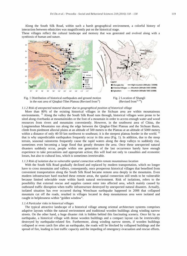
China is a mountainous country, especially the southwest, geologically uplifted area between Qinghai-Tibetan Plateau in the west and the basins, plains, and hills in the mid-east region (Fig. 1). Approximately 1500 years ago, benefitting from its important geographic location between the plateau and plain, this zone became the core area of the South Silk Road, the ancient trade route from central to west China, before it reached farther to India and connected over to Europe.
*Corresponding author. Tel.: +81-080-4765-5428; fax: +81-75-753-7450. E-mail address: [email protected]
© 2016 The Authors. Published by Elsevier Ltd. This is an open access article under the CC BY-NC-ND license (http://creativecommons.org/licenses/by-nc-nd/4.0/).Peer-review under responsibility of Dept of Transportation Engineering, University of Seoul.
brought to you by COREView metadata, citation and similar papers at core.ac.uk
provided by Elsevier - Publisher Connector
119 Fei Du et al. / Procedia - Social and Behavioral Sciences 218 ( 2016 ) 118 – 130
Along the South Silk Road, within such a harsh geographical environment, a colorful history of interaction between ethnicities was magnificently put on the historical stage. These villages reflect the cultural landscape and memory that was generated and evolved along with a symbiosis of human and nature.
1.1.2 Risk of unexpected natural disaster due to geographical position of historical village More than 80% of the existing historical villages in the Sichuan area are within mountainous
environments. 1) Along the valley the South Silk Road runs through, historical villages were prone to be sited along riverbanks at mountainsides or the foot of a mountain in order to access enough water and wood resources from rivers and mountains conveniently. However, in the southwest area of China, the Longmenshan Mountains run along the edge between the Qinghai-Tibet Plateau and the Sichuan Basin, climb from piedmont alluvial plains at an altitude of 500 meters to the Plateau at an altitude of 5000 meters within a distance of only 40-50 km northwest to southeast; it is the steepest plateau border in the world. 2) that is why unpredictable earthquakes frequently occur in this area (Fig. 1). In addition, due to the steep terrain, seasonal rainstorms frequently cause the rapid waters along the deep valleys to suddenly rise, sometimes even becoming a large flood that greatly threaten the area. Once these unexpected natural disasters suddenly occur, people within one generation of the last occurrence barely have enough experience to take precautions and appropriate action; this will lead not only to casualties and economic losses, but also to cultural loss, which is sometimes irretrievable.
1.1.3 Risk of isolation due to vulnerable spatial connection within remote mountainous location With the South Silk Road gradually declined and replaced by modern transportation, which no longer
have to cross mountains and valleys, consequently, once prosperous historical villages that benefited from convenient transportation along the South Silk Road became remote area deeply in the mountains. Even modern infrastructure hard reached these remote areas, the spatial connection still tends to be vulnerable because limited selectable route within harsh natural environment. Risk of isolations, refers to the possibility that external rescue and supplies cannot enter into affected area, which mainly caused by outbound traffic disruption when traffic infrastructure destroyed by unexpected natural disasters. Actually, isolated situation has ever occurred during Wenchuan earthquake happened in 2008 that collapsed mountain cut off the roads, resulted in villages located in deep mountainous area were isolated and caught in helplessness within “golden window”.
1.1.4 Particular risks in historical villages The typical attractive landscape of a historical village among oriental architecture systems comprises
adaptive layouts within the natural environment and traditional wooden buildings along winding narrow streets. On the other hand, a huge disaster risk is hidden behind this fascinating scenery. Once hit by an earthquake, a historical village with dense wooden buildings and a compact layout can be irretrievably destroyed by earthquake-related fire. Furthermore, along winding narrow streets, if wooden buildings collapsed or even catch fire after an earthquake, the roads will be blocked by collapsed buildings and the spread of fire, leading to lost traffic capacity and the impeding of emergency evacuation and rescue efforts.
Fig. 1 Distribution of historical earthquakes and ground motion Fig. 2 Location of Shangli in the east area of Qinghai-Tibet Plateau (Revised from1)) (Revised from5), 6))

120 Fei Du et al. / Procedia - Social and Behavioral Sciences 218 ( 2016 ) 118 – 130
Additionally, historical villages attract tourists that will be unfamiliar with local conditions and vulnerable in an emergency.
1.1.5 Top-down approach of decision-making ignoring the needs and capability of local community As stated above, these valuable historical villages within remote mountainous areas not only face a high
risk of unexpected natural disasters but are also threatened by isolation, fire, and being blocked when facing with an emergency due to vulnerable spatial connection, high density wooden buildings, compact village structure, and so on. Since public emergency services cannot cover all affected areas immediately after a disaster, 3) especially these remote areas, the disaster resilience of village community is noticeably important.
“Disaster coping capability” represents the comprehensive capability of the local community to cope with disaster when emergencies through cooperation of all community members, 3) which depends on not only practical strategies, but also the potential coping ability rooted in daily relationships and community cohesiveness. In other words, it is increasingly being realized that a village’s disaster resilience depends on not only the capability of its public agencies, but also on the capability of the community itself.
However, local issues in China showing a remarkable features of top-down decision-making that tends to be mainly dominated by the administration and experts. Either the government or ordinary people are accustomed to that public affairs should be taken charge by government, which roots in the deep rooted influence of feudalism thousands of years. 1) The administration prone to give priority to immediate economic benefits rather than inner improvement without immediate benefit, consequently, disaster issues are being ignored. On the other hand, during emergency, the local administration holds all resources engaged in rescue and evacuation, while the local inhabitants also actively help each other spontaneously. However, after the disasters, due to washed-out awareness of disaster risk and absence of civic consciousness, the capability of local inhabitants and community seems not being highly emphasized during the process of decision-making.
1.2 Research purpose and objectives Focusing on the case of the village of Shangli, this paper aims to investigate the disaster coping
capability of the community of historical mountainous village. Since earthquake emergency strategies in China began at the end of 1980s, 4) it was found, based on pre-
survey, that either the physical or organizational aspect of disaster risk reduction in the rural area was at primary stage; a pure quantitative evaluation system intended for a relatively mature and perfect community cannot be used in this situation. Therefore, based on previous evaluation studies in Japan, particularly those targeting historical villages and mountainous areas, this study summarizes the necessary components of disaster coping capability while fully considering the social and organizational differences between Japan and China.
According to these components, the research objectives are as follows. The first objective is to understand that the disaster awareness of local inhabitants refers to their disaster cognition, experience, and preparedness. Second, this research seeks to investigate the community’s “potential disaster coping capability”, which refers to its potential ability to take action when a disaster happens. The third objective is to grasp its “practical disaster coping capability”, which represents the efforts that Shangli village has exerted in planning to improve the disaster resilience of their community in either the physical or soft aspect.
1.3 Research methodology
1.3.1 Components of disaster coping capability extraction Based on the study of Nagamatsu, 7) this paper analyzed previous studies on local disaster coping
capability and summarized the general components of disaster coping capability as “disaster awareness”, “potential capability”, 8) and “practical capability”. 8) Owing to the social and organizational features of communities in China, the indicators and factors were adjusted (Table.1), and the detailed explanations are as follows.
1.3.1.1 “Disaster awareness” and its factors “Disaster awareness” refers to “the level of cognitive and grasp about the specific contents of disaster
risk in the region.” 7) its related subjects basically invovle local governments, voluntary disaster risk reductions organization, neighborhood associations, and disaster risk reduction events. Yet, in the study of Kamio, 11) the disaster awareness of local inhabitants should also be added to the components of disaster coping capability. In Chinese communities, there are no voluntary disaster-related organizations to the

121 Fei Du et al. / Procedia - Social and Behavioral Sciences 218 ( 2016 ) 118 – 130
extent of those in Japan; therefore, the topic of “disaster awareness” referenced to the study of Wakabayashi, 12) includes the factors of the disaster awareness of the local inhabitants’ disaster cognition, disaster experience, and disaster preparedness (Table. 1).
1.3.1.2 “Potential disaster coping capability” and its indicators and factors The concepts of “potential disaster coping capability” and “practical disaster coping capability” were put
forward by Okanishi, 8) and was considered to show one of the trends in the evaluation perception of regional disaster coping capability. 7)
“Potential disaster coping capability” refers to a community’s potential capability and whether the connection between its people would enable them to adequately respond together as a unit when disasters happen. 8) However, though it is also important to consider the attributes of the local residents and community, they belong to regional resident organizations; therefore, they count the activities in terms of units in the region. 8) Consequently, the specific evaluation indicators in their studies are centered all around voluntary disaster risk reduction organizations and neighborhood associations. Since China is without the same organizations as Japan, this study will instead consider the attributes of local residents and the community.
There are two papers refer to “potential disaster coping capability” with indicators that can represent
potential coping features of local inhabitants and community, without mentioned voluntary disaster risk reduction organizations and neighborhood associations. The study of Hori Takeo 13) emphasizes on three indicators: the disaster coping ability of the common people, the fundamental ability of local communities, and the adequacy of activities for local community improvement. Moreover, the study of Takeuchi 9) used an indicator of “basic regional characteristics involved in disaster response”, which emphasized the cohesiveness of the local community.
In reference to the literatures and analysis above, this paper reorganized the topic of “potential disaster coping capability” with the following indicators: potential ability to respond, and cohesiveness of community (detailed factors are listed in Table. 1).
1.3.1.3 “Practical disaster coping capability” and its indicators and factors “Practical disaster coping capability” refers to the component of various daily activities in a community
and whether it is possible that the enhancement of disaster preparedness activities could help the community embody the executive ability when a disaster occurs. In other words, the evaluation of
Table 1. Components of disaster coping capability. Topic 1 Indicator Factor Method
Disaster awareness
Disaster awareness 2
Disaster cognition Questionnaire Interview Disaster experience
Disaster preparedness
Potential capability
3
Cohesiveness of community
Perception of community
Questionnaire Interview
Community activity
Community events Percentage of permanent resident Collaboration work Maintenance of public facilities
Related organization cooperation
Daily contact with the administration Volunteer Fire& Flood Department Daily activities of Production Association
Potential ability for responding
Education about disaster risk reduction Questionnaire Interview Training on disaster risk reduction
Practical capability
4
Disaster risk reduction plan
Normal times risk inspection
Interview Observation Map
Disaster information check and transmission Plan for evacuation and rescue system improvement Improvement of cooperation with relevant organizations
Facilities& Infrastructure Improvement
Evacuation site and route improvement Information transmission equipment improvement Firefighting troops and equipment Other public facilities related to disaster
1 See 7), 9), 11); 2 See 12), 14); 3 See 8), 7), 9), 13); 4 See 9), 8); 5 See 10)

122 Fei Du et al. / Procedia - Social and Behavioral Sciences 218 ( 2016 ) 118 – 130
“practical disaster coping capability” is based on disaster countermeasure activities. 8) In the study by Takeuchi, 9) which summarized the framework for the implementation status of countermeasures against disasters, the indicators were designated as “disaster risk reduction plan” and “facility infrastructure improvement”. Although factors for these two indicators are without specific voluntary disaster risk reduction organizations and neighborhood associations, the activities and preparedness are necessary for any community. Therefore, this paper investigated the “potential disaster coping capability” with the following indicators: “disaster risk reduction plan” and “facility infrastructure improvement” with all factors retained as well as revised details (Table 1). 1.3.2 Investigation schedule and summary
This research was conducted by conjunct investigation of both the qualitative and quantitative approaches. The main methods were literature reviews, on-site observations, measurements, interviews, and questionnaire surveys. A ten day pre-survey was conducted in June 2014, based on a systematic sampling, 20 questionnaires were delivered and collected, mainly about the topics of basic information, living condition, community life, and conservation of the village. Additionally, five interviews were conducted about the disaster history of the village.
A one month investigation was conducted in October 2014 in which questionnaires were distributed to all 280 families in the Wujia village (Shangli’s core area). Of those questionnaires, 216 were collected, of which 174 were valid, producing a 62% valid response rate. The content of the questionnaires included four parts: basic information, degree of statisfication with living environment, disaster awareness (disaster cognition, experience, and preparedness), and cohesiveness and disaster-related activities of the community. In addition, the earthquake damage situition was understood in detiled, disaster-related facilities were checked, and a measurement survey of the road system was conducted. Additionally, ten local people were interviewed in-depth (three village committee leaders, three group leaders, and four villagers) about community activityies related organization cooperation, disaster education and training, and the disaster risk reduction and improvement plans of the village.
2. General information about Shangli Village
2.1 Location, history, and social condition of Shangli Village Located 168 km away from Chengdu, the provincial capital of Sichuan province (Fig. 2), lies the center
of Shangli named Wujia village, deep in a hilly area surrounded by mountains and rivers with steep gradients. It is the closest existing historical villages to the epicenter of two earthquakes that occurred in 2008 and 2013 (Fig. 1, 2). With the original name of “Luosheng”, Shangli was an ancient post town along the South Silk Road and reached its peak heyday about 300 years ago. Five big families lived here, which is why it was called Wujia (which means 5 families). The largest family migrated from Shaanxi along the South Silk Road for business. At present, in the center of Shangli, Wujia village has five groups and a total registered population of 1099 (2013); 99% of the local inhabitants are ethnic Han, and the 1% are Tibetans who came to the village for marriage. While social heterogeneity is a common phenomenon in the historical villages of Sichuan, 1) Wujia Village still has 90% of the population that are local inhabitants. Since the Tea-Horse trade along the South Silk Road declined when modern transportation developed, the village has mainly subside on farming for nearly one generation. However, with the rise of tourism and labor mobility about a dozen years ago, 70% of the economic income of this village now comes from tourism and 20% from migrant workers; comparatively, only 10% comes from traditional agriculture.
2.2 Spatial layout in Shangli Village Wujia village, Shangli’s center, is situated on “the most auspicious point” according to Feng Shui, the
traditional Chinese approach to settlement locations. The village is surrounded by continuous foothills in three directions, with rivers flowing from both the east and west, and then meandering south after converging in front of the village. The free morphology of Shangli’s regional spatial structure is a typical adaptable village layout inside the mountainous area. Along the rivers, there is a continuous winding spatial sequence, which is also a landscape sequence. (Fig. 3,4,5) However, the village center is like a peninsula, surrounded by two rivers at the foot of the northern mountains and connecting with the southern land only through ten old stone pedestrian bridges (Fig. 3). Furthermore, there is only one outbound traffic connection to the outside, which is less than 10 meters wide and winds through the mountains and valleys (Fig. 3). With the limited and vulnerable traffic capacity of the bridges and roads, the center area will be easily trapped and isolated.
Inside of the compact village, the streets are far from systematic; the width is also variant. The main roads are about 4.0-6.0 m wide, and most small roads are even less at 4.0 m, 2.7 m, 1.8 m, and some

123 Fei Du et al. / Procedia - Social and Behavioral Sciences 218 ( 2016 ) 118 – 130
sections without cwalking Shangli v
2.3 BuildAccord
have maicoated wstructureThree adwhich wCurrentlywith conThe fewecultural corder to Shangli v
1RC+B
even narrowconsidering that a width o
village has a h
dings in Shangding to strucintained their
with loam ( type featuresdditional typ
wooden framey, 163 buildincrete beam-cest number oconsumption,recover and
village is at h
Fig. 3 Regio
1 Wood (StructureBrick
wer than 1m he status of th
of 0-4 m is ohigh risk of b
gli Village cture, there arr original woo-1, -2 in Fis top walls coes gradually es and brickngs (58%), tholumn framef buildings (7, villagers usmaintain the
high risk from
onal structure
e)+Clay(Wall)
Fig
(Fig. 14). Whe buildings a
only 0.579, 15
being blocked
re four types oden structureig. 6), thus inomposed of w
developed. k together cohe largest numes combined w7%) are reinfe wooden mae historical a
m fire caused b
of Shangli Vi
2 Wood+Wood
g. 6 Buildings
When seismicalong the roa5) according d.
of buildingse, with walls nheriting a 30wooden board
Twenty-fouronstitute the mber of buildiwith brick waforced concreaterials as suratmosphere (Fby an earthqu
illage
d 3 Wood+Bric
of four types
Fig.
c intensity reads, the probato this, it can
s in this villamade of woo
00-year-old ad with bricksr buildings (
load-bearingings in the vialls to create ete (RC) strurface decoratFig. 6), togetuake.
ck, Wood Woo
of structure in
Fig. 4 Pub
5 Traditional
eaches 6 (maability that then be said tha
age. Seventy-oden board orncient style. on the bottom9%) are woog structural sllage, are conthe bearing sctures ( in tions, regardlether with den
od, Brick+Wood
n Shangli
blic square
residential ho
agnitude6.2-6ey will be paat the street
-three buildinr hand-wovenAn additiona
m half ( -3 iod-brick stru
system ( inncrete-brick sstructure ( i
Fig. 6). In cless of the strnse wooden b
Concrete, Bric
ouses
6.7), even ssable via system in
ngs (26%) n bamboo al wooden in Fig. 6). uctures in n Fig. 6). structures, in Fig. 6). atering to
ructure, in buildings,
ck+Brick

124 Fei Du et al. / Procedia - Social and Behavioral Sciences 218 ( 2016 ) 118 – 130
2.4 Disasters and damages in recent years According to recorded history, three earthquakes stronger than a magnitude 8 have occurred along the
Longmenshan fault zone (Fig. 1), and the Wenchuan Earthquake on May 12, 2008, which was a magnitude 8.0, is one of them. It caused about 69,000 deaths with about 374,000 people injured.2) The Lushan Earthquake of magnitude 7.0, happened on April 20, 2013, killing 193 people with about 2 million people affected. 16) At a straight-line distance of only 9.5 km from epicenter of Lushan Earthquake in 2013, Shangli was remarkably impacted. All buildings were affected, and the damage situation of the buildings were evaluated into three levels- mild, moderate and severe by a joint investigation team composed of experts, village leaders, and village representatives. One obvious feature of the damage situation was that 86% of the wooden buildings experienced mild or moderate damaged; 14% were severe damaged. Comparatively, the concrete-brick structures were found to be most vulnerable; 43.6% were severe damaged.
In addition, due to steep terrain, seasonal rainstorms frequently cause rapid rivers along the deep valleys to suddenly rise, and that often leads to flooding. Surrounded by two natural rivers (Fig. 3), Shangli is at risk of floods every year from July to September, a period which accounts for more than 70% of the annual rainfall. Based on the limited memory of the present generation, the biggest flood was on August 2, 1988; with a daily rainfall of 320 mm, the entire village, including 5000 acres of farmland, was flooded. A 200 m stone embankment as well as the single-story classrooms in the school were destroyed. 17) On July 8 and 28, 2013, floods hit this village, twice in a month, just three months after the Lushan earthquake. Nearly all of the houses were flooded, and one third of the houses were flooded with more than 1 m of water (Fig. 7). Wooden buildings in the village were severely affected by the combined effects of earthquake and flood (Fig. 8).
3. Disaster awareness
3.1 Disaster cognition Disaster cognition refers to the perception people have of the risk in their area and their dwelling.
Sichuan is a historically earthquake-prone area, but among local inhabitants, according to questionnaire survey, only 14.9% of the responses clearly know about that; comparatively, 31.4% of them are completely unaware of the fact. When referring to the possibility of a big earthquake happening again within ten years, 16.1% and 4.2% of the responses maintain a relatively optimistic perspective, thinking that it may not happen or certainly will not happen respectively. Regarding the assumption of a large earthquake happens again, 27.3% and 46.3% of the responses believe their houses will and may be destroyed again respectively. However, from the cross analysis between the damage situation and seismic performance of the houses, there are also some responders whose houses experienced severe damage but who are still satisfied with the seismic performance of their houses (Table 2). This shows that local inhabitants still do not clearly understand the risk they are facing.
3.2 Disaster experience “Disaster experience” indicates both the personal and group experience of local inhabitants represented
by the actions they took during the Lushan earthquake and big flood in 2013. Through questionnaire survey, it was found that when the shaking occurred, the top response of the local inhabitants was that they “fled outdoors” (66.1%) followed by “helped the weak” (37.8%) (Table 3). Moreover, when asked about the reason for their actions, the top answer, at 59.8% of the response, was “intuition” followed by 23.1% who
Fig.7 Situation of flood on July 8, 2013 Fig.8 Broken pillar rotten
by water

125 Fei Du et al. / Procedia - Social and Behavioral Sciences 218 ( 2016 ) 118 – 130
said thet “rely on their own experience”. In addition, just after the shaking stopped, 57.9% of them hurried to confirm whether their families were safe, and 31% went out-doors to ascertain the situation.
Through the interview survey, it was found that almost the same situation happened during the flood in July of 2013; most people just had the instinctive desire to seek “refuge at higher place”, even without pre-consideration of the exact location, and they tended to follow the crowd. The analysis above demonstrates that local inhabitants are temporarily still at a very elementary level of personal experience in coping with disasters.
Furthermore, without a formal disaster coping organization, how does the community react as a group?
This study also investigated the factor of “groups who are relied on” when an emergency occurs, aiming to grasp the potential connection within the community for emergency cooperation. According to the analysis based on the questionnaire survey, it was found that local inhabitants tend to rely on three aspects of power when emergency strikes: community power (neighbor, 52.7%; family, 37.3%; villagers, 31.5%); public power (local government, 26%); and coordinating power (leader of village, 16.4%) (Fig. 9). It surprisingly reveals a typical rudimentary of community cooperation structure, in other words, the potential for disaster coping on the community level is present in Shangli village.
3.3 Disaster preparedness This study investigated disaster preparedness from two aspects, both personal preparedness in the family
and public preparedness. According to the questionnaire and interview surveys, it was found that after they experienced large
earthquakes and floods, the disaster knowledge of the local inhabitants was remarkably enhanced; simultaneously, they already have a clear understanding of the importance of preparedness. Family preparedness was also found to be greatly enhanced after the earthquake according to the questionnaire survey (Fig. 10). However, it is still far from enough. For example, their preparedness against fire is very weak; 47.9% of the responses indicated that they did nothing, and even though 41.5% prepared by installing a fire extinguisher, only 32.2% of them know how to use it.
Regarding public preparedness, the local inhabitants gave negative comments about the disaster
Table 2. Action taken when earthquake happenedResponses Percentage
Fled outdoors 84 66.10% Helped the weak 48 37.80% Cut off the power prevent fire 34 26.80% Stand to prevent falling 25 19.70% Hid under the table or near column 22 17.30% Opened the window or door 12 9.40% Hold the furniture to prevent collapse 10 7.90%
Did nothing 7 5.50% Other 1 0.80% Total 243 191.30%
Percentage of cases by multiple choice
Table 2. Cross analysis between damage and perception of seismic behavior of dwelling Level of damaged Total Mild Moderate Severe
Degree
of satisfaction with seismic behavior of
dwelling
Greatly satisfied 0 6 1 7 Satisfied 2 26 5 33 Common 1 47 16 64
Dissatisfied 0 9 9 18 Very dissatisfied 0 12 11 23
No idea 0 3 3 6 Total 3 103 45 151
N=151 (216) Fig. 10 Preparedness before and after disaster Fig. 9 Groups relied on during emergencies

126 Fei Du et al. / Procedia - Social and Behavioral Sciences 218 ( 2016 ) 118 – 130
measurements after they twice experienced large earthquakes and floods. Only 2.7% of the responses indicates that they felt safe, while 89.1% indicated that the preparedness is inadequate. In spite of that, when asked about the resources for improvement of public preparedness, 76.8% of them selected the support from government as the most important element. They consider disaster issues to be the responsibility of the government. Therefore, when it comes to community cooperation and activities, without organization from the government, participation in disaster education and training did not improved (Fig. 10).
Disaster preparedness appears to comprise two general features. When local inhabitants have enhanced awareness about both public and family preparedness, they take better preparatory actions in their family. However, in reference to public preparedness, they are used to relying on the government.
To summarize the topic of “disaster awareness”, the local inhabitants of Shangli Village still have no clear understanding of the risk their region and houses face; their response to disasters rely almost entirely on intuition according to their personal experience, but their group experience reflected the typical rudiment of a potential basis for disaster coping cooperation on the community level. Moreover, they have an enhanced awareness of both public and family preparedness, and they have prepared better on the family level. However, they place high expectations and rely on the government for public preparedness.
4. Potential disaster coping capability
4.1 Cohesiveness of community
4.1.1 Perception of community Originated from five families-Han, Yang, Xu, Chen, and Zhang- 300 years ago, 30% of the local
inhabitants are descendants of the Han family, and 15% are descendants of the Yang family. Shangli is a typical historical village inhabited by consanguinity. Through the questionnaire and interview surveys, local inhabitants were found to have a high level of identity with their local history, culture, and community. Furthermore, they also have high expectation and remarkable enthusiasm for community life.
It was found that 70% of local inhabitants have a clear sense of cultural identity, and 75% of the
responses indicates that they are enjoying their life in this community. Satisfaction with family life, relationships and mutual help between neighborhoods were evaluated as remarkably high (Fig. 11). However, during pre-survey, 65% of the responders felt that their community lacked vitality. The reasons given were as follows: the top was “lack of community activities” followed by “traditional industry recession” and “lack of a leader who has the ability and desire to make arrangements for various civilian activities”. They said that if there are interesting activities, almost all of them are willing to participate. For these community issues, they still tend to rely on village committee and local government.
4.1.2 Community activities Although 90% of the population in Shangli village are permanent residents and they were found to be
enthusiastic about community activities, there is only one well-known community event, the traditional New Year’s sacrifice called the “Nianzhu festival” (Fig. 12). However, the majority of the audience for this solitary community event is tourists, and temporarily employed actors and actresses account for most of the participants during activities and performances. Of the responders, 70% had never been involved (Fig. 13). Recreational activities, just as interviewees said, could benefit the neighborhood contact and promote community cohesiveness. However, neither village leaders nor the local inhabitants could made it clear whether there were any activities or give an average of how many times per year; at least 90% of the responders have never joined in (Fig. 13).
With commercial development, traditional collaboration work gradually disappeared along with traditional agriculture. According to the diversification of property rights, maintenance of public facilities is mainly the responsiblility of the tourism authorities or a special management company. In many historical villages like Shangli, it is not uncommon for heritages and facilities to fall into severe condition due to confusing property rights.
Fig. 11 Degree of satisfaction with spiritual identity and daily life

127 Fei Du et al. / Procedia - Social and Behavioral Sciences 218 ( 2016 ) 118 – 130
Obviously, the current condition of community activities is far from active, cannot meet high expectations of local inhabitants, which is blamed as the top1 reason of why their community lack of vitality. Moreover, it represents that local inhabitants, local government, commercial management company, these various stakeholders are not well organized for cooperation to inherit and improve the community.
4.1.3 Cooperation of related organizations “Cooperation of related organizations” was proposed by Takeuchi with three factors in Japan: “daily
contact with the administration”, “volunteer fire& flood department”, and “daily activities of production association”. However, the real condition is that there are no volunteer fire & flood department and production association in China. Daily contact with the administration in Shangli Village tends to be substantially unidirectional and mainly performs as a top-down policy transmission and execution; an effective multi-cooperation system has not yet formed.
In summary, there are obvious gaps between the high perception and enthusiasm of local inhabitants about the community and the community’ lack of activities and cooperation. Therefore, despite great potential, the cohesiveness of the community has not yet been inspired well.
4.2 Potential ability for responding Except for the organizational ability, according to the study of Hori, disaster education and training can
represent the personal coping ability of local inhabitants. Through the questionnaire survey, it was found that the disaster knowledge of the local inhabitants mainly comes from TV programs. According to interview survey, education and training about disaster risk reduction was mainly organized by the fire department of the district or city, which seldom can be implemented in mountainous villages. Moreover, even though it was held twice, the only attendees were village leaders and a few villager representatives; it did not targeted ordinary villagers. Over 90% of the responders never participated in any education or training (Fig. 10, 13).
The main contents were also partial and limited, only including basic knowledge about fire and other common disasters and training on how to use a fire extinguisher. Comparatively, children are taught by teachers in school comprehensively and regularly; the education and training for disaster risk reduction in every semester is required by the government, especially after the Wenchuan earthquake in 2008.
5. Practical capability
5.1 Disaster risk reduction plan Although there is no systematic plan for disaster risk reduction in this village so far, after experienced
disasters in recent years, the public agency has started to take measures at primary level. First, they now have unscheduled routine inspections, mainly targeting fire risk. They are also paying attention to disaster information and drafted a simple arrangement ensuring that leaders keep in touch for information transmission. Third, they made a simple and conceptual arrangement for a two-level evacuation site, together with the rough evacuation direction (Fig. 14); a rescue system has not yet been involved. However, for improvement of cooperation with relevant organizations, there is still no pre-arranged system, though it relies on instant contact during emergencies.
5.2 Infrastructure improvement According to Takeuchi, infrastructure improvement entails three factors: “evacuation site and route
improvement”, “information transmission equipment improvement”, and “facilities related to disaster coping”. To highlight fire risk in Shangli Village, this paper identified “firefighting troops and equipment” as a separate factor.
Fig. 13 Participation situations of activities
Fig. 12 Community event: “Nianzhu Jie” Festival
128 Fei Du et al. / Procedia - Social and Behavioral Sciences 218 ( 2016 ) 118 – 130
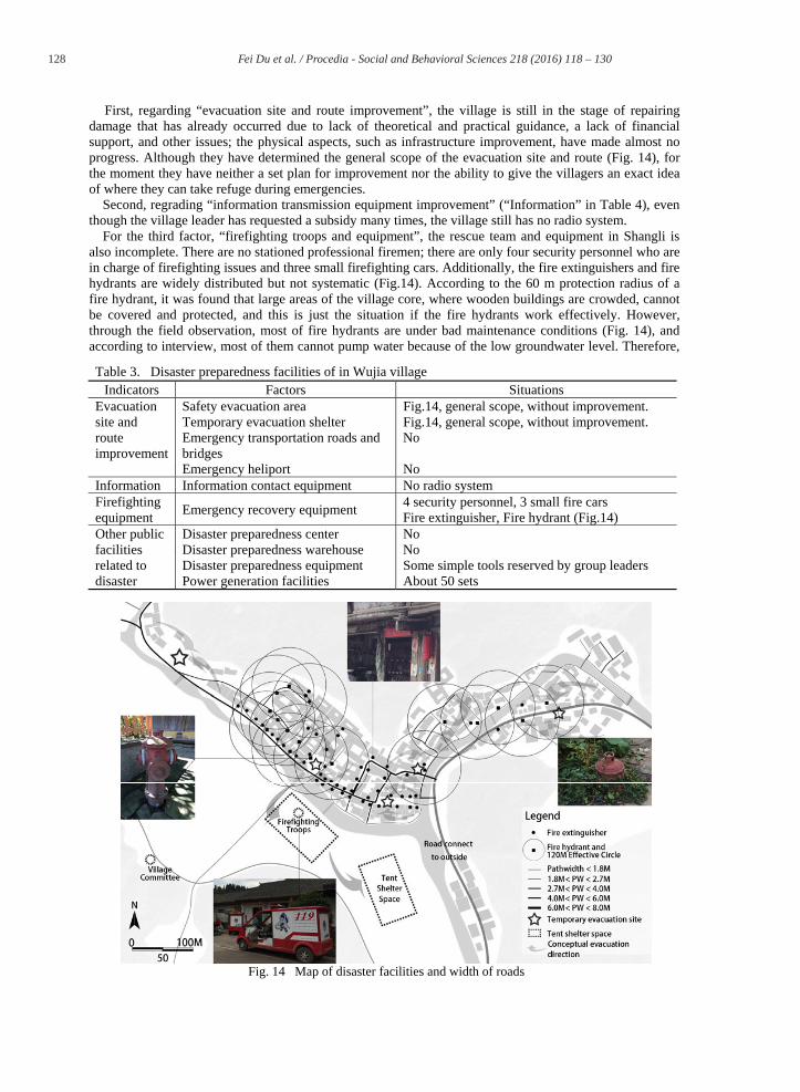
First, regarding “evacuation site and route improvement”, the village is still in the stage of repairing damage that has already occurred due to lack of theoretical and practical guidance, a lack of financial support, and other issues; the physical aspects, such as infrastructure improvement, have made almost no progress. Although they have determined the general scope of the evacuation site and route (Fig. 14), for the moment they have neither a set plan for improvement nor the ability to give the villagers an exact idea of where they can take refuge during emergencies.
Second, regrading “information transmission equipment improvement” (“Information” in Table 4), even though the village leader has requested a subsidy many times, the village still has no radio system.
For the third factor, “firefighting troops and equipment”, the rescue team and equipment in Shangli is also incomplete. There are no stationed professional firemen; there are only four security personnel who are in charge of firefighting issues and three small firefighting cars. Additionally, the fire extinguishers and fire hydrants are widely distributed but not systematic (Fig.14). According to the 60 m protection radius of a fire hydrant, it was found that large areas of the village core, where wooden buildings are crowded, cannot be covered and protected, and this is just the situation if the fire hydrants work effectively. However, through the field observation, most of fire hydrants are under bad maintenance conditions (Fig. 14), and according to interview, most of them cannot pump water because of the low groundwater level. Therefore,
Fig. 14 Map of disaster facilities and width of roads
Table 3. Disaster preparedness facilities of in Wujia village Indicators Factors Situations
Evacuation site and route improvement
Safety evacuation area Fig.14, general scope, without improvement. Temporary evacuation shelter Fig.14, general scope, without improvement. Emergency transportation roads and bridges
No
Emergency heliport No Information Information contact equipment No radio system Firefighting equipment Emergency recovery equipment 4 security personnel, 3 small fire cars
Fire extinguisher, Fire hydrant (Fig.14) Other public facilities related to disaster
Disaster preparedness center No Disaster preparedness warehouse No Disaster preparedness equipment Some simple tools reserved by group leaders Power generation facilities About 50 sets

129 Fei Du et al. / Procedia - Social and Behavioral Sciences 218 ( 2016 ) 118 – 130
when an emergency strikes, they usually use small firefighting cars to pump water from the river nearby via movable pump; it is conceivable that this is a large risk for the entire village.
Finally, “other public facilities related to disaster” are remarkably inadequate (Table. 4). Directly related to the safety and quality of the living environment, public service is one of the three major issues that local inhabitants are not satisfied with and emotionally complained about during interview. They had compaints such as, sewage system not having been renovated a year after it had been destroyed by flood, which has led to river pollution because sewage is discharged into the river. The current condition of the infrastructure improvement has two problems. The first is that not only specific disaster facilities, but also public facilities like the sewage system, need comprehensive improvement. The second is that there is no improvement plan for the serious shortage of disaster facilities; current existing facilities are not systematic and are poorly maintained.
6. Conclusion and discussion
According to the reorganized components of disaster coping capability extracted from previous studies, this research investigated the current state of disaster coping capability in the case of the historical village of Shangli in a mountainous area, from a new approach, which emphasises the capacity of local community. Regarding three topics: “disaster awareness”, “potential capability”, and “practical capability”. The conclusions are as follows.
First, local inhabitants of Shangli Village still have no clearly understanding of the risk their region and houses face; their response to disasters relies mostly on intuition according to their personal experience, but their group experience reflected typical rudimentary level of potential for disaster coping cooperation on the community level; moreover, they have an enhanced awareness of both public and family preparedness. They prepared better for their families, but they rely on the government for public preparedness.
Second, under the conventional top-down administration method, local inhabitants are prone to rely on the government. Consequently, there appears to be obvious gap between the high perception and enthusiasm of the local inhabitants regarding their community and the community’s actual, inactive status and lack of cooperation. Therefore, despite great potential and positive expectation for participation, the cohesiveness of the community have not yet been realized. Additionally, while the potential ability to respond, which depends on disaster education and training, has made little progress among the common adulta, it is greatly enhanced among students, who are well educated and trained in school.
Third, practical disaster coping capability, which greatly relies on the support of an established system and funding, is still in the preliminary stage. Although there is not yet systematic plan for disaster risk reduction in this village, the staff at the local public agency has started to take measures on primary level to make simple arrangements, such as establishing evacuation sites and conducting safety inspections.
In summary, the current state of the disaster coping capability in the mountainous historical village of Shangli is far from systematized. The key point tends to be that the local community needs to be motivated to apply its potential and well-organized cooperation must be established between the various stakeholders.
Acknowledgment I wish to thank Mr. Zhao Yulin (clerical staff in Wujia village) for his great advices on questionnaire, and
enthusiastic help in contact with villagers, and support in many times interview. My gratefulness is extended to Mr. Yang Yuankai (director in administration of Shangli town), for his generous help in providing the map and for support in interview. I also appreciate the kind support from Mrs. Liu and Mrs. Zou.
References Dai Yan (2010). Research on adaptable preservation of historical and cultural heritage of ancient town in Bashu area (pp. 29-228). Nanjing:
Southeast University Press Ji Shaocheng (2009). Earthquake, accompanied with China (pp. 5-139). Beijing: Science Press Kaji Hideki, et al. (2013). Study of Urban Disaster Risk Reduction (pp. 173-175). Kyoto: Gakugei Press Onishi Kazuyoshi (2002). History and Law System of Disaster in China, Chikyu Monthly, Vol. 24, No. 8, 539 USGSShakeMaps:http://earthquake.usgs.gov/earthquakes/shakemap/global/shake/2008ryan/&http://earthquake.usgs.gov/earthquakes/shake
map/global/shake/b000gcdd/ Editorial board of Tour of China ancient town (2011). Tour of China ancient town (pp. 625). Xi’an: Shaanxi Normal University Press Shingo Nagamatsu (2009). How can the “coping capacity of local community against disasters” be evaluated? Research Report of National
Research Institute for Earth Science and Disaster Prevention, No. 74, 4 Yasushi Okanishi, et al. (2006). A study on community and local disaster management in neighborhood associations for improving local
ability of disaster prevention, J. Archit. Plan, AIJ, No. 609, Nov, 77-78 Shin-ichi Takeuchi, et al. (2011). Study on local ability of disaster mitigation for community in Hokkaido, Institute of Social safety Science,
No. 14, 45

130 Fei Du et al. / Procedia - Social and Behavioral Sciences 218 ( 2016 ) 118 – 130
Social education and cultural assets Division in Board of Education of Sasayama City (2009). Research report on conservation countermeasure for traditional buildings of Fukuzumi district in Sasayama (pp. 30-31). Sasayama: Board of Education of Sasayama
Hisashi Kamio, et al. (2005). Evaluation and Subject extraction for Disaster coping capability with the object of residents and In-charge Person, Tsunami engineering research report, No. 22, 73-76
Naoko Wakabayashi, et al. (2000). A study on the structure of inhabitant’s consciousness about disaster prevention, Tohoku branch of Architectural Institute of Japan, 807
Takeo Hori, et al. (2007). Research on quantification of community disaster mitigation capability focusing on community and neighborhood disaster organizations and activities, part 3, Tokai Branch research report collection, AIJ, No. 45, 623
Hu Zhexin, et al. (2004). Assessment and improvement of local residents' disaster mitigation capability: Database Development for Study on the Residents' Behavior in Disaster Mitigation, Institute of Social safety Science, No. 15, 120, 121
Hiroshi Tsukaguchi (2009). Estimation on Road-blockage in a Historical City, Journal of Disaster Mitigation for Historicalal Cities, Vol. 3, 253, 254
For details please refer to the webpage of http://www.csi.ac.cn/publish/main/1/100260/20130528133636921935563/factor.html, April 24, 2013 (May 15, 2015 Editorial board of Ya’an city record (2000). Ya’an city record (pp. 300). Ya’an: Sichuan Science and Technology Press