Research & CAL/VAL - IOCCG
20
Transcript of Research & CAL/VAL - IOCCG


Research & CAL/VAL
Division
Ground Segment
Development Team
Satellite
Operation Team
Satellite Development & Planning Team
+ Application
- Operation

해양위성센터 동해기지국(울진) ▶
- 천리안 해양위성 1호 및 국외위성 수신/처리/배포
- 천리안 해양위성 수신안테나(4.5m), NOAA 수신안테나(1.2m),
MODIS&NPP 수신안테나(2.4m)
◀ 해양위성센터 안테나운영동(부산)
- 2019년 12월 완공 예정
- 천리안 해양위성 1호 및 2호 수신/처리/배포
- 지상 2층, 약 300평 규모
- 천리안 해양위성 1호 및 2호 동시 수신안테나
(9m, 레이돔 12m)
- 전산실, 상황실, 자료처리실, 브리핑실 등
위성운영 중심 인프라


GOCI Lifetime
Official GOCI/COMS operational lifetime is 7 years from the beginning of GOCI
normal on-orbit operation and data distribution service (April 1, 2011).
GOCI/COMS operational lifetime will be extended until March 2021(TBD).
GOCI and GOCI-II can acquire data simultaneously for about one year.
• Near Real-time distribution service to Gov. user
• Web-based data service(http://kosc.kiost.ac.kr)
• Open access for research/public use
• Public services using Portal
• Mirror site on NASA OBPG
• Level 1B : same as KOSC(HDF-EOS5 format)
• Level 2 : processed by NASA Seadas(NASA format)
• User SW : GDPS 2.0
GOCI Data Service

The GOCI-II is scheduled to be launched in Mar. 2020.


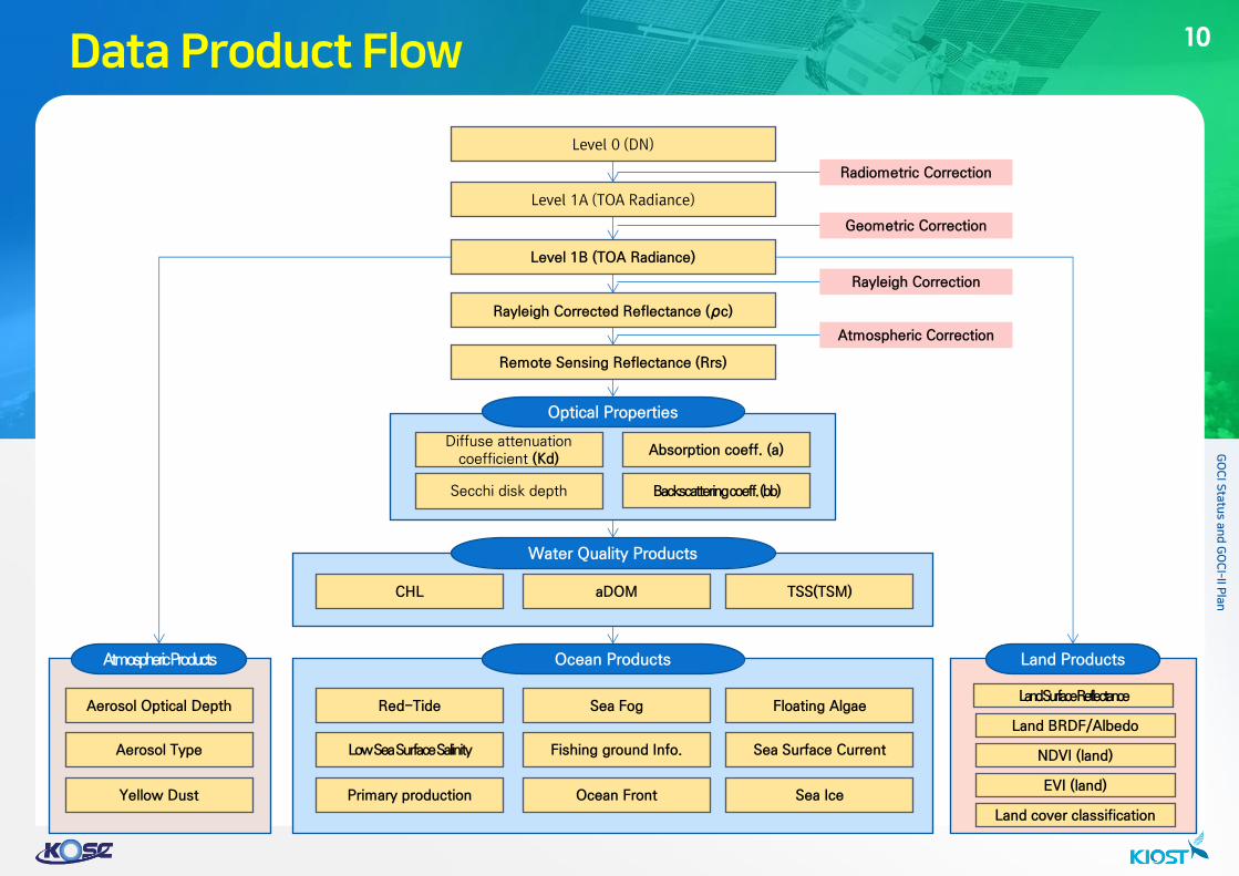
Land Products
Diffuse attenuation coefficient
Secchi disk depth
Optical Properties
Water Quality Products
Ocean Products Atmospheric Products

SOC
@KARI LV2
Raw
Signal
Raw,LV0,
LV0C, LV1A,
LV1B
LV0
LV1A
LV1B
LV2
Quality Info
Validation Info
Raw
LV0
LV0C
LV1A
LV1B
LV1B
DCS
Raw FileGeneration
Radiometric Correction
Geometric Correction
DAS
Data Acquisition
LV1B
ODPS
L2 Product
Processing
Algorithm
Management
Data Analysis
PCS
Data Correction
Quality Estimation
DMS
Data Management
Data Distribution
Storage DB External Data Collection
OQMS
Quality
Management
Operation
Management
Mission Plan
Management
NMSC
• Mission Schedule
• Mission Event
• OBT Drift Time
• Star Vector Telemetry
• FDS Data
• Ephemerides File
• Orbit Data (TLE)
• Mission Request
• DPS Channel
Parameter
• GOCI-ll FOV Offset
• Target Star Info
• xRIT Additional Data
Product
Request
Product
- LV1A+geo_info
- LV1B
- LV2
- RGB Complete
Image
xRIT
additional data
GOCI-II Ground Segment System
Data
Log
Control Command
& Status Info
ESC
Level Product
- Raw
Product Request
User LV0
LV1A
Quality Estimation
Result
G2GS is composed of 6 subsystems : data acquisition, data correction, ocean data
processing, data management, precision correction, operation and quality
management.

• Data Analysis Module
GOCI data visualization on snap is working after installing GTBX plug-in.
GOCI L2 and GOCI-II L2 sample data for one slot is shown on it.


GOCI-II Reference Local Area coverage by 12 slots
• Reference Local Area (RLA), 10 images a day
• Full Disk (FD) observation, once a day
GOCI-II Full Disk Area coverage by 235 slots


GOCI-II JOint Ocean reference Network (GI-JOON)
Indonesia (MTCRC) : Ocean monitoring, Cal/Val station
(Standard Criteria)


GOCI-II algorithms are developed based on the GOCI algorithms
Atmospheric correction
• Almost identical to SeaWiFS/MODIS/VIIRS atmospheric correction
• Partially modified
• It employs an alternative aerosol estimation scheme from two-NIR bands by using
spectral relationship of aerosol multiple-scattering reflectance
• For turbid water atmopsheric correction, it estimates NIR water reflectance by using 620
and 709 nm in the iterative scheme
Ocean color algorithms
• Primary ocean color products
• Chl-a (Hu et al., 2012 & Oreilly et al., 2000), CDOM (Siswanto et al., 2011), TSM
(Siswanto et al., 2011), Kd490 (Lee et al., 2005), IOP (QAA), Zsd (Lee et al., 2015)
• Algorithms’ coefficients are adjusted for GOCI-II spectral characteristics with in-situ data
• Employed algorithms can be changed during the IOT period
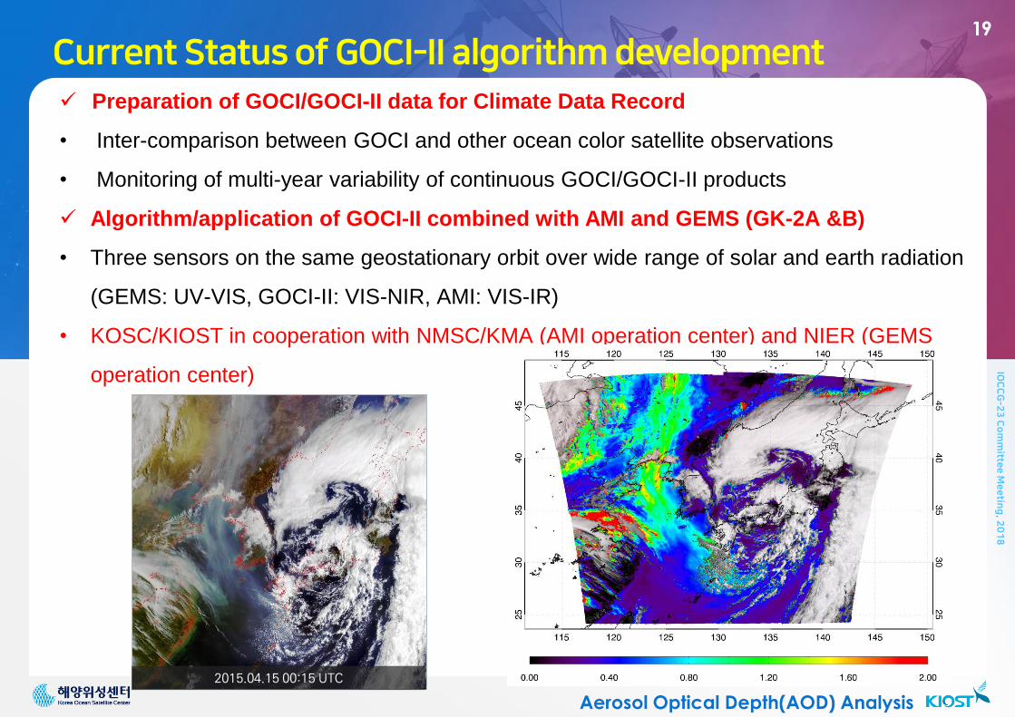
Preparation of GOCI/GOCI-II data for Climate Data Record
• Inter-comparison between GOCI and other ocean color satellite observations
• Monitoring of multi-year variability of continuous GOCI/GOCI-II products
Algorithm/application of GOCI-II combined with AMI and GEMS (GK-2A &B)
• Three sensors on the same geostationary orbit over wide range of solar and earth radiation
(GEMS: UV-VIS, GOCI-II: VIS-NIR, AMI: VIS-IR)
• KOSC/KIOST in cooperation with NMSC/KMA (AMI operation center) and NIER (GEMS
operation center)
Aerosol Optical Depth(AOD) Analysis
2015.04.15 00:15 UTC