
The FLARE Network Vicarious Cal/Val for Earth Observation ...
20
© 2021 Labsphere Proprietary The FLARE Network Vicarious Cal/Val for Earth Observation Satellites © 2021 Labsphere Proprietary & Confidential Better Calibration | Better Data | Better Decisions Brandon Russell a , Jeff Holt a , Will Arnold a , Chris Durell a , David Conran b , Arin Jumpasut c , Colm Lynch c , Stephen Schiller d a Labsphere, Inc., North Sutton, NH USA b Rochester Institute of Technology, Rochester NY USA Planet Labs, Inc., San Francisco, CA USA c Raytheon Technologies, El Segundo, CA USA
Transcript of The FLARE Network Vicarious Cal/Val for Earth Observation ...

© 2021 Labsphere Proprietary
The FLARE NetworkVicarious Cal/Val for Earth Observation Satellites
© 2021 Labsphere Proprietary & ConfidentialBetter Calibration | Better Data | Better Decisions
Brandon Russell a, Jeff Holt a, Will Arnold a, Chris Durell a, David Conran b, Arin Jumpasut c, Colm Lynch c, Stephen Schiller d
a Labsphere, Inc., North Sutton, NH USAb Rochester Institute of Technology, Rochester NY USA
Planet Labs, Inc., San Francisco, CA USAc Raytheon Technologies, El Segundo, CA USA
© 2021 Labsphere Proprietary
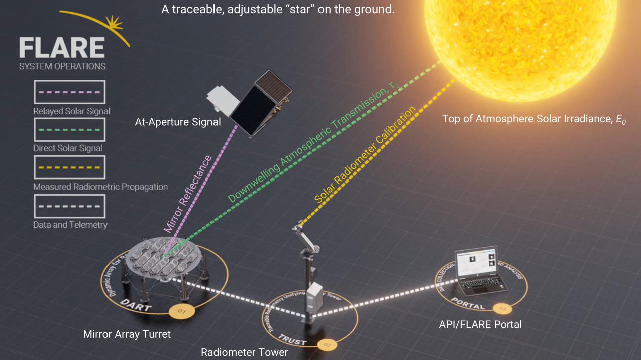
Top of Atmosphere Solar Irradiance, E0At-Aperture Signal
Mirror Array Turret
Radiometer Tower
A traceable, adjustable “star” on the ground.
API/FLARE Portal

© 2021 Labsphere Proprietary
Lambertian vs Specular TargetsTarget signal embedded in a uniform scene is elevated above the low spatial frequency background (sky path radiance, adjacency effect, stray light, etc.) and is separable
• Background becomes a bias and is subtracted out based on image data alone
• Sensor response to target radiance is integrated (DN) contained in the PSF
• Atmospheric, adjacency, multiple scattering effects reduce to transmittance only - measured with solar spectrometer coincident with overpass
The convex mirror acts as an aperture stop isolating the direct solar irradiance as the only contributor to the effective at-sensor calibration radiance
Target
Surround
Signal from surround background surface, sky path, adjacency effect, stray light, etc.
Signal from SPARC

© 2021 Labsphere Proprietary
FLARE Nodes FLARE Development
• Alpha Node• Arlington, SD
• SDSU Evaluation partnership
• Beta Node• Ft. Worth, TX
• Mobile Node future development
• Summer ’21
• Prototype at Beta site
• Custom Campaigns • Manual campaigns for
targeted geometry
• Commissioning Projects - individual assets or constellations
• Planned Nodes• Mauna Loa (3300m)
• Fall ‘21
• Railroad Valley Playa, Tenerife – TBD
• Atacama, Australia, Gobabeb - TBD
© 2021 Labsphere Proprietary
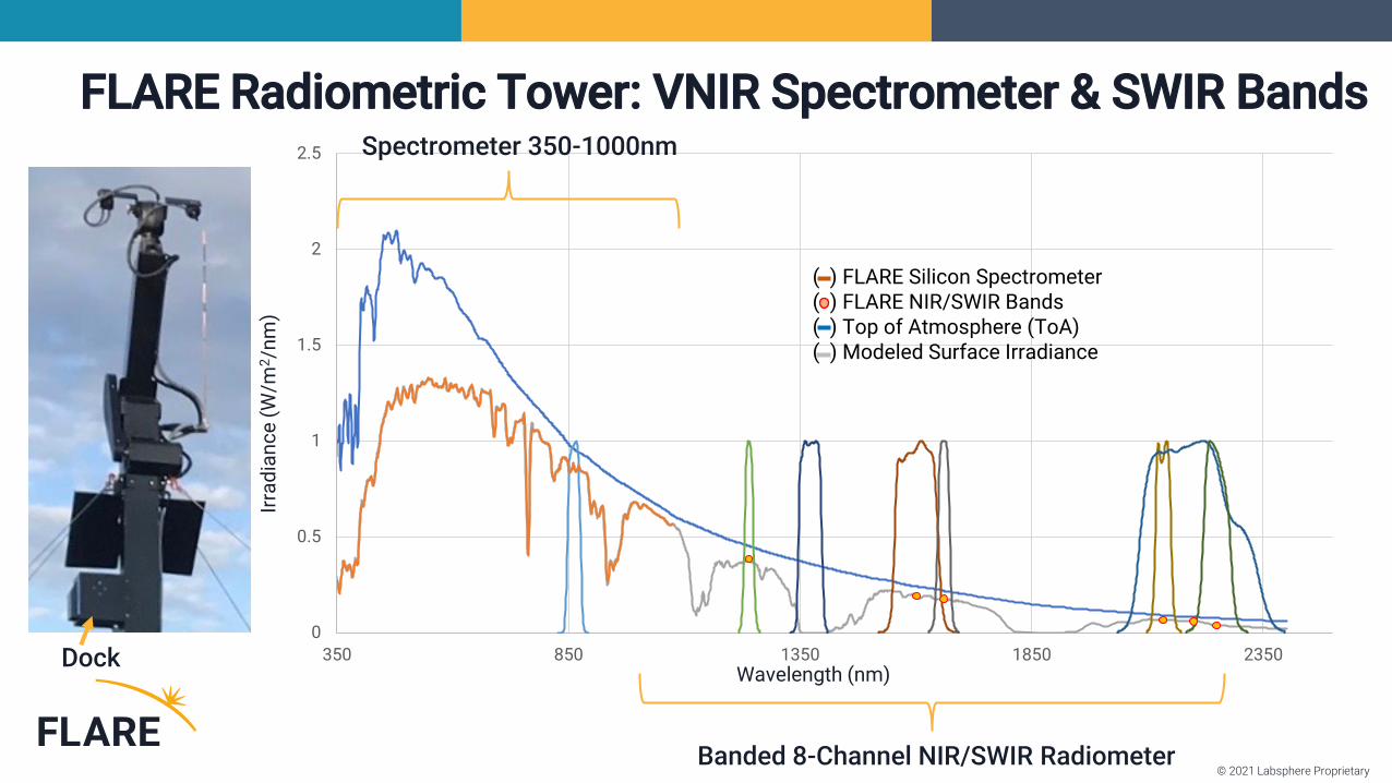
FLARE Radiometric Tower: VNIR Spectrometer & SWIR Bands
Wavelength (nm)
Irra
dia
nc
e (
W/m
2/n
m)
0
0.5
1
1.5
2
2.5
350 850 1350 1850 2350
( ) FLARE Silicon Spectrometer ( ) FLARE NIR/SWIR Bands( ) Top of Atmosphere (ToA)( ) Modeled Surface Irradiance
Spectrometer 350-1000nm
Banded 8-Channel NIR/SWIR Radiometer
Dock

© 2021 Labsphere Proprietary
Dual Traceability - Langley & Sphere Methods
Prelim. SWIR Uncertainty Analysis < 5%

© 2021 Labsphere Proprietary
Small Sats and Analysis Ready Data - CEOS CARD4L
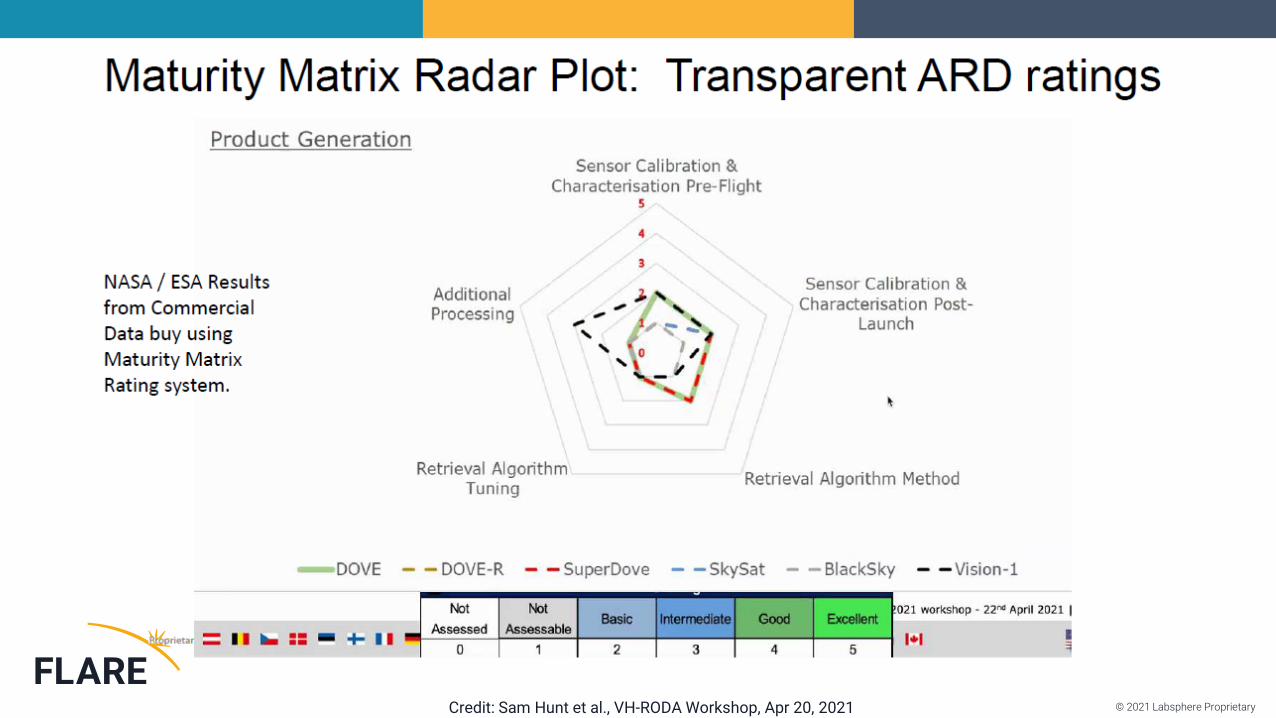
© 2021 Labsphere ProprietaryCredit: Sam Hunt et al., VH-RODA Workshop, Apr 20, 2021

© 2021 Labsphere Proprietary
DQR and GIQE FLARE – Feed for Maturity Matrices
GIQE = General Image Quality Equation
DQR = Data Quality Report

© 2021 Labsphere Proprietary
FLARE Mission Quality Metrics
IMAGE QUALITY PARAMETER DESCRIPTION
Absolute Radiometric Performance Imagery reported in-band radiance relative to uncertainty requirements.
Absolute GeolocationLocation error of imagery reported coordinates for FLARE signal center position relative to known values.
Multi-Spectral RegistrationInter-channel spatial band co-registration error based on evaluation of FLARE signal center position in reported bands.
Modulation Transfer Function Nyquist MTF, other sensor resolution metrics (Point Response Function, Line Response Function, Rayleigh/Sparrow Criterion, Ground Spot Size, etc.).
National Imagery Interoperability Rating Scale NIIRS value for provided imagery with FLARE target in-scene, derived through General Image Quality Equation v 5. Predicted NIIRS rating for sensor under alternative atmospheric conditions and solar/sensor geometries.

© 2021 Labsphere Proprietary
Successful Engagements with Small Sat and Agency Assets

© 2021 Labsphere Proprietary
Current Agency Archive
~60% yield including partly cloudy days.Successful LOOKS with PRISMA, ISRO LISS-3 also added.
Sentinel 2A
Sentinel 2B
Alpha
Beta
Clouds
Clear
Landsat 8
0.5
0.6
0.7
0.8
0.9
1
1.1
1.2
1.3
1.4
1.5
400 500 600 700 800 900
Landsat 8 Normalized Radiance (FLARE = 1)
16-Jan 25-Jan
© 2021 Labsphere Proprietary
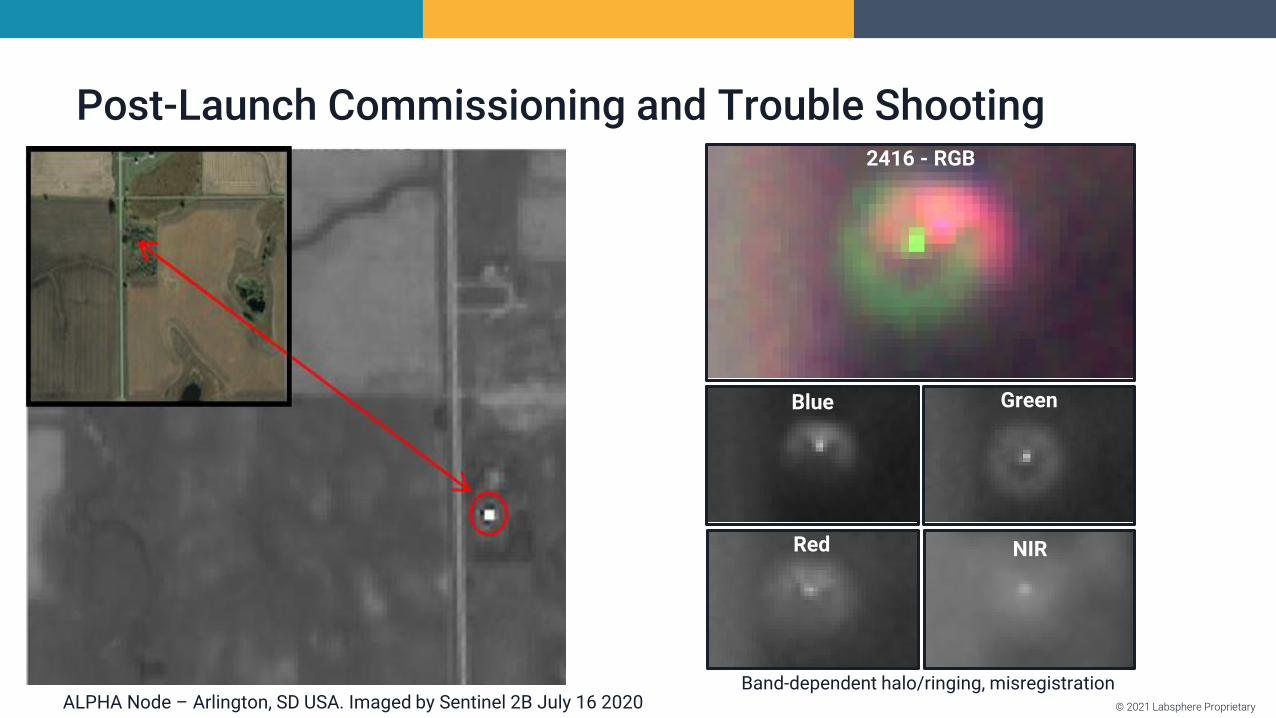
Post-Launch Commissioning and Trouble Shooting
ALPHA Node – Arlington, SD USA. Imaged by Sentinel 2B July 16 2020
2416 - RGB
Blue Green
Red NIR
Band-dependent halo/ringing, misregistration

© 2021 Labsphere Proprietary
Post-Launch Commissioning and Trouble Shooting
ALPHA Node – Arlington, SD USA. Imaged by Sentinel 2B July 16 2020Across-track smear, thermal defocusing
227a
2271

© 2021 Labsphere Proprietary
Campaigns – Rapid Baseline Characterizations
© 2021 Labsphere Proprietary
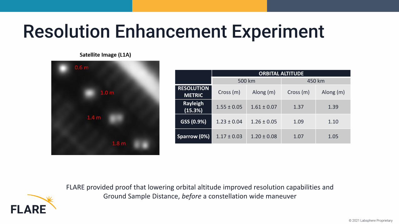
Resolution Enhancement Experiment
ORBITAL ALTITUDE
500 km 450 km
RESOLUTION METRIC
Cross (m) Along (m) Cross (m) Along (m)
Rayleigh (15.3%)
1.55 ± 0.05 1.61 ± 0.07 1.37 1.39
GSS (0.9%) 1.23 ± 0.04 1.26 ± 0.05 1.09 1.10
Sparrow (0%) 1.17 ± 0.03 1.20 ± 0.08 1.07 1.05
FLARE provided proof that lowering orbital altitude improved resolution capabilities and Ground Sample Distance, before a constellation wide maneuver

© 2021 Labsphere Proprietary
Mirror Empirical Line Method (MELM)
Results for Sept. 10, 2009 IKONOS collect.
DN/Mirror: Image po_365282 Glass Mirror SPARC Target
0
500
1000
1500
2000
2500
3000
0 20 40 60 80 100 120
Number of Mirrors
Ta
rge
t Σ
DN
Blue
Green
Red
NIR
Spectral Band Slope: DN/Mirror R2
Blue 17.9 0.9898
Green 25.2 0.9972
Red 22.8 0.9917
NIR 19.8 0.9965
Different mirror in targets = multiple levels in a scene
• MELM via Multi-LOOK events or Multi-Points in scene both provide
• Low reflectance signal verification • Absolute gain• Linearity assessment• SNR

© 2021 Labsphere Proprietary
FLARE 2021 Summer Campaigns for UAVs and Satellites
June 30-July 9, Hawaii Tests July 5-15, TexasAug 9-13, South DakotaAug 28-Sept 5 South Dakota:
Landsat 8 Surface Validation
Contract;Dr. Josh Hudson, FLARE Sales Manager –[email protected] M: 817-771-4847
Video & Flyer HERE➔ https://flare-network.com/latest-news/

© 2021 Labsphere Proprietary
FLARE Primary Benefits
New and independent method vs. classic vicarious calibration
• Radiometry & Spatial in ONE EVENT
• Fully automated synthetic target
• Small or Large target radiometry
• Impulse system response
• Band registration
• Geospatial Control Points
• Applies to all levels (L0, L1, L2, etc.)
• One-Sigma <3.5% VNIR Uncertainty
Scales and applies to Airborne, UAV & Satellite calibration (mirror changes)
• Common radiometric calibration & harmonization for all data sources
• FLARE can be scaled from 0.01m to ≥1km GSD Pixels (OLCI, MODIS, etc.)
• Rapid identification of imaging or radiometric errors
• Speed commissioning and satellite interoperability

© 2021 Labsphere Proprietary
Better Calibration. Better Data. Better Decisions.www.flare-network.com
Questions and Comments may be directed to:
Chris Durell, Business Development – [email protected] M: 858-414-1885
Dr. Brandon Russell, Science Lead – [email protected] M: 203-241-7253
Jeff Holt, Principal Architect – [email protected] M: 603-401-7471
Thank you!


![Vicarious Liability 2018 [Read-Only]elderabuseconference.org/.../09/Vicarious-Liability... · Vicarious liability means that "a person is liable not because he personally committed](https://static.fdocuments.net/doc/165x107/5fa8c4e76b57ec4c3a35aefd/vicarious-liability-2018-read-only-vicarious-liability-means-that-a-person.jpg)


