REQUEST FOR PROPOSALS East Montpelier Town...
13
REQUEST FOR PROPOSALS East Montpelier Town Hill/Gallison Hill Road Intersection and Orange Reservoir Road and Lords Road Curve and Intersection Contact: Daniel Currier, Transportation Program Manager, Central Vermont Regional Planning Commission. Project Schedule: Wednesday, July 19, 2017 RFP published and advertised Tuesday, July 25, 2017, 12:00PM Deadline for submission of questions in writing Thursday, July 27, 2017 Response to questions distributed Friday, August 4, 2017, 4:00 PM Proposal deadline - emailed Monday, August 7, 2017 Selection Committee meeting Friday, August 11, 2017 Interviews as needed; consultant notification September 30, 2017 Project 85% completion December 1, 2017 Project 100% completion Proposals must be clearly marked, and be emailed to: Daniel Currier, Transportation Program Manager, Central Vermont Regional Planning Commission at [email protected]. Submissions must be received by Friday, August 4 at 4:00 PM and can be emailed. Proposals sent via fax will not be accepted. Qualified disadvantaged (DBE) and women-owned (WBE) businesses are encouraged to submit proposals. Consultants are encouraged to bid on one or both study areas. A total of $40,000 has been budgeted for both project. ***** I. INTRODUCTION The Central Vermont Regional Planning Commission (CVRPC) is soliciting proposals from qualified consultants to complete two intersection design feasibility studies at the intersections of the Reservoir Road and Lords Road in Orange, Vermont and the Towne Hill Road/Gallison Hill Road/Brazier Road intersection in East Montpelier, Vermont. Potential upgrades to the intersections may include, but are not limited to, the addition of turn lane(s), improved signage, realignment and/or the installation of a traffic signal or roundabout. The goal of the studies is to determine how to improve circulation and safety for all modes of transportation utilizing these roads without unduly impacting the aesthetics of the area. Reservoir Road is a local road connecting the towns of Plainfield, Barre Town, and Orange together. It also serves as the access to the Barre City Water Treatment Plant. The curve on
Transcript of REQUEST FOR PROPOSALS East Montpelier Town...

REQUEST FOR PROPOSALS
East Montpelier Town Hill/Gallison Hill Road Intersection
and Orange Reservoir Road and Lords Road Curve and Intersection
Contact: Daniel Currier, Transportation Program Manager, Central Vermont Regional Planning Commission. Project Schedule: Wednesday, July 19, 2017 RFP published and advertised Tuesday, July 25, 2017, 12:00PM Deadline for submission of questions in writing Thursday, July 27, 2017 Response to questions distributed Friday, August 4, 2017, 4:00 PM Proposal deadline - emailed Monday, August 7, 2017 Selection Committee meeting Friday, August 11, 2017 Interviews as needed; consultant notification September 30, 2017 Project 85% completion December 1, 2017 Project 100% completion
Proposals must be clearly marked, and be emailed to: Daniel Currier, Transportation Program Manager, Central Vermont Regional Planning Commission at [email protected]. Submissions must be received by Friday, August 4 at 4:00 PM and can be emailed. Proposals sent via fax will not be accepted. Qualified disadvantaged (DBE) and women-owned (WBE) businesses are encouraged to submit proposals. Consultants are encouraged to bid on one or both study areas. A total of $40,000 has been budgeted for both project. ***** I. INTRODUCTION The Central Vermont Regional Planning Commission (CVRPC) is soliciting proposals from qualified consultants to complete two intersection design feasibility studies at the intersections of the Reservoir Road and Lords Road in Orange, Vermont and the Towne Hill Road/Gallison Hill Road/Brazier Road intersection in East Montpelier, Vermont. Potential upgrades to the intersections may include, but are not limited to, the addition of turn lane(s), improved signage, realignment and/or the installation of a traffic signal or roundabout. The goal of the studies is to determine how to improve circulation and safety for all modes of transportation utilizing these roads without unduly impacting the aesthetics of the area. Reservoir Road is a local road connecting the towns of Plainfield, Barre Town, and Orange together. It also serves as the access to the Barre City Water Treatment Plant. The curve on
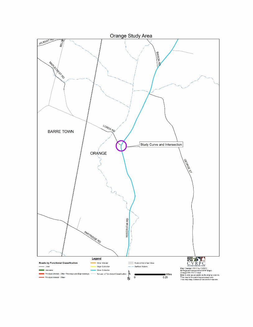
Reservoir Road into the intersection of Lords Road has poor sign distance which has been the cause of a number of accidents over the years. The realignment of this curve and intersection is the major focus of this study location along with:
1. What risks are motorists facing when driving through this curve and intersection? 2. What safety improvements can be considered to reconfigure the curve and
intersection? 3. What potential constraint exist that will impact the realignment of the curve and
intersection?
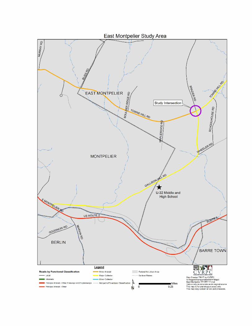
Gallison Hill Road, a connector road between US Rte. 2 and Towne Hill Road, is the location of U-32 Middle & High School, a sizeable, regional school community with more than its fair share of young, inexperienced drivers. Towne Hill Road is a major point-to-point commuter and local traffic highway. Brazier Road is an unpaved, local road subject to surges of traffic tied to U-32. A number of accidents, including ones involving serious injury, as well as many near misses have led residents and school officials to ask for safety improvements at and around the intersection. Exactly what might be possible/practical at the location has not yet been the subject of serious study. The safety analysis for this intersection is the major focus of this study location along with:
1. What risks are motorists, bicyclists, pedestrians, etc. facing when using this intersection?
2. What safety improvements can be considered to improve the intersection The studies are being conducted as part of CVRPCs FFY17 Transportation Planning Initiative grant agreement with the Vermont Agency of Transportation (VTrans). The consultant will work under the direction of CVRPC and the project will be administered by CVRPC. The consultant will collaborate with CVRPC staff, VTrans and a steering committees comprised of local municipal representatives. A site map for each study location can be found in Appendix A of this RFP II. SCOPE OF WORK
A. Collect Existing Conditions Data
1. The Consultant shall conduct field inspections of the two project areas: the intersection of Reservoir Road and Lords Road in Orange, Vermont and the intersection of Towne Hill Road/Gallison Hill Road/Brazier Road in East Montpelier, Vermont. As part of this phase, a local steering committee from each town including VTrans representatives specified by CVRPC will be established and the Consultant shall meet with the committee to understand the community’s concerns. The field inspections should note any obvious conditions that may have a major impact on the design of the two projects. The Consultant will take photographs of the project areas and a visual representation of the sites will be presented in the feasibility report. The

field inspections shall include bridges, culverts, bus route(s), pedestrian and bicycle facilities, freight movements, traffic control devices, lighting, drainage, access control, utility setbacks and obstacles in the right-of-way.
2. Conduct Traffic Analysis of both existing and future conditions (25 years) of the two intersections based on background traffic growth and future/planned land use development as identified by CVRPC and the Towns.
3. The Consultant shall obtain readily available pertinent information, such as: wetland
and floodplain locations, crash data, pavement condition data, traffic count data, and any available automatic traffic recorder counts. For roadway projects the Consultant will be required to obtain or develop design year traffic data including, but not necessarily limited to Average Daily Traffic (ADT), Design Hourly Volume (DHV), Directional Factor (%D), Percent Trucks (%T) and the intersection and signal (where appropriate) related traffic data (see below).
4. Obtain any existing ground survey data that may be available from existing sources
for Reservoir Road and Lords Road in Orange, Vermont and the intersection of Towne Hill Road/Gallison Hill Road/Brazier Road in East Montpelier, Vermont. If appropriate, the Consultant shall also request Record Plans and available right-of-way documents by contacting the Towns.
6. The Consultant shall identify and document the environmental resources within and
adjacent to the project areas. 7. The Consultant shall contact the Town of Orange and the Town of East Montpelier to
discuss the impact of this project relative to above-ground and underground utilities and to ascertain if there are any proposed developments that may affect the projects. CVRPC shall be included in these conversations.
B. Investigate Local and Regional Concerns
1. The Consultant shall organize and moderate a Local Concerns Meeting for both study
location to gather input from State agencies and to solicit input from CVRPC, municipal officials, regulatory/resource agencies, special interest groups including GMT, School Districts, School Busing groups and the public. These meetings shall be held during a regularly scheduled Selectboard meeting. The Consultant shall develop in cooperation with the Town of Orange, Town of East Montpelier and CVRPC a list of stakeholders to be invited to the Local Concerns Meetings and present this list to the CVRPC Project Manager and Towns for review. The Consultant shall send written notification of the project meetings, with copies of available maps of the two project areas, to all identified parties at least one weeks prior to the meeting. The consultant shall coordinate with the Towns for printing notification of the meeting in the community calendar section of regional and local newspapers.

The key point of this meeting is to obtain local and regional concerns. An initial presentation regarding the project feasibility process shall be given to educate the participants in the project development process. Following the project feasibility process portion of the presentation, the Consultant shall lead discussions to determine concerns and ideas regarding the two projects. The Consultant shall follow this meeting up by contacting affected local, regional or VTrans officials not in attendance.
2. The Consultant shall prepare minutes of the meeting and distribute them to the
CVRPC Project Manager, the Town, the VTrans coordinator and identified stakeholders. This shall be done in a format approved by the CVRPC Project Manager. Comments received from any stakeholder not present at the meeting will be attached to the minutes of the meeting.
3. Following the Concerns Meeting, the Consultant will incorporate concerns and ideas
received into the project feasibility report.
C. Develop Purpose and Need Statement 1. From information obtained at the Local Concerns Meeting, the Consultant shall
prepare/revise a Draft Purpose and Need Statements for each project. The Purpose and Need Statements shall clearly define the problem and provide objectives that describe what the solution must contain. The statements will not be so specific as to limit possible courses of action. These statements will be the crux of the project feasibility reports. The need for the project must be conclusively illustrated to prove that the project is justifiable and warrants spending public funds.
2. After the two Purpose and Need Statements are approved by the CVRPC Project
Manager, Town and VTrans, they will be sent to the project steering committee for their review. If it is not accepted, the Consultant shall rewrite the Purpose and Need Statements and resubmit it for review and acceptance
D. Project Constraints
1. All resources in the vicinity of the two projects shall be identified. These resources
include, but are not limited to, the following:
a. Wetlands b. Archaeological and historic sites/districts c. Air and water quality d. Noise sensitive land uses e. Fish and wildlife habitats f. Endangered/threatened species g. Community character (local aesthetics) h. Socioeconomic characteristics i. Agricultural lands
j. Land and Water Conservation Funds lands (Section 6(f)) k. Public and recreational land (Section 4(f)) l. Underground and Above-ground utilities m. Right of Way
2. The resource evaluations shall be sufficiently detailed to present the full range of
impacts on the project environment. All constraints shall be listed.
3. The Consultant will in identify potential or known conflicts with identified constraints and possible techniques of resolving those conflicts.
E. Define Alternatives 1. The draft feasibility reports shall include evaluation of all viable alternatives. The
maximum number of alternatives to be evaluated for each intersection will be three (3) to five (5) plus no-action, but may be subject to revision during project development. The alternatives evaluated must contain a No Action alternative for each intersection and a low-cost alternative. One of the options shall evaluate if warrants can be satisfied within the existing highway rights-of-way. The alternatives shall be developed such that they include the following information.
a. Base map/plan sheets showing pertinent features which may include general
topography, roadway alignment and grade, construction limits, existing and proposed alternative paths.
b. Typical sections, and critical cross sections if survey data is available from recent or upcoming projects. Critical cross sections will be located at points where structures and resources are impacted. Structures are defined as buildings, barns, cattle passes and culverts 48 inches or larger.
d. Earthwork estimate, from available topologic data, recent or upcoming projects. e. Cost estimates.
2. Where appropriate, the Consultant shall analyze each alternative to insure adequate
traffic levels of service. In the event that additional traffic data is needed, the Consultant may be required to collect it. The Consultant shall identify any geometric deficiencies.
F. Alternatives Presentation Meetings
1. The Consultant shall set up a meeting with the local officials, CVRPC, VTrans
coordinator, and the public to present the alternatives for each intersection. The Consultant shall give at least three weeks written notice of the meeting and follow the same notification procedure as for the Local Concerns Meeting. This meeting shall be held during a regularly scheduled Selectboard meeting. If a municipal preferred alternative for either intersection is agreed upon at these meetings, the Consultant shall proceed with the project feasibility process. If a municipal preferred alternative is not agreed upon, the Consultant shall obtain further information concerning the

existing alternatives. This process will continue until acceptance of a municipal preferred alternative, as determined by the CVRPC Project Manager.
G. Evaluate Alternatives
1. From information obtained at the Alternatives Presentation Meetings, the Consultant
shall prepare/revise a final list of alternatives indicating the preferred alternative if identified at the meeting for each project.
2. The Consultant will then prepare an evaluation matrix for each intersections alternatives, a meeting will occur with the CVRPC Project Manager and steering committee members to review the alternatives and matrix. The alternatives will be analyzed to determine if there is at least one alternative that is viable, permittable and cost effective for each intersection.
3. Each matrix will contain information concerning the basic alignment (i.e. length,
typical width, etc.), impacts assessed, the need to acquire right-of-way, an estimated cost, and any permits required. The Consultant shall utilize the standard matrix used by VTrans.
H. Draft Project Feasibility Report
1. The Consultant shall compile all pertinent information gathered during the
investigative stage of the project feasibility process, including all relevant meetings and engineering analyses, in a draft feasibility report for each intersection. A summary of the resource impacts will be prepared to clearly state the information presented in the evaluation matrix. A synopsis of the alternatives will be prepared that includes benefits and impacts for each alternative and a final recommendation will be presented for each intersection. Upon completion of two draft project feasibility reports, the Consultant shall deliver electronic copies to be reviewed by the CVRPC Project Manager and the steering committee. The CVRPC Project Manager will provide the Consultant with comments on the draft feasibility and revised draft feasibility reports shall be distributed to the steering committee, VTrans coordinator and any other parties deemed appropriate. The CVRPC Project Manager will provide any additional comments to the Consultant on the draft feasibility reports. Comments from this review shall be addressed and the draft feasibility reports revised to reflect those changes.
I. Select Locally Preferred Alternative Presentation Meeting
1. The Consultant shall set up a meeting with the local officials, CVRPC, VTrans coordinator to present the draft project feasibility report and the selected local preferred alternatives for each intersection. The Consultant shall give at least two weeks written notice of the meeting and follow the same notification procedure as for the Local Concerns Meeting. These meetings shall be held during a regularly scheduled Selectboard meeting. The Selectboard will be given the opportunity to
discuss the locally preferred alternative and vote to endorse the locally preferred alternative and the draft project feasibility report.
J. Final Project Feasibility Report
1. The final written reports will include any revisions requested by the CVRPC Project
Manager as well as an Executive Summary of the recommendations and findings of the reports.
2. The Consultant, with the concurrence of the CVRPC Project Manager, will submit 8
printed copies and one portable document format (pdf) of each final report and all project graphics and plans.
3. The two final feasibility reports will incorporate the draft reports and will include
conceptual project plans. The two final reports will include, but not be limited to, the following:
a. Title page. b. Base Map/plan sheets showing general topography, roadway alignment and grade,
approximate construction limits, and local and extent of all environmental constraints.
c. Typical Profile and Sections, if survey data is available from recent or upcoming VTrans projects.
d. Earthwork estimate, from existing topologic data or if survey data is available from recent or upcoming projects.
e. Initial construction cost estimate including estimate of right of way costs The concept plans in the final reports shall be for the preferred local alternative at
each intersection. 4. In conjunction with the concept plans submittal, the Consultant will in identify
potential or known constraints and any conflicts that where identified.
K. Design Criteria 1. All structural and highway design must be in accordance with applicable State and
Federal design standards. 2. Project design and plans preparation will conform to requirements of the VTrans
Design Manual and other relevant policies and standards. Where conflicts exist, the governing criteria will be determined by VTrans. Any need for design exceptions will be brought to the attention of the CVRPC Project Manager.
3. Traffic signs, signals and pavement markings shall meet all VTrans, AASHTO and
other relevant standards and policies. Highway capacity calculations shall be made using the most current version available of the Highway Capacity Manual.
4. If any structures occur within the project areas the Consultant shall evaluate the
hydraulic adequacy of all existing drainage culverts within the expected project limits at each intersection. The Consultant will contact the Town to solicit his/her input on any present drainage problems. The Consultant will follow the most current version available of VTrans “Hydrologic and Hydraulic Design Policies and Criteria”.
5. The Consultant shall follow any additional design criteria furnished by VTrans.
6. The Consultant shall utilize the AASHTO and VTrans guidelines for alternative
transportation path evaluation, including considerations for bicycle and pedestrian facilities such as sidewalks and bike lanes.
L. Monthly Progress Reports
1. Monthly Progress Reports showing tasks underway/completed, schedule adherence,
meetings held and progress towards document completion shall be forwarded to the Project Manager monthly during the study.
2. Progress Reports must be current with the CVRPC Project Manager for the
processing of invoices to proceed.
M. Meetings and Presentations 1. Meetings shall be held with the Consultant, the CVRPC Project Manager and the
steering committee at project kick-off and prior to the public Alternatives Presentation. These two meetings shall be informal and last approximately 60 minutes. Three public presentation meetings shall be held during regularly scheduled Selectboard meetings for the following milestones: Local Concerns Meeting, Alternatives Presentation, and Locally Preferred Alternatives & Draft Project Feasibility Report Presentation.
N. Documents
1. The Consultant shall provide materials for CVRPC and the Towns to populate a
project website accessible to the public. At a minimum this will include pdf versions of: all meeting announcements, all meeting minutes, all draft and final deliverables.
2. One electronic and five (5) paper copies of the Draft Project Feasibility Report shall
be provided for each intersection. 3. One electronic and eight (8) copies of the Final Project Feasibility Report shall be
provided for each intersection. 4. All draft and final reports shall be printed double sided.

5. Plastic and non-recyclable covers shall not be used. O. Data Formats
1. All data collected, text bases, drawings, details and documents must be recorded and
delivered in formats that are fully compatible with the existing systems utilized by VTrans.
2. The Consultant shall furnish all drawings and details in electronic form acceptable to
the Towns, VTrans and CVRPC. 3. Standard drawings and details are available from VTrans. If requested by the
Consultant, VTrans may provide pertinent data using digital formats. Files transferred to the Consultant may not be sold or transferred to others without written approval from the Vermont Agency of Transportation or CVRPC.
4. Word processing, spreadsheet files and database files shall be supplied in Microsoft
Word, Excel and Access. Mapping data files will be provided in an electronic form acceptable to VTrans and CVRPC.
5. It shall be the Consultant’s responsibility to keep a backup of all files for 90 days
after final acceptance by VTrans.
III. SUBMITTALS
A. Project Schedule 1. A project schedule will be submitted with the proposal. The two intersections shall
be studied simultaneously such that overall progress and milestones are concurrent; meetings and presentations shall be inclusive of both intersections for efficient use of time. Final reports and all preceding deliverables for each study shall be independent products, however the electronic transmittals and paper copies may be bundled for efficiency. Any changes in the schedule require written approval of the CVRPC Project Manager and the Town.
4. Major milestones and activities that shall be included in the schedule include, but are
not limited to, the following:
a) Kick-off meeting (stakeholder committee) b) Collect existing data and investigate local and regional concerns c) Local Concerns meeting (public Selectboard) d) Develop purpose and need statement e) Identify constraints and develop alternatives f) Alternatives review meeting (stakeholder committee and VTrans staff) g) Alternatives presentation meeting (public Selectboard) h) Initial project feasibility report preparation

i) Revision of draft Project Feasibility report j) Production and distribution of Draft Project Feasibility Report k) Preferred alternatives and Draft Project Feasibility Report presentation (public
Selectboard) l) Completion and final invoice date
3. Schedule submissions must be up to date with the CVRPC Project Manager for the processing of invoices to proceed.
B. Project Staff, Sub-Contractors, and Qualifications
1. Identify persons who will be involved in the project and their respective roles and/or functions. The project manager and task leaders should be clearly identified.
2. Consultant qualifications should include a brief list of relevant projects demonstrating
specific expertise in regional community-based transportation planning. At least three references should be provided, including client contact names, addresses, and phone numbers. Qualifications in the form of resumes for all key personnel also should be attached. The consultant also should be included on the Vermont Agency of Transportation's approved list of qualified consultants. Women and minority-owned businesses are encouraged to submit.
C. Cost Proposal
1. Present a detailed cost proposal for the work to be performed based upon the person
hours by task and including personnel, overhead, other direct costs, subcontractor costs, etc.
D. Submission Requirements 1. One (1) electronic Portable Document Format (PDF) file must be received on/before
Friday, August 4, 2017 at 4:00 PM and can be emailed, to Daniel Currier: CVRPC Orange and East Montpelier Intersection Studies [email protected] Proposals emailed, postmarked or hand-delivered after the above time and date will not be considered. All questions pertaining to the RFP should be submitted to Daniel Currier no later than noon on Monday, July 24. Responses to questions will be posted at www.centralvtplanning.org by the end of the work day on Thursday July, 27. All proposals upon submission become the property of CVRPC, the Town of Orange, the Town of East Montpelier, and VTrans. The expense of preparing, submitting, and presenting a proposal is the sole responsibility of the consultant. CVRPC through its Executive Director retains the right to reject any and all proposals received, to negotiate with any qualified

source, or to cancel in part or whole this RFP as in the best interest of the Commission. This solicitation in no way obligates CVRPC to award a contract.
IV. CONTRACTING PROVISIONS
CVRPC has budgeted $40,000 in consultant fees for these studies. Cost estimates should not exceed this amount. The work on the study spans two Federal Fiscal Years FFY 17 and FFY 18. Given this we expect 85% of the work to be billed and completed by September 30, 2017 and 100% of the work billed and completed by December 1, 2017. All consultants, and any sub-consultants, must comply with any and all applicable laws, statutes, ordinances, rules, regulations, and/or requirements of federal, state, and local governments and agencies thereof, which relate to or in any manner affect the performance of this agreement. Those requirements imposed upon the State of Vermont and CVRPC, respectively, as recipients of federal funds are thereby passed along to the consultant and any sub consultants, and those rights reserved by the U.S. Department of Transportation, Federal Highway Administration are likewise reserved by the State of Vermont and the Regional Commission.
The Central Vermont Regional Planning Commission is an Equal Opportunity Employer.
Appendix A – Site Maps