Remedial Investigation Report (Site Area) · PDF fileRemedial Investigation Report (Site Area)...
161
Imagine the result Remedial Investigation Report (Site Area) Operable Unit 3 (Former Grumman Settling Ponds), Bethpage, New York NYSDEC Site # 1-30-003A Revised: February 8, 2011
Transcript of Remedial Investigation Report (Site Area) · PDF fileRemedial Investigation Report (Site Area)...
Imagine the result
Remedial Investigation Report(Site Area)
Operable Unit 3 (Former Grumman Settling Ponds), Bethpage, New York NYSDEC Site # 1-30-003A
Revised: February 8, 2011

Remedial Investigation Report (Site Area)
Operable Unit 3 (Former Grumman Settling Ponds), Bethpage, New York.NYSDEC Site # 1-30-003A
David E. SternSenior Hydrogeologist
Carlo San GiovanniProject Manager
Michael F. WolfertProject Director
Prepared for:
North Grumman Systems Corporation
Prepared by:
ARCADIS of New York, Inc.Two Huntington QuadrangleSuite 1S10MelvilleNew York 11747Tel 631.249.7600Fax 631.249.7610
Our Ref.:
NY001496.0811.RPTB6
Date:
Revised February 8, 2011
This document is intended only for the use of the individual or entity for which it was prepared and may contain information that is privileged, confidential and exempt from disclosure under applicable law. Any dissemination, distribution or copying of this document is strictly prohibited.

g:\aproject\northrop grumman\superfund\2011\ou3\ny001496.0811 ri fs\revised site area ri report\final_ngc ou3 on-site ri rpt text_020811.doc i
Table of Contents
New York State Department of Environmental Conservation (NYSDEC) Approval Letter, Dated May 26, 2010
Northrop Grumman Systems Corporation Response Letter to NYSDEC Approval Letter, Dated February 3, 2011
Certification xiii
E-1 Executive Summary E-1
E-1.2 Purpose of the Operable Unit 3 Remedial Investigation E-1
E-1.3 Operable Unit 3 Remedial Investigation Scope of Work E-2
E-1.4 Proposed Interim Remedial Measures E-2
E-1.5 Findings, Conclusions, and Recommendations E-3
Acronyms and Abbreviations 1
1. Introduction 6
1.1 Site Background 7
1.1.1 Site Area Description 7
1.1.2 Park History and Ownership 8
1.1.3 Previous/Other Investigations 9
1.1.3.1 Soil Investigation 9
1.1.3.2 Soil Gas Investigation 11
1.1.3.3 Perched Water Investigation 11
1.1.3.4 Groundwater Investigation 12
1.2 Remedial Investigation Objectives and Approach 12
1.2.1 Objectives 12
1.2.2 Scope 13
1.2.3 Methods 15
1.2.4 Quality Assurance/Quality Control 15
1.3 Remedial Investigation Report Organization 16

g:\aproject\northrop grumman\superfund\2011\ou3\ny001496.0811 ri fs\revised site area ri report\final_ngc ou3 on-site ri rpt text_020811.doc ii
Table of Contents
2. Physical Characteristics 17
2.1 Surface Features 17
2.2 Surface Water Hydrology 17
2.3 Drainage 17
2.4 Demography and Land Use 18
2.5 Regional Geology 18
2.6 Regional Hydrogeology 18
3. Remedial Investigation Activities 19
3.1 Sampling Grid 21
3.2 Geophysical Surveying 21
3.3 Soil Investigation 21
3.3.1 Phase 1 Remedial Investigation 22
3.3.2 Remedial Investigation/Feasibility Study Soils Investigation 22
3.3.2.1 Phase 2A Remedial Investigation 22
3.3.2.2 Phase 2 Remedial Investigation 30
3.4 Soil Gas Investigation 31
3.5 Perched Water Investigation 32
3.6 Groundwater Investigation 32
3.6.1 Well Survey 33
3.6.2 Water Levels 33
3.6.3 Vertical Profile Borings 33
3.6.4 Monitoring Well Installation 34
3.6.5 Monitoring Well Sampling 34
3.7 Operable Unit 3 Interim Remedial Measures 35
3.8 Community Air Monitoring Program 37
3.9 Investigation-Derived Waste Disposal 37
4. Site Physical Setting 37

g:\aproject\northrop grumman\superfund\2011\ou3\ny001496.0811 ri fs\revised site area ri report\final_ngc ou3 on-site ri rpt text_020811.doc iii
Table of Contents
4.1 Local Geology and Hydrogeology 38
4.2 Local Geology 38
4.2.1 Unsaturated Zone Geology 39
4.2.1.1 Presence and Nature of Fill Deposits 39
4.2.1.2 Low Permeability Zones 42
4.2.1.3 Apparent High Moisture Zones in Fill Deposits 42
4.2.1.4 Native Deposits 43
4.2.2 Saturated Zone Geology 43
4.3 Local Hydrogeology 44
4.3.1 Groundwater Use 44
4.3.2 Groundwater Flow, Hydraulic Gradients and Groundwater Velocity 44
5. Nature and Extent of Constituents in Media 45
5.1 Development of Standards, Criteria, and Guidance Values 46
5.2 Summary of Data Usability 47
5.2.1 Dvirka & Bartilucci 47
5.2.2 ARCADIS 48
5.3 Nature and Extent of Constituents in Soil 50
5.3.1 Phase 2 RI - Membrane Interface Probe/Soil Borings 51
5.3.2 Phase 2A RI - Evaluation of Soil Analytical Data 52
5.3.3 Phase 2A RI - Overview of Soil Quality 56
5.3.3.1 Volatile Organic Compounds 57
5.3.3.2 Semi-Volatile Organic Compounds 60
5.3.3.3 Metals 60
5.3.3.4 Polychlorinated Biphenyls 61
5.4 Nature and Extent of Constituents in Soil Gas 61
5.5 Nature and Extent of Constituents in Perched Water 64
5.5.1 Volatile Organic Compounds 65

g:\aproject\northrop grumman\superfund\2011\ou3\ny001496.0811 ri fs\revised site area ri report\final_ngc ou3 on-site ri rpt text_020811.doc iv
Table of Contents
5.5.2 Semi-Volatile Organic Compounds 65
5.5.3 Metals 65
5.5.4 Pesticides/Polychlorinated Biphenyls 66
5.5.5 Perchlorate 66
5.5.6 Assessment of Biodegradation of Chlorinated VOCs 66
5.6 Nature and Extent of Constituents in Groundwater 67
5.6.1 Volatile Organic Compounds 68
5.6.2 Semi-Volatile Organic Compounds 71
5.6.3 Metals 72
5.6.4 Pesticides/Polychlorinated Biphenyls 72
5.6.5 Perchlorate 72
5.6.6 Assessment of Biodegradation of Chlorinated VOCs 73
5.7 Quality Assurance/Quality Control Samples 73
5.8 Tentatively Identified Compounds 73
6. Fate and Transport 74
6.1 Constituents of Concern 74
6.2 Physical and Chemical Properties 75
6.3 Constituent Fate and Transport Processes 76
6.3.1 Sorption/Precipitation 76
6.3.2 Volatilization 76
6.3.3 Degradation/Transformation 77
6.3.3.1 Oxidation/Reduction Reactions 78
6.3.3.2 Acid/Base Reactions (Hydrolysis) 79
6.3.4 Advection 79
6.3.5 Hydrodynamic Dispersion 79
6.4 Environmental Fate 79
6.4.1 Chlorinated Ethanes and Ethenes 80

g:\aproject\northrop grumman\superfund\2011\ou3\ny001496.0811 ri fs\revised site area ri report\final_ngc ou3 on-site ri rpt text_020811.doc v
Table of Contents
6.4.1.1 Trichloroethene 80
6.4.1.2 1,2-Dichloroethene 81
6.4.1.3 Vinyl chloride 81
6.4.2 Aromatic Hydrocarbons 81
6.4.2.1 Toluene 81
6.4.2.2 Ethylbenzene 82
6.4.2.3 Xylenes 82
6.4.2.4 Freons 12 and 22 82
6.4.3 Polycyclic Aromatic Hydrocarbons 83
6.4.4 Metals 84
6.4.4.1 Cadmium 84
6.4.4.2 Chromium 84
6.4.5 Polychlorinated Biphenyls 85
6.5 Transport Mechanisms 85
7. Conceptual Site Model 86
7.1 Assessment of Off-Site Sources 87
7.2 Presentation of Conceptual Site Model 87
7.3 Southwest Park Region 88
7.4 East-Central Park Region 90
7.5 Former Plant 24 Access Road 91
8. Interim Remedial Measures 92
8.1 Soil Gas Interim Remedial Measure 92
8.2 Groundwater Interim Remedial Measure 93
9. Findings and Conclusions 93
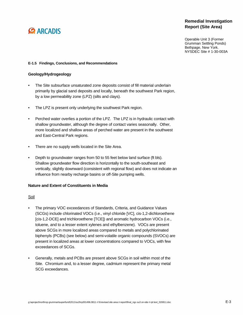
9.1 Geology/Hydrogeology 94
9.2 Nature and Extent of Constituents in Media 95

g:\aproject\northrop grumman\superfund\2011\ou3\ny001496.0811 ri fs\revised site area ri report\final_ngc ou3 on-site ri rpt text_020811.doc vi
Table of Contents
9.2.1 Soil 95
9.2.2 Soil Gas 97
9.2.3 Perched Water 97
9.2.4 Groundwater 98
9.3 Fate & Transport 100
9.4 Conceptual Site Model 102
10. Recommendations 103
11. References 104
Tables
Table 3.1 Summary of Site Area Remedial Investigation Samples Collected by ARCADIS, Northrop Grumman Systems Corporation, Operable Unit 3 (Former Grumman Settling Ponds), Bethpage, New York.
Table 3.2 Monitoring Well and Piezometer Construction Summary, NorthropGrumman Systems Corporation, Operable Unit 3 (Former Grumman Settling Ponds), Bethpage, New York.
Table 3.3 Summary of Groundwater Wells within a One-Half Mile Radius of Bethpage Community Park, Northrop Grumman Systems Corporation, Operable Unit 3 (Former Grumman Settling Ponds), Bethpage, New York
Table 3.4 Water-Levels Measured Collected September 2006 and July 2007, Northrop Grumman Systems Corporation, Operable Unit 3 (Former Grumman Settling Ponds), Bethpage, New York.
Table 5.1 Standards, Criteria, and Guidance Values for Groundwater and Cleanup Objectives for Soil, Northrop Grumman Systems Corporation, Operable Unit 3 (Former Grumman Settling Ponds), Bethpage, New York.
Table 5.2 Concentrations of Volatile Organic Compounds in Soil Samples from Vertical Profile Borings and Soil Borings, Northrop Grumman Systems Corporation, Operable Unit 3 (Former Grumman Settling Ponds), Bethpage, New York.
Table 5.3 Concentrations of Semi-Volatile Organic Compounds in Soil Samples from Vertical Profile Borings, Northrop Grumman Systems Corporation, Operable Unit 3 (Former Grumman Settling Ponds), Bethpage, New York.
Table 5.4 Concentrations of Volatile Organic Compounds, Metals, and Polychlorinated Biphenyls in Sample of Blue-Green Material Sample
g:\aproject\northrop grumman\superfund\2011\ou3\ny001496.0811 ri fs\revised site area ri report\final_ngc ou3 on-site ri rpt text_020811.doc vii
Table of Contents
Collected from Vertical Profile Boring VP-9, Northrop Grumman Systems Corporation, Operable Unit 3 (Former Grumman Settling Ponds), Bethpage, New York.
Table 5.5 Concentrations of Total Organic Carbon in Soil Samples Collected from Vertical Profile Borings and Soil Borings, Northrop Grumman Systems Corporation, Operable Unit 3 (Former Grumman Settling Ponds), Bethpage, New York.
Table 5.6 Concentrations of Volatile Organic Compounds in Soil Gas and Ambient Air Samples, Northrop Grumman Systems Corporation, Operable Unit 3 (Former Grumman Settling Ponds), Bethpage, New York.
Table 5.7 Concentrations of Volatile Organic Compounds in Perched Water Samples Collected from Piezometers, Northrop Grumman Systems Corporation, Operable Unit 3 (Former Grumman Settling Ponds), Bethpage, New York.
Table 5.8 Concentrations of Volatile Organic Compounds and Hydrocarbons in LNAPL Sample Collected from Piezometer I-4-PZ, Northrop Grumman Systems Corporation, Operable Unit 3 (Former Grumman Settling Ponds), Bethpage, New York.
Table 5.9 Concentrations of Semi-Volatile Organic Compounds in Perched Water Samples Collected from Piezometers, Northrop Grumman Systems Corporation, Operable Unit 3 (Former Grumman Settling Ponds), Bethpage, New York.
Table 5.10 Concentrations of Metals in Perched Water Samples Collected from Piezometers, Northrop Grumman Systems Corporation, Operable Unit 3 (Former Grumman Settling Ponds), Bethpage, New York.
Table 5.11 Concentrations of Biogeochemical and Wet Chemistry Parameters in Perched Water Samples Collected from Piezometers, Northrop Grumman Systems Corporation, Operable Unit 3 (Former Grumman Settling Ponds), Bethpage, New York.
Table 5.12 Concentrations of Perchlorate in Perched Water Samples Collected from Piezometers and Groundwater Samples Collected from Monitoring Wells and Vertical Profile Borings, Northrop Grumman Systems Corporation, Operable Unit 3 (Former Grumman Settling Ponds), Bethpage, New York.
Table 5.13 Concentrations of Biogeochemical and Wet Chemisistry Parameters in perched Water Samples Collected from Piezometers, Northrop Grumman Systems Corporation, Operable Unit 3 (Former Grumman Settling Ponds), Bethpage, New York.
Table 5.14 Concentrations of Volatile Organic Compounds in Groundwater Samples Collected from Vertical Profile Borings, Northrop Grumman Systems Corporation, Operable Unit 3 (Former Grumman Settling Ponds), Bethpage, New York.
g:\aproject\northrop grumman\superfund\2011\ou3\ny001496.0811 ri fs\revised site area ri report\final_ngc ou3 on-site ri rpt text_020811.doc viii
Table of Contents
Table 5.15 Concentrations of Volatile Organic Compounds in Groundwater Samples Collected from Monitoring Wells, Northrop Grumman Systems Corporation, Operable Unit 3 (Former Grumman Settling Ponds), Bethpage, New York.
Table 5.16 Concentrations of Semi-Volatile Organic Compounds in Groundwater Samples Collected from Vertical Profile Borings and Monitoring Wells, Northrop Grumman Systems Corporation, Operable Unit 3 (Former Grumman Settling Ponds), Bethpage, New York.
Table 5.17 Concentrations of Metals in Groundwater Samples Collected from Vertical Profile Borings and Monitoring Wells, Northrop Grumman Systems Corporation, Operable Unit 3 (Former Grumman Settling Ponds), Bethpage, New York.
Table 5.18 Concentrations of Pesticides and Polychlorinated Biphenyls in Groundwater Samples Collected from Monitoring Wells, Northrop Grumman Systems Corporation, Operable Unit 3 (Former Grumman Settling Ponds), Bethpage, New York.
Table 5.19 Concentrations of Biogeochemical and Wet Chemistry Parameters in Groundwater Samples Collected from Vertical Profile Borings and Monitoring Wells, Northrop Grumman Systems Corporation, Operable Unit 3 (Former Grumman Settling Ponds), Bethpage, New York.
Table 5.20 Concentrations of Volatile Organic Compounds in QA/QC Samples, Northrop Grumman Systems Corporation, Operable Unit 3 (Former Grumman Settling Ponds), Bethpage, New York.
Table 5.21 Concentrations of Semi-Volatile Organic Compounds in QA/QC Samples, Northrop Grumman Systems Corporation, Operable Unit 3 (Former Grumman Settling Ponds), Bethpage, New York.
Table 5.22 Concentrations of Metals in QA/QC Samples, Northrop Grumman Systems Corporation, Operable Unit 3 (Former Grumman Settling Ponds), Bethpage, New York.
Table 5.23 Concentrations of Pesticides and Polychlorinated Biphenyls in Perched Water Samples Collected from Piezometers, Northrop Grumman Systems Corporation, Operable Unit 3 (Former Grumman Settling Ponds), Bethpage, New York.
Table 5.24 Concentrations of Perchlorate in QA/QC Samples, Northrop Grumman Systems Corporation, Operable Unit 3 (Former Grumman Settling Ponds), Bethpage, New York.
Table 5.25 Concentrations of Biogeochemical and Wet Chemistry Parameters in QA/QC Samples, Northrop Grumman Systems Corporation, Operable Unit 3 (Former Grumman Settling Ponds), Bethpage, New York.
g:\aproject\northrop grumman\superfund\2011\ou3\ny001496.0811 ri fs\revised site area ri report\final_ngc ou3 on-site ri rpt text_020811.doc ix
Table of Contents
Table 5.26 Concentrations Tentatively Identified Compounds, Northrop Grumman Systems Corporation, Operable Unit 3 (Former Grumman Settling Ponds), Bethpage, New York.
Table 5.27 Concentrations of Tentatively Identified Compounds in Soil Gas and Ambient Air Samples, Northrop Grumman Systems Corporation, Operable Unit 3 (Former Grumman Settling Ponds), Bethpage, New York.
Table 5.28 Concentrations of Tentatively Identified Compounds in Groundwatger, Perched Water, and QA/QC Samples, Northrop Grumman Systems Corporation, Operable Unit 3 (Former Grumman Settling Ponds), Bethpage, New York.
Table 6.1 Summary of Chemical Properties for Constituents Exceeding Standards, Criteria, and Guidance Values, Northrop Grumman Systems Corporation, Operable Unit 3 (Former Grumman Settling Ponds), Bethpage, New York.
Figures
Figure 1.1 Site Area Location, Northrop Grumman Systems Corporation, Operable Unit 3 (Former Grumman Settling Ponds), Bethpage, New York.
Figure 1.2 Park Features (Prior to Town of Oyster Bay Redevelopment), Northrop Grumman Systems Corporation, Operable Unit 3 (Former Grumman Settling Ponds), Bethpage, New York.
Figure 1.3 Current and Former Site Features, Northrop Grumman Systems Corporation, Operable Unit 3 (Former Grumman Settling Ponds), Bethpage, New York.
Figure 2.1 Locations of Wells Within a One-Half Mile Radius of Bethpage Community Park, Northrop Grumman Systems Corporation, Operable Unit 3 (Former Grumman Settling Ponds), Bethpage, New York.
Figure 3.1 Site Area Cone Penetrometer Boring Membrane Interface Probe Boring, Soil Boring, Soil Gas Point, Vertical Profile Boring,Piezometer and Well Locations, Northrop Grumman Systems Corporation, Operable Unit 3 (Former Grumman Settling Ponds), Bethpage, New York.
Figure 4.1 Lines of Cross Section, Northrop Grumman Systems Corporation, Operable Unit 3 (Former Grumman Settling Ponds), Bethpage, New York.
Figure 4.2 Geologic Cross Section A-A’ with Total Volatile Organic Compound Concentrations in Soil, Northrop Grumman Systems Corporation, Operable Unit 3 (Former Grumman Settling Ponds), Bethpage, New York.
g:\aproject\northrop grumman\superfund\2011\ou3\ny001496.0811 ri fs\revised site area ri report\final_ngc ou3 on-site ri rpt text_020811.doc x
Table of Contents
Figure 4.3 Geologic Cross Section B-B’ with Total Volatile Organic Compound Concentrations in Soil, Northrop Grumman Systems Corporation, Operable Unit 3 (Former Grumman Settling Ponds), Bethpage, New York.
Figure 4.4 Geologic Cross Section C-C’ with Total Volatile Organic Compound Concentrations in Soil, Northrop Grumman Systems Corporation, Operable Unit 3 (Former Grumman Settling Ponds), Bethpage, New York.
Figure 4.5 Hydrogeochemical Cross Section D-D’ with Trichloroethene in Groundwater, Northrop Grumman Systems Corporation, Operable Unit 3 (Former Grumman Settling Ponds), Bethpage, New York.
Figure 4.6 Configuration of the Water Table and Groundwater Flow Direction –September 2006, Northrop Grumman Systems Corporation, Operable Unit 3 (Former Grumman Settling Ponds), Bethpage, New York.
Figure 4.7 Configuration of the Water Table and Groundwater Flow Direction –July 2007, Northrop Grumman Systems Corporation, Operable Unit 3 (Former Grumman Settling Ponds), Bethpage, New York.
Figure 5.1 Trichloroethene in Shallow Soil Gas, Northrop Grumman SystemsCorporation, Operable Unit 3 (Former Grumman Settling Ponds), Bethpage, New York.
Figure 5.2 Trichloroethene in Deep Soil Gas, Northrop Grumman Systems Corporation, Operable Unit 3 (Former Grumman Settling Ponds), Bethpage, New York.
Figure 5.3 Geologic Cross Section B-B’ with Trichloroethene in Soil Gas, Northrop Grumman Systems Corporation, Operable Unit 3 (Former Grumman Settling Ponds), Bethpage, New York.
Figure 5.4 Freons 12 and 22 in Shallow Soil Gas, Northrop Grumman Systems Corporation, Operable Unit 3 (Former Grumman Settling Ponds), Bethpage, New York.
Figure 5.5 Freons 12 and 22 in Deep Soil Gas, Northrop Grumman Systems Corporation, Operable Unit 3 (Former Grumman Settling Ponds), Bethpage, New York.
Figure 5.6 Areal Extent of Deep Low Permeabilitiey Zone and Concentrations of Volatile Organic Compounds and Select Metals in Perched Water, Northrop Grumman Systems Corporation, Operable Unit 3 (Former Grumman Settling Ponds), Bethpage, New York.
Figure 5.7 Total Volatile Organic Compounds in Shallow Groundwater, Northrop Grumman Systems Corporation, Operable Unit 3 (Former Grumman Settling Ponds), Bethpage, New York.

g:\aproject\northrop grumman\superfund\2011\ou3\ny001496.0811 ri fs\revised site area ri report\final_ngc ou3 on-site ri rpt text_020811.doc xi
Table of Contents
Figure 5.8 Trichloroethene in Shallow Groundwater, Northrop Grumman Systems Corporation, Operable Unit 3 (Former Grumman Settling Ponds), Bethpage, New York.
Figure 5.9 Cis-1,2-Dichloroethene in Shallow Groundwater, Northrop Grumman Systems Corporation, Operable Unit 3 (Former Grumman Settling Ponds), Bethpage, New York.
Figure 5.10 Vinyl Chloride in Shallow Groundwater, Northrop Grumman Systems Corporation, Operable Unit 3 (Former Grumman Settling Ponds), Bethpage, New York.
Figure 5.11 Freon 22 in Shallow Groundwater, Northrop Grumman Systems Corporation, Operable Unit 3 (Former Grumman Settling Ponds), Bethpage, New York.
Figure 5.12 Hydrogeochemical Cross Section B-B’ with Trichloroethene in Groundwater, Northrop Grumman Systems Corporation, Operable Unit 3 (Former Grumman Settling Ponds), Bethpage, New York.
Figure 5.13 Hydrogeochemical Cross Section B-B’ with cis-1,2-Dichloroethene in Groundwater, Northrop Grumman Systems Corporation, Operable Unit 3 (Former Grumman Settling Ponds), Bethpage, New York.
Figure 5.14 Hydrogeochemical Cross Section C-C’ with Trichloroethene in Groundwater, Northrop Grumman Systems Corporation, Operable Unit 3 (Former Grumman Settling Ponds), Bethpage, New York.
Figure 5.15 Hydrogeochemical Cross Section C-C’ with cis-1,2-Dichloroethene in Groundwater, Northrop Grumman Systems Corporation, Operable Unit 3 (Former Grumman Settling Ponds), Bethpage, New York.
Figure 5.16 Hydrogeochemical Cross Section D-D’ with cis-1,2-Dichloroethene in Groundwater, Northrop Grumman Systems Corporation, Operable Unit 3 (Former Grumman Settling Ponds), Bethpage, New York.
Figure 5.17 Semi-Volatile Organic Compounds in Shallow Groundwater, Northrop Grumman Systems Corporation, Operable Unit 3 (Former Grumman Settling Ponds), Bethpage, New York.
Figure 5.18 Total and Dissolved Chromium in Shallow Groundwater, Northrop Grumman Systems Corporation, Operable Unit 3 (Former Grumman Settling Ponds), Bethpage, New York.
Figure 5.19 Perchlorate in Shallow Groundwater, Northrop Grumman Systems Corporation, Operable Unit 3 (Former Grumman Settling Ponds), Bethpage, New York.
Figure 5.20 Concentrations of Inidcators of Biodegradation in Shallow Groundwater, Northrop Grumman Systems Corporation, Operable Unit 3 (Former Grumman Settling Ponds), Bethpage, New York.

g:\aproject\northrop grumman\superfund\2011\ou3\ny001496.0811 ri fs\revised site area ri report\final_ngc ou3 on-site ri rpt text_020811.doc xii
Table of Contents
Appendices
A Other/Third Party Data:
1. Town IRM Pre-Characterization Soil, Soil Gas, and Groundwater Data.
2. NYSDEC Soil Gas Data
3. Northrop Grumman Off-Site RI Groundwater Data
B Soil Remedial Investigation Report, Prepared by Dvirka & Bartilucci
C Geotechnical Data
D Sample/Core Logs
E Geophysical Reports and Logs
F Groundwater/Perched Water Sampling Logs and Perched Water Hydrographs
G Well and Piezometer Construction Logs and Well Development Logs
H Soil Gas Sampling Logs
I Community Air Monitoring Program Data
J Investigation-Derived Waste Disposition Documents
K Data Usability Summary Reports
L Cone Penetrometer and Membrane Interface Probe Reports
M Groundwater Bench Scale and Treatability Reports
N NYSDEC Category A and B Laboratory Reports (ARCADIS)
O NYSDEC EQUIS Compatible Electronic Data Deliverables
P Supplemental to the Remedial Investigation Report. January 8, 2009
Q Supplemental to the Remedial Investigation Report. January 8, 2009, Revised December 9, 2009
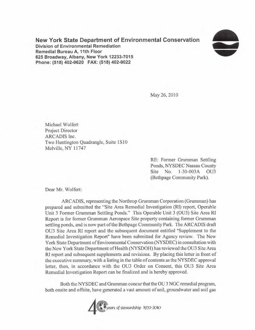
New York State Department of Environmental ConservationDivision of Environmental RemlediationRemedial Bureau A, 11th Floor625 Broadway, Albany, New York 12233·7015Phone: (518) 402-9620 FAX: (518) 402-9022
May 26,2010
Michael WolfertProject DirectorAReADIS Inc.Two Huntington Quadrangle, Suite 1S10Melville, NY 11747
RE: Fonner Grumman SettlingPonds, NYSDEC Nassau CountySite No. 1-30-003A OU3(Bethpage Community Park).
Dear Mr. Wolfert:
ARCADIS, representing the Northrop Grumman Corporation (Grumman) hasprepared and submitted the "Site Area Remedial Investigation (RI) report, OperableUnit 3 Former Grumman Settling Ponds." This Operable Unit 3 (OU3) Site Area RIReport is for fanner Grumman Aerospace Site property containing fanner Grummansettling ponds, and is now part of the Bethpage Community Park. The ARCADIS draftaU3 Site Area Rl report and the subsequent document entitled "Supplement to theRemedial Investigation Report" have been submitted for Agency review. The NewYork State Department ofEnvironmental Conservation (NYSDEC) in consultation withthe New York State Department ofHealth (NYSDOH) has reviewed the OU3 Site AreaRI report and subsequent supplements and revisions. By placing this letter in front ofthe executive summary, with ,a listing in the table ofcontents as the NYSDEC approvalletter, then, in accordance with the OU3 Order on Consent, this aU3 Site AreaRemedial Investigation Report can be finalized and is hereby approved.
Both the NYSDEC and Grumman concur that the OU 3 NGC remedial program,both onsite and offsite, have generated a vast amount of soil, groundwater and soil gas
4C~eQrsof stewardship 1970-2010
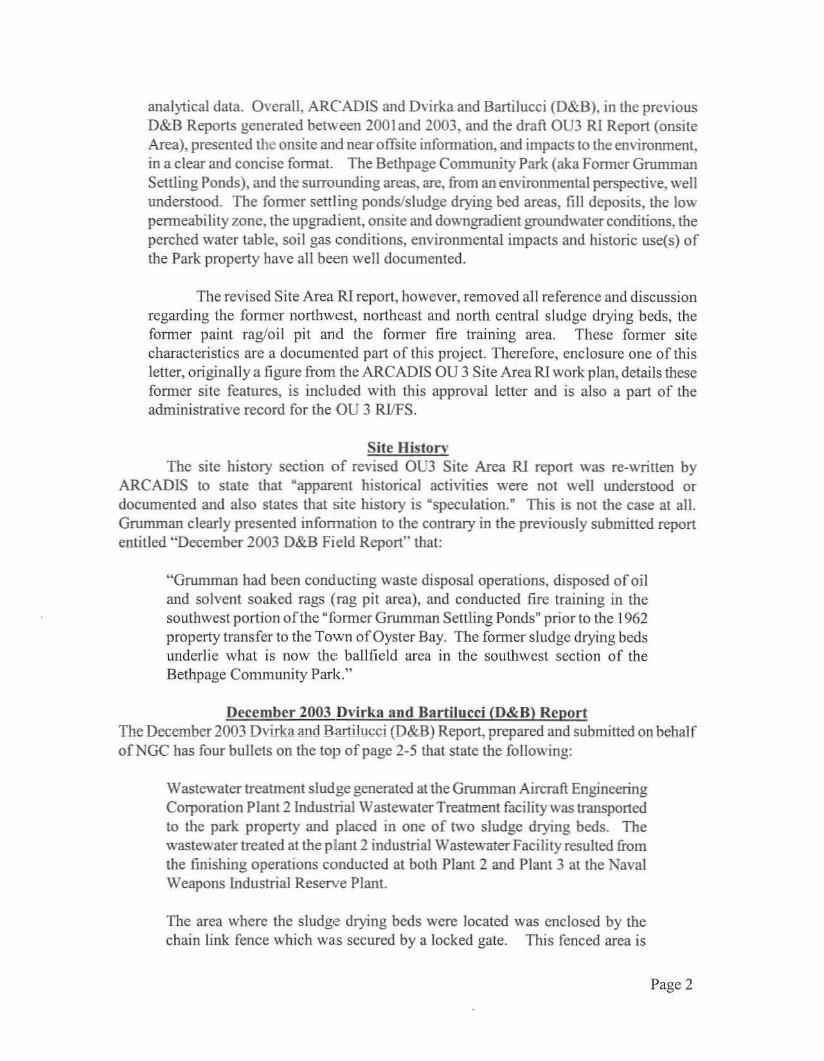
analytical data. Overall, ARCADIS and Dvirka and Bartilucci (O&B), in the previousD&B Reports generated between 2001 and 2003, and the draft OU3 RI Report (onsiteArea), presented the onsite and nearoffsite information, and impacts 10 the environment,in a clear and concise fonnat. The Bethpage Community Park (aka Fonner GrummanSettling Ponds), and the surrounding areas, are, from an environmental perspective, wellunderstood. The fonner settling ponds/sludge drying bed areas, fill deposits, the lowpenneabilily zone, the upgradient, onsite and downgradient groundwater conditions, theperched waler table, soil gas conditions, environmental impacts and historic use(s) ofthe Park property have all been well documented.
The revised Site Area RI report, however, removed all reference and discussionregarding the fanner northwest, northeast and north central sludge drying beds, thefanner paint rag/oil pit and the former fire training area. These fanner sitecharacteristics are a documented part of this project. Therefore, enclosure one of thisletter, originally a figure from the ARCADIS OU 3 Site Area Rl work plan, details thesefanner site features, is included with this approval letter and is also a part of theadministrative record for the OU 3 RVFS.
Site HistoryThe site history section of revised OU3 Site Area RI report was re-written by
ARCADIS to state that "apparent historical activities were not well understood ordocumented and also states that site history is "speculation." This is not the case at all.Grununan clearly presented information to the contrary in the previously submitted reportentitled "December 2003 D&B Field Report" that:
«Grumman had been conducting waste disposal operations, disposed of oiland solvent soaked rags (rag pit area), and conducted fire training in thesouthwest portion of the "faffiler Grumman Settling Ponds" prior to the 1962property transfer to the Town of Oyster Bay. The former sludge drying bedsunderlie what is now the ballfield area in the southwest section of theBethpage Community Park."
December 2003 Dvirka and Bartilucci (0&8) ReportThe December 2003 Dvirka and Hartilucci (D&B) Report, prepared and submitted on behalfofNGC has four bullets on the top of page 2-5 that state the following:
Wastewater treatment sludge generated at the Grumman Aircraft EngineeringCorporation Plant 2lndustrial Wastewater Treatment facility was transportedto the park property and placed in one of two sludge drying beds. Thewastewater treated at the plant 2 industrial Wastewater Facility resulted fromthe finishing operations conducted at both Plant 2 and Plant 3 at the NavalWeapons Industrial Reserve Plant.
The area where the sludge drying beds were located was enclosed by thechain link fence which was secured by a locked gate. This fenced area is
Page 2

visible in avai lab1e aerial photographs dated between the 1950s and 1962,when the property was transferred to the town of Oyster Bay.
Spent rags generated during the wipe-down of a paint booth watcr curtainlocated in Plant 2 were transferred to the fenced-in area of the park propertywhere they were emptied into a pit located on the property. In addition, usedoil may have been discarded in this pit.
The southeastern portion of the current park property was utilized as a firetraining area where wastc oil and jet fuel were ignited and extinguished.
The enclosed figure from thc NGC au 3 R1 Work Plan entitled "Remedial InvestigationProgram, Proposed sample Location Plan (D&B)" clearly shows where the outline of thefanner Grumman disposal areas are located. Also enclosed is figure 2-3 from the D&BDecember 2003 report entitled "April 10, 1962 Aerial Photograph Overlay" showing currentfeatures over fanner fill areas.
Presence and Nature ofFill Deposits, Southwest Park RegionThe blue silt materials referred to in OU 3 Site Area RI Report are clearly the chromium bearing
wastes, based on the location and analytical test results. These materials were desiccated in thefonner sludge drying beds, or "settling Ponds," prior to shipment offsite for disposal.
:Former Rag Pit AreaThe location and identification ofthe{jrumman fonner Rag Pit area can be found on the Dvirka andBartilucci, Consulting Engineers enclosed figure from the NGC OU 3RJ/FS work plan entitled"Rcmediallnvestigation Program, Proposed Sample Location Plan." The fonner Rag pit area islocated on the center of the northeast portion of the ballfield area. This location was used to disposeof spent paint rags and waste oils from Grumman Plant operations.
Low Permeability Zone and Perched GroundwaterThe low permeability zone, or LPZ is the semi-continuous confining layerjust above the water tableand underlying the southwest region of the Bethpage Community Park. Sampling has identified oilfrom the former rag pit area that has created the light non-aqueous phase liquid (LNAPL) identifiedon the LPZ. The selected remedy (ies) will include technologies that will address this LNAPL thatwill be included in the upcoming Proposed Remedial Action Plan (PRAP).
Western and Southern Grumman Access RoadThe infonnation on the stained soils identified in the January 4.2008 ARCADIS letter report clearlyindicates that soils in western access road area have been impacted with site-related contamination.These impacted soils will be included as part of the remedial alternatives to be included in theupcoming PRAP.
Remedial Action Objectives and Soil Cleanup CriteriaThe infonnation presented in the R1 report has been used to establish the remedial action objectivesfor this site. The NYSDEC, in conjunction with the NYSDOH, have reviewed the Northrop
Page 3

Grumman proposal to apply restricted residential use listed in Table 375-6.8(b) ofTitle 6 New YorkCode Rules and Regulations (6 NYCRR) Part 375 and have agreed that, as a minimum, alternativeremedies acceptable for selection must meet the restricted use SCOs. This applies for the fonnerballfield area, the south central part oCthe park not remediated by the Town ofOyster Bay and theformer Plant 24 Access Road.
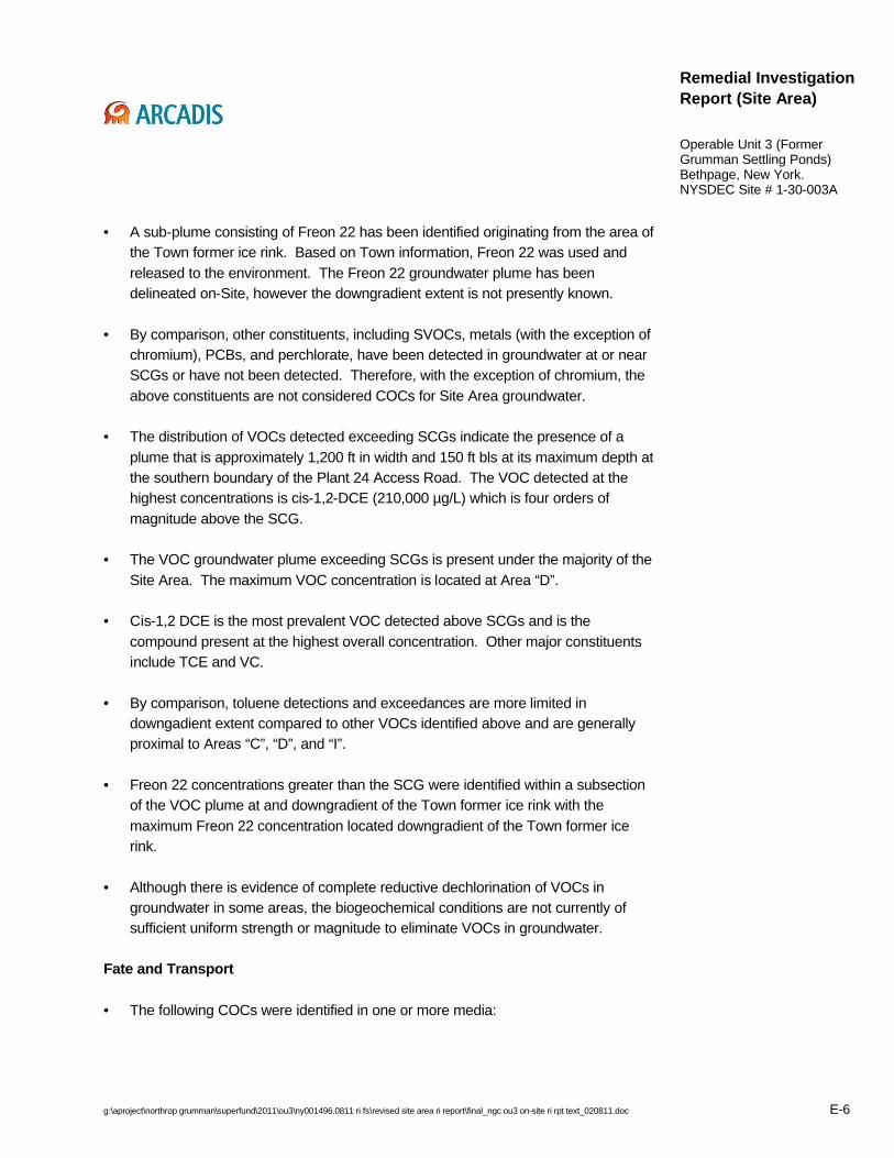
Freon 12 and 22 PlumeReview ofthe groundwater analytical data shows that Freon 22 groundwater contamination has beenidentified as a sub-plume within the overall OU 3 Grumman groundwater contamination plume.
The Finalized Site Area RI report needs to be submitted in both hard copy and electronic fonnat (PDF)within 30 days of receipt of this letter. The electronic data packages, global position, and if availablethe boring logs need to be submitted in electronic data deliverables fomlat for uploading into EQUIS.
If you have any questions prior to finalizing the Site Area RI report, please contact me at your earliestconvenience.
Sincerely,
s1!9sc1~r:6Project EngineerRemedial Bureau ADivision of Environmental Remediation
Enclosureec/w/enc: 1. Swartwout
S. ScharfH. Wilkie, DSHMR. Rusinko, Esq., Region 3W. Parish, Region 1S. Sheeran, NYSDOHS. Karpinski, NYSDOHJ. De Franco, l\'DCHK. Smith, Northrop GrummanJ. Cofman, Northrop GrummanJ. Palmer, Esq, Northrop GrummanC. Henry, EmaginC. Sangiovanni, ARCADISD. Stem, ARCADISEDOCS Grumman Aerospace 1.30003A-QU3-RVFS·NGC Site Area RI Approwlltner
Page 4

.,·I,
.;•
•
·,
·I
·,,"
,•
,.,.•
"
II II
) I~
..•
i
II!I
-+-
i
"•,..'-.,

'~,,I
o
III 5.' 0:
W., i;, :J:
!Iii ~, !I! ~,
I 'I! ~! i I !ll ~hli ~
~
Ii j I" " -0;-~ii:.."
-"
-"
-"
-"
IIII---~"
,
":f----=---I nI I -------------, -"I 'l:lloJ
, I ITo Il'
l. 'I'~cr__dl k----jY r 1
Iii .I Ii
?,·Jor1hrop Grumrnc/~erf)spOCeSy:~terr ,Borth? tv1onog(;;nle,-.t Bt: ~:, f;J(ll;?~{~n:(~;r1t SYS!e-f:t$
NORTHROP GRUMMAN
~February 3, 2011
Mr. St~ven M. Scharf, P.E.New York State Department of Environmental ConservationBureau of Eastern Remedial Action50 Wolf AdadAlbany, New York 12233-7010
Re: Northrop Grumman Systems Corporation Response to NYSDEC Conditional ApprovalL~Hter, dated May 26, 2010Site Area (On-Site) Remedial Investigation ReportNorthrop Grumman Operable Unit 3 (Former Grumman Settling Ponds)Bethpage, New York
Dear Mr. Scharf:
The purpose of this letter is to respond to comments submitted in the New York State Departmentof Environmental Conservation's (NYSDEC's) May 26,2010 letter regarding conditional approvalof the Operable Unit 3 (OU-3) Site Area (On-Site) Remedial Investigation (RI) Report. This letterformalizes, but does not change, the draft responses to NYSDEC's comments that we submittedin an August 9, 2010 email. As indicated in our January 27,2011 email regarding submittal of thefinal OU3 reports, we will include both NYSDEC's May 6, 2010 conditional approval letter and thisresponse letter in the report.
Northrop Grumman submitted the Site Area Rl Report to NYSDEC on February 1, 2008. Sincethat time, Northrop Grumman has submitted the Site Area Focused Feasibility Study (FFS), datedAugust 27, 2009, revised May 12, 2010, which speaks to a number of the points raised inNYSDEC's May 26 comments on the RI Report.
We have paraphrased NYSDEC's main comments from the May 26 letter below (in bold italicizedfont), folidWed by Northrop Grumman's response (in normal font).
1. Site History (related comments):
• The site history section of the revised Site Area RI report was rewritten by .ARCADIS to state that "apparent historical activities were not well understood ordOCumented". Northrop Grumman clearly ptesented information to the contrary inthe December 2003 Dvirka and Bartilucci (D&B) report.
• The former site characteristics (i.e., sludge drying beds, former rag pit, and formerfire training area) are a documented part of this project.
• Presence and Nature of Fill Deposits, Southwest Park Region - Blue silt materialsreferred to in the RI Report are chromium bearing wastes from the former slUdgedrying beds.
• Former Rag Pit Area - The former rag pit area, used to dispose of spent rags andwaste oils from Grumman Plant operations is located in the ballfield area.
The referenced language regarding apparent historical activities not being well understood ordocumented was included in the original RI Report, dated February 1, 2008; however, that

Mr. Steven M. Scharf, P.E.February 3, 2011Page 2 of 4
language was revised in both the January 8, 2009 and December 9, 2009 Supplements tothe RI Reports to read as follows:
"This is a summary of the history for the area comprising what is now known as the Town ofOyster Bay Bethpage Community Park (the "Property" or "Park"). The information regardingthe activities that may have taken place at the Property is historical in nature and thereforeincomplete and subject to change if and when additional and/or different informationbecomes available.
The Property is believed to have been primarily farmland until the 1940s. Around that time,the Property was purchased by Grumman Aircraft t=ngineering Corporation, a predecessorcompany of Northrop Grumman Systems Corporation. The Property was not used for actualmanufacturing operations undertaken at the Bethpage Facility, and no buildings were erectedon the property by Grumman Aircraft Engineering Corporation.
The Property was donated by Grumman Aircraft Engineering Corporation to the Town ofOyster Bay in October of 1962. Shortly thereafter, the Park was constructed on the Propertyby the Town.
It is generally believed that during the period between 1950 and late 1962 that GrummanAircraft Engineering Corporation owned the Property, wastewater treatment sludge from theGrumman Aircraft Engineering Corporation Plant 2 Industrial Wastewater Treatment Facilitymay have been transported to an area in the southwestern part of the Property and placed indrying beds. The wastewater treated at the Plant 2 Industrial Wastewater Treatment FacilityreSUlted from metal finishing operations conducted at both Plant 2 and the Naval WeaponsIndustrial Reserve Plant ("Plant 3"), which was owned by the U.S. Navy and operated byGrumman Aircraft Engineering Corporation. The southwestern portion of the Property wasenGiosed by a chain-link fence, which was secured by a locked gate. It is also believed thatused rags generated during the wipe-down of painting operations located in Plants 2 and 3may have been transported to the Property.
It is also believed that an area in the southwestern portion of the Property was utilized as afire training area where waste oil and jet fuel may have been ignited and extinguished, andthat the requirement to develop, operate and maintain an on-site fire fighting force ("CrashCrew"), including a fire training program may have been imposed on Grumman AircraftEngineering Corporation by the U.S. Navy.
Northrop Grumman Systems Corporation does not have any direct information regarding theoperations conducted by the Town of Oyster Bay subsequent to the transfer of the Propertyto the Town in 1962."
Notwithstanding the above language changes regarding site history, Northrop Grummandoes not believe that the information on historical activities presented in the referenced 2003D&B Report rises to the level of being well understood or well documented. The D&B Reportdescribed historical activities based largely on discussions with a single former Grummanemployee and his recollection of activities that took place between forty and sixty yearsearlier. Anecdotal information from the former employee, pieced together with some historicalaerial photographs, formed the basis for the understanding of the site's history. Accordingly, itdoes not follow that the site history was either well understood or well documented. Themost accurate information regarding the nature and extent of the site contamination is thedata collected during the RI. The thoroughness of that investigation has allowed us to identifyand develop remedial plans to address all areas of concern on the site, which should renderirrelevant any dispute over the understanding and documentation of historical activities.
2. Low Permeability Zone (LPZ) and Perched Groundwater - Oil from the former rag pitarea has created LNAPL identified on the LPZ, and the selected remedies will includetechnOlogies to address the LNAPL
Mr. Steven M. Scharf, P.E.February 3, 2011Page:3 of 4
LNAPL was identified on the LPZ in only one sample (piezometer 14-PZ) out of hundreds ofsamples collected during the RI. Northrop Grumman's recommended technology for sourcearea treatment, in situ thermal desorption (ISTD), presented in the Site Area FFS, will treatthe LNAPL identified in the perched groundwater at that location.
3. Western and Southern Grumman Access Road -Impacted (stained) soils identified inthe January 4, 2008 ARCADIS letter report will be included as part of the remedialalternatives.
A limited area of stained soils was observed and sampled in the Western Access Road areain December 2007 during soil excavation activities for installation of the Soil Gas InterimRemedial Measure (IRM) pipelines. The stained soils were stockpiled separately from othersoils excavated from the trench. The stained soils were then sampled for VOCs, SVOCs,and metals; the sample concentrations did not exceed the NYSDEC industrial soil cleanupstandards and passed TCLP. A limited volume of the excavated stained soil was properlydisposed of off-site, however, due to the presence of odors, the presence of foam that hadbeen used to suppress odors, and an excess of soils that were not needed to backfill thetrench,
ihe January 4,2008 report contained a plan (subsequently approved by NYSDEC) foradditional soil excavation and sampling to respond to any stained soils encountered duringthe r€lmainder of the IRM installation. In accordance with the approved plan, NorthropGrumman excavated soils 10 feet on either side of the initial pipeline excavation. Theadditional excavated soil was not visibly stained, nor did it exhibit odors; therefore, the soilwas used to backfill the excavation in accordance with the approved plan. The plan requiredsampling of any visibly stained soils in the sidewalls of the expanded excavation, but nostained soils were observed. Because no visible staining or odors were encountered duringthe additionallRM excavation activities, no soil remediation was required. Therefore, thosesoils will not be included as part of the remedial alternatives.
4. I'lemedial Action Objectives and Soil Cleanup Criteria - NYSDEC and NYSDOH havereviewed Northrop Grumman's proposal to apply restricted residential use and haveagreed that alternative remedies must meet restricted use soil cleanup objectives(SCOS) at a minimum.
Section 5 of the Site Area RI Report references restricted-residential SCOs as applicable toPark $oils. That reference did not, however, constitute a proposal by Northrop Grumman toapply restricted-residential SCOs at all locations and depths in the Site Area. The applicablecontext for establishing final soil cleanup goals for the Site Area will be the approved SiteArea PFS. In the FFS, the potential remedial technologies for soils were screened usingapplicable Standards, Criteria, and Guidelines (SCGs), including the NYSDECCommissioner's Policy on Soil Cleanup (Commissioner's Policy). The Commissioner'sPolicy, which was issued following submittal of the Site Area RI Report, provides forfleXibility in developing site-specific approaches to soil cleanup. That flexibility is reflected ina combination of soil remediation approaches recommended in the FFS.
5. Freon 12 and 22 Plume - Freon 22 groundwater contamination is a sub-plume withinthe overall OU3 groundwater contamination plume.
As shown in the Site Area RI Report, an area of Freon 22 groundwater contamination wasidentified in the southeastern portion of the Site Area. This groundwater contamination hasbeen clearly linked to releases from the Town of Oyster Bay's ice skating rink and is notassociated with any Northrop Grumman activities.
Northrop Grumman is willing to discuss some of the above points further, but it is important forthe Department to be aware that some of the Department's proposed revisions to the RI areproblematic and could cause unnecessary delay in the completing of the feasibility study and mayimpact whether Northrop Grumman will implement a remedy at this site. I hope this letter

Mr. Steven M. Scharf, P.E.February 3, 2011Page 4 of 4
clarifies Northrop Grumman's position regarding these points. Please contact us if you have anyquestions or need any additional information.
Sincerely,
qG-~Kent Smith,EHS&M ManagerNorthrop Grumman Systems Corporation
cc: John Cofman/Edward Hannon - Northrop GrummanMichael Wolfert -ARCADISCarol Henry, EMAGIN

g:\aproject\northrop grumman\superfund\2011\ou3\ny001496.0811 ri fs\revised site area ri report\final_ngc ou3 on-site ri rpt text_020811.doc xiii
Table of Contents
Certification
Pursuant to Section II.D.1 of the Order On Consent (Index #W1-0018-04-01) between the New York State Department of Environmental Conservation and Northrop Grumman Systems Corporation, Integrated Systems Sector, all requirements of the Remedial Investigation/Feasibility Study Work Plan, Former Grumman Settling Ponds (Operable Unit 3 – Bethpage Community Park), Bethpage, New York, NYSDEC Site # 1-30-003A, Revised: March 8, 2006 have been complied with and all activities have been performed in full accordance with the Work Plan.
By:
Michael F. Wolfert
Project Director

g:\aproject\northrop grumman\superfund\2011\ou3\ny001496.0811 ri fs\revised site area ri report\final_ngc ou3 on-site ri rpt text_020811.doc E-1
Remedial Investigation Report (Site Area)
Operable Unit 3 (Former Grumman Settling Ponds)Bethpage, New York.NYSDEC Site # 1-30-003A
E-1 Executive Summary
ARCADIS U.S., Inc. (ARCADIS) has prepared this Remedial Investigation (RI)Report (RI Report), with input from Dvirka and Bartilucci Consulting Engineers (D&B), on behalf of Northrop Grumman Systems Corporation (Northrop Grumman). This RI Report is being submitted pursuant to Section II of the July 4, 2005 Administrative Order on Consent (AOC) issued by the New York State Department of Environmental Conservation (NYSDEC) that required that an RI/FS be conducted for the present-day Bethpage Community Park property (referred to in this RI Report as the Park).
Collectively, the Park and the Former Grumman Plant 24 Access Road property are referred to in this RI Report as the Site. The Site, plus portions of the public rights of way along Sycamore Avenue and Stewart Avenue, are referred to in this RI Report as the Site Area. To expedite the RI/FS process, the Operable Unit 3 (OU3) Remedial Investigation (RI)/Feasibility Study (FS) project was bifurcated into two components: the Site Area and Off-Site. This RI Report addresses the Site Area. The Off-Site RI is underway and the Off-Site RI Report will be prepared following the completion of data collection and evaluation.
E-1.2 Purpose of the Operable Unit 3 Remedial Investigation
The following are the objectives of the OU3 RI:
• Define the geologic and hydrogeologic framework within the area where constituents of concern (COCs) exist in media.
• Fully develop the list of COCs.
• Determine the three-dimensional nature and extent of COCs in soil, soil gas, and perched water in the vadose zone, as well as in groundwater.
• Identify potential source areas, and determine if a continuing source(s) of COCs to groundwater is present.
• Determine if additional data collection efforts are warranted to meet RI goals.
• Identify and characterize COC fate and transport processes.

g:\aproject\northrop grumman\superfund\2011\ou3\ny001496.0811 ri fs\revised site area ri report\final_ngc ou3 on-site ri rpt text_020811.doc E-2
Remedial Investigation Report (Site Area)
Operable Unit 3 (Former Grumman Settling Ponds)Bethpage, New York.NYSDEC Site # 1-30-003A
• Develop sufficient data that, in conjunction with Interim Remedial Measure (IRM) pre-design data specified in the RI/FS Work Plan, will support the design and implementation of an IRM(s).
E-1.3 Operable Unit 3 Remedial Investigation Scope of Work
The following work was carried out under the supervision of NYSDEC and pursuant to the NYSDEC-approved RI/FS Work Plan:
• Drilled borings using a combination of Cone Penetrometer and Membrane Interface Probe.
• Drilled and sampled soil borings and geotechnical borings.
• Conducted surface geophysical surveys and excavated and sampled soil from test pits.
• Drilled, installed, developed, and sampled perched-water piezometers.
• Drilled and sampled soil gas points.
• Drilled, installed, developed and sampled groundwater from vertical profile borings and monitoring wells
• Measured water levels in perched-water piezometers and monitoring wells.
• Collected additional data in support of identification, evaluation, and selection of IRMs.
E-1.4 Proposed Interim Remedial Measures
Based on the Site Area RI results, Northrop Grumman has elected to implement two IRMs:
• The Soil Gas IRM is being installed and will be operated to prevent the off-Site lateral migration of volatile organic compounds (VOCs) in soil gas.
• The Groundwater IRM will be installed and operated to minimize off-Site migration of VOCs in groundwater.
g:\aproject\northrop grumman\superfund\2011\ou3\ny001496.0811 ri fs\revised site area ri report\final_ngc ou3 on-site ri rpt text_020811.doc E-3
Remedial Investigation Report (Site Area)
Operable Unit 3 (Former Grumman Settling Ponds)Bethpage, New York.NYSDEC Site # 1-30-003A
E-1.5 Findings, Conclusions, and Recommendations
Geology/Hydrogeology
• The Site subsurface unsaturated zone deposits consist of fill material underlain primarily by glacial sand deposits and locally, beneath the southwest Park region, by a low permeability zone (LPZ) (silts and clays).
• The LPZ is present only underlying the southwest Park region.
• Perched water overlies a portion of the LPZ. The LPZ is in hydraulic contact with shallow groundwater, although the degree of contact varies seasonally. Other, more localized and shallow areas of perched water are present in the southwest and East-Central Park regions.
• There are no supply wells located in the Site Area.
• Depth to groundwater ranges from 50 to 55 feet below land surface (ft bls). Shallow groundwater flow direction is horizontally to the south-southeast and vertically, slightly downward (consistent with regional flow) and does not indicate an influence from nearby recharge basins or off-Site pumping wells.
Nature and Extent of Constituents in Media
Soil
• The primary VOC exceedances of Standards, Criteria, and Guidance Values (SCGs) include chlorinated VOCs (i.e., vinyl chloride [VC], cis-1,2-dichloroethene [cis-1,2-DCE] and trichloroethene [TCE]) and aromatic hydrocarbon VOCs (i.e., toluene, and to a lesser extent xylenes and ethylbenzene). VOCs are present above SCGs in more localized areas compared to metals and polychlorinated biphenyls (PCBs) (see below) and semi-volatile organic compounds (SVOCs) are present in localized areas at lower concentrations compared to VOCs, with few exceedances of SCGs.
• Generally, metals and PCBs are present above SCGs in soil within most of the Site. Chromium and, to a lesser degree, cadmium represent the primary metal SCG exceedances.

g:\aproject\northrop grumman\superfund\2011\ou3\ny001496.0811 ri fs\revised site area ri report\final_ngc ou3 on-site ri rpt text_020811.doc E-4
Remedial Investigation Report (Site Area)
Operable Unit 3 (Former Grumman Settling Ponds)Bethpage, New York.NYSDEC Site # 1-30-003A
• Most of the soil SCG exceedances were detected in the southwest Park region, as follows:
o Localized VOC exceedances up to six orders of magnitude above SCGs exist in Area “D”, with concentrations similar to and in some cases up to one order of magnitude above the SCGs in Area “A”, Area “B”, Area “C”, Area “E”, Area “F”, Area “G”, Area “J”, and Area “K”. At Area “D", VOC concentrations increase with depth, with the highest concentrations present within the LPZ, at depths of approximately 40 ft bls to the water table. The greatest VOC mass in soils within the Site underlies Area “D”.
o SVOC exceedances near SCGs exist in the northern and southern portions of the southwest Park region and are generally present within the middle and basal fill.
o Metals (primarily chromium and, to a lesser degree, cadmium) exceed SCG by up to two orders of magnitude, and PCBs exceed SCGs by up to three orders of magnitude in the Park. Exceedances are generally limited to the fill deposits.
o The Town of Oyster Bay, during its IRM, excavated fill and native materials in their construction area.
Soil Gas
• Overall, the horizontal distribution of VOCs in soil gas indicates that the majority of VOC mass in soil gas is limited to the Park, with concentrations decreasing substantially in all four compass directions away from the Park.
• TCE was selected to best approximate the overall distribution of VOCs in the vadose zone. Generally, the highest concentrations of TCE are located within the southwest Park region, and most of the former parking lot and pool area, with the highest single value of 1,200,000 micrograms per cubic meter (µg/m3), at Area “D”.
• In the vertical direction, an increasing trend in TCE concentrations from land surface downward to the water table exists.

g:\aproject\northrop grumman\superfund\2011\ou3\ny001496.0811 ri fs\revised site area ri report\final_ngc ou3 on-site ri rpt text_020811.doc E-5
Remedial Investigation Report (Site Area)
Operable Unit 3 (Former Grumman Settling Ponds)Bethpage, New York.NYSDEC Site # 1-30-003A
• Freons 12 and 22 were mapped separately from TCE as the soil gas data suggest an apparently different point of origin for these compounds as well as a different subsurface distribution as compared to the other VOCs detected in soil gas.
• Generally, the highest concentrations of Freons 12 and 22 are located near the Town former ice rink, with the highest single value of 646,000 µg/m3, located near the southern end of the former Town ice rink area.
Perched Water
• The highest concentration of VOCs was determined to be 120,416 micrograms per liter (µg/L).
• Perched water is limited to the southwest Park region.
• The perched water data collectively indicate that SVOCs, pesticides, and PCBs are not COCs in perched water and, in conjunction with groundwater data, that perchlorate is not a COC at the Site Area.
• The concentrations of soluble iron and manganese in perched water are likely attributable to localized reductive dechlorination of VOCs. The data indicate that the metals identified are potential sources to groundwater.
• Although there is evidence of complete reductive dechlorination of VOCs in some areas, the biogeochemical conditions are not currently of sufficient uniform strength or magnitude to eliminate VOCs in perched water.
Groundwater
• The analytical results indicate a groundwater plume containing VOCs (primarily consisting of toluene, TCE, cis-1,2-DCE, and VC) is present beneath the Site Area, and the plume apparently originates from Areas “B”, “C”, “D”, and “I”. These areas appear to be continuing sources of VOCs to groundwater. The VOC groundwater plume has been delineated within the Site Area in the upgradient (i.e., north), and sidegradient directions (i.e., east-west) as well as vertically. The data indicate that groundwater SCG exceedances extend in the downgradient direction beyond the Site Area. The VOC plume, as it migrates hydraulically downgradient, is also migrating vertically downward.
g:\aproject\northrop grumman\superfund\2011\ou3\ny001496.0811 ri fs\revised site area ri report\final_ngc ou3 on-site ri rpt text_020811.doc E-6
Remedial Investigation Report (Site Area)
Operable Unit 3 (Former Grumman Settling Ponds)Bethpage, New York.NYSDEC Site # 1-30-003A
• A sub-plume consisting of Freon 22 has been identified originating from the area of the Town former ice rink. Based on Town information, Freon 22 was used and released to the environment. The Freon 22 groundwater plume has been delineated on-Site, however the downgradient extent is not presently known.
• By comparison, other constituents, including SVOCs, metals (with the exception of chromium), PCBs, and perchlorate, have been detected in groundwater at or near SCGs or have not been detected. Therefore, with the exception of chromium, the above constituents are not considered COCs for Site Area groundwater.
• The distribution of VOCs detected exceeding SCGs indicate the presence of a plume that is approximately 1,200 ft in width and 150 ft bls at its maximum depth at the southern boundary of the Plant 24 Access Road. The VOC detected at the highest concentrations is cis-1,2-DCE (210,000 µg/L) which is four orders of magnitude above the SCG.
• The VOC groundwater plume exceeding SCGs is present under the majority of the Site Area. The maximum VOC concentration is located at Area “D”.
• Cis-1,2 DCE is the most prevalent VOC detected above SCGs and is the compound present at the highest overall concentration. Other major constituents include TCE and VC.
• By comparison, toluene detections and exceedances are more limited in downgadient extent compared to other VOCs identified above and are generally proximal to Areas “C”, “D”, and “I”.
• Freon 22 concentrations greater than the SCG were identified within a subsection of the VOC plume at and downgradient of the Town former ice rink with the maximum Freon 22 concentration located downgradient of the Town former ice rink.
• Although there is evidence of complete reductive dechlorination of VOCs in groundwater in some areas, the biogeochemical conditions are not currently of sufficient uniform strength or magnitude to eliminate VOCs in groundwater.
Fate and Transport
• The following COCs were identified in one or more media:
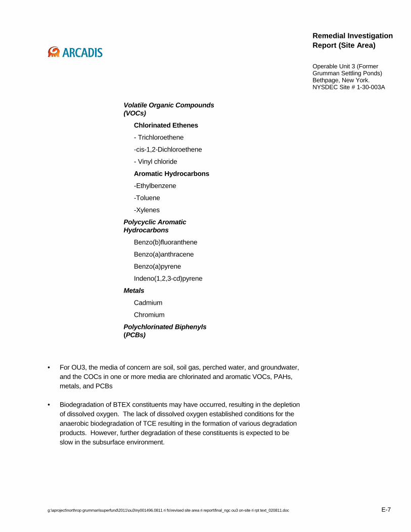
g:\aproject\northrop grumman\superfund\2011\ou3\ny001496.0811 ri fs\revised site area ri report\final_ngc ou3 on-site ri rpt text_020811.doc E-7
Remedial Investigation Report (Site Area)
Operable Unit 3 (Former Grumman Settling Ponds)Bethpage, New York.NYSDEC Site # 1-30-003A
Volatile Organic Compounds (VOCs)
Chlorinated Ethenes
- Trichloroethene
-cis-1,2-Dichloroethene
- Vinyl chloride
Aromatic Hydrocarbons
-Ethylbenzene
-Toluene
-Xylenes
Polycyclic Aromatic Hydrocarbons
Benzo(b)fluoranthene
Benzo(a)anthracene
Benzo(a)pyrene
Indeno(1,2,3-cd)pyrene
Metals
Cadmium
Chromium
Polychlorinated Biphenyls(PCBs)
• For OU3, the media of concern are soil, soil gas, perched water, and groundwater, and the COCs in one or more media are chlorinated and aromatic VOCs, PAHs, metals, and PCBs
• Biodegradation of BTEX constituents may have occurred, resulting in the depletion of dissolved oxygen. The lack of dissolved oxygen established conditions for the anaerobic biodegradation of TCE resulting in the formation of various degradation products. However, further degradation of these constituents is expected to be slow in the subsurface environment.
g:\aproject\northrop grumman\superfund\2011\ou3\ny001496.0811 ri fs\revised site area ri report\final_ngc ou3 on-site ri rpt text_020811.doc E-8
Remedial Investigation Report (Site Area)
Operable Unit 3 (Former Grumman Settling Ponds)Bethpage, New York.NYSDEC Site # 1-30-003A
Conceptual Site Model
• An off-Site, upgradient groundwater source of COCs apparently does not exist.
• The Park history and apparent historical activities are not well understood or documented.
• Each region of the Site Area (i.e., access road, southwest and east-central park regions) appears to contain one or more sources of COCs and exhibits a distinct profile of COCs detected as well as distinct physical characteristics that directly affect the location, distribution, and concentration of COCs.
• In the southwest Park region, the underlying soils (particularly the deep LPZ) and also the perched water appear to contain the majority of residual VOC mass above the water table.
• In the southwest Park region, the primary source of VOCs in soil gas is VOCs in soil, with a lesser contribution from VOCs in perched water and shallow groundwater.
• In the southwest Park region, perched water occurs due to percolating rainwater that accumulates atop and within the LPZ, which retards, but does not prevent, further vertical movement. The limited lateral extent of perched water and lack of lateral mixing indicates that perched water migration would only occur through its hydraulic connection with groundwater.
• A continuing source of VOCs to groundwater appears to be present in the southwest Park region, predominantly in Area “D”.
• The primary difference between the east-central park region and the southwest Park region is the absence of the deep LPZ in most areas and perched water in the east-central Park region. In the east-central Park region, VOCs may be sorbed onto soils beneath the water table and therefore may continue to be a source of VOCs to groundwater.
Recommendations
None.

g:\aproject\northrop grumman\superfund\2011\ou3\ny001496.0811 ri fs\revised site area ri report\final_ngc ou3 on-site ri rpt text_020811.doc 1
Remedial Investigation Report (Site Area)
Operable Unit 3 (Former Grumman Settling Ponds)Bethpage, New York.NYSDEC Site # 1-30-003A
Acronyms and Abbreviations
Access Road Former Grumman Plant 24 Access Road
AOC Administrative Order on Consent
ARCADIS ARCADIS U.S. Inc.
Atm-m3/mole Atmospheres-meter cubed per mole
ATSDR Agency for Toxic Substances and Disease Registry
Bls below land surface
BOD Biological Oxygen Demand
BTEX benzene, toluene, ethyl benzene, and xylene
BWD Bethpage Water District
CAMP Community Air Monitoring Plan
CERCLA Comprehensive Environmental Response, Compensation, and Liability Act
COC constituent of concern
COD Chemical Oxygen Demand
CPT Cone Penetrometer
CSM Conceptual Site Model
oC Degrees Celsius
D&B` Dvirka & Bartilucci Consulting Engineers, Inc.
DCA Dichloroethane
DCE Dichloroethene
DQO Data Quality Objective
DUSR Data Usability Summary Report
g:\aproject\northrop grumman\superfund\2011\ou3\ny001496.0811 ri fs\revised site area ri report\final_ngc ou3 on-site ri rpt text_020811.doc 2
Remedial Investigation Report (Site Area)
Operable Unit 3 (Former Grumman Settling Ponds)Bethpage, New York.NYSDEC Site # 1-30-003A
ECD Electron Capture Detector
ETI Envirometals Technology, Inc.
EVS Environmental Visualization Software
FID Flame Ionization Detector
Freon 22 chlorodifluoromethane
Freon 12 dichlorodifluoromethane
FS feasibility study
FSP Field Sampling Plan
Ft Feet
ft/d feet per day
GIS Geographic Information System
Grumman Grumman Aircraft Engineering Corp.
H2M Holzmacher, McClendon & Murell, Inc.
HASP Health and Safety Plan
HWR Hazardous Waste Remediation
IDW Investigation Derived Waste
IRM interim remedial measure
ISCO In-Situ Chemical Oxidation
Koc Organic carbon partitioning coefficient
Kow Octanol-water partitioning coefficient
LPZ Low Permeability Zone
MCLs maximum contaminant levels
Mg/kg Milligrams per kilogram

g:\aproject\northrop grumman\superfund\2011\ou3\ny001496.0811 ri fs\revised site area ri report\final_ngc ou3 on-site ri rpt text_020811.doc 3
Remedial Investigation Report (Site Area)
Operable Unit 3 (Former Grumman Settling Ponds)Bethpage, New York.NYSDEC Site # 1-30-003A
Mg/L Milligrams per liter
MIP Membrane Interface Probe
Msl mean sea level
NAD North American Datum
NAPL Non-aqueous phase liquid
Navy United States Navy
NCDOH Nassau County Department of Health
NCDPW Nassau County Department of Public Works
NCP National Contingency Plan
Northrop Grumman
Northrop Grumman Systems Corporation
NWIRP Naval Weapons Industrial Reserve Plant
NYCRR New York Code of Rules and Regulations
NYS New York State
NYSDEC New York State Department of Environmental Conservation
NYSDOH New York State Department of Health
NYSDOT New York State Department of Transportation
OM&M Operation, Maintenance, and Monitoring
OU Operable Unit
PAH Polynuclear Aromatic Hydrocarbons
Park Bethpage Community Park
PCB Polychlorinated Biphenyls
PCE tetrachloroethene (aka Perchloroethene)

g:\aproject\northrop grumman\superfund\2011\ou3\ny001496.0811 ri fs\revised site area ri report\final_ngc ou3 on-site ri rpt text_020811.doc 4
Remedial Investigation Report (Site Area)
Operable Unit 3 (Former Grumman Settling Ponds)Bethpage, New York.NYSDEC Site # 1-30-003A
PCOC Primary Constituent of Concern
PCT Pneumatic Conductivity Study
QAPP Quality Assurance Project Plan
QA/QC Quality assurance/quality control
RCRA Resource Conservation and Recovery Act
Redox Oxidation-reduction potential
RI remedial investigation
RI/FS remedial investigation/feasibility study
RSCO Recommended Soil Cleanup Objective
SCGs Standards, criteria and guidelines
SCOs Soil Cleanup Objectives
SDGs Sample delivery groups
Site Bethpage Community Park and Former Grumman Plant 24 Access Road
Site Area Bethpage Community Park and Former Grumman Plant 24 Access Road, plus rights of way along portions of Stewart Avenue and Sycamore Avenues that abut the Site to the east and south, respectively.
SBT Soil Behavior Type
SDG Sample Delivery Group
SVE Soil vapor extraction
SVOCs Semi-volatile organic compounds
TAGM Technical and Administrative Guidance Memorandum
TAL Target Analyte List
TCA Trichloroethane
TCE Trichloroethene

g:\aproject\northrop grumman\superfund\2011\ou3\ny001496.0811 ri fs\revised site area ri report\final_ngc ou3 on-site ri rpt text_020811.doc 5
Remedial Investigation Report (Site Area)
Operable Unit 3 (Former Grumman Settling Ponds)Bethpage, New York.NYSDEC Site # 1-30-003A
TCL Target Compound List
TCLP Toxicity Characteristic Leaching Procedure
TDS Total Dissolved Solids
TICs tentatively identified compounds
TOC Total Organic Carbon
Town Town of Oyster Bay
TP Test Pit
TSS Total Suspended Solids
USGS United States Geological Survey
µg/kg Micrograms per kilogram
µg/L Micrograms per liter
µg/m3 Micrograms per cubic meter
USEPA United States Environmental Protection Agency
VC Vinyl chloride
VI Vapor Intrusion
VOCs Volatile organic compounds
VPB Vertical Profile Boring

g:\aproject\northrop grumman\superfund\2011\ou3\ny001496.0811 ri fs\revised site area ri report\final_ngc ou3 on-site ri rpt text_020811.doc 6
Remedial Investigation Report (Site Area)
Operable Unit 3 (Former Grumman Settling Ponds)Bethpage, New York.NYSDEC Site # 1-30-003A
1. Introduction
This Remedial Investigation (RI) Report (RI Report) has been prepared by ARCADIS U.S., Inc. (ARCADIS), with input from Dvirka and Bartilucci Consulting Engineers (D&B), on behalf of Northrop Grumman Systems Corporation (Northrop Grumman), and is being submitted pursuant to Section II of the Administrative Order On Consent (AOC) Index # W1-0018-04-01 that was executed by the New York State Department of Environmental Conservation (NYSDEC) and Northrop Grumman, effective July 4, 2005 (NYSDEC 2005a). The AOC required that a Remedial Investigation/Feasibility Study (RI/FS) be conducted for the present-day Bethpage Community Park property (Park).
The Park, which was termed the “Former Grumman Settling Ponds Area” and designated as Operable Unit 3 (OU3) by the NYSDEC, and the Former Grumman Plant 24 Access Road Property (Access Road) are collectively referred to in this RI Report as the Site. The full scope of this RI Report includes the Site, as well as parts of public rights of way along Sycamore and Stewart Avenues (abutting the Site to the south and east, respectively). Collectively, the Site and these additional properties are referred to in this RI Report as the “Site Area”. In a letter dated April 25, 2007 to the NYSDEC, the OU3 RI/FS project was bifurcated into the Site Area (referred to previously as Sub Area 1) and Off-Site (referred to previously as Sub Area 2) components. This RI Report addresses the Site Area and was prepared to expedite the RI/FS process. The Off-Site RI has been underway since 2006 and the Off-Site RI Report will be prepared following the completion of data collection and evaluation.
The general objectives of the RI/FS process are as follows:
• Determine the nature and extent of the constituents of concern (COCs) and assess potential effects on the public health, welfare, and the environment related to the release or potential release of COCs at or from the Site.
• Develop and evaluate alternatives for remedial action, if needed, to prevent, mitigate, or otherwise respond to or remedy a release or potential release of COCs at or from the Site by conducting an FS.
• Compile all related (i.e., current and previous) data from relevant parties, including Northrop Grumman, the New York State Department of Health (NYSDOH), the
g:\aproject\northrop grumman\superfund\2011\ou3\ny001496.0811 ri fs\revised site area ri report\final_ngc ou3 on-site ri rpt text_020811.doc 7
Remedial Investigation Report (Site Area)
Operable Unit 3 (Former Grumman Settling Ponds)Bethpage, New York.NYSDEC Site # 1-30-003A
NYSDEC, the U.S. Navy, and the Town of Oyster Bay (Town) into a single, comprehensive RI Report.1
• Evaluate the need for an Interim Remedial Measure (IRM) and, if needed, evaluate potential technologies for and propose an IRM(s).
• Incorporate and implement all elements of an RI/FS, as set forth in the Comprehensive Environmental Response, Compensation, and Liability Act (CERCLA), as amended, the National Contingency Plan (NCP), the United States Environmental Protection Agency (USEPA) Guidance Document, entitled Guidance for Conducting Remedial Investigations and Feasibility Studies under CERCLA, dated October 1988, and any subsequent revisions thereto, in effect at the time the RI/FS Work Plan was submitted, and appropriate USEPA and NYSDEC technical and administrative guidance documents (including the following: USEPA 1988; NYSDEC 1990; NYSDEC 1994; NYSDEC 1998; NYSDEC 2002; NYSDOH 2004; NYSDEC 2006).
1.1 Site Background
This section of the RI Report provides a brief description of the Site Area, a summary of Park history, and a summary of previous/other investigation activities conducted in the Site Area.
1.1.1 Site Area Description
The present-day Bethpage Community Park is owned and operated by the Town of Oyster Bay. The Park is comprised of approximately 18 acres, and is located adjacent to the northeast portion of the Naval Weapons Industrial Reserve Plant (NWIRP) Facility (Figure 1-1). Prior to the Town’s redevelopment of the Park for construction of a new ice rink (currently underway), which commenced in 2005, the Park was open year-round and contained an ice rink, a parking lot, picnic and playground areas, a basketball court,
1 Third party data (i.e., Town of Oyster Bay and New York State Agencies) were utilized in this RI Report. However, by the use of these data, no opinion or evaluation as to their validity with respect to NYSDEC or USEPA data quality criteria or consistency with respect to the National Contingency Plan (NCP) is being made or implied.

g:\aproject\northrop grumman\superfund\2011\ou3\ny001496.0811 ri fs\revised site area ri report\final_ngc ou3 on-site ri rpt text_020811.doc 8
Remedial Investigation Report (Site Area)
Operable Unit 3 (Former Grumman Settling Ponds)Bethpage, New York.NYSDEC Site # 1-30-003A
paddleball courts, shuffleboard courts, horseshoe pits, and bicycle rack areas that have been removed by the Town as part of their redevelopment of the Park. Presently the Park still contains two swimming pools, offices, tennis courts, a baseball field, and a stormwater recharge basin.
Adjoining the Park property to the south and west is the Former Grumman Plant 24 Access Road Property, which is a partially asphalt-paved/partially grassed industrial property that runs east-west along the Park southern boundary and north-south to the west of the Park western boundary. Sycamore Avenue is a Town-owned roadway that abuts the Site to the south. Stewart Avenue is a Nassau County-owned roadway that abuts the Site to the east. North of the Park is Cherry Avenue/Aerospace Boulevard (owned by Northrop Grumman), along with commercial buildings. Site Area features and structures, prior to Town redevelopment, are shown on Figure 1-2.
1.1.2 Park History and Ownership
The land that comprises the current Bethpage Community Park originally was primarily farmland and was purchased by the Grumman Aircraft Engineering Corporation (Grumman) (a predecessor of Northrop Grumman) in 1941.
The apparent historical activities that occurred in the Park are not well understood or documented,
On October 17, 1962, the Park property was donated by Grumman to the Town of Oyster Bay for exclusive use as parkland. Shortly after Grumman donated the land to the Town, the Town commenced construction and other work on the Park property. The Park structures, as they were prior to the Town recent redevelopment, were built by the Town without any Grumman involvement. The Former Grumman Plant 24 Access Road Property is currently owned by Northrop Grumman.
Figure 1-3 shows the approximate limits of the apparent historical areas of soil disturbance in the Park (identified as Areas “A” through “K”), based on interpretation of aerial photographs and other information (D&B 2003). Other features such as transformers and septic systems are also shown on Figure 3.
In 2005, the Town of Oyster Bay initiated redevelopment of approximately 11 acres of the Park (referred to in this RI Report as the construction area). As part of the redevelopment, the Town executed an AOC with the NYSDEC in 2005 for implementation of an IRM for soils for the construction area. The Town performed an
g:\aproject\northrop grumman\superfund\2011\ou3\ny001496.0811 ri fs\revised site area ri report\final_ngc ou3 on-site ri rpt text_020811.doc 9
Remedial Investigation Report (Site Area)
Operable Unit 3 (Former Grumman Settling Ponds)Bethpage, New York.NYSDEC Site # 1-30-003A
investigation of soil, soil gas, and groundwater in the construction area in 2005. The Town submitted work plans to NYSDEC recommending excavation and off-Site disposal of soil within the construction area. The former features of the Park identified in Section 1.1.1 were demolished and removed in 2006. The Town IRM soil excavation/disposal was performed from October 2006 to May 2007. The final Construction Report related to the Town Soil IRM is currently under preparation by the Town. Redevelopment of the construction area portion of the Park by the Town is currently underway.
1.1.3 Previous/Other Investigations
This section of the RI Report summarizes the scope and results of relevant pre-RI (prior to 2004) Northrop Grumman field investigations as well as those independently completed by the Navy, the Town, and the State of New York at the Site Area. These data were utilized, where applicable, into the development of the scope of the Northrop Grumman Site Area RI, described in Section 3.0 of this RI Report. The results as described herein have been utilized, where applicable, into Section 5.0 of this RI Report.
Town sample locations and discussion of results are provided in the associated Town reports (H2M 2005a; 2005b). Town and NYSDOH sample results (NYSDEC 2004) are provided in Appendix A.
1.1.3.1 Soil Investigation
This section of the RI Report summarizes the following soil investigations that were completed at the Site Area: (1) by the Navy, the Town, and Northrop Grumman prior to the RI, (2) by the Town as part of their construction area investigation (concurrent with the Northrop Grumman RI), and (3) by NYSDOH in conjunction with NYSDEC and the Nassau County Department of Health (NCDOH) on adjoining residential properties (concurrent with the Northrop Grumman Phase 1 RI).
1.1.3.1.1 Pre-Remedial Investigation Activities (1994 to 2003)
Prior to 2004, five separate soil investigations had been conducted at the Site Area. The first four investigations occurred in November 1994 (by the Navy), April 1998 (by the Town), followed by March and May 2002 (two by D&B on behalf of Northrop Grumman). The 1994 and 1998 investigations were conducted in sporadic locations in the Site Area. Soil samples were analyzed for polychlorinated biphenyls (PCBs);

g:\aproject\northrop grumman\superfund\2011\ou3\ny001496.0811 ri fs\revised site area ri report\final_ngc ou3 on-site ri rpt text_020811.doc 10
Remedial Investigation Report (Site Area)
Operable Unit 3 (Former Grumman Settling Ponds)Bethpage, New York.NYSDEC Site # 1-30-003A
exceedances of the Recommended Soil Cleanup Objectives (RSCOs) were not detected.
The March and May 2002 investigations addressed larger portions of the Site Area, and samples collected were analyzed for PCBs and Resource Conservation and Recovery Act (RCRA) metals. PCBs and several RCRA Metals were detected above RSCOs in March 2002; in May 2002, PCBs were detected above the RSCO (D&B, 2003)
The 2002 D&B investigations are described by D&B in the December 2003 report. Based on the results of the 1994 and 1998 investigations (relative to applicable guidance values in effect at the time – see Section 3.3) and discussions with the NYSDEC and NYSDOH, it was determined that additional investigation was needed. Hence, in May/June 2003, the fifth overall investigation was performed (third by D&B).
In May and June 2003, soil borings were advanced and sampled in the Park. Soil samples from the soil borings were analyzed for the Target Compound List (TCL) volatile organic compounds (VOCs), semi-volatile organic compounds (SVOCs), PCBs, Target Analyte List (TAL) metals, and hexavalent chromium. In summary, based upon the analytical results of the soil samples collected, the vertical extent of soil exceeding RSCOs ranged to depths of 34 ft bls in the southwest Park region and to 12 ft bls along the perimeter of the southwest Park region. Data from the northern and eastern limits of the study area indicated exceedances of RSCOs appeared to be limited to the southwest Park region. The following COCs were detected in soil exceeding RSCOs: VOCs (primarily chlorinated and petroleum-related); SVOCs (primarily polynuclear aromatic hydrocarbons [PAHs]) and phenols; PCBs; and metals (primarily cadmium and chromium).
1.1.3.1.2 Department of Health Residential Soil Sampling
In July and September of 2002 and April 2003, the NYSDOH, in conjunction with the NYSDEC and the NCDOH, collected soil samples from select residential properties located south of the Access Road, between Stewart Avenue and 11th Street. A total of 63 soil samples were collected from 30 residential properties and analyzed for PCBs to determine if PCB concentrations above RSCOs were present.
The analytical results of the collected soil samples indicated that PCB concentrations ranged from non-detect to 56 milligrams per kilogram (mg/kg) in soil. Based on these results, the NYSDOH recommended that soil remediation should be conducted at three
g:\aproject\northrop grumman\superfund\2011\ou3\ny001496.0811 ri fs\revised site area ri report\final_ngc ou3 on-site ri rpt text_020811.doc 11
Remedial Investigation Report (Site Area)
Operable Unit 3 (Former Grumman Settling Ponds)Bethpage, New York.NYSDEC Site # 1-30-003A
residential properties and further PCB delineation should be conducted at a fourth residential property (NYSDEC 2004).
1.1.3.1.3 Town Interim Remedial Measure Soil Pre-Characterization
In June 2005, the Town performed an investigation of soil in the construction area, results of which are documented in two subsequent reports issued in November and December 2005 (H2M 2005a; H2M 2005b). Samples were analyzed primarily for metals and PCBs, with limited analysis of VOCs and SVOCs.
The results that were pertinent to the Northrop Grumman RI included PCB RSCO exceedances at depths ranging from land surface to 15 ft bls in the northern Parking Lot area (referred to in this report as Area “H” and in prior reports as the “B-43 Area”) as well as several above-background photo-ionization detector (PID) readings in the Parking Lot at depths ranging from 20 ft bls to the water table, equivalent to 55 ft bls (Area “I”). These data warranted additional investigation of soils in the area, which was conducted by Northrop Grumman as part of the RI (Section 3.3.2). The Town utilized the Northrop Grumman laboratory data from Area “H” to modify the scope of its soil IRM, in coordination with the NYSDEC.
1.1.3.2 Soil Gas Investigation
In June 2005, the Town performed an investigation of soil gas at the Park, which was documented in two subsequent reports in November and December 2005 (H2M 2005a; H2M 2005b).
As part of an independent assessment of potential vapor intrusion (VI) issues related to the Site Area, in August 2007, representatives of the NYSDEC collected single subslab soil gas samples and indoor air samples from eight residences on the north side of Sycamore Ave, outdoor (ambient) air samples at four residences on the north side of Sycamore Ave, and eight soil gas samples along Stewart Ave, northeast and east of the Park. The report entitled Summary Report for an Immediate Soil Vapor Intrusion Investigation at Former Grumman Settling Ponds (1-30-003A), Bethpage, New Yorkwas submitted to NYSDEC in December 2007.
1.1.3.3 Perched Water Investigation
Prior to the initiation of the OU3 RI in 2004, data had not been collected related to the presence or quality of perched water at the Site Area.

g:\aproject\northrop grumman\superfund\2011\ou3\ny001496.0811 ri fs\revised site area ri report\final_ngc ou3 on-site ri rpt text_020811.doc 12
Remedial Investigation Report (Site Area)
Operable Unit 3 (Former Grumman Settling Ponds)Bethpage, New York.NYSDEC Site # 1-30-003A
1.1.3.4 Groundwater Investigation
An initial groundwater investigation was conducted in May/June 2003 by D&B. Three monitoring wells (BCPMW-1, BCPMW-2, and BCPMW-3) were installed, and groundwater samples were collected from these and the three previously existing monitoring wells (B24MW-2, B24MW-3, and B30MW-1) at the Site. Groundwater samples were analyzed for the TCL VOCs and SVOCs, PCBs, hexavalent chromium (total and dissolved), and TAL metals (total and dissolved). The VOCs detected in excess of Class GA Groundwater Standards, along with the highest detected concentration, include: vinyl chloride (VC) (70 micrograms per liter [µg/L]); 1,1-dichloroethene (1,1-DCE) (44 µg/L); 1,1-dichloroethane (1,1-DCA) (18 µg/L); cis-1,2-dichloroethene (cis-1,2-DCE) (5,300 µg/L); 1,1,1-trichloroethane (1,1,1-TCA) (6 µg/L); and trichloroethene (TCE) (1,800 µg/L). The analytical results of the groundwater samples collected from the three Site Area monitoring wells (two located upgradient of the Park) coupled with the groundwater samples collected from the three monitoring wells in the Park indicated the presence of chlorinated VOCs in groundwater in the Park at concentrations up to three orders of magnitude greater than GA standards. As a result, further investigation was recommended to determine the potential source of the chlorinated VOCs detected in groundwater (D&B, 2003).
In June 2005, the Town performed a groundwater investigation through the installation and sampling of five monitoring wells (CAMW-1, CAMW-2, CAMW-3, CAMW-4, and CAMW-5). The results of this investigation are provided in Appendix A and discussed in reports dated November and December 2005 (H2M 2005a; H2M 2005b). Aftercompletion of the Town investigation and prior to implementation of their soil IRM, all five of the wells were abandoned by the Town.
1.2 Remedial Investigation Objectives and Approach
This section of the RI Report lists the specific objectives of the OU3 RI/FS, provides an overview of the scope of RI activities based on prior submittals to the NYSDEC, and describes the methods employed to implement the scope and achieve the objectives of the RI.
1.2.1 Objectives
The following are the objectives of the OU3 RI:
g:\aproject\northrop grumman\superfund\2011\ou3\ny001496.0811 ri fs\revised site area ri report\final_ngc ou3 on-site ri rpt text_020811.doc 13
Remedial Investigation Report (Site Area)
Operable Unit 3 (Former Grumman Settling Ponds)Bethpage, New York.NYSDEC Site # 1-30-003A
• Define the geologic and hydrogeologic framework within the area where COCs exist in media and adjacent areas.
• Fully develop the list of COCs.
• Determine the three-dimensional nature and extent of COCs in soil, soil gas, and perched water in the vadose zone, as well as in groundwater.
• Identify potential source areas, and determine if a continuing source(s) of COCs to groundwater is present.
• Determine if additional data collection efforts are warranted to meet RI goals.
• Identify and characterize COC fate and transport processes.
• Develop sufficient data that, in conjunction with IRM pre-design data specified in the RI/FS Work Plan, will support the design and implementation of an IRM(s).
1.2.2 Scope
In accordance with the provisions of the approved RI/FS Work Plan, the scope of work outlined therein was implemented, but with the allowance for future modifications in scope to meet the objectives of the RI (dynamic approach). Modifications to RI work scope were implemented based on field conditions; larger, more strategic changes in scope were developed and specified in RI/FS work plan addenda that were submitted to and approved by the NYSDEC. Data obtained from carrying out these addenda have been incorporated into this RI Report. Additionally, by request of the NYSDEC,this RI Report has utilized, where applicable, previous/third party data obtained for the Site Area. In summary, this RI Report incorporates, as appropriate, data obtained via the approved RI/FS Work Plan and work plan addenda, and utilized, as applicable, previous/third party data. The data collection plans, reports, and report results used to guide the RI data collection efforts are listed below:
• Northrop Grumman: Phase 3 RI Work Plan (ARCADIS of New York, Inc. 2007a).
• Northrop Grumman: Operable Unit 3 – Soil Gas Interim Remedial Measure Work Plan (ARCADIS of New York, Inc. 2007b).

g:\aproject\northrop grumman\superfund\2011\ou3\ny001496.0811 ri fs\revised site area ri report\final_ngc ou3 on-site ri rpt text_020811.doc 14
Remedial Investigation Report (Site Area)
Operable Unit 3 (Former Grumman Settling Ponds)Bethpage, New York.NYSDEC Site # 1-30-003A
• Northrop Grumman: Groundwater Interim Remedial Measure Bench Scale and Treatability Studies (ARCADIS of New York, Inc. 2007c).
• Northrop Grumman: Operable Unit 3 Remedial Investigation/Feasibility Study Work Plan, dated March 8, 2006 (ARCADIS G&M, Inc. 2006a) and Work Plan Addenda 1 through 7, as summarized below:
o Work Plan Addendum 1: On-Site Cone Penetrometer (CPT)/ Membrane Interface Probe (MIP) Borings (ARCADIS G&M, Inc. 2006b).
o Work Plan Addendum 2: On-Site Vertical Profile Borings (ARCADIS G&M, Inc. 2006c).
o Work Plan Addendum 3: On-Site CPT/MIP Borings (ARCADIS G&M, Inc. 2006d).
o Work Plan Addendum 4: On-Site Monitoring Wells (ARCADIS G&M, Inc. 2006e).
o Work Plan Addendum 5: On-Site Soil Borings, prepared by D&B (Northrop Grumman. 2006).
o Work Plan Addendum 6: On-Site Test Pits (D&B. 2006a).
o Work Plan Addendum 7: On-Site MIP Borings/Wells (ARCADIS G&M, Inc. 2006f).
• Northrop Grumman: Operable Unit 3 Phase 1, 1A, and 1B RI Work Plans, dated June 7, 2004, October 21, 2004, and May 25, 2005, respectively (ARCADIS G&M, Inc. 2004a; 2004b; 2005b).
• Town of Oyster Bay: Investigation Report and Remedial Action Plan and Supplemental Investigation Report (H2M 2005a; 2005b).
• NYSDEC: Results of NYSDOH soil sampling on residential properties (NYSDEC. 2004).
• NYSDEC: Summary Report for An Immediate Soil Vapor Intrusion Investigation at Former Grumman Settling Ponds (1-30-003A), Bethpage, New York
• Northrop Grumman: Town of Oyster Bay Bethpage Community Park Investigation Sampling Program, Bethpage, New York. December, 2003. (D&B 2003).

g:\aproject\northrop grumman\superfund\2011\ou3\ny001496.0811 ri fs\revised site area ri report\final_ngc ou3 on-site ri rpt text_020811.doc 15
Remedial Investigation Report (Site Area)
Operable Unit 3 (Former Grumman Settling Ponds)Bethpage, New York.NYSDEC Site # 1-30-003A
1.2.3 Methods
As summarized in Section 1.1.3 (Previous/Other Investigations) and further described in the NYSDEC-approved RI/FS Work Plan, several investigations had been undertaken by Northrop Grumman and others to meet various objectives for the Site Area investigation prior to initiation of the OU3 RI. As part of the dynamic approach (see above), an assessment was made as to the adequacy of pre-RI data in meeting the objectives of the RI. It was determined that the data collected during the pre-RI investigations undertaken by Northrop Grumman as well as the third party data, were adequate to assist in identifying data gaps related to scoping the RI.
The NYSDEC-approved RI/FS Work Plan developed the framework and rationale for RI decision-making using this dynamic approach. Specifically, real-time acquisition of screening-level data, expedited turnaround time of laboratory data, vertical profiles of soil, soil gas, and groundwater, coupled with ongoing data analysis and interpretation, allowed for timely field decisions to be made. By proceeding in this manner, data collected were constantly made available and considered during the decision-making process and thereby data collection was optimized. Additionally, the provision for development of work plan addenda was included in the approved RI/FS Work Plan so that additional data collection could be approved in a rapid manner by the NYSDEC that would limit interruptions in field work to the extent possible. In total, seven work plan addenda were prepared, submitted, and approved by NYSDEC, and implemented (see Section 1.2.2 – Scope).
1.2.4 Quality Assurance/Quality Control
In accordance with the procedures and protocols set forth in the NYSDEC-approved RI/FS Work Plan, approved Quality Assurance/Quality Control (QA/QC) protocols were implemented during the RI process. These included:
1. Following approved methods and standard operating procedures for RI fieldwork, including drilling, test pitting, well/piezometer installation, surveying, investigation-derived waste (IDW) management, and sample collection activities, in accordance with the Field Sampling Plan (FSP).
2. Following methods for sample control, handling, shipment, as well as laboratory and field QA/QC, in accordance with the Quality Assurance Project Plan (QAPP).

g:\aproject\northrop grumman\superfund\2011\ou3\ny001496.0811 ri fs\revised site area ri report\final_ngc ou3 on-site ri rpt text_020811.doc 16
Remedial Investigation Report (Site Area)
Operable Unit 3 (Former Grumman Settling Ponds)Bethpage, New York.NYSDEC Site # 1-30-003A
3. Following acceptable health and safety practices, in accordance with the Health and Safety Plan (HASP).
4. Maintaining project QA/QC in field decision-making, data management, data reduction, and analysis through utilization of the chain-of-command structure set forth in the Project Management Plan.
1.3 Remedial Investigation Report Organization
This RI Report for the Site Area, as required by the AOC, includes the following elements:
• The Site Area and regional physical characteristics, including surface features, surface water hydrology, regional geology and hydrogeology, drainage, and demography and land use are described in Section 2.0.
• The Site Area RI activities, including the sampling grid along with the scope of work performed to meet RI objectives for soil, soil gas/ambient air, perched water, and groundwater are summarized in Section 3.0.
• Site Area and local physical characteristics, including geology, hydrogeology, groundwater use, groundwater flow, hydraulic gradients, and groundwater velocity are discussed in Section 4.0.
• The RI standards, criteria, and guidance (SCG) values and the detailed evaluation of the nature and extent of constituents in media for the Site Area are provided in Section 5.0.
• The Fate and Transport Analysis for the Site Area is provided in Section 6.0.
• The current Conceptual Site Model for the Site Area is presented in Section 7.0.
• A summary of Site Area IRMs is presented in Section 8.0.
• Site Area RI Findings and Conclusions are provided in Section 9.0.
• Recommendations are provided in Section 10.0.
• References are listed in Section 11.0.

g:\aproject\northrop grumman\superfund\2011\ou3\ny001496.0811 ri fs\revised site area ri report\final_ngc ou3 on-site ri rpt text_020811.doc 17
Remedial Investigation Report (Site Area)
Operable Unit 3 (Former Grumman Settling Ponds)Bethpage, New York.NYSDEC Site # 1-30-003A
2. Physical Characteristics
This section of the RI Report describes the Site Area characteristics including surface features, surface water hydrology, and drainage. Also described in this section is the understanding of regional geology and hydrogeology, as well as demography and land use that collectively provided the basis for development of the strategy to meet RI objectives. The understanding of local geology and hydrogeology and other local physical characteristics, as developed based on Site Area RI data, is provided in Section 4.0 of this RI Report.
2.1 Surface Features
The Site Area is approximately 125 feet above mean sea level (ft msl) and, topographically, is generally flat; the stormwater recharge basin located in the western portion of the Park is a topographic low of approximately 112 ft msl. Most of the Site Area has been fully developed and is either parkland, industrial property (i.e., Former Grumman Access Road), or residential properties, with unpaved areas covered by grass or ornamental landscaping. The recharge basin and portions of the Park perimeter are overgrown. The Plant 24 Access Road Property is a partially paved roadway surface; the unpaved portion is grassed covered and not accessible for public use. The plan showing Site Area features (including the Park prior to Town redevelopment) is provided on Figure 1-2.
2.2 Surface Water Hydrology
Natural surface water features do not exist in the Site Area. The Park stormwater recharge basin may produce local, short-duration, mounding of the water-table during intense storm events, however no data currently exist to verify this. The next closest recharge basins are the Naval Weapons Industrial Reserve Plant (NWIRP) recharge basins located west of the Site Area.
2.3 Drainage
The Park recharge basin received runoff from a portion of the Park. Other portions of the Site (primarily the southwest Park region and the unpaved portion of the Plant 24 Access Road Property) are unpaved allowing surface infiltration to occur. Some of the Park stormwater piping formerly drained to an area immediately south of the Park recharge basin and terminated in a series of drywells, while other drainage terminated
g:\aproject\northrop grumman\superfund\2011\ou3\ny001496.0811 ri fs\revised site area ri report\final_ngc ou3 on-site ri rpt text_020811.doc 18
Remedial Investigation Report (Site Area)
Operable Unit 3 (Former Grumman Settling Ponds)Bethpage, New York.NYSDEC Site # 1-30-003A
at the Park recharge basin. The Park drainage structures are currently being modified by the Town as part of Park redevelopment.
2.4 Demography and Land Use
The Site Area is located adjacent to the industrial NWIRP facility (NYSDEC Site ID# 1-30-003B), and is bordered by Cherry Avenue Extension/Aerospace Boulevard and commercial properties, including the Robert Plan Company Building to the north, Stewart Avenue and Bethpage High School to the east, residential areas to the south, and 901 Stewart Avenue (former Northrop Grumman Plant 24; currently unoccupied) to the west. Other unoccupied properties owned by Northrop Grumman, including the McKay Field property, ballfields, and former nursery areas, are located to the west. Further to the west are the north campus of the Northrop Grumman Facility (NYSDEC Site ID# 1-30-003A) and the former Occidental Chemical Corporation (OCC)/RUCO Polymer Site (USEPA ID# NYD002920312).
2.5 Regional Geology
In general, the geology near the Site Area, from land surface downward to the basal Magothy Formation, consists primarily of sand with interbedded lenses of silts, clays, and gravels. The uppermost sequence of these sediments is part of the Upper Glacial Pleistocene-age outwash deposits, while the lower geologic sequence comprises the Cretaceous-age Magothy Formation. The Upper Glacial deposits in this area of Long Island tend to be coarser than the underlying upper portion of the Magothy Formation. Within the Magothy Formation, the deposits tend to become finer with depth, except for the basal Magothy, where sand and gravel deposits are more prevalent. The Upper Glacial deposits within the saturated zone tend to thin toward the north and are relatively thin beneath the Site Area. Geologic cross sections of the general area indicate a high degree of stratification of these deposits with stratification increasing in the Magothy Formation (ARCADIS Geraghty & Miller, Inc., 2000).
2.6 Regional Hydrogeology
The principal aquifers underlying the Site Area are the Upper Glacial aquifer and the Magothy aquifer; these hydrogeologic units are in direct hydraulic connection with each other. Groundwater in the Upper Glacial and Magothy aquifers occurs under unconfined conditions at and near the Site Area (although the Magothy aquifer in other areas of Long Island can exhibit semi-confined to confined conditions; with the degree of confinement increasing with depth due to stratification caused by the numerous silt
g:\aproject\northrop grumman\superfund\2011\ou3\ny001496.0811 ri fs\revised site area ri report\final_ngc ou3 on-site ri rpt text_020811.doc 19
Remedial Investigation Report (Site Area)
Operable Unit 3 (Former Grumman Settling Ponds)Bethpage, New York.NYSDEC Site # 1-30-003A
and clay lenses). Within the Site Area, the average horizontal hydraulic conductivity of the Upper Glacial aquifer is approximately 270 feet per day (ft/d); with an anisotropy of approximately 10:1 (horizontal to vertical, respectively). The average horizontal hydraulic conductivity of the Magothy aquifer in the Site Area is approximately 50 ft/d, with an anisotropy ratio of approximately 100:1 (horizontal to vertical, respectively) (Geraghty & Miller, Inc. 1994).
Wells within a half-mile radius of the Site Area (and one further away) are shown on Figure 2-1. Off-Site groundwater pumping wells are as follows:
• Approximately 1,000 ft to the northeast of the eastern Site Area boundary is Well N-4175. This is an irrigation well screened from 54 to 69 feet below land surface (ft bls).
• Approximately 2,000 ft to the northeast of the eastern Site boundary is the Bethpage Water District (BWD) Adams Avenue Wellfield. The wellfield is comprised of Wells N-4063, N-4146, N-6078 (Well #9), N-8767 (Well #7), and N-8768 (Well #8). The wells are screened from 139 to 233 ft bls; 153 to 235 ft bls; 225 to 275 ft bls; 579 to 640 ft bls; and 605 to 678 ft bls, respectively. Well N-6078 has reportedly been abandoned.
• Approximately 2,000 and 2,400 ft to the west of the Site Area were former Grumman Production Wells GP-15 and GP-11, respectively. These wells were determined to no longer be necessary and were abandoned in accordance with NYSDEC protocols.
• Approximately 2,500 ft to the northwest of the Site Area was former Grumman Production Well GP-16. This well was determined to no longer be necessary and was abandoned in accordance with NYSDEC protocols.
• Approximately 3,000 ft to the east of the Site Area (beyond a ½-mile radius from the Site) is the BWD BGB Wellfield. The wellfield is comprised of a single well, Well N-9591. The well is screened from 616 to 682 ft bls.
3. Remedial Investigation Activities
This section of the RI Report discusses data considered during development of the RI Report. In summary, data considered include pre-RI data collected by Northrop Grumman and others prior to the execution of the AOC, data obtained by the Town,
g:\aproject\northrop grumman\superfund\2011\ou3\ny001496.0811 ri fs\revised site area ri report\final_ngc ou3 on-site ri rpt text_020811.doc 20
Remedial Investigation Report (Site Area)
Operable Unit 3 (Former Grumman Settling Ponds)Bethpage, New York.NYSDEC Site # 1-30-003A
data collected by the NYSDEC/NYSDOH, and data collected by Northrop Grumman during the RI, the pre-RI data and data generated by other parties are summarized in Section 1.1.3 (Previous/Other Investigations). Descriptions of the scope of work and methodologies employed during the Site Area RI for the investigations of soil, soil gas, perched water, and groundwater, including establishment of the sampling grid system (including distinction between differing grid systems developed by various parties conducting investigations), and performance of geophysical surveys and logging, are provided in this RI Report section. The scope of the RI performed by ARCADIS and D&B is summarized in Table 3-1 and Appendix B, respectively. ARCADIS and D&B sample locations are shown on Figure 3-1 and in Appendix B, respectively.
The RI field work utilized a number of subcontractors; these subcontractors were approved in advance by the NYSDEC and acted under direction of either ARCADIS or D&B, as specified below. The identification of and activities performed by RI subcontractors are as follows:
• Columbia Analytical Services, Inc.: Provided laboratory analytical services. Columbia performed all work under direction of ARCADIS.
• Severn Trent Laboratories, Inc.: Provided laboratory analytical services. Severn Trent performed all work under direction of ARCADIS.
• Mitkem Corporation: Provided laboratory analytical services. Mitkem performed all work under direction of D&B.
• Delta Well & Pump Co., Inc.: Drilled, installed, and abandoned VPBs. Drilled, installed, and developed piezometers and monitoring wells. Drilled and obtained soil samples from soil and geotechnical borings. Performed geophysical logging of boreholes. Delta performed all work under direction of ARCADIS.
• Columbia Technologies, Inc.: Provided MIP services. Columbia performed all work under direction of ARCADIS.
• Zebra Environmental Corporation: Drilled, installed, and abandoned Soil Gas Points. Zebra performed all work under direction of ARCADIS.
• Conetec, Inc.: Performed Cone Penetrometer Borings. Conetec performed all work under direction of ARCADIS.

g:\aproject\northrop grumman\superfund\2011\ou3\ny001496.0811 ri fs\revised site area ri report\final_ngc ou3 on-site ri rpt text_020811.doc 21
Remedial Investigation Report (Site Area)
Operable Unit 3 (Former Grumman Settling Ponds)Bethpage, New York.NYSDEC Site # 1-30-003A
• NAEVA Geophysics: Geophysical Surveying. NAEVA Geophysics performed all work under direction of ARCADIS.
• Hager Geosciences: Geophysical Surveying. Hager Geosciences performed all work under direction of D&B.
• Clearwater Environmental: Excavated and backfilled test pits. Drilled and obtained soil samples from soil borings. Clearwater performed all work under direction of D&B.
3.1 Sampling Grid
Prior to the initiation of the RI, D&B established an alphanumeric sampling grid on 100-ft centers in the Park (D&B, 2003); this grid system is shown as appropriate on figures included in Appendix B. Based on an evaluation of the D&B data, a modified alphanumeric grid was defined by ARCADIS with 50-ft centers covering the Site and Northrop Grumman-owned areas west of the Plant 24 Access Road; this grid system is depicted on Figure 3-1. The Town of Oyster Bay established an independent alphanumeric sampling grid on 50-ft centers, focusing on the Park construction area (H2M 2005a; 2005b).
3.2 Geophysical Surveying
From 2004 to 2006, geophysical surveying was conducted under direction of ARCADIS as part of Phase 1 of the RI along the Plant 24 Access Road and at proposed drilling locations within the Park during subsequent phases of the RI to determine whether subsurface utilities were present. Other, geophysical surveys were conducted under D&B’s direction in the Park to assess the presence of underground utilities and anomalies prior to intrusive work (Section 3.3.2.1).
3.3 Soil Investigation
This section of the RI Report discusses investigations performed for the Site Area RI. The data were used to meet RI objectives and to further develop the Conceptual Site Model (CSM) for soils in the Site Area.
g:\aproject\northrop grumman\superfund\2011\ou3\ny001496.0811 ri fs\revised site area ri report\final_ngc ou3 on-site ri rpt text_020811.doc 22
Remedial Investigation Report (Site Area)
Operable Unit 3 (Former Grumman Settling Ponds)Bethpage, New York.NYSDEC Site # 1-30-003A
3.3.1 Phase 1 Remedial Investigation
In May and June 2005, as part of Phase 1 of the RI, ARCADIS performed sampling of soil for VOCs and SVOCs in selected on-Site vertical profile borings (VPBs).
During drilling of VPBs VP-22, VP-23, VP-24, VP-25, VP-27, VP-28, VP-29, VP-30, VP-32, and VP-33, a total of 26 soil samples were collected and analyzed for the TCL VOCs and 38 soil samples were collected and analyzed for the TCL SVOCs. The results of the Phase 1 RI are included in Section 5 of this RI Report.
3.3.2 Remedial Investigation/Feasibility Study Soils Investigation
Based on the pre-RI and other investigation results described in Section 1, and the Phase 1 RI results, several areas of soil disturbance were preliminarily identified from the RSCO exceedances as potential sources of VOCs in groundwater and also exhibited RSCO exceedances of SVOCs, metals, and PCBs. Additionally, the results of geophysical surveying conducted around proposed sample locations indicated the presence of subsurface anomalies on the Plant 24 Access Road and in the Park. Furthermore, during Phase 1, a bluish-green material was encountered at a shallow depth in the Park at VPB VP-9 (ARCADS G&M, Inc. 2006a) (trace amounts of a similar material were also reportedly identified in the Park during the previous investigations on the Site performed by D&B [D&B, 2003]). Based on these findings, the scope of work for the soil portion of Phases 2 and 2A of the RI was developed as described in the RI/FS Work Plan and associated addenda.
3.3.2.1 Phase 2A Remedial Investigation
This section of the RI Report describes the scope of the Phase 2A RI, performed by D&B, per the objectives of the RI/FS Work Plan and associated addenda.
3.3.2.1.1 Geophysical Survey
A geophysical survey was conducted within the Park to identify subsurface anomalies, specifically potential COCs sources, potential low permeability zones and the surface of the deep low permeability zone, previously encountered approximately 40 to 50 ft bls in the southwest Park region. Low permeability zones located in the subsurface may have retarded movement of COCs resulting in locations where COCs have accumulated within the vadose zone, (i.e., above the water table). The water table beneath the Park is approximately 50 to 55 ft bls.

g:\aproject\northrop grumman\superfund\2011\ou3\ny001496.0811 ri fs\revised site area ri report\final_ngc ou3 on-site ri rpt text_020811.doc 23
Remedial Investigation Report (Site Area)
Operable Unit 3 (Former Grumman Settling Ponds)Bethpage, New York.NYSDEC Site # 1-30-003A
A complete description of the manner in which the geophysical survey was performed as well as the findings of the geophysical survey is summarized in Work Plan Addendum No. 6.
3.3.2.1.2 Soil Borings
To further characterize on-Site soil and delineate COCs detected during previous investigations, a soil boring program was developed for the Park, as outlined in the RI/FS Work Plan. A phased approach was implemented that enabled soil quality to be optimally characterized through the evaluation of initial sample analytical results to identify subsequent sample analytes, depths and locations. Soil borings were advanced and soil samples collected in accordance with the procedures and scope outlined in the RI/FS Work Plan. The soil boring sampling activities were undertaken in June 2006.
Soil samples collected were denoted by their respective boring number (as shown on Figure B4-1) followed by the depth interval (in ft bls) from which the sample was retrieved. Boring logs prepared for each boring are provided in Appendix B of this report.
Any low permeability zone (silt or clay) encountered in a boring was pressure grouted with a cement/bentonite grout.
A total of 33 soil borings were advanced within the Park and 346 soil samples were collected for laboratory analysis. Each soil sample was analyzed for the constituents listed for its respective boring as outlined in the RI/FS Work Plan. A summary of all of the soil samples collected for laboratory analysis during the RI along with the constituents analyzed for is provided in Table B6-1B presented in Appendix B of this RI Report.
In addition, following completion of the soil sampling, Borings B-7A, B-17A and B-34 were geophysically logged (natural gamma) to provide additional information on soil type.
The original locations of some of the borings proposed in the RI/FS Work Plan had to be modified in the field due to new information identified subsequent to the submission of the work plan. The rationale for these changes follows:
• B-33: This boring was relocated to better target Area “C”.

g:\aproject\northrop grumman\superfund\2011\ou3\ny001496.0811 ri fs\revised site area ri report\final_ngc ou3 on-site ri rpt text_020811.doc 24
Remedial Investigation Report (Site Area)
Operable Unit 3 (Former Grumman Settling Ponds)Bethpage, New York.NYSDEC Site # 1-30-003A
• B-34: This boring was relocated to better target the northern portion of Area “D”.
• B-35: This boring was relocated to better target the southern portion of Area “D”.
• B-36: This boring was relocated to better target Area “B”.
• B-38: This boring was relocated to better target Area “B”.
• B-39: This boring was relocated to better target Area “B”.
In total, 8 soil borings were advanced between October 2 and 6, 2006 within Area “H” and 54 soil samples were collected for laboratory analysis. A summary of all of the soil samples collected for laboratory analysis during the RI along with the constituents analyzed for is provided in Table B6-1B presented in Appendix B of this report.
The results of the Area “H” investigation were presented to the NYSDEC in a letter report dated November 9, 2006. A discussion of these results is also presented later in this RI Report.
Subsequent to submission of Work Plan Addendum No. 5 (Northrop Grumman 2006), NYSDEC requested that all samples be analyzed immediately for VOCs to expeditethe results. As a result, none of the samples targeted for VOC analysis were placed “on-hold” as specified in Work Plan Addendum No. 5.
3.3.2.1.3 Test Pits
To investigate and characterize the geophysical survey anomalies and potential low permeability zones, a series of test pits were excavated. The locations and depths of the test pits were optimized by the findings of the geophysical survey, as well as the preliminary findings of the CPT and MIP. The test pit field activities were undertaken December 11 through 15, 2006.
A total of 27 test pits were excavated within the Park as shown on Figure B4-1 provided in Appendix B of this report. Eight additional test pit locations were added to the original 19 locations proposed based on field observations.
The areal dimensions of each test pit were approximately 4 ft wide by 10 to 15 ft long. Based on the field observations and the PID readings, samples of materials potentially containing COCs above SCGs, as well as samples from beneath any such material,

g:\aproject\northrop grumman\superfund\2011\ou3\ny001496.0811 ri fs\revised site area ri report\final_ngc ou3 on-site ri rpt text_020811.doc 25
Remedial Investigation Report (Site Area)
Operable Unit 3 (Former Grumman Settling Ponds)Bethpage, New York.NYSDEC Site # 1-30-003A
were collected for laboratory analysis. If more than one zone were observed to potentially contain COCs above SCGs, additional samples were collected for laboratory analysis. A minimum of one sample was collected from each test pit from the test pit bottom if the field observations (e.g., odors, PID readings, visual observations, anomalies, etc.) did not indicate any soil potentially containing COCs above SCGs. In total, 34 soil samples were collected and analyzed during the test pit program. The location of each test pit was plotted on Figure B4-1. Test Pit Log Forms completed for each test pit are presented in Appendix B of this RI Report.
The original locations/limits of some of the test pits proposed in Work Plan Addendum No. 6 (D&B 2006a) were modified in the field due to Site constraints and field observations. Also, based on field observations and information obtained subsequent to submission of Work Plan Addendum No. 6, test pits were added to the field program. Rationales for these modifications are as follows:
• TP-2: This test pit was re-oriented from northwest-southeast to east-west.
• TP-2A: The northern portion of originally proposed test pit TP-2 was re-named TP-2A.
• TP-5: This test pit was re-oriented from northwest-southeast to north-south.
• TP-6: The limits of this test pit were extended approximately 10 ft in the west direction.
• TP-7: This test pit was re-oriented from northwest-southeast to north-south.
• TP-8: This test pit was re-oriented from northwest-southeast to north-south.
• TP-8N: This test pit was added to delineate visual indications of COCs observed in test pit TP-8 to the north.
• TP-8W: This test pit was added to delineate visual indications of COCs observed in test pit TP-8 to the west.
• TP-8S: This test pit was added to delineate visual indications of COCs observed in test pit TP-8 to the south and east.

g:\aproject\northrop grumman\superfund\2011\ou3\ny001496.0811 ri fs\revised site area ri report\final_ngc ou3 on-site ri rpt text_020811.doc 26
Remedial Investigation Report (Site Area)
Operable Unit 3 (Former Grumman Settling Ponds)Bethpage, New York.NYSDEC Site # 1-30-003A
• TP-9: This test pit was re-oriented from northeast-southwest to northwest-southeast.
• TP-10: This test pit was re-oriented from north-south to northwest-southeast.
• TP-11: This test pit was re-oriented from northwest-southeast to east-west.
• TP-12: This test pit was re-oriented from northeast-southwest to north-south.
• TP-15: This test pit was re-oriented from north-south to east-west.
• TP-16: This test pit was re-oriented from northwest-southeast to northeast-southwest.
• TP-17: This test pit was re-oriented from north-south to northwest-southeast.
• TP-18: Two additional transects were added through this test pit location in an attempt to locate the suspected soil disturbance area in Area “G”.
• TP-19: This test pit was re-oriented from north-south to east-west.
• TP-20: This test pit was added to delineate visual indications of COCs observed in probe P-5 to the northwest.
• TP-20W: This test pit was added to delineate visual indications of COCs observed in Probe P-5 to the west.
• TP-20S: This test pit was added to delineate visual indications of COCs observed in Probe P-5 to the south.
• TP-21: This test pit was added to delineate visual indications of COCs observed in Probe P-5.
3.3.2.1.4 Geoprobe Sampling
Two rounds of Geoprobe sampling were conducted by D&B, in December 2006 and March 2007, as further described below.

g:\aproject\northrop grumman\superfund\2011\ou3\ny001496.0811 ri fs\revised site area ri report\final_ngc ou3 on-site ri rpt text_020811.doc 27
Remedial Investigation Report (Site Area)
Operable Unit 3 (Former Grumman Settling Ponds)Bethpage, New York.NYSDEC Site # 1-30-003A
December 2006
Based on the visual observations and PID readings made in the field during the soil boring and test pit program, Geoprobe™ borings were advanced to determine whether additional test pit excavation and/or soil sampling was necessary.
A round of Geoprobe soil sampling was conducted on December 28 and 29, 2006. A total of 28 Geoprobes were advanced to varying depths, ranging from 6 to 20 ft bls, with soil samples collected at 4-ft intervals from select soil zones below land surface. The probes were advanced in six areas within the southwest Park region (as shown on Figure B4-2 provided in Appendix B of this RI Report), namely, the southeastern portion of Area “A”, the western portion of Area “B”, the area surrounding Area “D”, the area surrounding Boring B-46, the area surrounding Probe/Boring P-20/B-22, and the area west of Probe P-5.
At each location, a 4-ft long Geoprobe sampler was driven to the desired depth and soil samples were retrieved at 4-ft intervals. Soil samples collected from each probe were characterized and screened with a PID. The final depth of each probe was field determined based on visual observation of the retrieved soil as well as the PID reading for the select interval to ensure that the maximum depth of potential COCs above SCGs within each probe was reached. If additional probes were necessary further from the area being investigated, then those probes were added to the program. During this portion of the field program, soil samples were not collected for laboratory analysis; visual characterization and PID reading from the samples were adequate for achieving the goals of this portion of the program. Logs prepared for each probehole are provided in Appendix B of this RI Report.
March 2007
Based on the sampling conducted during December 2006 along with earlier data it was determined that additional test pits and/or soil sampling were not necessary in the area surrounding Boring B-46, the area surrounding Probe/Boring P-20/B-22, and the area west of Probe P-5. Conversely, it was determined that additional soil sampling should be conducted in the southeastern portion of Area "A”, the western portion of Area “B” and the area surrounding Area “D”. Also, it was determined that the excavation of additional test pits within the southwest Park region was not necessary However, to determine where the proposed soil borings in these areas should be located, a second Geoprobe soil sampling event was conducted in March 2007.
g:\aproject\northrop grumman\superfund\2011\ou3\ny001496.0811 ri fs\revised site area ri report\final_ngc ou3 on-site ri rpt text_020811.doc 28
Remedial Investigation Report (Site Area)
Operable Unit 3 (Former Grumman Settling Ponds)Bethpage, New York.NYSDEC Site # 1-30-003A
Based on review of the previously obtained analytical data, screening data, test pit logs, boring logs and probehole logs, five soil boring locations were proposed surrounding Area “D”. To ensure that the borings were properly located (i.e., near Area “D”), it was determined that soil probes would be advanced in each proposed boring location to characterize underlying soil both visually and samples would be screened with a PID. If the first probehole in each location appeared to indicate the presence of COCs, a second probehole was advanced 10 feet out from the first location, away from Area “D”. If the first probehole appeared not to indicate the presence of COCs, the second probehole was advanced 10 ft from the first location toward Area “D”. This procedure was repeated a third time so that both probeholes with and without the apparent presence of COCs were obtained for each proposed boring location. With this information, each boring could be properly located.
The second Geoprobe sampling event was conducted on March 22 and 23, 2007. A total of 15 Geoprobes borings were advanced to depths ranging from 8 to 30 ft bls, with soil samples collected at 4-ft intervals from select zones below land surface. The probes were advanced surrounding Area “D” as shown on Figure B4-2 provided in Appendix B of this RI Report.
Soil samples collected from each probe were characterized and screened with a PID by the field geologist. The final depth of each probe was field determined based on visual observation of the retrieved soil as well as the PID reading for the select interval to ensure that the maximum depth of potential COCs above SCGs within each probe was reached.
To ensure that the probes with no visual indication of the presence of COCs located furthest from Area “D” did not contain COCs, a limited number of soil samples were selected for laboratory analysis. The soil samples were selected for analysis based on visual observation of staining and/or discoloration and/or PID readings above background concentrations. The soil samples selected for laboratory analysis are indicated on the logs prepared for each probehole. Copies of the probehole logs are provided in Appendix B of this RI Report.
Based on the sampling conducted during this portion of the program, the appropriate locations of the five additional borings (see following section) surrounding Area “D” were selected.
g:\aproject\northrop grumman\superfund\2011\ou3\ny001496.0811 ri fs\revised site area ri report\final_ngc ou3 on-site ri rpt text_020811.doc 29
Remedial Investigation Report (Site Area)
Operable Unit 3 (Former Grumman Settling Ponds)Bethpage, New York.NYSDEC Site # 1-30-003A
3.3.2.1.5 Additional Borings
As indicated previously, based on the results of the Geoprobe sampling conducted in December 2006 as well as the sample data and information collected from the previous test pits, soil borings and soil probes, data gaps were identified that indicated that an additional round of soil borings and sampling should be conducted within the southwest Park region. Soil borings were advanced and samples collected in accordance with the procedures outlined in the RI/FS Work Plan. The scope of the program was provided to the NYSDEC in summary table and figure format prior to initiation of the field activities. The soil boring sampling activities were undertaken on April 10 through 13 and 17 through 19, 2007. A representative of the NYSDEC was present on-Site on April 13 to witness the soil characterization and sampling of each boring advanced.
To improve the delineation of the previously detected presence of COCs in soil, a total of 24 soil borings were advanced within the Park during this phase of the RI. The locations of these borings are presented on Figure B4-1 in Appendix B of this RI Report. The soil borings advanced during this phase of the program are identified as Borings B-40, B-49N, B-49S, B-49E, B-49W and B-56 through B-74.
Since apparent historical soil disturbances were located within the area of investigation and the depth of COCs was uncertain, the total depth of each boring was field determined: Boring logs prepared for each Phase 2A RI boring are provided in Appendix B of this RI Report.
In total, 24 soil borings were advanced within the Park and 165 soil samples were collected for laboratory analysis. Each soil sample was analyzed for the constituents observed in adjacent soil borings, soil probes and/or test pits. A summary of all of the soil samples collected for laboratory analysis during the RI along with the constituents analyzed for is provided in Table B6-1C presented in Appendix B of this RI Report.
Soil Boring B-74 was not originally included in the scope for this portion of the program. This boring was added to the program in the field based on visual and PID observations of the soil samples retrieved from Borings B-57 and B-58. The NYSDEC representative present in the field on this day concurred that an additional data point west of Borings B-57/B-58 was necessary. The location of Boring B-74 is included on Figure B4-1 provided in Appendix B of this RI Report.

g:\aproject\northrop grumman\superfund\2011\ou3\ny001496.0811 ri fs\revised site area ri report\final_ngc ou3 on-site ri rpt text_020811.doc 30
Remedial Investigation Report (Site Area)
Operable Unit 3 (Former Grumman Settling Ponds)Bethpage, New York.NYSDEC Site # 1-30-003A
3.3.2.2 Phase 2 Remedial Investigation
This section of the RI Report describes the Phase 2 RI, performed by ARCADIS, per the objectives of the RI/FS Work Plan.
3.3.2.2.1 Cone Penetrometer/Membrane Interface Probe
In and near the southwest Park region, a total of 49 CPT/MIP borings were advanced along the ARCADIS sampling grid (Figure 3-1). As further described in the RI/FS Work Plan, CPT borings were drilled to provide a continuous profile of soil behavior type (SBT). Additionally, pore water dissipation testing was performed at each CPT location at various depths to assess the presence/thickness of perched water and determine the depth to groundwater. MIP borings were used to obtain continuous profiles of potential source-strength VOCs in soil, by utilizing a combination of photoionization detector (PID), flame-ionization detector (FID), and electron capture detector (ECD).
Based on soil PID readings and PCB concentrations determined by the Town and VOCs detected in Phase 1 RI groundwater samples obtained by ARCADIS, Areas “H” and “I”, respectively, were identified as requiring additional investigation (Area “H” is also referred to in prior reports as the “B-43 Area”). CPT borings were performed in Area “H” and MIP borings were performed in Area “I” to support soil characterization/soil quality delineation (total of 20 borings). Follow-up soil samples were collected in Area “H” by D&B and by ARCADIS in Areas “H” and “I” to further define the constituent concentrations in the areas. The results of Area “H” sampling/analysis were provided in a report to NYSDEC in November 2006 (D&B 2006b). As Areas “H” and “I” were located within the portion of the Park that was subject to the Town Soil IRM, the Town excavated an additional volume of soil, as part of its IRM.
3.3.2.2.2 Soil Borings
Based on the pre-RI results, Phase 1 and 2A RI results, along with the Phase 2 RI CPT/MIP and soil gas results, an additional 22 soil borings were drilled in the Park to complete characterization/delineation of VOCs in soil. Specifically, a total of 323 samples were collected for analysis of VOCs. Soil boring methods were implemented in accordance with the RI/FS Work Plan, and associated addenda.
A total of six geotechnical borings were also drilled and sampled in the southwest Park region concurrent with the soil boring effort for analysis of soil physical properties.

g:\aproject\northrop grumman\superfund\2011\ou3\ny001496.0811 ri fs\revised site area ri report\final_ngc ou3 on-site ri rpt text_020811.doc 31
Remedial Investigation Report (Site Area)
Operable Unit 3 (Former Grumman Settling Ponds)Bethpage, New York.NYSDEC Site # 1-30-003A
Data from these borings will be used to support future screening of remedial technologies and the development of remedial alternatives for the Site Area.
Geotechnical results are provided in Appendix C; Sample/core logs are provided in Appendix D.
3.4 Soil Gas Investigation
Soil gas sampling was conducted in a multi-phase approach between 2004 and 2007. Each round was utilized to refine the scope and objective of the next phase of work. Soil gas and ambient air samples collected by ARCADIS and soil gas samples collected by the Town and NYSDEC were analyzed for VOCs.
As part of the Phase 1A RI, ARCADIS sampled soil gas at four soil gas points (SGPs) along the Plant 24 Access Road. At each SGP, individual soil gas samples were collected at depths of approximately 5, 15, and 40 ft bls. The samples were submitted for laboratory analysis of VOCs. The results of this soil gas investigation were submitted to the NYSDEC in the June 2005 report, entitled Summary of Soil Vapor Sampling Results, Bethpage Community Park – Operable Unit 3 (ARCADIS G&M, Inc., 2005a).
As follow-up to the Site soil gas data developed by ARCADIS and the Town in 2004 and 2005, respectively, and to further develop the CSM for soil gas for the Site Area, in April and May 2006, 20 soil gas samples were collected on-Site from depths of 8, 35, and 50 ft bls from seven locations. Two ambient air samples were also collected coincident with the soil gas sampling event.
As part of the delineation of VOCs in soil gas to the west and further development of the CSM for soil gas for the Site Area, during March to June 2007, 23 soil gas samples were collected selectively from depths of 8, 20 and 50 ft bls from ten locations west of the Park on the Plant 24 Access Road and McKay Field. Concurrently, single groundwater samples were collected at two soil gas point locations.
As part of the delineation of VOCs in soil gas to the south and further development of the CSM for soil gas for the Site Area, during June 2006, 12 soil gas samples were collected selectively from depths of 8, 35, and 50 ft bls at eight locations immediately off-Site, along Town Rights of Way south and east of Park. Two ambient air samples were also collected coincident with the soil gas sampling event.
g:\aproject\northrop grumman\superfund\2011\ou3\ny001496.0811 ri fs\revised site area ri report\final_ngc ou3 on-site ri rpt text_020811.doc 32
Remedial Investigation Report (Site Area)
Operable Unit 3 (Former Grumman Settling Ponds)Bethpage, New York.NYSDEC Site # 1-30-003A
As part of the delineation of VOCs in soil gas to the south and further development of the CSM for soil gas for the Site Area, during March and April 2007, 17 soil gas samples were collected from depths of 8, 35 and 50 ft bls at six locations immediately off-Site, along Town Rights of Way, south of the Park. Concurrently, single groundwater samples were collected at four soil gas point locations.
Figure 3-1 shows locations of all SGPs. Soil gas sampling logs are provided in Appendix H.
3.5 Perched Water Investigation
Based on the CPT data, a perched water zone underlying the southwest Park region was identified. Therefore, perched water investigations were undertaken to meet RI objectives and further develop the CSM. Specifically, from April to December 2006, Piezometers F8-PZ, H3-PZ, H7-PZ, and I4-PZ were installed (Table 3-1 and Figure 3-1). Following installation, periodic water-level monitoring was conducted to determine the thickness of the perched water zone and assess variations (if any) in the quantity of perched water (Appendix F). Between December 2006 and February 2007, all four perched water piezometers were sampled for VOCs to evaluate the quality of the perched water. Piezometers H3-PZ, H7-PZ, and I4-PZ were also sampled for total/dissolved TAL metals, selected biogeochemical/wet chemistry parameters, perchlorate, and PCBs.
Based on the results of the 2006 monitoring and additional CPT data developed during that time (Section 3.3), between January and July 2007, two additional perched water piezometers (I97-PZ and O97-PZ) were installed to determine the southern extent of perched water. Additional periodic water-level monitoring of all piezometers continued in 2007. Piezometers F8-PZ, H3-PZ, and H7-PZ were re-sampled, this event included analysis for VOCs, SVOCs, metals, perchlorate, and PCBs. Light, non-aqueous phase liquid (LNAPL) was encountered in Piezometer I4-PZ; therefore, a water sample was not collected for VOC analysis. A sample of the LNAPL was collected for fingerprinting analysis for VOCs and petroleum hydrocarbons (i.e., Fuel Oil No. 2 and No. 6, gasoline, kerosene, and motor oil).
3.6 Groundwater Investigation
This section of the RI Report discusses work performed to meet RI objectives and further develop the CSM. Specific activities performed included review of the existing survey of wells within a specified radius of the Park, performance of depth to

g:\aproject\northrop grumman\superfund\2011\ou3\ny001496.0811 ri fs\revised site area ri report\final_ngc ou3 on-site ri rpt text_020811.doc 33
Remedial Investigation Report (Site Area)
Operable Unit 3 (Former Grumman Settling Ponds)Bethpage, New York.NYSDEC Site # 1-30-003A
groundwater measurements from Site wells, drilling and sampling of groundwater from VPBs, as well as drilling, installing, developing, and sampling monitoring wells.
3.6.1 Well Survey
The OU3 RI well survey was conducted as part of the RI/FS Work Plan (ARCADIS G&M, Inc. 2006a). Wells within a 1½ -mile radius of the Site Area were inventoried and well construction details were determined, as available. Types of wells identified within the 1½ -mile radius included non-municipal supply, industrial, extraction/recovery, municipal supply, and observation (monitoring) wells. The following agencies/organizations were contacted for well information:
• Bethpage Water District
• NYSDOH
• NYSDEC
• United States Geological Survey
Wells identified within a 1½-mile radius are summarized in Table 3-3 and shown on Figure3-2. A discussion of the affects of local pumping and recharging is provided in Section 4.3 (Local Hydrogeology).
3.6.2 Water Levels
Two rounds of water-level measurements were made, on September 27, 2006 and July 13, 2007, from the available monitoring wells at and near the Site Area. The wells measured along with water-level measurement data for these two rounds are included in Table 3-4. Section 4.3 (Local Hydrogeology) of this report provides a detailed discussion of groundwater flow at the Site Area.
3.6.3 Vertical Profile Borings
During 2004 and 2005, as part of the Phase 1 RI (consisting of Phases 1, 1A, and 1B), a total of 32 VPBs were installed in the Site Area. Split-spoon soil samples were collected and geophysical logging (natural gamma) of the VPB boreholes was performed to obtain hydrogeologic information in support of groundwater sample interval selection. Groundwater samples collected from all the VPBs were submitted for analysis of the TCL VOCs. Selected VPBs groundwater samples were also analyzed for the TCL SVOCs. VPB total drilled depths ranged from 90 to 300 ft bls.
g:\aproject\northrop grumman\superfund\2011\ou3\ny001496.0811 ri fs\revised site area ri report\final_ngc ou3 on-site ri rpt text_020811.doc 34
Remedial Investigation Report (Site Area)
Operable Unit 3 (Former Grumman Settling Ponds)Bethpage, New York.NYSDEC Site # 1-30-003A
As a follow-up to the Phase 1 RI results, from April to December 2006, an additional 17 VPBs were drilled and sampled in the Park; a total of 65 groundwater samples were analyzed for the TCL VOCs, with selected groundwater samples analyzed for the TCL SVOCs, TAL Metals, biogeochemical parameters, and perchlorate. VPB total drilled depths ranged from 70 to 130 ft bls.
3.6.4 Monitoring Well Installation
A total of seven permanent monitoring wells were installed, based on the VPB groundwater quality data, to meet RI objectives. From August 2006 to March 2007, Monitoring Wells BCPMW4-1, BCPMW4-2, BCPMW4-3, BCPMW5-1, BCPMW6-1, BCPMW6-2, and BCPMW7-1 were installed. Depths of the monitoring wells range from 70 to 148 ft bls. Well locations are shown on Figure 3-1.
The drilling, installation, and development of the seven on-Site monitoring wells was performed in accordance with the NYSDEC approved RI/FS Work Plan, with a single exception: an 8-inch diameter, outer steel casing was installed prior to drilling Well BCPMW5-1 (drilled at the downgradient perimeter of Area “D”) using the mud rotary method. This outer casing was installed to prevent COCs from migrating vertically downward through the perched water/low permeability zone (identified from previous drilling in the area) during well installation. Once the outer casing was installed, Well BCPMW5-1 was drilled, installed, and developed within the outer casing using methodologies specified in the NYSDEC-approved RI/FS Work Plan.
Following completion, the seven wells were surveyed to the 1983 North American Datum (NAD 83) by a NYS-licensed surveyor. Well construction details are summarized in Table 3-2 and boring logs for the OU3 RI are provided in Appendix D. The geophysical logs and monitoring well construction logs/well development logs are included in Appendices E and G, respectively.
3.6.5 Monitoring Well Sampling
Periodic monitoring of select wells (generally Wells BCPMW-3, BCPMW4-1, BCPMW4-2, and BCPMW5-1) was performed by ARCADIS from August 2006 to May 2007 to monitor VOC concentration trends at and downgradient of suspected sources of VOCs to groundwater. Samples were submitted for laboratory analysis of the TCL VOCs. The following Site-wide groundwater sampling events were also performed by ARCADIS:
g:\aproject\northrop grumman\superfund\2011\ou3\ny001496.0811 ri fs\revised site area ri report\final_ngc ou3 on-site ri rpt text_020811.doc 35
Remedial Investigation Report (Site Area)
Operable Unit 3 (Former Grumman Settling Ponds)Bethpage, New York.NYSDEC Site # 1-30-003A
1. April 2006: Northrop Grumman Monitoring Wells BCPMW-1, BCPMW-2, and BCPMW-3, along with Town Monitoring Wells CAMW-1, CAMW-2, CAMW-3, CAMW-4, and CAMW-5. Samples were analyzed for the TCL VOCs, and selectively for the TCL SVOCs, TAL Metals, perchlorate, wet chemistry, and biogeochemical parameters.
2. January 2007: Northrop Grumman Monitoring Wells B24MW-3, BCPMW-2, BCPMW-3, BCPMW4-1, BCPMW4-2, and BCPMW5-1. Samples were analyzed for the TCL VOCs, and selectively analyzed for metals, PCBs, perchlorate, wet chemistry, and biogeochemical parameters.
3. April 2007: Northrop Grumman Monitoring Wells BCPMW6-1 and BCPMW6-2. Samples were analyzed for the TCL VOCs.
4. July 2007: Northrop Grumman Monitoring Wells B24MW-2, B24MW-3, B30MW-1, BCPMW-1, BCPMW-2, BCPMW-3, BCPMW4-1, BCPMW4-2, BCPMW4-3, BCPMW5-1, BCPMW6-1, BCPMW6-2, and BCPMW7-1. Samples were analyzed for the TCL VOCs and SVOCs, TAL Metals, pesticides/PCBs, and perchlorate.
Sampling was implemented in accordance with the NYSDEC-approved RI/FS Work Plan. Groundwater and QA/QC samples were analyzed for the Site Area COCs following RI/FS Work Plan protocols. Groundwater sampling logs are provided in Appendix F. A discussion of the groundwater analytical results is provided in Section 5 (Nature and Extent of Constituents in Media) of this RI Report.
3.7 Operable Unit 3 Interim Remedial Measures
As required by the AOC, ARCADIS collected additional data to support a decision on the need for implementation of an IRM(s) at the Site Area. Based on an evaluation of the data, Northrop Grumman notified the NYSDEC that it had elected to implement two IRMs at the Site Area (Northrop Grumman 2007a; 2007b). An IRM is currently under construction to mitigate VOCs in soil gas south of the Park (Soil Gas IRM); the second IRM is currently planned to mitigate VOCs in groundwater downgradient of the Park (Groundwater IRM). A discussion of the data collection activities implemented in support of the IRMs is provided below.
To support the design of the Soil Gas IRM, which will span a distance of approximately 1,800 ft, pneumatic conductivity tests (PCTs) were performed at three locations along
g:\aproject\northrop grumman\superfund\2011\ou3\ny001496.0811 ri fs\revised site area ri report\final_ngc ou3 on-site ri rpt text_020811.doc 36
Remedial Investigation Report (Site Area)
Operable Unit 3 (Former Grumman Settling Ponds)Bethpage, New York.NYSDEC Site # 1-30-003A
the former Plant 24 Access Road. The PCT activities included the drilling/installation of vadose zone depressurization and monitoring wells, the extraction of VOC containing soil gas from the subsurface through the depressurization wells (VOCs in extracted vapors were treated via temporary granular activated carbon vessels), and monitoring/calculation of the radial influence of the depressurization wells. The complete description of the remedial goals of the Soil Gas IRM was provided in the NYSDEC-approved Soil Gas IRM Work Plan (ARCADIS of New York, Inc. 2007b). The results of the Soil Gas IRM PCTs and complete IRM system details were provided in the design reports that have been approved by the NYSDEC (ARCADIS of New York, Inc. 2007d; 2007e). The Soil Gas IRM system is currently under construction.
As detailed in the approved RI/FS Work Plan, during the RI, key treatability data (i.e., biogeochemical parameters, wet chemistry parameters, and selected inorganics) were collected from selected on-Site locations (i.e., soil borings, VPBs, and wells) to expedite the screening and selection of groundwater IRM remediation technologies for the Site Area.
Additional samples were also collected from on-Site soil borings, monitoring wells, and VPBs during the RI, with the specific intent of supporting potential selection and design of a groundwater IRM using an in-situ method. IRM data collection is summarized as follows:
• ARCADIS collected groundwater samples from VPB VP-3C in June 2006 for analysis by Envirometals Technologies, Inc. (ETI). The data were to be used to support the design of a trenchless, full-scale, permeable reactive barrier that was to be the groundwater IRM, given the Site-specific groundwater quality conditions. The ETI report is provided as Appendix M to this report.
• ARCADIS designed and implemented a second series of treatability studies to evaluate the applicability of In-Situ Chemical Oxidation (ISCO) as a potential groundwater IRM technology. Soil samples were collected in May 2007 from locations corresponding to Phase 1 RI VPBs VP-1, VP-3, VP-5, and VP-8 at depths ranging from 64 to 71 ft bls for treatability study laboratory analysis. Three reagents were evaluated in the treatability study, sodium persulfate, sodium permanganate, and potassium permanganate. The ISCO treatability study results are provided in Appendix M of this report.

g:\aproject\northrop grumman\superfund\2011\ou3\ny001496.0811 ri fs\revised site area ri report\final_ngc ou3 on-site ri rpt text_020811.doc 37
Remedial Investigation Report (Site Area)
Operable Unit 3 (Former Grumman Settling Ponds)Bethpage, New York.NYSDEC Site # 1-30-003A
The Groundwater IRM work plan was submitted to NYSDEC on November 14, 2007. The comprehensive Screening of Remedial Technologies Report will be prepared and submitted to NYSDEC under separate cover.
3.8 Community Air Monitoring Program
In accordance with the Community Air Monitoring Plan (CAMP), prepared in accordance with NYSEC requirements and contained in the NYSDEC-approved RI/FS Work Plan, real-time community air monitoring was performed and recorded by ARCADIS and D&B for VOCs (via PID) and dust (via dust monitor) for all field activities in the Site Area. The CAMP data indicated no exceedances of CAMP action levels. The CAMP results are provided in Appendix I of this RI Report.
3.9 Investigation-Derived Waste Disposal
Soils from shallow soil borings drilled by D&B were returned to the borehole, in accordance with past practices at the Site, with the exception of soils that visually exhibited evidence of the presence of COCs; such soils were containerized in New York State Department of Transportation (NYSDOT) 55-gallon drums, pending results of analysis. These soils were then disposed of off-Site as required. Personal protective equipment as well as soils generated by ARCADIS from borings, VPBs, soil gas points, piezometers, and wells were containerized in NYSDOT 55-gallon drums, characterized as appropriate, and transported for off-Site disposal. Water generated from drilling and sampling activities was containerized and discharged to the publicly-owned treatment works (POTW) intake at the Northrop Grumman facility, in accordance with the existing approvals previously granted by the Nassau County Department of Public Works. IDW records are provided in Appendix J.
4. Site Physical Setting
Evaluation of the Site physical setting, including degree of geologic stratification and heterogeneities in the unsaturated and saturated zones, hydrogeology including groundwater/perched water dynamics and interaction, groundwater flow characteristics, and Site-specific aquifer parameters are essential in understanding and evaluating COC fate and transport mechanisms (Section 6), and developing and refining the CSM (Section 7). This section of the RI Report evaluates Site geology and hydrogeology, based on Northrop Grumman RI data.
g:\aproject\northrop grumman\superfund\2011\ou3\ny001496.0811 ri fs\revised site area ri report\final_ngc ou3 on-site ri rpt text_020811.doc 38
Remedial Investigation Report (Site Area)
Operable Unit 3 (Former Grumman Settling Ponds)Bethpage, New York.NYSDEC Site # 1-30-003A
4.1 Local Geology and Hydrogeology
The potential pathways for migration of COCs are directly related to the hydrogeologicconditions underlying the Site Area. The presence and lateral extent of low-permeability zones (i.e., silts and clays) in the vadose zone (i.e., above the water table) and the horizontal and vertical hydraulic conductivities of the underlying aquifer are all important factors in determining the migration, fate and transport of COCs.
To support characterization of Site-Area geology and hydrogeology, ARCADIS developed four lines of cross section (Figure 4-1). Cross Sections A-A’, B-B’, and C-C’ (Figures 4-2, 4-3, and 4-4, respectively) are oriented north-south. Cross Section D-D’ (Figure 4-5) is oriented east-west along the former Grumman Plant 24 Access Road and is further discussed in Section 5.0 of this RI Report. D&B prepared additional cross sections within the Park depicting unsaturated zone geology (Appendix B). Sections 4.2 and 4.3 below discuss local geology and hydrogeology, respectively.
4.2 Local Geology
Split spoon and Macrocore™ soil samples obtained from monitoring well boreholes and probeholes, geophysical logs (natural gamma and conductivity), test pits, and CPT SBT sensing methods were collectively utilized to characterize local geology in the Site Area. Based on these data, the lithologic sequence from land surface downward generally consists of anthropogenic fill material within a large portion of the Park, underlain by native soils primarily consisting of interbedded fine to medium sands. Within the unsaturated zone, soil samples collected beneath the Park indicate the presence of two discrete zones of lower permeability soils (shallow and deep) consisting primarily of interbedded silts, silty clay, and clay with localized interbedded lenses/laminae of sands of varying grain sizes. The deeper, on-Site low permeability zone (hereinafter referred to as the LPZ) has been identified as more widespread and continuous and is present generally between approximately 68 and 88 ft msl. The clayey portion of the LPZ tends to become more prevalent as well as thicken and deepen toward the northwest part of the Site, although undulations in the top of the unit are evident. In contrast, the silty portion of the LPZ tends to increase and the unit appears to thin and become shallower toward the southern portion of the Park. The LPZ is most prevalent underlying the recharge basin, Areas “A”, “B”, “C”, and “D” (i.e., the southwest Park region), and within a portion of the central portion of the Park.
A more detailed analysis of unsaturated zone geology and the shallow low permeability zone is provided in the following subsections.

g:\aproject\northrop grumman\superfund\2011\ou3\ny001496.0811 ri fs\revised site area ri report\final_ngc ou3 on-site ri rpt text_020811.doc 39
Remedial Investigation Report (Site Area)
Operable Unit 3 (Former Grumman Settling Ponds)Bethpage, New York.NYSDEC Site # 1-30-003A
4.2.1 Unsaturated Zone Geology
To aid in the understanding of the local geology within the Park, graphical representations have been prepared for the information provided in this section. The figures presenting these graphics are provided in Appendix B of this report.
The probehole, boring and test pit locations where the geological data was derived are shown on Figure B4-1 provided in Appendix B. In addition, that figure indicates the limits of soil excavation conducted by the Town of Oyster Bay during its IRM program.
The subsurface materials encountered at the Park comprise fill or reworked deposits that overlie native deposits primarily comprised of sands with layers of silt and clay. An extensive silt/clay layer (LPZ) was encountered under the southwest Park region at a depth of approximately 40 ft bls with a thickness varying from a few feet to approximately 20 ft (see above).
The general distribution and nature of the subsurface materials described above are depicted in the Geologic Cross Sections E-E’ and F-F’ (Appendix B), which extend through the southwest Park region, where the soil investigation was conducted to the deepest extent and penetrated deposits down to the water table. Cross Section H-H’ (Appendix B), extends through the northern parking lot area, which is the only other area of the Park where subsurface deposits were penetrated to the depth of the water table. Boring logs, probehole logs, test pit logs and gamma logs providing detailed descriptions of the materials encountered during the soil investigation are provided in Appendix B to this report.
A description of the subsurface units encountered during the soil portion of the RI is presented in the following RI Report subsections from land surface downward.
4.2.1.1 Presence and Nature of Fill Deposits
Fill deposits were penetrated within the Park in thicknesses ranging from approximately 2 to 25 ft. A description of the fill deposits encountered in the various areas of the Park is presented below. Subsequent to obtaining the information described in this section, the Town of Oyster Bay excavated and removed soil from the central, northern and northeastern portions of the Park to depths between 2 and 20 ft bls during its IRM program, including a portion of Area “B"
g:\aproject\northrop grumman\superfund\2011\ou3\ny001496.0811 ri fs\revised site area ri report\final_ngc ou3 on-site ri rpt text_020811.doc 40
Remedial Investigation Report (Site Area)
Operable Unit 3 (Former Grumman Settling Ponds)Bethpage, New York.NYSDEC Site # 1-30-003A
Northern, Eastern and Southern Park Boundaries
Along the northern, eastern and southern boundaries of the Park, fill materials were encountered approximately 5 ft thick and comprised of reworked sand deposits. These materials are predominantly composed of brown to orange varied grained sands with some gravel and occasional cobbles. Zones of silt and clay were present sporadically.
Northern Portion of Park
In the northern portion of the Park, sandy fill deposits were encountered, similar to those described above along the Park boundaries, to a depth of approximately 8 ft bls. In addition, anthropogenic materials with an odor were present sporadically in the central portion of the area.
Northern Parking Lot Area (Area “H”)
In the northern parking lot area near Area “H”, fill deposits were encountered that varied in thickness between 14 and 19 ft. The fill was comprised primarily of black sand with occasional anthropogenic materials. The moisture content varied from moist to wet. The subsurface deposits encountered in this area are depicted on Figure B2-1 (Geologic Cross Section G-G’, in Appendix B).
Southwest Park Region
In the southwest Park region, the fill deposits are thickest and range from approximately 2 feet to 25 ft thick. The distribution and depth of the fill deposits are shown on Figure B2-2 (Appendix B).
The deepest areas of fill coincide with Area “A”, Area “B”, Area “D”, Area “E” and Area “K”, as shown on Figure B2-2. The depth of the fill in these areas ranges between 15 and 25 ft bls. The fill deposits in the remaining areas of the southwest Park regionrange from a few feet to approximately 15 ft thick.
In general, the upper few feet of the fill deposits encountered in this area are comprised of a brown sand unit with varying amounts of silt and fine to coarse gravel, and occasional silt and clay lenses or layers. The unit contains occasional anthropogenic materials.

g:\aproject\northrop grumman\superfund\2011\ou3\ny001496.0811 ri fs\revised site area ri report\final_ngc ou3 on-site ri rpt text_020811.doc 41
Remedial Investigation Report (Site Area)
Operable Unit 3 (Former Grumman Settling Ponds)Bethpage, New York.NYSDEC Site # 1-30-003A
A deeper fill unit underlies this surficial fill within most of the southwest Park region to the depth of the underlying native deposits. This unit is generally comprised of dark gray to black silt and fine to medium-grained sand, some fine to coarse-grained gravel and anthropogenic materials. Samples of black silt unit were collected during the RI, the results of the analysis performed are provided in Section 5.0 of this RI Report. The density of the unit varies from loose to dense with inclusions of gravel embedded. Also, present sporadically in this unit are occasional nodules of silt to fine grained sand material of various colors. The nodules were generally an inch or so in diameter with a yellow, blue, green, maroon or black color.
The black silt unit underlies most of the southwest Park region and its extent, depth from land surface, and thickness are shown on Figure B2-2 (Appendix B). The top of the unit is generally present within 5 feet of land surface and is thickest beneath Area “K” and Area “E”, where it has a maximum thickness of 22 ft. The unit is between 10 and 15 ft thick beneath Area “A”, Area “B” and Area “D”. In the remaining portion of the southwest Park region, the thickness of the unit is less than 10 ft.
A second major type of fill material encountered at the Park is present in the northern portion of the southwest Park region. This material is predominantly a blue silt and clay like material, which is present from approximately 1 ft bls to a depth of 22 ft bls. The location, depth from land surface, and thickness of this unit are shown on Figure B2-2 (Appendix B). The material is present beneath most of Area “A”, Area “B” and Area “C” and the northwest portion of Area “D”. The composition of this material along the western boundary of Area “A” (near Borings B-57 and B-58) is slightly different from the material present in other portions of the Park. In this area, the material varied morein color, from black to blue to gray to green, and its density was less with higher moisture content than the blue material discussed above. In the central and western region of Area “A”, the top of the blue material varies from 5 to 16 ft bls and its thickness varies from greater than 1 ft to over 6 ft. In Area “A”, the material is interbedded with sand. In Area “B”, the material was primarily encountered in the western and eastern portions of the area. It should be noted that approximately 75 percent of the eastern portion of Area “B” was excavated to a depth of up to 20 ft bls during the Town of Oyster Bay IRM program. In the western portion of Area “B”, the top of the material ranges between 6 and 9 ft bls and is up to 5 ft thick. In the eastern portion of the area, the top of the material was encountered between 1 and 6 ft bls with a thickness of between 0.5 and greater than 8 ft.
A third type of material was encountered in a localized area immediately west of Area “F”, at boring B-46. This material was comprised of a moist, plastic, black clayey
g:\aproject\northrop grumman\superfund\2011\ou3\ny001496.0811 ri fs\revised site area ri report\final_ngc ou3 on-site ri rpt text_020811.doc 42
Remedial Investigation Report (Site Area)
Operable Unit 3 (Former Grumman Settling Ponds)Bethpage, New York.NYSDEC Site # 1-30-003A
material and was encountered at a depth of between 4 and 6 ft bls. Samples of this material were collected during the RI, the results of the analyses performed are provided in Section 5.
4.2.1.2 Low Permeability Zones
As noted above, layers or lenses of low permeability silt and clay are sporadically present within the fill deposits. The thickness of these deposits varies from a few inches to a few feet.
The locations and thicknesses of these deposits, one foot thick or greater, are shown on Figure B2-3 (Appendix B). The figure shows that these low permeability deposits are primarily present beneath Area “A”, Area “B” and Area “C”. These deposits range up to approximately 5 ft thick.
Other low permeability deposits are locally present in the southern portion of the southwest Park region as shown on Figure B2-3. These deposits underlie Area “F”, Area “K”, Area “G” and the southern Site boundary.
Near Area “F”, three feet of black clayey material with nodule inclusions is present between 3 and 6 ft. This material extends horizontally less than 10 ft beyond the single boring where it was encountered (i.e., boring B-46).
In Area “K” and Area “G”, silt and clay units were encountered within approximately 10 feet of land surface that were generally 1 ft thick.
4.2.1.3 Apparent High Moisture Zones in Fill Deposits
Zones of apparent high moisture content 1 ft thick or greater were encountered in the southwest Park region as shown on Figure B2-3. The high moisture zones are predominantly associated with the low permeability materials encountered in Area “A”, Area “B” and Area “D”. These zones are generally present within 2 to 5 ft above the top of the shallow low permeability zones. In the center of Area “D”, high moisture content zones were encountered from 16 ft bls through the entire soil profile to the top of the clay layer (LPZ) present approximately 40 ft bls. High moisture content zones were sporadically noted near the base of the fill deposits in other localized portions of the southwest Park region as shown on Figure B2-3 ( Appendix B).
g:\aproject\northrop grumman\superfund\2011\ou3\ny001496.0811 ri fs\revised site area ri report\final_ngc ou3 on-site ri rpt text_020811.doc 43
Remedial Investigation Report (Site Area)
Operable Unit 3 (Former Grumman Settling Ponds)Bethpage, New York.NYSDEC Site # 1-30-003A
4.2.1.4 Native Deposits
The native deposits underlying the fill are comprised of layers of sand and gravel with occasional layers of silt and clay. The color of these deposits ranges from orange to tan to gray to shades of brown. Graded stratified sequences are common within the sands deposits. The sorting of this unit varies from poor to well sorted. The presence and extent of these units is depicted in the geologic cross sections on Figure B2-1 (Appendix B).
The LPZ was encountered at approximately 40 ft bls beneath the western region of the Park. The lithology of the LPZ varies from a solid stiff clay, to silt and clay, to clay with layers of fine to medium grained sand generally a few inches thick. The color of the LPZ varies from orange to beige to gray to black. Occasionally, the LPZ is embedded with a trace of fine gravel.
The locations of the soil borings that were advanced deep enough to encounter the LPZ are shown on Figure B2-3 (Appendix B). The figure also indicates the nature of the LPZ logged at each location, as well as the depth from land surface and the thickness at each location. The thickness of the encountered LPZ is between approximately 2 and 20 ft, and apparently thins towards the south.
Below the LPZ, the lithology of the native deposits is similar to that of the sand unit above, but with a greater degree of sorting and stratification. The color of these sand deposits is gray to dark gray and changes to orange and tan with depth.
4.2.2 Saturated Zone Geology
In the saturated zone, from the water table (approximately 50 to 55 ft bls) to depths of approximately 300 ft bls (maximum depth investigated with VPBs in the Site Area), the assessment of geophysical logs (natural gamma) and split-spoon soil samples obtained during drilling of VPBs and wells indicates that the geologic sequence primarily consists of interbedded fine to coarse sands and silts with localized, discontinuous zones of lower permeability consisting of clays, sandy clays, and silty clays. The basal portion of the LPZ identified in the unsaturated zone (see above) was determined to be in contact with the water table. Within the saturated zone, other, less continuous and less frequent zones of low permeability soils were also encountered.

g:\aproject\northrop grumman\superfund\2011\ou3\ny001496.0811 ri fs\revised site area ri report\final_ngc ou3 on-site ri rpt text_020811.doc 44
Remedial Investigation Report (Site Area)
Operable Unit 3 (Former Grumman Settling Ponds)Bethpage, New York.NYSDEC Site # 1-30-003A
4.3 Local Hydrogeology
Based on water-level measurements made in perched water piezometers and pore dissipation tests performed on selected CPT borings, a localized zone of perched water has been identified overlying a portion of the LPZ in the western portion of the Park, including a portion of the Park recharge basin. As expected, low-permeability soils appear more prevalent and continuous within the perched water area (Cross Section B-B’ – Figure 8), and the lithology of the low permeability zone within the perched water area consists more predominantly of clays. Perched water in the area was encountered at elevations ranging between approximately 77 and 82 ft msl (Groundwater elevation ranges from approximately 71 to 74 ft msl). Perched water elevations are greatest at and north of Area “D”. Trends of perched water elevations measured during the RI show stable levels of perched water in piezometers since 2006 (Appendix F). Seasonal water levels from on-Site wells indicate that the basal and northwestern fringe portions of the LPZ located in the southwest Park region are in contact with groundwater year-round.
Based on field observations, other more localized areas of perched water overlying shallow low permeability soils have been intermittently identified in the Southwest and east-central Park regions
The following RI Report subsections discuss groundwater use, groundwater flow, hydraulic gradients and the current estimate of shallow groundwater velocity.
4.3.1 Groundwater Use
There are no supply wells located on the Site and no wells are known to exist on Sycamore Avenue. All residents reportedly receive water supply from municipal wells owned/operated by the Bethpage Water District.
4.3.2 Groundwater Flow, Hydraulic Gradients and Groundwater Velocity
Based on borehole water levels measured during RI drilling between 2004 and 2007 as well as the two rounds of water levels measured in 2006 and 2007 during the RI, the depth to groundwater at the Site Area varies seasonally and is approximately 50 to 55 ft bls. Based on the RI water-level data (September 2006 and July 2007), the basal portion of the LPZ (as discussed in Section 4.3.1) appears to be within the saturated zone year-round. During periods when water levels are higher (i.e., seasonal

g:\aproject\northrop grumman\superfund\2011\ou3\ny001496.0811 ri fs\revised site area ri report\final_ngc ou3 on-site ri rpt text_020811.doc 45
Remedial Investigation Report (Site Area)
Operable Unit 3 (Former Grumman Settling Ponds)Bethpage, New York.NYSDEC Site # 1-30-003A
fluctuations due to variations in recharge), a greater portion of the LPZ is beneath the water table.
Groundwater exists under water-table conditions beneath the Site Area (i.e., under unconfined conditions). Water-level elevation data collected in the general area of the Site Area indicate a resultant direction of shallow groundwater flow that is horizontally south-southeasterly and vertically, slightly downward. The configuration of the water table and groundwater flow directions do not appear to exhibit any indication of influence from nearby recharge basins or off-Site pumping wells (see Section 2.6).
Based on the September 2006 and July 2007 rounds of water levels (see Figures 4-6 and 4-7), the Site Area shallow horizontal direction of groundwater flow is to the south-southeast, consistent with the regional flow direction. The hydraulic gradient across the Site was calculated to be 0.0016 ft/ft. Assuming an aquifer porosity range of 0.15 to 0.3 and an Upper Glacial aquifer average horizontal conductivity of 270 ft/day (Geraghty & Miller, Inc. 1994), the average horizontal groundwater velocity at the water table was calculated to range from approximately 1.4 to 2.8 ft/day. One objective under consideration as part of planning the Groundwater IRM is the determination of a Site-specific horizontal hydraulic conductivity value (that will allow for determination of on-Site groundwater velocity) for shallow groundwater (See Section 8.2 of this report for additional information related to the proposed Groundwater IRM).
5. Nature and Extent of Constituents in Media
This section of the RI Report discusses in detail the analytical data collected from samples obtained from soil, soil gas, perched water, and groundwater in the Site Area. The nature and extent of the constituents of concern (COCs) are described in the following sections. Where iso-concentration contours are depicted on the RI Report figures, the krieging function of Environmental Visualization Software (EVS) (ARCADIS) or GIS-Key (Dvirka & Bartilucci) was used to develop the contours. The contours were then reviewed and modified using professional judgment, as appropriate.
Although this RI report was prepared to discuss and evaluate the data collected at the Site Area, data have also been collected off-Site (i.e., downgradient of the Site Area) to determine the nature and extent of COCs in groundwater. Currently, the off-Site component of the OU3 RI completed to-date consists of the sampling of groundwater from VPBs and monitoring wells for analysis of VOCs and selectively for perchlorate. These data were tabulated and validated in accordance with the RI/FS Work Plan and

g:\aproject\northrop grumman\superfund\2011\ou3\ny001496.0811 ri fs\revised site area ri report\final_ngc ou3 on-site ri rpt text_020811.doc 46
Remedial Investigation Report (Site Area)
Operable Unit 3 (Former Grumman Settling Ponds)Bethpage, New York.NYSDEC Site # 1-30-003A
are provided in Appendix A. The evaluation of COCs related to OU3 in the off-Site area will be the subject of an addendum to this RI Report that will be provided at a later date, following the completion of the off-Site component of the OU3 RI.
5.1 Development of Standards, Criteria, and Guidance Values
Standards, Criteria, and Guidance Values (SCGs) have been identified for OU3 that pertain to meeting applicable regulations and RI objectives.
The SCGs for OU3 soils are based upon the selection of applicable values from the New York State Code of Rules and Regulations (6 NYCRR) Part 375.6 Soil Cleanup Objectives (SCOs) and have been applied as follows:
• Bethpage Community Park:
o Restricted-Residential Soil Cleanup Objectives are the applicable SCGs for SVOCs, metals, PCBs, and VOCs other than discussed below, as these analytes satisfy the conditions of 6 NYCRR Part 375-6.5(1)(iii)(a).
o Protection of Groundwater Soil Cleanup Objectives are the applicable SCGs for the VOCs that have exceeded the applicable criteria in groundwater (see below).
• Plant 24 Access Road:
o Industrial Soil Cleanup Objectives are the applicable SCGs for SVOCs, metals, PCBs, and VOCs other than discussed above, as these analytes satisfy the conditions of 6 NYCRR Part 375-6.5(1)(iii)(a).
o The Protection of Groundwater Soil Cleanup Objectives are also applicable as the SCGs for the VOCs, as discussed above.
No SCGs currently exist for soil gas or perched water; therefore none are presented in this RI Report.
The SCGs for groundwater consist of the 6 NYCRR Part 703 Ambient Water Quality Standards, and the USEPA Maximum Contaminant Levels (MCLs).
The list of the OU3 SCGs is shown in Table 5-1 of this RI Report.
g:\aproject\northrop grumman\superfund\2011\ou3\ny001496.0811 ri fs\revised site area ri report\final_ngc ou3 on-site ri rpt text_020811.doc 47
Remedial Investigation Report (Site Area)
Operable Unit 3 (Former Grumman Settling Ponds)Bethpage, New York.NYSDEC Site # 1-30-003A
5.2 Summary of Data Usability
This section report of the RI Report provides a summary of OU3 RI data quality based on validation performed and usability toward meeting data quality objectives (DQOs) for the Site Area. Data Usability Summary Reports (DUSRs) are provided in Appendix K.
5.2.1 Dvirka & Bartilucci
Surface and subsurface soil samples were collected during the Phase 2A RI conducted within the Park during June, October and December 2006, and March and April 2007. The soil boring and probe samples were analyzed for cadmium, chromium, PCBs, VOCs and SVOCs, as indicated in Tables B6-1 and B6-2, in Appendix B. The test pit soil samples were analyzed for VOCs, SVOCs, PCBs, and TAL metals, as indicated in Table B6-3 in Appendix B. NYSDEC Category B deliverables are provided in Appendix N.
All sample analyses performed by Mitkem Corporation and QA/QC review/validation performed by D&B was in accordance with the March 2006 RI/FS Work Plan. The findings of the validation process are summarized below.
All soil samples were analyzed within the method specified holding times, with the exception of several re-extractions.
The SVOC fraction for sample B-43F (12’-14’) was re-extracted outside of its holding time since two surrogate recoveries in the initial extract were outside QC limits. The results from the re-extraction were similar to that of the initial extract. As a result, the data from the initial extract is considered to be the “best set” and is included on the data summary tables.
Several soil samples required re-analysis at secondary dilutions due to compound concentrations exceeding the instrument calibration range. The results from the diluted analyses have been used for environmental assessment purposes and are included on the data summary tables qualified with a “D.”
Duplicate soil samples were collected at a frequency of 1 per 20 samples. The results for the duplicate samples were compared to that of the actual sample and all results were found to be comparable.

g:\aproject\northrop grumman\superfund\2011\ou3\ny001496.0811 ri fs\revised site area ri report\final_ngc ou3 on-site ri rpt text_020811.doc 48
Remedial Investigation Report (Site Area)
Operable Unit 3 (Former Grumman Settling Ponds)Bethpage, New York.NYSDEC Site # 1-30-003A
Several samples required reanalysis due to surrogate recoveries and/or internal standard area counts being outside QC limits. Both sets of data were included in the data packages and have been reviewed to determine which set was the most contractually compliant. The results of the analysis considered to be the “best set” have been included on the data summary tables.
No other issues were found with the sample results. All results have been deemed valid and usable for environmental assessment purposes as qualified above.
5.2.2 ARCADIS
ARCADIS reviewed the Data Validation Checklist associated with sampling conducted as part of the OU3 RI from April 2006 through July 2007 for thoroughness and accuracy. The analytical data underwent an independent review process following NYSDEC DUSR guidelines. Analytical methods utilized followed acceptable NYSDEC or USEPA methods, as specified in the approved RI/FS Work Plan. Data Validation was conducted by representatives of ARCADIS. The DUSRs are provided in Appendix K. NYSDEC Category A and B deliverables are provided as Appendix N.
Two sample delivery groups (SDGs) were associated with the April 2006 water sampling event. The samples were analyzed for one or more of the following: VOCs, SVOCs, Total Metals, and/or Classical chemistry: Chloride, Nitrate, Nitrite, Orthophosphate, Sulfate, total dissolved solids (TDS), Alkalinity, Ammonia and total organic carbon (TOC). The data were determined to be acceptable with only TIC data qualified as not usable based on blank results.
Four aqueous and a single soil SDGs were associated with the May 2006 sampling event. The samples were analyzed for one or more of the following: VOCs, SVOCs, Total Metal, and/or Classical chemistry: Chloride, Nitrate, Nitrite, Orthophosphate,Sulfate, TDS, Alkalinity, Ammonia and TOC. A single air SDG was analyzed for VOCs. The data were determined to be acceptable with only TIC data qualified as not usable based on blank results.
Four SDGs were associated with the June 2006 water sampling event. The samples were analyzed for one or more of the following: VOCs, SVOCs, Total Metals, Classical chemistry: Chloride, Nitrate, Nitrite, Orthophosphate, Sulfate, TDS, Alkalinity, Ammonia, TOC, and perchlorate. A single air SDG was analyzed for VOCs. The data were determined to be acceptable.
g:\aproject\northrop grumman\superfund\2011\ou3\ny001496.0811 ri fs\revised site area ri report\final_ngc ou3 on-site ri rpt text_020811.doc 49
Remedial Investigation Report (Site Area)
Operable Unit 3 (Former Grumman Settling Ponds)Bethpage, New York.NYSDEC Site # 1-30-003A
Five SDGs were associated with the July 2006 water sampling event. The samples were analyzed for VOCs and perchlorate. The data were determined to be acceptable.
Four SDGs were associated with the August 2006 water sampling event. The samples were analyzed for VOCs and perchlorate. A single air SDG was analyzed for VOCs. The data were determined to be acceptable with only TIC data qualified as not usable based on blank results.
Two SDGs were associated with the September 2006 water sampling event. The samples were analyzed for VOCs and perchlorate. The data were determined to beacceptable.
Six aqueous and five soil SDGs were associated with the October 2006 sampling event. The samples were analyzed for VOCs and perchlorate. Soils also were analyzed for TOC. The data were determined to be acceptable with only TIC data qualified as not usable based on blank results.
A single SDG was associated with the November 2006 water sampling event. The samples were analyzed for VOCs. The data were determined to be acceptable.
A single aqueous and a single soil SDG were associated with the December 2006 sampling event. The water samples were analyzed for VOCs. The soil samples were analyzed for Toxicity Characteristic Leaching Procedure (TCLP) VOCs, TCLP SVOCs, Pesticides, Herbicides, TCLP Total Metals and mercury, Classical chemistry: Corrosivity/pH, Cyanide, Ignitability and Sulfide. The data were determined to beacceptable.
Nine SDGs were associated with the January 2007 water sampling event. Eight of the SDGs were analyzed for VOCs and perchlorate. A single SDG was analyzed by STL in Shelton, CT for VOCs, Metals (total and dissolved) and mercury, Hardness, TDS, total suspended solids (TSS), Sulfate, Chloride, Nitrate, Nitrite, Orthophosphate, Alkalinity, Ammonia, biological oxygen demand (BOD), chemical oxygen demand (COD), Hexavalent Chromium, TOC, Pesticides/PCBs , and perchlorate. The data were determined to be acceptable.
Twelve aqueous SDGs and three soil SDGs were associated with the February 2007 sampling event. The water samples were analyzed for VOCs and perchlorate. The soil samples were analyzed for VOCs. The data were determined to be acceptable with only TIC data qualified as not usable based on blank results.

g:\aproject\northrop grumman\superfund\2011\ou3\ny001496.0811 ri fs\revised site area ri report\final_ngc ou3 on-site ri rpt text_020811.doc 50
Remedial Investigation Report (Site Area)
Operable Unit 3 (Former Grumman Settling Ponds)Bethpage, New York.NYSDEC Site # 1-30-003A
Two aqueous SDGs and a single soil SDG were associated with the March 2007 sampling event. The water samples were analyzed for VOCs. The soil samples were analyzed for TCLP VOCs, TCLP SVOC, Pesticides, Herbicides, TCLP Total Metals and mercury, Classical chemistry: Corrosivity/pH, Cyanide, Ignitability and Sulfide. The data were determined to be acceptable.
Thirteen aqueous SDGs and twelve soil SDGs were associated with the April 2007 sampling event. The samples were analyzed for VOCs and perchlorate. A single water SDG was analyzed for metals. The data were determined to be acceptable with only TIC data qualified as not usable based on blank results.
Five SDGs were associated with the May 2007 water sampling event. The samples were analyzed for VOCs and perchlorate. The data were determined to be acceptable.
Nine aqueous SDGs, a single soil SDG, and a single air SDG were associated with the June 2007 sampling event. The water samples were analyzed for VOCs and perchlorate. The air SDG was analyzed for VOCs. The soil samples were analyzed for TCLP VOCs, TCLP SVOCs, Pesticides, Herbicides, TCLP Total Metals and mercury, Classical chemistry: Corrosivity/pH, Cyanide, Ignitability and Sulfide. The data were determined to be acceptable.
Two SDGs were associated with the July 2007 water sampling event. The samples were analyzed for VOCs, SVOCs, Pesticides (including dissolved), PCBs (including dissolved), Metals including mercury (including dissolved), Perchlorate, and Hexavalent Chromium. The data were determined to be acceptable with only TIC data qualified as not usable based on blank results.
It is the opinion of the data reviewer that the analytical data generated from samples collected and analyzed as part the OU3 RI Report underwent a thorough data review process in accordance with QAPP requirements. Based on the data validation, the data met Data Quality Objectives (DQO) of sufficient quality.
5.3 Nature and Extent of Constituents in Soil
This section of the RI Report provides the evaluation of the nature and extent of exceedances of SCGs of Site constituents on soil quality for the Site. Analytical results of soil samples collected by ARCADIS (Phase 2 RI) are provided in Tables 5-2 through 5-5. Results of analysis of soil samples collected by ARCADIS are depicted on Figures 4-2 to 4-4. Analytical results of soil samples collected by D&B (Phase 2A RI)

g:\aproject\northrop grumman\superfund\2011\ou3\ny001496.0811 ri fs\revised site area ri report\final_ngc ou3 on-site ri rpt text_020811.doc 51
Remedial Investigation Report (Site Area)
Operable Unit 3 (Former Grumman Settling Ponds)Bethpage, New York.NYSDEC Site # 1-30-003A
are summarized below. Additional supporting information related to determination of the nature and extent of soil contamination is provided in the following appendices: Other/Third Party Data (Appendix A), Soil Remedial Investigation Report (prepared by Dvirka & Bartilucci) (Appendix B), Geotechnical Data (Appendix C), Sample/Core Logs (Appendix D), and Geophysical Reports and Logs (Appendix E). MIP responses are provided in Appendix L.
In general, the data obtained from sampling of soil from borings, probes, and test pits have met the OU3 RI goal of determining the nature and extent of COCs in soil on the Site. A more detailed analysis of COCs in soil is presented in the following subsections.
5.3.1 Phase 2 RI - Membrane Interface Probe/Soil Borings
Based on the on-Site MIP boring results (refer to Section 3 of this RI Report for a description of the scope of the MIP program), responses from the PID FID, and ECD, Areas “B” and “D” exhibited responses on each detector. Specifically, the PID, ECD, and FID showed responses above background at depths generally greater than 20 ft bls. Area “A” exhibited elevated responses on the MIP FID at depths less than 20 ft bls. Area “H” exhibited elevated responses on the MIP ECD and PID to 14 ft bls. Area “I” exhibited elevated responses on the MIP ECD. Based on these data, the scope of the soil boring program was developed. The complete results of the MIP program are provided in Appendix L.
The soil boring portion of the Phase 2 RI was implemented by ARCADIS as described in Section 3.3. The focus of the OU3 RI soil boring program was to identify potential sources of VOC exceedances in groundwater. Other data, such as those collected by the Town (as part of the IRM pre-characterization) and D&B (OU3 Phase 2A RI) were used as appropriate to supplement this evaluation.
Cross Sections A-A’, B-B’, and C-C’ (Figures 4-2 to 4-4) and Table 5-2 provide the results of total VOCs in soil and also key contrasts in stratigraphy (i.e., sands as well as zones of low permeability – see Section 4.2 for details).
Cross Section A-A’ along the western portion of the Park indicates a localized horizon of soil exceedances (primarily 1,2,4-trimethylbenzene, cis-1,2-DCE, and total xylenes at maximum concentrations of 30,000 micrograms per kilogram [µg/kg]; 38,000 µg/kg; and 21,000 µg/kg, respectively) above SCGs. The concentrations were identified immediately above a shallow low permeability zone, within 10 ft of land surface. Based
g:\aproject\northrop grumman\superfund\2011\ou3\ny001496.0811 ri fs\revised site area ri report\final_ngc ou3 on-site ri rpt text_020811.doc 52
Remedial Investigation Report (Site Area)
Operable Unit 3 (Former Grumman Settling Ponds)Bethpage, New York.NYSDEC Site # 1-30-003A
on the surrounding soil samples, the data indicate that this exceedance is highly localized in the vadose zone, at Area “F”. Additionally, the low permeability zone appears to have limited the vertical migration of VOCs in this area.
Cross Section B-B’ west of the parking lot, indicates VOCs present at Areas “B”, “C”, “D”, and “J” in the vadose zone. The total VOC concentrations along this cross section range up to 1,368,200 µg/kg. The majority of VOC mass within Areas “B”, “C”, “D”, and “J” is present underlying Area “D” and, to a lesser extent, Area “C”. Furthermore, the greatest mass within the entire Site appears to underlie Area “D”. Generally, TVOC concentrations increase with depth, with the highest concentrations present within the LPZ, at depths of approximately 40 ft bls to the water table, approximately 50 to 55 ft bls. Maximum concentrations of VOCs detected at concentrations greater than 10,000 µg/kg include toluene (1,000,000 µg/kg); total xylenes (490,000 µg/kg); TCE (270,000 µg/kg); ethylbenzene (90,000 µg/kg); and cis-1,2-DCE (36,000 µg/kg). Additionally, 1,1,1-TCA (3,300 µg/kg) and vinyl chloride (1,000 µg/kg) were also detected. The remaining VOCs were detected at concentrations at or less than 200 µg/kg.
Cross Section C-C’ along the central portion of the Park indicates a localized horizon of soil exceedances of SCGs (vinyl chloride and cis-1,2-DCE exceeded the SCG in two samples) immediately above and adjacent to a shallow low permeability zone, between 13 and 33 ft bls. The low permeability zone identified does not appear to be present at Area “I”. Based on the surrounding soil samples, the data indicate that this exceedance is localized in the vadose zone, at Area “I”. Section 5.3.2 provides additional information as to the nature and extent of VOCs as well as other COCs in soil within the Site Area.
During Phase 1 RI drilling, a bluish-green material was encountered (from approximately 1 to 6 ft bls) north of Area “D” during drilling of VPB VP-9. The results of analysis of this material are provided in Table 5-4. Total mass analysis of the material indicated concentrations of VOCs less than 20 µg/kg, no detections of SVOCs, and total PCBs, at 600 µg/kg. Metals detected included, among others: arsenic, barium, cadmium, chromium, aluminum, magnesium, mercury, iron, and zinc.
5.3.2 Phase 2A RI - Evaluation of Soil Analytical Data
The soil quality data evaluated and presented in this RI Report were generated from soil samples obtained as described in Section 3.3.2.1. A summary of these soil samples, including date of collection, depth and the parameters analyzed for is presented in Tables B6-1 through B6-3 in Appendix B.

g:\aproject\northrop grumman\superfund\2011\ou3\ny001496.0811 ri fs\revised site area ri report\final_ngc ou3 on-site ri rpt text_020811.doc 53
Remedial Investigation Report (Site Area)
Operable Unit 3 (Former Grumman Settling Ponds)Bethpage, New York.NYSDEC Site # 1-30-003A
As discussed in Section 1.1.3, although the Phase 2A RI addressed the Site, the majority of the effort focused on the areas of apparent historical soil disturbance in the southwest Park region. The scope of soil sampling considered the apparent historical activities (see RI/FS Work Plan for details) which aided in the selection of sample analytes and depths.
A complete description of the SCGs selected for this RI is presented in Section 5.1 of this RI Report.
A summary of the constituent concentrations exceeding the Site SCGs for the RI, including the previous analytical results described in Section 1.1.3, are identified in Tables B8-1 through B8-4, in Appendix B. A statistical summary of COCs in soil is presented in Table B8-5. This table includes the constituents exceeding SCGs, the respective SCGs, the total number of exceedances, the percentage of each constituent’s total exceedance relative to the associated analyte group, and the number of exceedances for each constituent by orders-of-magnitude above its applicable SCG. From this information, the “primary constituents of concern” (PCOCs) for the Site were identified. Based on this characterization process, the Site PCOCs were identified as the following:
ConstituentPercent of Total Analyte Group Exceedances
Volatile Organic Compounds (VOCs)
Chlorinated VOCs
-Vinyl chloride 36
-cis-1,2-Dichloroethene 29
-Trichloroethene 16
Aromatic Hydrocarbons
-Toluene 34
-Xylene 32
-Ethylbenzene 30
Semivolatile Organic Compounds (SVOCs)
Benzo(b)fluoranthene 28
Benzo(a)anthracene 23
Benzo(a)pyrene 18

g:\aproject\northrop grumman\superfund\2011\ou3\ny001496.0811 ri fs\revised site area ri report\final_ngc ou3 on-site ri rpt text_020811.doc 54
Remedial Investigation Report (Site Area)
Operable Unit 3 (Former Grumman Settling Ponds)Bethpage, New York.NYSDEC Site # 1-30-003A
ConstituentPercent of Total Analyte Group Exceedances
Indeno(1,2,3-cd)pyrene 17
Metals
Cadmium 46
Chromium 40
An overview of the soil exceedances at the Site, including the presence, distribution and order of magnitude of exceedances for the PCOCs is presented on Figure B9-1 in Appendix B of this RI Report. Information on the figure is presented by area to provide an overview of the areal extent of soil quality for the Site. To provide a perspective of the soil exceedances with depth within each area, the order of magnitude exceedances are provided for four depth horizons, including 0 to 2 ft bls, 2 to 10 ft bls, 10 to 20 ft bls and greater than 20 ft bls. Also included on the figure is the maximum depth of fill within each area.
The distribution and degree of exceedances within the soil at the Site were mapped for all PCOCs. GIS Key®, which uses kreiging, was used to create iso-concentration contours for each constituent. Then, the contours were evaluated and modified as appropriate based on surrounding concentrations, geology, sample spacing and areas of apparent historical soil disturbance. As a result, the iso-concentration lines were dashed at the inferred limits of the areas of apparent historical soil disturbance, since it is assumed that exceedances would only be present within these areas and end at the area limits. The approximate edges of apparent historical disturbances were either inferred from the aerial photographs (see RI/FS Work Plan) and geophysical survey findings, as discussed in Section 3.3.1.3, or inferred from stratigraphy developed from soil borings, probeholes and test pits located within and beyond the limits of the areas of apparent historical soil disturbances. The chemical data from soil samples collected outside of these areas of apparent historical soil disturbances were also evaluated and utilized in depicting the limits of exceedances.
Based on an evaluation of these chemical distribution maps for the Site PCOCs, index constituents were selected as proxies for the metal, SVOC and VOC analyte groups. These index constituents are listed below and are presented on figures in this report.
g:\aproject\northrop grumman\superfund\2011\ou3\ny001496.0811 ri fs\revised site area ri report\final_ngc ou3 on-site ri rpt text_020811.doc 55
Remedial Investigation Report (Site Area)
Operable Unit 3 (Former Grumman Settling Ponds)Bethpage, New York.NYSDEC Site # 1-30-003A
Analyte Group Index Constituents
Metals Cadmium and chromium
PCBs Total PCBs
SVOCs Benzo(a)anthracene
VOCs Vinyl chloride and toluene
Figures presenting the distribution of index PCOCs in the subsurface soil at the Site are provided in Appendix B. The Town, as part of its IRM, excavated soils in the construction area portion of the Park for off-Site disposal. Some of the COCs identified in soil in the Park and discussed in this section have already been removed from the Park. The horizontal and vertical extent of Town-excavated soils, to the degree that it coincides with RI soil sampling, are mentioned in the appropriate sections in Appendix B. In addition, a single figure has been prepared that presents the iso-concentration contour for each index PCOC’s SCG concentration to provide an overall representation of the extent of exceedances at the Site.
To evaluate COC distribution, additional figures have been prepared to focus on Area “A” and Area “D”. The distribution of exceedances within the subsurface at the Site is graphically depicted utilizing geochemical cross sections. Similar to the chemical distribution maps, geochemical sections were prepared for all of the index PCOCs, with the exception of benzo(a)pyrene (due to limited distribution). The lines of section for each area were selected to show the maximum exceedances within each area. Geochemical sections are shown on Figure B2-1 in Appendix B. Similar to the chemical distribution maps, the contours were generated and modified as discussed above.
Any constituent analyzed that exceeded its respective SCG that was not identified as a PCOC is considered a “non-primary constituent.” Summary information for the non-primary constituents detected in soil at the Site is presented in Table B8-5 in Appendix B. These constituent exceedances reflect less than 10 percent of their respective analyte group and include the following:

g:\aproject\northrop grumman\superfund\2011\ou3\ny001496.0811 ri fs\revised site area ri report\final_ngc ou3 on-site ri rpt text_020811.doc 56
Remedial Investigation Report (Site Area)
Operable Unit 3 (Former Grumman Settling Ponds)Bethpage, New York.NYSDEC Site # 1-30-003A
Analyte Group Non-Primary Constituents
Metals Arsenic, barium, copper, lead,mercury and zinc
SVOCs Benzo(k)fluoranthene , chryseneand dibenzo(a,h)anthracene
VOCs 1,1,1-TCA, 1,1-DCE, 1,2-DCA, benzene and PCE
Figure B9-7 provided in Appendix B presents the exceedances for the non-primary constituents listed above.
Area “J” has not been shown on the figures provided in Appendix B.
5.3.3 Phase 2A RI - Overview of Soil Quality
This section of the RI Report presents an overview of the distribution of the PCOC exceedances in soil for the Site. The presentation of non-primary constituents is included in the detailed description for each Site area provided in Appendix B. In this appendix, areas of the Site have been designated by geographic reference and areas of apparent historical soil disturbance. These Site areas are as follows:
Geographic Areas
• Park Northern Border
• Park Eastern Border.
• Park Southeastern Border.
• Park South-Central Site Area.
• Grass Area North of the Plant 24 Access Road Property.
• Area Immediately East of the Recharge Basin.
• Area Immediately North of the Recharge Basin.
g:\aproject\northrop grumman\superfund\2011\ou3\ny001496.0811 ri fs\revised site area ri report\final_ngc ou3 on-site ri rpt text_020811.doc 57
Remedial Investigation Report (Site Area)
Operable Unit 3 (Former Grumman Settling Ponds)Bethpage, New York.NYSDEC Site # 1-30-003A
• Park North Grass Area.
Apparent Historical Soil Disturbance Areas
• Areas “A” through “G”, and Area “K” (all located in the southwest Park region).
• Area “H” (located in the parking lot).
The approximate locations of the apparent historical soil disturbance areas are shown on Figure B4-1 in Appendix B. Most of the exceedances at the Site are present in the southwest Park region. Figure B4-2 provided in Appendix B focuses on the southwest Park region and includes the nearby areas.
The following text addresses the PCOCs by analyte group and describes the horizontal and vertical distribution of order of magnitude exceedances of Site SCGs. The figures prepared for this discussion and provided in Appendices B9 include the following:
• Distribution of Maximum Order of magnitude Exceedances above Part 375 Soil Cleanup Objectives.
• Chemical Distribution Maps for the four soil horizons (0 to 2 ft, 2 to 10 ft, 10 to 20 ft and greater than 20 ft) from land surface down to the water table.
• Geochemical Sections for areas where exceedances are prevalent.
It should be noted that for Area “B” and Area “H” most of the fill deposits have been excavated during the Town IRM.
5.3.3.1 Volatile Organic Compounds
Six primary VOCs are present at the Site. These VOCs are comprised of three chlorinated VOCs and three aromatic hydrocarbon VOCs.
Chlorinated
The primary chlorinated VOCs include cis-1,2-DCE; TCE; and vinyl chloride. Based on the chemical distribution maps and geochemical sections for each primary VOC the distribution and magnitude of exceedances for each of these VOCs is similar. As such, the single VOC with the most number of exceedances and orders-of-magnitude

g:\aproject\northrop grumman\superfund\2011\ou3\ny001496.0811 ri fs\revised site area ri report\final_ngc ou3 on-site ri rpt text_020811.doc 58
Remedial Investigation Report (Site Area)
Operable Unit 3 (Former Grumman Settling Ponds)Bethpage, New York.NYSDEC Site # 1-30-003A
occurrences above SCGs, vinyl chloride, was selected as a representative index VOCfor discussion of VOC exceedances.
Primary chlorinated VOC exceedances are mainly present in Area “A”, Area “B” and Area “D”. Other primary chlorinated VOCs are present in Area “C”, Area “E”, Area “G”, Area “H” and the South-Central Area.
In Area “A”, all three primary chlorinated VOCs are present in the central and southeastern portions of the area. Exceedances are present in the middle to lower horizon of the fill deposits with concentrations between two and three orders-of-magnitude above the SCGs.
In Area “B”, all three primary chlorinated VOCs are present at concentrations up to one order of magnitude above the SCGs. Exceedances in Area “B” are generally present in the central portion of the area and within the basal fill deposits.
In Area “D”, all three chlorinated VOCs are present. The exceedances are located in the western portion of the area within the middle and basal fill deposits at concentrations up to three orders-of-magnitude above the SCGs. More than 30 ft beneath the fill deposits, chlorinated VOC exceedances are present in the basal portion of the LPZ. In this zone, the vinyl chloride and TCE concentrations are highest, between one and three orders-of-magnitude above the SCGs, respectively.
For the other areas of the Site containing primary chlorinated VOC exceedances, concentrations are generally up to one order of magnitude above the SCGs. In the northeastern portion of Area “E” and the northwestern portion of Area “G”, vinyl chloride is present within the basal fill deposits. In the southwestern portion of the South-Central Area, TCE and vinyl chloride are present in the middle fill deposits. In Area “H”, all three chlorinated VOCs were present (soils in Area “H” were excavated and disposed off-Site during the Town IRM the actual scope of soil excavation and disposal from Area “H” will be presumably provided by the Town in a forthcoming report) between one and two orders-of-magnitude higher than the SCGs in the middle of the fill deposits in the middle of the area.
Aromatic Hydrocarbons
The primary aromatic hydrocarbon VOCs are ethylbenzene, toluene and xylene. Based on chemical distribution maps and geochemical sections the distribution and magnitude of exceedances for each of these VOCs is generally similar. For graphing

g:\aproject\northrop grumman\superfund\2011\ou3\ny001496.0811 ri fs\revised site area ri report\final_ngc ou3 on-site ri rpt text_020811.doc 59
Remedial Investigation Report (Site Area)
Operable Unit 3 (Former Grumman Settling Ponds)Bethpage, New York.NYSDEC Site # 1-30-003A
purposes, toluene was selected because it had exceedances present in a few more areas than ethylbenzene and xylene.
All three primary aromatic hydrocarbon VOCs are present at several orders-of-magnitude above the SCGs in Area “A”, Area “D” and Area “H”. Other areas of the Site where primary aromatic hydrocarbon VOC exceedances are present include Area “F”, Area “G” and Area “K”.
In Area “A”, all three primary aromatic hydrocarbons are present in the central and southeastern portions of the area within the middle and basal fill deposits. The exceedance concentrations for these VOCs ranged between one and four orders-of-magnitude higher than the SCGs.
In Area “D”, all three primary aromatic hydrocarbon VOCs are present in the western portion of the area. The VOC concentrations are up to three orders-of-magnitude higher than the SCGs and were highest for toluene and lowest for ethylbenzene. The VOC exceedances are present from the bottom of the fill deposits down to the water table at varying concentrations. These concentrations are highest in the 10-foot horizon above the LPZ and in the basal portion of this zone with VOC concentrations up to two orders-of-magnitude above the SCGs.
In Area “F”, xylene is present in the shallow fill deposits in the northern portion of the area at concentrations up to one order of magnitude higher than the SCG. Immediately adjacent to Area “F” to the west, toluene is present near the base of the shallow fill deposits at similar concentrations to the SCG.
In Area “G”, toluene and xylene exceedances are present in the north-central portion of the area in the middle of the fill deposits. The concentrations are similar for both VOCs and are one order of magnitude above the SCGs.
In Area “K”, exceedances of toluene are present in the middle and deep fill deposits in the northern region of the area with concentrations up to one order of magnitude above its SCG.
In Area “H”, exceedances of ethylbenzene, toluene and xylene were present in the middle of the fill deposits in the central portion of the area at a concentration similar to its SCG.

g:\aproject\northrop grumman\superfund\2011\ou3\ny001496.0811 ri fs\revised site area ri report\final_ngc ou3 on-site ri rpt text_020811.doc 60
Remedial Investigation Report (Site Area)
Operable Unit 3 (Former Grumman Settling Ponds)Bethpage, New York.NYSDEC Site # 1-30-003A
5.3.3.2 Semi-Volatile Organic Compounds
Four primary SVOCs exist in soil at the Site and are benzo(a)anthracene, benzo(a)pyrene, benzo(b)fluoranthene and indeno(1,2,3-cd)pyrene. The distribution and magnitude of exceedances for each of these SVOCs is similar.
SVOC concentrations were generally similar to the SCGs at the Site. The highest SVOC concentrations at the Site were present in Area “H”. Exceedances within the same order of magnitude as the SCGs are generally present within the fill deposits in the southwest Park region.
The benzo(a)anthracene concentrations in Area “H” were up to one order of magnitude above the SCG and were highest in the basal fill deposits, soils in Area “H” were excavated and disposed off-Site during the Town IRM (the actual scope of soil excavation and disposal will be presumably provided by the Town in a forthcoming report).
5.3.3.3 Metals
Cadmium
Cadmium exceedances of its SCG are primarily present in Area “A”, Area “B”, Area “D” and Area “K”. Other cadmium exceedances are localized in the southern region of the Eastern Border, South-Central Area, Area “E” and Area “G”.
In Area “A” and Area “B”, the cadmium exceedances are generally present in the fill and are highest, up to three orders-of-magnitude above the SCG, near the base of the fill units. A similar distribution for cadmium applies to Area “D” and Area “K”, except that the highest exceedances are up to two orders-of-magnitude above the SCG.
Near the southeastern corner of the Site, the cadmium exceedances are shallow, less than 2 ft bls, with concentrations comparable to the SCG. In the remaining areas in the southwest Park region, the cadmium exceedances are localized to the middle horizon of the fill deposits and are up to one order of magnitude higher than the SCG.
g:\aproject\northrop grumman\superfund\2011\ou3\ny001496.0811 ri fs\revised site area ri report\final_ngc ou3 on-site ri rpt text_020811.doc 61
Remedial Investigation Report (Site Area)
Operable Unit 3 (Former Grumman Settling Ponds)Bethpage, New York.NYSDEC Site # 1-30-003A
Chromium
Chromium exceedances of its SCG are primarily present in Area “A”, Area “B”, Area “C” and Area “D”. Other chromium exceedances are localized and present at the Eastern Border, South-Central Area, Area “G”, Area “F”, Area “E” and Area “K”.
In Area “A”, Area “B” and Area “C”, the chromium exceedances are generally present in the fill and are highest, up to three orders-of-magnitude above the SCG, near the base of the fill units.
At the Eastern Border, the chromium exceedances are shallow, less than 8 ft bls, with concentrations similar to the SCG. In the southwestern portion of the South-Central Area, the chromium exceedances are localized to the fill deposits and up to three orders-of-magnitude above the SCG. In the remaining areas in the southwest Park region, the chromium exceedances are generally present in the fill deposits and between one to two orders-of-magnitude higher than the SCG.
5.3.3.4 Polychlorinated Biphenyls
PCB exceedances of its SCG are present primarily in the southwest Park region. PCB exceedances are also present in Area “H” and the northern portion of the Site (between Area “H” and the Area Immediately North of the Recharge Basin), and also along the Southeastern Border and in the South-Central Area. In the northern portion of the Site and along the Southeastern Border, the PCB exceedances are generally at similar concentrations to the SCG and are present within the upper two ft of soil. In Area “H”, the PCB exceedances were up to one-order-of magnitude above the SCG and generally present in the basal fill deposits.
In the southwest Park region, the PCB exceedances are present in the fill deposits generally up to two orders-of-magnitude higher than the SCG. The highest PCB concentrations are up to three orders-of-magnitude above the SCG in Area “D”, within the basal fill deposits. A localized area of PCB exceedances is present in shallow near-surface soil in the eastern portion of Area “C” where the PCB concentration is three orders-of-magnitude higher than the SCG.
5.4 Nature and Extent of Constituents in Soil Gas
This section of the RI Report provides an evaluation of the nature and extent of VOCs in soil gas in the Site Area. Analytical results of soil gas samples collected by
g:\aproject\northrop grumman\superfund\2011\ou3\ny001496.0811 ri fs\revised site area ri report\final_ngc ou3 on-site ri rpt text_020811.doc 62
Remedial Investigation Report (Site Area)
Operable Unit 3 (Former Grumman Settling Ponds)Bethpage, New York.NYSDEC Site # 1-30-003A
ARCADIS are provided in Table 5-6. Town soil gas results are provided in Appendix A and were selectively used in the figures referenced in this section. Also, soil gas data from the EA Engineering report, entitled Summary Report for an Immediate Soil Vapor Intrusion Investigation at Former Grumman Settling Ponds (1-30-003A), Bethpage, New York has also been incorporated (EA 2007) and the soil gas data are provided in Appendix A. Soil gas results are depicted on Figures 5-1 to 5-5. Additional supporting information related to determination of the nature and extent of VOCs in soil gas is provided in the Sample Gas Sampling Logs (Appendix H).
In general, the data obtained from soil gas quality sampling of soil gas points have met the OU3 RI goal of determining the nature and extent of VOCs in soil gas (excluding Freons, see below) on the Site. Overall, the distribution of VOCs in soil gas both shallow and deep indicates that the majority of VOC mass in soil gas is limited to the Park. A detailed discussion of the findings of the soil gas portion of the OU3 RI follows.
Since SCGs for soil gas do not exist and because a total of 43 individual VOCs were detected (with apparently significant variability in VOC detection frequency, type, and concentration by location), mapping of total VOCs was determined to be less useful than selection of an individual VOC to best approximate the distribution of VOCs in the vadose zone. Statistical methods (minimum, maximum, average, and frequency of detection) were applied to the data to weight the selection using the actual RI data. The outcome of this evaluation identified TCE as the compound to best approximate the overall distribution of VOCs in the vadose zone. With TCE as the selected VOC, its horizontal distribution in shallow (i.e., less than 10 ft bls) and deep (greater than 34 ft bls) soil gas was mapped as shown on Figures 5-1 and 5-2, respectively. Cross Section B-B’ depicts the vertical distribution of TCE in soil gas in the Site Area (Figure 5-3).
Figure 5-1 depicts TCE beneath the Site Area in shallow soil gas. The highest concentration of TCE in the shallow soil gas was 36,000 micrograms per cubic meter (µg/m3) at Soil Gas Point SGP-13, located west of the Park. The highest concentrations of TCE (as defined by concentrations greater than 1,000 µg/m3) are located within the southwest Park region, and most of the former parking lot and pool area. Within the western portion of the 1,000 µg/m3 contour, data from two samples indicate higher localized TCE concentrations greater than 10,000 µg/m3. Moving away from the 1,000 µg/m3 contour in all four compass directions, TCE concentrations decrease substantially. Specifically, moving from the southern boundary of the Park south to Sycamore Avenue, a distance of a little more than 200 ft, the TCE

g:\aproject\northrop grumman\superfund\2011\ou3\ny001496.0811 ri fs\revised site area ri report\final_ngc ou3 on-site ri rpt text_020811.doc 63
Remedial Investigation Report (Site Area)
Operable Unit 3 (Former Grumman Settling Ponds)Bethpage, New York.NYSDEC Site # 1-30-003A
concentration decreases by two orders of magnitude. More significant decreases occur to the west, north, and east from the 1,000 µg/m3 contour.
Figure 5-2 depicts TCE beneath the Site Area in deep soil gas. The highest concentration of TCE in the deep soil gas was 1,200,000 µg/m3 at Soil Gas Point SGP-8, located in the Park, at Area “D”. The overall distribution of TCE in deep soil gas is similar to the shallow soil gas, with the 1,000 µg/m3 contour occupying the same general area. However, within the 1,000 µg/m3 contour in the deep soil gas, there are areas of TCE concentrations greater than 10,000 µg/m3 that occur over a much broader area, in contrast to shallow soil gas. Furthermore, the highest TCE concentration in soil gas greater than 1,000,000 µg/m3 was detected at Soil Gas Point SGP-8 within Area “D”. Generally, as with the shallow soil gas, moving away from the 1,000 µg/m3 contour in the deep zone in all four compass directions, TCE concentrations decrease substantially.
Figure 5-3 depicts the vertical distribution of TCE in soil gas. Overall, the highest concentrations of TCE in soil gas are present underlying Area “D”, within the LPZ and immediately above the water table (from elevations of 70 to 80 ft msl). Consistent with the shallow and deep soil gas plan view figures, the cross-sectional view shows that TCE concentrations decrease by three to four orders of magnitude to the south and north. In addition, a decreasing trend in TCE concentrations from the LPZ upward to land surface also exists.
Figure 5-4 depicts the sum of Freons 12 and 22 beneath the Site Area in shallow soil gas. The highest concentration of Freons 12 and 22 in the shallow soil gas was 590,000 µg/m3 at Soil Gas Point R-1, located within the northern end of the former Town ice rink area. The highest concentrations of Freons 12 and 22 (as defined by concentrations greater than 1,000 µg/m3) are located in and around the area of the former Town ice rink. Within the northern and southern portions of the 1,000 µg/m3
contour, data from two samples indicate higher localized Freons 12 and 22 concentrations greater than 100,000 µg/m3. Moving away from the 1,000 µg/m3
contour toward the west, Freons 12 and 22 concentrations decrease to less than 10 µg/m3 at the eastern edge of the parking lot area and were not detected in the remainder of shallow soil gas samples collected within the Park. North and east of the Park, the extent of the 10 µg/m3 contour has not been defined.
Figure 5-5 depicts Freons 12 and 22 beneath the Site Area in deep soil gas. The highest concentration of Freons 12 and 22 in deep soil gas was 646,000 µg/m3 at Soil Gas Point SGP-10, located near the southern end of the former Town ice rink area.

g:\aproject\northrop grumman\superfund\2011\ou3\ny001496.0811 ri fs\revised site area ri report\final_ngc ou3 on-site ri rpt text_020811.doc 64
Remedial Investigation Report (Site Area)
Operable Unit 3 (Former Grumman Settling Ponds)Bethpage, New York.NYSDEC Site # 1-30-003A
The overall distribution of Freons 12 and 22 in deep soil gas is similar compared to shallow soil gas, however in contrast, the contours encompass a greater area, denoting overall higher concentrations in deep soil gas compared to the shallow soil gas. As an example, the 100,000 µg/m3 contour of Freons 12 and 22 in deep soil gas occupies the same location and area as the 10,000 µg/m3 in shallow soil gas. Moving away from the 1,000 µg/m3 contour toward the west, Freons 12 and 22 concentrations decrease to less than 10 µg/m3 at the eastern edge of the parking lot area and were not detected in the remainder of deep soil gas samples collected within the Park. North and east of the Park, the extent of the 10 µg/m3 contour has not been defined.
5.5 Nature and Extent of Constituents in Perched Water
This section of the RI Report discusses the nature and extent of COCs in the zone of perched water that was encountered in the Park and evaluates biogeochemical conditions in perched water related to the biodegradation of VOCs. The LPZ that was identified during the RI (Section 4.2) suggested the presence of perched water in the southwest Park region. Pore dissipation testing of CPT borings initially identified up to 8 ft of perched water within some areas of apparent historical soil disturbance (Figure 1-3). Perched water Piezometers H-3-PZ, H-7-PZ, I-4-PZ, I-97-PZ, F-8-PZ, and O-97-PZ were installed in areas where perched water was suspected to be present. The results of sampling these piezometers are presented in this section.
In general the data obtained from the perched water piezometers have met the RI goal of determining the nature and extent of COCs in perched water on the Site Area. Data obtained from the piezometers in and close to apparent historical areas of disturbance indicated the highest concentrations of VOCs (some values greater than 100,000 µg/L) with substantially lower to non-detected concentrations of other COCs. The VOCs detected and their concentration as a percentage of total VOCs differed greatly by location and over time. Additionally, approximately 3 inches of light, non-aqueous phase liquid (LNAPL) was detected in Piezometer I4-PZ during one sampling event. A more detailed discussion of results is provided below. Perched water data are provided in Tables 5-7 to 5-11 and depicted on Figure 5-6. Additional supporting information related to determination of the nature and extent of perched water is provided in the Perched Water Sampling Logs (Appendix F).
The NYSDEC has not developed SCGs for perched water.
g:\aproject\northrop grumman\superfund\2011\ou3\ny001496.0811 ri fs\revised site area ri report\final_ngc ou3 on-site ri rpt text_020811.doc 65
Remedial Investigation Report (Site Area)
Operable Unit 3 (Former Grumman Settling Ponds)Bethpage, New York.NYSDEC Site # 1-30-003A
5.5.1 Volatile Organic Compounds
As shown in Table 5-7 and on Figure 5-6, total VOC concentrations for the period of record ranged from 24 µg/L (F-8-PZ) to 120,416 µg/L (I-4-PZ). In general, the highest concentrations of VOCs were identified in proximity to Area “D”, in Piezometers H-3-PZ and I-4-PZ. The primary VOCs detected by location are as follows: toluene, ethylbenzene and xylenes (H-3-PZ); TCE and vinyl chloride (H-7-PZ); and cis-1,2 DCE, toluene, TCE, and vinyl chloride (I-4-PZ). Piezometer F-8-PZ is located in the Park recharge basin and exhibited concentrations of VOCs up to four orders of magnitude lower than the maximum concentration of VOCs detected in perched water. Piezometers I-97-PZ and O-97-PZ, located along the former Plant 24 Access Road south of the Park, have exhibited no measurable perched water for the period of record. The VOCs detected in perched water show good correlation to VOCs detected in soil samples collected from proximal soil borings. These data in conjunction with local geologic heterogeneities (i.e., the presence of low permeability zones) suggest that zones of perched water likely exist in discrete areas beneath the southwest Park region, with limited lateral mixing of COCs.
The results of fingerprinting of the LNAPL detected in Piezometer I-4-PZ indicated the LNAPL consists primarily of Fuel Oil No. 6 (54 percent) and motor oil (46 percent), along with a total VOC concentration of 37,988 µg/L (which equates to less than a fraction of one percent) of chlorinated VOCs (primarily cis-1,2 DCE, TCE, and vinyl chloride) (Table 5-8).
5.5.2 Semi-Volatile Organic Compounds
As shown in Table 5-9, based on results of SVOC analysis of water samples collected from Piezometers F-8-PZ, H-3-PZ, and H-7-PZ, only four SVOCs were detected in Piezometer H-3-PZ, with each constituent detected at less than 7 µg/L. Compared to the concentrations of SVOCs detected in soil samples collected from proximal soil borings, the perched water data collectively indicate that SVOCs remain relatively immobile and tightly sorbed onto the soil matrix and are therefore not COCs in perched water.
5.5.3 Metals
Total (unfiltered) and dissolved (filtered) samples were collected for metals analysis. However, because the total analysis includes potential contribution from suspended solids as well as constituents dissolved in water; this section focuses on the results of

g:\aproject\northrop grumman\superfund\2011\ou3\ny001496.0811 ri fs\revised site area ri report\final_ngc ou3 on-site ri rpt text_020811.doc 66
Remedial Investigation Report (Site Area)
Operable Unit 3 (Former Grumman Settling Ponds)Bethpage, New York.NYSDEC Site # 1-30-003A
the dissolved samples only. The results are provided in Table 5-10, and on Figure 5-6. Generally, three of the four piezometers (located near the areas of apparent historical soil disturbances) exhibit metals concentrations at least one order of magnitude greater than Piezometer F-8-PZ, which underlies the Park recharge basin. Although there are no promulgated standards for perched water, to place the data in perspective to groundwater, the dissolved perched water results were compared to groundwater SCGs. The results of this comparison indicated iron, manganese, and sodium as exceeding groundwater SCGs by one to two orders of magnitude. The concentrations of soluble iron and manganese may be attributable to localized reductive dechlorination of VOCs (see Section 5.5.6).
These data would indicate that the metals identified are potential sources to groundwater.
5.5.4 Pesticides/Polychlorinated Biphenyls
As shown in Table 5-11, the results of pesticides/PCB analysis of water samples collected from Piezometers F-8-PZ, H-3-PZ, H-7-PZ, and I-4-PZ indicated a total of four detections of less than 1 µg/L and one detection of 4.5 µg/L (Aroclor 1248 in H-3-PZ). No detectable concentrations were found in Piezometers F-8-PZ. The perched water data collectively indicate that pesticides are not a COC at the Site and that PCBs remain relatively immobile and tightly sorbed onto the soil matrix and are therefore not COCs in perched water.
5.5.5 Perchlorate
Table 5-12 provides the results of perchlorate analysis of perched water. Based on these results, only a single detection was identified (0.7 µg/L in F8-PZ). Evaluation of the perched water data in conjunction with groundwater data (Section 5.6.5) collectively indicates that perchlorate is not a COC at the Site.
5.5.6 Assessment of Biodegradation of Chlorinated VOCs
Tables 5-10 and 5-13 and Figure 5-20 provide the results of metals and biogeochemical and wet chemistry analysis of perched water, respectively. There are no data currently available to indicate a suitable background piezometer. Compared to biogeochemical conditions in groundwater (Section 5.6.6), the perched water results within the Park (I-4-PZ, H-3-PZ, and H-7-PZ) indicate stronger evidence of reducing conditions (as indicated by elevated concentrations of soluble iron and manganese and
g:\aproject\northrop grumman\superfund\2011\ou3\ny001496.0811 ri fs\revised site area ri report\final_ngc ou3 on-site ri rpt text_020811.doc 67
Remedial Investigation Report (Site Area)
Operable Unit 3 (Former Grumman Settling Ponds)Bethpage, New York.NYSDEC Site # 1-30-003A
the presence of methane) along with comparatively higher levels of TOC. Additionally, the presence of daughter VOCs (i.e., cis-1,2-DCE and vinyl chloride) as well as end products of biodegradation (i.e., ethene and ethane) indicates that biodegradation of VOCs is occurring. However, although there is evidence of complete reductive dechlorination of VOCs in some areas, the biogeochemical conditions are not currently of sufficient uniform strength or magnitude to eliminate VOCs in perched water.
5.6 Nature and Extent of Constituents in Groundwater
This section of the RI Report provides the evaluation of the nature and extent of exceedances of SCGs for COCs in groundwater for the Site Area and evaluates biogeochemical conditions in groundwater related to the biodegradation of VOCs. Analytical results of groundwater samples collected by ARCADIS are provided in Tables 5-12, and 5-14 through 5-20. Groundwater analytical results for key constituents are depicted on Figure 4-5 and Figures 5-7 to 5-21. Additional supporting information related to determination of the nature and extent of constituents in groundwater is provided in Appendices E and F.
In general, the data obtained from water quality sampling of groundwater from VPBs and monitoring wells have met the RI goal of determining the nature and extent of COCs in groundwater on the Site Area. The analytical results indicate a groundwater plume containing VOCs (primarily consisting of toluene, TCE, cis-1,2-DCE, and vinyl chloride) is present beneath the Site Area, and that the plume apparently originates from Areas “B”, “C”, “D”, and “I”. These areas appear to be continuing sources of VOCs to groundwater. The VOC groundwater plume has been delineated within the Site Area in the upgradient (i.e., north), and sidegradient directions (i.e., east-west to the limits of the Site Area) as well as vertically. The data indicate that groundwater exceedances extend in the downgradient direction (i.e., south-southeast) to the southern boundary of the Plant 24 Access Road and beyond the Site Area2.
Based on data obtained by the Town and Northrop Grumman, a sub-plume consisting of chlorodifluoromethane (Freon 22) has been identified originating from the Town former ice rink. Based on Town information, Freon 22 was used and released to the
2 Delineation of the off-Site Area portion of the VOC groundwater plume is currently in progress, the results of which will be appended to the Site Area RI Report when the data collection and interpretation are complete.

g:\aproject\northrop grumman\superfund\2011\ou3\ny001496.0811 ri fs\revised site area ri report\final_ngc ou3 on-site ri rpt text_020811.doc 68
Remedial Investigation Report (Site Area)
Operable Unit 3 (Former Grumman Settling Ponds)Bethpage, New York.NYSDEC Site # 1-30-003A
environment at the Park (Zervos 2007). Furthermore, dichlorodifluoromethane (Freon 12), a parent compound of Freon 22, was reportedly used by the Town at the Park(Zervos 2007). Freons 12 and 22 were detected in soil gas beneath the Park former ice rink (Section 5.4). The Freon 22 groundwater plume has been delineated on-Site, however the downgradient extent is not presently known.
By comparison, other constituents, including SVOCs, metals (with the exception of chromium), PCBs, and perchlorate have been detected in groundwater at or near SCGs or have not been detected, therefore with the exception of chromium, the above constituents are not considered COCs for Site Area groundwater. A more detailed discussion of results is provided below.
5.6.1 Volatile Organic Compounds
The distribution of VOCs detected in excess of 6 NYCRR Part 703 GA Groundwater Standards indicate the presence of a commingled plume (derived from multiple on-Site sources) that is approximately 1,200 ft in width and 150 ft bls at its maximum depth at the southern boundary of the Plant 24 Access Road. VOCs at the highest detected concentrations include: 1,1,1-trichloroethane (1,1,1-TCA) (45 µg/L); 1,1-dichloroethane (1,1-DCA) (110 µg/L); 1,1-dichloroethene (1,1-DCE) (83 µg/L); chloroform (110 µg/L); cis-1,2-dichloroethene (cis-1,2-DCE) (210,000 µg/L); trichloroethene (TCE) (1,800 µg/L); vinyl chloride (VC) (6,800 µg/L); toluene (89,000 µg/L); and xylenes (4,700 µg/L). A more detailed discussion of the distribution of TCE, cis-1,2-DCE, VC, toluene, and xylenes is provided below.
The total VOC groundwater plume (concentrations greater than 5 µg/L) is present under the majority of the Site Area, with the exception of the very northern portion of the Park (Figure 5-7). The maximum VOC concentration is located primarily at Area “D” (304,600 µg/L) with concentrations greater than 10,000 µg/L persisting Area “D” to the downgradient extent of the Site Area. Concentrations of VOCs in groundwater above 1,000 µg/L also exists in Area “I” (1,025 µg/L), with concentrations greater than 500 µg/L persisting from Area “I” to the downgradient extent of the Site Area.
In general, cis-1,2 DCE is the most prevalent VOC detected above SCGs and is the compound present at the highest concentration overall. The lateral and vertical extent of TCE and cis-1,2-DCE are similar and these compounds apparently originated from and apparently continue to migrate to groundwater from Areas “B”, “C”, “D”, and “I”. Concentrations of TCE and cis-1,2-DCE exceed SCGs along the entire width of the

g:\aproject\northrop grumman\superfund\2011\ou3\ny001496.0811 ri fs\revised site area ri report\final_ngc ou3 on-site ri rpt text_020811.doc 69
Remedial Investigation Report (Site Area)
Operable Unit 3 (Former Grumman Settling Ponds)Bethpage, New York.NYSDEC Site # 1-30-003A
southern boundary of the Park, (approximately 1,200 ft), and extend to the downgradient (south-southeast) boundary of the Plant 24 Access Road.
The TCE component of the VOC groundwater plume (concentrations greater than 5 µg/L) is present under the majority of the Site Area, with the exception of the very northern and eastern portions of the Park (Figure 5-8). The maximum TCE concentration is located at Area “D” (2,700 µg/L) with concentrations greater than 500 µg/L persisting to the downgradient extent of the Park. The remainder of the Site Area exhibits TCE concentrations less than 500 µg/L. In the vertical plane along Cross Section B-B’ (Figure 5-12), TCE concentrations above 5 µg/L are generally present above 60 ft msl, with the exception of beneath Areas “B”, “C”, and “D”, where TCE concentrations greater than 5 µg/L persist to an elevation below -20 ft msl. The highest TCE concentrations remain shallow (i.e., within 20 ft of the water table, equivalent to approximately 50 ft msl) and underlie the area of highest soil VOC concentrations. In the vertical plane along Cross Section C-C’ (which generally is oriented parallel to shallow groundwater flow) (Figure 5-14), TCE concentrations greater than 10 µg/L are generally present above 10 ft msl. The highest TCE concentrations remain shallow (i.e., within 10 ft of the water table, equivalent to approximately 60 ft msl) and underlie the area of highest soil VOC concentrations in Area “I”. Along the Site Area southern boundary, Cross Section D-D’ shows TCE concentrations approximately perpendicular to the direction of shallow groundwater flow (Figure 4-5). Overall, the TCE concentrations are present in groundwater at lower elevations on the eastern portion of the Site Area as compared to the western portion. Specifically, the iso-concentrations contour of 10 µg/L reaches a lowest elevation of between approximately 0 ft msl and -10 ft msl in the eastern portion of the Site Area, between VPBs VP-11 and VP-8.
The cis-1,2-DCE component of the VOC groundwater plume (concentrations greater than 5 µg/L) is present under the majority of the Site Area, with the exception of the very northwestern, northern, and eastern portions of the Park (Figure 5-9). The maximum cis-1,2-DCE concentration is located beneath Area “D” (210,000 µg/L) with concentrations greater than 5,000 µg/L persisting to the downgradient extent of the Site Area. Concentrations of cis-1,2-DCE in groundwater above 500 µg/L also exist in Area “I” (970 µg/L) and such concentrations persist to the downgradient extent of the Site Area. In the vertical plane along Cross Section B-B’ (Figure 5-13), the 5 µg/L iso-concentration contour reaches its greatest depth below water table under Area “D” (approximately 30 ft msl) and the Plant 24 Access Rd (approximately 20 ft msl). The highest cis-1,2-DCE concentrations beneath Area “D” (greater than 1,000 µg/L) are within 15 ft of the water table (60 ft msl). Beneath the Former Plant 24 Access Road,
g:\aproject\northrop grumman\superfund\2011\ou3\ny001496.0811 ri fs\revised site area ri report\final_ngc ou3 on-site ri rpt text_020811.doc 70
Remedial Investigation Report (Site Area)
Operable Unit 3 (Former Grumman Settling Ponds)Bethpage, New York.NYSDEC Site # 1-30-003A
the highest cis-1,2-DCE concentrations are present at approximately 35 ft below the water table (approximately 40 ft msl). In the vertical plane along Cross Section C-C’ (Figure 5-15), cis-1,2-DCE concentrations greater than 10 µg/L consistently occur at progressively greater depths further downgradient. The highest cis-1,2-DCE concentrations generally follow the same trend. These data suggest the VOC plume also migrates vertically downward, as it migrates horizontally downgradient. Along the Site Area southern boundary, Cross Section D-D’ shows cis-1,2-DCE concentrations in the vertical plane as described above (Figure 5-16). Consistent with TCE concentrations in cross section, cis-1,2-DCE concentrations are present in groundwater at lower elevations on the eastern portion of the Site Area as compared to the western portion. Specifically, the iso-concentrations contour of 10 µg/L reaches a lowest elevation of between approximately -10 ft msl in the eastern portion of the Site Area, at VPB VP-8. Additionally, cis-1,2-DCE maximum concentrations are higher in the western portion of the Site Area (more than one order of magnitude) compared to the eastern portion of the Site Area
The TCE and cis-1,2-DCE cross sectional data collectively suggest that the VOC source(s) to groundwater is further upgradient (north-northwest) from the Site Area southern boundary in the eastern portion of the Site, as compared to the VOC sources identified in the western portion of the Site Area (i.e., longer groundwater flow path).
VC concentrations exceeding the standard were identified within a subsection of the VOC plume, over a width of approximately 270 ft at locations primarily at and downgradient of Area “D”; exceedances extend to the downgradient boundary of the Plant 24 Access Road (Figure 5-10). The maximum VC concentration is located beneath Area “D” (5,900 µg/L) with concentrations greater than 5,000 µg/L persisting to the downgradient extent of the Site Area. Beyond this area, the remainder of the Park groundwater exhibits two detections of 30 µg/L or less.
By comparison, toluene detections and exceedances are more limited in downgadient extent compared to other VOCs identified above and are generally proximal to Areas “C”, “D”, and “I”. Toluene exhibits few exceedances in groundwater at the downgradient boundary of the Plant 24 Access Road, with the maximum concentration of 11 µg/L. Xylenes were detected above SCGs in an area similar in extent to VC but at comparatively lower concentrations.
Freon 22 concentrations greater than 10 µg/L were identified within a subsection of the VOC plume, over an average width of approximately 250 ft at locations at and downgradient of the Town former ice rink (Figure 5-11). The maximum Freon 22
g:\aproject\northrop grumman\superfund\2011\ou3\ny001496.0811 ri fs\revised site area ri report\final_ngc ou3 on-site ri rpt text_020811.doc 71
Remedial Investigation Report (Site Area)
Operable Unit 3 (Former Grumman Settling Ponds)Bethpage, New York.NYSDEC Site # 1-30-003A
concentration is located south-southeast (downgradient) of the Town former ice rink (290 µg/L) with concentrations greater than 100 µg/L persisting to the downgradient extent of the Site Area. Outside of the 10 µg/L iso-concentration contour, the remainder of the Site Area groundwater exhibited four detections (less than 5.4 µg/L) with the remaining samples exhibiting no detections.
Based on the VPB data, Monitoring Wells BCPMW4-3 and BCPMW6-2 were installed to confirm the vertical extent of COCs in groundwater. The sampling results indicate VOC concentrations were below SCGs (the detections of TCE and VC above SCGs in Well BCPMW4-3 in the July 2007 round were determined from September 2007 re-sampling to be anomalous) and therefore the goal of vertical delineation of the VOC groundwater plume at the Site Area has been met.
Town Wells CAMW-1, CAMW-5, and Northrop Grumman Wells B30MW-1 and B24MW-2 were all sampled to evaluate water quality upgradient of suspected VOC sources. The analytical results indicate only a single exceedance of SCGs (5.6 µg/L of TCE versus the standard of 5 µg/L in Well B24MW-2) in upgradient areas.
Sidegradient Wells CAMW-4 and BCPMW7-1 (eastern Park boundary) and Well B24MW-3 (western Site boundary) were sampled with the goal of delineating VOCs in groundwater. Well B24-MW3 indicates concentrations of VOCs exceeding SCGs (106 µg/L of total VOCs), indicating the possible existence of an historic source in a sidegradient area west of the Park. Based on the Town data (Appendix A), Well CAMW-4 exhibited detections of Freon 22 that were determined to be related to the operation of the former ice rink. Similarly, Well BCPMW7-1 exhibited no detections of VOCs, with the exception of Freon 22 (5.9 µg/L). Collectively, the results from Wells BCPMW7-1 and CAMW-4 met the goal of delineation of Site COCs in the eastern sidegradient area.
5.6.2 Semi-Volatile Organic Compounds
SVOC concentrations in groundwater are provided in Table 5-16 and on Figure 5-17. Based on results from VPBs and monitoring wells four SVOCs were detected at concentrations above SCGs, including phenol, naphthalene, Bis(2-ethylhexyl)phthalate (BEHP), and Bis(2-chloroethyl)ether. The SVOC maximum concentration is co-located with the VOC maximum concentration, in Area “D”. SVOC exceedances are limited to areas proximal to suspected sources within the boundaries of the Park.

g:\aproject\northrop grumman\superfund\2011\ou3\ny001496.0811 ri fs\revised site area ri report\final_ngc ou3 on-site ri rpt text_020811.doc 72
Remedial Investigation Report (Site Area)
Operable Unit 3 (Former Grumman Settling Ponds)Bethpage, New York.NYSDEC Site # 1-30-003A
5.6.3 Metals
Metals concentrations in groundwater are provided in Table 5-17 and on Figure 5-18. Based on results of analysis of unfiltered water samples (total) collected from VPBs and monitoring wells, nine metals exhibited exceedances of SCGs (maximum concentrations shown in parentheses), as follows: arsenic (49.2 µg/L), beryllium (5.9 µg/L), chromium (729 µg/L), hexavalent chromium (51 µg/L), iron (37,000 µg/L), lead (111 µg/L), manganese (696 µg/L), sodium (86,400 µg/L), and thallium (11.8 µg/L). Based on the results from dissolved (filtered) samples only two metals exhibited exceedances of standards; maximum concentrations were as follows: iron (10,400 µg/L) and sodium (79,300 µg/L). The concentrations of soluble iron and manganese may be attributable to localized reductive dechlorination of VOCs (see Section 5.6.6). At the Site Area southern boundary, sodium is the only metal detected in groundwater above the SCG. Sodium concentrations above the SCG were also identified in upgradient and sidegradient wells (all are located near traffic areas), indicating that the exceedances identified in the Site Area may be related to salting of paved surfaces, rather than former Site activities. Collectively, the groundwater data indicate that Site-related metals in groundwater are limited in extent to the Site, remain relatively immobile and tightly sorbed onto the soil matrix, and are therefore not COCs in groundwater.
5.6.4 Pesticides/Polychlorinated Biphenyls
Pesticide/PCB concentrations in groundwater are provided in Table 5-18. Based on results of pesticide/PCB analysis of water samples collected from monitoring wells, out of 504 possible results only five detections of pesticides/PCBs were found (less than 1 µg/L). Compared to the results from soil samples collected from soil borings (Section 5.2), the groundwater data collectively indicate that pesticides and PCBs remain relatively immobile and tightly sorbed onto the soil matrix and are therefore not COCs in groundwater.
5.6.5 Perchlorate
Perchlorate concentrations in groundwater are provided in Table 5-12 and on Figure 5-19. Based on concentrations detected in VPBs and monitoring wells, the average perchlorate concentration at the Site was determined to be less than 1.5 µg/L, with a maximum concentration of 3 µg/L. Additionally, based on the ubiquitous, similar detections of low concentrations on-Site, at the downgradient Site boundary, and as well as in sidegradient and upgradient areas, no on-Site source of perchlorate was
g:\aproject\northrop grumman\superfund\2011\ou3\ny001496.0811 ri fs\revised site area ri report\final_ngc ou3 on-site ri rpt text_020811.doc 73
Remedial Investigation Report (Site Area)
Operable Unit 3 (Former Grumman Settling Ponds)Bethpage, New York.NYSDEC Site # 1-30-003A
identified. Overall, evaluation of the perched water data (Section 5.5.5) in conjunction with groundwater data collectively indicates that perchlorate is not a COC at the Site.
5.6.6 Assessment of Biodegradation of Chlorinated VOCs
Tables 5-17 and 5-19 and Figure 5-20 provide the results of metals and biogeochemical and wet chemistry analysis of groundwater samples obtained from VPBs and monitoring wells. Background conditions can generally be characterized by analysis of samples obtained from upgradient wells (i.e., CAMW-1, CAMW-4, CAMW-5, and B30MW-1). The analytical results show conditions that are not amenable to reductive dechlorination of VOCs, because there are high levels of sulfate and no detectable levels of soluble iron and manganese in groundwater at these locations. In comparison to background conditions, the groundwater results within the Park at and downgradient of former apparent historical areas of soil disturbance (i.e., VP-19A, VP-27A, BCPMW5-1, and BCPMW-3) indicate evidence of reducing conditions (as indicated by elevated concentrations of soluble iron and manganese and the presence of methane). Additionally, data suggest evidence of biodegradation of VOCs due to the presence of daughter VOCs (i.e., cis-1,2-DCE and VC) as well as end products of biodegradation (i.e., ethene and ethane). Reductive dechlorination effectiveness may be limited by the lack of an available carbon substrate. Although there is evidence of complete reductive dechlorination of VOCs in some areas, the biogeochemical conditions are not currently of sufficient uniform strength or magnitude to eliminate VOCs in groundwater.
5.7 Quality Assurance/Quality Control Samples
This section of the RI Report evaluates the analysis of QA/QC samples collected during the RI. The results of QA/QC sample analysis are provided in Tables 5-20 to 5-25. The data were incorporated into the data usability assessment performed by the Data Validator for the RI. The results show no detections that adversely affected the acceptability of the results of samples obtained during the RI.
5.8 Tentatively Identified Compounds
This section of the RI Report evaluates the results of analysis for Tentatively Identified Compounds (TICs) in soil, soil gas, perched water, and groundwater samples collected during the RI. The results of TIC sample analysis are provided in Tables 5-26 to 5-28, respectively. Freon 22 was reported as a TIC by the Town in some instances and identified as such in the appropriate figures of this RI Report. The TIC data indicate no
g:\aproject\northrop grumman\superfund\2011\ou3\ny001496.0811 ri fs\revised site area ri report\final_ngc ou3 on-site ri rpt text_020811.doc 74
Remedial Investigation Report (Site Area)
Operable Unit 3 (Former Grumman Settling Ponds)Bethpage, New York.NYSDEC Site # 1-30-003A
discernable trend and as such, no additional COCs were added to the TCL or TAL for Site COCs.
6. Fate and Transport
This section of the RI report provides a discussion of the environmental processes that control the movement and distribution of the COCs related to OU3. Site COCs were identified in Section 5 (Nature and Extent of Constituents in Media) of this report.
In general, after a chemical is released to the environment, it may be transported; transformed physically, chemically, or biologically; or accumulated in one or more media. The evaluation of the fate and transport of the COCs identified for the Site will aid in predicting future potential risks.
6.1 Constituents of Concern
As described in Section 5 (Nature and Extent of Constituents in Media), COCs were selected based on comparison to SCGs (as applicable), the frequency of their detection in soil (based on soil boring and test pit data), soil gas (based on data from soil gas points), perched water (based on data from perched water piezometers), and groundwater (based on data from VPBs and monitoring wells) at the Site. COCs have further been classified based on media affected, location, concentration, and distribution. The following COCs were identified in one or more media:
Volatile Organic Compounds (VOCs)
Chlorinated Ethenes
- Trichloroethene
-cis-1,2-Dichloroethene
- Vinyl chloride
Aromatic Hydrocarbons
-Ethylbenzene
-Toluene
-Xylenes

g:\aproject\northrop grumman\superfund\2011\ou3\ny001496.0811 ri fs\revised site area ri report\final_ngc ou3 on-site ri rpt text_020811.doc 75
Remedial Investigation Report (Site Area)
Operable Unit 3 (Former Grumman Settling Ponds)Bethpage, New York.NYSDEC Site # 1-30-003A
Polycyclic Aromatic Hydrocarbons
Benzo(b)fluoranthene
Benzo(a)anthracene
Benzo(a)pyrene
Indeno(1,2,3-cd)pyrene
Metals
Cadmium
Chromium
Polychlorinated Biphenyls(PCBs)
6.2 Physical and Chemical Properties
Table 6-1 summarizes the chemical properties relevant to fate and transport analyses of COCs exceeding SCGs in one or more media. Definitions of general chemical properties are provided in the following paragraphs; while physical and chemical properties for individual constituents are discussed in the next two sections.
• The organic carbon partitioning coefficient, usually expressed as a logarithmic value, (log Koc) provides a measure of the extent of chemical partitioning between organic carbon and water at equilibrium. The higher the log Koc, the more likely a chemical is to bind to soil rather than remain dissolved in water.
• The octanol-water partitioning coefficient, usually expressed as a logarithmic value, (log Kow) provides a measure of the extent of chemical partitioning between water and octanol at equilibrium. The greater the log Kow, the more likely a chemical is to partition to octanol rather than to remain in water. Octanol is used as a surrogate for lipids, and log Kow is used to predict bio-concentration in living organisms (i.e., plants and animals).
• The solubility of a chemical is an upper limit on its dissolved concentration in pure water at a specific temperature (usually 25oC). Aqueous concentrations in excess of solubility may indicate sorption onto sediments, the presence of solubilizing chemicals such as solvents, or the presence of a non-aqueous phase liquid (NAPL).
g:\aproject\northrop grumman\superfund\2011\ou3\ny001496.0811 ri fs\revised site area ri report\final_ngc ou3 on-site ri rpt text_020811.doc 76
Remedial Investigation Report (Site Area)
Operable Unit 3 (Former Grumman Settling Ponds)Bethpage, New York.NYSDEC Site # 1-30-003A
• Henry’s Law constant provides a measure of the extent of chemical partitioning between air and water at equilibrium. The higher the Henry’s Law constant, the more likely a chemical is to volatilize rather than to remain in water.
• Vapor pressure is the pressure exerted by a chemical vapor in equilibrium with its solid or liquid form at any given temperature. It is used to calculate the rate of volatilization of a pure substance from a surface or in estimating a Henry’s Law constant for chemicals with low water solubility. The higher the vapor pressure, the more likely a chemical is to exist in a gaseous state.
6.3 Constituent Fate and Transport Processes
Various fate and transport processes are possible for COCs; a discussion of these processes for COCs identified during the OU3 RI for the Site Area is provided in the following sections of the RI Report.
6.3.1 Sorption/Precipitation
Sorption and precipitation are chemical processes that retard or prohibit chemical constituent migration in the subsurface. Sorption refers collectively to those processes (adsorption and absorption) where constituents chemically attach to soil or sediment. Precipitation is a chemical reaction in which the dissolved constituent reacts with another dissolved species and forms an insoluble product (or solid).
For VOCs, solubility and adsorption to naturally occurring organic matter in soil or sediment are the dominant processes affecting mobility and migration. The mobility of VOCs in groundwater may be evaluated by examining their aqueous solubilities and partition coefficients (see Table 6-1). In general, the higher the solubility, the greater the mobility, and the higher the log Koc and log Kow values the lower the aqueous mobility and the higher the affinity for organic matter in the soil.
6.3.2 Volatilization
Volatilization refers to the transfer of constituents from the dissolved phase or liquid state to the gaseous (vapor) state. For example, volatilization can occur directly from a spill or leak, from the surface of uncovered impoundments with water containing VOCs, from VOCs in water at or near the water table, or from VOCs in groundwater.
g:\aproject\northrop grumman\superfund\2011\ou3\ny001496.0811 ri fs\revised site area ri report\final_ngc ou3 on-site ri rpt text_020811.doc 77
Remedial Investigation Report (Site Area)
Operable Unit 3 (Former Grumman Settling Ponds)Bethpage, New York.NYSDEC Site # 1-30-003A
Volatilization is assessed by examining the Henry’s law constant and vapor pressure (see Table 6-1) for each constituent. Henry’s law constants provide a semi-quantitative rate at which a constituent will volatilize from soil and/or water. If the Henry’s law constant is less than 10–7 atmospheres-cubic meter/mole (atm-m3/mole), the substance has a low volatility; if the Henry’s law constant is greater than 10–7 atm-m3/mole but less than 10–5 atm-m3/mole, the substance will volatilize slowly. Values of Henry’s Law constant between 10–5 atm-m3/mole and 10–3 atm-m3/mole indicate volatilization will proceed at a moderate rate. Values of Henry’s law constant exceeding 10-3 atm-m3/mole indicate volatilization will proceed rapidly. The higher the vapor pressure, the more easily the constituent will volatilize.
6.3.3 Degradation/Transformation
Degradation is a chemical or biochemical process that removes or transforms organic constituents. Chemical degradation usually involves hydrolysis or oxidation, while biochemical processes (biodegradation) can involve oxidation or reduction depending on whether aerobic (oxygen) or anaerobic (without oxygen) conditions are present. In general, aerobic processes are faster than anaerobic processes. The wide range of environmental conditions that control degradation processes makes it infeasible to characterize the degradability of a constituent with a measured value. In general, hydrolysis and oxidation reactions in groundwater are slow compared with transformations mediated by biochemical processes.
In general, chlorinated ethanes and ethenes have been found to undergo either biotic or abiotic degradation (i.e., the sequential removal of chlorine atoms from the molecule). For example, several studies have found that PCE and TCE can be transformed under anaerobic conditions by sequential reductive dechlorination to produce dichloroethene, vinyl chloride, and in some instances ethene or ethane. As an example, the anaerobic transformation pathway for PCE is shown below (Suthersan 1997).
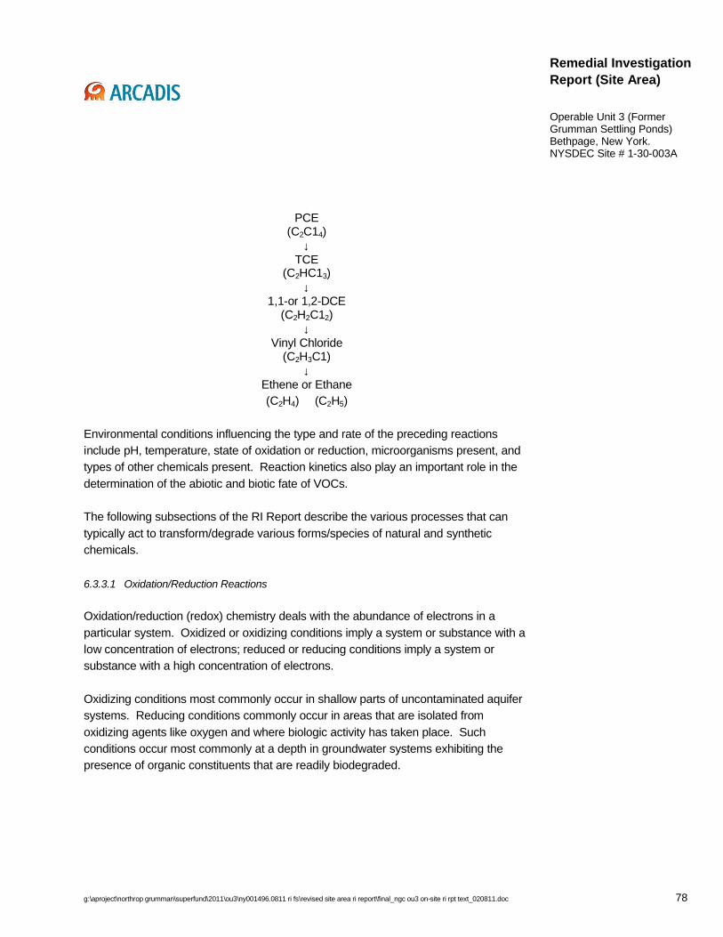
g:\aproject\northrop grumman\superfund\2011\ou3\ny001496.0811 ri fs\revised site area ri report\final_ngc ou3 on-site ri rpt text_020811.doc 78
Remedial Investigation Report (Site Area)
Operable Unit 3 (Former Grumman Settling Ponds)Bethpage, New York.NYSDEC Site # 1-30-003A
PCE(C2C14)
↓TCE
(C2HC13)↓
1,1-or 1,2-DCE(C2H2C12)
↓Vinyl Chloride
(C2H3C1)↓
Ethene or Ethane(C2H4) (C2H5)
Environmental conditions influencing the type and rate of the preceding reactions include pH, temperature, state of oxidation or reduction, microorganisms present, and types of other chemicals present. Reaction kinetics also play an important role in the determination of the abiotic and biotic fate of VOCs.
The following subsections of the RI Report describe the various processes that can typically act to transform/degrade various forms/species of natural and synthetic chemicals.
6.3.3.1 Oxidation/Reduction Reactions
Oxidation/reduction (redox) chemistry deals with the abundance of electrons in a particular system. Oxidized or oxidizing conditions imply a system or substance with a low concentration of electrons; reduced or reducing conditions imply a system or substance with a high concentration of electrons.
Oxidizing conditions most commonly occur in shallow parts of uncontaminated aquifer systems. Reducing conditions commonly occur in areas that are isolated from oxidizing agents like oxygen and where biologic activity has taken place. Such conditions occur most commonly at a depth in groundwater systems exhibiting the presence of organic constituents that are readily biodegraded.
g:\aproject\northrop grumman\superfund\2011\ou3\ny001496.0811 ri fs\revised site area ri report\final_ngc ou3 on-site ri rpt text_020811.doc 79
Remedial Investigation Report (Site Area)
Operable Unit 3 (Former Grumman Settling Ponds)Bethpage, New York.NYSDEC Site # 1-30-003A
6.3.3.2 Acid/Base Reactions (Hydrolysis)
Acid/base chemistry relates to the abundance of hydrogen ions in a system. Acidic conditions imply a system with a high concentration of hydrogen ions (H+) and a low concentration of hydroxide ions (OH-); basic conditions imply the opposite. Hydrolysis is the reaction of an ion with water (H2O) or hydroxide (OH-) to form a hydroxide. The hydrolysis reaction is important because it changes the charge and hence the mobility of a constituent in the system. Most hydroxides have low solubility which translates into low mobility. Hydrolysis rates increase as the hydroxide concentration or pH is raised.
6.3.4 Advection
Advection describes the process of COC migration due to the average bulk movement of groundwater, and typically is the most important factor governing the transport of COCs in groundwater. Advection defines the direction and rate of travel of a plume’s center of mass. The advective transport term is computed using velocities determined by solving the groundwater flow equation, which is a function of hydraulic conductivity, hydraulic gradient, and porosity (Section 4.3 – Local Hydrogeology).
6.3.5 Hydrodynamic Dispersion
Hydrodynamic dispersion describes the spread of COCs around an average groundwater flow path, beyond the region they would normally occupy due to advection alone. Hydrodynamic dispersion is the sum of two processes: mechanical dispersion and molecular diffusion. Mechanical dispersion results from mixing that occurs as a consequence of local variations in groundwater velocity and the aquifer’s matrix. Molecular diffusion results from variations in solute concentrations within the groundwater system. The molecular diffusion effect is generally secondary to and negligible compared with the mechanical dispersion effect (Zheng, 1992).
6.4 Environmental Fate
For OU3, the media of concern are soil, soil gas, perched water, and groundwater, and the COCs are chlorinated and aromatic VOCs, PAHs, metals, and PCBs. In general, the VOCs detected in groundwater during the OU3 RI are relatively mobile ingroundwater having a moderate to high solubility and/or low Koc and Kow values. By comparison, PAHs, metals, and PCBs are relatively immobile. The environmental fate
g:\aproject\northrop grumman\superfund\2011\ou3\ny001496.0811 ri fs\revised site area ri report\final_ngc ou3 on-site ri rpt text_020811.doc 80
Remedial Investigation Report (Site Area)
Operable Unit 3 (Former Grumman Settling Ponds)Bethpage, New York.NYSDEC Site # 1-30-003A
processes of the specific Site-related COCs are discussed in the following sections of the RI Report.
6.4.1 Chlorinated Ethanes and Ethenes
Chlorinated ethene COCs in groundwater include cis-1,2-DCE; TCE; and vinyl chloride. As indicated in Section 5, these constituents have the highest frequency of distribution and are the most widespread of the chlorinated VOCs identified.
In general, chlorinated ethanes and ethenes are considered to have medium-to-high mobility in groundwater, depending on their degree of chlorination. Sorption to soils is expected to be relatively minor; thus, transport in groundwater away from COC source areas is expected to be the dominant transport pathway.
The dominant degradation processes for chlorinated ethanes and ethenes is hydrolysis and biodegradation. Based on data from the RI, chlorinated ethanes are present in soils also containing aromatic hydrocarbons (BTEX – primarily toluene). As also discussed in Section 5 (Nature and Extent of Constituents in Media), a number of biodegradation processes may have occurred in the Site Area. Biodegradation of BTEX constituents may have occurred, resulting in the depletion of dissolved oxygen. The lack of dissolved oxygen established conditions for the anaerobic biodegradation of TCE resulting in the formation of the various degradation products summarized above, including cis-1,2-DCE (one of the most frequently detected VOCs) and vinyl chloride. However, further degradation of these constituents is expected to be slow in the subsurface environment; therefore, these constituents may persist for some time.
A more detailed discussion of the fate of primary chlorinated VOCs is presented in the following subsections.
6.4.1.1 Trichloroethene
TCE was identified as a COC in soil, soil gas, perched water, and groundwater. TCE is moderately soluble in water, although it partitions rapidly to the atmosphere (ATSDR, 1997c). Volatilization of TCE from soil is slower than water, and is related to the organic carbon content of the soil. Sorption of this constituent to the surfaces of soil particles is inversely dependent on soil moisture since polar water molecules may out-compete the non-polar vapor phase of TCE resulting in a greater percentage of TCE in the vapor phase. Bio-magnification in the aquatic food chain does not appear to be significant (ATSDR, 1997c).
g:\aproject\northrop grumman\superfund\2011\ou3\ny001496.0811 ri fs\revised site area ri report\final_ngc ou3 on-site ri rpt text_020811.doc 81
Remedial Investigation Report (Site Area)
Operable Unit 3 (Former Grumman Settling Ponds)Bethpage, New York.NYSDEC Site # 1-30-003A
6.4.1.2 1,2-Dichloroethene
Cis-1,2-dichloroethene was identified as a COC in soil, soil gas, perched water, and groundwater. Soil adsorption coefficients suggest that adsorption of 1,2-dichloroethene isomers (i.e., cis- and trans-) to soil, sediment, and suspended solids in water is not a significant fate process. Without significant adsorption to soil, this constituent can leach into groundwater where very slow biodegradation could occur. Bio-concentration in aquatic organisms is not expected to be significant (ATSDR, 1996).
6.4.1.3 Vinyl chloride
Vinyl chloride was identified as a COC in soil, soil gas, perched water, and groundwater. The primary transport mechanism for vinyl chloride from aquatic systems is volatilization to the atmosphere. This constituent volatilizes rapidly from dry soil surfaces, but does have the potential to leach into groundwater. Vinyl chloride is soluble in most common organic solvents, and organic solvents in relatively high concentrations may reduce its volatility. The high volatility of vinyl chloride precludes potential bioaccumulation, and bio-magnification in aquatic food chains is not expected to be significant (ATSDR, 2004a).
6.4.2 Aromatic Hydrocarbons
Benzene, Toluene, Ethylbenzene, and Xylenes (methyl, para, and ortho) (collectively termed BTEX) belong to the group of constituents known as aromatic hydrocarbons. Aromatic hydrocarbons all have a molecular skeleton that contains the benzene ring as the parent structure.
A more detailed discussion of fate of toluene, ethylbenzene, and xylene constituents is presented in the following subsections.
6.4.2.1 Toluene
Toluene was identified as a COC in soil, soil gas, perched water, and groundwater. Toluene can be biodegraded fairly easily (either aerobically or anaerobically). Oxidation reactions are important elements in the biodegradation of toluene. The majority of toluene released to the environment partitions to air, although rates of volatilization from soils depends on temperature, humidity, and soil type. Transport of toluene from soil to groundwater depends on the degree of adsorption to soil, which is
g:\aproject\northrop grumman\superfund\2011\ou3\ny001496.0811 ri fs\revised site area ri report\final_ngc ou3 on-site ri rpt text_020811.doc 82
Remedial Investigation Report (Site Area)
Operable Unit 3 (Former Grumman Settling Ponds)Bethpage, New York.NYSDEC Site # 1-30-003A
mediated by the presence of organic matter. Toluene will be readily leached from soils with low organic content. The metabolism of toluene limits its bio-magnification in the food chain. Degradation of toluene in soil occurs primarily by microbial action (ATSDR, 2000a).
6.4.2.2 Ethylbenzene
Ethylbenzene was identified as a COC in soil, soil gas, perched water, and groundwater. Ethylbenzene has a high vapor pressure and will partition into the atmosphere from surface soils and surface water; subsurface soil infiltration will also occur. This chemical has a relatively high mobility in soils because sorption is not significant enough to prevent migration. Ethylbenzene will leach into groundwater, particularly in soils with low organic carbon content. Significant bioaccumulation does not occur in aquatic food chains. In soils, aerobic soil microbes are responsible for biodegradation (ATSDR, 1999a).
6.4.2.3 Xylenes
Xylenes were identified as a COC in soil, soil gas, perched water, and groundwater. Xylenes are highly volatile and readily partition into the atmosphere from surface water. In soils, xylenes tend to adsorb to organic matter, and will leach into groundwater from subsurface soils with low organic carbon content. Volatilization and photo-oxidation are the primary removal mechanisms in surface soil and surface water. Biodegradation is the primary removal mechanism in subsurface soils (ATSDR, 1995a).
6.4.2.4 Freons 12 and 22
As discussed in Section 5 (Nature and Extent of Constituents in Media) Freons 12 and 22 were detected at and hydraulically downgradient of the Town former ice rink, located in the Park. The following subsections describe the environmental fate of these constituents.
6.4.2.4.1 Freon 12 (Dichlorodifluoromethane)
Freon 12 has a high vapor pressure, therefore volatilization to the atmosphere is rapid (HSDB, 2005d). Freon 12 is expected to have moderate mobility in soil and is expected to volatilize from both moist and dry soil. Biodegradation may be a factor for soils under anaerobic conditions. Based on its chemical properties (log Koc, log Kow),

g:\aproject\northrop grumman\superfund\2011\ou3\ny001496.0811 ri fs\revised site area ri report\final_ngc ou3 on-site ri rpt text_020811.doc 83
Remedial Investigation Report (Site Area)
Operable Unit 3 (Former Grumman Settling Ponds)Bethpage, New York.NYSDEC Site # 1-30-003A
Freon 12 is not expected to adsorb to suspended solids in the water column (HSDB, 2005d). Freon 12 is expected to volatilize from water surfaces. In the atmosphere, this chemical will slowly degrade due to direct photolysis. The potential for bio-concentration in aquatic organisms is low (HSDB, 2005d).
6.4.2.4.2 Freon 22 (Chlorodifluoromethane)
Because Freon 22 is a gas under ambient conditions, it will volatilize rapidly when released on land (HSDB, 2005e). Based on its estimated log Koc, this chemical has a high potential for leaching in soil. Biodegradation is not expected in soils. In aquatic systems, Freon 22 is not expected to adsorb to suspended solids or sediment. Similar to its behavior in soils, biodegradation of this chemical in aquatic systems is not expected under either aerobic or anaerobic conditions (HSDB, 2005e). The potential for bio-concentration in aquatic organisms is considered to be low based on the log Kow. In the atmosphere, Freon 22 has a relatively long half-life (9.4 years) and is expected to exist as a gaseous phase with degradation occurring by reaction due to direct photolysis (HSDB, 2005e).
6.4.3 Polycyclic Aromatic Hydrocarbons
A number of polycyclic aromatic hydrocarbons (PAHs) were detected in soil as COCs at the Site. These PAHs include benzo(b)fluoranthene, benzo(a)anthracene, benzo(a)pyrene, and indeno(1,2,3-cd)pyrene. PAHs are expected to adsorb to soils and are not be expected to leach to the groundwater. However, their presence in some groundwater samples indicates that PAHs can be transported by some mechanisms.
In soils, PAHs can volatilize, undergo abiotic or biotic degradation, or bio-accumulate in plants. Some PAHs may leach into groundwater from subsurface soils, however the Site Area data indicate few PAHs in groundwater. The transport and partitioning of PAHs in the environment are dependent on several chemical factors, such as water solubility, vapor pressure, Henry’s law constant, octanol-water partition coefficient, and organic carbon partition coefficient. Due to their low solubility and high affinity for organic carbon, PAHs in aquatic systems are generally sorbed to sediments or particulate matter suspended in the water column (USEPA 2006a).
Based on physical properties, (Table 6-1) PAHs do not represent a risk to the environment from volatilization.

g:\aproject\northrop grumman\superfund\2011\ou3\ny001496.0811 ri fs\revised site area ri report\final_ngc ou3 on-site ri rpt text_020811.doc 84
Remedial Investigation Report (Site Area)
Operable Unit 3 (Former Grumman Settling Ponds)Bethpage, New York.NYSDEC Site # 1-30-003A
In groundwater, PAHs, have been shown to be susceptible to significant metabolism by microorganisms without a carbon or energy source, but in most waters and in sediments it is stable towards biodegradation. Particularly benzo(a) pyrene will be expected to undergo significant photo-degradation near the surface of waters. However, adsorption to sediments and particulates may significantly retard biodegradation, photo-degradation, and evaporation.
6.4.4 Metals
Cadmium and chromium have been identified as the primary metal COCs at the Site Area. The following subsections discuss the fate and transport processes of these constituents.
6.4.4.1 Cadmium
In groundwater, cadmium can exist in a number of forms including as a hydrated ion, or form ionic complexes with other inorganic or organic substances. Cadmium is more mobile than most other heavy metals (e.g., lead). Cadmium concentrations in water are inversely proportional to pH and organic material present in the water column. Soluble forms of cadmium complexes may migrate in water, but cadmium associated with insoluble complexes is relatively immobile. Likewise, cadmium in soils may form both soluble and insoluble complexes with organic or inorganic substances. Mobility of cadmium in soils is affected by pH, oxidation-reduction reactions, and formation of complexes. Cadmium is taken up by aquatic and terrestrial plants and can bio-accumulate in all levels of the food chain (ATSDR, 1999b).
6.4.4.2 Chromium
Chromium generally exists in two forms, trivalent (Cr [III]) and hexavalent (Cr [VI]). In groundwater, Cr (VI) is reduced to Cr (III) in the presence of electron donors. These donors are generally found in a reduced subsurface environment where such ions as ferrous iron, reduced sulfur, and organic materials occur. The concentration of Cr (VI) in water is inversely proportional to pH. Chromium is generally immobile in soil because it is generally present as an insoluble oxide, which precludes leaching. Chromium, although not likely to migrate to groundwater, if found, tends to persist over time (USEPA 2006b). This constituent is not expected to bio-magnify in the aquatic or terrestrial food chains.

g:\aproject\northrop grumman\superfund\2011\ou3\ny001496.0811 ri fs\revised site area ri report\final_ngc ou3 on-site ri rpt text_020811.doc 85
Remedial Investigation Report (Site Area)
Operable Unit 3 (Former Grumman Settling Ponds)Bethpage, New York.NYSDEC Site # 1-30-003A
Based on physical properties, chromium does not represent a risk to the environment from volatilization.
6.4.5 Polychlorinated Biphenyls
PCBs in soil are unlikely to migrate to groundwater because of strong binding to soil (ASTDR, 2000b). PCBs will generally not leach significantly in aqueous soil systems; the higher chlorinated congeners will have a lower tendency to leach than the lower chlorinated congeners. In the presence of organic solvents, PCBs may leach rapidly through soil (USEPA 2006c).
Volatilization of PCBs from soil surfaces appears to be an important fate mechanism with the rate of volatilization decreasing with increasing chlorination. Although the volatilization rate may be low, the total loss by volatilization over time may be significant because of the persistence and stability of PCBs. Enrichment of the low-chlorine PCBs occurs in the vapor phase relative to the original Aroclor; the residue will be enriched in the PCBs containing high chlorine content.
PCBs are mixtures of different congeners of chlorobiphenyl and the relative importance of the environmental fate mechanisms generally depends on the degree of chlorination. In general, the persistence of PCBs increases with an increase in the degree of chlorination. Mono-, di- and trichlorinated biphenyls biodegrade relatively rapidly, tetrachlorinated biphenyls biodegrade slowly, and higher chlorinated biphenyls are resistant to biodegradation. Although biodegradation of higher chlorinated congeners may occur very slowly on an environmental basis, no other degradation mechanisms have been shown to be important in natural water and soil systems; therefore, biodegradation may be the ultimate degradation process in water and soil. (USEPA 2006c).
PCBs accumulate more in higher trophic levels through the consumption of contaminated food (i.e., bio-magnification) (ASTDR, 2000d).
6.5 Transport Mechanisms
Transport mechanisms are physical processes governing the movement of constituents from points of origin (i.e., sources). The primary transport mechanisms for COCs identified for OU3 are: leaching from soils in source areas to perched water and groundwater, volatilization from source areas and shallow groundwater to the soil gas/atmosphere, and advective groundwater movement. In groundwater, the

g:\aproject\northrop grumman\superfund\2011\ou3\ny001496.0811 ri fs\revised site area ri report\final_ngc ou3 on-site ri rpt text_020811.doc 86
Remedial Investigation Report (Site Area)
Operable Unit 3 (Former Grumman Settling Ponds)Bethpage, New York.NYSDEC Site # 1-30-003A
subsurface lithology and structure and local pumpage and recharge, are the primary influences on the movement of groundwater.
To perform quantitative analysis of groundwater flow and solute transport (of Site-related COCs), ARCADIS developed a regional model using the United States Geological Survey (USGS) modular, finite-difference, groundwater flow code (MODFLOW) as well as the USEPA modular, three-dimensional transport model (MT3D), respectively. Over time, ARCADIS has performed various updates/revisions, in light of new data, for project remedial decision-making. This NYSDEC-accepted model has been used by ARCADIS for the Northrop Grumman and NWIRP sites (ARCADIS G&M, Inc. 2003) and will continue to be used to assist in OU3 remedial decisions, including decisions related to the groundwater IRM currently in progress (see Section 8 for details).
7. Conceptual Site Model
This section of the RI report develops and discusses the conceptual site model (CSM) for the Site Area. Previous sections of the RI Report summarized relevant Site conditions, consisting of the Site history and usage, geology and hydrogeology (local and regional), and distribution of COCs in the environment (i.e., quality of soil, soil gas, perched water, and groundwater). These sections included a discussion of current conditions that was illustrated with figures, as appropriate. The CSM presented herein relates current conditions to the apparent historical areas of soil disturbance (to the extent possible with available data).
The purpose of the CSM is to more specifically explain the source(s) of COCs and the mode(s) of transport of COCs in and between media (i.e., soil, soil gas, perched water, and groundwater) (a general discussion of fate and transport mechanisms is provided in Section 6 [Fate and Transport]). The discussion below also considers the strength of the conclusions reached, as relates to the occurrence and migration of COCs, from the data. By the end of this section it should be understood, to the extent it can be known, how and why COCs entered the soil, soil gas, perched water, and groundwater systems and where COCs will migrate if left unabated. Key questions that were considered when preparing the CSM for OU3 are as follows:
• By what means did COCs arrive at the Site?
• Is there a single source of COCs or are there multiple sources?
g:\aproject\northrop grumman\superfund\2011\ou3\ny001496.0811 ri fs\revised site area ri report\final_ngc ou3 on-site ri rpt text_020811.doc 87
Remedial Investigation Report (Site Area)
Operable Unit 3 (Former Grumman Settling Ponds)Bethpage, New York.NYSDEC Site # 1-30-003A
• Is the source(s) historical or continuing? If continuing, by what mechanism(s)?
• Is the vadose zone affected by COCs?
• Is there evidence of an off-Site source(s)?
• Do COCs in perched water affect other media?
• How have COCs in groundwater and soil gas moved historically versus currently observed patterns (any changes to the larger system; i.e., pumping wells that would have affected or will affect groundwater flow direction)?
• What is the likely future migration of COCs in soil, soil gas, perched water, and groundwater?
During the development of the CSM, an assessment of data gaps was made.
7.1 Assessment of Off-Site Sources
Data collected from upgradient shallow monitoring wells indicated total VOC concentrations ranging from non-detect to 12 µg/L; these data in conjunction with the results of analysis for SVOCs, metals, and PCBs, support the conclusion that an off-Site, upgradient groundwater source of COCs does not exist.
7.2 Presentation of Conceptual Site Model
To clearly and unambiguously present the CSM, three specific regions of the Site Area were focused on, as follows:
1. southwest park region (i.e., south of the recharge basin and west of the Parking Lot) (includes Areas “A” through “G”; “J”; and “K”),
2. east-central Park region (Parking Lot eastward to the Park eastern boundary) (includes Areas “H”, “I”, and former Town Ice Rink), and
3. The Former Grumman Plant 24 Access Road (south and west of the Park).
The Site Area was viewed in this manner because, although the history and specific past activities conducted on the Site are not well understood or documented, the data
g:\aproject\northrop grumman\superfund\2011\ou3\ny001496.0811 ri fs\revised site area ri report\final_ngc ou3 on-site ri rpt text_020811.doc 88
Remedial Investigation Report (Site Area)
Operable Unit 3 (Former Grumman Settling Ponds)Bethpage, New York.NYSDEC Site # 1-30-003A
suggest that past activities varied among these three regions. The data indicate that each region contains one or more sources of COCs, exhibits a distinct profile of COCs detected (i.e., type of constituent) as well as distinct physical characteristics (i.e., geology and hydrogeology) that directly affect the location, distribution, and concentration of COCs.
This CSM will be re-evaluated and revised (as needed) as additional data are collected.
7.3 Southwest Park Region
The southwest Park region appears to contain nine areas of apparent historical soil disturbance (Figure 1-3). COCs present in the southwest Park region include VOCs, SVOCs, metals, and PCBs.
VOCs are present above SCGs (see Section 5 for details) in all four media (soil, soil gas, perched water, and groundwater), indicative of their higher degree of volatility and mobility, compared to the other parameters discussed below. In general,concentrations of VOCs in soil increase with increasing depth below land surface, with the highest concentrations located immediately above and within the deep LPZ (see Section 4). This information indicates that the underlying soils (particularly the deep LPZ) and also the perched water (see below) appear to contain the majority of residual VOC mass above the water table. However SCG exceedances also exist near land surface in this region.
The primary source of VOCs in soil gas is VOCs in soil in the Park as described in Section 5, with a lesser contribution from VOCs in perched water and shallow groundwater. Evidence supporting this conclusion are the data that indicate VOC soil gas concentrations are highest closest to soil VOC source areas and thatconcentrations decrease with increasing distance from the soil VOC source areas. Additionally, VOC concentrations increase with increasing depth below land surface, which is attributable to the depth of the soil VOC source areas.
Perched water at the Site Area is limited to this region of the Park. Perched water occurs due to percolating rainwater that accumulates atop and within the LPZ, which retards, but does not prevent, further vertical movement. The primary source of VOCs in perched water is VOCs in soil in the Park, as described in Section 5. Additionally, the data indicate differing types and concentrations of VOCs in perched water by location, which suggests limited lateral mixing of VOCs in the horizon where perched
g:\aproject\northrop grumman\superfund\2011\ou3\ny001496.0811 ri fs\revised site area ri report\final_ngc ou3 on-site ri rpt text_020811.doc 89
Remedial Investigation Report (Site Area)
Operable Unit 3 (Former Grumman Settling Ponds)Bethpage, New York.NYSDEC Site # 1-30-003A
water occurs. The deep LPZ is partially below the water table, which indicates that there is a hydraulic connection between the perched water and groundwater. The limited lateral extent of perched water and lack of lateral mixing indicates that perched water migration would only occur through its hydraulic connection with groundwater.
The following lines of evidence support the conclusion that a continuing source of VOCs to groundwater is present in this region of the Site Area, predominantly in Area “D”:
1. The maximum concentration of VOCs in groundwater is 304,000 µg/L, of which 210,000 µg/L is cis-1,2-DCE (the cis-1,2-DCE concentration is approximately 40,000 times greater than the groundwater standard).
2. More than 40 years have passed since soil disturbances at the Site ceased.
3. The maximum groundwater VOC concentration is proximate to the highest concentration of VOCs in soil.
4. A hydraulic connection exists between perched water and groundwater.
VOCs in groundwater have migrated hydraulically downgradient and are present at the Site Area boundary at concentrations exceeding SCGs.
In contrast, the data indicate that SVOCs, metals, and PCBs generally occur in soil above SCGs in the fill/re-worked horizon of the unsaturated zone from land surface to a maximum depth of approximately 25 ft bls. SVOCs, metals, and PCBs are generally considered immobile and, based on the RI data, are apparently adsorbed onto the soil matrix (see Sections 5 and 6). Evidence for this is as follows:
• Other than iron, manganese, and sodium, the data indicate that metals are not present in groundwater above SCGs downgradient of this region or in perched water.
• Few SVOC detections and no PCB detections were identified in groundwater downgradient of this region or perched water.
Additionally, due to their low to non-existent volatility, SVOCs, metals, and PCBs are not expected to occur in soil gas and as such are not normally analyzed for.

g:\aproject\northrop grumman\superfund\2011\ou3\ny001496.0811 ri fs\revised site area ri report\final_ngc ou3 on-site ri rpt text_020811.doc 90
Remedial Investigation Report (Site Area)
Operable Unit 3 (Former Grumman Settling Ponds)Bethpage, New York.NYSDEC Site # 1-30-003A
Consistent with this thinking, these parameters were not analyzed for in soil gas during the OU3 RI.
7.4 East-Central Park Region
The east-central Park region appears to contain two areas of apparent historical soil disturbance (Figure 1-3). COCs present in the east-central Park region include VOCs, SVOCs, metals, and PCBs.
The primary difference between this region of the Park and the southwest Park region is the absence of the deep LPZ in most areas and perched water in the east-central Park region. Additionally, based on data collected by Northrop Grumman, fewer areas of soil disturbance exist in this region, therefore the total area of disturbed soil is smaller in extent. VOCs are present above SCGs (see Section 5 for details) in three media (soil, soil gas, and groundwater), indicative of their higher degree of volatility and mobility, compared to the other parameters discussed below. In general, concentrations of VOCs in soil are orders of magnitude lower compared to the southwest Park region and comparatively few SCG exceedances are evident. The groundwater data suggest that VOCs may be sorbed onto soils beneath the water table and therefore may continue to be a source of VOCs to groundwater in this region.
The primary source of VOCs in soil gas is residual VOCs in soil in this region of the Park as well as lateral diffusion from soil VOC source areas and VOCs in perched water in the adjoining southwest Park region, with a lesser contribution from VOCs in shallow groundwater. Similar to the southwest Park region, VOC concentrations increase with increasing depth below land surface, which is attributable to the depth of the soil VOC source areas.
The following lines of evidence support the conclusion that a continuing source of VOCs to groundwater may be present below the water table in this region of the Site Area:
1. The maximum concentration of VOCs in groundwater is 4,182 µg/L, of which 3,800 µg/L is cis-1,2-DCE (this value is approximately 760 times greater than the groundwater standard).
2. More than 40 years have passed since soil disturbances at the Site ceased.
g:\aproject\northrop grumman\superfund\2011\ou3\ny001496.0811 ri fs\revised site area ri report\final_ngc ou3 on-site ri rpt text_020811.doc 91
Remedial Investigation Report (Site Area)
Operable Unit 3 (Former Grumman Settling Ponds)Bethpage, New York.NYSDEC Site # 1-30-003A
VOCs in groundwater have migrated hydraulically downgradient and are present at the Site Area boundary at concentrations exceeding SCGs.
In contrast, the data indicate that SVOCs, metals, and PCBs generally occur in soil above SCGs in the fill/re-worked horizon of the unsaturated zone (within the construction area, the Town, as part of its IRM, excavated soils to depths ranging up to 20 ft bls and disposed of the soils off-Site; the details of the Town IRM will be the subject of their forthcoming report). SVOCs, metals, and PCBs are generally considered immobile and, based on the RI data, are apparently adsorbed onto the soil matrix (see Sections 5 and 6). Evidence for this is as follows:
• Other than sodium, the data indicate that metals apparently are not present in groundwater above SCGs downgradient of this region.
• No SVOC or PCB detections were identified in groundwater downgradient of this region.
7.5 Former Plant 24 Access Road
The Former Plant 24 Access Road region of the Park historically was used as an access road and no evidence of areas of soil disturbance exists (Figure 1-3). COCs present in this region include VOCs, PCBs and, to a lesser extent, metals.
VOCs in soil gas underlying the Former Plant 24 Access Road region are primarily derived from lateral diffusion from soil VOC source areas and VOCs in perched water in the Park, with a lesser contribution from VOCs in shallow groundwater. Similar to the other regions, VOC concentrations increase with increasing depth below land surface, which is attributable to the depth of the soil VOC source areas in the Park.
As stated above, VOCs in groundwater have migrated from hydraulically upgradient soil VOC source areas and are present underlying this region, and at the Site Area southern boundary at concentrations exceeding SCGs.
PCBs and, secondarily, metals occur in the region in the unsaturated zone, with PCB concentrations above 10 mg/kg from land surface to a maximum depth of 7 ft bls. PCB concentrations are generally higher at the eastern section of the unpaved portion of the Access Road.

g:\aproject\northrop grumman\superfund\2011\ou3\ny001496.0811 ri fs\revised site area ri report\final_ngc ou3 on-site ri rpt text_020811.doc 92
Remedial Investigation Report (Site Area)
Operable Unit 3 (Former Grumman Settling Ponds)Bethpage, New York.NYSDEC Site # 1-30-003A
8. Interim Remedial Measures
As required by the OU3 AOC, Northrop Grumman considered the need for IRMs and, based on the data, proposed two IRMs for the Site. Specifically, Northrop Grumman elected to implement a Soil Gas IRM as well as a Groundwater IRM. Both IRMs will be constructed on Northrop Grumman property (i.e., the Plant 24 Access Road and McKay Field). The following subsections of the RI Report summarize objectives, scope, status, and schedule of each IRM.
8.1 Soil Gas Interim Remedial Measure
The objective of the Soil Gas IRM is to prevent the migration of soil gas by creating a zone of lower pressure (in the vadose zone, i.e., above the water table) between the Park and adjoining properties to the south and west.
The Soil Gas IRM consists of the following elements:
• A total of 18 vadose zone depressurization wells (11 shallow and 7 deep) installed at varying depths below land surface.
• Approximately 33,000 linear ft (a portion of this piping is intended to be used by the Groundwater IRM – see below) of subsurface piping connecting individual depressurization wells to a manifold at a treatment building on McKay Field.
• Treatment building consists of manifold, blowers, master system controls, and air treatment (vapor-phase granular activated carbon).
• Emission stack that is connected to treatment building.
• Vadose zone observation wells to monitor IRM effectiveness.
The Soil Gas IRM Work Plan, the 50-75 Percent Design Report, and the 95 Percent Design Report have been submitted, reviewed, and approved by the NYSDEC. The Soil Gas IRM is currently under construction by ARCADIS and is scheduled to commence operation in early February 2008. Prior to startup, the Sampling and Analysis Plan (SAP) component of the OM&M Manual will be prepared and submitted to the NYSDEC.

g:\aproject\northrop grumman\superfund\2011\ou3\ny001496.0811 ri fs\revised site area ri report\final_ngc ou3 on-site ri rpt text_020811.doc 93
Remedial Investigation Report (Site Area)
Operable Unit 3 (Former Grumman Settling Ponds)Bethpage, New York.NYSDEC Site # 1-30-003A
8.2 Groundwater Interim Remedial Measure
The objective of the Groundwater IRM is to minimize the off-Site migration of VOCs in groundwater.
The Groundwater IRM currently consists of the following elements:
• Four shallow groundwater extraction wells intended to intercept VOCs in groundwater at the Site southern boundary.
• Subsurface piping connecting the extraction wells to a treatment building on McKay Field.
• Treatment building consists of air stripper, blower, master system controls, and air treatment (at a minimum consisting of vapor-phase granular activated carbon).
• Emission stack that is connected to treatment building (this IRM will utilize the same stack as the Soil Gas IRM).
• Local recharge basin, to be used for discharge of the treated effluent.
• Groundwater observation wells to monitor IRM effectiveness.
The Groundwater IRM work plan has been submitted, reviewed, and approved by the NYSDEC. The 50-75 Percent Design Report is currently being prepared, and will be followed by the 95 Percent Design Report. The Groundwater IRM aquifer test in support of the design will be implemented by ARCADIS in the First Quarter of 2008. The Groundwater IRM is scheduled for startup in the Fourth Quarter 2008. Prior to startup, the SAP component of the OM&M Manual will be prepared and submitted to the NYSDEC.
9. Findings and Conclusions
This section of the RI Report summarizes the findings of the RI and presents the conclusions, based on the data presented in prior sections of this RI Report.
g:\aproject\northrop grumman\superfund\2011\ou3\ny001496.0811 ri fs\revised site area ri report\final_ngc ou3 on-site ri rpt text_020811.doc 94
Remedial Investigation Report (Site Area)
Operable Unit 3 (Former Grumman Settling Ponds)Bethpage, New York.NYSDEC Site # 1-30-003A
9.1 Geology/Hydrogeology
• The Site subsurface unsaturated zone deposits consist of fill material between 2 and 27 ft in thickness underlain primarily by glacial sand deposits and locally, beneath the southwest Park region, by a low permeability zone (LPZ), the top of which is approximately 40 ft bls.
• Fill deposits generally are deepest in Southwestern Park Region. The main fill deposit lithologies are as follows:
o Shallow (upper 5 ft of subsurface) sand fill unit or reworked native deposits.
o Predominantly black-stained silt and sand unit containing anthropogenic materials (unit thickness up to approximately 25 ft).
• A material resembling NAPL was observed in Area “D” within the vadose zone extending vertically downward to the water table.
• The Site unsaturated zone glacial (non-fill) lithology underlying the fill consists of sands of varying grain size with silt, clay and gravel lenses, which is in turn underlain in some areas by the LPZ.
• The LPZ is present predominantly underlying the southwest Park region and extends to northwest. .
• Underlying the LPZ to a depth of approximately 300 ft bls, the lithology consists of interbedded fine to coarse sands and silts with discontinuous and less frequent zones of lower permeability clays, sandy clays, and silty clays.
• Perched water overlies a portion of the LPZ. Perched water appears to be present only underlying the southwest Park region. Perched water elevations are consistent over time and are greatest at and north of Area “D”. The LPZ is in hydraulic contact with shallow groundwater, although the degree of contact varies seasonally. Other, more localized and shallow areas of perched water are present in the Southwest and east-central Park regions.
• There are no supply wells located in the Site Area.
g:\aproject\northrop grumman\superfund\2011\ou3\ny001496.0811 ri fs\revised site area ri report\final_ngc ou3 on-site ri rpt text_020811.doc 95
Remedial Investigation Report (Site Area)
Operable Unit 3 (Former Grumman Settling Ponds)Bethpage, New York.NYSDEC Site # 1-30-003A
• Beneath the Site Area, groundwater exists under water-table conditions and seasonally varies from approximately 50 to 55 ft bls. Shallow groundwater flow direction is horizontally to the south-southeast and vertically, slightly downward (consistent with regional flow) and does not indicate an influence from nearby recharge basins or off-Site pumping wells.
• Using regional aquifer characteristics, the average shallow horizontal groundwater velocity ranges from approximately 1.4 to 2.8 ft/day.
9.2 Nature and Extent of Constituents in Media
9.2.1 Soil
• The primary VOC exceedances include chlorinated VOCs (i.e., vinyl chloride, cis-1,2-DCE and TCE) and aromatic hydrocarbon VOCs (i.e., toluene, and to a lesser extent xylenes and ethylbenzene). VOCs are present above SCGs in more localized areas compared to metals and PCBs (see below) and SVOCs are present in localized areas at lower concentrations with few exceedances of SCGs compared to VOCs.
• Metals and PCBs are present above SCGs in soil within most of the Site. Chromium and, to a lesser degree, cadmium represent the primary metal exceedances.
• Most of the soil SCG exceedances were detected in the southwest Park region, as follows:
o Localized VOC exceedances up to six orders of magnitude above SCGs exist in Area “D”, with concentrations similar to SCGs and in some cases up to one order of magnitude above the SCGs in Area “A”, Area “B”, Area “C”, Area “E”, Area “F”, Area “G”, Area “J”, and Area “K”. At Area “D", VOC concentrations increase with depth, with the highest concentrations present within the LPZ, at depths of approximately 40 ft bls to the water table. The greatest mass within the Site underlies Area “D”.
o SVOC exceedances near SCGs exist in the northern and southern portions of the southwest Park region and are generally present within the middle and basal fill.

g:\aproject\northrop grumman\superfund\2011\ou3\ny001496.0811 ri fs\revised site area ri report\final_ngc ou3 on-site ri rpt text_020811.doc 96
Remedial Investigation Report (Site Area)
Operable Unit 3 (Former Grumman Settling Ponds)Bethpage, New York.NYSDEC Site # 1-30-003A
o Metals exceedances of up to two orders of magnitude above SCGs (primarily chromium and, to a lesser degree, cadmium), and PCB exceedances of up to three orders of magnitude above the SCG exist in and are generally limited to the fill deposits.
o Soil in a portion of Area “B” was excavated by the Town of Oyster Bay during its IRM.
• Exceedances outside of the southwest Park region (soil in portions of this region has been excavated by the Town as part of its IRM):
o At Area “F”, data indicate a localized horizon (immediately above a shallow low permeability zone, within 10 ft of land surface) of VOCs in soil with SCG exceedances by up to five orders of magnitude. Chromium SCG exceedances were also detected.
o Area “H” exhibits exceedances of SCGs for the Site-related COCs, as follows:
§ VOC concentrations up to three orders of magnitude above the SCGs in the fill.
§ SVOC concentrations up to one order of magnitude above the SCGs within the fill and at concentrations similar to SCGs in the underlying few feet of native soil.
§ Cadmium and/or chromium concentrations similar to or up to one order of magnitude above SCGs within the fill
§ PCB exceedances up to two orders-of-magnitude above the SCG within the fill and at concentrations similar to the SCG in the underlying 6 feetof native deposits.
o The Area Immediately East of the Recharge Basin exhibits cadmium and chromium concentrations one order of magnitude above the SCGs within the fill.
o The South-Central Area exhibits exceedances of SCGs for the Site-related COCs within the fill, as follows:

g:\aproject\northrop grumman\superfund\2011\ou3\ny001496.0811 ri fs\revised site area ri report\final_ngc ou3 on-site ri rpt text_020811.doc 97
Remedial Investigation Report (Site Area)
Operable Unit 3 (Former Grumman Settling Ponds)Bethpage, New York.NYSDEC Site # 1-30-003A
§ VOCs at concentrations up to one order of magnitude above the SCGs.
§ SVOC concentrations similar to SCGs.
§ Cadmium exceedance of one order of magnitude above the SCG and chromium concentrations two to three orders-of-magnitude above the SCG.
o In the remaining areas of the Site (except for the Northern Border where PCB concentrations were below the SCG), concentrations were similar to the SCG within the fill.
• The Town of Oyster Bay, during its IRM, excavated fill and native materials to depths ranging between 2 and 20 ft bls in their construction area.
9.2.2 Soil Gas
• Overall, the horizontal distribution of VOCs in soil gas indicates that the majority of VOC mass in soil gas is limited to the Park, with concentrations decreasing substantially in all four compass directions away from the Park.
• TCE was selected as the compound to best approximate the overall distribution of VOCs in the vadose zone. The highest concentration of TCE was 1,200,000 µg/m3, located at Area “D”.
• In the vertical direction, an increasing trend in TCE concentrations from land surface downward to the water table exists.
• Generally, the highest concentrations of Freons 12 and 22 are located near the Town former ice rink, with the highest single value of 646,000 µg/m3, near the southern end of the former Town ice rink area.
9.2.3 Perched Water
• The highest concentration of VOCs detected was 120,416 µg/L.
• The VOCs detected and their concentration as a percentage of total VOCs differed greatly by location and over time.
g:\aproject\northrop grumman\superfund\2011\ou3\ny001496.0811 ri fs\revised site area ri report\final_ngc ou3 on-site ri rpt text_020811.doc 98
Remedial Investigation Report (Site Area)
Operable Unit 3 (Former Grumman Settling Ponds)Bethpage, New York.NYSDEC Site # 1-30-003A
• Piezometers along the former Plant 24 Access Road south of the Park, have exhibited no measurable perched water for the period of record.
• The perched water data collectively indicate that SVOCs remain relatively immobile and tightly sorbed onto the soil matrix and are therefore not COCs in perched water.
• The concentrations of soluble iron and manganese in perched water are likely attributed to localized reductive dechlorination of VOCs and the data indicate that the metals identified are potential sources to groundwater.
• The perched water data collectively indicate that pesticides are not a COC in perched water and that PCBs remain relatively immobile and tightly sorbed onto the soil matrix and are therefore not COCs in perched water.
• Evaluation of the perched water data in conjunction with groundwater data collectively indicates that perchlorate is not a COC at the Site.
• Compared to biogeochemical conditions in groundwater, the perched water results within the Park indicate evidence of stronger reducing conditions (as indicated by elevated concentrations of soluble iron and manganese and the presence of methane). Additionally, the presence of daughter VOCs (i.e., cis-1,2-DCE and vinyl chloride) as well as end products of biodegradation (i.e., ethene and ethane) indicates that biodegradation of VOCs is occurring. However, although there is evidence of complete reductive dechlorination of VOCs in some areas, the biogeochemical conditions are not currently of sufficient uniform strength or magnitude to eliminate VOCs in perched water.
9.2.4 Groundwater
• The analytical results indicate a groundwater plume containing VOCs (primarily consisting of toluene, TCE, cis-1,2-DCE, and vinyl chloride) is present beneath the Site Area, and the plume apparently originates from Areas “B”, “C”, “D”, and “I”. These areas appear to be continuing sources of VOCs to groundwater. The VOC groundwater plume has been delineated within the Site Area in the upgradient (i.e., north), and sidegradient directions (i.e., east-west to the limits of the Site Area) as well as vertically. The data indicate that groundwater exceedances extend in the downgradient direction to the southern boundary of the Plant 24 Access Road and
g:\aproject\northrop grumman\superfund\2011\ou3\ny001496.0811 ri fs\revised site area ri report\final_ngc ou3 on-site ri rpt text_020811.doc 99
Remedial Investigation Report (Site Area)
Operable Unit 3 (Former Grumman Settling Ponds)Bethpage, New York.NYSDEC Site # 1-30-003A
beyond the Site Area. The VOC plume, as it migrates downgradient, also migrates vertically downward.
• A sub-plume consisting of Freon 22 has been identified originating from the Town former ice rink. Based on Town information, Freon 22 was used and released to the environment. The Freon 22 groundwater plume has been delineated on-Site, however the downgradient extent is not presently known.
• By comparison, other constituents, including SVOCs, metals (with the exception of chromium), PCBs, and perchlorate have been detected in groundwater at or near SCGs or have not been detected, therefore with the exception of chromium, the above constituents are not considered COCs for Site Area groundwater.
• The distribution of VOCs detected in excess of SCGs indicate the presence of a plume derived from multiple on-Site sources that is approximately 1,200 ft in width and 150 ft bls at its maximum depth at the southern boundary of the Plant 24 Access Road. The VOC detected at the highest concentrations is cis-1,2-DCE (210,000 µg/L) which is four orders of magnitude above the SCG.
• The VOC groundwater plume above SCGs is present under the majority of the Site Area. The maximum VOC concentration is located at Area “D”.
• Cis-1,2 DCE is the most prevalent VOC detected above SCGs and is the compound present at the highest concentration overall.
• The TCE component of the VOC groundwater plume is present under the majority of the Site Area with a maximum TCE concentration is located at Area “D”. The highest TCE concentrations remain shallow and underlie the area of highest soil VOC concentrations. Along the Site southern boundary, TCE concentrations are present in groundwater at lower elevations on the eastern portion of the Site Area as compared to the western portion.
• The cis-1,2-DCE component of the VOC groundwater plume is similar in extent to TCE with the maximum concentration also located beneath Area “D”. Consistent with TCE concentrations, cis-1,2-DCE concentrations are present in groundwater at lower elevations on the eastern portion of the Site Area as compared to the western portion.
g:\aproject\northrop grumman\superfund\2011\ou3\ny001496.0811 ri fs\revised site area ri report\final_ngc ou3 on-site ri rpt text_020811.doc 100
Remedial Investigation Report (Site Area)
Operable Unit 3 (Former Grumman Settling Ponds)Bethpage, New York.NYSDEC Site # 1-30-003A
• VC concentrations exceeding the SCG were identified within a narrow subsection of the VOC plume at and downgradient of Area “D” with the maximum VC concentration located beneath Area “D”.
• Freon 22 concentrations greater than the SCG were identified within a subsection of the VOC plume at and downgradient of the Town former ice rink with the maximum Freon 22 concentration located downgradient of the Town former ice rink.
• Four SVOCs were detected at concentrations above SCGs, with the maximum concentration co-located with the VOC maximum concentration, in Area “D”. SVOC exceedances are limited to areas proximal to suspected sources within the boundaries of the Park.
• Based on the results from dissolved samples, only iron and sodium exhibited exceedances of SCGs. The concentrations of soluble iron and manganese are likely attributed to localized reductive dechlorination of VOCs. Collectively, the groundwater data indicate that Site-related metals in groundwater are limited in extent to the Site, remain relatively immobile and tightly sorbed onto the soil matrix, and are therefore not COCs in groundwater.
• Out of 504 possible results only five detections of pesticides/PCBs were found (all less than 1 µg/L). Compared to the results from soil samples collected from soil borings, the groundwater data collectively indicate that pesticides and PCBs remain relatively immobile and tightly sorbed onto the soil matrix and are therefore not COCs in groundwater.
• No on-Site source of perchlorate was identified and overall, the data indicate that perchlorate is not a COC at the Site.
• Similar to perched water conditions, although there is evidence of complete reductive dechlorination of VOCs in groundwater in some areas, the biogeochemical conditions are not currently of sufficient uniform strength or magnitude to eliminate VOCs in groundwater.
9.3 Fate & Transport
• The following COCs were identified in one or more media:
g:\aproject\northrop grumman\superfund\2011\ou3\ny001496.0811 ri fs\revised site area ri report\final_ngc ou3 on-site ri rpt text_020811.doc 101
Remedial Investigation Report (Site Area)
Operable Unit 3 (Former Grumman Settling Ponds)Bethpage, New York.NYSDEC Site # 1-30-003A
Volatile Organic Compounds (VOCs)
Chlorinated Ethenes
- Trichloroethene
-cis-1,2-Dichloroethene
- Vinyl chloride
Aromatic Hydrocarbons
-Ethylbenzene
-Toluene
-Xylenes
Polycyclic Aromatic Hydrocarbons
Benzo(b)fluoranthene
Benzo(a)anthracene
Benzo(a)pyrene
Indeno(1,2,3-cd)pyrene
Metals
Cadmium
Chromium
Polychlorinated Biphenyls(PCBs)
• For OU3, the media of concern are soil, soil gas, perched water, and groundwater, and the COCs are chlorinated and aromatic VOCs, PAHs, metals, and PCBs. In general, the VOCs detected in groundwater during the OU3 RI are relatively mobile in groundwater having a moderate to high solubility and/or low Koc and Kow
values. By comparison, PAHs, metals, and PCBs are relatively immobile.
• Biodegradation of BTEX constituents may have occurred, resulting in the depletion of dissolved oxygen. The lack of dissolved oxygen established conditions for the anaerobic biodegradation of TCE resulting in the formation of various degradation products. However, further degradation of these constituents is expected to be slow in the subsurface environment; therefore, these constituents may persist for some time.

g:\aproject\northrop grumman\superfund\2011\ou3\ny001496.0811 ri fs\revised site area ri report\final_ngc ou3 on-site ri rpt text_020811.doc 102
Remedial Investigation Report (Site Area)
Operable Unit 3 (Former Grumman Settling Ponds)Bethpage, New York.NYSDEC Site # 1-30-003A
9.4 Conceptual Site Model
• An off-Site, upgradient groundwater source of COCs apparently does not exist.
• The history and specific past activities conducted on the Site are not well understood or documented and the data suggest that past activities varied among the southwest Park region, east-central Park region and the Former Grumman Plant 24 Access Road. Each region appears to contain one or more sources of COCs, exhibits a distinct profile of COCs detected as well as distinct physical characteristics that directly affect the location, distribution, and concentration of COCs.
• In the southwest Park region, the underlying soils (particularly the deep LPZ) and also the perched water appear to contain the majority of residual VOC mass above the water table.
• In the southwest Park region, the primary source of VOCs in soil gas is VOCs in soil, with a lesser contribution from VOCs in perched water and shallow groundwater.
• In the southwest Park region, perched water occurs due to percolating rainwater that accumulates atop and within the LPZ, which retards, but does not prevent, further vertical movement. The limited lateral extent of perched water and lack of lateral mixing indicates that perched water migration would only occur through its hydraulic connection with groundwater.
• A continuing source of VOCs to groundwater is present in the southwest Park region, predominantly in Area “D”.
• The primary difference between the East-Central and the southwest Park regionsis the absence of the deep LPZ in most areas and perched water in the East-Central Region. VOCs may be sorbed onto soils beneath the water table and therefore may continue to be a source of VOCs to groundwater.
• In the east-central Park region, the primary source of VOCs in soil gas is residual VOCs in soil as well as lateral diffusion from soil VOC source areas and VOCs in perched water in the adjoining southwest Park region, with a lesser contribution from VOCs in shallow groundwater.

g:\aproject\northrop grumman\superfund\2011\ou3\ny001496.0811 ri fs\revised site area ri report\final_ngc ou3 on-site ri rpt text_020811.doc 103
Remedial Investigation Report (Site Area)
Operable Unit 3 (Former Grumman Settling Ponds)Bethpage, New York.NYSDEC Site # 1-30-003A
• In the east-central Park region, a continuing source of VOCs to groundwater may be present below the water table.
• The Former Plant 24 Access Road region of the Park historically was used as an access road and no evidence of areas of soil disturbance exists.
• At the Former Plant 24 Access Road VOCs in soil gas underlying the Former Plant 24 Access Road region are primarily derived from lateral diffusion from soil VOC source areas and VOCs in perched water in the Park, with a lesser contribution from VOCs in shallow groundwater.
10. Recommendations
None
g:\aproject\northrop grumman\superfund\2011\ou3\ny001496.0811 ri fs\revised site area ri report\final_ngc ou3 on-site ri rpt text_020811.doc 104
Remedial Investigation Report (Site Area)
Operable Unit 3 (Former Grumman Settling Ponds)Bethpage, New York.NYSDEC Site # 1-30-003A
11. References
Agency for Toxic Substances and Disease Registry (ATSDR). 2004a. Toxicological profile for vinyl chloride. Atlanta, GA: U.S. Department of Health and Human Services, Public Health Service.
Agency for Toxic Substances and Disease Registry (ATSDR). 2004b. Toxicological profile for 1,1,1-trichloroethane. Atlanta, GA: U.S. Department of Health and Human Services, Public Health Service.
Agency for Toxic Substances and Disease Registry (ATSDR). 2000a. Toxicological profile for toluene. Atlanta, GA: U.S. Department of Health and Human Services, Public Health Service.
Agency for Toxic Substances and Disease Registry (ATSDR). 2000b. Toxicological profile for methylene chloride. Atlanta, GA: U.S. Department of Health and Human Services, Public Health Service.
Agency for Toxic Substances and Disease Registry (ATSDR). 2000c. Toxicological profile for chromium. Atlanta, GA: U.S. Department of Health and Human Services, Public Health Service.
Agency for Toxic Substances and Disease Registry (ATSDR). 2000d. Toxicological profile for PCBs. Atlanta, GA: U.S. Department of Health and Human Services, Public Health Service.
Agency for Toxic Substances and Disease Registry (ATSDR). 1999a. Toxicological profile for ethylbenzene. Atlanta, GA: U.S. Department of Health and Human Services, Public Health Service.
Agency for Toxic Substances and Disease Registry (ATSDR). 1999b. Toxicological profile for cadmium. Atlanta, GA: U.S. Department of Health and Human Services, Public Health Service.
Agency for Toxic Substances and Disease Registry (ATSDR). 1997a. Toxicological profile for benzene. Atlanta, GA: U.S. Department of Health and Human Services, Public Health Service.
g:\aproject\northrop grumman\superfund\2011\ou3\ny001496.0811 ri fs\revised site area ri report\final_ngc ou3 on-site ri rpt text_020811.doc 105
Remedial Investigation Report (Site Area)
Operable Unit 3 (Former Grumman Settling Ponds)Bethpage, New York.NYSDEC Site # 1-30-003A
Agency for Toxic Substances and Disease Registry (ATSDR). 1997b. Toxicological profile for chloroform. Atlanta, GA: U.S. Department of Health and Human Services, Public Health Service.
Agency for Toxic Substances and Disease Registry (ATSDR). 1997c. Toxicological profile for trichloroethylene. Atlanta, GA: U.S. Department of Health and Human Services, Public Health Service.
Agency for Toxic Substances and Disease Registry (ATSDR). 1996. Toxicological profile for 1,2-dichloroethene. Atlanta, GA: U.S. Department of Health and Human Services, Public Health Service.
Agency for Toxic Substances and Disease Registry (ATSDR). 1995a. Toxicological profile for xylenes. Atlanta, GA: U.S. Department of Health and Human Services, Public Health Service.
Agency for Toxic Substances and Disease Registry (ATSDR). 1995b. Toxicological profile for PAHs. Atlanta, GA: U.S. Department of Health and Human Services, Public Health Service.
Agency for Toxic Substances and Disease Registry (ATSDR). 1990. Toxicological profile for 1,1-dichloroethane. Atlanta, GA: U.S. Department of Health and Human Services, Public Health Service.
ARCADIS of New York, Inc. 2007a. Summary of Phase 3 Remedial Investigation and Interim Remedial Measures Pre-Design Investigation Work Plan, Former Grumman Settling Ponds (Operable Unit 3 – Bethpage Community Park), Bethpage, New York. NYSDEC Site # 1-30-003A. January 17, 2007.
ARCADIS of New York, Inc. 2007b. Correspondence from Mr. David Stern (ARCADIS) to Mr. Steve Scharf (NYSDEC). Re: Northrop Grumman OU3 - GW IRM Treatability Testing. May 29, 2007.
ARCADIS of New York, Inc. 2007c. Operable Unit 3 – Soil Gas Interim Remedial Measure Work Plan, Former Grumman Settling Ponds, Bethpage, New York. NYSDEC Site # 1-30-003A. February 16, 2007.

g:\aproject\northrop grumman\superfund\2011\ou3\ny001496.0811 ri fs\revised site area ri report\final_ngc ou3 on-site ri rpt text_020811.doc 106
Remedial Investigation Report (Site Area)
Operable Unit 3 (Former Grumman Settling Ponds)Bethpage, New York.NYSDEC Site # 1-30-003A
ARCADIS of New York, Inc. 2007d. Operable Unit 3 – Soil Gas Interim Remedial Measure 50 to 75 Percent Design, Former Grumman Settling Ponds, Bethpage, New York. NYSDEC Site # 1-30-003A. August 2, 2007.
ARCADIS of New York, Inc. 2007e. Operable Unit 3 – Soil Gas Interim Remedial Measure 95 Percent Design, Former Grumman Settling Ponds, Bethpage, New York. NYSDEC Site # 1-30-003A. September 7, 2007.
ARCADIS G&M, Inc. 2006a. Remedial Investigation/Feasibility Study Work Plan, Former Grumman Settling Ponds (Operable Unit 3 – Bethpage Community Park), Bethpage, New York. NYSDEC Site # 1-30-003A. Revised March 8, 2006.
ARCADIS G&M, Inc. 2006b. Phase 2 Remedial Investigation Work Plan Addendum No. 1, Former Grumman Settling Ponds (Operable Unit 3 – Bethpage Community Park), Bethpage, New York. NYSDEC Site # 1-30-003A. April 25, 2006.
ARCADIS G&M, Inc. 2006c. Phase 2 Remedial Investigation Work Plan Addendum No. 2, Former Grumman Settling Ponds (Operable Unit 3 – Bethpage Community Park), Bethpage, New York. NYSDEC Site # 1-30-003A. June 9, 2006.
ARCADIS G&M, Inc. 2006d. Phase 2 Remedial Investigation Work Plan Addendum No. 3, Former Grumman Settling Ponds (Operable Unit 3 – Bethpage Community Park), Bethpage, New York. NYSDEC Site # 1-30-003A. July 13, 2006.
ARCADIS G&M, Inc. 2006e. Phase 2 Remedial Investigation Work Plan Addendum No. 4, Former Grumman Settling Ponds (Operable Unit 3 – Bethpage Community Park), Bethpage, New York. NYSDEC Site # 1-30-003A. August 7, 2006.
ARCADIS G&M, Inc. 2006f. Phase 2 Remedial Investigation Work Plan Addendum No. 7, Former Grumman Settling Ponds (Operable Unit 3 – Bethpage Community Park), Bethpage, New York. NYSDEC Site # 1-30-003A. November 13, 2006.
ARCADIS G&M, Inc. 2005a. Summary of Soil Vapor Sampling Results, Bethpage Community Park – Operable Unit 3. June 2005.
ARCADIS G&M, Inc. 2005b. Correspondence from Mr. David Stern (ARCADIS) to Mr. Steve Scharf (NYSDEC). Re: Phase 1B RI Work Plan. May 25, 2005.

g:\aproject\northrop grumman\superfund\2011\ou3\ny001496.0811 ri fs\revised site area ri report\final_ngc ou3 on-site ri rpt text_020811.doc 107
Remedial Investigation Report (Site Area)
Operable Unit 3 (Former Grumman Settling Ponds)Bethpage, New York.NYSDEC Site # 1-30-003A
ARCADIS G&M, Inc. 2004a. Correspondence from Mr. David Stern (ARCADIS) to Mr. Steve Scharf (NYSDEC). Re: Phase 1 RI Work Plan. June 7, 2004.
ARCADIS G&M, Inc. 2004b. Correspondence from Mr. David Stern (ARCADIS) to Mr. Larry Leskovjan (Northrop Grumman). Re: Phase 1A RI Work Plan. October 21, 2004.
ARCADIS G&M, Inc. 2003. Comprehensive Groundwater Model Report, U.S. Naval Weapons Industrial Reserve Plant/Northrop Grumman, Bethpage, New York. April 28, 2003.
ARCADIS Geraghty & Miller, Inc., 2000. Groundwater Feasibility Study, Grumman Aerospace-Bethpage, NY Site #130003A and Naval Weapons Industrial Reserve Plant Bethpage, NY Site #130003B.
Dvirka & Bartilucci Consulting Engineers (D&B) 2006. Phase 2A Remedial Investigation, Work Plan Addendum No. 6, Former Grumman Settling Ponds (Operable Unit 3 – Bethpage Community Park), Bethpage, New York. NYSDEC Site # 1-30-003A. November 30, 2006.
Dvirka & Bartilucci Consulting Engineers (D&B) 2006b. Town of Oyster Bay Bethpage Community Park, B-43 Area Investigation Results, Bethpage, New York. November 9, 2006.
Dvirka and Bartilucci Consulting Engineers. (D&B) 2003. Town of Oyster Bay Bethpage Community Park Investigation Sampling Program, Bethpage, New York. December, 2003.
EA Engineering, P.C. and its Affiliate EA Science and Technology (EA), 2007, Summary Report for An Immediate Soil Vapor Intrusion Investigation at Former Grumman Settling Ponds (1-30-003A), Bethpage, New York
Geraghty & Miller, Inc. 1994. Remedial Investigation Report, Grumman Aerospace Corporation, Bethpage, New York. Revised September 1994.
Hazardous Substances Data Bank (HSDB). 2005a. Toxicology data for 1,1,2-trichloroethane. Available at http://toxnet.nlm.nih.gov.

g:\aproject\northrop grumman\superfund\2011\ou3\ny001496.0811 ri fs\revised site area ri report\final_ngc ou3 on-site ri rpt text_020811.doc 108
Remedial Investigation Report (Site Area)
Operable Unit 3 (Former Grumman Settling Ponds)Bethpage, New York.NYSDEC Site # 1-30-003A
Hazardous Substances Data Bank (HSDB). 2005b. Toxicology data for 1,1-dichloroethene. Available at http://toxnet.nlm.nih.gov.
Hazardous Substances Data Bank (HSDB). 2005c. Toxicology data for 1,2-dichloropropane. Available at http://toxnet.nlm.nih.gov.
Hazardous Substances Data Bank (HSDB). 2005d. Toxicology data for Freon 12. Available at http://toxnet.nlm.nih.gov.
Hazardous Substances Data Bank (HSDB). 2005e. Toxicology data for Freon 22. Available at http://toxnet.nlm.nih.gov.
Holzmacher, McClendon, & Murrell (H2M), P.C.. 2007. Correspondence from Mr. Paul Lageraan (H2M) to Mr. Steve Scharf (NYSDEC). August 8, 2007.
Holzmacher, McClendon, and Murrell, P.C. (H2M), 2005a. Investigation Report and Remedial Action Plan, Town of Oyster Bay Bethpage Community Park Interim Remedial Measure – Construction Area. Prepared for: Town of Oyster Bay Department of Public Works. November 2005.
Holzmacher, McClendon, and Murrell, P.C. (H2M), 2005b. Supplemental Investigation Report, Town of Oyster Bay Bethpage Community Park Interim Remedial Measure – Construction Area. Prepared for: Town of Oyster Bay Department of Public Works. December 2005.
New York State Department of Environmental Conservation (NYSDEC), 2005a, Order on Consent Index # W1-0018-04-01, Site # 1-30-003A, July 4, 2005.
New York State Department of Environmental Conservation (NYSDEC), 2005b, Division of Environmental Remediation Policies, Technical and Administrative Guidance Memorandum (TAGM), 4000 Series TAGMs. July 2005.
New York State Department of Environmental Conservation (NYSDEC), 2004. Correspondence from Steve Scharf (NYSDEC) to Mr. John Cofman) Northrop Grumman. Re: Northrop Grumman Site, Nassau County Site No. 1-30-003A-OU3, Former Northrop Grumman Settling Ponds. February 12, 2004.
New York State Department of Environmental Conservation (NYSDEC), 2002 Draft DER-10 Technical Guidance for Site Investigation and Remediation, December.

g:\aproject\northrop grumman\superfund\2011\ou3\ny001496.0811 ri fs\revised site area ri report\final_ngc ou3 on-site ri rpt text_020811.doc 109
Remedial Investigation Report (Site Area)
Operable Unit 3 (Former Grumman Settling Ponds)Bethpage, New York.NYSDEC Site # 1-30-003A
New York State Department of Environmental Conservation (NYSDEC), 1998, Inactive Hazardous Waste Disposal, NYS 6NYCRR Part 375. January 1998.
New York State Department of Environmental Conservation (NYSDEC), 1994, Technical and Administrative Guidance Memorandum #4046, Determination of Soil Cleanup Objective and Cleanup Levels. January 1994.
New York State Department of Environmental Conservation (NYSDEC), 1990, Selection of Remedial Actions at Inactive Hazardous Waste Sites, Technical and Administrative Guidance Memorandum #4030. May 1990.
New York State Department of Environmental Conservation (NYSDEC), 1989. (Hazardous Waste Remediation) Engineering Division Technical and Administrative Guidance Memoranda (TAGM), including TAGM HWR-89-4025 Guidelines for Remedial Investigations/Feasibility Studies.
Northrop Grumman Systems Corporation (Northrop Grumman) 2007a. Correspondence from Mr. Larry Leskovjan (Northrop Grumman) to Mr. Chittibabu Vasudevan (NYSDEC); Re: Former Grumman Settling Ponds, NYSDEC Nassau County site #1-30-003A OU3 (Bethpage Community Park). January 12, 2007.
Northrop Grumman Systems Corporation (Northrop Grumman) 2007b. Correspondence from Mr. Larry Leskovjan (Northrop Grumman) to Mr. Chittibabu Vasudevan (NYSDEC); Re: Notice of Intent to Implement Groundwater Interim Remedial Measure, Operable Unit 3 (Former Grumman Settling Ponds), NYSDEC Site #1-30-003A, Bethpage, New York. September 25, 2007.
Northrop Grumman Systems Corporation (Northrop Grumman) 2006a. Town of Oyster Bay Bethpage Community Park, Phase 2A Remedial Investigation, Work Plan Addendum No. 5. September 26, 2006.
Nyer, Evan K.. 1992. Practical Techniques for Groundwater and Soil Remediation.
Suthersan, Suthan, S. 1997. Remediation Engineering: Design Concepts. Lewis Publishers. New York.
U.S. Environmental Protection Agency (USEPA) 2006a. Technical Factsheet on: Polycyclic Aromatic Hydrocarbons (PAHs) November 2006

g:\aproject\northrop grumman\superfund\2011\ou3\ny001496.0811 ri fs\revised site area ri report\final_ngc ou3 on-site ri rpt text_020811.doc 110
Remedial Investigation Report (Site Area)
Operable Unit 3 (Former Grumman Settling Ponds)Bethpage, New York.NYSDEC Site # 1-30-003A
U.S. Environmental Protection Agency (USEPA) 2006b. Technical Factsheet on: Chromium November 2006
U.S. Environmental Protection Agency (USEPA) 2006c, Technical Factsheet on: PCBs November 2006
U.S. Environmental Protection Agency (USEPA). 1999. Risk AssessmentGuidance for Superfund Volume I Human Health Evaluation Manual. Supplemental Guidance. Dermal Risk Assessment. Interim Guidance. U.S. Environmental Protection Agency, Office of Emergency and Remedial Response, Washington, D.C.
U.S. Environmental Protection Agency (USEPA). 1995. Policy for RiskCharacterization at the U.S. Environmental Protection Agency. U.S. Environmental Protection Agency, Office of the Administrator, Washington, D.C. March.
U.S. Environmental Protection Agency (USEPA). 1994. Methods for Derivation of Inhalation Reference Concentrations and Application of Inhalation Dosimetry. U.S. Environmental Protection Agency, Washington, D.C. EPA/600/8-90/066F. October.
U.S. Environmental Protection Agency (USEPA). 1992. Final Guidelines forExposure Assessment: Notice. U.S. Environmental Protection Agency, Washington, D.C., 57 Federal Register 104: 22888-22938. May 29.
U.S. Environmental Protection Agency (USEPA). 1990. National ContingencyPlan. U.S. Environmental Protection Agency, Washington, D.C.
U.S. Environmental Protection Agency (USEPA). 1988. Guidance for ConductingRemedial Investigation and Feasibility Studies Under the Comprehensive Environmental Response, Compensation, and Liability Act (CERCLA) Interim Final
Weinberg, Nadine. 2007. Telephone conversation with Ms. Krista Anders (Public Health Specialist III) of NYSDOH. December 2007.
Zervos, Theodore, 2007. Deposition of Theodore Zervos in the matter Town of Oyster Bay v. Northrop Grumman Systems Corporation et al. Case No. 05-CV-1945 (TCP)(AKT). January 22, 2007.

g:\aproject\northrop grumman\superfund\2011\ou3\ny001496.0811 ri fs\revised site area ri report\final_ngc ou3 on-site ri rpt text_020811.doc 111
Remedial Investigation Report (Site Area)
Operable Unit 3 (Former Grumman Settling Ponds)Bethpage, New York.NYSDEC Site # 1-30-003A
Zheng, C. 1992. MT3D. A Modular Three-Dimensional Transport Model. S.S. Papadopulos and Associates, Inc.

Appendix A
Other/Third Party Data:
1. Town IRM Pre-Characterization Soil, Soil Gas, and Groundwater Data.
2. NYSDEC Soil Gas Data
3. Northrop Grumman Off-Site RI Groundwater Data
Appendix B
Soil Remedial Investigation Report, Prepared by Dvirka & Bartilucci

Appendix C
Geotechnical Data

Appendix D
Sample/Core Logs

Appendix E
Geophysical Reports and Logs
Appendix F
Groundwater/Perched Water Sampling Logs and Perched Water Hydrographs

Appendix G
Well and Piezometer Construction Logs and Well Development Logs

Appendix H
Soil Gas Sampling Logs

Appendix I
Community Air Monitoring Program Data
Appendix J
Investigation-Derived Waste Disposition Documents

Appendix K
Data Usability Summary Reports

Appendix L
Cone Penetrometer and Membrane Interface Probe Reports

Appendix M
Groundwater Bench Scale and Treatability Reports
Appendix N
NYSDEC Category A and B Laboratory Reports (ARCADIS)

Appendix O
NYSDEC EQUIS Compatible Electronic Data Deliverables

Appendix P
Supplemental to theRemedial Investigation Report.January 8, 2009
Appendix Q
Supplemental to theRemedial Investigation Report.January 8, 2009, Revised December 9, 2009