Remedial Investigation Report Former Boiler House Property ...
235
Remedial Investigation Report Former Boiler House Property NYSDEC Site No. B00197 US Route 4 and Best Avenue Town of Stillwater Saratoga County, New York VOLUME 1 of 7 February 2009 Chazen Project No. 30201.14 Capital District Office: Kim L. Baines 547 River Street Troy, NY 12180 (518) 273-0055 Dutchess County Office: 21 Fox Street, Poughkeepsie, NY 12601 Orange County Office: 356 Meadow Avenue, Newburgh, NY 12550 North Country Office 100 Glen Street, Glens Falls, NY 12801 Prepared by: ENGINEERS/SURVEYORS PLANNERS ENVIRONMENTAL SCIENTISTS
Transcript of Remedial Investigation Report Former Boiler House Property ...

Remedial Investigation Report Former Boiler House Property
NYSDEC Site No. B00197 US Route 4 and Best Avenue
Town of Stillwater Saratoga County, New York
VOLUME 1 of 7
February 2009
Chazen Project No. 30201.14
Capital District Office: Kim L. Baines 547 River Street Troy, NY 12180 (518) 273-0055
Dutchess County Office: 21 Fox Street, Poughkeepsie, NY 12601
Orange County Office: 356 Meadow Avenue, Newburgh, NY 12550
North Country Office 100 Glen Street, Glens Falls, NY 12801
Prepared by:
ENGINEERS/SURVEYORS PLANNERS
ENVIRONMENTAL SCIENTISTS

Remedial Investigation Report Former Boiler House Property
NYSDEC Site No. B00197 US Route 4 and Best Avenue
Town of Stillwater Saratoga County, New York
VOLUME 1 of 7
February 2009
Prepared for:
Mr. Michael McLean, P.E.
NYSDEC, Region 5 Route 86 Ray Brook, NY 12977
Town of Stillwater Supervisor, Shawn Connelly East Street PO Box 700 Stillwater, New York 12170

Remedial Investigation Report: Volume 1 of 7 Page - i - Former Boiler House Property NYSDEC Site No. B00197
The Chazen Companies 30201.14
February 2009
TABLE OF CONTENTS
1.0 INTRODUCTION ................................................................................................................................. 1 1.1 REMEDIAL INVESTIGATION OBJECTIVES .............................................................................................. 2 1.2 SITE DESCRIPTION ............................................................................................................................... 3
1.2.1 Site Location ............................................................................................................................... 3 1.2.2 Property Uses.............................................................................................................................. 3
1.2.2.1 Current Property Use............................................................................................................................ 3 1.2.2.2 Historic Property Uses ......................................................................................................................... 4 1.2.2.3 Future Property Use ............................................................................................................................. 4
1.2.3 Environmental Setting................................................................................................................. 4 1.2.3.1 Geology................................................................................................................................................ 4 1.2.3.2 Hydrogeology....................................................................................................................................... 5 1.2.3.3 Surface Water Resources...................................................................................................................... 6
1.2.4 Site Environmental History......................................................................................................... 6 1.2.5 Previous Soil and Groundwater Investigations........................................................................... 8
1.3 REMEDIAL INVESTIGATION REPORT ORGANIZATION ........................................................................... 8 1.4 REMEDIAL INVESTIGATION AND IRM CHRONOLOGY........................................................................... 8
2.0 SITE CHARACTERIZATION .......................................................................................................... 10 2.1 PRE-IRM SUBSURFACE SOIL QUALITY INVESTIGATION .................................................................... 10
2.1.1 Soil Boring Installation............................................................................................................. 10 2.1.2 Ground-Penetrating Radar Survey ........................................................................................... 11
2.1.2.1 GPR Theory ....................................................................................................................................... 11 2.1.2.2 GPR Limitations................................................................................................................................. 11 2.1.2.3 GPR Survey Results ........................................................................................................................... 12
2.1.3 Test Pit Installation................................................................................................................... 12 2.1.3.1 Test Pit Investigation Findings........................................................................................................... 12 2.1.3.2 Community Air Monitoring Program................................................................................................. 13
2.2 PRE-IRM SURFACE SOIL QUALITY INVESTIGATION........................................................................... 13 2.3 PRE-IRM SOIL GAS INVESTIGATION.................................................................................................. 14
2.3.1 Collection of Soil Gas Samples for Field Gas Chromatography Analysis................................ 14 2.3.2 Collection of Soil Gas Samples for Laboratory Analysis.......................................................... 14
2.4 PRE-IRM GROUNDWATER QUALITY INVESTIGATION ........................................................................ 15 2.4.1 Groundwater Monitoring Well Installation and Sampling ....................................................... 15
2.5 PRE-IRM BOILER ASH PILE INVESTIGATION ..................................................................................... 16 2.6 PRE-IRM LEAD-BASED PAINT EVALUATION..................................................................................... 16
3.0 AREAS OF CONCERN...................................................................................................................... 17 3.1 EXISTING 16,000-GAL. AST AREA – AOC-1 ..................................................................................... 17 3.2 FORMER 16,000-GAL. AST AREA – AOC-2....................................................................................... 17 3.3 AREA ADJACENT TO FORMER BULK PETROLEUM STORAGE AREA – AOC-3..................................... 17 3.4 FORMER CHAMPLAIN CANAL – AOC-4 ............................................................................................. 17 3.5 BUILDING DRAINAGE SYSTEM – AOC-5............................................................................................ 18 3.6 BOILER ASH PILE – AOC-6................................................................................................................ 18 3.7 ABANDONED DRUMS AND CONTAINERS – AOC-7............................................................................. 18 3.8 GAS CYLINDER STABILIZATION – AOC-8.......................................................................................... 19 3.9 FORMER TRANSFORMER AREA – AOC-9 ........................................................................................... 19 3.10 LEAD BASED PAINT – AOC-10 ........................................................................................................ 19 3.11 ASBESTOS ABATEMENT – AOC-11.................................................................................................. 19 3.12 PETROLEUM CONTAMINATED SOIL DISPOSAL – AOC-1, AOC-3, & AOC-9 ................................... 20 3.13 BUILDING DEMOLITION – AOC-11 & AOC-6.................................................................................. 20
4.0 PRE-INTERIM REMEDIAL MEASURES ANALYTICAL RESULTS ....................................... 22 4.1 PRE-INTERIM REMEDIAL MEASURES ANALYTICAL SOIL QUALITY DATA ......................................... 22

Remedial Investigation Report: Volume 1 of 7 Page - ii - Former Boiler House Property NYSDEC Site No. B00197
The Chazen Companies 30201.14
February 2009
4.1.1 VOCs Detected in Pre-IRM Subsurface Soil Samples............................................................... 22 4.1.2 SVOCs Detected in Pre-IRM Subsurface Soil Samples............................................................. 22 4.1.3 Metals Detected in Pre-IRM Subsurface Soil Samples ............................................................. 23 4.1.4 PCBs Detected in Pre-IRM Subsurface Soil Samples ............................................................... 24
4.2 PRE-INTERIM REMEDIAL MEASURES – SURFACE SOIL QUALITY DATA ............................................. 24 4.2.1 Metals Detected in Pre-IRM Surface Soil Samples................................................................... 24 4.2.2 Offsite/Background Surface Soil Sampling ............................................................................... 24 4.2.3 Asbestos Detected in Pre-IRM Surface Soil Samples................................................................ 25
4.3 PRE-INTERIM REMEDIAL MEASURES ANALYTICAL SOIL GAS QUALITY DATA.................................. 25 4.4 PRE-INTERIM REMEDIAL MEASURES GROUNDWATER QUALITY DATA ............................................. 26 4.5 DATA VALIDATION ............................................................................................................................ 27 4.6 PRE-INTERIM REMEDIAL MEASURES BOILER ASH ANALYTICAL RESULTS........................................ 28 4.7 PRE-INTERIM REMEDIAL MEASURES LEAD-BASED PAINT SURVEY RESULTS.................................... 28
5.0 POST-INTERIM REMEDIAL MEASURES ANALYTICAL RESULTS..................................... 30 5.1 POST-INTERIM REMEDIAL MEASURES ANALYTICAL SOIL QUALITY DATA........................................ 30 5.2 POST IRM - SURFACE SOIL ANALYTICAL RESULTS ........................................................................... 31 5.3 POST-INTERIM REMEDIAL MEASURES ANALYTICAL SOIL GAS QUALITY DATA................................ 32 5.4 POST-INTERIM REMEDIAL MEASURES GROUNDWATER QUALITY DATA ........................................... 32
6.0 QUALITATIVE EXPOSURE ASSESSMENT................................................................................. 33 6.1 CONTAMINANT SOURCES................................................................................................................... 33 6.2 CONTAMINANT RELEASE AND TRANSPORT MECHANISMS................................................................. 34 6.3 POINTS OF EXPOSURE ........................................................................................................................ 34 6.4 ROUTES OF EXPOSURE ....................................................................................................................... 34 6.5 RECEPTOR POPULATIONS................................................................................................................... 35 6.6 COMPLETED PATHWAYS .................................................................................................................... 35
7.0 SUMMARY AND CONCLUSIONS.................................................................................................. 36 7.1 SUMMARY OF AOCS.......................................................................................................................... 36 7.2 SUMMARY OF IRMS........................................................................................................................... 36 7.3 SITE RESTORATION ............................................................................................................................ 38 7.4 SURFACE SOIL CONFIRMATION SAMPLING ........................................................................................ 38 7.5 SUMMARY OF GROUNDWATER ANALYTICAL RESULTS ...................................................................... 39 7.6 SUMMARY OF SUBSURFACE SOIL ANALYTICAL RESULTS................................................................... 40 7.7 SUMMARY OF SOIL GAS ANALYTICAL RESULTS................................................................................ 41 7.8 CONCLUSIONS.................................................................................................................................... 42

Remedial Investigation Report: Volume 1 of 7 Page - iii - Former Boiler House Property NYSDEC Site No. B00197
The Chazen Companies 30201.14
February 2009
List of Tables
(PRESENTED IN VOLUME 2) Table 1: Site Areas of Concern Table 2: Pre-IRM Volatile Organic Compounds Detected in Subsurface Soil
Samples Table 3: Pre-IRM Semi-volatile Organic Compounds Detected in Subsurface Soil
Samples Table 4: Pre-IRM Metals Detected in Subsurface Soil Samples Table 5: Pre-IRM PCBs Detected in Subsurface Soil Samples Table 6: Pre-IRM Lead Detected in Surface Soil Samples Table 7: SVOCs Detected in Off Site Subsurface Soil Samples Table 8: Metals Detected in Off Site Subsurface Soil Samples Table 9: Metals Detected in Off Site Surface Soil Samples Table 10: VOCs Detected in Soil Gas by Portable Gas Chromatography Analysis Table 11: VOCs Detected in Soil Gas by Summa Canister Analysis Table 12: Summary of Detected Compounds and Metals in Groundwater Samples Table 13: VOCs Detected in Post-IRM Soil Samples Table 14: SVOCs Detected in Post-IRM Soil Samples Table 15: Metals Detected in Post-IRM Soil Samples
List of Figures Figure 1: Site Location Map Figure 2: Pre-Demo Site Plan Map Figure 3: Current Conditions Site Plan Map Figure 4: Bedrock Relief Contour Map Figure 5: Shallow Groundwater Contour Map Figure 6: Site Areas of Concern Figure 7: Soil Boring, Test Pit, and Groundwater Monitoring Well Location Map Figure 8: Geophysical Survey Map Figure 9: Lead and Asbestos Surface Soil Sample Location Map Figure 10: Soil Gas Sample Location Map Figure 11: IRM - Remediated Petroleum Impacted Areas Figure 12: Soil Sample Locations Adjacent to Riverside Park Figure 13: Surface Soil Sample Locations within Riverside Park Figure 14: Post-IRM Surface Soil Sample Locations Figure 15: Summary of Excavations and Backfill Materials

Remedial Investigation Report: Volume 1 of 7 Page - iv - Former Boiler House Property NYSDEC Site No. B00197
The Chazen Companies 30201.14
February 2009
Appendices APPENDIX A: Photographic Log APPENDIX B: Subsurface Soil Boring Logs APPENDIX C: Subsurface Test Pit Logs APPENDIX D: Lead-Based Paint Building Materials Survey and Asbestos Soil
Evaluation Report
RI Report Volume Index Volume 1 RI Report Volume 2 Tables Volume 3 GPR Report Volume 4 IRM Report Volume 5 ACM Abatement Report Volume 6 Demolition Report Volume 7 Data Usability Summary Report

Remedial Investigation Report: Volume 1 of 7 Page - 1 - Former Boiler House Property NYSDEC Site No. B00197
The Chazen Companies 30201.14
February 2009
1.0 Introduction The Chazen Companies (TCC) has prepared this Remedial Investigation (RI) Report to detail the findings of the subsurface investigation performed at the Former Boiler House Property in the Town of Stillwater, Saratoga County, New York (site). TCC, on behalf of the Town of Stillwater (Town), completed this investigation under the New York State Environmental Restoration Program anticipating substantial environmental and public safety hazards associated with remediating the property. The Former Boiler House Property was assigned New York State Department of Environmental Conservation (NYSDEC) Site Identification No. B00197 when it entered the program.
The site is a roughly square-shaped 1.23-acre land parcel situated on the northwestern corner of the intersection of Best Avenue and U.S. Route 4 in the Town of Stillwater (Figure 1). The property was developed in the first half of the 19th century with two adjoining masonry and steel buildings containing coal- and fuel oil-fired boilers and two masonry smokestacks. Historic maps indicate that the boiler house to the north was constructed circa 1918 and the boiler house to the south was constructed in 1947. The boiler houses provided steam to the paper manufacturing buildings that occupied the surrounding land through the mid-1970s when paper mill operations ceased.
The northern boiler house was a two and one-half story steel frame brick structure with a partial basement. A brick masonry smokestack adjoined the northern side of the building. The stack was partially demolished by a tornado which occurred in 1998.
A four-story, metal frame, glazed block boiler house adjoined the north boiler house along a common wall. The south boiler house contained a full basement. The south boiler house had a flat, composite roof which was in poor condition. A concrete masonry smokestack adjoined the structure to the south.
The boiler house is evident on historic Sanborn Fire Insurance Maps dated after 1949. The boiler house is depicted as two adjoining structures, identified as the No. 3 and No. 4 Boiler Houses. Properties which surrounded the subject site were also part of the paper mill. Information provided on the Sanborn Maps indicates that lime reclaiming operations occurred to the northeast of the subject site, while the main paper mill operations appeared to have occurred south along the western bank of the Hudson River.
Currently, the properties surrounding the boiler house site consist of the following: To the east, there is a New York State Electric and Gas hydroelectric facility. To the south, former paper mill property has been redeveloped as DeCresente Distributing, W.A. Patenaude & Sons Construction, and the Price Chopper Plaza. To the west, the Town maintains a public park and farther west are private residences. To the north, former paper mill buildings are occupied by the Polyset Company, Inc.
Due to the industrial use of the property and the deteriorated condition of the on-site structures, the Former Boiler House Property presented concerns for both adverse environmental impacts and public safety risks–some of which were substantial and would
Remedial Investigation Report: Volume 1 of 7 Page - 2 - Former Boiler House Property NYSDEC Site No. B00197
The Chazen Companies 30201.14
February 2009
have increased without expedited remedial actions. In 2001, as a safety measure, the Town erected a chain-linked fence around the property and boarded broken windows throughout the building. The Town was able to gain legal ownership of the boiler house property in 2004 due to the tax-delinquent status and deteriorated conditions of the property, and in 2004 the Town was granted access into the NYS Brownfields Environmental Restoration Program to investigate the site for environmental impacts.
1.1 Remedial Investigation Objectives
The main objectives of this RI were as follows:
(1) Investigate the site to determine if it posed unacceptable risks to human health or the environment;
(2) Investigate the site to determine if applicable standards, criteria, and guidance (SCG) concentrations of hazardous substances in environmental media had been contravened; and
(3) Identify appropriate remedial measures to remove hazardous conditions from the community and achieve the goal of rendering the site suitable for community use.
To accomplish the RI objectives, the scope of work performed at the site consisted of the following (A detailed scope of work was provided in the Site Investigation Work Plan dated April 2004 by TCC):
• A comprehensive on-site subsurface soil and groundwater investigation. This included a ground-penetrating radar (GPR) survey, the installation of soil borings, test pits, groundwater monitoring wells, and the collection of representative soil and groundwater samples.
• Analysis of soil and groundwater samples by a NYSDEC-certified laboratory for evidence of adverse chemical impacts and the identification of chemicals of potential concern (COPCs).
• A soil gas investigation to characterize the extent to which COPCs exist in site vadose soil.
• An evaluation of materials used to fill the segment of the Champlain Canal which formerly crossed the project site.
• The chemical characterization of ash located inside the boiler house as needed for disposal.
• An evaluation of the building drainage system to determine the discharge location(s).
Remedial Investigation Report: Volume 1 of 7 Page - 3 - Former Boiler House Property NYSDEC Site No. B00197
The Chazen Companies 30201.14
February 2009
• The implementation of Interim Remedial Measures (IRMs) designed to reduce and/or prevent contaminant exposures to the public. The IRMs included:
(1) The closure and removal of an abandoned 16,000-gallon petroleum aboveground storage tank (AST).
(2) An inventory of drums and containers of chemical substances which had been abandoned on the property. This included characterization of contents, stabilization procedures, and off-site disposal.
(3) The stabilization and/or decommissioning of three deteriorated pressurized gas cylinders.
(4) Lead-based paint (LBP) and asbestos-containing material (ACM) surveys to identify quantities and locations of materials containing lead or asbestos.
(5) Pre-demolition ACM abatement.
(6) Demolition of the on-site structures to allow investigation and source removal work underneath the building foundations.
(7) Excavation and disposal of petroleum-contaminated soil.
(8) Post-remediation site restoration to create a soil barrier with clean, imported fill to eliminate the potential for direct contact exposure to potentially impacted fill material.
1.2 Site Description
1.2.1 Site Location
The boiler house site is situated on the northwestern corner of the intersection of Best Avenue and U.S. Route 4 in the Town of Stillwater, New York (Figure 1). The boiler house property was developed in the first half of the 19th century with two adjoining masonry and steel buildings containing five coal- and fuel oil-fired boilers and two masonry smokestacks. The pre-RI site plan is shown in Figure 2. Photographs of the pre-RI site conditions are included in Appendix A. The property is identified in the Town of Stillwater tax rolls as Section 262 Block 1 Lot 9.14.
1.2.2 Property Uses
1.2.2.1 Current Property Use
In the years immediately prior to the RI, the site had no active use. The entire mill complex (the site and surrounding properties) was abandoned by the West Virginia Pulp and Paper Company and the Saratoga Board Mills in the mid-1970s. As of the date of

Remedial Investigation Report: Volume 1 of 7 Page - 4 - Former Boiler House Property NYSDEC Site No. B00197
The Chazen Companies 30201.14
February 2009
this report, the site is owned by the Town of Stillwater. It is the Town’s intention to use the site as public park land. The post-RI site is vacant, level-graded, and has a grass ground cover with a gravel parking area in the northern end (Figure 3).
1.2.2.2 Historic Property Uses
Historic Sanborn Fire Insurance maps indicate that a portion of the Champlain Barge Canal was located within the boundaries of the site property. The canal cut an approximately 50-ft. wide swath across the site in a north-south direction. This portion of the Champlain Canal was abandoned in the early 1900s, presumably around the time the paper mill was constructed.
The southeastern portion of the site was apparently developed from 1892 until some time before 1911 with a private residence along the eastern side on the canal. In the 1911 Sanborn Map, the residence is not present. A structure identified as a poultry storage house is located on the western side of the canal in southwestern corner of the site. The 1927 Sanborn Map indicates the presence of the boiler house constructed in 1918 and a coal storage area.
The site was developed circa 1918 as a boiler house to the surrounding pulp and paper mill complex. The boiler house was used to supply steam to the surrounding manufacturing buildings. Historic maps indicate that the mill was active from the late 1800s until the mid-1970s. While pulp and paper mill operations are known to have remained generally consistent through the years, the mill was owned and operated by several companies including the Hudson River Water Power and Paper Co., The Duncan Co., West Virginia Pulp & Paper Co. (later known as Westvaco, Inc.), and the Saratoga Board Mills. The boiler house basement was leased-out for a short period of time in the 1980s to an automotive and boat repair business. The site has been unused since the auto repair operation abandoned the site in the 1980s.
1.2.2.3 Future Property Use
The Town intends to use the property as a part of its public park system in an effort to enhance the quality of life in the town. Visitors and area residents will be able to walk the site and access public fitness trails and the adjacent Riverside Park. This future use of the site may involve a small structure to be erected for the purpose of maintaining local historical information (e.g., photographs, pamphlets, etc.). The visitors’ center would not be an occupied structure.
1.2.3 Environmental Setting
1.2.3.1 Geology
A review of the Surficial Geologic Map of New York—Hudson-Mohawk Sheet (1989) indicates no soil information for the site area due to the presence of exposed bedrock and/or bedrock generally within one meter of the ground surface.

Remedial Investigation Report: Volume 1 of 7 Page - 5 - Former Boiler House Property NYSDEC Site No. B00197
The Chazen Companies 30201.14
February 2009
The soil geology at the boiler house site was extensively investigated during the course of this RI. A total of 115 soil borings and 36 test pits were advanced between 2004 and 2006. Unconsolidated materials encountered during the RI consisted primarily of non-native fill including silt, sand, gravel, brick, coal, and ash from surface grade to variable depths ranging from 4 to 12 feet.
Soil borings and test pits were terminated at the bedrock surface in most instances. The terminated depths provided the data necessary to contour the bedrock surface. Figure 4 of this report is a topographic representation of the bedrock surface at this site. The contours shown in Figure 4 are based on boring locations surveyed in 2004, all of which were located outside the boiler house structure. The contours drawn through the building are approximations. Soil borings installed inside the boiler house in 2005 (not surveyed) suggest that it was built on a level-graded bedrock surface due to relatively uniform depth to boring terminations. It is assumed that a substantial portion of the bedrock at the site was removed to allow for the canal and boiler house construction projects.
Bedrock in the area of the subject site is mapped on the Geologic Map of New York—Hudson-Mohawk Sheet (1995) as Canajoharie Shale. The Canajoharie Shale is largely comprised of fissile and highly fractured black shale with traces of sandstone.
Shale was observed in most soil borings completed during the RI. Bedrock was visually identified as shale at the base of several test pits striking approximately north-south and dipping steeply to the east. At two locations where bedrock monitoring wells were installed, a thin layer (1-3 feet) of shale was present over fractured carbonate rock.
Very little native soil material was observed at the boiler house site. In the northwest corner, one boring was advanced to 16 feet (SB-26). The bottom 6 feet consisted of a gray-brown, clayey-gravel till. This material was not observed at any other location on the subject site; however, it was encountered in off-site exploratory borings installed on the west side of East Street.
1.2.3.2 Hydrogeology
The shallow groundwater table was contoured across the site based on the surveyed measurements collected from six permanent monitoring wells and 10 temporary piezometers placed in test pits. All were gauged once in 2004 shortly after the test pits were backfilled. Based on this data, the groundwater surface appears to mimic the bedrock surface as a thin veneer across the site (Figure 5). The groundwater table appeared just above the fractured shale bedrock. Based on the thickness of the unconsolidated saturated zone and the absence of an unconsolidated aquifer in portions of the site, no productive aquifer appears to be present in the unconsolidated materials. Any existing shallow groundwater flow appears to be toward the center of the site from the east, west, and north and likely intersects with the building drainage system which was trenched into the bedrock.
Two shallow bedrock wells were installed to examine the probable interconnectedness of the unconsolidated zone and the bedrock aquifer at the site. Based on bedrock core

Remedial Investigation Report: Volume 1 of 7 Page - 6 - Former Boiler House Property NYSDEC Site No. B00197
The Chazen Companies 30201.14
February 2009
samples collected, weathered and fractured bedrock is present in the upper 10-15 feet. It is likely that any groundwater present in unconsolidated materials is hydraulically interconnected with the fractured bedrock. Static groundwater was present in the bedrock wells at approximately seven feet below ground surface. This water level is above the bedrock surface.
No nationally designated Sole Source or Primary Aquifers are located on or adjacent to the site. The site is not located on a NYSDEC primary water supply or principle aquifer.
1.2.3.3 Surface Water Resources
No streams, lakes, or other surface water bodies are present on the site property; however, the site is located within the Hudson River watershed. The Hudson River is located approximately 250 feet to the east of the site.
A review of the U.S. Department of Housing and Urban Development, National Flood Insurance Program, Federal Emergency Management Association, Flood Insurance Rate Map for the Town of Stillwater indicated no mapped floodways or flood hazard zones on site. The site is designated as a Zone C Area indicating that it falls outside the 500-year floodplain.
1.2.4 Site Environmental History
A Phase I Environmental Site Assessment was completed on the Former Boiler House site in September 2002 by TCC for the Town of Stillwater. Potential for adverse impacts to the site soil and groundwater were identified based on the historic uses described below.
• The property was developed circa 1918 as the boiler house for the West Virginia Pulp & Paper Co mill. Typical waste streams from pulp and paper mills include wastewater treatment sludge, lime and liquor dregs, solvent wastes, boiler and furnace ash, scrubber sludge, and wood processing residuals. No information was obtained pertaining to the use, storage, or disposal of chemicals or other materials used by the paper mills on the site of the boiler house.
• Information gleaned from historic press releases indicated that the boilers were converted from a coal-fired system to an industrial fuel oil-fired system in the mid-1960s. Bulk storage tanks totaling a capacity of 1.5 million gallons were located on the adjacent property to the north. No documentation or other information pertaining to the historic use, condition, or demolition of these tanks was identified. These storage tanks are no longer present on the adjacent parcels.
• In the 1980s, the boiler house was leased to an automotive and boat repair business. No information pertaining to the use, storage, or disposal of petroleum and/or chemicals by the boat and car business was identified.
The following conditions were noted prior to the onset of the investigation, before any

Remedial Investigation Report: Volume 1 of 7 Page - 7 - Former Boiler House Property NYSDEC Site No. B00197
The Chazen Companies 30201.14
February 2009
interim remedial measures were implemented, and were the basis for determining the site Areas of Concern (AOCs) for this Remedial Investigation. The AOCs are listed in Table 1, and their approximate locations are indicated in Figure 6:
• Floor drains were present on the basement level of the boiler house. These structures were located below grade, and no apparent interconnections or outlets were identified. No information regarding any materials released to these drains was identified. If these drains discharged on-site, by design or inadvertently, then the potential for adverse impacts to soil and groundwater quality exists.
• Petroleum in the form of industrial (No. 6) fuel oil is known to have been stored on the site since the 1960s. A 16,000-gallon above-ground storage tank (AST) was present on the southwestern portion of the site prior to RI activities. Historic maps indicate that a second 16,000-gallon AST was present along the northern boundary of the site from the 1960s until at least 1971.
• It is likely that soil had been substantially disturbed as a result of historic site use and development. According to historic maps, the Champlain Canal crossed a 50-ft.-wide section of the site in a north-south direction. This portion of the Champlain Canal was apparently abandoned in the early 1900s. The materials used to fill the former Champlain Canal (if any) were not investigated prior to this RI.
• Drums and other smaller containers were observed inside and outside of the boiler house. Two drums appeared to contain used motor oil and were in poor condition. No information pertaining to the historic use, storage, or disposal practices of petroleum and/or chemicals was identified in available records.
• A propane gas cylinder (tentatively identified as acetylene in the Site Investigation Work Plan) was present in the basement of the boiler house prior to RI activities. The cylinder was heavily corroded and presented a potential fire and/or explosion hazard.
• Historic maps of the paper mill complex (circa 1961) indicated that a 2,000-kVA transformer was located on the eastern side of the boiler house. Given the age of the transformer, it may have contained a dielectric fluid containing polychlorinated biphenyls (PCBs). Therefore, a potential for adverse impacts to soil and groundwater quality from PCBs was found to exist in this site area.
• Painted surfaces, including the southern smoke stack, appeared to be in poor condition. Chipping and peeling paint was observed. Based on the age of the boiler house, painted and coated surfaces were suspected to have contained lead and/or asbestos. No documentation pertaining to the use or presence of lead-based paint (LBP) or asbestos-containing materials (ACMs) on the site was identified.
• A visual survey performed between 2001 and 2002 indicated that asbestos was

Remedial Investigation Report: Volume 1 of 7 Page - 8 - Former Boiler House Property NYSDEC Site No. B00197
The Chazen Companies 30201.14
February 2009
likely present in the boiler house in the form of boiler, pipe, and building insulation, window glazing, caulks, floor tiles, and mastics. Asbestos was also likely to be present in some roofing materials. Sampling and analysis to confirm the presence of asbestos was performed in 2005 as part of the Interim Remedial Measure to demolish the boiler house.
• During a September 2002 site visit, suspected asbestos-containing insulation was observed on the ground surface of the site property. The presence of ACMs on the ground surface created a potential human exposure pathway. The presence of ACM debris on the ground surface also presented a potential for adverse impacts to soil quality.
1.2.5 Previous Soil and Groundwater Investigations
No prior subsurface investigations evaluating soil, groundwater, or soil gas quality are known to have been performed on the boiler house property.
1.3 Remedial Investigation Report Organization
This Remedial Investigation Report (RI Report) contains eight volumes. This volume (Volume 1) details the site setting, site history, investigative methods, results, qualitative exposure assessment, and conclusions. Volume 2 contains all the tables referenced in Volume 1 including summary tables of analytical data received from samples submitted to environmental laboratories during the investigation. The remaining volumes are as follows:
Volume 3 - Ground-Penetrating Radar Survey Report as provided by Subsurface, Inc.
Volume 4 - Interim Remedial Measures Report detailing activities completed as IRMs.
Volume 5 - Asbestos Abatement Report as provided by Alpine Environmental Services, Inc.
Volume 6 - Demolition Report detailing the activities undertaken to raze the boiler house structures.
Volume 7 - Data Usability Report as provided by Dataval, Inc.
1.4 Remedial Investigation and IRM Chronology
• The site was accepted into the NYSDEC Environmental Restoration Program in 2004.
• In June 2004, TCC began the subsurface investigation with the installation of 34 soil borings, 6 shallow monitoring wells, and 26 test pits.

Remedial Investigation Report: Volume 1 of 7 Page - 9 - Former Boiler House Property NYSDEC Site No. B00197
The Chazen Companies 30201.14
February 2009
• In June 2004, Optech Environmental Services completed the product removal and tank cleaning of the on-site 16,000-gallon fuel oil AST as an IRM.
• On July 14, 2004, Optech Environmental Services completed the product inventory and disposal of drums and other small containers found throughout the building as an IRM.
• On July 20, 2004, a Chemcept, Inc. high-hazard unit decommissioned three compressed gas cylinders found on the site property as an IRM.
• On July 28, 2004, a ground-penetrating radar (GPR) survey was completed to assess the potential for buried drums and storage tanks on the site.
• During the period from April 2005 through November 2005, the boiler house was abated of asbestos and mechanically demolished. During the demolition, TCC investigated sub-slab soil beneath the boiler house via the installation of 20 shallow soil borings.
• From October 27 through November 1, 2005, 422 tons of petroleum-contaminated soil (PCS) was removed from the sub-slab areas of the boiler house and was disposed of at the ESMI facility in Fort Edwards, New York as an IRM.
• In June and July 2006, TCC collected additional investigative samples to delineate the exterior areas of petroleum impacted soil on site and extending offsite.
• In October, November, and December 2006, TCC observed the removal of 3,825 tons of petroleum- and PCB-contaminated soil and coal ash waste as well as the backfilling, grading, and seeding of the site as an IRM.
• In 2008, TCC collected additional investigative samples to determine if surface impacts identified prior to the building demolition were mitigated as a result of the IRMs performed; specifically, was impacted soil still present in the top 2-ft of soil.
• On June 24, 2008, TCC observed the removal of approximately 125 yards of surface soil from the post-IRM drainage swale on the northeast corner of the site. The shallow excavation was backfilled with clean, imported sand and gravel from a local quarry and reseeded. Excavated soil was taken to the ESMI facility in Fort Edwards, New York for disposal.

Remedial Investigation Report: Volume 1 of 7 Page - 10 - Former Boiler House Property NYSDEC Site No. B00197
The Chazen Companies 30201.14
February 2009
2.0 Site Characterization Site characterization was achieved through soil and groundwater sampling, laboratory analysis of representative samples, and the evaluation of analytical data. Remedial investigation activities were performed in each AOC identified in the Site Investigation Work Plan as having the potential to adversely impact the site subsurface.
The RI activities at the boiler house property are summarized in this chapter. All sampling locations referenced below are depicted on Figures 7 through 10.
2.1 Pre-IRM Subsurface Soil Quality Investigation
The subsurface soil investigation included the installation of 115 direct-push soil borings and 36 test pits. The locations of all the borings and 26 of the test pits are indicated on Figure 7. The remaining test pit locations are indicated in Volume 4, Figure 2.
2.1.1 Soil Boring Installation
Soil borings were installed using a Geoprobe® or other direct-push type drilling rig. A Geoprobe® uses a hydraulic direct-push drilling mechanism to advance a four-foot stainless steel soil sampling tube. A plastic sleeve is placed in the sampler and the soil is cored in-situ.
At each soil boring location, composite soil samples were collected from each four-foot depth interval. The soil was logged by a TCC geologist and screened for volatile organic compounds (VOCs) with a portable photoionization detector (PID). Soil boring logs are included in Appendix B of this volume.
Unconsolidated materials consisted primarily of miscellaneous fill including clay, silt, sand, gravel, brick, coal, and ash. This miscellaneous fill material was prevalent throughout the boiler house site from the surface grade to the top of bedrock. Adverse soil impacts that were noted based on field observations existed primarily in the 3-4 feet above the bedrock surface. A black petroleum-like substance resembling No. 6 fuel oil was noted in this interval in borings installed in the northeast area of the site, and in a small area near the southern AST.
Based on site observations and field screening, select soil samples were submitted to a New York State Environmental Laboratory Accreditation Program (NYS ELAP) certified analytical laboratory and were analyzed for volatile organic compounds, semi-volatile organic compounds, and metals. In locations associated with AOC-9 (Former Transformer Area), soil samples were also analyzed for polychlorinated biphenyls (PCBs). Analytical results for soil samples are discussed in Section 4.0

Remedial Investigation Report: Volume 1 of 7 Page - 11 - Former Boiler House Property NYSDEC Site No. B00197
The Chazen Companies 30201.14
February 2009
2.1.2 Ground-Penetrating Radar Survey
A combination of GPR and shallow test pits were employed in accessible locations to evaluate the site for potential subsurface disposal of drums, debris, or other materials. GPR was utilized prior to the test pit investigation to focus the investigation on areas with potential subsurface features of concern.
2.1.2.1 GPR Theory
GPR operates by transmitting pulses of microwave-range electromagnetic energy into the ground through an antenna (a.k.a. transducer). Some of the energy is reflected where materials with different electrical properties interface. The remaining energy passes through the interface and down to the next interface where it may be reflected or pass through to deeper interfaces. The reflected signals are received by a control unit which registers the reflections against two-way travel time in nanoseconds. The control unit typically contains an output display on which the signals are plotted in profile (a. radargram).
The depth of radar penetration is determined by the electrical properties of subsurface materials and by the frequency of wave transmission. The electrical conductivity of a natural earth material is related to its moisture content. Clay and shale are examples of high conductivity materials that reduce the depth of wave penetration. Silt, sand, and gravel are examples of materials that have lower moisture content and low conductivity. Electromagnetic energy can propagate deeper through these materials. The water table is often the maximum depth of penetration, especially for high frequency antennas.
Antennas with higher frequencies (300 to 1000 MHz) are used to investigate shallow features. With increased frequency comes increased resolution and decreased penetration. Low frequency antennas (less than 300 MHz) are used to investigate deep, large-scale features. GPR waves can penetrate up to 100 feet using a low frequency antenna through low conductivity materials.
2.1.2.2 GPR Limitations
GPR works by differentiating the electrical conductivity of subsurface materials. The ability of GPR to identify subsurface features is dependent on a number of physical variables, all of which are beyond the control of the GPR surveyor. Often the depth of penetration is limited by the presence of mineralogical clays or high conductivity pore fluid (groundwater or other liquids in the subsurface). The presence of subsurface features can also be masked in areas where there are changes in stratigraphy, where subsurface soils have been previously disturbed, where buried debris is present, or where overlying objects mask underlying objects. Materials such as plastic, clay, and fiberglass may be difficult to detect depending on the surrounding soil types.
GPR is a non-intrusive method that is very useful in detecting subsurface objects, but is subject to interferences. Because of the wide range of variability in subsurface conditions, no GPR surveyor can ultimately guarantee the validity of a suspected
Remedial Investigation Report: Volume 1 of 7 Page - 12 - Former Boiler House Property NYSDEC Site No. B00197
The Chazen Companies 30201.14
February 2009
subsurface object detection. The only true confirmation of the presence or absence of subsurface objects is excavation and visual observation.
2.1.2.3 GPR Survey Results
The GPR survey performed at the Former Boiler House Property utilized Geophysical Survey System, Inc. GPR equipment. This consisted of a 400 MHz antenna and a portable computer system equipped to display profiles as data was collected. The locations of the geophysical survey traverse lines are depicted on Figure 8.
No anomalies which would indicate the presence of buried drums or other buried debris were identified. A copy of the Sub-Surface Informational Surveys, Inc. GPR report prepared for the Former Boiler House Property is included in this RI report as Volume 3.
2.1.3 Test Pit Installation
A total of 26 test pits were installed in 2004 following the GPR survey. Test pits were excavated to depths of approximately 6 to 10 feet below surface grade using a hydraulic excavator. The terminated depths of the test pits typically represented the bedrock surface. A TCC geologist observed the test pit installations and documented soil conditions. The locations of the 26 test pits are shown on Figure 7.
As the test pits were excavated, soil was collected and placed in plastic bags and headspace air in the bag was screened for VOCs with a PID. PID readings are included on the test pit logs in Appendix C.
2.1.3.1 Test Pit Investigation Findings
A three-inch steel pipe was encountered at approximately three feet below the ground surface in TP-7 along the eastern side of the site building. Petroleum was noted within and beneath this pipe and petroleum odors were noted. The NYSDEC was contacted and this petroleum release was assigned to the existing site spill record (NYSDEC Spill No. 0445021).
Portions of a 3-inch diameter steel pipe were unearthed in several areas within the northeastern property running from the boiler house area adjacent to the catwalk to the northern boundary of the property. The 3-inch diameter pipe is thought to have been a petroleum fueling line that formerly served the boilers from the bulk storage tanks located offsite to the north.
During the test pit excavation process, evidence of free-phase petroleum, petroleum staining and volatile odors were observed in the northeastern area of the subject site. The petroleum was noted immediately above the bedrock surface in this area of the property. Evidence of petroleum impact was also observed in the test pits located north of Best Avenue where the 16,000-gallon fuel oil AST existed.

Remedial Investigation Report: Volume 1 of 7 Page - 13 - Former Boiler House Property NYSDEC Site No. B00197
The Chazen Companies 30201.14
February 2009
2.1.3.2 Community Air Monitoring Program
A NYS Department of Health Community Air Monitoring Plan (CAMP) was implemented during the test pit investigation due to potential airborne releases as a direct result of invasive site investigation activities.
During the test pit investigation, air monitoring for VOCs in ambient air was performed using a MiniRae® 2000 PID with a 10.6-eV lamp. VOC concentrations were measured continuously at the downwind perimeter of the work zone. Upwind concentrations were measured at the start of the workday and periodically thereafter.
Ambient concentrations of airborne dust were measured on the site during test pit activities. Particulate levels were continuously monitored upwind, downwind, and within the work zone area at established monitoring stations using a MIE Personal DataRam® instrument. The MIE Personal DataRam® is sensitive to particulates which range in size from 0.1 - 10µm, which includes both respirable and non-respirable dusts. At no point during the investigation activities did downwind levels exceed upwind (background) levels or previously established public health action levels.
2.2 Pre-IRM Surface Soil Quality Investigation
Shallow surface soil (0-0.5 ft.) samples were collected on the boiler house property primarily to evaluate for impacts from lead and asbestos due to building degradation. One sample was also evaluated for VOCs, SVOCs, and Target Analyte List (TAL) metals.
To evaluate the potential for lead to have adversely impacted surface soil, shallow soil samples were collected in areas where evidence of residual paint was observed on the ground surface. A total of five shallow soil samples were collected from exterior locations to be analyzed for lead. Samples were submitted to York Analytical Laboratory and were analyzed for total lead by United States Environmental Protection Agency (USEPA) Method 6010. The surface soil locations sampled for lead analysis are identified on Figure 9. The analytical data is presented in Section 4.2.1 of this volume.
Thermal pipe insulating materials were present on the ground near the building prior to IRMs. These materials were assumed to contain asbestos. To evaluate the potential for ACMs to have adversely impacted surface soil, 10 surface soil samples were collected in exterior areas around the site building where suspected ACM was observed on the ground. The sample locations are identified on Figure 9. Soil samples were submitted to Alpine Environmental Services, Inc. and were analyzed for asbestos. The findings of the ACM soil survey are presented in Section 4.2.3 of this volume. The survey report is included as Appendix D of this volume.
One surface soil sample was collected from the pre-IRM surface grade soil for analysis of VOCs, SVOCs, and metals. The sample was collected from soil boring SB-29. The soil boring location is indicated on Figure 7. Soil was collected from this location due to the observation of petroleum-like odors and a black tar-like substance at the surface. This sample location was not associated with any particular AOC.

Remedial Investigation Report: Volume 1 of 7 Page - 14 - Former Boiler House Property NYSDEC Site No. B00197
The Chazen Companies 30201.14
February 2009
2.3 Pre-IRM Soil Gas Investigation
A soil gas investigation was performed to determine contaminant concentrations in soil gas in exterior locations, and if contamination was present, to determine its distribution across the site. Soil gas sample locations are indicated in Figure 10.
2.3.1 Collection of Soil Gas Samples for Field Gas Chromatography Analysis
Soil gas samples were collected for field analysis by gas chromatography (GC) using an air sampling vacuum box and sampling train. The sampling train was designed to minimize the introduction or loss of contaminants due to adsorption and other factors. All parts used for sample collection were either Teflon® or stainless steel, and the vacuum was drawn indirectly to avoid contamination from the vacuum pump.
Soil gas was sampled using discrete-interval sampling techniques. A one-inch diameter soil gas probe with a 2-ft. screened interval was advanced using a Geoprobe® drilling rig to two depths; a shallow depth (typically 2 to 4 feet below ground surface) and a depth just above zone of saturation (typically 7 to 9 feet below the ground surface). The probe was advanced to the desired sampling depth and sealed with a metal cap.
To ensure a representative soil gas sample, approximately three boring volumes of air were purged to expel atmospheric air and allow the subsurface soil gas to enter the probe and tubing. After allowing the sampling system to return to ambient atmospheric pressure, soil gas was withdrawn from the probe using a vacuum box sampling train. Samples were collected in Tedlar® air sample bags for field analysis by GC.
A Tedlar® bag was placed inside the vacuum box and was attached to the sampling port. The sample probe was attached to the sampling port with dedicated Teflon® tubing. A vacuum was drawn around the outside of the bag, using a pump connected to the vacuum box. The negative pressure inside the sampling box caused the bag to inflate, drawing the sample into the bag. After the Tedlar® bag was filled (approximately one-liter volume), the vacuum was broken by removing the tubing from the pump. The air sample was then removed from the box and the valve on the bag was closed.
The portable GC was calibrated with a three-point curve utilizing certified chemical standards for the detection of common volatile organic solvents, gasoline, and light fuel oil range VOCs. The GC is sensitive to these compounds in the range of parts per billion (ppb). Other VOCs in this elution range, if any were detected, were reported as “unknown detected peaks”.
The findings of the soil gas GC analysis are presented in Section 4.3 of this RI Report.
2.3.2 Collection of Soil Gas Samples for Laboratory Analysis
At three locations, soil gas samples were collected in summa-type, pre-evacuated, stainless steel canisters for laboratory analysis. Locations were selected based on portable GC results and to provide overall site coverage. The laboratory soil gas samples

Remedial Investigation Report: Volume 1 of 7 Page - 15 - Former Boiler House Property NYSDEC Site No. B00197
The Chazen Companies 30201.14
February 2009
were collected for analysis using the same discrete-interval soil gas probe as described in Section 2.3.1.
Approximately three volumes of air were purged to pull subsurface soil gas into the tubing and probe. Gas contained in the vadose zone was withdrawn from the probe into the evacuated canister by pressure equilibration.
The canister samples were submitted to Galson Laboratories of East Syracuse, New York, for analysis of VOCs by EPA Compendium Method TO-15. The locations of the canister soil gas sampling points are identified on Figure 10.
The analytical results of the soil gas investigation are discussed in Section 4.3 of this report.
2.4 Pre-IRM Groundwater Quality Investigation
Eight groundwater monitoring wells were installed in representative locations of the site concurrently with the subsurface soil investigation. The monitoring well locations are indicated on Figure 7. Locations of the monitoring wells were selected based on visual and PID evidence of adverse impacts identified during the soil boring installation. In some areas of the site, particularly the southeast and northwest corners, groundwater was not observed in the unconsolidated sediments at the time of the investigation.
2.4.1 Groundwater Monitoring Well Installation and Sampling
Six monitoring wells were installed in the shallow, unconsolidated sediments and were constructed of 1-inch diameter PVC materials. The PVC was inserted through the 2.5-inch diameter hollow steel rods of the Geoprobe®. As the steel rods were removed, filter sand was poured around the well screen. A bentonite clay plug was placed on top of the filter sand. The wells were capped with steel flush-mounted covers.
Two monitoring wells were installed into shallow bedrock. Eight-inch diameter augers were used to remove soil to the bedrock surface. A roller bit was utilized to remove loose, weathered bedrock from the bottom of the augers to competent bedrock (approximately 1-2 feet). A six-inch diameter solid steel casing was placed through the hollow augers, set into the rock socket, and grouted in place. After the concrete and grout mixture had hardened, rock core samples were collected to characterize the bedrock geology beneath the site. Lastly, a roller bit was used to expand the borehole and a 2-inch diameter PVC well was installed. The wells’ screened intervals were surrounded with silica filter sand and sealed below the bedrock surface with bentonite clay.
The monitoring wells were developed and sampled at least 24 hours after construction. Groundwater samples were collected from each well and were submitted to a NYSDEC-certified environmental laboratory. Samples were analyzed for the Target Compound List (TCL) of Volatile Organic Compounds (VOCs) by USEPA Method 8260; for TCL Semi-volatile organic compounds (SVOCs) by USEPA Method 8270; for PCBs by

Remedial Investigation Report: Volume 1 of 7 Page - 16 - Former Boiler House Property NYSDEC Site No. B00197
The Chazen Companies 30201.14
February 2009
USEPA Method 8082; for Target Analyte List (TAL) metals by USEPA Method 6010 and for mercury by Method 7471.
Analytical groundwater quality data is discussed in Section 4.4.
2.5 Pre-IRM Boiler Ash Pile Investigation
Piles of boiler ash waste were present in the basement areas and main operational floor (floor above basement) of the boiler house. Composite samples were collected from the ash piles on January 5, 2005. The ash samples were composited from several points on each pile and submitted to an analytical laboratory for metals analysis. The location of the largest ash pile is indicated on Figure 6 as Area of Concern (AOC) 6. Eight smaller piles were located throughout the basement and first level of the boiler house.
The analytical findings of the boiler ash pile investigation are discussed in Section 4.6 of this report. Because of the concern that the outer portions of these piles had been exposed to asbestos dust settlement, the ash piles were removed and disposed of as part of the asbestos abatement and building demolition IRMs. The metals analysis was used to characterize the ash for appropriate disposal.
2.6 Pre-IRM Lead-Based Paint Evaluation
On July 28, 2004, the boiler house was evaluated for lead painted surfaces by a USEPA-Certified Lead Inspector from Alpine Environmental Services, Inc. Paint on building surfaces was analyzed for lead using direct-reading, portable, X-Ray Fluorescence (XRF) testing equipment. XRF sampling allows in-situ, non-destructive sampling of painted surfaces. Due to the structural condition of the building, the LBP evaluation was limited to interior areas located on the first floor and exterior areas accessible from the ground. A total of 19 locations along the interior perimeter of the first floor and eight exterior locations were evaluated for lead. Interior and exterior surfaces were selected to be representative of building materials and paint types throughout the structure as a whole. The LBP report is attached to this volume as Appendix D.

Remedial Investigation Report: Volume 1 of 7 Page - 17 - Former Boiler House Property NYSDEC Site No. B00197
The Chazen Companies 30201.14
February 2009
3.0 Areas of Concern Eleven Areas of Concern (AOCs) were identified as potential risks to public health or potential sources of adverse impacts to soil and groundwater quality. The AOCs were the focus of the remedial investigation conducted between 2004 and 2006. The 11 AOCs are described in detail in the Site Investigation Work Plan and are briefly summarized in Table 1 of this report. The AOCs are identified in Figure 6. Photographs of the AOCs visible aboveground are included in Appendix A. The following describes each of these areas as they existed before site remedial actions.
3.1 Existing 16,000-gal. AST Area – AOC-1
A 16,000-gallon petroleum AST was examined during a June 2004 site walk-through. Stained soil was observed beneath the west end of the tank. TCC notified NYSDEC of a petroleum release, and NYSDEC Spill Record No. 0445021 was assigned to this incident. The tank was cleaned and recycled as an Interim Remedial Measure (IRM). Petroleum-contaminated soil was also removed and disposed of as an IRM from this AOC.
This AOC is detailed in Sections 2.1 and 2.3 of the IRM Report included as Volume 4.
3.2 Former 16,000-gal. AST Area – AOC-2
Soil and groundwater beneath and surrounding the former location of a 16,000-gallon AST on the north side of the boiler house were investigated in June and July 2004. Samples of soil and groundwater were submitted to a NYSDEC-ELAP-certified environmental testing laboratory and analyzed for VOCs, SVOCs, and metals. No soil cleanup objective or ambient groundwater quality standard was contravened in this AOC. No additional investigation or remedial activities took place in this AOC.
3.3 Area Adjacent to Former Bulk Petroleum Storage Area – AOC-3
Soil borings, test pits, and groundwater monitoring wells were installed in the northern part of the site in 2004 to investigate subsurface conditions for evident of adverse impacts from the former bulk petroleum storage area on the adjacent property. Field observations and laboratory analytical data indicated that petroleum was present in the subsurface soil in this AOC. Additional soil borings were installed in 2006 to delineate the impacted area. Petroleum contaminated soil (PCS) was removed from this AOC as an IRM. The soil removal activities are discussed in Section 2.3 of the IRM Report included as Volume 4.
3.4 Former Champlain Canal – AOC-4
Soil borings, groundwater monitoring wells, and test pit excavations were installed in the site areas that were indicated on historic maps as part of the former Champlain Canal. These areas were explored for evidence of adverse impacts to soil and groundwater as a

Remedial Investigation Report: Volume 1 of 7 Page - 18 - Former Boiler House Property NYSDEC Site No. B00197
The Chazen Companies 30201.14
February 2009
result of low-quality fill materials that might have been used to fill the canal after its use was discontinued.
The subsurface materials examined in this AOC were indistinguishable from the fill used in all other areas of the site. The Former Champlain Canal could not be directly identified as a source of subsurface contamination. No additional investigation or remedial activities were undertaken for this AOC.
3.5 Building Drainage System – AOC-5
Numerous floor drains were present inside the boiler house building. No information pertaining to the nature of materials which may have been historically released to these drains or the discharge point(s) of the site building drainage system was identified. If these drains discharged on-site then adverse impacts to soil and groundwater quality may have occurred.
The floor drainage system was examined during the subsurface investigation. Only one discharge point was identified. The drainage system was discharged to the Town storm water collection system at a connection located on Best Avenue. This connection was severed and plugged during the demolition of the boiler house. The floor drains were removed during the petroleum contaminated soil (PCS) removal IRM.
3.6 Boiler Ash Pile – AOC-6
Multiple piles of boiler ash were present in the building basement areas and main operational floor (floor above basement). Because of the concern that the outer portions of these piles had been exposed to asbestos dust settlement and possible lead paint debris, the ash was sampled for asbestos and lead.
The ash piles were removed and disposed of as part of the asbestos abatement and building demolition IRMs. The former location of the largest ash pile is indicated on Figure 6 as AOC 6. The analytical findings of the boiler ash pile investigation are discussed in Section 4.6 of this volume.
3.7 Abandoned Drums and Containers – AOC-7
Drums and other smaller containers were observed inside and outside of the boiler house. Two drums appeared to contain used motor oil and were in poor condition. No information pertaining to the historic use, storage, or disposal practices of petroleum and/or chemicals was identified in available records. Due to the potential for adverse soil and/or groundwater impacts from petroleum or chemical releases, these containers were removed as an IRM.
This AOC is detailed in Section 2.2 of the IRM Report included as Volume 4.

Remedial Investigation Report: Volume 1 of 7 Page - 19 - Former Boiler House Property NYSDEC Site No. B00197
The Chazen Companies 30201.14
February 2009
3.8 Gas Cylinder Stabilization – AOC-8
Three compressed gas cylinders and one fire suppressant powder cylinder were abandoned in the basement of the boiler house. Due to the degraded condition of the gas cylinders, they were considered a fire, explosion, or environmental hazard. All four cylinders were removed and dismantled as an IRM.
This AOC is detailed in Section 2.4 of the IRM Report included as Volume 4.
3.9 Former Transformer Area – AOC-9
Soil surrounding the former location of an electrical transformer on the north side of the boiler house was investigated in June and July 2004. The potential for adverse impacts to soil and groundwater existed due to the historic presence of the transformer.
Soil samples were submitted to an NYSDEC ELAP-certified environmental testing laboratory and analyzed for VOCs, SVOCs, PCBs, and metals. Soil was determined to be impacted with petroleum-range SVOCs and low levels of PCBs. Because of the close proximity to AOC-3 both areas were remediated concurrently via soil removal and disposal as an IRM.
This AOC is detailed in Section 2.3 of the IRM Report included as Volume 4.
3.10 Lead Based Paint – AOC-10
All painted surfaces of the boiler house were suspected of containing lead. Due to the potential for human exposure to lead; potential exposure threat to workers who may perform renovation or other building activities; and concern for adverse soil impacts from lead-containing debris on the ground surface outside the site building, the building was evaluated for lead-based paint, and surface soil was evaluated for lead impacts.
Both paint and surface soil was determined to contain lead. The potential for continued human exposure to lead and soil impacts from lead paint existed as long as the boiler house remained in its neglected condition. Ultimately, the need to investigate subsurface conditions necessitated the demolition of the boiler house as an IRM. Lead paint as a source of lead exposure and a source of lead impacts to surface soil was effectively eliminated with the boiler house demolition.
The demolition of the boiler house is described in Volume 6 of this report.
3.11 Asbestos Abatement – AOC-11
Asbestos-containing materials were believed to be present at the boiler house site in the form of boiler, pipe, and building insulation, window glazing, caulks, floor tiles and mastics. Asbestos was also believed to be present in roofing materials. The presence of asbestos represented a public health threat and a potential source of adverse soil impacts.

Remedial Investigation Report: Volume 1 of 7 Page - 20 - Former Boiler House Property NYSDEC Site No. B00197
The Chazen Companies 30201.14
February 2009
The need to investigate subsurface conditions required the demolition of the boiler house as an IRM. Asbestos abatement was conducted at the boiler house site as a pre-demolition IRM between 2004 and 2005. Asbestos abatement activities are described in the IRM Report included as Volume 4 and in the daily reports filed by Alpine Environmental Services included in Volume 5.
3.12 Petroleum Contaminated Soil Disposal – AOC-1, AOC-3, & AOC-9
In order to investigate the subsurface conditions beneath the boiler house structure, the building needed to be rendered safe. In 2005, the Town approved the demolition of the boiler house. The demolition of the boiler house included comprehensive asbestos abatement and mechanical removal of site structures.
Following the asbestos abatement, but before the building demolition, TCC was able to enter the boiler house with a small direct-push drill rig and investigate sub-slab soil quality. On July 19 and 21, 2005, TCC worked with a Geoprobe® contractor to install soil borings through the concrete slab in the boiler house basement area. Soil samples were submitted to a NYSDEC ELAP-certified laboratory. The results of the soil sampling activities indicated certain semi-volatile organic compounds (SVOC) were present in the sub-slab soil at concentrations greater than the 6NYCRR Part 375 Soil Cleanup Objectives (SCOs) for Restricted Residential Use. Groundwater was not encountered during the sub-slab investigation. Bedrock was encountered approximately 2-4 feet below the top of concrete in most of the borings.
With the exception of the area extending from the southeastern-most boiler to the southeast corner of the building where the samples collected were determined to meet SCOs, the concrete floor slab was removed and soil above the bedrock surface was excavated and disposed of as PCS.
The soil was transported to the ESMI disposal facility in Fort Edward, New York by Genovese Transport. A total of 421.56 tons of PCS was removed from the site from beneath the floor slab.
During the removal of the concrete slab from the northern (1918) boiler house foundation, free hydrocarbon product was observed infiltrating a former coal conveyer trench. In June and July 2006, an additional soil boring investigation was completed to delineate the area of petroleum impact that existed beneath the northern boiler house foundation and exterior areas extending offsite to the north. Once delineated, the removal of 3,403.55 tons of PCS took place in October and November 2006. This soil excavation and related activities are described in more detail in Volume 4 of this report.
3.13 Building Demolition – AOC-11 & AOC-6
In 2004, it was determined that the site building was structurally unstable and a hazard to the surrounding community. As a result of preliminary site testing, it was determined that contaminated soil may extend beneath the building making it necessary to remove

Remedial Investigation Report: Volume 1 of 7 Page - 21 - Former Boiler House Property NYSDEC Site No. B00197
The Chazen Companies 30201.14
February 2009
the building to adequately assess and remediate subsurface impacts.
The demolition of the building began on June 13, 2005 with the construction of scaffolding around the south smoke stack, and continued until September 29, 2005 when all foundation walls were approximately two feet below surface grade.
As part of the building demolition, ACM was removed, ash piles were chemically characterized and disposed of, and steel was recycled to the extent practicable. A Demolition Report is included under separate cover as Volume 6.

Remedial Investigation Report: Volume 1 of 7 Page - 22 - Former Boiler House Property NYSDEC Site No. B00197
The Chazen Companies 30201.14
February 2009
4.0 Pre-Interim Remedial Measures Analytical Results Analytical data generated during this remedial investigation were compared to the applicable NYSDEC standards, criteria, and guidance (SCG). Data are presented in Tables 2 through 15 and are summarized below. The summary analytical data tables for all investigation samples are provided in Volume 2.
4.1 Pre-Interim Remedial Measures Analytical Soil Quality Data
Based upon site observations and field screening, select soil samples were collected and submitted to a NYSDEC-certified analytical laboratory. Samples were analyzed for TCL VOCs by USEPA Method 8260; for TCL SVOCs by USEPA Method 8270 and for TAL metals by USEPA Methods 6010 and 7471. Select samples were analyzed for PCBs by USEPA Method 8082. Additionally, to evaluate the potential for soil impacts from ACM and LBP, surface soil samples were collected and analyzed for asbestos and lead. The analytical findings of the soil quality investigation are summarized in the sections below. Based upon the Town’s future use objectives, the results of the soil samples for the remedial investigation were compared to the Title 6 NYCRR Part 375 Soil Cleanup Objectives (SCOs) for Restricted Residential Use.
4.1.1 VOCs Detected in Pre-IRM Subsurface Soil Samples
A total of 49 subsurface soil samples (not including quality assurance samples) were submitted to a laboratory for analysis of VOCs. As indicated in Table 2, trace concentrations of VOCs were detected in soil samples collected throughout the site. VOCs including acetone, carbon disulfide, methylene chloride, 2-butanone (MEK), 2-hexanone, methyl tertiary butyl ether (MTBE), tetrachloroethene, and chlorobenzene were detected at concentrations substantially lower than the SCOs.
Evidence of VOCs, as determined by field PID screening, was identified in soil borings SB-9, SB-11, SB-12, SB-15, and SB-34. Low levels of VOCs were detected with the PID in most soils; however, the ambient high-humidity conditions experienced during the PID field screening could have affected the PID operation and contributed interference. PID readings are included on the boring logs and test pit logs in Appendices B and C, respectively.
4.1.2 SVOCs Detected in Pre-IRM Subsurface Soil Samples
Analytical data indicated that SVOCs were present in soil at varying concentrations throughout the site property prior to IRMs. Compounds belonging to the polycyclic aromatic hydrocarbons (PAHs) group of SVOCs were detected in soil samples at concentrations contravening the SCOs. These SVOCs included benzo(a)anthracene, benzo(a)pyrene, benzo(b)fluoranthene, benzo(k)-fluoranthene, and chrysene. PAHs comprise a group of over 100 different chemicals that are formed during the incomplete combustion of coal, oil, gas, and other organic substances.
Remedial Investigation Report: Volume 1 of 7 Page - 23 - Former Boiler House Property NYSDEC Site No. B00197
The Chazen Companies 30201.14
February 2009
A total of 73 subsurface soil samples (not including quality assurance samples) were submitted to a laboratory for SVOC analysis. As indicated in Table 3, SVOCs were detected in nine subsurface soil samples at concentrations which exceed the SCOs. The soil borings containing SVOCs at concentrations greater than the SCOs were SB-19, SB-20, SB-45, SB-47, SB-50, SB-55, SB-75, SB-83, and SB-98. All of these borings, with the exception of SB-20, were located in areas where the impacted soil was removed through IRMs (Figure 11). SB-20 appeared to be an isolated impacted location, and no visual or field screening evidence of SVOC impacts was noted. SB-20 was located on an earthen ramp on the west side of the boiler house inside the west fence gate. Attempts to delineate the impacts at this location failed because concrete railroad piers extending to the bedrock surface were found both to the north and south and an underground gas line was located to the west.
4.1.3 Metals Detected in Pre-IRM Subsurface Soil Samples
Various metals were detected in all subsurface soil samples collected at the Former Boiler House Property. As indicated in Table 4, the TAL list includes 23 metals, and 13 of these have published soil cleanup objectives in 6 NYCRR Part 375. Metals are naturally occurring, and most soils normally contain low levels (background concentrations) of these elements.
No previous analytical data which establishes the background concentration of metals in soil on the site property, or surrounding properties, is known to exist.
A total of 75 subsurface soil samples (not including quality assurance samples) were submitted for laboratory analysis of metals. A total of 15 subsurface soil samples exceeded the SCOs for one or more of the following metals: arsenic, cadmium, copper, lead, mercury, and nickel.
Arsenic was detected at a concentration of 16.1 parts per million (ppm) in the subsurface soil sample collected from SB-3, 121 ppm from soil boring SB-33, and 16.5 ppm from test pit TP-5. These concentrations exceeded the Restricted Residential Use SCO of 16 ppm.
Cadmium was detected at a concentration of 4.38 ppm in the subsurface soil sample collected from SB-35, 4.72 ppm from soil boring SB-47, 5.25 ppm from test pit TP-5, and 5.43 ppm from test pit TP-6. These concentrations exceeded the Restricted Residential Use SCO of 4.3 ppm.
Copper was detected at a concentration of 511 ppm and 621 ppm in soil borings SB-12 and SB-13, respectively. These concentrations exceed the Restricted Residential Use SCO of 270 ppm. Copper was also detected above the SCO in SB-32 at 363 ppm, SB-55 at 372 ppm, SB-83 at 328 ppm, and in test pits TP-4, TP-5, and TP-6 at concentrations of 791, 425, and 458 ppm, respectively
Lead was detected at a concentration of 931 ppm and 942 ppm in test pit soil sample TP-25 and soil boring SB-83, respectively. These concentrations exceed the Restricted
Remedial Investigation Report: Volume 1 of 7 Page - 24 - Former Boiler House Property NYSDEC Site No. B00197
The Chazen Companies 30201.14
February 2009
Residential Use SCO concentration of 400 ppm.
Mercury was detected at a concentration of 1.30 ppm in soil boring SB-3. The Restricted Residential Use SCO concentration for Mercury is 0.81 ppm.
Nickel was detected at a concentration of 316 parts per millions (ppm) in the sample collected from SB-35, 950 ppm from soil boring SB-47, and 420 ppm from soil boring SB-48. These concentrations exceeded the Restricted Residential Use SCO concentration for nickel of 310 ppm.
4.1.4 PCBs Detected in Pre-IRM Subsurface Soil Samples
Soil samples from borings SB-12 and SB-13 were submitted for analysis for PCBs during the subsurface investigation. The analytical data for PCB analysis is summarized in Table 5. These samples were collected adjacent to the location of a former electrical transformer. As indicated in Table 5, Aroclor 1260 was detected in soil collected from SB-13 at a concentration which did not exceed the SCO for Restricted Residential Use. Soil from the location of SB-13 was removed during the PCS removal IRM.
An additional six soil profiling and excavation confirmation samples were collected and analyzed for PCBs during the course of the PCS removal IRM in 2006. Three of these samples contained concentrations of PCBs exceeding the Restricted Residential Use SCO. Soil was excavated until the SCO was met.
4.2 Pre-Interim Remedial Measures – Surface Soil Quality Data
4.2.1 Metals Detected in Pre-IRM Surface Soil Samples
Results for surface soil samples analyzed for lead, arsenic, and mercury are summarized in Table 6. Lead was detected in all nine shallow soil samples collected at exterior locations of the site. Samples SS-11 through SS-15 were collected around the exterior of the boiler house at locations indicated on Figure 9. Samples SS-16 through SS-19 were collected at locations where subsurface soil sample results indicated elevated concentrations of lead, arsenic, or mercury. Lead concentrations in three of the nine samples (SS-13, SS-14, and SS-15) exceeded the SCO for lead in soil of 400 ppm.
4.2.2 Offsite/Background Surface Soil Sampling
As part of the remedial investigation, TCC collected soil samples at the Town’s Riverside Park property to the west of the boiler house site to determine if there was evidence of off-site petroleum or metals impacts that could be correlated to contamination on the boiler house site or to historic activities at the boiler house. Riverside Park is situated at the intersection of Best Avenue and East Street. The park contains a basketball court, a baseball field, a war memorial, and a playground. A 3-ft. chain link fence encloses the property and defines the approximate boundaries. The majority of the park is grass-covered.

Remedial Investigation Report: Volume 1 of 7 Page - 25 - Former Boiler House Property NYSDEC Site No. B00197
The Chazen Companies 30201.14
February 2009
The initial offsite sampling on June 6, 2006 consisted of three soil borings (SB-77, SB-78, and SB-79) placed on the west side of East Street (Figure 12). SVOCs were identified in a subsurface soil sample collected from SB-79 which contravened the SCOs for the boiler house site. Following this finding, and at the request of NYSDEC, TCC sampled surface soil in the same area for arsenic, lead, and mercury to determine if elevated concentrations of these metals exist at the ground surface. In one of two surface soil samples (SS-20) collected on July 27, 2006, lead and arsenic were detected at concentrations that exceeded the SCO for the boiler house site.
At the request of the NYS Department of Health, additional surface soil sampling was conducted in Riverside Park. Shallow surface soil from 0 to 2-inches was sampled to determine if the soil in this area presented a public health exposure threat.
Twelve surface soil samples (TNSW-7, TNSW-8, TNSW-9, TNSW-10, TNSW-11, TNSW-12, TNSW-13, TNSW-14, TNSW-15, TNSW-16, TNSW-17, and TNSW-18) were collected in the area outside of the fenced perimeter of the park along East Street. Figure 12 depicts the locations of these samples.
Six surface soil samples (TNSW-01, TNSW-02, TNSW-03, TNSW-04, TNSW-05, and TNSW-06) were obtained at locations within Riverside Town Park. The locations of these samples are indicated in Figure 13.
The soil encountered both onsite and offsite was similar in content and suggests that a substantial portion of the former paper mill complex was filled before, or during, the industrial development of the area with the same type of material. Unconsolidated materials encountered during the RI consisted primarily of non-native fill including silt, sand, gravel, brick, coal, and ash. The fill is persistent throughout the former boiler house location and also exists in the off-site areas. The total distribution of the fill in the area surrounding the site is not known.
None of the surface soil samples collected from the Town Park in November 2006 (either inside or outside the fence) contained concentrations of lead, mercury, or arsenic that contravene the SCOs. Offsite soil analytical data is summarized in Tables 7, 8, and 9.
4.2.3 Asbestos Detected in Pre-IRM Surface Soil Samples
Surface soil samples were collected from ten locations for asbestos analysis (Figure 9). Analytical data indicated that asbestos was not present in shallow soil samples collected on the boiler house property. A copy of the ACM Soil Evaluation Report is attached as Appendix D.
The findings of the soil evaluation indicate that the presence of asbestos in building materials does not appear to have adversely impacted shallow soil quality.
4.3 Pre-Interim Remedial Measures Analytical Soil Gas Quality Data
Soil gas sampling performed at the site confirmed that very low concentrations of VOCs

Remedial Investigation Report: Volume 1 of 7 Page - 26 - Former Boiler House Property NYSDEC Site No. B00197
The Chazen Companies 30201.14
February 2009
were present in soil gas at the site. The data collected with the field gas chromatograph (GC) is summarized in Table 10. Field GC analysis identified trace concentrations of trichloroethylene (TCE) in soil gas samples collected in soil borings SB-2 from 7 to 9 feet, SB-5 from 3 to 5 feet, and SB-6 from 3 to 5 feet. The greatest concentration of TCE was detected in SB-6 3-5 feet; however, TCE was also detected in a method blank indicating that this detection may be attributed to some type of field artifact or other residual contamination. These locations were all south of the boiler house, but not coincident with areas determined to be contaminated with petroleum.
Laboratory analysis of summa-type canister samples did not confirm the presence of TCE. It is possible that TCE detected in the field GC samples at multiple locations is a chemical contaminant (or contaminants) which co-elute with TCE and for which the GC was not calibrated. A review of chemical information indicates that several VOCs, including dibromomethane and bromodichloromethane potentially co-elute with TCE. The GC was not calibrated for these compounds. Dibromomethane and bromodichloromethane were detected at trace concentrations (at the method detection limit) in the canister samples. The data from the analysis of canister samples is summarized in Table 11.
Laboratory analysis indicated that isopropyl alcohol, acetone, methyl ethyl ketone (MEK), cyclohexane, heptane, toluene, m&p-xylene, o-xylene, vinyl acetate, hexane, ethylbenzene, carbon disulfide, benzene, 4-ethyltoluene, 1,3,5-trimethylbenzene, and 1,2,4-trimethylbenzene were detected in one or more of the summa canister samples. There are currently no promulgated standards or clean-up action levels for VOCs in soil gas at outdoor locations or in non-occupational settings.
4.4 Pre-Interim Remedial Measures Groundwater Quality Data
Analytical groundwater quality data is summarized in Table 12. Groundwater samples were collected from permanent monitoring wells.
VOCs
Methylene chloride was detected in monitoring wells MW-4 and MW-5 at trace concentrations. Acetone and total xylenes were detected in bedrock monitoring well MW-7 at trace concentrations.
SVOCs
Trace concentrations of the SVOC bis(2-ethylhexyl)phthalate were detected in groundwater monitoring wells MW-1 through MW-6. Bis(2-ethylhexyl)phthalate was detected at concentrations which are flagged as estimated values by the analytical laboratory. The SVOC caprolactam was detected in bedrock monitoring wells MW-7 and MW-8 at 23 ppb and 110 ppb, respectively. No other SVOCs were detected in the groundwater samples.
PCBs

Remedial Investigation Report: Volume 1 of 7 Page - 27 - Former Boiler House Property NYSDEC Site No. B00197
The Chazen Companies 30201.14
February 2009
Groundwater samples collected from monitoring wells MW-3 and MW-4 were analyzed for PCBs. The analytical data indicate that PCBs were not present in the groundwater monitoring well samples at concentrations above the method detection limit.
Metals
As indicated in Table 12, metals were detected in groundwater samples collected in all eight groundwater monitoring wells. Metals results may have been affected by sediment in the wells. One or more of the following metals were detected in each of the wells at concentrations which contravene groundwater quality standards as cited in 6 NYCRR Parts 703.5: aluminum, iron, lead, and manganese.
4.5 Data Validation
Independent data validation of laboratory results was performed by Dataval, Inc. in accordance with the quality assurance/quality control requirements of the NYSDEC’s Analytical Services Protocol (June 2000). When a required protocol was not followed, the current EPA Region II Functional Guidelines (SOW HW-2, rev. January 11, 1992, Evaluation of Metals Data for the Contract Laboratory Program) was used as a technical reference.
The data validation process included eight soil samples from two separate data groups as described below:
Data Group 1: Five shallow soil samples including SS-11, SS-12, SS-13, SS-14 and SS-15; which were analyzed for lead by SW-846 Method 6010.
Data Group 2: Four subsurface soil samples (from 4 – 12 feet deep) including SB-2/4’-8’; SB-11/10’-12’; SB-12/6’-8’; and SB-19/4’-8’; which were analyzed for metals using SW-846 Methods 6010 and 7471.
Data validation was performed to determine the correctness and usability of a subset of the site data and included the evaluation of sample holding times, instrument acceptance tests, calibration, instrument tuning, method blanks, lab control procedures, field blank frequency and analysis, surrogate recovery, target compound identification, duplicate sample analysis, matrix spike and matrix spike duplicates, internal QA/QC, compound quantification and reported detection limits, sample custody, and miscellaneous observations.
Based on their review, Dataval, Inc. provided the following conclusions relative to the two data groups evaluated:
• No discrepancies or other issues were noted which would indicate that the data from Data Group 1 (shallow soil samples) should be qualified.
• Mercury results from Data Group 2 (deeper soil samples) have been qualified as estimates (flagged as “J”) because the holding time limitation was exceeded by

Remedial Investigation Report: Volume 1 of 7 Page - 28 - Former Boiler House Property NYSDEC Site No. B00197
The Chazen Companies 30201.14
February 2009
two days and because duplicate measurements of mercury demonstrated poor measurement recovery.
• Selenium results from Data Group 2 have been qualified as estimates (flagged as “J”) due to low CRDL recovery.
• Antimony and Cobalt results from Data Group 2 have been qualified as estimates (flagged as “J”) due to low matrix spike recoveries.
Additionally, Dataval Inc. noted several conditions in both data groups which, although do not warrant data qualification, should be noted:
• Interference check samples (ICS) were not analyzed at the end of each analytical sequence. Although this practice is in accordance with the cited methods, it is not in accordance with ASP protocol.
• A sample from an unrelated analytical group was selected by the laboratory for matrix spiking. ASP protocol requires that program samples be used for matrix spiking.
A copy of the Dataval, Inc. Data Usability Summary Report is included as Volume 7.
4.6 Pre-Interim Remedial Measures Boiler Ash Analytical Results
On January 5, 2005, TCC personnel collected six composite samples from ash piles located inside the Boiler House. The samples were collected for waste stream characterization which is required for disposal. The six ash samples were transported to a New York State-certified laboratory for analysis of total RCRA metals. The six samples were labeled as follows: CZ-PILE-2, CZ-PILE -4, CZ-PILE-6, CZ-PILE-7, CZ-PILE-8, and CZ-PILE-9.
The results of the laboratory analysis of metals on the six ash samples indicated that metals were detected at levels acceptable to the receiving facility. The boiler ash was subsequently disposed of as solid waste. All ash was removed prior to the building demolition IRM.
4.7 Pre-Interim Remedial Measures Lead-Based Paint Survey Results
On July 28, 2004, the boiler house was evaluated for lead by a USEPA Certified Lead Inspector from Alpine Environmental Services, Inc. Paint on building surfaces was analyzed for lead using direct-reading, portable, X-Ray Fluorescence (XRF) testing equipment. XRF sampling allows in-situ, non-destructive sampling of painted surfaces.
The Federal Occupational Safety and Health Administration (OSHA) considers any amount of lead in paint to be LBP. The LBP evaluation confirmed that lead was present on the following first floor areas and surfaces: window frames, interior columns, brick walls, wood doors, metal doors, boiler units, interior stair stringers, and interior stair

Remedial Investigation Report: Volume 1 of 7 Page - 29 - Former Boiler House Property NYSDEC Site No. B00197
The Chazen Companies 30201.14
February 2009
railings. Additionally, the following exterior building areas were found to contain lead: exterior stair railings and beams, exterior ductwork, columns, doors, and stair stringers. A copy of the LBP Evaluation Report is attached as Appendix D.
All painted metal surfaces were removed as part of the building demolition IRM and sold as salvage. Little to no paint was present on the majority of building masonry surfaces; the majority of which was crushed and used as backfill.

Remedial Investigation Report: Volume 1 of 7 Page - 30 - Former Boiler House Property NYSDEC Site No. B00197
The Chazen Companies 30201.14
February 2009
5.0 Post-Interim Remedial Measures Analytical Results The IRMs for this site included:
• The closure and removal of an abandoned 16,000-gallon petroleum aboveground storage tank (AST).
• An inventory of drums and containers of chemical substances which had been abandoned on the property. This included characterization of contents, stabilization procedures, and off-site disposal.
• The stabilization and/or decommissioning of four deteriorated cylinders containing propane, Freon, nitrogen, and a dry fire extinguishing agent.
• ACM abatement.
• Demolition of the on-site structures to allow investigation and source removal work to continue underneath the building foundations.
• Excavation and disposal of PCB- and petroleum-contaminated soil.
• Post-remediation site restoration to create a 2-ft. soil barrier with clean, imported fill to eliminate the potential for direct contact exposure to impacted fill material.
The IRMs concluded with the backfilling, grading, and seeding of the property, during which samples were collected of the backfill material to document compliance with site-specific soil cleanup objectives. Because of the exhaustive pre-IRM delineation of impacted soil zones on and off the site to identify the extent of materials to be removed and the occurrence of bedrock in the excavations, samples were only collected when needed to document remaining concentrations in the bedrock overburden. The post-IRM soil quality data is summarized in Tables 13, 14, and 15.
5.1 Post-Interim Remedial Measures Analytical Soil Quality Data
Coal Ash Fill Excavation Analytical Results
On November 2, 2006, following the completion of the coal ash fill removal, soil sample BH-SS-02 was collected from the bottom of the northern boiler house foundation excavation. No volatile or semi-volatile constituents were detected. TAL metals analysis indicated that the remaining subsurface material is not impacted with metals at concentrations exceeding the SCOs.
Stockpiled Backfill Analytical Results
Sample BH-SS-03 was collected on November 7, 2006 from an onsite stockpile which consisted primarily of crushed building debris. Three semi-volatile compounds fluoranthene, phenanthrene, and pyrene, were detected above the laboratory method

Remedial Investigation Report: Volume 1 of 7 Page - 31 - Former Boiler House Property NYSDEC Site No. B00197
The Chazen Companies 30201.14
February 2009
detection limit at 1,400 parts per billion (ppb), 1,100 ppb, and 1,400 ppb, respectively. These concentrations are well below the SCO of 100,000 ppb for each compound.
Metals detected in the fill did not exceed the restricted residential SCOs.
Imported Fill Analytical Results
Three samples of imported fill materials were collected and submitted to an analytical laboratory to verify that they met the SCOs. Sample Fill-01, was collected on December 5, 2006 and sample Fill-02 was collected on December 6, 2006. No volatile or semi-volatile constituents were detected above the laboratory method detection limits. Metal constituents were detected within the typical range for the site and did not exceed the SCOs. Sample
Imported topsoil sample TS-01 was collected on December 11, 2006 and submitted to an analytical laboratory. No volatile or semi-volatile constituents were detected above the laboratory method detection limit. The results for metals detected in the topsoil sample did not exceed the SCOs.
5.2 Post IRM - Surface Soil Analytical Results
Six locations (SS-22 through SS-27) were sampled in 2008 to evaluate the efficacy of site restoration activities. Soil from the surface to a depth of two feet was sampled and analyzed for total lead concentration at 4 locations and PAH compounds at three locations (Figure 14). The results of analysis indicated that lead is present at concentrations that are below the SCOs, and very low concentrations of PAH compounds are present in the top two feet of soil.
These same six locations were sampled and analyzed for PAH compounds and total lead from the surface to a depth of six inches. This interval was presumed to be composed entirely of imported topsoil emplaced during site restoration activities.
The locations of post-IRM soil samples SS-22 and SS-27 correspond to pre-IRM subsurface soil sample locations SB-26 and SB-6, respectively, and were analyzed for a select list of PAH compounds. Both pre- and post-IRM sample results indicate that the soil does not contain concentrations of SVOCs that are in excess of the restricted residential SCO applied to this site. The topsoil (0-6 inches) at sample locations SS-22 and SS-27 was analyzed for both lead and PAH compounds. The results of analysis for topsoil samples SS-22S and SS-27S indicate that no PAH compounds are present in the top soil and that the concentration of lead in both is below the restricted residential SCO.
The locations of post-IRM shallow soil samples SS-23, SS-24, SS-25, and SS-26 correspond to pre-IRM locations SS-13, SS-15, SS-14, and TP-26, respectively, and were analyzed for total lead. Post-IRM sample results indicate that the soil does not contain concentrations of lead in the top two feet that contravene the restricted residential SCO applied to this site. The topsoil (0-6 inches) at sample locations SS-23, SS-24, SS-25, and SS-26 was analyzed for total lead and PAH compounds. The results of analysis for

Remedial Investigation Report: Volume 1 of 7 Page - 32 - Former Boiler House Property NYSDEC Site No. B00197
The Chazen Companies 30201.14
February 2009
samples SS-23S (Pre-IRM location SS-13) indicated the presence of three PAH compounds in the topsoil that contravene the restricted residential SCOs for the site. Results of samples SS-24S, SS-25S, and SS-26S indicated that no PAH compounds are present in the top soil and that the concentration of lead is below the restricted residential SCO.
The presence of PAH compounds in the topsoil at location SS-23S suggested that the imported topsoil was insufficiently thick at this location; possibly the result of cutting in a drainage swale in this area during final grading of the site. To ensure the existence of a clean soil barrier across the site, soil was removed from the drainage swale to a depth of 2 feet and replaced with sand and gravel fill from a local quarry (Figure 11). The fill was analyzed to ensure that it met the SCOs prior to delivery to the site.
In addition to total lead, post-IRM soil sample SS-24 was also analyzed for PAH compounds. The location of SS-24 corresponded to pre-IRM subsurface soil sample location SB-20. While analytical results for the post-IRM shallow soil analysis were substantially lower than the pre-IRM subsurface soil analysis of the same location, the detected concentration one compound (benzo(b)flouranthene) remained in excess of the SCO. The topsoil sample SS-24S did not contain any detected concentration of PAH compounds.
5.3 Post-Interim Remedial Measures Analytical Soil Gas Quality Data
Given that only trace detections of VOCs were found prior to the IRMs completed at the site and no building is present or is planned as part of the reuse, no further soil gas testing was considered necessary.
5.4 Post-Interim Remedial Measures Groundwater Quality Data
No post-IRM groundwater samples were collected. The pre-IRM samples indicated several metals were present in the groundwater that contravened the NYSDEC ambient groundwater quality standards. In particular, aluminum, iron, lead, and manganese were detected in one or more of the shallow or bedrock monitoring wells. Metals detected in groundwater may be attributed to sediment in the monitoring wells or background groundwater quality. No offsite groundwater samples were collected.
Based on current and future use of the site no IRM was undertaken to address groundwater impacts. Groundwater is not used as a drinking water source in the site area, and there is no productive shallow aquifer on the site. The presence of a deep bedrock aquifer was not investigated during this RI.

Remedial Investigation Report: Volume 1 of 7 Page - 33 - Former Boiler House Property NYSDEC Site No. B00197
The Chazen Companies 30201.14
February 2009
6.0 Qualitative Exposure Assessment In the environmental health field, exposure is defined as contact over time between a person and one or more biological, chemical, or physical agents. The magnitude of exposure is determined by measuring, or estimating, the amount of an agent available at point of exchange (i.e. lungs, skin, etc.) during a specified time period. A Human Health Exposure Assessment is the process by which the magnitude, frequency, duration, and route of exposure is determined in either a qualitative or quantitative manner. The process of exposure assessment typically begins after site chemical data have been collected and evaluated.
An exposure pathway consists of five key elements:
• A source and mechanism of chemical release
• A mechanism of chemical transport
• An exposure point (point of contact with a contaminated medium)
• An exposure route (e.g. ingestion, inhalation, etc.) which occurs at the exposure point
• Receptor population
A completed exposure pathway exists when all five elements are present. A potential exposure pathway occurs when one or more of the five elements are missing or incomplete and exposure could have occurred in the past, could presently be occurring, or could occur in the future. An exposure pathway can be eliminated from further examination if at least one of the five elements is missing and will not likely be present in the future.
In accordance with New York State Department of Health Qualitative Human Health Exposure Assessment guidelines, this RI Report qualitatively considers the site data, the exposure setting, and exposure pathways to determine whether humans could be exposed to site contaminants of concern. These pathways will be identified for further evaluation; however, the quantification of exposure is beyond the scope of this assessment. This Qualitative Human Health Exposure Assessment examines the site data and evaluates the five key elements of an exposure pathway to identify completed and potential pathways of exposure which warrant additional evaluation.
6.1 Contaminant Sources
As discussed in this RI report, remaining contaminants on the site consist of metals and semi-volatile organic compounds in the original site fill. Most of these contaminants are present at concentrations that are below the Restricted Residential Use SCOs selected for the intended use of the site as a public park.

Remedial Investigation Report: Volume 1 of 7 Page - 34 - Former Boiler House Property NYSDEC Site No. B00197
The Chazen Companies 30201.14
February 2009
Metals were also found to exist in the site groundwater at concentrations which contravene NYSDEC’s ambient groundwater quality standards.
The imported fill and topsoil that currently covers the site following all IRMs is not considered to be a contaminant source.
6.2 Contaminant Release and Transport Mechanisms
The known contamination in soil and groundwater can be released or migrate in the following ways:
• Release of dust into air – this potential release and transport mechanism would only be significant if soil were excavated through the imported cover material. The Town does not currently intent to build any structure on the site which would require extensive excavation.
• Migration of contaminated groundwater – groundwater was present in the shallow, unconsolidated fill in portions of the site as a thin veneer that mimics the bedrock topography. The groundwater present in the shallow unconsolidated materials appeared to flow toward the center of the site where it would likely have been intercepted by the building drainage system. Since the drainage system has been largely demolished and the outlet to the Town storm water system has been plugged, the current, post-IRM flow direction of groundwater at the site is unknown. Groundwater in the area is believed to flow to the east toward the Hudson River. If impacted groundwater were to reach the Hudson River, it would be diluted by the much greater flow of surface water.
6.3 Points of Exposure
Exposure to the soil and groundwater contaminants remaining on the site is limited primary to workers involved in future development. The general public is not considered at risk of exposure due to the clean fill covering the site. Additionally, groundwater between the site and the Hudson River is not used.
At this time, the Town has no plans to develop the site for any use other than park land.
6.4 Routes of Exposure
If the town decides to build on the site and excavation is required, construction workers and area residents could be exposed to contaminated media by:
• Inhalation or ingestion of impacted dust.
• Dermal contact with contaminated soil and groundwater.

Remedial Investigation Report: Volume 1 of 7 Page - 35 - Former Boiler House Property NYSDEC Site No. B00197
The Chazen Companies 30201.14
February 2009
6.5 Receptor Populations
Based on the current conditions and plans for future use, park visitors are the primary population currently at risk of exposure; however, the exposure risk is currently minimal. However, if at some point in the future, the site is developed and extensive excavation is required, a plan to reduce or limit the potential exposure to site workers and area residents would be necessary. Such a plan could include physical barriers to prevent the general public from entering excavations and dust suppression when necessary.
6.6 Completed Pathways
Based on an evaluation of the five pathway components discussed above, there are no completed pathways to human exposure to site contaminants based on the current, post-IRM conditions.
Remedial Investigation Report: Volume 1 of 7 Page - 36 - Former Boiler House Property NYSDEC Site No. B00197
The Chazen Companies 30201.14
February 2009
7.0 Summary and Conclusions
7.1 Summary of AOCs
The following environmental issues or areas of concern were identified during the preparation of the Remedial Investigation Work Plan or during the course of the Remedial Investigation.
1. Asbestos containing materials were present throughout the boiler house and in pipe insulation on the outside of the building.
2. Two adjoining boiler house structures and two large masonry smokestacks were present on the site property. Both buildings were in dilapidated condition and had been partially dismantled for recyclable steel. As a result, they were not structurally sound. Additionally, the north smoke stack was partially destroyed during a 1998 tornado. Loose bricks were continuing to fall onto the site and the neighboring property.
3. The majority of painted surfaces were painted with lead-based paint; and that paint was pealing and accumulating on the ground surface.
4. A 16,000-gallon industrial fuel oil aboveground storage tank was abandoned on the site. The tank contained approximately 2,000-gallons of fuel oil and was visibly leaking onto the ground surface.
5. Four drums containing unknown liquids and powdered solids, and numerous small containers had been left behind from boiler house operations or from subsequent business operations in the building creating a potential for release to the ground surface or to the building drainage system.
6. Three pressurized gas cylinders and one powdered fire suppressant cylinder were present in the boiler house basement. These cylinders were in heavily corroded condition and may not have been empty.
7. Soil contaminated with petroleum compounds, PCBs, and/or metals was discovered to exist in the area surrounding the former 16,000-gallon AST, in the soil beneath the boiler house, and in soil to the northeast of the boiler house.
8. Fill consisting of a coal ash material was present beneath the older (1918) boiler house and was found to be impacted with metals.
7.2 Summary of IRMs
The following remedial actions were employed during the remedial investigation to remove physical and environmental hazards from the boiler house site:

Remedial Investigation Report: Volume 1 of 7 Page - 37 - Former Boiler House Property NYSDEC Site No. B00197
The Chazen Companies 30201.14
February 2009
1. A comprehensive asbestos abatement was completed at the site. The following lists the asbestos containing material removed and transported to an approved landfill for disposal:
• Boiler Insulation /Boiler Packing 14,920 sq. ft. • Breaching Insulation 7,500 sq. ft. • Duct Insulation 4,600 sq. ft. • Tank Insulation 105 sq. ft. • Pipe and Pipe Fitting Insulation 1,350 Linear Feet • Insulation Board 3 sq. ft. • Gaskets 260 sq. ft. • Transite Board, Resin Board, Switchgear 150 sq. ft. • Fire Doors 80 sq. ft. • Elevator Brake Pads 1 Set • Electric Wire Insulation Unknown amt. • Debris 44,760 sq. ft. • Exterior caulk 875 sq. ft. • Tar coating/Caulk 1,600 sq. ft. • Tank Coating 400 sq. ft. • Built up Roofing and Roof Flashing 10,250 sq. ft. • Window/Door Caulk/Window Glazing 375 sq. ft. • 9-inch Tile and Mastic 630 sq. ft. • Silver Paint 23,460 sq. ft.
2. The two boiler house buildings, two smokestacks, and all other aboveground structures were demolished. All metal was recycled to the extent practicable, and all brick, tile, and concrete building materials were crushed and used for backfill.
3. The existing 16,000-gallon aboveground storage tank was cleaned and recycled. All fuel oil contained in the tank was mixed with sand and sent to the Albany County Landfill as petroleum-contaminated waste.
4. All drums and small containers were inventoried and packaged for transportation and were sent to a permitted facility for final disposal.
5. All pressurize cylinders were decommissioned by a high hazard waste disposal team. The cylinders were sent to a steel recycling facility with other steel waste.
6. Contaminated soil was delineated and removed from the site from the area around the existing AST, from beneath the building slab, and from the northeast area of the site including a portion of the adjacent property.
7. Contaminated coal ash fill was removed from the foundation of the 1918 boiler house and transported to a permitted solid waste disposal facility.
The boiler house property was found to be developed using a low quality fill material containing variable concentrations of metals. In some instances, soil samples were found

Remedial Investigation Report: Volume 1 of 7 Page - 38 - Former Boiler House Property NYSDEC Site No. B00197
The Chazen Companies 30201.14
February 2009
to contain concentrations of metals which exceeded Part 375 Restricted Residential Use Soil Cleanup Objectives. Not all metals impacts were removed during PCS soil removal.
At locations adjacent to the boiler house buildings (SS-13, SS-14, and SS-15) where surface soil was found to be impacted with lead, surface soil was excavated as part of the process of lowering the foundation walls and placed as backfill in the former basement area of the boiler house buildings.
7.3 Site Restoration
As an Interim Remedial Measure and to restore the site to a usable state, fill and topsoil were imported to the site and graded over existing materials. Up to two feet of crushed building material or imported fill was placed over excavated areas, and at least 6-inches of topsoil were placed over all areas to establish a grass cover. The state of the site at the conclusion of the remedial investigation (and the current site condition) is a grass-covered field and gravel parking area, which are being utilized by the Town of Stillwater as a public park (Figure 3).
7.4 Surface Soil Confirmation Sampling
At the conclusion of this RI, to confirm post-IRM shallow soil and surface soil conditions, six samples (SS-22 through SS-27) were collected from locations where the only remedial action taken was the placement of topsoil and the planting of a grass cover (Figure 14). Shallow soil was collected from the surface to a depth of two feet. Surface soil samples (SS-22S through SS-27S) were collected at the same locations from the surface to a depth of six inches.
The locations of post-IRM soil samples SS-22 and SS-27 correspond to pre-IRM subsurface soil sample locations SB-26 and SB-6, respectively, and were analyzed for a select list of PAH compounds. Both pre- and post-IRM sample results indicate that the soil does not contain concentrations of SVOCs that are in excess of the restricted residential SCO applied to this site. The topsoil (0-6 inches) at sample locations SS-22 and SS-27 was analyzed for both lead and PAH compounds. The results of analysis for topsoil samples SS-22S and SS-27S indicate that no PAH compounds are present in the top soil and that the concentration of lead in both is below the restricted residential SCO.
The locations of post-IRM shallow soil samples SS-23, SS-24, SS-25, and SS-26 correspond to pre-IRM locations SS-13, SS-15, SS-14, and TP-26, respectively, and were analyzed for total lead. Post-IRM sample results indicate that the soil does not contain concentrations of lead in the top two feet that contravene the restricted residential SCO applied to this site. The topsoil (0-6 inches) at sample locations SS-23, SS-24, SS-25, and SS-26 was analyzed for total lead and PAH compounds. The results of analysis for samples SS-23S (Pre-IRM location SS-13) indicated the presence of three PAH compounds in the topsoil that contravene the restricted residential SCOs for the site. Results of samples SS-24S, SS-25S, and SS-26S indicated that no PAH compounds are present in the top soil and that the concentration of lead is below the restricted residential

Remedial Investigation Report: Volume 1 of 7 Page - 39 - Former Boiler House Property NYSDEC Site No. B00197
The Chazen Companies 30201.14
February 2009
SCO.
The presence of PAH compounds in the topsoil at location SS-23S suggested that the imported topsoil was insufficiently thick at this location; possibly the result of cutting in a drainage swale in this area during final grading of the site. To ensure the existence of a clean soil barrier across the site, soil was removed from the drainage swale to a depth of 2 feet and replaced with sand and gravel fill from a local quarry. The fill was analyzed to ensure that it met the SCOs prior to delivery to the site.
Post-IRM soil sample SS-24 was also analyzed for PAH compounds. The location of SS-24 corresponded to pre-IRM subsurface soil sample location SB-20. While analytical results for the post-IRM shallow soil analysis were substantially lower than the pre-IRM subsurface soil analysis of the same location, the detected concentration of one compound (benzo(b)flouranthene) remained in excess of the SCO. However, the topsoil sample, SS-24S, did not contain any detected concentration of PAH compounds.
Additional COPCs remaining on the property after IRMs for various media were compared to the applicable SCG in the summaries below.
7.5 Summary of Groundwater Analytical Results
During the Remedial Investigation, groundwater samples were collected and analyzed for the presence of target constituents. The target list included PCBs, VOCs, SVOCs, and Metals. All groundwater samples analyzed were compared to NYSDEC Ambient Groundwater Quality Standards (6 NYCRR Part 703.5).
The analytical results of the groundwater samples collected from the eight (8) groundwater monitoring wells indicated that several metals were detected in wells MW-1 through MW-8 at levels that exceed the NYSDEC’s Ambient Groundwater Quality Standards. Specific metals that were detected in excess of the standards are shown on Table 12 of this report. They include aluminum, iron, and manganese, and in one shallow monitoring well, lead slightly exceeded the ambient groundwater quality standard.
In general, metals have limited mobility in groundwater due to cation exchange and sorption onto mineral grains. With the exception of lead, the metals identified as COPC in groundwater at the boiler house site are not the same metals identified as COPC in site soil. The flow of groundwater at the site appears to be influenced by the placement of fill and removal of bedrock during site development. The groundwater in the shallow aquifer, where present, appears to flow toward the center of the site where it intercepts the fractured bedrock aquifer and quite possibly the former building drainage system. Neither of the samples collected from the two bedrock monitoring wells contained lead in excess of the NYSDEC ambient groundwater quality standard. However, the bedrock wells contained similar concentrations of aluminum and manganese as shallow monitoring wells MW-5 and MW-6.
No PCB, VOCS, or SVOCs were detected above the ambient groundwater quality

Remedial Investigation Report: Volume 1 of 7 Page - 40 - Former Boiler House Property NYSDEC Site No. B00197
The Chazen Companies 30201.14
February 2009
standards in any of the eight groundwater monitoring wells.
7.6 Summary of Subsurface Soil Analytical Results
Subsurface soil samples were collected throughout the site area and were analyzed for PCBs, VOCs, SVOCs, and metals.
SVOCs
Seventy-three subsurface soil samples (not including quality assurance samples) were submitted to a laboratory for analysis of SVOCs. The SVOCs present onsite in excess of SCOs appear to be primarily petroleumco compounds. As indicated in Table 3, SVOCs were detected at concentrations which exceed the SCOs in nine subsurface soil samples. The soil borings containing SVOCs at concentrations greater than the cleanup objectives were SB-19, SB-20, SB-45, SB-47, SB-50, SB-55, SB-75, SB-83, and SB-98. All of these borings, with the exception of SB-20, were located in areas mitigated by IRMs where all impacted soil was removed to the bedrock surface and disposed of off-site (Figure 11). SB-20 appeared to be a single isolated location where no visual or field screening evidence of SVOC impacts was noted, but laboratory analysis of a subsurface soil sample indicated SVOC impacts. A groundwater monitoring well was installed and sampled at location SB-20 (MW-6). No SVOC impacts to groundwater were detected at this location.
VOCs
Trace concentrations of VOCs were detected below SCOs in soil samples collected throughout the Boiler House Property. VOCs, including acetone, carbon disulfide, methylene chloride, 2-butanone, 2-hexanone, and methyl tert-butyl ether, were detected at trace concentrations substantially lower than the applicable SCOs for these constituents. No VOCs were detected at concentration levels that exceeded the SCOs.
PCBs
Select soil samples were analyzed for the presence of PCBs. PCBs were detected in the northeastern corner of the site, and are believed to be associated with an electric transformer formerly located in this area. PCB concentrations slightly exceeded the SCO. All soil determined to be impacted with PCBs was removed concurrently with PCS as an IRM.
Metals
Several metals exceeded the SCOs in subsurface fill material throughout the site. Metals that were detected at concentrations that exceeded their respective standards included arsenic, cadmium, chromium, copper, lead, mercury, nickel, selenium, and zinc.
Metals were present in most of the soil borings and test pits throughout the site. Metals were detected at multiple depth intervals which were completed from surface grade to
Remedial Investigation Report: Volume 1 of 7 Page - 41 - Former Boiler House Property NYSDEC Site No. B00197
The Chazen Companies 30201.14
February 2009
bedrock. Materials used to fill the former Champlain Canal and to develop the site as a boiler house appear to have been variable and consisted of coal ash, brick, clay, silt, sand, and gravel. These materials are likely present throughout the former mill complex and are not limited to the boiler house site.
Geologic information collected during the site investigation indicated that site geology is mainly characterized by fill consisting of clay, silt, sand, gravel, coal, brick, and cinders from surface grade to a depth of approximately 12 feet below grade. The nature and source of this fill material is not known. It is possible that historic industrial operations at the site and the site’s proximity to NYS Routes 4 and 32 may have partially contributed to elevated metal concentrations in site soils.
7.7 Summary of Soil Gas Analytical Results
To evaluate soil gas for the potential presence of site contaminants, a soil gas investigation was performed. The purpose of the soil gas investigation was to determine if volatile site contaminants are present in the soil gas and to determine the concentrations and spatial distribution of soil gas contamination across the site. Soil gas analytical results were compared to OSHA and NIOSH exposure guidelines and NYSDOH Vapor Intrusion Guidelines.
Soil gas samples were collected from the subsurface by advancing a vapor probe with a Geoprobe® drilling rig to one or two discreet depths which included a shallow depth (typically 2-4-feet below ground surface) and a depth immediately above the saturation zone (typically 7-9-feet below the ground surface). Gas contained in the interstitial spaces of the soil was withdrawn from the probe using a vacuum box sampling train and was collected in a Tedlar® air sample bag for field analysis by gas chromatography (GC). Select samples were also collected in summa-type canisters for laboratory analysis.
The results of the field GC soil gas analysis indicated that TCE was present above the analytical detection limit in two of the 23 soil gas samples. TCE was detected in soil boring SB-2 from the depth of 7 to 9 ft. below ground surface and in soil boring SB-5 from the depth of 3 to 5 ft. TCE was not detected in any other soil gas sample analyzed by field GC. No volatile organic compounds were detected in the other 21 soil gas samples analyzed by field GC.
Three soil gas samples (SG-1, SG-2, and SG-3) were collected in laboratory-provided summa-type canisters for certified analysis. SG-1 and SG-2 were collected in the northeast and northwest corners of the property, respectively, for general site coverage. SG-3 was placed immediately adjacent to soil boring SB-2 in the southern portion of the site in order to evaluate the field GC results.
Results for canister samples SG-1 and SG-2 indicated the presence of numerous VOCs at concentrations at or very slightly above the method detection limit. None of the detected compounds exceeded the exposure guidelines or vapor intrusion guidelines.
TCE was not detected in the canister sample SG-3 indicating that the field GC

Remedial Investigation Report: Volume 1 of 7 Page - 42 - Former Boiler House Property NYSDEC Site No. B00197
The Chazen Companies 30201.14
February 2009
identification of this compound may have been a product of equipment contamination or the presence of a co-eluting compound. Most of the VOCs detected in SG-3 were reported at the detection limit. All detected compounds were well below exposure guidelines and vapor intrusion guidance concentrations. As such, soil gas/vapor contamination at the site was not identified as a site impact of concern.
Petroleum contamination of soil in the areas of the site where SG-1 and SG-3 were collected resulted in an Interim Remedial Measure being implemented which removed the soil in these areas and replaced it with clean fill. No post-IRM soil gas samples were collected. No IRMs were performed in the location of canister sample SG-2.
No on-site source of VOCs was identified during the course of this RI. Based on the findings of an extensive soil investigation, it is unlikely that substantial soil gas impacts exist on the site.
7.8 Conclusions
As a result of the IRMs completed at the site, no known impacts remain in the surface soil (0-6-inches). No known impacts are present in the soil from the surface to two feet deep over the majority of the site. An excavation and backfill map is presented in Figure 15 which shows all locations where excavation and/or fill activities have taken place on the site.
One COC is known to exceed SCOs at one sample location (SS-24) in the soil from 0.5 to 2.0 feet deep. The same compound was not present in the top six inches at this location.
Multiple IRMs were completed at the Stillwater Boiler House. The IRMs addressed the AOCs that required immediate environmental remedies to remove, reduce, and prevent exposure to these materials and the potential for contaminant migration which could affect public health and safety. The IRMs implemented and subsequently completed at the site as part of the investigation phase included:
• AST product inventory and closure – included the removal of approximately 2,000-gallons of industrial fuel oil and the recycling of the scrap steel from the tank and piping.
• Drum and Container Inventory – Four drums of solid and liquid chemicals were overpacked for safe transport and numerous small (less than five gallons) containers were containerized for transportation and disposal at a licensed facility.
• PCS Disposal – 3,825 tons of petroleum contaminated soil and 1,152 tons of metals-impacted coal ash fill was removed from the site and disposed of at licensed soil waste disposal facilities.
• Gas Cylinder Stabilization – four corroded cylinders were stabilized and cut for metal scrap.
• Asbestos Abatement –All of the identified asbestos containing materials at the site was removed from the site building by a licensed abatement contractor. All ACM was disposed of at a facility permitted to accept asbestos.

Remedial Investigation Report: Volume 1 of 7 Page - 43 - Former Boiler House Property NYSDEC Site No. B00197
The Chazen Companies 30201.14
February 2009
• Building Demolition – the two adjoined boiler house buildings and two smokestacks were demolished due to their structural instability and the need to investigate subsurface conditions beneath the buildings.
• Soil excavations and building foundations were backfilled with crushed demolition debris and imported fill both determined to meet SCOs through laboratory analysis. Additionally, a 6-inch layer of clean, imported topsoil was placed over the entire site to provide a barrier to contact with any potentially impacted material remaining and establish a vegetative cover.
The IRMs were performed to prevent, mitigate, and remedy environmental media impacts attributed to the historic use of the site as a paper mill boiler house. The IRMs discussed above successfully mitigated immediate threats to public health and the environment. Based on the proposed future use of the property and the current conditions, the potential for human exposure as a result of remaining deep subsurface fill material impacts is considered negligible.
No VOCs in surface or subsurface soil are known to be present on the site in exceedance of the 6 NYCRR Part 375 Restricted Residential Use Soil Cleanup objectives.
Several SVOCs exist in subsurface soil at the location of soil borings SB-20 onsite and SB-79 offsite which contravene the SCOs. SB-20 was located on the west side of the boiler house site beneath the former elevated railroad spur. No other soil samples collected below the railroad were found to be contaminated. Unlike the soil in the areas where soil was removed as an IRM, the soil at SB-20 did not have visual evidence of contamination. Groundwater collected from the well installed in SB-20 was not impacted with SVOCs.
No PCBs are known to be remaining in site soil. No PCBs were detected in site groundwater.
Two locations are known to contain metals in subsurface soil in exceedance of the SCOs. Copper was detected in a sampled collected from test pit TP-4 at 6-7 feet below the ground surface and Lead was detected in TP-25 at 4-5 feet below the ground surface. Nether of these locations were remediated as part of the PCS IRM. Both locations are now covered with clean imported fill.
At locations adjacent to the boiler house buildings where surface soil was found to be impacted with lead, surface soil was excavated as part of the process of lowering the foundation walls and placed as backfill in the former basement area of the boiler house buildings.
Metals were detected in shallow groundwater monitoring wells in exceedance of 6 NYCRR Part 703.5 ambient groundwater quality standards. Metals detected in the groundwater samples may have been affected by sediment in the monitoring wells. No productive aquifer was found on the boiler house site, and no future use of groundwater is planned for the area.

Remedial Investigation Report: Volume 1 of 7 Page - 44 - Former Boiler House Property NYSDEC Site No. B00197
The Chazen Companies 30201.14
February 2009
Through the installation of 115 subsurface soil borings, 36 test pits, and laboratory analysis of over 70 subsurface soil samples for the site COCs, the horizontal and general vertical extent of impacts throughout the site were determined prior to implementing IRMs to mediate soil impacts. Confirmation samples were collected where the vertical extent of impacts was not known to verify that remaining soil met the site soil cleanup objectives. Imported fill and stockpiled crushed concrete and masonry building debris was used to backfill and grade the site and was also tested for compliance with site soil cleanup objectives. Fill materials were determined to be “clean fill material” based on results of laboratory analysis.
As a result of site restoration activities, a clean, imported soil layer exists across the site (Figure 15). In areas where soil was excavated or in areas where the buildings were backfilled, this layer is a minimum of two-feet thick. In the areas of the site where no COCs were found exceeding SCOs, a 6-inch layer of clean, imported topsoil was placed during site restoration for establishing a new grass cover.
A discussion of Remedial Alternatives for the Boiler House site is presented in Volume 8.

Figure 1 Site Location Map

Glens Falls Office:100 Glen Street, Glens Falls, NY 12801
Dutchess County Office:21 Fox StreetPoughkeepsie, NY 12601Phone: (845) 454-3980
Capital District Office:547 River Street, Troy, NY 12180
Orange County Office:356 Meadow Ave., Newburgh, NY 12550
Date:2008
Scale:1:24000
Project #:30201.14
ENGINEERS/SURVEYORSPLANNERS
ENVIRONMENTAL SCIENTISTSUSGS 7.5 Minute Series Topographic Map of the Mechanicville Quadrangle,
1954 photorevised to 1980
FIGURE 1- SITE LOCATION MAPStillwater Boiler House Site
Best Avenue & U.S. Route 4Town of Stillwater, Saratoga County, New York

Figure 2 Pre-RI Site Plan Map

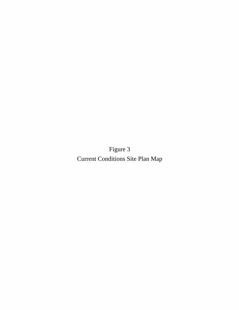
Figure 3 Current Conditions Site Plan Map

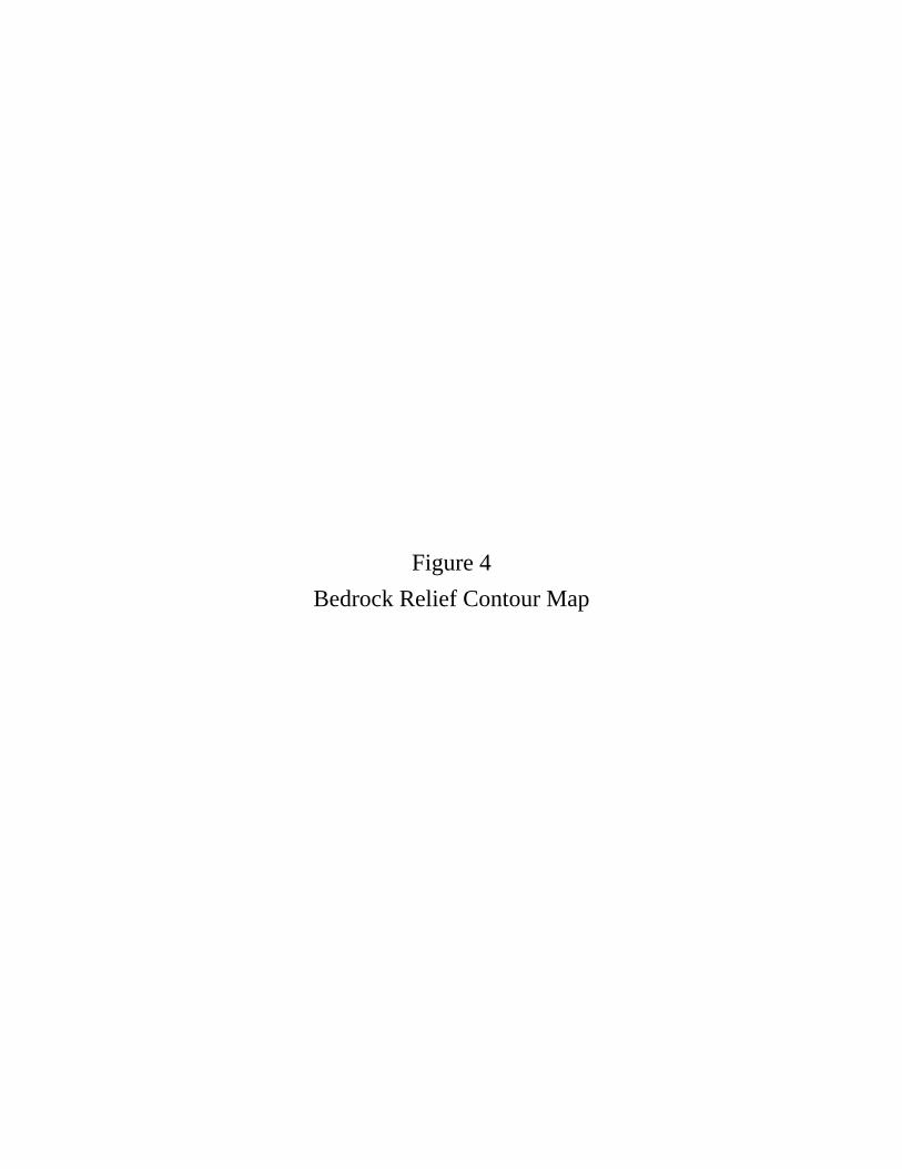
Figure 4 Bedrock Relief Contour Map
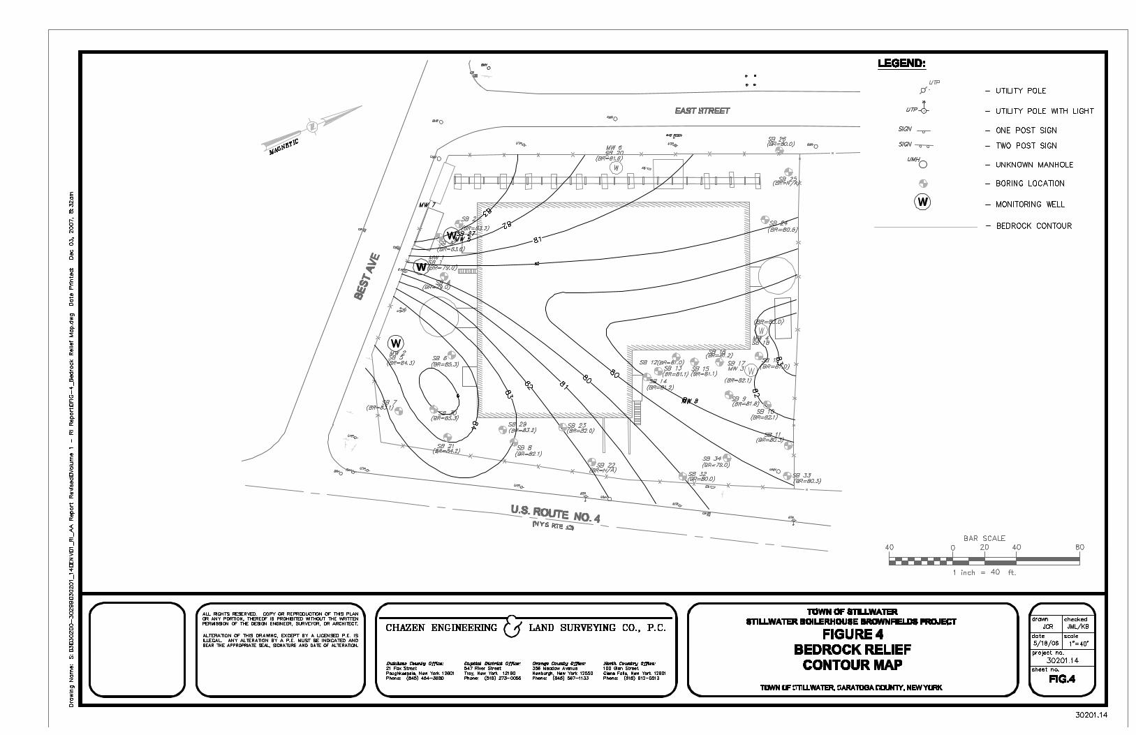
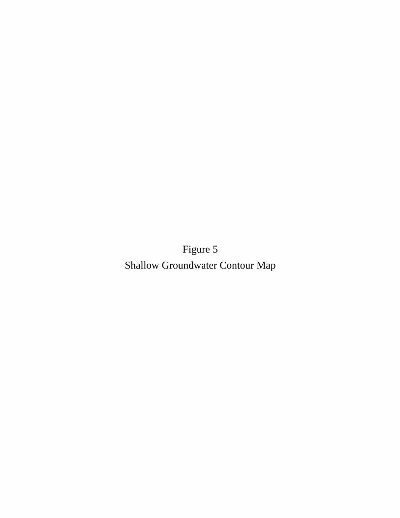
Figure 5 Shallow Groundwater Contour Map


Figure 6 Site Areas of Concern


Figure 7 Soil Boring, Test Pit, and Groundwater Monitoring Well Location
Map


Figure 8 Geophysical Survey Map

Figure 9 Lead and Asbestos Surface Soil Sample Location Map


Figure 10 Soil Gas Sample Location Map


Figure 11 IRM –Remediated Petroleum Impacted Areas


Figure 12 Surface Soil Sample Locations Adjacent to Riverside Park


Figure 13 Surface Soil Sample Locations within Riverside Park

Glens Falls Offi ce:110 Glen Street Glens Falls, NY 12801
Dutchess County Offi ce:21 Fox St. Poughkeepsie, NY 12601Phone: (845) 454-3980
Capital District Offi ce:547 River Street, Troy, NY 12180
Orange County Offi ce:263 Route 17K Newburgh, NY 12550
ENGINEERS/SURVEYORSPLANNERS
ENVIRONMENTAL SCIENTISTS
FIGURE 13-SAMPLE LOCATION MAPRiverside Park
Town of Stillwater, Saratoga County, New York
Date:2006
Scale:Not Indicated
30201.14Project #:
��
��
��
��
��
��
SS-01SS-01
SS-02SS-02
SS-03SS-03SS-04SS-04
SS-05SS-05
SS-06SS-06

Figure 14 Post-IRM Surface Soil Sample Locations


Figure 15 Summary of Excavations and Backfill Materials


APPENDIX A Photographic Log
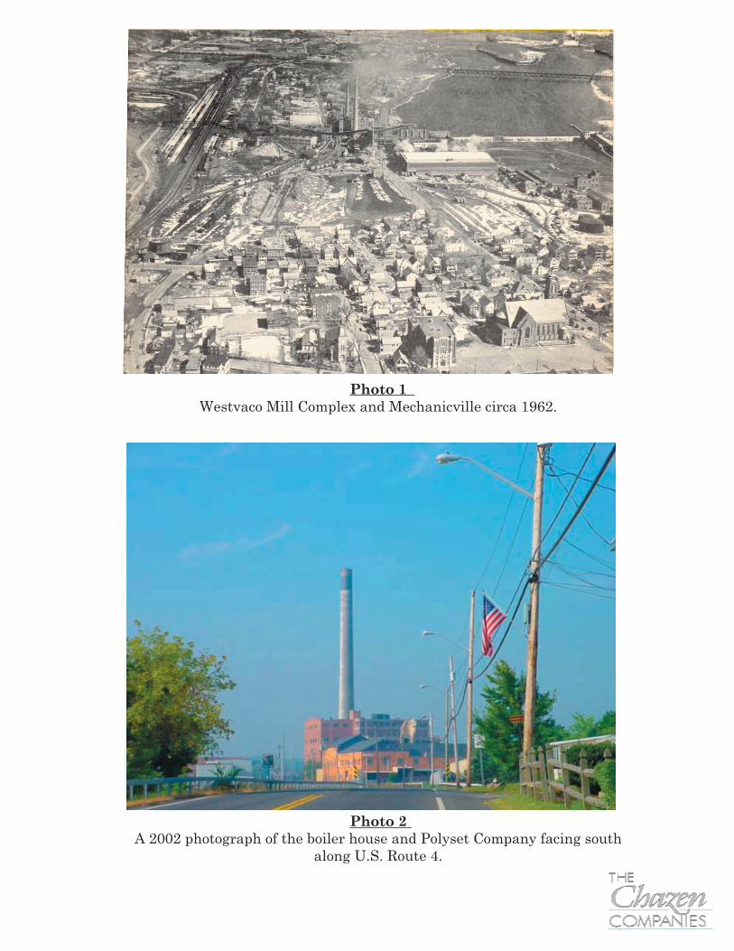
Photo 1 Westvaco Mill Complex and Mechanicville circa 1962.
Photo 2 A 2002 photograph of the boiler house and Polyset Company facing south
along U.S. Route 4.

Photo 3 2004 photograph of the boiler house facing southeast from Riverside Park.
Photo 4 2002 photograph of the 16,000-gal AST on the south side
of the boiler house

Photo 6 2004 photograph of the test pit investigation. This test pit
is parallel to the east side of the boiler house.
Photo 5 2004 photograph of the subsurface soil investigation near the 16,000-gal. AST
on the south side of the boiler house.

Photo 7Lead-based paint survey completed in 2004.

APPENDIX B Subsurface Soil Boring Logs

The Chazen Companies BORING SB-1MW-1
PROJECT NAME: Stillwater Boiler House Elevations: Starting Date:PROJECT No.: Ground Surface Elevation: NA Stop Date:
CLIENT: Town of Stillwater Water Level Reference Point: Top of PVC Method: GeoprobeWELL TYPE: Flush mount PVC, monitoring Water Level Reference Point Elevation: NA Contractor: Geologic
WELL LOCATION: NA Driller: Judd/JoshCITY/TOWN: Stillwater Water Levels: Rig: Truck-mounted
COUNTY: Saratoga Date: 7/8/04 Geologist: S Titzel/A RichardsSTATE: New York Depth to Water: 8.10
Dept
h(D
epth
s in
Feet
)
Sam
ple #
Blow
Coun
tsRe
cove
ry(D
epth
s in
Inch
es)
Unifi
ed Stratum andField Descriptions: Field Notes, Comments, PID Readings
38 Dark brown to light brown silt, sand, PID = 0.3gravel, FILL, loose; slightly moist, rock fragments
24 Same PID = 5.0
44 Light brown, silty clay w/gravel, moist, PID = 4.6medium stiff, FILL, v. moist @ 11ft
Loose angular rock, wet
40 Same, wet, sandy, gravelly shale; loose PID = 5.0
Boring Terminated @ 16'
NOTES:
30201.146/28/20046/28/2004
1
2
3
4
5
6
7
8
9
10
11
12
13
18
19
14
15
16
17
Concrete
Bentonite seal
Silica Sand Filter Pack
1" Slotted PVC Screen 5 to 15 feet below ground surface.

The Chazen Companies BORING SB-2
PROJECT NAME: Stillwater Boiler House Elevations: Starting Date:PROJECT No.: Ground Surface Elevation: NA Stop Date:
CLIENT: Town of Stillwater Water Level Reference Point: NA Method: GeoprobeWELL TYPE: Soil Boring Water Level Reference Point Elevation: NA Contractor: Geologic
WELL LOCATION: NA Driller: Judd/JoshCITY/TOWN: Stillwater Water Levels: Rig: Truck-mounted
COUNTY: Saratoga Date: NA Geologist: S Titzel/A RichardsSTATE: New York Depth to Water: NA
Dept
h(D
epth
s in
Feet
)
Sam
ple #
Blow
Coun
tsRe
cove
ry(D
epth
s in
Inch
es)
Unifi
ed Stratum andField Descriptions: Field Notes, Comments, PID Readings
24 Dk. Brown silty loam 6" PID = 3.26" cinder-like sand6" brown silty sand, clay4" brick, then clayey silt
30 Grey/green, silty clay, moist, stiff PID = 12.2
48 Grey/light brown, v. stiff, silty clay, PID = 12.1wet @ 8-8.5' and 11-11.5'
Boring Terminated @ 12'
NOTES:
30201.146/28/20046/28/2004
1
2
3
4
5
6
7
8
9
10
11
12
13
18
19
14
15
16
17

The Chazen Companies BORING SB-3
PROJECT NAME: Stillwater Boiler House Elevations: Starting Date:PROJECT No.: Ground Surface Elevation: NA Stop Date:
CLIENT: Town of Stillwater Water Level Reference Point: NA Method: GeoprobeWELL TYPE: Soil Boring Water Level Reference Point Elevation: NA Contractor: Geologic
WELL LOCATION: NA Driller: Judd/JoshCITY/TOWN: Stillwater Water Levels: Rig: Truck-mounted
COUNTY: Saratoga Date: NA Geologist: S Titzel/A RichardsSTATE: New York Depth to Water: NA
Dept
h(D
epth
s in
Feet
)
Sam
ple #
Blow
Coun
tsRe
cove
ry(D
epth
s in
Inch
es)
Unifi
ed Stratum andField Descriptions: Field Notes, Comments, PID Readings
36 Dk. Brown/black; silt, sand, gravel, PID = 7.4coal slag & rock fragments (FILL), m. soft, moist
30 Same, mostly coal slag PID = 13.3
44 Same to 9' then lt. brown, silty clay PID = 5.0w/gravel to 11', wet, soft; then grey shaleand gravel, sand, wet @ 12'
Boring Terminated @ 12'
NOTES:
30201.146/28/20046/28/2004
1
2
3
4
5
6
7
8
9
10
11
12
13
18
19
14
15
16
17

The Chazen Companies BORING SB-4
PROJECT NAME: Stillwater Boiler House Elevations: Starting Date:PROJECT No.: Ground Surface Elevation: NA Stop Date:
CLIENT: Town of Stillwater Water Level Reference Point: NA Method: GeoprobeWELL TYPE: Soil Boring Water Level Reference Point Elevation: NA Contractor: Geologic
WELL LOCATION: NA Driller: Judd/JoshCITY/TOWN: Stillwater Water Levels: Rig: Truck-mounted
COUNTY: Saratoga Date: NA Geologist: S Titzel/A RichardsSTATE: New York Depth to Water: NA
Dept
h(D
epth
s in
Feet
)
Sam
ple #
Blow
Coun
tsRe
cove
ry(D
epth
s in
Inch
es)
Unifi
ed Stratum andField Descriptions: Field Notes, Comments, PID Readings
30 Sandy silt, gravel, rock fragments, FILL, loose, moist PID = 6.4
30 Same fill, some silty clay w/gravel PID = 8.3moist, soft
24 Same silty clay w/gravel and shale PID = 15.9
Wet22 Same, soft PID = 10.4
Boring Terminated @ 16'
NOTES:
30201.146/28/20046/28/2004
1
2
3
4
5
6
7
8
9
10
11
12
13
18
19
14
15
16
17

The Chazen Companies BORING SB-5MW-2
PROJECT NAME: Stillwater Boiler House Elevations: Starting Date:PROJECT No.: Ground Surface Elevation: NA Stop Date:
CLIENT: Town of Stillwater Water Level Reference Point: Top of PVC Method: GeoprobeWELL TYPE: Flush mount PVC, monitoring Water Level Reference Point Elevation: NA Contractor: Geologic
WELL LOCATION: NA Driller: Judd/JoshCITY/TOWN: Stillwater Water Levels: Rig: Truck-mounted
COUNTY: Saratoga Date: 7/8/2004 Geologist: S Titzel/A RichardsSTATE: New York Depth to Water: 6.67
Dept
h(D
epth
s in
Feet
)
Sam
ple #
Blow
Coun
tsRe
cove
ry(D
epth
s in
Inch
es)
Unifi
ed Stratum andField Descriptions: Field Notes, Comments, PID Readings
32 Silt, sand, gravel, rock and brick fragments PID = 10.5(fill), loost, moist
30 Grey brown, silty clay w/gravel and rock PID = 13.0fragments
Wet
40 Wet fill to 10' then weathered shale, PID = 4.2moist, not wet
Boring Terminated @ 12'
NOTES:
30201.146/28/20046/28/2004
1
2
3
4
5
6
7
8
9
10
11
12
13
18
19
14
15
16
17
Slotted PVC Screen 6 to 11 feet below ground surface.
Silica Sand Filter Pack
Bentonite seal
Concrete

The Chazen Companies BORING SB-6
PROJECT NAME: Stillwater Boiler House Elevations: Starting Date:PROJECT No.: Ground Surface Elevation: NA Stop Date:
CLIENT: Town of Stillwater Water Level Reference Point: NA Method: GeoprobeWELL TYPE: Soil Boring Water Level Reference Point Elevation: NA Contractor: Geologic
WELL LOCATION: NA Driller: Judd/JoshCITY/TOWN: Stillwater Water Levels: Rig: Truck-mounted
COUNTY: Saratoga Date: NA Geologist: S Titzel/A RichardsSTATE: New York Depth to Water: NA
Dept
h(D
epth
s in
Feet
)
Sam
ple #
Blow
Coun
tsRe
cove
ry(D
epth
s in
Inch
es)
Unifi
ed Stratum andField Descriptions: Field Notes, Comments, PID Readings
30 Dk. Brown sand, silt, gravel, brick, cinders PID = 5.7
28 PID = 8.9
Wet
PID = 4.718 Sheen on water; shale
Refusal @ 9.5'
NOTES:
30201.146/28/20046/28/2004
1
2
3
4
5
6
7
8
9
10
11
12
13
18
19
14
15
16
17

The Chazen Companies BORING SB-7
PROJECT NAME: Stillwater Boiler House Elevations: Starting Date:PROJECT No.: Ground Surface Elevation: NA Stop Date:
CLIENT: Town of Stillwater Water Level Reference Point: NA Method: GeoprobeWELL TYPE: Soil Boring Water Level Reference Point Elevation: NA Contractor: Geologic
WELL LOCATION: NA Driller: Judd/JoshCITY/TOWN: Stillwater Water Levels: Rig: Truck-mounted
COUNTY: Saratoga Date: NA Geologist: S Titzel/A RichardsSTATE: New York Depth to Water: NA
Dept
h(D
epth
s in
Feet
)
Sam
ple #
Blow
Coun
tsRe
cove
ry(D
epth
s in
Inch
es)
Unifi
ed Stratum andField Descriptions: Field Notes, Comments, PID Readings
46 Brown, clayey silt w/gravel FILL, black cinders PID = 8.5from 2-2.5'Brown silty clay w/gravel FILL, still moist
48 Fill to 6' then weathered shale PID = 38.2
Same weathered shale, stiff, slightly moist PID = 13.4
Refusal @ 10'
NOTES:
30201.146/28/20046/28/2004
1
2
3
4
5
6
7
8
9
10
11
12
13
18
19
14
15
16
17

The Chazen Companies BORING SB-8
PROJECT NAME: Stillwater Boiler House Elevations: Starting Date:PROJECT No.: Ground Surface Elevation: NA Stop Date:
CLIENT: Town of Stillwater Water Level Reference Point: NA Method: GeoprobeWELL TYPE: Soil Boring Water Level Reference Point Elevation: NA Contractor: Geologic
WELL LOCATION: NA Driller: Judd/JoshCITY/TOWN: Stillwater Water Levels: Rig: Truck-mounted
COUNTY: Saratoga Date: NA Geologist: S Titzel/A RichardsSTATE: New York Depth to Water: NA
Dept
h(D
epth
s in
Feet
)
Sam
ple #
Blow
Coun
tsRe
cove
ry(D
epth
s in
Inch
es)
Unifi
ed Stratum andField Descriptions: Field Notes, Comments, PID Readings
36 2" brown silty loam top soil, PID = 2.9dk. brown sandy gravel and cinder FILL
Grey/brown silty clay and gravel, FILL, stiff, moist
44 Same to 6' then brown and grey PID = 4.1weathered shale, v. stiff, mostly dry
24 Weathered shale PID = 2.5
Refusal @ 10'
NOTES:
30201.146/28/20046/28/2004
1
2
3
4
5
6
7
8
9
10
11
12
13
18
19
14
15
16
17

The Chazen Companies BORING SB-9
PROJECT NAME: Stillwater Boiler House Elevations: Starting Date:PROJECT No.: Ground Surface Elevation: NA Stop Date:
CLIENT: Town of Stillwater Water Level Reference Point: NA Method: GeoprobeWELL TYPE: Soil Boring Water Level Reference Point Elevation: NA Contractor: Geologic
WELL LOCATION: NA Driller: Judd/JoshCITY/TOWN: Stillwater Water Levels: Rig: Truck-mounted
COUNTY: Saratoga Date: NA Geologist: S Titzel/A RichardsSTATE: New York Depth to Water: NA
Dept
h(D
epth
s in
Feet
)
Sam
ple #
Blow
Coun
tsRe
cove
ry(D
epth
s in
Inch
es)
Unifi
ed Stratum andField Descriptions: Field Notes, Comments, PID Readings
40 Dk brown sandy/cindery gravel till PID = 6.7
More silty clay fill, moist
38 Concrete and other fill PID = 27.9
Beginning weathered shale, slight hydrocarbon odor
24 Shale PID = 7.1
Refusal @ 10' on shale
NOTES:
30201.146/28/20046/28/2004
1
2
3
4
5
6
7
8
9
10
11
12
13
18
19
14
15
16
17

The Chazen Companies BORING SB-10
PROJECT NAME: Stillwater Boiler House Elevations: Starting Date:PROJECT No.: Ground Surface Elevation: NA Stop Date:
CLIENT: Town of Stillwater Water Level Reference Point: NA Method: GeoprobeWELL TYPE: Soil Boring Water Level Reference Point Elevation: NA Contractor: Geologic
WELL LOCATION: NA Driller: Judd/JoshCITY/TOWN: Stillwater Water Levels: Rig: Truck-mounted
COUNTY: Saratoga Date: NA Geologist: S Titzel/A RichardsSTATE: New York Depth to Water: NA
Dept
h(D
epth
s in
Feet
)
Sam
ple #
Blow
Coun
tsRe
cove
ry(D
epth
s in
Inch
es)
Unifi
ed Stratum andField Descriptions: Field Notes, Comments, PID Readings
40 Brown silt, loose, slightly moist PID = 1.4
Black cinders/sand, loose fill
Brick30 Brown silty clay fill w/rock fragments PID = 2.5
24 Wet @ 8', weathered shale PID = 2.8
Refusal @ 10'
NOTES:
30201.146/29/20046/29/2004
1
2
3
4
5
6
7
8
9
10
11
12
13
18
19
14
15
16
17
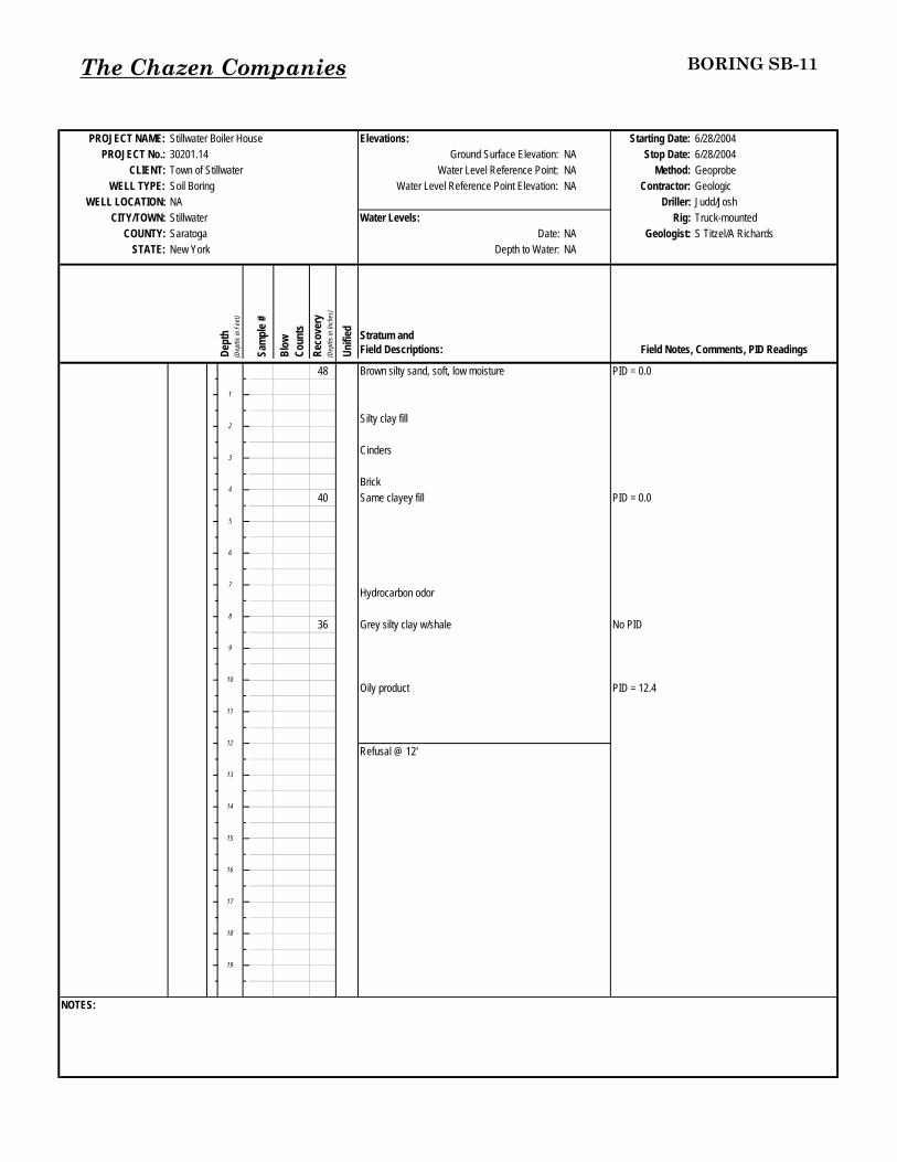
The Chazen Companies BORING SB-11
PROJECT NAME: Stillwater Boiler House Elevations: Starting Date:PROJECT No.: Ground Surface Elevation: NA Stop Date:
CLIENT: Town of Stillwater Water Level Reference Point: NA Method: GeoprobeWELL TYPE: Soil Boring Water Level Reference Point Elevation: NA Contractor: Geologic
WELL LOCATION: NA Driller: Judd/JoshCITY/TOWN: Stillwater Water Levels: Rig: Truck-mounted
COUNTY: Saratoga Date: NA Geologist: S Titzel/A RichardsSTATE: New York Depth to Water: NA
Dept
h(D
epth
s in
Feet
)
Sam
ple #
Blow
Coun
tsRe
cove
ry(D
epth
s in
Inch
es)
Unifi
ed Stratum andField Descriptions: Field Notes, Comments, PID Readings
48 Brown silty sand, soft, low moisture PID = 0.0
Silty clay fill
Cinders
Brick40 Same clayey fill PID = 0.0
Hydrocarbon odor
36 Grey silty clay w/shale No PID
Oily product PID = 12.4
Refusal @ 12'
NOTES:
30201.146/28/20046/28/2004
1
2
3
4
5
6
7
8
9
10
11
12
13
18
19
14
15
16
17

The Chazen Companies BORING SB-12
PROJECT NAME: Stillwater Boiler House Elevations: Starting Date:PROJECT No.: Ground Surface Elevation: NA Stop Date:
CLIENT: Town of Stillwater Water Level Reference Point: NA Method: GeoprobeWELL TYPE: Soil Boring Water Level Reference Point Elevation: NA Contractor: Geologic
WELL LOCATION: NA Driller: Judd/JoshCITY/TOWN: Stillwater Water Levels: Rig: Truck-mounted
COUNTY: Saratoga Date: NA Geologist: S Titzel/A RichardsSTATE: New York Depth to Water: NA
Dept
h(D
epth
s in
Feet
)
Sam
ple #
Blow
Coun
tsRe
cove
ry(D
epth
s in
Inch
es)
Unifi
ed Stratum andField Descriptions: Field Notes, Comments, PID Readings
30 Brown silt, loose, moist PID = 3.9Black sandy cinders (coal slag), fill, shale, brick and rock fragments
36 Same fill PID = 8.6
Clay and gravel fill, hydrocarbon odor,oily product, v. moist
40 Fill, wet, water w/oily sheen PID = 21.0
Weathered shale, v. stiff, not wet
Refusal @ 11'
NOTES:
30201.146/29/20046/29/2004
1
2
3
4
5
6
7
8
9
10
11
12
13
18
19
14
15
16
17

The Chazen Companies BORING SB-13
PROJECT NAME: Stillwater Boiler House Elevations: Starting Date:PROJECT No.: Ground Surface Elevation: NA Stop Date:
CLIENT: Town of Stillwater Water Level Reference Point: NA Method: GeoprobeWELL TYPE: Soil Boring Water Level Reference Point Elevation: NA Contractor: Geologic
WELL LOCATION: NA Driller: Judd/JoshCITY/TOWN: Stillwater Water Levels: Rig: Truck-mounted
COUNTY: Saratoga Date: NA Geologist: S Titzel/A RichardsSTATE: New York Depth to Water: NA
Dept
h(D
epth
s in
Feet
)
Sam
ple #
Blow
Coun
tsRe
cove
ry(D
epth
s in
Inch
es)
Unifi
ed Stratum andField Descriptions: Field Notes, Comments, PID Readings
40 Silt, sand, gravel, cinders, shale fragments, PID = 6.4brick, clay (fill), moist
32 Sand, clay, silt, wood, hydrocarbon odor PID = 3.9
Oily productWet PID = 3.2
Shale
Refusal @ 11'
NOTES:
30201.146/29/20046/29/2004
1
2
3
4
5
6
7
8
9
10
11
12
13
18
19
14
15
16
17

The Chazen Companies BORING SB-14
PROJECT NAME: Stillwater Boiler House Elevations: Starting Date:PROJECT No.: Ground Surface Elevation: NA Stop Date:
CLIENT: Town of Stillwater Water Level Reference Point: NA Method: GeoprobeWELL TYPE: Soil Boring Water Level Reference Point Elevation: NA Contractor: Geologic
WELL LOCATION: NA Driller: Judd/JoshCITY/TOWN: Stillwater Water Levels: Rig: Truck-mounted
COUNTY: Saratoga Date: NA Geologist: S Titzel/A RichardsSTATE: New York Depth to Water: NA
Dept
h(D
epth
s in
Feet
)
Sam
ple #
Blow
Coun
tsRe
cove
ry(D
epth
s in
Inch
es)
Unifi
ed Stratum andField Descriptions: Field Notes, Comments, PID Readings
38 Silt, sand, gravel, cinders, shale fragments, PID = 2.6brick, clay (fill), moist
38 Silt, clay, sand, moist PID = 4.0
Moist, hydrocarbon odor (faint)
Bedrock
Refusal @ 11'
NOTES:
30201.146/29/20046/29/2004
1
2
3
4
5
6
7
8
9
10
11
12
13
18
19
14
15
16
17

The Chazen Companies BORING SB-15
PROJECT NAME: Stillwater Boiler House Elevations: Starting Date:PROJECT No.: Ground Surface Elevation: NA Stop Date:
CLIENT: Town of Stillwater Water Level Reference Point: NA Method: GeoprobeWELL TYPE: Soil Boring Water Level Reference Point Elevation: NA Contractor: Geologic
WELL LOCATION: NA Driller: Judd/JoshCITY/TOWN: Stillwater Water Levels: Rig: Truck-mounted
COUNTY: Saratoga Date: NA Geologist: S Titzel/A RichardsSTATE: New York Depth to Water: NA
Dept
h(D
epth
s in
Feet
)
Sam
ple #
Blow
Coun
tsRe
cove
ry(D
epth
s in
Inch
es)
Unifi
ed Stratum andField Descriptions: Field Notes, Comments, PID Readings
36 Brown clayey silt (fill), moist, loose PID = 4.3
Grey silt, sand, clayey gravel (fill),moist, rock fragments, brick
36 Same PID = 15.0
V. moist, oily sheen on water, hydrocarbon odorOily product in clayey fill
36 Same oily fill PID = 1.4
Weathered shale
Refusal @ 11'
NOTES:
30201.146/29/20046/29/2004
1
2
3
4
5
6
7
8
9
10
11
12
13
18
19
14
15
16
17

The Chazen Companies BORING SB-16
PROJECT NAME: Stillwater Boiler House Elevations: Starting Date:PROJECT No.: Ground Surface Elevation: NA Stop Date:
CLIENT: Town of Stillwater Water Level Reference Point: NA Method: GeoprobeWELL TYPE: Soil Boring Water Level Reference Point Elevation: NA Contractor: Geologic
WELL LOCATION: NA Driller: Judd/JoshCITY/TOWN: Stillwater Water Levels: Rig: Truck-mounted
COUNTY: Saratoga Date: NA Geologist: S Titzel/A RichardsSTATE: New York Depth to Water: NA
Dept
h(D
epth
s in
Feet
)
Sam
ple #
Blow
Coun
tsRe
cove
ry(D
epth
s in
Inch
es)
Unifi
ed Stratum andField Descriptions: Field Notes, Comments, PID Readings
30 Brown silt, moist, loose PID = 4.6
Mixed fill, moist
24 Very moist PID = 4.0
Wet clay, gravel (fill), hydrocarbon odor, no product
24 Wet fill PID = 3.1
Weathered shale 9'-11'
Refusal @ 11'
NOTES:
30201.146/29/20046/29/2004
1
2
3
4
5
6
7
8
9
10
11
12
13
18
19
14
15
16
17

The Chazen Companies BORING SB-17MW-3
PROJECT NAME: Stillwater Boiler House Elevations: Starting Date:PROJECT No.: Ground Surface Elevation: NA Stop Date:
CLIENT: Town of Stillwater Water Level Reference Point: Top of PVC Method: GeoprobeWELL TYPE: Flush mount PVC, monitoring Water Level Reference Point Elevation: NA Contractor: Geologic
WELL LOCATION: NA Driller: Judd/JoshCITY/TOWN: Stillwater Water Levels: Rig: Truck-mounted
COUNTY: Saratoga Date: 7/8/04 Geologist: S Titzel/A RichardsSTATE: New York Depth to Water: 6.4
Dept
h(D
epth
s in
Feet
)
Sam
ple #
Blow
Coun
tsRe
cove
ry(D
epth
s in
Inch
es)
Unifi
ed Stratum andField Descriptions: Field Notes, Comments, PID Readings
36 Brown clayey silt, soft, moist PID = 1.0
Black/brown sand, gravel, cinder,brick, rock fragments, silty clay w/rock fill
PID = 3.332 Same clayey fill
Wet @ 7'PID = 2.0
24 Same fill, wet
Weathered shale
Refusal @ 10'
NOTES:
30201.146/29/20046/29/2004
1
2
3
4
5
6
7
8
9
10
11
12
13
18
19
14
15
16
17
Concrete
Bentonite seal
Silica Sand Filter Pack
Slotted PVC Screen 4 to 9 feet below ground surface.

The Chazen Companies BORING SB-18MW-4
PROJECT NAME: Stillwater Boiler House Elevations: Starting Date:PROJECT No.: Ground Surface Elevation: NA Stop Date:
CLIENT: Town of Stillwater Water Level Reference Point: Top of PVC Method: GeoprobeWELL TYPE: Flush mount PVC, monitoring Water Level Reference Point Elevation: NA Contractor: Geologic
WELL LOCATION: NA Driller: Judd/JoshCITY/TOWN: Stillwater Water Levels: Rig: Truck-mounted
COUNTY: Saratoga Date: 7/8/04 Geologist: S Titzel/A RichardsSTATE: New York Depth to Water: 4.48
Dept
h(D
epth
s in
Feet
)
Sam
ple #
Blow
Coun
tsRe
cove
ry(D
epth
s in
Inch
es)
Unifi
ed Stratum andField Descriptions: Field Notes, Comments, PID Readings
24 Mixed fill, sand, gravel, cinders, brick PID = 4.0and rock fragments, moist, med. stiff
48 Same fill PID = 4.3
Refusal @ 5' on debris (?), offset 2' and redrilled
Weathered shale (6-8')
Wet zone 4" gravely shaleWeathered shale
PID = 4.1
Refusal @ 9'
NOTES:
30201.146/29/20046/29/2004
1
2
3
4
5
6
7
8
9
10
11
12
13
18
19
14
15
16
17
Slotted PVC Screen 4 to 9 feet below ground surface.
Silica Sand Filter Pack
Bentonite seal
Concrete

The Chazen Companies BORING SB-19
PROJECT NAME: Stillwater Boiler House Elevations: Starting Date:PROJECT No.: Ground Surface Elevation: NA Stop Date:
CLIENT: Town of Stillwater Water Level Reference Point: NA Method: GeoprobeWELL TYPE: Soil Boring Water Level Reference Point Elevation: NA Contractor: Geologic
WELL LOCATION: NA Driller: Judd/JoshCITY/TOWN: Stillwater Water Levels: Rig: Truck-mounted
COUNTY: Saratoga Date: NA Geologist: S Titzel/A RichardsSTATE: New York Depth to Water: NA
Dept
h(D
epth
s in
Feet
)
Sam
ple #
Blow
Coun
tsRe
cove
ry(D
epth
s in
Inch
es)
Unifi
ed Stratum andField Descriptions: Field Notes, Comments, PID Readings
32 Mixed fill (as previous) PID = 6.0
40 Same clayey, gravel, rock, brick fill PID = 7.7
V. moist to wet @ 5'
Weathered shale @ 7'
28 Same shale PID = 3.0
Refusal @ 11'
NOTES:
30201.146/29/20046/29/2004
1
2
3
4
5
6
7
8
9
10
11
12
13
18
19
14
15
16
17

The Chazen Companies BORING SB-20MW-5
PROJECT NAME: Stillwater Boiler House Elevations: Starting Date:PROJECT No.: Ground Surface Elevation: NA Stop Date:
CLIENT: Town of Stillwater Water Level Reference Point: Top of PVC Method: GeoprobeWELL TYPE: Flush mount PVC, monitoring Water Level Reference Point Elevation: NA Contractor: Geologic
WELL LOCATION: NA Driller: Judd/JoshCITY/TOWN: Stillwater Water Levels: Rig: Truck-mounted
COUNTY: Saratoga Date: 7/8/2004 Geologist: S Titzel/A RichardsSTATE: New York Depth to Water: 8.55
Dept
h(D
epth
s in
Feet
)
Sam
ple #
Blow
Coun
tsRe
cove
ry(D
epth
s in
Inch
es)
Unifi
ed Stratum andField Descriptions: Field Notes, Comments, PID Readings
36 Black, sandy (coal slag), gravel (fill), PID = 5.1moist, loose
40 PID = 2.5Grey (mixed fill), clayey gravel
V. moist to wetPID = 0.0
36 Grey clayey gravel, fill
Lt. brown silty clay, moist, stiff, mottled grey
PID = 7.1Same as above
Refusal at 15'
NOTES:
30201.146/29/20046/29/2004
1
2
3
4
5
6
7
8
9
10
11
12
13
18
19
14
15
16
17
Slotted PVC Screen 9 to 14 feet below ground surface.
Silica Sand Filter Pack
Bentonite seal
Concrete

The Chazen Companies BORING SB-21
PROJECT NAME: Stillwater Boiler House Elevations: Starting Date:PROJECT No.: Ground Surface Elevation: NA Stop Date:
CLIENT: Town of Stillwater Water Level Reference Point: NA Method: GeoprobeWELL TYPE: Soil Boring Water Level Reference Point Elevation: NA Contractor: Geologic
WELL LOCATION: NA Driller: Judd/JoshCITY/TOWN: Stillwater Water Levels: Rig: Truck-mounted
COUNTY: Saratoga Date: NA Geologist: S Titzel/A RichardsSTATE: New York Depth to Water: NA
Dept
h(D
epth
s in
Feet
)
Sam
ple #
Blow
Coun
tsRe
cove
ry(D
epth
s in
Inch
es)
Unifi
ed Stratum andField Descriptions: Field Notes, Comments, PID Readings
48 Brown silt 0-3' PID = 3.7
Dk. Brown sand, gravel, cinder, brick fill
48 Weathered shale, v. stiff, nearly dry PID = 4.7
Sheet metal Refusal @ 6' on sheel metal, offset 2'
Refusal @ 8'
NOTES:
30201.146/28/20046/28/2004
1
2
3
4
5
6
7
8
9
10
11
12
13
18
19
14
15
16
17

The Chazen Companies BORING SB-22
PROJECT NAME: Stillwater Boiler House Elevations: Starting Date:PROJECT No.: Ground Surface Elevation: NA Stop Date:
CLIENT: Town of Stillwater Water Level Reference Point: Top of PVC Method: GeoprobeWELL TYPE: Flush mount PVC, monitoring Water Level Reference Point Elevation: NA Contractor: Geologic
WELL LOCATION: NA Driller: Judd/JoshCITY/TOWN: Stillwater Water Levels: Rig: Truck-mounted
COUNTY: Saratoga Date: NA Geologist: S Titzel/A RichardsSTATE: New York Depth to Water: NA
Dept
h(D
epth
s in
Feet
)
Sam
ple #
Blow
Coun
tsRe
cove
ry(D
epth
s in
Inch
es)
Unifi
ed Stratum andField Descriptions: Field Notes, Comments, PID Readings
Slag, silt, coal, cinders, fill shale PID = 3.8
Refusal @ 2'
NOTES:
30201.146/28/20046/28/2004
1
2
3
4
5
6
7
8
9
10
11
12
13
18
19
14
15
16
17

The Chazen Companies BORING SB-23
PROJECT NAME: Stillwater Boiler House Elevations: Starting Date:PROJECT No.: Ground Surface Elevation: NA Stop Date:
CLIENT: Town of Stillwater Water Level Reference Point: NA Method: GeoprobeWELL TYPE: Soil Boring Water Level Reference Point Elevation: NA Contractor: Geologic
WELL LOCATION: NA Driller: Judd/JoshCITY/TOWN: Stillwater Water Levels: Rig: Truck-mounted
COUNTY: Saratoga Date: NA Geologist: S Titzel/A RichardsSTATE: New York Depth to Water: NA
Dept
h(D
epth
s in
Feet
)
Sam
ple #
Blow
Coun
tsRe
cove
ry(D
epth
s in
Inch
es)
Unifi
ed Stratum andField Descriptions: Field Notes, Comments, PID Readings
Brown silty sand, cinders, gravel fill PID = 2.9
Clayey silt and gravel fill
Same fill PID = 3.9
Weathered shale @ 6'
Same PID = 2.9
Refusal @ 10'
NOTES:
30201.146/28/20046/28/2004
1
2
3
4
5
6
7
8
9
10
11
12
13
18
19
14
15
16
17
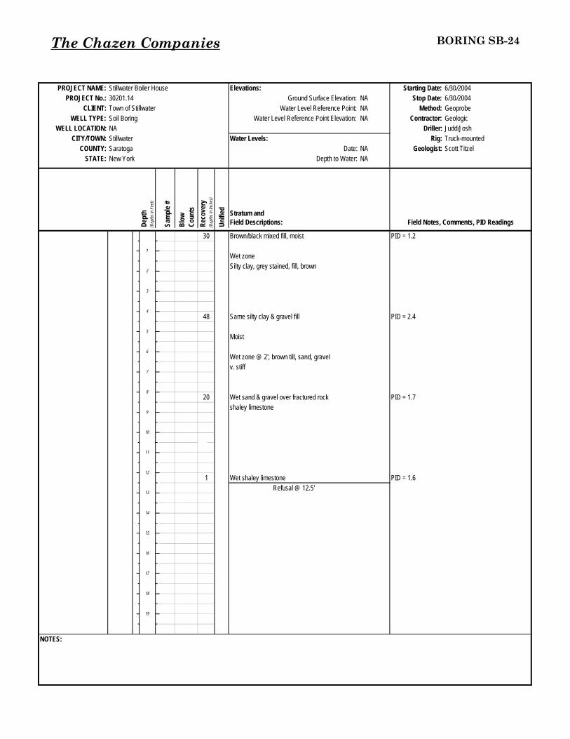
The Chazen Companies BORING SB-24
PROJECT NAME: Stillwater Boiler House Elevations: Starting Date:PROJECT No.: Ground Surface Elevation: NA Stop Date:
CLIENT: Town of Stillwater Water Level Reference Point: NA Method: GeoprobeWELL TYPE: Soil Boring Water Level Reference Point Elevation: NA Contractor: Geologic
WELL LOCATION: NA Driller: Judd/JoshCITY/TOWN: Stillwater Water Levels: Rig: Truck-mounted
COUNTY: Saratoga Date: NA Geologist: Scott TitzelSTATE: New York Depth to Water: NA
Dept
h(D
epth
s in
Feet
)
Sam
ple #
Blow
Coun
tsRe
cove
ry(D
epth
s in
Inch
es)
Unifi
ed Stratum andField Descriptions: Field Notes, Comments, PID Readings
30 Brown/black mixed fill, moist PID = 1.2
Wet zoneSilty clay, grey stained, fill, brown
48 Same silty clay & gravel fill PID = 2.4
Moist
Wet zone @ 2', brown till, sand, gravelv. stiff
20 Wet sand & gravel over fractured rock PID = 1.7shaley limestone
1 Wet shaley limestone PID = 1.6Refusal @ 12.5'
NOTES:
30201.146/30/20046/30/2004
1
2
3
4
5
6
7
8
9
10
11
12
13
18
19
14
15
16
17

The Chazen Companies BORING SB-25
PROJECT NAME: Stillwater Boiler House Elevations: Starting Date:PROJECT No.: Ground Surface Elevation: NA Stop Date:
CLIENT: Town of Stillwater Water Level Reference Point: NA Method: GeoprobeWELL TYPE: Soil Boring Water Level Reference Point Elevation: NA Contractor: Geologic
WELL LOCATION: NA Driller: Judd/JoshCITY/TOWN: Stillwater Water Levels: Rig: Truck-mounted
COUNTY: Saratoga Date: NA Geologist: Scott TitzelSTATE: New York Depth to Water: NA
Dept
h(D
epth
s in
Feet
)
Sam
ple #
Blow
Coun
tsRe
cove
ry(D
epth
s in
Inch
es)
Unifi
ed Stratum andField Descriptions: Field Notes, Comments, PID Readings
36 Mix fill, loose, moist PID = 3.1
6 Fill
Refusal @ 5' on concrete
NOTES:
30201.146/30/20046/30/2004
1
2
3
4
5
6
7
8
9
10
11
12
13
18
19
14
15
16
17
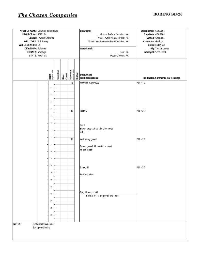
The Chazen Companies BORING SB-26
PROJECT NAME: Stillwater Boiler House Elevations: Starting Date:PROJECT No.: Ground Surface Elevation: NA Stop Date:
CLIENT: Town of Stillwater Water Level Reference Point: NA Method: GeoprobeWELL TYPE: Soil Boring Water Level Reference Point Elevation: NA Contractor: Geologic
WELL LOCATION: NA Driller: Judd/JoshCITY/TOWN: Stillwater Water Levels: Rig: Truck-mounted
COUNTY: Saratoga Date: NA Geologist: Scott TitzelSTATE: New York Depth to Water: NA
Dept
h(D
epth
s in
Feet
)
Sam
ple #
Blow
Coun
tsRe
cove
ry(D
epth
s in
Inch
es)
Unifi
ed Stratum andField Descriptions: Field Notes, Comments, PID Readings
12 Mixed fill as previous PID = 1.0
30 Fill to 6' PID = 2.3
BrickBrown, grey stained silty clay, moist,soft
36 Wet, sandy gravel PID = 2.9
Brown, gravel, till, moist to v. moist,m. soft to stiff
Same, till PID = 3.7
Peat inclusions
Grey till, wet, v. stiffRefusal @ 16' on grey till and shale
NOTES: Just outside NW cornerBackground boring
30201.146/30/20046/30/2004
1
2
3
4
5
6
7
8
9
10
11
12
13
18
19
14
15
16
17

The Chazen Companies BORING SB-27MW-6
PROJECT NAME: Stillwater Boiler House Elevations: Starting Date:PROJECT No.: Ground Surface Elevation: NA Stop Date:
CLIENT: Town of Stillwater Water Level Reference Point: Top of PVC Method: GeoprobeWELL TYPE: Flush mount PVC, monitoring Water Level Reference Point Elevation: NA Contractor: Geologic
WELL LOCATION: NA Driller: Judd/JoshCITY/TOWN: Stillwater Water Levels: Rig: Truck-mounted
COUNTY: Saratoga Date: 7/8/2004 Geologist: Scott TitzelSTATE: New York Depth to Water: 10.97
Dept
h(D
epth
s in
Feet
)
Sam
ple #
Blow
Coun
tsRe
cove
ry(D
epth
s in
Inch
es)
Unifi
ed Stratum andField Descriptions: Field Notes, Comments, PID Readings
24 Dk. brown & black coal slag, cindery PID = 2.9fill, loose, moist
44 Soft silty clay & gravel fill PID = 3.7Brick, v. moist to wetM. stiff silty clay, moist, brown; grey mottled fill
24 Same till, less grey, more silt PID = 5.3
12 Wet, shaley limestone PID = 3.1
Refusal @ 13'
NOTES: SW by tank
30201.146/30/20046/30/2004
1
2
3
4
5
6
7
8
9
10
11
12
13
18
19
14
15
16
17
Concrete
Bentonite seal
Silica Sand Filter Pack
Slotted PVC Screen 2.5 to 12.5 feet below ground surface.

The Chazen Companies BORING SB-28
PROJECT NAME: Stillwater Boiler House Elevations: Starting Date:PROJECT No.: Ground Surface Elevation: NA Stop Date:
CLIENT: Town of Stillwater Water Level Reference Point: NA Method: GeoprobeWELL TYPE: Soil Boring Water Level Reference Point Elevation: NA Contractor: Geologic
WELL LOCATION: NA Driller: Judd/JoshCITY/TOWN: Stillwater Water Levels: Rig: Truck-mounted
COUNTY: Saratoga Date: NA Geologist: Scott TitzelSTATE: New York Depth to Water: NA
Dept
h(D
epth
s in
Feet
)
Sam
ple #
Blow
Coun
tsRe
cove
ry(D
epth
s in
Inch
es)
Unifi
ed Stratum andField Descriptions: Field Notes, Comments, PID Readings
24 Brown/black fill, coal slag, brick PID = 4.2
Same fill, silt brown w/gray mottling PID = 4.0
Brick
Brown/grey silty clay, fill
Fill PID = 7.1
Wet (maybe an inch of till, but probably fill)Shale
Refusal @ 11'
NOTES:
30201.146/30/20046/30/2004
1
2
3
4
5
6
7
8
9
10
11
12
13
18
19
14
15
16
17

The Chazen Companies BORING SB-29
PROJECT NAME: Stillwater Boiler House Elevations: Starting Date:PROJECT No.: Ground Surface Elevation: NA Stop Date:
CLIENT: Town of Stillwater Water Level Reference Point: NA Method: GeoprobeWELL TYPE: Soil Boring Water Level Reference Point Elevation: NA Contractor: Geologic
WELL LOCATION: NA Driller: Judd/JoshCITY/TOWN: Stillwater Water Levels: Rig: Truck-mounted
COUNTY: Saratoga Date: NA Geologist: Scott TitzelSTATE: New York Depth to Water: NA
Dept
h(D
epth
s in
Feet
)
Sam
ple #
Blow
Coun
tsRe
cove
ry(D
epth
s in
Inch
es)
Unifi
ed Stratum andField Descriptions: Field Notes, Comments, PID Readings
30 Stiff at surface 4" PID = 6.4Mix fill, soft sandy asphalt-like
Fill, clayey silt & gravel, crushed rock PID = 3.4Grey/rust mottled clay
Shale PID = 7.1
Refusal @ 9'
NOTES: SE corner of building
30201.146/30/20046/30/2004
1
2
3
4
5
6
7
8
9
10
11
12
13
18
19
14
15
16
17

The Chazen Companies BORING SB-30
PROJECT NAME: Stillwater Boiler House Elevations: Starting Date:PROJECT No.: Ground Surface Elevation: NA Stop Date:
CLIENT: Town of Stillwater Water Level Reference Point: NA Method: GeoprobeWELL TYPE: Soil Boring Water Level Reference Point Elevation: NA Contractor: Geologic
WELL LOCATION: NA Driller: Judd/JoshCITY/TOWN: Stillwater Water Levels: Rig: Truck-mounted
COUNTY: Saratoga Date: NA Geologist: Scott TitzelSTATE: New York Depth to Water: NA
Dept
h(D
epth
s in
Feet
)
Sam
ple #
Blow
Coun
tsRe
cove
ry(D
epth
s in
Inch
es)
Unifi
ed Stratum andField Descriptions: Field Notes, Comments, PID Readings
24 Mix fill (as previous), brown silt 6" PID = 6.4Coal slag 12"
Red brick 6", loose
Brick & shale fill PID = 18.0
Metal-sheetRefusal @ 7.5'
NOTES:
30201.146/30/20046/30/2004
1
2
3
4
5
6
7
8
9
10
11
12
13
18
19
14
15
16
17

The Chazen Companies BORING SB-31
PROJECT NAME: Stillwater Boiler House Elevations: Starting Date:PROJECT No.: Ground Surface Elevation: NA Stop Date:
CLIENT: Town of Stillwater Water Level Reference Point: Top of PVC Method: GeoprobeWELL TYPE: Flush mount PVC, monitoring Water Level Reference Point Elevation: NA Contractor: Geologic
WELL LOCATION: NA Driller: Judd/JoshCITY/TOWN: Stillwater Water Levels: Rig: Truck-mounted
COUNTY: Saratoga Date: NA Geologist: Scott TitzelSTATE: New York Depth to Water: NA
Dept
h(D
epth
s in
Feet
)
Sam
ple #
Blow
Coun
tsRe
cove
ry(D
epth
s in
Inch
es)
Unifi
ed Stratum andField Descriptions: Field Notes, Comments, PID Readings
31 Sandy gravel fill around storm drain PID = 12.1
36 Same sandy fill No PID
Clayey silt, wet, grey mottling Sample + DUP
21 Brown, v. wet, clayey silt w/gravel till PID = 9.3
Wet shale fragmentsRefusal @ 12.1' on shale
NOTES: By AST outside fence
30201.146/30/20046/30/2004
1
2
3
4
5
6
7
8
9
10
11
12
13
18
19
14
15
16
17

The Chazen Companies BORING SB-32
PROJECT NAME: Stillwater Boiler House Elevations: Starting Date:PROJECT No.: Ground Surface Elevation: NA Stop Date:
CLIENT: Town of Stillwater Water Level Reference Point: Top of PVC Method: GeoprobeWELL TYPE: Flush mount PVC, monitoring Water Level Reference Point Elevation: NA Contractor: Geologic
WELL LOCATION: NA Driller: Judd/JoshCITY/TOWN: Stillwater Water Levels: Rig: Truck-mounted
COUNTY: Saratoga Date: NA Geologist: Scott TitzelSTATE: New York Depth to Water: NA
Dept
h(D
epth
s in
Feet
)
Sam
ple #
Blow
Coun
tsRe
cove
ry(D
epth
s in
Inch
es)
Unifi
ed Stratum andField Descriptions: Field Notes, Comments, PID Readings
30 Brown to black sand & gravel fill, coal slag, PID = 6.5loose, moist
44 Brown silty clay w/crushed rock fill, moist, v. stiff PID = 9.1
30 Brown grey mottled silty clay & gravel till, v. stiff PID = 10.1
Weathered wet shaleRefusal @ 11 feet
NOTES:
30201.146/30/20046/30/2004
1
2
3
4
5
6
7
8
9
10
11
12
13
18
19
14
15
16
17

The Chazen Companies BORING SB-33
PROJECT NAME: Stillwater Boiler House Elevations: Starting Date:PROJECT No.: Ground Surface Elevation: NA Stop Date:
CLIENT: Town of Stillwater Water Level Reference Point: NA Method: GeoprobeWELL TYPE: Soil Boring Water Level Reference Point Elevation: NA Contractor: Geologic
WELL LOCATION: NA Driller: Judd/JoshCITY/TOWN: Stillwater Water Levels: Rig: Truck-mounted
COUNTY: Saratoga Date: NA Geologist: Scott TitzelSTATE: New York Depth to Water: NA
Dept
h(D
epth
s in
Feet
)
Sam
ple #
Blow
Coun
tsRe
cove
ry(D
epth
s in
Inch
es)
Unifi
ed Stratum andField Descriptions: Field Notes, Comments, PID Readings
36 18" brown clayey silt top soil, moist, some PID = 7.0rock fragmentsGrey sandy gravel fill
24 Same PID = 8.0
36 Same fill PID = 9.0
Brown/grey mottled silty/clayey till, stiff
Refusal @ 11' on shale
NOTES: NE corner
30201.146/30/20046/30/2004
1
2
3
4
5
6
7
8
9
10
11
12
13
18
19
14
15
16
17

The Chazen Companies BORING SB-34
PROJECT NAME: Stillwater Boiler House Elevations: Starting Date:PROJECT No.: Ground Surface Elevation: NA Stop Date:
CLIENT: Town of Stillwater Water Level Reference Point: NA Method: GeoprobeWELL TYPE: Soil Boring Water Level Reference Point Elevation: NA Contractor: Geologic
WELL LOCATION: NA Driller: Judd/JoshCITY/TOWN: Stillwater Water Levels: Rig: Truck-mounted
COUNTY: Saratoga Date: NA Geologist: Scott TitzelSTATE: New York Depth to Water: NA
Dept
h(D
epth
s in
Feet
)
Sam
ple #
Blow
Coun
tsRe
cove
ry(D
epth
s in
Inch
es)
Unifi
ed Stratum andField Descriptions: Field Notes, Comments, PID Readings
40 Mixed fill as previous PID = 12.1
PID = 15.930 Same fill
Silty clay brown fill w/crushed rock fragments, PID = 16.7hydrocarbon odor, moist, not wet shale DUP
Refusal @ 12'
NOTES: Between stumps
30201.146/30/20046/30/2004
1
2
3
4
5
6
7
8
9
10
11
12
13
18
19
14
15
16
17

SOIL BORING LOGSB-35
PROJECT NAME: Stillwater Boiler House Elevations: Starting Date:PROJECT No.: Ground Surface Elevation: NA Stop Date:
CLIENT: Town of Stillwater Water Level Reference Point: NA Method: GeoprobeWELL TYPE: Soil Boring Water Level Reference Point Elevation: NA Contractor: Geologic
WELL LOCATION: NA Driller: Judd/JoshCITY/TOWN: Stillwater Water Levels: Rig: Skid Steer-Mounted
COUNTY: Saratoga Date: NA Geologist: Scott TitzelSTATE: New York Depth to Water: NA
Dept
h(D
epth
s in
Feet
)
Sam
ple #
Blow
Coun
tsRe
cove
ry(D
epth
s in
Inch
es)
Unifi
ed Stratum andField Descriptions: Field Notes, Comments, PID Readings
Concrete slab - ~6" PID = 0.31 24 Fill; mostly course gravel, some sand, crushed stone,
moist, loose
Weathered shale, wet
Equipment refusal at 3 feet.
NOTES:
7/21/200530201.14 7/21/2005
1
2
3
4
5
6
7
8
9
10
11
12
13
18
19
14
15
16
17
The Chazen Companies30201.14

SOIL BORING LOGSB-36
PROJECT NAME: Stillwater Boiler House Elevations: Starting Date:PROJECT No.: Ground Surface Elevation: NA Stop Date:
CLIENT: Town of Stillwater Water Level Reference Point: NA Method: GeoprobeWELL TYPE: Soil Boring Water Level Reference Point Elevation: NA Contractor: Geologic
WELL LOCATION: NA Driller: Judd/JoshCITY/TOWN: Stillwater Water Levels: Rig: Skid Steer-Mounted
COUNTY: Saratoga Date: NA Geologist: Scott TitzelSTATE: New York Depth to Water: NA
Dept
h(D
epth
s in
Feet
)
Sam
ple #
Blow
Coun
tsRe
cove
ry(D
epth
s in
Inch
es)
Unifi
ed Stratum andField Descriptions: Field Notes, Comments, PID Readings
Concrete slab1 20 GP Fill, mostly coarse gravel, some sand, concrete fragments, PID = 1.0
moist, not wet, weathered shale at base.
Equipment refusal at 2 feet.
NOTES:
7/21/200530201.14 7/21/2005
1
2
3
4
5
6
7
8
9
10
11
12
13
18
19
14
15
16
17
The Chazen Companies30201.14

SOIL BORING LOGSB-37
PROJECT NAME: Stillwater Boiler House Elevations: Starting Date:PROJECT No.: Ground Surface Elevation: NA Stop Date:
CLIENT: Town of Stillwater Water Level Reference Point: NA Method: GeoprobeWELL TYPE: Soil Boring Water Level Reference Point Elevation: NA Contractor: Geologic
WELL LOCATION: NA Driller: Judd/JoshCITY/TOWN: Stillwater Water Levels: Rig: Skid Steer-Mounted
COUNTY: Saratoga Date: NA Geologist: Scott TitzelSTATE: New York Depth to Water: NA
Dept
h(D
epth
s in
Feet
)
Sam
ple #
Blow
Coun
tsRe
cove
ry(D
epth
s in
Inch
es)
Unifi
ed Stratum andField Descriptions: Field Notes, Comments, PID Readings
Concrete slab PID = 0.21 12 SP Fill, mostly medium sand, some gravel, some shale,
mostly dryEquipment refusal at 1.5 feet
NOTES:
7/21/200530201.14 7/21/2005
1
2
3
4
5
6
7
8
9
10
11
12
13
18
19
14
15
16
17
The Chazen Companies30201.14

SOIL BORING LOGSB-38
PROJECT NAME: Stillwater Boiler House Elevations: Starting Date:PROJECT No.: Ground Surface Elevation: NA Stop Date:
CLIENT: Town of Stillwater Water Level Reference Point: NA Method: GeoprobeWELL TYPE: Soil Boring Water Level Reference Point Elevation: NA Contractor: Geologic
WELL LOCATION: NA Driller: Judd/JoshCITY/TOWN: Stillwater Water Levels: Rig: Skid Steer-Mounted
COUNTY: Saratoga Date: NA Geologist: Scott TitzelSTATE: New York Depth to Water: NA
Dept
h(D
epth
s in
Feet
)
Sam
ple #
Blow
Coun
tsRe
cove
ry(D
epth
s in
Inch
es)
Unifi
ed Stratum andField Descriptions: Field Notes, Comments, PID Readings
Concrete slab PID = 0.01 9 Weathered shale
Equipment refusal at 1.3 feet
NOTES:
7/21/200530201.14 7/21/2005
1
2
3
4
5
6
7
8
9
10
11
12
13
18
19
14
15
16
17
The Chazen Companies30201.14

SOIL BORING LOGSB-39
PROJECT NAME: Stillwater Boiler House Elevations: Starting Date:PROJECT No.: Ground Surface Elevation: NA Stop Date:
CLIENT: Town of Stillwater Water Level Reference Point: NA Method: GeoprobeWELL TYPE: Soil Boring Water Level Reference Point Elevation: NA Contractor: Geologic
WELL LOCATION: NA Driller: Judd/JoshCITY/TOWN: Stillwater Water Levels: Rig: Skid Steer-Mounted
COUNTY: Saratoga Date: NA Geologist: Scott TitzelSTATE: New York Depth to Water: NA
Dept
h(D
epth
s in
Feet
)
Sam
ple #
Blow
Coun
tsRe
cove
ry(D
epth
s in
Inch
es)
Unifi
ed Stratum andField Descriptions: Field Notes, Comments, PID Readings
Concrete slab1 12 GP Fill, mostly lt. brown medium sand, some gravel, PID = 0.0
weathered shale, wetEquipment refusal at 1.5 feet
NOTES:
7/21/200530201.14 7/21/2005
1
2
3
4
5
6
7
8
9
10
11
12
13
18
19
14
15
16
17
The Chazen Companies30201.14

SOIL BORING LOGSB-40
PROJECT NAME: Stillwater Boiler House Elevations: Starting Date:PROJECT No.: Ground Surface Elevation: NA Stop Date:
CLIENT: Town of Stillwater Water Level Reference Point: NA Method: GeoprobeWELL TYPE: Soil Boring Water Level Reference Point Elevation: NA Contractor: Geologic
WELL LOCATION: NA Driller: Judd/JoshCITY/TOWN: Stillwater Water Levels: Rig: Skid Steer-Mounted
COUNTY: Saratoga Date: NA Geologist: Scott TitzelSTATE: New York Depth to Water: NA
Dept
h(D
epth
s in
Feet
)
Sam
ple #
Blow
Coun
tsRe
cove
ry(D
epth
s in
Inch
es)
Unifi
ed Stratum andField Descriptions: Field Notes, Comments, PID Readings
Concrete slab1 24 SP Mostly medium sand, brown PID = 0.0
weathered shale, wet
Equipment refusal at 3 feet
NOTES:
7/21/200530201.14 7/21/2005
1
2
3
4
5
6
7
8
9
10
11
12
13
18
19
14
15
16
17
The Chazen Companies30201.14

SOIL BORING LOGSB-41
PROJECT NAME: Stillwater Boiler House Elevations: Starting Date:PROJECT No.: Ground Surface Elevation: NA Stop Date:
CLIENT: Town of Stillwater Water Level Reference Point: NA Method: GeoprobeWELL TYPE: Soil Boring Water Level Reference Point Elevation: NA Contractor: Geologic
WELL LOCATION: NA Driller: Judd/JoshCITY/TOWN: Stillwater Water Levels: Rig: Skid Steer-Mounted
COUNTY: Saratoga Date: NA Geologist: Scott TitzelSTATE: New York Depth to Water: NA
Dept
h(D
epth
s in
Feet
)
Sam
ple #
Blow
Coun
tsRe
cove
ry(D
epth
s in
Inch
es)
Unifi
ed Stratum andField Descriptions: Field Notes, Comments, PID Readings
Concrete slab1 14 ML Mostly clay, brown, some silt, shale fragments, moist, stiff PID = 1.0
Weathered shale, not wetEquipment refusal at 2 feet
NOTES:
7/21/200530201.14 7/21/2005
1
2
3
4
5
6
7
8
9
10
11
12
13
18
19
14
15
16
17
The Chazen Companies30201.14

SOIL BORING LOGSB-42
PROJECT NAME: Stillwater Boiler House Elevations: Starting Date:PROJECT No.: Ground Surface Elevation: NA Stop Date:
CLIENT: Town of Stillwater Water Level Reference Point: NA Method: GeoprobeWELL TYPE: Soil Boring Water Level Reference Point Elevation: NA Contractor: Geologic
WELL LOCATION: NA Driller: Judd/JoshCITY/TOWN: Stillwater Water Levels: Rig: Skid Steer-Mounted
COUNTY: Saratoga Date: NA Geologist: Scott TitzelSTATE: New York Depth to Water: NA
Dept
h(D
epth
s in
Feet
)
Sam
ple #
Blow
Coun
tsRe
cove
ry(D
epth
s in
Inch
es)
Unifi
ed Stratum andField Descriptions: Field Notes, Comments, PID Readings
Concrete Slab1 44 ML Mostly clay, brown, some silt, shale fragments PID = 1.2
Weathered shale, wet
Equipment refusal at 4.2 feet
NOTES:
7/21/200530201.14 7/21/2005
1
2
3
4
5
6
7
8
9
10
11
12
13
18
19
14
15
16
17
The Chazen Companies30201.14

SOIL BORING LOGSB-43
PROJECT NAME: Stillwater Boiler House Elevations: Starting Date:PROJECT No.: Ground Surface Elevation: NA Stop Date:
CLIENT: Town of Stillwater Water Level Reference Point: NA Method: GeoprobeWELL TYPE: Soil Boring Water Level Reference Point Elevation: NA Contractor: Geologic
WELL LOCATION: NA Driller: Judd/JoshCITY/TOWN: Stillwater Water Levels: Rig: Skid Steer-Mounted
COUNTY: Saratoga Date: NA Geologist: Scott TitzelSTATE: New York Depth to Water: NA
Dept
h(D
epth
s in
Feet
)
Sam
ple #
Blow
Coun
tsRe
cove
ry(D
epth
s in
Inch
es)
Unifi
ed Stratum andField Descriptions: Field Notes, Comments, PID Readings
Concrete slab1 24 Mostly medium sand, brown, moist PID = 5.2
Weather shale, wet, slight HC - odor
Equipment refusal at 2 feet
NOTES:
18
19
14
15
16
17
10
11
12
13
6
7
8
9
2
3
4
5
7/21/200530201.14 7/21/2005
1
The Chazen Companies30201.14

SOIL BORING LOGSB-44
PROJECT NAME: Stillwater Boiler House Elevations: Starting Date:PROJECT No.: Ground Surface Elevation: NA Stop Date:
CLIENT: Town of Stillwater Water Level Reference Point: NA Method: GeoprobeWELL TYPE: Soil Boring Water Level Reference Point Elevation: NA Contractor: Geologic
WELL LOCATION: NA Driller: Judd/JoshCITY/TOWN: Stillwater Water Levels: Rig: Skid Steer-Mounted
COUNTY: Saratoga Date: NA Geologist: Scott TitzelSTATE: New York Depth to Water: NA
Dept
h(D
epth
s in
Feet
)
Sam
ple #
Blow
Coun
tsRe
cove
ry(D
epth
s in
Inch
es)
Unifi
ed Stratum andField Descriptions: Field Notes, Comments, PID Readings
Concrete slab1 20 SP Mostly medium sand, brown, moist PID = 0.5 ppm
Weathered shale, wet, slight odor
Equipment refusal at 2.5 feet.
NOTES:
18
19
14
15
16
17
10
11
12
13
6
7
8
9
2
3
4
5
7/21/200530201.14 7/21/2005
1
The Chazen Companies30201.14

SOIL BORING LOGSB-45
PROJECT NAME: Stillwater Boiler House Elevations: Starting Date:PROJECT No.: Ground Surface Elevation: NA Stop Date:
CLIENT: Town of Stillwater Water Level Reference Point: NA Method: GeoprobeWELL TYPE: Soil Boring Water Level Reference Point Elevation: NA Contractor: Geologic
WELL LOCATION: NA Driller: Judd/JoshCITY/TOWN: Stillwater Water Levels: Rig: Skid Steer-Mounted
COUNTY: Saratoga Date: NA Geologist: Scott TitzelSTATE: New York Depth to Water: NA
Dept
h(D
epth
s in
Feet
)
Sam
ple #
Blow
Coun
tsRe
cove
ry(D
epth
s in
Inch
es)
Unifi
ed Stratum andField Descriptions: Field Notes, Comments, PID Readings
Concrete slab1 18 SP Mostly, medium sand, brown, moist PID = 0.9 ppm
Weathered shale, wet, no odor
Equipment refusal at 2.5 feet
NOTES:
18
19
14
15
16
17
10
11
12
13
6
7
8
9
2
3
4
5
7/21/200530201.14 7/21/2005
1
The Chazen Companies30201.14
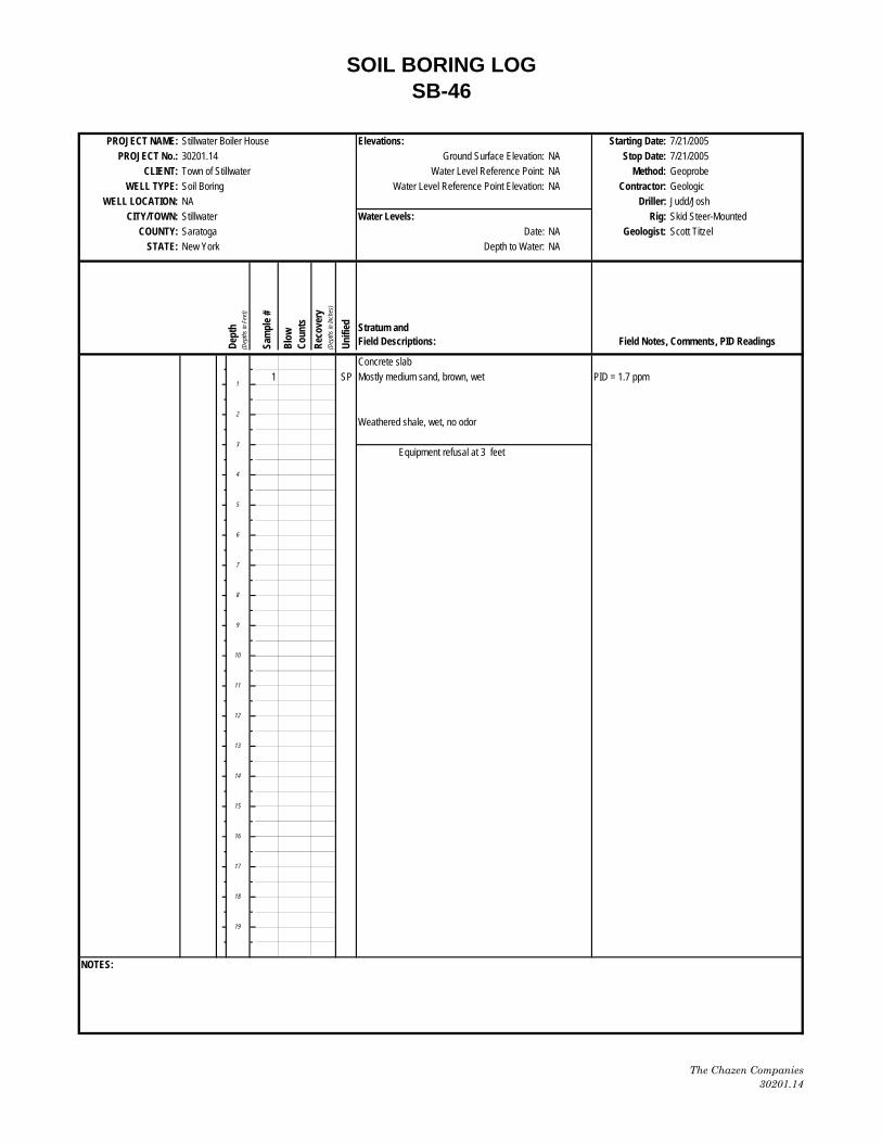
SOIL BORING LOGSB-46
PROJECT NAME: Stillwater Boiler House Elevations: Starting Date:PROJECT No.: Ground Surface Elevation: NA Stop Date:
CLIENT: Town of Stillwater Water Level Reference Point: NA Method: GeoprobeWELL TYPE: Soil Boring Water Level Reference Point Elevation: NA Contractor: Geologic
WELL LOCATION: NA Driller: Judd/JoshCITY/TOWN: Stillwater Water Levels: Rig: Skid Steer-Mounted
COUNTY: Saratoga Date: NA Geologist: Scott TitzelSTATE: New York Depth to Water: NA
Dept
h(D
epth
s in
Feet
)
Sam
ple #
Blow
Coun
tsRe
cove
ry(D
epth
s in
Inch
es)
Unifi
ed Stratum andField Descriptions: Field Notes, Comments, PID Readings
Concrete slab1 SP Mostly medium sand, brown, wet PID = 1.7 ppm
Weathered shale, wet, no odor
Equipment refusal at 3 feet
NOTES:
18
19
14
15
16
17
10
11
12
13
6
7
8
9
2
3
4
5
7/21/200530201.14 7/21/2005
1
The Chazen Companies30201.14

SOIL BORING LOGSB-47
PROJECT NAME: Stillwater Boiler House Elevations: Starting Date:PROJECT No.: Ground Surface Elevation: NA Stop Date:
CLIENT: Town of Stillwater Water Level Reference Point: NA Method: GeoprobeWELL TYPE: Soil Boring Water Level Reference Point Elevation: NA Contractor: Geologic
WELL LOCATION: NA Driller: Judd/JoshCITY/TOWN: Stillwater Water Levels: Rig: Skid Steer-Mounted
COUNTY: Saratoga Date: NA Geologist: Scott TitzelSTATE: New York Depth to Water: NA
Dept
h(D
epth
s in
Feet
)
Sam
ple #
Blow
Coun
tsRe
cove
ry(D
epth
s in
Inch
es)
Unifi
ed Stratum andField Descriptions: Field Notes, Comments, PID Readings
Concrete slab1 24 SP Mostly medium sand, brown, moist PID = 1.5 ppm
Sand with shale fragments, wet
Weathered shale, wet
Equipment refusal at 3.5 ppm
NOTES:
18
19
14
15
16
17
10
11
12
13
6
7
8
9
2
3
4
5
7/21/200530201.14 7/21/2005
1
The Chazen Companies30201.14

SOIL BORING LOGSB-48
PROJECT NAME: Stillwater Boiler House Elevations: Starting Date:PROJECT No.: Ground Surface Elevation: NA Stop Date:
CLIENT: Town of Stillwater Water Level Reference Point: NA Method: GeoprobeWELL TYPE: Soil Boring Water Level Reference Point Elevation: NA Contractor: Geologic
WELL LOCATION: NA Driller: Judd/JoshCITY/TOWN: Stillwater Water Levels: Rig: Skid Steer-Mounted
COUNTY: Saratoga Date: NA Geologist: Scott TitzelSTATE: New York Depth to Water: NA
Dept
h(D
epth
s in
Feet
)
Sam
ple #
Blow
Coun
tsRe
cove
ry(D
epth
s in
Inch
es)
Unifi
ed Stratum andField Descriptions: Field Notes, Comments, PID Readings
Concrete1 24 Coal ash PID = 2.1 ppm
Sand with shale fragments, wetWeathered shale, no odor
Equipment refusal at 3.5 feet
NOTES:
18
19
14
15
16
17
10
11
12
13
6
7
8
9
2
3
4
5
7/21/200530201.14 7/21/2005
1
The Chazen Companies30201.14

SOIL BORING LOGSB-49
PROJECT NAME: Stillwater Boiler House Elevations: Starting Date:PROJECT No.: Ground Surface Elevation: NA Stop Date:
CLIENT: Town of Stillwater Water Level Reference Point: NA Method: GeoprobeWELL TYPE: Soil Boring Water Level Reference Point Elevation: NA Contractor: Geologic
WELL LOCATION: NA Driller: Judd/JoshCITY/TOWN: Stillwater Water Levels: Rig: Skid Steer-Mounted
COUNTY: Saratoga Date: NA Geologist: Scott TitzelSTATE: New York Depth to Water: NA
Dept
h(D
epth
s in
Feet
)
Sam
ple #
Blow
Coun
tsRe
cove
ry(D
epth
s in
Inch
es)
Unifi
ed Stratum andField Descriptions: Field Notes, Comments, PID Readings
Concrete Slab1 20 Mostly medium sand, brown, moist PID = 0.0 ppm
weathered shale, wet, no odor
Equipment refusal at 2.0 feet
NOTES:
18
19
14
15
16
17
10
11
12
13
6
7
8
9
2
3
4
5
7/21/200530201.14 7/21/2005
1
The Chazen Companies30201.14

SOIL BORING LOGSB-50
PROJECT NAME: Stillwater Boiler House Elevations: Starting Date:PROJECT No.: Ground Surface Elevation: NA Stop Date:
CLIENT: Town of Stillwater Water Level Reference Point: NA Method: GeoprobeWELL TYPE: Soil Boring Water Level Reference Point Elevation: NA Contractor: Geologic
WELL LOCATION: NA Driller: Judd/JoshCITY/TOWN: Stillwater Water Levels: Rig: Skid Steer-Mounted
COUNTY: Saratoga Date: NA Geologist: Scott TitzelSTATE: New York Depth to Water: NA
Dept
h(D
epth
s in
Feet
)
Sam
ple #
Blow
Coun
tsRe
cove
ry(D
epth
s in
Inch
es)
Unifi
ed Stratum andField Descriptions: Field Notes, Comments, PID Readings
Concrete Slab1 32 FILL, gray to black stained silty clay with coarse gravel, PID = 31.4 ppm
hydrocarbon odor, oily product on soil, soft to m. dense
2 36 same, wet PID = 22.7 ppm
Equipment refusal at 6.5 feet
NOTES:
18
19
14
15
16
17
10
11
12
13
6
7
8
9
2
3
4
5
7/19/200530201.14 7/19/2005
1
The Chazen Companies30201.14

SOIL BORING LOGSB-51
PROJECT NAME: Stillwater Boiler House Elevations: Starting Date:PROJECT No.: Ground Surface Elevation: NA Stop Date:
CLIENT: Town of Stillwater Water Level Reference Point: NA Method: GeoprobeWELL TYPE: Soil Boring Water Level Reference Point Elevation: NA Contractor: Geologic
WELL LOCATION: NA Driller: Judd/JoshCITY/TOWN: Stillwater Water Levels: Rig: Skid Steer-Mounted
COUNTY: Saratoga Date: NA Geologist: Scott TitzelSTATE: New York Depth to Water: NA
Dept
h(D
epth
s in
Feet
)
Sam
ple #
Blow
Coun
tsRe
cove
ry(D
epth
s in
Inch
es)
Unifi
ed Stratum andField Descriptions: Field Notes, Comments, PID Readings
1 36 FILL, Brown, gry, silt, sand, and gravel, no oily residue PID = 0.0 ppmor odor
Weathered shale
Equipment refusal at 4 feet
NOTES:
18
19
14
15
16
17
10
11
12
13
6
7
8
9
2
3
4
5
7/19/200530201.14 7/19/2005
1
The Chazen Companies30201.14

SOIL BORING LOGSB-52
PROJECT NAME: Stillwater Boiler House Elevations: Starting Date:PROJECT No.: Ground Surface Elevation: NA Stop Date:
CLIENT: Town of Stillwater Water Level Reference Point: NA Method: GeoprobeWELL TYPE: Soil Boring Water Level Reference Point Elevation: NA Contractor: Geologic
WELL LOCATION: NA Driller: Judd/JoshCITY/TOWN: Stillwater Water Levels: Rig: Skid Steer-Mounted
COUNTY: Saratoga Date: NA Geologist: Scott TitzelSTATE: New York Depth to Water: NA
Dept
h(D
epth
s in
Feet
)
Sam
ple #
Blow
Coun
tsRe
cove
ry(D
epth
s in
Inch
es)
Unifi
ed Stratum andField Descriptions: Field Notes, Comments, PID Readings
Concrete Slab1 36 Mostly gravel, some sand, moist, Fill PID = 0.0 ppm
Weathered shale
Equipment refusal at 3 feet
NOTES:
18
19
14
15
16
17
10
11
12
13
6
7
8
9
2
3
4
5
7/19/200530201.14 7/19/2005
1
The Chazen Companies30201.14

SOIL BORING LOGSB-53
PROJECT NAME: Stillwater Boiler House Elevations: Starting Date:PROJECT No.: Ground Surface Elevation: NA Stop Date:
CLIENT: Town of Stillwater Water Level Reference Point: NA Method: GeoprobeWELL TYPE: Soil Boring Water Level Reference Point Elevation: NA Contractor: Geologic
WELL LOCATION: NA Driller: Judd/JoshCITY/TOWN: Stillwater Water Levels: Rig: Skid Steer-Mounted
COUNTY: Saratoga Date: NA Geologist: Scott TitzelSTATE: New York Depth to Water: NA
Dept
h(D
epth
s in
Feet
)
Sam
ple #
Blow
Coun
tsRe
cove
ry(D
epth
s in
Inch
es)
Unifi
ed Stratum andField Descriptions: Field Notes, Comments, PID Readings
Concrete Slab1 18 Medium sand, wet PID = 0.5 ppm
weathered shale, wet
Equipment refusal at 2.0 feet
NOTES:
18
19
14
15
16
17
10
11
12
13
6
7
8
9
2
3
4
5
7/21/200530201.14 7/21/2005
1
The Chazen Companies30201.14

SOIL BORING LOGSB-54
PROJECT NAME: Stillwater Boiler House Elevations: Starting Date:PROJECT No.: Ground Surface Elevation: NA Stop Date:
CLIENT: Town of Stillwater Water Level Reference Point: NA Method: GeoprobeWELL TYPE: Soil Boring Water Level Reference Point Elevation: NA Contractor: Geologic
WELL LOCATION: NA Driller: Judd/JoshCITY/TOWN: Stillwater Water Levels: Rig: Skid Steer-Mounted
COUNTY: Saratoga Date: NA Geologist: Scott TitzelSTATE: New York Depth to Water: NA
Dept
h(D
epth
s in
Feet
)
Sam
ple #
Blow
Coun
tsRe
cove
ry(D
epth
s in
Inch
es)
Unifi
ed Stratum andField Descriptions: Field Notes, Comments, PID Readings
Concrete Slab1 30 Sand with shale fragments, moist PID = 0.0 ppm
weathered shale, slightly moist
Equipment refusal at 3.0 feet
NOTES:
18
19
14
15
16
17
10
11
12
13
6
7
8
9
2
3
4
5
7/21/200530201.14 7/21/2005
1
The Chazen Companies30201.14

TEST BORING LOG Page 1 of 1
547 River Street PROJECT:Troy, New York LOCATION:
CLIENT:PROJECT NO.: Total Depth: 7.5 ft.
Start Date: 6/2/2006 Northing: -- Borehole Dia.: 2 in.Finish Date: 6/2/2006 Easting: -- Depth to Water: N/A ft.
El. Datum: --- Longitude: -- Depth to Rock: 7.5 ft.G.S. Elevation: 0.00 Latitude: --
Dep
th (F
eet)
Ele
vatio
n (F
eet)
Cas
ing
Dat
a
Sam
ple
No.
Sam
ple
Dat
a
Rec
over
y (I
nche
s)
PID
(ppm
)
Gro
up S
ymbo
l1 24 Fill, wood, brick, crushed rock, silt, slight hydrocarbon odor
1 -1
2 -2
3 -3
4 -4
2 30 Black, clayey silt, hydrocarbon odor no free product observed5 -5
6 -6
7 -7
very moist, weathered shale8 -8
9 -9
10 -10
11 -11
12 -12
13 -13
14 -14
15 -15
16 -16
17 -17
18 -18
19 -19
20 -20
NOTES:
Test Boring No.: 55Stillwater Boiler House SiteStillwater, Saratoga County, New York
30201.14Contractor: Aztech Technologies
12180 Town of Stillwater
Drill Rig:Driller:
Inspector:
ForemostChrisScott Titzel
Field Notes, Comments:Stratum andField Descriptions:
Boring terminated due to equipment refusal on bedrock

TEST BORING LOG Page 1 of 1
547 River Street PROJECT:Troy, New York LOCATION:
CLIENT:PROJECT NO.: Total Depth: 7.5 ft.
Start Date: 6/2/2006 Northing: -- Borehole Dia.: 2 in.Finish Date: 6/2/2006 Easting: -- Depth to Water: 7 ft.
El. Datum: --- Longitude: -- Depth to Rock: 7.5 ft.G.S. Elevation: 0.00 Latitude: --
Dep
th (F
eet)
Ele
vatio
n (F
eet)
Cas
ing
Dat
a
Sam
ple
No.
Sam
ple
Dat
a
Rec
over
y (I
nche
s)
PID
(ppm
)
Gro
up S
ymbo
l1 24 Fill, brown silt, crushed rock, brick, moist
1 -1
2 -2
3 -3
4 -4
2 30 SAA no free product observed5 -5
6 -6
7 -7
wet, weathered shale8 -8
9 -9
10 -10
11 -11
12 -12
13 -13
14 -14
15 -15
16 -16
17 -17
18 -18
19 -19
20 -20
NOTES:
Stillwater Boiler House SiteTest Boring No.: 56Stillwater, Saratoga County, New York
12180 Town of Stillwater30201.14
Contractor: Aztech TechnologiesDrill Rig: Foremost
Driller: ChrisInspector: Scott Titzel
Boring terminated due to equipment refusal on bedrock
Stratum andField Descriptions: Field Notes, Comments:

TEST BORING LOG Page 1 of 1
547 River Street PROJECT:Troy, New York LOCATION:
CLIENT:PROJECT NO.: Total Depth: 8 ft.
Start Date: 6/2/2006 Northing: -- Borehole Dia.: 2 in.Finish Date: 6/2/2006 Easting: -- Depth to Water: 7.5 ft.
El. Datum: --- Longitude: -- Depth to Rock: 7.5 ft.G.S. Elevation: 0.00 Latitude: --
Dep
th (F
eet)
Ele
vatio
n (F
eet)
Cas
ing
Dat
a
Sam
ple
No.
Sam
ple
Dat
a
Rec
over
y (I
nche
s)
PID
(ppm
)
Gro
up S
ymbo
l1 24 Fill, silty sand, crushed rock, brick, and concrete
1 -1
2 -2
3 -3
4 -4
2 36 SAA no free product observed5 -5
6 -6
7 -7
8 -8 wet, weathered shale
9 -9
10 -10
11 -11
12 -12
13 -13
14 -14
15 -15
16 -16
17 -17
18 -18
19 -19
20 -20
NOTES:
Stillwater Boiler House SiteTest Boring No.: 57Stillwater, Saratoga County, New York
12180 Town of Stillwater30201.14
Contractor: Aztech TechnologiesDrill Rig: Foremost
Driller: ChrisInspector: Scott Titzel
Boring terminated due to equipment refusal on bedrock
Stratum andField Descriptions: Field Notes, Comments:

TEST BORING LOG Page 1 of 1
547 River Street PROJECT:Troy, New York LOCATION:
CLIENT:PROJECT NO.: Total Depth: 8.5 ft.
Start Date: 6/2/2006 Northing: -- Borehole Dia.: 2 in.Finish Date: 6/2/2006 Easting: -- Depth to Water: N/A ft.
El. Datum: --- Longitude: -- Depth to Rock: 8 ft.G.S. Elevation: 0.00 Latitude: --
Dep
th (F
eet)
Ele
vatio
n (F
eet)
Cas
ing
Dat
a
Sam
ple
No.
Sam
ple
Dat
a
Rec
over
y (I
nche
s)
PID
(ppm
)
Gro
up S
ymbo
l1 20 Fill, brick, silty sand, crushed rock, moist
1 -1
2 -2
3 -3
4 -4
2 8 (poor recovery), fine sand and silt, few coarse rock fragments, fill no free product observed5 -5
6 -6
7 -7
8 -8
3 18 SAA, moist9 -9
10 -10
11 -11
12 -12
13 -13
14 -14
15 -15
16 -16
17 -17
18 -18
19 -19
20 -20
NOTES:
Stillwater Boiler House SiteTest Boring No.: 58Stillwater, Saratoga County, New York
12180 Town of Stillwater30201.14
Contractor: Aztech TechnologiesDrill Rig: Foremost
Driller: ChrisInspector: Scott Titzel
Boring terminated due to equipment refusal on bedrock
Stratum andField Descriptions: Field Notes, Comments:

TEST BORING LOG Page 1 of 1
547 River Street PROJECT:Troy, New York LOCATION:
CLIENT:PROJECT NO.: Total Depth: 4 ft.
Start Date: 6/2/2006 Northing: -- Borehole Dia.: 2 in.Finish Date: 6/2/2006 Easting: -- Depth to Water: N/A ft.
El. Datum: --- Longitude: -- Depth to Rock: N/A ft.G.S. Elevation: 0.00 Latitude: --
Dep
th (F
eet)
Ele
vatio
n (F
eet)
Cas
ing
Dat
a
Sam
ple
No.
Sam
ple
Dat
a
Rec
over
y (I
nche
s)
PID
(ppm
)
Gro
up S
ymbo
l1 30 Brown silt, crushed rock, brick, moist
1 -1
ash2 -2 no free product observed
3 -3
4 -4
5 -5
6 -6
7 -7
8 -8
9 -9
10 -10
11 -11
12 -12
13 -13
14 -14
15 -15
16 -16
17 -17
18 -18
19 -19
20 -20
NOTES:2 attempts to drill past obstruction. Concrete
Stillwater Boiler House SiteTest Boring No.: 59Stillwater, Saratoga County, New York
12180 Town of Stillwater30201.14
Contractor: Aztech TechnologiesDrill Rig: Foremost
Driller: ChrisInspector: Scott Titzel
Boring terminated due to equipment refusal
Stratum andField Descriptions: Field Notes, Comments:

TEST BORING LOG Page 1 of 1
547 River Street PROJECT:Troy, New York LOCATION:
CLIENT:PROJECT NO.: Total Depth: 1.5 ft.
Start Date: 6/2/2006 Northing: -- Borehole Dia.: 2 in.Finish Date: 6/2/2006 Easting: -- Depth to Water: N/A ft.
El. Datum: --- Longitude: -- Depth to Rock: N/A ft.G.S. Elevation: 0.00 Latitude: --
Dep
th (F
eet)
Ele
vatio
n (F
eet)
Cas
ing
Dat
a
Sam
ple
No.
Sam
ple
Dat
a
Rec
over
y (I
nche
s)
PID
(ppm
)
Gro
up S
ymbo
l1 18 Imported top soil
1 -1 Fill
2 -2
3 -3
4 -4
5 -5
6 -6
7 -7
8 -8
9 -9
10 -10
11 -11
12 -12
13 -13
14 -14
15 -15
16 -16
17 -17
18 -18
19 -19
20 -20
NOTES:3 attempts to drill past obstruction
Stillwater Boiler House SiteTest Boring No.: 60Stillwater, Saratoga County, New York
12180 Town of Stillwater30201.14
Contractor: Aztech TechnologiesDrill Rig: Foremost
Driller: ChrisInspector: Scott Titzel
Stratum andField Descriptions: Field Notes, Comments:
Boring terminated due to equipment refusal
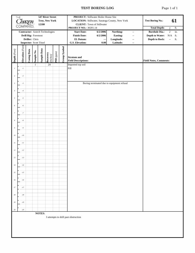
TEST BORING LOG Page 1 of 1
547 River Street PROJECT:Troy, New York LOCATION:
CLIENT:PROJECT NO.: Total Depth: 2 ft.
Start Date: 6/2/2006 Northing: -- Borehole Dia.: 2 in.Finish Date: 6/2/2006 Easting: -- Depth to Water: N/A ft.
El. Datum: --- Longitude: -- Depth to Rock: -- ft.G.S. Elevation: 0.00 Latitude: --
Dep
th (F
eet)
Ele
vatio
n (F
eet)
Cas
ing
Dat
a
Sam
ple
No.
Sam
ple
Dat
a
Rec
over
y (I
nche
s)
PID
(ppm
)
Gro
up S
ymbo
l1 24 Imported top soil
1 -1 Fill
2 -2
3 -3
4 -4
5 -5
6 -6
7 -7
8 -8
9 -9
10 -10
11 -11
12 -12
13 -13
14 -14
15 -15
16 -16
17 -17
18 -18
19 -19
20 -20
NOTES:3 attempts to drill past obstruction
Stillwater Boiler House SiteTest Boring No.: 61Stillwater, Saratoga County, New York
12180 Town of Stillwater30201.14
Contractor: Aztech TechnologiesDrill Rig: Foremost
Driller: ChrisInspector: Scott Titzel
Boring terminated due to equipment refusal
Stratum andField Descriptions: Field Notes, Comments:

TEST BORING LOG Page 1 of 1
547 River Street PROJECT:Troy, New York LOCATION:
CLIENT:PROJECT NO.: Total Depth: 10 ft.
Start Date: 6/2/2006 Northing: -- Borehole Dia.: 2 in.Finish Date: 6/2/2006 Easting: -- Depth to Water: N/A ft.
El. Datum: --- Longitude: -- Depth to Rock: 10 ft.G.S. Elevation: 0.00 Latitude: --
Dep
th (F
eet)
Ele
vatio
n (F
eet)
Cas
ing
Dat
a
Sam
ple
No.
Sam
ple
Dat
a
Rec
over
y (I
nche
s)
PID
(ppm
)
Gro
up S
ymbo
l1 24 Fill
1 -1
2 -2
3 -3
4 -4
2 30 Fill5 -5
6 -6
7 -7
8 -8
3 24 HC in matrix9 -9
10 -10 Shale
11 -11
12 -12
13 -13
14 -14
15 -15
16 -16
17 -17
18 -18
19 -19
20 -20
NOTES:
Stillwater Boiler House SiteTest Boring No.: 62Stillwater, Saratoga County, New York
12180 Town of Stillwater30201.14
Contractor: Aztech TechnologiesDrill Rig: Foremost
Driller: ChrisInspector: Scott Titzel
Boring terminated due to equipment refusal on bedrock
Stratum andField Descriptions: Field Notes, Comments:

TEST BORING LOG Page 1 of 1
547 River Street PROJECT:Troy, New York LOCATION:
CLIENT:PROJECT NO.: Total Depth: 10 ft.
Start Date: 6/2/2006 Northing: -- Borehole Dia.: 2 in.Finish Date: 6/2/2006 Easting: -- Depth to Water: N/A ft.
El. Datum: --- Longitude: -- Depth to Rock: 10 ft.G.S. Elevation: 0.00 Latitude: --
Dep
th (F
eet)
Ele
vatio
n (F
eet)
Cas
ing
Dat
a
Sam
ple
No.
Sam
ple
Dat
a
Rec
over
y (I
nche
s)
PID
(ppm
)
Gro
up S
ymbo
l1 30 Fill, brown silt with crushed brick, rock, and ash material
1 -1
2 -2
3 -3
4 -4
2 30 Black, clayey silt, hydrocarbon odor5 -5
6 -6
7 -7
Shaley fill, HC product in soil matrix8 -8
3 24 Wet9 -9
10 -10 6" dry weathered shale
11 -11
12 -12
13 -13
14 -14
15 -15
16 -16
17 -17
18 -18
19 -19
20 -20
NOTES:
Stillwater Boiler House SiteTest Boring No.: 63Stillwater, Saratoga County, New York
12180 Town of Stillwater30201.14
Contractor: Aztech TechnologiesDrill Rig: Foremost
Driller: ChrisInspector: Scott Titzel
Boring terminated due to equipment refusal on bedrock
Stratum andField Descriptions: Field Notes, Comments:

TEST BORING LOG Page 1 of 1
547 River Street PROJECT:Troy, New York LOCATION:
CLIENT:PROJECT NO.: Total Depth: 8 ft.
Start Date: 6/2/2006 Northing: -- Borehole Dia.: 2 in.Finish Date: 6/2/2006 Easting: -- Depth to Water: N/A ft.
El. Datum: --- Longitude: -- Depth to Rock: 8 ft.G.S. Elevation: 0.00 Latitude: --
Dep
th (F
eet)
Ele
vatio
n (F
eet)
Cas
ing
Dat
a
Sam
ple
No.
Sam
ple
Dat
a
Rec
over
y (I
nche
s)
PID
(ppm
)
Gro
up S
ymbo
l1 30 Fill, silty Clay with crushed rock, ash; no brick
1 -1
2 -2
3 -3
4 -4
2 36 Fill, some brick observed no free product observed5 -5
6 -6
orange and gray mottling7 -7
8 -8 Shale
9 -9
10 -10
11 -11
12 -12
13 -13
14 -14
15 -15
16 -16
17 -17
18 -18
19 -19
20 -20
NOTES:
Stillwater Boiler House SiteTest Boring No.: 64Stillwater, Saratoga County, New York
12180 Town of Stillwater30201.14
Contractor: Aztech TechnologiesDrill Rig: Foremost
Driller: ChrisInspector: Scott Titzel
Stratum andField Descriptions: Field Notes, Comments:
Boring terminated due to equipment refusal on bedrock

TEST BORING LOG Page 1 of 1
547 River Street PROJECT:Troy, New York LOCATION:
CLIENT:PROJECT NO.: Total Depth: 7.5 ft.
Start Date: 6/2/2006 Northing: -- Borehole Dia.: 2 in.Finish Date: 6/2/2006 Easting: -- Depth to Water: N/A ft.
El. Datum: --- Longitude: -- Depth to Rock: 7.5 ft.G.S. Elevation: 0.00 Latitude: --
Dep
th (F
eet)
Ele
vatio
n (F
eet)
Cas
ing
Dat
a
Sam
ple
No.
Sam
ple
Dat
a
Rec
over
y (I
nche
s)
PID
(ppm
)
Gro
up S
ymbo
l1 24 Fill, silty clay, brick, rock, ash
1 -1
2 -2
3 -3
4 -4
2 28 SAA no free product observed5 -5
6 -6
7 -7
Shale8 -8
9 -9
10 -10
11 -11
12 -12
13 -13
14 -14
15 -15
16 -16
17 -17
18 -18
19 -19
20 -20
NOTES:
Stillwater Boiler House SiteTest Boring No.: 65Stillwater, Saratoga County, New York
12180 Town of Stillwater30201.14
Contractor: Aztech TechnologiesDrill Rig: Foremost
Driller: ChrisInspector: Scott Titzel
Boring terminated due to equipment refusal on bedrock
Stratum andField Descriptions: Field Notes, Comments:

TEST BORING LOG Page 1 of 1
547 River Street PROJECT:Troy, New York LOCATION:
CLIENT:PROJECT NO.: Total Depth: 11 ft.
Start Date: 6/2/2006 Northing: -- Borehole Dia.: 2 in.Finish Date: 6/2/2006 Easting: -- Depth to Water: 10 ft.
El. Datum: --- Longitude: -- Depth to Rock: 11 ft.G.S. Elevation: 0.00 Latitude: --
Dep
th (F
eet)
Ele
vatio
n (F
eet)
Cas
ing
Dat
a
Sam
ple
No.
Sam
ple
Dat
a
Rec
over
y (I
nche
s)
PID
(ppm
)
Gro
up S
ymbo
l1 24 Fill, silty clay, brick, rock, ash
1 -1
2 -2
3 -3
4 -4
2 40 SAA no free product observed5 -5
6 -6
7 -7
8 -8
3 28 Fill, no product, no HC-odor, slight staining, orange/gray mottling9 -9
10 -10
11 -11 Wet
12 -12
13 -13
14 -14
15 -15
16 -16
17 -17
18 -18
19 -19
20 -20
NOTES:
Stillwater Boiler House SiteTest Boring No.: 66Stillwater, Saratoga County, New York
12180 Town of Stillwater30201.14
Contractor: Aztech TechnologiesDrill Rig: Foremost
Driller: ChrisInspector: Scott Titzel
Boring terminated due to equipment refusal on bedrock
Stratum andField Descriptions: Field Notes, Comments:

TEST BORING LOG Page 1 of 1
547 River Street PROJECT:Troy, New York LOCATION:
CLIENT:PROJECT NO.: Total Depth: 8 ft.
Start Date: 6/2/2006 Northing: -- Borehole Dia.: 2 in.Finish Date: 6/2/2006 Easting: -- Depth to Water: N/A ft.
El. Datum: --- Longitude: -- Depth to Rock: 8 ft.G.S. Elevation: 0.00 Latitude: --
Dep
th (F
eet)
Ele
vatio
n (F
eet)
Cas
ing
Dat
a
Sam
ple
No.
Sam
ple
Dat
a
Rec
over
y (I
nche
s)
PID
(ppm
)
Gro
up S
ymbo
l1 15 Fill
1 -1 Ash
2 -2 Fill
3 -3
4 -4
2 24 Sity Clay with rock fragments (FILL)5 -5
6 -6
7 -7
8 -8 Shale No oily product or odors observed
9 -9
10 -10
11 -11
12 -12
13 -13
14 -14
15 -15
16 -16
17 -17
18 -18
19 -19
20 -20
NOTES:
Stillwater Boiler House SiteTest Boring No.: 67Stillwater, Saratoga County, New York
12180 Town of Stillwater30201.14
Contractor: Aztech TechnologiesDrill Rig: Foremost
Driller: ChrisInspector: Scott Titzel
Stratum andField Descriptions: Field Notes, Comments:
Boring terminated due to equipment refusal on bedrock

TEST BORING LOG Page 1 of 1
547 River Street PROJECT:Troy, New York LOCATION:
CLIENT:PROJECT NO.: Total Depth: 7 ft.
Start Date: 6/2/2006 Northing: -- Borehole Dia.: 2 in.Finish Date: 6/2/2006 Easting: -- Depth to Water: N/A ft.
El. Datum: --- Longitude: -- Depth to Rock: 7 ft.G.S. Elevation: 0.00 Latitude: --
Dep
th (F
eet)
Ele
vatio
n (F
eet)
Cas
ing
Dat
a
Sam
ple
No.
Sam
ple
Dat
a
Rec
over
y (I
nche
s)
PID
(ppm
)
Gro
up S
ymbo
l1 15 Fill
1 -1
2 -2
3 -3
4 -4
2 30 Fill5 -5
6 -6 oily product in fill matrix
7 -7 Shale
8 -8
9 -9
10 -10
11 -11
12 -12
13 -13
14 -14
15 -15
16 -16
17 -17
18 -18
19 -19
20 -20
NOTES:
Stillwater Boiler House SiteTest Boring No.: 68Stillwater, Saratoga County, New York
12180 Town of Stillwater30201.14
Contractor: Aztech TechnologiesDrill Rig: Foremost
Driller: ChrisInspector: Scott Titzel
Boring terminated due to equipment refusal on bedrock
Stratum andField Descriptions: Field Notes, Comments:

TEST BORING LOG Page 1 of 1
547 River Street PROJECT:Troy, New York LOCATION:
CLIENT:PROJECT NO.: Total Depth: 6.5 ft.
Start Date: 6/2/2006 Northing: -- Borehole Dia.: 2 in.Finish Date: 6/2/2006 Easting: -- Depth to Water: N/A ft.
El. Datum: --- Longitude: -- Depth to Rock: 6.5 ft.G.S. Elevation: 0.00 Latitude: --
Dep
th (F
eet)
Ele
vatio
n (F
eet)
Cas
ing
Dat
a
Sam
ple
No.
Sam
ple
Dat
a
Rec
over
y (I
nche
s)
PID
(ppm
)
Gro
up S
ymbo
l1 12 Fill
1 -1
2 -2
3 -3
4 -4
2 28 Fill no free product observed5 -5
6 -6
Shale7 -7
8 -8
9 -9
10 -10
11 -11
12 -12
13 -13
14 -14
15 -15
16 -16
17 -17
18 -18
19 -19
20 -20
NOTES:
Stillwater Boiler House SiteTest Boring No.: 69Stillwater, Saratoga County, New York
12180 Town of Stillwater30201.14
Contractor: Aztech TechnologiesDrill Rig: Foremost
Driller: ChrisInspector: Scott Titzel
Boring terminated due to equipment refusal on bedrock
Stratum andField Descriptions: Field Notes, Comments:

TEST BORING LOG Page 1 of 1
547 River Street PROJECT:Troy, New York LOCATION:
CLIENT:PROJECT NO.: Total Depth: 10 ft.
Start Date: 6/5/2006 Northing: -- Borehole Dia.: 2 in.Finish Date: 6/5/2006 Easting: -- Depth to Water: 8 ft.
El. Datum: --- Longitude: -- Depth to Rock: 10 ft.G.S. Elevation: 0.00 Latitude: --
Dep
th (F
eet)
Ele
vatio
n (F
eet)
Cas
ing
Dat
a
Sam
ple
No.
Sam
ple
Dat
a
Rec
over
y (I
nche
s)
PID
(ppm
)
Gro
up S
ymbo
l1 36 Fill, gray-brown silty clay with crushed rock and brick, slightly moist
1 -1
2 -2
Ash 1-ft3 -3
4 -4
2 32 Gray silty sand, moist5 -5
brown silty sand6 -6
7 -7 Olive gray silty sand, weathered shale, oily product
8 -8
3 24 weathered shale, wet, sheen on water, oily product in matrix9 -9
10 -10
11 -11
12 -12
13 -13
14 -14
15 -15
16 -16
17 -17
18 -18
19 -19
20 -20
NOTES:
Stillwater Boiler House SiteTest Boring No.: 70Stillwater, Saratoga County, New York
12180 Town of Stillwater30201.14
Contractor: Aztech TechnologiesDrill Rig: Foremost
Driller: ChrisInspector: Scott Titzel
Boring terminated due to equipment refusal on bedrock
Stratum andField Descriptions: Field Notes, Comments:
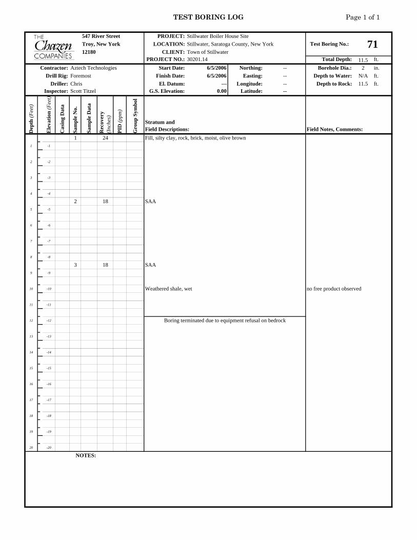
TEST BORING LOG Page 1 of 1
547 River Street PROJECT:Troy, New York LOCATION:
CLIENT:PROJECT NO.: Total Depth: 11.5 ft.
Start Date: 6/5/2006 Northing: -- Borehole Dia.: 2 in.Finish Date: 6/5/2006 Easting: -- Depth to Water: N/A ft.
El. Datum: --- Longitude: -- Depth to Rock: 11.5 ft.G.S. Elevation: 0.00 Latitude: --
Dep
th (F
eet)
Ele
vatio
n (F
eet)
Cas
ing
Dat
a
Sam
ple
No.
Sam
ple
Dat
a
Rec
over
y (I
nche
s)
PID
(ppm
)
Gro
up S
ymbo
l1 24 Fill, silty clay, rock, brick, moist, olive brown
1 -1
2 -2
3 -3
4 -4
2 18 SAA5 -5
6 -6
7 -7
8 -8
3 18 SAA9 -9
10 -10 Weathered shale, wet no free product observed
11 -11
12 -12
13 -13
14 -14
15 -15
16 -16
17 -17
18 -18
19 -19
20 -20
NOTES:
Stillwater Boiler House SiteTest Boring No.: 71Stillwater, Saratoga County, New York
12180 Town of Stillwater30201.14
Contractor: Aztech TechnologiesDrill Rig: Foremost
Driller: ChrisInspector: Scott Titzel
Boring terminated due to equipment refusal on bedrock
Stratum andField Descriptions: Field Notes, Comments:
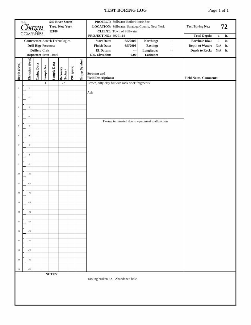
TEST BORING LOG Page 1 of 1
547 River Street PROJECT:Troy, New York LOCATION:
CLIENT:PROJECT NO.: Total Depth: 4 ft.
Start Date: 6/5/2006 Northing: -- Borehole Dia.: 2 in.Finish Date: 6/5/2006 Easting: -- Depth to Water: N/A ft.
El. Datum: --- Longitude: -- Depth to Rock: N/A ft.G.S. Elevation: 0.00 Latitude: --
Dep
th (F
eet)
Ele
vatio
n (F
eet)
Cas
ing
Dat
a
Sam
ple
No.
Sam
ple
Dat
a
Rec
over
y (I
nche
s)
PID
(ppm
)
Gro
up S
ymbo
l1 22 Brown, silty clay fill with rock brick fragments
1 -1
Ash2 -2
3 -3
4 -4
5 -5
6 -6
7 -7
8 -8
9 -9
10 -10
11 -11
12 -12
13 -13
14 -14
15 -15
16 -16
17 -17
18 -18
19 -19
20 -20
NOTES:Tooling broken 2X. Abandoned hole
Stillwater Boiler House SiteTest Boring No.: 72Stillwater, Saratoga County, New York
12180 Town of Stillwater30201.14
Contractor: Aztech TechnologiesDrill Rig: Foremost
Driller: ChrisInspector: Scott Titzel
Boring terminated due to equipment malfunction
Stratum andField Descriptions: Field Notes, Comments:

TEST BORING LOG Page 1 of 1
547 River Street PROJECT:Troy, New York LOCATION:
CLIENT:PROJECT NO.: Total Depth: 10 ft.
Start Date: 6/5/2006 Northing: -- Borehole Dia.: 2 in.Finish Date: 6/5/2006 Easting: -- Depth to Water: N/A ft.
El. Datum: --- Longitude: -- Depth to Rock: 7.5 ft.G.S. Elevation: 0.00 Latitude: --
Dep
th (F
eet)
Ele
vatio
n (F
eet)
Cas
ing
Dat
a
Sam
ple
No.
Sam
ple
Dat
a
Rec
over
y (I
nche
s)
PID
(ppm
)
Gro
up S
ymbo
l1 18 Fill, Brown silty clay with rock fragments
1 -1
2 -2
3 -3
4 -4
2 28 Fill, moist, gray, brown, and orange, silty clay with coarse 5 -5 sand and rock fragments
6 -6
7 -7
8 -8
3 20 SAA9 -9
no free product observed10 -10 Shale
11 -11
12 -12
13 -13
14 -14
15 -15
16 -16
17 -17
18 -18
19 -19
20 -20
NOTES:
Stillwater Boiler House SiteTest Boring No.: 73Stillwater, Saratoga County, New York
12180 Town of Stillwater30201.14
Contractor: Aztech TechnologiesDrill Rig: Foremost
Driller: ChrisInspector: Scott Titzel
Boring terminated due to equipment refusal on bedrock
Stratum andField Descriptions: Field Notes, Comments:

TEST BORING LOG Page 1 of 1
547 River Street PROJECT:Troy, New York LOCATION:
CLIENT:PROJECT NO.: Total Depth: 12 ft.
Start Date: 6/5/2006 Northing: -- Borehole Dia.: 2 in.Finish Date: 6/5/2006 Easting: -- Depth to Water: N/A ft.
El. Datum: --- Longitude: -- Depth to Rock: 8 ft.G.S. Elevation: 0.00 Latitude: --
Dep
th (F
eet)
Ele
vatio
n (F
eet)
Cas
ing
Dat
a
Sam
ple
No.
Sam
ple
Dat
a
Rec
over
y (I
nche
s)
PID
(ppm
)
Gro
up S
ymbo
l1 36 2 ft. brown silty clay fill
1 -1
2 -2
Ash3 -3
4 -4
2 18 Ash5 -5
6 -6 Gray, coarse sand, silty clay and rock fragments (FILL)
7 -7
8 -8
3 28 Wet, weathered shale,9 -9 Sheen on shale
10 -10
11 -11
12 -12
13 -13
14 -14
15 -15
16 -16
17 -17
18 -18
19 -19
20 -20
NOTES:
Stillwater Boiler House SiteTest Boring No.: 74Stillwater, Saratoga County, New York
12180 Town of Stillwater30201.14
Contractor: Aztech TechnologiesDrill Rig: Foremost
Driller: ChrisInspector: Scott Titzel
Boring terminated due to equipment refusal on bedrock
Stratum andField Descriptions: Field Notes, Comments:

TEST BORING LOG Page 1 of 1
547 River Street PROJECT:Troy, New York LOCATION:
CLIENT:PROJECT NO.: Total Depth: 8 ft.
Start Date: 6/5/2006 Northing: -- Borehole Dia.: 2 in.Finish Date: 6/5/2006 Easting: -- Depth to Water: N/A ft.
El. Datum: --- Longitude: -- Depth to Rock: 8 ft.G.S. Elevation: 0.00 Latitude: --
Dep
th (F
eet)
Ele
vatio
n (F
eet)
Cas
ing
Dat
a
Sam
ple
No.
Sam
ple
Dat
a
Rec
over
y (I
nche
s)
PID
(ppm
)
Gro
up S
ymbo
l1 30 FILL, Brown silty clay, rock fragments, brick
1 -1
2 -2
Ash3 -3 Fill, SAA
4 -4
2 36 SAA no free product observed5 -5
6 -6
7 -7
8 -8
9 -9
10 -10
11 -11
12 -12
13 -13
14 -14
15 -15
16 -16
17 -17
18 -18
19 -19
20 -20
NOTES:
Stillwater Boiler House SiteTest Boring No.: 75Stillwater, Saratoga County, New York
12180 Town of Stillwater30201.14
Contractor: Aztech TechnologiesDrill Rig: Foremost
Driller: ChrisInspector: Scott Titzel
Boring terminated due to equipment refusal on bedrock
Stratum andField Descriptions: Field Notes, Comments:

TEST BORING LOG Page 1 of 1
547 River Street PROJECT:Troy, New York LOCATION:
CLIENT:PROJECT NO.: Total Depth: 7 ft.
Start Date: 6/5/2006 Northing: -- Borehole Dia.: 2 in.Finish Date: 6/5/2006 Easting: -- Depth to Water: N/A ft.
El. Datum: --- Longitude: -- Depth to Rock: 7 ft.G.S. Elevation: 0.00 Latitude: --
Dep
th (F
eet)
Ele
vatio
n (F
eet)
Cas
ing
Dat
a
Sam
ple
No.
Sam
ple
Dat
a
Rec
over
y (I
nche
s)
PID
(ppm
)
Gro
up S
ymbo
l1 18 Fill, wood, brick, crushed rock, silt, slight hydrocarbon odor
1 -1
2 -2
3 -3
4 -4
2 36 SAA no free product observed5 -5
6 -6
Weathered Shale7 -7
8 -8
9 -9
10 -10
11 -11
12 -12
13 -13
14 -14
15 -15
16 -16
17 -17
18 -18
19 -19
20 -20
NOTES:
Stillwater Boiler House SiteTest Boring No.: 76Stillwater, Saratoga County, New York
12180 Town of Stillwater30201.14
Contractor: Aztech TechnologiesDrill Rig: Foremost
Driller: ChrisInspector: Scott Titzel
Boring terminated due to equipment refusal on bedrock
Stratum andField Descriptions: Field Notes, Comments:

TEST BORING LOG Page 1 of 1
547 River Street PROJECT:Troy, New York LOCATION:
CLIENT:PROJECT NO.: Total Depth: 11 ft.
Start Date: 6/6/2006 Northing: -- Borehole Dia.: 2 in.Finish Date: 6/6/2006 Easting: -- Depth to Water: 8 ft.
El. Datum: --- Longitude: -- Depth to Rock: 11 ft.G.S. Elevation: 0.00 Latitude: --
Dep
th (F
eet)
Ele
vatio
n (F
eet)
Cas
ing
Dat
a
Sam
ple
No.
Sam
ple
Dat
a
Rec
over
y (I
nche
s)
PID
(ppm
)
Gro
up S
ymbo
l1 24 Fill, silt, sand, rock, brick
1 -1
2 -2
3 -3
4 -4
2 18 SAA5 -5
6 -6
7 -7
8 -8 no free product observed3 30 wet
9 -9 clayey gravel, TILL
10 -10
11 -11
12 -12
13 -13
14 -14
15 -15
16 -16
17 -17
18 -18
19 -19
20 -20
NOTES:
Stillwater Boiler House SiteTest Boring No.: 77Stillwater, Saratoga County, New York
12180 Town of Stillwater30201.14
Contractor: Aztech TechnologiesDrill Rig: Foremost
Driller: ChrisInspector: Scott Titzel
Boring terminated due to equipment refusal on bedrock
Stratum andField Descriptions: Field Notes, Comments:

TEST BORING LOG Page 1 of 1
547 River Street PROJECT:Troy, New York LOCATION:
CLIENT:PROJECT NO.: Total Depth: 11.5 ft.
Start Date: 6/6/2006 Northing: -- Borehole Dia.: 2 in.Finish Date: 6/6/2006 Easting: -- Depth to Water: 9.8 ft.
El. Datum: --- Longitude: -- Depth to Rock: 11.5 ft.G.S. Elevation: 0.00 Latitude: --
Dep
th (F
eet)
Ele
vatio
n (F
eet)
Cas
ing
Dat
a
Sam
ple
No.
Sam
ple
Dat
a
Rec
over
y (I
nche
s)
PID
(ppm
)
Gro
up S
ymbo
l1 6 Poor recovery, gravel from surface
1 -1
2 -2
3 -3
4 -4
2 28 Fill, rock (shale fragments)5 -5
6 -6
7 -7 wet, soft, black sandy siltstiff, gray clay, moist
8 -8
3 249 -9
10 -10 wet, loose shale fragments no free product observedTILL, olive brown, clayey gravel
11 -11
12 -12
13 -13
14 -14
15 -15
16 -16
17 -17
18 -18
19 -19
20 -20
NOTES:Island park accross from site gate
Stillwater Boiler House SiteTest Boring No.: 78Stillwater, Saratoga County, New York
12180 Town of Stillwater30201.14
Contractor: Aztech TechnologiesDrill Rig: Foremost
Driller: ChrisInspector: Scott Titzel
Boring terminated due to equipment refusal
Stratum andField Descriptions: Field Notes, Comments:

TEST BORING LOG Page 1 of 1
547 River Street PROJECT:Troy, New York LOCATION:
CLIENT:PROJECT NO.: Total Depth: 12 ft.
Start Date: 6/6/2006 Northing: -- Borehole Dia.: 2 in.Finish Date: 6/6/2006 Easting: -- Depth to Water: N/A ft.
El. Datum: --- Longitude: -- Depth to Rock: 12 ft.G.S. Elevation: 0.00 Latitude: --
Dep
th (F
eet)
Ele
vatio
n (F
eet)
Cas
ing
Dat
a
Sam
ple
No.
Sam
ple
Dat
a
Rec
over
y (I
nche
s)
PID
(ppm
)
Gro
up S
ymbo
l1 32 Fill, silty gravel, rock fragments, mostly shale
1 -1
2 -2
3 -3
4 -4
2 30 shaley fill SAA5 -5
wet, medium sand, olive6 -6 no free product observed
TILL, olive to olive brown clayey gravel7 -7
8 -8
3 30 SAA9 -9
10 -10
11 -11
12 -12
13 -13
14 -14
15 -15
16 -16
17 -17
18 -18
19 -19
20 -20
NOTES:Island park by fire hydrant
Stillwater Boiler House SiteTest Boring No.: 79Stillwater, Saratoga County, New York
12180 Town of Stillwater30201.14
Contractor: Aztech TechnologiesDrill Rig: Foremost
Driller: ChrisInspector: Scott Titzel
Stratum andField Descriptions: Field Notes, Comments:
Boring terminated due to equipment refusal

TEST BORING LOG Page 1 of 1
547 River Street PROJECT:Troy, New York LOCATION:
CLIENT:PROJECT NO.: Total Depth: 14 ft.
Start Date: 6/6/2006 Northing: -- Borehole Dia.: 2 in.Finish Date: 6/6/2006 Easting: -- Depth to Water: N/A ft.
El. Datum: --- Longitude: -- Depth to Rock: 14 ft.G.S. Elevation: 0.00 Latitude: --
Dep
th (F
eet)
Ele
vatio
n (F
eet)
Cas
ing
Dat
a
Sam
ple
No.
Sam
ple
Dat
a
Rec
over
y (I
nche
s)
PID
(ppm
)
Gro
up S
ymbo
l1 Fill
1 -1
2 -2
3 -3
4 -4
2 SAA5 -5
6 -6 no free product observed
7 -7
8 -8
3 SAA9 -9
10 -10
11 -11
12 -12
4 Grey clayey GRAVEL, till13 -13
14 -14
15 -15
16 -16
17 -17
18 -18
19 -19
20 -20
NOTES:Island park by fire hydrant
Stillwater Boiler House SiteTest Boring No.: 80Stillwater, Saratoga County, New York
12180 Town of Stillwater30201.14
Contractor: Aztech TechnologiesDrill Rig: Foremost
Driller: ChrisInspector: Scott Titzel
Boring terminated due to equipment refusal on bedrock
Stratum andField Descriptions: Field Notes, Comments:

TEST BORING LOG Page 1 of 1
547 River Street PROJECT:Troy, New York LOCATION:
CLIENT:PROJECT NO.: Total Depth: 12 ft.
Start Date: 6/6/2006 Northing: -- Borehole Dia.: 2 in.Finish Date: 6/6/2006 Easting: -- Depth to Water: N/A ft.
El. Datum: --- Longitude: -- Depth to Rock: N/A ft.G.S. Elevation: 0.00 Latitude: --
Dep
th (F
eet)
Ele
vatio
n (F
eet)
Cas
ing
Dat
a
Sam
ple
No.
Sam
ple
Dat
a
Rec
over
y (I
nche
s)
PID
(ppm
)
Gro
up S
ymbo
l1 24 0.2 Fill, ash, brick, silty clay, brown to gray moist
1 -1
2 -2
3 -3
4 -4
2 24 0.1 SAA5 -5
6 -6
wet7 -7
8 -8
3 36 Gravel, wet9 -9 soft clay no free product observed
10 -10
TILL11 -11
12 -12
13 -13
14 -14
15 -15
16 -16
17 -17
18 -18
19 -19
20 -20
NOTES:
Stillwater Boiler House SiteTest Boring No.: 81Stillwater, Saratoga County, New York
12180 Town of Stillwater30201.14
Contractor: Aztech TechnologiesDrill Rig: Foremost
Driller: ChrisInspector: Scott Titzel
Boring terminated due to equipment refusal
Stratum andField Descriptions: Field Notes, Comments:

TEST BORING LOG Page 1 of 1
547 River Street PROJECT:Troy, New York LOCATION:
CLIENT:PROJECT NO.: Total Depth: 12 ft.
Start Date: 6/6/2006 Northing: -- Borehole Dia.: 2 in.Finish Date: 6/6/2006 Easting: -- Depth to Water: N/A ft.
El. Datum: --- Longitude: -- Depth to Rock: 11.8 ft.G.S. Elevation: 0.00 Latitude: --
Dep
th (F
eet)
Ele
vatio
n (F
eet)
Cas
ing
Dat
a
Sam
ple
No.
Sam
ple
Dat
a
Rec
over
y (I
nche
s)
PID
(ppm
)
Gro
up S
ymbo
l1 36 top soil - brown SILT
1 -1 Fill, brick, concrete, rock, etc.
2 -2
3 -3
4 -4
2 28 SAA5 -5
Green/gray clay soft, orange mottled6 -6
7 -7
8 -8
3 30 SAA no free product observed9 -9 still clayey gravel (TILL)
10 -10
11 -11
12 -12 shale
13 -13
14 -14
15 -15
16 -16
17 -17
18 -18
19 -19
20 -20
NOTES:SW corner of site property
Stillwater Boiler House SiteTest Boring No.: 82Stillwater, Saratoga County, New York
12180 Town of Stillwater30201.14
Contractor: Aztech TechnologiesDrill Rig: Foremost
Driller: ChrisInspector: Scott Titzel
Exploration terminated due to equipment refusal on bedrock
Stratum andField Descriptions: Field Notes, Comments:

TEST BORING AND WELL LOG Page 1 of 2
547 River Street PROJECT:Troy, New York LOCATION:12180 CLIENT:
PROJECT NO.: Total Depth: 23.5 ft.Start Date: 6/23/2006 Borehole Dia.: 4 in.
Finish Date: 6/27/2006 Depth to Water: N/A ft.El. Datum: Depth to Rock: 11 ft.
G.S. Elevation: Depth of Well: 22 ft.
Dep
th (F
eet)
Ele
vatio
n (F
eet)
Cas
ing
Dat
a
Sam
ple
No.
Sam
ple
Dat
a
Rec
over
y (I
nche
s)
PID
(ppm
)
Gro
up S
ymbo
l
1 N/A Top Soil1 -1 FILL, rock, brick, etc.
2 -2
3 -3
4 -4
2 30 0.2 Loose, sand and gravel5 -5
Hydrocarbon odor, stained, possible product6 -6
7 -7 brickGray and Brown mottled, silty CLAY, stiff Till
8 -8
3 24 SAA (Till)9 -9
10 -10
11 -11
Geoprobe exploration12 -12 RUN #1 Limestone terminated @ 11 ft.
13 -13
14 -14
15 -15
16 -16 RUN #2
17 -17
18 -18
19 -19
20 -20 RUN #3
Stratum andField Descriptions:
Roller bit 10-11.5 ft.
83 MW-8
Field Notes, Well Notes, Comments:
Scott Titzel
Test Boring No.:
Inspector:
Stillwater Boiler House SiteStillwater, Saratoga County, New Y
30201.14Town of Stillwater
AztechForemostChris D
Contractor:Drill Rig:
Driller:
Steel outer casing installed into shale bedrock
Concrete/bentonitegrout to surface
Filter sand
Sch. 20 PVC well
Bentonite seal

TEST BORING AND WELL LOG Page 2 of 2
547 River Street PROJECT:Troy, New York LOCATION:12180 CLIENT:
PROJECT NO.: Total Depth: 22 ft.D
epth
(Fee
t)
Ele
vatio
n (F
eet)
Cas
ing
Dat
a
Sam
ple
No.
Sam
ple
Dat
a
Rec
over
y (I
nche
s)
PID
(ppm
)
Gro
up S
ymbo
l
21 -21
22 -22
Borehole collapsed23 -23 prior to inserting PVC
24 -24
25 -25
26 -26
27 -27
28 -28
29 -29
30 -30
31 -31
32 -32
33 -33
34 -34
35 -35
36 -36
37 -37
38 -38
39 -39
40 -40
41 -41
42 -42
43 -43
44 -44
45 -45
ADDITIONAL NOTES:
Exploration terminated at 23.5 feet
Test Boring No.:83
MW-8
Field Notes, Well Notes, Comments:
Stratum andField Descriptions: W
ell D
iagr
am
Stillwater Boiler House SiteStillwater, Saratoga County, New Y
30201.14Town of Stillwater

TEST BORING LOG Page 1 of 1
547 River Street PROJECT:Troy, New York LOCATION:
CLIENT:PROJECT NO.: Total Depth: 8 ft.
Start Date: 6/6/2006 Northing: -- Borehole Dia.: 2 in.Finish Date: 6/6/2006 Easting: -- Depth to Water: N/A ft.
El. Datum: --- Longitude: -- Depth to Rock: N/A ft.G.S. Elevation: 0.00 Latitude: --
Dep
th (F
eet)
Ele
vatio
n (F
eet)
Cas
ing
Dat
a
Sam
ple
No.
Sam
ple
Dat
a
Rec
over
y (I
nche
s)
PID
(ppm
)
Gro
up S
ymbo
l1 30 Top soil
1 -1 Fill, brick, tile, rock, etc
2 -2
Medium SAND, dark gray3 -3 white granular substance (degraded refractory brick?)
4 -4
2 30 FILL5 -5
red brick6 -6
Gray and Brown mottled clayey Gravel TILL7 -7
no free product observed8 -8
9 -9
10 -10
11 -11
12 -12
13 -13
14 -14
15 -15
16 -16
17 -17
18 -18
19 -19
20 -20
NOTES:
Stillwater Boiler House SiteTest Boring No.: 84Stillwater, Saratoga County, New York
12180 Town of Stillwater30201.14
Contractor: Aztech TechnologiesDrill Rig: Foremost
Driller: ChrisInspector: Scott Titzel
Boring terminated due to equipment refusal
Stratum andField Descriptions: Field Notes, Comments:

TEST BORING LOG Page 1 of 1
547 River Street PROJECT:Troy, New York LOCATION:
CLIENT:PROJECT NO.: Total Depth: 8 ft.
Start Date: 6/6/2006 Northing: -- Borehole Dia.: 2 in.Finish Date: 6/6/2006 Easting: -- Depth to Water: N/A ft.
El. Datum: --- Longitude: -- Depth to Rock: N/A ft.G.S. Elevation: 0.00 Latitude: --
Dep
th (F
eet)
Ele
vatio
n (F
eet)
Cas
ing
Dat
a
Sam
ple
No.
Sam
ple
Dat
a
Rec
over
y (I
nche
s)
PID
(ppm
)
Gro
up S
ymbo
l1 N/A Top soil
1 -1 Fill, brick, tile, rock, etc
2 -2
3 -3
4 -4
2 N/A5 -5
6 -6
Gray and Brown mottled clayey Gravel TILL7 -7
no free product observed8 -8
9 -9
10 -10
11 -11
12 -12
13 -13
14 -14
15 -15
16 -16
17 -17
18 -18
19 -19
20 -20
NOTES:
Stillwater Boiler House SiteTest Boring No.: 85Stillwater, Saratoga County, New York
12180 Town of Stillwater30201.14
Contractor: Aztech TechnologiesDrill Rig: Foremost
Driller: ChrisInspector: Scott Titzel
Boring terminated due to equipment refusal
Stratum andField Descriptions: Field Notes, Comments:

TEST BORING LOG Page 1 of 1
547 River Street PROJECT:Troy, New York LOCATION:
CLIENT:PROJECT NO.: Total Depth: 8 ft.
Start Date: 6/6/2006 Northing: -- Borehole Dia.: 2 in.Finish Date: 6/6/2006 Easting: -- Depth to Water: N/A ft.
El. Datum: --- Longitude: -- Depth to Rock: N/A ft.G.S. Elevation: 0.00 Latitude: --
Dep
th (F
eet)
Ele
vatio
n (F
eet)
Cas
ing
Dat
a
Sam
ple
No.
Sam
ple
Dat
a
Rec
over
y (I
nche
s)
PID
(ppm
)
Gro
up S
ymbo
l1 32 Top soil
1 -1 FILLbrick
2 -2 sandash
3 -3 silty clay, soft
4 -4
2 36 silty clay fill, soft, wet, very slight odor5 -5
6 -6
Brown and gray mottled till. Clayey Gravel.7 -7
no free product observed8 -8
9 -9
10 -10
11 -11
12 -12
13 -13
14 -14
15 -15
16 -16
17 -17
18 -18
19 -19
20 -20
NOTES:
Stillwater Boiler House SiteTest Boring No.: 86Stillwater, Saratoga County, New York
12180 Town of Stillwater30201.14
Contractor: Aztech TechnologiesDrill Rig: Foremost
Driller: ChrisInspector: Scott Titzel
Boring terminated due to equipment refusal
Stratum andField Descriptions: Field Notes, Comments:

TEST BORING LOG Page 1 of 1
547 River Street PROJECT:Troy, New York LOCATION:
CLIENT:PROJECT NO.: Total Depth: 10 ft.
Start Date: 6/6/2006 Northing: -- Borehole Dia.: 2 in.Finish Date: 6/6/2006 Easting: -- Depth to Water: 8.5 ft.
El. Datum: --- Longitude: -- Depth to Rock: 9.5 ft.G.S. Elevation: 0.00 Latitude: --
Dep
th (F
eet)
Ele
vatio
n (F
eet)
Cas
ing
Dat
a
Sam
ple
No.
Sam
ple
Dat
a
Rec
over
y (I
nche
s)
PID
(ppm
)
Gro
up S
ymbo
l1 NA Crushed rock fill
1 -1
2 -2
3 -3
4 -4
2 NA SAA5 -5
6 -6
7 -7
sand, gray. Mostly fm sand no free product observed8 -8
3 NA9 -9 wet, wood fragments, very slight hydrocarbon odor (from wood)
10 -10 shale
11 -11
12 -12
13 -13
14 -14
15 -15
16 -16
17 -17
18 -18
19 -19
20 -20
NOTES:adjacent to wood NYSEG pole.
Stillwater Boiler House SiteTest Boring No.: 87Stillwater, Saratoga County, New York
12180 Town of Stillwater30201.14
Contractor: Aztech TechnologiesDrill Rig: Foremost
Driller: ChrisInspector: Scott Titzel
Exploration terminated due to equipment refusal on bedrock
Stratum andField Descriptions: Field Notes, Comments:

TEST BORING LOG Page 1 of 1
547 River Street PROJECT:Troy, New York LOCATION:
CLIENT:PROJECT NO.: Total Depth: 4 ft.
Start Date: 6/6/2006 Northing: -- Borehole Dia.: 2 in.Finish Date: 6/6/2006 Easting: -- Depth to Water: N/A ft.
El. Datum: --- Longitude: -- Depth to Rock: N/A ft.G.S. Elevation: 0.00 Latitude: --
Dep
th (F
eet)
Ele
vatio
n (F
eet)
Cas
ing
Dat
a
Sam
ple
No.
Sam
ple
Dat
a
Rec
over
y (I
nche
s)
PID
(ppm
)
Gro
up S
ymbo
l1 24 Fill, sand, gravel, silt, and little clay
1 -1
2 -2
3 -3
4 -4
5 -5
6 -6
7 -7
8 -8
9 -9
10 -10
11 -11
12 -12
13 -13
14 -14
15 -15
16 -16
17 -17
18 -18
19 -19
20 -20
NOTES:
Appears to be refusal on concrete.
Stillwater Boiler House SiteTest Boring No.: 88Stillwater, Saratoga County, New York
12180 Town of Stillwater30201.14
Contractor: Aztech TechnologiesDrill Rig: Foremost
Driller: ChrisInspector: Scott Titzel
Boring terminated due to equipment refusal
Stratum andField Descriptions: Field Notes, Comments:

TEST BORING LOG Page 1 of 1
547 River Street PROJECT:Troy, New York LOCATION:
CLIENT:PROJECT NO.: Total Depth: 8 ft.
Start Date: 6/6/2006 Northing: -- Borehole Dia.: 2 in.Finish Date: 6/6/2006 Easting: -- Depth to Water: N/A ft.
El. Datum: --- Longitude: -- Depth to Rock: 8 ft.G.S. Elevation: 0.00 Latitude: --
Dep
th (F
eet)
Ele
vatio
n (F
eet)
Cas
ing
Dat
a
Sam
ple
No.
Sam
ple
Dat
a
Rec
over
y (I
nche
s)
PID
(ppm
)
Gro
up S
ymbo
l1 24 Fill
1 -1
2 -2
3 -3
4 -4
2 30 0 Sub-slab fill no free product observed5 -5
6 -6
7 -7
Shale8 -8
9 -9
10 -10
11 -11
12 -12
13 -13
14 -14
15 -15
16 -16
17 -17
18 -18
19 -19
20 -20
NOTES:
Stillwater Boiler House SiteTest Boring No.: 89Stillwater, Saratoga County, New York
12180 Town of Stillwater30201.14
Contractor: Aztech TechnologiesDrill Rig: Foremost
Driller: ChrisInspector: Scott Titzel
Boring terminated due to equipment refusal on bedrock
Stratum andField Descriptions: Field Notes, Comments:

TEST BORING LOG Page 1 of 1
547 River Street PROJECT:Troy, New York LOCATION:
CLIENT:PROJECT NO.: Total Depth: 11.5 ft.
Start Date: 6/6/2006 Northing: -- Borehole Dia.: 2 in.Finish Date: 6/6/2006 Easting: -- Depth to Water: N/A ft.
El. Datum: --- Longitude: -- Depth to Rock: 11 ft.G.S. Elevation: 0.00 Latitude: --
Dep
th (F
eet)
Ele
vatio
n (F
eet)
Cas
ing
Dat
a
Sam
ple
No.
Sam
ple
Dat
a
Rec
over
y (I
nche
s)
PID
(ppm
)
Gro
up S
ymbo
l1 24 Loose ash fill
1 -1
2 -2
3 -3
4 -4
2 24 Wet soft, Olive-gray clay over stiff brown-gray mottle clayey no free product observed5 -5 gravel
6 -6
7 -7
8 -8
3 18 clayey gravel9 -9
10 -10
11 -11
Shale12 -12
13 -13
14 -14
15 -15
16 -16
17 -17
18 -18
19 -19
20 -20
NOTES:
Stillwater Boiler House SiteTest Boring No.: 90Stillwater, Saratoga County, New York
12180 Town of Stillwater30201.14
Contractor: Aztech TechnologiesDrill Rig: Foremost
Driller: ChrisInspector: Scott Titzel
Boring terminated due to equipment refusal on bedrock
Stratum andField Descriptions: Field Notes, Comments:
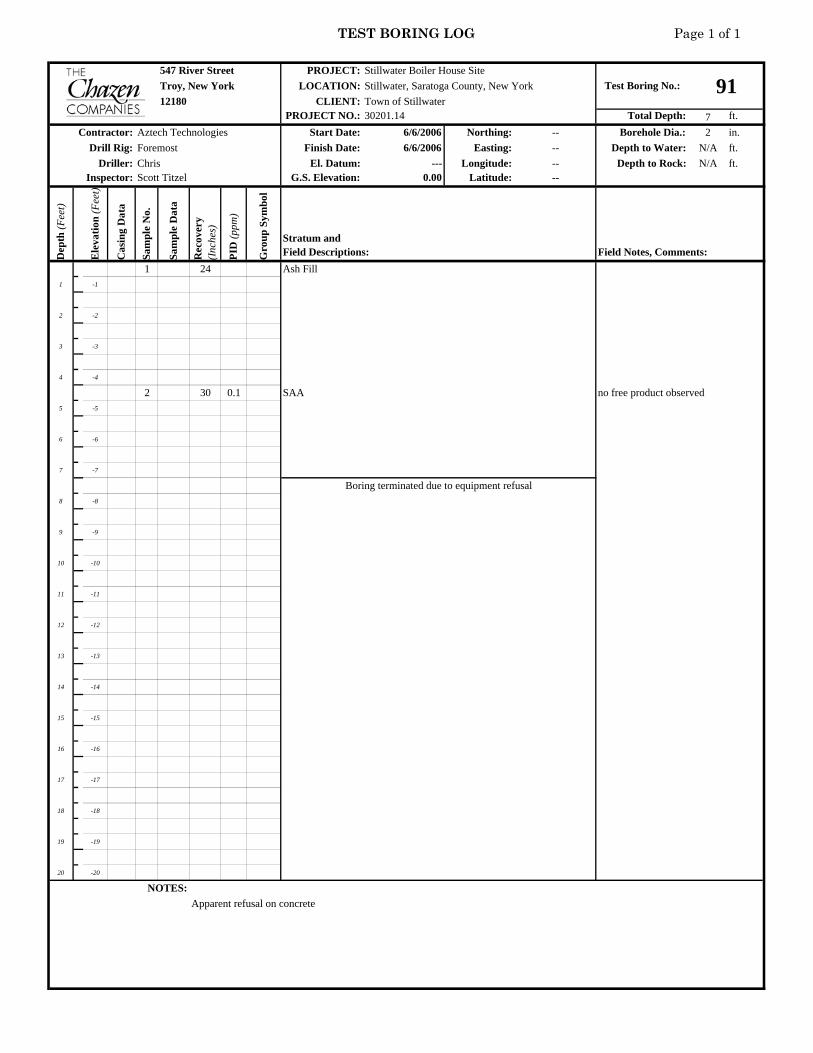
TEST BORING LOG Page 1 of 1
547 River Street PROJECT:Troy, New York LOCATION:
CLIENT:PROJECT NO.: Total Depth: 7 ft.
Start Date: 6/6/2006 Northing: -- Borehole Dia.: 2 in.Finish Date: 6/6/2006 Easting: -- Depth to Water: N/A ft.
El. Datum: --- Longitude: -- Depth to Rock: N/A ft.G.S. Elevation: 0.00 Latitude: --
Dep
th (F
eet)
Ele
vatio
n (F
eet)
Cas
ing
Dat
a
Sam
ple
No.
Sam
ple
Dat
a
Rec
over
y (I
nche
s)
PID
(ppm
)
Gro
up S
ymbo
l1 24 Ash Fill
1 -1
2 -2
3 -3
4 -4
2 30 0.1 SAA no free product observed5 -5
6 -6
7 -7
8 -8
9 -9
10 -10
11 -11
12 -12
13 -13
14 -14
15 -15
16 -16
17 -17
18 -18
19 -19
20 -20
NOTES:Apparent refusal on concrete
Stillwater Boiler House SiteTest Boring No.: 91Stillwater, Saratoga County, New York
12180 Town of Stillwater30201.14
Contractor: Aztech TechnologiesDrill Rig: Foremost
Driller: ChrisInspector: Scott Titzel
Boring terminated due to equipment refusal
Stratum andField Descriptions: Field Notes, Comments:

TEST BORING LOG Page 1 of 1
547 River Street PROJECT:Troy, New York LOCATION:
CLIENT:PROJECT NO.: Total Depth: 11 ft.
Start Date: 6/6/2006 Northing: -- Borehole Dia.: 2 in.Finish Date: 6/6/2006 Easting: -- Depth to Water: N/A ft.
El. Datum: --- Longitude: -- Depth to Rock: 11 ft.G.S. Elevation: 0.00 Latitude: --
Dep
th (F
eet)
Ele
vatio
n (F
eet)
Cas
ing
Dat
a
Sam
ple
No.
Sam
ple
Dat
a
Rec
over
y (I
nche
s)
PID
(ppm
)
Gro
up S
ymbo
l1 24 Ash Fill
1 -1
2 -2
3 -3
4 -4
2 30 Sandy Gravel no free product observed5 -5 Gray-brown mottled clayey gravel
6 -6
7 -7
8 -8
3 18 SAA9 -9
10 -10
11 -11 very moist, weathered shale
12 -12
13 -13
14 -14
15 -15
16 -16
17 -17
18 -18
19 -19
20 -20
NOTES:
Stillwater Boiler House SiteTest Boring No.: 92Stillwater, Saratoga County, New York
12180 Town of Stillwater30201.14
Contractor: Aztech TechnologiesDrill Rig: Foremost
Driller: ChrisInspector: Scott Titzel
Boring terminated due to equipment refusal on bedrock
Stratum andField Descriptions: Field Notes, Comments:

TEST BORING LOG Page 1 of 1
547 River Street PROJECT:Troy, New York LOCATION:
CLIENT:PROJECT NO.: Total Depth: 8 ft.
Start Date: 6/6/2006 Northing: -- Borehole Dia.: 2 in.Finish Date: 6/6/2006 Easting: -- Depth to Water: N/A ft.
El. Datum: --- Longitude: -- Depth to Rock: 7.5 ft.G.S. Elevation: 0.00 Latitude: --
Dep
th (F
eet)
Ele
vatio
n (F
eet)
Cas
ing
Dat
a
Sam
ple
No.
Sam
ple
Dat
a
Rec
over
y (I
nche
s)
PID
(ppm
)
Gro
up S
ymbo
l1 20 Ash Fill
1 -1
2 -2 Brown, soft, silty Clay, moist
3 -3
4 -4
2 24 Brown-gray mottled, clayey gravel, stiff no free product observed5 -5
6 -6
7 -7
moist, weathered shale8 -8
9 -9
10 -10
11 -11
12 -12
13 -13
14 -14
15 -15
16 -16
17 -17
18 -18
19 -19
20 -20
NOTES:
Stillwater Boiler House SiteTest Boring No.: 93Stillwater, Saratoga County, New York
12180 Town of Stillwater30201.14
Contractor: Aztech TechnologiesDrill Rig: Foremost
Driller: ChrisInspector: Scott Titzel
Boring terminated due to equipment refusal on bedrock
Stratum andField Descriptions: Field Notes, Comments:

TEST BORING LOG Page 1 of 1
547 River Street PROJECT:Troy, New York LOCATION:
CLIENT:PROJECT NO.: Total Depth: 7 ft.
Start Date: 6/6/2006 Northing: -- Borehole Dia.: 2 in.Finish Date: 6/6/2006 Easting: -- Depth to Water: N/A ft.
El. Datum: --- Longitude: -- Depth to Rock: 6.5 ft.G.S. Elevation: 0.00 Latitude: --
Dep
th (F
eet)
Ele
vatio
n (F
eet)
Cas
ing
Dat
a
Sam
ple
No.
Sam
ple
Dat
a
Rec
over
y (I
nche
s)
PID
(ppm
)
Gro
up S
ymbo
l1 24 Ash Fill
1 -1
2 -2
3 -3
4 -4
2 36 SAA no free product observed5 -5
Clayey Gravel, stiff6 -6
7 -7 very moist, weathered shale
8 -8
9 -9
10 -10
11 -11
12 -12
13 -13
14 -14
15 -15
16 -16
17 -17
18 -18
19 -19
20 -20
NOTES:
Stillwater Boiler House SiteTest Boring No.: 94Stillwater, Saratoga County, New York
12180 Town of Stillwater30201.14
Contractor: Aztech TechnologiesDrill Rig: Foremost
Driller: ChrisInspector: Scott Titzel
Boring terminated due to equipment refusal on bedrock
Stratum andField Descriptions: Field Notes, Comments:
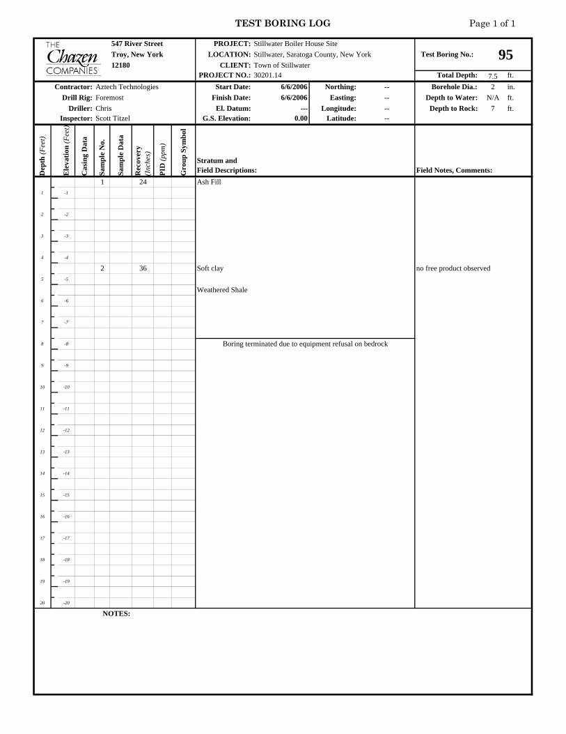
TEST BORING LOG Page 1 of 1
547 River Street PROJECT:Troy, New York LOCATION:
CLIENT:PROJECT NO.: Total Depth: 7.5 ft.
Start Date: 6/6/2006 Northing: -- Borehole Dia.: 2 in.Finish Date: 6/6/2006 Easting: -- Depth to Water: N/A ft.
El. Datum: --- Longitude: -- Depth to Rock: 7 ft.G.S. Elevation: 0.00 Latitude: --
Dep
th (F
eet)
Ele
vatio
n (F
eet)
Cas
ing
Dat
a
Sam
ple
No.
Sam
ple
Dat
a
Rec
over
y (I
nche
s)
PID
(ppm
)
Gro
up S
ymbo
l1 24 Ash Fill
1 -1
2 -2
3 -3
4 -4
2 36 Soft clay no free product observed5 -5
Weathered Shale6 -6
7 -7
8 -8
9 -9
10 -10
11 -11
12 -12
13 -13
14 -14
15 -15
16 -16
17 -17
18 -18
19 -19
20 -20
NOTES:
Stillwater Boiler House SiteTest Boring No.: 95Stillwater, Saratoga County, New York
12180 Town of Stillwater30201.14
Contractor: Aztech TechnologiesDrill Rig: Foremost
Driller: ChrisInspector: Scott Titzel
Boring terminated due to equipment refusal on bedrock
Stratum andField Descriptions: Field Notes, Comments:

TEST BORING LOG Page 1 of 1
547 River Street PROJECT:Troy, New York LOCATION:
CLIENT:PROJECT NO.: Total Depth: 7.5 ft.
Start Date: 6/6/2006 Northing: -- Borehole Dia.: 2 in.Finish Date: 6/6/2006 Easting: -- Depth to Water: N/A ft.
El. Datum: --- Longitude: -- Depth to Rock: 5.5 ft.G.S. Elevation: 0.00 Latitude: --
Dep
th (F
eet)
Ele
vatio
n (F
eet)
Cas
ing
Dat
a
Sam
ple
No.
Sam
ple
Dat
a
Rec
over
y (I
nche
s)
PID
(ppm
)
Gro
up S
ymbo
l1 24 0.2 Ash Fill
1 -1
2 -2
3 -3
4 -4
2 36 Soft clay no free product observed5 -5
Weathered Shale6 -6
7 -7
8 -8
9 -9
10 -10
11 -11
12 -12
13 -13
14 -14
15 -15
16 -16
17 -17
18 -18
19 -19
20 -20
NOTES:
Boring terminated due to equipment refusal on bedrock
Stratum andField Descriptions: Field Notes, Comments:
Driller: ChrisInspector: Scott Titzel
Contractor: Aztech TechnologiesDrill Rig: Foremost
Stillwater Boiler House SiteTest Boring No.: 96Stillwater, Saratoga County, New York
12180 Town of Stillwater30201.14
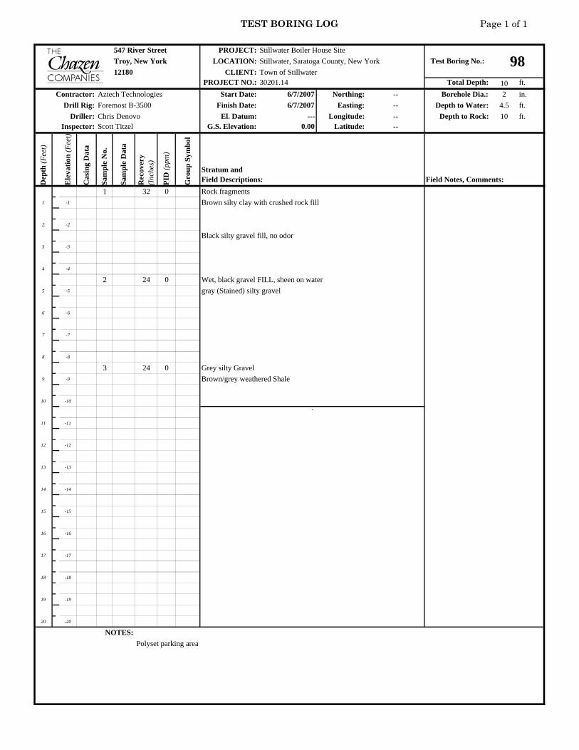
TEST BORING LOG Page 1 of 1
547 River Street PROJECT:Troy, New York LOCATION:
CLIENT:PROJECT NO.: Total Depth: 10 ft.
Start Date: 6/7/2007 Northing: -- Borehole Dia.: 2 in.Finish Date: 6/7/2007 Easting: -- Depth to Water: 4.5 ft.
El. Datum: --- Longitude: -- Depth to Rock: 10 ft.G.S. Elevation: 0.00 Latitude: --
Dep
th (F
eet)
Ele
vatio
n (F
eet)
Cas
ing
Dat
a
Sam
ple
No.
Sam
ple
Dat
a
Rec
over
y (I
nche
s)
PID
(ppm
)
Gro
up S
ymbo
l1 32 0 Rock fragments
1 -1 Brown silty clay with crushed rock fill
2 -2
Black silty gravel fill, no odor3 -3
4 -4
2 24 0 Wet, black gravel FILL, sheen on water5 -5 gray (Stained) silty gravel
6 -6
7 -7
8 -8
3 24 0 Grey silty Gravel9 -9 Brown/grey weathered Shale
10 -10
11 -11
12 -12
13 -13
14 -14
15 -15
16 -16
17 -17
18 -18
19 -19
20 -20
NOTES:Polyset parking area
Stillwater Boiler House SiteTest Boring No.: 98Stillwater, Saratoga County, New York
12180 Town of Stillwater30201.14
Contractor: Aztech TechnologiesDrill Rig: Foremost B-3500
Driller: Chris DenovoInspector: Scott Titzel
Stratum andField Descriptions: Field Notes, Comments:
`
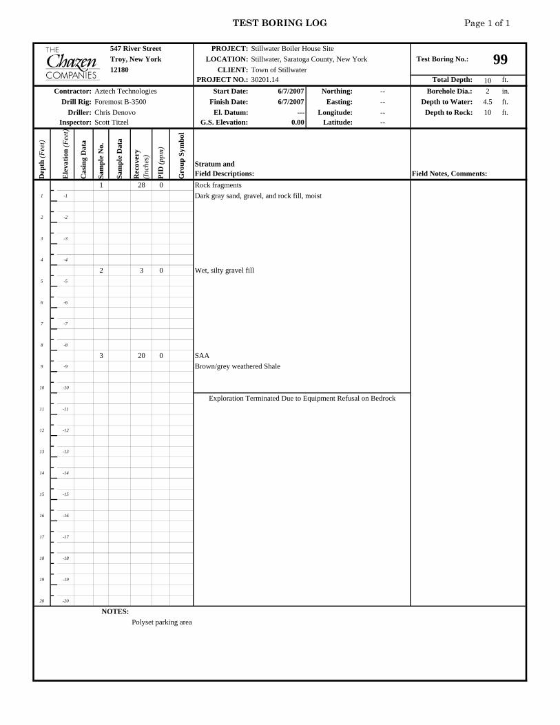
TEST BORING LOG Page 1 of 1
547 River Street PROJECT:Troy, New York LOCATION:
CLIENT:PROJECT NO.: Total Depth: 10 ft.
Start Date: 6/7/2007 Northing: -- Borehole Dia.: 2 in.Finish Date: 6/7/2007 Easting: -- Depth to Water: 4.5 ft.
El. Datum: --- Longitude: -- Depth to Rock: 10 ft.G.S. Elevation: 0.00 Latitude: --
Dep
th (F
eet)
Ele
vatio
n (F
eet)
Cas
ing
Dat
a
Sam
ple
No.
Sam
ple
Dat
a
Rec
over
y (I
nche
s)
PID
(ppm
)
Gro
up S
ymbo
l1 28 0 Rock fragments
1 -1 Dark gray sand, gravel, and rock fill, moist
2 -2
3 -3
4 -4
2 3 0 Wet, silty gravel fill5 -5
6 -6
7 -7
8 -8
3 20 0 SAA9 -9 Brown/grey weathered Shale
10 -10
11 -11
12 -12
13 -13
14 -14
15 -15
16 -16
17 -17
18 -18
19 -19
20 -20
NOTES:Polyset parking area
Stratum andField Descriptions: Field Notes, Comments:
Exploration Terminated Due to Equipment Refusal on Bedrock
Driller: Chris DenovoInspector: Scott Titzel
Contractor: Aztech TechnologiesDrill Rig: Foremost B-3500
Stillwater Boiler House SiteTest Boring No.: 99Stillwater, Saratoga County, New York
12180 Town of Stillwater30201.14

TEST BORING LOG Page 1 of 1
547 River Street PROJECT:Troy, New York LOCATION:
CLIENT:PROJECT NO.: Total Depth: 5 ft.
Start Date: 6/7/2007 Northing: -- Borehole Dia.: 2 in.Finish Date: 6/7/2007 Easting: -- Depth to Water: N/A ft.
El. Datum: --- Longitude: -- Depth to Rock: N/A ft.G.S. Elevation: 0.00 Latitude: --
Dep
th (F
eet)
Ele
vatio
n (F
eet)
Cas
ing
Dat
a
Sam
ple
No.
Sam
ple
Dat
a
Rec
over
y (I
nche
s)
PID
(ppm
)
Gro
up S
ymbo
l1 24 0 Rock fragments
1 -1
Brown silty clay with crushed rock fill2 -2
3 -3
4 -4
2 12 0 SAA5 -5 Concrete
6 -6
7 -7
8 -8
9 -9
10 -10
11 -11
12 -12
13 -13
14 -14
15 -15
16 -16
17 -17
18 -18
19 -19
20 -20
NOTES:Polyset parking area
Stillwater Boiler House SiteTest Boring No.: 100Stillwater, Saratoga County, New York
12180 Town of Stillwater30201.14
Contractor: Aztech TechnologiesDrill Rig: Foremost B-3500
Driller: Chris DenovoInspector: Scott Titzel
Stratum andField Descriptions: Field Notes, Comments:
Exploration Terminated Due to Equipment Refusal

TEST BORING LOG Page 1 of 1
547 River Street PROJECT:Troy, New York LOCATION:
CLIENT:PROJECT NO.: Total Depth: 8 ft.
Start Date: 6/7/2007 Northing: -- Borehole Dia.: 2 in.Finish Date: 6/7/2007 Easting: -- Depth to Water: 4.5 ft.
El. Datum: --- Longitude: -- Depth to Rock: 8 ft.G.S. Elevation: 0.00 Latitude: --
Dep
th (F
eet)
Ele
vatio
n (F
eet)
Cas
ing
Dat
a
Sam
ple
No.
Sam
ple
Dat
a
Rec
over
y (I
nche
s)
PID
(ppm
)
Gro
up S
ymbo
l1 32 0 Rock fragments
1 -1 Brown silty clay with crushed rock fill
2 -2
3 -3
4 -4
2 24 0 Dark gray sandy gravel fill, wet5 -5
6 -6
7 -7
8 -8 Brown/gray weathered shale
9 -9
10 -10
11 -11
12 -12
13 -13
14 -14
15 -15
16 -16
17 -17
18 -18
19 -19
20 -20
NOTES:Polyset parking area
Stratum andField Descriptions: Field Notes, Comments:
Exploration Terminated Due to Equipment Refusal on Bedrock
Driller: Chris DenovoInspector: Scott Titzel
Contractor: Aztech TechnologiesDrill Rig: Foremost B-3500
Stillwater Boiler House SiteTest Boring No.: 101Stillwater, Saratoga County, New York
12180 Town of Stillwater30201.14

TEST BORING LOG Page 1 of 1
547 River Street PROJECT:Troy, New York LOCATION:
CLIENT:PROJECT NO.: Total Depth: 8 ft.
Start Date: 6/7/2007 Northing: -- Borehole Dia.: 2 in.Finish Date: 6/7/2007 Easting: -- Depth to Water: 4.5 ft.
El. Datum: --- Longitude: -- Depth to Rock: 8 ft.G.S. Elevation: 0.00 Latitude: --
Dep
th (F
eet)
Ele
vatio
n (F
eet)
Cas
ing
Dat
a
Sam
ple
No.
Sam
ple
Dat
a
Rec
over
y (I
nche
s)
PID
(ppm
)
Gro
up S
ymbo
l1 24 0 Fill, dark gray, sand, gravel, and rock fragments, brick
1 -1
2 -2
3 -3
4 -4
2 24 0 SAA5 -5
Brown, silty gravel6 -6
7 -7
8 -8 Shale in tip
9 -9
10 -10
11 -11
12 -12
13 -13
14 -14
15 -15
16 -16
17 -17
18 -18
19 -19
20 -20
NOTES:Polyset parking area
Stillwater Boiler House SiteTest Boring No.: 102Stillwater, Saratoga County, New York
12180 Town of Stillwater30201.14
Contractor: Aztech TechnologiesDrill Rig: Foremost B-3500
Driller: Chris DenovoInspector: Scott Titzel
Stratum andField Descriptions: Field Notes, Comments:
Exploration Terminated Due to Equipment Refusal on Bedrock

TEST BORING LOG Page 1 of 1
547 River Street PROJECT:Troy, New York LOCATION:
CLIENT:PROJECT NO.: Total Depth: 11.5 ft.
Start Date: 6/7/2007 Northing: -- Borehole Dia.: 2 in.Finish Date: 6/7/2007 Easting: -- Depth to Water: 5 ft.
El. Datum: --- Longitude: -- Depth to Rock: 11.5 ft.G.S. Elevation: 0.00 Latitude: --
Dep
th (F
eet)
Ele
vatio
n (F
eet)
Cas
ing
Dat
a
Sam
ple
No.
Sam
ple
Dat
a
Rec
over
y (I
nche
s)
PID
(ppm
)
Gro
up S
ymbo
l1 24 0 Fill
1 -1
2 -2
3 -3
4 -4
2 24 0 SAA5 -5
6 -6
7 -7
8 -8
3 18 0 Weathered Shale, wet9 -9
10 -10
11 -11
12 -12
13 -13
14 -14
15 -15
16 -16
17 -17
18 -18
19 -19
20 -20
NOTES:Polyset parking area
Stratum andField Descriptions: Field Notes, Comments:
Exploration Terminated Due to Equipment Refusal on Bedrock
Driller: Chris DenovoInspector: Scott Titzel
Contractor: Aztech TechnologiesDrill Rig: Foremost B-3500
Stillwater Boiler House SiteTest Boring No.: 103Stillwater, Saratoga County, New York
12180 Town of Stillwater30201.14

TEST BORING LOG Page 1 of 1
547 River Street PROJECT:Troy, New York LOCATION:
CLIENT:PROJECT NO.: Total Depth: 9 ft.
Start Date: 6/7/2007 Northing: -- Borehole Dia.: 2 in.Finish Date: 6/7/2007 Easting: -- Depth to Water: 5.5 ft.
El. Datum: --- Longitude: -- Depth to Rock: 9 ft.G.S. Elevation: 0.00 Latitude: --
Dep
th (F
eet)
Ele
vatio
n (F
eet)
Cas
ing
Dat
a
Sam
ple
No.
Sam
ple
Dat
a
Rec
over
y (I
nche
s)
PID
(ppm
)
Gro
up S
ymbo
l1 24 0 Fill, Gray
1 -1
2 -2
3 -3
4 -4
2 24 0 SAA5 -5
6 -6 wet
7 -7
8 -8
3 12 0 SAA9 -9 Shale
10 -10
11 -11
12 -12
13 -13
14 -14
15 -15
16 -16
17 -17
18 -18
19 -19
20 -20
NOTES:Polyset parking area
Stillwater Boiler House SiteTest Boring No.: 104Stillwater, Saratoga County, New York
12180 Town of Stillwater30201.14
Contractor: Aztech TechnologiesDrill Rig: Foremost B-3500
Driller: Chris DenovoInspector: Scott Titzel
Stratum andField Descriptions: Field Notes, Comments:
Exploration Terminated Due to Equipment Refusal on Bedrock

TEST BORING LOG Page 1 of 1
547 River Street PROJECT:Troy, New York LOCATION:
CLIENT:PROJECT NO.: Total Depth: 6 ft.
Start Date: 6/7/2007 Northing: -- Borehole Dia.: 2 in.Finish Date: 6/7/2007 Easting: -- Depth to Water: 5 ft.
El. Datum: --- Longitude: -- Depth to Rock: 6 ft.G.S. Elevation: 0.00 Latitude: --
Dep
th (F
eet)
Ele
vatio
n (F
eet)
Cas
ing
Dat
a
Sam
ple
No.
Sam
ple
Dat
a
Rec
over
y (I
nche
s)
PID
(ppm
)
Gro
up S
ymbo
l1 24 0 Fill, Gray
1 -1
2 -2
3 -3
4 -4
2 24 0 SAA, wet5 -5
6 -6
7 -7
8 -8
9 -9
10 -10
11 -11
12 -12
13 -13
14 -14
15 -15
16 -16
17 -17
18 -18
19 -19
20 -20
NOTES:Polyset parking area
Stratum andField Descriptions: Field Notes, Comments:
Exploration Terminated Due to Equipment Refusal on Bedrock
Driller: Chris DenovoInspector: Scott Titzel
Contractor: Aztech TechnologiesDrill Rig: Foremost B-3500
Stillwater Boiler House SiteTest Boring No.: 105Stillwater, Saratoga County, New York
12180 Town of Stillwater30201.14

TEST BORING LOG Page 1 of 1
547 River Street PROJECT:Troy, New York LOCATION:
CLIENT:PROJECT NO.: Total Depth: 3 ft.
Start Date: 6/7/2007 Northing: -- Borehole Dia.: 2 in.Finish Date: 6/7/2007 Easting: -- Depth to Water: N/A ft.
El. Datum: --- Longitude: -- Depth to Rock: N/A ft.G.S. Elevation: 0.00 Latitude: --
Dep
th (F
eet)
Ele
vatio
n (F
eet)
Cas
ing
Dat
a
Sam
ple
No.
Sam
ple
Dat
a
Rec
over
y (I
nche
s)
PID
(ppm
)
Gro
up S
ymbo
l1 24 0 Fill, Gray
1 -1
2 -2
3 -3
4 -4
5 -5
6 -6
7 -7
8 -8
9 -9
10 -10
11 -11
12 -12
13 -13
14 -14
15 -15
16 -16
17 -17
18 -18
19 -19
20 -20
NOTES:Polyset parking area
Stratum andField Descriptions: Field Notes, Comments:
Exploration Terminated Due to Equipment Refusal
Driller: Chris DenovoInspector: Scott Titzel
Contractor: Aztech TechnologiesDrill Rig: Foremost B-3500
Stillwater Boiler House SiteTest Boring No.: 107Stillwater, Saratoga County, New York
12180 Town of Stillwater30201.14

TEST BORING LOG Page 1 of 1
547 River Street PROJECT:Troy, New York LOCATION:
CLIENT:PROJECT NO.: Total Depth: 2 ft.
Start Date: 6/7/2007 Northing: -- Borehole Dia.: 2 in.Finish Date: 6/7/2007 Easting: -- Depth to Water: N/A ft.
El. Datum: --- Longitude: -- Depth to Rock: N/A ft.G.S. Elevation: 0.00 Latitude: --
Dep
th (F
eet)
Ele
vatio
n (F
eet)
Cas
ing
Dat
a
Sam
ple
No.
Sam
ple
Dat
a
Rec
over
y (I
nche
s)
PID
(ppm
)
Gro
up S
ymbo
l1 24 0 Fill, Gray
1 -1
2 -2
3 -3
4 -4
5 -5
6 -6
7 -7
8 -8
9 -9
10 -10
11 -11
12 -12
13 -13
14 -14
15 -15
16 -16
17 -17
18 -18
19 -19
20 -20
NOTES:Polyset parking area
Stratum andField Descriptions: Field Notes, Comments:
Exploration Terminated Due to Equipment Refusal
Driller: Chris DenovoInspector: Scott Titzel
Contractor: Aztech TechnologiesDrill Rig: Foremost B-3500
Stillwater Boiler House SiteTest Boring No.: 108Stillwater, Saratoga County, New York
12180 Town of Stillwater30201.14

TEST BORING LOG Page 1 of 1
547 River Street PROJECT:Troy, New York LOCATION:
CLIENT:PROJECT NO.: Total Depth: 2 ft.
Start Date: 6/7/2007 Northing: -- Borehole Dia.: 2 in.Finish Date: 6/7/2007 Easting: -- Depth to Water: N/A ft.
El. Datum: --- Longitude: -- Depth to Rock: N/A ft.G.S. Elevation: 0.00 Latitude: --
Dep
th (F
eet)
Ele
vatio
n (F
eet)
Cas
ing
Dat
a
Sam
ple
No.
Sam
ple
Dat
a
Rec
over
y (I
nche
s)
PID
(ppm
)
Gro
up S
ymbo
l1 24 0 Fill, Gray
1 -1
2 -2
3 -3
4 -4
5 -5
6 -6
7 -7
8 -8
9 -9
10 -10
11 -11
12 -12
13 -13
14 -14
15 -15
16 -16
17 -17
18 -18
19 -19
20 -20
NOTES:Polyset parking area
Stillwater Boiler House SiteTest Boring No.: 109Stillwater, Saratoga County, New York
12180 Town of Stillwater30201.14
Contractor: Aztech TechnologiesDrill Rig: Foremost B-3500
Driller: Chris DenovoInspector: Scott Titzel
Stratum andField Descriptions: Field Notes, Comments:
Exploration Terminated Due to Equipment Refusal
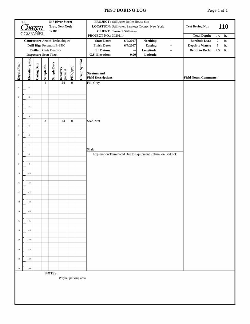
TEST BORING LOG Page 1 of 1
547 River Street PROJECT:Troy, New York LOCATION:
CLIENT:PROJECT NO.: Total Depth: 7.5 ft.
Start Date: 6/7/2007 Northing: -- Borehole Dia.: 2 in.Finish Date: 6/7/2007 Easting: -- Depth to Water: 5 ft.
El. Datum: --- Longitude: -- Depth to Rock: 7.5 ft.G.S. Elevation: 0.00 Latitude: --
Dep
th (F
eet)
Ele
vatio
n (F
eet)
Cas
ing
Dat
a
Sam
ple
No.
Sam
ple
Dat
a
Rec
over
y (I
nche
s)
PID
(ppm
)
Gro
up S
ymbo
l1 24 0 Fill, Gray
1 -1
2 -2
3 -3
4 -4
2 24 0 SAA, wet5 -5
6 -6
7 -7
Shale8 -8
9 -9
10 -10
11 -11
12 -12
13 -13
14 -14
15 -15
16 -16
17 -17
18 -18
19 -19
20 -20
NOTES:Polyset parking area
Stillwater Boiler House SiteTest Boring No.: 110Stillwater, Saratoga County, New York
12180 Town of Stillwater30201.14
Contractor: Aztech TechnologiesDrill Rig: Foremost B-3500
Driller: Chris DenovoInspector: Scott Titzel
Stratum andField Descriptions: Field Notes, Comments:
Exploration Terminated Due to Equipment Refusal on Bedrock

TEST BORING LOG Page 1 of 1
547 River Street PROJECT:Troy, New York LOCATION:
CLIENT:PROJECT NO.: Total Depth: 7.5 ft.
Start Date: 6/7/2007 Northing: -- Borehole Dia.: 2 in.Finish Date: 6/7/2007 Easting: -- Depth to Water: 5 ft.
El. Datum: --- Longitude: -- Depth to Rock: 7.5 ft.G.S. Elevation: 0.00 Latitude: --
Dep
th (F
eet)
Ele
vatio
n (F
eet)
Cas
ing
Dat
a
Sam
ple
No.
Sam
ple
Dat
a
Rec
over
y (I
nche
s)
PID
(ppm
)
Gro
up S
ymbo
l1 24 0 Fill, Gray
1 -1
2 -2
3 -3
4 -4
2 24 0 SAA, wet5 -5
6 -6
7 -7
Shale8 -8
9 -9
10 -10
11 -11
12 -12
13 -13
14 -14
15 -15
16 -16
17 -17
18 -18
19 -19
20 -20
NOTES:Polyset parking area
Stratum andField Descriptions: Field Notes, Comments:
Exploration Terminated Due to Equipment Refusal on Bedrock
Driller: Chris DenovoInspector: Scott Titzel
Contractor: Aztech TechnologiesDrill Rig: Foremost B-3500
Stillwater Boiler House SiteTest Boring No.: 111Stillwater, Saratoga County, New York
12180 Town of Stillwater30201.14

TEST BORING LOG Page 1 of 1
547 River Street PROJECT:Troy, New York LOCATION:
CLIENT:PROJECT NO.: Total Depth: 7.5 ft.
Start Date: 6/7/2007 Northing: -- Borehole Dia.: 2 in.Finish Date: 6/7/2007 Easting: -- Depth to Water: 5 ft.
El. Datum: --- Longitude: -- Depth to Rock: 7.5 ft.G.S. Elevation: 0.00 Latitude: --
Dep
th (F
eet)
Ele
vatio
n (F
eet)
Cas
ing
Dat
a
Sam
ple
No.
Sam
ple
Dat
a
Rec
over
y (I
nche
s)
PID
(ppm
)
Gro
up S
ymbo
l1 24 0 Fill, Gray
1 -1
2 -2
3 -3
4 -4
2 24 0 SAA, wet5 -5
6 -6
7 -7
Shale8 -8
9 -9
10 -10
11 -11
12 -12
13 -13
14 -14
15 -15
16 -16
17 -17
18 -18
19 -19
20 -20
NOTES:Polyset parking area
Stillwater Boiler House SiteTest Boring No.: 112Stillwater, Saratoga County, New York
12180 Town of Stillwater30201.14
Contractor: Aztech TechnologiesDrill Rig: Foremost B-3500
Driller: Chris DenovoInspector: Scott Titzel
Stratum andField Descriptions: Field Notes, Comments:
Exploration Terminated Due to Equipment Refusal on Bedrock

TEST BORING LOG Page 1 of 1
547 River Street PROJECT:Troy, New York LOCATION:
CLIENT:PROJECT NO.: Total Depth: 7.5 ft.
Start Date: 6/7/2007 Northing: -- Borehole Dia.: 2 in.Finish Date: 6/7/2007 Easting: -- Depth to Water: 5 ft.
El. Datum: --- Longitude: -- Depth to Rock: 7.5 ft.G.S. Elevation: 0.00 Latitude: --
Dep
th (F
eet)
Ele
vatio
n (F
eet)
Cas
ing
Dat
a
Sam
ple
No.
Sam
ple
Dat
a
Rec
over
y (I
nche
s)
PID
(ppm
)
Gro
up S
ymbo
l1 24 0 Fill, Gray
1 -1
2 -2
3 -3
4 -4
2 24 0 SAA, wet5 -5
6 -6
7 -7
Shale8 -8
9 -9
10 -10
11 -11
12 -12
13 -13
14 -14
15 -15
16 -16
17 -17
18 -18
19 -19
20 -20
NOTES:Polyset parking area
Stratum andField Descriptions: Field Notes, Comments:
Exploration Terminated Due to Equipment Refusal on Bedrock
Driller: Chris DenovoInspector: Scott Titzel
Contractor: Aztech TechnologiesDrill Rig: Foremost B-3500
Stillwater Boiler House SiteTest Boring No.: 113Stillwater, Saratoga County, New York
12180 Town of Stillwater30201.14

TEST BORING LOG Page 1 of 1
547 River Street PROJECT:Troy, New York LOCATION:
CLIENT:PROJECT NO.: Total Depth: 10 ft.
Start Date: 7/27/2006 Northing: -- Borehole Dia.: 2 in.Finish Date: 7/27/2006 Easting: -- Depth to Water: 4.5 ft.
El. Datum: --- Longitude: -- Depth to Rock: 10 ft.G.S. Elevation: 0.00 Latitude: --
Dep
th (F
eet)
Ele
vatio
n (F
eet)
Cas
ing
Dat
a
Sam
ple
No.
Sam
ple
Dat
a
Rec
over
y (I
nche
s)
PID
(ppm
)
Gro
up S
ymbo
l1 40 blacktop and road base
1 -1 black SILT w/ sand and red brick fragments - damp
2 -2 SAA
3 -3
4 -4 2 42 fine grained black SAND w/some silt and angular shale fragments, moist
SAA - wet5 -5
6 -6 SAA
7 -7
8 -8 3 30 black SILTY fine-grained sand w/ rock fragments
9 -9
10 -10 refusal
11 -11
12 -12
13 -13
14 -14
15 -15
16 -16
17 -17
18 -18
19 -19
20 -20
NOTES:Polyset parking areaThere is no SB114
Stratum andField Descriptions: Field Notes, Comments:
Boring terminated
Driller: Chris DenovoInspector: Charles Post
Contractor: Aztech TechnologiesDrill Rig: Foremost B-3500
Stillwater Boiler House SiteTest Boring No.: 115Stillwater, Saratoga County, New York
12180 Town of Stillwater30201.14
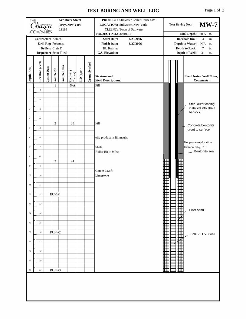
TEST BORING AND WELL LOG Page 1 of 2
547 River Street PROJECT:Troy, New York LOCATION:12180 CLIENT:
PROJECT NO.: Total Depth: 31.5 ft.Start Date: 6/23/2006 Borehole Dia.: 4 in.
Finish Date: 6/27/2006 Depth to Water: N/A ft.El. Datum: Depth to Rock: 7 ft.
G.S. Elevation: Depth of Well: 31 ft.
Dep
th (F
eet)
Ele
vatio
n (F
eet)
Cas
ing
Dat
a
Sam
ple
No.
Sam
ple
Dat
a
Rec
over
y (I
nche
s)
PID
(ppm
)
Gro
up S
ymbo
l1 N/A Fill
1 -1
2 -2
3 -3
4 -4
2 30 Fill5 -5
6 -6 oily product in fill matrixGeoprobe exploration
7 -7 Shale terminated @ 7 ft.Roller Bit to 9 feet
8 -8
3 249 -9
Core 9-31.5ft10 -10 Limestone
11 -11
12 -12 RUN #1
13 -13
14 -14
15 -15
16 -16 RUN #2
17 -17
18 -18
19 -19
20 -20 RUN #3
Chris D.
Contractor:Drill Rig:
Driller:Scott Titzel
Test Boring No.:
Inspector:
Stillwater Boiler House SiteStillwater, New York
30201.14Town of Stillwater
AztechForemost
MW-7
Field Notes, Well Notes, Comments:
Stratum andField Descriptions:
Steel outer casing installed into shale bedrock
Concrete/bentonitegrout to surface
Filter sand
Sch. 20 PVC well
Bentonite seal

TEST BORING AND WELL LOG Page 2 of 2
547 River Street PROJECT:Troy, New York LOCATION:12180 CLIENT:
PROJECT NO.: Total Depth: 31.5 ft.D
epth
(Fee
t)
Ele
vatio
n (F
eet)
Cas
ing
Dat
a
Sam
ple
No.
Sam
ple
Dat
a
Rec
over
y (I
nche
s)
PID
(ppm
)
Gro
up S
ymbo
l
21 -21
22 -22
23 -23
24 -24
25 -25
26 -26
27 -27
28 -28
29 -29
30 -30
31 -31
32 -32
33 -33
34 -34
35 -35
36 -36
37 -37
38 -38
39 -39
40 -40
41 -41
42 -42
43 -43
44 -44
45 -45
ADDITIONAL NOTES:
Stratum andField Descriptions: W
ell D
iagr
am
Stillwater Boiler House SiteStillwater, New York
30201.14Town of Stillwater
Exploration terminated at 31 feet
Test Boring No.: MW-7
Field Notes, Well Notes, Comments:
RUN 4
RUN 5

APPENDIX C Subsurface Test Pit Logs


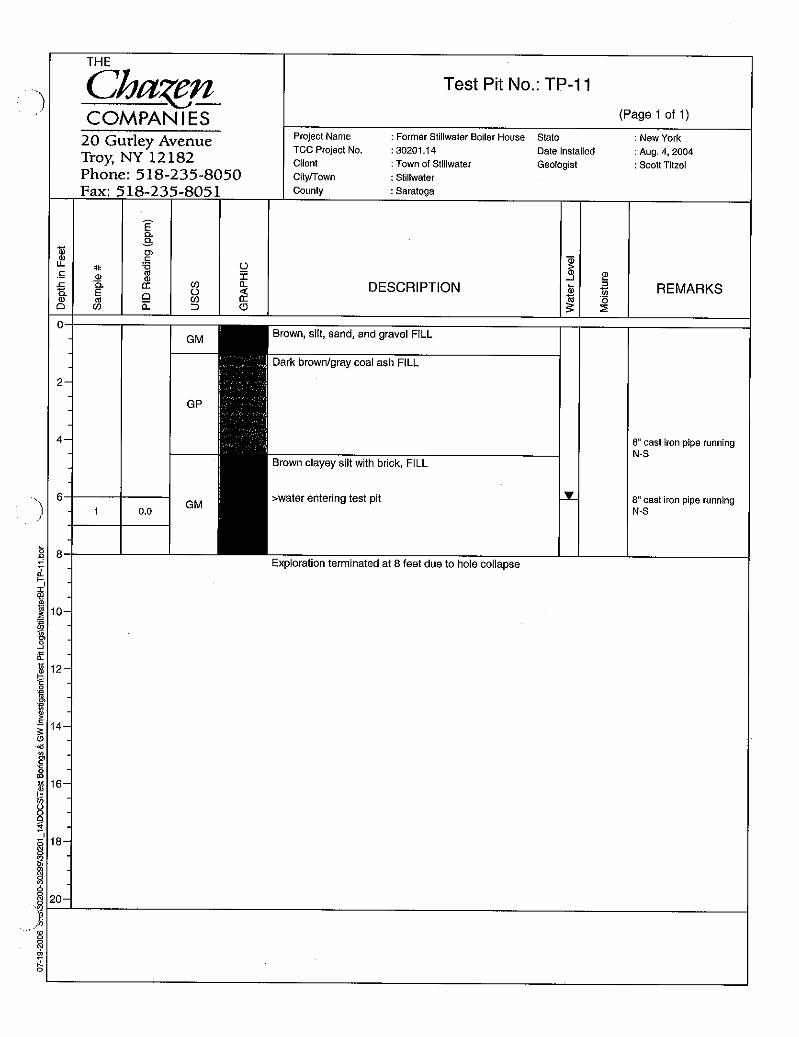


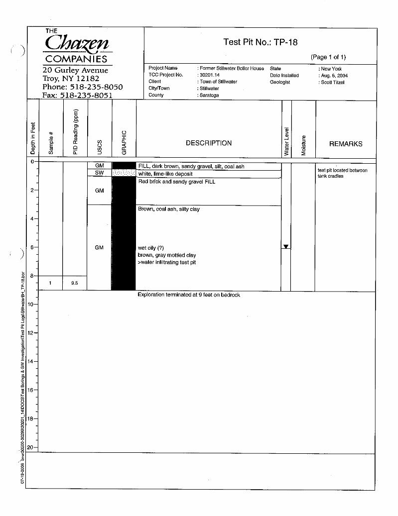


APPENDIX D Lead-Based Paint Building Materials Survey and Asbestos Soil
Evaluation Report