Re: Supplemental Site Characterization Report … SITE CHARACTERIZATION REPORT Former Nash Road...
32
495 Aero Drive, Suite 3, Cheektowaga, NY 14225 • 1‐800‐287‐7857 • www.gesonline.com November 12, 2013 Mr. Gregory Sutton NYSDEC, Region 9 270 Michigan Avenue Buffalo, New York 14203 Re: Supplemental Site Characterization Report Former Nash Road Landfill Town of Wheatfield Niagara County, New York NYSDEC Site # 932054 Dear Mr. Sutton: Groundwater & Environmental Services, Inc. (GES) has prepared the enclosed Supplemental Site Characterization Report the Former Nash Road Landfill site; located in the Town of Wheatfield in Niagara County, New York. The work was completed in accordance with the call-out issued by New York State Department of Environmental Conservation (NYSDEC) on March 26, 2013 as well as the NYSDEC-approved Site Characterization Workplan prepared by GES and submitted on June 10, 2013. If you have any questions or comments, please do not hesitate to contact GES at your convenience. Sincerely, GROUNDWATER & ENVIRONMENTAL SERVICES, INC. Eric D. Popken Project Manager Enclosure
Transcript of Re: Supplemental Site Characterization Report … SITE CHARACTERIZATION REPORT Former Nash Road...

495 Aero Drive, Suite 3, Cheektowaga, NY 14225 • 1‐800‐287‐7857 • www.gesonline.com
November 12, 2013 Mr. Gregory Sutton NYSDEC, Region 9 270 Michigan Avenue Buffalo, New York 14203 Re: Supplemental Site Characterization Report Former Nash Road Landfill Town of Wheatfield Niagara County, New York NYSDEC Site # 932054 Dear Mr. Sutton: Groundwater & Environmental Services, Inc. (GES) has prepared the enclosed Supplemental Site Characterization Report the Former Nash Road Landfill site; located in the Town of Wheatfield in Niagara County, New York. The work was completed in accordance with the call-out issued by New York State Department of Environmental Conservation (NYSDEC) on March 26, 2013 as well as the NYSDEC-approved Site Characterization Workplan prepared by GES and submitted on June 10, 2013. If you have any questions or comments, please do not hesitate to contact GES at your convenience. Sincerely, GROUNDWATER & ENVIRONMENTAL SERVICES, INC.
Eric D. Popken Project Manager Enclosure

SUPPLEMENTAL SITE CHARACTERIZATION REPORT
Former Nash Road Landfill Town of Wheatfield
Niagara County, New York NYSDEC Site #932054
Prepared for
New York State Department of Environmental Conservation 270 Michigan Avenue
Buffalo, New York 14203
Report Date
November 12, 2013
Prepared By: Reviewed By:
Eric D. Popken
Project Manager
Steven P. Leitten
Senior Project Manager
GROUNDWATER & ENVIRONMENTAL SERVICES, INC. 495 Aero Drive, Suite 3
Cheektowaga, NY 14225 1-800-287-7857

TABLE OF CONTENTS
1.0 INTRODUCTION ........................................................................................................................... 1
2.0 PREVIOUS SITE INVESTIGATIONS AND HISTORICAL DOCUMENTS .......................... 1
3.0 SITE CHARACTERIZATION WORKPLAN ............................................................................. 1
4.0 SITE INSPECTION / SURVEY / SETTING ................................................................................ 2
4.1 SITE SURVEY .................................................................................................................................................... 2
5.0 SURFACE SOIL AND WATER SAMPLING ............................................................................. 3
5.1 SURFACE SOIL / SEDIMENT SAMPLING .............................................................................................................. 3 5.2 SURFACE WATER SAMPLING ............................................................................................................................. 4
6.0 SURFACE SOIL AND WATER SAMPLING RESULTS ........................................................... 4
6.1 SURFACE SOIL ANALYTICAL RESULTS ............................................................................................................... 4 6.2 SURFACE WATER ANALYTICAL RESULTS ............................................................................................................ 5
7.0 SUBSURFACE INVESTIGATION ............................................................................................... 5
7.1 SOIL BORINGS ................................................................................................................................................. 5 7.2 MONITORING WELL INSTALLATION ................................................................................................................... 6 7.3 INVESTIGATION DERIVED WASTE ...................................................................................................................... 6 7.4 MONITORING WELL DEVELOPMENT ................................................................................................................. 6 7.5 MONITORING WELL SAMPLING ......................................................................................................................... 7
8.0 SUBSURFACE INVESTIGATION RESULTS ............................................................................ 7
8.1 LITHOLOGY AND FIELD OBSERVATIONS ............................................................................................................ 7 8.2 SOIL BORING SAMPLE ANALYTICAL RESULTS .................................................................................................... 8 8.3 SITE HYDROLOGY AND SHALLOW AQUIFER HYDROGEOLOGY ............................................................................ 9 8.4 GROUNDWATER ANALYTICAL RESULTS ........................................................................................................... 10
9.0 SUMMARY, DISCUSSION, AND RECOMMENDATIONS ................................................... 10
9.1 SURFACE SOIL CONTAMINANT EXPOSURE ....................................................................................................... 10 9.2 SURFACE WATER CONTAMINANT EXPOSURE ................................................................................................... 10 9.3 SUBSURFACE SOIL CONTAMINANT EXPOSURE ................................................................................................. 11 9.4 GROUNDWATER CONTAMINANT EXPOSURE ..................................................................................................... 11
FIGURES
Figure 1 Site Map Figure 2 Site Location Map Figure 3 Soil Sample Location Map Figure 4 Surface Water Sample Location Map Figure 5 Soil Boring/Monitoring Well Location Map Figure 6 Area of Soil Impacts Figure 7 Groundwater Elevation Contour Map – Shallow Aquifer

TABLES
Table 1 Sample Matrix Table 2 Surface Soil Analytical Data Table 3 Surface Water Analytical Data Table 4 Soil Boring Analytical Data Table 5 Groundwater Gauging and Analytical Data
APPENDICES
Appendix A Historical Documentation Appendix B Sample Coordinates Appendix C Laboratory Analytical Reports Appendix D Soil Boring Logs/Monitoring Well Construction Information Appendix E Monitoring Well Development Data
Supplemental Site Characterization Report Former Nash Road Landfill NYSDEC Site #932054 November 2013
1
1.0 INTRODUCTION This report has been prepared for New York State Department of Environmental Conservation (NYSDEC) to document the field activities undertaken in 2013 by Groundwater & Environmental Services, Inc. (GES) to characterize soil and water conditions, both at the surface and below grade, on the former Nash Road Landfill property located in the Town of Wheatfield in Niagara County, New York. 2.0 PREVIOUS SITE INVESTIGATIONS AND HISTORICAL DOCUMENTS Previous site investigations included Phase II site investigations conducted in 1985 and 1989 prepared by Engineering-Science for NYSDEC. According to the 1989 Phase II Site Investigation, the Nash Road Landfill site was operated by the Niagara Sanitation Company between 1964 and 1968 for disposal of municipal and industrial wastes. NYSDEC records show that the site was used for disposal by the Niagara Falls Air Force Base, Bell Aerospace, Carborundum, Frontier Chemical, Graphite Specialties, Continental Can, and Grief Brothers. In June 1968, approximately 1600 cubic yards of material excavated from a sewer relocation project along Frontier Avenue (associated with the construction of the LaSalle Expressway) near the Love Canal site in Niagara Falls, New York was disposed at the Nash Landfill site in the area shown on Figure 1. Records indicated that the material contained chemical wastes. The 1985 Phase II Investigation Report was initially conducted across the site; however concerns regarding the portion of the site that received the Love Canal material prompted the 1989 study. The 1985 and 1989 investigations established the following site conditions:
The site geology consisted of five lithological units over dolostone bedrock: fill at grade, followed by a shallow sand lens, followed by clay, followed by a lower sand lens, followed by glacial till overlying the bedrock.
The site hydrogeology consisted of three water bearing zones: a shallow zone located in the fill and shallow sand lens, an intermediate zone located in the lower sand lens, and a deeper zone in the glacial till.
The 1989 investigation concluded that based on the soil and groundwater analytical data that was collected, the Love Canal wastes buried at the site have contributed to groundwater contamination in the shallow aquifer.
In addition to the historical documents referenced in the 1985 and 1989 investigations, additional historical documents were provided by Niagara County Department of Health (NCDOH) and are included in Appendix A. The historical documents reference additional chemical wastes that originated at or near the Love Canal site and were also buried at the Nash Road Landfill. 3.0 SITE CHARACTERIZATION WORKPLAN On June 10, 2013, GES submitted the NYSDEC-approved Site Characterization Work Plan for the site, which included an outline for plans to further characterize and delineate impacts previously discovered on-site, to assist NYSDEC in determining if the site poses a significant threat to public health and the environment from the possible exposure of industrial wastes that were reportedly disposed at the site. The scope of work included a site walk over, review of historical data and site information, the collection of surface soil samples, groundwater samples, surface water samples and advancement of additional soil borings, and installation of monitoring wells.

Supplemental Site Characterization Report Former Nash Road Landfill NYSDEC Site #932054 November 2013
2
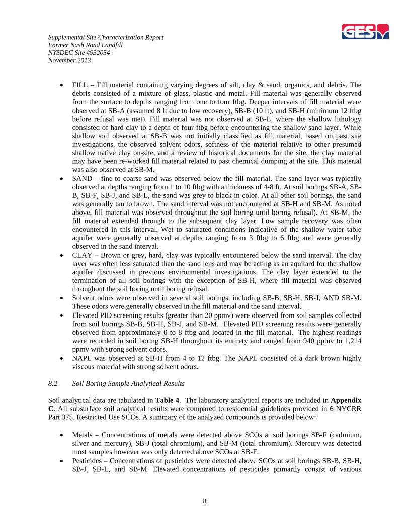
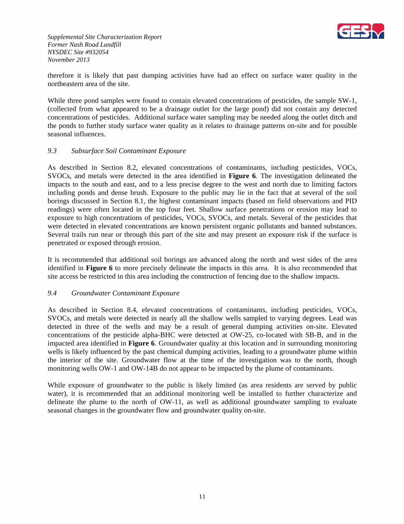
4.0 SITE INSPECTION / SURVEY / SETTING On April 10, 2013, GES met representatives from NYSDEC, New York State Department of Health (NYSDOH), and NCDOH to inspect the current site conditions. Site inspection involved identifying possible evidence of environmental contamination, location of existing monitoring wells, surface water locations, and site access. The site is bordered to the north by the Holy Infant Shrine, to the east by a cemetery as well as property that contains a motel and livery service, to the south by utility right-of-ways (both overhead electric and underground natural gas and brine lines), followed by residences, and to the west by Nash Road, followed by residences. A site location map for the site is provided in Figure 2. The site contained swamplands before landfilling began. The site is poorly drained and contains several ponds and areas of standing water. Since landfilling began, portions of the property are covered with surface water at certain times of the year, particularly in the spring and early summer. The site is wooded with mature trees, dense brush, and patches of phragmites in wet areas, as shown in Figure 1. Site topographically overall is flat with less than ten feet of relief, however landfilling of wastes and excavation of a disposal trench has resulted in irregular ground surface topography. Numerous mounds of soil/fill material were observed. Waste material was observed to be obtruding from the mounds. During the visit, evidence of partially buried waste were observed across the site, including tires, drums, battery casings, metal and plastic debris, and mounds of fill material. These observations were used to determine surface soil and water sample locations. There were numerous indications of trespass, including residential dumping, clusters of beverage cans, and all-terrain vehicle (ATV) & walking trails. The site is not fenced or secured. “No Trespassing” signs were placed in some locations along the perimeter of the site, however they are in derelict condition and most were covered in overgrowth. 4.1 Site Survey On April 24 and 25, 2013, GES surveyed the site using a Trimble GeoXH hand held Global Positioning System (GPS) unit with a Trimble GeoBeacon receiver. GPS data was collected to map the location of existing wells, planned surface sample locations, boundaries of surface water bodies, items observed during the April 10, 2013 inspection, and other site features. The data was entered into a Geographic Information System (GIS) database to produce the maps presented in this report. The site map was generated from available aerial maps for the site. Coordinates for all sample points are provided in Appendix B for future reference. On July 26, 2013 GES returned to the site with the GPS equipment to collect position data for all soil borings and new monitoring wells.

Supplemental Site Characterization Report Former Nash Road Landfill NYSDEC Site #932054 November 2013
3
5.0 SURFACE SOIL AND WATER SAMPLING On May 29, 2013, GES collected surface soil, water, and sediment samples to characterize current surface environmental conditions of the site. Samples were collected in accordance with the sampling matrix provided in Table 1 as well as the table provided below. 5.1 Surface Soil / Sediment Sampling Surface soil sample locations were chosen to evaluate for potential exposure of contaminants to pedestrians and all-terrain vehicle (ATV) riders who travel through the site. Sample locations were biased towards walking and ATV paths where there is obvious evidence of exposed waste from the former dumping activities. One sediment sample (SED-1) was collected from the drainage swale close to the northern property boundary where surface water appears to drain from the interior of the site (Figure 3). The table below provides information on the surface soil sample locations and their location description. Sample Name
Sample Type
Location Description Purpose of Evaluation
SOIL-1 Surface Soil ATV Trail Exposure of contaminants to the public. SOIL-2 Surface Soil Near Nimo Electric Tower
365 Exposure of contaminants to the public along power line
corridor, located adjacent to residences. SOIL-3 Surface Soil Near Nimo Electric Tower
364 Exposure of contaminants to the public along power line
corridor, located adjacent to residences. SOIL-4 Surface Soil Ridge Mound of Fill
Material Exposure of contaminants to the public.
SOIL-5 Surface Soil Black Staining Observed at Surface
Exposure of contaminants to the public.
SOIL-6 Surface Soil Mound of Fill Material Exposure of contaminants to the public. SOIL-7 Surface Soil Soil around large Boulders
at Surface Exposure of contaminants to the public.
SOIL-8 Surface Soil Mound of Fill Material Exposure of contaminants to the public. SOIL-9 Surface Soil Battery Casings Along
Trail Exposure of contaminants to the public.
SOIL-10 Surface Soil Soil Around Drums at the Edge of one of the Ponds
Potential concentrated impacts at edge of pond related to the observed drums.
SOIL-11 Surface Soil Soil from the “Barren Area” described in past reports and observed in
2013.
Exposure of contaminants to the public.
SED-1 Sediment Sediment From Drainage Swale
Evaluate sediment where surface water drainage leaves large pond towards drainage swale along north and east
perimeter of site. Surface soil and sediment samples were collected from within the top three inches of surface material using manual techniques. Samples were collected in laboratory supplied bottleware and submitted to TestAmerica Laboratories, Inc. (TestAmerica) of Amherst, New York for laboratory analysis of semi-volatile organic compounds (SVOCs) via United States Environmental Protection Agency (USEPA) Method 8270 and USEPA Resource Conservation and Recovery Act (RCRA) List metals via USEPA method 6010B. Coordinates for all surface soil sample locations were collected using the GPS unit and are provided in Appendix B for future reference.
Supplemental Site Characterization Report Former Nash Road Landfill NYSDEC Site #932054 November 2013
4
5.2 Surface Water Sampling Surface water samples were collected to evaluate for potential exposure of contaminants in the pond water to the public, primarily at the former dumping site in the northeast area of the site as well as one sample collected to evaluate surface water leaving the interior of the site to the northeastern property boundary (Figure 4). The table below provides information on the surface soil sample locations and their location description. Sample Name Sample Type Location Description Purpose of Evaluation SW-1 Surface Water Drainage Swale Evaluate surface water drainage that leaves
large pond towards drainage swale along north and east perimeter of site.
SW-2 Surface Water Pond Sample Exposure of contaminants to the public. SW-3 Surface Water Pond Sample Exposure of contaminants to the public. SW-4 Surface Water Water in Pond Near Drums at
the Edge of one of the Ponds Potential concentrated impacts at edge of pond related to the observed drums.
SW-5 Surface Water Pond Sample Exposure of contaminants to the public. SW-6 Surface Water Drainage Swale, near old
drum labeled “atomizer”. Potential concentrated impacts related to the observed drum. Also exposure of contaminants to the public.
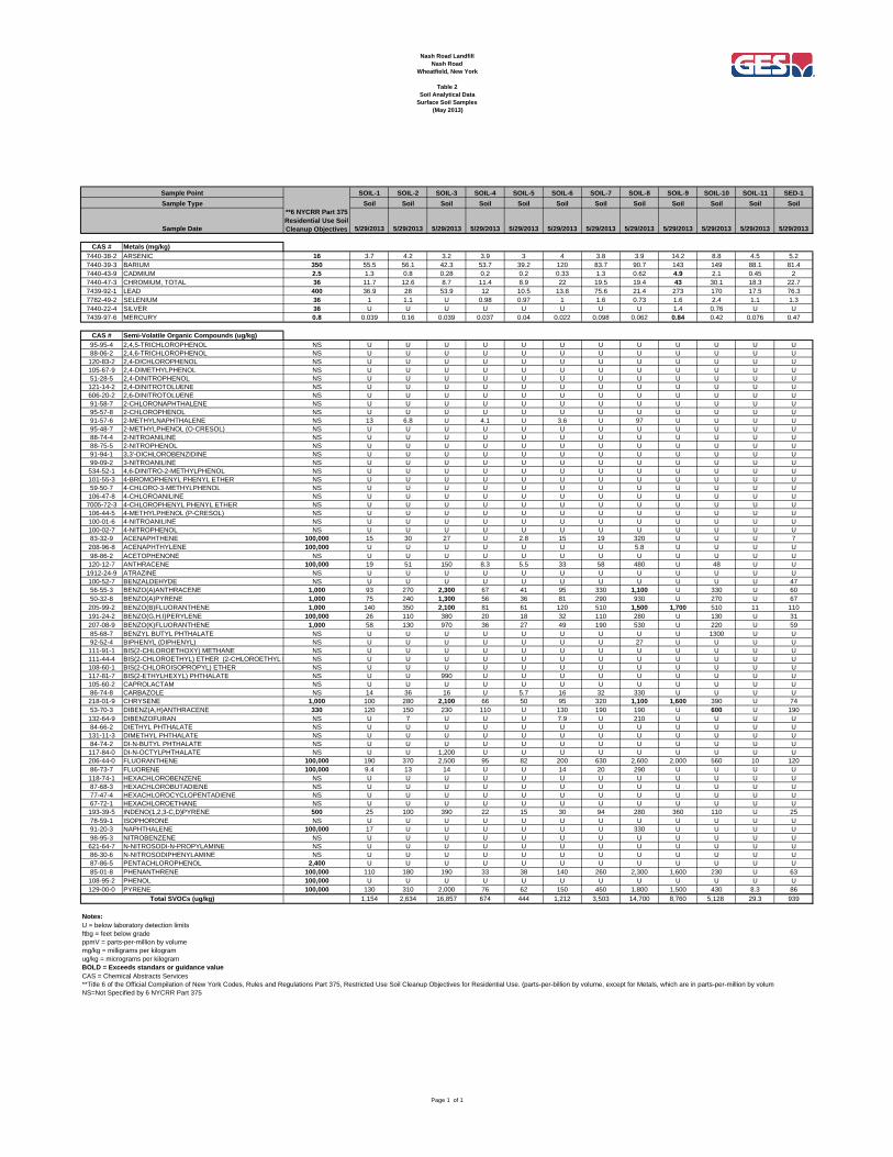
SW-7 Surface Water Pond Sample Exposure of contaminants to the public. Surface water samples were collected in lab supplied bottleware and submitted to TestAmerica for laboratory analysis of volatile organic compounds (VOCs) via USEPA Method 8260, SVOCs via USEPA method 8270, pesticides via USEPA method 8081, and herbicides via USEPA method 8151. Coordinates for all surface water sample locations were collected using the GPS unit and are provided in Appendix B for future reference. 6.0 SURFACE SOIL AND WATER SAMPLING RESULTS 6.1 Surface Soil Analytical Results The surface soil sample locations, with respect to the site layout are illustrated on Figure 3. Surface soil analytical data are tabulated in Table 2. The laboratory analytical reports are included in Appendix C. Surface soil analytical results were compared to residential guidelines provided in Title 6 of the Official Compilation of New York State Codes, Rules and Regulations (6 NYCRR) Part 375, Restricted Use Soil Cleanup Objectives (SCOs). A summary of the analyzed compounds is provided below:
Metals – Concentrations of metals were detected above residential SCOs at soil sample SOIL-9 (battery casings along path), including cadmium, mercury, and total chromium. While concentrations of lead at this location were the highest detected on-site, the concentration was below residential SCOs.
SVOCs – Concentrations of SVOCs were detected above residential SCOs at soil samples SOIL-3 (proximate to Nimo Electric Tower #364), SOIL-8 (mound of fill material), SOIL-9 (battery casings along path), and SOIL-10 (near drums at the edge of one of the ponds). Typical compounds that were detected above residential SCOs included polycyclic aromatic hydrocarbons. (PAHs).
Supplemental Site Characterization Report Former Nash Road Landfill NYSDEC Site #932054 November 2013
5
6.2 Surface Water Analytical Results The surface water sample locations, with respect to the site layout are illustrated on Figure 4. Surface water sample analytical data are tabulated in Table 3. The laboratory analytical reports are included in Appendix C. All surface water analytical results were compared to NYSDEC Technical and Operational Guidance Series (TOGS) 1.1.1 standards (or guidance values where no standard exists). A summary of the analyzed compounds is provided below:
Pesticides – Concentrations of pesticides were detected above TOGS 1.1.1 standards or guidance values at water samples SW-2 (pond sample), SW-3 (pond sample), and SW-5 (pond sample).
Herbicides – Herbicides were not detected above laboratory detection limits in any of the surface water samples.
VOCs – VOCs were not detected above laboratory limits in any of the surface water samples. SVOCs – SVOCs were not detected above laboratory limits in any of the surface water samples.
7.0 SUBSURFACE INVESTIGATION From June 15 through 17, 2011, Quality Inspection Services, Inc. (QIS), of Buffalo, New York, under the supervision of GES, advanced thirteen soil borings (SB-A through SB-M) using an Acker Soil Scout track-mounted direct push drill rig. Soil borings were advanced to depths ranging from eight to twenty feet below grade (ftbg). Of the thirteen soil borings, five of the borings were converted to groundwater monitoring wells (OW-21 through OW-25). The subsurface investigation was focused in the northeast area of the site where it has been reported that chemical waste had been buried and covered with fill. The purpose of the investigation was to re-characterize and delineate any subsurface impacts in the vicinity of the former dumping site. It should be noted that some areas were inaccessible, specifically areas covered by standing water or dense brush. 7.1 Soil Borings Soil samples were collected in approximate four-foot intervals via macro-core sampling. Soil samples were logged by GES personnel for color, moisture content, grain size, and visual evidence of hydrocarbon impact. A portion of each sample collected was placed into a re-sealable plastic bag and screened for the presence of volatile organic vapors. GES personnel used a MiniRAE 2000 photo-ionization detector (PID) equipped with a 10.6 electron-volt (eV) lamp which was calibrated to a 100 parts per million by volume (ppmv) isobutylene standard. From soil borings with elevated PID readings, the sample that recorded the highest PID reading from was submitted to TestAmerica Laboratories, Inc. for laboratory analysis of VOCs via USEPA Method 8260, SVOCs via USEPA method 8270, pesticides via USEPA method 8081, herbicides via USEPA method 8151, and RCRA-8 metals via USEPA Method 6010B. At soil borings SB-B, SB-H, and SB-J, additional samples were collected based on field observations made. A sample was not collected from SB-C due to poor recovery and low PID readings collected from the surrounding depth intervals. The soil boring locations, with respect to the site layout are illustrated on Figure 5. Soil boring logs containing soil lithology, field screening readings and general observations are included in Appendix D.

Supplemental Site Characterization Report Former Nash Road Landfill NYSDEC Site #932054 November 2013
6
7.2 Monitoring Well Installation Of the thirteen soil borings, five of the borings were converted to groundwater monitoring wells (OW-21 through OW-25). The table below summarizes the soil borings and their corresponding monitoring wells.
Soil Boring Monitoring Well Total Depth (ftbg) Screened Interval (ftbg) SB-A OW-24 10 5-10 SB-B OW-25 12 7-12 SB-C OW-22 8 3-8 SB-D OW-21 8 3-8 SB-F OW-23 8 3-8
The monitoring wells were constructed with two inch inner diameter polyvinyl chloride (PVC) flush-threaded pipe. The wells were installed to depths ranging from eight to twelve ftbg in the shallow sandy water-bearing zone identified in the previous Phase II reports, as well as during this investigation. The screen openings were 0.01 inch machine slotted. The wells were completed with a sand filter pack surrounding the wells screen to a height of six to twelve inches above the top of the screen, followed by a 2 foot bentonite seal. The remaining well annulus was sealed with a bentonite-portland cement grout to near grade. The wells were installed to rise approximately two to three feet above grade and were completed with four inch diameter steel protective casings and locks. Coordinates for all monitoring wells locations were collected using the GPS unit. 7.3 Investigation Derived Waste Investigation derived waste (IDW) in the form of auger cuttings and contaminated macro-core liners were staged in two steel 55-gallon drums, labeled and staged near the entrance to the site. A composite sample of the soil cuttings was collected for hazardous waste determination. On November 5, 2013, the drums were transported by the Environmental Service Group (ESG) of North Tonawanda, New York and transported to the Town of Tonawanda Landfill in Tonawanda, New York as non-hazardous waste. A copy of the completed manifest will be provided under separate cover. 7.4 Monitoring Well Development Following installation of the monitoring wells, the wells were developed in order to repair damage to the formation caused by drilling activities and increase the porosity/permeability of the materials surrounding the well screen. The well development served to remove foreign materials from the groundwater, well annulus, or well screen during and/or after well installation, and to facilitate hydraulic communication between the formation and the well screen. The wells were developed via mechanical surging method using a surge block device. The surge block can be used effectively to destroy the bridging of the fine formation particles and to create the agitation that is necessary to develop the well. The surge block technique was used alternatively with manual bailing so that material that has been agitated and loosened by the surging action could be removed. The surge block assembly was of sufficient weight to free-fall through the water in the well and create a vigorous outward surge. Surging began at the top of the well intake so that sand or silt loosened by the initial surging action could not cascade down on top of the surge block and prevent removal of the surge block from the well. Surging was initially conducted slowly, with the energy of the action increasing during the development process. Surging and bailing was conducted until either water clarity was

Supplemental Site Characterization Report Former Nash Road Landfill NYSDEC Site #932054 November 2013
7
improved or until the wells could not sustain further purging. Before and after well development, ground water chemistry readings were collected from the monitoring wells using a Horiba U-52 multi-parameter meter. Field chemistry readings are included in Appendix E. 7.5 Monitoring Well Sampling On August 22, 2013, GES surveyed the top of casing (TOC) at all monitoring wells using standard laser level survey methods. TOCs were referenced to the TOC elevations of the existing monitoring wells, and were measured to the nearest 0.01 foot. Table 5 lists the established TOC elevations for the newly-installed and existing groundwater monitoring wells. On August 2, 2013, GES conducted groundwater sampling activities at newly installed monitoring wells OW-21 through OW-25, and existing shallow monitoring wells OW-1, OW-2, OW-11, OW-13, OW-14B, and OW-16. Prior to purging, gauging was performed to determine static water levels and the presence of non-aqueous phase liquids (NAPL) using an oil/water interface probe. The interface probe measures depth to groundwater and phase separated hydrocarbons to the nearest 0.01-foot. The interface probe was decontaminated prior to use and between wells utilizing a tap water and Alconox™ rinse to prevent cross-contamination. NAPL was not detected in the wells. Prior to sampling, the wells were purged utilizing dedicated polyethylene disposable bailers. Three to five well volumes were purged from the monitoring wells based on the recharge capability of the individual wells. Purge water was discharged to the surface after being treated with a portable carbon filter unit. OW-11 was found to be bent below grade and could not be purged or sampled with a bailer. On August 22, 2013, GES purged and sampled the well using a peristaltic pump with dedicated polyethylene tubing. Groundwater samples were collected in lab supplied bottleware and submitted to TestAmerica for laboratory analysis of VOCs via USEPA Method 8260, SVOCs via USEPA method 8270, pesticides via USEPA method 8081, herbicides via USEPA method 8151, and RCRA-8 metals via USEPA Method 6010B. 8.0 SUBSURFACE INVESTIGATION RESULTS 8.1 Lithology and Field Observations The soil boring locations, with respect to the site layout are illustrated on Figure 5. Coordinates for all soil boring locations were collected using the GPS unit and are provided in Appendix B for future reference. Soil boring logs containing soil lithology, field screening readings and general observations are included in Appendix D. In general, three distinct lithological layers were encountered during the subsurface investigation: fill material, a sand interval, and a clay interval that extended to the termination depth of the investigation. These layers were consistent with the upper layers encountered during previous subsurface investigations. A summary of the observed site lithology and field observations are described below:
Supplemental Site Characterization Report Former Nash Road Landfill NYSDEC Site #932054 November 2013
8
FILL – Fill material containing varying degrees of silt, clay & sand, organics, and debris. The
debris consisted of a mixture of glass, plastic and metal. Fill material was generally observed from the surface to depths ranging from one to four ftbg. Deeper intervals of fill material were observed at SB-A (assumed 8 ft due to low recovery), SB-B (10 ft), and SB-H (minimum 12 ftbg before refusal was met). Fill material was not observed at SB-L, where the shallow lithology consisted of hard clay to a depth of four ftbg before encountering the shallow sand layer. While shallow soil observed at SB-B was not initially classified as fill material, based on past site investigations, the observed solvent odors, softness of the material relative to other presumed shallow native clay on-site, and a review of historical documents for the site, the clay material may have been re-worked fill material related to past chemical dumping at the site. This material was also observed at SB-M.
SAND – fine to coarse sand was observed below the fill material. The sand layer was typically observed at depths ranging from 1 to 10 ftbg with a thickness of 4-8 ft. At soil borings SB-A, SB-B, SB-F, SB-J, and SB-L, the sand was grey to black in color. At all other soil borings, the sand was generally tan to brown. The sand interval was not encountered at SB-H and SB-M. As noted above, fill material was observed throughout the soil boring until boring refusal). At SB-M, the fill material extended through to the subsequent clay layer. Low sample recovery was often encountered in this interval. Wet to saturated conditions indicative of the shallow water table aquifer were generally observed at depths ranging from 3 ftbg to 6 ftbg and were generally observed in the sand interval.
CLAY – Brown or grey, hard, clay was typically encountered below the sand interval. The clay layer was often less saturated than the sand lens and may be acting as an aquitard for the shallow aquifer discussed in previous environmental investigations. The clay layer extended to the termination of all soil borings with the exception of SB-H, where fill material was observed throughout the soil boring until boring refusal.
Solvent odors were observed in several soil borings, including SB-B, SB-H, SB-J, AND SB-M. These odors were generally observed in the fill material and the sand interval.
Elevated PID screening results (greater than 20 ppmv) were observed from soil samples collected from soil borings SB-B, SB-H, SB-J, and SB-M. Elevated PID screening results were generally observed from approximately 0 to 8 ftbg and located in the fill material. The highest readings were recorded in soil boring SB-H throughout its entirety and ranged from 940 ppmv to 1,214 ppmv with strong solvent odors.
NAPL was observed at SB-H from 4 to 12 ftbg. The NAPL consisted of a dark brown highly viscous material with strong solvent odors.
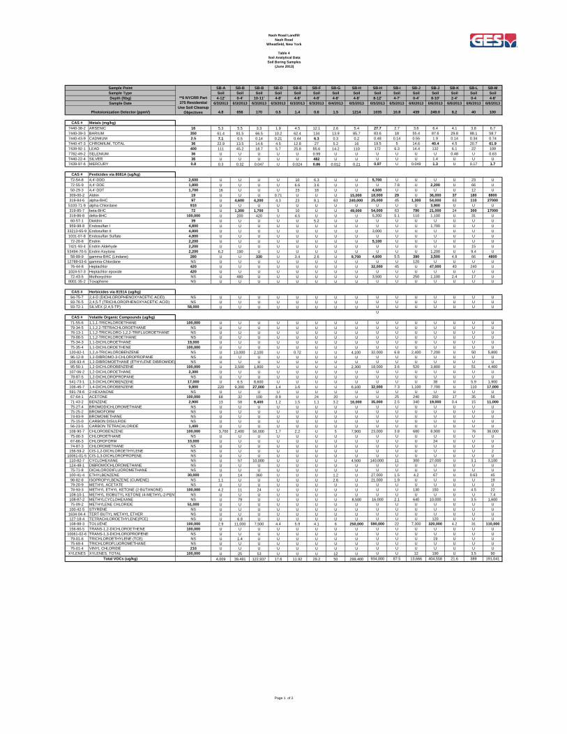
8.2 Soil Boring Sample Analytical Results Soil analytical data are tabulated in Table 4. The laboratory analytical reports are included in Appendix C. All subsurface soil analytical results were compared to residential guidelines provided in 6 NYCRR Part 375, Restricted Use SCOs. A summary of the analyzed compounds is provided below:
Metals – Concentrations of metals were detected above SCOs at soil borings SB-F (cadmium, silver and mercury), SB-J (total chromium), and SB-M (total chromium). Mercury was detected most samples however was only detected above SCOs at SB-F.
Pesticides – Concentrations of pesticides were detected above SCOs at soil borings SB-B, SB-H, SB-J, SB-L, and SB-M. Elevated concentrations of pesticides primarily consist of various

Supplemental Site Characterization Report Former Nash Road Landfill NYSDEC Site #932054 November 2013
9
benzenehexachloride (BHC) compounds (including lindane) and aldrin that were detected at several orders of magnitude above residential SCOs.
Herbicides – Herbicides were not detected above laboratory detection limits in any of the surface water samples.
VOCs – Concentrations of VOCs were detected above SCOs at soil borings SB-B, SB-H, SB-J, and SB-M. Elevated concentrations of VOCs consisted primarily of benzene, toluene, and chlorinated benzenes.
SVOCs – Concentrations of SVOCs were detected above SCOs at soil borings SB-A, SB-B, SB-H, SB-J, and SB-M. Detected SVOCs primarily consisted of various PAHs.
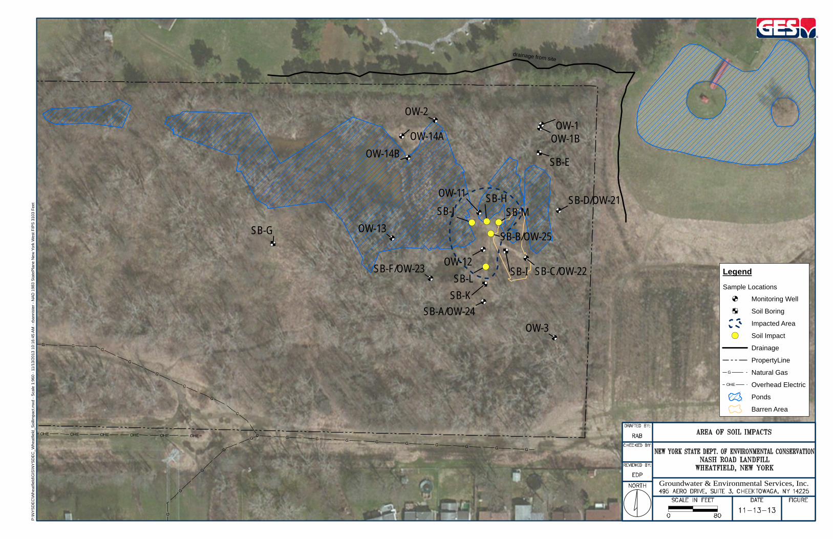
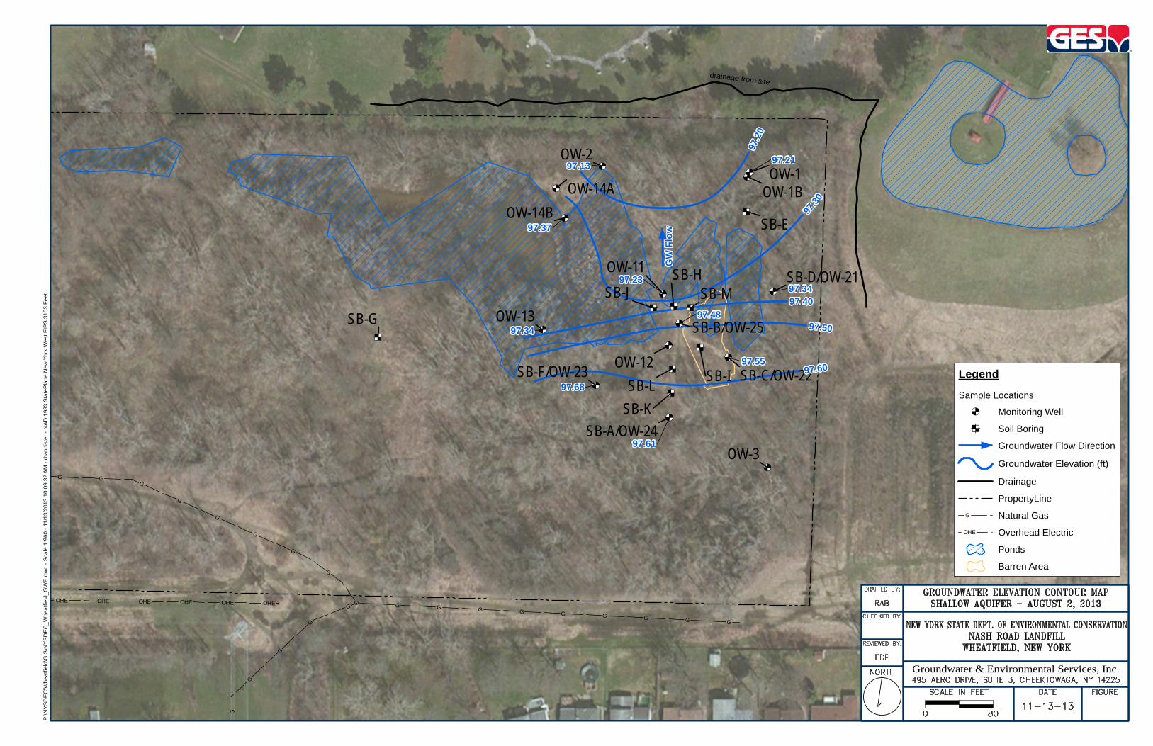
Figure 6 shows the approximate delineated limits of the area of the site that are impacted by Pesticides, VOCs, and SVOCs based on the soil boring analytical results of the investigation as well as previous site investigations. The limits were based on analytical exceedences above residential SCOs. It should be noted that the western and northern bounds of the delineated area are estimated, as site access was limited due to ponding and heavy brush. 8.3 Site Hydrology and Shallow Aquifer Hydrogeology Groundwater gauging and analytical data are tabulated in Table 5. The monitoring well locations, with respect to the site layout are illustrated on Figure 5. Groundwater elevation contours based on the monitoring well gauging data from the shallow aquifer wells on the eastern side of the site are presented on Figure 7. As shown on Figure 7, at the time of the investigation, groundwater in the shallow aquifer flows to the north. Groundwater flow may be influenced by surface hydrology, including the large pond in northeastern area of the site, as groundwater flow mimics the surface drainage pattern of the northeast area of the site. The large pond appears to drain to the north via a small swale located at the location of surface water sample SW-2 and sediment sample SED-1. This swale connects to a drainage ditch that runs east along the northern boundary of the site to the northeast corner of the site, where it makes a “dogleg” turn and continues to the south. The drainage ditch along the north side of the site provides a hydraulic barrier from surface drainage from the neighboring property to the north (religious shrine), and there does not appear to be any other surface water bodies that supply the site. The 1989 Phase II Investigation made reference to the ditch draining into Sawyer Creek; however the drainage ditch does not appear to continuously link to any creeks or streams, and may explain the large amount of ponding that occurs on-site. It was observed during the sampling events and site visits that at the “dogleg” turn, a plastic drain pipe protruded from the eastern side of the ditch. The drain pipe appeared to bear towards and protrude at the western side of the pond that is located on the neighboring property to the east. The property to the east appears to contain a motel and a livery company. The drain pipe was shallower than standing water in either water body, therefore it could not be determined which direction flow would occur through the pipe. It should also be noted that most site investigation activities occurred in the spring through mid-summer months, when the site received large amounts of precipitation. During a site visit on August 22, 2013 after several weeks without significant precipitation, many of the smaller ponds had dried, and the large pond had receded by approximately 5-10 feet along its edge, indicating that the surface hydrology is seasonally influenced.

Supplemental Site Characterization Report Former Nash Road Landfill NYSDEC Site #932054 November 2013
10
8.4 Groundwater Analytical Results The monitoring well locations, with respect to the site layout are illustrated on Figure 5. Groundwater gauging and analytical data are tabulated in Table 5. The laboratory analytical reports are included in Appendix C. All groundwater analytical results were compared to NYSDEC TOGS 1.1.1 standards (or guidance values where no standard exists) Class GA, type H(WS) for protection of drinking water. A summary of the analyzed compounds is provided below:
Metals – Concentrations of metals were detected above TOGS 1.1.1 standards or guidance values at monitoring wells OW-11 (cadmium and lead), OW-16 (barium), OW-22 (lead), OW-23 (lead), and OW-29 (lead). Mercury was detected at OW-11 below standards.
Pesticides – Concentrations of pesticides were detected above TOGS 1.1.1 standards or guidance values at all monitoring wells with the exception of OW-2 and OW-23. OW-11, OW-13, OW-16, and OW-25 all contained numerous detections of pesticides above standards or guidance values.
Herbicides – Herbicides were not detected above laboratory detection limits in any of the surface water samples.
VOCs – Concentrations of VOCs were detected above TOGS 1.1.1 standards or guidance values at monitoring wells OW-11, OW-16, OW-24, and OW-25. Elevated concentrations of VOCs consisted primarily of benzene and various chlorinated benzenes.
SVOCs – Concentrations of SVOCs were detected above TOGS 1.1.1 standards or guidance values at monitoring well OW-13 and OW-25 which consisted primarily of phenolic compounds.
9.0 SUMMARY, DISCUSSION, AND RECOMMENDATIONS Provided below is a brief discussion of the results and recommendations for future actions. 9.1 Surface Soil Contaminant Exposure As described in Section 6.1, concentrations of metals were detected above residential SCOs at soil sample SOIL-9. This sample was located at an area along one of the trails where black, broken battery casings were observed. Concentrations of SVOCs were detected above residential SCOs at soil samples SOIL-3 (proximate to Nimo Tower #364), SOIL-8 (mound of fill materials), SOIL-9 (battery casings along path), and SOIL-10 (near drums at the edge of one of the ponds). Typical compounds that were detected included PAHs. The trails at the site have been moderately developed; ATV use by one of the residences was witnessed during the subsurface investigation, so it is known that these paths will continue to be eroded, thus exposing additional contaminants. 9.2 Surface Water Contaminant Exposure As described in Section 6.2, concentrations of pesticides were detected above TOGS 1.1.1 standards or guidance values at water samples SW-2, SW-3, and SW-5. All three samples were collected from the ponds on-site. Apart from the drainage pipe that was found at the northeast corner of the site, the site is relatively isolated hydraulically from outside sources of surface water. The drainage ditch along the north side of the site provides a hydraulic barrier from surface drainage from the neighboring property to the north (religious shrine). There does not appear to be any other surface water bodies that supply the site,
Supplemental Site Characterization Report Former Nash Road Landfill NYSDEC Site #932054 November 2013
11
therefore it is likely that past dumping activities have had an effect on surface water quality in the northeastern area of the site. While three pond samples were found to contain elevated concentrations of pesticides, the sample SW-1, (collected from what appeared to be a drainage outlet for the large pond) did not contain any detected concentrations of pesticides. Additional surface water sampling may be needed along the outlet ditch and the ponds to further study surface water quality as it relates to drainage patterns on-site and for possible seasonal influences. 9.3 Subsurface Soil Contaminant Exposure As described in Section 8.2, elevated concentrations of contaminants, including pesticides, VOCs, SVOCs, and metals were detected in the area identified in Figure 6. The investigation delineated the impacts to the south and east, and to a less precise degree to the west and north due to limiting factors including ponds and dense brush. Exposure to the public may lie in the fact that at several of the soil borings discussed in Section 8.1, the highest contaminant impacts (based on field observations and PID readings) were often located in the top four feet. Shallow surface penetrations or erosion may lead to exposure to high concentrations of pesticides, VOCs, SVOCs, and metals. Several of the pesticides that were detected in elevated concentrations are known persistent organic pollutants and banned substances. Several trails run near or through this part of the site and may present an exposure risk if the surface is penetrated or exposed through erosion. It is recommended that additional soil borings are advanced along the north and west sides of the area identified in Figure 6 to more precisely delineate the impacts in this area. It is also recommended that site access be restricted in this area including the construction of fencing due to the shallow impacts. 9.4 Groundwater Contaminant Exposure As described in Section 8.4, elevated concentrations of contaminants, including pesticides, VOCs, SVOCs, and metals were detected in nearly all the shallow wells sampled to varying degrees. Lead was detected in three of the wells and may be a result of general dumping activities on-site. Elevated concentrations of the pesticide alpha-BHC were detected at OW-25, co-located with SB-B, and in the impacted area identified in Figure 6. Groundwater quality at this location and in surrounding monitoring wells is likely influenced by the past chemical dumping activities, leading to a groundwater plume within the interior of the site. Groundwater flow at the time of the investigation was to the north, though monitoring wells OW-1 and OW-14B do not appear to be impacted by the plume of contaminants. While exposure of groundwater to the public is likely limited (as area residents are served by public water), it is recommended that an additional monitoring well be installed to further characterize and delineate the plume to the north of OW-11, as well as additional groundwater sampling to evaluate seasonal changes in the groundwater flow and groundwater quality on-site.

FIGURES
EHO EHO EHO EHO EHO EHO EHO EHO EHO EHO EHO EHO EHO EHO EHO
GG
G
G
G
G G G G G G G G G G G G GG
G
G
G G G G G
&<
&<&<
&<&<
§
&<&<
&<
&<&<&<
&<
&<
§
&<
¥§
§
§
&>
&<
&<
&<ED
ED
ED
ED&<
&<
ED
ED
ED
ED
§
§
&>&>
&>
&>&>
&>
&>
&>
&>
&>
OW-5OW-16
OW-6
OW-15
OW-4SW-4
OW-13
OW-12
OW-11
OW-1BOW-1
OW-2OW-14A
OW-14B
SW-6
OW-3
SED-1SW-1
SW-2
SW-3
SOIL-1SB-F/OW-23
SB-A/OW-24
SB-B/OW-25SB-M
SB-K
SB-J
SB-L SB-C/OW-22
SB-D/OW-21
SB-E
SB-I
SB-H
SB-G
SW-5
SW-7
SOIL-2SOIL-3
SOIL-4
SOIL-5SOIL-6
SOIL-7
SOIL-8
SOIL-9
SOIL-10
SOIL-11
Forbes S t ree t
Forb
es
Ter race
Niagra Fa l l s B l vd
Suspected LoveCanal DisposalArea
drainage from site
LegendSample Locations
$! Drum
&< Monitoring Well
¥ Sediment
ED Soil Boring
&> Surface Soil
§ Surface Water
Drainage
PropertyLine
G Natural Gas
EHO Overhead Electric
Ponds
Barren Area
Groundwater & Environmental Services, Inc.
P:\N
YS
DE
C\W
hea
tfiel
d\G
IS\N
YS
DE
C_W
hea
tfiel
d_S
M_
Love
Ca
nal.m
xd -
Sca
le 1
:1,9
20
- 11
/13
/20
13 1
0:3
7:1
6 A
M -
rb
anni
ster
- N
AD
19
83 S
tate
Pla
ne N
ew
Yor
k W
est
FIP
S 3
103
Fe
et
EPopken
Typewritten Text
1
!\] NEW YORKNEW YORK
SITE
P:\N
YS
DE
C\W
hea
tfiel
d\G
IS\N
YS
DE
C_W
hea
tfiel
d_S
LM
.mxd
- S
cale
1:2
4,0
00 -
11/
13/
201
3 10
:48
:06
AM
- r
ban
nis
ter
- N
AD
198
3 S
tate
Pla
ne
New
Yo
rk W
est F
IPS
31
03
Fee
t
Groundwater & Environmental Services, Inc.
Sources:USGS 7.5 Minute Series Topographic QuadranglesTonawanda East and Tonawanda West
© 2011 National Geographic Society, i-cubed
EPopken
Rectangle
EPopken
Typewritten Text
2

EHO EHO EHO EHO EHO EHO EHO EHO EHO EHO EHO EHO EHO EHO EHO
GG
G
G
G
G G G G G G G G G G G G GG
G
G
G G G G G
¥
&>
&>&>
&>
&>&>
&>
&>
&>
&>
&>
SED-1
SOIL-1
SOIL-2SOIL-3
SOIL-4
SOIL-5SOIL-6
SOIL-7
SOIL-8
SOIL-9
SOIL-10
SOIL-11
Forbes S t ree t
Forb
es
Ter race
Niagra Fa l l s B l vd
drainage from site
LegendSample Locations
¥ Sediment
&> Surface Soil
Drainage
PropertyLine
G Natural Gas
EHO Overhead Electric
Ponds
Barren Area
Groundwater & Environmental Services, Inc.
P:\N
YS
DE
C\W
hea
tfiel
d\G
IS\N
YS
DE
C_W
hea
tfiel
d_S
SL
M.m
xd -
Sca
le 1
:1,9
20
- 11
/13
/20
13 1
0:1
8:0
8 A
M -
rba
nni
ste
r -
NA
D 1
983
Sta
teP
lane
Ne
w Y
ork
We
st F
IPS
310
3 F
eet
EPopken
Typewritten Text
3

EHO EHO EHO EHO EHO EHO EHO EHO EHO EHO EHO EHO EHO EHO EHO
GG
G
G
G
G G G G G G G G G G G G GG
G
G
G G G G G
§
§§
§
§
§
§
SW-4
SW-6SW-1
SW-2
SW-3
SW-5
SW-7
Forbes S t ree t
Forb
es
Ter race
Niagra Fa l l s B l vd
drainage from site
LegendSample Locations
§ Surface Water
Drainage
PropertyLine
G Natural Gas
EHO Overhead Electric
Ponds
Barren Area
Groundwater & Environmental Services, Inc.
P:\N
YS
DE
C\W
hea
tfiel
d\G
IS\N
YS
DE
C_W
hea
tfiel
d_S
WS
LM
.mxd
- S
cale
1:1
,92
0 -
11/1
3/2
013
10:
19:
24
AM
- r
bann
iste
r -
NA
D 1
983
Sta
teP
lan
e N
ew Y
ork
We
st F
IPS
310
3 F
eet
EPopken
Typewritten Text
4

EHO EHO EHO EHO EHO EHO
G
G
G
G
G
G GG
G
G
G
G
G
G
G G G G G G G G G
&<
&<
&<
&<&<
&<
&<
&<
&<
&<
&<
&<
ED
ED
ED
ED
&<
&<
ED
ED
ED
ED
OW-4
OW-13
OW-12
OW-11
OW-1BOW-1
OW-2OW-14A
OW-14B
OW-3
SB-F/OW-23
SB-A/OW-24
SB-B/OW-25SB-M
SB-K
SB-J
SB-L SB-C/OW-22
SB-D/OW-21
SB-E
SB-I
SB-H
SB-G
drainage from site
LegendSample Locations
&< Monitoring Well
ED Soil Boring
Drainage
PropertyLine
G Natural Gas
EHO Overhead Electric
Ponds
Barren Area
Groundwater & Environmental Services, Inc.
P:\N
YS
DE
C\W
hea
tfiel
d\G
IS\N
YS
DE
C_W
hea
tfiel
d_S
BM
WL
M.m
xd -
Sca
le 1
:960
- 1
1/1
3/2
013
10:
10:
58 A
M -
rb
ann
iste
r -
NA
D 1
983
Sta
teP
lan
e N
ew Y
ork
Wes
t FIP
S 3
10
3 F
eet
EPopken
Typewritten Text
5
EHO EHO EHO EHO EHO EHO
G
G
G
G
G
G GG
G
G
G
G
G
G
G G G G G G G G G
&<
&<
&<
&<&<
&<
&<
&<
&<
&<
&<
&<
ED
ED
ED
ED
&<
&<
ED
ED
ED
ED
OW-4
OW-13
OW-12
OW-11
OW-1BOW-1
OW-2OW-14A
OW-14B
OW-3
SB-F/OW-23
SB-A/OW-24
SB-B/OW-25SB-M
SB-K
SB-J
SB-L SB-C/OW-22
SB-D/OW-21
SB-E
SB-I
SB-H
SB-G !(
!(!(
!(
!(
drainage from site
LegendSample Locations
&< Monitoring Well
ED Soil Boring
Impacted Area
!( Soil Impact
Drainage
PropertyLine
G Natural Gas
EHO Overhead Electric
Ponds
Barren Area
Groundwater & Environmental Services, Inc.
P:\N
YS
DE
C\W
hea
tfiel
d\G
IS\N
YS
DE
C_W
hea
tfiel
d_S
oilI
mp
act.m
xd -
Sca
le 1
:96
0 -
11/1
3/2
013
10
:16:
45
AM
- r
ban
nist
er
- N
AD
19
83 S
tate
Pla
ne N
ew
Yor
k W
est
FIP
S 3
103
Fe
et
EPopken
Typewritten Text
6
EHO EHO EHO EHO EHO EHO
G
G
G
G
G
G GG
G
G
G
G
G
G
G G G G G G G G G
&<
&<
&<
&<&<
&<
&<
&<
&<
&<
&<
&<
ED
ED
ED
ED
&<
&<
ED
ED
ED
ED
OW-4
OW-13
OW-12
OW-11
OW-1BOW-1
OW-2OW-14A
OW-14B
OW-3
SB-F/OW-23
SB-A/OW-24
SB-B/OW-25SB-M
SB-K
SB-J
SB-L SB-C/OW-22
SB-D/OW-21
SB-E
SB-I
SB-H
SB-G97.34
97.23
97.2197.13
97.37
97.68
97.61
97.48
97.55
97.34
drainage from site
97.20
97.40
97.60
97.50
97.30
GW Fl
ow
LegendSample Locations
&< Monitoring Well
ED Soil Boring
Groundwater Flow Direction
Groundwater Elevation (ft)
Drainage
PropertyLine
G Natural Gas
EHO Overhead Electric
Ponds
Barren Area
Groundwater & Environmental Services, Inc.
P:\N
YS
DE
C\W
hea
tfiel
d\G
IS\N
YS
DE
C_W
hea
tfiel
d_G
WE
.mxd
- S
cale
1:9
60
- 1
1/13
/20
13 1
0:0
9:3
2 A
M -
rb
anni
ster
- N
AD
19
83 S
tate
Pla
ne
Ne
w Y
ork
We
st F
IPS
31
03 F
eet
EPopken
Typewritten Text
7

TABLES

Nash Road LandfillNash Road
Wheatfield, New York
Table 1Sample Matrix
Sample Media Purpose Quantity Analysis MethodSVOCs 8270
RCRA-8 Metals 6010B
SVOCs 8270RCRA-8 Metals 6010B
SVOCs 8270RCRA-8 Metals 6010B
SVOCs 8270VOCs 8260
Pesticides 8081Herbicides 8151
SVOCs 8270VOCs 8260
Pesticides 8081Herbicides 8151
SVOCs 8270VOCs 8260
RCRA-8 Metals 6010BPesticides 8081Herbicides 8151
SVOCs 8270VOCs 8260
RCRA-8 Metals 6010BPesticides 8081Herbicides 8151
SVOCs 8270VOCs 8260
RCRA-8 Metals 6010BPesticides 8081Herbicides 8151
Groundwater
Collect groundwater samples from the existing shallow monitoring wells to evaluate current potential impact of the dumping activities to groundwater
on-site.6
Collect groundwater samples from newley installed shallow monitoring wells to evaluate current potential impact of the dumping activities to
groundwater on-site.5
Surface Water
Evaluate for potential exposure of contaminants in the pond water to the public, primarily at the former dumping site in the northeast area of the site.
6
Evaluate water leaving the site the site toward direction of pond on adjacent property.
1
Subsurface SoilRe-characterization/delineation of any subsurface impacts from the
formmer dumping site in the northeast corner of the site.15
Surface Soil
Evaluate for potential exposure of contaminants to pedestrian traffic through site via surface soil within interior of the site, biased towards
walking and ATV paths where there is obvious evidence of exposed waste from the former dumping activities.
10
Evaluate sediment where waters can leave site toward direction of pond on adjacent property.
1
Evaluate for potential exposure of contaminants to pedestrian traffic through site via surface soil along the power line corridor.
2
Page 1 of 1
Nash Road LandfillNash Road
Wheatfield, New York
Table 2Soil Analytical Data
Surface Soil Samples (May 2013)
SOIL-1 SOIL-2 SOIL-3 SOIL-4 SOIL-5 SOIL-6 SOIL-7 SOIL-8 SOIL-9 SOIL-10 SOIL-11 SED-1Soil Soil Soil Soil Soil Soil Soil Soil Soil Soil Soil Soil
5/29/2013 5/29/2013 5/29/2013 5/29/2013 5/29/2013 5/29/2013 5/29/2013 5/29/2013 5/29/2013 5/29/2013 5/29/2013 5/29/2013
CAS # Metals (mg/kg)7440-38-2 ARSENIC 16 3.7 4.2 3.2 3.9 3 4 3.8 3.9 14.2 8.8 4.5 5.27440-39-3 BARIUM 350 55.5 56.1 42.3 53.7 39.2 120 83.7 90.7 143 149 88.1 81.47440-43-9 CADMIUM 2.5 1.3 0.8 0.28 0.2 0.2 0.33 1.3 0.62 4.9 2.1 0.45 27440-47-3 CHROMIUM, TOTAL 36 11.7 12.6 8.7 11.4 8.9 22 19.5 19.4 43 30.1 18.3 22.77439-92-1 LEAD 400 36.9 28 53.9 12 10.5 13.8 75.6 21.4 273 170 17.5 76.37782-49-2 SELENIUM 36 1 1.1 U 0.98 0.97 1 1.6 0.73 1.6 2.4 1.1 1.37440-22-4 SILVER 36 U U U U U U U U 1.4 0.76 U U7439-97-6 MERCURY 0.8 0.039 0.16 0.039 0.037 0.04 0.022 0.098 0.062 0.84 0.42 0.076 0.47
CAS # Semi-Volatile Organic Compounds (ug/kg)95-95-4 2,4,5-TRICHLOROPHENOL NS U U U U U U U U U U U U88-06-2 2,4,6-TRICHLOROPHENOL NS U U U U U U U U U U U U120-83-2 2,4-DICHLOROPHENOL NS U U U U U U U U U U U U105-67-9 2,4-DIMETHYLPHENOL NS U U U U U U U U U U U U51-28-5 2,4-DINITROPHENOL NS U U U U U U U U U U U U121-14-2 2,4-DINITROTOLUENE NS U U U U U U U U U U U U606-20-2 2,6-DINITROTOLUENE NS U U U U U U U U U U U U91-58-7 2-CHLORONAPHTHALENE NS U U U U U U U U U U U U95-57-8 2-CHLOROPHENOL NS U U U U U U U U U U U U91-57-6 2-METHYLNAPHTHALENE NS 13 6.8 U 4.1 U 3.6 U 97 U U U U95-48-7 2-METHYLPHENOL (O-CRESOL) NS U U U U U U U U U U U U88-74-4 2-NITROANILINE NS U U U U U U U U U U U U88-75-5 2-NITROPHENOL NS U U U U U U U U U U U U91-94-1 3,3'-DICHLOROBENZIDINE NS U U U U U U U U U U U U99-09-2 3-NITROANILINE NS U U U U U U U U U U U U534-52-1 4,6-DINITRO-2-METHYLPHENOL NS U U U U U U U U U U U U101-55-3 4-BROMOPHENYL PHENYL ETHER NS U U U U U U U U U U U U59-50-7 4-CHLORO-3-METHYLPHENOL NS U U U U U U U U U U U U106-47-8 4-CHLOROANILINE NS U U U U U U U U U U U U
7005-72-3 4-CHLOROPHENYL PHENYL ETHER NS U U U U U U U U U U U U106-44-5 4-METHYLPHENOL (P-CRESOL) NS U U U U U U U U U U U U100-01-6 4-NITROANILINE NS U U U U U U U U U U U U100-02-7 4-NITROPHENOL NS U U U U U U U U U U U U83-32-9 ACENAPHTHENE 100,000 15 30 27 U 2.8 15 19 320 U U U 7208-96-8 ACENAPHTHYLENE 100,000 U U U U U U U 5.8 U U U U98-86-2 ACETOPHENONE NS U U U U U U U U U U U U120-12-7 ANTHRACENE 100,000 19 51 150 8.3 5.5 33 58 480 U 48 U U
1912-24-9 ATRAZINE NS U U U U U U U U U U U U100-52-7 BENZALDEHYDE NS U U U U U U U U U U U 4756-55-3 BENZO(A)ANTHRACENE 1,000 93 270 2,300 67 41 95 330 1,100 U 330 U 6050-32-8 BENZO(A)PYRENE 1,000 75 240 1,300 56 36 81 290 930 U 270 U 67205-99-2 BENZO(B)FLUORANTHENE 1,000 140 350 2,100 81 61 120 510 1,500 1,700 510 11 110191-24-2 BENZO(G,H,I)PERYLENE 100,000 26 110 380 20 18 32 110 280 U 130 U 31207-08-9 BENZO(K)FLUORANTHENE 1,000 58 130 970 36 27 49 190 530 U 220 U 5985-68-7 BENZYL BUTYL PHTHALATE NS U U U U U U U U U 1300 U U92-52-4 BIPHENYL (DIPHENYL) NS U U U U U U U 27 U U U U111-91-1 BIS(2-CHLOROETHOXY) METHANE NS U U U U U U U U U U U U111-44-4 BIS(2-CHLOROETHYL) ETHER (2-CHLOROETHYL E NS U U U U U U U U U U U U108-60-1 BIS(2-CHLOROISOPROPYL) ETHER NS U U U U U U U U U U U U117-81-7 BIS(2-ETHYLHEXYL) PHTHALATE NS U U 990 U U U U U U U U U105-60-2 CAPROLACTAM NS U U U U U U U U U U U U86-74-8 CARBAZOLE NS 14 36 16 U 5.7 16 32 330 U U U U218-01-9 CHRYSENE 1,000 100 280 2,100 66 50 95 320 1,100 1,600 390 U 7453-70-3 DIBENZ(A,H)ANTHRACENE 330 120 150 230 110 U 130 190 190 U 600 U 190132-64-9 DIBENZOFURAN NS U 7 U U U 7.9 U 210 U U U U84-66-2 DIETHYL PHTHALATE NS U U U U U U U U U U U U131-11-3 DIMETHYL PHTHALATE NS U U U U U U U U U U U U84-74-2 DI-N-BUTYL PHTHALATE NS U U U U U U U U U U U U117-84-0 DI-N-OCTYLPHTHALATE NS U U 1,200 U U U U U U U U U206-44-0 FLUORANTHENE 100,000 190 370 2,500 95 82 200 630 2,600 2,000 560 10 12086-73-7 FLUORENE 100,000 9.4 13 14 U U 14 20 290 U U U U118-74-1 HEXACHLOROBENZENE NS U U U U U U U U U U U U87-68-3 HEXACHLOROBUTADIENE NS U U U U U U U U U U U U77-47-4 HEXACHLOROCYCLOPENTADIENE NS U U U U U U U U U U U U67-72-1 HEXACHLOROETHANE NS U U U U U U U U U U U U193-39-5 INDENO(1,2,3-C,D)PYRENE 500 25 100 390 22 15 30 94 280 360 110 U 2578-59-1 ISOPHORONE NS U U U U U U U U U U U U91-20-3 NAPHTHALENE 100,000 17 U U U U U U 330 U U U U98-95-3 NITROBENZENE NS U U U U U U U U U U U U621-64-7 N-NITROSODI-N-PROPYLAMINE NS U U U U U U U U U U U U86-30-6 N-NITROSODIPHENYLAMINE NS U U U U U U U U U U U U87-86-5 PENTACHLOROPHENOL 2,400 U U U U U U U U U U U U85-01-8 PHENANTHRENE 100,000 110 180 190 33 38 140 260 2,300 1,600 230 U 63108-95-2 PHENOL 100,000 U U U U U U U U U U U U129-00-0 PYRENE 100,000 130 310 2,000 76 62 150 450 1,800 1,500 430 8.3 86
1,154 2,634 16,857 674 444 1,212 3,503 14,700 8,760 5,128 29.3 939
Notes:U = below laboratory detection limitsftbg = feet below gradeppmV = parts-per-million by volumemg/kg = milligrams per kilogramug/kg = micrograms per kilogramBOLD = Exceeds standars or guidance valueCAS = Chemical Abstracts Services
Total SVOCs (ug/kg)
**Title 6 of the Official Compilation of New York Codes, Rules and Regulations Part 375, Restricted Use Soil Cleanup Objectives for Residential Use. (parts-per-billion by volume, except for Metals, which are in parts-per-million by volumNS=Not Specified by 6 NYCRR Part 375
Sample Point
**6 NYCRR Part 375 Residential Use Soil Cleanup Objectives
Sample Type
Sample Date
Page 1 of 1

Nash Road LandfillNYSDEC Site #932054
Nash RoadWheatfield, New York
Table 3Surface Water Analytical Data
(May 2013)
SW-1 SW-2 SW-3 SW-4 SW-5 SW-6 SW-7
Surface Water
Surface Water
Surface Water
Surface Water
Surface Water
Surface Water
Surface Water
5/29/2013 5/29/2013 5/29/2013 5/29/2013 5/29/2013 5/29/2013 5/29/2013
CAS # Pesticides via 8081A (ug/L)72-54-8 4,4'-DDD 0.3 U U U U U U U72-55-9 4,4'-DDE 0.2 U U U U 0.013 U U50-29-3 4,4'-DDT 0.2 U U U U U U U
309-00-2 Aldrin 0.002 U U U U U U U319-84-6 alpha-BHC 0.01 U 0.016 0.024 U 0.012 U 0.01
5103-71-9 alpha-Chlordane 0.05 U U U U U U U319-85-7 beta-BHC 0.04 U U 0.042 U U U U319-86-8 delta-BHC 0.04 U U U U U U U60-57-1 Dieldrin 0.004 U 0.011 U U U U U
959-98-8 Endosulfan I 0.009 U U U U U U U33213-65-9 Endosulfan II 0.009 U U U U U U U1031-07-8 Endosulfan Sulfate NS U U U U U U U
72-20-8 Endrin 0.2 U U U U U U U7421-93-4 Endrin Aldehyde 5 U U U U U U U
53494-70-5 Endrin Keytone 5 U U U U U U U58-89-9 gamma-BHC (Lindane) 0.05 U 0.012 0.019 U 0.021 U 0.015
12789-03-6 gamme-Chlordane 0.05 U 0.33 U U U U U76-44-8 Heptachlor 0.04 U U U U U U U
1024-57-3 Heptachlor epoxide 0.03 U U 0.024 U U U U72-43-5 Methoxychlor 35 U U U U U U U
8001-35-2 Toxaphene 0.06 U U U U U U U
CAS # Herbicides via 8151A (ug/L)94-75-7 2,4-D (DICHLOROPHENOXYACETIC ACID) 50 U U U U U U U93-76-5 2,4,5-T (TRICHLOROPHENOXYACETIC ACID) NS U U U U U U U93-72-1 SILVEX (2,4,5-TP) 10 U U U U U U U
CAS # Volatile Organic Compounds (ug/L)71-55-6 1,1,1-TRICHLOROETHANE 5 U U U U U U U79-34-5 1,1,2,2-TETRACHLOROETHANE 5 U U U U U U U76-13-1 1,1,2-TRICHLORO-1,2,2-TRIFLUOROETHANE 5 U U U U U U U79-00-5 1,1,2-TRICHLOROETHANE 1 U U U U U U U75-34-3 1,1-DICHLOROETHANE 5 U U U U U U U75-35-4 1,1-DICHLOROETHENE 0.6 U U U U U U U
120-82-1 1,2,4-TRICHLOROBENZENE 5 U U U U U U U96-12-8 1,2-DIBROMO-3-CHLOROPROPANE 0.04 U U U U U U U
106-93-4 1,2-DIBROMOETHANE (ETHYLENE DIBROMIDE) 0.0006 U U U U U U U95-50-1 1,2-DICHLOROBENZENE 3 U U U U U U U
107-06-2 1,2-DICHLOROETHANE 5 U U U U U U U78-87-5 1,2-DICHLOROPROPANE 5 U U U U U U U
541-73-1 1,3-DICHLOROBENZENE 3 U U U U U U U106-46-7 1,4-DICHLOROBENZENE 3 U U U U U U U591-78-6 2-HEXANONE 50 U U U U U U U67-64-1 ACETONE 50 U U U U U U U71-43-2 BENZENE 1 U U U U U U U75-27-4 BROMODICHLOROMETHANE 50 U U U U U U U75-25-2 BROMOFORM 50 U U U U U U U74-83-9 BROMOMETHANE 5 U U U U U U U75-15-0 CARBON DISULFIDE NS U U U U U U U56-23-5 CARBON TETRACHLORIDE 0.4 U U U U U U U
108-90-7 CHLOROBENZENE 5 U U U U U U U75-00-3 CHLOROETHANE 5 U U U U U U U67-66-3 CHLOROFORM 7 U U U U U U U74-87-3 CHLOROMETHANE (METHYL CHLORIDE) 5 U U U U U U U
156-59-2 CIS-1,2-DICHLOROETHYLENE 5 U U U U U U U10061-01-5 CIS-1,3-DICHLOROPROPENE 5 U U U U U U U
110-82-7 CYCLOHEXANE NS U U U U U U U124-48-1 DIBROMOCHLOROMETHANE 5 U U U U U U U75-71-8 DICHLORODIFLUOROMETHANE 5 U U U U U U U
100-41-4 ETHYLBENZENE 5 U U U U U U U98-82-8 ISOPROPYLBENZENE (CUMENE) 5 U U U U U U U79-20-9 METHYL ACETATE NS U U U U U U U78-93-3 METHYL ETHYL KETONE (2-BUTANONE) 50 U U U U U U U
108-10-1 METHYL ISOBUTYL KETONE (4-METHYL-2-PENTANONE) NS U U U U U U U108-87-2 METHYLCYCLOHEXANE NS U U U U U U U75-09-2 METHYLENE CHLORIDE 5 U U U U U U U
100-42-5 STYRENE 5 U U U U U U U1634-04-4 TERT-BUTYL METHYL ETHER NS U U U U U U U127-18-4 TETRACHLOROETHYLENE(PCE) 0.7 U U U U U U U108-88-3 TOLUENE 5 U U U U U U U156-60-5 TRANS-1,2-DICHLOROETHENE 5 U U U U U U U
10061-02-6 TRANS-1,3-DICHLOROPROPENE 0.4 U U U U U U U79-01-6 TRICHLOROETHYLENE (TCE) 5 U U U U U U U75-69-4 TRICHLOROFLUOROMETHANE 5 U U U U U U U75-01-4 VINYL CHLORIDE 0.3 U U U U U U U
XYLENES XYLENES, TOTAL 5 U U U U U U U
U U U U U U U
Sample Point
Sample Type
Sample Date
NYSDEC TOGS 1.1.1 Ambient Water Quality Standards (or Guidance Where no Standard Exists) Class A, Type H (WS) for Protection
of Drinking Water
Total VOCs (ug/L)
Page 1 of 2

Nash Road LandfillNYSDEC Site #932054
Nash RoadWheatfield, New York
Table 3Surface Water Analytical Data
(May 2013)
SW-1 SW-2 SW-3 SW-4 SW-5 SW-6 SW-7
Surface Water
Surface Water
Surface Water
Surface Water
Surface Water
Surface Water
Surface Water
5/29/2013 5/29/2013 5/29/2013 5/29/2013 5/29/2013 5/29/2013 5/29/2013
Sample Point
Sample Type
Sample Date
NYSDEC TOGS 1.1.1 Ambient Water Quality Standards (or Guidance Where no Standard Exists) Class A, Type H (WS) for Protection
of Drinking Water
CAS # Semi-Volatile Organic Compounds (ug/L)95-95-4 2,4,5-TRICHLOROPHENOL NS U U U U U U U88-06-2 2,4,6-TRICHLOROPHENOL NS U U U U U U U
120-83-2 2,4-DICHLOROPHENOL 5 U U U U U U U105-67-9 2,4-DIMETHYLPHENOL 50 U U U U U U U51-28-5 2,4-DINITROPHENOL 10 U U U U U U U
121-14-2 2,4-DINITROTOLUENE 5 U U U U U U U606-20-2 2,6-DINITROTOLUENE 0.07 U U U U U U U91-58-7 2-CHLORONAPHTHALENE 10 U U U U U U U95-57-8 2-CHLOROPHENOL NS U U U U U U U91-57-6 2-METHYLNAPHTHALENE NS U U U U U U U95-48-7 2-METHYLPHENOL (O-CRESOL) NS U 5.1 U U U U 1.288-74-4 2-NITROANILINE 5 U U U U U U U88-75-5 2-NITROPHENOL NS U U U U U U U91-94-1 3,3'-DICHLOROBENZIDINE 5 U U U U U U U99-09-2 3-NITROANILINE 5 U U U U U U U
534-52-1 4,6-DINITRO-2-METHYLPHENOL 1 U U U U U U U101-55-3 4-BROMOPHENYL PHENYL ETHER 1 U U U U U U U59-50-7 4-CHLORO-3-METHYLPHENOL 1 U U U U U U U
106-47-8 4-CHLOROANILINE 5 U U U U U U U7005-72-3 4-CHLOROPHENYL PHENYL ETHER NS U U U U U U U106-44-5 4-METHYLPHENOL (P-CRESOL) NS U 36 U U U U 1.0100-01-6 4-NITROANILINE 5 U U U U U U U100-02-7 4-NITROPHENOL NS U U U U U U U83-32-9 ACENAPHTHENE NS U U U U U U U
208-96-8 ACENAPHTHYLENE NS U U U U U U U98-86-2 ACETOPHENONE NS U U U U U U U
120-12-7 ANTHRACENE 50 U U U U U U U1912-24-9 ATRAZINE 3 U U U U U U U100-52-7 BENZALDEHYDE NS 3.3 0.6 12 5.1 4.0 1.0 6.056-55-3 BENZO(A)ANTHRACENE 0.002 U U U U U U U50-32-8 BENZO(A)PYRENE 0.002 U U U U U U U
205-99-2 BENZO(B)FLUORANTHENE 0.002 U U U U U U U191-24-2 BENZO(G,H,I)PERYLENE NS U U U U U U U207-08-9 BENZO(K)FLUORANTHENE 0.002 U U U U U U U85-68-7 BENZYL BUTYL PHTHALATE NS U U U U U U U92-52-4 BIPHENYL (DIPHENYL) 5 U U U U U U U
111-91-1 BIS(2-CHLOROETHOXY) METHANE 5 U U U U U U U111-44-4 BIS(2-CHLOROETHYL) ETHER (2-CHLOROETHYL ETHER 0.03 U U U U U U U108-60-1 BIS(2-CHLOROISOPROPYL) ETHER 5 1.0 U U U U U U117-81-7 BIS(2-ETHYLHEXYL) PHTHALATE 5 U U U U U U U105-60-2 CAPROLACTAM NS U U U U U U U86-74-8 CARBAZOLE NS U U U U U U U
218-01-9 CHRYSENE 0.002 U U U U U U U53-70-3 DIBENZ(A,H)ANTHRACENE NS U U U U U U U
132-64-9 DIBENZOFURAN NS U U U U U U U84-66-2 DIETHYL PHTHALATE 50 U U U U U U U
131-11-3 DIMETHYL PHTHALATE 50 U U U U U U U84-74-2 DI-N-BUTYL PHTHALATE 50 0.68 0.59 0.47 0.5 0.56 0.52 0.39
117-84-0 DI-N-OCTYLPHTHALATE 50 U U U U U U U206-44-0 FLUORANTHENE 50 U U U U U U U86-73-7 FLUORENE 50 U U U U U U U
118-74-1 HEXACHLOROBENZENE 0.04 U U U U U U U87-68-3 HEXACHLOROBUTADIENE 0.5 U U U U U U U77-47-4 HEXACHLOROCYCLOPENTADIENE 5 U U U U U U U67-72-1 HEXACHLOROETHANE 5 U U U U U U U
193-39-5 INDENO(1,2,3-C,D)PYRENE 0.002 U U U U U U U78-59-1 ISOPHORONE 50 U U U U U U U91-20-3 NAPHTHALENE 13 U U U U U U U98-95-3 NITROBENZENE 0.4 U U U U U U U
621-64-7 N-NITROSODI-N-PROPYLAMINE NS U U U U U U U86-30-6 N-NITROSODIPHENYLAMINE 50 U U U U U U U87-86-5 PENTACHLOROPHENOL 5 U U U U U U U85-01-8 PHENANTHRENE 50 U U U U U U U
108-95-2 PHENOL NS U 0.73 U U U U U129-00-0 PYRENE 50 U U U U U U U
4.98 43.02 12.47 5.6 4.56 1.52 8.59
Notes:U = below laboratory detection limitsug/L = micrograms per literBOLD = exceeds standard or guidance valueND = standard is to be below detection limitsCAS = Chemical Abstracts Services
Total SVOCs (ug/L)
* TOGS 1.1.1 - 1 ug/L standard applies to total chlorinated PhenolsNR=Not Regulated by TOGS 1.1.1
Page 2 of 2
Nash Road LandfillNash Road
Wheatfield, New York
Table 4Soil Analytical DataSoil Boring Samples
(June 2013)
SB-A SB-B SB-B SB-D SB-E SB-F SB-G SB-H SB-H SB-I SB-J SB-J SB-K SB-L SB-MSoil Soil Soil Soil Soil Soil Soil Soil Soil Soil Soil Soil Soil Soil Soil4-12' 0-4' 10-11' 4-8' 4-8' 4-8' 4-8' 4-8' 8-12' 4-7' 0-4' 8-10' 2-4' 0-4 4-8'
6/3/2013 6/3/2013 6/3/2013 6/3/2013 6/3/2013 6/3/2013 6/4/2013 6/5/2013 6/5/2013 6/5/2013 6/6/2013 6/6/2013 6/6/2013 6/6/2013 6/6/2013
4.8 656 170 0.5 1.4 0.6 1.5 1214 1035 10.8 439 249.0 8.2 40 100
CAS # Metals (mg/kg)7440-38-2 ARSENIC 16 5.3 5.5 3.3 1.9 4.5 12.1 2.6 5.4 27.7 2.7 3.6 6.4 4.1 3.8 6.77440-39-3 BARIUM 350 61.4 81.5 66.5 10.2 62.4 134 13.9 85.7 83.6 18 55.4 87.6 29.8 88.1 58.77440-43-9 CADMIUM 2.5 7.1 0.5 0.14 0.21 0.44 6.3 0.3 0.2 0.48 0.14 0.55 1.9 0.14 0.34 0.747440-47-3 CHROMIUM, TOTAL 36 22.9 13.5 14.6 4.5 12.8 27 5.2 16 19.5 5 14.6 40.4 4.5 20.7 61.97439-92-1 LEAD 400 111 45.2 18.7 5.7 25.8 85.6 14.2 110 172 6.3 14.4 132 6.1 22 1097782-49-2 SELENIUM 36 U U U U U 0.99 U U U U U U 0.48 U 0.637440-22-4 SILVER 36 U U U U U 482 U U U U U 1.4 U U U7439-97-6 MERCURY 0.8 0.3 0.32 0.047 U 0.024 0.86 0.012 0.21 0.97 U 0.049 1.3 U 0.17 1.7
CAS # Pesticides via 8081A (ug/kg)72-54-8 4,4'-DDD 2,600 U U U U 10 6.3 U U 5,700 U U U U 23 U72-55-9 4,4'-DDE 1,800 U U U U 6.6 3.6 U U U 7.8 U 2,200 U 66 U50-29-3 4,4'-DDT 1,700 16 U U U 23 18 U U 4,500 U U U U 12 U
309-00-2 Aldrin 19 U U U 0.71 U U U 15,000 18,000 29 U 36,000 37 180 8800319-84-6 alpha-BHC 97 U 4,600 4,200 4.3 23 8.1 63 240,000 25,000 45 1,300 54,000 63 110 270005103-71-9 alpha-Chlordane 910 U U U U U U U U U U U 3,900 U U U319-85-7 beta-BHC 72 U 1,300 1,700 5 10 U U 49,000 54,000 63 790 21,000 24 300 17000319-86-8 delta-BHC 100,000 U 200 420 U 4.5 U U U 5,200 5.1 110 1,100 U 31 U60-57-1 Dieldrin 39 U U U U U 5.2 U U U U U U U U U
959-98-8 Endosulfan I 4,800 U U U U U U U U U U U 1,700 U U U33213-65-9 Endosulfan II 4,800 U U U U U U U U 3,000 U U U U U U1031-07-8 Endosulfan Sulfate 4,800 U U U U U U U U U U U U U U U
72-20-8 Endrin 2,200 U U U U U U U U 5,100 U U U U U U7421-93-4 Endrin Aldehyde 2,200 U U U U U U U U U U U U U 15 U
53494-70-5 Endrin Keytone 2,200 6.2 190 U U U U U U U U U 1,200 U 9.4 U58-89-9 gamma-BHC (Lindane) 280 U U 330 U 3.4 2.6 U 9,700 4,600 5.5 390 3,500 4.8 66 4800
12789-03-6 gamma-Chlordane NS U U U U U U U U U U 120 U U U U76-44-8 Heptachlor 420 U U U U U U U U 32,000 45 U 47,000 40 240 U
1024-57-3 Heptachlor epoxide 420 U U U U U U U U U U U U U U U72-43-5 Methoxychlor NS U 480 U U U U U U 3,500 U 250 1,100 2.4 17 U
8001-35-2 Toxaphene NS U U U U U U U U U U U U U U U
CAS # Herbicides via 8151A (ug/kg)94-75-7 2,4-D (DICHLOROPHENOXYACETIC ACID) NS U U U U U U U U U U U U U U U93-76-5 2,4,5-T (TRICHLOROPHENOXYACETIC ACID) NS U U U U U U U U U U U U U U U93-72-1 SILVEX (2,4,5-TP) 58,000 U U U U U U U U U U U U U U U
UCAS # Volatile Organic Compounds (ug/kg)71-55-6 1,1,1-TRICHLOROETHANE 100,000 U U U U U U U U U U U U U U U79-34-5 1,1,2,2-TETRACHLOROETHANE NS U U U U U U U U U U U U U U U76-13-1 1,1,2-TRICHLORO-1,2,2-TRIFLUOROETHANE NS U U U U U U U U U U U U U U U79-00-5 1,1,2-TRICHLOROETHANE NS U U U U U U U U U U U U U U U75-34-3 1,1-DICHLOROETHANE 19,000 U U U U U U U U U U U U U U U75-35-4 1,1-DICHLOROETHENE 100,000 U U U U U U U U U U U U U U U
120-82-1 1,2,4-TRICHLOROBENZENE NS U 13,000 2,100 U 0.72 U U 4,100 32,000 6.8 2,400 7,200 U 50 5,80096-12-8 1,2-DIBROMO-3-CHLOROPROPANE NS U U U U U U U U U U U U U U U
106-93-4 1,2-DIBROMOETHANE (ETHYLENE DIBROMIDE) NS U U U U U U U U U U U U U U U95-50-1 1,2-DICHLOROBENZENE 100,000 U 3,500 1,800 U U U U 2,300 18,000 3.6 520 3,800 U 51 4,400
107-06-2 1,2-DICHLOROETHANE 2,300 U U U U U U U U U U U U U U U78-87-5 1,2-DICHLOROPROPANE NS U U U U U U U U U U U U U U U
541-73-1 1,3-DICHLOROBENZENE 17,000 U 6.5 8,600 U U U U U U U U 38 U 5.9 1,900106-46-7 1,4-DICHLOROBENZENE 9,800 220 9,300 27,000 1.4 1.6 U U 6,100 32,000 7.3 1,100 7,700 U 110 17,000591-78-6 2-HEXANONE NS U U U U U U U U U U U U U U U67-64-1 ACETONE 100,000 68 32 100 8.9 U 24 20 U U 25 240 350 17 35 5671-43-2 BENZENE 2,900 13 58 9,400 1.2 1.5 1.1 3.2 16,000 35,000 2.5 340 19,000 0.4 15 11,00075-27-4 BROMODICHLOROMETHANE NS U U U U U U U U U U U U U U U75-25-2 BROMOFORM NS U U U U U U U U U U U U U U U74-83-9 BROMOMETHANE NS U U U U U U U U U U U U U U U75-15-0 CARBON DISULFIDE NS U U U U U U U U U U U U U U U56-23-5 CARBON TETRACHLORIDE 1,400 U U U U U U U U U U U U U U U
108-90-7 CHLOROBENZENE 100,000 3,700 2,400 56,000 1.7 2.2 U 5 7,900 23,000 3.8 680 8,900 U 76 36,00075-00-3 CHLOROETHANE NS U U U U U U U U U U U U U U U67-66-3 CHLOROFORM 10,000 U U U U U U U U U U U 24 U U U74-87-3 CHLOROMETHANE NS U U U U U U U U U U U U U U U
156-59-2 CIS-1,2-DICHLOROETHYLENE NS U U U U U U U U U U U U U U 210061-01-5 CIS-1,3-DICHLOROPROPENE NS U U U U U U U U U U U U U U U
110-82-7 CYCLOHEXANE NS U 57 10,000 U U U U 4,500 140,000 11 300 27,000 U 3.1 3,100124-48-1 DIBROMOCHLOROMETHANE NS U U U U U U U U U U U U U U U75-71-8 DICHLORODIFLUOROMETHANE NS U U U U U U U U U U U U U U U
100-41-4 ETHYLBENZENE 30,000 U 14 360 U U U 1.2 U 27,000 1.5 4.2 67 U 0.63 4598-82-8 ISOPROPYLBENZENE (CUMENE) NS 1.1 U U U U U 2.6 U 21,000 1.9 U U U U 1979-20-9 METHYL ACETATE NS U U U U U U U U U U U U U U U78-93-3 METHYL ETHYL KETONE (2-BUTANONE) 100,000 4.2 11 24 U U U U U U U 130 150 U 4.5 22
108-10-1 METHYL ISOBUTYL KETONE (4-METHYL-2-PENT NS U U U U U U U U U U U U U U 7.4108-87-2 METHYLCYCLOHEXANE NS U 79 U U U U U 8,500 16,000 2.1 640 10,000 U 3.5 1,60075-09-2 METHYLENE CHLORIDE 51,000 U U U U U U U U U U U U U U U
100-42-5 STYRENE NS U U U U U U U U U U U U U U U1634-04-4 TERT-BUTYL METHYL ETHER NS U U U U U U U U U U U U U U U127-18-4 TETRACHLOROETHYLENE(PCE) NS U 6.8 U U U U U U U U U 120 U U U108-88-3 TOLUENE 100,000 2.9 11,000 7,500 4.4 5.9 4.1 6 250,000 590,000 22 7,300 320,000 4.2 31 110,000156-60-5 TRANS-1,2-DICHLOROETHENE 100,000 U U U U U U U U U U U U U U U
10061-02-6 TRANS-1,3-DICHLOROPROPENE NS U U U U U U U U U U U U U U U79-01-6 TRICHLOROETHYLENE (TCE) NS U 1.4 U U U U U U U U U 19 U U U75-69-4 TRICHLOROFLUOROMETHANE NS U U U U U U U U U U U U U U U75-01-4 VINYL CHLORIDE 210 U U U U U U U U U U U U U U U
XYLENES XYLENES, TOTAL 100,000 U 25 53 U U U 12 U U U 12 190 U 3.5 90
4,009 39,491 122,937 17.6 11.92 29.2 50 299,400 934,000 87.5 13,666 404,558 21.6 389 191,041Total VOCs (ug/kg)
Photoionization Detector (ppmV)
Sample Type**6 NYCRR Part 375 Residential
Use Soil Cleanup Objectives
Sample Point
Depth (ftbg)Sample Date
Page 1 of 2

Nash Road LandfillNash Road
Wheatfield, New York
Table 4Soil Analytical DataSoil Boring Samples
(June 2013)
SB-A SB-B SB-B SB-D SB-E SB-F SB-G SB-H SB-H SB-I SB-J SB-J SB-K SB-L SB-MSoil Soil Soil Soil Soil Soil Soil Soil Soil Soil Soil Soil Soil Soil Soil4-12' 0-4' 10-11' 4-8' 4-8' 4-8' 4-8' 4-8' 8-12' 4-7' 0-4' 8-10' 2-4' 0-4 4-8'
6/3/2013 6/3/2013 6/3/2013 6/3/2013 6/3/2013 6/3/2013 6/4/2013 6/5/2013 6/5/2013 6/5/2013 6/6/2013 6/6/2013 6/6/2013 6/6/2013 6/6/2013
4.8 656 170 0.5 1.4 0.6 1.5 1214 1035 10.8 439 249.0 8.2 40 100Photoionization Detector (ppmV)
Sample Type**6 NYCRR Part 375 Residential
Use Soil Cleanup Objectives
Sample Point
Depth (ftbg)Sample Date
CAS # Semi-Volatile Organic Compounds (ug/kg)95-95-4 2,4,5-TRICHLOROPHENOL NS U U U U U U U U U U U U U U U88-06-2 2,4,6-TRICHLOROPHENOL NS U U U U U U U U U U U U U U U
120-83-2 2,4-DICHLOROPHENOL NS U U U U U U U U U U U U U U U105-67-9 2,4-DIMETHYLPHENOL NS U U U U U U U 970 U U 160 2,900 U U 2,70051-28-5 2,4-DINITROPHENOL NS U U U U U U U U U U U U U U U
121-14-2 2,4-DINITROTOLUENE NS U U U U U U U U U U 69 9,700 U U 9,200606-20-2 2,6-DINITROTOLUENE NS U U U U U U U U U U U U U U U91-58-7 2-CHLORONAPHTHALENE NS U U 1,600 U U U U 1,300 6,600 U 52 7,200 U 2,200 1,10095-57-8 2-CHLOROPHENOL NS U U U U U U U 230 U U 170 U U U U91-57-6 2-METHYLNAPHTHALENE NS 49 580 700 U 4.1 33 U 470 1,100 U 24 670 U 210 52095-48-7 2-METHYLPHENOL (O-CRESOL) NS U U U U U U U 770 2,700 U 240 1,100 U U 28088-74-4 2-NITROANILINE NS U U U U U U U U U U U U U U U88-75-5 2-NITROPHENOL NS U U U U U U U U U U U U U U U91-94-1 3,3'-DICHLOROBENZIDINE NS U U U U U U U U U U U U U U U99-09-2 3-NITROANILINE NS U U U U U U U U U U U U U U U
534-52-1 4,6-DINITRO-2-METHYLPHENOL NS U U U U U U U U U U U U U U U101-55-3 4-BROMOPHENYL PHENYL ETHER NS U U U U U U U U U U U U U U U59-50-7 4-CHLORO-3-METHYLPHENOL NS U U U U U U U U U U 35 U U U U
106-47-8 4-CHLOROANILINE NS U U U U U U U U U U U U U U U7005-72-3 4-CHLOROPHENYL PHENYL ETHER NS U U U U U U U U U U U U U 490 U106-44-5 4-METHYLPHENOL (P-CRESOL) NS 350 U U U U U U 2,000 7,400 U 650 2,900 U U 1,200100-01-6 4-NITROANILINE NS U U U U U U U U U U U U U U U100-02-7 4-NITROPHENOL NS U U U U U U U U U U U U U U U83-32-9 ACENAPHTHENE 100,000 U 610 550 U U 75 51 U U U U 1,100 U U 380
208-96-8 ACENAPHTHYLENE 100,000 U 130 260 U U U U 360 U U U 220 U U U98-86-2 ACETOPHENONE NS U U U U U U U U U U U U U U U
120-12-7 ANTHRACENE 100,000 U 3,100 1,500 U U 210 91 850 U U 18 2,400 U U 6301912-24-9 ATRAZINE NS U U U U U U U U U U U U U U U100-52-7 BENZALDEHYDE NS U U U U U U U 1,000 170,000 U 55 3,300 U 2,200 1,10056-55-3 BENZO(A)ANTHRACENE 1,000 360 5,700 3,700 U U 390 320 2,600 U U U 7,300 U 370 1,40050-32-8 BENZO(A)PYRENE 1,000 1,200 4,300 3,200 U U 290 300 2,300 U U 30 5,900 U U 920
205-99-2 BENZO(B)FLUORANTHENE 1,000 U 5,400 4,300 U U 400 390 3,700 U U 57 9,700 U 530 2,200191-24-2 BENZO(G,H,I)PERYLENE 100,000 110 2,000 1,200 U 11 100 130 900 U U 23 2,000 U 150 550207-08-9 BENZO(K)FLUORANTHENE 1,000 U 2,400 3,400 U U 170 170 1,600 U U 22 3,900 U 250 1,10085-68-7 BENZYL BUTYL PHTHALATE NS U U U U U U U U U U U U U U U92-52-4 BIPHENYL (DIPHENYL) NS 41 140 350 U U U U 730 U U 28 1,500 U 1,400 680
111-91-1 BIS(2-CHLOROETHOXY) METHANE NS U U U U U U U U U U U U U U U111-44-4 BIS(2-CHLOROETHYL) ETHER (2-CHLOROETHY NS U U U U U U U U U U U U U U U108-60-1 BIS(2-CHLOROISOPROPYL) ETHER NS U U U U U U U U U U U U U U U117-81-7 BIS(2-ETHYLHEXYL) PHTHALATE NS 1,200 U U 82 490 U 760 3,100 64,000 160 240 730 67 U 33,000105-60-2 CAPROLACTAM NS 200 U U U U U U U U U U U U U U86-74-8 CARBAZOLE NS U 570 630 U U 110 U 280 U U U 580 U U 390
218-01-9 CHRYSENE 1,000 220 4,700 3,600 U U 310 300 2,500 U U 68 5,900 4.8 440 1,50053-70-3 DIBENZ(A,H)ANTHRACENE 330 U 1,600 1,400 U U 150 U 1,300 U U U 1,800 U U U
132-64-9 DIBENZOFURAN NS 16 830 1,900 U U 88 U 1,800 U U 100 2,300 U 1,500 2,30084-66-2 DIETHYL PHTHALATE NS U U U U U U U U U U U U U U U
131-11-3 DIMETHYL PHTHALATE NS U U U U U U U U U U U U U U U84-74-2 DI-N-BUTYL PHTHALATE NS U U U U U U U U U U U U U U U
117-84-0 DI-N-OCTYLPHTHALATE NS U U U U U U U U U U U U U U U206-44-0 FLUORANTHENE 100,000 69 12,000 8,800 U 16 860 530 4,900 U U 63 14,000 8.9 1,100 3,70086-73-7 FLUORENE 100,000 46 1,500 2,100 U U 130 U 760 U U 30 1,200 U U U
118-74-1 HEXACHLOROBENZENE NS U U U U U U U 1,200 U U 59 4,300 U 2,100 86087-68-3 HEXACHLOROBUTADIENE NS U U U U U U U U U U U U U U U77-47-4 HEXACHLOROCYCLOPENTADIENE NS U U U U U U U U U U U U U U U67-72-1 HEXACHLOROETHANE NS U U U U U U U U U U U U U U U
193-39-5 INDENO(1,2,3-C,D)PYRENE 500 U 1,800 1,100 U U 99 120 790 U U 13 1,900 U 150 48078-59-1 ISOPHORONE NS U U U U U U U U U U U U U U U91-20-3 NAPHTHALENE 100,000 280 830 2,100 U U 65 130 2,600 6,400 U 270 17,000 U 3,100 3,70098-95-3 NITROBENZENE NS U U U U U U U U U U U U U U U
621-64-7 N-NITROSODI-N-PROPYLAMINE NS U U U U U U U U U U U U U U U86-30-6 N-NITROSODIPHENYLAMINE NS 71 U U U U U U U U U U U U U U87-86-5 PENTACHLOROPHENOL 2,400 U U U U U U U U U U U U U U U85-01-8 PHENANTHRENE 100,000 160 12,000 10,000 U 14 930 370 4,400 U U 88 9,100 9.1 950 3,500
108-95-2 PHENOL 100,000 110 9,100 U U U U U 1,400 3,900 U 600 1,400 U U U129-00-0 PYRENE 100,000 91 U 5,000 U 13 580 420 3,100 U U 46 8,400 6.5 730 2,200
4,573 69,290 57,390 82 548 4,990 4,082 47,910 262,100 160 3,210 130,400 96.3 17,870 75,590
Notes:U = below laboratory detection limitsftbg = feet below gradeppmV = parts-per-million by volumemg/kg = milligrams per kilogramug/kg = micrograms per kilogramCAS = Chemical Abstracts Services
NS=Not Specified by 6 NYCRR Part 375
Total SVOCs (ug/kg)
**Title 6 of the Official Compilation of New York Codes, Rules and Regulations Part 375, Restricted Use Soil Cleanup Objectives for Residential Use. (parts-per-billion by volume, except for Metals, which are in parts-per-million by volume)
Page 2 of 2
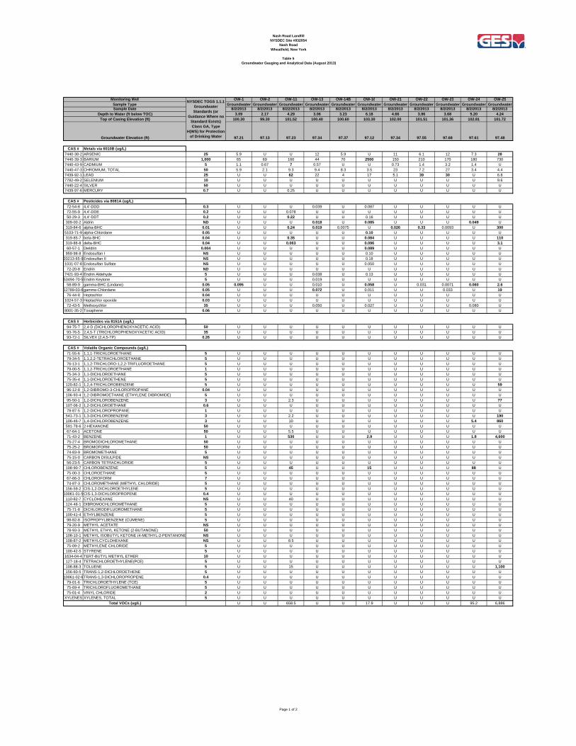
Nash Road LandfillNYSDEC Site #932054
Nash RoadWheatfield, New York
Table 5Groundwater Gauging and Analytical Data (August 2013)
OW-1 OW-2 OW-11 OW-13 OW-14B OW-16 OW-21 OW-22 OW-23 OW-24 OW-25Groundwater Groundwater Groundwater Groundwater Groundwater Groundwater Groundwater Groundwater Groundwater Groundwater Groundwater
8/2/2013 8/2/2013 8/22/2013 8/2/2013 8/2/2013 8/2/2013 8/2/2013 8/2/2013 8/2/2013 8/2/2013 8/2/20133.09 2.17 4.29 3.06 3.23 6.18 4.66 3.96 3.68 5.20 4.24
100.30 99.30 101.52 100.40 100.60 103.30 102.00 101.51 101.36 102.81 101.72
97.21 97.13 97.23 97.34 97.37 97.12 97.34 97.55 97.68 97.61 97.48
CAS # Metals via 6010B (ug/L)7440-38-2 ARSENIC 25 5.9 U U 12 5.9 U 11 6.1 12 7.3 287440-39-3 BARIUM 1,000 65 69 160 44 70 2500 150 210 170 180 7307440-43-9 CADMIUM 5 1.1 0.67 7 0.57 U U 0.73 1.4 3.2 1.4 U7440-47-3 CHROMIUM, TOTAL 50 5.9 2.1 9.3 9.4 8.3 3.5 23 7.2 27 3.4 4.47439-92-1 LEAD 25 U U 62 22 4 17 5.1 39 30 U 6.87782-49-2 SELENIUM 10 U U U U U U U U U U 9.67440-22-4 SILVER 50 U U U U U U U U U U U7439-97-6 MERCURY 0.7 U U 0.25 U U U U U U U U
CAS # Pesticides via 8081A (ug/L)72-54-8 4,4'-DDD 0.3 U U U 0.039 U 0.087 U U U U U72-55-9 4,4'-DDE 0.2 U U 0.078 U U U U U U U U50-29-3 4,4'-DDT 0.2 U U 0.22 U U 0.16 U U U U U309-00-2 Aldrin ND U U U 0.018 U 0.085 U U U 0.049 U319-84-6 alpha-BHC 0.01 U U 0.24 0.019 0.0075 U 0.026 0.33 0.0093 U 300
5103-71-9 alpha-Chlordane 0.05 U U U U U 0.10 U U U U U319-85-7 beta-BHC 0.04 U U 0.35 U U 0.084 U U U U 110319-86-8 delta-BHC 0.04 U U 0.063 U U 0.096 U U U U 3.160-57-1 Dieldrin 0.004 U U U U U 0.089 U U U U U959-98-8 Endosulfan I NS U U U U U 0.10 U U U U U
33213-65-9Endosulfan II NS U U U U U 0.18 U U U U U1031-07-8 Endosulfan Sulfate NS U U U U U 0.050 U U U U U
72-20-8 Endrin ND U U U U U U U U U U U7421-93-4 Endrin Aldehyde 5 U U U 0.038 U 0.13 U U U U U53494-70-5Endrin Keytone 5 U U U 0.019 U U U U U U U
58-89-9 gamma-BHC (Lindane) 0.05 0.095 U U 0.010 U 0.058 U 0.031 0.0071 0.060 2.612789-03-6gamme-Chlordane 0.05 U U U 0.072 U 0.011 U U 0.033 U 19
76-44-8 Heptachlor 0.04 U U U U U U U U U U U1024-57-3 Heptachlor epoxide 0.03 U U U U U U U U U U U
72-43-5 Methoxychlor 35 U U U 0.050 U 0.027 U U U 0.080 U8001-35-2 Toxaphene 0.06 U U U U U U U U U U U
CAS # Herbicides via 8151A (ug/L)94-75-7 2,4-D (DICHLOROPHENOXYACETIC ACID) 50 U U U U U U U U U U U93-76-5 2,4,5-T (TRICHLOROPHENOXYACETIC ACID) 35 U U U U U U U U U U U93-72-1 SILVEX (2,4,5-TP) 0.26 U U U U U U U U U U U
CAS # Volatile Organic Compounds (ug/L)71-55-6 1,1,1-TRICHLOROETHANE 5 U U U U U U U U U U U79-34-5 1,1,2,2-TETRACHLOROETHANE 5 U U U U U U U U U U U76-13-1 1,1,2-TRICHLORO-1,2,2-TRIFLUOROETHANE 5 U U U U U U U U U U U79-00-5 1,1,2-TRICHLOROETHANE 1 U U U U U U U U U U U75-34-3 1,1-DICHLOROETHANE 5 U U U U U U U U U U U75-35-4 1,1-DICHLOROETHENE 5 U U U U U U U U U U U120-82-1 1,2,4-TRICHLOROBENZENE 5 U U U U U U U U U U 5996-12-8 1,2-DIBROMO-3-CHLOROPROPANE 0.04 U U U U U U U U U U U106-93-4 1,2-DIBROMOETHANE (ETHYLENE DIBROMIDE) 5 U U U U U U U U U U U95-50-1 1,2-DICHLOROBENZENE 3 U U 2.3 U U U U U U U 77107-06-2 1,2-DICHLOROETHANE 0.6 U U U U U U U U U U U78-87-5 1,2-DICHLOROPROPANE 1 U U U U U U U U U U U541-73-1 1,3-DICHLOROBENZENE 3 U U 2.2 U U U U U U U 190106-46-7 1,4-DICHLOROBENZENE 3 U U 10 U U U U U U 5.4 860591-78-6 2-HEXANONE 50 U U U U U U U U U U U67-64-1 ACETONE 50 U U 5.5 U U U U U U U U71-43-2 BENZENE 1 U U 530 U U 2.9 U U U 1.8 4,60075-27-4 BROMODICHLOROMETHANE 50 U U U U U U U U U U U75-25-2 BROMOFORM 50 U U U U U U U U U U U74-83-9 BROMOMETHANE 5 U U U U U U U U U U U75-15-0 CARBON DISULFIDE NS U U U U U U U U U U U56-23-5 CARBON TETRACHLORIDE 5 U U U U U U U U U U U108-90-7 CHLOROBENZENE 5 U U 45 U U 15 U U U 88 U75-00-3 CHLOROETHANE 5 U U U U U U U U U U U67-66-3 CHLOROFORM 7 U U U U U U U U U U U74-87-3 CHLOROMETHANE (METHYL CHLORIDE) 5 U U U U U U U U U U U156-59-2 CIS-1,2-DICHLOROETHYLENE 5 U U U U U U U U U U U
10061-01-5CIS-1,3-DICHLOROPROPENE 0.4 U U U U U U U U U U U110-82-7 CYCLOHEXANE NS U U 40 U U U U U U U U124-48-1 DIBROMOCHLOROMETHANE 5 U U U U U U U U U U U75-71-8 DICHLORODIFLUOROMETHANE 5 U U U U U U U U U U U100-41-4 ETHYLBENZENE 5 U U U U U U U U U U U98-82-8 ISOPROPYLBENZENE (CUMENE) 5 U U U U U U U U U U U79-20-9 METHYL ACETATE NS U U U U U U U U U U U78-93-3 METHYL ETHYL KETONE (2-BUTANONE) 50 U U U U U U U U U U U108-10-1 METHYL ISOBUTYL KETONE (4-METHYL-2-PENTANONE NS U U U U U U U U U U U108-87-2 METHYLCYCLOHEXANE NS U U 8.5 U U U U U U U U75-09-2 METHYLENE CHLORIDE 5 U U U U U U U U U U U100-42-5 STYRENE 5 U U U U U U U U U U U
1634-04-4 TERT-BUTYL METHYL ETHER 10 U U U U U U U U U U U127-18-4 TETRACHLOROETHYLENE(PCE) 5 U U U U U U U U U U U108-88-3 TOLUENE 5 U U 15 U U U U U U U 1,100156-60-5 TRANS-1,2-DICHLOROETHENE 5 U U U U U U U U U U U
10061-02-6TRANS-1,3-DICHLOROPROPENE 0.4 U U U U U U U U U U U79-01-6 TRICHLOROETHYLENE (TCE) 5 U U U U U U U U U U U75-69-4 TRICHLOROFLUOROMETHANE 5 U U U U U U U U U U U75-01-4 VINYL CHLORIDE 2 U U U U U U U U U U U
XYLENES XYLENES, TOTAL 5 U U U U U U U U U U U
U U 658.5 U U 17.9 U U U 95.2 6,886Total VOCs (ug/L)
Top of Casing Elevation (ft)
Sample TypeNYSDEC TOGS 1.1.1
Groundwater Standards (or
Guidance Where no Standard Exists) Class GA, Type
H(WS) for Protection of Drinking Water
Monitoring Well
Sample Date
Groundwater Elevation (ft)
Depth to Water (ft below TOC)
Page 1 of 2

Nash Road LandfillNYSDEC Site #932054
Nash RoadWheatfield, New York
Table 5Groundwater Gauging and Analytical Data (August 2013)
OW-1 OW-2 OW-11 OW-13 OW-14B OW-16 OW-21 OW-22 OW-23 OW-24 OW-25Groundwater Groundwater Groundwater Groundwater Groundwater Groundwater Groundwater Groundwater Groundwater Groundwater Groundwater
8/2/2013 8/2/2013 8/22/2013 8/2/2013 8/2/2013 8/2/2013 8/2/2013 8/2/2013 8/2/2013 8/2/2013 8/2/20133.09 2.17 4.29 3.06 3.23 6.18 4.66 3.96 3.68 5.20 4.24
100.30 99.30 101.52 100.40 100.60 103.30 102.00 101.51 101.36 102.81 101.72
97.21 97.13 97.23 97.34 97.37 97.12 97.34 97.55 97.68 97.61 97.48
Top of Casing Elevation (ft)
Sample TypeNYSDEC TOGS 1.1.1
Groundwater Standards (or
Guidance Where no Standard Exists) Class GA, Type
H(WS) for Protection of Drinking Water
Monitoring Well
Sample Date
Groundwater Elevation (ft)
Depth to Water (ft below TOC)
CAS # Semi-Volatile Organic Compounds (ug/L)95-95-4 2,4,5-TRICHLOROPHENOL 1* U U U U U U U U U U U88-06-2 2,4,6-TRICHLOROPHENOL 1* U U U U U U U U U U U120-83-2 2,4-DICHLOROPHENOL 5 U U U U U U U U U U U105-67-9 2,4-DIMETHYLPHENOL 50 U U U U U U U U U U 43051-28-5 2,4-DINITROPHENOL 10 U U U U U U U U U U U121-14-2 2,4-DINITROTOLUENE 5 U U U U U U U U U U U606-20-2 2,6-DINITROTOLUENE 5 U U U U U U U U U U U91-58-7 2-CHLORONAPHTHALENE 10 U U U U U U U U U U U95-57-8 2-CHLOROPHENOL 1* U U U U U U U U U U 1091-57-6 2-METHYLNAPHTHALENE NS U U U U U U U U U U U95-48-7 2-METHYLPHENOL (O-CRESOL) 1* U U U U U U U U U U 6188-74-4 2-NITROANILINE 5 U U U U U U U U U U U88-75-5 2-NITROPHENOL 1* U U U U U U U U U U U91-94-1 3,3'-DICHLOROBENZIDINE 5 U U U U U U U U U U U99-09-2 3-NITROANILINE 5 U U U U U U U U U U U534-52-1 4,6-DINITRO-2-METHYLPHENOL 1* U U U U U U U U U U U101-55-3 4-BROMOPHENYL PHENYL ETHER NS U U U U U U U U U U U59-50-7 4-CHLORO-3-METHYLPHENOL 1* U U U U U U U U U U U106-47-8 4-CHLOROANILINE 5 U U U U U U U U U U U
7005-72-3 4-CHLOROPHENYL PHENYL ETHER NS U U U U U U U U U U U106-44-5 4-METHYLPHENOL (P-CRESOL) 1* U U U 3.2 U U U U U U 520100-01-6 4-NITROANILINE 5 U U U U U U U U U U U100-02-7 4-NITROPHENOL 1* U U U U U U U U U U U83-32-9 ACENAPHTHENE 20 U U U U U U U U U U U208-96-8 ACENAPHTHYLENE NS U U U U U U U U U U U98-86-2 ACETOPHENONE NS U U U U U 1.5 U U U U U120-12-7 ANTHRACENE 50 U U U 0.82 U U U U U 0.97 U
1912-24-9 ATRAZINE 7.5 U U U U U U U U U U U100-52-7 BENZALDEHYDE NS 0.3 U U 0.86 U 0.36 U 0.28 U 0.29 8.456-55-3 BENZO(A)ANTHRACENE 0.002 U U U U U U U U U U U50-32-8 BENZO(A)PYRENE ND U U U U U U U U U U U205-99-2 BENZO(B)FLUORANTHENE 0.002 U U U U U U U U U U U191-24-2 BENZO(G,H,I)PERYLENE NS U U U U U U U U U U U207-08-9 BENZO(K)FLUORANTHENE 0.002 U U U U U U U U U U U85-68-7 BENZYL BUTYL PHTHALATE NS U U U U U U U U U U U92-52-4 BIPHENYL (DIPHENYL) 5 U U U U U U U U U U U111-91-1 BIS(2-CHLOROETHOXY) METHANE 5 U U U U U U U U U U U111-44-4 BIS(2-CHLOROETHYL) ETHER (2-CHLOROETHYL ETHE 1 U U U U U U U U U U U108-60-1 BIS(2-CHLOROISOPROPYL) ETHER 5 U U U U U U U U U U U117-81-7 BIS(2-ETHYLHEXYL) PHTHALATE 5 U U U U U U 2.8 U U 3.1 U105-60-2 CAPROLACTAM NS U U U U U U U U U U U86-74-8 CARBAZOLE NS U U U U U U U U U U U218-01-9 CHRYSENE 0.002 U U U U U U U U U U U53-70-3 DIBENZ(A,H)ANTHRACENE NS U U U U U U U U U U U132-64-9 DIBENZOFURAN NS U U U U U U U U U U U84-66-2 DIETHYL PHTHALATE 50 U U U U U 0.49 U 0.57 0.21 0.33 U131-11-3 DIMETHYL PHTHALATE 50 U U U U U U U U U U U84-74-2 DI-N-BUTYL PHTHALATE 50 0.67 0.47 0.33 0.48 0.75 1.0 0.59 U 0.50 U U117-84-0 DI-N-OCTYLPHTHALATE 50 U U U U U U U U U U U206-44-0 FLUORANTHENE 50 U U U 0.51 U U U 0.39 0.51 0.43 U86-73-7 FLUORENE 50 U U U U U 0.41 U U U U U118-74-1 HEXACHLOROBENZENE 0.04 U U U U U U U U U U U87-68-3 HEXACHLOROBUTADIENE 0.5 U U U U U U U U U U U77-47-4 HEXACHLOROCYCLOPENTADIENE 5 U U U U U U U U U U U67-72-1 HEXACHLOROETHANE 5 U U U U U U U U U U U193-39-5 INDENO(1,2,3-C,D)PYRENE 0.002 U U U U U U U U U U U78-59-1 ISOPHORONE 50 U U U U U 0.43 U U U U U91-20-3 NAPHTHALENE 10 U U U U U U U U U U 2798-95-3 NITROBENZENE 0.4 U 0.89 U U U U U U U U U621-64-7 N-NITROSODI-N-PROPYLAMINE NS U U U U U U U U U U U86-30-6 N-NITROSODIPHENYLAMINE 50 U U U U U U U U U U U87-86-5 PENTACHLOROPHENOL 1* U U U U U U U U U U U85-01-8 PHENANTHRENE 50 0.78 U 0.64 0.84 U 0.83 0.91 0.80 0.85 1.0 U108-95-2 PHENOL 1* U U 1 U U U 2.5 U U U 43129-00-0 PYRENE 50 U U U 0.36 U U U U U U U
1.75 1.36 1.97 7.07 0.75 5.02 6.8 2.04 2.07 6.12 1,099
Notes:U = below laboratory detection limitsug/L = micrograms per literND = standard is to be below detection limitsCAS = Chemical Abstracts Services* TOGS 1.1.1 - 1 ug/L standard applies to total chlorinated PhenolsNR=Not Regulated by TOGS 1.1.1NS=Not Specified by TOGS 1.1.1
Total SVOCs (ug/L)
Page 2 of 2