Rapid Watershed Assessment Gallo Arroyo Watershed · Gallo Arroyo Watershed (HUC8 13060006) 2 The...
26
Gallo Arroyo Watershed (HUC8 13060006) 1 Rapid Watershed Assessment Gallo Arroyo Watershed
Transcript of Rapid Watershed Assessment Gallo Arroyo Watershed · Gallo Arroyo Watershed (HUC8 13060006) 2 The...

Gallo Arroyo Watershed (HUC8 13060006)
1
Rapid Watershed Assessment Gallo Arroyo Watershed

Gallo Arroyo Watershed (HUC8 13060006)
2
The U.S. Department of Agriculture (USDA) prohibits discrimination in all its programs and activities on the basis of race, color, national origin, age, disability, and where applicable, sex, marital status, familial status, parental status, religion, sexual orientation, genetic information, political beliefs, reprisal, or because all or a part of an individual's income is derived from any public assistance program. (Not all prohibited bases apply to all programs.) Persons with disabilities who require alternative means for communication of program information (Braille, large print, audiotape, etc.) should contact USDA's TARGET Center at (202) 720-2600 (voice and TDD). To file a complaint of discrimination write to USDA, Director, Office of Civil Rights, 1400 Independence Avenue, S.W., Washington, D.C. 20250-9410 or call (800) 795-3272 (voice) or (202) 720-6382 (TDD). USDA is an equal opportunity provider and employer.

Gallo Arroyo Watershed (HUC8 13060006)
3
Table of Contents Overview ......................................................................................................................................... 4 Physical Setting ............................................................................................................................... 6 Precipitation .................................................................................................................................... 9 Land Ownership ............................................................................................................................ 10 Land Use / Land Cover ................................................................................................................. 12 Hydrology ..................................................................................................................................... 16 Threatened and Endangered Species ............................................................................................ 18 Invasive Species ............................................................................................................................ 18 Common Resource Areas ............................................................................................................. 19 Conservation ................................................................................................................................. 20 Soil Resource Inventory ................................................................................................................ 21 Socioeconomic Data ..................................................................................................................... 25 References ..................................................................................................................................... 26 List of Tables Table 1. Gallo Arroyo watershed acreage distribution. .................................................................. 5 Table 2. Land ownership in the Gallo Arroyo Watershed. ........................................................... 11 Table 3. Extent of NLCD classes in the Gallo Arroyo watershed. ............................................... 13 Table 4. SW Region Gap analysis ecosystem acreages. ............................................................... 15 Table 5. NHD Water Course Type and Extents ........................................................................... 17 Table 6. Invasive Species Recognized by the SWEMP. .............................................................. 18 Table 7. 5 year Trends in Applied Conservation Practices. Reported in Acres. ......................... 20 Table 8. 5 Year Trends in Location Specific Applied Conservation Practices. Reported in Feet if Linear (i.e. Fence) ...................................................................................................................... 20 Table 9. Criteria Used for Soil Erosion Susceptibility Model. .................................................... 22 Table 10. Soil Erosion Potential Model Results. A greater rank indicates greater potential for erosion. .......................................................................................................................................... 24 Table 11. Socioeconomic Data of the Counties in the Watershed (2010) except for green cells, not available yet from 2010 census so are 2000. .......................................................................... 25 List of Figures Figure 1. Gallo Arroyo Watershed Overview ................................................................................ 4 Figure 2. Hydrologic Soils Groups ................................................................................................ 7 Figure 3. Gallo Arroyo Watershed Shaded Relief ......................................................................... 8 Figure 4. Gallo Arroyo Watershed Annual Precipitation. ............................................................. 9 Figure 5. Gallo Arroyo Watershed Land Ownership. .................................................................. 10 Figure 6. The National Land Cover Dataset over the Gallo Arroyo Watershed. ......................... 12 Figure 7. Subset of the SWREGAP over the Gallo Arroyo Watershed. The 15 dominant ecosystems are displayed in the legend. ....................................................................................... 14 Figure 8. National Hydrologic Dataset (NHD) of the Gallo Arroyo. .......................................... 16 Figure 9. National Cooperative Soil Survey of Gallo Arroyo ..................................................... 21 Figure 10. Erosion Potential of the Gallo Arroyo Watershed ...................................................... 23

Gallo Arroyo Watershed (HUC8 13060006)
Overview
Figure 1. Gallo Arroyo Watershed Overview

Gallo Arroyo Watershed (HUC8 13060006)
5
Overview The Gallo Arroyo Watershed is located in central New Mexico. It covers 557,570 total acres (2,256 sq. km). Portions of the Gallo Arroyo watershed extend into Torrance, Lincoln, and Chavez counties. Table 1 summarizes the distribution of the Gallo Arroyo watershed. Table 1. Gallo Arroyo watershed acreage distribution.
County Acres Total
Acres in HUC
% of County in HUC
% of HUC in County
Chavez 3,885,365 11,099 <1 2
Lincoln 3,089,795 509,294 16 91
Torrance 2,139,990 37,177 2 7
Sum (∑) 557,570 100

Gallo Arroyo Watershed (HUC8 13060006)
Physical Setting Geology: The HUC has a northwestern boundary at Lackey Peak. The southern boundary passes through Tecolote Peak, between Pipeline Road and Hasperos Canyon, crosses Pipeline Road just SE of the County Road B026 and Pipeline Road intersection, and ends at the confluence of Gallo Arroyo with Arroyo del Macho. The northern boundary passes through Cougar Mountain, Cameleon Hill, crosses State Highway 247 near the intersection with County Road B041, and then to the confluence. The bedrock is Permian Period limestone, dolomite and sandstone. The limestone is porous and has many sinkholes. Caliche also forms on the ground surface. On the northern edge along the county boundary there are some Quaternary Period eolian deposits. Resource concerns are high sediment erosion. In addition the lowering of valleys by river incision is a continuing process. Rivers respond by aggrading during climates that promote large sediment yield and large, stable discharges; and incise during climates that produce flashy flows and reduce the sediment supply. Groundwater quality and quantity is a concern. Depth to groundwater is a concern if the shallow unconfined aquifer does not produce enough water for the resource or increased population demands are ‘mining’ the water. Groundwater in the limestone is usually along fracture zones which are hard to intercept with water wells. Groundwater quality ranges from good to fair for livestock or crops. Soils: Hydrologic soil groups are based on estimates of runoff potential. Soils are assigned to one of four groups according to the rate of water infiltration when the soils are not protected by vegetation, are thoroughly wet, and receive precipitation from long-duration storms. The soils in the Rio Grande-Albuquerque Watershed are assigned to four groups (A, B, C, and D).
Group A. Soils having a high infiltration rate (low runoff potential) when thoroughly wet. These consist mainly of deep, well drained to excessively drained sands or gravelly sands. These soils have a high rate of water transmission.
Group B. Soils having a moderate infiltration rate when thoroughly wet. These consist chiefly of moderately deep or deep, moderately well drained or well drained

Gallo Arroyo Watershed (HUC8 13060006)
soils that have moderately fine texture to moderately coarse texture. These soils have a moderate rate of water transmission.
Group C. Soils having a slow infiltration rate when thoroughly wet. These consist chiefly of soils having a layer that impedes the downward movement of water or soils of moderately fine texture or fine texture. These soils have a slow rate of water transmission.
Group D. Soils having a very slow infiltration rate (high runoff potential) when thoroughly wet. These consist chiefly of clays that have a high shrink-swell potential, soils that have a high water table, soils that have a claypan or clay layer at or near the surface, and soils that are shallow over nearly impervious material. These soils have a very slow rate of water transmission.
Figure 2. Hydrologic Soils Groups

Gallo Arroyo Watershed (HUC8 13060006)
Figure 3. Gallo Arroyo Watershed Shaded Relief

Gallo Arroyo Watershed (HUC8 13060006)
9
Precipitation 1
Figure 4. Gallo Arroyo Watershed Annual Precipitation.

Gallo Arroyo Watershed (HUC8 13060006)
10
Land Ownership 2
Figure 5. Gallo Arroyo Watershed Land Ownership.

Gallo Arroyo Watershed (HUC8 13060006)
11
Land Ownership COUNTY BLM FS Private State
Chavez 4,651 656 5,792
Lincoln 128,536 10,747 291,514 78,498
Torrance 749 1,178 33,816 1,434
Watershed (∑) 133,936 11,925 325,986 85,724
% Watershed 24 2 58 15 Table 2. Land ownership in the Gallo Arroyo Watershed.

Gallo Arroyo Watershed (HUC8 13060006)
12
Land Use / Land Cover 3, 4
Figure 6. The National Land Cover Dataset over the Gallo Arroyo Watershed.

Gallo Arroyo Watershed (HUC8 13060006)
13
Land Use / Land Cover
Table 3. Extent of NLCD classes in the Gallo Arroyo watershed.
Land use / Land cover Acres % of Watershed
Grasslands, Herbaceous 375,335 67
Shrubland 156,525 28
Evergreen Forest 23,877 4
Low Intensity Residential 1,603 <1
Bare Rock/Sand/Clay 128 <1
Emergent Herbaceous Wetlands 54 <1
High Intensity Residential 20 <1
Pasture/Hay 18 <1
Commercial/Industrial/Transportation 4 <1
Deciduous Forest 2 <1
The U.S. Geological Survey (USGS) produced the National Land Cover Dataset (NLCD) as part of a cooperative project between the USGS and the U.S. Environmental Protection Agency (USEPA). The goal of this project was to produce a consistent land cover data layer for the conterminous United States. The Multiresolution Land Characterization (MRLC) Consortium collected the data used to compile the NLCD. The MRLC Consortium is a partnership of Federal agencies that produce or use land cover data; partners include the UNITED STATES GEOLOGICAL SURVEY (National Mapping, Biological Resources, and Water Resources Divisions), USEPA, the U.S. Forest Service, and the National Oceanic and Atmospheric Administration.

Gallo Arroyo Watershed (HUC8 13060006)
Land Use / Land Cover
Figure 7. Subset of the SWREGAP over the Gallo Arroyo Watershed. The 15 dominant ecosystems are displayed in the legend.

Gallo Arroyo Watershed (HUC8 13060006)
15
Land Use / Land Cover
Ecosystem Acres % of Watershed
Western Great Plains Shortgrass Prairie 348,843 63
Southern Rocky Mountain Juniper Woodland and Savanna 122,244 22
Apacherian-Chihuahuan Piedmont Semi-Desert Grassland and Steppe 48,860 9
Southern Rocky Mountain Pinyon-Juniper Woodland 22,499 4
Inter-Mountain Basins Semi-Desert Shrub Steppe 4,735 1
Rocky Mountain Ponderosa Pine Woodland 2,375 < 1
Chihuahuan Creosotebush, Mixed Desert and Thorn Scrub 1,147 < 1
Chihuahuan Sandy Plains Semi-Desert Grassland 1,090 < 1
Madrean Pinyon-Juniper Woodland 1,028 < 1
Rocky Mountain Lower Montane-Foothill Shrubland 737 < 1
Madrean Juniper Savanna 577 < 1
Rocky Mountain Gambel Oak-Mixed Montane Shrubland 575 < 1
Chihuahuan Gypsophilous Grassland and Steppe 532 < 1
Western Great Plains Riparian Woodland and Shrubland 445 < 1
North American Warm Desert Active and Stabilized Dune 382 < 1 Table 4. SW Region Gap analysis ecosystem acreages.
The landcover mapping effort for the Southwest Region Gap Analysis Project was a coordinated multi-institution endeavor. This dataset was created for regional terrestrial biodiversity assessment. Additional objectives were to establish a coordinated mapping approach to create detailed, seamless maps of land cover, all native terrestrial vertebrate species, land stewardship, and management status, and to analyze this information to identify those biotic elements that are underrepresented on lands managed for their long term conservation.

Gallo Arroyo Watershed (HUC8 13060006)
16
Hydrology 5, 6. 7. 8, 9 The National Hydrography Dataset (NHD) is a comprehensive set of data that encodes information about naturally occurring and constructed bodies of water, paths through which water flows, and related entities. The NHD identifies 1,233 miles (1,984 km) of water courses in the Gallo Arroyo River Watershed. The majority of these courses typically flow intermittently in summer months during periods associated with high intensity convective thunderstorms.
Figure 8. National Hydrologic Dataset (NHD) of the Gallo Arroyo.

Gallo Arroyo Watershed (HUC8 13060006)
Water Course Type Miles
Artificial path 10
Connector 26
Intermittent Stream / River 1,198
Sum (∑) 1,233
Table 5. NHD Water Course Type and Extents
There are no dams or water gauging stations in the watershed.
Hydrology
The New Mexico Water Quality Control Commission (NMWQCC) is the issuing agency of water quality standards for interstate and intrastate waters in New Mexico. The NMWQCC has defined the Gallo Arroyo watershed as part of the Rio Grande River Basin.
The Gallo Arroyo watershed has no lakes or reaches designated as impaired.
Hydrology - Declared Groundwater Basins A declared groundwater basin is an area of the state proclaimed by the State Engineer to be underlain by a groundwater source having reasonably ascertainable boundaries. By such proclamation the State Engineer assumes jurisdiction over the appropriation and use of groundwater from the source. The Gallo Arroyo watershed is within one Underground Water Basin: the Roswell Artesian. Groundwater Basin Acres in Basin
Watershed Acres % of Declared Basin
Roswell Artesian 6,920,505 557,570 8

Gallo Arroyo Watershed (HUC8 13060006)
18
Threatened and Endangered Species 10 Endangered species are those that are at risk of extinction throughout all or a significant portion of its native range. A threatened species is one that is likely to become endangered in the foreseeable future. The New Mexico Natural Heritage program tracks the status of threatened and endangered species which are listed on both federal and state lists. There are no species which are currently listed and tracked in the Gallo Arroyo River Watershed. Invasive Species 11
Invasive species are those which have been introduced into a region or ecosystem and have the ability to out-compete native species for resources (i.e. water, nutrients, sunlight, etc.) The Southwest Exotic Plant Mapping Program (SWEMP) is a collaborative effort between the United States Geological Survey and federal, tribal, state, county and non-government organization partners in the southwest which maintains ongoing efforts to compile and distribute regional data on the occurrence of non-native invasive plants in the southwestern United States. Within the Gallo Arroyo watershed, the SWEMP has identified 6 species of invasive plants (Table 6). Each of these species is defined as non-native by the USDA PLANTS database.
Scientific Name Common Name
Zygophyllaceae (Caltrop Family) African Rue
Scrophylariaceae (Figwort Family) Dalmatian Toadflax
Brassicaceae (Mustard Family) Hoary Cress (Whitetop)
Asteraceae (Sunflower Family) Musk Thistle
Asteraceae (Sunflower Family) Russian Knapweed
Scrophulariaceae (Figwort Family) Yellow Toadflax Table 6. Invasive Species Recognized by the SWEMP.

Gallo Arroyo Watershed (HUC8 13060006)
19
Common Resource Areas12
A Common Resource Area (CRA) is defined as a geographical area where resource concerns, problems, or treatment needs are similar. It is considered a subdivision of an existing Major Land Resource Area (MLRA) designation. Landscape conditions, soil, climate, human considerations, and other natural resource information are used to determine the geographic boundaries of a Common Resource Area.
Each Common Resource Area will have multiple Conservation System Guides associated with it. A Conservation System Guide associates, for a given CRA and land use, different components of Resource Management Systems and their individual effect on conserving soil and water resources.
The entire Gallo Arroyo watershed is in the 70.1 Common Resource Area
70C.1 - Central New Mexico Highlands Tablelands and mesas separated by broad plains and small terraces characterize this area. Elevation is 5,000 to 7,200 feet and precipitation is 12 to 17 inches. The soil moisture regime is aridic to ustic and the soil temperature regime is mesic. Pinyon-juniper savannah and pinyon juniper woodlands at higher elevations, and broad mid- to short-grass prairies and basins at lower elevations dominate the area. Current land use is livestock grazing. The soils formed in Quaternary alluvium, eolian sands, and sedimentary rocks of Permian age. (Old CP-3)

Gallo Arroyo Watershed (HUC8 13060006)
Conservation 13
The USDA-Natural Resources Conservation Service (NRCS) focuses on the development and delivery of high quality products and services that enable people to be good stewards of our Nation’s soil, water, and related natural related resources on non-Federal lands. The Natural Resources Conservation Service’s conservation programs aid agricultural producers in their efforts to reduce soil erosion, enhance water supplies, improve water quality, increase wildlife habitat, and reduce damages caused by floods and other natural disasters. Public benefits include enhanced natural resources that help sustain agricultural productivity and environmental quality while supporting continued economic development, recreation, and scenic beauty.
Conservation Practice
2007 2008 2009 2010 2011 TOTAL
# Acres # Acres # Acres # Acres # Acres # Acres Brush Management 6 633 33 3671 9 1233 33 2844 18 1012 99 9393
Prescribed Grazing 1 1408 25 23406 10 15186 52 28337 4 3860 92 72197
Upland Wildlife Habitat Management
1 1408 28 31635 10 15186 49 27369 88 75598
SUM (∑) 8 3449 86 58712 29 31605 134 58550 22 4872 279 157188 Table 7. 5 year Trends in Applied Conservation Practices. Reported in Acres.
Conservation Practice 2007 2008 2009 2010 2011 TOTAL # Feet # Feet # Feet # Feet # Feet # Feet
Fence 1 3030 1 3900 1 3900 1 5265 4 16095 Pipeline 5 8575 7 31077 3 6920 2 13800 2 5390 19 65762 Pumping Plant 3 2 5 Water Well 2 1 2 5 Watering Facility 10 13 3 9 5 40 SUM (∑) 18 25 7 16 7 73 81857
Table 8. 5 Year Trends in Location Specific Applied Conservation Practices. Reported in Feet if Linear (i.e. Fence)

Gallo Arroyo Watershed (HUC8 13060006)
21
Soil Resource Inventory 14
Figure 9. National Cooperative Soil Survey of Gallo Arroyo
The Gallo Arroyo Watershed has a number of certified National Cooperative Soil Survey (NCSS) inventories, and is completely covered by soil surveys.

Gallo Arroyo Watershed (HUC8 13060006)
Soil Resource Inventory
In order to evaluate the susceptibility of erosion within the Gallo Arroyo watershed, a model was developed using Soil Survey Geographic Database (SSURGO) information. The soil properties saturated hydraulic conductivity, soil loss tolerance, and wind erodibility group were used in conjunction with slope to assess soil mapunit potential for erosion. Saturated hydraulic conductivity and slope are reported in SSURGO databases as interval/ratio data whereas wind erodibility and soil loss tolerance are ordinal data. Data transformations for the model are listed -
Table 9. Criteria Used for Soil Erosion Susceptibility Model.
SSURGO Value Nominal Description Model Rank
Saturated Hydraulic Conductivity
µm / s 705.0 - 100.0 Very High 0 100.0 - 10.0 High 1
10.0 - 1.0 Moderately High 2 1.0 - 0.1 Moderately Low 3 0.1 - 0.01 Low 4 Slope %
0 - 5 0 6 - 10 1
11 - 15 2 16 - 25 3
> 25 4 Soil Loss Tolerance
5 High Tolerance For loss 0 4 ↓ 1 3 ↓ 2 2 ↓ 3 1 Low Tolerance For Loss 4
Wind Erodibility Group 1 Very High 4 2 Very High 4 3 High 3 4 High 3 4L High 3 5 Moderate 2 6 Moderate 2 7 Moderate 1 8 Slight 0

Gallo Arroyo Watershed (HUC8 13060006)
23
Soil Resource Inventory
For each soil map unit (discrete delineation), the soil properties (named above) of the dominant soil type was used as the condition to be evaluated in the susceptibility to erosion model. Miscellaneous areas such as gravel pits, water, riverwash, etc. were excluded from evaluation. Possible range of values for each map unit are 0 – 16. Increasing values represent a higher susceptibility to soil erosion.
Figure 10. Erosion Potential of the Gallo Arroyo Watershed

Gallo Arroyo Watershed (HUC8 13060006)
Soil Resource Inventory
Table 10. Soil Erosion Potential Model Results. A greater rank indicates greater potential for erosion.
Rank Acres 1 136
3 8,278
4 107,513
5 93,517
6 23,314
7 56,051
8 11,465
9 200,688
10 40,102
11 452
12 16,054
Sum( ∑) 557,570
Gallo Arroyo Watershed (HUC8 13060006)
25
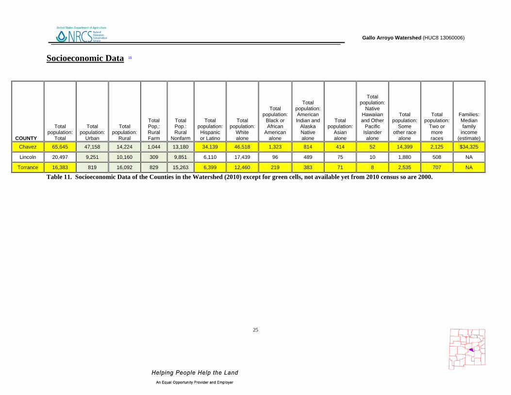
Socioeconomic Data 15
COUNTY
Total population:
Total
Total population:
Urban
Total population:
Rural
Total Pop,: Rural Farm
Total Pop.: Rural
Nonfarm
Total population: Hispanic or Latino
Total population:
White alone
Total population:
Black or African
American alone
Total population: American Indian and
Alaska Native alone
Total population:
Asian alone
Total population:
Native Hawaiian and Other
Pacific Islander
alone
Total population:
Some other race
alone
Total population:
Two or more races
Families: Median family
income (estimate)
Chavez 65,645 47,158 14,224 1,044 13,180 34,139 46,518 1,323 814 414 52 14,399 2,125 $34,325
Lincoln 20,497 9,251 10,160 309 9,851 6,110 17,439 96 489 75 10 1,880 508 NA
Torrance 16,383 819 16,092 829 15,263 6,399 12,460 219 383 71 8 2,535 707 NA
Table 11. Socioeconomic Data of the Counties in the Watershed (2010) except for green cells, not available yet from 2010 census so are 2000.

Gallo Arroyo Watershed (HUC8 13060006)
26
References 1. Parameter-elevation Regressions on Independent Slopes Model (PRISM).PRISM is a unique knowledge-based system that uses point measurements of precipitation, temperature, and other climatic factors to produce continuous, digital grid estimates of monthly, yearly, and event-based climatic parameters. http://www.prism.oregonstate.edu/ 2. Bureau of Land Management – New Mexico State Office. - http://www.blm.gov/nm/st/en/prog/more/geographic_sciences/spatial_data_metadata.html 3. UNITED STATES GEOLOGICAL SURVEY - National Land Cover Dataset. http://landcover.United States Geological Survey.gov/ 4. Southwest Regional Gap Analysis Project (SWReGAP). http://earth.gis.usu.edu/swgap/ 5. UNITED STATES GEOLOGICAL SURVEY – National Hydrography Dataset. http://nhd.United States Geological Survey.gov/ 6. UNITED STATES GEOLOGICAL SURVEY - http://waterdata.usgs.gov/nwis/rt 7. State of New Mexico Environment Department - ftp://ftp.nmenv.state.nm.us/www/swqb/303d-305b/2010/USEPA-Approved303dList.pdf 8. United States Environmental Protection Agency - http://cfpub.epa.gov/surf/huc.cfm?huc_code=13060006 9. New Mexico - Office of the State Engineer- http://www.ose.state.nm.us/water_info_data.html 10. New Mexico Natural Heritage Program - http://nhnm.unm.edu/ 11. Southwest Exotic Plant Mapping Program - http://www.invasiveweeds.com/mapping/welcome.html 12. National Coordinated Common Resource Area (CRA) Geographic Database http://soils.usda.gov/survey/geography/cra.html 13. Natural Resources Conservation Service – Performance Results System http://ias.sc.egov.usda.gov/PRSHOME/ 14. Natural Resources Conservation Service – Soil Data Mart http://soildatamart.nrcs.usda.gov/ 15. United States Census Bureau - http://factfinder2.census.gov/faces/nav/jsf/pages/index.xhtml