Ramsar site- Nariva Swamp - biodiversity.gov.tt
19
Nariva swamp Country: The Republic of Trinidad and Tobago Name of the Ramsar site: Nariva swamp Geographical coordinates: 10° 23' N, 61° 04' W Altitude: Varies from sea level to 10 m at its highest point. Area: 6,234 ha. Overview: Nariva Swamp is the largest freshwater herbaceous swamp in Trinidad. It is a permanent brackish lagoon with extensive mangrove swamps, seperated from the sea' by, two parallel sandbars, and a large area of flooded marshes. The seasonal marshes flood to a depth of 1 m in the wet season (June - November) leaving islands of higher ground with humid tropical forest. The site is ecologically diverse and is the habitat for several .endangered species such as the-Caribbean manatee and the red- bellied macaw it also represents the only natural habitat in Trinidad for the locally extirpated Blue and Gold Macaw. Ramsar Criteria: 1a• 1b• 1c• 1d• 2a• 2b• 2c• 2d• 3a• 3b• 3c• 4a• 4b Justification of the application criteria listed above: 1a. Nariva Swamp is a very good example of a large swamp/mangrove forest ecosystem,characteristic for the Caribbean region . 2a. The globally threatened manatee Trichechus manatus occurs at the swamp. 2b. Nariva Swamp is the only habitat for several species in Trinidad and Tobago and is important in maintaining the biological diversity in the region. 3b. The site regularly supports large numbers of the order Ciconiiformes, these include the families Ardeidae (Herons), Cochleariidea (Boat-billed Heron), and Therskiornithidae (Ibises) General location: Nariva Swamp is situated on the East coast of Trinidad about 50 km southeast of the city of Port-of-Spain. The site comprises state lands, including the Nariva Swamp Prohibited Area, Bush Bush Wildlife Sanctuary, part of the Ortoire Nariva Windbelt Forest Reserve and the proposed Nariva National Park. Physical features: Nariva Swamp is a permanent brackish lagoon with extensive mangrove swamps. It is separated from the sea by a sand bar. It has fresh to brackish swamps, swamp forest and seasonal flooded marshes in addition there are higher areas with humid tropical hardwood forest. It has tidal influence and possibly surface seepage. The salinity is approximately 18-25 % and varies depending on the tides. The Bush Bush Wildlife Sanctuary which is part of the Nariva Swamp Ramsar site, receives its waters from the Navet, Bois Neuf and Guatacara Rivers, which drain the
Transcript of Ramsar site- Nariva Swamp - biodiversity.gov.tt

Nariva swamp
Country: The Republic of Trinidad and Tobago Name of the Ramsar site: Nariva swamp Geographical coordinates: 10° 23' N, 61° 04' W Altitude: Varies from sea level to 10 m at its highest point. Area: 6,234 ha. Overview: Nariva Swamp is the largest freshwater herbaceous swamp in Trinidad. It is a permanent brackish lagoon with extensive mangrove swamps, seperated from the sea' by, two parallel sandbars, and a large area of flooded marshes. The seasonal marshes flood to a depth of 1 m in the wet season (June - November) leaving islands of higher ground with humid tropical forest. The site is ecologically diverse and is the habitat for several .endangered species such as the-Caribbean manatee and the red-bellied macaw it also represents the only natural habitat in Trinidad for the locally extirpated Blue and Gold Macaw. Ramsar Criteria: 1a• 1b• 1c• 1d• 2a• 2b• 2c• 2d• 3a• 3b• 3c• 4a• 4b Justification of the application criteria listed above: 1a. Nariva Swamp is a very good example of a large swamp/mangrove forest ecosystem,characteristic for the Caribbean region . 2a. The globally threatened manatee Trichechus manatus occurs at the swamp. 2b. Nariva Swamp is the only habitat for several species in Trinidad and Tobago and is important in maintaining the biological diversity in the region. 3b. The site regularly supports large numbers of the order Ciconiiformes, these include the families Ardeidae (Herons), Cochleariidea (Boat-billed Heron), and Therskiornithidae (Ibises) General location: Nariva Swamp is situated on the East coast of Trinidad about 50 km southeast of the city of Port-of-Spain. The site comprises state lands, including the Nariva Swamp Prohibited Area, Bush Bush Wildlife Sanctuary, part of the Ortoire Nariva Windbelt Forest Reserve and the proposed Nariva National Park. Physical features: Nariva Swamp is a permanent brackish lagoon with extensive mangrove swamps. It is separated from the sea by a sand bar. It has fresh to brackish swamps, swamp forest and seasonal flooded marshes in addition there are higher areas with humid tropical hardwood forest. It has tidal influence and possibly surface seepage. The salinity is approximately 18-25 % and varies depending on the tides. The Bush Bush Wildlife Sanctuary which is part of the Nariva Swamp Ramsar site, receives its waters from the Navet, Bois Neuf and Guatacara Rivers, which drain the

eastern slopes of the Central Range . The fluctuations of the water level lies between 0 .6-1 .9 m. In the wet season there is considerable water in the swamp which makes the Bush Bush wildlife Sanctuary only accessible by boat. Also at the height of the wet season the Bush Bush and Bois Neuf Islands lie only 3m above the surrounding swamps. In the dry season certain areas may dry completely. The soils are sandy and are well drained, however it is a class VI soil which has been under the Draft National Physical Development Plan (1978) deemed unsuitable for agricultural practices and be left under indigenous growth of forest . Rainfall averages 250 mm annually. Hydrological values: No special hydrological values known Ecological features: The Nariva Swamp includes the largest freshwater herbaceous swamp in Trinidad and has the most varied vegetation of all wetlands in Trinidad and Tobago. The major vegetation types are: beach scrub with Coccoloba spp, mangrove swamps with Rhizophora mangle and Avicennia germinans, permanent herbaceous swamp with Montrichardia arborescens and Cyperus giganteus, seasonally flooded marshes with Eleocharis mutata, Cyperus odoratus and Phragmites spp ., swamp forest with Pterocarpus officinalis, Carapa spp and Bactris major and islands of humid tropical forest with Roystonea oleracea, Mauritia setigera and Euterpe oleracea and E. precatoria. The Cocorite palm, Atlalea maripa is also abundant on Bush Bush .
Noteworthy flora: The Nariva Swamp supports one of only two communities in Trinidad of the moriche palm (Mauritia spp.). The palmiste palm (Roystonea oleracea) is also found and is presently under severe threat because of the unsustainable harvesting of the meristems primarily for use in local cuisine, also trees are destroyed for poaching of nests of young parrots for the pet trade. Bush Bush Island hosts a true hardwood forest. The main canopy is about 21-24 m with a few emergent reaching up to 30 m. There is a secondary canopy of 12-15 m, consisting of tirite palms, while the forest floor is made up of tirite and seedling trees. Some of the hardwood was cut prior to its protection status (protected since 1960) and occasional fires have occurred in the northern part of the island, but the forest has not changed appreciably. Towards the eastern boundary of the island, and in the swamps, are magnificent stands of swamp bloodwoods and moriche palms, while the open swamp consists of a dense matting of grass . Noteworthy fauna : The area supports a rich fauna; common or important birds include blue heron Ardea herodias, great egret Egretta alba, snowy egret E. thula, cattle egret Bubulcus ibis, green-backed heron Butorides striatus, red-billed whistling duck Dendrocygna autumnalis, limpikin Aramus guarauma, moorhen Gallinula martinica, wattled jacana Jacana jacana, anhinga Anhinga anhinga, yellow-headed caracara Milvago chimachima, savanna hawk Buteogallus meridionalis, blue and yellow macaw Ara ararauna (at least locally highly endangered ; probably extinct, as a result of loss of food supply and trapping), red-bellied macaw Ara manilata and dickcissel Spiza americana. Amongnst the mammals present within the site are the red howler monkey Alouatta seniculus, white-fronted capuchin Cebus albifrons, paca Agouti paca and manatee Trichechus manatus (globally threatened), three species of opossums, the three-toed anteater and two-toed anteater Cyclopus didactylus, agouti

Dasyprocta agouti, and the tree porcupine . There are 32 species of bat recorded at Bush Bush Wildlife Sanctuary . The fishing catch consists mainly of cascadura Hoplosternum littorale and conch Pomacea urceus. Other fish species at the site are guabine Hoplias malabaricus and yarrow Hoplerythrinus unitaeniatus. Main reptiles at the site are Caiman crocodilus and Iguana iguana, zandolie Ameiva ameiva and matte Tupinambis negropunctatus. The site also host the snakes anaconda Eunectes murinus and fer-de-lance Bothrops atrox, and the blue crab cardisoma guanhumi, hairy crab Ucides cordatus and mangrove oyster Crassostrea rhizophorae. Finally, 92 species of mosquitoes have been recorded. Social and cultural values: The wetland has been traditionally used for artisan fishing and small subsistence farming .The wetland is also being used for commercial rice farming . Land tenure/ownership of: (a) Site: State of Trinidad and Tobago . (b) Surrounding area; private owners . Current land use: (a) Site: The mangrove vegetation is cut at Nariva Swamp for commercial and traditional purposes. Large areas of the swamp were allocated by the government for rice and water melon cultivation, however some farmers do not limit their agricultural activities to the allocated areas .There are several communities in the wetland that are largely dependent on it for their social and economic needs. The people here use the site for hunting, commercial and subsistence fishing, catching of conch and crabs, gathering of firewood from the forest and plant products for use in the craft industry. Several species of birds are caught mainly for the pet trade. Herds of water buffaloes are kept in the marsh, they keep the vegetation from becoming to dense and from being dominated by Phragmites spp. (b). surrounding/catchment : The surrounding area is used for rice cultivation . The total Nariva Swamp is much larger than the area designated as the Ramsar Site and much of the surrounding area has the same land use as the site itself. Factors (past, present or potential) adversely affecting the site's ecological character, including changes in land use and development projects : (a) at the site : This site is under serious threat, because a large part of the Nariva Swamp has been, and are currently being, destroyed for unsustainable agricultural activities by rice-farmers . They use land for a couple of years, and then abandon it in favor of newly cleared land . Due to trapping, disturbance and loss of food supply, the site has lost several species over the last years, like the blue and yellow macaw Ara ararauna. The manatee Trichechus manatus is extremely vulnerable. Other problems are the illegal felling of mangroves in order to supply bark to the tanning industry, illegal squatting, reclamation of land for agriculture and clandestine cultivation of cannabis, illegal grazing of domestic livestock in the Game Sanctuary; exploitation of the forest for timber ; overfishing; illegal hunting including the use of gun traps ; excessive trapping of birds for the pet trade and the unsustainable levels of crab and oyster harvesting .

There is also the felling of Roseau Palms for hearts and for parrots. Fires also threaten the swamp. Often they are started deliberately. They ruin forests, and are especially harmful to reptiles and amphibians that live in the marshes. Nariva Swamp is threatened by pesticides and other agricultural chemicals utilised by farmers in the surrounding area and in the swamp itself. The swamp constantly receives inflow of water polluted with agricultural chemicals. These chemicals lead to Euthrophication and destruction of the insect biota which some waterfowl depend on as a food source. Other problems associated with rice farming are the dilapidated state of the irrigation structures, which cause a substantial loss of water during the dry season . Another cause of water loss is over-draining of the swamp during the dry season. This has lead to the early drying out of the swamp during the dry season. An indirect, but nevertheless severe problem for the Nariva Swamp is the problems rice farmers face to obtain a good yield. They have great difficulties obtaining proper seeds and therefore they are forced to use much more herbicides and pesticides. There are also problems with dividing the available water amongst the farmers. Especially the small farmers suffer a lot from these problems. Altogether the problems the rice farmers face have great negative impacts on the swamp, both in water level management and in pollution. Extension of a branch of the Nariva River close to the sea has caused a serious threat of salt intrusion into a section of the Nariva Swamp . It is not clear which Government Agency is responsible for the active management of the site, and therefore it is not always possible to respond adequately to the problems that were arising at the Nariva Swamp .This problem may have been solved since the establishment of the Environmental Management Act in 1995. Conservation measures taken: Management in Trinidad and Tobago focuses largely on resource protection under the Forests Act, the Conservation of Wildlife Act and the State Lands Act. Offenses taken to court are usually related to wildlife poaching. However, this has not been entirely successful and encroachment of squatters has occurred at Nariva . In 1993 the first squatter was brought to court and found guilty. Up until then, the government had never managed to stop their activities. After an intense public campaign coupled with government's actions, the illegal rice farmers have been evicted from Block B in the Plum Mitan area. An environmental impact assessment is currently being conducted by the Institute of Marine Affairs to ascertain how the illegal rice farming has affected the swamp and provide information towards the preparation of a management plan. Nariva Swamp has been on the Montreux list of seriously threatened wetlands since 16 June 1993 . A Ramsar Monitoring Procedure Mission visited the site in 1994 . In its report a lot of recommendations for improvement of this site's management . Conservation measures proposed but not yet implemented: In the Monitoring Procedure Report of the Ramsar Convention Bureau, there is a proposal about "Methods for rice farming with low environmental impact and wise use of Nariva Swamp Ramsar site". It proposes to provide small land assignments to family farms. The Government is at present working on the regularization of land tenure in this area. Recommendations made in the Monitoring Procedure Report include the preparation of an integral management plan for the site, include an assessment of the economic and social values of the swamp and an environmental impact assessment. With this in mind the Institute of marine Affairs is currently investigating the effects of rice farming on the swamp and from this study a

management plan will be formulated. To be able to manage the site properly, additional funding will be needed, and more trained staff to implement the policy that is to be developed in the management plan . The newly appointed National Wetlands Committee is supported strongly by the Government and by other organizations . Education on the wise use of Nariva Swamp is recommended at all levels, including the local people. Four field coordinators have been trained, two in the Plum Mitan area and two in the Kernahan area. They facilitate the relationship between the local people, the Government and other organization involved, as well as help in surveying the bird population of the swamp for the Wildlife Section of the Forestry Division. Overall the local people should be involved in the plans for managing the area. There are many other recommendation in the report, on water issues, agricultural practices, government involvement, rice mills, agrochemicals, machinery, restoration and pilot projects, water buffaloes, other uses and fires. Current scientific research and facilities: The University of the West Indies conducts limited research in the area as part of students postgraduate research. There are plans to re-introduce the blue and gold macaw in the Bush Bush area by the Wildlife section aided by representatives of the Cincinnati Zoo. There is also the ongoing Environmental Impact Assessment by the Institute of Marine Affairs. Wildlife officers conduct bird surveys in the area on a regular basis. Current conservation education: Community education by Wildlife officers is ongoing in the area . As well as lectures on the importance of wetlands were conducted by wildlife officers to school children and the Civilian Conservation corps. Current recreation and tourism: Due to the inaccessibility of the site recreational activities is very small scale and is limited to bird watching and fishing. Some ecotours are conducted by tour guides, but this is limited. Jurisdiction: Ministry of Agriculture, Land and Marine Resources. Management authority: Wildlife Section, Forestry Division - Conservation of Biodiversity. North Regional Office, Ministry of Agriculture, Land and Marine Resources – Agricultural activities . State Lands Division - Land Tenure.

Nariva Swamp
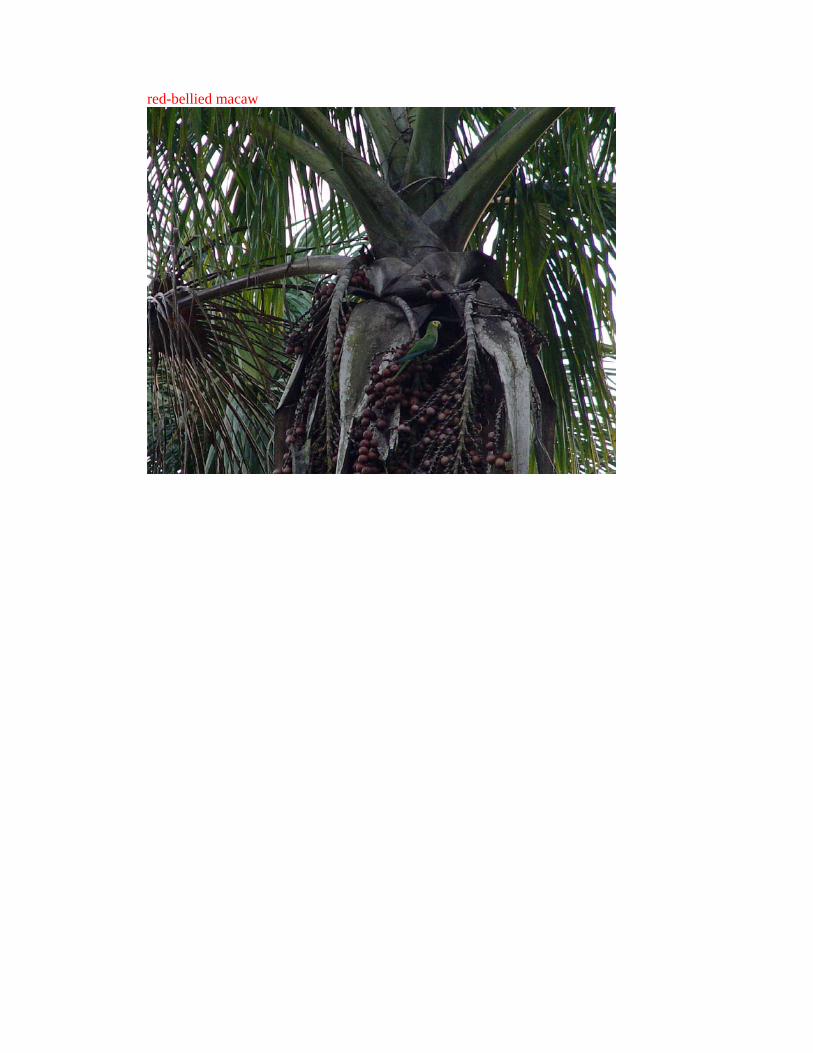
red-bellied macaw

Herons

by a sand bar

\swamp forest

Rhizophora mangle
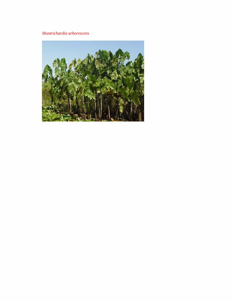
Montrichardia arborescens

Roystonea oleracea

moriche palm

savanna hawk

Cebus albifrons

Alouatta seniculus

two-toed anteater Cyclopus didactylus