RAAF BASE WILLIAMTOWN & SALT ASH AIR WEAPONS RANGE...AGL and 1000 ft AGL for other aircraft...
31
SUMMARY REPORT RAAF BASE WILLIAMTOWN & SALT ASH AIR WEAPONS RANGE 2025 ANEF AUGUST 2011
Transcript of RAAF BASE WILLIAMTOWN & SALT ASH AIR WEAPONS RANGE...AGL and 1000 ft AGL for other aircraft...

SUMMARY REPORT
RAAF BASE WILLIAMTOWN& SALT ASH AIR WEAPONS
RANGE2025 ANEF
AUGUST 2011
RAAF BASE WILLIAMTOWN& SALT ASH AIR WEAPONS RANGE
2025 ANEFSUMMARY REPORT
GHD Pty Ltd
Level 7, 16 Marcus Clarke Street
Canberra ACT 2601
ABN 39 008 488 373

ii
Job Number: 23 13062 RAAF Base Williamtown & Salt Ash Air Weapons Range 10 Aug 11File name: WLM Summary Report V3.doc 2025 ANEF — Summary Report
RAAF Base Williamtown & Salt Ash Air Weapons Range
2025 ANEF — SUMMARY REPORTTABLE OF CONTENTS PAGE
ENDORSEMENT ivABBREVIATIONS vDEFINITIONS vii
1. EXECUTIVE SUMMARY 11.1 RAAF Base Williamtown & Salt Ash Air Weapons Range 2025 ANEF 1
2. INTRODUCTION 22.1 RAAF Base Williamtown 22.2 Salt Ash Air Weapons Range 22.3 Summary of the Assessment of Aircraft Noise 22.4 ANEF for RAAF Base Williamtown 32.5 Data Collection, Compilations and Validation 4
3. SUMMARY OF INPUT DATA 53.1 General 53.2 Datum for the Integrated Noise Model 53.3 Aircraft Flight Tracks 63.4 Aircraft Movement Numbers 83.5 Runway Usage 9
4. INM DATA 104.1 Overview 104.2 Aircraft Substitutions 104.3 INM Parameter Settings 124.4 Williamtown Environmental Conditions 124.5 Terrain 12
5. 2025 ANEF CONTOURS 13

iii
Job Number: 23 13062 RAAF Base Williamtown & Salt Ash Air Weapons Range 10 Aug 11File name: WLM Summary Report V3.doc 2025 ANEF — Summary Report
APPENDICES
A. The ANEF System & INM
B. Regional Location Plan and Runway Layout Plan
C. Flight Track Plans
D. Summary of Aircraft Movements
E. 2025 ANEF Map

v
Job Number: 23 13062 RAAF Base Williamtown & Salt Ash Air Weapons Range 10 Aug 11File name: WLM Summary Report V3.doc 2025 ANEF — Summary Report
ABBREVIATIONS2OCU No. 2 Operational Conversion Unit2SQN No. 2 Squadron3SQN No. 3 Squadron4SQN No. 4 Squadron44WG No. 44 Wing76SQN No. 76 Squadron77SQN No. 77 SquadronA320 Airbus 320A330 Airbus 330ACG Air Combat GroupADF Australian Defence ForceAEW&C Airborne Early Warning & ControlAGL Above Ground LevelAMSL Above Mean Sea LevelANEC Australian Noise Exposure ConceptANEF Australian Noise Exposure ForecastARP Aerodrome Reference PointARR ArrivalAS Australian StandardsATC Air Traffic ControlB737 Boeing 737BDR Embraer Bandeirante (also see EMB)CAGRS Certified Air Ground Radio ServiceCL601 Bombardier Challenger 601CNA441 Cessna 441 Conquest IICTAF Common Traffic Advisory FrequencyDash8 Bombardier (de Havilland Canada) Dash 8DEP DepartureDoD Department of DefenceEMB Embraer Bandeirante (also see BDR)ERSA En-Route Supplement AustraliaF-35A Lockheed Martin F-35A Lightning II Joint Strike FighterF/A-18A/B McDonnell Douglas (Boeing) F/A-18A/B HornetF/A-18F Boeing F/A-18F Super HornetFAA Federal Aviation Administration (USA)GHD GHD Pty LtdI&P Initial & PitchIFR Instrument Flight RulesILS Instrument Landing SystemINM Integrated Noise ModelJ32 Jetstream 32JSF Joint Strike FighterKCAS Knots Calibrated AirspeedLIF Lead-In FighterMBZ Mandatory Broadcast ZoneMetro Swearingen Metroliner

vi
Job Number: 23 13062 RAAF Base Williamtown & Salt Ash Air Weapons Range 10 Aug 11File name: WLM Summary Report V3.doc 2025 ANEF — Summary Report
MGA 94 Map Grid of Australia 94NACC New Air Combat CapabilityNDB Non Directional Beaconnm Nautical mileNOTAM Notice To AirmenOVF OverflightP-3C Lockheed P-3 OrionPC9 Pilatus PC-9RAAF Royal Australian Air ForceRPT Regular Public TransportRWY RunwaySATCO Senior Air Traffic Control OfficerSAAWR Salt Ash Air Weapons RangeSRG Surveillance and Response GroupTACAN Tactical Air Navigation BeaconTAG The Acoustic GroupTGO Touch&GoVHF Very High FrequencyVOR VHF Omni-directional Range

vii
Job Number: 23 13062 RAAF Base Williamtown & Salt Ash Air Weapons Range 10 Aug 11File name: WLM Summary Report V3.doc 2025 ANEF — Summary Report
DEFINITIONS
Airfield An Australian Defence establishment where aircraft operations are undertaken.
Australian NoiseExposure Concept(ANEC)
This is a noise contour map that may be produced during considerations ofoptions for aerodrome development. It is based on a hypothetical set of aircraftmovement numbers and operating times, aircraft types, destinations, flight pathsand a given use of runways at the aerodrome.
Australian NoiseExposure Forecast(ANEF)
A contour map showing the forecast of noise exposure levels that will exist in afuture year. It is based on a firm forecast of aircraft movement numbers andoperating times, aircraft types, destinations, flight paths and a given use ofrunways at the aerodrome.
Day Defined (in the ANEF system) as being the hours between 7.00 am and7.00 pm.
Flight Path A corridor within which an aircraft is to move defined by a flight track and aflight profile. It is typically described by a centre line (backbone) and a set ofsubtracks.
Flight Track A line depicting aircraft movement in three dimensions through the atmosphere.
Initial & PitchApproach
An “Initial&Pitch” approach involves an aircraft joining the circuit, usually viaa point at 5nm downwind of the runway in use (“initial”), displaced to the deadside, and track inbound at speeds up to 450 knots. When abeam of either theupwind or downwind thresholds, the aircraft turns (“pitches”) to join downwindto configure for landing.
When conducting this procedure, the height for fast jets is normally 1500 ftAGL and 1000 ft AGL for other aircraft (Standard Initial&Pitch). Aircraft ontactical missions can conduct the Initial&Pitch at 500 ft AGL and this isreferred to as a Low Initial&Pitch (or Tactical Initial&Pitch).
Generally pilots conducting this manoeuvre will broadcast their position at theinitial point, on the pitch, and on the base turn.
Instrument Approach An approach using a navigation aid such as VOR, TACAN, NDB or ILS toprovide guidance to the airfield or align the aircraft onto the runway.
Instrument FlightRules
Procedures where aircraft fly by reference to instruments in the flight deck, andnavigation is accomplished by reference to electronic signals.
Integrated NoiseModel (INM)
A computer modelling tool used to model the impact of aircraft noise developedby the US FAA.
Movement Either a take-off or a landing by an aircraft.
Nautical mile A length of 1,852 metres.
Night Defined (in the ANEF system) as being the hours between 7.00 pm and7.00 am.
1
Job Number: 23 13062 RAAF Base Williamtown & Salt Ash Air Weapons Range 10 Aug 11File name: WLM Summary Report V3.doc 2025 ANEF — Summary Report
1. EXECUTIVE SUMMARY
1.1 RAAF Base Williamtown & Salt Ash Air Weapons Range 2025 ANEF
1.1.1 On 23 October 2009, Defence promulgated an ANEF which forecast the proposedflying operations for the introduction into service of the F-35 Joint Strike Fighter (JSF) aircraftat WLM & SAAWR at the year 2025.
1.1.2 Defence has also prepared and released to the public an ANEC (the 2025 ANEC – 17May 2010) which modelled a reduction of the JSF’s proposed use of SAAWR by 50% inconjunction with lower engine thrust settings, thereby reducing the forecast level of noiseexposure around Salt Ash, Oyster Cove and East Medowie.
1.1.3 In September 2010, a comprehensive review of meteorological data for Williamtownshowed that a number of instrument approaches planned for JSF arrivals on Runway 12 couldbe reapportioned to visual approaches or moved to Runway 30. This had the effect of furtherreducing the forecast level of noise exposure to areas northwest of the base around RaymondTerrace. Another ANEC was released to the public known as “2025 ANEC – 1 September2010” incorporating the re-apportionment and well as the earlier refinements made in theANEC of 17 May 2010
1.1.4 In May 2011 new optimised departure and arrival flight profiles were developed withthe aim of reducing the impact of JSF noise. This development showed that the JSF can beoperated safely at significantly reduced thrust settings during departures and arrivals at WLMand for the use of SAAWR.
1.1.5 The validation of flight profiles that allow the safe and efficient operation of the JSF atreduced thrust settings represents a significant change to the planned aircraft operations atWLM and SAAWR as forecast in the 2025 ANEF of October 2009. The development of JSFNoise Abatement Procedures, together with the other reductions in the abovementionedANECs, has prompted Defence to issue a revised forecast.
1.1.6 This report summarises the data used for the INM and includes the resultant noiseexposure contours for the 2025 ANEF for RAAF Base Williamtown and SAAWR.
1.1.7 The RAAF Base Williamtown and SAAWR 2025 ANEF (10 August 11) isillustrated in Appendix F, Figure 1. Appendix F, Figure 2 show a comparison with the RAAFBase Williamtown 2012 ANEF and the SAAWR 2012 ANEF. Appendix F, Figure 3 show acomparison with the RAAF Base Williamtown and SAAWR 2025 ANEF (23 October 2009).Appendix F, Figure 4 show a comparison with the RAAF Base Williamtown and SAAWR2025 ANEC (1 September 2010).

2
Job Number: 23 13062 RAAF Base Williamtown & Salt Ash Air Weapons Range 10 Aug 11File name: WLM Summary Report V3.doc 2025 ANEF — Summary Report
2. INTRODUCTION
2.1 RAAF Base Williamtown
2.1.1 RAAF Base Williamtown is located approximately 15 km north of the city centre ofNewcastle in central NSW, and is part of the Local Government Area of the Port StephensCouncil. The Base property encompass an area of approximately 800 ha with a perimeter ofapproximately 15 km, and is bounded by Nelson Bay Road to the south-east, Medowie Roadto the east and Hunter Water Corporation land to the north and west.
2.2 Salt Ash Air Weapons Range
2.2.1 Associated with RAAF Base Williamtown is the SAAWR which is used for air-surface gunnery and bombing practice. SAAWR is located approximately 6 km to the north-east of the Base and contains various target and support facilities.
2.2.2 SAAWR is located approximately 20 km north of Newcastle on the central coast ofNSW and is within the Port Stephens local government area. SAAWR covers an area of 2,800ha with a perimeter of approximately 32 km and is bounded by Moffats Road, Old Swan BayRoad, Boundary Road and the Medowie State Forest.
2.2.3 SAAWR supports operations from RAAF Base Williamtown. Flying operations atSAAWR are directly linked to the basing of military fast jet aircraft at RAAF BaseWilliamtown. The proximity of SAAWR to RAAF Base Williamtown makes it ideal for air-to-ground attack training of pilots.
2.3 Summary of the Assessment of Aircraft Noise
2.3.1 In order to provide an authoritative basis for suitable land use planning in thevicinity of the Australian Defence Force (ADF) establishments, the Department of Defence(Defence) produces noise exposure contour maps covering the operations at Defence airfieldsand some air weapons or bombing ranges. Noise contour maps for Defence are produced inconsideration of Australian Standard AS2021-2000 Acoustics—Aircraft noise intrusion—Building siting and construction. The ANEFs are generally reviewed every five years or whenthere is a change in the operating aircraft or when there is a significant change in the number ofmovements or operational characteristics.
2.3.2 Defence can also produce ANEC maps prior to an ANEF map being endorsed andpromulgated for public information. There can be several ANEC maps for the same yearwhich may represent different operational scenarios.
2.3.3 The ANEF and ANEC contours are produced by the Integrated Noise Model(INM), a sophisticated computer modelling tool developed by the FAA. Preparation of theinput data for the INM requires detailed information regarding aircraft flight tracks, aircraftoperational profiles, aircraft noise signatures, aircraft movement numbers on specific flighttracks and time of day of the operations.
2.3.4 A more detailed discussion on the ANEF system for the assessment of aircraftnoise is included in Appendix A – The ANEF System and INM..

3
Job Number: 23 13062 RAAF Base Williamtown & Salt Ash Air Weapons Range 10 Aug 11File name: WLM Summary Report V3.doc 2025 ANEF — Summary Report
2.4 ANEF for RAAF Base Williamtown
2.4.1 On 23 October 2009, Defence promulgated an ANEF which forecast the proposedflying operations for the introduction into service of the F-35 Joint Strike Fighter (JSF) aircraftat WLM & SAAWR at the year 2025.
2.4.2 Defence has also prepared and released to the public an ANEC (the 2025 ANEC – 17May 2010) which modelled a reduction of the JSF’s proposed use of SAAWR by 50% inconjunction with lower engine thrust settings, thereby reducing the forecast level of noiseexposure around Salt Ash, Oyster Cove and East Medowie.
2.4.3 In September 2010, a comprehensive review of meteorological data for Williamtownshowed that a number of instrument approaches planned for JSF arrivals on Runway 12 couldbe reapportioned to visual approaches or moved to Runway 30. This had the effect of furtherreducing the forecast level of noise exposure to areas northwest of the base around RaymondTerrace. Another ANEC was released to the public known as “2025 ANEC – 1 September2010” incorporating the re-apportionment and well as the earlier refinements made in theANEC of 17 May 2010
2.4.4 In May 2011 new optimised departure and arrival flight profiles were developed withthe aim of reducing the impact of JSF noise. This development showed that the JSF can beoperated safely at significantly reduced thrust settings during departures and arrivals at WLMand for the use of SAAWR.
2.4.5 The validation of flight profiles that allow the safe and efficient operation of the JSF atreduced thrust settings represents a significant change to the planned aircraft operations atWLM and SAAWR as forecast in the 2025 ANEF of 23 October 2009. The development ofJSF Noise Abatement Procedures, together with the other reductions in the abovementionedANECs, has prompted Defence to issue a revised forecast.
2.4.6 This report summarises the data used for the INM and includes the resultant noiseexposure contours for the 2025 ANEF for RAAF Base Williamtown and SAAWR.
4
Job Number: 23 13062 RAAF Base Williamtown & Salt Ash Air Weapons Range 10 Aug 11File name: WLM Summary Report V3.doc 2025 ANEF — Summary Report
2.5 Data Collection, Compilations and Validation
2.5.1 The process adapted for collection of data, compiling and validation of the militaryoperations at RAAF Base Williamtown and SAAWR is as follows:
a. Preparation of Data Proformas by GHD personnel;
b. Completion of Data Proformas during a consultation visit to the Base byGHD personnel;
c. Compilation of a draft INM Input Data Report by GHD personnel;
d. Review of the draft INM Input Data Report by Defence personnel;
e. Amendment of the draft INM Input Data Report by GHD personnel;
f. Endorsement of the final INM Input Data Report by Defence; and
g. Production of the ANEF and preparation of a Summary Report.
h. Production of a Transparent Noise Information Package for the RAAF BaseWilliamtown and SAAWR 2025 ANEF.
2.5.2 Over the period 2007-2011 a number of visits to RAAF Base Williamtown wereundertaken to collect the input data for the Integrated Noise Model (INM) model. Discussionswere held with representatives of the following stakeholders:
a. Chief of Staff (COS) Air Combat Group
b. Combat Support Unit (CSU) Williamtown
c. No. 44 Wing Detachment Williamtown (ATC)
d. Regional Environmental Officer (REO) Williamtown; and
e. Newcastle Airport Limited (NAL).
2.5.3 The New Air Combat Capability (NACC) Project Office provided information on theproposed F-35A JSF operations at RAAF Base Williamtown. This information was providedthrough a number of interviews with operation staff in the NACC Project Office and wasconfirmed through the F-35 Operational Profile Version 1.1.01 document provided by NACCDirectorate of Operational Requirements.
2.5.4 Defence sent a team to the USA to fly the F-35A flight simulator and to furtherdevelop noise abatement flight profiles and flight tracks for use in Australia and specifically atRAAF Base Williamtown. This data was provided to GHD by Air Force Headquarters(AFHQ) and the NACC Project Office in the form of flight track and flight profile data andrefined in the INM computer model through a series of meetings and interviews and iterativeimprovements to the computer model.
2.5.5 This report presents the endorsed 2025 ANEF contour maps for RAAF BaseWilliamtown and SAAWR. Additionally this report summarises the input data used for thepreparation of the 2025 ANEF.

5
Job Number: 23 13062 RAAF Base Williamtown & Salt Ash Air Weapons Range 10 Aug 11File name: WLM Summary Report V3.doc 2025 ANEF — Summary Report
3. SUMMARY OF INPUT DATA
3.1 General
3.1.1 Data on the existing military aircraft movements to be included in the draft 2025ANEF for RAAF Base Williamtown and SAAWR was provided by the NACC Project Office,Defence personnel from the Air Combat Group (ACG), 44WG (Air Traffic Control) and NAL.The data collected included details of the flight tracks flown, operational characteristics of theaircraft and the existing number of aircraft movements.
3.1.2 A forecast of the annual aircraft movements was prepared based on the existingaircraft movements and extrapolated to include future operations by aircraft such as the F-35Aand AEW&C.
3.1.3 The data was collated into the format required for input into the INM and includesthe number of aircraft movements, the proportion of day and night movements, the flighttracks used by aircraft and the typical profiles of aircraft.
3.1.4 The following sections provide summary information on the aircraft movementsused in the modelling exercise as well as major assumptions influencing construction of themodel.
3.2 Datum for the Integrated Noise Model
3.2.1 The INM requires an origin point for the coordination of the flight tracks and noisecontours. This is normally the Aerodrome Reference Point (ARP) of the airfield with eachrunway end referenced to the ARP. The latitude and longitude of the ARP at RAAF BaseWilliamtown was provided by the Department of Defence in the WGS 84 coordinate system.These coordinates and the converted INM coordinates are shown in Table 3.1.
Table 3.1INM Datum
Aerodrome Reference Point WGS 84 INM
Latitude S 32°47 41 -32.794,928°Longitude E 151°50 04 151.834,473°
3.2.2 The coordinates of the runways at RAAF Base Williamtown were provided by theDepartment of Defence in MGA 94 format as shown in Table 3-2. These co-ordinates takeinto account a proposed runway extension which would increase the runway length by 610metres to a total of 3,048 metres.

6
Job Number: 23 13062 RAAF Base Williamtown & Salt Ash Air Weapons Range 10 Aug 11File name: WLM Summary Report V3.doc 2025 ANEF — Summary Report
Table 3-2 MGA 94 Coordinates of the extended Runway 12/30
Location Eastings (m) Northings (m)
Runway 12 (extended) 389,752.0934 6,371,518.9180Runway 30 (extended) 392,098.6434 6,369,745.3262
3.2.3 The coordinates of the runways, after converting them to coordinates in the INM withreference to the ARP as the origin (0,0), are shown in Table 3-3.
Table 3-3INM Datum Coordinates
Runway Ends Easting (km) Northing (km)
Runway 12 (extended) -1.1149 0.8454Runway 30 (extended) 1.2316 -1.1005
3.3 Aircraft Flight Tracks
3.3.1 The military and civil aircraft flight tracks to and from RAAF Base Williamtownare illustrated in Figures 1 to 33 of Appendix C – Flight Track Plans.
3.3.2 The majority of departures to the north-east are used by military jet aircraft flyingto SAAWR or training areas outside 25 nautical miles from the Base. The remaining tracks areused by RAAF PC9s, RAAF transport aircraft and civilian aircraft.
3.3.3 There are three main categories of arrival tracks to the Base: initial and pitchapproaches, standard visual approaches and instrument approaches.
3.3.4 Military aircraft based at RAAF Base Williamtown (F-35A, Hawk, and PC9)normally perform an initial and pitch manoeuvre whereby they approach the airfield singly or information and pitch into the circuit pattern at regular intervals.
3.3.5 Military transport aircraft and civilian aircraft normally perform standard visualapproaches to the airfield where the aircraft manoeuvre to a point approximately three nauticalmiles from the end of the runway and land.
3.3.6 All aircraft performing instrument approaches will commence their approaches tothe runway from a distance approximately 15 nautical miles using navigation aids such as theInstrument Landing System (ILS), Tactical Air Navigation System (TACAN) or the Non-Directional Beacon (NDB) to provide guidance on the position of the aircraft relative to therunway end. These approaches are flown in poor visibility conditions and additionally areflown in good visibility conditions for training purposes.

7
Job Number: 23 13062 RAAF Base Williamtown & Salt Ash Air Weapons Range 10 Aug 11File name: WLM Summary Report V3.doc 2025 ANEF — Summary Report
3.3.7 The majority of flight tracks to and from RAAF Base Williamtown modelled inINM incorporate a central backbone track and associated subtracks as shown in Appendix C –Flight Track Plans. Subtracks have been used to represent normal variation in the alignmentof the tracks flown caused by meteorological conditions such as wind strength and direction,formation flying and pilot technique.
3.3.8 The aircraft movements are concentrated along the backbone track with thenumber of subtracks varying depending on the aircraft type and operation. The extent of thedispersal of the subtracks and the distribution of aircraft movements onto the tracks wasdetermined in consultation with ATC and the aircraft operators at RAAF Base Williamtown.
3.3.9 Right hand circuits are flown for operations on Runway 12 and left hand circuitsare flown for operations on Runway 30 as illustrated in C – Flight Track Plans. This results inall the circuit tracks being orientated to the southern side of the airfield.
3.3.10 The track name convention used in this study is outlined in Table 3.4.
Table 3.4Track naming convention
Description
12C D 09 F 1 Runway 12C, Departure, track 09, Fighter, Variation 130C A 01 F L Runway 30C, Arrival, track 01, Fighter, Long12C T 05 X Runway 12C, Touch&Go, track 05, common12C A Q 1 Runway 12C, Arrival, Noise Abatement, Initial&Pitch 1SA S 01 L Overflight, strafing, track 01, Lead-in Fighter
Additional information (optional)L=long, M=medium, S=short.I=Initial&Pitch.1=variation 1, 2= variation 2 , 3= variation 3
Aircraft designatorB=Large aircraft, F=fighter (F-35A or Hawk), Q=noise abatement,L=Lead-in Fighter (Hawk), P=JPATS (PC9), X=common track (morethan 1 aircraft type),
Consecutive number of a trackType of operation
A = Arrival, D = Departure, T = Touch&Go, B=Bombing, P=Pop attack, S=Strafing
Runway name
C stands for centre runway (default), SA for SAAWR flights (overflights, no runway)

8
Job Number: 23 13062 RAAF Base Williamtown & Salt Ash Air Weapons Range 10 Aug 11File name: WLM Summary Report V3.doc 2025 ANEF — Summary Report
3.4 Aircraft Movement Numbers
3.4.1 The forecast annual aircraft movement numbers in Table 3.5 are used in Williamtownand SAAWR 2025 ANEF. The F-35A forecast annual aircraft movement numbers models theplanned number of aircraft movements from two operational squadrons and one trainingsquadron of F-35A (approximately 70 F-35A aircraft) that will replace the current Squadronsof F/A-18 Hornet aircraft.
Table 3.5Forecast Annual Aircraft Movements
Aircraft Arrivals Departures CircuitMovements
SAAWRMovements
Total
F-35A (JSF) 6,964 6,964 3,118 1,200 18,246
HAWK LIF 1,971 1,971 2,728 10,716 17,386
JPATS (PC-9) 1,188 1,188 1,640 708 4,724
Military Transport 190 190 0 0 380
KC-30A (MRTT) 95 95 0 0 190
AEW&C 384 384 192 0 960
Civil Heavy Jet(A330) 260 260 0 0 520
Civil Medium Jet(737400) 5,460 5,460 0 0 10,920
Civil Commuter(DHC8) 5,512 5,512 500 0 11,524
Civil Light (CNA441) 2,002 2,002 540 0 4,544
Business Jet (CL601) 2,002 2,002 100 0 4,104
Helicopter (IROQA) 374 374 164 0 912
TOTAL 26,402 26,402 8,982 12,624 74,410
3.4.2 The proposed annual movements for the AEW&C aircraft is in accordance withdetails of the proposed operations provided by 42WG. Additional movements by the MilitaryTransport and KC-30A aircraft to support the additional capability were also incorporated intothe forecasts.
3.4.3 The forecast civilian movements were based on forecasts prepared by NewcastleAirport Limited (NAL) in the Newcastle Airport Master Plan, and related to the maximumnumber of movements permitted under the lease agreement with the Department of Defence.The forecast civilian aircraft movements were confirmed by NAL based on the planned futureservices to/from Newcastle Airport.
9
Job Number: 23 13062 RAAF Base Williamtown & Salt Ash Air Weapons Range 10 Aug 11File name: WLM Summary Report V3.doc 2025 ANEF — Summary Report
3.4.4 The INM requires input of the average daily aircraft movements for the forecast year.The annual aircraft movements, therefore, need to be converted from annual movements toaverage daily movements for the INM. As there is generally no military flying on theweekends and reduced activity over the Christmas period, the number of military flying daysper year at the Base has been calculated on the basis of operations on 5 days a week, 48 weeksa year, i.e. 240 days a year. Civilian operations have been assumed to occur on 365 days ayear. One of the environmental conditions of consent for the introduction into service of theHawk LIF was that the average annual use of the Range will not increase and will continue tobe minimised as far as practical. The maximum 10-year rolling average for aircraft usage at theRange will be 115 days for all Hornet and Hawk operations. Therefore, it has been assumedthat there will be 115 flying days at SAAWR for the purposes of this forecast.
3.4.5 Accordingly, to determine the noise impact for the actual flying days, the annualmilitary aircraft movement figures were divided by 240 whilst annual civilian movement figureswere divided by 365 and the results added to obtain the average daily aircraft movements atthe Base. At SAAWR, the annual military aircraft movement figures were divided by 115.
3.5 Runway Usage
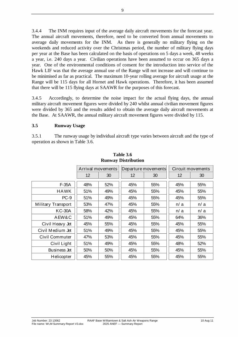
3.5.1 The runway usage by individual aircraft type varies between aircraft and the type ofoperation as shown in Table 3.6.
Table 3.6Runway Distribution
Arrival movements Departure movements Circuit movements12 30 12 30 12 30
F-35A 48% 52% 45% 55% 45% 55%HAWK 51% 49% 45% 55% 45% 55%
PC-9 51% 49% 45% 55% 45% 55%Military Transport 53% 47% 45% 55% n/a n/a
KC-30A 58% 42% 45% 55% n/a n/aAEW&C 51% 49% 45% 55% 64% 36%
Civil Heavy Jet 45% 55% 45% 55% 45% 55%Civil Medium Jet 51% 49% 45% 55% 45% 55%Civil Commuter 47% 53% 45% 55% 45% 55%
Civil Light 51% 49% 45% 55% 48% 52%Business Jet 50% 50% 45% 55% 45% 55%
Helicopter 45% 55% 45% 55% 45% 55%

10
Job Number: 23 13062 RAAF Base Williamtown & Salt Ash Air Weapons Range 10 Aug 11File name: WLM Summary Report V3.doc 2025 ANEF — Summary Report
4. INM DATA
4.1 Overview
4.1.1 The Integrated Noise Model software used to model the impact of aircraft noisewas developed by the US Federal Aviation Administration in response to an increasingrequirement to be able to scientifically measure and forecast noise impacts around airports.The first version of the model was released in 1978. Version 6.2a, was endorsed byAirservices Australia for the preparation of ANEF contours. INM version 6.2a was used forthe preparation of the ANEF contours for RAAF Base Williamtown and SAAWR.
4.1.2 The specific US based noise exposure system parameters are varied within themodel to reflect the Australian parameters for the Australian Noise Exposure Forecast Systemas endorsed by the House of Representatives Standing Committee on Aircraft Noise.
4.2 Aircraft Substitutions
4.2.1 The INM software includes noise profile data for a number of different aircrafttypes. The Department of Defence also maintains noise profile data for RAAF aircraft. Whereinformation on specific aircraft types was not available in the model or from the Department ofDefence, equivalent aircraft from the INM suite were used. A summary of the INM aircraftused and the source of the data is shown in Table 4.1.
Table 4.1INM Aircraft Data
AircraftCategory Aircraft Type Actual
AircraftINM
AircraftData
Source
Military F-35A F-35A F35AA1 DoD
HAWK Hawk 127 HAWK* INM
PC-9 PC-9 JPATS INM
Military Transport C-130 C130 INM
KC-30A A330-301 A330 INM
AEW&C B737 737400 INM
Civilian Civil Heavy Jet A330-300 A330 INM
Civil Medium Jet B737 737800 INM
Civil Commuter Dash 8 DHC8 INM
Civil Light CNA441 CNA441 INM
Business Jet Canadair CL601 INM
Helicopter IROQ IROQA DoD
* The noise signature of standard Hawk with an ADOUR engine was modified by increasing the noise produced at each thrust level by 3dB.
4.2.2 Standard operational profiles and noise signatures within the INM were used for thecivil aircraft.

11
Job Number: 23 13062 RAAF Base Williamtown & Salt Ash Air Weapons Range 10 Aug 11File name: WLM Summary Report V3.doc 2025 ANEF — Summary Report
4.2.3 The flight profiles for the F-35A have been updated for this ANEF to reflect the latestinformation available to Australia from the aircraft manufacturer, Lockheed Martin. The flightprofiles reflect a significant change to the previously used profiles, as a consequence of aircraftperformance validation through flight modelling and simulator optimisation.
4.2.4 The noise profile of the Hawk LIF was based upon standard data for the Hawk 100aircraft, powered by a Rolls Royce ADOUR Mk 151 engine, included in the INM. The RAAFoperates a variant to the standard Hawk which has been modified by installing the ADOUR Mk871-05 instead of the ADOUR Mk 151 engine.
4.2.5 Consultation with the Environment Services Branch of Airservices Australiaindicated that the noise signature of the modified Hawk with the ADOUR Mk 871-05 engine isincreased by 3dB at all altitudes and power settings compared to the standard Hawk with a Mk151 engine. This assumption was later confirmed as being a close approximation to the actualnoise signature of the Hawk 127 by the measurements undertaken during the EnvironmentalImpact Statement (EIS) for the introduction of the Hawk.
12
Job Number: 23 13062 RAAF Base Williamtown & Salt Ash Air Weapons Range 10 Aug 11File name: WLM Summary Report V3.doc 2025 ANEF — Summary Report
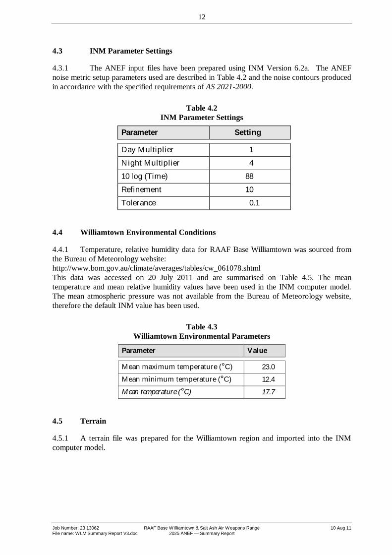
4.3 INM Parameter Settings
4.3.1 The ANEF input files have been prepared using INM Version 6.2a. The ANEFnoise metric setup parameters used are described in Table 4.2 and the noise contours producedin accordance with the specified requirements of AS 2021-2000.
Table 4.2INM Parameter Settings
Parameter Setting
Day Multiplier 1Night Multiplier 410 log (Time) 88Refinement 10Tolerance 0.1
4.4 Williamtown Environmental Conditions
4.4.1 Temperature, relative humidity data for RAAF Base Williamtown was sourced fromthe Bureau of Meteorology website:http://www.bom.gov.au/climate/averages/tables/cw_061078.shtmlThis data was accessed on 20 July 2011 and are summarised on Table 4.5. The meantemperature and mean relative humidity values have been used in the INM computer model.The mean atmospheric pressure was not available from the Bureau of Meteorology website,therefore the default INM value has been used.
Table 4.3Williamtown Environmental Parameters
Parameter Value
Mean maximum temperature (°C) 23.0
Mean minimum temperature (°C) 12.4
Mean temperature (°C) 17.7
4.5 Terrain
4.5.1 A terrain file was prepared for the Williamtown region and imported into the INMcomputer model.

13
Job Number: 23 13062 RAAF Base Williamtown & Salt Ash Air Weapons Range 10 Aug 11File name: WLM Summary Report V3.doc 2025 ANEF — Summary Report
5. 2025 ANEF CONTOURS
5.1.1 The RAAF Base Williamtown and SAAWR draft 2025 ANEF is illustrated inAppendix F, Figure 1. Appendix F, Figure 2 show a comparison with the RAAF BaseWilliamtown and SAAWR 2012 ANEF. Appendix F, Figure 3 show a comparison with theRAAF Base Williamtown and SAAWR 2025 ANEF (23 October 2009). Appendix F, Figure 4show a comparison with the RAAF Base Williamtown and SAAWR 2025 ANEC (1September 2010).

Job Number: 23 13062 RAAF Base Williamtown & Salt Ash Air Weapons Range 10 Aug 11File name: WLM Summary Report V3.doc 2025 ANEF — Summary Report
Appendix A
The ANEF System & INM

A-2
Job Number: 23 13062 RAAF Base Williamtown & Salt Ash Air Weapons Range 10 Aug 11File name: WLM Summary Report V3.doc 2025 ANEF — Summary Report
Assessment of Aircraft NoiseThe Australian Noise Exposure Forecast SystemIn 1980, the Department of Defence and the then Department of Transport commissioned theAustralian National Acoustics Laboratories (NAL) to undertake a major socio-acousticinvestigation to assess the impact of aircraft noise on residential communities in Australia. TheNAL confirmed that the ‘equal energy’ indices such as the NEF were more highly correlated tothe community reaction than any other indices.
The NAL investigations also found that the standard weightings given in the US-based NEFsystem were not applicable to the Australian environment. As a result of the NAL’s findings,the NEF technique was refined for application in Australian conditions. The amendedparameters in the NEF system were defined as the Australian Noise Exposure Forecast(ANEF) system and later endorsed by the Australian Federal Government as the technique tobe used for the determination and evaluation of the impact of aircraft noise on communities inthe vicinity of Australian airports.
The resulting ANEF system defines a means of determining a scientific measure of the noiseexposure levels around Australian airports taking into account the following factors:
The intensity, duration, tonal content and spectrum of audible frequencies of the noise ofaircraft take-offs, approaches to land, overflights and reverse thrust after landing;
The forecast frequency of aircraft types and movements on various flight paths, and
The average daily distribution of aircraft take-off and landing movements in day time andnight time.
The NAL report also investigated the percentage of residents living around airfields who wereseriously affected, moderately affected or not affected by aircraft noise. This information waspresented in a ‘dose/response’ relationship as illustrated in the diagram below. Thisinformation was used in the formulation of the recommendations on compatible land usearound Australian airports.
A-3
Job Number: 23 13062 RAAF Base Williamtown & Salt Ash Air Weapons Range 10 Aug 11File name: WLM Summary Report V3.doc 2025 ANEF — Summary Report
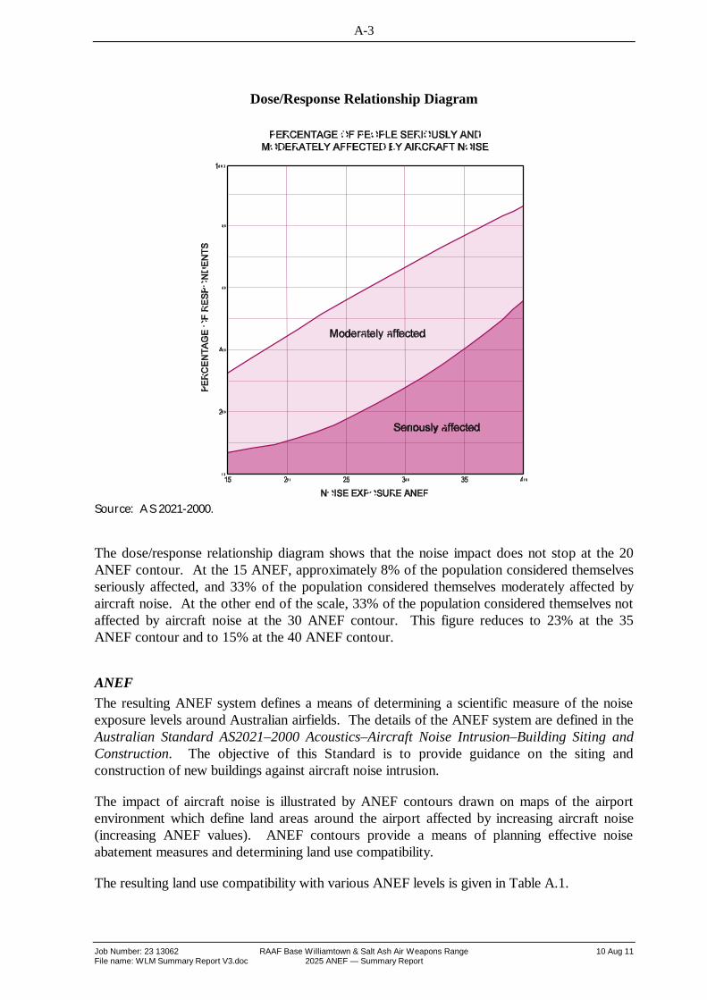
Dose/Response Relationship Diagram
Source: AS 2021-2000.
The dose/response relationship diagram shows that the noise impact does not stop at the 20ANEF contour. At the 15 ANEF, approximately 8% of the population considered themselvesseriously affected, and 33% of the population considered themselves moderately affected byaircraft noise. At the other end of the scale, 33% of the population considered themselves notaffected by aircraft noise at the 30 ANEF contour. This figure reduces to 23% at the 35ANEF contour and to 15% at the 40 ANEF contour.
ANEFThe resulting ANEF system defines a means of determining a scientific measure of the noiseexposure levels around Australian airfields. The details of the ANEF system are defined in theAustralian Standard AS2021–2000 Acoustics–Aircraft Noise Intrusion–Building Siting andConstruction. The objective of this Standard is to provide guidance on the siting andconstruction of new buildings against aircraft noise intrusion.
The impact of aircraft noise is illustrated by ANEF contours drawn on maps of the airportenvironment which define land areas around the airport affected by increasing aircraft noise(increasing ANEF values). ANEF contours provide a means of planning effective noiseabatement measures and determining land use compatibility.
The resulting land use compatibility with various ANEF levels is given in Table A.1.

A-4
Job Number: 23 13062 RAAF Base Williamtown & Salt Ash Air Weapons Range 10 Aug 11File name: WLM Summary Report V3.doc 2025 ANEF — Summary Report
Table A.1.
Building site acceptability based on ANEF zones
Building TypeANEF zone of site
Acceptable Conditionallyacceptable Unacceptable
House, home unit,flat, caravan park
Less than 20 ANEF(Note 1)
20 to 25 ANEF(Note 2) Greater than 25 ANEF
Hotel, motel,hostel Less than 25 ANEF 25 to 30 ANEF Greater than 30 ANEF
School, university Less than 20 ANEF(Note 1)
20 to 25 ANEF(Note 2) Greater than 25 ANEF
Hospital, nursinghome
Less than 20 ANEF(Note 1) 20 to 25 ANEF Greater than 25 ANEF
Public building Less than 20 ANEF(Note 1) 20 to 30 ANEF Greater than 30 ANEF
Commercialbuilding Less than 25 ANEF 25 to 35 ANEF Greater than 35 ANEF
Light industrial Less than 30 ANEF 30 to 40 ANEF Greater than 40 ANEF
Other industrial Acceptable in all ANEF zones
Notes:
1. The actual location of the 20 ANEF contour is difficult to define accurately, mainly because of variations inaircraft flight paths.
2. Within the 20 ANEF to 25 ANEF, some people may find that the land is not compatible with residential oreducational uses. Land use authorities may consider that the incorporation of noise control features in theconstruction of residences or schools is appropriate.
3. There will be cases where a building of a particular type will contain spaces used for activities which wouldgenerally be found in a different type of building (e.g. an office in an industrial building). In these casesTable A.1 should be used to determine site acceptability, but internal design noise levels within the specificspaces should be determined by reference to the Australian Standard.
4. The Australian Standard does not recommend development in unacceptable areas. However, where therelevant planning authority determines that any development may be necessary within existing built-upareas designated as unacceptable, it is recommended that such development should achieve the requiredAircraft Noise Reduction (ANR) determined in accordance with the Standard. For residences, schools, etc.,the effect of aircraft noise on outdoor areas associated with the buildings should be considered.
5. In no case should new development take place in greenfield sites deemed unacceptable because suchdevelopment may impact on airport operations.
Source: AS 2021–2000

A-5
Job Number: 23 13062 RAAF Base Williamtown & Salt Ash Air Weapons Range 10 Aug 11File name: WLM Summary Report V3.doc 2025 ANEF — Summary Report
In the areas outside the 20 ANEF noise contour, the standard assumes that noise exposure isnot of significant concern. However, as detailed in the NAL report, noise does not drop off atthis contour. The actual location of the 20 ANEF contour is difficult to define accurately,because of variations in aircraft flight paths, pilot operating techniques and the effect ofmeteorological and terrain conditions on noise propagation. For that reason, the 20 ANEFcontour is shown as a broken line on ANEF plans.
Within the area from the 20 ANEF to the 25 ANEF noise contour, aircraft noise exposurestarts to emerge as an environmental problem, while above the 25 ANEF noise contour thenoise exposure becomes progressively more severe.
Land-use planning for new developments should be in accordance with the above Table A.1, tominimise the noise intrusion for developments in the vicinity of airports.
The ANEF computation is based on forecasts of traffic movements on an average day for anominated year in the future, normally ten years ahead. Allocations of the forecast movementsto runways and flight paths are on an average basis, and take into account the existing, andforecast, air traffic control procedures at the airport which nominates preferred runways andpreferred flight paths for noise abatement purposes. When developing the ANEF, aircraftmovements are grouped according to the following categories:
Type of aircraft;
Take-off, landing, overflight or Touch&Go route;
Runway used (including displaced thresholds);
Flight path; and
Night or day.
Integrated Noise Model (INM)The Integrated Noise Model (INM) is a sophisticated computer modelling tool used to assessthe impact of aircraft noise in the vicinity of airports. The INM was first developed by the USFederal Aviation Administration (FAA) in 1978 in response to an increasing requirement toscientifically measure and forecast noise impacts around airports. The latest version is theculmination of 20 years of development of acoustic modelling capabilities and a graphicalrepresentation of results.
INM is designed to estimate the impacts of aircraft noise using average annual inputconditions. An average annual day is a user-defined best representation of the typicaloperations for the airport. These conditions include the number and type of operations,routing structure, runway configuration, aircraft weight, air temperature, and wind.
The INM requires detailed data of aircraft flight tracks, aircraft profiles (thrust settings,altitude, air speed), noise signature for each aircraft, movement numbers for each flight trackand time of day of the movements. Using the above data, the program compiles output forvarious noise metrics. The ANEF noise metric based on the parameters established by theNAL is included in the model. The outputs (noise contours) of the INM can be exported in anumber of formats for inclusion in various electronic documents for publishing or analysis.

Job Number: 23 13062 RAAF Base Williamtown & Salt Ash Air Weapons Range 10 Aug 11File name: WLM Summary Report V3.doc 2025 ANEF — Summary Report
Appendix B
Regional Location Plan and Runway Layout Plan
Figure 1. Regional Location PlanFigure 2. Runway Layout Plan
Job Number: 23 13062 RAAF Base Williamtown & Salt Ash Air Weapons Range 10 Aug 11File name: WLM Summary Report V3.doc 2025 ANEF — Summary Report
Appendix C
Flight Track PlansFigure 1. F-35A Arrival tracks • Runway 12Figure 2. F-35A Arrival tracks • Runway 30Figure 3. F-35A Departure tracks • Runway 12Figure 4. F-35A Departure tracks • Runway 30Figure 5. F-35A Touch&Go and Circuit tracks • All RunwaysFigure 6. Hawk Arrival tracks • Runway 12Figure 7. Hawk Arrival tracks • Runway 30Figure 8. Hawk Departure tracks • Runway 12Figure 9. Hawk Departure tracks • Runway 30Figure 10. Hawk Touch&Go and Circuit tracks • All RunwaysFigure 11. PC-9 Arrival tracks • Runway 12Figure 12. PC-9 Arrival tracks • Runway 30Figure 13. PC-9 Departure tracks • Runway 12Figure 14. PC-9 Departure tracks • Runway 30Figure 15. PC-9 Touch&Go and Circuit tracks • All RunwaysFigure 16. AEW&C Arrival, Departure and Touch&Go tracks • Runway 12Figure 17. AEW&C Arrival, Departure and Touch&Go tracks • Runway 30Figure 18. C-130 Arrival and Departure tracks • Runway 12Figure 19. C-130 Arrival and Departure tracks • Runway 30Figure 20. KC-30A Arrival and Departure tracks • Runway 12Figure 21. KC-30A Arrival and Departure tracks • Runway 30Figure 22. Civil Heavy Jet Arrival and Departure tracks • Runway 12Figure 23. Civil Heavy Jet Arrival and Departure tracks • Runway 30Figure 24. Civil Medium Jet Arrival, Departure and Touch&Go tracks • Runway 12Figure 25. Civil Medium Jet Arrival , Departure and Touch&Go tracks • Runway 30Figure 26. Civil Commuter Arrival, Departure and Touch&Go tracks • Runway 12Figure 27. Civil Commuter Arrival , Departure and Touch&Go tracks • Runway 30Figure 28. Civil Light Arrival, Departure and Touch&Go tracks • Runway 12Figure 29. Civil Light Arrival , Departure and Touch&Go tracks • Runway 30Figure 30. Business Jet Arrival, Departure and Touch&Go tracks • Runway 12Figure 31. Business Jet Arrival , Departure and Touch&Go tracks • Runway 30Figure 32. Helicopter Arrival, Departure and Touch&Go tracks • Runway 12Figure 33. Helicopter Arrival , Departure and Touch&Go tracks • Runway 30

Job Number: 23 13062 RAAF Base Williamtown & Salt Ash Air Weapons Range 10 Aug 11File name: WLM Summary Report V3.doc 2025 ANEF — Summary Report
Appendix D
Summary of Aircraft Movements
This appendix details the annual aircraft movements for each aircraft type that is included inthe INM computer model. The annual civil aircraft movements have been averaged over 365days while the annual military aircraft movements have been averaged over 240 days being thenumber of operational days at RAAF Base Williamtown and 115 days for Salt Ash AirWeapons Range. As these movements have been averaged, minor discrepancies may occurbetween totals and the sums of the component items.

Job Number: 23 13062 RAAF Base Williamtown & Salt Ash Air Weapons Range 10 Aug 11File name: WLM Summary Report V3.doc 2025 ANEF — Summary Report
Appendix E
2025 ANEF Map
Figure 1. RAAF Base Williamtown & SAAWR 2025 ANEF (10 Aug 11)Figure 2. RAAF Base Williamtown & SAAWR 2025 ANEF (10 Aug 11) vs RAAF
Base Williamtown & SAAWR 2012 ANEFFigure 3. RAAF Base Williamtown & SAAWR 2025 ANEF (10 Aug 11) vs RAAF
Base Williamtown & SAAWR 2025 ANEF (23 Oct 09)Figure 4. RAAF Base Williamtown & SAAWR 2025 ANEF (10 Aug 11) vs RAAF
Base Williamtown & SAAWR 2025 ANEC ( 1 Sep 10)