ra i tropical cyclone committee for the south-west indian - WMO
51
W O R L D M E T E O R O L O G I C A L O R G A N I Z A T I O N RA I TROPICAL CYCLONE COMMITTEE FOR THE SOUTH-WEST INDIAN OCEAN TWENTIETH SESSION Maputo, Mozambique 3 to 7 September 2012 FINAL REPORT
Transcript of ra i tropical cyclone committee for the south-west indian - WMO

W O R L D M E T E O R O L O G I C A L O R G A N I Z A T I O N
RA I TROPICAL CYCLONE COMMITTEE FOR THE SOUTH-WEST INDIAN OCEAN
TWENTIETH SESSION
Maputo, Mozambique
3 to 7 September 2012
FINAL REPORT

1
GENERAL SUMMARY OF THE WORK OF THE SESSION 1. ORGANIZATION OF THE SESSION (Agenda item 1) 1.1 Opening of the session (agenda item 1.1) 1.1.1 At the kind invitation of the Government of the Republic of Mozambique, the twentieth session of the WMO Regional Association I (Africa) Tropical Cyclone Committee (RA I/TCC) for the South-West Indian Ocean was held at the Vip Hotel, Maputo, Mozambique, from 3 to 7 September 2012. The session was attended by representatives from Botswana, Comoros, France (La Réunion), Kenya, Lesotho, Madagascar, Malawi, Mauritius, Mozambique, Seychelles, South Africa, Swaziland, Tanzania and Zimbabwe. Australia participated as ex-officio Member of the Committee. Also in attendance were UNESCO/IOC, South African Development Community Secretariat (SADC), and Japan International Cooperation Agency (JICA) and representatives of the WMO Secretariat. The list of participants is given in Appendix I to this report. 1.1.2 On behalf of Mr. Michel Jaraud, Secretary-General of WMO, Mr. Koji Kuroiwa, Chief, Tropical Cyclone Programme Division, expressed the sincere appreciation of WMO to the Government of Mozambique for hosting the twentieth session of the Committee. Mr Kuroiwa extended his gratitude to Mr Moises Benessene, Director of Meteorological Services of Mozambique and Permanent Representative of Mozambique with WMO, and his staff for the warm welcome and hospitality and for the excellent arrangements made to ensure the success of the session. Referring to the WMO Statement on the Status of the Global Climate, which showed that global temperatures in 2011 were the eleventh highest on record, Mr Kuroiwa emphasized that climate variability and change should increasingly modify the relative magnitude of disaster risks, which would be especially critical in coastal areas on account of altered storm patterns and sea-level rise. In this regard, he stressed the necessity of establishing the multi-sectoral preparedness and prevention as part of overall national development programmes. Such development of the risk management of disasters emphasized the increasing need for more reliable and longer lead-time hydro-meteorological information as well as for closer linkage between the disaster agencies and relevant sectors. Under these circumstances, Mr Kuroiwa encouraged the participants to renew their awareness that the Committee was expected to play an ever-greater role in the reduction of disaster risks for the people in the Region and expressed his expectation that the twentieth session would develop concrete actions to meet the requirement. In expressing WMO’s continued support for the Committee’s programmes, he wished the participants a very successful session and an enjoyable stay in Maputo. 1.1.3 Ms Ana Paulo Samo Gudo Chichva, Vice Minister of Environment, Mozambique welcomed the participants at the twentieth session of the RA I Tropical Cyclone Committee and extended her warmest greetings. Ms Chichva mentioned that the east coast of Africa, the SADC region is extremely vulnerable to natural disasters, particularly tropical cyclones. This vulnerability is exacerbated by the fact that most people in this region live along the coast. Mozambique is heavily hit by storms and tropical cyclones, which jeopardizes the social and economic development of the communities. The damage caused by cyclone "Funso" and "Dando" that recently affected the country sowing grief and pain, are still patent, despite the best efforts of reconstruction and rehabilitation that followed immediately after its occurrence. Ms Chichva therefore emphasized that it is important that each and every one of us strives to reduce the vulnerability of society, particularly the communities most at risk, through preventive actions. She stressed that important steps have already been taken in this direction, resettling of population in safe areas, building infrastructure that address climate risks and strengthening the early warning system. The challenges to the monitoring of tropical cyclones and the need to mitigate their impacts in place, invite us to appeal to all scientists and academics, both in our region and in other cyclonic basins, to contribute with our knowledge, expertise and experience in order to turn these challenges into development

2
opportunities. At the same time it has become necessary that our society and citizens adopt proactive attitudes and practices to strengthen the early warning system. Ms Chichva indicated that the twentieth session of the Committee has taken place at a time when many countries worldwide are facing a major financial crisis with impacts on their economies, of which the impacts are still more serious on developing countries like Mozambique. While we cannot prevent natural disasters, much can be done to mitigate the negative impact and vulnerability of populations and countries to its effects. And this process can only achieve positive results with the close cooperation between the national meteorological services and regional and global centers. Finally, Ms Chichva wished that this session could contribute to development of a mechanism for minimizing pain and grief in the Committee region, arising from extreme weather events that affect the population in the region cyclically. 1.1.4 Ms Chichva declared the twentieth session of the RA I Tropical Cyclone Committee officially open. 1.2 Adoption of the agenda (agenda item 1.2)
The Committee adopted the provisional agenda. The agenda for the session is given in Appendix II to this report. 1.3 Election of the vice-chairperson (agenda item 1 .3)
The Committee unanimously elected Mr Moises Benessene (Mozambique) as Vice-chairperson of the session. In this connection, the Committee was informed by the WMO Secretariat that the President of RA I took a formal action in August 2012 to designate Mr Balrad Dunputh (Mauritius) as Chairperson of the RA I Tropical Cyclone Committee. 1.4 Working arrangements for the session (agenda it em 1.4)
The Committee agreed on its working hours and work programme. 2. REPORT OF THE CHAIRPERSON OF THE COMMITTEE (Age nda item 2) 2.1 Mr B. Dunputh, Chairperson of the Committee, presented his report on the main activities of the Committee that have been carried out since the 19th session held in Nairobi from 20 to 24 September 2010. 2.2 He thanked the Government of the Republic of Mozambique for hosting this 20th session and expressed his gratitude to the WMO, the Chief of the Tropical Cyclone Programme Division and local Personnel in organizing the event. 2.3 During the inter-sessional period, the Chair of RA I Tropical Cyclone Committee reported on its recent activities to the Management Group of the Region of its meeting held in Zimbabwe from 14 to 16 November 2011. 2.4 During the cyclone season 2010-2011, only 3 storms were baptized in this region. One reached moderate intensity; one became a tropical cyclone and one an intense tropical cyclone as per classification of storms in this basin. The La Nina event influenced the state of the atmosphere and sea during the past two seasons. 2.5 Regarding the cyclone season 2011-2012, 2 storms reached moderate strength; 3 severe, 2 tropical cyclones, 2 intense tropical cyclones and one sub tropical depression were named. 2.6 Due to increased variability in the formation and intensities of cyclones, it is highly recommended that the public be informed of the risk and the warning systems in respective countries which have to be continuously monitored or updated and awareness campaigns

3
should be conducted locally to warn the population of rapid intensification of tropical systems, specially if storms are in close vicinity of mainlands. Deficiencies in the National Warning Systems including operational capabilities have to be considered and improvements made can be exposed for consideration by members. 2.7 The Chairperson informed that the RSMC La Reunion will give a brief expose on the overall evolution of the cyclones in the area and members will have the opportunity to present cases of cyclones which have affected their countries. 2.8 EUMETSAT has been providing significant training to NMS in the region on the applications and interpretation of data and products. 2.9 The 5th RA I Training Course on Tropical Cyclones and PWS was held at St. Denis, Reunion (2 to 13 November 2010). Meteorologists of the region benefited from this event. 2.10 The International Workshop on Tropical Cyclones (ITWC-7) held in La Reunion in November 2010 produced several recommendations to WMO. Several of those were classified as high priority, namely, “tropical cyclone structure and intensity change”, “formation and extra tropical transition”, “tropical cyclones and climate”, “disaster risks”, “warning systems”, “mitigation and socio economic impacts, particularly in individual basins” etc. Many Meteorologists from the SWIO attended. 2.11 For the SWIO, the ITWC-7 recommended that a field campaign be conducted to study the formation, intensity, ENSO influences, structure change, extra tropical transition and dissipation. This is no doubt an immense challenge as far as costs is concerned because there is very little time to plan such exercises within a few days after the formation of a cyclone. 2.12 The WMO has to be thanked for the provision of consumables/radiosondes, under VCP which help is assessing the vertical structure of the atmosphere during adverse weather conditions. 2.13 Regarding the Severe Weather Forecast Demonstration Project (SWFDP), the outputs of the project are available through website and are referred to for forecasting purposes. The concurrence of RSMC South Africa is well noted and progress made will be presented to the Committee. 2.14 The provision of ensemble track of information using ensemble track from EPS of the ECMWF through uncertainty cones via the special website from RSMC is well appreciated. It has a fairly good estimation forecast for about 72 hours. Also, the new information provided by TCAC Reunion for aviation purposes is noted since December 2011. 2.15 Considering that the SWIO is a data sparse region where tropical storms form, the network of observing stations, upper air and surface and ocean observations need to be strengthened so that data and information is regularly available to enable reliable prediction, the Chairman reiterated that although the models products have considerably improved, young Meteorologists in the tropical regions should be encouraged to use measured data, basic forecasting principles intensively for analysis of tropical systems/cyclones specially for the short term forecasting. The use of NWP is being made but the consistency is still not at high level for small core systems. Future satellite programmes should continue to provide data (especially wind data) across the vast SWI Ocean. 2.16 Chairperson stated that the session must continue to consolidate the Tropical Cyclone Operational Plan for the SWI Ocean, the technical plan amongst others, and will review the tasks which were scheduled.

4
2.17 The main developments which should have taken place during the last session are still to be discussed during this session. This Committee must review and comment on the TC Program activities for its future planning, taking into consideration guidelines agreed upon by WMO Congress, the Executive Council and WMO Strategic Plan. 2.18 It should be noted that despite several attempts, no information was received on the submissions regarding the improvement required in the Technical plan. It is expected that the two member countries designated have compiled the necessary documents from members. 2.19 Also, no communication has been obtained on the committee set up at its 18th session (Malawi, September 2008) where an adhoc group was formed to develop the Regional Storm Surge Watch Scheme (SSWS). At the 19th session, La Reunion was requested to take the lead on the matter. Any progress made should be expressed under Agenda item 8.2. 2.20 Research has to be encouraged in the region amongst Meteorologists. The issue of wind pressure relationship for tropical cyclones in the SWIO can be a topic of interest for investigation during the coming inter-sessional period before adopting and implementing the relation to classify storms/cyclones in this region. In that respect, it would be much necessary that the Pressure Wind relationship be taken on board in the training organized by RSMC La Reunion for tropical cyclones so that all countries would be aware how to make use of intensity classifications. 2.21 Members are encouraged to participate further in different programs of WMO through regional cooperation. The transfer of research results should be encouraged in order to improve skills and competencies for operational capacity as well as non real time analysis. 2.22 The Chairman therefore requested members to strengthen the capacity of their institutions to become more resilient to natural disasters as one of the main objectives of National Meteorological Services is to save life property and also to contribute in the socio economic development of their countries through appropriate Disaster Management. 3. COORDINATION WITHIN THE WMO TROPICAL CYCLONE PR OGRAMME
(Agenda item 3) 3.1 The Committee was informed by the WMO Secretariat that the Executive Council, at its 64th session in June 2012, gave following guidance to the Tropical Cyclone Programme (TCP):
• Close collaborations between TCP and other WMO Programmes based on relevant WMO projects such as SWFDP and CIFDP.
• Extended use of ensemble techniques including multi-model consensus forecasting and ensemble-based probabilistic guidance.
• More objective TC analyses as recommended by IWSATC and establishment of TC Forecaster Website.
• Implementation of Common Alert Protocol (CAP) in TC warnings and change of the format of the advisories for aviation from text to graphic.
3.2 The Committee was also briefed about the TCP activities during the inter-sessional period as follows:
- Capacity Development TCP/PWS joint training courses/workshops on TC Forecasting and Public Weather Service were held for RA I TCC (La Reunion, November 2010), RA IV Hurricane Committee (USA, March 2011 & March 2012) and RA V TCC (Australia, September 2011), and attachment trainings were for Panel on Tropical Cyclones (RSMC New Delhi, February 2010 & February 2011) and for Typhoon Committee (RSMC Tokyo, July 2010 & July 2011).
5
- Support to Operational Forecasting
Global Guide to Tropical Cyclone Forecasting has been updated toward publication during 2012. The new Guide will be mainly Web-based for widespread access by forecasters and researchers around the globe and a limited number of hard copies will be distributed to the WMO Members and WMO Regional Training Centres (RTCs) concerned. The Guide is expected to achieve synergetic effect with the TC Forecaster Website to be hosted by Hong Kong, China.
- Storm Surge Watch Scheme TCP collaborated with WMO/IOC Joint Technical Commission for Oceanography and Marine Meteorology (JCOMM) to organize the 6th Storm Surge Workshop in the Dominican Republic for the RA IV Hurricane Committee Members in February 2011. It also held the 7th Storm Surge Workshop in Macao, China for the Typhoon Committee Members in October 2011 in cooperation with Meteorological and Geophysical Bureau of Macao and the Typhoon Committee.
- Application of Research and Development
The first WMO International Workshop on the Satellite Analysis of Tropical Cyclones (IWSATC) was organized in Honolulu, Hawaii, USA from 13 to 16 April 2011 in collaboration with the WMO World Weather Research Programme (WWRP) and the National Climatic Data Center of NOAA (NCDC). It was held in conjunction with the 2nd workshop of the International Best Track Archive for Climate Stewardship (IBTrACS) which is run by NCDC. Linking with producing a globally-unified best track dataset, IWSATC set out to promote the sharing of expertise in satellite analysis of tropical cyclones between forecasters and researchers and helped facilitate their discussions on its future improvement.
3.3 The Committee was informed that the sixth RA I Training Course on Tropical Cyclones and Public Weather Services was successfully held in Saint-Denis, La Réunion from 2 to 13 November 2010. The Committee noted with satisfaction that the Training Course was linked with SWFDP- Southern Africa Project to develop synergies in terms of forecasting severe weathers. The Committee expressed its gratitude to RSMC La Reunion for hosting the biennial training course and workshop and reiterated its key contribution to the capacity development of the Committee members. 3.4 The Committee noted with pleasure that the TC Forecaster Website is being developed by Hong Kong, China, which agreed to host the Website, and will be launched before the start of 2012/2013 cyclone season. The Website is aimed to assist forecasters in their operational forecasting of tropical cyclones. It will function as a portal to various websites offering data/products of TC analyses and forecasts and will also provide research outcomes and training materials, thus serving as a comprehensive source of information for TC forecasters. 3.5 The Committee took note of the effectiveness of application of CAP to the tropical cyclone warning services. In this regard, the WMO Secretariat advised the Committee that, while it plans to take up this subject at the next TC RSMCs/TCWCs Technical Coordination Meeting to be held in Indonesia inNovember 2012, it is important for the Committee to coordinate closely with the relevant working group of RA I. On a national basis, the WMO Secretariat encouraged the Committee Members to consult with the communication mangers of their respective services for implementation of CAP.

6
4. REVIEW OF THE 2010/2011 AND 2011/2012 CYCLONE SEASONS (Agenda item 4)
4.1 Report of RSMC La Reunion 4.1,1 Reports of the 2010/2011 and 2011/2012 cyclone seasons were presented to the Committee by Mr Philippe Caroff (RSMC La Réunion - Tropical Cyclone Centre, France). 2010/2011 cyclone season 4.1.2 The 2010-2011 cyclone season in the South-West Indian Ocean will go down in history for its very low activity, almost unprecedented for more than fifty years, as it was ranked as the second-least active season over that period. The reasons for the lack of activity are likely mostly related to the combined powerful anomalies of the oceanic and atmospheric circulations which ruled over the tropical Indian Ocean during the warm season and which resulted, on the oceanic level, in a very notable deficiency of the oceanic heat content, and, on the atmospheric level, in a large-scale subsidence over the whole western part of the tropical Indian Ocean. 4.1.3 To the much reduced cyclone activity has corresponded a season that was also quieter than usual for the populations of the area, but not totally deprived of all impact though: if a single storm has hit one of the inhabited lands (cyclone BINGIZA), it all the same had harsh and painful consequences for the inhabitants of the North-East of Madagascar. Only three meteors have been granted a naming during the 2010-2011 season (cyclones ABELE in December and BINGIZA in February, plus moderate tropical storm CHERONO – named on 17 March, which was the latest birth-date for the third tropical storm of any season in the basin). Since 1960, when the tropical systems began to be named in the South-West Indian Ocean, no season had ever come to an end with fewer than four named systems. As it set up that new record-breaking value of the smallest number of named phenomena in a season, the year 2010-2011 would then be entitled to claim the title of the least active cyclone season of the last 50 years. 4.1.4 However, a more thorough evaluation compels to temper this statement. First of all, a fourth system could have possibly deserved to be named: subtropical depression number 09 (in April). But because of its particular origin and structure (as well as its location) it was eventually decided otherwise. Lastly, the number of phenomena cannot alone characterize the activity of a cyclone season and it is usually preferable to consider rather another metric, like the number of days of disturbed activity, a much more representative criterion of actual cyclone activity (as it integrates both the number of phenomena and the cumulated days of their respective life-cycles). According to that criterion, it appears that the 2010-2011 season must be considered as the second-least active cyclone season in 50 years in terms of number of days of disturbed activity, just behind the 1982-1983 season, which therefore remains the season that may be deemed as the really least active of the last 50 years. 4.1.5 The exceptional listlessness of the cyclone activity over the South-West Indian Ocean basin may have resulted from the conjunction of two factors : a global context of significant decline in the cyclone activity observed for the past 4-5 years world-wide, having brought back the global cyclone activity to a level that had never been known for about thirty years since the preceding major slack period of inactivity at the end of the seventies and a more particular factor peculiar to this year, namely the very special climate conditions prevailing over the whole Indo-Pacific zone, during the 2010-2011 warm season in the southern hemisphere. 4.1.6 There were indeed important anomalies in the oceanic and atmospheric circulations. The latter resulted in a modification in the zoning and above all the intensity of the upward and subsident branches of the cells associated to the Walker circulation. As the main consequence, it generated abnormally moist conditions in the eastern tropical Indian Ocean

7
as far as the South-West Pacific, hence excessive rainfall over Indonesia and Australia (in Australia the period from September 2010 to March 2011 was the wettest on record – 100% above average) which induced widespread and disastrous flooding (Brisbane in southeast Queensland had its worst floods since 1974), and a sustained cyclone activity around the latter (but eventually simply in accordance with the climatologic norm); whereas, on the contrary, abnormally dry conditions and quiet conditions in terms of disturbed cyclonic activity, prevailed over the western part of the Indian Ocean and the central Pacific. 4.1.7 At the same time the oceanic heat content remained much below normal over most of the tropical Indian Ocean lying between latitudes 5 and 15°South and to the west of longitude 90°East. There is no doubt that this oceanic anomal y played a major part in the notable weakness of the cyclone activity over the South-West Indian Ocean, as it certainly accounted to a large extent for the total absence of cyclogenesis observed this season within the wide zone situated to the south of the Chagos (between longitudes 65 and 85°East), usually a privileged cyclogenesis area of the basin. 2011/2012 cyclone season 4.1.8 Following three years of reduced tropical cyclone activity, most notably 2010-2011, which was almost a record year in terms of inactivity, the 2011-2012 season saw the return of concentrated tropical cyclone activity in the South-West Indian Ocean. Disturbed activity, although not major, continued almost unabated during the height of the season, interrupted only by a few very brief intervals. Thus, a series of no less than nine tropical storms occurred in the two-and-a-half month period between the end of December 2011 and the first 10 days of March 2012, accounting fo over 90% of total significant disturbed activity at the heart of the southern summer. In the end, with a total of eleven tropical storms, of which three reached the status of tropical cyclone, the season was unusually active. 4.1.9 Four of these 11 storms made landfall at varying stages of intensity, directly affecting Madagascar or Mozambique, but only one, Giovanna, which struck the east coast of Madagascar, did so at the tropical cyclone stage. 4.1.10 Therefore, after a 2010/2011 season marked by exceptionally weak cyclone activity which had fallen to levels almost unprecedented in the last 50 years, both in the South-West Indian Ocean and globally, 2011-2012 saw a spectacular return; in fact, disturbed activity over the basin area was almost four times greater than in the previous year. 4.1.11 With regard to the end of the season, 2011-2012 could have become the third shortest season since the satellite era began, if it had ended in mid-March with KOJI-JONI; instead, it was the third latest season, owing to the unexpected arrival of tropical storm KUENA at the beginning of June. This unseasonal occurrence was very unusual, but not unprecedented. 4.1.12 As concerns the spatial distribution of disturbed activity, the outstanding feature was the strong activity affecting the extreme west of the basin, that is the Mozambique Channel, where four mature low-pressure systems evolved, all four developing in the Channel, although two were of exogenous origin. Intense tropical cyclone Funso was emblematic of this heightened activity in the Channel: given the abnormal intensity it reached, it was regarded as the most intense cyclone observed in the Mozambique Channel in recent history. Moreover, its longevity as a tropical cyclone (seven days) was exceptional. 4.1.13 Madagascar was directly affected by four low-pressure systems. They varied widely in intensity and impact, which was limited for Chanda and Dando, but considerably more severe in the case of GIOVANNA and IRINA, which, directly or indirectly, claimed over a hundred lives.

8
4.1.14 Two disturbances ended their course over Southern Africa after making landfall over Mozambique, while Funso came to a standstill early in its life cycle just off the coast of Africa, not far from the town of Pebane. Mozambique, which had been unaffected since 2008, was therefore struck by Funso, as well as feeling the impact of the approach of IRINA. It had already been shaken by DANDO in a southern area of the country that was rarely affected, and had not experienced an event of this kind since the devastating DOMOINA, which made landfall in late January 1984, a little further north than DANDO, bringing flooding which claimed many lives in the same area. 4.1.15 This time, the torrential rain and flooding occurred a little further inland, mainly on the other side of the border. It hit the extreme north-east of South Africa, in the Kruger National Park region and the adjacent territory. 4.1.16 The Mascarene Islands were unaffected: tropical storms ETHEL and HILWA passed near Rodrigues Island, but without causing damage, while Mauritius and La Réunion were only moderately affected by the passing of Giovanna. 4.2 Reports of Members on significant /notable cycl ones of the seasons 4.2.1 Following the presentation of RSMC La Réunion, each Member provided a review of the 2010/2011 and 2011/2012 cyclone seasons. 4.2.2 Mozambique informed the Committee that the 2011/2012 tropical cyclone was one of the most active along with 1974/1975 and 1999/2000, during which 5 tropical systems reached the Mozambican Channel. The most notables were tropical storm “Dando” and tropical cyclone “Funso”. “Dando” was the first tropical depression or tropical cyclone to make landfall further south of southern Mozambique since 1984. The National center for emergency operations declared orange alert 24 hours before the landfall of “Dando”. Just 10 days after “Dando”, tropical cyclone “Funso” affected the central Mozambique, Zambezia province. Although “Funso” did not make landfall in Mozambique, the destructive effects were felt 200 km from the coast. Due to a good coordination within the early warning system, all rescue and humanitarian assistance operation took place without need to declare red Alert or international appeal. The high commitment of the government at all levels toward enhancement of early warning system was demonstrated from the preparation of the contingency plan to the end of emergency stage. However, during cyclone “Funso”,, a need was recognized to work with South Africa to jointly address the issue of communicating the English speaking users (see para 4.2.4) 4.2.3 During the 2011/2012 cyclone season, South Africa was affected by three tropical disturbances, namely, Tropical Storm Dando, Intense Tropical Cyclone Funso and Severe Tropical Storm Irina. Dando and Irina were the only two that directly affected South Africa, resulting in heavy rainfall in places in the north-eastern parts of country. Funso did not directly affect South Africa, but the damage caused along the Mozambique north coast resulted in a lot of interest from the media and general public. One of the challenges currently being faced is that there are people living along the Mozambican coast that do not understand Portuguese and therefore often contact the National Forecasting Centre in Pretoria, South Africa, to receive a forecast. The concern is that the guidance from the two countries, with regards to possible threats, could differ. 4.2.4 Concerning the language issue raised by Mozambique and South Africa, the Committee discussed a few possible solutions, the first could be that the Mozambique Weather Office translate their warnings into English and put these on their website for both the general public as well as the other NMS’s. Another way to solve the problem is by having the forecasters in the Mozambique office construct a forecast in a graphical manner, similar to the guidance forecast that RSMC Pretoria is currently issuing for the SWFDP, mainly using symbols to explain the alert and therefore eliminating the language barrier. In

9
view of the significance of this issue in terms of service delivery, the Committee decided to take it up for its consideration of the Technical Plan (see para 6.7.4). 4.2.5 Madagascar informed the Committee that Madagascar statistically faces 3 to 4 cyclonic disturbances every cyclone season. For this reason, 2010/2011 was considered a relatively quiet season in terms of number of cyclonic disturbances yet not in terms of intensity as “BINGIZA”, the only storm to reach the status of tropical cyclone, resulting in strong winds and rather heavy rainfalls (276.3mm/24h in Morondava), crossed La Grande Île from end to end, impacting 11 of the 22 regions of Madagascar and causing huge damage, with 34 fatalities and about 217,000 people affected. As for the 2011/2012 season, it has been extremely active as 4 cyclonic disturbances hit La Grande Île: CHANDA, DANDO, GIOVANNA and IRINA. However only the last 2 impacted Madagascar.The number of fatalities caused by GIOVANNA was 35, while 77 losses of life were to be deplored following IRINA which generated more rainfall, causing floods, a situation enhanced by the influence of the cloud mass that had settled over the east coast where landslides were observed. The warning system operates properly in Madagascar; nevertheless, in view of the large size of the country, many regions are isolated so that resources are limited. At technical level, it seems necessary to build capacities for cyclone track forecasting and to upgrade the level of cartographers. 4.2.6 Over the cyclone seasons of 2010/2011 and 2011/2012, the Comoros archipelago was not notably impacted by cyclones. Cyclone BINGIZA, in February 2011, was the only one to generate above-normal rainfalls over the archipelago, i.e. 770.2 mm for the station of Moroni versus a normal amount of 249.4 mm. During that month of February 2011, the meteorological Service remained on cyclone watch. However, since April 20th 2012, torrential rains, generating large amounts of precipitations and landslides, have hit the whole of the Union of the Comoros. The main impacted regions are Bambao, Hambou and Mbadjini Est for the island of Grande Comore; Sima and Domoni for Anjouan and all of Mohéli Island especially Nioumachiwa and Hoani. Over the past decade, the reliefs of the Comoros archipelago have known heavy rainfalls located over the south and south west of the islands mentioned above. 4.2.7 Tanzania informed the Committee about tropical cyclones that had significant influence to weather pattern in the Tanzania region. During the Tropical Cyclone Season 2010-2011 ‘Cyclone Bingiza’ resulted in enhanced wet and windy conditions over the country. Overall, the cyclone season can be considered relatively inactive season. Tropical cyclone season 2011-2012 had relatively more cases of Tropical Cyclones and depressions but only a few were significant to the weather conditions in Tanzania. A subtropical depression over southern tip of Madagascar on 20th to 22nd December 2011 intensified rapidly and propagated slowly towards the Mozambique Channel and triggered heavy rains resulting to floods over Dar Es Salaam city. The event caused death to about 43 people and thousands were left homeless. The warning issued in advance by Tanzania Meteorological Agency is believed to have reduced the impact given the scale of the flooding. Tropical cyclone ‘Funso’ on January 2012 caused heavy precipitation in excess of 100mm at Kilwa station southern coast of Tanzania. Information from Regional Storm Monitoring Center La Réunion (RSMC) was very useful in the country’s operational weather monitoring, forecasting and early warning. 4.2.8 Malawi informed the Committee that the 2010–11 South-West Indian Ocean Cyclone Season was the least active on record. However, Malawi benefited a lot from tropical cyclone Bingiza that contributed to water availability due to its position in the Mozambique channel that induced an influx of Congo air mass as a result many areas registered more than 110% of normal. The active 2011/2012 tropical cyclone season produced two cyclones Chanda and Funso that affected Malawi indirectly by again attracting Congo air mass into Malawi in the first and third dekad of January respectively. Many places received more than 150% of normal rainfall in these two dakades. However, these amounts of rainfall resulted into floods mostly in Nsanje and Chikhwawa Districts in Southern Malawi. Chanda displaced 1,359

10
households while Funso contributed to the displacement of 6,159 people due to swelling of Ruo and Shire rivers. Out of these are 480 households who were affected by both floods episodes and have permanently shifted from the affected area. The total loss and damage due to the floods in Nsanje District alone is estimated to be at 2,946,386 USD. 4.2.9 The detailed reports on the review submitted by the Members are given in Appendix III. 5. REVIEW OF THE TROPICAL CYCLONE OPERATIONAL PLAN FOR THE
SOUTH-WEST INDIAN OCEAN (Agenda item 5) 5.1 Mr Philippe Caroff (France) and Mr Samuel Mbuya (Tanzania) served as rapporteur and co-rapporteur, respectively, for this agenda item. 5.2 Following terminologies were decided to be used in the basin to describe low-pressure systems and be added to the section 1.2.2:
- Filling low - Remnant low - Dissipating low - Post-tropical storm
Definitions are given in Appendix IV . 5.3 The naming procedure was modified. As the interim phase decided at the previous session was coming to an end, the dual naming system (hyphenated name made up of original name given for the South East Indian Ocean (Australian region/Indonesian region) followed by the name for the South West region will be abandoned and, from now on, the original name will be retained. 5.4 During the review of the Operational Plan, the question of the relation between pressure and winds was raised. Mr Caroff covered this issue in his presentation, explaining how RSMC La Réunion was now treating the matter. Following the testing period agreed upon at the nineteenth session of the Committee, it appears that the Courtney & Knaff wind-pressure Relationship (WPR) is not totally satisfactory as it suffers from not factoring in the radius of maximum winds. Following a reflection process carried out internally, the idea retained was to rely on the parametric Holland model (using the 1980 version for the moment, pending the availability of the last 2010 version) to adjust the pressure calculated from the parameters used by Courtney & Knaff (intensity, size of low pressure circulation – extension of near gale or gale in quadrants, environmental pressure, latitude, speed of movement). 5.5 Mr Caroff demonstrated using the tool (Excel macros) developed by H. Quetelard, forecaster at RSMC La Réunion. The concept is now to integrate the basic parameter of radius of maximum winds and adjust the minimum pressure at the center accordingly, “forcing” the value that enables the best adjustment between wind field and pressure at the center, in order to obtain the most balanced vortex possible (modulo potential asymmetries, usually generated by gradient effect, and frequently present, especially in the south semi-circle). To do this, it is obviously necessary to have the best available estimate both of the radius of maximum winds and also of the size of the low-pressure circulation, through external wind (wind radii) extensions (near gale or gale). To estimate the radius of maximum winds, forecasters can rely more specifically on microwave imagery, while scattering radars (ASCAT or Oceansat) represent valuable support for the best calibration of wind extensions. 5.6 The Committee also agreed to make the following amendments:
• Attachment 1 A-1 to be amended. Individual countries will provide updated version of their warning system for tropical cyclones
• The information on radar position/location and any changes will be submitted to the rapporteurs by the designated countries (section 2.4.1)

11
5.7 The Committee reviewed the proposed lists of tropical cyclone names for the 2013/2014 and 2014/2015 cyclone seasons which were compiled by the rapporteur based on the names submitted by the Committee Members to the WMO Secretariat prior to this session. The Committee made a minor change to the proposed names and adopted the tropical cyclone names for the 2013/2014 and 2014/2015 seasons as shown in the 2012 version of the Operational Plan. 5.8 The Committee requested the WMO Secretariat to publish as soon as possible the 2012 edition of the Tropical Cyclone Operational Plan in English and French as the TCP Report (TCP-12). 6. REVIEW OF THE TECHNICAL PLAN AND ITS IMPLEMENTA TION PROGRAM
(Agenda item 6) 6.1 Meteorological Component (agenda item 6.1) 6.1.1 The Committee noted that the review of the meteorological component of the Plan focused on the status of implementation of the WWW, the needs for additional data, facilities and arrangements for the purpose of tropical cyclone detection, monitoring and forecasting, and on the modernization of the tropical cyclone warning system through regional coordination and cooperation. Regional Basic Synoptic Networks (RBSN) 6.1.2 The Committee was informed that the countries of the region are contributing to the implementation of the Regional Basic Synoptic Network (RBSN) by operating a total of 859 stations (780 surface-synoptic and 79 upper-air). 6.1.3 The Committee was informed that the status of the number of observations implemented by these RBSN stations in the area of the RA I TCC remained stable at around 70 per cent for surface and 65 per cent for upper-air. However, the overall percentage of both the SYNOP and TEMP reports received had shown a decrease during the inter-sessional period. The quarterly Integrated WWW Monitoring (IWM; July 2009 – April 2010 and July 2010 – April 2011) showed that the availability of reports from some areas of the region was not satisfactory although some parts showed a favorable increase. Upper-air stations in two countries (Malawi and Mozambique) remained silent during the period of the monitoring exercise 2010 – 2011. Comoros, Lesotho, Seychelles and Swaziland do not have any upper-air stations listed in the RBSN. 6.1.4 Concerning the IWM results, Kenya suggested that the reduced availability of SYNOP from Kenya is mainly because of communication delays; otherwise the local monitoring would indicate more than 90%. As regards upper-air observation, Kenya maintains one upper-air station making ascent and reporting TEMP once a day, which means that the availability of TEMP should be regarded as 50%. 6.1.5 Madagascar clarified that unavailability of SYNOP in the country is ascribable to;
i) Equipments and facilities are obsolete, ii) Madagascar is located on the path of tropical cyclones, so that stations are
frequently damaged. An example is the case of Antalaha synoptic station which was destroyed by INDLALA and subsequently by JAYA before the rehabilitation is completed. The Direction Générale de la Météorologie spares no efforts to fully operate the stations; however, the limited resources do not allow it to ensure a satisfactory maintenance. Also, silence of stations does not necessarily mean that they are “out of service”. Some have communication problems and others are limited in observation parameters due to lack of instruments. Although acquisition of automatic observing stations through GCOS is being finalized, the telecommunication problems (inadequate SIM cards) need to be addressed.

12
Aircraft Observations 6.1.6 The Committee was informed that little has changed in regard to the status of aircraft observations and AMDAR data coverage over RA I. The South African AMDAR Programme is still the sole AMDAR Programme in the region and supplemented by voluntary and contracted contributions from EUMETNET via the E-AMDAR programme. With the impending finalization of the transition of the AMDAR programme to WMO and the cessation of activities of the WMO AMDAR Panel, CBS will in the future be relying more upon the Regional Association and regional Members in cooperation with partner organizations and the aviation industry, to further the expansion of aircraft-based observations over RA I. Nothing that such growth and enhancement would be expected to have a significant additional positive impact on tropical cyclone forecasting and monitoring, the Committee encouraged the members to make an effort for further development and expansion of AMDAR in the region.. Marine and Ocean Meteorological Observations 6.1.7 The Committee was informed that, overall, the ocean in situ observing system is now 62% implemented and the global surface buoy network coordinated through the Data Buoy Cooperation Panel (DBCP) is now essentially complete. It noted, however, that the South Indian Ocean appears relatively data sparse. Argo profiling float programme reached completion in November 2007 and, currently, efforts are being made to increase robustness of the drifters and the number of those reporting sea level pressure. Regarding Voluntary Observing Ships (VOS), greater emphasis is placed on the increase of the number of Automatic Weather Stations installed on ships to improve real time reporting for weather forecasting and climate. Also, to enhance the observations by ships, the network of Expendable Bathythermograph (XBT) has been increasingly deployed under the Ship of Opportunity Programme (SOOP). 6.1.8 Regarding the buoy network, the representative of RSMC La Réunion (Mr Caroff) highlighted the success and contribution of RAMA (moored buoys over the Indian Ocean), as well as of IBPIO (drifting buoys over the Indian Ocean), which are certainly among the most successful programs of the past few years in terms of observations in the area of the Indian Ocean. In particular, during the intersession period, the RAMA program has enabled the deployment of several moored buoys in the Southwest Indian Ocean, which record extremely valuable data (mainly pressure and wind) for monitoring of the ITCZ. In the case of an approaching low-pressure system, these data can be determining, be it for operational monitoring or for the improvement of numerical models (and optimization of their forecasts). RAMA is the result of a major international cooperation, involving a number of countries (such as the USA, India, South Africa, and others); Météo-France contributed to the project with the supply of pressure sensors. The RAMA was a major element of the observation network used during the CINDY-DYNAMO scientific observation campaign. The Committee expressed its gratitude to the participants in these programs, which are quite demanding, in particular as concerns the maintenance of the buoys and related equipment. WMO Information System (WIS/GTS) 6.1.9 The Committee was informed that the WWW’s Annual Global Monitoring (AGM) in 2011 revealed that many of the missing observations are circulating as nil reports rather than the GTS not passing them on suggesting that if they are made, they are not being passed to an RTH. The monitoring of the GTS circuits also reveals continued major deficiencies in the GTS infrastructure in RA I, which Members are overcoming by increased use of the Internet and other WIS communication channels such as EUMETCast as well as the ICAO’s AFTN

13
and SADIS to offset the problems with the RA I RMTN. The Committee recognized the need to address the issues of missing observations, including non-submission of observations into WIS as well as issues with the communication links and practises. It is also important for the plan to include important partners such as EUMETSAT and ASECNA. 6.1.10 The Committee noted that the new functionality of WIS, e.g. Discovery, Access and Retrieval Services, has been formally operational since January 2012. There are now five Global Information and System Centres (GISCs) fully operational. It also noted that Cg-XVI designated two GISCs in RA I, e.g. GISC Casablanca and GISC Pretoria, both of whom plan to become operational in 2013. To fully benefit from WIS, the Committee recognized that members should provide suitable discovery metadata describing their products and services. This must be a priority for the next two years. In this regard, the Committee emphasized the need of appropriate training on the use and management of metadata. 6.2 Hydrological Component (agenda item 6.2) 6.2.1 The Committee was informed that the fourteenth session of WMO RA I, through the Management Group and Subsidiary Bodies of Regional Association I (Africa), re-established the Working Group on Hydrology, which includes Liaison to the Tropical Cyclone Committee (TCC). 6.2.2 WMO, jointly with the Hydrologic Research Centre in San Diego (HRC), the USA National Oceanic and Atmospheric Administration (NOAA) and USAID is implementing a Southern Africa Region Flash Flood Guidance System (SARFFGS) covering basins in SADC countries (currently eight countries), using satellite based Hydro-estimator rainfall estimation in basins of average size of 200 km2. It is implemented under the WMO’s Flood Forecasting Initiative. Weather and hydrological information is sent by participating countries to the Regional Centre at the South Africa Weather Service to be used in validating the products. 6.2.3 The Committee wanted to know whether it would be possible to apply the Flash Flood Guidance system in the Indian Ocean, for which it was confirmed that this is possible in the Ocean islands for basins of average size 200 km2. 6.2.4 WMO, in collaboration with USAID/OFDA, has developed a Strategy for Flood Forecasting and Early Warning in the Zambezi Basin, based on the assessment of relevant national capacity carried out through regional and national consultations in August 2011. Within the framework of the Strategy implementation, a demonstration project is planned to be launched in 2012, in the downstream part of the Zambezi River basin, in the border area between Malawi and Mozambique, including the tributary Shire River in Malawi. The project aims at the establishment of real/near-real time measuring stations, improving data communication and management, facilitating data and information sharing among countries and formulating flood preparedness and flood response mechanisms. 6.2.5 The Committee was informed that WMO is also cooperating with the Department of Water Affairs of the Republic of South Africa and the Limpopo Watercourse Commission in the development of a project proposal to establish a flood forecasting and warning capabilities for the Limpopo River basin. 6.2.6 Flooding is one of the main causes of damages and loss of lives associated with tropical cyclones. Improved tropical cyclone forecasting will directly improve flood forecasting and allow more reliable flood warnings. The Committee agreed that it is therefore important to further deploy efforts for increased cooperation between NMS and NHS experts for better exchange of tropical cyclone forecasts and flood forecasting information. In this regard, advantage would be taken of the Southern Africa Regional Flash Flood Guidance System. The RA I WGH will be constantly involved in the work of the TCC.. 6.3 Public Weather Services (PWS) Delivery Componen t (agenda item 6.3)

14
6.3.1 The Committee recognized that the complexity of the relationship between service delivery and effective response to extreme weather, climate and hydrological events requires that multi-hazard, multi-scale early warning systems be embedded within operational end-to-end forecasts and warnings service delivery framework for the full benefit to the public and other users. Also, the need to improve warning understanding and response applies not only to the general public, but also to NMHSs professional partners, in particular, the media and emergency managers. An effective warning message should recommend ways that the public and other users can achieve protection, including safety rules or guidelines for appropriate action. These recommended actions should be worked out in agreement with disaster managers, following established regulations. 6.3.2 The Committee also recognized that the development of solid working relationships with public safety and emergency management agencies is vital to the success of the delivery of weather and warning services to all user groups. All NMHSs in the tropical cyclone region should have a Disaster or Emergency Response Plan which clearly spells out individual and collective responsibilities in the face of catastrophic events. The Plan should identify responsible managers, focal points, spokespersons, the procedures for emergency communication, and key contacts in the disaster management agencies. Overall, it should describe in considerable detail how the Service will meet its mandated responsibilities in the face of a catastrophe. The emergency plan should be coordinated with corresponding plans of agencies with emergency responsibilities, and be exercised on a regular basis to ensure that all staff are familiar with their responsibilities. 6.3.3 The Committee noted that the Severe Weather Information Centre (SWIC) Website (http://severe.worldweather.wmo.int) continues to be a source of official warnings of tropical cyclones on a global scale, including those in the RA-1 TCC region. In the dissemination of warnings, the Committee also took note of the Common Alert Protocol (CAP), which facilitates the communication of all warnings through all forms of media including broadcast radio and television as well as new technologies such as Web services, to the public and all user communities. CAP is also very useful where alerting systems serve multilingual and special-needs populations. The Committee members including RSMC and TCWCSs are encouraged to adopt CAP for dissemination of warnings for tropical cyclones and other severe weathers. 6.3.4 The Committee noted that the PWS Programme has been an integral component of the SWFDP since its inception, and has provided guidance and training to the participating countries. The focus of the PWS component has been on improving the delivery of services to users and in order to do that, particular attention has been given to the importance of improving relationships between NMHSs and disaster management agencies as well as building or strengthening relations with the media organizations, and the public as end users of products and services. It is recognized that this aspect of the SWFDP is highly demanding in terms of skills required for the delivery of services, and is less developed than forecasting skills. It is however, a fact that without strengthening the capability of the participating countries to apply their improved forecasting abilities to the delivery of warning and forecast services to end users, the full potential of the project will not be realized. This fact has been emphasized at every opportunity and has formed the focus of training events for SWFDP in the region. 6.4 Reduction of the Impacts of Natural Disasters a nd Preparedness Component
(agenda item 6.4) 6.4.1 The Committee was informed that the implementation of the Hyogo Framework for Action (HFA) by national governments is leading to changes in national DRR policies, legal and institutional frameworks, with implications on the role, responsibilities and new working arrangements for the NMHS. These changes provide opportunities such as increased

15
recognition of the NMHS by their governments and stakeholders, which could result in strengthened partnerships and increased resources. 6.4.2 To meet these new challenges, following the outcomes of Congress XVI, the crosscutting DRR Programme two-tier Work Plan for 2012-2015 (hereafter referred to as the DRR Work Plan) aims to facilitate better alignment of the activities of WMO constituent bodies and global operational network as well as strategic partners to assist NMHS through coordinated projects. Two of the priorities of the DRR Work Plan include the need to assist NMHS to:
- Strengthen partnership agreements with other national technical agencies (e.g. hydrological services, ocean services, etc) as well as global and regional specialized centres; and,
- Engage in regional and global efforts for development of risk information for large
scale and trans-boundary hazards, through strengthened regional and global cooperation, information sharing, and engagement in regional DRR platforms, and Regional Climate Outlook Forums (RCOFs), etc.
6.4.3 The Committee noted with appreciation that the WMO DRR Programme, recognizing the importance of an integrated approach to mitigating tropical cyclone disasters in the South-West Indian Ocean, has proposes to facilitate two workshops over two years which would include representatives from the NMHS, DRM agencies, SWFDP, and FFG to explore opportunities for a more coordinated approach to strengthening institutional capacities at national and regional levels to support risk assessment and MHEWS for hydrometeorological hazards. 6.5 Research Component (agenda item 6.5) 6.5.1 The Committee noted that the International Workshop on Rapid Change of Tropical Cyclone Intensity and Movement was successfully held in Xiamen, China from 18 to 20 October 2011. Organized by the current and former Chair of World Weather Research Programme (WWRP's) Working Group on Tropical Meteorology Research (WGTMR), Dr Yihong Duan and Prof Chen Lianshou respectively, the workshop was attended by 53 tropical cyclone researchers and forecasters. The workshop highlighted recent advances in the theory and practice of forecasting rapid changes in tropical cyclone intensity and track. 6.5.2 The website for the NWPacific Tropical Cyclone Ensemble Forecast Project (NWP-TCEFP) (http://tparc.mri-jma.go.jp/cyclone/login.php), maintained by the Meteorological Research Institute (MRI) of the Japan Meteorological Agency (JMA), had recently been improved based on feedback received from Members of the Typhoon Committee. The project is a collaborative effort between WMO and the Typhoon Committee and aims to explore the utility of ensemble forecast products through THORPEX interactive Grand Global Ensemble (TIGGE) and thus promote application of the products to the operational forecasting of tropical cyclones. It is closely linked with the TLFDP. 6.5.3 WWRP in collaboration with the Tropical Cyclone Programme (TCP) is organizing an International Workshop on Unusual Tropical Cyclone Behavior to be held in Haikou, Hainan, China from 5-9 November 2012. The overarching objective of the workshop is to focus on unusual if not rare tropical cyclone behavior, especially on motion, evolution, intensity, precipitation patterns and other structure issues. A better understanding of tropical cyclone behavior leads to more accurate forecasts and better guidance for risk managers, both aspects critical to mitigate the adverse impacts of these storms. 6.5.4 RSMC La Reunion informed the Committee that it hosts a joint Météo-France/La Reunion University/CNRS (National scientific Research Center) research team, out of which
16
9 researchers are working on TC (7 permanent staff and 2 PhD students). Their work focuses on 2 main areas:
i) Prediction of intensity changes of TC ii) TC impacts, in particular precipitation.
Thus, over the past few years, research work has been carried out on the following topics: • Improvement of NWP models
- ALADIN/Reunion: work on improvement of deep convection parameterization so as to better predict the intensity evolution of TC and reduce false cyclogenesis and improve 3D-Var assimilation pattern.
- AROME (Météo-France non hydrostatic model), with the first TC simulation tests
• Use of ensemble forecasting for cyclone tracks, in particular to estimate the cones of uncertainty
• Participation in the Cindy-Dynamo scientific measurement campaign for the Indian Ocean
• Electrical activity over the Indian ocean and linkage with cyclonic activity (PhD on this topic)
The program of the next two years (2013/2014) will focus on: • Further improvement of ALADIN/Reunion for TC forecasting (physics of the model
and data assimilation) • Development of a 3D-variation assimilation scheme for non-hydrostatic model
AROME • Development and testing of various configurations for AROME, for precipitation
modeling (resolution, micro-physics, initial conditions, etc.) • Analysis of cyclogenesis during Cindy-Dynamo measurement campaign • Conclusion concerning the link between electrical activity and TC intensity
development. 6.6 Training Component (agenda item 6.6 ) 6.6.1 The Committee expressed its appreciation for the number of training events that were organized by WMO and Member countries since its nineteenth session in 2010, especially those events that were of direct relevance to tropical cyclones, which were considered of great value in stimulating and assisting in further development of tropical cyclone activities. 6.6.2 Noting that the development and maintenance of staff knowledge and skills in dealing with tropical cyclone events was a significant contributor to the service delivery performance of Members in Tropical Cyclone related services, the Committee considered forming an expert team to identify the training needs for providing tropical cyclone related services and options for addressing them. The expert team would work at distance on an intra-sessional basis and be expected to provide to the Committee in the next 12 months the following:
- An indication of the number of staff from each service who would require training in specific areas on a year by year basis over the remainder of this financial period and for the 2016 to 2019 period;
- Noting the limited resources within the tropical cyclone programme, options for
addressing the identified training needs using face-to-face workshops as well as distance learning methods such as the WMO Virtual Laboratory weather discussions run the Centre of Excellence in South Africa, the ASMET modules, the COMET modules and resources of the Regional Training Centres in Madagascar, South Africa and Kenya
6.6.3 The Committee noted the work being undertaken by the RA V Tropical Cyclone Committee on developing a set of competencies for tropical cyclone forecasting based upon the Australian Bureau of Meteorology Tropical Cyclone Competencies and asked the expert

17
team to consider using these competencies, adapted for the South-West Indian Ocean, as the basis for determining the training needs referred to in paragraph 6.6.2 of this session. 6.6.4 In response to the request of the Committee, Mr Mike Bergin, Chair of the RA V TCC, provided the Committee with a presentation on the development of TC Competencies in RA V lead by the new system introduced in Australia. There was considerable discussion between Committee Members with the following points raised during the exchange. 6.6.5 Formal educational qualifications will still be required for positions in NHMS but utilization of staff will be based around them achieving certain competencies rather than just having achieved a level of qualification. Achieving competencies does not change the needs for training rather it recognizes and extends the need for ongoing training followed by assessment. It was acknowledged that the competencies approach will likely require additional training resources and that there will need to be prioritized targeted training initiatives. The high turn over of staff in NHMS was raised as an issue that will make achievement of competencies difficult and will also add to the training resource requirement. 6.6.6 Meteo-France advised that they have developed their own set of competencies and would be pleased to provide those to assist in developing a set of competencies across RA 1. Mauritius has developed a set of SOPs for each position level which could also assist. 6.6.7 Skills in establishing and maintaining close and effective relationships with Emergency Managers were seen as a key competency that needed to be developed. 6.6.8 Several examples were discussed which demonstrated the different levels of competencies that are required for various forecasting centres depending on their need to provide primary scientific assessment and essential policy products, such as the RSMC, compared with a smaller NHMS whose forecasters are required to interpret that advice for use by their clients such as media and emergency managers and producing local products appropriate to the needs of the local communities. 6.6.9 The Committee agreed that the development of tropical cyclone competencies ought be undertaken through liaison with the RA V initiative and relevant Programmes of WMO. 6.6.10 After deliberation on the training issue, the Committee agreed to establish an expert team and proposed that Madagascar which has adequate experience on requirements and issues regarding Tropical Cyclones take the lead in the team in helping the Committee Members to identify the training needs for providing future services and operations addressed in the paragraph 6.6.2. The expert team should consist of South Africa, Kenya, La Reunion and is led by Madagascar. Madagascar would liaise with the Tropical Cyclone Programme to decide on the modalities and any questionnaire to be prepared for a survey. The expert team would work at distance (via email and fax) in the coming months and is expected to provide to the Committee the final outcomes in 12 months time. The result should involve TC competencies requirements to be used as a basis for implementation of the training activities in this TCC region.. 6.6.11 As part of the Committee’s action for enhancement of the training, the Committee encouraged the members to consider applying for WMO short-term fellowships to undertake on-the-job training at key centres in the region but noted that it would be possible for, at most, 3 short-term fellowships a year to be offered and that cost-sharing, such as the fellows’ country providing the round-trip airfare was expected. The Committee also encouraged centres such as the RSMC La Réunion to accept fellows and where possible assist in the provision of accommodation or other support. The Committee noted the desirability of establishing a regular roster of such training with the fellows contributing to the programmed face-to-face training events and activities such as the regular Virtual Laboratory online weather briefings.
18
6.7 Updated Technical Plan 6.7.1 The Committee was of the view that the existing Technical Plan needs to be improved so as to allow the members to set clear objectives and the Committee to closely monitor the performance of planned activities. In this regard, the Committee welcomed the proposal of Mauritius to modify the existing Technical Plan into more strategy oriented with inclusion of “outcomes” and “key performance indicators” so that the Committee can assess the activity outcomes in an objective manner. The proposed Technical Plan in a new format is given in Appendix V . To facilitate the formulation of the new Technical Plan, the Committee decided to set up an ad-hoc group which is composed of the TCC Chairperson as leader and Madagascar and Lesotho as rapporteurs. 6.7.2 After a thorough discussion on the roadmap for developing the Technical Plan, the Committee agreed that each Member country should propose its country-based technical plan to the rapporteurs (Madagascar for French speaking countries and Lesotho for English speaking countries) in the formant given in Appendix V. Accordingly, the plans should include objectives, outcomes and performance indictors as discussed during the session and be submitted by the end of October 2012. In this regard, the Committee recognized that it is crucial that the Members are fully aware about the terms of reference of the Technical Plan so as to make it most strategic and well structured and be implemented in an effective and coordinated manner. The Committee therefore requested the ad-hoc group to define the terms of reference of the Technical Plan with support of the WMO Secretariat and communicate it to the Members for consideration of their country-based technical plans. 6.7.3 The Committee also agreed that the existing Technical Plan as shown in the Doc 6 will be replaced by the new Technical Plan, accordingly. Those plans to be proposed by the Members will be reviewed by the rapporteurs in coordination with the leader of the ad-hoc group prior to the submission to the WMO Secretariat for finalization. 6.7.4 As regards the language issue, which was discussed under the agenda 4.2 (see para 4.2.3), the Committee urged Mozambique and South Africa to coordinate to build a consensus taking into account some approaches suggested during the discussion (see para 4.2.4). 7. ASSISTANCE REQUIRED FOR THE IMPLEMENTATION OF TH E TECHNICAL PLAN AND STRENGTHENING OF THE OPERATIONAL PLAN (Age nda item 7) 7.1 The Committee was informed that since the last meeting of the Tropical Cyclone Committee held in Nairobi, Kenya, 20-24 September 2010, several countries in the Region continued to receive technical assistance from various funding sources including Trust Funds, the World Bank, Korea ODA Agency (KOICA), the Rockefeller Foundation, the WMO’s Voluntary Cooperation Programme (VCP), Regular Budget and several other development partners. The main objective of the assistance was to strengthen the capabilities of National Meteorological and Hydrological Services (NMHSs) and Regional Centres to provide reliable and accurate weather/climate information and products in support of improved agricultural production, environmental protection, natural disaster preparedness and management, water and energy resources management, etc. 7.2 The Committee was informed that members of RA I Tropical Cyclone Committee were participating in the implementation of the African Monitoring Environment for Sustainable Development Project (AMESD) which is funded by European Union and implemented by the African Union Commission in collaboration with WMO. The project is implemented through designated Regional Implementing Centres, which includes Mauritius Oceanography Institute for the IOC region, Botswana Meteorological Department for the SADC region and IGAD Climate Prediction and Applications Centre (ICPAC) for IGAD region. Several activities have already taken place and this project will contribute significantly in the improvement in availability of observed data.

19
7.3 The Committee was briefed on the further discussions that have taken place between the WMO Resource Mobilization Office (RMO) and Korean International Cooperation Agency (KOICA) which focused on project work in East Africa that builds on previous work in support of Climate and Health and support to Regional Climate Centre (ICPAC). This is in concept stage at the moment. 7.4 Support for the delivery of weather and climate services in the Lake Victoria Region consists of different activities. Activity 1: Climate services review involves developing the National Climate Services Framework and further enhancing climate data rescue and data management procedures in the participating countries. Activity 2: Agricultural applications involve improving quarterly climate watch bulletins to inform the agricultural sector about evolving or foreseen climate abnormalities. Activity 3: Improving weather forecasting for maritime safety across Lake Victoria deals with further development of a severe weather forecasting system for Lake Victoria (SWFDP, Eastern Africa Project), with the objective to improve the lead time and accuracy of forecasts for extreme weather phenomena such as heavy rainfall, strong winds and hazardous waves. 7.5 The Committee was informed that, under Activity 3, the NMSs will further analyze available and most relevant global numerical weather prediction (NWP) and Ensemble Prediction System (EPS) based products from major NWP centres of the WMO’s Global Data Processing and Forecasting System (GDPFS) and satellite-based products which are crucial for very short range forecasting, including nowcasting. These are being and will be further integrated and synthesized by the WMO Regional Specialized Meteorological Centre (RSMC) Nairobi, Kenya which, in turn, will provide daily guidance for short-range (days 1 and 2) and medium-range (out to day-5) on specified hazardous phenomena relevant for the agricultural sector (i.e. heavy rain and strong winds over the Lake Victoria) and a 10-day dry-spell outlook to the three participating National Meteorological Centres (NMCs) through the SWFDP Portal. 7.6 Further, under Activity 3, the Regional Forecasting Support Centre (RSFC) Dar-es-Salaam (Tanzania) has been and will be further developing specialized products from high-resolution Numerical Weather Prediction (NWP) – Limited Area Model (LAM) over the Lake Victoria and will make the best use of these products for diagnosing the convective systems in order to provide daily severe weather forecasting guidance and storm wave warning for the Lake Victoria region to NMSs, which are responsible for the warning services to the above-mentioned socio-economic sectors. A workshop to further develop the NWP products platform Portal and Web Site will be carried out to assist the regional centre in further improving the tools required to disseminate the products to NMSs in the region. 7.7 Procurement of two anchored weather buoys for Lake Victoria by Kenya Meteorological Department (KMD) is at an advanced stage. This is to enhance safety of fishermen and transport over the lake, and to understand the evolution, development, advection and interaction of dynamic atmospheric systems over the lake. 7.8 The Committee was informed that the multi-year Norwegian Government funded programme, “Global Framework for Climate Services – Adaptation and Disaster Risk Reduction in Africa” is supporting some members of the committee. The objectives of this programme, which is in its first year, are to establish the high-level strategies and mechanisms at global and regional levels to develop Weather and Climate Services through the Global Framework for Climate Services (GFCS). The programme is supporting the African Ministerial Council on Meteorology (AMCOMET) process for development of GFCS for Africa. It is also building capacity for the prediction of severe weather in Africa, and contributing to improved regional coordination of weather and climate services. Project Components include establishing AMCOMET as a high-level mechanism for the strategic development of weather and climate services in Africa and building capacity and resilience in

20
the prediction of severe weather in countries in East Africa. Specific assistance to countries will be determined as the GFCS is elaborated further. 7.9 The Committee noted that, at the regional level, ICPAC in Nairobi, Kenya and the SADC Climate Services Centre (CSC) in Gaborone, Botswana continued providing weather and climate information, products and early warning advisories to the eastern and southern African countries. They also organized regularly Regional Climate Outlook Fora to develop consensus seasonal climate outlooks for the coming rainy seasons. It was also noted that ICPAC is developing a NWP capacity. 7.10 The Committee was informed that WMO continued to collaborate with the various economic sub-groupings such as the East African Community (EAC), the Indian Ocean Commission (IOC), the Intergovernmental Authority on Development (IGAD) and the Southern Africa Development Community (SADC) with the aim of formulating and implementing meteorology development programmes and projects. In this regard, efforts have continued to develop Memorandums of Understanding (MOUs) in order to enhance collaboration between WMO and the respective economic sub-groupings.. 8. LINKAGE WITH WMO REGIONAL PROJECTS 8.1 Severe Weather Forecasting Demonstration Projec t 8.1.1 The WMO/CBS Severe Weather Forecasting Demonstration Project (SWFDP) explores and enhances the use of outputs of existing NWP systems, including ensemble prediction systems (EPS). In Southern Africa, where the participating countries include all members of the RA I TCC, the SWFDP has been successful in contributing to capacity building by helping the sixteen participating countries of the region to access and improve their use of existing NWP products to improve warning services for hazardous weather conditions and weather-related hazards. The NMCs have, to varying degrees, achieved longer lead-times and reliability for alerting the public, the news media, and national disaster management and civil protection authorities. Global-scale NWP products, as well as data and information provided by other regional centres, are integrated and synthesized by RSMC Pretoria, which, in turn, is providing daily guidance out to day-5 on specified hazardous phenomena (heavy rain, strong winds, damaging waves, etc) to participating NMCs of the region. This is the “Cascading Forecasting Process” concept implemented by the SWFDP. 8.1.2 Noting the need for ensuring the long-term sustainability of the benefits gained with mature SWFDP regional projects through making the transition into routine operations of the project’s successful elements, CBS through its Steering Group for the SWFDP, developed an additional project phase entitled: “Continuing Development Phase” (referred to as “Phase 4”, refer to following paragraph 8.1.3), when the project starts exploring synergies and benefits with other WMO programmes (see Appendix VI ). As well, this is when the project has developed sufficiently its framework through its initial phases for it to be fully assumed under the responsibility of the respective Regional Associations including the raising of necessary resources to sustain the project. Such is the case for SWFDP in the Southern Africa. 8.1.3 The project’s Regional Technical Implementation Team (RTIT) has been maintained from its earlier implementation phases (chaired by Mr Eugene Poolman (South Africa), and vice-chaired by Mr Premchand Goolaup (Mauritius)). Its transitional meeting took place in July 2011, when a new project implementation plan (entitled “Regional Phase 4 Implementation Plan (“RP4IP”) has been drafted, and is available at:
http://www.wmo.int/pages/prog/www/CBS-Reports/documents/Regional-Phase4Impl-Plan_2011draft.doc
The meeting report of the RTIT (Flic-en-Flac, Maurtius; 19-22 July 2011), is found at:;

21
http://www.wmo.int/pages/prog/www/CBS-Reports/documents/Report-RTIT-SWFDP-SA-Mauritius-July2011.pdf
8.1.4 The SWFDP could be viewed as a starting point for contributing to, developing and establishing national severe weather warning programmes for Members of WMO, and a vehicle to assess the gaps in the Basic Systems for effective weather warnings services. 8.1.5 The Committee recalled that Congress-16 (2011) approved a vision for the SWFDP as an end-to-end, cross-programme collaborative activity led by the GDPFS, in collaboration with the PWS programme, and that the SWFDP should engage all WMO Programmes that concern the real-time prediction of hydrometeorological hazards (e.g. flash flood guidance (SAFFGS) and storm surge forecasting (CIFDP), from observations, to information exchange, to delivery of services, education and training, and to the transfer of relevant promising research outputs into operations. Therefore, the SWFDP is exploring synergy with the TC Programme for the Southwest Indian Ocean. 8.1.6 The Committee noted the active and important operational role RSMC La Réunion for TC forecasting that has been linked with the SWFDF development for several years. In particular the NMSs of the island states in the Southwest Indian Ocean have expressed appreciation for having routine access to a set of relevant outputs of the Aladin-Réunion LAM outputs through the SWFDP RSMC Pretoria Website. Continued close cooperation between RSMC La Réunion with RSMC Pretoria in relation to SWFDP is highly valued, so that TCC members will be assured of consistent operational forecasting guidance. 8.1.7 The Committee acknowledged the importance and need of its members to improve the prediction of heavy rainfall amounts, while noting that much improvement has taken place in NWP/QPF estimates. The Committee also noted that one of the possible indirect effects of the existence of a tropical cyclone in the region is the enhancement of available moisture and instabilities that produce heavy convective rainfalls, which could result in flash floods, at considerable distance from the tropical cyclone itself. 8.1.8 The Committee agreed to examine its Operational and Technical Plans for the Southwest Indian Ocean, in collaboration with the SWFDP-Southern Africa project management team (i.e. the RTIT) and its RP4IP, with the goal of identifying and developing suitable operational and planning linkages in these Plans for adoption at the next session (RAI/TCC-XXI) anticipated for 2014. The Chairperson requested Mr Goolaup (Mauritius, and vice-chair of the RTIT) to take this issue under his charge on behalf of the Committee. 8.2 Storm Surge Watch Scheme (SSWS) 8.2.1 The Committee noted that WMO has made continuing efforts to provide support for technical development and training opportunities in all the regions to help establish the regional storm surge watch schemes. In order to provide up-to-date information for storm surge forecasting, the JCOMM guide to Storm Surge Forecasting (WMO-No.1076) was published, and its Dynamic Part (http://www.jcomm.info/SSguide) is being continuously reviewed by the JCOMM Expert Team on Waves and Coastal Hazards Forecasting Systems (ETWCH). The Committee also noted with pleasure that, furthering the effort to assist the Members in operational forecasting/warning services, TCP and JCOMM will jointly hold the 8th training workshop on storm surge and wave forecasting for the forecasters and operator of the NMHSs and scientists in African coasts (Nairobi, Kenya, 19-24 November 2012). 8.2.2. It was also noted that, not only for storm surges but also for coastal inundation causes by multiple factors (e.g. storm surges, waves, tides, hydrological flooding), JCOMM in cooperation with CHy has initiated the WMO Coastal Inundation Forecasting Demonstration Project (CIFDP), aiming to provide an example of cooperative work as a strategy for building improved operational forecast and warning capability for coastal inundation, combining extreme waves, surges and river flooding events that can be sustained by the responsible

22
national agencies. The project focuses on two fundamental aspects of the operational services in NMHSs, in support of the national coastal disaster management:
1) Institutional cooperation (at national level) for operation; 2) support to develop (a) technical solution(s) for coastal inundation forecasting, to be operated by the responsible national agencies, and responding to national requirements.
8.2.3 The Committee was informed that, as of the end of August 2012, two national CIFDP sub-projects are being implemented in Bangladesh (Bay of Bengal) and in Dominican Republic (Caribbean). Two other sub-projects are under consideration for Fiji (South Pacific) and Indonesia (North Pacific / South China Sea) in order to improve the forecasting and warning capability of NMHSs on coastal inundation caused by waves, storm surges and hydrological flooding, following the recommendations made at the SSWS Action Group meeting in 2008. 8.2.4 The Committee noted that the Severe Weather Forecasting Demonstration Project (SWFDP) in the southern Africa region has reached the Continuous Development Phase (Phase 4) defined by CBS, which represents a degree of project maturity to take action for ensuring long-term sustainability and for seeking synergies with other related programmes. The Committee is invited to:
(a) consider the potential benefit of developing national sub-project(s) of CIFDP as an extension(s) to the successful SWFDP-southern Africa implementation, such as the use of regional forecasting guidance products made available through the RSMC Pretoria (see also item 8.1), and;
(b) decide on the course of actions for the future development, starting from reaching a national agreement with other national agencies for disaster management, to ensure the future forecasting products would become a part of an end-to-end operational coastal disaster management system.
8.2.5 The representative of RSMC La Réunion (P. Caroff) made a presentation about the storm surge model used by Météo-France and the work carried out in the RSMC on this issue of storm surges during the intersession. This major topic was entrusted to one the RSMC’s staff member (H. Quetelard) who was freed from other tasks so as to be able to spend most of his time on it (apart from his operational activities and monitoring tasks). His familiarization with Météo-France’s surge model was made easier due to the fact that he had already worked with it when in charge of the Studies and Development Division. Nevertheless, end of 2011 he went to the Marine Department in Toulouse where the model was developed about 20 years ago, to improve his knowledge of the model (which led to an ensuing improvement in the code), but mainly to discuss the best strategy/methodology to adopt in order to satisfy the requirements in terms of cyclonic storm surge in the Southwest Indian Ocean. This discussion led to a working methodology and a work plan. 8.2.6 More intensive work has been done since the end of 2011-2012 cyclone season. Progress was delayed by issues concerning bathymetry which is obviously a key element when one tries to simulate correctly the level of the storm surge on the coast (the other key element being the availability of the best possible representation of the cyclone wind field). The initial choice was a bathymetry with a resolution of a 30’’ arch, but it turned out that it contained many errors/aberrations (artificial trenches along certain coasts – in particular Madagascar – and even imaginary lagoon areas beyond the coast line, i.e. inland!). This option had to be replaced by a 1’ arch bathymetry (i.e. a 1 NM resolution). Yet, even with this solution it turned out necessary to check the whole coastal bathymetry along the coasts of Madagascar and Mozambique, in particular the land-sea limit, and to introduce manual corrections as some of the grid-point values where erroneously positioned inland, thus closing some such as the Bay of Diego-Suarez, in the north of Madagascar.

23
8.2.7 Once this tedious bathymetric process was finalized, the first tests concerning the model sensitivity were carried out. The model behavior was checked using the case of cyclone YASI, a powerful category 5 cyclone that hit the coast of Queensland in Australia in early February 2011, as two sea-level measurement points were available which meant that storm surge data measured close to the point of landfall of the cyclone were available. The storm surge simulation was satisfactory when compared to observations, even though it presents a bias leading to an overestimate, which is nevertheless quite logical as the model used by Météo-France does not integrate inland penetration of excess surge water (run-off). 8.2.8 Mr. H. Quetelard also worked on the launching interface of the model so as to enable a simple and quick launch, on demand by TC forecasters, based on the official RSMC forecast. The launching of a storm surge simulation will therefore be possible as soon as a cyclone moves towards a coast in the area (mainly Madagascar or Mozambique) thus giving the forecaster an idea about the magnitude of the potential storm surge. This was used for the first time on February 13th 2012 when cyclone GIOVANNA was heading towards the East coast of Madagascar making it possible to include for the first time qualitative and quantitative information within the technical bulletin disseminated b y the RSMC concerning the risk and magnitude of the storm surge approaching the Malagasy coast close to the impact area, near the locality of Vatomandry. Of course this is just a simple deterministic prediction and any error in the cyclone track forecast or in its structure (intensity or extension of the strong winds, in particular) will inevitably degrade the quality and accuracy of the modeling of the induced storm surge. 8.2.9 In fact, the most appropriate solution is a probabilistic approach and several methods can be contemplated. As a first step, the privileged option will be the creation of a “cyclonic storm surge atlas for the Southwest basin of the Indian Ocean” (in digital format) covering all the coastal areas in the basin, and the development of a web interface making the data available to supply the user, mainly the RSMC TC forecasters, with storm surge probability maps. This requires the development of a simulated data base, from the Météo-France storm surge model. In order to reduce the number of simulations and the calculation time required, tests were carried out with steady wind to identify the most sensitive areas, thus generating a first mapping of the storm surge risk and vulnerable areas. 8.2.10 The next step will be to test the sensitivity of storm surge to the various cyclone-related parameters likely to influence the storm surge: i.e. point of landfall, cyclone track (angle of attack on the coast), cyclone intensity (maximum wind), size and structure of the cyclone, speed of movement. With these tests, it will be possible to determine the interval at which the various parameters must vary in order to obtain pertinent samples while remaining within available calculation time constraints. 8.2.11 Mr Caroff suggested that they are hoping to finalize all the simulations before the end of the year 2012. The atlas could thus be available by then. The forecast guidance tool (web interface for use by the RSMC forecasters) would then be developed over the first half of 2013. Nevertheless, this work plan might be adjusted especially in relation with the level of cyclone activity during the coming cyclone season. 9. SCIENTIFIC LECTURES AND DISCUSSIONS (Agenda item 9)
During the session, the Committee devoted part of its time to the presentation of the following scientific lectures.
� Disaster Preparedness in Kenya - Major Jason NYANDEGE (NDOC)
� Overview of IOC’s Activities in Africa
- Ms Cândida SETE (IOC/UNESCO)

24
� JICA’s Strategy for Disaster Risk Management - Ms Megumi TSUKIZOE (JICA)
� Performance of Seasonal Rainfall Forecast over Southern Africa Region
- Dr Faka NSADISA (SADC) � Some Aspects about Predictability in 2010/11 and 2011/12 Cyclone Seasons
- Mr Philippe CAROFF (France) All the presentation materials of the above lectures are available at the WMO/TCP website. 10. OTHER MATTERS RSMC La Reunion extranet website dedicated to hazar dous weather events 10.1 Mr Yves Gregoris of RSMC La Reunion reminded the Committee about the content of the website which includes ALADIN/La Reunion model outputs, RSMC forecasts and a number of ensemble predictions focused on TC and TC impacts forecasting. Five ensemble prediction models are available in real time for the South-West Indian Ocean basin. Presentation of the First Southwest Indian Ocean Cl imate Outlook Forum (SWIOCOF) 10.2 Mr Gregoris also informed the Committee that the First Southwest Indian Ocean Climate Outlook (IOC) Forum which will be held in La Reunion from 24 September to 02 October 2012. This event is organized in partnership with Météo-France, the Indian Ocean Commission, and WMO. It will be devoted to seasonal forecast for island countries in the Indian Ocean i.e., Seychelles, Comoros, Madagascar, Mauritius, La Reunion, Tanzania Islands, the Maldives, Sri Lanka and with the participation of India. 11. DATE AND PLACE OF THE TWENTY-FIRST (Agenda item 11) 11.1 The Committee expressed the need to continue its work in the light of Resolution 9 (XIV-RA I). It also expressed the desire that its twenty-first session be held before the 2014/2015 cyclone season, the dates to be determined later. 11.2 The delegates of Seychelles informed the Committee that, subject to the decision of the government, their country would be privileged to host the twenty-first session of the RA I/TCC in 2014. 12. CLOSURE OF THE SESSION (Agenda item 12)
The report of the twentieth session of the Committee was adopted. The 20th Session was closed at 1230 hours on 7 September 2012.
_______

25
LIST OF APPENDICES APPENDIX I List of Participants APPENDIX II Agenda APPENDIX III Reports of the Members affected by tropical cyclones APPENDIX IV Definitions of the new terminology APPENDIX V Technical Plan proposed by Mauritius APPENDIX VI SWFDP Phase 4 – sustainability and development

APPENDIX I, p1
LIST OF PARTICIPANTS 1. Officer of the Session
Mr. Barlad DUNPUTH
Chairperson of the Committee Mauritius Meteorological Services St. Paul Road VACOAS Mauritius Tel.: + 230.686.1031 Fax: + 230.686.1033 Email: [email protected]
2. Representatives of Committee’s Members
BOTSWANA
Mr. Oliver MOSES Botswana Meteorological Services P.O. Box 10100 GABORONE Botswana Tel.: + 267.361.2296 Fax: + 267.395.3617 Email: [email protected]
COMOROS
Mr CHAMSODINE Charani Agence Nationale de L’Aviation Civil Et de La Meteorologie B. P. 78 MORONI Comoros Tel.: + 269.773.09.48 Fax: + 269.773.09.48 Email: [email protected]
FRANCE
Mr. Yves GREGORIS Directeur interrégional, Météo-France et RSMC - La Réunion Tel.: +262. 692.081.579 Fax: +262.262.921.147 Email: [email protected] Mr. Philippe CAROFF Responsable opérationnel RSMC La Réunion Tel.: +262.262.921.106 Fax: +262.262.921.147 Email: [email protected]
APPENDIX I, p2
KENYA
Major Jason NYANDEGE Desk operations officer Kenya National Disaster Operation Centre 46867-00100 NRB Nairobi Kenya Tel.: +254722661730 Fax: Email: [email protected] Mr Samwel MWANGI Senior Assistant Director Kenya Meteorological Department P.O. Box 30259-00100 Nairobi Kenya Tel.: + 254.20.386.7830 Fax: + 254.20 387.6955 Email: [email protected]
LESOTHO
Mr. Neko RETSEPILE Meteorologist Lesotho Meteorological Services P.O. Box 14515 MASERU 100 Lesotho Tel.: + 266.22.350.732 Fax: + 266.22.350.325 Email: [email protected]
MADAGASCAR
Ms. Sahondrarilala RAVELOARISOA Directeur Des Exploitations Météorologiques Direction de la météorologie et de l’hydrologie Boîte postale 1254 ANTANANARIVO CP 101 Madagascar Tel.: + 261.34.05.561.00 Fax: + 261.20.22.408.23 Email: [email protected]
MALAWI
Ms. Mtilatila LUCY Principal Meteorologist Malawi Department of Climate Change and Meteorological Services P.O. Box 48

APPENDIX I, p3
KIA Met, Lumbadli, Lilongwe Malawi Tel.: + 265.8.888.62010 Fax: + 265.1.700.159 Email: [email protected]
MAURITIUS
Mr. Barlad DUNPUTH Mauritius Meteorological Services St. Paul Road VACOAS Mauritius Tel.: + 230.686.1031 Fax: + 230.686.1033 Email: [email protected]
MOZAMBIQUE
Mr. Sergio BUQUE Chief of Weather Forecast Department Instituto Nacional de Meteorologia Rua de Mukumbura 164 C.P. 256 MAPUTO Mozambique Tel.: + 258.21.491.150 Fax: + 258.21.491.150 Email: [email protected] Mr. Jose SAWANGWANE Chief of Aeronautical Forecast Instituto Nacional de Meteorologia Rua de Mukumbura 164 C.P. 256 MAPUTO Mozambique Tel.: + 258.21.491.150 Fax: + 258.21.491.150 Email: [email protected] Ms. Claire SENDELA Weather Forecaster Instituto Nacional de Meteorologia Rua de Mukumbura 164 C.P. 256 MAPUTO Mozambique Tel.: + 258.21.491.150 Fax: + 258.21.491.150 Email: [email protected] [email protected] Mr. Flavio MONJANE

APPENDIX I, p4
Weather Forecaster Instituto Nacional de Meteorologia Rua de Mukumbura 164 C.P. 256 MAPUTO Mozambique Tel.: + 258.21.491.150 Fax: + 258.21.491.150 Email: [email protected] Ms. Ivenilde MATE Observer Instituto Nacional de Meteorologia Rua de Mukumbura 164 C.P. 256 MAPUTO Mozambique Tel.: + 258.21.491.150 Fax: + 258.21.491.150 Email: [email protected]
SEYCHELLES
Mr Vincent AMELIE Assistant Director Meteorologist National Meteorological Services Division of Policy Planning and Services Ministry of Environment, Natural Resources & Transport P.O. Box 1145 Victoria MAHÉ Seychelles Tel.: + 266.22.350.732 Fax: + 266.22.350.325 Email: [email protected]
SOUTH AFRICA
Ms. Elizabeth WEBSTER South African Weather Service 442 rigel Avenue Pretoria South Africa Tel.: + 27.21.934.0836 Fax: + 27.21.934.3296 Email: [email protected]
SWAZILAND
Mr. Dennis S. MKHONTA Senior Forecaster Swaziland Met Service P.O. Box 3844 MBABANE
APPENDIX I, p5
Swaziland Tel.: + 268.409.468 / 404.8859 Fax: + 268.404.1530 Email: [email protected]
UNITED REPUBLIC OF TANZANIA
Mr. Mbuya S. Ibrahim Manager Network operations Tanzania Meteorological Agency P.O Box 3056 DAR ES SALAAM United Republic of Tanzania Tel.: + 255.2.460.706 / 8 Fax: + 255.2.460.735 Email: [email protected]
ZIMBABWE
Mr Masikinye AUSTIN Senior Weather Forecaster Zimbabwe Meteorological Services P.O Box 11, VICTORIA FALLS Zimbabwe Tel.: + 263.712.544.302 Fax: + 263.778161. Email: [email protected]
3. Ex-Officio Member
AUSTRALIA
Mr. Mike BERGIN (RA V-TCC Chair) Regional Director (Western Australia) Bureau of Meteorology P.O. Box 1370 WEST PERTH 6872 Australia Tel.: + 618.9263.2210 Fax: + 618.9263.2211 Email: [email protected]
4. Representatives from WMO and other International Organizations
WMO
Mr. Koji KUROIWA Chief Tropical Cyclone Programme Division Weather and Disaster Risk Reduction Services Department, 7 bis, avenue de la Paix C.P. 2300 1211 GENEVA 2

APPENDIX I, p6
Switzerland Tel.: + 41.22.730.8453 Fax: + 41.22.730.8128 Email: [email protected] Mr. Peter Chen Chief Data Processing and Forecasting System Division Weather and Disaster Risk Reduction Services Department, 7 bis, avenue de la Paix C.P. 2300 1211 GENEVA 2 Switzerland Tel: +41.22.730.8531 Email: [email protected] Mr. Rutashobya Datius Senior programme Manager Office for the LDC Program 7 bis, avenue de la Paix C.P. 2300 1211 GENEVA 2 Switzerland Tel: +41.22.730.8339 Fax: +41.22.730.8053 Email: [email protected]
IOC/UNESCO
Mrs. Candida SETE Director of Oceanography service National Institute for Hydrograph and Navigation Karl Marx Avenue, 153-5/12 MAPUTO Mozambique Tel.: + 258.21430186/8 Fax: + 258.21.430.185 Email: [email protected]
5. Others
JICA
Ms. Tsukizoe MEGUNI Deputy assistant Director Disaster Management division II, JICA HQ Japan Tel.: +81.3.5226.9572 Fax: +81.3.5226.6343

APPENDIX II, p1
AGENDA 1. ORGANIZATION OF THE SESSION 1.1 Opening of the session 1.2 Adoption of the agenda 1.3 Election of the vice-chairperson 1.4 Working arrangements for the session 2. REPORT OF THE CHAIRPERSON OF THE COMMITTEE
3. COORDINATION WITHIN THE WMO TROPICAL CYCLONE PROGRAMME 4. REVIEW OF THE 2010/2011 AND 2011/2012 CYCLONE SEASONS 4.1 Report of RSMC La Réunion 4.2 Reports of Members on significant/notable cyclones of the seasons 5. REVIEW OF THE TROPICAL CYCLONE OPERATIONAL PLAN FOR THE SOUTH-
WEST INDIAN OCEAN 6. REVIEW OF THE TECHNICAL PLAN AND ITS IMPLEMENTATION PROGRAMME 6.1 Meteorological component 6.2 Hydrological component 6.3 Public Weather Services (PWS) delivery component 6.4 Disaster risk reduction component 6.5 Research 6.6 Training 7. ASSISTANCE REQUIRED FOR THE IMPLEMENTATION OF THE TECHNICAL
PLAN AND STRENGTHENING OF THE OPERATIONAL PLAN 8. LINKAGE WITH WMO REGIONAL PROJECTS 8.1 Severe Weather Forecast Demonstration Project 8.2 Storm Surge Watch Scheme
9. SCIENTIFIC LECTURES 10. OTHER MATTERS 11. DATE AND PLACE OF THE TWENTY-FIRST SESSION 12. CLOSURE OF THE SESSION
____________________
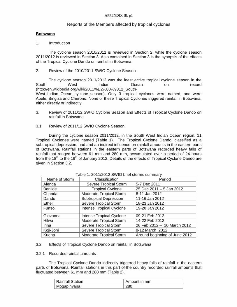
APPENDIX III, p1
Reports of the Members affected by tropical cyclones Botswana 1. Introduction
The cyclone season 2010/2011 is reviewed in Section 2, while the cyclone season 2011/2012 is reviewed in Section 3. Also contained in Section 3 is the synopsis of the effects of the Tropical Cyclone Dando on rainfall in Botswana. 2. Review of the 2010/2011 SWIO Cyclone Season
The cyclone season 2011/2012 was the least active tropical cyclone season in the South West Indian Ocean on record (http://en.wikipedia.org/wiki/2011%E2%80%9312_South-West_Indian_Ocean_cyclone_season). Only 3 tropical cyclones were named, and were Abele, Bingiza and Cherono. None of these Tropical Cyclones triggered rainfall in Botswana, either directly or indirectly. 3. Review of 2011/12 SWIO Cyclone Season and Effects of Tropical Cyclone Dando on
rainfall in Botswana 3.1 Review of 2011/12 SWIO Cyclone Season
During the cyclone season 2011/2012, in the South West Indian Ocean region, 11 Tropical Cyclones were named (Table 1). The Tropical Cyclone Dando, classified as a subtropical depression, had and an indirect influence on rainfall amounts in the eastern parts of Botswana. Rainfall stations in the eastern parts of Botswana recorded heavy falls of rainfall that ranged between 61 mm and 280 mm, accumulated over a period of 24 hours from the 18th to the 19th of January 2012. Details of the effects of Tropical Cyclone Dando are given in Section 3.2.
Table 1: 2011/2012 SWIO brief storms summary Name of Storm Classification Period
Alenga Severe Tropical Storm 5-7 Dec 2011 Benilde Tropical Cyclone 25 Dec 2011 – 5 Jan 2012 Chanda Moderate Tropical Storm 8-11 Jan 2012 Dando Subtropical Depression 11-16 Jan 2012 Ethel Severe Tropical Storm 18-23 Jan 2012 Funso Intense Tropical Cyclone 19-28 Jan 2012
Giovanna Intense Tropical Cyclone 09-21 Feb 2012 Hilwa Moderate Tropical Storm 14-22 Feb 2012 Irina Severe Tropical Storm 26 Feb 2012 – 10 March 2012 Koji-Joni Severe Tropical Storm 8-12 March 2012 Kuena Moderate Tropical Storm Around beginning of June 2012
3.2 Effects of Tropical Cyclone Dando on rainfall in Botswana 3.2.1 Recorded rainfall amounts
The Tropical Cyclone Dando indirectly triggered heavy falls of rainfall in the eastern parts of Botswana. Rainfall stations in this part of the country recorded rainfall amounts that fluctuated between 61 mm and 280 mm (Table 2).
Rainfall Station Amount in mm Mogapinyana 280

APPENDIX III, p2
Kgagodi 230 Zanzibar Border 98 Ratholo 90 Lentswelemoriti 70 Diloro 61
Table 2 Twenty-hour rainfall accumulation (mm) in the eastern parts of Botswana, recorded on 19th January 2012, at 06:00 G.M.T.
3.2.2 Evolution of the Tropical Cyclone Dando
Below is the summary of the evolution of the Tropical Cyclone Dando (http://en.wikipedia.org/wiki/2011%E2%80%9312_South-West_Indian_Ocean_cyclone_season):
• 11 Jan 2012 => Extra-tropical disturbance formed east of Madagascar • 12 Jan 2012 => Evolved into subtropical depression, moved towards mainland • 15 Jan 2012 => Reached cyclone strength, allocated name Dando • 16 Jan 2012 => Last advisory issued for Dando, system weakened to remnant
low • 17 Jan 2012 => Made landfall • 18 Jan 2012 => Remnants of Dando began to dissipate
3.2.3 Surface Chart Analysis of the 18th January 2012
The analyzed surface chart of the 18th of January 2012, 06:00 G.M.T., indicated a deep low (remnants of Tropical Cyclone Dando) over southern Mozambique, which linked up with another low over Botswana. The link between these two lows caused heavy downpours over the eastern parts of Botswana (Table 2). 3.2.4 Overview of global and regional model forecasts for 18th January 2012
Global models like NCEP, ECMWF and Japanese model also indicated lows over Mozambique and Botswana, but failed to predict precipitation of more than 60 mm over the eastern Botswana. Even the local models that we run at Botswana Meteorological Services, namely, High Resolution Model (HRM) and Weather Research and Forecast - Environmental Modeling System (WRF-EMS) failed to forecast heavy falls for the eastern parts of the country. 3.2.5 SWFDP guidance
The SWFDP guidance issued by RSMC Pretoria for 18th of January 2012 did not indicate that heavy falls were expected over Botswana. 3.2.6 No warning issued
Since the SWFDP guidance did not forecast heavy falls for the eastern parts of Botswana, nor did the regional and global models, this resulted in warnings being not issued for the 18th of January 2012. The heavy falls resulted in flash floods, but no casualties were reported. Some buildings constructed using inferior materials were damaged. Comoros
DIRECTION DE LA METEOROLOGIE
Pendant les deux saisons, les Comores n’ont pas connu des influences cycloniques notables. Seulement le cyclone BINGIZA de février 2011 que l’archipel a connu

APPENDIX III, p3
beaucoup de précipitations que d’habitude, soit 770.2mm pour la station de Moroni alors que la normale est de 249.4mm. Ce mois de février 2011 le service météorologique était en en phase de vigilance cyclonique.
Toutefois, depuis le 20 avril 2012, l’ensemble de l’Union des Comores est frappé
par des pluies torrentielles qui ont provoqué des fortes précipitations, des glissements de terrains. Les principales régions affectées sont Bambao, Hambou et Mbadjini Est pour la grande Comores ; Sima et Domoni pour Anjouan et l’ensemble de l’ile de Mohéli surtout Nioumachiwa et Hoani.
Pendant cette dernière décade, les reliefs de l’Archipel des Comores ont connu de
très fortes précipitations localisés sur sud et sud-ouest des iles citées plus haut. Voici quelques exemples des valeurs enregistrées à la grande Comores.
DIRECTION DE LA METEOROLOGIE DEPARTMENT OF METEOROLOGY
Over the two cyclone seasons, the Comoros archipelago was not notably impacted by
cyclones. Cyclone BINGIZA, in February 2011, was the only one to generate above-normal rainfalls over the archipelago, i.e. 770.2 mm for the station of Moroni versus a normal amount of 249.4 mm. During that month of February 2011, the meteorological Service remained on cyclone watch.
However, since April 20th 2012, torrential rains, generating large amounts of
precipitations and landslides, have hit the whole of the Union of the Comoros. The main impacted regions are Bambao, Hambou and Mbadjini Est for the island of Grande Comore; Sima and Domoni for Anjouan and all of Mohéli Island especially Nioumachiwa and Hoani.
Over the past decade, the reliefs of the Comoros archipelago have known heavy
rainfalls located over the south and south west of the islands mentioned above. Here are a few examples of the quantities recorded in Grande Comore.
Kenya 1. INTRODUCTION In the Southwest Indian Ocean, Tropical cyclones form from November to May and this is the Cyclone Season for the RA I Africa. The Regional Specialized Meteorological Center La Réunion (RSMC) carry out monitoring and forecasting of tropical cyclones, provide advisory information and guidance to National Meteorological Services. Naming of the storms is done with input from the Meteorological services of Madagascar and Mauritius. The cyclone season starts in the middle of the “Short Rains” season in Kenya that runs from October to December and ends well into the “Long Rains” of March to May. The period of intense cyclone activity normally coincides with the dry period of January and March. Early intense cyclone activity; especially when the storms are located in the region of Madagascar and the Mozambique Channel herald an early cessation of the Short Rains. On the other hand delayed intense activity delays the onset of the Long Rains or induces poor performance of the rains. 2. 2010-2011 TROPICAL CYCLONE SEASON
The 2010-2011 Tropical Cyclone Season started early with promise but fizzled out to be one of the least active seasons in recent history. With the exception of tropical cyclone “Bingiza” that made landfall over Madagascar most of the other storms formed and tracked over the eastern extremes of the basin. The storms also formed southward of 15˚S. As a result the impacts of the cyclones on Kenyan weather were minimal.

APPENDIX III, p4
3. 2011-2012 TROPICAL CYCLONE SEASON
The 2011-2012 Tropical Cyclone Season was a marked improvement in activity over the preceding season. This would be classified as an average season in terms of the number of storms that formed. While this season started late, it also ended late.
The impacts on Kenyan weather were mainly at the end of the Short Rains, which ended abruptly at the beginning of December. This could be associated with the formation of storms over the region of the Mozambique Channel and around Madagascar. This resulted in the shift of the rainfall belt southwards and signaled the end of the rainfall season especially over the eastern parts of Kenya. 4. SUMMARY The Tropical Cyclone Seasons of 2010-2011 and 2011-2012 both coincided with cold episode ENSO phenomena. However the Sea Surface Temperature (SST) patterns over the Southwest Indian Ocean basin were different with cooler SST observed during 2010-2011 compared to 2011-2012. This may have been responsible for the stark differences in terms of cyclone activities between the two seasons.
Kenya recognizes the useful and important contribution by the RSMC La Réunion in the country’s operational weather monitoring, forecasting and early warning. Lesotho 2010-2012 TROPICAL CYCLONE SEASONS During the tropical season 2010/2011 and 2011/2012, there was no particular cyclone which directly hit Lesotho. However, it was observed that tropical cyclones/depressions particularly in the Mozambique Channel and in the vicinity had negative impacts on the rainfall received over Lesotho. The following tropical cyclones/depressions had a negative influence on rainfall during the 2011/2012 tropical cyclone season.
• The Subtropical Depression Dando (January 11-16, 2012) • Severe Tropical Storm Ethel (January 18-23, 2012) • Intense Tropical Cyclone Funso (January 19-28, 2012) • Intense Tropical Cyclone Giovanna (Feb 9-21, 2012) • Severe Tropical Storm Irina (February 26 - March 10, 2012) • Moderate Tropical Storm Chanda (January 8-11, 2012)
Information on the forecasts of intensities and movements of tropical cyclones made available by RSMC-Reunion and RSMC-Pretoria were found useful for monitoring the Tropical Cyclones in the South West Indian Ocean. SUMMARY The Tropical Cyclone Season 2010/2011 can be described as inactive season with regard to the tropical cyclones because there were no notable Tropical Cyclones which influenced Lesotho weather although the country experienced flash floods and heavy rains during the season. On the other hand, Tropical Cyclones had a negative impact during the 2011/2012 season since they caused to dry conditions over Lesotho. Mozambique 1. INTRODUCTION

APPENDIX III, p5
Tropical cyclones are amongst the deadly hydrometeorological hazards that cyclically hit Mozambique, causing havoc and negative impact on several activities which has devastating effects on the economic development. The close proximity of tropical cyclones which pass mostly from the north to the south of the country or tropical cyclones evolving over the areas between the Mozambican Channel and 50 degree longitude, strongly affects the weather patterns over Mozambique, increasing convection and rainshower activities along the ITCZ. 1.1 Overview of the 2010-2011 Tropical Cyclone Season During the 2010/2011 season tropical cyclone “Bingiza” was the only tropical system that entered the Mozambican Channel, enhancing the heavy rainfall over northern portion of Mozambique due to intensification of ITCZ over this area. Therefore the 2010/2011 tropical cyclone season is considered none active.
1.2 Overview of the 2011-2012 Tropical Cyclone Season 2011/2012 was one of the most active tropical cyclone seasons along with 1974/1975 and 1999/2000, during which 5 tropical cyclones or tropical disturbances reached the Mozambican Channel. Mozambique was extremely affected by 2 of these 5 tropical cyclones or storms, namely Tropical Storm “Dando” in southern Mozambique, (from 16 to 18 January, 2012) and tropical cyclone “Funso” over Zambézia province, central Mozambique (from 22 to 25 January, 2012). Although “Funso” did not make landfall in Mozambique, the eye center approached the coast of Quelimane Town up to 90 to 110 km and the destructive effects were felt 200 km inland with heavy rainfall, damaging winds and thunderstorms. Since 1984 (tropical cyclone “Domoina”), “Dando” is the first tropical depression or tropical cyclone to make landfall further south of southern Mozambique.
In two weeks, a total of 25 deaths were reported by the National Center for Emergency Operation (CENOE), due to “Dando” and “Funso”. Since the full introduction of the SWFDP in the operational forecasting processes, they have especially demonstrated to be one of the best and helpful tools used to predict severe weather thus improving the forecasters abilities in the monitoring of extreme weather events. Enhancement of the exchange of information between neighbouring countries (INAM- Mozambique, NMS - Swaziland) and the regional centres (RSMC Pretoria and La Reunion) during the tropical cyclone “Funso” and “Dando” improved the early warning system.
1.3 Significant TC of the period (Case Study: The Monitoring of Tropical Cyclone “Funso” and Tropical Depression “Dando”) The case study (to be submitted) gives the story behind the monitoring and dissemination of alerts and warnings at INAM during the Tropical cyclone “Funso” and “Dando”, the challenge to improve service delivery, enhanced communications and exchange of warnings/alerts between neighboring countries and regional centers, and lessons learned. 2. INTERACTION OF INAM (NMS-Mozambique) WITH DMCPAs, MEDIA AND THE PUBLIC

APPENDIX III, p6
INAM’s capacities and capabilities to effectively deliver warning services to the general public through the media and Disaster Management and Civil Protection Authorities (DMCPAs) have been increasing since the implementation of the SWFDP in 2007. Although much important work remains to be done, collaboration between INAM, CENOE and media is well established. In the course of two weeks in last January, Mozambique was hit by tropical storm Dando (16th January) and tropical cyclone “Funso” (22nd January), which left significant structural damage in their wake and led to a total of 25 deaths. The two weather events, which followed in rapid succession, caused significant rainfall leading to flooding in many coastal areas. In general, the response was sharp, although some of the relief work was hampered by road access problems and continued bad weather. As soon as the NMS Mozambique informed that “Dando”, the first tropical depression was tracking to southern Mozambique and was forecasted to make landfall in the following 48 to 36 hours, the National Disaster Management Institute (INGC) and the CENOE kicked into operation, organizing the emergency response to the storm and coordinating relief efforts. The emergency response in Mozambique is organized in ‘clusters’, each of which addresses a key area of response, such as information sector (comprised by the INAM, National water Directorate and focal points from the Disaster Management Center), health, education or water and sanitation sector. Each cluster is led by one of the organizations engaged in the response. By organizing the response through the clusters, coordination is improved and unnecessary overlap reduced, leading to a more efficient and effective response. In comparison with other natural disasters in recent years, the impact of the two tropical weather events in January and other severe weather that affected Mozambique in the last season was limited and to some extent manageable. Together, “Dando” and “Funso” proved that the EWS (emergency preparedness and response system) is functioning and ready to step into action when needed. Some effort still need to be done within INAM, concerning the determination of adequate lead time for each event for the issuance of alert or warning, join the state of the art on information technology for dissemination of climate service and information and also to increase the outreach activities, in order to better understand users requirements and preferences for the delivery of the severe weather warning and forecast services.
3. GAPS AND AREAS TO BE IMPROVED
In the last years INAM have been working hardly to fill the gap between the climate service and information disseminated and the response in most of the vulnerable communities. This effort is undermined by detachment of the population living in remote areas with no access to up to date information.
The lack of meteorological information or deficient communication system also
contributes to less responsiveness communities which lead to high level of vulnerability. The use of information technology such as community radio, mobiles and others as
proved to be valuable for the enhancement of the early warning system.
4. SUMMARY

APPENDIX III, p7
During the Tropical Cyclone Season 2010-2011 and 2011-2012 INAM continued the effort for timely warning delivery building capacity to full integrate all the process in the operational, enhancing the capacity development, demonstrating the valuable work conducted through the years. The challenges are mostly linked to the communication system and lack of meteorological station which could allow better monitoring of the weather events. Seychelles
Seychelles, particularly its main island, Mahe, lies outside the cyclone belt. But
sometimes, depending on the movement and orientation of the cyclone, the feeder clouds associated with the cyclone shift over the region and trigger bad weather conditions.
However for the 2011/2011 and 2011/2012 tropical cyclone seasons, Seychelles and its islands did not come under the influence of any cyclone and this could have contributed to the below normal rainfall recorded for the two seasons and water shortage that the country is still experiencing. The 2011/12 was also a season with few formations of cyclones and this could have been due to the presence of La Nina.
South Africa
1. INTRODUCTION Statistically, landfalling tropical cyclones are relatively rare along the South African coastline adjoining the Indian Ocean. The last such system to make direct landfall was Tropical Cyclone Domoina (1984), which had significant impact along the northern coast and interior of KwaZulu-Natal province. However, in the interim there have been instances of tropical systems that have made first landfall over Mozambique and crossed overland into South African territory. The most recent such example was Dando, in mid-January 2012. As RSMC, the South African Weather Service (SAWS) has a large area of responsibility, regarding marine forecasts, namely METAREA VII, which includes the Mozambique Channel and Durban East marine areas. These regions are within the SW Indian Ocean domain of Tropical Cyclone development, hence SAWS forecasters must remain aware and vigilant regarding transfer of accurate and timely information regarding Tropical Cyclones. By agreement (within the SW Indian Ocean Operational Plan), such information is sourced directly from TCC La Réunion and embedded in marine forecast products disseminated via the GTS by SAWS. 1.1 Overview of the 2010-2011 Tropical Cyclone Season Noting that the previous two tropical cyclone seasons in the SW Indian Ocean basin (namely 2008/2009 and 2009/2010) were considered to have been amongst the lowest frequency of incidence within the past 3 decades, this quiescent (dormant/inactive) trend was continued into the 2010/2011 season, with only a single named system (i.e. Bingiza) entering the northern Mozambique Channel. Thus, from a Southern African NMS perspective, there were no direct or indirect impacts resulting from tropical cyclones.
1.2 Overview of the 2011-2012 Tropical Cyclone Season 2011/2012 was one of the most active tropical cyclone seasons on record for the SW Indian Ocean basin. From a South African Weather Service perspective, three of the named tropical systems during this particular season had notable direct or indirect impact on South Africa. The systems were namely Subtropical Depression Dando (January 2012), Intense

APPENDIX III, p8
tropical Cyclone Funso (January 2012) and Severe Tropical Storm Irina (February/March 2012), all within the latter part of the 2011/2012 season. Notably, whilst Dando was one of the weaker systems of the 2011/2012 season, this was the system that had the most impact on the natural environment as well as infrastructure over the eastern extremities of South Africa. Despite the system having been monitored closely and landfall accurately predicted, it was whilst the system was dissipating overland (over the eastern escarpment of Mpumalanga and Limpopo provinces of South Africa) that the bulk of the impact occurred. The rainfall, primarily from rainbands containing embedded thunderstorms, was locally enhanced by orographic uplift along the escarpment. Some bridges in the Kruger National Park were swept away or severely damaged, especially along major rivers such as the Olifants, Letaba and Sabie, stranding many tourists. At least six deaths were reported and at least 30 people had to be airlifted to safety by helicopter. In hindsight, whilst SAWS issued press releases ahead of time and also engaged pro-actively with Disaster Management, the overall magnitude of the damage was underestimated. It is sobering to see damage on this scale, even from a “weakening and dissipating” system. Intense Tropical Cyclone Funso was the subject of much media and public interest in South Africa and was thus the subject of a number of informative press releases issued by SAWS (despite never making landfall in South Africa). Early in its lifetime, Funso caused much damage and numerous fatalities in Zambezia province in the north of Mozambique. Subsequently, when Funso moved out into the Mozambique Channel and began moving slowly southwards (mainly parallel to the Mozambican coast), there were public concerns and media speculation as to whether the system would recurve back on to the Mozambican coast (and possibly cross over into South Africa). Luckily this did not occur and the system stayed well offshore of the Mozambican coast in the latter part of its lifetime. Frequent and numerous calls were, however received by NFC in Pretoria, from concerned hotel and lodge owners along the southern Mozambican coast (see comment in section (3) below) In a similar vein to the above comments regarding Funso, Severe Tropical Storm Irina was also the subject of much media and public concern, due in part to the track being consistently south-westward, towards Maputo and the Zululand region of South Africa, as it traversed the southern part of the Mozambique Channel. Consequently a number of press releases were issued by SAWS regarding this system. Whilst true landfall never occurred, Irina came very close to the northern coast of the KwaZulu-Natal province of South Africa on the night of 3 March 2012, with rainband features of Irina delivering over 100mm of rain overnight at numerous localities along a section of coastline, with widespread flooding and limited structural damage. Levels of awareness and alertness were high amongst the public as well as (National/Provincial/Local) Disaster Management and mitigatory measures were in place, well ahead of time. Officially, four fatalities were reported. 2. INTERACTION OF SAWS (NMS-South Africa) WITH DISASTER MANAGEMENT STRUCTURES (DMCPAs), MEDIA AND THE PUBLIC Since the previous RA1 Tropical Cyclone Committee meeting (in 2010) SAWS has created an in-house Corporate Communications directorate, who are collectively tasked with being the conduit for official communication (inter alia) between forecasters and the media at large. This has markedly improved the strength, frequency and quality of information transfer to and from the media. Where possible SAWS strives to issue formal press releases well ahead of approaching tropical disturbances. Such press releases are clearly branded as having been issued by SAWS, so as to limit the possibility of hoax warnings. The technical accuracy and meteorological correctness of journalistic reporting is also enhanced, as the text content of the official press release is usually relayed verbatim in electronic and print news media.

APPENDIX III, p9
Even whilst tropical cyclones are well beyond South African territory, there is significant media and public pressure for SAWS to issue press releases of a more informative nature as a courtesy to keep the public aware and informed and to prevent panic being triggered by hoax e-mails. As an example, a number of SAWS press releases were issued regarding Funso, although Funso never made landfall on the SA coastline and remained well seawards of the coast. At national level there are established routes and processes regarding communication with the National Disaster Management Centre (NDMC) as well as frequent (sometimes daily) meetings at the NATJOINT/NATJOC forum which are convened on an ad hoc basis on occasions when tropical cyclones threaten the eastern extremities of South Africa. NATJOC is the National Joint Operations Centre (located close to Pretoria), co-ordinated by SA Police Services (SAPS) and serves as a forum for all role-players, such as the (SANDF) Defence Force, SAPS, SAWS, Energy sector, Disaster Management etc to meet formally, exchange information and to execute tasks aimed towards mitigating risk and deploying resources effectively. Numerous NATJOC meetings were held during the lifetimes of Dando, Funso and Irina, with SAWS presenting weather-related Powerpoint briefings. Such briefings also typically included tropical cyclone position, current/projected movement and intensity, as determined by TCC La Réunion. 1. GAPS AND AREAS TO BE IMPROVED
Public awareness and overall safety could be measurably enhanced through
improved pro-active interaction between SAWS and SANPARKS (South African National Parks, who administer the Kruger National Park) when faced with similar events in future which might threaten the Kruger Park. Tourists face the real danger of attack by wild animals if unable to return by road to secure rest camps due to flooding of rivers. Technically, it could be argued that National Disaster Management and Provincial Disaster Management (NDMC and PDMC respectively) should perform this (and similar) roles, in terms of effective and timely dissemination of critical tropical cyclone-related information to affected stakeholders.
SAWS forecasters have a general concern regarding the vulnerability of coastal
communities, especially hotels/lodges along Mozambican southern coastline, where many owners/guests are anglophile (English-speaking) and rely heavily on telephonic contact with SAWS NFC (National forecast Centre, Pretoria) for frequent updates and guidance as to possible evacuation, ahead of an approaching tropical system which may or may not make landfall. In this context, SAWS is pleased to be able to make a direct contribution to public safety and awareness, especially if the client is unable to speak Portuguese (the lingua franca of Mozambique). There is however the potential that South African NMS forecaster guidance could differ from Mozambican INAM guidance to the public (particularly in the event of a decision to evacuate (or not)). More frequent and formalized telephonic and e-mail contact between INAM and SAWS forecasters would be the first step towards a more unified and holistic NMS response to such threats.
4. SUMMARY SAWS is of the opinion that, during the 2010/2011 and 2011/2012 Tropical Cyclone seasons, both the general public as well as DMCPA’s (Disaster Management) have benefitted from an increasingly pro-active approach being followed by SAWS (as elaborated in (2) above). SAWS have consistently made an attempt to issue press statements to the Media at the earliest opportunity, in an effort to limit undue media and public speculation and/or uncertainty regarding tropical cyclones within the SW Indian Ocean region. Furthermore, SAWS is also of the opinion that the SWFDP continues to be a robust vehicle to transfer critical and essential information regarding extreme weather phenomena within the RA1 region. SAWS is happy to continue to fulfill this support and guidance role, in line with the responsibilities and duties of an RSMC and in co-operation with RSMC La

APPENDIX III, p10
Réunion Tropical Cyclone Centre. It is quite likely that in seasons to come, the variety and scope of meteorological products (such as NWP, Ensembles etc.) disseminated via the SWFDP website will continue to expand, providing a broad spectrum of information to better inform forecaster decision-making within RA I. Tanzania
1. INTRODUCTION Tropical cyclones form annually over warm tropical oceans. Initially they start as tropical disturbance then develop and attain intensity with surface wind speed increasing to about 200 km/h. In the south West Indian Ocean they are called Severe Tropical Cyclone. In other regions of the global Oceans they are called typhoons or Hurricanes. In the West Indian Ocean the period during which most of the Tropical Disturbances and Cyclone occur is between 1November and 15 May, this is known as the Cyclone Season. Tropical cyclones are among the most devastating of all natural hazards. They have potential to change the winds and the weather patterns over our region causing violent winds, torrential rainfall and floods; moreover they can also cause poor seasonal rainfall depending on their strength and position from our country. Every year several tropical disturbances and cyclones cause disasters of varying scales, with loss of life, human suffering, destruction of property, severe disruption of normal agricultural activities and adversely effects to social and economic progress. Regional Storm Monitoring Center La Réunion (RSMC) carry out monitoring and forecasting of tropical cyclones, provide advisory information and guidance to National Meteorological Services. The provision of tropical cyclone warnings over Tanzania territory and coastal waters is the responsibility of Tanzania Meteorological Agency (TMA). The official warnings are contained in advisories and warnings issued by the Tanzania Meteorological Agency from time to time. 2. 2010-2011 TROPICAL CYCLONE SEASON
The 2010-2011 Tropical Cyclone Seasons started in November 2010 with the first tropical cyclone “Bingiza” observed over the South West Indian Ocean. The 2010–11 South-West Indian Ocean cyclone season can be considered relatively inactive season. During this season cyclone Bingiza was the only storm with significant influence Tanzania climate and to make landfall over Madagascar. Bingiza developed on February 9 to the northeast of Madagascar. The storm stated as a weak Storm with little intensification until February 12 when the storm began a steady westward track as environmental conditions became more favorable. Within a 24–hour period, Bingiza developed from a moderate tropical storm into an intense tropical cyclone with a well-defined eye. The cyclone moved ashore in northeastern Madagascar on February 14 and quickly weakened as it crossed the country. It emerged into the Mozambique Channel as a weak tropical disturbance. Cyclone Bingiza attained tropical storm status before making its final landfall on February 18. Development of Bingiza and its movement brought much relief over many parts of central and northern Tanzania where dry conditions had been experienced. During the life span of Bingiza much of the wet conditions in the country were linked to enhanced low level wind convergence and moisture from the Indian Ocean and Congo rain-forest. Strong winds were also experienced though no disaster was observed. The season had very few tropical disturbances and cyclones that influenced the climate of Tanzania due to their relative far position and strength. Moreover, most of the storms tracked south westwards along the far eastern coast of Madagascar rather than passing through the Mozambique Channel.

APPENDIX III, p11
The tropical Cyclones were closely monitored based on the reports and bulletins from the Regional Storm Monitoring Center La Réunion (RSMC). 3. 2011-2012 TROPICAL CYCLONE SEASON
This season can be considered inactive tropical cyclone season. There were no tropical disturbances in the region. 4. SUMMARY During the Tropical Cyclone Season 2010-2011, only Cyclone Bingiza could be linked to enhanced wet conditions and windy over the country. The 2011-2012 was inactive season. Information from Regional Storm Monitoring Center La Réunion (RSMC) was very useful in the country’s operational weather monitoring, forecasting and early warning.
_____

APPENDIX IV, p1
Definitions of the new terminology Part I To add to the first table of page I-2 Classification of weather disturbances Classification des perturbations météorologiques (i) Low pressure area i) Zone dépressionnaire (ii) Extra-tropical disturbance ii) Dépression extratropicale (iii) Sub-tropical disturbance iii) Dépression subtropicale (iv) Zone of disturbed weather iv) Zone perturbée (v) Tropical wave v) Onde tropicale (vi) (Generic term) vi) (Terme générique) Tropical disturbance Perturbation tropicale Or (preferably) Tropical system ou (préférentiellement) Système dépressionnaire tropical (vii) Tropical depression vii) Dépression tropicale (viii) Moderate tropical storm viii) Tempête tropicale modérée (ix) Severe tropical storm ix) Forte tempête tropicale (x) Tropical cyclone x) Cyclone tropical (xi) Intense tropical cyclone xi) Cyclone tropical intense (xii) Very intense tropical cyclone xii) Cyclone tropical très intense (xiii) Remnant low xii) Dépression résiduelle (xiv) Filling low xiv) Dépression se comblant (xv) Dissipating low xv) Dépression se dissipant (xvi) Post-tropical depression xvi) Dépression post-tropicale To add to the list page I-2 and ending page I-4 (Cl assification of weather disturbances): Remnant low : A former tropical system having weakened and that is no longer associated with established and/or organized convection. Within the related cyclonic surface wind circulation the maximum estimated average wind does not exceed 27 knots (50 km/h, force 6 in the Beaufort scale). Filling low : A former tropical system undergoing sustained weakening and whose related minimum of pressure is in advanced stage of filling trend. Dissipating low : A former tropical system in final decaying phase that is doomed to vanish at short range. Post-tropical depression : A former tropical system (tropical depression or tropical storm or tropical cyclone) in extratropical transition, that no longer possesses sufficient tropical characteristics to be considered a tropical system, but that has not yet completed its extratropical transition to be considered as a fully extratropical depression and qualified as such. Hence it generally corresponds to a transient stage (lasting less than 24 hours most of the time). Dépression résiduelle : ancien système dépressionnaire tropical s’étant affaibli et ne comportant plus de convection établie et/ou organisée. Au sein de la circulation dépressionnaire associée, la valeur maximale estimée de la vitesse moyenne du vent n’excède pas 27 nœuds (soit 50 km/h, force 6 Beaufort). Dépression se comblant : ancien système dépressionnaire tropical en phase d’affaiblissement durable et dont le minimum de pression associé est en voie de comblement. Dépression se dissipant : ancien système dépressionnaire tropical en fin de vie appelé à disparaître à brève échéance.

APPENDIX IV, p2
Dépression post-tropicale : ancien système dépressionnaire tropical (dépression tropicale ou tempête tropicale ou cyclone tropical) en phase de transition extra-tropicale, ne possédant plus toutes les caractéristiques d’un système dépressionnaire purement tropical, mais n’ayant pas encore achevé sa transition extra-tropicale et ne pouvant de ce fait pas encore être considéré comme une dépression extratropicale et qualifié comme telle. Cet état est donc généralement transitoire (durant moins de 24 heures la plupart du temps). Part II To replace the last § of 1.2.2 (page I-5) Saison cyclonique : Dans le Sud-Ouest de l’océan Indien, la saison cyclonique s’étend du 1er juillet de l’année N au 30 juin de l’année N+1, sachant que les occurrences de systèmes dépressionnaires tropicaux sont rares en hiver austral (période allant de juin à septembre) et que le risque de cyclogenèse est maximal durant l’été austral. Le risque cyclonique n’étant pas uniforme sur le bassin, certains des pays membres du Comité des cyclones tropicaux du Sud-Ouest de l’océan Indien ont défini, pour leurs propres besoins nationaux, une durée spécifique pour la saison cyclonique, période plus restreinte (s’étalant généralement de novembre à avril ou mai) durant laquelle se manifestent la plupart des perturbations susceptibles de les concerner. To add to the item 1.4 page I-7 (Classification de s perturbations tropicales dans le secteur sud-ouest de l’océan Indien de la Région I) N.B. : La correspondance univoque pressions-vents figurant en bas du diagramme est donnée à titre purement indicatif. En pratique, cette correspondance est adaptée au cas par cas pour tenir compte de la variabilité naturelle de la relation pression-vents, en fonction des principaux paramètres susceptibles de la modifier (intensité du système dépressionnaire, taille de circulation dépressionnaire et extensions de vents associées, pression environnementale, latitude, vitesse de déplacement, rayon des vents maximaux). Page I-9 to be modified Le baptême d’une perturbation tropicale ou subtropicale intervient au stade de la tempête tropicale modérée (valeur maximale de la vitesse moyenne du vent – définie au paragraphe 1.2.2 – correspondant à des vents de la force du coup de vent – observés ou estimés – soufflant à proximité du centre dépressionnaire dans une partie notable de la circulation cyclonique). Lorsque le CMRS de la Réunion ou le Centre sous-régional d’avis de cyclones tropicaux* qui est responsable de la zone dans laquelle se trouve la perturbation (Madagascar si le centre de la perturbation se trouve à l’ouest de 55°E, Maurice si le centre de la perturbation se trouve entre 55°E et 90°E) co nstate que la perturbation tropicale ou subtropicale en question atteint une intensité proche de celle d’une tempête tropicale modérée, ils prennent contact et se consultent. Si, au terme de la discussion technique, il apparaît que le stade de la tempête tropicale modérée est atteint, le Centre sous-régional compétent attribue alors officiellement un nom à la perturbation. Ce nom est choisi par ordre de rang alphabétique dans la liste pré-définie de noms telle que précédemment indiquée, sauf lorsqu’un système dépressionnaire déjà préalablement nommé dans la zone Sud-Est de l’océan Indien (est de 90° Est) vient à pénétrer dans la zone Sud-Ouest de l’océan Indien, auquel cas le nom d’origine est conservé sans modification.
Les Services météorologiques du secteur sud-ouest de l'océan Indien utiliseront le nom attribué à l'exception de tout autre pour désigner une tempête tropicale, jusqu'à ce qu'elle sorte du secteur, devienne une dépression post-tropicale ou extratropicale, ou, s'étant affaiblie, cesse de remplir les conditions requises pour être classée tempête tropicale modérée.
Dans ces derniers cas, on continuera d’identifier la perturbation par le nom qui lui a été attribué, précédé de la mention «EX» dans tous les bulletins la concernant.

APPENDIX IV, p3
Les dispositions qui précèdent se rapportent uniquement à la désignation des tempêtes tropicales à l'aide de noms et n'entraînent aucune restriction en ce qui concerne les avis de cyclones tropicaux qui doivent être diffusés conformément aux dispositions du chapitre V qui s’appliquent aussi bien aux cyclones baptisés qu'aux perturbations non baptisées.

APPENDIX V, p1
Technical Plan proposed by Mauritius Strategic Objective 1: Support and maintain the Regional Meteorological Observing System
S. No
Activities Outcome Key Performance Indicators
1. Provision of satellite imageries up to 1000E (priority)
Necessary for issue of forecasts in the region East of Madagascar to 1000E (as sat data is sparse)
Reception facilities by 2014
2. Provision and installation of a wind finding radar at Rodrigues
Upperwinds at Rodrigues contributes towards the improvement in monitoring and tracking of storms/cyclones
Installation of radar completed by 2015. Improved storm/cyclone track
3. Provision and installation of upper-air station at Agalega
Upper winds at Agalega contributes towards monitoring of storms/cyclones
Installation of equipment by 2018
4. Maintain radiosonde launch at Vacoas station 61995, Mauritius
Improved analysis of severe weather, including monitoring and tracking of storms/cyclones
Overall improvement in tropical cyclone track forecasting
5. Wave rider launched off the south lagoon of Rodrigues
Improved sea forecast for fishermen at Rodrigues
Improved wave forecast at Rodrigues by 2015
Strategic Objective 2: Enhance dissemination of severe weather warnings and other weather information to the general public (TV weather service) as to mitigate hydrometeor disasters
S. No
Activities Outcome Key Performance Indicators
1. Provision of a media system (for e.g. MESSIR-MEDIA) for improved dissemination of weather information and weather warnings through TV stations
The population in the Republic of Mauritius are forewarned of severe weather associated with tropical storm/cyclone
Improved TV weather bulletin by 2015
2. Capacity building in MESSIR-MEDIA
Fully trained personnel to produce quality graphics for TV weather
Increased audience for TV weather programme.
Strategic Objective 3: Setting up of a new database system for climatology
SN Activities Outcome Key Performance Indicators 1. Provision of appropriate
software for archiving, analysis and production of improved climate services
Secured database set up and improved products generated for national use
New system installed by end of 2016
2. Capacity building in database management
Fully trained personnel in the applied sections
Quality products generated in less time.
3. Provision of TDCF associated infrastructure and training
To comply by WMO regulations codes and transmission of data
Operational early 2014

APPENDIX V, p2
Strategic Objective 4: Improved Disaster Risk Reduction and Preparedness Program and Capacity building in DRR
SN Activities Outcome Key Performance Indicators 1. Setting up of a high
resolution Limited Area Model (LAM) to cover the Exclusive Economic Zone of the Republic of Mauritius and the SWIO TC Basin.
Improved TC track forecast and extreme weather forecast in the context and a changing climate.
Overall benefit for the region and increased security against severe weather by 2014
1. Regional workshop on weather hazards in the SWIO
Forecasters in the region have an opportunity to meet and know each other thus improved communication within the region
Improved and efficient personnel to mitigate disasters.
2. Roving Seminar in member countries of the RA 1 TCC
All professional staff (weather forecasters and other meteorologists including disaster management people) are fully trained
A professional and efficient staff ready to mitigate hazards impacts and disaster by end 2016
Strategic Objective 5: Strengthen research activities in the SWIO tropical Cyclone basin SN Activities Outcome Key Performance Indicators 1. Collaborate with RSMC La
Reunion and Pretoria to set up a research team in the region
Better understanding of tropical weather/system in the region, especially with increased climate variability and climate change.
Researched paper published by 2016
2. Short term attachment in the Meteorological Services in La Reunion or Pretoria which will allow access to NWP and LAM of selected severe weather events
Better understanding of tropical weather /system in the region
MMS becomes a centre of excellence

APPENDIX VI, p1
SWFDP Phase 4 – sustainability and development The document is available at:
http://www.wmo.int/pages/prog/www/CBS-Reports/documents/Regional-Phase4Impl-Plan_2011draft.doc